final alton ea june05,07 - government of nova scotia · numerical brine dispersion modeling in ......
TRANSCRIPT

FINAL REPORT
APPENDIX C Dispersion Modeling of Discharged Brine

Smart Solutions for Engineering, Science and Computing
Smart Solutions for Engineering,
Science & Computing
Martec Limited tel. 902.425.5101 1888 Brunswick Street, Suite 400 fax. 902.421.1923
Halifax, Nova Scotia B3J 3J8 Canada email. [email protected]
www.martec.com
Numerical Brine Dispersion Modeling in the Shubenacadie River
Martec Technical Report # TR-07-12
March 2007
Management System Certified to:
I SO 9001:200

2
1.0 Numerical Brine Dispersion Modeling in the Shubenacadie River The numerical modeling of brine dispersion in receiving waters of the Shubenacadie River is based on the USEPA supported Cormix Modeling System (Jirka et. al., 1996) for near-field mixing predictions, and a detailed RMA 10/11 finite element hydrodynamic/water quality river model (United States Waterways Experimental Station Coastal and Hydraulics Laboratory) to quantify far-field dispersion. Various outfall configurations were considered as potential designs for brine discharge in the Shubenacadie River. These included the following: Option # 1 Submerged Outfall at mid-channel and shore-attached. Option # 2 Submerged Diffuser positioned across the river width (perpendicular
diffuser) and along the riverbank (parallel diffuser). In addition, multi-staged diffuser configurations were considered where ports operate only under specific ambient and discharge conditions.
Option # 3 Shore-attached discharge from pre-mixing pond. A mid-channel single outfall as well as the perpendicular diffuser were not considered feasible options due to the potential problems associated with sedimentation covering the outfall or ports, erosion, potential damage to the pipe from ice flows, difficulties associated with laying or directional drilling of the pipe or diffuser across the river and the required annual maintenance. For these reasons, only shore-attached outfalls were considered feasible layouts for the three options described above. The Cormix Modeling System provides detailed mixing analysis of dense (negatively buoyant) discharges in steady and unsteady receiving waters and can account for bottom density current mixing with sloping bathymetry. Until recently, very little guidance has been documented in the literature concerning the dispersion of negatively buoyant jets in receiving water environments. However, Jirka (2007) has developed guidelines for the optimal discharge configuration for brine effluents in the marine environment for single and multiple port (diffuser) configurations. These guidelines can be incorporated directly into Cormix with results assessed in terms of efficiency of mixing and the ability of the receiving water environment to assimilate the brine discharge. For submerged outfalls, better mixing efficiencies can be attained with high-velocity discharges in relatively deep water. Previous researchers (Zeitoum et al., 1970 and Roberts et al., 1997) have found that an optimal outfall or port angle with a 60o inclination provides the highest dilution of negatively buoyant jets. However, Cipollina at al. (2005) and Jirka (2007) have found that the negatively buoyant jet inclination should be in the range of 30o to 45o above horizontal in order to provide good trajectory of the effluent as well as a high degree of mixing at the point of impingement on the bottom slope. The lower angle of inclination also provides considerably flatter trajectories, thus allowing the discharge to be located in much smaller ambient depth conditions.
3
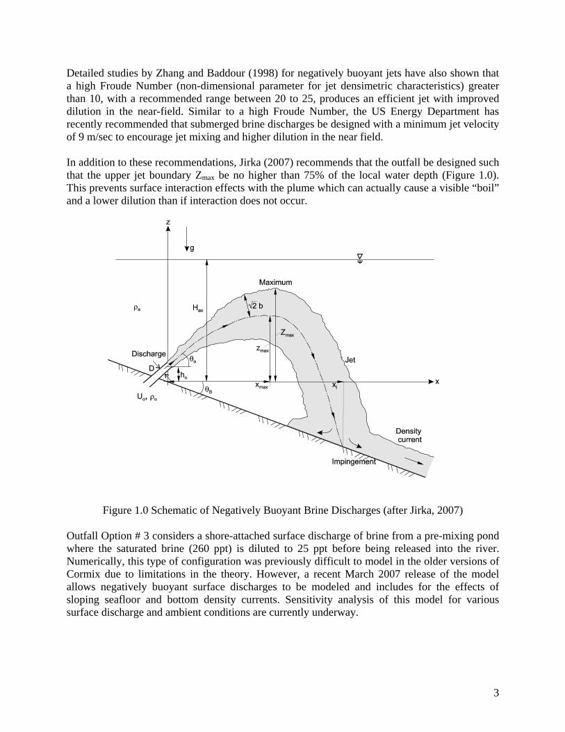
Detailed studies by Zhang and Baddour (1998) for negatively buoyant jets have also shown that a high Froude Number (non-dimensional parameter for jet densimetric characteristics) greater than 10, with a recommended range between 20 to 25, produces an efficient jet with improved dilution in the near-field. Similar to a high Froude Number, the US Energy Department has recently recommended that submerged brine discharges be designed with a minimum jet velocity of 9 m/sec to encourage jet mixing and higher dilution in the near field. In addition to these recommendations, Jirka (2007) recommends that the outfall be designed such that the upper jet boundary Zmax be no higher than 75% of the local water depth (Figure 1.0). This prevents surface interaction effects with the plume which can actually cause a visible “boil” and a lower dilution than if interaction does not occur.
Figure 1.0 Schematic of Negatively Buoyant Brine Discharges (after Jirka, 2007)
Outfall Option # 3 considers a shore-attached surface discharge of brine from a pre-mixing pond where the saturated brine (260 ppt) is diluted to 25 ppt before being released into the river. Numerically, this type of configuration was previously difficult to model in the older versions of Cormix due to limitations in the theory. However, a recent March 2007 release of the model allows negatively buoyant surface discharges to be modeled and includes for the effects of sloping seafloor and bottom density currents. Sensitivity analysis of this model for various surface discharge and ambient conditions are currently underway.

4
1.1 Shore-Attached Submerged Single Outfall (Option # 1) Numerical modeling of brine discharge was carried out for a series of discharge end-of-pipe conditions to establish salinity concentrations above ambient at different downstream locations. The brine was considered saturated with a corresponding salinity of 260 ppt and density of 1200 kg/m3. The general configuration of the shore-attached submerged outfall is presented in Figure 2.0. In order to reduce interaction of the plume with the riverbank, the submerged outfall modeled is located approximately 20 meters from the top of the East Bank with an outfall height of 0.5 meters above the river bottom (geodetic elevation of 3.22 m)
Figure 2.0 Schematic of Shore-Attached Submerged Single Outfall
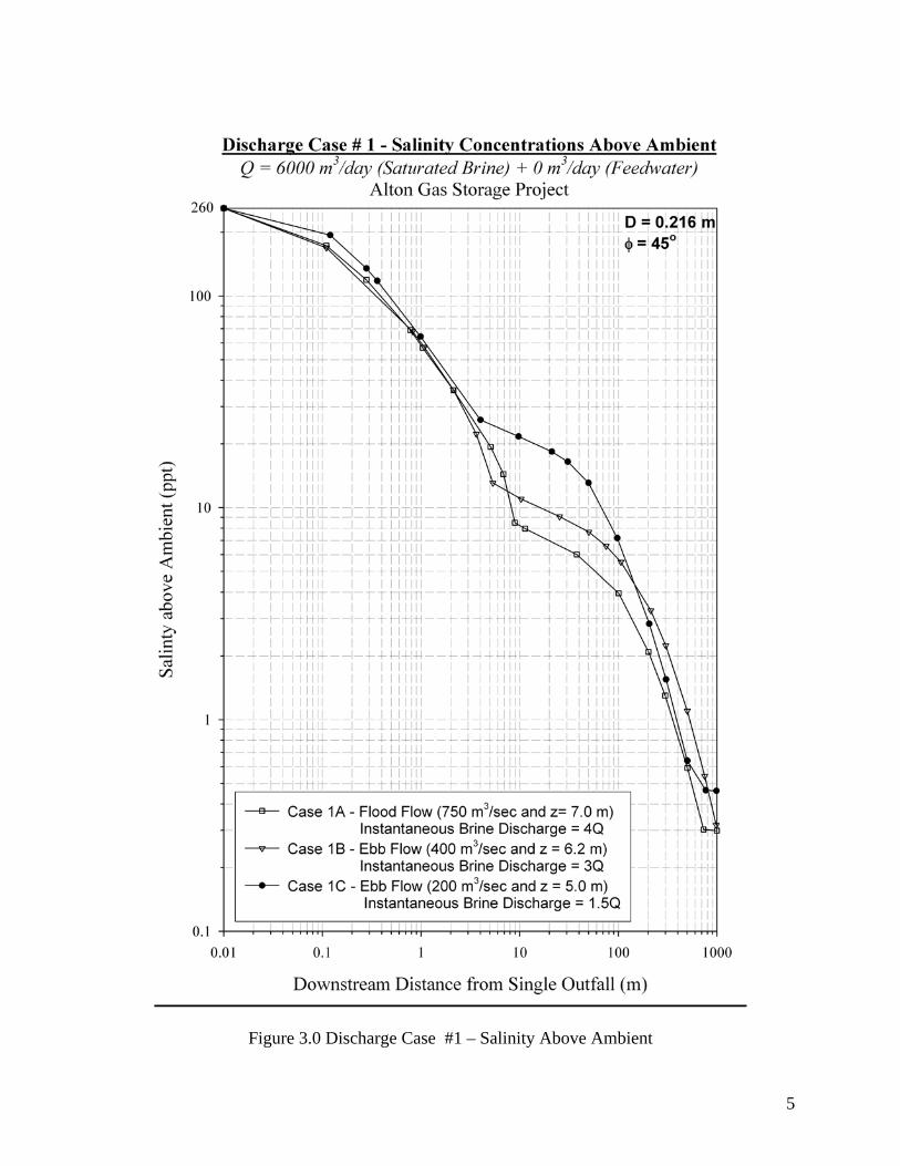
The end-of-pipe conditions considered are shown in Table 1.0 with saturated brine volume rates of 6,000 m3/day and 9000 m3/day mixed with various brackish feedwater dilutions (a total of 6 discharge cases). Three receiving water conditions were considered for each discharge case giving a total of 18 overall discharge cases considered. The receiving water conditions were obtained from the flow and water elevation measurements carried out at the site on November 6 and 30, 2006. Figure 3.0 depicts the dispersion results for Case 1.0 showing the salinity above ambient as a function of distance downstream for discharge case #1 for the three river conditions A, B, and C identified in Figure 3.0. Similar plots were generated for Cases 2.0 to 6.0. A summary of the results of the analysis for all 18 discharge cases is given in Table 2.0. The bottom three rows in the table give the salinity values (above ambient, Sa = 10 ppt) expected for each case at 10 m, 100 m and 1000 m downstream of the outfall.
5
Figure 3.0 Discharge Case #1 – Salinity Above Ambient

6
Table 1.0 Numerical Water Quality Simulation Cases
End-of-Pipe Discharge Conditions for Various Cases of
Saturated Brine Solution Diluted with Brackish River Water (Feedwater)
Receiving Water Conditions for each Discharge Case
River Condition A – Flood Flow (750 m3/sec) and Water Elevation (7.0 m)
River Condition B – Ebb Flow (400 m3/sec) and Water Elevation (6.2 m)
River Condition C – Ebb Flow (200 m3/sec) and Water Elevation (5.0 m)
Total Number of Discharge Cases Simulated = 18 A variable brine discharge rate was modeled for each receiving water condition such that during high river flows and elevations greater volumes of brine were released into the receiving waters. Due to the limited water depth at the outfall site, jet velocities exiting the outfall are relatively low, particularly during low water conditions when the brine discharge is throttled back to lower rates. Although the reduced jet velocity prevents interaction with the river surface, it also creates inefficient mixing conditions in close proximity to the outfall. Predicted Froude Numbers for the 18-discharge cases range from 1.5 to 12, well below the recommended range of 20 to 25.
Discharge Case 1 2 3 4 5 6 Saturated Brine
Volume Rate (m3/day) @260 ppt
6,000
6,000
6,000
9,000
9,000
9,000
Brackish River Water Volume Rate (m3/day)
@10 ppt
0
3,000
6,000
0
4,500
9,000
Total Volumetric Discharge (m3/day)
6,000
9,000
12,000
9,000
13,500
18,000
Total Volumetric Discharge (litres/sec)
69.4
104.2
138.8
104.2
156.3
208.4
Total Brine Concentration (ppt)
260.0
176.7
135.0
260.0
176.7
135.0
Discharge Density (kg/m3)
1,200
1,133
1,101
1,200
1,133
1,101

7
Table 2.0 Summary of Near-field 3-Dimensional Dispersion Modeling Results (Option # 1)
Discharge Case No.
1A 1B 1C 2A 2B 2C 3A 3B 3C 4A 4B 4C 5A 5B 5C 6A 6B 6C
Saturated Brine Rate (m3/day)
6000
6000
6000
6000
6000
6000
6000
6000
6000
9000
9000
9000
9000
9000
9000
9000
9000
9000
Feedwater Rate
(m3/day)
0
0
0
3000
3000
3000
6000
6000
6000
0
0
0
4500
4500
4500
9000
9000
9000
Total Discharge (m3/day)
6000
6000
6000
9000
9000
9000
12000
12000
12000
9000
9000
9000
13500
13500
13500
18000
18000
18000
Discharge Salinity (ppt)
260
260
260
177
177
177
135
135
135
260
260
260
177
177
177
135
135
135
Outfall Diameter
(m)
0.22
0.22
0.22
0.30
0.30
0.30
0.40
0.40
0.40
0.30
0.30
0.30
0.45
0.45
0.45
0.60
0.60
0.60
Discharge Angle
(o)
45
45
45
40
40
40
35
35
35
40
40
40
35
35
35
30
30
30
River Flow
(m3/sec)
+750
-400
-200
+750
-400
-200
+750
-400
-200
+750
-400
-200
+750
-400
-200
+750
-400
-200
Froude Number
(dim)
12.0
9.0
4.5
9.9
7.4
3.7
7.4
5.6
2.8
7.9
5.9
3.0
5.4
4.0
2.0
4.1
3.0
1.5
Salinity (ppt)
@ 10 m
8.20
11.25
21.41
7.72
9.99
20.31
8.71
11.40
25.81
13.73
18.92
38.70
16.02
21.94
47.41
21.32
26.94
44.12
Salinity (ppt)
@ 100m
3.99
5.59
7.10
3.77
5.10
6.80
4.28
5.69
8.17
6.81
10.63
13.75
7.90
11.89
14.74
9.81
14.21
14.33
Salinity (ppt)
@ 1000 m
0.30
0.32
0.46
0.30
0.32
0.48
0.32
0.33
0.48
0.38
0.63
0.60
0.39
0.64
0.61
0.40
0.68
0.61
8
For most discharge cases, diluting the saturated brine with feedwater has a negative effect and tends to increase downstream salinity. The addition of feedwater increases the discharge volume and prevents proper mixing or entrainment with river flows. The relatively large jet is thicker and requires the outfall angle of inclination to be lowered to prevent surface interaction. In addition, jet velocities need to be decreased (by increasing the pipe diameter) to ensure that the plume does not produce a near-surface boil and decreased dilution. This demonstrates that the relatively high rate of brine discharge from a single outfall is not operating efficiently and it is necessary to distribute the flow over several ports (i.e., multiport diffuser) to effectively mix the brine in this shallow water marine environment. 1.2 Shore-Attached Parallel Diffuser (Option # 2) This outfall configuration effectively divides the discharge over several smaller ports that are typically spaced an equal distance along the riverbank. This allows the individual jets to exit the ports at a higher velocity and entrain greater volumes of river water during the turbulent mixing phase. The main disadvantage of a parallel diffuser is that a relatively large separation distance between ports is usually required in order to allow sufficient dilution of the individual plumes before merging into the adjacent port. Because rivers have relatively parallel streamlines of flow, concentrations from the individual plumes are usually additive at a particular downstream location, such that the plume associated with the furthest downstream port has contributions from each of the upstream ports. An optimized single port with a reduced saturated brine rate of 2,250 m3/day (with no discharge multiplier) can be jetted without surface interference and have a corresponding Froude number within the recommended range. A discharge multiplier cannot be applied to the single port flows because jet velocities will be too large and cause near-field flow instabilities. Jet velocities greater than 9-10 m/sec should not be exceeded in this marine environment. Mixing zone variables for the single port analysis are as follows: • 30 meter Downstream Mixing Zone with a minimum 1:100 dilution at the boundary Optimum Configuration: Port Diameter = 60.0 mm Port Angle = 35 degrees Maximum Allowable Discharge = 2,250 m3/day (0.02604 m3/sec) Downstream salinities above ambient: See Figure 4.0 Subsurface negatively buoyant plume with jet velocity of 9.2 m/sec Discharge Restrictions: Water Elevations less than 4.8 m Geodetic and near HW slack water Results show a significant improvement in dilution when compared to option # 1 with salinities less than approximately 2.5 ppt at a downstream distance of 30 meters. This is equivalent to a 1:100 dilution at the boundary of the 30-m mixing zone. For comparative purposes, Figure 4.0 presents the downstream salinity (above ambient) for similar receiving water conditions as Option # 1. The figure demonstrates the effectiveness of achieving turbulent mixing with a high Froude Number, particularly within the 30-m mixing zone, where regardless of ambient condition, similar salinities are predicted downstream for the three cases. Salinities only begin to diverge at a distance

9
Figure 4.0 Downstream Salinity for Single Port Diffuser
10
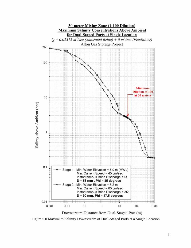
200-m downstream, a location where the buoyant spreading and diffusion processes end and passive ambient diffusion becomes dominant. Although the single port diffuser results presented in Figure 4.0 is optimized to account for relatively large variations in ambient conditions, further optimization can be carried out by considering dual-staged ports at single locations along the diffuser line. This allows the port to operate more efficiently during particular stages of the tidal cycle (i.e., river flow and water elevation conditions) than a single port. The operation of the dual-stage ports is dependent on the following receiving water conditions:
Stage 1 Port Operates when river elevation exceeds 5.0 m Geodetic (MWL) and current speeds are in excess of 45 cm/sec.
• Optimum Configuration: Port Diameter = 56 mm Port Angle = 35 degrees • Maximum Allowable Discharge = Q = 0.02315 m3/sec (2000 m3/day) • Saturated Brine = 260 ppt Stage 2 Port Operates when river elevation exceeds 6.2 m Geodetic and current speeds are
in excess of 65 cm/sec. • Optimum Configuration: Port Diameter = 90 mm Port Angle = 47.5 degrees • Maximum Allowable Discharge = 3Q = 0.06944 m3/sec • Saturated Brine = 260 ppt
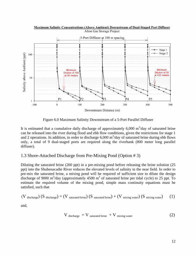
Only one of the dual-stage ports operates at any given time. The increased water elevation and flow in the river during stage 2 conditions allows the port to be designed with a higher brine discharge and angle of inclination than the stage 1 port. The threshold receiving water conditions for the stage 1 and 2 ports are likely the period of time that maximum salinity concentrations will occur downstream of the ports. Greater dilution will occur for the other periods of operation due to increased river flow and water depth. Figure 5.0 presents the maximum salinity concentrations downstream (above ambient, Sa = 10 ppt) for dual-staged port operation from a single location. The ports were optimized for a minimum dilution of 1:100 at the downstream boundary of a 30-m mixing zone. The associated brine concentrations downstream from a parallel diffuser located along the east bank of the river, with dual-staged ports separated a distance of 100 meters apart, is presented in Figure 6.0. Results from the diffuser analysis show the following:
(1) For a 5-port dual-staged diffuser, maximum salinity concentrations 500 meters downstream of the first dual-staged port (P1) are 1.0 ppt (above ambient) for stage 1 and 1.9 ppt (above ambient) for stage 2 conditions.
(2) Salinities greater than 28 ppt occur within 1-meter of ports for both stages. (3) Salinities greater than 5.5 ppt occur within 10-meters of ports for both stages. (4) Maximum salinities 1000-meters downstream of P1 are less than 1 ppt for both stages. (5) Maximum plume width 1000 meters downstream of P1 is less than 45-meters (from
east bank) for both stages.
11
Figure 5.0 Maximum Salinity Downstream of Dual-Staged Ports at a Single Location
12
Figure 6.0 Maximum Salinity Downstream of a 5-Port Parallel Diffuser
It is estimated that a cumulative daily discharge of approximately 6,000 m3/day of saturated brine can be released into the river during flood and ebb flow conditions, given the restrictions for stage 1 and 2 operations. In addition, in order to discharge 6,000 m3/day of saturated brine during ebb flows only, a total of 9 dual-staged ports are required along the riverbank (800 meter long parallel diffuser). 1.3 Shore-Attached Discharge from Pre-Mixing Pond (Option # 3) Diluting the saturated brine (260 ppt) in a pre-mixing pond before releasing the brine solution (25 ppt) into the Shubenacadie River reduces the elevated levels of salinity in the near field. In order to pre-mix the saturated brine, a mixing pond will be required of sufficient size to dilute the design discharge of 9000 m3/day (approximately 4500 m3 of saturated brine per tidal cycle) to 25 ppt. To estimate the required volume of the mixing pond, simple mass continuity equations must be satisfied, such that (V discharge) (S discharge) = (V saturated brine) (S saturated brine) + (V mixing water) (S mixing water) (1) and, V discharge = V saturated brine + V mixing water (2)
13
where, the average salinity of the mixing water (S mixing water) is assumed to be 10 ppt , saturated brine salinity (S saturated brine) of 260 ppt, discharge salinity (S discharge) into the river of 25 ppt, and a saturated brine volume (V saturated brine) of 4500 m3 pumped into the mixing pond per tidal cycle. Substituting these known variables in equations (1) and (2) above, and solving simultaneously gives a mixing water volume (V mixing water) of 70,500 m3 at 10 ppt and a total discharge volume (V discharge) of 75,000 m3 at 25 ppt. Because the water level in the mixing pond will be designed to mimic the water elevation in the river (as described in the pond operations section by Matrix Solutions Inc.), the volume of brine solution discharged into the river will vary depending on the stage of the tide (small or large tidal range). The salinity of the pond will vary with the tidal range, and will be designed to achieve a salinity of 25 ppt for a small tidal cycle resulting in a salinity of less than 25 ppt for mean and large tidal cycles. If the pond is designed to discharge approximately 75,000 m3 of brine solution for the small tide, then it is estimated that approximately 100,000 m3 of brine solution will be discharged during the medium tide and 125,000 m3 for the large tide. Operational controls that continually monitor these variables are essential to ensure that a salinity of 25 ppt or less is discharged into the river. Due to the rapid rise and fall of the tide at the proposed outfall site, the majority of the volume of water contained in the mixing pond will be released during ebb flow over a fairly short period of time. This will allow the brine solution to be released into the river during the early stages of ebb flow when river flows are the largest. This not only provides greater volumes of river water for initial dilution but also allows a portion of the remaining ebb flow period to effectively flush the brine out of the Shubenacadie River and into Cobequid Bay. Modelling of the river would determine the residence time of brine in the river. Preliminary near field dispersion modeling of brine discharged from the mixing pond has been carried out for the following conditions:
Small Tide River Conditions Small Tide (High Water Elevation of 6.0 m Geodetic) River Flow = 170 m3/sec Depth = 1.8 m Salinity = 15 ppt (at time of discharge) Discharge Conditions Total Brine Volume = 75,000 m3 Discharge Rate = 5.95 m3/sec for 3.5 hours Salinity = 25.0 ppt (Excess Salinity = 10 ppt) Rectangular Outfall = 10-m wide by 1.8-m deep
14
Mean Tide
River Conditions Mean Tide (High Water Elevation of 7.0 m Geodetic) River Flow = 300 m3/sec Depth = 2.4 m Salinity = 15 ppt (at time of discharge) Discharge Conditions Total Brine Volume = 101,787 m3 Discharge Rate = 8.08 m3/sec for 3.5 hours Salinity = 21.1 ppt (Excess Salinity = 6.1 ppt) Rectangular Outfall = 10-m wide by 2.4-m deep
Large Tide River Conditions Large Tide (High Water Elevation of 8.0 m Geodetic) River Flow = 500 m3/sec Depth = 3.0 m Salinity = 15 ppt (at time of discharge) Discharge Conditions Total Brine Volume = 128,573 m3 Discharge Rate = 10.20 m3/sec for 3.5 hours Salinity = 18.8 ppt (Excess Salinity = 3.8 ppt) Rectangular Outfall = 10-m wide by 3-m deep Figure 7.0 presents the preliminary brine dispersion results for the small, mean and large tidal conditions in terms of salinity above ambient at various downstream locations. For the three tidal ranges considered, the total volume of saturated brine (260 ppt) pumped into the mixing pond was 4500 m3 per tidal cycle. The dispersion analysis represents a “snapshot” of salinity above ambient (Sa = 15 ppt) downstream of the rectangular outfall during ebb flow at a period in time of approximately 1.5 hours after the high tide flow reversal.

15
Figure 7.0 Preliminary Brine Dispersion Results Results from the preliminary near field dispersion analysis show the following:
1) The decay of brine in the near field is most rapid within 100-meters of the outfall (dilution of approximately 2 for the three tidal conditions), beyond this point the decay is more gradual. Predicted salinities above ambient at a downstream distance of 1000-m from the outfall is 3.4 ppt, 1.74 ppt and 0.89 ppt for the small, mean, and large tidal conditions, respectively.
2) For the three tidal conditions, the plume becomes attached to the east bank a short distance downstream of the outfall. Due to the momentum of the brine discharge, the plume initially extends into the river a distance of approximately 20 –m and then decreases to a width of 10-m approximately 150 meters downstream. From this location, the plume gradually begins to increase in width (from the east bank) to approximately 20 meters at a distance 1000-m downstream.
3) Preliminary modeling results show the plume becomes vertically mixed within 250-m of the outfall. Worst-case scenarios associated with low river flows and higher discharge salinities will be investigated.

16
The model scenario presented above assumes a constant discharge from the mixing pond for a period of 3.5 hours after flow reversal, whereas the actual discharge will likely last for a longer time period. In reviewing the water elevation and flow measurements at the proposed outfall site, ebb flowing water begins not at high tide but usually 20 to 30-minutes after high tide. During this period, river water can drop up to 1.0-m in elevation depending on tidal flow condition. This means that when the water elevation begins to fall in the mixing pond, river water is still flooding upriver and could cause the brine to be dispersed with the flood flows until reversal occurs. Careful modeling of the pond hydraulics and river flows would define the details of the interactions occurring at the outlet during the release period and allow any required modifications to the pond/river interface to be carried out.

FINAL REPORT
APPENDIX D
Preliminary Designs of the Surface Facility


FINAL REPORT
APPENDIX E Injection Zones Discussion

Alton Natural Gas Storage
Injection Zones Discussion
For
Landis Energy Corporation
by
Hitchner Exploration Services Ltd.
Calgary, Alberta January 2007
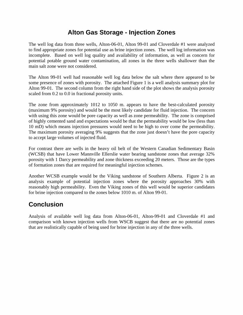
Alton Gas Storage - Injection Zones The well log data from three wells, Alton-06-01, Alton 99-01 and Cloverdale #1 were analyzed to find appropriate zones for potential use as brine injection zones. The well log information was incomplete. Based on well log quality and availability of information, as well as concern for potential potable ground water contamination, all zones in the three wells shallower than the main salt zone were not considered. The Alton 99-01 well had reasonable well log data below the salt where there appeared to be some presence of zones with porosity. The attached Figure 1 is a well analysis summary plot for Alton 99-01. The second column from the right hand side of the plot shows the analysis porosity scaled from 0.2 to 0.0 in fractional porosity units. The zone from approximately 1012 to 1050 m. appears to have the best-calculated porosity (maximum 9% porosity) and would be the most likely candidate for fluid injection. The concern with using this zone would be pore capacity as well as zone permeability. The zone is comprised of highly cemented sand and expectations would be that the permeability would be low (less than 10 mD) which means injection pressures would need to be high to over come the permeability. The maximum porosity averaging 9% suggests that the zone just doesn’t have the pore capacity to accept large volumes of injected fluid. For contrast there are wells in the heavy oil belt of the Western Canadian Sedimentary Basin (WCSB) that have Lower Mannville Ellerslie water bearing sandstone zones that average 32% porosity with 1 Darcy permeability and zone thickness exceeding 20 meters. Those are the types of formation zones that are required for meaningful injection schemes. Another WCSB example would be the Viking sandstone of Southern Alberta. Figure 2 is an analysis example of potential injection zones where the porosity approaches 30% with reasonably high permeability. Even the Viking zones of this well would be superior candidates for brine injection compared to the zones below 1010 m. of Alton 99-01. Conclusion Analysis of available well log data from Alton-06-01, Alton-99-01 and Cloverdale #1 and comparison with known injection wells from WSCB suggest that there are no potential zones that are realistically capable of being used for brine injection in any of the three wells.

Figure 1 – Well Analysis Summary Plot for Alton 99-01
Figure 2 – WSCB - Viking Example
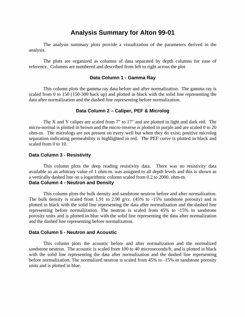
Analysis Summary for Alton 99-01 The analysis summary plots provide a visualization of the parameters derived in the
analysis. The plots are organized as columns of data separated by depth columns for ease of
reference. Columns are numbered and described from left to right across the plot
Data Column 1 - Gamma Ray This column plots the gamma ray data before and after normalization. The gamma ray is
scaled from 0 to 150 (150-300 back up) and plotted in black with the solid line representing the data after normalization and the dashed line representing before normalization.
Data Column 2 – Caliper, PEF & Microlog
The X and Y caliper are scaled from 7” to 17" and are plotted in light and dark red. The
micro-normal is plotted in brown and the micro-inverse is plotted in purple and are scaled 0 to 20 ohm-m. The micrologs are not present on every well but when they do exist; positive microlog separation indicating permeability is highlighted in red. The PEF curve is plotted in black and scaled from 0 to 10.
Data Column 3 - Resistivity
This column plots the deep reading resistivity data. There was no resistivity data
available so an arbitrary value of 1 ohm-m. was assigned to all depth levels and this is shown as a vertically dashed line on a logarithmic column scaled from 0.2 to 2000. ohm-m. Data Column 4 - Neutron and Density
This column plots the bulk density and sandstone neutron before and after normalization.
The bulk density is scaled from 1.91 to 2.90 g/cc. (45% to -15% sandstone porosity) and is plotted in black with the solid line representing the data after normalization and the dashed line representing before normalization. The neutron is scaled from 45% to -15% in sandstone porosity units and is plotted in blue with the solid line representing the data after normalization and the dashed line representing before normalization.
Data Column 5 - Neutron and Acoustic
This column plots the acoustic before and after normalization and the normalized
sandstone neutron. The acoustic is scaled from 100 to 40 microseconds/ft. and is plotted in black with the solid line representing the data after normalization and the dashed line representing before normalization. The normalized neutron is scaled from 45% to -15% in sandstone porosity units and is plotted in blue.

Data Column 6 – Grain Density & Secondary Porosity Index using Neutron/Density
Column 6 plots the apparent grain density calculated from a neutron vs. density cross plot
analysis. This curve is plotted in black and scaled from 2.5 to 3.0 g/cc. Normal sandstone will read between 2.65 and 2.68 g/cc. Limestone will read 2.71 g/cc. and dolomite will read 2.87 g/cc. A mixture of sand and dolomite to the logs might calculate as an apparent grain density of limestone.
The Secondary Porosity Index is also plotted in this column in blue with blue shading.
The curve is scaled from 0 to 0.20 fractional porosity units and is used to indicate apparent vugs, fractures and/or dual porosity systems. It is a measure of the contrast of the neutron-density porosities to that of the acoustic log. .
Certain zones have definable secondary porosity indexes, which suggest the presence of
fracturing. How extensive the fracture systems are and how useful these systems would be for brine injection is indeterminate
Data Column 7 – Conventional Water Saturation using Neutron/Density
This column plots the water saturations derived from conventional methods. The water
saturation is plotted in black and is scaled from 0 to 1.00 in fractional units. Since there was no resistivity data available, water saturations were not determined.
Data Column 8 – Conventional Porosity Analysis using Neutron/Density
This column plots the porosity scaled from 0.2 to 0.0 fractional units along with the bulk
volume water or phi*Sw product. The porosity was developed using shale corrected neutron and density values. The shale corrections were based on the gamma ray log.
The porosity analysis was ‘free run’ in that no attempt was made to exclude extremely
enlarged borehole.
Data Column 9 – Bulk Volume Analysis This column plots a representation of the bulk volume analysis of the rocks. The scaling
is from 0 to 1.0 in fractional units. The dark brown shading represents the apparent volume of shale as determined from the gamma ray. The yellow shading represents the apparent sandstone rock matrix volume. The dark blue shading represents the apparent limestone rock matrix volume. The dark purple shading represents the apparent dolostone rock matrix volume. The light red shading represents the apparent anhydrite rock matrix volume. The remainder of the plot shows the apparent porosity.

FINAL REPORT
APPENDIX F Brine Consumption Study
BRINE CONSUMPTION STUDY
PREPARED FOR
ALTON NATURAL GAS STORAGE L.P.
ALTON, NOVA SCOTIA SITE
Prepared by:
Don Dickie & Associates
Sackville, New Brunswick
February 8, 2007

TABLE OF CONTENTS INTRODUCTION............................................................................................................. 4
ACKNOWLEDGEMENTS ............................................................................................... 6
DISCLAIMER .................................................................................................................. 6
EXECUTIVE SUMMARY................................................................................................. 7
PROJECT ASSUMPTIONS ............................................................................................ 9
PROJECT OPTIONS
SALE OF BRINE TO PRODUCERS....................................................................................... 14 SUPPLY BRINE TO PROVINCIAL AND MUNICIPAL USERS .............................................. 19 ESTABLISH EVAPORATION PRODUCTION FACILITY ....................................................... 23
SUMMARY AND CONCLUSIONS ................................................................................ 30
APPENDIX
PARTICIPANTS/CONTRIBUTORS TO STUDY..................................................................... 31 REFERENCES AND SUGGESTED REFERENCE MATERIAL............................................. 32 DDA, ABOUT THE AUTHOR ................................................................................................. 33
2

FIGURES, TABLES & CHARTS
FIGURE 1 - ALTON TYPICAL SALT CAVERN SATURATION PROFILE..................... 10
FIGURE 2 - ALTON BRINE PRODUCTION VOLUMES ............................................... 11
FIGURE 3 - ALTON BRINE PRODUCTION/TONNES SALT EQUIVALENT ................ 12
FIGURE 4 - ALTON BRINE PRODUCTION/CONSUMPTION...................................... 17
FIGURE 5 - BRINE COSTS COMPARISON, SIFTO, C.S.C., ALTON.......................... 18
FIGURE 6 - NOVA SCOTIA PRE-WETTING BRINE DEMAND.................................... 22
FIGURE 7 - CAPITAL COST FOR SALT PRODUCTION FACILITY ............................ 27
FIGURE 8 - SIMPLIFIED CAPITAL COST/TONNE ...................................................... 28
FIGURE 9 - SIMPLIFIED OPERATING AND CAPITAL/TONNE................................... 29
TABLE A - SODIUM CHLORIDE SALOMETER CHART .............................................. 13
TABLE B - BRINE PRE-WETTING, STATISTICS/ICE SALT USAGE .......................... 21
TABLE C - MARITIME CANADA SALT PRODUCTION................................................ 24
TABLE D - PLANT CAPACITY AND COSTS SCENARIOS.......................................... 28
CHART 1 - CONCEPTUAL EVAPORATION PLANT INSTALLATION ......................... 26
3
INTRODUCTION:
Alton Natural Gas Storage L.P. is preparing to develop salt cavern storage for
natural gas at its property near Alton, Nova Scotia. After acquiring necessary
approvals, the project contemplates moving forward with the drilling of an initial four
wells, installation of a fresh (leaching) water delivery pipeline, leaching plant and brine
disposal system. Depending on the level of demand for gas storage, additional drilling
and leaching may continue over a ten year time frame, resulting in up to twenty caverns
with an individual storage capacity of one bcf/cavern or 20 bcf in total.
To create these storage caverns, bedded salt formations will be leached with the
resultant production of salt brine over the entire ten year period. Alton has contracted
Don Dickie & Associates (Appendix) to evaluate alternatives to disposal of this brine into
the local marine environment. This evaluation is restricted to those practices currently
utilized within the province and it’s regions in general, and which are conventional,
practical and reasonable.
Three options are presented accompanied by the relative costs, timing, volumes,
benefits and downsides. They are as follows:
OPTION 1:
Supply Alton brine to the two major Nova Scotia-based commercial producers.
a) Sifto Canada Corp. located at Nappan produces high grade salt products
from its salt solution mining and evaporation facility. Bedded salt
formations are dissolved through fresh water injection to generate
concentrated brine through a process very similar to that contemplated for
Alton.
b) The Canadian Salt Company Limited located at Pugwash produces both
rock salt and evaporated salt. Dry mining is conducted within
4

underground salt formations. Primary crushed material is hoisted to the
surface and further upgraded for highway de-icing and chemical
production end uses. A portion of this material is further converted to
brine and refined through the facility’s evaporation plant.
OPTION 2:
Supply Alton brine to municipal and provincial public works departments.
Those groups responsible for maintaining the winter roads and highways
are increasingly using salt brine in anti-icing and pre-wetting applications.
These brines are currently being produced for the most part at the
maintenance yards by dissolving rock salt in specially designed agitator
and dissolving systems and storing the brine on-site for on-demand use.
OPTION 3:
Produce evaporated salt for commercial sale.
Construct a salt brine receiving facility, evaporation plant with compaction,
crushing & screening systems and a shipping terminal (similar to Sifto
Canada and The Canadian Salt Company Limited) for the purpose of
producing salt for commercial use and sale. Several volume capacities will
be evaluated.
5

ACKNOWLEDGEMENTS
I wish to express my sincere gratitude to the many companies and individuals
who made themselves available for discussion and consultation (Appendix).
The material contained herein was derived through the following sources:
• Landis Energy Corporation and its Alton project consultants.
• Personal communication with several individuals from: (Appendix).
o Sifto Canada Corp., Compass Minerals International.
o The Canadian Salt Company Limited.
o Town of Amherst.
o Halifax Regional Municipality.
o Nova Scotia Department of Transportation and Public Works.
o Whiting Equipment Canada Limited
• Internet and literature review. (Appendix).
• The writer’s direct experience and background from working within the industry.
DISCLAIMER
The intent of this study is to provide general information as a platform for more
detailed analysis if warranted. It is not intended as a detailed reference, guide or
suggestion to be used in trading or investment. The author makes no warranty of any
kind with respect to the content and accepts no liability, either incidental, consequential,
financial or otherwise, arising from the use of this information.
6

EXECUTIVE SUMMARY
• The Alton project is expected to generate up to 10,000 m3 of brine/day. Initially
brine production rates will be much lower, and the brine will be undersaturated
with salt.
• Evaporation facilities at Nappan and Pugwash consume saturated brine at an
average combined rate of 1,560 m3 /day. Cost of brine generation is low while
brine quality and supply are well established and secure.
Freight cost for delivering brine from Alton to the Nappan and Pugwash
producers is estimated at up to 13 times the cost of those experienced by these
producers on-site. In addition, interruption of supply, brine saturation and quality
are concerns.
• Use of brine within Nova Scotia for pre-wetting of highways during the winter
season is gaining momentum. According to sources polled, total consumption in
the province will likely top out at 2,200 to 2,800 m3/year.
The potential market for Alton brine as a pre-wetting supply is very small and
represents less than one day of Alton production per year. It may be attractive to
local users or larger users who can make a case for the freight cost versus in-
house production.
• A scenario of building an evaporator plant complete with downstream equipment
and storage was considered. On a capital and operating cost basis alone, such
a facility cannot compete with the established producers. In addition the current
markets are saturated and volumes such as those contemplated from Alton are
excessive when compared to even national volumes for evaporated salt. If
converted to a rock salt equivalent a number of factors continue to overwhelm an
Alton production scenario.
7

In conclusion, this study illustrates that use of Alton brine in any commercial
application is restricted to very small volumes only. The various scenarios
presented do not offer a viable means for usage of the project brine other than in
very limited amounts. It is the writer’s opinion that marine disposal of brine
represents the only practical means of addressing cavern development and the
related brine generation from this activity. It is recommended that the project
developer focus its studies in that area of environmental assessment.
8

PROJECT ASSUMPTIONS TIMETABLE
• Begin with development of four caverns; time frame 28 months to completion.
• Day 1 – Commence drilling well #1.
• Day 30 – Brining well/cavern #1 @ 1500m3 /day.
• Day 50 – Four wells drilled.
• Day 60 – Brining all four caverns @ 6,000m3/day.
• Day 150 – Peak brine generation @ 10,000 m3/day.
• 28 months – Four caverns at target volume. 500,000 tonnes of salt removed from
each, storage capacity 1 bcf gas/cavern.
• 28 months to 10 years – Next four wells drilled and leaching @ 10,000 m3/day.
To continue with similar development for up to 10 years resulting in 20 storage
caverns.
* Unless designated otherwise, all units of measure in this report employ the metric
system.
9

ALTON TYPICAL SALT CAVERN SATURATION PROFILE(REPRODUCED FROM SOLTECH DOCUMENT)
0
10
20
30
40
50
60
70
80
90
100
110
0 50 100 150 200 250 300 350 400 450 500 550 600 650 700 750 800DAYS
OU
TLET
SA
TUR
ATI
ON
(%)
Figure 1
10

Alton Brine Production Volumes
0
2000
4000
6000
8000
10000
12000
0 30 60 150 200 500 1000 2500 3000 3000 3500 4000
Days
M3/
day
Figure 2
11
ALTON BRINE PRODUCTION/TONNES SALT EQUIVALENT
0
500
1000
1500
2000
2500
3000
3500
4000
4500
5000
0 1000 2000 3000 4000 5000 6000 7000 8000 9000 10000 11000 12000 13000 14000 15000
M3 BRINE/DAY
TON
NES
/DA
Y
PEAK OUTPUT BRINE
SALT EQUIVALENT
Figure 3
12

Table A
13
SALE OF BRINE TO PRODUCERS
Both Sifto Canada Corp. in Nappan and The Canadian Salt Company Limited in
Pugwash operate salt brine evaporation and upgrade facilities. Best estimates for
production put each facility at approximately 90,000 tonnes/year (Reference #5).
Products are high purity and range from bulk evaporated to those further processed and
packaged for such uses as table salt, agricultural feeds, fish processing and packing,
water conditioning and food processing.
Sifto generates evaporator feed brine from solution mining and creation of
underground caverns. The Canadian Salt Company Limited operates a surface brining
facility which combines water with rock salt from its surface milling operations.
Combined daily brine usage is approximately 1,560 m3 (Figure 4). Alton brine
production will quickly increase to 10,000 m3/day (Figure 2) and is expected to remain
there for up to ten years.
Discussions were held with senior management at both facilities in order to
assess the practicality of Alton brine being shipped to either or both producers versus
utilizing their own on-site production. While it is obvious that price for delivery and sale
is of major importance, other criteria also factor into the decision such as:
a) Brine saturation %.
b) Interruption/continuity of supply.
c) Brine chemistry, critical for both evaporator performance and end product quality.
d) Brine color concerns.
e) Evaporator bleeds (CaCO3 and CaSo4.) are still a consideration.
With respect to cost, it is estimated that these facilities incur brine production
costs ranging from $3.00 to $10.00 per tonne of salt equivalent. Delivered prices for
Alton brine must be competitive with in-house brine costs. Freight rate inquiries were
14

made which put the delivered brine price on freight alone at $35-40/tonne of salt
equivalent. Specifically, a 49,000 litre B-train from Alton would cost approximately
$600/load delivered with a salt equivalent of 15.53 tonnes. The conclusion is that Alton
brine, even if given away, is at a 3.5 to 13 times cost disadvantage (Figure 5).
In addition to the above, other considerations noted come into play as follows:
a) Brine Saturation %
It will take in excess of one year (Figure 1) for a new cavity to reach 100%
saturation. Since the Alton project will be developing up to twenty cavities
over a ten year time frame, it is an obvious conclusion that periods of
undersaturated brine production are inevitable. For the salt producers,
undersaturated brine results in lower production output and higher energy
costs as a minimum. These outcomes are undoubtedly unacceptable.
b) Interruption of Supply
One or both facilities would decommission their own brining operations if
converting to an outside supplier. On-site brine storage capacities constitute
at most a one day supply. Daily receiving would require up to 24 loads per
customer or one load every hour. Delays due to production interruption at
Alton or from inclement weather as examples could not be tolerated.
c) Brine Chemistry
Evaporators and systems materials of construction do not react well to
acidic or caustic ph. Content of elements such as Mn and Fe will destroy mild
and low grade stainless steels. Additionally some elemental chemistry will
negatively affect product compaction quality rendering the end product
offspec. As such producers will require certificates of analysis on a frequent
basis and only after having first confirmed initial production brine qualities.
15

d) Color
This item speaks for itself as elevated Fe content for example will
discolour product to a degree that customers will not accept.
e) Evaporator Bleeds
Evaporators are designed to recrystallize minerals which the brine holds in
solution. During the process, not only does salt recrystallize, but also
carbonates and sulphates. In the case of Sifto, these precipitates are
returned to the brine wells with the leaching injection waters. Usage of Alton
brine would still require handling these other “by products”, most likely
through the existing equipment and caverns. As a result, the facility will be
required to maintain these systems and unable to realize the savings from
their decommissioning.
The use of a third party to supply brine does provide advantages to the
producers. Some examples of cost savings are:
• Possible decommissioning of brine production equipment.
• Reduced maintenance costs.
• Reduced capital costs.
• Extra product (rock salt) available for resale.
Unfortunately when the brine freight costs are considered they greatly outweigh
all other advantages. This negative cost differential when combined with the other
criteria in a) – e) make this option unattractive to the potential end users.
16

WORKSHEET FOR BRINE SALES
• 4 caverns generating brine @ 2,500 m3/ day = 10,000/m3/day.
• Sifto and C.S.C. each ~ 90,000 tonnes/yr evaporated salt.
• 1 tonne salt requires 3.155 m3 brine.
• 90,000 tonnes salt requires 283,950 m3 or 778 m3/ day.
• The two operations consume ~ 1,560 m3 / day.
ALTON BRINE PRODUCTION/CONSUMPTION
780 780
10,000
0
2000
4000
6000
8000
10000
12000
SIFTO CSC ALTONOUTPUT
M3/
DA
Y
Figure 4
17

BRINE COSTS COMPARISON (SALES TO COMMERCIAL COMPANIES) - SIFTO, CSC, ALTON
• 1 tonne evaporated salt requires 3.15 m3 of brine. • Approximate freight cost from Alton to Nappan or Pugwash (based on 49,000 litre B – train traveling 300 kms round
trip) ~ $600 or 1.2 cpl (cents/litre) *
BRINE COSTS COMPARISON (SALES TO COMMERCIAL COMPANIES)
0 5 10 15 20 25 30 35 40 45 50
SIFTOC.S.C
ALTONDELIVERED
$ COST/TONNE
LOW END
TOP END
Figure 5
18

SUPPLY BRINE TO PROVINCIAL AND MUNICIPAL USERS
Nova Scotia is reported to be the third largest user of road salt in Canada
(Reference #2). The Nova Scotia Department of Transportation and Public Works and
many municipalities and regions are utilizing pre-wetting and some anti-icing techniques
using salt brine. Salt brine application in highway maintenance is a somewhat recent
practice and as such statistics are not yet well documented or readily available for Nova
Scotia.
As part of this study, managers with groups such as the Nova Scotia Department
of Transportation and Public Works, Halifax Regional Municipality, etc. were consulted.
Also utilized were relevant websites, and technical resources (Appendix).
As is evidenced in Table “B” and Figure 6, the volume of brine currently
consumed for ice control is small. Those groups utilizing brine, report combining forty
litres of brine with each tonne of rock salt spread onto the roads and highways. This
technique with the Nova Scotia Department of Transportation and Public Works for
example is only used approximately 20% of the time since once a storm is well
underway the practice is ineffective due to the condition of the highways.
If all roadway maintenance groups, province-wide were pre-wetting, only 20
m3/day of brine would be required over a 150 day period annually based on the 20%
estimate from Nova Scotia Department of Transportation and Public Works.
There are logistics issues to utilizing Alton brine for the above purposes. Most
user groups make brine from rock salt or acquire it locally. As such many only have
storage capabilities ranging from a few hundred litres to 10 m3. To bring in brine from
Alton, the end users would need to greatly increase their holding volume capabilities or
face punitive freight costs for small loads.
Brine levels proven most effective lie at 88% saturation or 23% concentration
(Reference #2). Levels below this will cause freezing and the associated safety
concerns; higher concentrations lead to ineffective de-icing and plugging off of
equipment due to salt crystallization. As such, saturation levels of incoming brine
require monitoring and adjustment as warranted.
19

Those jurisdictions with experience in using pre-wetting have generally invested
$10-12,000/mixing system and additional capital into tanks, piping, etc.
For Alton brine to find it’s way to Nova Scotia highway maintenance users,
individual user assessments will be required. In any case, volumes will be very low
when compared to Alton output. It will most likely be attractive to end users close to the
project. Larger groups such as Halifax Regional Municipality and most of the provincial
districts will as a minimum find the freight distances a major financial hurdle.
20

BRINE PRE-WETTING INFORMATION SHEET
• 1 tonne salt = 3,700 L brine @ 23% concentration.
• Users apply @ 40 L / tonne rock salt.
• Halifax Regional Municipality cost delivered ~ $54.00 / tonne of rock salt.
Yield = 3,700 L @ 1.46 cents / L (cpl).
• At 100,000 L / year usage, Halifax Regional Municipality requires mixing 27
tonnes of salt. Storage tanks < 10,000 L or 10 m3.
• Cost to haul brine (HRM) estimated ~ $260.00 for a 49,000 L (49m3) B – train or
.53 cpl. Smaller quantities elevate cpl factor.
• Mixing system – capital cost $10 – 12,000.
BRINE PRE-WETTING STATISTICS
ICE SALT ANNUAL USAGE RATES IN NOVA SCOTIA
AREA LANE KM’S SALT USAGE
(tonnes annual) BRINE USAGE
(m3 annual)
Town of Amherst 70 – 75 1000 – 1500 10 – 20
(40 L/t)
H.R.M. 3,100 25,000 100
Provincial Highways (Depart. Of Trans. &
P.W.) 23,000 220,000 to 280,000
apply with 20% of
Total salt
(-40 L/t)
All Municipalities 6,000 (est.) 55,000 – 70,000
(est.) Unknown
All N.S. 29,000 275,000 to
350,000
@ -40L/ton
2,200 – 2,800 m3
Table B
21

NOVA SCOTIA PRE-WETTING BRINE DEMAND
0
2500
5000
7500
10000
0 100 200 300 400 500 600 700 800 900 1000DAYS
M3/
DA
Y
ALTON PRODUCTION
ALL NOVA SCOTIA @ 100% PARTICIPATION(<20m3/day over 150 days/year)
Figure 6
22

ESTABLISH EVAPORATION PRODUCTION FACILITY
There are seven facilities across Canada producing evaporated salt from brine.
According to Natural Resources Canada (Reference #1), total annual capacity is
945,000 tonnes, while total production in 2005 stood at 912,000 tonnes. Individual plant
capacities range from the smallest at 100 tonnes/day, (36,500/year) to the largest at
680 tonnes/day, (248,200/year). Only one Canadian plant has an annual capacity
greater than 200,000 tonnes.
Atlantic Canadian evaporated salt production takes place at two sites (Nappan
and Pugwash) and average output is estimated at 500 tonnes/day or 180,000
tonnes/year (Table “C”) with a large percentage of that volume being shipped to
markets outside the region. It is presumed that both facilities have unused production
capacity.
There are three rock salt production facilities in N.S., N.B. and Quebec, with a
total annual capacity of approximately 4.4 million tonnes. Actual production volumes
fluctuate somewhat from year to year due to weather variability and it is suspected that
most years there is excess capacity available. Rock salt production in the Atlantic
region, is estimated at 3,000 tonnes/day or approximately 3.1 million tonnes/year (Table
“C”).
The established salt producers in Canada are Canadian Salt, Cargill and Sifto
Canada Corp., a subsidiary of Compass Minerals International. These are mature
organizations with strategically placed production facilities and well established markets,
sales and distribution networks, port terminals and related infrastructure. From their
production facilities in Nova Scotia, New Brunswick and Quebec, markets are serviced
in Eastern Canada and along the United States eastern seaboard.
23
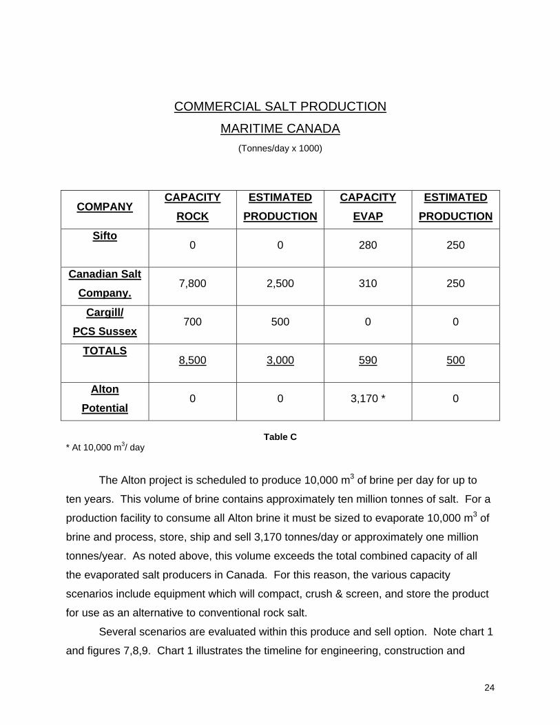
COMMERCIAL SALT PRODUCTION
MARITIME CANADA (Tonnes/day x 1000)
COMPANY CAPACITY
ROCK ESTIMATED
PRODUCTION CAPACITY
EVAP ESTIMATED
PRODUCTION
Sifto
0 0 280 250
Canadian Salt Company.
7,800 2,500 310 250
Cargill/ PCS Sussex
700 500 0 0
TOTALS
8,500 3,000 590 500
Alton Potential
0 0 3,170 * 0
Table C
* At 10,000 m3/ day
The Alton project is scheduled to produce 10,000 m3 of brine per day for up to
ten years. This volume of brine contains approximately ten million tonnes of salt. For a
production facility to consume all Alton brine it must be sized to evaporate 10,000 m3 of
brine and process, store, ship and sell 3,170 tonnes/day or approximately one million
tonnes/year. As noted above, this volume exceeds the total combined capacity of all
the evaporated salt producers in Canada. For this reason, the various capacity
scenarios include equipment which will compact, crush & screen, and store the product
for use as an alternative to conventional rock salt.
Several scenarios are evaluated within this produce and sell option. Note chart 1
and figures 7,8,9. Chart 1 illustrates the timeline for engineering, construction and
24

commissioning of a new production facility. Even the most aggressive schedule will
require 3.5 years to production. At this rate the project life for salt production is reduced
to less than seven years.
Capital cost projections do not include the cost of debt servicing. Operating
costs do not include sg&a, or charges other than the operating costs on-site. It is further
assumed that a partnership with one of the majors will be required for sales, marketing,
logistics, infrastructure, etc.
Upon review of the chart and tables it is fully apparent that this option is financially
impractical.
• The cost of capital and operating exceeds product sale price points in all
scenarios; even the one million ton facility with its economies of scale.
Therefore, the Internal Rate of Return for the project is negative; an unlikely
scenario for attracting investors.
• It is very unlikely that the market serviced from Nova Scotia can absorb
additional volume when established facilities have unused capacity and
expansion capability for less capital requirement than Alton. Also to consider is
the damage that could occur within the industry long-term for any short-term
production at Alton. Should there be an aggressive marketing and price assault
on the U.S. markets, implications under NAFTA require consideration.
• The life of the project is less that seven years and would require accelerated
depreciation and incur early costs for decommissioning and closure.
• The facility is landlocked and would require expensive on-site storage and
truck/rail freight to a port, creating a significant distribution cost disadvantage.
25

0 5 10 15 20 25 30 35 40 45
MONTHS
CAVERNDEVELOPMENT
COMMISSION
INSTALLATION
CONSTRUCTION
RECEIVE
ORDER
ENGINEERING
DRILL WELLS
GENERALIZED CONCEPTUAL DESIGN TO PRODUCTION TIMELINE, ALTON
Chart 1
26
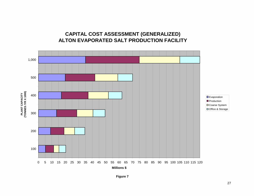
CAPITAL COST ASSESSMENT (GENERALIZED)ALTON EVAPORATED SALT PRODUCTION FACILITY
0 5 10 15 20 25 30 35 40 45 50 55 60 65 70 75 80 85 90 95 100 105 110 115 120
100
200
300
400
500
1,000
PLA
NT
CA
PAC
ITY
(TO
NN
ES /Y
R X
100
0)
Millions $
EvaporationProductionCoarse SystemOffice & Storage
Figure 7
27

SIMPLIFIED COST OF CAPITAL/TONNE ASSUMPTION
• Project life 7,000,000 tonnes production over 7 years • Follow capital cost outline from Whiting Equipment • Does not include cost of debt servicing
PLANT COST ($ x 1000)
PLANT CAPACITY (x 1000/Tonne/Yr)
LIFE (Yrs)
COST/TONNE $
20,250 100 7 28.93 34,500 200 7 24.64 49,500 300 7 23.57 62,000 400 7 22.14 70,000 500 7 20.00 120,000 1,000 7 17.14
Table D
SIMPLIFIED COST OF CAPITAL/TONNE
0 5 10 15 20 25 30
100
200
300
400
500
1,000
Tonn
es P
rodu
ced/
Year
(X
100
0)
$/TONNE
Figure 8
28
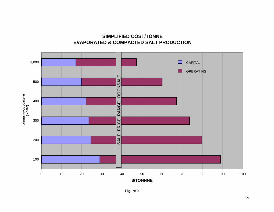
SIMPLIFIED COST/TONNE EVAPORATED & COMPACTED SALT PRODUCTION
0 10 20 30 40 50 60 70 80 90 100
100
200
300
400
500
1,000
TON
NES
PR
OD
UC
ED/Y
R
( x 1
000)
$/TONNNE
SALE
PR
ICE
RA
NG
E R
OC
KSA
LT
CAPITAL
OPERATING
Figure 9
29

SUMMARY AND CONCLUSIONS
Please refer to the “Executive Summary”.
This report by no means represents an exhaustive study. Volumes have been written
on the salt industry. The intent of the material contained herein is to provide the reader
with an overview of the industry in a regional context and how the Alton gas storage
project may apply to it.
It is concluded that none of the options considered in this report can be justified on
either an economic or volume basis.
Respectfully Submitted,
Don Dickie and Associates
Don Dickie
Lead Consultant.
30

APPENDIX PARTICIPANTS/CONTRIBUTORS TO STUDY
Mr. Jerry Poe, Technical Director, Compass Minerals International, Overland Park, Kansas. Mr. Floyd D’Entremont, Plant Manager, Sifto Canada Corp., Nappan, Nova Scotia. Mr. Art Gilroy, Buyer, Sifto Canada Corp., Nappan, Nova Scotia. Mr. Grant Sutherland, Facility Manager, The Canadian Salt Company Limited, Pugwash Mine and Refinery. Mr. Buck Wile, Mine Superintendent, The Canadian Salt Company Limited. Mr. Ben Pitman, Operations Manager, Operational Services, Town of Amherst. Mr. Aaron Bourgeois, Transportation Foreman, Operational Services, Town of Amherst. Mr. Gordon Smith, Water and Sewer Foreman, Operational Services, Town of Amherst. Mr. Gordon Hayward, Co-ordinator, Ice and Snow Program, Halifax Regional Municipality. Mr. Peter Hackett, Area Manager Colchester, Nova Scotia Department of Transportation and Public Works, Truro. Mr. Bob MacLean, Operations Supervisor Londonderry, Nova Scotia Department of Transportation and Public Works. Mr. Paul Richard, Acting Manager of Operations, Nova Scotia Department of Transportation and Public Works, Halifax, Nova Scotia Mr. David Neville, Sales Manager, Whiting Equipment Canada Inc., Welland, Ontario.
31
REFERENCES AND SUGGESTED REFERENCE MATERIAL
1. Natural Resources Canada,
Mineral and Mining Statistics On-Line,
Mines, Quarries, Pits, Bogs, Mills and Concentrators in Canada – Salt
2. Environment Canada, Road Salts,
Case Study #7
3. Health Canada
Environmental and Workplace Health,
Priority Substances List Assessment Report for Road Salts
4. Natural Resources Canada,
Mineral and Metals Sector,
“Salt”, by Michael Dumont
5. Salt in Nova Scotia,
Nova Scotia Department of Natural Resources,
Mineral Resources Branch,
Information Circulars
6. Government of Nova Scotia,
Transportation and Public Works,
Highway Operations
7. “Salt Institute” Website
32

DDDOOONNN DDDIIICCCKKKIIIEEE &&& AADDA
ASSSSSSOOOCCCIIIAAATTTEEESSS CCCOOONNNSSSUUULLLTTTAAANNNTTTSSS TTTOOO MMMAAANNNAAAGGGEEEMMMEEENNNTTT
Don Dickie, Lead Consultant Don graduated from Acadia University in Nova Scotia with a BSc, Geology and later completed a
Business Administration Certificate from Sheridan College in Oakville, Ontario. A seasoned professional
with a diverse technical and progressive management background developed over 30 years; Don has
experience in geology, rock mechanics, surface, underground and solution mining. Holding positions with
government and primarily private industry in organizations including New Brunswick, Dept. of Natural
Resources, Hudson’s Bay Mining & Smelting, Domtar Inc., Harris Chemical Group, IMC Global and
Compass Minerals International, his working locations have spanned a broad range of unionized facilities
throughout Canada, the USA and the UK.
Don’s responsibilities have ranged from exploration geologist, in-house geological and
geotechnical specialist, to operating management roles as Mine Superintendent, Operations
Superintendent, Assistant Mine Manager and Plant General Manager, applying and acquiring the
integrated skills and experience commensurate with these positions. Working mostly in industrial minerals
industries, including limestone, gypsum and potash, primary involvement has been with salt; specifically
underground mining, solution mining and cavern development, mechanical evaporation, upgrading,
manufacturing and related responsibilities. More recently activities have included feasibility studies for co-
generation, salt cavern storage of natural gas, and cavern disposal of non-hazardous oilfield waste.
Don has performed in house roles as safety trainer and total quality management trainer and
facilitator. He has authored and co-authored technical papers in geology and rock mechanics with
presentations before the Canadian Institute of Mining and Metallurgy, World Salt Congress (Kyoto,
Japan) and represented the industry as a member of the CIMM Rock Mechanics and Strata Control
Committee. An active member of his community, Don has held a number of volunteer positions.
Initiatives now involve offering value-added services to industry and government as a consulting
resource to management and lead consultant of “Don Dickie & Associates” (DDA). DDA was established
in 2006 with the primary objective of redirecting acquired skills and experience to focus on the areas of
business development, project management/participation, feasibility studies and productivity/production
analysis and enhancement.
6 Sawdon St., Sackville, New Brunswick, Canada E4L 4K5 Office; 506-536-9668 Cell; 506-536-8764 E-mail; [email protected]

FINAL REPORT
APPENDIX G Public Consultation Information
Landis Mining Corporation Suite 207, 212 – 7th Avenue SW TSX Symbol LIS Calgary, Alberta Phone (403) 263-2118 T2P 0W6 Fax (403) 264-8365
For Immediate Release February 1, 2006
News Release
Landis completes seismic and will proceed with drilling David Birkett, President of Landis Mining Corporation (symbol LIS on the TSX Venture Exchange) is pleased to announce that Landis, on behalf of itself and its partner, has completed the acquisition and interpretation of 28 km of new 2D seismic data over the Alton natural gas storage project area in Nova Scotia. Mr. Birkett commented: “We are encouraged by the results of the seismic and are proceeding with the next phase of development for the Alton natural gas storage project.” The seismic data defined an anomalously thick salt formation within the project area. The next phase of the project will include the drilling of a core hole to evaluate the cap rock above the salt formation and to confirm the correlation of the seismic data with the geology in the project area. It is anticipated that the core hole will take 40 days to complete, with commencement expected in February. Landis and its partner each own 50% interests in the Alton natural gas storage project. Under the terms of the partnership agreement, the partner will contribute up to $3 million, and Landis will contribute up to $2 million (including previously invested funds) toward the development of the project. Thereafter, the parties will be responsible for costs on an equal basis. Landis is the operator of the project. Long-term gas supply to the region is viewed as critical to the viability of the project. Landis is closely monitoring LNG projects and other offshore opportunities in the region and is moving forward with securing Letters of Intent from potential customers of the storage project. Currently there are no underground gas storage facilities north of Boston along the Maritimes and Northeast Pipeline route, which runs from Nova Scotia to the northeastern United States. Landis is an energy asset and service company and is currently developing energy related infrastructure projects in Nova Scotia. For more information, contact: Mr. David Birkett, President Landis Mining Corporation Phone: (403) 263-2118 The TSX Venture Exchange has neither approved nor disapproved the information contained herein. This news release may contain forward-looking statements. These statements are based on current company expectations, objectives and projections which are subject to risks and uncertainties. These statements reflect the best estimate with respect to future events at any given point in time. Actual results could differ materially from the forward-looking statement, due to risks and uncertainties. All forward-looking statements are expressly qualified in their entirety by this Cautionary Statement.

Landis Mining Corporation Suite 2320, 444 – 5th Avenue SW TSX Symbol LIS Calgary, Alberta Phone (403) 263-2118 T2P 2T8 Fax (403) 264-8365
For Immediate Release May 16, 2006
News Release
Landis recommences drilling David Birkett, President of Landis Mining Corporation (symbol LIS on the TSX Venture Exchange) is pleased to announce that Alton Natural Gas Storage L.P., in which Landis holds a 50% interest, has recommenced the drilling program announced in February. The delay in the drilling program was due to an early spring break up and associated road weight restrictions in Nova Scotia. Seismic data has defined an anomalously thick salt formation within the project area. This next phase of work is the drilling of a core hole to evaluate the cap rock, analyze the salt formation and correlate the seismic data with the actual geology. Long-term gas supply to the region is viewed as critical to the viability of the project. Landis is closely monitoring LNG projects and other offshore opportunities in the region and is moving forward with securing Letters of Intent from potential customers of the storage project. There are currently no underground gas storage facilities north of Boston along the Maritimes and Northeast Pipeline route, which runs from Nova Scotia to the northeastern United States. Landis is an energy asset and service company and is presently developing energy related infrastructure projects in Nova Scotia. For more information, contact: Mr. David Birkett, President Landis Mining Corporation Phone: (403) 263-2118 The TSX Venture Exchange has neither approved nor disapproved the information contained herein. This news release may contain forward-looking statements. These statements are based on current company expectations, objectives and projections which are subject to risks and uncertainties. These statements reflect the best estimate with respect to future events at any given point in time. Actual results could differ materially from the forward-looking statement, due to risks and uncertainties. All forward-looking statements are expressly qualified in their entirety by this Cautionary Statement.

Brookfield, Nova Scotia October 12, 2006
Alton Natural Gas Storage Project
The project is owned equally through a limited partnership between Landis Energy Corporation and Fort Chicago Energy Partners. Landis Energy is the operator of the project. Both Landis Energy and Fort Chicago are committed to developing energy related infrastructure projects in the province of Nova Scotia. Landis Energy and Fort Chicago are publicly traded companies, listed on the TSX Venture Exchange (symbol LIS) and TSX Exchange respectively (symbol FCE.un).
Alton Ownership
Community Benefits
To date, through Alton Natural Gas Storage L.P., Landis Energy and Fort Chicago have contributed over $1.6 million to the Nova Scotia economy. This equates to over 60% of total project expenditures. We plan to continue contributing to the community by:
• Creating jobs through the construction and operation of the facility. • Bringing gas closer to the communities of Alton, Brookfield, Stewiacke, and Truro through the
development of a gas pipeline to the Alton facility. • Decrease gas price volatility for Heritage Gas customers. • Long-term facility life – 50+ years. • Providing the opportunity for other energy related projects to develop in the area as a result of
storage. • Using local organizations whenever possible (i.e. labour, civil engineering, transportation,
restaurants, hotels, retail, etc.). • Contributing to the overall economic growth.
Alton Components
The components of the proposed project include: • Buried pipelines from the area overlaying
the salt formation to the confluence of the Shubenacadie/Stewiacke Rivers, for water withdrawal and brine discharge and;
• An underground storage facility in engineered salt caverns with above ground structures.
• Buried pipelines from the facility to the Maritimes & Northeast Pipelines system.
Landis Energy Corporation and Fort Chicago Energy Partners, through Alton Natural Gas Storage L.P., are proposing to develop an underground storage facility for natural gas near Alton, Nova Scotia to meet the growing demand for natural gas storage in Nova Scotia, New Brunswick and northeast US. Presently, no storage facilities connect to the Maritimes and Northeast Pipeline system. The project began in 2002 when Landis Energy commenced an exploration program in Nova Scotia to identify a salt formation suitable for storage. Exploration work to date and preliminary geotechnical analysis indicates a geologically sound salt formation exists between 500 and 1000 meter below the ground in the Alton area. The site has a number of advantages in addition to its proximity to the Maritimes & Northeast Pipeline. These include its geological properties and other valuable infrastructure such as rail lines, power lines and tidal river as a main water source. In October 2006, the application for a Hydrocarbon Storage Licence will be submitted to the Nova Scotia Government for approval which is the next step in developing the storage facility.
Landis Energy Corporation Suite 2320, 444 – 5th Avenue S.W. Calgary, Alberta T2P 2T8 Phone: 403-263-2118 Fax: 403-264-8365 www.landis.ca
Alton Natural Gas Storage L.P. PO Box 36052
Halifax, Nova Scotia B3J 3S9 Phone: 902-422-9718 Fax: 902-422-9421
www.altongas.com
Forward Looking Statement
This information sheet contains forward-looking information on project start-up and future demand. Actual results could differ materially due to changes in project schedules, operating performance, demand for storage, commercial negotiations or other technical and economic factors or revisions.
Management Team
David Birkett, President & CEO Gordon Hart, Chairman John Hilland, Vice President Operations Jan van Egteren, Vice President Marketing Paul MacLean, Senior Advisor
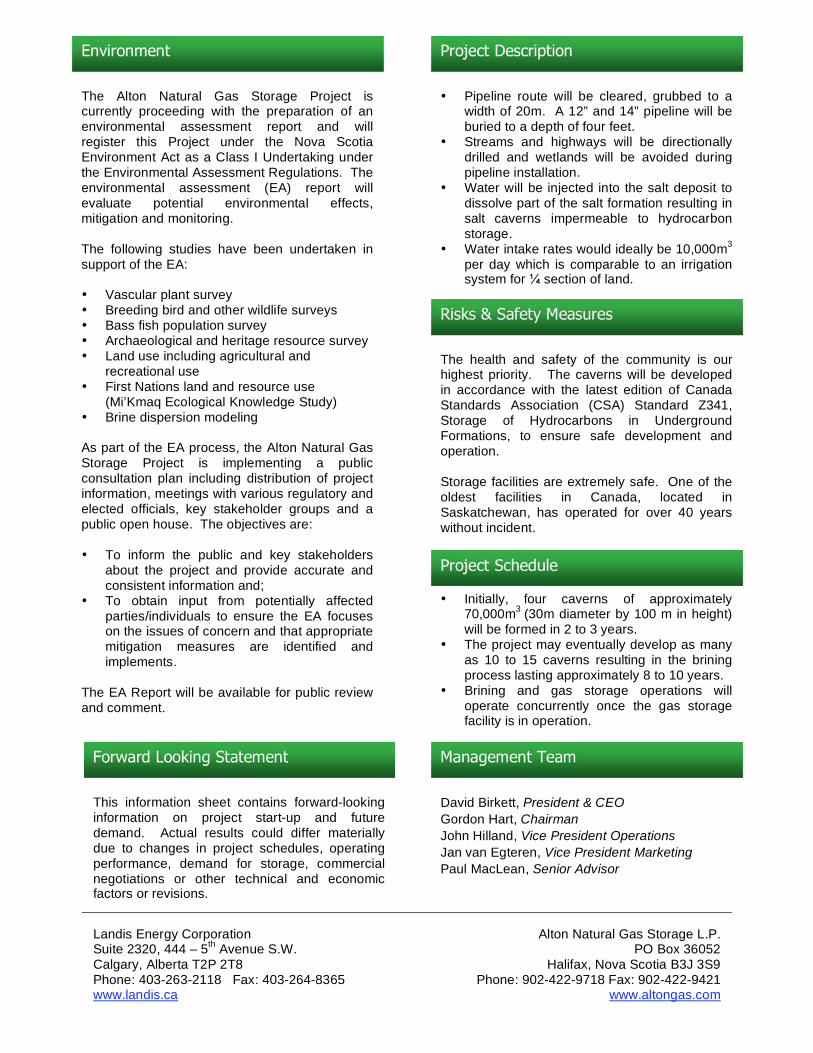
Environment
Risks & Safety Measures
The Alton Natural Gas Storage Project is currently proceeding with the preparation of an environmental assessment report and will register this Project under the Nova Scotia Environment Act as a Class I Undertaking under the Environmental Assessment Regulations. The environmental assessment (EA) report will evaluate potential environmental effects, mitigation and monitoring. The following studies have been undertaken in support of the EA: • Vascular plant survey • Breeding bird and other wildlife surveys • Bass fish population survey • Archaeological and heritage resource survey • Land use including agricultural and
recreational use • First Nations land and resource use
(Mi’Kmaq Ecological Knowledge Study) • Brine dispersion modeling As part of the EA process, the Alton Natural Gas Storage Project is implementing a public consultation plan including distribution of project information, meetings with various regulatory and elected officials, key stakeholder groups and a public open house. The objectives are: • To inform the public and key stakeholders
about the project and provide accurate and consistent information and;
• To obtain input from potentially affected parties/individuals to ensure the EA focuses on the issues of concern and that appropriate mitigation measures are identified and implements.
The EA Report will be available for public review and comment.
The health and safety of the community is our highest priority. The caverns will be developed in accordance with the latest edition of Canada Standards Association (CSA) Standard Z341, Storage of Hydrocarbons in Underground Formations, to ensure safe development and operation. Storage facilities are extremely safe. One of the oldest facilities in Canada, located in Saskatchewan, has operated for over 40 years without incident.
Project Schedule
• Initially, four caverns of approximately 70,000m3 (30m diameter by 100 m in height) will be formed in 2 to 3 years.
• The project may eventually develop as many as 10 to 15 caverns resulting in the brining process lasting approximately 8 to 10 years.
• Brining and gas storage operations will operate concurrently once the gas storage facility is in operation.
Project Description
• Pipeline route will be cleared, grubbed to a width of 20m. A 12” and 14” pipeline will be buried to a depth of four feet.
• Streams and highways will be directionally drilled and wetlands will be avoided during pipeline installation.
• Water will be injected into the salt deposit to dissolve part of the salt formation resulting in salt caverns impermeable to hydrocarbon storage.
• Water intake rates would ideally be 10,000m3 per day which is comparable to an irrigation system for section of land.


Alton Natural Gas Storage Project
Landis Energy Corporation and Fort Chicago Energy Partners, through Alton Natural Gas Storage L.P., are proposing to develop an underground storage facility for natural gas near Alton, Nova Scotia, to meet the growing demand for natural gas storage in Nova Scotia, New Brunswick, and northeast U.S. Presently, no storage facilities connect to the Maritimes & Northeast Pipeline system. The Project began in 2002 when Landis Energy commenced an exploration program in Nova Scotia to identify a salt formation suitable for storage. Exploration work to date and preliminary geotechnical analysis indicates a geologically sound salt formation exists between 500 m and 1000 m below the ground in the Alton area. An application for a Hydrocarbon Storage Licence is being submitted to the Nova Scotia Government for approval. The site has a number of advantages in addition to its proximity to the Maritimes & Northeast Pipeline. These include its geological properties and other valuable infrastructure such as power lines, rail lines, and a tidal river as the water source. The components of the proposed project include: • Buried water line from the area overlaying the
salt formation to the Shubenacadie River for water withdrawal and brine discharge
• An underground storage facility in engineered salt caverns with above ground structures
The Alton Natural Gas Storage Project is currently proceeding with the preparation of an environmental assessment (EA) report and will register this Project under the Nova Scotia Environment Act and Environmental Assessment Regulations as a Class I Undertaking. The environmental assessment will focus on key environmental and socio-economic aspects that could potentially be affected by the Project. The following studies are underway in support of the EA: • Vascular plant survey • Breeding birds and other wildlife surveys • Archaeological and heritage resource survey • Land use including agricultural and recreational
use • First Nations land and resource use (Mi’Kmaq
Ecological Knowledge Study) • Brine dispersion modeling
Project Description
• The water line route will be cleared to a width of 10 m - 20 m and 12” and 14” lines will be buried to a depth of four feet
• Streams and highways will be directionally drilled and wetlands will be avoided during water line installation
• Water will be circulated through the salt deposit to dissolve part of the salt formation resulting in salt caverns impermeable to hydrocarbons
• Water intake rates would ideally be 10,000 m3
per day, which is comparable to an irrigation system for 200 acres of land
• A future application will be made for a gas pipeline to connect the storage facility to the Maritimes & Northeast Pipeline
Environmental Assessment
Public Open House
Alton Natural Gas Storage Project
Wednesday, November 22, 2006
5pm to 8pm
Brookfield Firehall
The purpose of this public open house will be to present information on: • Project design and location • The environmental assessment process • The studies that will be undertaken as part of the
environmental assessment
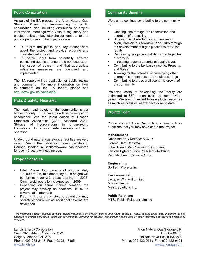
Landis Energy Corporation Suite 2320, 444 – 5
th Avenue S.W.
Calgary, Alberta T2P 2T8 Phone: 403-263-2118 Fax: 403-264-8365 www.landis.ca
Alton Natural Gas Storage L.P. PO Box 36052
Halifax, Nova Scotia B3J 3S9 Phone: 902-422-9718 Fax: 902-422-9421
www.altongas.com
Please contact Alton Gas with any comments or questions that you may have about the Project.
Management
David Birkett, President & CEO
Gordon Hart, Chairman
John Hilland, Vice President Operations
Jan van Egteren, Vice President Marketing
Paul MacLean, Senior Advisor
Engineering
SolTech Projects Inc.
Environmental
Jacques Whitford Limited
Martec Limited
Matrix Solutions Inc.
Public Relations
MT&L Public Relations Limited
Project Schedule
• Initial Phase: four caverns of approximately 100,000 m
3 (40 m diameter by 80 m height) will
be formed over 2-3 years starting in 2007. Commercial operation is expected in 2009
• Depending on future market demand, the project may develop an additional 10 to 15 caverns at a later date
• If so, brining and gas storage operations may operate concurrently as additional caverns are developed
This information sheet contains forward-looking information on Project start-up and future demand. Actual results could differ materially due to changes in project schedules, operating performance, demand for storage, commercial negotiations or other technical and economic factors or
revisions.
Risks & Safety Measures The health and safety of the community is our highest priority. The caverns will be developed in accordance with the latest edition of Canada Standards Association (CSA) Standard Z341, Storage of Hydrocarbons in Underground Formations, to ensure safe development and operation. Underground natural gas storage facilities are very safe. One of the oldest salt cavern facilities in Canada, located in Saskatchewan, has operated for over 40 years without incident.
As part of the EA process, the Alton Natural Gas Storage Project is implementing a public consultation plan including distribution of project information, meetings with various regulatory and elected officials, key stakeholder groups, and a public open house. The objectives are: • To inform the public and key stakeholders
about the project and provide accurate and consistent information
• To obtain input from potentially affected parties/individuals to ensure the EA focuses on the issues of concern and that appropriate mitigation measures are identified and implemented
The EA report will be available for public review and comment. For more information on how to comment on the EA report, please see
http://www.gov.ns.ca/enla/ea/.
Public Consultation Community Benefits We plan to continue contributing to the community by: • Creating jobs through the construction and
operation of the facility • Bringing gas closer to the communities of
Alton, Brookfield, Stewiacke, and Truro through the development of a gas pipeline to the Alton facility
• Decreasing gas price volatility for Heritage Gas customers
• Increasing regional security of supply levels • Contributing to the tax base (Income, Property,
and Sales) • Allowing for the potential of developing other
energy related projects as a result of storage • Contributing to the overall economic growth of
the community Projected costs of developing the facility are estimated at $60 million over the next several years. We are committed to using local resources as much as possible, as we have done to date.
Project Team

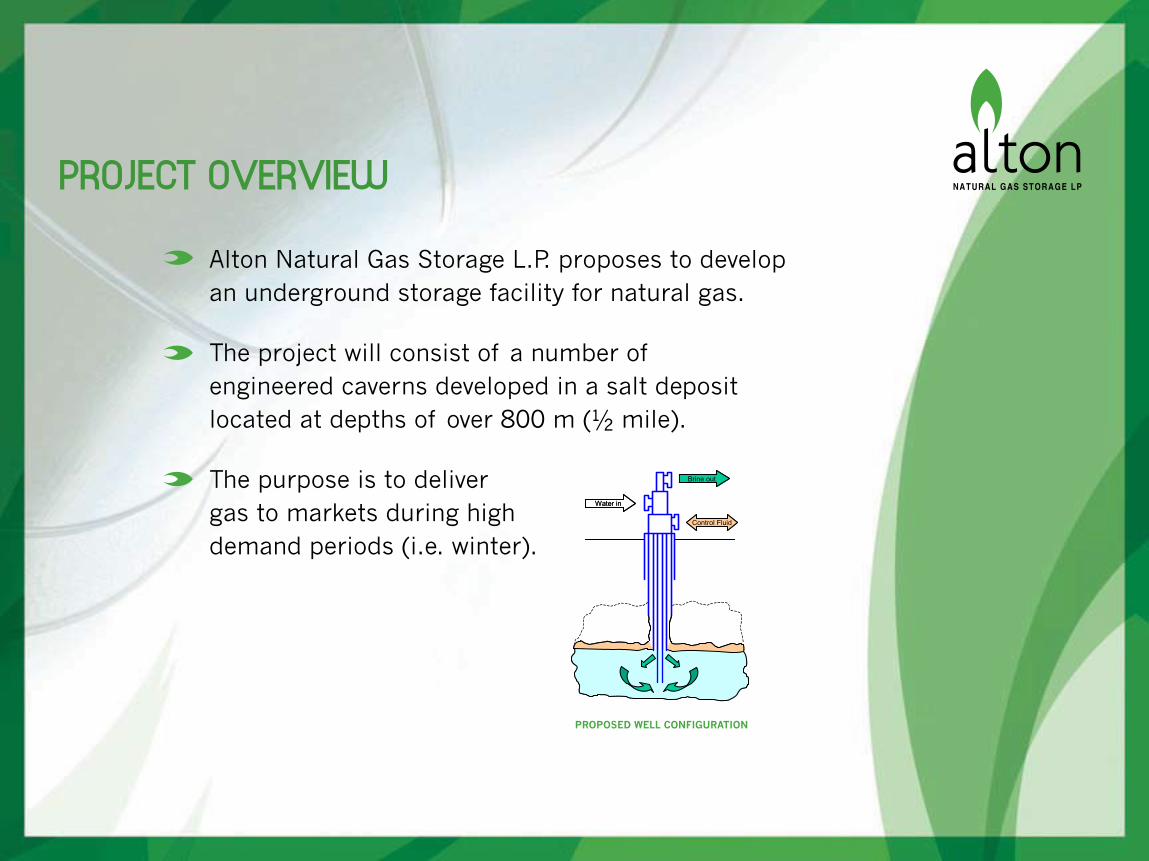
PROJECT OVERVIEW
Alton Natural Gas Storage L.P. proposes to develop an underground storage facility for natural gas.
The project will consist of a number of engineered caverns developed in a salt deposit located at depths of over 800 m (½ mile).
The purpose is to deliver gas to markets during high demand periods (i.e. winter).
Water in
Brine out
Control Fluid
PROPOSED WELL CONFIGURATION
HISTORY AND CURRENT USE
Salt caverns are very safe.
The first salt caverns used for natural gas storage in Canada were built in Saskatchewan in 1963.
Over 35 underground salt cavern facilities operating in North America.
Caverns will be developed in accordance with the latest edition of Canadian Standards Association (CSA) Standard Z341, Storage of Hydrocarbons in Underground Formations, to ensure safe development and operation.

PROJECT COMPONENTS
Buried waterlines from the facility to the Shubenacadie River for brackish water withdrawal and brine discharge.
Buried gas pipeline from the facility to the Maritimes and Northeast Pipeline Halifax lateral.
Engineered salt caverns with above ground structures.
• Four caverns approximately 40 m in diameter by 80 m in height.
NATURAL GAS STORAGE FACILITY


PROJECT DESCRIPTION
A waterline route will be cleared to a width of 10 m – 20 m.
• 12” and 14” pipelines will be buried to a depth of four feet.
• Streams and highways directionally drilled and wetlands avoided.
Brackish water intake rate approx. 10,000 m3 per day.
• Comparable to an irrigation system for 200 acres of land.
Water will be circulated through the salt deposit to dissolve a salt cavern impermeable to hydrocarbons.
Brine will be discharged into the tidal Shubenacadie River.
RECORDING FLOW
HIGH FLOW RATES
LOW FLOW RATES

PROPOSED PROJECT SCHEDULE
ALTON NATURAL GAS STORAGE PROJECT 2007 2008 2009 2010Q1 Q2 Q3 Q4 Q1 Q2 Q3 Q4 Q1 Q2 Q3 Q4 Q1 Q2 Q3 Q4
Pre-DevelopmentRegulatory Filings/Engineering/Commercial/Permits Approved
DevelopmentWaterline ConstructionGas Pipeline Regulatory FilingsGas Pipeline ConstructionCavern 1 Drilling
Cavern 1 BriningCavern 2 Drilling
Cavern 3 DrillingCavern 3 Brining
Cavern 4 DrillingCavern 4 Brining
CompressorsIn Service Date
Cavern 2 Brining
ENVIRONMENTAL ASSESSMENT
The Environmental Assessment (EA) report is currently being prepared.
The project will be registered with the Nova Scotia Environmental Act and Environmental Assessment Regulations as a Class I Undertaking.
The EA will focus on environmental and socio – economic aspects. Studies include:
• Vascular plant survey;
• Breeding birds and other wildlife surveys;
• Archaeological and heritage resource survey;
• Land use including agricultural and recreational use;
• First Nations land and resource use (Mi’kmaq Ecological Knowledge Study); and
• Brine dispersion modeling.

PUBLIC CONSULTATION
The public consultation plan includes distribution of project information, meetings with various regulatory and elected officials, key stakeholder groups, and a public open house. The objectives are:
• To inform the public and key stakeholders about the project and provide accurate and consistent information.
• To obtain input from potentially affected parties/individuals to ensure the EA focuses on the issues of concern and that appropriate mitigation measures are identified and implemented.
The EA report will be available for public review and comment.

1/2
Alton Natural Gas Storage Project
www.altongas.com
PUBLIC OPEN HOUSE November 22, 2006
Brookfield, Nova Scotia
FEEDBACK FORM Thank you for attending the Open House. We encourage you to complete the following feedback form. Your input will help us to identify key issues and concerns related to this Project and will be incorporated in the environmental assessment. For more information, please contact [email protected] or 902-468-7777, extension 380. Name: Organization (if any): Mailing Address: Telephone: E-mail:
How did you hear about the Open House?
Letter Newspaper Word of Mouth Other
Comments:
(Additional space provided on back)

2/2

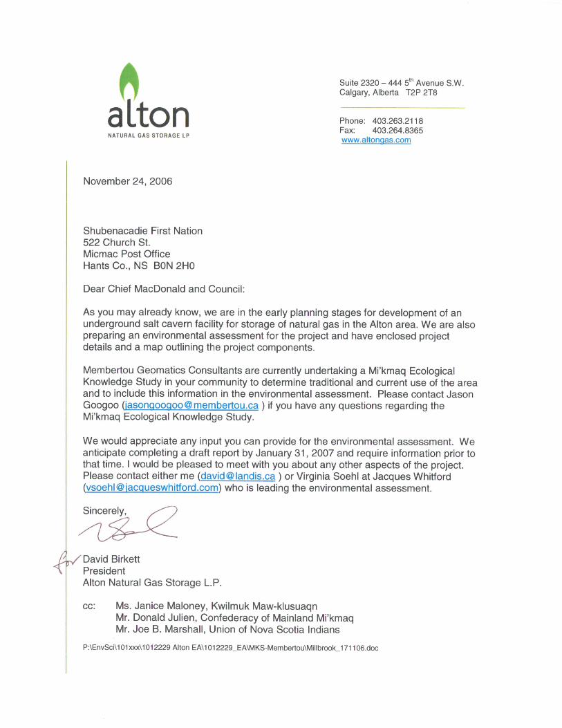

FINAL REPORT
APPENDIX H Disposition Table with Draft EA Comments
Comments on Proposed Alton Natural Gas Storage Project Draft EA Document May 2007
Comment No. Originator Question/Statement 1 Response
NSEL-AC-01 Andrew D Cameron
The authors of the report appear to understand the issues associated with agriculture and provide a reasonable approach toward a solution.
Comment noted.
NSEL-MT-01 Minh TanEnvironmental Chemical SpecialistNSEL
Overall, it was very well done with lots of details. Design is not complete so further details are still to come, but request was made for some of that information to ensure it will be there in capacities desired. Specific comments are as follows:
Comment noted.
NSEL-MT-02 Minh TanEnvironmental Chemical SpecialistNSEL
Please briefly elaborate on some applicable requirements of ASME B31.3. While I expect this is a very technical document, referencing it without giving details of any type leaves it somewhat meaningless.
EA text updated with the following text in Section 2.1.1.2:This American Society of Mechanical Engineers Code contains requirements for piping typically found in petroleum refineries; chemical, pharmaceutical, textile, paper, semiconductor, and cryogenic plants, and related processing plants and terminals. The requirements cover materials and components, design, fabrication, assembly, erection, examination, inspection, and testing of piping. Also included is piping which interconnects pieces or stages within a packaged equipment assembly.
NSEL-MT-03 Minh TanEnvironmental Chemical SpecialistNSEL
Please provide a clear summary statement on Alton's commitment to meeting or exceeding CSA Z341. Alton said it would meet or exceed requirements of CSA Z341 on numerous occasions relating to various aspects of CSA Z341 in talking about related aspects of the project. CSA Z341 is lengthy, and it is not clear how much of CSA Z341 the numerous commitments made by Alton would cover. A Board established under the Pipeline Regulations would determine what of CSA Z341 would be required for adherence, the terms of which would not be known until after an EA. However, Alton seem to already know what it intends to meet or exceed of CSA Z341 so perhaps it could make an overarching summary statement whether it intends to meet or exceed CSA Z341 as required by that Board (minimum required), potentially in more capacities than would be required, or in all aspects of CSA Z341, additional to many similar small statements made in the draft EA.
EA updated with the following text in Section 2.5: The most common cause of incidents is from undetected corrosion in the wellbore, wellhead or surface piping, aggravated by poorly designed control and safety systems and/or poor operating procedures. CSA Z341 recognizes that corrosion may be an important factor in cavern system failures, and therefore addresses this issue in a number of sections. For example, casing inspection logs capable of identifying corrosion are required before placing the system in service, and every 10 years thereafter. Where a cavern well passes through a potentially corrosive zone, a special completion is required with extra tubing creating an annulus that is filled with a corrosion inhibiting fluid. A full section, Section 8.4, is devoted to Corrosion Control requirements, and includes the use of impressed-current cathodic protection systems. CSA Z341 specifies that corrosion control monitoring shall conform to a further standard, NACE RP0186.
Surface piping and equipment is more accessible, and therefore easier to monitor for corrosion. In gas plants and facilities such as the Alton project, this is normally done by the use of ultrasonic thickness tests and the evaluation of corrosion coupons; these items will be used in the Alton project. Weekly visual inspection of all components will be used to monitor external corrosion, and special materials or coatings will be employed where they can be effective. Alton intends to install and use a de-aerator to reduce the oxygen level in the intake water to reduce internal corrosion in the piping, vessels and wells. In addition, corrosion allowances will be incorporated into the design of all these components. Regular testing will also be employed to check for a number of potential problems, including corrosion.
NSEL-MT-04 Minh TanEnvironmental Chemical SpecialistNSEL
Many failures of similar facilities in North America cited in Section 2.5 had to do with corrosion, ultimately. While corrosion is addressed later on in brief discussion of potential hazards and safety features, a brief discussion here on how corrosion will be monitored in the Alton project so as to avoid any similar outcomes would be effective, though not necessary.
EA updated with the following text in Section 2.5: CSA Z341 is the standard specified by the Nova Scotia Code of Practice Respecting the Underground Storage of Hydrocarbons. It is the only such standard worldwide, and is specified and/or copied in many jurisdictions. This standard recognizes that corrosion may be an important factor in cavern system failures, and therefore addresses this issue in a number of sections. For example, casing inspection logs capable of identifying corrosion are required before placing the system in service, and every 10 years thereafter. Where a cavern well passes through a potentially corrosive zone, a special completion is required with extra tubing creating an annulus that is filled with a corrosion inhibiting fluid. A full section, Section 8.4, is devoted to Corrosion Control requirements, and includes the use of impressed-current cathodic protection systems. CSA Z341 specifies that corrosion control monitoring shall conform to a further standard, NACE RP0186. Surface piping and equipment is more accessible, and therefore easier to monitor for corrosion. In gas plants and facilities such as the Alton project, this is normally done by the use of ultrasonic thickness tests and the evaluation of corrosion coupons; these items will be used in the Alton project. Weekly visual inspection of all components will be used to monitor external corrosion, and special materials or coatings will be employed where they can be effective. Alton intends to install and use a de-aerator to reduce the oxygen level in the intake water to reduce internal corrosion in the piping, vessels and wells. In addition, corrosion allowances will be incorporated into the design of all these components. Regular testing will also be employed to check for a number of potential problems, including corrosion.
1 of 17

Comments on Proposed Alton Natural Gas Storage Project Draft EA Document May 2007
Comment No. Originator Question/Statement 1 Response
NSEL-MT-05 Minh TanEnvironmental Chemical SpecialistNSEL
Please provide Emergency Response and Contingency Plans with details. There was very impressively thorough discussion of potential hazards and environmental impacts from them. However, in most cases, Emergency Response Plans and/or Contingency Plans were only roughly outlined as to what they would be intended to do, or approaches were generally given, rather than specific details. Design is not complete so the details are not yet available. However, plans with details are required for the final EA. Please be sure to provide details of such plans, including training of local personnel depended upon like fire fighters, for all situations considered since if they were deemed worthy for consideration based on "reasonable" probability of occurrence, that should justify having details ready for plans to handle these situations. The request for details in these plans should be reasonable given most situations are limited in potential consequences, as stated by Alton.
It is standard practice for NS provincial EAs to provide an outline of the Emergency Response and Contingency Plan in the EA registration document. Additional details will be provided in the Environmental Protection Plan with final design plans provided to regulators when available.
NSEL-MT-06 Minh TanEnvironmental Chemical SpecialistNSEL
Please provide more thorough test results for some parts of Table 6.1 on Element Levels in Diluted (10:1) Brine [pg 84-85]. The problem is that the Detection Level is sometimes at CCME guidelines or above, rendering the result ineffective. An example would be for Selenium. CCME allows for 0.1 ug/L, but the detection level is at 50 ug/L. A No Detection result could mean some 49 ug/L could be present, which is way beyond the 0.1 ug/L limit. There is no hope of detecting potentially dangerous levels of selenium given the parameters used for measurement so the No Detection conclusion drawn may be dangerously incorrect. As well, please add other sources of recommended limits besides CCME where CCME does not have a value, and identify those sources with an asterisk or some other symbol. CCME may not have a limit, but that does not mean some other reputable source may not have recommended a limit. Having a limit helps give Reported Levels context and meaning. Otherwise, there is no way to determine if the Detection Level might have been sufficient to address required or meaningful testing, nor if Reported Levels might be "safe" pending recommended values and non-CCME source credibility. Of course, there is less or no expectation to comply with non-CCME sources' recommended values, but it does help put results into some sort of context, especially if other sources were fairly credible, like the US Environmental Protection Agency. Only with this context can the true potential damage of brine discharge could be assessed.
The analytical tests conducted on the brine dilution were intended as an indicator of the levels of potentially harmful metals in the salt-core that may be introduced to the Estuary via diluted brine discharge. Maxxam Analytical Laboratories (the laboratory retained by the proponent to conduct analytical testing) endeavoured for detection limits to be at or below the Canadian Council of Ministers of the Environment (CCME) interim Canadian Water Quality Guidelines for the Protection of Aquatic Life, (CCME 1996); however, the presence of high levels of sodium chloride (salt) made it unfeasible to have detection limits at or below the CCME guideline limit for all metals (i.e. , cadmium, chromium, copper, iron, selenium, and thallium). The CCME guideline limits that are below the detection limits generally pertain to limits identified for freshwater systems and the aqueous solutions tested were essentially seawater (~26 ppt) and thus Maxxam could not achieve detection limits at or below the CCME freshwater guidelines. Regardless, no exceptionally high levels of metals in the salt core were indicated by results and thus the present analytical results give a proximate indicator of the potential risk that metals in the salt-core pose to aquatic receptors. The EA report has been revised to acknowledge the limitations of inferring the risk of toxic effects due other metals present in the salt-core based on existing analytical results. Other guidelines have been referenced to give context to results for metals for which no CCME guidelines apply, refer to Table 6.1 in the EA document. Given the limitations of the existing analytical results, the risk of other elements present in the salt-core (and thus in diluted brine discharged to the Estuary) will be determined by toxicity testing using diluted brine and representative organisms. In addition, more detailed analytical testing may be required on the brine (at varying dilutions) if tested solutions are deemed to have toxic effects. The specifics of this toxicity testing program will be developed in consultation with regulators, most notably Environment Canada. The test solution used for toxicity testing would consist of saturated brine from the salt-core diluted to mimic the upper-target salinity level of discharge at the outlet of the holding pond (i.e. , 25 ppt).
NSEL-MT-07 Minh TanEnvironmental Chemical SpecialistNSEL
Please include brief, but required, statements on Funding Sources and Other Approvals Required for the EA.
As stated in Section 2.6, this Project will be 100% privately funded. Alton Natural Gas Storage L.P. is committed to using local resources where possible.
NSEL-GC-01 Gordon G. CheckHydrogeologist NSEL
From a geoscience point of view, in my opinion there should be more information provided in the document related to the geology of the actual salt storage. This includes providing a geological cross-section to show the location and stratigraphy of the salt layering (Figure 5.1 is a 2-D geological map view and does not actually confirm salt anywhere in the area). This may include providing a graphical figure of the borehole stratigraphy from the (1) apparent test hole to date as well as any other relevant testing (seismic etc.). This project is completely dependent on the right subsurface geological conditions - but information confirming these has not been provided.
Details of the seismic data are proprietary but can be discussed with government regulators on request. EA updated with the following text in Section 5.1 to provide further clarification: In early 2005, 8 km of seismic data was acquired from Hunt Oil Company. This survey tied into the EOG/Hunt Cloverdale #1 well and the Hunt Alton 99-1 well, which had encountered 420 m of salt. This program allowed Alton to regionally understand the salt formation in the area surrounding the permits held today. In 2005, a gravity survey was conducted in order to correlate the seismic data with gravity in an attempt to gain a better understanding of the formation and to outline potentially deeper and thicker portions of the salt formation. Later that year, Alton conducted a 28 km seismic survey within the present salt and potash licences and mineral exploration licences. The survey defined an area with the desired geological characteristics to allow for the storage of hydrocarbons. In the winter and spring of 2006, Alton drilled a core hole 650 m to the north of the Hunt Alton 99-1 well to confirm the seismic interpretation and candidacy of the salt formation for the use of underground hydrocarbon storage. The drilling program was conducted on the Special Licence No.1-05.
NSEL-GC-02 Gordon G. CheckHydrogeologist NSEL
A second related aspect to this is that, again in my view, the conceptual cavern development diagram (Figure 2.3) should be related more directly to the actual site geology - both in cross-section as well as plan view on a map. The diagram is far too simplified/generalized. Where exactly are these caverns being proposed ? Under the Estuary ? Where are the proposed cavern boundaries relative to the known subsurface geology ? Much better graphic(s) should be prepared to show these things. This is relevant information to ask for.
Figure 2.3 revised and basemapping revised to indicate subsurface footprint.
2 of 17
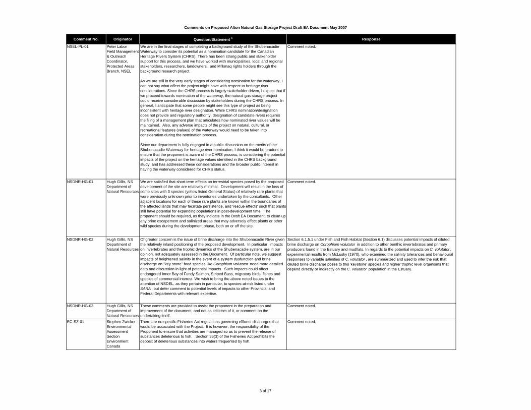
Comments on Proposed Alton Natural Gas Storage Project Draft EA Document May 2007
Comment No. Originator Question/Statement 1 Response
NSEL-PL-01 Peter LaborField Management & Outreach Coordinator, Protected Areas Branch, NSEL
We are in the final stages of completing a background study of the Shubenacadie Waterway to consider its potential as a nomination candidate for the Canadian Heritage Rivers System (CHRS). There has been strong public and stakeholder support for this process, and we have worked with municipalities, local and regional stakeholders, researchers, landowners, and Mi'kmaq rights holders through the background research project.
As we are still in the very early stages of considering nomination for the waterway, I can not say what affect the project might have with respect to heritage river considerations. Since the CHRS process is largely stakeholder driven, I expect that if we proceed towards nomination of the waterway, the natural gas storage project could receive considerable discussion by stakeholders during the CHRS process. In general, I anticipate that some people might see this type of project as being inconsistent with heritage river designation. While CHRS nomination/designation does not provide and regulatory authority, designation of candidate rivers requires the filing of a management plan that articulates how nominated river values will be maintained. Also, any adverse impacts of the project on natural, cultural, or recreational features (values) of the waterway would need to be taken into consideration during the nomination process.
Since our department is fully engaged in a public discussion on the merits of the Shubenacadie Waterway for heritage river nomination, I think it would be prudent to ensure that the proponent is aware of the CHRS process, is considering the potential impacts of the project on the heritage values identified in the CHRS background study, and has addressed these considerations and the broader public interest in having the waterway considered for CHRS status.
Comment noted.
NSDNR-HG-01 Hugh Gillis, NS Department of Natural Resources
We are satisfied that short-term effects on terrestrial species posed by the proposed development of the site are relatively minimal. Development will result in the loss of some sites with 3 species (yellow listed General Status) of relatively rare plants that were previously unknown prior to inventories undertaken by the consultants. Other adjacent locations for each of these rare plants are known within the boundaries of the affected lands that may facilitate persistence, and 'rescue effects' such that plants still have potential for expanding populations in post-development time. The proponent should be required, as they indicate in the Draft EA Document, to clean up any brine escapement and salinized areas that may adversely effect plants or other wild species during the development phase, both on or off the site.
Comment noted.
NSDNR-HG-02 Hugh Gillis, NS Department of Natural Resources
Of greater concern is the issue of brine discharge into the Shubenacadie River given the relatively inland positioning of the proposed development. In particular, impacts on invertebrates and the trophic dynamics of the Shubenacadie system, are in our opinion, not adequately assessed in the Document. Of particular note, we suggest impacts of heightened salinity in the event of a system dysfunction and brine discharge on "key stone" food species like Corophium volutator need more detailed data and discussion in light of potential impacts. Such impacts could affect endangered Inner Bay of Fundy Salmon, Striped Bass, migratory birds, fishes and species of commercial interest. We wish to bring the above noted issues to the attention of NSDEL, as they pertain in particular, to species-at-risk listed under SARA , but defer comment to potential levels of impacts to other Provincial and Federal Departments with relevant expertise.
Section 6.1.5.1 under Fish and Fish Habitat (Section 6.1) discusses potential impacts of diluted brine discharge on Corophium volutator in addition to other benthic invertebrates and primary producers found in the Estuary and mudflats. In regards to the potential impacts on C. volutator , experimental results from McLusky (1970), who examined the salinity tolerances and behavioural responses to variable salinities of C. volutator , are summarized and used to infer the risk that diluted brine discharge poses to this 'keystone' species and higher trophic level organisms that depend directly or indirectly on the C. volutator population in the Estuary.
NSDNR-HG-03 Hugh Gillis, NS Department of Natural Resources
These comments are provided to assist the proponent in the preparation and improvement of the document, and not as criticism of it, or comment on the undertaking itself.
Comment noted.
EC-SZ-01 Stephen ZwickerEnvironmental Assessment SectionEnvironment Canada
There are no specific Fisheries Act regulations governing effluent discharges that would be associated with the Project. It is however, the responsibility of the Proponent to ensure that activities are managed so as to prevent the release of substances deleterious to fish. Section 36(3) of the Fisheries Act prohibits the deposit of deleterious substances into waters frequented by fish.
Comment noted.
3 of 17
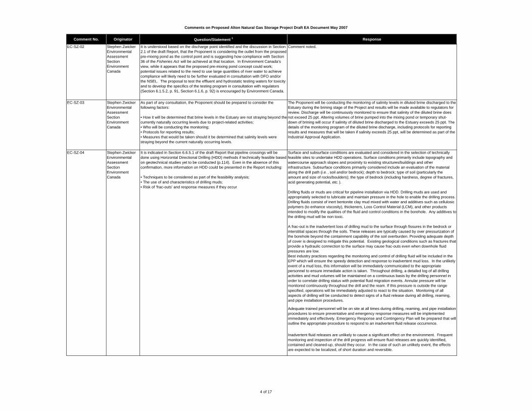
Comments on Proposed Alton Natural Gas Storage Project Draft EA Document May 2007
Comment No. Originator Question/Statement 1 Response
EC-SZ-02 Stephen ZwickerEnvironmental Assessment SectionEnvironment Canada
It is understood based on the discharge point identified and the discussion in Section 2.1 of the draft Report, that the Proponent is considering the outlet from the proposed pre-mixing pond as the control point and is suggesting how compliance with Section 36 of the Fisheries Act will be achieved at that location. In Environment Canada’s view, while it appears that the proposed pre-mixing pond concept could work; potential issues related to the need to use large quantities of river water to achieve compliance will likely need to be further evaluated in consultation with DFO and/or the NSEL. The proposal to test the effluent and hydrostatic testing waters for toxicity and to develop the specifics of the testing program in consultation with regulators (Section 6.1.5.2, p. 91, Section 6.1.6, p. 92) is encouraged by Environment Canada.
Comment noted.
EC-SZ-03 Stephen ZwickerEnvironmental Assessment SectionEnvironment Canada
As part of any consultation, the Proponent should be prepared to consider the following factors:
• How it will be determined that brine levels in the Estuary are not straying beyond the currently naturally occurring levels due to project-related activities;• Who will be conducting the monitoring; • Protocols for reporting results; • Measures that would be taken should it be determined that salinity levels were straying beyond the current naturally occurring levels.
The Proponent will be conducting the monitoring of salinity levels in diluted brine discharged to the Estuary during the brining stage of the Project and results will be made available to regulators for review. Discharge will be continuously monitored to ensure that salinity of the diluted brine does not exceed 25 ppt. Altering volumes of brine pumped into the mixing pond or temporary shut-down of brining will occur if salinity of diluted brine discharged to the Estuary exceeds 25 ppt. The details of the monitoring program of the diluted brine discharge, including protocols for reporting results and measures that will be taken if salinity exceeds 25 ppt, will be determined as part of the Industrial Approval Application.
EC-SZ-04 Stephen ZwickerEnvironmental Assessment SectionEnvironment Canada
It is indicated in Section 6.6.5.1 of the draft Report that pipeline crossings will be done using Horizontal Directional Drilling (HDD) methods if technically feasible based on geotechnical studies yet to be conducted (p.114). Even in the absence of this confirmation, more information on HDD could be presented in the Report including:
• Techniques to be considered as part of the feasibility analysis; • The use of and characteristics of drilling muds;• Risk of 'frac-outs' and response measures if they occur
Surface and subsurface conditions are evaluated and considered in the selection of technically feasible sites to undertake HDD operations. Surface conditions primarily include topography and watercourse approach slopes and proximity to existing structures/buildings and other infrastructure. Subsurface conditions primarily considered include an evaluation of the material along the drill path (i.e. , soil and/or bedrock); depth to bedrock; type of soil (particularly the amount and size of rocks/boulders); the type of bedrock (including hardness, degree of fractures, acid generating potential, etc. ).
Drilling fluids or muds are critical for pipeline installation via HDD. Drilling muds are used and appropriately selected to lubricate and maintain pressure in the hole to enable the drilling process. Drilling fluids consist of inert bentonite clay mud mixed with water and additives such as cellulosic polymers (to enhance viscosity), thickeners, Loss Control Material (LCM), and other products intended to modify the qualities of the fluid and control conditions in the borehole. Any additives to the drilling mud will be non toxic.
A frac-out is the inadvertent loss of drilling mud to the surface through fissures in the bedrock or interstitial spaces through the soils. These releases are typically caused by over pressurization of the borehole beyond the containment capability of the soil overburden. Providing adequate depth of cover is designed to mitigate this potential. Existing geological conditions such as fractures that provide a hydraulic connection to the surface may cause frac-outs even when downhole fluid pressures are low.Best industry practices regarding the monitoring and control of drilling fluid will be included in the EPP which will ensure the speedy detection and response to inadvertent mud loss. In the unlikely event of a mud loss, this information will be immediately communicated to the appropriate personnel to ensure immediate action is taken. Throughout drilling, a detailed log of all drilling activities and mud volumes will be maintained on a continuous basis by the drilling personnel in order to correlate drilling status with potential fluid migration events. Annular pressure will be monitored continuously throughout the drill and the ream. If this pressure is outside the range specified, operations will be immediately adjusted to react to the situation. Monitoring of all aspects of drilling will be conducted to detect signs of a fluid release during all drilling, reaming, and pipe installation procedures.
Adequate trained personnel will be on site at all times during drilling, reaming, and pipe installation procedures to ensure preventative and emergency response measures will be implemented immediately and effectively. Emergency Response and Contingency Plan will be prepared that will outline the appropriate procedure to respond to an inadvertent fluid release occurrence.
Inadvertent fluid releases are unlikely to cause a significant effect on the environment. Frequent monitoring and inspection of the drill progress will ensure fluid releases are quickly identified, contained and cleaned-up, should they occur. In the case of such an unlikely event, the effects are expected to be localized, of short duration and reversible.
4 of 17

Comments on Proposed Alton Natural Gas Storage Project Draft EA Document May 2007
Comment No. Originator Question/Statement 1 Response
EC-SZ-05 Stephen ZwickerEnvironmental Assessment SectionEnvironment Canada
In several sections of the draft Report, HDD is identified as a primary mitigation measure for protection of sensitive environmental resources (e.g., pp. 96, 102, 104). Given that the feasibility of HDD at each of these locations has not been determined, alternative crossing methods and their potential environmental impacts should be discussed.
As discussed in Section 6.1.4 under Fish and Fish Habitat (Section 6.1), if HDD is not practical given the underlying geology, alternative stream crossing methods will be developed in consultation with DFO and NSEL. Supporting work will include detailed fish habitat assessments, permit application and habitat compensation (if required), stream specific mitigation, sediment control plans and follow-up monitoring.
EC-SZ-06 Stephen ZwickerEnvironmental Assessment SectionEnvironment Canada
It is not clear from the draft Report how unplanned fluid releases which could occur during directional drilling would be managed. A release of drilling fluids or cuttings into water frequented by fish could constitute a violation of the Fisheries Act (s. 36[3]). Where applicable, it is recommended that the directional drilling path selection process and corresponding efforts establish due diligence in preventing frac-out or any other spill, and to ensure compliance with Section 36(3) of the Fisheries Act be documented.
Comment noted. See response to EC-SZ-04.
EC-SZ-07 Stephen ZwickerEnvironmental Assessment SectionEnvironment Canada
More information on the use of glycol for dehydration purposes during the operation of the facility is needed. The draft Report indicates that the dehydration process is not connected to the brine disposal stream but some waste water will be generated from this process. In one of the diagrams in Appendix D, there is a reference to a wastewater tank, however important details related to this tank are lacking including: • the amount of water that will be generated from the dehydration process;• the predicted quality of the water; and, • where the water will be directed after leaving the wastewater tank
EA updated with the following text in Section 2.1.2.6: Tri-ethlyene glycol dehydration is a standard method of removing any water vapour from a natural gas stream. Water in the gas may condense, and at high pressures may cause the formation of a hydrate, much like ice, that can plug piping systems even at room temperatures. Pipeline specifications therefore require the removal of excess water to a level below which hydrates can occur. In a glycol dehydrator, the gas passes through a trayed or packed vessel where it contacts very pure glycol, which absorbs the moisture. The glycol then flows to a regenerator, where it is heated to distil the absorbed water from it. This water usually comes off as steam and is vented as vapour. If the gas stream tobe dehydrated contains substances such as benzene, toluene or xylene, these will be condensed and drained to a special waste tank, from which it will be transported to a refinery for processing, or to a suitable waste facility. The amount of water that will be generated from the dehydrator is a function of the amount remaining on the walls of the cavern and the residence time for evaporation of this water. When first placed in service, there will be more water than will be available after a few injection/withdrawal cycles. As the cavern pressure declines with removal of stored gas, the amount of water that the gas can hold increases. At maximum, and for design purposes, the gas may contain about 0.034 m3 of water per mmscf, and this would be reduced to 0.002 m3/mmscf. At a flow rate of 135 mmscf per day, this would amount to about 4.59 m3 per day. Typically this rate would occur for very little of the total production.
EC-SZ-08 Stephen ZwickerEnvironmental Assessment SectionEnvironment Canada
As part of planning and construction of any Project, a number of measures need to be considered implemented as applicable to minimize and control erosion and sedimentation including the following:· coordinate construction activities with seasonal constraints (e.g., time clearing, grubbing, and excavation activities to avoid heavy precipitation; avoid sensitive periods for fish and wildlife; shut down and stabilize the work site in accordance with pre-established criteria in advance of the winter season) {before revegetation is no longer possible and before freeze-up};· implement measures in advance of grubbing and excavation activities, that will allow surface drainage to be diverted around the work area;· implement further mitigative actions as necessary based on monitoring results.· monitor any nearby receiving waters for total suspended solids or contaminants of concern to ensure maintenance of the Canadian Council of Ministers of the Environment (CCME) Environmental Quality Guidelines for the protection of aquatic life (http://www.ccme.ca/publications/ceqg_rcqe.html) when considered in conjunction with existing ambient water quality and site-specific factors;· maintain sediment control structures (by inspecting and repairing structural problems during and after storm events, removing accumulated sediment at regular intervals or at designated capacities, and by disposing of it at an approved site, given its unsuitability as structural fill material);· stabilize exposed soil as soon as possible (e.g., stabilize interim exposed soil with mulch, erosion control blankets or final exposed soil with fast-growing, non-invasive, native vegetation);· minimize the exposed soil area (by limiting the area that is exposed at any one time and by limiting the amount of time that any area is exposed);· maintain vegetated buffer zones as appropriate to protect environmental values;· install all perimeter control structures (e.g., silt fencing, sediment traps, settling ponds) prior to any land disturbance.
Comment noted. Measures to minimize and control erosion and sedimentation will be built into the Project specific Environmental Protection Plan (EPP), where applicable. In addition, the EA report (Section 6.1.5.1, Habitat Effects) has been updated to include these measures and other more specific mitigative strategies to avoid or minimize the introduction of sediment to the Estuary.
5 of 17

Comments on Proposed Alton Natural Gas Storage Project Draft EA Document May 2007
Comment No. Originator Question/Statement 1 Response
EC-SZ-09 Stephen ZwickerEnvironmental Assessment SectionEnvironment Canada
The Project has the potential to impact migratory birds. The conservation of migratory birds is the joint responsibility of the countries these birds visit during the breeding, migration, and non-breeding seasons. Environment Canada is responsible for fulfilling Canada's obligations for the conservation of migratory birds through administration of the Migratory Birds Convention Act (MBCA ) and the associated regulations. Migratory birds protected by the Act generally include all seabirds except cormorants and pelicans, all waterfowl, all shorebirds, and most landbirds (birds with principally terrestrial life cycles). Most of these birds are specifically named in the Environment Canada publication, Birds Protected in Canada under the Migratory Birds Convention Act , Canadian Wildlife Service Occasional Paper No. 1.
Comment noted.
EC-SZ-10 Stephen ZwickerEnvironmental Assessment SectionEnvironment Canada
At this point, it is unclear how the Proponent proposes to comply with the MBCA. Thedraft Report does not include a clear commitment to avoid the destruction of active nests of migratory birds and comply with the MBCA . The Report states that "Clearing should be conducted during the fall and winter" (p. 101) but then later states that "If clearing is necessary prior to August 15, the Project area will be monitored for breeding activities no more than one week prior to beginning of Project activities. Activities which may impact the young will not occur within a 50 m buffer zone surrounding the nest." The proposal to have an ornithologist conduct a nest survey in advance of clearing in order to identify the presence of nests and to implement a 50 m buffer zone around active nests is not very realistic. First of all, as adult birds generally avoid approaching their nests in a manner that would attract predators to their eggs or chicks, the locations of nests in vegetation are generally very difficult to find. Secondly, considering the amount of habitat that would be impacted by the proposed project and would therefore need to be searched, this measure seems unlikely to be successful.
Comment noted. It is our expectation that clearing in the fall and winter generally allows for compliance with the MBCA . If clearing during the fall and winter is not feasible, the proponent will work with CWS to develop a practical mitigation plan to avoid contravening the MCBA . Such a plan would include provisions for indentifying nests and establishing buffers to avoid disturbing adults and young.
EC-SZ-11 Stephen ZwickerEnvironmental Assessment SectionEnvironment Canada
It is stated that other hydrocarbons may be stored in caverns in the future, and that test waters from hydrostatic testing would be stored in lined ponds in cases where there is potential for hydrocarbon residues on cavern walls. Birds may be attracted to constructed ponds. It is not clear whether these would be enclosed structures or whether birds would have access to the liquids being treated. Further clarification on these structures is required, as well as methods proposed, for all project components and phases, to avoid deposit of substances harmful to migratory birds in areas frequented by these species.
Other hydrocarbons may be stored in the caverns in the future. In cases where there is the potential for hydrocarbon residues on cavern walls, hydrostatic test waters will not be discharged into the Estuary. Test waters will be stored in secure facilities (e.g ., lined and enclosed pond) and re-used for further testing.
EC-SZ-12 Stephen ZwickerEnvironmental Assessment SectionEnvironment Canada
Under Section 6 of the Migratory Birds Regulations (MBR), it is forbidden to disturb, destroy or take a nest or egg of a migratory bird; or to be in possession of a live migratory bird, or its carcass, skin, nest or egg, except under authority of a permit. It is important to note that under the current MBR, no permits can be issued for the incidental take of migratory birds caused by development projects or other economic activities. Furthermore, under Section 5.1 of the MBCA describes prohibitions related to deposit of substances harmful to migratory birds:
“5.1 (1) No person or vessel shall deposit a substance that is harmful to migratory birds, or permit such a substance to be deposited, in waters or an area frequented by migratory birds or in a place from which the substance may enter such waters or such an area. (2) No person or vessel shall deposit a substance or permit a substance to be deposited in any place if the substance, in combination with one or more substances, results in a substance — in waters or an area frequented by migratory birds or in a place from which it may enter such waters or such an area — that is harmful to migratory birds.”
Comment noted.
6 of 17
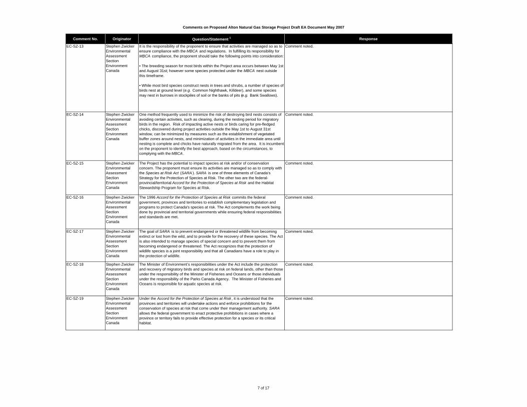
Comments on Proposed Alton Natural Gas Storage Project Draft EA Document May 2007
Comment No. Originator Question/Statement 1 Response
EC-SZ-13 Stephen ZwickerEnvironmental Assessment SectionEnvironment Canada
It is the responsibility of the proponent to ensure that activities are managed so as to ensure compliance with the MBCA and regulations. In fulfilling its responsibility for MBCA compliance, the proponent should take the following points into consideration: • The breeding season for most birds within the Project area occurs between May 1st and August 31st; however some species protected under the MBCA nest outside this timeframe.
• While most bird species construct nests in trees and shrubs, a number of species of birds nest at ground level (e.g. Common Nighthawk, Killdeer), and some species may nest in burrows in stockpiles of soil or the banks of pits (e.g. Bank Swallows).
Comment noted.
EC-SZ-14 Stephen ZwickerEnvironmental Assessment SectionEnvironment Canada
One method frequently used to minimize the risk of destroying bird nests consists of avoiding certain activities, such as clearing, during the nesting period for migratory birds in the region. Risk of impacting active nests or birds caring for pre-fledged chicks, discovered during project activities outside the May 1st to August 31st window, can be minimized by measures such as the establishment of vegetated buffer zones around nests, and minimization of activities in the immediate area until nesting is complete and chicks have naturally migrated from the area. It is incumbent on the proponent to identify the best approach, based on the circumstances, to complying with the MBCA .
Comment noted.
EC-SZ-15 Stephen ZwickerEnvironmental Assessment SectionEnvironment Canada
The Project has the potential to impact species at risk and/or of conservation concern. The proponent must ensure its activities are managed so as to comply with the Species at Risk Act (SARA ). SARA is one of three elements of Canada’s Strategy for the Protection of Species at Risk. The other two are the federal-provincial/territorial Accord for the Protection of Species at Risk and the Habitat Stewardship Program for Species at Risk.
Comment noted.
EC-SZ-16 Stephen ZwickerEnvironmental Assessment SectionEnvironment Canada
The 1996 Accord for the Protection of Species at Risk commits the federal government, provinces and territories to establish complementary legislation and programs to protect Canada's species at risk. The Act complements the work being done by provincial and territorial governments while ensuring federal responsibilities and standards are met.
Comment noted.
EC-SZ-17 Stephen ZwickerEnvironmental Assessment SectionEnvironment Canada
The goal of SARA is to prevent endangered or threatened wildlife from becoming extinct or lost from the wild, and to provide for the recovery of these species. The Act is also intended to manage species of special concern and to prevent them from becoming endangered or threatened. The Act recognizes that the protection of wildlife species is a joint responsibility and that all Canadians have a role to play in the protection of wildlife.
Comment noted.
EC-SZ-18 Stephen ZwickerEnvironmental Assessment SectionEnvironment Canada
The Minister of Environment’s responsibilities under the Act include the protection and recovery of migratory birds and species at risk on federal lands, other than those under the responsibility of the Minister of Fisheries and Oceans or those individuals under the responsibility of the Parks Canada Agency. The Minister of Fisheries and Oceans is responsible for aquatic species at risk.
Comment noted.
EC-SZ-19 Stephen ZwickerEnvironmental Assessment SectionEnvironment Canada
Under the Accord for the Protection of Species at Risk , it is understood that the provinces and territories will undertake actions and enforce prohibitions for the conservation of species at risk that come under their management authority. SARA allows the federal government to enact protective prohibitions in cases where a province or territory fails to provide effective protection for a species or its critical habitat.
Comment noted.
7 of 17
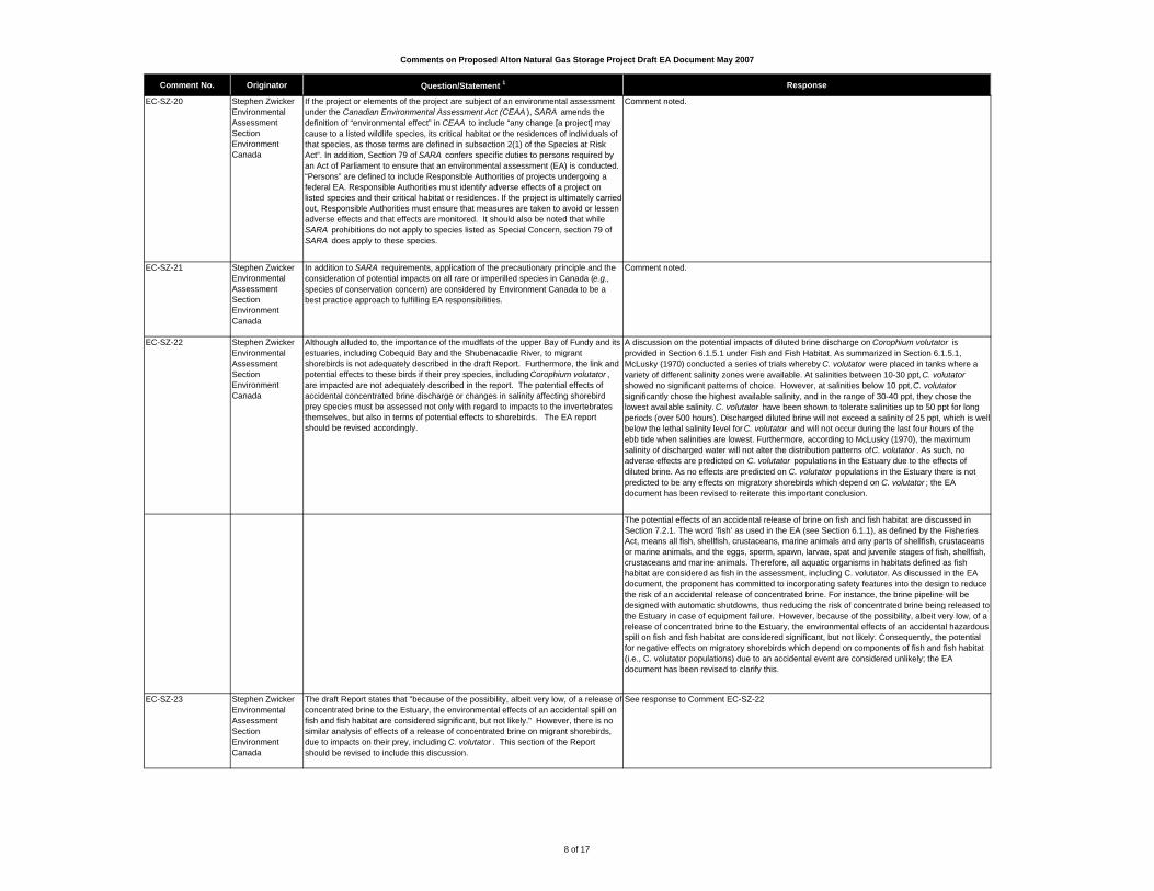
Comments on Proposed Alton Natural Gas Storage Project Draft EA Document May 2007
Comment No. Originator Question/Statement 1 Response
EC-SZ-20 Stephen ZwickerEnvironmental Assessment SectionEnvironment Canada
If the project or elements of the project are subject of an environmental assessment under the Canadian Environmental Assessment Act (CEAA ), SARA amends the definition of “environmental effect” in CEAA to include “any change [a project] may cause to a listed wildlife species, its critical habitat or the residences of individuals of that species, as those terms are defined in subsection 2(1) of the Species at Risk Act“. In addition, Section 79 of SARA confers specific duties to persons required by an Act of Parliament to ensure that an environmental assessment (EA) is conducted. “Persons” are defined to include Responsible Authorities of projects undergoing a federal EA. Responsible Authorities must identify adverse effects of a project on listed species and their critical habitat or residences. If the project is ultimately carried out, Responsible Authorities must ensure that measures are taken to avoid or lessen adverse effects and that effects are monitored. It should also be noted that while SARA prohibitions do not apply to species listed as Special Concern, section 79 of SARA does apply to these species.
Comment noted.
EC-SZ-21 Stephen ZwickerEnvironmental Assessment SectionEnvironment Canada
In addition to SARA requirements, application of the precautionary principle and the consideration of potential impacts on all rare or imperilled species in Canada (e.g., species of conservation concern) are considered by Environment Canada to be a best practice approach to fulfilling EA responsibilities.
Comment noted.
EC-SZ-22 Stephen ZwickerEnvironmental Assessment SectionEnvironment Canada
Although alluded to, the importance of the mudflats of the upper Bay of Fundy and its estuaries, including Cobequid Bay and the Shubenacadie River, to migrant shorebirds is not adequately described in the draft Report. Furthermore, the link and potential effects to these birds if their prey species, including Corophium volutator , are impacted are not adequately described in the report. The potential effects of accidental concentrated brine discharge or changes in salinity affecting shorebird prey species must be assessed not only with regard to impacts to the invertebrates themselves, but also in terms of potential effects to shorebirds. The EA report should be revised accordingly.
A discussion on the potential impacts of diluted brine discharge on Corophium volutator is provided in Section 6.1.5.1 under Fish and Fish Habitat. As summarized in Section 6.1.5.1, McLusky (1970) conducted a series of trials whereby C. volutator were placed in tanks where a variety of different salinity zones were available. At salinities between 10-30 ppt, C. volutator showed no significant patterns of choice. However, at salinities below 10 ppt, C. volutator significantly chose the highest available salinity, and in the range of 30-40 ppt, they chose the lowest available salinity. C. volutator have been shown to tolerate salinities up to 50 ppt for long periods (over 500 hours). Discharged diluted brine will not exceed a salinity of 25 ppt, which is well below the lethal salinity level for C. volutator and will not occur during the last four hours of the ebb tide when salinities are lowest. Furthermore, according to McLusky (1970), the maximum salinity of discharged water will not alter the distribution patterns of C. volutator . As such, no adverse effects are predicted on C. volutator populations in the Estuary due to the effects of diluted brine. As no effects are predicted on C. volutator populations in the Estuary there is not predicted to be any effects on migratory shorebirds which depend on C. volutator ; the EA document has been revised to reiterate this important conclusion.
The potential effects of an accidental release of brine on fish and fish habitat are discussed in Section 7.2.1. The word ‘fish’ as used in the EA (see Section 6.1.1), as defined by the Fisheries Act, means all fish, shellfish, crustaceans, marine animals and any parts of shellfish, crustaceans or marine animals, and the eggs, sperm, spawn, larvae, spat and juvenile stages of fish, shellfish, crustaceans and marine animals. Therefore, all aquatic organisms in habitats defined as fish habitat are considered as fish in the assessment, including C. volutator. As discussed in the EA document, the proponent has committed to incorporating safety features into the design to reduce the risk of an accidental release of concentrated brine. For instance, the brine pipeline will be designed with automatic shutdowns, thus reducing the risk of concentrated brine being released to the Estuary in case of equipment failure. However, because of the possibility, albeit very low, of a release of concentrated brine to the Estuary, the environmental effects of an accidental hazardous spill on fish and fish habitat are considered significant, but not likely. Consequently, the potential for negative effects on migratory shorebirds which depend on components of fish and fish habitat (i.e., C. volutator populations) due to an accidental event are considered unlikely; the EA document has been revised to clarify this.
EC-SZ-23 Stephen ZwickerEnvironmental Assessment SectionEnvironment Canada
The draft Report states that "because of the possibility, albeit very low, of a release of concentrated brine to the Estuary, the environmental effects of an accidental spill on fish and fish habitat are considered significant, but not likely." However, there is no similar analysis of effects of a release of concentrated brine on migrant shorebirds, due to impacts on their prey, including C. volutator . This section of the Report should be revised to include this discussion.
See response to Comment EC-SZ-22
8 of 17

Comments on Proposed Alton Natural Gas Storage Project Draft EA Document May 2007
Comment No. Originator Question/Statement 1 Response
EC-SZ-24 Stephen ZwickerEnvironmental Assessment SectionEnvironment Canada
A local resident identified a Great Blue Heron colony approximately 500 m south of the proposed Right-of-Way (ROW) however, the exact location and size of the colony has not yet been verified (p. 66). The draft Report recommends that a field survey be conducted prior to commencement of construction to ensure that there is adequate space for the 400 m buffer recommended by NSDNR. It is unfortunate that this data was not obtained in late 2006 or very early 2007, as it is important that this information be provided for review. However, it is now too late in the year to go out and conduct surveys (either on foot or helicopter) due to the extreme sensitivity of this species to disturbance.
Comment noted.
EC-SZ-25 Stephen ZwickerEnvironmental Assessment SectionEnvironment Canada
Colonial nesters such as Great Blue Herons are known to be very sensitive to human disturbance during the breeding season, and will fly away if humans approach their colonies. The result is nests or chicks left unattended and vulnerable to predators or the elements. When disturbed by humans, older chicks may fall out of nests while trying to fledge prematurely. Birds are also known to desert nests and entire colonies if disturbance occurs during the periods of pair-formation, nest construction, or early egg-laying. Environment Canada therefore recommends the following:
• In late summer (no sooner than late August), a field survey should be conducted to determine the exact location and size of the colony. The following information should be sent to the Canadian Wildlife Service (CWS): a map showing the delineated colony, GPS coordinates, number of nests observed, and number of nests that appear to have been used. In order to avoid attracting people to this sensitive site, it would be preferable to not make the specific location data generally available, but only to provide this data to regulatory authorities.• If the pipeline RoW is located less than 400 m from the edge of the colony, then the RoW should be adjusted so that such a buffer is possible.• In addition to the general buffer (i.e. NSDNR 400 m) from the edge of a heron colony from April through mid-August, CWS recommends no activities with a high disturbance factor (e.g. blasting, drilling) within a 1 kilometer buffer during this period. • No activities that would require the removal of trees should take place within the 400 m buffer regardless of the time of year.
Section 6.3.5.1 updated with comments from EC.
EC-SZ-26 Stephen ZwickerEnvironmental Assessment SectionEnvironment Canada
The possibility of shifting the route to avoid rare plants is mentioned (pages 96-98). While we encourage the avoidance of rare plants, it would be preferable to not bring the pipeline RoW closer to the colony of Great Blue Herons.
Comment noted.
EC-SZ-27 Stephen ZwickerEnvironmental Assessment SectionEnvironment Canada
Although none were identified during the June 2006 field survey, the Common Nighthawk is listed in Table 5.6 as one of the "Sensitive, Rare or Uncommon Bird Species Most Likely to be Found Along the RoW" due to the fact that clear-cuts are a common habitat type along the proposed route. At its Spring 2007 meeting, the Committee on the Status of Endangered Wildlife in Canada (COSEWIC) listed this species as Threatened. While this migratory bird has not yet been added to Schedule 1 of SARA , the application of the precautionary principle, as recognized in the SARA preamble, is advocated.
Comment noted.
EC-SZ-28 Stephen ZwickerEnvironmental Assessment SectionEnvironment Canada
Even though none were identified in 2006, there is no reason to believe that this species may not choose to nest in appropriate habitats in the study area in future years, including the proposed new pipeline RoW. As such, the revised EA Report should provide a description of potential effects of project-related activities and increased access to the pipeline RoW by the public (e.g. ATV use), as well as potential accidental events, on this species. Proposed mitigation measures and monitoring should also be discussed.
Mitigation identified in Section 6.3.5 will protect Common Nighthawks, and other bird species not specifically addressed in the EA, that may nest and/or forage along the proposed RoW. Mitigation includes no clearing activities during the nesting season (April 1 to August 15), no blasting, and no use of pesticides by the proponent along the RoW. The Common Nighthawk is not particularly sensitive to human disturbance, indicated by its nesting in habitats altered by human activities, such as cut-overs and even urban areas. The edge habitat created by the RoW may actually encourage nesting of Common Nighthawks. Strategies to stop or minimize unauthorized access to the RoW (i.e., ATVs) are discussed in Section 6.3.5.2.
EC-SZ-29 Stephen ZwickerEnvironmental Assessment SectionEnvironment Canada
Although none were identified during the June 2006 field survey, the Chimney Swift is listed in Table 5.6 as one of the "Sensitive, Rare or Uncommon Bird Species Most Likely to be Found Along the RoW." At its Spring 2007 meeting, COSEWIC listed this species as Threatened. While this migratory bird has not yet been added to Schedule 1 of SARA , the application of the precautionary principle, as recognized in the SARA preamble, is advocated.
Comment noted.
9 of 17

Comments on Proposed Alton Natural Gas Storage Project Draft EA Document May 2007
Comment No. Originator Question/Statement 1 Response
EC-SZ-30 Stephen ZwickerEnvironmental Assessment SectionEnvironment Canada
While this species is listed in Table 5.6, there is no further discussion of it in subsequent paragraphs. The revised EA Report should include a description of the nesting habitat (if any) for this species in the study area.
The Chimney Swift nests principally in chimneys, but also on the interior walls of a variety of other anthropogenic structures, such as abandoned buildings and wells. Natural nesting habitat for this species includes the inside walls of large, hollow trees. There is little suitable nesting habitat for the Chimney Swift in the Project area. Open chimneys and abandoned buildings, which are the preferred nesting habitat of this species, do not exist along the RoW or in close proximity to it. Furthermore, suitable natural besting habitats (i.e., large hollow trees) are uncommon along the RoW, due to clear-cut foreestry operations. No nests or adults were encountered during the field surveys.
EC-SZ-31 Stephen ZwickerEnvironmental Assessment SectionEnvironment Canada
The Olive-sided Flycatcher is ranked Yellow by the NSDNR and is a Partners in Flightpriority species. It is stated on p. 102 that Olive-sided Flycatchers were heard in 2 wetlands during 2006 field surveys, and neither of these wetlands is expected to be disturbed during project-related activities. However, it appears the small stream that connects the two wetlands will need to be crossed by horizontal directional drilling (HDD). The draft Report recommends that "HDD at this site be conducted outside the nesting period of this species (June to August)." It should be noted that during field work for the first Atlas of Breeding Birds of the Maritime Provinces, chicks of this species were reported into mid-August. We therefore recommend a precautionary approach, and that the time period for not conducting HDD at this site is extended until the end of August.
Comment noted. HDD under the small stream that connects the two wetlands will not be conducted during the period from April 1 to August 31. Section 6.3.5.1 of EA updated.
EC-SZ-32 Stephen ZwickerEnvironmental Assessment SectionEnvironment
Based on the information provided, it is not possible to gain a clear understanding of the impact of the Project on various forest habitats, and the migratory birds that use these habitats.
See response to comment EC-SZ-33.
EC-SZ-42 Stephen ZwickerEnvironmental Assessment SectionEnvironment Canada
Several types of migratory bird habitat are in decline in Nova Scotia, including mature coniferous forest, mature deciduous forest and mature mixed forest. This is of concern because certain bird species prefer mature forest habitat. Furthermore, some bird species, generally known as interior species, only prosper when the tracts of mature forest are relatively large and unfragmented (i.e. interior forest). Examples of bird species of conservation concern, or Partners in Flight priority species, that are primarily mature forest habitat dwellers include the Boreal Chickadee, Brown Creeper, Canada Warbler, and Eastern Wood-Pewee.
Comment noted.
EC-SZ-33 Stephen ZwickerEnvironmental Assessment SectionEnvironment Canada
It is desirable for projects to avoid causing further loss and fragmentation of these habitat types, and to avoid further fragmentation of the landscape.
To help demonstrate how the Project is being planned with these objectives in mind, the next version of the EA document should include the following information and clarifications:
• mapping that identifies mature and interior forest habitat for migratory birds in the project area, along with a rationale as to why this habitat cannot be avoided through routing and siting of facilities; • the total area (hectares) mature coniferous, mature hardwood, mature mixed forest, and interior forest habitat for migratory birds that would be lost as a result of the project (e.g. clearing of ROW, temporary and permanent access roads and work areas), a description of the specific steps taken to minimize those losses;• an analysis of project impacts on mature and interior forest habitat for migratory birds on a regional scale taking into account cumulative losses;• proposed mitigation for the predicted loss of mature and interior forest habitat for migratory birds and the related effects on species using these habitats.
As discussed in Section 6.3.4, linear developments have the potential to fragment interior forest habitat, bringing wildlife populations, such as forest birds, into contact with humans which can lead to direct mortality and disturbance. However, in the case of pipeline corridors where there is no ongoing human presence and noise, the likelihood of anthropogenic mortality and/or disturbance on wildlife, including forest birds, is reduced. The RoW will be kept as narrow as possible and the route has been chosen to avoid sensitive habitats such as wetlands, riparian zones and streams. In addition, clearing will be scheduled to avoid interaction with the breeding season of most bird species, there will be no blasting and vegetation control will be carried out using mechanical means. Strategies to stop or minimize unauthorized access to the RoW (i.e., ATVs) are discussed in Section 6.3.5.2. Furthermore, terrestrial habitat within the RoW will not be permanently lost; rather it will be converted to open shrub and forest edge habitat, which will be used by a variety of bird species and will likely not pose a long-term barrier to wildlife movement.
As discussed in section 5.7.2, based on aerial photography, it is estimated that the proposed RoW crosses 27 parcels of forested land. One parcel is crown land and four parcels are owned by Neenah Paper Company of Canada (spun off from Kimberly-Clark Corporation in 2004). In Nova Scotia, Neenah Paper operates a Kraft pulp mill in Pictou along with several hectares of timberlands. Figure 5.3 in the EA report delineates whether land crossed by the proposed RoW is forested, agricultural, clear cut, etc . In total, the following areas (in hectares) will be altered (i.e ., converted to open, shrub habitat) as a result of the Project RoW:
• Agriculture: 6.69 ha• Alder Stand: 0.19 ha• Natural Tree Stand: 13.32 ha• Treated Tree Stand: 0.74 ha• Plantation: 0.51 ha• Clear Cut: 2.88 ha
10 of 17

Comments on Proposed Alton Natural Gas Storage Project Draft EA Document May 2007
Comment No. Originator Question/Statement 1 Response
The terrestrial environment of Nova Scotia has been significantly altered by past anthropogenic influences. Large scale human activities such as forestry and industrial, infrastructure and residential development as well as smaller scale activities such as fishing, hunting and other recreational activities (i.e., ATV use) have altered the distribution and abundance of plant and animal species and the structure, diversity and productivity of onshore ecosystems in Nova Scotia. There has been a cumulative loss of terrestrial habitat within the onshore study area due to forestry, road-development, agriculture and residential development. The pipeline RoW will result in a habitat change to a small area of terrestrial habitat; however, the area altered due to the Project is insignificant as compared to the amount of forested land cleared during un-mitigated clear-cut forestry operations in the vicinity of the Project. In general, the Project will contribute to a cumulative loss of habitat and dependent plant and animal species; however, any effects will be minor (i.e., not significant) and will be further reduced through Project mitigation.
EC-SZ-34 Stephen ZwickerEnvironmental Assessment SectionEnvironment Canada
The draft Report mentions vent stacks that would be supported by guy wires (p. 16) however, it is not clear whether these structures would be lit? In order to minimize the risk to nocturnal migrants, Environment Canada recommends that the minimum amount of pilot warning and obstruction avoidance lighting should be used. The use of only strobe lights on tall structures at night, at the minimum intensity and minimum number of flashes per minute (longest duration between flashes) allowable by Transport Canada, is recommended. The use of solid-burning or slow pulsing red warning lights at night should be avoided.
Comment noted.
EC-SZ-35 Stephen ZwickerEnvironmental Assessment SectionEnvironment Canada
It is also recommended that the proponent avoid or restrict the time of operation of exterior decorative lights such as spotlights and floodlights whose function is to highlight features of buildings, or to illuminate an entire building. Especially on humid, foggy or rainy nights, their glow can draw birds from far away. It would be best for the birds if these lights were turned off, at least during the migratory season, when the risk to birds is greatest. Other considerations include:
• Lighting for the safety of the employees should be shielded to shine down and only to where it is needed, without compromising safety. • Street and parking lot lighting should also be shielded so that little escapes into the sky and it falls where it is required. • If vent stacks are to be lit, then a detailed avian collision monitoring protocol should be prepared and submitted for review.
Section 2.1.1.5 of EA updated with the following text: All outdoor lighting will be directed and shielded so as to illuminate only the areas that must have adequate lighting for safety of operations personnel. As most equipment will be housed in buildings, the amount of outdoor lighting will be minimal, and will generally be limited to lights mounted on the buildings for illumination of entrances and adjacent equipment. Some of this may be actuated by motion sensors, and can then be turned off except when needed. There will likely be some yard lighting that cannot be avoided; where this occurs, it will be shielded and directed so that little escapes to the sky.
There will be a flare stack to burn gas that must be released in an emergency. However, as this is for emergency use only, it will not normally be lit. Typically, it will be tested annually, and will be used when a well work-over is required or on an equipment failure. Well work-overs are specified by standard to occur every ten years for each cavern; they would be staggered so they do not all occur at once. Equipment failures are rare and do not usually result in a gas leak. When a gas leak does occur, gas is usually released over a very short time period.
EC-SZ-36 Stephen ZwickerEnvironmental Assessment SectionEnvironment Canada
Further details regarding on this topic can be found in the attached pamphlet titled Bird Friendly Structures which, though still in draft form, discusses best management considerations for tall structures.
Comment noted.
EC-SZ-37 Stephen ZwickerEnvironmental Assessment SectionEnvironment Canada
The significance criteria proposed for effects on birds in Section 6.3.3 only considers effects to species at risk or species of conservation concern. There is no consideration for birds that do not have rarity ranks. It should be recognized that large numbers of birds may congregate in certain areas during certain life-stages (e.g. nesting colonies, shorebirds in migration), and that harm to important habitat components or disturbance to these birds could potentially result in significant effects. The significance criteria should be revised to include consideration of colonial nesters and migrating shorebirds and their habitat (including C. volutator ).
The proposed significance criteria should also be revised to consider species listed as Endangered, Threatened, or Special Concern by COSEWIC but not yet listed on SARA Schedules.
The residual environmental effects evaluation criteria for wildlife and wildlife habitat has been revised to include provisions for COSEWIC listed, sensitive, and secure bird and other wildlife species. Sensitive bird species (i.e., colonial nesters) present in the Project area are discussed in Section 5.6 and potential interactions, issues and concerns as well as analysis, mitigation and environmental effects prediction pertinent to sensitive species are described in Sections 6.3.4 and 6.3.5, respectively. The focus on rare or at-risk species is twofold. First, species that are low in abundance and threatened with extirpation and/or extinction require special protection from anthropogenic impacts to assure their future security and maintain biodiversity. Second, mitigation for rare species serves to protect common species and/or species of unknown status. Overall, the focus on at-risk wildlife species makes for a more concise EA based on a precautionary principle of protecting the species most susceptible to anthropogenic impacts. The feeding habitats of migratory shorebirds on mudflats of the Estuary are discussed in Section 6.1.5.1, under Fish and Fish Habitat; also refer to responses to comments EC-SZ-22 and NSDNR-HG-02.
11 of 17

Comments on Proposed Alton Natural Gas Storage Project Draft EA Document May 2007
Comment No. Originator Question/Statement 1 Response
EC-SZ-38 Stephen ZwickerEnvironmental Assessment SectionEnvironment Canada
The Federal Policy on Wetland Conservation (FPWC) was introduced “to promote the conservation of Canada’s wetlands to sustain their ecological and socio-economic functions, now and in the future.” The policy recognizes the importance of wetlands to the environment, the economy and human health, and promotes a goal of no-net-loss of wetland functions. In support of this goal, the FPWC and related implementation guidance identify the importance of planning, siting and designing a project in a manner that accommodates a consideration of mitigation options in a hierarchical sequence - avoidance, minimization, and as a last resort, compensation. Environment Canada advocates application of the FPWC to the Project as a best practice.
Environment Canada also supports the provincial government in its protection of wetlands on provincial lands and provides expertise as requested.
Comment noted.
EC-SZ-39 Stephen ZwickerEnvironmental Assessment SectionEnvironment Canada
It is not clear whether freshwater wetlands would be directly impacted, although it appears that coastal wetland habitat will be impacted. It is stated in draft report that wetlands will be avoided "where feasible" (pages 8 and 34) and based on this it appears that wetlands are not included in the scope of the EA, although this appears to refer to freshwater wetlands only. This is despite the fact that there is no certainty that wetlands will be avoided, and this statement appears to apply to only to freshwater wetlands. For example, no details are provided regarding what factors would be considered when making the determination of whether or not it is "feasible" to avoid wetlands and their 30 m buffers. It is proposed that if wetlands are determined to be unavoidable upon final design routing of the pipeline and location of project facilities, then full wetland evaluations would be conducted according to provincial policy and guidelines, and that permit applications would be submitted with habitat compensation guidelines.
The proponent is planning to avoid all wetlands, where feasible. Factors that would make wetland avoidance not feasible relate to land-use and geological constraints. Should wetlands be determined to be unavoidable, full wetland evaluations will be conducted according to provincial policy and guidelines, and permit applications submitted with habitat compensation proposals.
Interaction between the Project and the intertidal zone of the Estuary is possible due to the discharge of diluted brine. This habitat consists of mudflats and salt-tolerant grasses. Potential interactions between the discharge of diluted brine and aquatic-related mammals and migratory shorebirds that forage in the Estuary and associated intertidal zone are discussed in Section 6.1 (Fish and Fish Habitat) as well as Section 6.3 (Wildlife and Wildlife Habitat). In addition, potential interactions between the discharge of diluted brine and rare and sensitive flora that may be present in the intertidal zone are discussed in Section 6.2 (Rare and Sensitive Flora).
EC-SZ-40 Stephen ZwickerEnvironmental Assessment SectionEnvironment Canada
Since at this time, the proponent cannot guarantee that freshwater wetlands will be avoided, and it appears that coastal wetland habitat will be impacted, Environment Canada recommends that wetlands in the project area be considered a Valued Ecosystem Component (VEC) for the EIA review, and that the document be revised accordingly. This revision should also include consideration of impacts to wetlands due to ATV use of the pipeline RoW.
The proponent recognizes the ecological, economic and hydrological importance of wetlands. Project activities will not occur in wetland areas without full wetland evaluations that would be conducted in accordance with provincial policy and guidelines. In addition, permit applications will be submitted with habitat compensation proposals. See response to comment EC-SZ-39.
EC-SZ-41 Stephen ZwickerEnvironmental Assessment SectionEnvironment Canada
It is not clear whether wetlands would be directly impacted by the proposed project. Itis stated that wetlands will be avoided "where feasible" (pages 8 and 34). The proponents have therefore chosen to scope wetlands out of the EIA. However, no details are provided regarding what factors would considered when making the determination of whether or not it is "feasible" to avoid wetlands and their 30 m buffers. It is proposed that if wetlands are determined to be unavoidable upon final design routing of the pipeline and location of project facilities, then full wetland evaluations would be conducted according to provincial policy and guidelines, and that permit applications would be submitted with habitat compensation guidelines. It is not clear whether coastal wetlands will be affected by the proposed project. Since the proponent cannot guarantee that wetlands will be avoided, Environment Canada recommends that wetlands in the project area be considered a Valued Ecosystem Component (VEC) for the EA review, and that the document be revised accordingly. The revision should also include consideration of impacts to wetlands due to ATV use of the pipeline RoW.
See responses to comments EC-SZ-39 and 40.
12 of 17
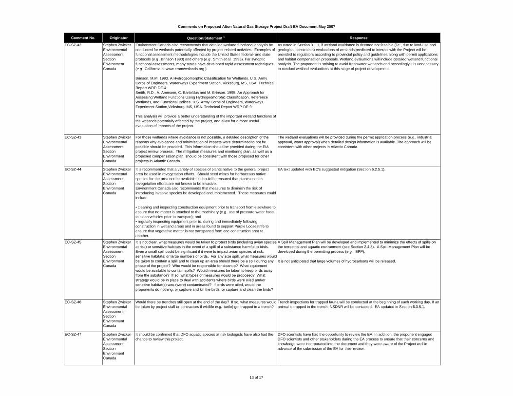
Comments on Proposed Alton Natural Gas Storage Project Draft EA Document May 2007
Comment No. Originator Question/Statement 1 Response
EC-SZ-42 Stephen ZwickerEnvironmental Assessment SectionEnvironment Canada
Environment Canada also recommends that detailed wetland functional analysis be conducted for wetlands potentially affected by project-related activities. Examples of functional assessment methodologies include the United States federal- and state protocols (e.g . Brinson 1993) and others (e.g . Smith et al. 1995). For synoptic functional assessments, many states have developed rapid assessment techniques (e.g . California at www.cramwetlands.org ). Brinson, M.M. 1993. A Hydrogeomorphic Classification for Wetlands. U.S. Army Corps of Engineers, Waterways Experiment Station, Vicksburg, MS, USA. Technical Report WRP-DE-4Smith, R.D., A. Ammann, C. Bartoldus and M. Brinson. 1995. An Approach for Assessing Wetland Functions Using Hydrogeomorphic Classification, Reference Wetlands, and Functional Indices. U.S. Army Corps of Engineers, Waterways Experiment Station,Vicksburg, MS, USA. Technical Report WRP-DE-9
This analysis will provide a better understanding of the important wetland functions of the wetlands potentially affected by the project, and allow for a more useful evaluation of impacts of the project.
As noted in Section 3.1.1, if wetland avoidance is deemed not feasible (i.e., due to land-use and geological constraints) evaluations of wetlands predicted to interact with the Project will be provided to regulators according to provincial policy and guidelines along with permit applications and habitat compensation proposals. Wetland evaluations will include detailed wetland functional analysis. The proponent is striving to avoid freshwater wetlands and accordingly it is unnecessary to conduct wetland evaluations at this stage of project development.
EC-SZ-43 Stephen ZwickerEnvironmental Assessment SectionEnvironment Canada
For those wetlands where avoidance is not possible, a detailed description of the reasons why avoidance and minimization of impacts were determined to not be possible should be provided. This information should be provided during the EIA project review process. The mitigation measures and monitoring plan, as well as a proposed compensation plan, should be consistent with those proposed for other projects in Atlantic Canada.
The wetland evaluations will be provided during the permit application process (e.g., industrial approval, water approval) when detailed design information is available. The approach will be consistent with other projects in Atlantic Canada.
EC-SZ-44 Stephen ZwickerEnvironmental Assessment SectionEnvironment Canada
It is recommended that a variety of species of plants native to the general project area be used in revegetation efforts. Should seed mixes for herbaceous native species for the area not be available, it should be ensured that plants used in revegetation efforts are not known to be invasive. Environment Canada also recommends that measures to diminish the risk of introducing invasive species be developed and implemented. These measures could include:
• cleaning and inspecting construction equipment prior to transport from elsewhere to ensure that no matter is attached to the machinery (e.g. use of pressure water hose to clean vehicles prior to transport); and • regularly inspecting equipment prior to, during and immediately following construction in wetland areas and in areas found to support Purple Loosestrife to ensure that vegetative matter is not transported from one construction area to another.
EA text updated with EC's suggested mitigation (Section 6.2.5.1).
EC-SZ-45 Stephen ZwickerEnvironmental Assessment SectionEnvironment Canada
It is not clear, what measures would be taken to protect birds (including avian species at risk) or sensitive habitats in the event of a spill of a substance harmful to birds. Even a small spill could be significant if it were to impact avian species at risk, sensitive habitats, or large numbers of birds. For any size spill, what measures would be taken to contain a spill and to clean up an area should there be a spill during any phase of the project? Who would be responsible for cleanup? What equipment would be available to contain spills? Would measures be taken to keep birds away from the substance? If so, what types of measures would be proposed? What strategy would be in place to deal with accidents where birds were oiled and/or sensitive habitat(s) was (were) contaminated? If birds were oiled, would the proponents do nothing, or capture and kill the birds, or capture and clean the birds?
A Spill Management Plan will be developed and implemented to minimize the effects of spills on the terrestrial and aquatic environment (see Section 2.4.3). A Spill Management Plan will be developed during the permitting process (e.g ., EPP).
It is not anticipated that large volumes of hydrocarbons will be released.
EC-SZ-46 Stephen ZwickerEnvironmental Assessment SectionEnvironment Canada
Would there be trenches still open at the end of the day? If so, what measures would be taken by project staff or contractors if wildlife (e.g. turtle) got trapped in a trench?
Trench inspections for trapped fauna will be conducted at the beginning of each working day. If an animal is trapped in the trench, NSDNR will be contacted. EA updated in Section 6.3.5.1.
EC-SZ-47 Stephen ZwickerEnvironmental Assessment SectionEnvironment Canada
It should be confirmed that DFO aquatic species at risk biologists have also had the chance to review this project.
DFO scientists have had the opportunity to review the EA. In addition, the proponent engaged DFO scientists and other stakeholders during the EA process to ensure that their concerns and knowledge were incorporated into the document and they were aware of the Project well in advance of the submission of the EA for their review.
13 of 17

Comments on Proposed Alton Natural Gas Storage Project Draft EA Document May 2007
Comment No. Originator Question/Statement 1 Response
EC-SZ-48 Stephen ZwickerEnvironmental Assessment SectionEnvironment Canada
Please provide a description of temporary work areas, including marshalling yards, access roads and storage areas, that will be required for the project (e.g., approximate number, general locations, total area), and confirmation of whether temporary work areas will be rehabilitated.
Existing roads will be used where possible to access the RoW. Work areas will not be known until the final design is completed, but mitigative measures that apply throughout the EA will also be applied to new access roads and work areas. Further project details will be provided in the permitting process (e.g. , industrial approval, EPP).
EC-SZ-49 Stephen ZwickerEnvironmental Assessment SectionEnvironment Canada
Environment Canada does not agree that a mechanical failure of wellheads, pipeline, or compressors leading to uncontrolled release of natural gas, fire and explosion would have no interaction with the terrestrial environment. Terrestrial environment should therefore be considered a VEC for the assessment of this type of malfunction or accidental event.
Because the stored product, natural gas, is lighter than air, it will rise and will not accumulate in low areas surrounding the site. An explosion or fire would be limited to the location of the release. Therefore, the impact of a critical failure will be limited to the vicinity of the release, and would not likely extend beyond the project site.
EC-SZ-50 Stephen ZwickerEnvironmental Assessment SectionEnvironment Canada
It is stated on p. 124 that "Should there be a 1% change in flow volume on the discharge line from the underground storage facility to the brine holding and mixing ponds, an alarm will be raised. A small change will initiate an automatic system shutdown." Would failure of brine pond or diluting pond containment dyke initiate a similar automatic system shutdown? If not, how would a containment dyke failure be detected?
Sections 2.5.2, updated with the following text: The brine pond will be equipped with a level sensing device that will provide an indication of the volume of brine in the pond. This will provide asignal that will be integrated with the in-flow and out-flow of brine, so that the volume in storage based on flow can be compared with the volume based on level, and an alarm raised if there is a discrepancy. There will be no alarm system on the mixing pond; this pond is below river level, and is influenced by tidal activity. It is anticipated that this pond will be open to the river, so the water level will in the pond be the same as the river level.
EC-SZ-51 Stephen ZwickerEnvironmental Assessment SectionEnvironment Canada
What is the proposed height of the holding dykes for the brine holding and mixing ponds? What is the risk of the brine holding and mixing ponds being inundated at extreme high tides, storm events, or overflowing during periods of extreme precipitation and/or snow melt?
According to the river monitoring that was conducted from August to December 2006, the highest tide that was recorded was 8.3 m Geodetic Elevation in November 2006. River monitoring has begun and will run from May 2007 until December 2007. Using this additional data, Alton will establish an appropriate dyke height which will be approximately 10 m and will include a suitable safety factor, as the current dyke is 9.73 m.
There is very limited risk that the holding or mixing ponds will be inundated at extreme high tides, storm events and extreme precipitation as the system will be shut down when required. However, the brine pond will be equipped with a level sensing device that will provide an indication of the volume of brine in the pond. See response to comment EC-SZ-50 for further details.
EC-SZ-52 Stephen ZwickerEnvironmental Assessment SectionEnvironment Canada
The draft Report provides a brief outline of a proposed Environmental Management Plan (Section 2.5.3.1) and a project-specific Emergency Response and Contingency Plan (Section 2.5.3.3). In the context of the EA, it is also recommended that environmental emergency prevention, preparedness, response and recovery plans for the Project include the following specific elements:
• a description of biological and human-use resources that could be impacted; • an inventory of oil and chemical products and associated storage locations for both Project construction and operational phases; • the identification of spill response equipment that will be on-site or available in case of emergency events; • staff training; • procedures for responding to operational spills and releases; • an incident reporting system, including notification and alerting procedures; • a list of response organizations and clarification of the roles of each organization; and, • clean-up and disposal procedures.
Text updated in the EA (Section 2.5.3.3).
EC-SZ-53 Stephen ZwickerEnvironmental Assessment SectionEnvironment Canada
The Proponent is advised to report all spills, releases and deposits into the environment to the Canadian Coast Guard Regional Operations Centre (1-800-565-1633) as soon as possible. The Operations Centre will notify appropriate federal and provincial agencies. The Proponent should also be aware of and discuss any reporting obligations under federal legislation and regulations.
Comment noted.
14 of 17
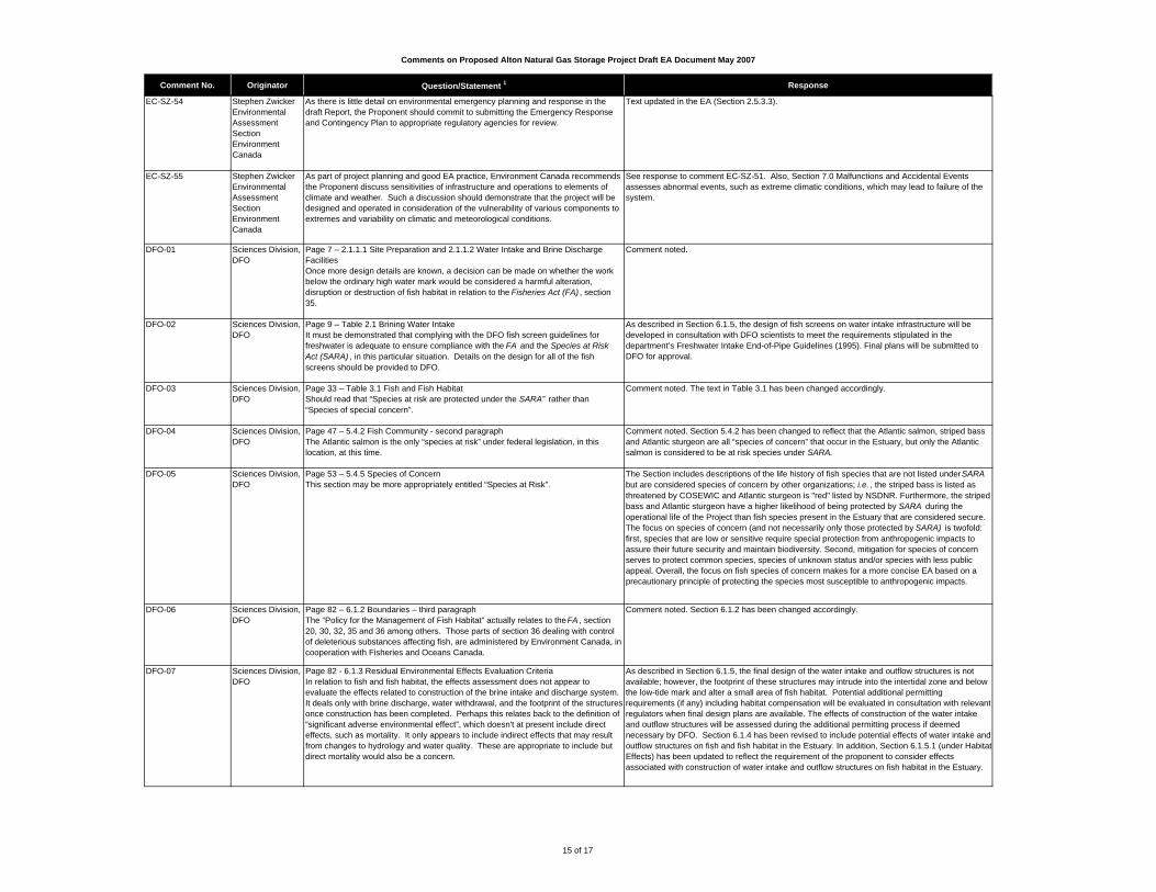
Comments on Proposed Alton Natural Gas Storage Project Draft EA Document May 2007
Comment No. Originator Question/Statement 1 Response
EC-SZ-54 Stephen ZwickerEnvironmental Assessment SectionEnvironment Canada
As there is little detail on environmental emergency planning and response in the draft Report, the Proponent should commit to submitting the Emergency Response and Contingency Plan to appropriate regulatory agencies for review.
Text updated in the EA (Section 2.5.3.3).
EC-SZ-55 Stephen ZwickerEnvironmental Assessment SectionEnvironment Canada
As part of project planning and good EA practice, Environment Canada recommends the Proponent discuss sensitivities of infrastructure and operations to elements of climate and weather. Such a discussion should demonstrate that the project will be designed and operated in consideration of the vulnerability of various components to extremes and variability on climatic and meteorological conditions.
See response to comment EC-SZ-51. Also, Section 7.0 Malfunctions and Accidental Events assesses abnormal events, such as extreme climatic conditions, which may lead to failure of the system.
DFO-01 Sciences Division, DFO
Page 7 – 2.1.1.1 Site Preparation and 2.1.1.2 Water Intake and Brine Discharge FacilitiesOnce more design details are known, a decision can be made on whether the work below the ordinary high water mark would be considered a harmful alteration, disruption or destruction of fish habitat in relation to the Fisheries Act (FA) , section 35.
Comment noted.
DFO-02 Sciences Division, DFO
Page 9 – Table 2.1 Brining Water IntakeIt must be demonstrated that complying with the DFO fish screen guidelines for freshwater is adequate to ensure compliance with the FA and the Species at Risk Act (SARA) , in this particular situation. Details on the design for all of the fish screens should be provided to DFO.
As described in Section 6.1.5, the design of fish screens on water intake infrastructure will be developed in consultation with DFO scientists to meet the requirements stipulated in the department’s Freshwater Intake End-of-Pipe Guidelines (1995). Final plans will be submitted to DFO for approval.
DFO-03 Sciences Division, DFO
Page 33 – Table 3.1 Fish and Fish HabitatShould read that “Species at risk are protected under the SARA” rather than “Species of special concern”.
Comment noted. The text in Table 3.1 has been changed accordingly.
DFO-04 Sciences Division, DFO
Page 47 – 5.4.2 Fish Community - second paragraphThe Atlantic salmon is the only “species at risk” under federal legislation, in this location, at this time.
Comment noted. Section 5.4.2 has been changed to reflect that the Atlantic salmon, striped bass and Atlantic sturgeon are all “species of concern” that occur in the Estuary, but only the Atlantic salmon is considered to be at risk species under SARA.
DFO-05 Sciences Division, DFO
Page 53 – 5.4.5 Species of ConcernThis section may be more appropriately entitled “Species at Risk”.
The Section includes descriptions of the life history of fish species that are not listed under SARA but are considered species of concern by other organizations; i.e. , the striped bass is listed as threatened by COSEWIC and Atlantic sturgeon is "red" listed by NSDNR. Furthermore, the striped bass and Atlantic sturgeon have a higher likelihood of being protected by SARA during the operational life of the Project than fish species present in the Estuary that are considered secure. The focus on species of concern (and not necessarily only those protected by SARA) is twofold: first, species that are low or sensitive require special protection from anthropogenic impacts to assure their future security and maintain biodiversity. Second, mitigation for species of concern serves to protect common species, species of unknown status and/or species with less public appeal. Overall, the focus on fish species of concern makes for a more concise EA based on a precautionary principle of protecting the species most susceptible to anthropogenic impacts.
DFO-06 Sciences Division, DFO
Page 82 – 6.1.2 Boundaries – third paragraphThe “Policy for the Management of Fish Habitat” actually relates to the FA , section 20, 30, 32, 35 and 36 among others. Those parts of section 36 dealing with control of deleterious substances affecting fish, are administered by Environment Canada, in cooperation with Fisheries and Oceans Canada.
Comment noted. Section 6.1.2 has been changed accordingly.
DFO-07 Sciences Division, DFO
Page 82 - 6.1.3 Residual Environmental Effects Evaluation CriteriaIn relation to fish and fish habitat, the effects assessment does not appear to evaluate the effects related to construction of the brine intake and discharge system. It deals only with brine discharge, water withdrawal, and the footprint of the structures once construction has been completed. Perhaps this relates back to the definition of “significant adverse environmental effect”, which doesn't at present include direct effects, such as mortality. It only appears to include indirect effects that may result from changes to hydrology and water quality. These are appropriate to include but direct mortality would also be a concern.
As described in Section 6.1.5, the final design of the water intake and outflow structures is not available; however, the footprint of these structures may intrude into the intertidal zone and below the low-tide mark and alter a small area of fish habitat. Potential additional permitting requirements (if any) including habitat compensation will be evaluated in consultation with relevant regulators when final design plans are available. The effects of construction of the water intake and outflow structures will be assessed during the additional permitting process if deemed necessary by DFO. Section 6.1.4 has been revised to include potential effects of water intake and outflow structures on fish and fish habitat in the Estuary. In addition, Section 6.1.5.1 (under Habitat Effects) has been updated to reflect the requirement of the proponent to consider effects associated with construction of water intake and outflow structures on fish habitat in the Estuary.
15 of 17

Comments on Proposed Alton Natural Gas Storage Project Draft EA Document May 2007
Comment No. Originator Question/Statement 1 Response
DFO-08 Sciences Division, DFO
It is suggested that the definition of “significant adverse environmental effect” be changed
From: "A signifcant adverse environmental effect on fish habitat, and ultimately fish, is one that changes hydrology and surface water quality sufficiently to cause:” followed by list.
To: "A significant adverse environmental effect on fish and fish habitat is one that would result (either directly or indirectly) in” followed by list.
The residual environmental effects evaluation criteria for fish and fish habitat (Section 6.1.3) has been changed accordingly to include provisions for both direct and indirect effects.
DFO-09 Sciences Division, DFO
Page 83 - 6.1.4 Potential Interactions, Issues and ConcernsFurther to the comments on section 6.1.3, the list of potential interactions doesn’t appear to include effects related to the construction of the brine intake and discharge system. The list focuses on water withdrawal, brine discharge and spills.
See response to comment DFO-08. Section 6.1.4 has been changed to mention potential effects of water intake and outflow structures on fish and fish habitat in the Estuary. In addition, Section 6.1.5.1 (under Habitat Effects) has been updated to reflect the requirement of the proponent to consider effects associated with construction of water intake and outflow structures on fish habitat in the Estuary.
DFO-10 Sciences Division, DFO
Page 83 - 6.1.4 Potential Interactions, Issues and ConcernsIn regards to the statement about horizontal directional drilling (HDD) and the pipeline watercrossings, it is apparent that options other than HDD are not assessed as part of this environmental assessment. If HDD is not possible for any of the watercrossings, it is important that the information needed by DFO for a FA review be provided in a timely manner to DFO in order to ensure that the there are no delays in the review. Depending on the particular watercrossing method selected, there could also be a requirement for a federal environmental assessment. Transport Canada should also be consulted to ensure they do not have any regulatory requirements associated with the watercrossings should HDD not be possible.
Comment noted.
DFO-11 Sciences Division, DFO
Page 84 – 6.1.5.1 ConstructionThis section is confusing. “Construction” appears to refer to construction of the salt caverns as opposed to construction of the brine intake and discharge system. I would suggest that this section be named “Construction of the Project” or better yet, “Construction of the Underground Hydrocarbon Storage Facility”.
Section 6.1.5.1 has been updated to include a discussion on the effects of construction of the water intake and outflow structures thus better reflecting the current title.
DFO-12 Sciences Division, DFO
Page 91 – 6.1.5.1 Construction – Second ParagraphIt is stated that sedimentation of the Estuary is not considered a threat to fish and fish habitat. According to the information provided earlier in this document (e.g. , 6.1.3 and 6.1.4), it doesn’t appear that sedimentation effects would be considered within this environmental assessment. Also, there is no information provided as to why sedimentation is not considered a threat.
As stated in the updated EA report in Section 6.1.5, sedimentation of the Estuary due to Project construction (including solution mining and construction of water intake and outflow structures) is not considered a threat to fish habitat due to the baseline conditions in the Estuary and mitigation that will be employed during construction and operation of the Project. Biological communities in the Estuary are not particularly sensitive to suspended solids given the high natural levels of suspended matter in the water column and the shifting, fine-grained substrates. Diluted brine will be held in settling ponds prior to discharge which will facilitate settling of suspended solids. Removal of sediment from ponds may be required; however, in such cases, intakes and outlets will be closed off to avoid introduction of large amounts of sediment to the Estuary. The Project-specific EPP will include further mitigative strategies for reducing the risk of sedimentation and erosion during construction activities in proximity to the Estuary. See Section 6.1.5.1 for examples.
16 of 17

Comments on Proposed Alton Natural Gas Storage Project Draft EA Document May 2007
Comment No. Originator Question/Statement 1 Response
DFO-13 Sciences Division, DFO
The following information is also required in order to assess effects that could result from the project:
• material assay• pumping rates• physical configuration of the dilution facility and separation facilities • particulate discharge assay and plan • plume analysis for the specific site • detailed site survey including the plume area • expected sectional salinity concentration profiles for the plume at specified distances and tide cycle from the discharge site
The risk of other elements present in the salt-core (and thus in diluted brine discharged to the Estuary) will be determined by toxicity assays using diluted brine and representative organisms. In addition, more detailed analytical testing may be required on the brine (at varying dilutions) if tested solutions are deemed to have toxic effects. The specifics of this toxicity testing program will be developed in consultation with regulators, most notably Environment Canada. The test solution used for toxicity testing would consist of saturated brine from the salt-core diluted to mimic the upper-target salinity level of discharge at the outlet of the holding pond (i.e. , 25 ppt).
In regards to pumping rates and as described in Section 2.1.1.5, the Project will use relatively small amounts of water, compared to overall flow at the intake site, to minimize any potential impact on the aquatic environment.
Preliminary physical configuration of the dilution facility and separation facilities are provided in Appendix B of the EA report (Water Intake and Discharge Facilities). Final design plans will be made available to regulators prior to construction.
Dispersion modeling of the discharge for the specific site is provided in Appendix C (Dispersion Modeling of Discharged Brine). The Project design is such that concentrations of salinity of the brine discharge will mimic natural variation of salinity in the system and will not exceed 25 ppt.
Detailed surveys pertaining to the physical conditions in the Estuary in the vicinity of the Project have been conducted by Martec. Results of surveys are described in detail in Appendix A (Physical Description of the Shubenacadie River). In addition, further physical and biological monitoring proposed in support of the Project will add to baseline data of conditions in the Estuary near the Project.
TC-CR-01 Environmental Affairs, Transport Canada
Specifically, the Navigable Waters Protection Program (NWPP) will require authorization applications for the specific watercourses that will be involved in the development of the proposed project.
Application packages can be obtained from the NWPP office:
Navigable Waters Protection Program, Marine Safety, Transport Canada Queens Square Building 1, 11th Floor Box 101345 Alderney Drive Dartmouth, Nova Scotia B2Y 4K2
(902) 426-2726 (902) [email protected]
If the proponent has further questions or concerns regarding the information required by NWPP they can contact the office at the coordinates above.
Comment noted.
1 Please note that page numbers refer to the Draft Registration Document and may not correspond with this document. Section numbers are used in the following column to provide guidance.
17 of 17
FINAL REPORT
APPENDIX I Terrestrial Data
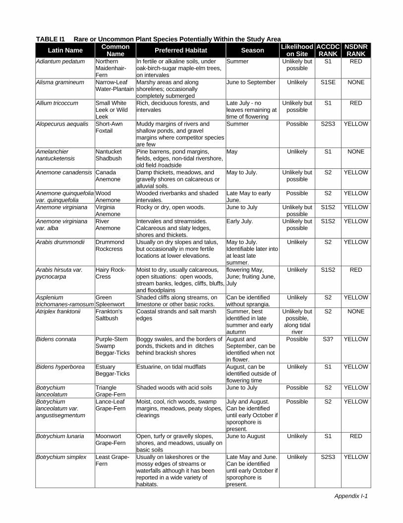
Appendix I-1
TABLE I1 Rare or Uncommon Plant Species Potentially Within the Study AreaLatin Name Common
Name Preferred Habitat Season Likelihood on Site
ACCDC RANK
NSDNR RANK
Adiantum pedatum Northern Maidenhair-Fern
In fertile or alkaline soils, under oak-birch-sugar maple-elm trees, on intervales
Summer Unlikely but possible
S1 RED
Alisma gramineum Narrow-Leaf Water-Plantain
Marshy areas and along shorelines; occasionally completely submerged
June to September Unlikely S1SE NONE
Allium tricoccum Small White Leek or Wild Leek
Rich, deciduous forests, and intervales
Late July - no leaves remaining at time of flowering
Unlikely but possible
S1 RED
Alopecurus aequalis Short-Awn Foxtail
Muddy margins of rivers and shallow ponds, and gravel margins where competitor species are few
Summer Possible S2S3 YELLOW
Amelanchier nantucketensis
Nantucket Shadbush
Pine barrens, pond margins, fields, edges, non-tidal rivershore, old field /roadside
May Unlikely S1 NONE
Anemone canadensis Canada Anemone
Damp thickets, meadows, and gravelly shores on calcareous or alluvial soils.
May to July. Unlikely but possible
S2 YELLOW
Anemone quinquefolia var. quinquefolia
Wood Anemone
Wooded riverbanks and shaded intervales.
Late May to early June.
Possible S2 YELLOW
Anemone virginiana Virginia Anemone
Rocky or dry, open woods. June to July Unlikely but possible
S1S2 YELLOW
Anemone virginiana var. alba
River Anemone
Intervales and streamsides. Calcareous and slaty ledges, shores and thickets.
Early July. Unlikely but possible
S1S2 YELLOW
Arabis drummondii Drummond Rockcress
Usually on dry slopes and talus, but occasionally in more fertile locations at lower elevations.
May to July. Identifiable later into at least late summer.
Unlikely S2 YELLOW
Arabis hirsuta var. pycnocarpa
Hairy Rock-Cress
Moist to dry, usually calcareous, open situations: open woods, stream banks, ledges, cliffs, bluffs, and floodplains
flowering May, June; fruiting June, July
Unlikely S1S2 RED
Asplenium trichomanes-ramosum
Green Spleenwort
Shaded cliffs along streams, on limestone or other basic rocks.
Can be identified without sprangia.
Unlikely S2 YELLOW
Atriplex franktonii Frankton's Saltbush
Coastal strands and salt marsh edges
Summer, best identified in late summer and early autumn
Unlikely but possible,
along tidal river
S2 NONE
Bidens connata Purple-Stem Swamp Beggar-Ticks
Boggy swales, and the borders of ponds, thickets and in ditches behind brackish shores
August and September, can be identified when not in flower.
Possible S3? YELLOW
Bidens hyperborea Estuary Beggar-Ticks
Estuarine, on tidal mudflats August, can be identified outside of flowering time
Unlikely S1 YELLOW
Botrychium lanceolatum
Triangle Grape-Fern
Shaded woods with acid soils June to July Possible S2 YELLOW
Botrychium lanceolatum var. angustisegmentum
Lance-Leaf Grape-Fern
Moist, cool, rich woods, swamp margins, meadows, peaty slopes, clearings
July and August. Can be identified until early October if sporophore is present.
Possible S2 YELLOW
Botrychium lunaria Moonwort Grape-Fern
Open, turfy or gravelly slopes, shores, and meadows, usually on basic soils
June to August Unlikely S1 RED
Botrychium simplex Least Grape-Fern
Usually on lakeshores or the mossy edges of streams or waterfalls although it has been reported in a wide variety of habitats.
Late May and June. Can be identified until early October if sporophore is present.
Unlikely S2S3 YELLOW
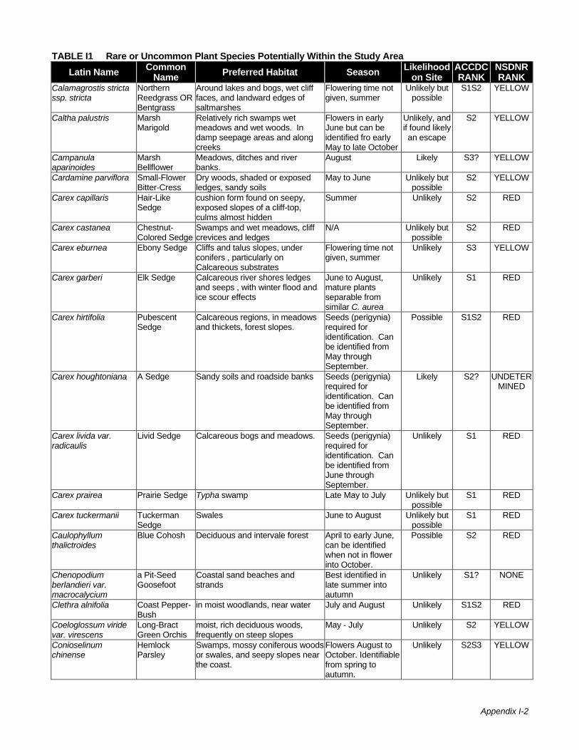
Appendix I-2
TABLE I1 Rare or Uncommon Plant Species Potentially Within the Study AreaLatin Name Common
Name Preferred Habitat Season Likelihood on Site
ACCDC RANK
NSDNR RANK
Calamagrostis stricta ssp. stricta
Northern Reedgrass OR Bentgrass
Around lakes and bogs, wet cliff faces, and landward edges of saltmarshes
Flowering time not given, summer
Unlikely but possible
S1S2 YELLOW
Caltha palustris Marsh Marigold
Relatively rich swamps wet meadows and wet woods. In damp seepage areas and along creeks
Flowers in early June but can be identified fro early May to late October
Unlikely, and if found likely an escape
S2 YELLOW
Campanula aparinoides
Marsh Bellflower
Meadows, ditches and river banks.
August Likely S3? YELLOW
Cardamine parviflora Small-Flower Bitter-Cress
Dry woods, shaded or exposed ledges, sandy soils
May to June Unlikely but possible
S2 YELLOW
Carex capillaris Hair-Like Sedge
cushion form found on seepy, exposed slopes of a cliff-top, culms almost hidden
Summer Unlikely S2 RED
Carex castanea Chestnut-Colored Sedge
Swamps and wet meadows, cliff crevices and ledges
N/A Unlikely but possible
S2 RED
Carex eburnea Ebony Sedge Cliffs and talus slopes, under conifers , particularly on Calcareous substrates
Flowering time not given, summer
Unlikely S3 YELLOW
Carex garberi Elk Sedge Calcareous river shores ledges and seeps , with winter flood and ice scour effects
June to August, mature plants separable from similar C. aurea
Unlikely S1 RED
Carex hirtifolia Pubescent Sedge
Calcareous regions, in meadows and thickets, forest slopes.
Seeds (perigynia) required for identification. Can be identified from May through September.
Possible S1S2 RED
Carex houghtoniana A Sedge Sandy soils and roadside banks Seeds (perigynia) required for identification. Can be identified from May through September.
Likely S2? UNDETERMINED
Carex livida var. radicaulis
Livid Sedge Calcareous bogs and meadows. Seeds (perigynia) required for identification. Can be identified from June through September.
Unlikely S1 RED
Carex prairea Prairie Sedge Typha swamp Late May to July Unlikely but possible
S1 RED
Carex tuckermanii Tuckerman Sedge
Swales June to August Unlikely but possible
S1 RED
Caulophyllum thalictroides
Blue Cohosh Deciduous and intervale forest April to early June, can be identified when not in flower into October.
Possible S2 RED
Chenopodium berlandieri var. macrocalycium
a Pit-Seed Goosefoot
Coastal sand beaches and strands
Best identified in late summer into autumn
Unlikely S1? NONE
Clethra alnifolia Coast Pepper-Bush
in moist woodlands, near water July and August Unlikely S1S2 RED
Coeloglossum viride var. virescens
Long-Bract Green Orchis
moist, rich deciduous woods, frequently on steep slopes
May - July Unlikely S2 YELLOW
Conioselinum chinense
Hemlock Parsley
Swamps, mossy coniferous woods or swales, and seepy slopes near the coast.
Flowers August to October. Identifiable from spring to autumn.
Unlikely S2S3 YELLOW

Appendix I-3
TABLE I1 Rare or Uncommon Plant Species Potentially Within the Study AreaLatin Name Common
Name Preferred Habitat Season Likelihood on Site
ACCDC RANK
NSDNR RANK
Cryptogramma stelleri Fragile Rockbrake
Shaded limestone cliffs, and shaded crevices in conglomerate cliff-face.
Late May to September. Can be identified when sporangia are not present.
Unlikely S1S2 YELLOW
Cynoglossum virginianum var. boreale
Northern Wild Comfrey
Rich woods and thickets, often associated with hemlocks
Flowering May, June; fruiting June, July, identifiable throughout spring to fall
Unlikely but possible
S1 RED
Cypripedium arietinum Ram's-Head Lady's-Slipper
On calcareous soils, often near outcrops of gypsum, or limestone, occasionally in deciduous forests
Late May Unlikely S1 RED
Cypripedium parviflorum or Cypripedium calceolus var parviflorum
Small Yellow Lady's-Slipper
Most often associated with gypsum or open calcarious soils
Flowers in June. Plant identifiable from late May to October
Unlikely but possible
S3 YELLOW
Cypripedium parviflorum var. pubescens or Cypripedium calceolus var pubescens
Large Yellow Lady's-Slipper
Rich calcareous woodlands, also in drier sections of seepage fed wetlands or old beaver pond woodland
Flowers in June. Plant identifiable from late May to October
Possible S2 YELLOW
Cypripedium reginae Showy Lady's-Slipper
Alkaline swamps and bogs. Flowers June through August. Can be identified some weeks prior to bloom and at least to early October.
Possible S2 RED
Desmodium canadense
Showy Tick-Trefoil
Open woods and river banks Late July to early September, can be identified when not in flower.
Unlikely but possible
S1 RED
Desmodium glutinosum
Large Tick-Trefoil
Thickets, streambanks, low woods, roadsides, railroads
June to August, can be identified when not in flower
Unlikely but possible
S2 RED
Dichanthelium linearifolium OR Panicum linarifolium
Slim-Leaf Witchgrass
Dry sandy soils. July to October. Unlikely S2? YELLOW
Dirca palustris Eastern Leatherwood
Low wet woods, streambanks, rich wooded slopes
March to April Possible S1 RED
Draba arabisans Rock Whitlow-Grass
Muddy soils or on calcareous rocks, in cliff crevices and ledges.
May to July Unlikely S2 YELLOW
Dryopteris fragrans var. remotiuscula
Fragrant Fern Dry, overhanging cliffs, and in cliff crevices along streams or near waterfalls.
June to September. Can be identified without sporangia.
Unlikely S2 YELLOW
Elymus hystrix Bottle-Brush Grass
Bottoms, mesic to dry upland forests, glade margins, upland prairies, bluff ledges, streambanks, disturbed sites. In Maritimes in rich open calcareous hardwoods or clearings or similar river intervales
June to August, best identified at or subsequent to bloom into early autumn when most detectable
Unlikely but possible
S1 RED
Elymus wiegandii SYN Elymus wiegandii var wiegandii
Wiegand's Wild Rye
Rich streambanks and meadows Flowers July and August, not readily noticeable until bloom
Possible S1 RED
Empetrum eamesii Rock Crowberry
Exposed sands and siliceous gravels and rocks
identifiable year round
Unlikely S2S3 YELLOW
Empetrum eamesii ssp. atropurpureum
Purple Crowberry
Granitic or acidic gravel and sands on mountains
identifiable year round
Unlikely S2S3 YELLOW

Appendix I-4
TABLE I1 Rare or Uncommon Plant Species Potentially Within the Study AreaLatin Name Common
Name Preferred Habitat Season Likelihood on Site
ACCDC RANK
NSDNR RANK
Epilobium coloratum Purple-Leaf Willow-Herb
Low-lying ground, springy slopes and similar locations.
July and October. Seeds required for identification.
Likely S2? YELLOW
Epilobium strictum Downy Willow-Herb
Boggy areas and wet meadows Flowers July to September. Likely identifiable from late May to October
Possible S3 YELLOW
Equisetum pratense Meadow Horsetail
Grassy stream banks, up to 900m Coning in May and June, identifiable through growing season
Likely S2 YELLOW
Erigeron hyssopifolius Daisy Fleabane
Exposed gypsum outcrops, damp stream banks between flood levels, banks ledges and cliffs. Calcareous and low competition
Flowers July and August but identifiable though less noticeable from May to October
Unlikely but possible
S2S3 YELLOW
Eriophorum gracile Slender Cotton-Grass
Wet peat and inundated shores Flowers and fruits early summer, distinguishable on to
Possible S2 YELLOW
Euthamia caroliniana Grass-Leaved Goldenrod
Outwash plain pondshores, in moist sand, usually below seasonal high-water level
August to October Unlikely S3 YELLOW
Euthamia galetorum Narrow-Leaf Fragrant Golden-Rod
Old fields, poorly drained soils, ditches, swamps, and lakeshores
August and September
Unlikely S3S4 GREEN
Festuca subverticillata Nodding Fescue
Rich, deciduous forested slopes and alluvial woods
June and early July Unlikely but possible
S1S2 RED
Floerkea proserpinacoides
False Mermaid-Weed
Deciduous ravine slopes, river margins, and intervale forests.
Late May to late June. Can be identified when not in flower.
Unlikely but possible
S2S3 YELLOW
Fraxinus nigra Black Ash Low ground, damp woods and swamps.
May and June. Can be identified without flowers.
Likely S3 YELLOW
Geocaulon lividum Northern Comandra
Sterile soils and damp sands, in acid or peaty locations. Typically on mesic lichen barrens and drier lichen set areas of ombrotrophic bog.
Late May to early August
Unlikely S2S3 YELLOW
Goodyera pubescens Downy Rattlesnake-Plantain
Coniferous woods, often growing on moss
July to August Likely S1 RED
Gratiola neglecta Clammy Hedge-Hyssop
Muddy places, wet ground June to September Likely S1 YELLOW
Helianthemum canadense
Canada Frostweed
Sandy or rocky dry soil in open woods and clearings
May to June Unlikely S1 RED
Hepatica nobilis Round-Lobe Hepatica
Dry, usually mixed deciduous forests
Early May Unlikely S1 NONE
Hepatica nobilis var. obtusa or Hepatica americana
Round-Leaved Liverleaf
Rich or rocky wooded slopes, ravines, mossy banks, ledges. Usually on circumneutral soils.
March to April. Can be identified when not in flower
Possible S1 RED
Hudsonia ericoides Golden-Heather
Dunes, rocks, pine barrens May to July. Can be identified when not in flower
Unlikely S2 YELLOW
Hudsonia tomentosa Sand-Heather Sandy dunes and shores Flowers May to June. Identifiable year round
Unlikely S1 RED
Hypericum dissimulatum
Disguised St. John's-Wort
Moist, gravelly sand roadsides and in fresh marshes
N/A Unlikely but possible
S2S3 NONE
Impatiens pallida Pale Jewel-Weed
Rich alluvial soils, damp thickets, and along intervales
July and August. Unlikely but possible
S2 YELLOW
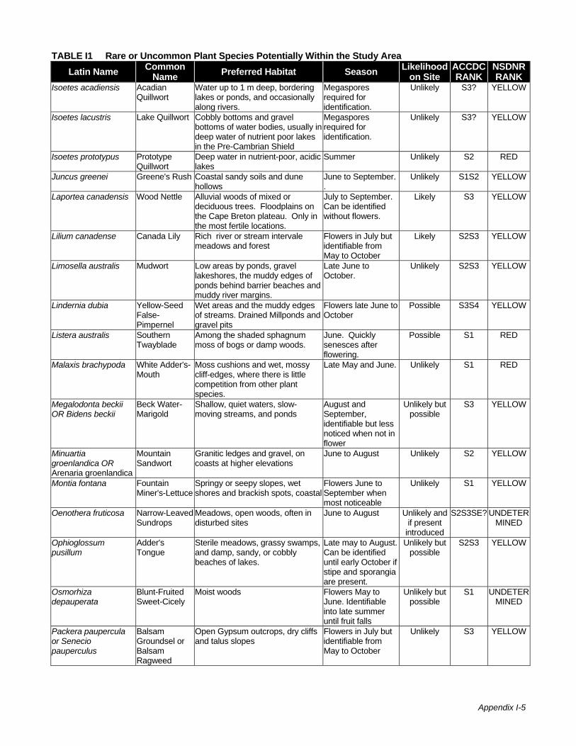
Appendix I-5
TABLE I1 Rare or Uncommon Plant Species Potentially Within the Study AreaLatin Name Common
Name Preferred Habitat Season Likelihood on Site
ACCDC RANK
NSDNR RANK
Isoetes acadiensis Acadian Quillwort
Water up to 1 m deep, bordering lakes or ponds, and occasionally along rivers.
Megaspores required for identification.
Unlikely S3? YELLOW
Isoetes lacustris Lake Quillwort Cobbly bottoms and gravel bottoms of water bodies, usually in deep water of nutrient poor lakes in the Pre-Cambrian Shield
Megaspores required for identification.
Unlikely S3? YELLOW
Isoetes prototypus Prototype Quillwort
Deep water in nutrient-poor, acidic lakes
Summer Unlikely S2 RED
Juncus greenei Greene's Rush Coastal sandy soils and dune hollows
June to September. .
Unlikely S1S2 YELLOW
Laportea canadensis Wood Nettle Alluvial woods of mixed or deciduous trees. Floodplains on the Cape Breton plateau. Only in the most fertile locations.
July to September. Can be identified without flowers.
Likely S3 YELLOW
Lilium canadense Canada Lily Rich river or stream intervale meadows and forest
Flowers in July but identifiable from May to October
Likely S2S3 YELLOW
Limosella australis Mudwort Low areas by ponds, gravel lakeshores, the muddy edges of ponds behind barrier beaches and muddy river margins.
Late June to October.
Unlikely S2S3 YELLOW
Lindernia dubia Yellow-Seed False-Pimpernel
Wet areas and the muddy edges of streams. Drained Millponds and gravel pits
Flowers late June to October
Possible S3S4 YELLOW
Listera australis Southern Twayblade
Among the shaded sphagnum moss of bogs or damp woods.
June. Quickly senesces after flowering.
Possible S1 RED
Malaxis brachypoda White Adder's-Mouth
Moss cushions and wet, mossy cliff-edges, where there is little competition from other plant species.
Late May and June. Unlikely S1 RED
Megalodonta beckii OR Bidens beckii
Beck Water-Marigold
Shallow, quiet waters, slow-moving streams, and ponds
August and September, identifiable but less noticed when not in flower
Unlikely but possible
S3 YELLOW
Minuartia groenlandica OR Arenaria groenlandica
Mountain Sandwort
Granitic ledges and gravel, on coasts at higher elevations
June to August Unlikely S2 YELLOW
Montia fontana Fountain Miner's-Lettuce
Springy or seepy slopes, wet shores and brackish spots, coastal
Flowers June to September when most noticeable
Unlikely S1 YELLOW
Oenothera fruticosa Narrow-Leaved Sundrops
Meadows, open woods, often in disturbed sites
June to August Unlikely and if present
introduced
S2S3SE? UNDETERMINED
Ophioglossum pusillum
Adder's Tongue
Sterile meadows, grassy swamps, and damp, sandy, or cobbly beaches of lakes.
Late may to August. Can be identified until early October if stipe and sporangia are present.
Unlikely but possible
S2S3 YELLOW
Osmorhiza depauperata
Blunt-Fruited Sweet-Cicely
Moist woods Flowers May to June. Identifiable into late summer until fruit falls
Unlikely but possible
S1 UNDETERMINED
Packera paupercula or Senecio pauperculus
Balsam Groundsel or Balsam Ragweed
Open Gypsum outcrops, dry cliffs and talus slopes
Flowers in July but identifiable from May to October
Unlikely S3 YELLOW
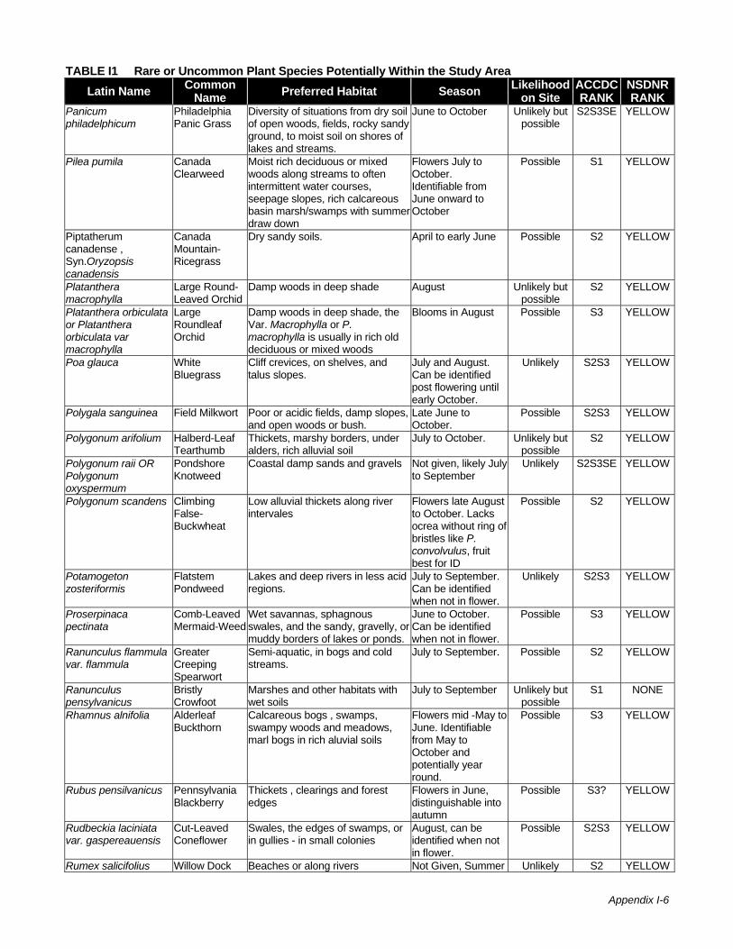
Appendix I-6
TABLE I1 Rare or Uncommon Plant Species Potentially Within the Study AreaLatin Name Common
Name Preferred Habitat Season Likelihood on Site
ACCDC RANK
NSDNR RANK
Panicum philadelphicum
Philadelphia Panic Grass
Diversity of situations from dry soil of open woods, fields, rocky sandy ground, to moist soil on shores of lakes and streams.
June to October Unlikely but possible
S2S3SE YELLOW
Pilea pumila Canada Clearweed
Moist rich deciduous or mixed woods along streams to often intermittent water courses, seepage slopes, rich calcareous basin marsh/swamps with summer draw down
Flowers July to October. Identifiable from June onward to October
Possible S1 YELLOW
Piptatherum canadense , Syn.Oryzopsis canadensis
Canada Mountain-Ricegrass
Dry sandy soils. April to early June Possible S2 YELLOW
Platanthera macrophylla
Large Round-Leaved Orchid
Damp woods in deep shade August Unlikely but possible
S2 YELLOW
Platanthera orbiculata or Platanthera orbiculata var macrophylla
Large Roundleaf Orchid
Damp woods in deep shade, the Var. Macrophylla or P. macrophylla is usually in rich old deciduous or mixed woods
Blooms in August Possible S3 YELLOW
Poa glauca White Bluegrass
Cliff crevices, on shelves, and talus slopes.
July and August. Can be identified post flowering until early October.
Unlikely S2S3 YELLOW
Polygala sanguinea Field Milkwort Poor or acidic fields, damp slopes, and open woods or bush.
Late June to October.
Possible S2S3 YELLOW
Polygonum arifolium Halberd-Leaf Tearthumb
Thickets, marshy borders, under alders, rich alluvial soil
July to October. Unlikely but possible
S2 YELLOW
Polygonum raii OR Polygonum oxyspermum
Pondshore Knotweed
Coastal damp sands and gravels Not given, likely July to September
Unlikely S2S3SE YELLOW
Polygonum scandens Climbing False-Buckwheat
Low alluvial thickets along river intervales
Flowers late August to October. Lacks ocrea without ring of bristles like P. convolvulus, fruit best for ID
Possible S2 YELLOW
Potamogeton zosteriformis
Flatstem Pondweed
Lakes and deep rivers in less acid regions.
July to September. Can be identified when not in flower.
Unlikely S2S3 YELLOW
Proserpinaca pectinata
Comb-Leaved Mermaid-Weed
Wet savannas, sphagnous swales, and the sandy, gravelly, or muddy borders of lakes or ponds.
June to October. Can be identified when not in flower.
Possible S3 YELLOW
Ranunculus flammula var. flammula
Greater Creeping Spearwort
Semi-aquatic, in bogs and cold streams.
July to September. Possible S2 YELLOW
Ranunculus pensylvanicus
Bristly Crowfoot
Marshes and other habitats with wet soils
July to September Unlikely but possible
S1 NONE
Rhamnus alnifolia Alderleaf Buckthorn
Calcareous bogs , swamps, swampy woods and meadows, marl bogs in rich aluvial soils
Flowers mid -May to June. Identifiable from May to October and potentially year round.
Possible S3 YELLOW
Rubus pensilvanicus Pennsylvania Blackberry
Thickets , clearings and forest edges
Flowers in June, distinguishable into autumn
Possible S3? YELLOW
Rudbeckia laciniata var. gaspereauensis
Cut-Leaved Coneflower
Swales, the edges of swamps, or in gullies - in small colonies
August, can be identified when not in flower.
Possible S2S3 YELLOW
Rumex salicifolius Willow Dock Beaches or along rivers Not Given, Summer Unlikely S2 YELLOW
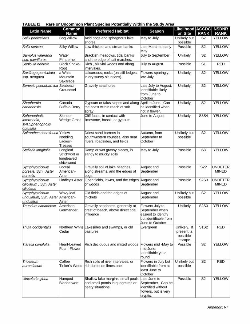
Appendix I-7
TABLE I1 Rare or Uncommon Plant Species Potentially Within the Study AreaLatin Name Common
Name Preferred Habitat Season Likelihood on Site
ACCDC RANK
NSDNR RANK
Salix pedicellaris Bog Willow Acid bogs and sphagnous lake shores.
May to July. Unlikely but possible
S2 YELLOW
Salix sericea Silky Willow Low thickets and streambanks Late March to early May
Possible S2 YELLOW
Samolus valerandi ssp. parviflorus
Water Pimpernel
Brackish meadows, tidal banks and the edge of salt marshes.
July to September. Unlikely S2 YELLOW
Sanicula odorata Black Snake-Root
Rich , alluvial woods and along intervales.
July to August Possible S1 RED
Saxifraga paniculata ssp. neogaea
a White Mountain Saxifrage
calcareous; rocks (on cliff ledges, in dry sunny situations).
Flowers sparingly, late July
Unlikely S2 YELLOW
Senecio pseudoarnica Seabeach Groundsel
Gravelly seashores Late July to August. Identifiable likely from June to October
Unlikely S2 YELLOW
Shepherdia canadensis
Canada Buffalo-Berry
Gypsum or talus slopes and along the coast within reach of salt spray.
April to June. Can be identified when not in flower.
Unlikely S2 YELLOW
Sphenopholis intermedia, syn.Sphenopholis obtusata
Slender Wedge Grass
Cliff faces, in contact with limestone, basalt, or gypsum
June to August Unlikely S3S4 YELLOW
Spiranthes ochroleuca Yellow Nodding Ladies'-Tresses
Driest sand barrens in southwestern counties, also near rivers, roadsides, and fields
Autumn, from September to October
Unlikely but possible
S2 YELLOW
Stellaria longifolia Longleaf Stitchwort or longleaved chickweed
Damp or wet grassy places, in sandy to mucky soils
May to July Possible S3 YELLOW
Symphyotrichum boreale, Syn. Aster borealis
Boreal American-Aster
Gravelly soil of lake beaches, along streams, and the edges of bogs
August and September
Possible S2? UNDETERMINED
Symphyotrichum ciliolatum , Syn. Aster ciliolatus
Lindley's Aster Open fields, lawns, and the edges of woods
August and September
Possible S2S3 UNDETERMINED
Symphyotrichum undulatum, Syn. Aster undulatus
Wavy-leaf American-Aster
Old fields and the edges of thickets
August and September
Unlikely but possible
S2 YELLOW
Teucrium canadense American Germander
Gravelly seashores, generally at crest of beach, above direct tidal influence
Flowers July to September when easiest to identify but identifiable from June to October
Unlikely S2S3 YELLOW
Thuja occidentalis Northern White Cedar
Lakesides and swamps, or old pastures
Evergreen Unlikely. If present, a possible escape
S1S2 RED
Tiarella cordifolia Heart-Leaved Foam-Flower
Rich deciduous and mixed woods Flowers mid -May to mid-June. Identifiable year round
Possible S2 YELLOW
Triosteum aurantiacum
Coffee Tinker's-Weed
Rich soils of river intervales, or rich forest on limestone
Flowers in July but identifiable from at least June to October
Unlikely but possible
S2 RED
Utricularia gibba Humped Bladderwort
Shallow lake margins, small pools and small ponds in quagmires or peaty situations.
Late June to September. Can be identified without flowers, but is very cryptic.
Possible S2 YELLOW

Appendix I-8
TABLE I1 Rare or Uncommon Plant Species Potentially Within the Study AreaLatin Name Common
Name Preferred Habitat Season Likelihood on Site
ACCDC RANK
NSDNR RANK
Vaccinium caespitosum
Dwarf Blueberry
Rocky cliffs and rock crevices. Dry or wet acidic sites
Not given for NS. Likely identifiable in early summer on to October
Unlikely S2 YELLOW
Vaccinium uliginosum Alpine Blueberry
Dry or wet organic and inorganic soils, tolerant of high copper concentrations.
Not given for NS. Likely identifiable from early summer to October
Unlikely S2 YELLOW
Viola nephrophylla Northern Bog Violet
Cool mossy bogs, the borders of streams, and damp woods.
May to July. Best identified in flower
Likely S2 YELLOW
Viola sagittata Arrow-Leaved Violet
Dry sterile woods, clearings, and fields
April and May, identifiable into early autumn
Unlikely but possible
S3S4 YELLOW
Woodsia glabella Smooth Woodsia
Shaded vertical cliffs, and along streams in northern Cape Breton.
Spores form June to August. Can be identified without sporangia.
Unlikely S2 YELLOW
Zizia aurea Common Alexanders
Meadows, shores, damp thickets and wet woods. Generally in relatively rich sites
Flowers May and June but is identifiable until October
Unlikely but possible
S1S2 YELLOW
Likelihood on Site Unlikely Very low probability due to likely absence of suitable habitat, or dispersability limitations combined with
lack of nearby known populations. Unlikely but possible Low probability due to likely absence of suitable habitat or dispersability limitations combined with lack
of nearby known populations, but with more potential than above. Possible Medium probability due to more proximal known populations, better dispersability and greater chance
apparent existing habitats could hold these species. Likely High probability of encountering these species in habitats possibly present in the study area. Atlantic Canada Conservation Data Centre (ACCDC) General Status Ranks S1 Very Rare S2 Rare S3 Uncommon S4 Fairly Common SE Exotic Note: A combination of S ranks (eg. S3S4) or the presence of a question mark denotes uncertainty regarding the population status of species Nova Scotia Department of Natural Resources (NSDNR) General Status Ranks Blue Extinct Red Known to be or thought to be at risk Yellow Sensitive to human activities or natural events Undetermined Insufficient data exists to assess status Green Secure Source: ACCDC 2005; NSDNR 2002; Roland and Zinck 1998

Appendix I-9
References Atlantic Canada Conservation Data Centre (ACCDC). 2005. Data request for uncommon and rare
species in the vicinity of Alton, Nova Scotia. Request made September 2005.
ACCDC. 2002. Nova Scotia Vascular Plant Tracking List. March 29, 2002.
Nova Scotia Department of Natural Resources (NSDNR). 2002. General Status Ranks of Wild Species in Nova Scotia. Internet Publication. http://www.gov.ns.ca/natr/wildlife/genstatus/.
Roland, A.E. and M. Zinck. 1998. Roland’s Flora of Nova Scotia. Nimbus Publishing and the Nova Scotia Museum, Halifax, NS.
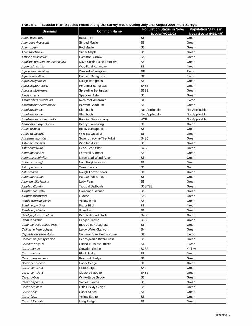
Binomial Common Name Population Status in Nova Scotia (ACCDC)
Population Status in Nova Scotia (NSDNR)
Abies balsamea Balsam Fir S5 GreenAcer pensylvanicum Striped Maple S5 GreenAcer rubrum Red Maple S5 GreenAcer saccharum Sugar Maple S5 GreenAchillea millefolium Common Yarrow S5 GreenAgalinus pururea var. neoscotica Nova Scotia False-Foxglove S4 GreenAgrimonia striata Woodland Agrimony S5 GreenAgropyron cristatum Crested Wheatgrass SE ExoticAgrostis capillaris Colonial Bentgrass SE ExoticAgrostis hyemalis Rough Bentgrass S5 GreenAgrostis perennans Perennial Bentgrass S4S5 GreenAgrostis stolonifera Spreading Bentgrass S5SE GreenAlnus incana Speckled Alder S5 GreenAmaranthus retroflexus Red-Root Amaranth SE ExoticAmelanchier bartramiana Bartram Shadbush S5 GreenAmelanchier sp. Shadbush Not Applicable Not ApplicableAmelanchier sp. Shadbush Not Applicable Not ApplicableAmelanchier x intermedia Running Serviceberry HYB Not ApplicableAnaphalis margaritacea Pearly Everlasting S5 GreenAralia hispida Bristly Sarsaparilla S5 GreenAralia nudicaulis Wild Sarsaparilla S5 GreenArisaema triphyllum Swamp Jack-In-The-Pulpit S4S5 GreenAster acuminatus Whorled Aster S5 GreenAster cordifolius Heart-Leaf Aster S4S5 GreenAster lateriflorus Farewell-Summer S5 GreenAster macrophyllus Large-Leaf Wood-Aster S5 GreenAster novi-belgii New Belgium Aster S5 GreenAster puniceus Swamp Aster S5 GreenAster radula Rough-Leaved Aster S5 GreenAster umbellatus Parasol White-Top S5 GreenAthyrium filix-femina Lady-Fern S5 GreenAtriplex littoralis Tropical Saltbush S3S4SE GreenAtriplex prostrata Creeping Saltbush S5 GreenAtriplex subspicata Orache S5? GreenBetula alleghaniensis Yellow Birch S5 GreenBetula papyrifera Paper Birch S5 GreenBetula populifolia Gray Birch S5 GreenBrachyelytrum erectum Bearded Short-Husk S4S5 GreenBromus ciliatus Fringed Brome S4S5 GreenCalamagrostis canadensis Blue-Joint Reedgrass S5 GreenCallitriche heterophylla Large Water-Starwort S4 GreenCapsella bursa-pastoris Common Shepherd's Purse SE ExoticCardamine pensylvanica Pennsylvania Bitter-Cress S5 GreenCarduus crispus Curled Plumless-Thistle SE ExoticCarex adusta Crowded Sedge S2S3 YellowCarex arctata Black Sedge S5 GreenCarex brunnescens Brownish Sedge S5 GreenCarex canescens Hoary Sedge S5 GreenCarex conoidea Field Sedge S4? GreenCarex cumulata Clustered Sedge S4S5 GreenCarex debilis White-Edge Sedge S5 GreenCarex disperma Softleaf Sedge S5 GreenCarex echinata Little Prickly Sedge S5 GreenCarex exilis Coast Sedge S4 GreenCarex flava Yellow Sedge S5 GreenCarex folliculata Long Sedge S5 Green
TABLE I2 Vascular Plant Species Found Along the Survey Route During July and August 2006 Field Sureys.
Appendix I‐1

Binomial Common Name Population Status in Nova Scotia (ACCDC)
Population Status in Nova Scotia (NSDNR)
TABLE I2 Vascular Plant Species Found Along the Survey Route During July and August 2006 Field Sureys.
Carex gynandra A Sedge S5 GreenCarex houghtoniana A Sedge S3? YellowCarex intumescens Bladder Sedge S5 GreenCarex leptalea Bristle-Stalk Sedge S5 GreenCarex leptonervia Finely-Nerved Sedge S5 GreenCarex lurida Shallow Sedge S5 GreenCarex novae-angliae New England Sedge S5 GreenCarex pallescens Pale Sedge S5 GreenCarex projecta Necklace Sedge S4S5 GreenCarex retrorsa Retrorse Sedge S3S4 GreenCarex scoparia Pointed Broom Sedge S5 GreenCarex stipata Stalk-Grain Sedge S5 GreenCarex stricta Tussock Sedge S5 GreenCarex trisperma Three-Seed Sedge S5 GreenCentaurea nigra Black Starthistle SE ExoticCentaurium pulchellum Branching Centaury-Plant SE ExoticCerastium arvense Mouse-Ear Chickweed S4? GreenCerastium vulgatum Common Mouse-Ear Chickweed SE ExoticChamaedaphne calyculata Leatherleaf S5 GreenChelone glabra White Turtlehead S5 GreenChenopodium album White Goosefoot SE ExoticChrysanthemum leucanthemum Oxeye Daisy SE ExoticChrysosplenium americanum American Golden-Saxifrage S5 GreenCicuta bulbifera Bulb-Bearing Water-Hemlock S5 GreenCicuta maculata Spotted Water-Hemlock S5 GreenCircaea alpina Small Enchanter's Nightshade S5 GreenCirsium arvense Creeping Thistle SE ExoticClematis virginiana Virgin's Bower S5 GreenClintonia borealis Clinton Lily S5 GreenComptonia peregrina Sweet Fern S5 GreenCoptis trifolia Goldthread S5 GreenCornus alternifolia Alternate-Leaf Dogwood S5 GreenCornus canadensis Dwarf Dogwood S5 GreenCornus sericea Red Osier Dogwood S5 GreenCorydalis sempervirens Pale Corydalis S4S5 GreenCorylus cornuta Beaked Hazelnut S5 GreenCypripedium acaule Pink Lady's-Slipper S5 GreenDalibarda repens Robin Runaway S5 GreenDanthonia compressa Flattened Oatgrass S4 GreenDanthonia spicata Poverty Oat-Grass S5 GreenDaucus carota Wild Carrot SE ExoticDennstaedtia punctilobula Eastern Hay-Scented Fern S5 GreenDiervilla lonicera Northern Bush-Honeysuckle S5 GreenDrosera rotundifolia Roundleaf Sundew S5 GreenDryopteris carthusiana Spinulose Shield Fern S5 GreenDryopteris cristata Crested Shield-Fern S5 GreenDryopteris intermedia Evergreen Woodfern S5 GreenDryopteris x boottii a Hybrid Wood-fern HYB Not ApplicableEchinochloa crus-galli Barnyard Grass SE ExoticElymus repens Quackgrass SE ExoticEpigaea repens Trailing Arbutus S5 GreenEpilobium angustifolium Fireweed S5 GreenEpilobium ciliatum Hairy Willow-Herb S5 GreenEpilobium leptophyllum Linear-Leaved Willow-Herb S5 GreenEquisetum sylvaticum Woodland Horsetail S5 GreenEquisetum variegatum Variegated Horsetail S3 Green
Appendix I‐2

Binomial Common Name Population Status in Nova Scotia (ACCDC)
Population Status in Nova Scotia (NSDNR)
TABLE I2 Vascular Plant Species Found Along the Survey Route During July and August 2006 Field Sureys.
Erechtites hieraciifolia Fireweed S5 GreenErigeron strigosus Daisy Fleabane S5 GreenEriophorum polystachion Narrow-Leaved Cotton-Grass S5 GreenEriophorum virginicum Tawny Cotton-Grass S5 GreenEupatorium maculatum Spotted Joe-Pye Weed S5 GreenEupatorium perfoliatum Common Boneset S5 GreenEuphorbia vermiculata Worm Seeded Spurge SE ExoticEuphrasia officinalis Drug Eyebright SE ExoticEuthamia graminifolia Flat-Top Fragrant-Golden-Rod S5 GreenFestuca arundinacea Tall Rye Grass SE ExoticFestuca rubra Red Fescue S5 GreenFragaria virginiana Virginia Strawberry S5 GreenFraxinus americana White Ash S5 GreenGalium asprellum Rough Bedstraw S5 GreenGalium palustre Marsh Bedstraw S5 GreenGalium tinctorium Stiff Marsh Bedstraw S5 GreenGalium trifidum Small Bedstraw S5 GreenGalium triflorum Sweet-Scent Bedstraw S5 GreenGaultheria hispidula Creeping Snowberry S5 GreenGaultheria procumbens Teaberry S5 GreenGeranium bicknellii Bicknell Northern Crane's-Bill S3 GreenGeum rivale Purple Avens S5 GreenGlaux maritima Sea Milkwort S5 GreenGlyceria canadensis Canada Manna-Grass S5 GreenGlyceria grandis American Mannagrass S4S5 GreenGlyceria striata Fowl Manna-Grass S5 GreenGlyceria X laxa Northern Mannagrass S4? GreenGnaphalium uliginosum Low Cudweed SE ExoticGymnocarpium dryopteris Northern Oak Fern S5 GreenGymnocarpium dryopteris Northern Oak Fern S5 GreenHamamelis virginiana American Witch-Hazel S5 GreenHeracleum lanatum Cow Parsnip S4S5 GreenHieracium aurantiacum Orange Hawkweed SE ExoticHieracium caespitosum Meadow Hawkweed SE ExoticHieracium canadense Canada Hawkweed S4S5 GreenHieracium lachenalii Common Hawkweed SE ExoticHieracium pilosella Mouseear SE ExoticHieracium piloselloides Tall Hawkweed SE ExoticHieracium scabrum Rough Hawkweed S5 GreenHordeum jubatum Fox-Tail Barley S5 GreenHydrocotyle americana American Water-Pennywort S5 GreenHypericum boreale Northern St. John's-Wort S5 GreenHypericum canadense Canadian St. John's-Wort S5 GreenHypericum ellipticum Pale St. John's-Wort S5 GreenHypericum perforatum A St. John's-Wort SE ExoticIlex verticillata Black Holly S5 GreenImpatiens capensis Spotted Jewel-Weed S5 GreenIris versicolor Blueflag S5 GreenJuncus articulatus Jointed Rush S5 GreenJuncus brevicaudatus Narrow-Panicled Rush S5 GreenJuncus effusus Soft Rush S5 GreenJuncus gerardii Black-Grass Rush S5 GreenJuncus pelocarpus Brown-Fruited Rush S5 GreenJuncus tenuis Slender Rush S5 GreenKalmia angustifolia Sheep-Laurel S5 GreenLactuca canadensis Canada Lettuce S5 Green
Appendix I‐3
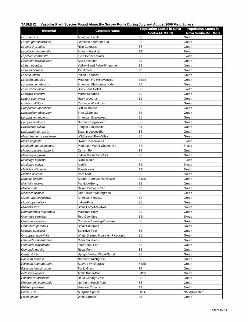
Binomial Common Name Population Status in Nova Scotia (ACCDC)
Population Status in Nova Scotia (NSDNR)
TABLE I2 Vascular Plant Species Found Along the Survey Route During July and August 2006 Field Sureys.
Larix laricina American Larch S5 GreenLedum groenlandicum Common Labrador Tea S5 GreenLeersia oryzoides Rice Cutgrass S5 GreenLeontodon autumnalis Autumn Hawkbit SE ExoticLepidium campestre Field Pepper-Grass SE ExoticLimonium carolinianum Sea-Lavender S5 GreenLindernia dubia Yellow-Seed False-Pimpernel S2 GreenLinnaea borealis Twinflower S5 GreenLobelia inflata Indian-Tobacco S5 GreenLonicera caerulea Mountain Fly-Honeysuckle S4S4 GreenLonicera canadensis American Fly-Honeysuckle S5 GreenLotus corniculatus Birds-Foot Trefoil SE ExoticLudwigia palustris Marsh Seedbox S5 GreenLuzula acuminata Hairy Woodrush S5 GreenLuzula multiflora Common Woodrush S5 GreenLycopodium annotinum Stiff Clubmoss S5 GreenLycopodium obscurum Tree Clubmoss S5 GreenLycopus americanus American Bugleweed S5 GreenLycopus uniflorus Northern Bugleweed S5 GreenLysimachia ciliata Fringed Loosestrife S4 GreenLysimachia terrestris Swamp Loosestrife S5 GreenMaianthemum canadense Wild Lily-of-The-Valley S5 GreenMalva neglecta Dwarf Cheeseweed SE ExoticMatricaria matricarioides Pineapple-Weed Chamomile SE ExoticMatteuccia struthiopteris Ostrich Fern S5 GreenMedeola virginiana Indian Cucumber-Root S5 GreenMedicago lupulina Black Medic SE ExoticMedicago sativa Alfalfa SE ExoticMelilotus officinalis Sweetclover SE ExoticMentha arvensis Corn Mint S5 GreenMimulus ringens Square-Stem Monkeyflower S4S5 GreenMitchella repens Partridge-Berry S5 GreenMitella nuda Naked Bishop's-Cap S5 GreenMoneses uniflora One-Flower Wintergreen S5 GreenMonotropa hypopithys American Pinesap S4 GreenMonotropa uniflora Indian-Pipe S5 GreenMyosotis laxa Small Forget-Me-Not S5 GreenNemopanthus mucronata Mountain Holly S5 GreenOdontites serotina Red Odontites SE ExoticOenothera biennis Common Evening-Primrose S5 GreenOenothera perennis Small Sundrops S5 GreenOnoclea sensibilis Sensitive Fern S5 GreenOryzopsis asperifolia White-Grained Mountain-Ricegrass S5 GreenOsmunda cinnamomea Cinnamon Fern S5 GreenOsmunda claytoniana Interrupted Fern S5 GreenOsmunda regalis Royal Fern S5 GreenOxalis stricta Upright Yellow Wood-Sorrel S5 GreenPanicum boreale Northern Witchgrass S5 GreenPanicum depauperatum Starved Witchgrass S4S5 GreenPanicum lanuginosum Panic Grass S5 GreenPetasites frigidus Arctic Butter-Bur S4S5 GreenPhalaris arundinacea Reed Canary Grass S5 GreenPhegopteris connectilis Northern Beech Fern S5 GreenPhleum pratense Meadow Timothy SE ExoticPicea X sp. A Hybrid Spruce HYB Not ApplicablePicea glauca White Spruce S5 Green
Appendix I‐4
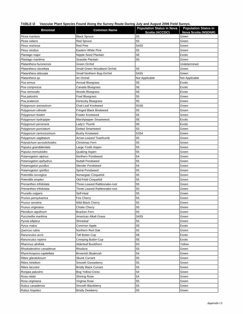
Binomial Common Name Population Status in Nova Scotia (ACCDC)
Population Status in Nova Scotia (NSDNR)
TABLE I2 Vascular Plant Species Found Along the Survey Route During July and August 2006 Field Sureys.
Picea mariana Black Spruce S5 GreenPicea rubens Red Spruce S5 GreenPinus resinosa Red Pine S4S5 GreenPinus strobus Eastern White Pine S5 GreenPlantago major Nipple-Seed Plantain SE ExoticPlantago maritima Seaside Plantain S5 GreenPlatanthera huronensis Green Orchid UndeterminedPlatanthera clavellata Small Green Woodland Orchid S5 GreenPlatanthera obtusata Small Northern Bog-Orchid S4S5 GreenPlatanthera sp. An Orchid Not Applicable Not ApplicablePoa annua Annual Bluegrass SE ExoticPoa compressa Canada Bluegrass SE ExoticPoa nemoralis Woods Bluegrass SE ExoticPoa palustris Fowl Bluegrass S5 GreenPoa pratensis Kentucky Bluegrass S5 GreenPolygonum arenastrum Oval-Leaf Knotweed S5SE GreenPolygonum cilinode Fringed Black Bindweed S5 GreenPolygonum fowleri Fowler Knotweed S5 GreenPolygonum hydropiper Marshpepper Smartweed SE ExoticPolygonum persicaria Lady's Thumb SE ExoticPolygonum punctatum Dotted Smartweed S5 GreenPolygonum ramosissimum Bushy Knotweed S3S4 GreenPolygonum sagittatum Arrow-Leaved Tearthumb S5 GreenPolystichum acrostichoides Christmas Fern S5 GreenPopulus grandidentata Large-Tooth Aspen S5 GreenPopulus tremuloides Quaking Aspen S5 GreenPotamogeton alpinus Northern Pondweed S4 GreenPotamogeton epihydrus Nuttall Pondweed S5 GreenPotamogeton pusillus Slender Pondweed S4 GreenPotamogeton spirillus Spiral Pondweed S5 GreenPotentilla norvegica Norwegian Cinquefoil S5 GreenPotentilla simplex Old-Field Cinquefoil S5 GreenPrenanthes trifoliolata Three-Leaved Rattlesnake-root S5 GreenPrenanthes trifoliolata Three-Leaved Rattlesnake-root S5 GreenPrunella vulgaris Self-Heal S5 GreenPrunus pensylvanica Fire Cherry S5 GreenPrunus serotina Wild Black Cherry S5 GreenPrunus virginiana Choke Cherry S5 GreenPteridium aquilinum Bracken Fern S5 GreenPuccinellia maritima American Alkali Grass S4S5 GreenPyrola elliptica Shineleaf S5 GreenPyrus malus Common Apple SE ExoticQuercus rubra Northern Red Oak S5 GreenRanunculus acris Tall Butter-Cup SE ExoticRanunculus repens Creeping Butter-Cup SE ExoticRhamnus alnifolia Alderleaf Buckthorn S3 YellowRhododendron canadense Rhodora S5 GreenRhynchospora capitellata Brownish Beakrush S4 GreenRibes glandulosum Skunk Currant S5 GreenRibes hirtellum Smooth Gooseberry S5 GreenRibes lacustre Bristly Black Currant S5 GreenRorippa palustris Bog Yellow-Cress S4 GreenRosa nitida Shining Rose S4 GreenRosa virginiana Virginia Rose S5 GreenRubus canadensis Smooth Blackberry S5 GreenRubus hispidus Bristly Dewberry S5 Green
Appendix I‐5

Binomial Common Name Population Status in Nova Scotia (ACCDC)
Population Status in Nova Scotia (NSDNR)
TABLE I2 Vascular Plant Species Found Along the Survey Route During July and August 2006 Field Sureys.
Rubus idaeus Red Raspberry S5 GreenRubus pubescens Dwarf Red Raspberry S5 GreenRubus setosus Small Bristleberry S4? GreenRubus sp. A Bramble Not Applicable Not ApplicableRumex crispus Curly Dock SE ExoticSagittaria Sp. An Arrowhead Not Applicable Not ApplicableSalix bebbiana Bebb's Willow S5 GreenSalix discolor Pussy Willow S5 GreenSalix eriocephala Heart-Leaved Willow S5 GreenSalix humilis Prairie Willow S5 GreenSambucus racemosa Red Elderberry S5 GreenScirpus atrovirens Georgia Bulrush S4 GreenScirpus cyperinus Cottongrass Bulrush S5 GreenScirpus cyperinus Black-Girdle Bulrush S5 GreenScirpus maritimus Saltmarsh Bulrush S4S5 GreenScirpus microcarpus Small-Fruit Bulrush S5 GreenScutellaria galericulata Hooded Skullcap S5 GreenScutellaria lateriflora Mad Dog Skullcap S5 GreenSenecio robbinsii Robbins Squaw-Weed S4S5 GreenSisyrinchium montanum Strict Blue-Eyed-Grass S5 GreenSium suave Hemlock Water-Parsnip S5 GreenSmilacina racemosa Solomon's-Plume S4S5 GreenSmilacina trifolia Three-Leaf Solomon's-Plume S4S5 GreenSolanum dulcamara Climbing Nightshade SE ExoticSolidago canadensis Canada Goldenrod S5 GreenSolidago juncea Early Goldenrod S5 GreenSolidago nemoralis Field Goldenrod S4S5 GreenSolidago puberula Downy Goldenrod S5 GreenSolidago rugosa Rough-Leaf Goldenrod S5 GreenSolidago sempervirens Seaside Goldenrod S5 GreenSolidago uliginosa Bog Goldenrod S5 GreenSonchus arvensis Field Sowthistle SE ExoticSonchus oleraceus Common Sowthistle SE ExoticSorbus americana American Mountain-Ash S5 GreenSparganium angustifolium Narrow-Leaf Burreed S4S5 GreenSparganium emersum Narrow-Leaf Burreed S5 GreenSparganium sp. A Burreed Not Applicable Not ApplicableSpartina alterniflora Saltwater Cordgrass S5 GreenSpartina patens Salt-Meadow Cordgrass S5 GreenSpartina pectinata Fresh Water Cordgrass S5 GreenSpiraea alba Narrow-Leaved Meadow-Sweet S5 GreenSpiraea tomentosa Hardhack Spiraea S5 GreenSpiranthes cernua Nodding Ladies'-Tresses S5 GreenStreptopus roseus Rosy Twistedstalk S5 GreenSuaeda maritima Maritime Sea-blite S5 GreenTaraxacum laevigatum Red-Seeded Dandelion SE ExoticTaraxacum officinale Common Dandelion SE ExoticThalictrum pubescens Tall Meadow-Rue S5 GreenThelypteris noveboracensis New York Fern S5 GreenThelypteris palustris Marsh Fern S5 GreenTriadenum fraseri Marsh St. John's-Wort S5 GreenTrientalis borealis Northern Starflower S5 GreenTrifolium arvense Rabbit-Foot Clover SE ExoticTrifolium aureum Yellow Clover SE ExoticTrifolium campestre Low Hop Clover SE ExoticTrifolium hybridum Alsike Clover SE Exotic
Appendix I‐6

Binomial Common Name Population Status in Nova Scotia (ACCDC)
Population Status in Nova Scotia (NSDNR)
TABLE I2 Vascular Plant Species Found Along the Survey Route During July and August 2006 Field Sureys.
Trifolium pratense Red Clover SE ExoticTrifolium repens White Clover SE ExoticTriglochin maritima Common Bog Arrow-Grass S5 GreenTussilago farfara Colt's Foot SE ExoticTypha latifolia Broad-Leaf Cattail S5 GreenVaccinium angustifolium Late Lowbush Blueberry S5 GreenVaccinium macrocarpon Large Cranberry S5 GreenVaccinium myrtilloides Velvetleaf Blueberry S5 GreenVaccinium oxycoccos Small Cranberry S5 GreenVeronica officinalis Gypsy-Weed S5SE ExoticVeronica scutellata Marsh Speedwell S5 GreenViburnum nudum Possum-Haw Viburnum S5 GreenViburnum opulus Guelder-Rose Viburnum S5 GreenVicia cracca Tufted Vetch SE ExoticViola adunca Labrador Violet S5 GreenViola blanda Smooth White Violet S5 GreenViola cucullata Marsh Blue Violet S5 GreenViola macloskeyi Smooth White Violet S5 GreenViola sororia Woolly Blue Violet S5 GreenZea mays Indian Corn; Maize SE Exotic
Appendix I‐7

Common Name Binomial Breeding Status NSDNR Population StatusCommon Loon Gavia immer Probable YellowPied-billed Grebe Podilymbus podiceps Probable GreenAmerican Bittern Botaurus lentiginosus Confirmed GreenGreat Blue Heron Ardea herodias Confirmed GreenCanada Goose Branta canadensis Confirmed GreenWood Duck Aix sponsa Possible GreenGreen-winged Teal Anas crecca Confirmed GreenAmerican Black Duck Anas rubripes Confirmed GreenMallard Anas platyrhynchos Confirmed GreenNorthern Pintail Anas acuta Probable GreenBlue-winged Teal Anas discors Confirmed GreenRing-necked Duck Aythya collaris Probable GreenOsprey Pandion haliaetus Confirmed GreenBald Eagle Haliaeetus leucocephalus Confirmed GreenNorthern Harrier Circus cyaneus Confirmed GreenSharp-shinned Hawk Accipiter striatus Confirmed GreenNorthern Goshawk Accipiter gentilis Confirmed YellowBroad-winged Hawk Buteo platypterus Probable GreenRed-tailed Hawk Buteo jamaicensis Probable GreenAmerican Kestrel Falco sparverius Confirmed GreenMerlin Falco columbarius Possible GreenRing-necked Pheasant Phasianus colchicus Confirmed ExoticSpruce Grouse Dendragapus canadensis Confirmed GreenRuffed Grouse Bonasa umbellus Confirmed GreenVirginia Rail Rallus limicola Probable GreenSora Porzana carolina Probable GreenKilldeer Charadrius vociferus Confirmed GreenSpotted Sandpiper Actitus macularia Confirmed GreenCommon Snipe Gallinago galinago Confirmed GreenAmerican Woodcock Scolopax minor Confirmed GreenRock Dove Columba livia Confirmed ExoticMourning Dove Zenaida macroura Possible GreenBlack-billed Cuckoo Coccyzus erythropthalmus Possible GreenGreat Horned Owl Bubo virginianus Probable GreenBarred Owl Strix varia Confirmed GreenCommon Nighthawk Chordeiles minor Confirmed YellowChimney Swift Chaetura pelagica Confirmed YellowRuby-throated Hummingbird Archilocus colubris Confirmed GreenBelted Kingfisher Ceryle alcyon Confirmed GreenYellow-bellied Sapsucker Sphryrapicus varius Confirmed GreenDowny Woodpecker Picoides pubescens Confirmed GreenHairy Woodpecker Picoides villosus Confirmed GreenBlack-backed Woodpecker Picoides arcticus Confirmed GreenNorthern Flicker Colaptes auratus Confirmed GreenPileated Woodpecker Dryocopus pileatus Confirmed GreenOlive-sided Flycatcher Contopus borealis Confirmed YellowEastern Wood Pewee Contopus virens Confirmed GreenYellow-bellied Flycatcher Empidonax flaviventris Probable GreenAlder Flycatcher Empidonax alnorum Confirmed Green
TABLE I3 Breeding Status of Birds Recorded in the Four Breeding Bird Atlas Squares within which the Project Area is found.
Appendix I-1

Common Name Binomial Breeding Status NSDNR Population Status
TABLE I3 Breeding Status of Birds Recorded in the Four Breeding Bird Atlas Squares within which the Project Area is found.
Least Flycatcher Empidonax minimus Confirmed GreenGreat-crested Flycatcher Myiarchus crinitus Probable GreenTree Swallow Tachycineta bicolor Confirmed GreenBank Swallow Riparia riparia Confirmed GreenCliff Swallow Hirundo pyrrhonota Confirmed GreenBarn Swallow Hirundo rustico Confirmed YellowGray Jay Perisoreus canadensis Confirmed YellowBlue Jay Cyanocitta cristata Confirmed GreenAmerican Crow Corvus brachyrhynchos Confirmed GreenCommon Raven Corvus corax Confirmed GreenBlack-capped Chickadee Poecile atricapillus Confirmed GreenBoreal Chickadee Poecile hudsonicus Confirmed YellowRed-breasted Nuthatch Sitta canadensis Confirmed GreenWhite-breasted Nuthatch Sitta carolinensis Probable GreenBrown Creeper Certhia americana Confirmed GreenWinter Wren Troglodytes troglodytes Confirmed GreenGolden-crowned Kinglet Regulus satrapa Confirmed GreenRuby-crowned Kinglet Regulus calendula Confirmed GreenEastern Bluebird Sialis sialis Confirmed YellowVeery Catharus fuscescens Confirmed GreenSwainson's Thrush Catharus ustulatus Confirmed GreenHermit Thrush Catharus guttatus Confirmed GreenWood Thrush Hylocichla mustelina Possible GreenAmerican Robin Turdus migratorius Confirmed GreenGray Catbird Dumetella carolinensis Confirmed GreenNorthern Mockingbird Mimus polyglottos Possible GreenCedar Waxwing Bombycilla cedrorum Confirmed GreenEuropean Starling Sturnus vulgaris Confirmed ExoticBlue-headed Vireo Vireo solitarius Confirmed GreenRed-eyed Vireo Vireo olivaceus Confirmed GreenTennessee Warbler Vermivora peregrina Probable GreenNashville Warbler Vermivora ruficapilla Confirmed GreenNorthern Parula Warbler Parula americana Confirmed GreenYellow Warbler Dendroica petechia Confirmed GreenChestnut-sided Warbler Dendroica pensylvanica Confirmed GreenMagnolia Warbler Dendroica magnolia Confirmed GreenCape May Warbler Dendroica tigrina Probable GreenBlack-throated Blue Warbler Dendroica caerulescens Possible GreenYellow-rumped Warbler Dendroica coronata Confirmed GreenBlack-throated Green Warbler Dendroica virens Confirmed GreenBlackburnian Warbler Dendroica fusca Confirmed GreenPalm Warbler Dendroica palmarum Confirmed GreenBay-breasted Warbler Dendroica castanea Confirmed GreenBlack-and-white Warbler Mniotilta varia Confirmed GreenAmerican Redstart Setophaga ruticilla Confirmed GreenOvenbird Seiurus aurocapillus Probable GreenNorthern Waterthrush Seiurus noveboracencis Confirmed GreenMourning Warbler Oporornis philadelphia Confirmed GreenCommon Yellowthroat Geothlypis trichas Confirmed Green
Appendix I-2
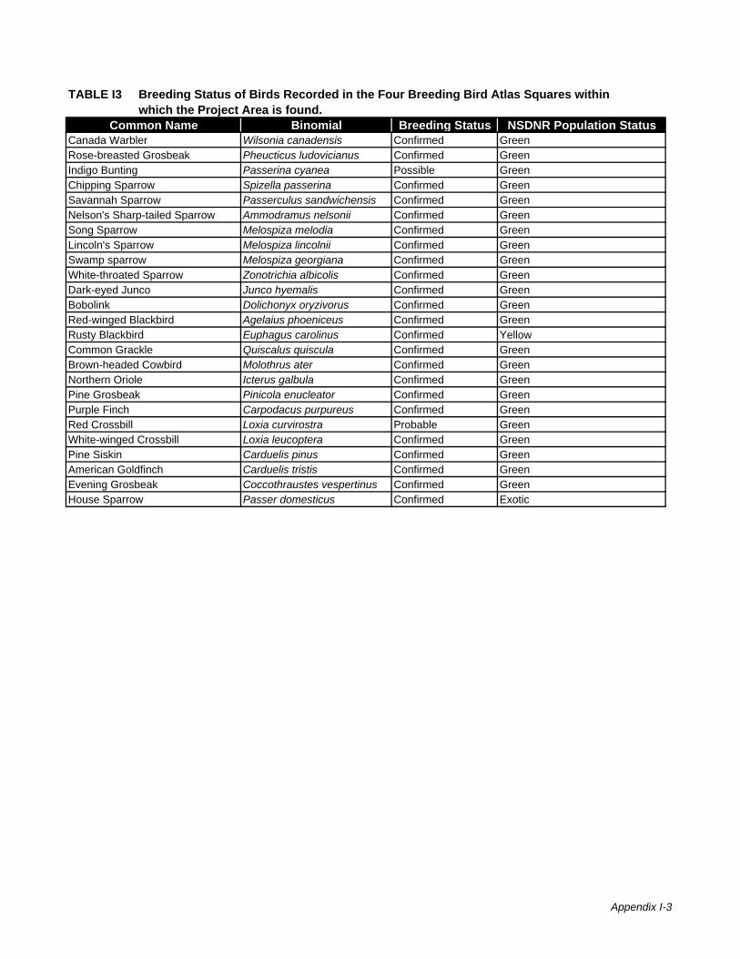
Common Name Binomial Breeding Status NSDNR Population Status
TABLE I3 Breeding Status of Birds Recorded in the Four Breeding Bird Atlas Squares within which the Project Area is found.
Canada Warbler Wilsonia canadensis Confirmed GreenRose-breasted Grosbeak Pheucticus ludovicianus Confirmed GreenIndigo Bunting Passerina cyanea Possible GreenChipping Sparrow Spizella passerina Confirmed GreenSavannah Sparrow Passerculus sandwichensis Confirmed GreenNelson's Sharp-tailed Sparrow Ammodramus nelsonii Confirmed GreenSong Sparrow Melospiza melodia Confirmed GreenLincoln's Sparrow Melospiza lincolnii Confirmed GreenSwamp sparrow Melospiza georgiana Confirmed GreenWhite-throated Sparrow Zonotrichia albicolis Confirmed GreenDark-eyed Junco Junco hyemalis Confirmed GreenBobolink Dolichonyx oryzivorus Confirmed GreenRed-winged Blackbird Agelaius phoeniceus Confirmed GreenRusty Blackbird Euphagus carolinus Confirmed YellowCommon Grackle Quiscalus quiscula Confirmed GreenBrown-headed Cowbird Molothrus ater Confirmed GreenNorthern Oriole Icterus galbula Confirmed GreenPine Grosbeak Pinicola enucleator Confirmed GreenPurple Finch Carpodacus purpureus Confirmed GreenRed Crossbill Loxia curvirostra Probable GreenWhite-winged Crossbill Loxia leucoptera Confirmed GreenPine Siskin Carduelis pinus Confirmed GreenAmerican Goldfinch Carduelis tristis Confirmed GreenEvening Grosbeak Coccothraustes vespertinus Confirmed GreenHouse Sparrow Passer domesticus Confirmed Exotic
Appendix I-3

Appendix I-1
TABLE I4. Rare or Uncommon Bird Species Potentially Within the Study AreaLatin Name Common Name Preferred Habitat Likeihood
Site ACCDCRANK
NSDNRRank
Anas acuta Northern Pintail Grassland, cultivated field, sandy flat, islands in lakes, marsh, pond
Unlikely S2B
Rallus limicola Virginia Rail Freshwater marshes, usually in cattails, reeds or dense grass. Occasionally in brackish marsh
Unlikely S2B
Poecile hudsonica Boreal Chickadee Boreal coniferous and mixed coniferous-deciduous woodland
Likely S3S4
Dolichonyx oryzivorus Bobolink Tall grass, flooded meadows, dense grain fields Likely S3B YellowEuphagus carolinus Rusty Blackbird Cool habitats in treed bogs, swamps and damp
alder swalesUnlikely S3S4B
Icterus galbula Baltimore Oriole Open and riparian woodland, deciduous forest edge, open areas with scattered trees, around human habitation
Unlikely but possible
S3B
Ammodramus nelsoni Nelson's Sharp-tailed Sparrow
Primarily saltwater marshes but occassionally in freshwater marshes
Possible S2S3B Yellow
Coccyzus erythropthalmus Black-billed Cuckoo Deciduous/coniferous forest and open woodland
Possible S3B
Sayornis phoebe Eastern Phoebe Open and riparian woodlands, rocky ravines, farmland with scattered trees. Typically nests near water, often in buildings or bridges
Unlikely but possible
S2S3B
Caprimulgus vociferus Whip-Poor-Will Open dry deciduous forest Unlikely S2BFalco columbarius Merlin Open habitats, nests primarily in open
woodlands; occasionaly in towns and citiesPossible S3S4B
Sialia sialis Eastern Bluebird Forest edge, burned or cutover woodland, open country with scattered trees
Possible S2S3B Yellow
Piranga olivacea Scarlet Tanager Deciduous forest and woodland, mixed deciduous-coniferous forest
Unlikely but possible
S3B
Loxia curvirostra Red Crossbill Coniferous and mixed coniferous-deciduous forest
Possible S3S4
Charadrius melodus Piping Plover Mostly sand, occasional gravel, or pebble beaches, especially among scattered grass tufts
Unlikely S1B Red
Passerina cyanea Indigo Bunting Deciduous forest edge and clearings , open woodland, weedy fields, shrublands, orchards
Possible S2S3B
Accipiter gentilis Northern Goshawk Mixed, often mostly coniferous forest, open woodland
Possible S3B Yellow
Sterna hirundo Common Tern Usually islands or coastal beaches with sparse matted vegetation, grassy areas
Unlikely S3B Yellow
Eremophila alpestris Horned Lark Open grassy areas with sparse vegetation and few trees. In Nova Scotia most nesting occurs at airports
Unlikely S2B
Tringa melanoleuca Greater Yellowlegs Treed bog Unlikely S2B,S5MLarus ridibundus Black-headed Gull Coastal waters Unlikely S3NHylocichla mustelina Wood Thrush Deciduous or mixedwood forest, especially
near water, ocassionally near human habitation Unlikely S2B
Pooecetes gramineus Vesper Sparrow Open agricultural land with low vegetation. In Nova Scotia most nests are in blueberry fields
Unlikely S2S3B Yellow
Myiarchus crinitus Great Crested Flycatcher
Deciduous forest edge, woodland, orchards, parks
Possible S2S3B
Mergus serrator Red-breasted Merganser
Nests amid low brush and driftwood on coastal islands and sandbars
Unlikely S2S3B
Mimus polyglottos Northern Mockingbird
Habitat generalist: wide range of open and partly open habitats, abundant in suburbs
Possible S3B
Falco peregrinus anatum American Peregrine Falcon
Nests mainly on cliff faces Unlikely S1B Red
Bucephala clangula Common Goldeneye
Floodplain forests Unlikely S2B
Sterna dougallii Roseate Tern Usually on offshore islands with sandy, rocky pebble beaches, among boulders and in open or grassy habitat
Unlikely S1B Red
Aythya marila Greater Scaup Lakes and coastal waters Unlikely S3NSterna paradisaea Arctic Tern Offshore islands, rocky or grass-covered
coasts, tundra, occasionally along inland lakes and rivers
Unlikely S3B Yellow
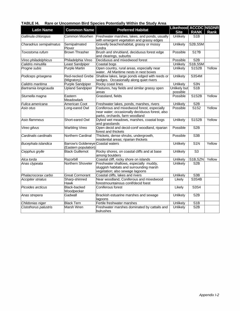
Appendix I-2
TABLE I4. Rare or Uncommon Bird Species Potentially Within the Study AreaLatin Name Common Name Preferred Habitat Likeihood
Site ACCDCRANK
NSDNRRank
Gallinula chloropus Common Moorhen Freshwater marshes, lakes, and ponds, usually with emergent vegetation and grassy edges
Unlikely S1B
Charadrius semipalmatus Semipalmated Plover
Gravelly beacheshabitat, grassy or mossy tundra
Unlikely S2B,S5M
Toxostoma rufum Brown Thrasher Brush and shrubland, deciduous forest edge and clearings, suburbs
Possible S1?B
Vireo philadelphicus Philadelphia Vireo Deciduous and mixedwood forest Possible S2BCalidris minutilla Least Sandpiper Coastal bogs Unlikely S1B,S5MProgne subis Purple Martin Open country, rural areas, especially near
water. All Maritime nests in nest boxesUnlikely S1S2B Yellow
Podiceps grisegena Red-necked Grebe (Migratory)
Shallow lakes, large ponds edged with reeds or sedges. Occasionally along quiet rivers
Unlikely S3S4M
Calidris maritima Purple Sandpiper Rocky coast lines Unlikely S3NBartramia longicauda Upland Sandpiper Pastures, hay fields and similar grassy open
areasUnlikely but
possible S1B
Sturnella magna Eastern Meadowlark
Grassland, fields Possible S1S2B Yellow
Fulica americana American Coot Freshwater lakes, ponds, marshes, rivers Unlikely S2BAsio otus Long-eared Owl Coniferous and mixedwood forest, especially
near water; occasionally deciduous forest, also parks, orchards, farm woodland
Possible S1S2 Yellow
Asio flammeus Short-eared Owl Dyked wet meadows, marshes, coastal bogs and grasslands
Unlikely S1S2B Yellow
Vireo gilvus Warbling Vireo Open decid and decid-conif woodland, riparian forest and thickets
Possible S2B
Cardinalis cardinalis Northern Cardinal Thickets, dense shrubs, undergrowth, residential areas; riparian thickets
Possible S3B
Bucephala islandica Barrow's Goldeneye (Eastern population)
Coastal waters Unlikely S1N Yellow
Cepphus grylle Black Guillemot Rocky shores, on coastal cliffs and at base among boulders
Unlikely S3
Alca torda Razorbill Coastal cliff, rocky shore on islands Unlikely S1B,SZN YellowAnas clypeata Northern Shoveler Freshwater shallows, especially muddy,
sluggish habitats and surrounding marsh vegetation; also sewage lagoons
Unlikely S2B
Phalacrocorax carbo Great Cormorant Coastal cliffs, lakes and rivers Unlikely S3BAccipiter striatus Sharp-shinned
Hawk Near woodland, Coniferous and mixedwood forestmountainous conif/decid foest
Likely S3S4B
Picoides arcticus Black-backed Woodpecker
Coniferous forest Likely S3S4
Anas strepera Gadwall Brackish estuarine marshes and sewage lagoons
Unlikely S2B
Chlidonias niger Black Tern Fertile freshwater marshes Unlikely S1BCistothorus palustris Marsh Wren Freshwater marshes dominated by cattails and
bulrushesUnlikely S2B
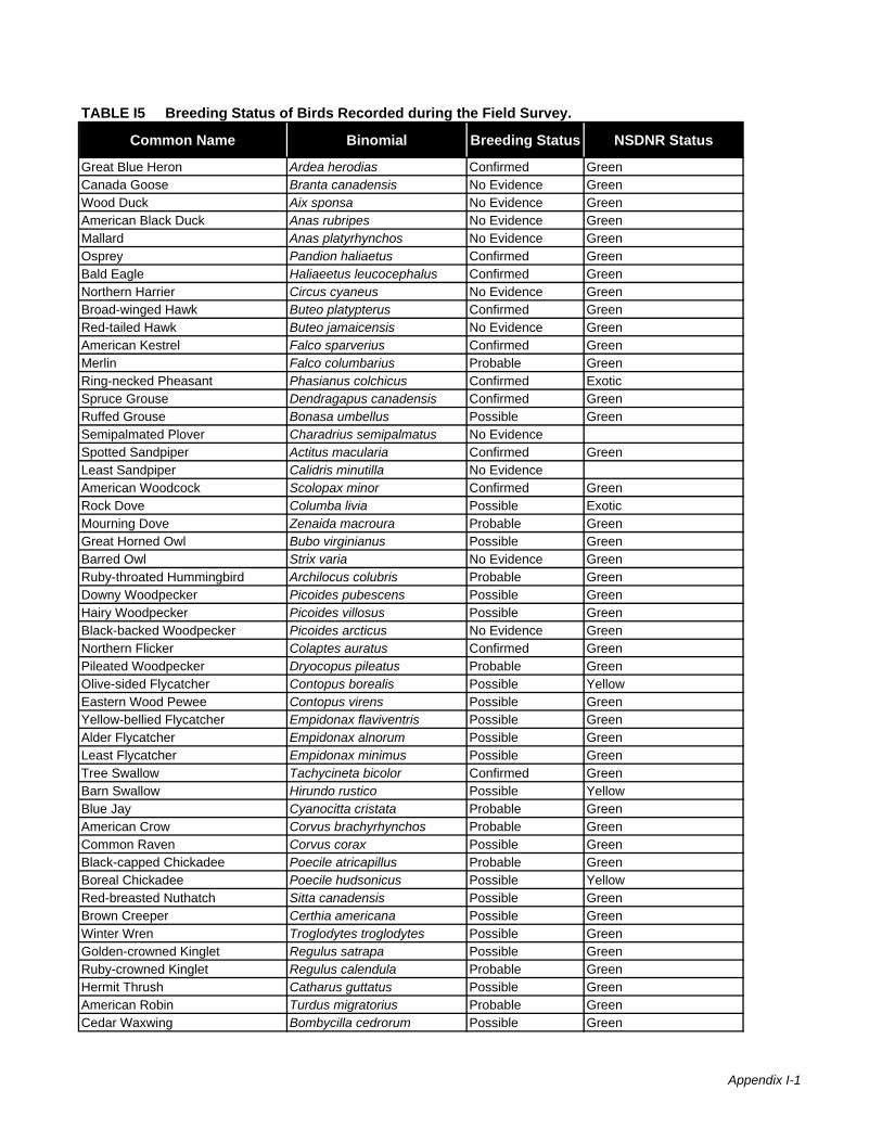
Common Name Binomial Breeding Status NSDNR Status
Great Blue Heron Ardea herodias Confirmed GreenCanada Goose Branta canadensis No Evidence GreenWood Duck Aix sponsa No Evidence GreenAmerican Black Duck Anas rubripes No Evidence GreenMallard Anas platyrhynchos No Evidence GreenOsprey Pandion haliaetus Confirmed GreenBald Eagle Haliaeetus leucocephalus Confirmed GreenNorthern Harrier Circus cyaneus No Evidence GreenBroad-winged Hawk Buteo platypterus Confirmed GreenRed-tailed Hawk Buteo jamaicensis No Evidence GreenAmerican Kestrel Falco sparverius Confirmed GreenMerlin Falco columbarius Probable GreenRing-necked Pheasant Phasianus colchicus Confirmed ExoticSpruce Grouse Dendragapus canadensis Confirmed GreenRuffed Grouse Bonasa umbellus Possible GreenSemipalmated Plover Charadrius semipalmatus No EvidenceSpotted Sandpiper Actitus macularia Confirmed GreenLeast Sandpiper Calidris minutilla No EvidenceAmerican Woodcock Scolopax minor Confirmed GreenRock Dove Columba livia Possible ExoticMourning Dove Zenaida macroura Probable GreenGreat Horned Owl Bubo virginianus Possible GreenBarred Owl Strix varia No Evidence GreenRuby-throated Hummingbird Archilocus colubris Probable GreenDowny Woodpecker Picoides pubescens Possible GreenHairy Woodpecker Picoides villosus Possible GreenBlack-backed Woodpecker Picoides arcticus No Evidence GreenNorthern Flicker Colaptes auratus Confirmed GreenPileated Woodpecker Dryocopus pileatus Probable GreenOlive-sided Flycatcher Contopus borealis Possible YellowEastern Wood Pewee Contopus virens Possible GreenYellow-bellied Flycatcher Empidonax flaviventris Possible GreenAlder Flycatcher Empidonax alnorum Possible GreenLeast Flycatcher Empidonax minimus Possible GreenTree Swallow Tachycineta bicolor Confirmed GreenBarn Swallow Hirundo rustico Possible YellowBlue Jay Cyanocitta cristata Probable GreenAmerican Crow Corvus brachyrhynchos Probable GreenCommon Raven Corvus corax Possible GreenBlack-capped Chickadee Poecile atricapillus Probable GreenBoreal Chickadee Poecile hudsonicus Possible YellowRed-breasted Nuthatch Sitta canadensis Possible GreenBrown Creeper Certhia americana Possible GreenWinter Wren Troglodytes troglodytes Possible GreenGolden-crowned Kinglet Regulus satrapa Possible GreenRuby-crowned Kinglet Regulus calendula Probable GreenHermit Thrush Catharus guttatus Possible GreenAmerican Robin Turdus migratorius Probable GreenCedar Waxwing Bombycilla cedrorum Possible Green
TABLE I5 Breeding Status of Birds Recorded during the Field Survey.
Appendix I-1

Common Name Binomial Breeding Status NSDNR Status
TABLE I5 Breeding Status of Birds Recorded during the Field Survey.
European Starling Sturnus vulgaris Confirmed ExoticBlue-headed Vireo Vireo solitarius Possible GreenRed-eyed Vireo Vireo olivaceus Possible GreenNashville Warbler Vermivora ruficapilla Possible GreenNorthern Parula Warbler Parula americana Possible GreenMagnolia Warbler Dendroica magnolia Possible GreenYellow-rumped Warbler Dendroica coronata Possible GreenBlack-throated Green Warbler Dendroica virens Probable GreenBlackburnian Warbler Dendroica fusca Possible GreenPalm Warbler Dendroica palmarum Probable GreenBlack-and-white Warbler Mniotilta varia Probable GreenAmerican Redstart Setophaga ruticilla Possible GreenOvenbird Seiurus aurocapillus Possible GreenMourning Warbler Oporornis philadelphia Possible GreenCommon Yellowthroat Geothlypis trichas Possible GreenCanada Warbler Wilsonia canadensis Possible GreenRose-breasted Grosbeak Pheucticus ludovicianus Possible GreenChipping Sparrow Spizella passerina Possible GreenSavannah Sparrow Passerculus sandwichensis Probable GreenNelson's Sharp-tailed Sparrow Ammodramus nelsonii Possible GreenSong Sparrow Melospiza melodia Confirmed GreenSwamp sparrow Melospiza georgiana Possible GreenWhite-throated Sparrow Zonotrichia albicolis Confirmed GreenDark-eyed Junco Junco hyemalis Probable GreenCommon Grackle Quiscalus quiscula Probable GreenPurple Finch Carpodacus purpureus Possible GreenPine Siskin Carduelis pinus No Evidence GreenAmerican Goldfinch Carduelis tristis Possible Green
Appendix I-2
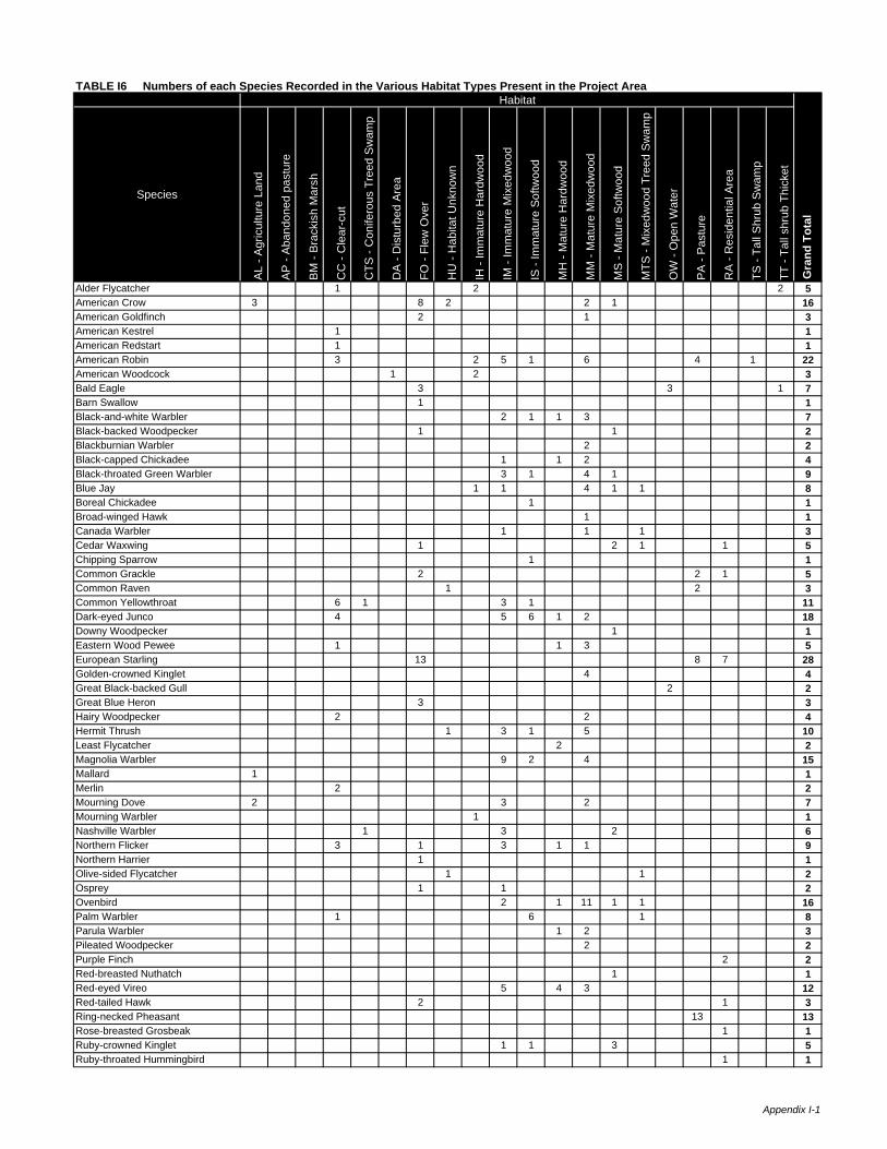
Species
AL
- Agr
icul
ture
Lan
d
AP
- A
band
oned
pas
ture
BM
- B
rack
ish
Mar
sh
CC
- C
lear
-cut
CTS
- C
onife
rous
Tre
ed S
wam
p
DA
- D
istu
rbed
Are
a
FO -
Flew
Ove
r
HU
- H
abita
t Unk
now
n
IH -
Imm
atur
e H
ardw
ood
IM -
Imm
atur
e M
ixed
woo
d
IS -
Imm
atur
e So
ftwoo
d
MH
- M
atur
e H
ardw
ood
MM
- M
atur
e M
ixed
woo
d
MS
- M
atur
e S
oftw
ood
MTS
- M
ixed
woo
d Tr
eed
Sw
amp
OW
- O
pen
Wat
er
PA
- P
astu
re
RA
- R
esid
entia
l Are
a
TS -
Tall
Shr
ub S
wam
p
TT -
Tall
shru
b Th
icke
t
Alder Flycatcher 1 2 2 5American Crow 3 8 2 2 1 16American Goldfinch 2 1 3American Kestrel 1 1American Redstart 1 1American Robin 3 2 5 1 6 4 1 22American Woodcock 1 2 3Bald Eagle 3 3 1 7Barn Swallow 1 1Black-and-white Warbler 2 1 1 3 7Black-backed Woodpecker 1 1 2Blackburnian Warbler 2 2Black-capped Chickadee 1 1 2 4Black-throated Green Warbler 3 1 4 1 9Blue Jay 1 1 4 1 1 8Boreal Chickadee 1 1Broad-winged Hawk 1 1Canada Warbler 1 1 1 3Cedar Waxwing 1 2 1 1 5Chipping Sparrow 1 1Common Grackle 2 2 1 5Common Raven 1 2 3Common Yellowthroat 6 1 3 1 11Dark-eyed Junco 4 5 6 1 2 18Downy Woodpecker 1 1Eastern Wood Pewee 1 1 3 5European Starling 13 8 7 28Golden-crowned Kinglet 4 4Great Black-backed Gull 2 2Great Blue Heron 3 3Hairy Woodpecker 2 2 4Hermit Thrush 1 3 1 5 10Least Flycatcher 2 2Magnolia Warbler 9 2 4 15Mallard 1 1Merlin 2 2Mourning Dove 2 3 2 7Mourning Warbler 1 1Nashville Warbler 1 3 2 6Northern Flicker 3 1 3 1 1 9Northern Harrier 1 1Olive-sided Flycatcher 1 1 2Osprey 1 1 2Ovenbird 2 1 11 1 1 16Palm Warbler 1 6 1 8Parula Warbler 1 2 3Pileated Woodpecker 2 2Purple Finch 2 2Red-breasted Nuthatch 1 1Red-eyed Vireo 5 4 3 12Red-tailed Hawk 2 1 3Ring-necked Pheasant 13 13Rose-breasted Grosbeak 1 1Ruby-crowned Kinglet 1 1 3 5Ruby-throated Hummingbird 1 1
Habitat
Gra
nd T
otal
TABLE I6 Numbers of each Species Recorded in the Various Habitat Types Present in the Project Area.
Appendix I-1

Species
AL
- Agr
icul
ture
Lan
d
AP
- A
band
oned
pas
ture
BM
- B
rack
ish
Mar
sh
CC
- C
lear
-cut
CTS
- C
onife
rous
Tre
ed S
wam
p
DA
- D
istu
rbed
Are
a
FO -
Flew
Ove
r
HU
- H
abita
t Unk
now
n
IH -
Imm
atur
e H
ardw
ood
IM -
Imm
atur
e M
ixed
woo
d
IS -
Imm
atur
e So
ftwoo
d
MH
- M
atur
e H
ardw
ood
MM
- M
atur
e M
ixed
woo
d
MS
- M
atur
e S
oftw
ood
MTS
- M
ixed
woo
d Tr
eed
Sw
amp
OW
- O
pen
Wat
er
PA
- P
astu
re
RA
- R
esid
entia
l Are
a
TS -
Tall
Shr
ub S
wam
p
TT -
Tall
shru
b Th
icke
t
Habitat
Gra
nd T
otal
TABLE I6 Numbers of each Species Recorded in the Various Habitat Types Present in the Project Area.
Savannah Sparrow 10 1 32 43Sharp-tailed Sparrow 1 1Solitary Vireo 1 1Song Sparrow 1 2 2 1 1 11 3 2 23Spotted Sandpiper 1 1Spruce Grouse 3 3Swamp sparrow 1 2 3Tree Swallow 4 4White-throated Sparrow 13 1 4 10 5 3 36Winter Wren 1 3 4Wood Duck 1 1Yellow-bellied Flycatcher 1 1Yellow-rumped Warbler 1 1 1 1 2 6Grand Total 7 1 10 40 4 1 40 6 14 63 29 14 75 20 6 5 74 21 3 5 438
Appendix I-2