final draft issues paper land information systems · 2020-02-07 · this paper discusses issues...
TRANSCRIPT
THE REPUBLIC OF UGANDA
Private Sector Foundation Uganda
SECOND PRIVATE SECTOR COMPETITIVENESS PROJECT
(PSCP II)
CREDIT NUMBER: 3975 UG
Review of the Legal Framework
for Land Administration
Final Draft Issues Paper
Land Information Systems
August 2010
Kalenge, Bwanika, Kimuli & Company, Advocates

TABLE OF CONTENTS i
Contents
1 Introduction.........................................................................................................................1
1.1 Overview.......................................................................................................................1
1.2 Structure of the Paper ....................................................................................................2
2 Policy Framework ...............................................................................................................4
2.1 Government LIS Policy Context ....................................................................................4
2.2 LIS Policy in the Context of Existing Government Reports ...........................................6
3 Existing Legal Framework for Land Administration in Uganda ...........................................8
3.1 Inventory of Legislation ................................................................................................8
3.2 Summary Overview of land administration legislation in Uganda ..................................8
3.2.1 The Constitution of Uganda 1995 (as amended) .....................................................8
3.2.2 Land Act, 1998, Cap. 227of the Laws of Uganda, Revised Edition, 2000 .............10
3.2.3 The Land (Amendment) Act 2004........................................................................10
3.2.4 Registration of Titles Act, Cap. 230 .....................................................................10
3.2.5 Surveyor’s Registration Act, Cap. 275 .................................................................11
3.2.6 The Land Acquisition Act, Cap. 226 ....................................................................11
3.2.7 The Mortgage Act, Cap. 229 ................................................................................12
3.2.8 The Town and Country Planning Act, Cap. 246 ...................................................12
3.2.9 The Condominium Property Act, No. 4 of 2001 ...................................................13
3.2.10 Traditional Rulers (Restitution of Assets and Properties Act), Cap. 247............13
3.2.11 Local Government (Rating) Act, No. 8 of 2005 ................................................13
3.2.12 Land Regulations, 2004....................................................................................14
4 Conceptual Framework......................................................................................................15
4.1 Land Administration....................................................................................................15

TABLE OF CONTENTS ii
4.2 Land Management .......................................................................................................17
4.3 Land Information Management....................................................................................17
4.4 Land Information Systems...........................................................................................19
4.5 Cadastre ......................................................................................................................21
4.6 Geographic Information Systems (GIS) .......................................................................25
4.7 Spatial Data Infrastructure ...........................................................................................26
4.8 Uganda National Spatial Data Infrastructure Initiatives................................................30
5 LIS Implementation Issues in Uganda ...............................................................................32
5.1 Governance .................................................................................................................32
5.1.1 Land Registration or Lands and Survey Department?...........................................32
5.1.2 A statutory Authority or Semi-Autonomous Institution?.......................................33
5.1.3 Governance Structure of ULII:.............................................................................35
5.1.4 Major Functions of the Institution (ULII):............................................................35
5.1.5 Powers and Functions of the Uganda Land Information Infrastructure Committee
(ULIIC):............................................................................................................................36
5.1.6 Terms of office of members of the ULIIC ............................................................37
5.1.7 Disqualification as member of Committee............................................................37
5.1.8 Meetings of the Committee: .................................................................................37
5.1.9 Establishment of Sub-committees: .......................................................................38
5.1.10 Regulations ......................................................................................................38
5.2 Transition Issues..........................................................................................................39
5.2.1 Running Parallel Manual and Computerized Land Recording Systems.................39
5.2.2 Correction of Errors resulting from Rehabilitation and Validation of Registers ....42
5.3 Core Legal Issues ........................................................................................................46
5.3.1 Custodianship in Land Information ......................................................................46

TABLE OF CONTENTS iii
5.3.2 Pricing of Land Information.................................................................................51
5.3.3 Admissibility of Evidence from Computerised Land Records...............................60
5.3.4 Standards for Data, Metadata and Applications ....................................................77
5.3.5 Copyright and Land Information ..........................................................................79
5.3.6 Liability for Land Information .............................................................................83
5.3.7 Access to Land Information .................................................................................91
5.4 Technical/Technological Issues ...................................................................................99
5.4.1 Implementation Approach....................................................................................99
5.4.2 Parcel Identification .............................................................................................99
5.5 Financing and sustainability issues ............................................................................100
6 Summary of recommendations ........................................................................................101
Appendix 1 : Disposition of comments of LRWG ...................................................................108
Appendix 2 : National Land Information Infrastructure Bill ....................................................131

REVIEW OF THE LEGAL FRAMEWORK FOR LAND ADMINISTRATION: LAND INFORMATION SYSTEMS 1
1 Introduction
1.1 Overview
This is the Draft Final Issues Paper on Land Information Systems. It is submitted against the
background of the Second Private Sector Competitiveness Project (PSCP II). The Government of
Uganda has received funds (under Credit Number: 3975 UG) from the International
Development Association (IDA), towards the cost of the PSCP II. It has applied part of the
proceeds of this Credit to a component for Improving the Business Environment (Land Registry
sub-component Improvements in the Land Registry). This component aims to improve the
business environment through a number of steps, including:
• strengthening the capacity of the Land Registry to process land titles;
• updating land records and establishing a land information system;
• extending the formal system of land registration;
• sensitizing groups or individuals who have not had access to land tenure security; and
• building the capacity of the Land Registry staff.
Under the PSCP II Project and in particular the above component, Private Sector Foundation
Uganda (PSFU) has procured the services of the Consultant (Kalenge, Bwanika, Kimuli &
Company, Advocates, in association with several Subconsultants) to provide consultancy
services for the Review of the Legal Framework for Land Administration. This assignment, in
summary, entails:
• comprehensively reviewing land-based laws;
• recommending revisions and harmonization; and
• drafting new laws in areas indicated.
This Paper discusses issues that, in our view, require legislative attention for effective
implementation of a land information system (LIS) in Uganda. Given the inherent complexity of
the topic, this Paper (while our final contribution) does not purport to be the final word on LIS
issues. Rather, we see it as a guideline for further discussion by stakeholders during
consultations before final enactment of any LIS legislation.
Importantly, this Paper takes into account comments made on our earlier Draft Issues Paper on
LIS. In particular, we benefited from the views of Mr Mike Che (LIS Consultant on the PSCP II,
and the author of two key reports on the LIS). We have also considered and taken into account
the comments of the Law Reform Working Group (LRWG) on our earlier Draft Issues Paper on
land information systems. The LRWG’s comments were formulated at its meetings on 24
January to 27 January 2010. For ease of reference, Appendix 1 of this Paper tabulates the
LRWG’s comments and our responses to them.
REVIEW OF THE LEGAL FRAMEWORK FOR LAND ADMINISTRATION: LAND INFORMATION SYSTEMS 2
Appendix 2 of this Paper comprises a draft Bill for a National Land Information Authority Act.
This Act also is for discussion purposes only. Many of its clauses will need amendment to give
effect to the final decisions which will need to be on matters raised in this Paper. We put it
forward as a starting point, to give stakeholders a feel for how the eventual legislation might
look.
The information in this Paper is based on:
• The Consultant’s understanding of the task, gained from the terms of reference and
discussions with officials from the Ministry of Lands and Urban Development.
• A review of literature and case studies on LIS best practices. The case studies have been
synthesized to identify the issues that are relevant for LIS implementation in Uganda.
• Our own local knowledge of the history of land administration in Uganda. In addition,
our subconsultants in Australia have provided international experience to ensure that the
proposals in this Paper reflect international best practice in land information systems.
• Reviews of the work of leading experts and scholars in LIS and of cadastre studies, such
as Peter Dale, Ian Williamson, Helge Onsrud, Kate Lance and Clarissa Fourie
Augustinus.
1.2 Structure of the Paper
This Paper is organized into six sections and two appendices.
• Section One gives a general introduction to the paper.
• Section Two highlights the policy context of a LIS in Uganda. It also summarises the
recommendations of Government-commissioned studies.
• Section Three discusses a number of concepts that are closely related to LIS. It explains
linkages between the concepts of Land Management, Land Administration, Land
Information Management, Land Information Systems and Spatial Data Infrastructures.
Where necessary, we explain or define these concepts. This section should be useful both
to readers with limited experience of LIS concepts and to professionals who need to
understand the rationale behind our proposals for LIS implementation in Uganda.
• Section Four presents some LIS best-practices and case studies. It appraises the case
studies and discusses implications for LIS development in Uganda.
• Section Five expands on lessons learnt in the case studies, to present and discuss specific
issues around implementation of a LIS in Uganda. It discusses various options, and
highlights our recommendations at the end of each area discussed.
REVIEW OF THE LEGAL FRAMEWORK FOR LAND ADMINISTRATION: LAND INFORMATION SYSTEMS 3
• Section Six summarises our general conclusions and recommendations on LIS
implementation.
• Appendix 1 tabulates the LRWG’s comments on our earlier Issues Paper on land
information systems, and our responses to those comments.
• Appendix 2 comprises a Draft National Land Information Infrastructure Act. The aim is
to show how the key recommendations in this Report could be translated into legislative
action.
REVIEW OF THE LEGAL FRAMEWORK FOR LAND ADMINISTRATION: LAND INFORMATION SYSTEMS 4
2 Policy Framework
The Paper discusses the implementation of the LIS from the perspective of various government
policy initiatives and documents. The initiatives include the PSCPII, the Medium-Term
Competitiveness Strategy (MTCS), and the Land Sector Strategic Plan (LSSP). The documents
are mainly government-commissioned studies on LIS.
2.1 Government LIS Policy Context
The overall objective of the PSCP II is to create sustainable conditions for enterprise-creation
and growth that respond to local and export markets. The PSCP II supports the Uganda
Government program for eliminating the key restraints on Uganda’s international
competitiveness. Crucial steps include reducing the cost of doing business and encouraging
investment, to better position the private sector to respond to market opportunities.
PSCP II has three mutually-reinforcing components. The pertinent one for this assignment is the
Project Component 3 (Improving the Business Environment).1
This addresses critical issues in
the business environment, including improvements in the Land Registry and other related spatial
records. Implementing the components will help to modernize the commercial legal
environment, reduce the time and cost of doing business, and, crucially, restore the integrity of
the Land Registry and other land information databases.
In July 2000, the Government of Uganda produced the Medium-Term Competitiveness Strategy
(2000-2005) (MTCS).2 Its aim was to create an environment in which the private sector could
grow, become profitable, and compete both locally and abroad. It set out reform priorities,
including reforms to the substance and application of commercial law, the regulatory and
administrative framework governing business transactions, and more particularly (for the
purposes of this assignment) land registration.
The MTCS was also intended to facilitate the growth of an efficient land market, to stimulate
investment and market-led development. From the perspective of the land sector, a priority was
to remedy shortcomings in the land registration system. These shortcomings are seen as a
significant obstacle to investment. One possible strategy was to promote private sector
partnership with government in the provision of land-related services. These services may
include systematic demarcation, cadastral surveying, topographical mapping, database
development, and so on.
11.. TThhee ootthheerr ccoommppoonneennttss aarree::
PPrroojjeecctt CCoommppoonneenntt 11——DDeevveellooppiinngg IInnffrraassttrruuccttuurree aanndd FFiinnaanncciiaall SSeerrvviicceess;; aanndd
PPrroojjeecctt CCoommppoonneenntt 22——EEnnhhaanncciinngg EEnntteerrpprriissee CCoommppeettiittiivveenneessss..
TThheeyy aarree oouuttssiiddee tthhee ssccooppee ooff tthhee CCoonnssuullttaanntt’’ss aassssiiggnnmmeenntt aanndd ooff tthhiiss RReeppoorrtt..
22.. NNooww rreeppllaacceedd bbyy tthhee CCoommppeettiittiivveenneessss aanndd IInnvveessttmmeenntt CClliimmaattee SSttrraatteeggyy ((CCIICCSS))..

REVIEW OF THE LEGAL FRAMEWORK FOR LAND ADMINISTRATION: LAND INFORMATION SYSTEMS 5
The Government of Uganda’s commitment to developing a computerised land information
system is also seen in the Land Sector Strategic Plan 2001-2010 (LSSP). LSSP is the guiding
document for providing the operational, institutional and financial framework for sector-wide
reforms in land management, including implementing the Land Act 1998. The LSSP is also an
important element in Uganda’s contribution to the United Nations Agenda 21, and to the Habitat
Agenda, which outline strategies for achieving sustainable development, adequate shelter for all,
and sustainable human settlement in an urbanizing world.
The LSSP was designed around key national priorities. They include:
(i) the Poverty Eradication Action Plan;
(ii) the Plan for the Modernisation of Agriculture;
(iii) the Decentralization policy;
(iv) the Liberalization and Medium-Term Competitiveness Strategy.
The LSSP aims to remove barriers to increased land utilization; to broaden land services to rural
areas and customary land; to address inequality, tenure insecurity and inequitable systems and
processes; to strengthen the land rights of the vulnerable and of women; to empower local
governments and communities to make and implement their own policies for their land; and to
provide an appropriate and supportive framework for sound environmental and natural resource
management.
Six broad objectives for the Land Sector were identified through the consultative planning
process. Strategic Objective 4, “To increase availability, accessibility, affordability, and use of
land information for planning and implementing development programmes”, directly highlights
the importance of a viable land information system. The two strategies to achieve this objective
are:
• a systematic adjudication and demarcation of land rights; and
• a unified, relevant and accessible land information system.
As part of the strategy to establish a land information system, the LSSP sets priorities that
include the following:
• rehabilitating the Land Registry and existing land records, so as to overcome the
current predicament of non-existent or unclear land records and the inability to
enforce existing land rights; and
• facilitating decentralization of records, so as to improve access to land and title
information.
The reform objectives of the LSSP, viewed in the overall context of the Government of Uganda’s
policy instruments, are multi-faceted and multi-sectoral. They are intended to address many
issues. These include:
REVIEW OF THE LEGAL FRAMEWORK FOR LAND ADMINISTRATION: LAND INFORMATION SYSTEMS 6
• creating a land market
• enhancing private sector development and private sector competitiveness
• improving security of tenure and land rights
• updating land-sector legislation to bring it into line with the provisions in the
Constitution and the Land Act for protecting land and property rights
• removing or overhauling superfluous or obscure land legislation
• removing barriers to increased land use and unshackling the enforcement of land
rights
• helping to modernise agriculture and eradicate poverty
• creating a Land Information System (LIS)
• removing obstacles to using land as security
• enhancing access to financial services
• strengthening the land rights of vulnerable members or groups in Ugandan society,
and of women
• facilitating and promoting the decentralisation of land services
• providing an appropriate and supportive framework for sound environmental and
natural resource management.
2.2 LIS Policy in the Context of Existing Government Reports
The Government’s commitment to developing a Land Information System is manifested in the
studies it has commissioned on the topic. The studies stretch back more than 15 years. Notable
studies include:
1. Land Tenure and Agriculture Development in Uganda, by Makerere Institute of
Social Research and The Land Tenure Centre of Wisconsin, USA, 1989;
2. Report on the Land Registration Procedure and Land Registry in Uganda, D.W.
Greenwood, 1990;
3. Rehabilitation and Development of Land Survey and Registration in Uganda,
Gerhard Larsson, 1990;
4. A Base For a Land Information System In Uganda, Swede Survey, 1996;
5. Proposal for the Computerization of the Land Registry, Computer Supplies Ltd,
1996;
6. Design and Development of a Geographic Information System including the
Master Plans for the Development of the Ugandan Spatial Infrastructure, The
Swedish Consortium, June 2001;
REVIEW OF THE LEGAL FRAMEWORK FOR LAND ADMINISTRATION: LAND INFORMATION SYSTEMS 7
7. Technical Audit on Current Initiatives and Proposals for Securing Land Registry
Records in Uganda, Swede Survey, 2003;
8. A Review of the Status of Land Information Systems in Uganda, Sivest, 2003;
9. Detailed Plan for the Design and Implementation of LIS in Uganda, Swede
Survey, 2004;
10. Securing and Upgrading the Land Registry and Implementation of a Land
Information System in Uganda, Geo-Information Communication Ltd, 2007.
These studies make many useful recommendations, covering a wide range of issues—from
technical, technological and legal, to economic and institutional. A recurrent theme is the
need for immediate and urgent rehabilitation and computerization of land records. The
studies consistently and universally recommend establishment of a Land Information System
as a long-term strategy for addressing land information accessibility in Uganda. We present
the key recommendations later, in Section Four.

REVIEW OF THE LEGAL FRAMEWORK FOR LAND ADMINISTRATION: LAND INFORMATION SYSTEMS 8
3 Existing Legal Framework for Land Administration in Uganda
3.1 Inventory of Legislation
The legal framework for land administration in Uganda comprises the following core legislation:
i). The Constitution of the Republic of Uganda 1995 (as amended)
ii). Land Act, 1998 (Cap. 227 laws of Uganda, Revised Edition 2000), as amended by the
Land (Amendment) Act No. 1 of 2004
iii). Registration of Titles Act, Cap. 230
iv). Survey Act, Cap. 232
v). Surveyor’s Registration Act, Cap. 275
vi). Land Acquisition Act, Cap. 226
vii). Mortgage Act, Cap. 229
viii). Town and Country Planning Act, Cap. 246
ix). Condominium Property Act, No. 4 of 2001
x). Traditional Rulers (Restitution of Assets and Properties Act 1993), Cap. 247
ix). Local Government (Rating) Act, No. 8 of 2005
xii). Land Regulations, 2004.
In addition, other laws govern certain aspects of land-related activity. They may be relevant to
land information management and may contribute vital land information. An example is the
Stamps Act, Cap 342, which applies to land transactions (instruments) that attract Stamp Duty,
such as sales and transfers, leases, mortgages and charges, and to some extent affects land market
valuations. But its function is more tax-related than land administration-related.
The laws numbered iii) to ix) above are comprehensively covered in our other Issues Papers
under this Project—Reform of Land Administration Laws.
3.2 Summary Overview of land administration legislation in Uganda
3.2.1 The Constitution of Uganda 1995 (as amended)
At the apex of land administration laws is the Constitution of Uganda 1995 (as amended). The
Constitution is the supreme law of Uganda and the fountain from which all land legislation
originates (and in case of legislation that pre-dates the Constitution, it is the source from which
that legislation derives its legitimacy).
REVIEW OF THE LEGAL FRAMEWORK FOR LAND ADMINISTRATION: LAND INFORMATION SYSTEMS 9
The 1995 Constitution ushered in fundamental reforms in ownership, tenure, management and
control of land in Uganda. Under Directive XI (Role of the State in development), Paragraph
(iii), in furtherance of social justice, the State may regulate the acquisition, ownership, use and
development of land and other property, in accordance with the Constitution. Under Article 26
(Protection from deprivation of property), every person has a right to own property either
individually or in association with others, and no person may be compulsorily deprived of
property or any interest in or right over property, except on certain conditions.
Chapter Fifteen, on Land and Environment, is the core of the Constitutional provisions
governing Land. This Chapter includes Article 237 (1), under which land in Uganda belongs to
the citizens of Uganda and vests in them in accordance with the land tenure systems provided for
in the Constitution. The land tenure systems are:
(a) customary;
(b) freehold;
(c) mailo; and
(d) leasehold.
The Constitution re-established these four land tenure systems, reversing the Land Reform
Decree 1975 which had abolished all tenures except customary tenure and leasehold. The 1995
Constitution further provided for the enactment of a law on or before July 2, 1998 (i.e. the
second anniversary of the first sitting of Parliament elected under the Constitution) that would
• regulate the relationship between the lawful or bonafide occupants of land referred to in
Article 237(8) and the registered owners of that land, and
• provide for the acquisition of registrable interests in land by occupants.
This is the foundation for the Land Act of 1998, now Cap. 227 of the Laws of Uganda, Revised
Edition, 2000.
In relation to land administration, the Constitution provides for the establishment and functions
of the Uganda Land Commission. The Constitution also provides for the establishment of
District Land Boards to hold and allocate land not held by any person or authority, and to
facilitate the registration and transfer of interests in land. The District Land Boards are to be
independent of the Uganda Land Commission and of any other person or authority; and they are
required to take account of national and district land policies.

REVIEW OF THE LEGAL FRAMEWORK FOR LAND ADMINISTRATION: LAND INFORMATION SYSTEMS 10
3.2.2 Land Act, 1998, Cap. 227of the Laws of Uganda, Revised Edition, 2000
The stated objective of the Land Act is to provide for the tenure, ownership and management of
land; to amend and consolidate the law relating to tenure, ownership and management of land;
and to provide for other related matters.
In conjunction with the Constitution, the Land Act provides for, amongst other things:
• a range of land-management institutions;
• a re-affirmation of the types of land tenure systems in Uganda (customary, mailo,
freehold and leasehold);
• a decentralized system of land administration, corresponding to the decentralization of
governance of districts under the Local Governments Act, 1997;
• the operations of the transformed Uganda Land Commission, District Land Boards, and
District Land Tribunals;
• establishment of District Land Offices, Sub-county Land Tribunals, and Parish Land
Committees;
• customary owners to acquire certificates of ownership and to convert customary and
leasehold tenure to freehold; and
• security of occupancy on mailo, freehold or leasehold land for lawful or bonafide
occupants.
3.2.3 The Land (Amendment) Act 2004
The Land (Amendment) Act, 2004 made certain changes to the Land Act, Cap. 227, and imposed
restrictions on the transfer of family land. The Amendments also introduced changes to the
dispute resolution mechanisms under the principal Act.
3.2.4 Registration of Titles Act, Cap. 230
The Registration of Titles Act (RTA), Cap. 230, has been in force since 1924. It is based on a
1915 statute from the Australian state of Victoria. It governs the registration of land titles in
Uganda, and the registration of key transactions in land, such as transfers, mortgages, leases and
encumbrances. The Act introduced the Torrens system of title registration, which provides a
state-guaranteed system of title (usually called an “indefeasible” title), backed by a right to
compensation for loss of land. Except for changes in the provisions dealing with mortgages and
some amendments made by the Land Act, Cap. 227 and the Land (Amendment) Act, 2004, the
RTA has remained virtually unchanged since its enactment over 80 years ago.
The Survey Act, Cap. 232
The Survey Act was enacted in 1939 to provide for and regulate the survey of lands. It set up
the statutory office of Commissioner of Lands and Surveys, which later became the
REVIEW OF THE LEGAL FRAMEWORK FOR LAND ADMINISTRATION: LAND INFORMATION SYSTEMS 11
Commissioner for Surveys and Mapping, with functions and responsibilities for regulating land
surveys.
Since 1939, enormous changes have occurred in surveying methods and expertise. They have
changed dramatically the technical landscape in which surveyors work. The legal framework in
which surveyors work has also changed dramatically. The 1995 Constitution now provides a
framework within which all Ugandans must work; and the Land Act 1998 has established
principles that must be complied with by any professional whose work bears a connection with
land.
Surveying is a fundamental aspect of land administration and, for that matter, of any Land
Information System. Cadastral surveys directly affect the establishment of the Land Information
System and the rehabilitation of the land registration system in Uganda. Surveys are required for
a number of land transactions, including subdivision, consolidation, and conversion from
customary or leasehold tenure.3
3.2.5 Surveyor’s Registration Act, Cap. 275
The Surveyors Registration Act, Cap. 275, commenced in June, 1974, originally as the Surveyors
Registration Decree 9/1973. The Act establishes a Surveyor’s Registration Board, defines the
powers and functions of the Board, and provides for the registration of surveyors, the regulatory
discipline of surveyors, and related matters.
Laws governing the making of surveys and the regulation of surveyors (qualifications, licensing
and permitted activities) are a fundamental component of any land administration framework.
3.2.6 The Land Acquisition Act, Cap. 226
The Land Acquisition Act, Cap 226, provides for the compulsory acquisition of land for public
purposes, compensation for such acquisition, and incidental matters such as valuation for
compensation purposes.
The Act has been in place since 1965. It was applied to the Protectorate of Uganda by virtue of
the Indian Acts Ordinance. It is the implementing law for Article 26 of the Constitution, which
guarantees the right to own property and requires prompt payment of fair and adequate
compensation before the taking of possession and acquisition of the land. However, it is not
entirely in harmony with Article 26, since it allows possession of land to be taken before
compensation is paid, and it is by no means clear that the Act would necessarily ensure the
prompt payment of fair and adequate compensation. (However, of course, the Act predates the
1995 Constitution by 30 years.)
33.. LLIISS BBaasseelliinnee RReeppoorrtt,, aatt pp.. 6677..

REVIEW OF THE LEGAL FRAMEWORK FOR LAND ADMINISTRATION: LAND INFORMATION SYSTEMS 12
We have prepared a separate Issues Paper specifically dealing with reform of the law relating to
Land Acquisition.
3.2.7 The Mortgage Act, Cap. 229
The Mortgage Act was originally enacted in 1974, as the Mortgage Decree No. 17/1974. Its
purpose was to amend the law relating to mortgages, which was then principally contained in the
Registration of Titles Act.
The Mortgage Decree, and later the Mortgage Act, set out the remedies available to a mortgagee
upon default by a mortgagor. These included realization of the security; the appointment, duties
and remuneration of a receiver; possession by a mortgagee; foreclosure; distribution of proceeds
of sale; and other related matters.
More recently, the Mortgage Act 2007 was enacted to consolidate Ugandan mortgage law, which
until then was scattered between the Mortgage Act, Registration of Titles Act, the Land Act, and
to an extent, the Financial Institutions Act No.2 of 2004. This Act repeals and replaces the
Mortgage Act Cap 229 and also certain mortgage-related provisions in the Registration of Titles
Act, Cap. 230. The Act also introduces a number of innovations.
Mortgage law is the subject of a separate Draft Final Issues Paper.
3.2.8 The Town and Country Planning Act, Cap. 246
The Town and Country Planning Act, Cap. 246 (TCPA) is the principal statute governing
physical planning in Uganda. It was originally enacted as the Town and Planning Ordinance,
1951 and revised in 1964. The object of the TCPA is to provide for the orderly and progressive
development of land, towns and other areas.
The TCPA makes provision for declaration of planning areas, preparation and approval of
schemes, execution of schemes, and compensation and betterment.
The TCPA has been overtaken by events. Legislation such as the 1995 Constitution, the 1998
Land Act and the National Environment Act, Cap. 153, have rendered parts of the TCPA
redundant. Further, like much other land-sector legislation, the Act predates the Constitution of
1995, the Land Act, 1998, and other recent legislation which impacts on spatial and land use
issues and policies. In our view, it is out of step with present land law and newly-recognized
interests in land. It is also out of step with modern policies on matters such as decentralization,
environmental protection and sustainability, land use, and the creation of a free land market.
Its obsolescence culminated in the drafting of the Physical Planning Bill, 2007. The Bill
envisages the establishment of a National Physical Planning Board; the composition, functions
and procedures of the Board; the establishment of district and urban physical planning
committees; the making and approval of physical development plans; applications for
development permission; and other related matters.

REVIEW OF THE LEGAL FRAMEWORK FOR LAND ADMINISTRATION: LAND INFORMATION SYSTEMS 13
3.2.9 The Condominium Property Act, No. 4 of 2001
The Condominium Property Act regulates the ownership of property in condominium
developments, especially apartment blocks. Followoing the lead of other countries, the Act
allows buildings or parts of buildings to be separately owned. In Uganda, this is called
“condominium” property; in other jurisdictions, it is called “strata” property.
The Condominium Property Act is a fairly recent statute. It is generally viewed as overly-
complex, and this complexity is likely to discourage development rather than encourage it.
Amongst its shortcomings, the Act lacks effective enforcement mechanisms to ensure the
adequate regulation of day-to-day living in condominium properties. At present, disputes can
only be resolved by court action. By contrast, the Land Act provides alternative dispute
resolution mechanisms, such as mediation—a process that is quicker, cheaper and more
accessible than court proceedings.
The Act requires the establishment of a fund for administrative expenses, for the day-to-day
management of the condominium property (section 21). However, it does not require the
establishment of a fund for future expenditure, such as structural maintenance of the
condominium property. This is a serious deficiency.
The Act also lacks clarity on issues such as mortgage insurance, and liability for law suits in case
of building defects.
We have discussed these and other shortcomings of the Condominium Act in a separate Draft
Final Issues Paper.
3.2.10 Traditional Rulers (Restitution of Assets and Properties Act), Cap. 247
This Act was passed in 1993. Its long title states that it is: “An Act to give effect to article 118A
of the Constitution of 1967 and to restore to traditional rulers assets and properties previously
owned by them or connected with or attached to their offices but which were confiscated by the
State . . .”. Section 2(1) provides for the transfer of property, previously confiscated, back to the
Traditional Rulers.
Although relatively recent, this Act needs to conform with the provisions of the Constitution. It
also needs to conform with the Land Act.
Any transfer to Traditional Rulers raises issues about the rights and interests of occupants on
land claimed back by Traditional Rulers.
3.2.11 Local Government (Rating) Act, No. 8 of 2005
The purpose of this Act is to provide for the levy of rates on property by local governments
within their areas of jurisdiction, to provide for the valuation of property for the purpose of
rating, and to provide for the collection of rates. Enacted in 2005, this Act repealed the old law
REVIEW OF THE LEGAL FRAMEWORK FOR LAND ADMINISTRATION: LAND INFORMATION SYSTEMS 14
on local government rating (the Local Government Act, Cap. 243), which had been in place since
1979.
Despite its rather recent enactment, the Act needs review in the context of a modern land
administration system. An efficient local government system must facilitate the flow of key land
information to the land information system, provide for the data-custody and data-remittance
responsibilities of local governments, and facilitate efficient methods of local government tax
collection.
3.2.12 Land Regulations, 2004
The Land Regulations 2004, although strictly subsidiary legislation, are a major component of
the land administration framework.
The Land Regulations, 2004 (Statutory Instrument No. 100 of 2004), became effective in
November, 2004. They revoked and replaced the Land Regulations 2001 (Statutory Instrument
No. 16 of 2001), made under Section 94 of the Land Act 1998.
The Regulations generally operationalize the detailed provisions of the Land Act. They provide
forms for various functions, and for transactions under both the Act and the Regulations.
There are numerous other land-related laws in Uganda. However, the laws mentioned above
form the basis of the land administration system.
REVIEW OF THE LEGAL FRAMEWORK FOR LAND ADMINISTRATION: LAND INFORMATION SYSTEMS 15
4 Conceptual Framework
“Land Information System” (LIS) is a well-known concept. However, the understanding of the
concept, and its practical application, varies throughout the world. These variations stem from
different perceptions of related concepts, such as land management, land administration, and
land tenure—concepts that are much older than the concept of LIS itself.
We begin with an explanation of these related concepts, as a prelude to adopting a working
definition of LIS for the purpose of this Draft Final Issues Paper. By doing so, we avoid the
temptation of slavishly adopting standard western definitions of LIS that fail to engage the
problems of emerging and innovative land tenure systems.
The concepts covered in the following discussion include land administration, land management,
land information management, and LIS-related acronyms such as GIS and SDI.
4.1 Land Administration
It is difficult to formulate a universal definition of land administration. This is because of the
diversity of cultures, traditions, legal systems and societies which land administration systems
serve.
Nevertheless, it is generally accepted that “land administration” should describe those public
sector activities required to support the alienation, development, use, valuation and transfer of
land—including cadastre, land registers, land consolidation, valuation, and land information
systems.4 This, for example, is the meaning used in UNECE 1999.
5 “Land administration” also
includes the process of recording and disseminating information about ownership, value and use
of land and associated resources (ibid).
More comprehensively, the World Bank6 defines “land administration” as a system,
implemented by the State, to record and manage rights in land. According to this definition, a
land administration system may include the following major elements:
a) the management of public land;
b) the recording and registration of private rights in land;
44.. LLaanndd AAddmmiinniissttrraattiioonn,, bbyy PPeetteerr FF.. DDaallee aanndd JJoohhnn DD.. MMccLLaauugghhlliinn,, CChhaapptteerr 11 --IInnttrroodduuccttiioonn aanndd OOvveerrvviieeww,, ppaarrtt
11..11 LLaanndd aanndd SSoocciieettyy..
55.. TThhee UUNNEECCEE ((MMOOLLAA)) iinniittiiaattiivveess ffoorr EEuurrooppee aanndd tthheeiirr PPootteennttiiaall IImmppaacctt oonn IInntteerrnnaattiioonnaall LLaanndd AAddmmiinniissttrraattiioonn,,
HHeellggee OOnnssrruudd ((NNoorrwwaayy)).. PPrreesseenntteedd aatt tthhee UUNN--FFIIGG CCoonnffeerreennccee oonn LLaanndd TTeennuurree aanndd CCaaddaassttrraall
IInnffrraassttrruuccttuurreess ffoorr SSuussttaaiinnaabbllee DDeevveellooppmmeenntt MMeellbboouurrnnee,, AAuussttrraalliiaa,, 2244 –– 2277 OOccttoobbeerr 11999999..
66.. AAccccoorrddiinngg ttoo aa rreeppoorrtt pprreeppaarreedd bbyy LLaanndd EEqquuiittyy IInntteerrnnaattiioonnaall PPttyy LLttdd ffoorr tthhee WWoorrlldd BBaannkk ((LLaanndd
AAddmmiinniissttrraattiioonn:: IInnddiiccaattoorrss ooff SSuucccceessss,, FFuuttuurree CChhaalllleennggeess,, 22000066))..
REVIEW OF THE LEGAL FRAMEWORK FOR LAND ADMINISTRATION: LAND INFORMATION SYSTEMS 16
c) the recording, registration and publicizing of grants or transfers of rights in land
through, for example, sale, gift, encumbrance, subdivision, and consolidation;
d) the management of fiscal aspects of land, including land tax, historical sales data,
and land valuation (for a range of purposes, including the assessment of fees and
taxes, and compensation for State acquisition of land); and
e) the control of land use, including zoning and the development
application/approval process.
In terms of functionality, land administration has been said to include primarily the following
five components: cadastre, land registration, land consolidation, land valuation, and land
information systems (ECE 1999).7
Some authors, such as Flourie Clarissa (see Clarissa 20028) have expressed concerns that modern
definitions of LIS do not address African issues, such as possessory/occupancy rights; communal
ownership of land; and the role of land administration infrastructure.
For the purposes of this Issues Paper, then, we may adopt as sufficient the following definition of
land administration:
"the process of determining, recording and disseminating information about ownership, value and use of land, when implementing land management policies”.
This definition, or something very close to it, serves as a guiding principle in many policy
documents, in research programmes, as well as in education and training.9 It incorporates most of
the components seen in the definitions noted above. It is the definition proposed in previous LIS
design Government Reports (see GIC Report 200710
). And it has the benefit of not restricting
unduly what may be included in an LIS.
77. Meeting on Officials on Land Administration (MOLA) of The UN Economic Commission for Europe (ECE)
(The UNECE (MOLA) initiatives for Europe and their Potential Impact on International Land Administration,
Helge Onsrud (Norway). Presented at the UN-FIG Conference on Land Tenure and Cadastral
Infrastructures for Sustainable Development Melbourne, Australia, 24 – 27 October 1999.
88. DDeessiiggnniinngg VViiaabbllee LLaanndd AAddmmiinniissttrraattiioonn SSyysstteemmss:: OOppttiioonnss aanndd CChhaalllleennggeess,, Paper presented at the World
Bank Regional Workshop on Land Issues in Africa and the Middle East, Kampala, Uganda, May, 2002, Panel
discussion statement, 'Land administration in Africa: Options and challenges', by Dr. Clarissa Fourie.
99.. SSoommee ooppttiioonnss ffoorr uuppddaattiinngg tthhee LLaanndd AAddmmiinniissttrraattiioonn GGuuiiddeelliinneess wwiitthh rreessppeecctt ttoo iinnssttiittuuttiioonnaall aarrrraannggeemmeennttss
aanndd ffiinnaanncciiaall mmaatttteerrss””,, PPaauull vvaann ddeerr MMoolleenn ((NNeetthheerrllaannddss))..
1100.. SSeeccuurriinngg aanndd UUppggrraaddiinngg tthhee LLaanndd RReeggiissttrryy aanndd IImmpplleemmeennttaattiioonn ooff aa LLaanndd IInnffoorrmmaattiioonn SSyysstteemm iinn UUggaannddaa::
TThhee BBaasseelliinnee EEvvaalluuaattiioonn RReeppoorrtt,, FFiinnaall DDrraafftt,, GGeeoo--IInnffoorrmmaattiioonn CCoommmmuunniiccaattiioonn LLttdd,, KKaammppaallaa,, UUggaannddaa ––
MMaayy,, 22000077..

REVIEW OF THE LEGAL FRAMEWORK FOR LAND ADMINISTRATION: LAND INFORMATION SYSTEMS 17
4.2 Land Management
Defined simply, land management is the management of activities associated with land as a
resource from both an environmental and an economic perspective. It is the process by which
land resources are put to good effect, and encompasses the management of all land-related
activities that are required to achieve sustainable development. It may include farming, mineral
extraction, property and estate management, and the physical planning of towns and countryside.
It also includes such matters as:11
• property conveyancing, including decisions on mortgages and investment;
• property assessment and valuation;
• the development and management of utilities and services;
• the management of land-related resources such as forestry, soils, or agriculture;
• the formation and implementation of land-use policies;
• environmental impact assessment; and
• the monitoring of all activities that affect the best use of land.
Land management therefore involves fundamental policy decisions about the nature and extent
of investment in land. At the same time, it encompasses routine operational decisions made on a
daily basis by land administrators, such as surveyors, valuers, land registrars, and other land
users.
From an institutional perspective, land management includes land information management.
This is because land management requires a range of land administration functions,12
which in
turn are based on and are facilitated by land information infrastructures that provide information
about the built and natural environments.
4.3 Land Information Management
In simple terms, land information management is the managing of information about land.
However, land information management can also be seen from a broad economic and
institutional perspective, since it contributes to the operation of a wide range of activities in both
the urban and rural sectors.
In the urban context, a primary activity of land information management is contributing towards
the efficient management and administration of land. This is closely tied to land and housing
1111.. UUNNEECCEE llaanndd AAddmmiinniissttrraattiioonn GGuuiiddeelliinneess,, pp..1133..
1122.. TThheessee ffuunnccttiioonnss iinncclluuddee tthhee aarreeaass ooff rreegguullaattiioonn ooff llaanndd rriigghhttss ((sseeccuurriinngg aanndd ttrraannssffeerrrriinngg rriigghhttss iinn llaanndd));;
llaanndd vvaalluuee ((vvaalluuaattiioonn aanndd ttaaxxaattiioonn ooff llaanndd aanndd pprrooppeerrttiieess));; llaanndd uussee ((ppllaannnniinngg aanndd ccoonnttrrooll ooff tthhee uussee ooff
llaanndd aanndd nnaattuurraall rreessoouurrcceess));; aanndd llaanndd ddeevveellooppmmeenntt ((iimmpplleemmeennttiinngg uuttiilliittiieess,, iinnffrraassttrruuccttuurree aanndd
ccoonnssttrruuccttiioonn ppllaannnniinngg))..
REVIEW OF THE LEGAL FRAMEWORK FOR LAND ADMINISTRATION: LAND INFORMATION SYSTEMS 18
delivery, the housing finance system, town planning, utility and infrastructure management, land
taxation, land ownership, land transfer and land development. In the rural context, land
information management is closely connected to increases in agricultural productivity through
improved security of tenure, the evolution of a formal land market, and environmental
management.13
Modern land administration systems also deliver detailed information at the individual land
parcel level. At that level, they service the needs of all categories of land information users—
individual, community, district and national. Benefits include guarantee of ownership; security of
tenure and credit; facilitating efficient land transfers and land markets; supporting the
management of assets; and the provision of basic information in the processes of physical
planning, land development and environmental control. Ultimately, data collected for individual
land parcels at a local level becomes essential at national level also.14
Land administration functions are typically divisible into four components: juridical (ie, the
register of ownership of parcels of land),15
regulatory, fiscal, and information management.
These constituent functions are conventionally organized around a number of agencies (five in
Uganda), responsible respectively for land administration, surveying and mapping, land
registration, land valuation, and physical planning. Each of these agencies collects data and
makes it available to the public. This reflects the need for institutionalized and regulated land
information management, not only for managing information but also for collating it,
harmonizing it, and keeping it up to date.
Effective land management must be based on knowledge. And knowledge depends on
information. And reliable information depends on the methods of data collection and the ways in
which their results are disseminated.16
Land-related information must be managed efficiently to
maximize its potential benefits and to satisfy the diverse interests of stakeholders.
1133.. SSeeee ggeenneerraallllyy,, LLaanndd IInnffoorrmmaattiioonn MMaannaaggeemmeenntt aatt tthhee WWoorrlldd BBaannkk,, IIaann WWiilllliiaammssoonn,, TThhee AAuussttrraalliiaann SSuurrvveeyyoorr,,
MMaarrcchh 11999911,, VVooll.. 3366 NNoo.. 11..
1144.. CCaaddaassttrraall ddaattaa aass aa ccoommppoonneenntt ooff SSppaattiiaall DDaattaa IInnffrraassttrruuccttuurree iinn ssuuppppoorrtt ooff AAggrrii--eennvviirroonnmmeenntt pprrooggrraammmmeess..
RReeppoorrtt ooff tthhee EECC –– EEUURROOGGII –– HHUUNNAAGGII WWoorrkksshhoopp,, 22000011..
1155.. TThhee jjuurriiddiiccaall ccaaddaassttrree iinnvvoollvveess tthhee ddeeffiinniittiioonn ooff tthhee lleeggaall iinntteerreessttss iinn tthhee rreeaall pprrooppeerrttyy.. SSeeee aallssoo CCaaddaassttrreess
aanndd LLaanndd IInnffoorrmmaattiioonn SSyysstteemmss iinn CCoommmmoonn LLaaww JJuurriissddiiccttiioonnss,, II.. PP.. WWiilllliiaammssoonn,, ffoorr aa wwiiddeerr rraannggee ooff
ccaaddaassttrreess..
1166.. LLaanndd AAddmmiinniissttrraattiioonn GGuuiiddeelliinneess:: WWiitthh SSppeecciiaall RReeffeerreennccee ttoo CCoouunnttrriieess iinn TTrraannssiittiioonn,, PPuubblliiccaattiioonn EECCEE//HHBBPP//9966,,
UUnniitteedd NNaattiioonnss,, EEccoonnoommiicc CCoommmmiissssiioonn ffoorr EEuurrooppee,, GGeenneevvaa,, 11999966..
REVIEW OF THE LEGAL FRAMEWORK FOR LAND ADMINISTRATION: LAND INFORMATION SYSTEMS 19
Bringing all these elements together, in our view it is evident that land information management
should entail:17
i. Determining the land information requirements of government (at both national and local
level), of the community and of individuals;
ii. Examining how the information is actually used in decision-making processes; how
information flows from one producer or user to another; and what constraints exist on
that flow;
iii. Developing policies for determining priorities, allocating resources, assigning
responsibilities for action, and setting standards of performance and methods for
monitoring them;
iv. Improving existing land information management systems, or introducing new ones;
v. Assessing and designing new tools and techniques;
vi. Ensuring that privacy and data security are respected (a matter we return to below).
The processes for setting up and managing land information systems must reflect these qualities.
4.4 Land Information Systems
The International Federation of Surveyors (FIG) defines a land information system (LIS) as:-
a tool for legal, administrative and economic decision-making and an aid for planning and development. A land information system consists, on the one hand, of a database containing spatially referenced land-related data for a defined area and, on the other, of procedures and techniques for the systematic collection, updating, processing and distribution of the data. The base of a land information system is a uniform spatial referencing system, which also simplifies the linking of data within the system with other land-related data.
Data relating to land and property is increasingly being managed within formal land information
systems.18
The land information system (LIS) plays a central role in managing the flow of and
access to this data. The operations of the LIS encompass various stages and processes of dealing
with data. They include:
• the acquisition and assembly of data;
• the processing, storage, and maintenance of data; and
• the retrieval, analysis, and dissemination of data.
The usefulness of the LIS depends upon its being accurate, accessible, up-to-date, complete, and
comprehensive. It also depends on user-friendliness, as distinct from convenience merely for the
producer of the information it contains.
1177.. LLaanndd AAddmmiinniissttrraattiioonn GGuuiiddeelliinneess,, iibbiidd..
1188 .. DDaallee && MMccllaauugghhlliinn,, LLaanndd AAddmmiinniissttrraattiioonn..
REVIEW OF THE LEGAL FRAMEWORK FOR LAND ADMINISTRATION: LAND INFORMATION SYSTEMS 20
An efficient LIS facilitates access to accurate and relevant information. This in turn leads to
informed land management decision-making. The type and scope of information in a LIS
database may vary for different jurisdictions, depending on the administration system it supports
and prioritises. Traditionally, however, land information systems evolve from basic cadastres
(e.g., parcels, ownership, boundaries and rights) and then later widen their scope to multi-
purpose cadastres. A multi-purpose cadastre integrates legal information (e.g., parcels,
ownership, boundaries, rights), physical information (e.g., topography, man-made features), and
cultural information (e.g., land use, demographics) into a common and accurate spatial reference
framework (see Figure 119
).
A Land Information System may exist in manual or paper form. In paper form, all the data and
procedures for capturing, storing and disseminating data are paper-based. This approach is slow,
inefficient, outdated, and has given way to the computer-based LIS. Nowadays, a reference to
LIS generally means a computer-based LIS.
A computer-based LIS is beneficial in that it:
• Facilitates faster processing of land registrations and transactions.
• Provides an efficient way of storing land records, hence saving space and cost.
• Leads to standardization in the collection and processing of information.
• Saves records from deterioration through tear and wear.
• Allows efficient security procedures for preventing unauthorised access.
• Efficiently manages back-up and recovery of records in case of fire and other
disasters.
• Promotes intra- and inter-institutional collaboration.
For the purposes of this Issues Paper, we have adopted the FIG definition of a land information
system. The same definition has been used in Government-commissioned LIS reports.
To ease of reference, we repeat, the FIG definition here:
a tool for legal, administrative and economic decision-making and an aid for planning and development. A land information system consists, on the one hand, of a database containing spatially referenced land-related data for a defined area and, on the other, of procedures and techniques for the systematic collection, updating, processing and distribution of the data. The base of a land information system is a uniform spatial
1199.. WWiilllliiaammssoonn,, IIaann 11999977:: AA ssttrraatteeggiicc MMaannaaggeemmeenntt ooff CCaaddaassttrraall RReeffoorrmm -- IInnssttiittuuttiioonnaall IIssssuueess.. FFIIGG CCoommmmiissssiioonn
77 SSyymmppoossiiuumm oonn CCaaddaassttrraall SSyysstteemmss iinn DDeevveellooppiinngg CCoouunnttrriieess,, PPeennaanngg,, MMaallaayyssiiaa..
REVIEW OF THE LEGAL FRAMEWORK FOR LAND ADMINISTRATION: LAND INFORMATION SYSTEMS 21
referencing system, which also simplifies the linking of data within the system with other land-related data.
4.5 Cadastre
As noted earlier, land management and land information are significant components in the land
administration process. Land management is the process of managing the use and development
of land resources. Land information is an essential prerequisite for achieving land-management
objectives.
A critical component of land information is the cadastre. Essentially, a cadastre is a land
information system that records land parcels. A cadastre may take a number of forms:
• Juridical cadastre: a register of ownership of parcels of land.
• Fiscal cadastre: a register of properties recording their value.
• Land-use cadastre: a register of land use.
• Multi-purpose cadastre: a register including many attributes of land parcels.
The FIG definition of cadastre is as follows:
A cadastre is normally a parcel based, and up-to-date land information system containing a record of interests in land (e.g. rights, restrictions and responsibilities). It usually includes a geometric description of land parcels linked to other records describing the nature of the interests, the ownership or control of those interests, and often the value of the parcel and its improvements. It may be established for fiscal purposes (e.g. valuation and equitable taxation), legal purposes (conveyancing), to assist in the management of land and land use (e.g. for planning and other administrative purposes), and enables sustainable development and environmental protection.
We respectfully adopt this definition in this Paper. Thus, the cadastre is the principal source of
information about property rights. Amongst other things, the cadastre provides land information
users (whether in the private or public sector) with:
• information identifying the owners of interests in land;
• information about those interests (e.g. the nature and duration of rights, restrictions, and
responsibilities);
• information about the parcels (e.g. location, size, improvements, value).
The essential elements of a modern cadastre have been described as follows:20
2200.. CCaaddaassttrreess aanndd LLaanndd IInnffoorrmmaattiioonn SSyysstteemmss iinn CCoommmmoonn LLaaww JJuurriissddiiccttiioonnss,, II.. PP.. WWiilllliiaammssoonn,, TThhee AAuussttrraalliiaann
SSuurrvveeyyoorr,, MMaarrcchh 11998866,, VVooll.. 3333,, NNoo.. 11..

REVIEW OF THE LEGAL FRAMEWORK FOR LAND ADMINISTRATION: LAND INFORMATION SYSTEMS 22
1. A series of large-scale maps showing property boundaries, all buildings and structures on the land and the major natural features. In urban areas scales of 1:1000, 1:500 or even 1:100 are used, decreasing to about 1:2500, or less, in rural areas.
2. A register or number of registers containing information on ownership, valuation, land use and any other matters dealt with by the cadastre, for every land parcel. While there may be variations in content, e.g., the inclusion of valuation of taxation matters in a fiscal cadastre, generally it is the legal component of the cadastre which has primary importance. The cadastre must be complete, that is, every parcel of land in the state or jurisdiction must be displayed on the maps and included in the respective registers. Ideally, this would include all state owned parcels including reserves, parks, roads and unalienated land, if applicable.
3. Each parcel in the cadastre must have a unique common identifier21 to be used by all authorities dealing with parcel based information. This acts as a link between the parcel itself and all records related to it such as legal documents, valuation or assessment rolls. It facilitates data input and data exchange. The parcel reference number should appear on base or index maps that will help the public identify their land in relation to their neighbours. Index maps should be compiled both as reference for cadastral information and for efficiently integrating environmental and other information.
4. Ideally, the use of this identifier by all authorities would be enforceable at law. Common identifiers include:
i. volume number and folio number derived from title registration ;
ii. recorded survey plan number and parcel number;
iii. Municipal, village or regional unit and parcel number;
iv. map number and parcel number;
v. municipality, suburb or region and street address; and
vi. geographic coordinates.
5. The cadastre must be dynamic, that is, it must be continually updated. There must be legally enforceable procedures which require that all changes to the information in the cadastre must automatically and immediately update the registers and large scale maps.
6. The information in the registers must be correct and preferably have legal status and be "guaranteed" by the state. This aspect particularly applies to title registration but equally could apply to all encumbrances or matters affecting title.
7. The contents of the registers should be public, within reasonable limits. It must be
2211.. SSoommeettiimmeess tthhiiss iiss rreeffeerrrreedd ttoo aass aa UUnniiqquuee PPaarrcceell IIddeennttiiffiieerr oorr PPaarrcceell IIddeennttiiffiiccaattiioonn NNuummbbeerr ((PPIINN)):: aa uunniiqquuee
nnuummbbeerr ppeerrmmaanneennttllyy lliinnkkiinngg aa ppaarrcceell wwiitthh iinnffoorrmmaattiioonn rreellaattiinngg ttoo tthhaatt ssppeecciiffiicc ppaarrcceell..

REVIEW OF THE LEGAL FRAMEWORK FOR LAND ADMINISTRATION: LAND INFORMATION SYSTEMS 23
available to all government authorities.
8. The large-scale mapping system must be supported by a permanently marked and well maintained, coordinated survey/geodetic reference system. Such a system is mandatory so as to be able to integrate all forms of spatial information.
9. The cadastre must include an unambiguous definition of parcel boundaries both in map form and on the ground; this is usually the result of cadastral surveys. The most common method of carrying this out is to permanently monument the parcel boundaries. These monuments are then surveyed with the corresponding measurements being displayed on technical maps or plans. In such a system the boundaries of each parcel can be precisely defined and located on the ground even if the boundary monuments are missing or disturbed.
The central role of the cadastre in land administration is underscored by statements such as:-
A cadastre is similar to a land register in that it contains a set of records about land. The cadastre is a form of land information system.
22
The most common form of land information system is the cadastre.23
Land information systems can take many forms, depending on the purpose for which they are
designed. For example, environmental information systems, and road and utility network
systems, are all forms of land information systems. However, for a land information system to
be a cadastre, it must be parcel-based.24
While all cadastres or cadastral systems are forms of
land information systems, not all land information systems are parcel-based.
In this Draft Final Issues Paper, we see a parcel-based system as the starting point for a Ugandan
land information system.
The SwedeSurvey Study on the Development of a Detailed Plan for the Implementation of LIS
in Uganda, carried out in 2003/2004, proposed a phased approach to establishing a unified LIS.
The Study recommended that the LIS should start from cadastre and land registration, and then
gradually expand to valuation, taxation and planning:
2222.. SSeeee FFIIGG SSttaatteemmeenntt oonn tthhee CCaaddaassttrree,, PPaarraaggrraapphh 22 ((22.. TThhee CCaaddaassttrree aanndd LLaanndd IInnffoorrmmaattiioonn))..
2233.. DDaallee && MMccLLaauugghhlliinn,, LLaanndd AAddmmiinniissttrraattiioonn..
2244.. AA ppaarrcceell ((oorr pplloott)) ooff llaanndd iiss aann aarreeaa ooff llaanndd wwiitthh aa ppaarrttiiccuullaarr oowwnneerrsshhiipp,, llaanndd uussee,, oorr ootthheerr cchhaarraacctteerriissttiicc.. AA
ppaarrcceell iiss ffrreeqquueennttllyy uusseedd aass tthhee bbaassiiss ffoorr aa ccaaddaassttrree oorr llaanndd rreeggiissttrraattiioonn ssyysstteemm.. ““TThhee bbaassiicc ssppaattiiaall uunniitt iinn aa
ccaaddaassttrree iiss kknnoowwnn aass aa ppaarrcceell.. AA ppaarrcceell ccaann bbee ddeeffiinneedd iinn mmaannyy wwaayyss ddeeppeennddiinngg oonn tthhee ppuurrppoossee ooff tthhee
ccaaddaassttrree......”” FFIIGG,, 11999955.. AAddaapptteedd ffrroomm tthhee EEnngglliisshh vveerrssiioonn ooff tthhee MMuullttiilliinngguuaall LLaanndd TTeennuurree TThheessaauurruuss ooff tthhee
FFoooodd aanndd AAggrriiccuullttuurree OOrrggaanniizzaattiioonn ooff tthhee UUnniitteedd NNaattiioonnss,, 22000033.. UUnnddeerr aa ppaarrcceell--bbaasseedd ssyysstteemm,, iinnffoorrmmaattiioonn
iiss ggeeooggrraapphhiiccaallllyy rreeffeerreenncceedd ttoo uunniiqquuee,, wweellll--ddeeffiinneedd uunniittss ooff llaanndd..
REVIEW OF THE LEGAL FRAMEWORK FOR LAND ADMINISTRATION: LAND INFORMATION SYSTEMS 24
The existing land registries in Uganda are proposed to be replaced with only one information system, which will include information on the different tenure types like freehold, leasehold, mailo and customary rights. The system will consist of two parts: a central database for the whole country and updating from districts. A separate LIS Centre, under the MWLE but with an independent management structure will be responsible for the LIS is also proposed. The LIS Centre will start as a project and develop into an independent authority under MLHUD during a project phase of five years”. Swedesurvey (2004)
RECOMMENDATION
Based on international best practice, on our own judgment, and on
recommendations in previously-commissioned Government reports, we
recommend that the Ministry begin with a parcel-based land information system
(LIS), to be transformed into a multi-purpose cadastre or universal LIS. The
Universal LIS would contain relevant information as determined by Uganda’s
development needs. Such information may include environmental information,
utilities/facilities information, socio-economic information, and citizen-
management data such as births, deaths and marriages.
REVIEW OF THE LEGAL FRAMEWORK FOR LAND ADMINISTRATION: LAND INFORMATION SYSTEMS 25
4.6 Geographic Information Systems (GIS)
Since its evolution, GIS has revolutionised the geospatial industry. GIS are sets of hardware,
software and data, which facilitate matters such as: the acquisition and assembly of spatial data;
their processing, storage and maintenance; and their retrieval, analysis and dissemination.25
GIS
should be seen as all-embracing institutional arrangements, of which the technology is but a part.
A GIS helps facilitate the process of decision-making where alternative possibilities or choice
options exist. GIS-modelling embodies entirely new spatial reasoning, concepts and
procedures—features that are not reflected in traditional paper-map processes.
From the viewpoint of data-processing and analysis, the GIS is an integrating technology,
especially where analysis may involve one or more data types in a multi-layer arrangement. The
concept borrows certain ideas from the old “map overlay” concept (Egonhofer and Richards
1993), which has been applied successfully as a design principle to separate geographical data
into thematic map layers.
The layers that represent different themes of spatial data are two dimensional virtual and
transparent horizontal planes, vertically arranged so that geographical locations on one plane
map to the same locations vertically above or below them (see Figure 226
).
The bulk of GIS analyses are based on manipulation of one layer—e.g., looking for locations that
show some conformity, similarity or variation in characteristics over space and time. However,
the analyses may also involve manipulation of multiple layers, using mathematical, logical or
spatial operators.
The degree to which the layers register (or align) to each other in a GIS is crucial. However,
achieving a perfectly-registered GIS can be difficult.
A number of factors may cause imperfections in the registration of layers, and (at worst) lead to
incompatibilities in the vertical alignment of layers. These factors include:
(i) Variations in map projections of the individual layers.
(ii) Variations in coordinate systems.
(iii) Variations in the scale at which the geographical objects are compiled.
(iv) Internal errors within the data, including digitization errors, errors in field observations,
errors resulting from sampling in satellite images, and aggregation errors.
2255.. PPeetteerr FF.. DDaallee && JJoohhnn DD.. MMccLLaauugghhlliinn,, LLaanndd AAddmmiinniissttrraattiioonn,, ((11999999))..
2266.. DDrraawwnn ffrroomm AA SSppaattiiaall DDaattaa IInnffrraassttrruuccttuurree ffoorr MMooddeelliinngg WWeettllaanndd FFuunnccttiioonnaall CCaappaacciittyy iinn UUggaannddaa,, PPHHDD
TThheessiiss BByy MMuussiinngguuzzii MMoosseess 22000077,, UUppppssaallaa UUnniivveerrssiittyy//MMaakkeerreerree UUnniivveerrssiittyy LLiibbrraarryy..

REVIEW OF THE LEGAL FRAMEWORK FOR LAND ADMINISTRATION: LAND INFORMATION SYSTEMS 26
A GIS employs map projections. A map projection is the manner in which the spherical surface
of the earth is translated onto a plane (map surface). It is accomplished by direct geometric
projection or by a mathematically derived transformation. A projection begins with an
assumption of a spheroid or ellipsoid, which is a mathematical figure that approximates the
shape of the Earth in form and size, and is used as a reference. The translation results in some
distortions which affect the size, shape and location of objects on the map.
Variations in the coordinate system and the origin may cause GIS layers not to overlay (register).
Variations in the units adopted for both angular and distance measurements may also cause GIS
data layers not to overlay.
The institutional context in which the GIS will be used, and the functions it is to perform may
shape the characterization of the GIS. 27
4.7 Spatial Data Infrastructure
There is a perception that the bulk of the cost of setting up a GIS lies in the purchase of
hardware, software, hiring of personnel and installation of office infrastructure. Experience,
however, has shown that the largest proportion of expenditure is on data capture and
management (Rhind 2003).
In some instances, data capture constitutes between 60 - 85% of the cost of establishing a GIS.
This makes it prudent for different organizations and institutions to share spatial data. It is
neither possible nor economical for any one organization to acquire all the data its GIS would
require.
Groot and McLaughlin (2003) trace the need for sharing spatial data back to the 1970s, when
many national surveying and mapping agencies began developing strategies for standardising
procedures for accessing geospatial data.
Today, there is widespread recognition that the data layers and tables in most geographic
information systems should come from multiple organizations (ESRI Website 2006). One way of
sharing data is for users to acquire portions of their GIS databases from other GIS users.
A basic requirement for sharing and integration is that data be collected and spatially referenced
in a consistent manner (Groot and McLaughlin 2003, p3; Smith and Rhind 1999). There must be
common standards for capture, structure and documentation of spatial datasets. Potential users
can then search and use datasets from other institutions within a framework of agreed
institutional arrangements.
2277.. TThhee iimmpplleemmeennttaattiioonn ooff ggeeooggrraapphhiiccaall iinnffoorrmmaattiioonn ssyysstteemmss ffoorr llaanndd aaddmmiinniissttrraattiioonn iinn GGhhaannaa,, IIssaaaacc KKaarriikkaarrii
aanndd JJoohhnn SSttiillllwweellll ,, IIDDPPRR,, 2266 ((22)) 22000044..

REVIEW OF THE LEGAL FRAMEWORK FOR LAND ADMINISTRATION: LAND INFORMATION SYSTEMS 27
A framework under which data is captured, documented and disseminated would help to widen
the scope of geographical information systems from individual corporate levels to more general
spatial data infrastructures. Within a spatial data infrastructure framework, the individual
corporate GIS then becomes a building block for larger infrastructure (Chan and Williamson
1999).
Spatial data infrastructures are now accepted as efficient frameworks for increasing the quantity
and accessibility of spatial data across organizations at local, national or federal government
level—even up to global level.
What is a Spatial Data Infrastructure?
Described simply, a spatial data infrastructure is a framework for connecting users of
geographic information (GI) to the producers or users of data, through an efficient
infrastructure.28
A common definition of spatial data infrastructure, often quoted in the SDI
literature, is: ‘the technology, policies, standards, human resources, and related activities
necessary to acquire, process, distribute, use, maintain, and preserve spatial data’.29
Spatial Data Infrastructures facilitate the sharing of data with the aim of saving money, time and
effort required to acquire new data sets.
The components of a Spatial Data Infrastructure are30
:
(i) People/institutions, constituting partnerships.
(ii) Networks, providing the means to access data.
(iii) Policies, guiding access to data.
(iv) Technical standards, prescribing structured approaches to development of and access to
data.
(v) Spatial datasets, developed by institutions under their individual mandates but in
conformity with agreed standards.
2288.. MMaasstteerr PPllaann ffoorr tthhee EEssttaabblliisshhmmeenntt ooff aa NNaattiioonnaall GGeeooggrraapphhiicc IInnffoorrmmaattiioonn SSyysstteemm ffoorr BBoottsswwaannaa,, BBWW--11447755--
0044,, SSwweeddeeSSuurrvveeyy,, JJuunnee 22000044..
2299.. UUSS FFeeddeerraall GGoovveerrnnmmeenntt cciirrccuullaarr iissssuueedd oonn 1199 AAuugguusstt 22000022,, aanndd aavvaaiillaabbllee aatt
hhttttpp::////wwwwww..wwhhiitteehhoouussee..ggoovv//oommbb//cciirrccuullaarrss//aa001166//pprriinntt//aa001166__rreevv..hhttmmll..
3300.. RRaajjaabbiiffaarrdd AA.. aanndd II.. WWiilllliiaammssoonn ((22000011)),, SSppaattiiaall DDaattaa IInnffrraassttrruuccttuurree:: CCoonncceeppttss,, SSDDII HHiieerraarrcchhyy aanndd FFuuttuurree
DDiirreeccttiioonnss,, PPrroocceeeeddiinnggss ooff GGEEOOMMAATTIICCSS''8800 CCoonnffeerreennccee,, TTeehhrraann,, IIrraann..

REVIEW OF THE LEGAL FRAMEWORK FOR LAND ADMINISTRATION: LAND INFORMATION SYSTEMS 28
SDIs are best constituted through institutional partnerships, with dedicated persons or institutions
committed to sharing spatial data and adhering to established norms and agreed standards (see
Figure 2).
Since an LIS is an infrastructure and possesses all the qualities of an SDI, in reality an LIS is a
form of SDI. The framework for implementing an LIS also requires provisions that encourage,
motivate and facilitate organizations to share spatial information. In an effective LIS,
departments and institutions that produce land information work together for the benefit of users
at government, community, institutional and individual level.
The term infrastructure in this context expresses the idea of an underlying foundation or basic
framework, on which data, activities or procedures are built. The concept is a broad one, and
requires “a reliable, supporting environment, analogous to a road or telecommunications
network that, in this case, facilitates the access to geographically-related information using a
minimum set of standard practices, protocols, and specifications. … Like roads and wires, an
SDI facilitates the conveyance of virtually unlimited packages of geographic information.”31
In
this sense, land and spatial information infrastructures have the same underlying rationale and
characteristics as roads and communications infrastructures.32
An effective SDI is, therefore, more than mere technology and the provision of datasets. Rather,
an SDI is the “ground rules” to enable spatial data from different digital data bases to be
combined seamlessly without undue difficulty, and for the data to be made widely available. It is
a means to collect, collate and disseminate spatial data to users at an organizational, local,
national, and even international level. The central objective of an SDI is to link people to data.33
The development of an efficient SDI is fundamental to an efficient and effective cadastral
system.34
In this sense, SDI, cadastre and LIS are interdependent. Land records are themselves a
form of spatially-referenced information, and indeed a cadastral layer is one of the core datasets
of most spatial data infrastructures. Thus, a modern analysis of land administration should focus
3311.. TThhiiss fflloowwss ffrroomm aa mmoorree ddeettaaiilleedd ddeeffiinniittiioonn ((wwhhiicchh hhaass ffoorr eexxaammppllee,, bbeeeenn aacccceepptteedd bbyy BBoottsswwaannaa)),, aanndd iiss
ddeerriivveedd ffrroomm tthhee SSDDII CCooookkBBooookk.. SSeeee DDeevveellooppiinngg SSppaattiiaall DDaattaa IInnffrraassttrruuccttuurreess:: TThhee SSDDII CCooookkbbooookk,, VVeerrssiioonn
11..00,, 66 JJuullyy 22000000,, EEddiitteedd bbyy:: DDoouuggllaass DD.. NNeebbeerrtt,, TTeecchhnniiccaall WWoorrkkiinngg GGrroouupp CChhaaiirr,, GGSSDDII;; wwwwww..ggssddii..oorrgg
3322.. SSppaattiiaall DDaattaa IInnffrraassttrruuccttuurree ffoorr AAuussttrraalliiaa aanndd NNeeww ZZeeaallaanndd,, AANNZZLLIICC:: TThhee SSppaattiiaall IInnffoorrmmaattiioonn CCoouunncciill
((AAuussttrraalliiaa NNeeww ZZeeaallaanndd LLaanndd IInnffoorrmmaattiioonn CCoouunncciill))..
3333.. LLaanndd AAddmmiinniissttrraattiioonn aanndd SSppaattiiaall DDaattaa IInnffrraassttrruuccttuurreess ,, bbyy IIaann WWiilllliiaammssoonn,, DDoonnaalldd GGrraanntt aanndd AAbbbbaass
RRaajjaabbiiffaarrdd ,, TTSS 11 –– SSDDII aanndd CCaaddaassttrree,, CCaaiirroo,, EEggyypptt AApprriill ,, 22000055..
3344.. SSppaattiiaall DDaattaa IInnffrraassttrruuccttuurree aanndd tthhee CCaaddaassttrraall SSyysstteemm ooff TTrriinniiddaadd aanndd TToobbaaggoo:: tthhee CCaarriibbbbeeaann EExxppeerriieennccee,,
JJaaccoobb OOPPAADDEEYYII,, TTrriinniiddaadd aanndd TToobbaaggoo..

REVIEW OF THE LEGAL FRAMEWORK FOR LAND ADMINISTRATION: LAND INFORMATION SYSTEMS 29
not merely on juridical issues, but also on the benefits arising from the use of land records as a
source of spatial information.35
The goal, at the Pilot Stage of the Uganda LIS, should be to establish the national land
information database as the core element of the spatial data infrastructure.36
Cadastral systems record information about the ownership, use and classification of land at a
detailed level. This information is necessary for any modern economy to function efficiently.
Data collected in connection with or based upon cadastral systems is often required at national
level—even though it must be collected for individual parcels at the local level. The data is
important for informed decision-making at various levels of government.37
The information requirements for managing sustainable development require datasets to be
available locally, nationally, regionally as well as globally. This necessitates the creation of a
“vertical information highway”, to allow information to be generated through administrative
activities at the local level (e.g. land registration), and then to be aggregated through the local to
the national level; and in some cases (such as federal structures in Australia, Canada and USA, or
regional organizations like the European Community and locally the East African Community)
to be further integrated through to regional and even global levels. 38
A review of the most common datasets in many SDIs is presented in the Table below.39
It shows
that the cadastral layer is a basic layer in many countries. It is among the seven datasets that have
been generally accepted as fundamental datasets in various national and regional SDIs.
3355.. ''LLaanndd aaddmmiinniissttrraattiioonn iinn AAffrriiccaa:: OOppttiioonnss aanndd cchhaalllleennggeess'',, bbyy DDrr.. CCllaarriissssaa FFoouurriiee,, aa ppaappeerr pprreesseenntteedd aatt tthhee
sseessssiioonn oonn:: DDeessiiggnniinngg VViiaabbllee LLaanndd AAddmmiinniissttrraattiioonn SSyysstteemmss iinn AAffrriiccaa aatt TThhee WWoorrlldd BBaannkk RReeggiioonnaall WWoorrkksshhoopp
OONN LLaanndd IIssssuueess iinn AAffrriiccaa aanndd tthhee MMiiddddllee EEaasstt,, KKaammppaallaa,, UUggaannddaa,, MMaayy,, 22000022..
3366.. FFIINNAALL RREEPPOORRTT VVoolluummee –– 11:: LLaanndd IInnffoorrmmaattiioonn SSyysstteemm PPrreelliimmiinnaarryy DDeessiiggnn aanndd AArrcchhiitteeccttuurree,, GGeeoo--
IInnffoorrmmaattiioonn CCoommmmuunniiccaattiioonnss LLttdd,, KKaammppaallaa,, UUggaannddaa,, 22000077,, aatt pp..4477..
3377.. CCaaddaassttrraall DDaattaa aass aa CCoommppoonneenntt ooff SSppaattiiaall DDaattaa IInnffrraassttrruuccttuurree iinn ssuuppppoorrtt ooff AAggrrii--EEnnvviirroonnmmeennttaall
PPrrooggrraammmmeess,, RReeppoorrtt ooff tthhee EECC--EEuurrooGGII-- HHuunnaaggii WWoorrkksshhoopp,, BBuuddaappeesstt,, 22000011..
3388.. TThhee NNaaiirroobbii SSttaatteemmeenntt oonn SSppaattiiaall IInnffoorrmmaattiioonn ffoorr SSuussttaaiinnaabbllee DDeevveellooppmmeenntt,, FFIIGG aanndd TThhee UUnniitteedd NNaattiioonnss,,
OOccttoobbeerr 22000011..
3399 AA SSppaattiiaall DDaattaa IInnffrraassttrruuccttuurree ffoorr MMooddeelliinngg WWeettllaanndd FFuunnccttiioonnaall CCaappaacciittyy iinn UUggaannddaa;; PPhh DD tthheessiiss bbyy
MMuussiinngguuzzii MMoosseess 22000077,, UUppppssaallaa UUnniivveerrssiittyy//MMaakkeerreerree UUnniivveerrssiittyy LLiibbrraarryy..

REVIEW OF THE LEGAL FRAMEWORK FOR LAND ADMINISTRATION: LAND INFORMATION SYSTEMS 30
Table 4.1 Framework datasets for various National& Regional SDI(Musinguzi 2007) D
atas
et
South
Afr
ica
NS
IF
Glo
bal
Map
(Ja
pan
)
US
-Nat
ional
Spat
ial
Dat
a
Infr
astr
uct
ure
(N
SD
I)
Can
adia
n G
eo-S
pat
ial
Dat
a
Infr
astr
uct
ure
( G
SD
I)
Aust
rali
an S
pat
ial
Dat
a
Infr
astr
uct
ure
(A
SD
I)
Infr
astr
uct
ure
for
Spat
ial
Info
rmat
ion i
n
Euro
pe)
(IN
SP
IRE
)
Nig
eria
SD
I
Bots
wan
a N
GIS
Hungar
y
Nat
ional
Ass
oci
atio
n
for
Geo
Info
rmat
ion
(HU
NA
GI)
Topography √ √ √ √
Digital Imagery √ √ √ √ √ √
Administrative
Units
√ √ √ √ √ √ √ √ √
Cadastral √ √ √ √ √ √ √
Transportation √ √ √ √ √ √ √ √
Geodetic
framework
√ √ √ √ √ √
Hydrography √ √ √ √ √ √ √
Landuse √ √ √ √
Geology √ √
Population √ √ √ √
Elevation √ √ √ √ √ √ √ √ √
Landcover √ √ √
Risk vulnerability √
Environmental √
4.8 Uganda National Spatial Data Infrastructure Initiatives40
Earlier, we noted a Study Report on Design and Development of Geographic Information,
Uganda, by Swedish Consortium, 2001. This contained a component, Recommendations on the
Development of Co-ordinated Uganda National Spatial Data Infrastructure. That NSDI
initiative was under the auspices of the Ministry of Finance and Economic Development (ie,
under the Second Economic and Financial Management Project [EFMP II]) and did not envisage
a key role for an SDI-support to land administration or the LIS. However, the Study Report
recommended:
4400.. FFoorr aa rreecceenntt CCaassee SSttuuddyy oonn UUggaannddaa,, sseeee OOppppoorrttuunniittiieess aanndd CChhaalllleennggeess ffoorr SSDDII DDeevveellooppmmeenntt iinn DDeevveellooppiinngg
CCoouunnttrriieess -- AA CCaassee SSttuuddyy ooff UUggaannddaa,, MMoosseess MMuussiinngguuzzii,, GGeerrhhaarrdd BBaaxx aanndd SS..SS.. TTiicckkooddrrii--TTooggbbooaa,,
GGeeooiinnffoorrmmaattiiccss 22000044,, PPrroocceeeeddiinnggss ooff tthhee 1122tthh IInntteerrnnaattiioonnaall CCoonnffeerreennccee oonn GGeeooiinnffoorrmmaattiiccss −− GGeeoossppaattiiaall
IInnffoorrmmaattiioonn RReesseeaarrcchh:: BBrriiddggiinngg tthhee PPaacciiffiicc aanndd AAttllaannttiicc,, UUnniivveerrssiittyy ooff GGäävvllee,, SSwweeddeenn,, 77--99 JJuunnee 22000044..
REVIEW OF THE LEGAL FRAMEWORK FOR LAND ADMINISTRATION: LAND INFORMATION SYSTEMS 31
i. MHLUD (Lands and Survey Department), which is one of the major producers and users
of geo-spatial data and maps, should be a member of a Co-Financing Committee for
Acquisition of Spatial Data and Maps;
ii. MHLUD (Lands and Survey Department) should have ownership/custodianship of
certain main datasets, in accordance with the principle that each dataset should be owned
by the organisation with the mandate to decide on changes to and use of the dataset. (The
Study also recommended that ownership of the key spatial data subsets—hydrography,
elevation, and additional infrastructure—be placed in the Lands and Surveys
Department.); and
iii. Free exchange of key spatial data sets within Government institutions, so as to promote
further development of an SDI in Uganda.
The LIS Baseline Survey correctly pointed out that the Uganda National Spatial Data
Infrastructure proposed in the above study:
“was not directly linked to the land administration system and was concentrated on education, health and water resources management sectors”.
There was no evident follow-up action by Government to create the NSDI proposed in that GIS
study, until the initiative was taken up by the Ministry of Lands, Housing and Urban
Development as part of this current project for the Reform of Land Administration Laws. Most
of the intermediary discussions (such as the Global Spatial Data Infrastructure (GSDI) workshop
in the Geography Department at Makerere University, and the workshop by Ministry of Finance
and Wetlands Inspection Division) have merely heightened awareness of the benefits of SDI.
Development of a national SDI requires concrete actions geared to forming strong partnerships,
if the infrastructure is to overcome institutional and organization barriers.
To sum up this discussion: in our view, MLHUD should assume the leadership role in creating
an SDI in Uganda.41
The Ministry holding the Department of Lands and Surveys is the
appropriate Department to provide leadership for a national SDI.
4411 .. NNkkaammbbwwee,, MM..,, ““LLaanndd IInnffoorrmmaattiioonn SSyysstteemmss DDeevveellooppmmeenntt aanndd tthhee NNaattiioonnaall SSppaattiiaall DDaattaa IInnffrraassttrruuccttuurree””,,
TThhee IInntteerrnnaattiioonnaall AArrcchhiivveess ooff tthhee PPhhoottooggrraammmmeettrryy,, RReemmoottee SSeennssiinngg aanndd SSppaattiiaall IInnffoorrmmaattiioonn SScciieenncceess,, VVooll..
XXXXXXIIVV,, PPaarrtt 66//WW66,, 111133--111166..

REVIEW OF THE LEGAL FRAMEWORK FOR LAND ADMINISTRATION: LAND INFORMATION SYSTEMS 32
5 LIS Implementation Issues in Uganda
5.1 Governance
Experience has shown the success or failure of LIS projects are determined by institutional
issues, not technical issues. It is therefore necessary to suggest an institutional arrangement that
will provide a suitable environment for the implementation of an LIS.
The Registrar of Titles is currently the main recorder and source of land information. Other land
information is shared between various government departments. The studies referred to in our
Inception Report, as well as the LSSP, recommend the development of an integrated land
information system combining all major land-related information. We take this to be the
Government’s objective.
The first issue to address is whether the combined land information services should be provided
and administered by a particular government department or departments, or by an autonomous or
semi-autonomous statutory authority? We now review the main possibilities.
5.1.1 Land Registration or Lands and Survey Department?
If the LIS is to be administered by an existing government department, either the Registrar’s
office or Surveys and Mapping Department would be the primary choice. Both departments
generate and maintain cadastral and land information that would be priority information for an
LIS. The Registrar’s office is competent in handling legal cadastral information, which in LIS
terminology is ‘textual’. The Registrar’s office may be slightly handicapped in handing cadastral
survey data, which in LIS terminology is ‘graphical’ information. This data may be more
competently handled by surveyors. Likewise, the Surveys and Mapping Department is competent
in handling graphical information but may be less competent in handling textual information. A
land information system must comprise both graphical and textual data.
In Uganda, the Registrar’s office is the source of land information for titles for those searching
titles for ownership and encumbrances. Some people may also refer to Surveys and Mapping
when seeking information about the location of boundaries of a parcel; but the volume of the
latter is not as great as the former. If volume of inquiries were a basis for selecting a suitable
home for an LIS, then the Registrar’s office would be the choice, and indeed, some reports have
recommended this. This option would, however, necessitate all other departments (such as
Surveys and Mapping, Valuation, Land Administration and Physical Planning) supplying their
information to the Land Registration Department in order to feed into the LIS. It would also
require personnel in the Land Registration Department to acquire additional skills in IT and in
handling cadastral survey data. The question is whether this is feasible at the moment.

REVIEW OF THE LEGAL FRAMEWORK FOR LAND ADMINISTRATION: LAND INFORMATION SYSTEMS 33
5.1.2 A statutory Authority or Semi-Autonomous Institution?
As we noted in our Inception Report, some studies have recommended that the management of
land information services be vested in a separate institution that is either a statutory authority or a
semi-independent institution, but is not an existing department in the Ministry of Lands Housing
and Urban Development. This recommendation was based on the assumption that such a body
would:
• Enhance efficiency in the delivery of land information services.
• Enable commercial or semi-commercial activities to be conducted in order to generate
income for better sustainability of the LIS.
• Be less prone to undue political interference in land information management activities.
• Promote staff motivation, as better employment terms could be negotiated, and pegged to
performance.
The recommendation was also based on the view that government departments are not
necessarily the most effective providers of prompt and quality services to modern customers.
This same view has led to some government departments in Uganda being restructured into
statutory authorities, such as Uganda Revenue Authority, Uganda Wildlife Authority, National
Forest Authority, and so on. At a global level also, land-related services in many countries are
provided by statutory authorities.
If a statutory authority is to be considered as an option, it should be developed along the lines of
Uganda Revenue Authority, Uganda Wildlife Authority or National Forest Authority. The
Authority should be governed by a board of directors and managed by a Managing Director or
Commissioner-General (MD/CG), with a Deputy MD/CG and a Secretary. The MD/CG would
be the Authority’s chief executive officer. He or she would be appointed by the Minister in
consultation with the board of directors. The Deputy MD/CG would assist the MD/CG in the
performance of his or her duties. The Secretary to the Board would carry out the usual functions
of a Secretary to a statutory authority.
Choosing this option would involve merging and restructuring the existing Departments of
Surveys and Mapping, Land Registration, Valuation, Land Administration and Physical
Planning, so as to fall under the new Authority. The Departments under the new Authority would
become Directorates, headed by Directors. Furthermore, this option would require establishing a
Secretariat with technical advisors to implement the restructuring process. The Secretariat would
be disbanded as soon as the new Authority is in force.
Furthermore, before this option were adopted, it would be important to consider sustainability of
the Authority, given the volume of business in land information services. In many developed
countries where land information services are provided under statutory authorities, the authorities
are able to generate income from land information services, and the income is used to employ
REVIEW OF THE LEGAL FRAMEWORK FOR LAND ADMINISTRATION: LAND INFORMATION SYSTEMS 34
staff and maintain a number of other activities. In this same way certain statutory authorities in
Uganda (such as Uganda Revenue Authority and Uganda Wildlife Authority) have been able to
sustain their existence and operations. However other authorities, such as National
Environmental Management Authority (NEMA), which substantially depend on donor-funding
for running their operations, are faced with closing if funding ceases, because they are not self-
sustaining. The issue of sustainability therefore needs to be addressed before selecting this
option as providing the infrastructure for a land information system in Uganda.
An alternative to a statutory authority is a semi-autonomous institution that operates outside the
Ministry structure. The institution would not merge any of the existing departments, but instead
would “mainstream” the application of automated procedures for managing land information in
the departments. This arrangement is along the lines of the Integrated Financial Management
System (IFMS) of Uganda, The National Infrastructure for Land Information System (NaLIS) of
Malaysia, the National Spatial Data Infrastructure of US, and the Spatial Data Infrastructure of
South Africa.
The semi-independent institution would be responsible for developing information systems to
support land information management in each of the user departments, and ensure that the
information systems and data therein are inter-operable. The institution would be responsible for
building the capacity of the local staff in the user departments to develop, maintain, update and
manage the local information systems. However, the data and databases developed would remain
the property of the parent institutions. The institution would have full access to the databases, so
that users who need land information would refer to the one-stop centre, even if the information
is stored in various databases.
At first, the institution should spearhead the development of a computerised land registration
information system in the Department of Land Registration, and a computerised cadastral
surveying information system in the Surveys and Mapping Department. The legislation to enable
electronic registration of land and surveying would be incorporated not only into the LIS law, but
also into the respective laws that govern land registration and cadastral surveying (RTA, Survey
Act respectively).
As the system matures, the institution would develop linkages with other Departments in the
Ministry, and other public and private institutions, for improving access to their land
information.
This second option is relatively easy to implement and would avoid many of the institutional
issues that might otherwise derail the development of an LIS.
RECOMMENDATION
We recommend the development of a semi-autonomous institution (Uganda Land
Information Infrastructure—ULII) with a secretariat—The Uganda Land
Information Centre (ULIC)—hosted by the Ministry of Lands, Housing and Urban

REVIEW OF THE LEGAL FRAMEWORK FOR LAND ADMINISTRATION: LAND INFORMATION SYSTEMS 35
Development. The Institution should be administered by a steering committee
appointed by the Minister. Key staff of the institution (Secretariat) could be hired
on contract basis and given contracts that are pegged to performance.
We attach, as Appendix 2 to this Report, a draft Draft Bill, entitled the National Land
Information Infrastructure Bill. If enacted, it would (amongst other things) set up the Uganda
Land Information Infrastructure along the lines we recommend. The Draft Bill also shows how
such an institution might operate, and the ways in which Ministerial control could be exercised to
ensure that the institution works to implement governmental priorities while retaining a degree of
independence and responsibility for its own actions.
5.1.3 Governance Structure of ULII:
The ULII should be administered by a steering committee, composed of representatives of user
departments and institutions, as well as representatives from the private sector, the donor
community, and academia.
5.1.4 Major Functions of the Institution (ULII):
We would envisage the major functions of the institution to be as follows:
• Perform the role of the main land information provider at the national level, and as a core
element of the land/spatial information infrastructure;
• Spearhead the development of computerised databases for land registration, cadastral
surveying, land use planning, valuation, and land administration;
• Develop strategies for providing land information services to various clients, including
the banking system, real estate companies, developers and investment institutions;
• Assist the District Land Offices (DLO) in managing local land information databases;
• Provide methodological support to DLOs in land registration and cadastral activities;
• Maintain the LIS centralized database as a mirror copy of the land information data
maintained in the DLOs;
• Promote land information data exchanges with other committed agencies;
• Link all land information databases, so as to provide timely access to land information for
users of land information; and
• Build the capacity of relevant departments to implement and maintain land information
databases.
REVIEW OF THE LEGAL FRAMEWORK FOR LAND ADMINISTRATION: LAND INFORMATION SYSTEMS 36
5.1.5 Powers and Functions of the Uganda Land Information
Infrastructure Committee (ULIIC):
We would see the powers and functions of the steering committee (the Committee) as
follows:
1. To advise the Minister or relevant organ of state on:
(i) matters referred to the Committee by the Minister or organ of state,
(ii) any matter regarding the capture, management, maintenance, integration,
distribution and use of land information; and
(iii) any matter the Committee considers necessary or expedient for achieving
the objectives of the National Land Information System.
2. Additionally, to undertake the following functions:
(i) supervise, monitor and control the activities of the Uganda Land
Information Centre;
(ii) determine, recruit and employ staff of the Uganda Land Information
Centre;
(iii) facilitate, promote and safeguard an environment for the efficient
collection, management, distribution and use of land information;
(iv) monitor and acquire information relating to the functioning of the Land
Information System;
(v) promote accessibility and use of spatial information in Uganda through
coordinating key activities for establishing a National Spatial Data
Infrastructure;
(vi) support the functioning of any structure or measure established under any
Land Information Infrastructure Act;
(vii) print, circulate, sell, finance and administer the publication of any material
relating to land information;
(viii) charge fees for services comparable to the current rate presently charged
by the Ministry or reasonable for recovering costs of production and
maintenance. (The revenue earned could be reinvested in the further
development of the LIS. Ministerial control would ensure that the charges
were not excessive.);
(ix) promote awareness of its activities, including dissemination of information
on the importance of land information for effective governance, planning
and decision-making;
(x) submit an annual report to the Minister, reporting the activities of the
Committee and its subcommittees and making any recommendations for
improving its functioning or the functioning of the Uganda Land
Information Infrastructure; and

REVIEW OF THE LEGAL FRAMEWORK FOR LAND ADMINISTRATION: LAND INFORMATION SYSTEMS 37
(xi) do anything necessary for the proper performance of its functions or to
achieve the objectives of the Uganda Land Information Infrastructure.
5.1.6 Terms of office of members of the ULIIC
The staff members of the ULIIC:
(i) should be appointed for three years; and
(ii) may not serve more than two consecutive terms unless the Minister
considers that appointment for a further term will be beneficial to the
Committee.
5.1.7 Disqualification as member of Committee
(1) The Minister could not appoint as a member of the Committee a person who-
(i) is insolvent;
(ii) is mentally ill;
(iii) has been convicted of an offence involving dishonesty or an offence punished by
imprisonment.
(2) A member of the Committee would have to vacate office if he or she-
(i) becomes disqualified under (1) from being appointed a member of the
Committee;
(ii) has, without the Committee’s permission, been absent from two consecutive
meetings of the Committee or a subcommittee of which he or she is member;
(iii) resigns;
(iv) has been recalled by, or ceases to be associated with, the institution that he or she
represented when appointed;
(v) is incapable of performing his or her duties due to ill health; or
(vi) has engaged in any activity that has brought or may bring the Committee into
disrepute.
5.1.8 Meetings of the Committee:
1. The first meeting of the Committee should be held as determined by the Minister and
subsequent meetings should be held as determined by the Committee;
2. The Committee must hold at least four meetings each year and any further meetings it
determines;

REVIEW OF THE LEGAL FRAMEWORK FOR LAND ADMINISTRATION: LAND INFORMATION SYSTEMS 38
3. The chairperson may convene special meetings of the Committee as he or she
determines;
4. The chairperson must convene a special meeting, if requested by:
• the Minister; or
• one third of the Committee members.
5. A majority of the members of the Committee constitutes a quorum;
6. A decision of the majority of the members of the Committee present at any meeting
constitutes a decision of the Committee;
7. The chairperson has a casting vote in addition to his or her deliberative vote;
5.1.9 Establishment of Sub-committees:
We would envisage that the Committee could-
(i) establish subcommittees for the effective performance of its functions;
(ii) delegate any of its powers or functions to a subcommittee;
(iii) direct the subcommittee to perform the tasks the Committee considers appropriate;
(iv) at any time revoke the delegation to a subcommittee;
(v) despite any delegation, itself exercise a delegated power or function;
(vi) co-opt experts or persons with special skills who are not members of the Committee as
non-voting members of a subcommittee; and
(vii) designate a member of a subcommittee as chairperson of the sub-committee.
5.1.10 Regulations
For more detailed matters, the Minister could make regulations to cover (for example):
(i) any matters required to be prescribed under the LIS law;
(ii) criteria for the nomination, selection and appointment of Committee members;
(iii) requirements for capturing spatial information, including exemptions from the
requirements;
(iv) measures for avoiding duplication of capture, safeguarding the integrity of captured
spatial information, and access to and distribution of spatial information;
(v) administrative or procedural matters necessary to give effect to the objects of the Act.

REVIEW OF THE LEGAL FRAMEWORK FOR LAND ADMINISTRATION: LAND INFORMATION SYSTEMS 39
5.2 Transition Issues
Development of a computer based LIS is a new undertaking. A number of transitional issues
would need to be addressed while migrating from a manual LIS to a computer-based LIS.
In identifying and discussing transitional issues, therefore, we have drawn on experiences from
other countries, together with the views provided in previous LIS studies in Uganda.
Most of the transition issues concern the creation of a new organization to manage land
information services. Creation of a new organization may lead to:
• the replacement of the conventional Lands and Surveys Department with a statutory
authority;
• the assumption of responsibility for functions previously performed by the conventional
Lands and Surveys Department;
• the transition of staff, assets, liabilities, contracts, rights, proceedings, records and other
matters, from the incumbent department to the new authority;
• staff reductions, merging of departments, and related issues.
Examples of similar issues are seen in the land information authority statutes of Western
Australia, Singapore, and New Brunswick (Canada).
While some of the issues may be relevant to Uganda, many will not apply under our
recommendation for a different governance structure. And so we will discuss only the transition
issues which are relevant to our proposed governance structure. These include:
1) maintaining parallel manual and computerized systems for land recording;
2) managing and correcting errors resulting from rehabilitation of land registers; and
3) implementing LIS through piloting and rolling-out phases.
5.2.1 Running Parallel Manual and Computerized Land Recording
Systems
Development of an efficient and fully functioning LIS is an enormous task. It involves many
stages, spanning long periods of time. Before LIS modules can replace manual systems, they
must be developed through processes of testing, piloting and correction of errors. As the LIS is
being developed and tested, manual systems must remain operational until the computerized LIS
has reached maturity and is able to stand on its own. Only when this is achieved can the
computerized LIS be accepted as the primary source of land information.
REVIEW OF THE LEGAL FRAMEWORK FOR LAND ADMINISTRATION: LAND INFORMATION SYSTEMS 40
On the transition from a manual to a computerized system, we adopt the following
recommendation from the Land Information System Preliminary Design and Architecture: Final
Report:
a) The paper documents will still serve as the main evidence for any land disputes solution for quite a time yet until appropriate legislation is adopted and a completely digital system established.42
b) The paper originals of the documents can be stored in the strong rooms and should be used only in case of doubt or as the primary evidence.43
c) The preservation and rehabilitation of written documents is essential because they are accepted as evidence of ownership, and signed and sealed documents remain first evidence and are essential if fraud is to be discovered.
44
The same Report emphasises that, in any transition to an electronic environment, evidentiary
certainty must not be prejudiced. Even in jurisdictions where electronic registers have been
operational for many years (e.g. Ontario and British Columbia in Canada, and New Zealand),
protocols still exist for retaining paper documents.45
Further, even once the land register becomes computerised, it will be many years before the LIS
can accommodate fully-fledged electronic conveyancing and lodgement. Instruments and
information will still be prepared and presented in paper format for signing and registration prior
to scanning and digital storage. For many years, the Land Titles Office staff will still need to
manually record instruments and information on the Register, which will then be used to update
the electronic LIS.
Additionally, all LIS studies recommend initial implementation of the LIS as a pilot project.
During the pilot stage, the LIS would be limited in scope to a Parcel Information Management
System (PIMS). At that stage, and while the necessary administrative and technical processes are
under development, the computerized system cannot be given primacy over the paper records.
An example is seen in the experience of Bulgaria. Bulgaria is one of the transition countries
which have recently set up a modern land information system. In Bulgaria, paper copies of all
4422.. FFiinnaall RReeppoorrtt,, pp.. 4444..
4433.. BBaasseelliinnee EEvvaalluuaattiioonn RReeppoorrtt,, pp..5544..
4444.. BBaasseelliinnee EEvvaalluuaattiioonn RReeppoorrtt,, pp.. 6655..
4455.. EElleeccttrroonniicc LLaanndd DDeeaalliinnggss iinn CCaannaaddaa,, NNeeww ZZeeaallaanndd aanndd tthhee UUnniitteedd KKiinnggddoomm:: LLeessssoonnss ffoorr AAuussttrraalliiaa,, bbyy
SShhaarroonn CChhrriisstteennsseenn,, MMuurrddoocchh UUnniivveerrssiittyy EElleeccttrroonniicc JJoouurrnnaall ooff LLaaww || IISSSSNN 11332211--88224477..

REVIEW OF THE LEGAL FRAMEWORK FOR LAND ADMINISTRATION: LAND INFORMATION SYSTEMS 41
documents entered in the property register, are also kept; and more significantly, Bulgarian
legislation46
gives paper documents primacy over electronic ones.
Of course, despite the continuing primacy of the paper records during the LIS formative period,
care would need to be taken to ensure as little disharmony as possible between the paper and the
electronic records. The Ugandan LIS law should require synchronization of content, so that
people searching either system do not obtain conflicting information.
RECOMMENDATION
The paper-based manual records should continue to be the principal legal
registers until the proposed computerised Land Information System has reached
maturity. Until then, efforts should be made to ensure that both the paper-based
records and the electronic records are accurate and are synchronized.
The legal framework for establishing and maintaining an electronic register of
titles has already been set out in the draft Registration of Titles Bill, 2010, which
we submitted in conjunction with our Draft Final Issues Paper on Registration of
Titles. In addition, however, the proposed LIS law should establish a legal basis
for establishing and maintaining an electronic facsimile of the Valuation, Survey
& Mapping, Physical Planning and other Land Administration records.
The proposed LIS law should also provide for the continuity of the powers,
functions and responsibilities of the statutory officers in charge of the functions
of Survey & Mapping, Physical Planning and Land Administration, and define the
obligations of these departments towards the proposed LIS.
The proposed LIS law should also authorize the conversion to electronic form
(and maintenance in that form) of all documents and records that are part of the
Land Register at the coming into force of the LIS Law. The same should apply to
all records pertaining to land that are kept by or stored in the departments of,
Survey & Mapping, Physical Planning and Land Administration. The object would
be to ensure that, under the LIS law, the records could be maintained and
organized electronically, and have full legal effect.
The proposed LIS Law should also provide for keeping ‘back-up’ copies of
registers.
4466.. CCaaddaassttrree aanndd PPrrooppeerrttyy RReeggiisstteerr AAcctt 22000000,, BBuullggaarriiaa.. SSeeee aallssoo,, ‘‘LLeeggiissllaattiioonn oonn PPrrooppeerrttyy RReeggiissttrraattiioonn aanndd iittss
IImmppaacctt oonn tthhee PPrrooppeerrttyy MMaarrkkeett’’,, ppaappeerr pprreesseenntteedd bbyy PPeetteerr DDeenntt aanndd SSllaattiinnaa YYaanneevvaa,, OOxxffoorrdd BBrrooookkeess
UUnniivveerrssiittyy,, RRIICCSS FFoouunnddaattiioonn..

REVIEW OF THE LEGAL FRAMEWORK FOR LAND ADMINISTRATION: LAND INFORMATION SYSTEMS 42
Finally, the LIS law should authorise the Minister to make subsidiary legislation
for the detailed prioritization, phasing-in and other operational aspects of the
transition, and any incidental and transitional provisions as may be
recommended by the steering committee of the Uganda Land Information
Infrastructure (ULII). The aim would be to make the transition to electronic
record-keeping as smooth and convenient as possible.
5.2.2 Correction of Errors resulting from Rehabilitation and Validation
of Registers
Rectification of Registers
As an introduction, and to highlight the significance of this issue, we quote the following extract
from an LIS design preliminary study.
The land registration and cadastral systems are in sorry conditions. The land records, including title registration records, are deteriorated and damaged. The errors (as double numbering), inconsistency of records and cases of frauds are as a result of poor documentation and downsizing of personnel, which reduce crosschecks, [promote] low motivation of personnel and spread “back door” practices in the registration procedures.47
The result of such [loose] practices are also fake land titles circulating on the market, which create additional uncertainty on the market. According to different sources of information over 4000 fake land titles could be on the land property market in the country. Some other sources indicate that a few thousands of fake land titles could be in circulation in Kampala alone. The forged titles can be used also as the instrument for grabbing of the land and depriving many people of their property.48
A World Bank STA Report on the Reform of Land Administration in Uganda (which largely
defines the path of this Project) highlights some of the tasks to be undertaken to ensure the
rehabilitation, modernization and updating of the land title register.49
They include
harmonization, geo-referencing and rectification of overlapping surveys, reconstruction of
missing records, and indexing and reorganizing storage and retrieval systems.
Previous cadastral legislation did not impose a specific duty on statutory officers to ensure the
accuracy of land records and data. However, the Registrar of Titles has the power to rectify the
4477.. TThhee BBaasseelliinnee EEvvaalluuaattiioonn RReeppoorrtt,, MMHHLLUUDD//GGeeoo--IInnffoorrmmaattiioonn CCoommmmuunniiccaattiioonn LLttdd,, KKaammppaallaa,, MMaayy,, 22000077,,
EExxeeccuuttiivvee SSuummmmaarryy,, aatt pp..66..
4488.. IIbbiidd,, aatt pp.. 5511..
4499.. MMoovviinngg ffrroomm AAnnaallyyssiiss ttoo AAccttiioonn:: LLaanndd iinn tthhee UUggaannddaa PPrriivvaattee SSeeccttoorr CCoommppeettiittiivveenneessss PPrroojjeecctt IIII,, RReexxffoorrdd AA..
AAhheennee..
REVIEW OF THE LEGAL FRAMEWORK FOR LAND ADMINISTRATION: LAND INFORMATION SYSTEMS 43
Register under Section 156 of the RTA. Also, under the special powers conferred by Section 91
of the Land Act, Cap. 227 (as amended by Section 37 of the Land (Amendment) Act, No. 1 of
2004), the Commissioner for Land Registration has power, without referring a matter to a court
or a district land tribunal, to cancel or correct a certificate of title or instrument that was issued in
error; or that contains a wrong description of land or boundaries; or contains an entry or
endorsement made in error; or contains an illegal endorsement; or is illegally or wrongfully
obtained or retained. And Section 138 of our draft RTA Bill 2010 gives the Registrar power to
correct obvious errors in instruments lodged for registration, while Section 154 of the same Bill
empowers the Registrar to correct errors in the Register in the circumstances and manner
specified in section 91 of the Land Act.
No similar powers seem to exist for other statutory offices or cadastral components. This
absence of power may well cause delays while rectifying errors, when the LIS exercise begins.
The LIS law should therefore impose a statutory duty to examine and verify land records and
data before the information is entered into the LIS. The law should also provide for the Steering
Committee to authenticate any exercise of scanning, examination and verification of land records
and data carried out in any ad hoc procedures before the LIS law comes into force. Since the
Steering Committee would already have representation from relevant departments (see above),
their input would be ensured.
The Government should encourage land owners to voluntarily submit their land records for
verification. This would speed up data capture by the LIS, as well as help correct errors, keep
data up-to-date, and isolate fraudulent records. It would also increase public awareness of the
establishment and functions of the LIS. It should gain the support of banks and financial
institutions, because it would improve collateral security in the land market. The support of the
banks and financial institutions should also encourage registered land owners, who would see
value in cooperating with their lenders.
To encourage this route, voluntarily-verified cadastre records should be fast-tracked into the LIS.
Any future dealings on those fast-tracked titles should be allocated a fast-track desk, since they
would be already computerized. After full absorption of all records, the desks would be merged
with the rest of the modern Land Information System.
To help accelerate the take-up rate of the LIS, the Government could also consider charging
lower fees for electronic searches for those land records which are already voluntarily submitted
for verification, and higher fees for manual searches where a record is not yet verified.
Subsequently, if the take-up rate remains low, consideration can be given to either compulsory
verification or denial of assurance of title for non-verified records. Voluntary verification
benefits everyone. Where a title is fast-tracked into the LIS, the state guarantee of title takes on a
more realistic meaning.
RECOMMENDATION
REVIEW OF THE LEGAL FRAMEWORK FOR LAND ADMINISTRATION: LAND INFORMATION SYSTEMS 44
The LIS law should impose a statutory duty to examine and verify land records and data
before the information is entered into the LIS. It should also provide for the Steering
Committee to authenticate any exercise of scanning, geo-referencing, examination and
verification of graphical and textual land records and data carried out in any ad hoc
procedures before the LIS law comes into force. Where there is discrepancy between
information verified on the ground and information in the register, the newly verified
information should take precedence.
Government should encourage voluntary submission of land records for verification.
Voluntary verification can be encouraged by fast-tracking into the LIS and providing a
fast-track desk for verified titles.
Updating the LIS
Keeping land information up-to-date and accurate is important in achieving the three key
principles of the Torrens System:50
• The ‘mirror principle’, under which the register reflects accurately and completely the
current rights in a parcel of land;
• The ‘curtain principle’, under which the register is the sole source of information in
ascertaining rights in land;
• The ‘insurance principle’, under which, if the register fails accurately to reflect rights in
land, a person who suffers a loss is entitled to an indemnity from the government.
Where there are numerous dataset contributors to a national land information service, the
organization responsible for the LIS cannot itself guarantee the accuracy of the data. It must rely
on the original producers to supply accurate data. To illustrate this point: in Finland it was
considered necessary for the LIS law to stipulate that the authority responsible for producing
information to the land information system had the obligation to ensure that the information was
accurately entered into the system and was kept up to date.51
In our view, the same obligation should extend to all producers of datasets.52
It should extend to
spatial data and all other geographic information integrated into the LIS.
5500.. DDaallee aanndd MMccLLaauugghhlliinn,, LLaanndd AAddmmiinniissttrraattiioonn,, 11999999..
5511.. RRaaiimmoo VVaajjaavvaaaarraa,, aabboovvee..
5522.. SSeeee AArrttiiccllee 88((22))((ee)) aanndd AAnnnneexx II((66)) ooff tthhee EEUU DDiirreeccttiivvee eessttaabblliisshhiinngg aann IInnffrraassttrruuccttuurree ffoorr SSppaattiiaall IInnffoorrmmaattiioonn
iinn tthhee EEuurrooppeeaann CCoommmmuunniittyy ((IINNSSPPIIRREE))..

REVIEW OF THE LEGAL FRAMEWORK FOR LAND ADMINISTRATION: LAND INFORMATION SYSTEMS 45
Earlier, we pointed out that although there are powers for the Registrar to rectify the Register and
correct errors, no such powers exist for officers in charge of other cadastral components.
Previous Reports have made similar comments. For example, in relation to the Survey Act, Cap.
232, the Swedesurvey Report (A Concept for a National Land Information System in Uganda)
commented:53
The Statute is silent on whether after survey there is need to have the surveyed land registered or the record of survey kept either for future use or proof of survey having been carried. With an LIS, every information regarding land must be captured and made available for use and where possible legislation must be in place to ensure compliance and uniformity in quality. Under current legislation, this is not possible. The Survey Act does not take into account the current trend of decentralisation under the Local Government Act and the Land Act where each district is supposed to have its own land office and officers. Consequently the control which the Commissioner is assumed to have remains superfluous in as far as the District Land officer can work independent of the Commissioner.
With respect to the now-repealed54
Local Government (Ratings) Act (Cap 242), the same Report
noted:
Although the Statute authorizes urban authorities to collect data regarding properties and their values, the urban authorities are not obliged to provide this information to any other authority that may be interested in its use. Consequently different organizations, authorities and users end up duplicating their records trying to capture this information due to lack of Modern LIS. Indeed, the existence of such power at the individual cadastral component levels may not benefit the LIS.
As a result, there is no organized local government fiscal cadastre. This has resulted in
deficiencies in local government funding. Also, the same property may be valued at
contradictory values in relatively contemporary periods. While computerization of valuation
records will help iron out these distortions, there is a strong case for a sound legal and
institutional framework for updating (and therefore maintaining) the accuracy of the information.
In short, an effective updating mechanism fundamentally improves the sustainability of an LIS.
A dynamic, accurate and up-to-date land information system encourages user confidence. This
is essential for sustainability of the system, as well as for cost-recovery.
Proposed Solutions
In the deteriorated state of Ugandan land records, robust LIS measures are needed.
5533.. AAtt pp..3377..
5544.. RReeppeeaalleedd bbyy tthhee LLooccaall GGoovveerrnnmmeennttss ((RRaattiinngg)) AAcctt,, NNoo.. 88 ooff 22000055,, wwhhiicchh ccaammee iinnttoo ffoorrccee oonn 11 NNoovveemmbbeerr,,
22000055.. AA pprroovviissiioonn hhaass aallwwaayyss eexxiisstteedd ffoorr nnoottiiffiiccaattiioonn ooff cchhaannggeess.. SSeeee ddiissccuussssiioonn iinnffrraa..

REVIEW OF THE LEGAL FRAMEWORK FOR LAND ADMINISTRATION: LAND INFORMATION SYSTEMS 46
The starting point would be a provision in the LIS law along the lines of the Finish LIS Act,
creating a statutory duty for the LIS organization to update and maintain all records in the
system. The same duty would apply to all data custodians and producers. Indeed, the law could
especially require compliance by those data custodians and producers of datasets who are public
or governmental authorities. They should lead by example.
RECOMMENDATION
The proposed LIS Law should establish and detail the statutory duty to update
the information in the LIS. The provision should include a framework for the
custodians and the data producers who supply datasets to the LIS to update their
databases. The statutory duty should particularly apply to data custodians and
other producers of datasets who are either local governments or public
authorities, or private persons who use public funds to capture data.
5.3 Core Legal Issues
5.3.1 Custodianship in Land Information
What is custodianship?
In the context of land information, custodianship has been described as follows:
The principle of custodianship assigns to an agency certain rights and responsibilities for the collection of spatial information and the management of this on behalf of the community. The rights and responsibilities include the right to set marketing conditions for the information and responsibilities regarding the maintenance and quality of the information. It also ensures accessibility of the information and provides a recognised contact point for the distribution, transfer and sharing of the information.
The overriding philosophy associated with custodianship is that custodians manage the spatial information as trustees for the community to enable the integration of spatial
information. 55
This concept finds its way into legislation. An example is the South African Spatial Data
Infrastructure Act:56
“data custodian” means-
(a) an organ of state; or
5555.. AAuussttrraalliiaa NNeeww ZZeeaallaanndd LLaanndd IInnffoorrmmaattiioonn CCoouunncciill ((AANNZZLLIICC)),, GGuuiiddeelliinneess ffoorr CCuussttooddiiaannsshhiipp,, AApprriill 11999988..
5566.. SSeeccttiioonn 11 ((ddeeffiinniittiioonnss)),, AAcctt 5544 ooff 22000033..
REVIEW OF THE LEGAL FRAMEWORK FOR LAND ADMINISTRATION: LAND INFORMATION SYSTEMS 47
(b) an independent contractor or person engaged in the exercise of a public power which captures, maintains, manages, integrates, distributes or uses spatial information.
Namibia’s Spatial Data Infrastructure Draft Spatial Data Sharing Policy of July, 2003, also defines the key terms as follows:-
Custodian
A body or person designated as having a certain right and responsibility for development and/or management of spatial data. A custodian may have the right on behalf of the community to determine the condition for use, accessibility and distribution of data.
Custodianship
The act of ensuring appropriate care and maintenance of the information.
For our purposes, we may define a custodian of a dataset, or a component of that dataset, as an
agency having the responsibility to ensure that the dataset is collected and maintained according
to specifications and priorities determined in consultation with the user community, and made
available to the community under conditions and in a format that conform with specified
standards.
Custodianship entails rights and responsibilities associated with the capture and management of
information. Where the custodian is a government agency, the information captured by the
agency forms part of a State's corporate information resource, with the custodian being appointed
to manage information about that resource on behalf of the government.
Understood in this sense, custodianship is an indispensable component of land information
management policy. Separate sections of the data base are collected or supplied by many
individual components, but the integrated whole can be used by all.
However, custodianship is not necessarily synonymous with ownership. Various datasets may be
individually owned by the relevant contributors or, in the case of a national land information
system, by the Government; but the data-sets may continue to be managed by the custodians
according to agreed principles and procedures.
As a rule of thumb, the institution that produces a dataset should have the mandate for its
custodianship. But it is different for core datasets, like the cadastral layer. There, the mandate
should be with the appropriate department (Lands and Surveys). Thus, for example, if a private
institution (such as a private survey firm) were to produce a cadastral layer, it would have to
submit it to Lands and Surveys, the body with the appropriate mandate.
REVIEW OF THE LEGAL FRAMEWORK FOR LAND ADMINISTRATION: LAND INFORMATION SYSTEMS 48
The Study Report on Design and Development of Geographic Information, Uganda, by Swedish
Consortium, 2001,57
recommended that:
a) the ownership and the responsibilities of each dataset should be clearly defined, and for
each dataset there should be only one owner/custodian; and
b) the guiding principle should be that each dataset is owned by the organisation that has the
mandate to decide on changes to and use of the dataset.
On that basis, the Report recommended that ownership of the following key datasets be in the
Department of Lands and Surveys:58
a. Hydrography (lakes and rivers)
b. Elevation and additional infrastructure
c. Aerial photographs and satellite imagery
d. Man-made structures
e. Topography (elevation).
Custodianship of land-related data may generate certain rights and obligations. These flow from
the nature of the data and the role of the custodian. The responsibilities of a custodian include
ensuring the accuracy (integrity) and currency (timeliness) of data storage and the security of
datasets. Inter-agency relationships (for example between custodians such as NEMA,59
NWSC60
or UNBS61
) may also require the custodian to delegate any or all of its functions for a data item
to another custodian or to the LIS organisation, while still remaining accountable for the integrity
of the data item. This delegation of functions may need to be supported by a formal agreement or
by legislation, defining the relevant duties and obligations.
The custodian may be entitled to charge users for the data, but (possibly) on the condition that it
(the custodian) complies with certain land information management standards and acts
consistently with the policies and principles of the LIS of which it is a constituent, contributor or
participant.
5577.. PPrroojjeecctt NNoo.. UUGGAANNDDAA EEFFMMPP IIII//PPHHRRDD//0000//0055--GGIISS,, MMiinniissttrryy ooff FFiinnaannccee,, PPllaannnniinngg && EEccoonnoommiicc
DDeevveellooppmmeenntt//TThhee SSwweeddiisshh CCoonnssoorrttiiuumm,, KKaammppaallaa 22000011--0022--2244..
5588.. SSeeee TTaabbllee ttiittlleess ““MMaaiinn UUsseerr OOrriieenntteedd DDaattaasseettss iinn tthhee NNaattiioonnaall SSppaattiiaall IInnffrraassttrruuccttuurree –– RReeccoommmmeennddeedd
MMaannddaatteess aanndd AAccttiioonnss””..
5599.. NNaattiioonnaall EEnnvviirroonnmmeennttaall MMaannaaggeemmeenntt AAuutthhoorriittyy..
6600.. NNaattiioonnaall WWaatteerr && SSeewweerraaggee CCoorrppoorraattiioonn..
6611.. UUggaannddaa NNaattiioonnaall BBuurreeaauu ooff SSttaannddaarrddss..

REVIEW OF THE LEGAL FRAMEWORK FOR LAND ADMINISTRATION: LAND INFORMATION SYSTEMS 49
Custodians may also have rights to issue licenses to users and distributors of the data, and to
market the data. Distributorship would carry obligations and responsibilities, including
compliance with legal issues (ie, copyright, liability and access).
These matters are illustrated in the South African Spatial Data Infrastructure Act, 2003, which
provides:
Appointment and accountability of data vendors
14. (1) A data custodian may, in the prescribed manner, appoint a data vendor to supply products derived from the data custodian’s dataset.
(2) A data custodian is accountable for the integrity of unmodified spatial information which is supplied by the data vendor in terms of this Act.
Agreements on utilisation of spatial information
15. (1) A data custodian or a data vendor and a user may enter into a licensing agreement with regard to the use of spatial information.
(2) A licensing agreement must provide for—
(a) the duration of the agreement;
(b) the legal protection of the copyright of the State and any other interested party; and
(c) any other provision that the parties may consider necessary and as may be prescribed.
One needs to note, however, that, the Study Report on Design and Development of Geographic
Information, Uganda, recommended the adoption of the Principle of Free Exchange of Key
Spatial Data Sets within Government Institutions, so as to better promote development of SDI in
Uganda. Adoption of this principle would significantly affect any scheme of custodianship.
As with other legal aspects of land information discussed above, custodianship overlaps with
other issues. For example, custodianship:-
• can be protected though intellectual property laws such as copyright;
• can be used to control or limit access;
• poses issues of liability regarding LIS data, particularly accuracy, currency, data storage,
and the security of land information items or datasets;
REVIEW OF THE LEGAL FRAMEWORK FOR LAND ADMINISTRATION: LAND INFORMATION SYSTEMS 50
• poses issues of “standards” (discussed later in this Paper), because a custodian’s
responsibilities include ensuring that a dataset is collected, prepared and maintained
according to specifications and priorities determined by consultation with the user
community.
A useful African model on custodianship is that of Nigeria. In respect of legal issues, it provides
as follows:62
1. The owner of a geospatial dataset shall be the person or institution who funded and created the dataset.
2. The custodian shall be the person or organization who is responsible for the production, storage, management and distribution of the dataset on behalf of another organization (usually Government).
3. The producer of public-funded data (community data) shall only be custodian and not owner, managing the data as a trustee for the community and the authoritative source of the fundamental dataset in its care.
4. The owner (or custodian in the case of community data) of a dataset shall be responsible for:
• Quality control and assurance
• Data content and formats
• Validation and maintenance
• Storage and security
• Maintenance and updates of metadata
• Accessibility of the data through supply of the metadata to the Clearinghouse.
RECOMMENDATION
The proposed LIS law should clearly define “ownership” and “custodianship” of
land information and other spatial data and then provide for its custodianship. It
should also provide for:
• the duties and responsibilities of a custodian;
6622. National Geoinformation Policy, Federal Ministry of Science and Technology, Abuja, September, 2003, at
p.29.
REVIEW OF THE LEGAL FRAMEWORK FOR LAND ADMINISTRATION: LAND INFORMATION SYSTEMS 51
• the interrelationship between various custodians, and the relationship
between them and the LIS organization;
• the protection of data in the custody of a custodian;
• the interrelationship between custodianship of land information, copyright
over land information, and liability in relation to land information;
• any related matters.
5.3.2 Pricing of Land Information
Our literature review reveals that, in some quarters, pricing of access to land information is seen
as a purely administrative matter. In others it is considered of such importance that pricing ought
to be regulated by legislation.
Pricing of land information gives rise to a number of issues. They include:
• rigorous attitudes towards cost recovery and downsizing of government; and
• the need to provide access to land information to the rural poor or others whose land is
not titled. (These are estimated at more than ¾ of the population.)
There is also the reality that government authorities acquire information about land ownership
and use by statutory compulsion and at taxpayers’ expense. Having used its position as upholder
of community interests to collect the information, should the government agency be able to sell it
for profit? Or should it treat the information as a ‘public good’, freely available to stimulate
social and economic development?63
The need for cost-recovery can put pressure on governments to sell information for commercial
benefit, even to government authorities themselves. Governments must balance diverse
demands, including from individuals, community interest groups and corporate business. It must
be concerned not only with wider community interests such as the rural poor, but with
stimulating an efficient land market, privatization, downsizing government, private sector
competitiveness, and other economic sector reforms—all of which limit the government’s ability
to offer this service as a public good.
6633.. PPrriinncciipplleess ffoorr aann IInntteeggrraatteedd LLaanndd AAddmmiinniissttrraattiioonn SSyysstteemm ttoo SSuuppppoorrtt SSuussttaaiinnaabbllee DDeevveellooppmmeenntt bbyy LLiissaa AA..
TTiinngg,, TThhee UUnniivveerrssiittyy ooff MMeellbboouurrnnee,, MMeellbboouurrnnee,, VViiccttoorriiaa 33001100,, AAuussttrraalliiaa.. TThhee ccoonncceepptt ooff aa ““PPuubblliicc GGoooodd”” iiss
aallssoo cchhaammppiioonneedd bbyy BBrr.. CCllaarriissssaa FFoouurriiee AAuugguussttiinnuuss.. SSeeee ''LLaanndd AAddmmiinniissttrraattiioonn iinn AAffrriiccaa:: OOppttiioonnss aanndd
CChhaalllleennggeess'' ppaappeerr pprreesseenntteedd aatt sseessssiioonn oonn:: DDeessiiggnniinngg VViiaabbllee LLaanndd AAddmmiinniissttrraattiioonn SSyysstteemmss iinn AAffrriiccaa,, bbyy
CCllaarriissssaa FFoouurriiee aatt tthhee WWoorrlldd BBaannkk RReeggiioonnaall WWoorrkksshhoopp oonn LLaanndd IIssssuueess iinn AAffrriiccaa aanndd tthhee MMiiddddllee EEaasstt,,
KKaammppaallaa,, UUggaannddaa,, 2299tthh AApprriill--22nndd MMaayy,, 22000022..

REVIEW OF THE LEGAL FRAMEWORK FOR LAND ADMINISTRATION: LAND INFORMATION SYSTEMS 52
Relevant questions include the following:64
• How much should be charged to customers for land information services and products?
• Should the land information organization charge differentially for services and products
(business vs. private citizens)?
• Will charging inhibit equitable access to information?
• Does charging constitute “double taxation” if the data is produced from public funds? Is
government information part of government service, or is it to be treated as a corporate
asset?
Computerization of Land Records and Sustainability
There are two major cost elements in constituting a land information system: the construction of
the system, and its continuing maintenance. In both elements, computerization plays a
fundamental role.
Computerization provides prompt access to land data. It also facilitates earlier analysis of land
market information, standardization in the collection and processing of land information,
prevention of unnecessary duplication, ease of storage, faster title registration and transfer
processes, the keeping of disaster recovery copies of registers, and data aggregation and
integration.65
But computerization is costly, and this ultimately affects the pricing of land information. A
fundamental problem is how to ensure the sustainability of the IT component of the LIS, when
the lifespan of most hardware and software is merely a few years. It is likely in the case in the
Land Component of the PSCPII, that donor-funding will help in the initial set-up costs, including
procuring hardware and software. But what happens if the donor-funding were to dry-up? And
the more capital-intensive an agency becomes, the more it needs to spend on maintaining and
replacing equipment. Difficult decisions need to be made on who will pay for technology
upgrades.66
6644.. TThhee UUnniiqquuee CChhaalllleennggee ooff LLaanndd IInnffoorrmmaattiioonn SSyysstteemmss aanndd tthhee KKnnoowwlleeddggee EEccoonnoommyy iinn AAffrriiccaa,, bbyy IIaann RR..
MMeetthhvveenn,, MMiicchhaaeell DD.. SSuutthheerrllaanndd,, aanndd BBooiippuussoo NNkkwwaaee,, BBaacckkggrroouunndd IIssssuueess PPaappeerr ffoorr tthhee UUNNEECCAA
SSyymmppoossiiuumm ‘‘LLaanndd IInnffoorrmmaattiioonn SSyysstteemmss iinn tthhee KKnnoowwlleeddggee EEccoonnoommyy’’,, CCeennttrree ffoorr PPrrooppeerrttyy SSttuuddiieess aanndd
TTeerrrraaddiiggmm,, NNeeww BBrruunnsswwiicckk,, CCaannaaddaa,, DDeecceemmbbeerr,, 22000066..
6655.. SSeeee ggeenneerraallllyy,, UUNNEECCEE LLaanndd AAddmmiinniissttrraattiioonn GGuuiiddeelliinneess,, aatt pp..2200;; AA CCoonncceepptt ffoorr aa NNaattiioonnaall LLaanndd IInnffoorrmmaattiioonn
SSyysstteemm iinn UUggaannddaa,, pp.. 1188 aanndd pp.. 4411;; aanndd sseeee aallssoo LLIISS -- PPrreelliimmiinnaarryy DDeessiiggnn aanndd AArrcchhiitteeccttuurree -- FFiinnaall RReeppoorrtt,,
pp..1144..
6666.. LLaanndd AAddmmiinniissttrraattiioonn iinn tthhee UUNNEECCEE RReeggiioonn -- DDeevveellooppmmeenntt TTrreennddss aanndd MMaaiinn PPrriinncciipplleess,, pp..6677--7700 ((7755--7788,, EE::
PPaayyiinngg ffoorr llaanndd aaddmmiinniissttrraattiioonn))..

REVIEW OF THE LEGAL FRAMEWORK FOR LAND ADMINISTRATION: LAND INFORMATION SYSTEMS 53
In terms of sustainability, of course, the higher the level of cost recovery, the more the
organization ought to be able to invest in developing new products, services and technology.
The various options for funding a LIS include the following:67
(a) no cost recovery, with all operations being paid for by the State;
(b) users pay for the cost of making data available, but not for the cost of its
collection and updating;
(c) partial cost recovery;
(d) full cost recovery;
(e) profit, which is reinvested in the LIS agency.
Many studies have concluded that a land administration system can become self-supporting by
recovering all costs through user fees.68
On this basis, pricing policy follows the cost-recovery
principle:
“…maintenance and continued development more and more are financed through direct users fees. In principle a properly designed land information system should be able to recover its operating costs and perhaps also the direct investment costs within a certain length of time. Different arrangements can be considered for the financing from commercial financing, donor support in form of grants and loans and partnership between government and commercial financing.”
This is essentially the approach advocated by the 2004 Swedesurvey Report.69
It recommends
that:
(i) in the second phase (i.e., a pilot stage to test design proposals) project implementation
should be financed fully from governmental funding supported by donors; and
6677.. LLaanndd AAddmmiinniissttrraattiioonn iinn tthhee UUNNEECCEE RReeggiioonn,, pp..6688 ((7766)).. SSoommee ooff tthheessee ooppttiioonnss hhaavvee bbeeeenn eexxpprreesssseedd aass
ffoolllloowwss::
TThheerree aarree iinn pprriinncciippllee tthhrreeee ddiiffffeerreenntt ffoorrmmss ffoorr ffiinnaanncciinngg aa llaanndd aaddmmiinniissttrraattiioonn ssyysstteemm:: ffiinnaanncciinngg bbyy ttaaxx;;
ffiinnaanncciinngg bbyy ffeeeess;; ffiinnaanncciinngg bbyy ccoommmmiissssiioonn.. FFiinnaanncciinngg bbyy ttaaxx mmeeaannss tthhaatt tthheerree iiss nnoo ccoonnnneeccttiioonn bbeettwweeeenn
tthhee aaccttiivviittyy ffrroomm wwhhiicchh tthhee ttaaxx iiss ddrraawwnn aanndd tthhee ggrraanntt tthhaatt iiss ggiivveenn bbyy tthhee GGoovveerrnnmmeenntt ((nnaattiioonnaall oorr llooccaall))
ttoo aann aaggeennccyy iinn oorrddeerr ttoo ffiinnaannccee aann aaccttiivviittyy.. FFiinnaanncciinngg bbyy ffeeeess mmeeaannss tthhaatt aann aapppplliiccaanntt ppaayyss ffoorr aa sseerrvviiccee
aanndd tthhaatt tthheerree iiss aa ccoonnnneeccttiioonn bbeettwweeeenn tthhee ffeeee aanndd tthhee ccoosstt ffoorr tthhee sseerrvviiccee.. TThhee ttaarriiffff iiss ddeecciiddeedd bbyy tthhee
GGoovveerrnnmmeenntt.. TThhee ffeeeess ccaann ggoo ddiirreeccttllyy oorr iinnddiirreeccttllyy ttoo tthhee aaggeennccyy.. FFiinnaanncciinngg bbyy ccoommmmiissssiioonn mmeeaannss tthhaatt
aann aapppplliiccaanntt ppaayyss ffoorr aa sseerrvviiccee aanndd tthhaatt tthhee aaggeennccyy tthhaatt ooffffeerrss tthhee sseerrvviiccee hhaass tthhee aauutthhoorriittyy ttoo ddeecciiddee
aabboouutt tthhee ttaarriiffff bbaasseedd oonn rruulleess sseett bbyy tthhee GGoovveerrnnmmeenntt..
6688.. UUNNEECCEE GGuuiiddeelliinneess,, PPaaggee 4466;; AAnn IInntteeggrraatteedd GGeeoo--IInnffoorrmmaattiioonn SSyysstteemm WWiitthh EEmmpphhaassiiss OOnn CCaaddaassttrree AAnndd LLaanndd
IInnffoorrmmaattiioonn SSyysstteemmss FFoorr DDeecciissiioonn MMaakkeerrss IInn AAffrriiccaa,, pp..3366..
6699.. IIbbiidd,, pp.. 4411..

REVIEW OF THE LEGAL FRAMEWORK FOR LAND ADMINISTRATION: LAND INFORMATION SYSTEMS 54
(ii) in the third phase (full-scale implementation) the funding of the LIS organisation should
gradually be based on collection of fees for registration, search and delivery of
information, and from the sale of information to other authorities and the business sector.
At the end of that third phase (3 years), the LIS organization should completely base its
funding on user fees.70
Within the European Union, the policy is that charges applied should not exceed the cost of
collection, production, reproduction and dissemination of data, together with a reasonable return
on investment.71
However, the commentators who have examined the issue of LI data pricing in the African
context have recommended a cautious approach until the LIS has firmly established itself:-
An issue affecting the administrative processes is the level of fees and charges that can be reasonably imposed to ensure the land administration system is at least self funding. Care must be exercised to ensure that the revenue objectives are balanced by the capacity of those participating in the market to pay. In the initial stages this usually means a period of subsidization until the critical mass of parcels needed to sustain a land market are registered and the land administration system has the confidence and
support of the community.72
The Nigerian National Geoinformation Policy, in a cautious policy, envisaged that at an
appropriate time after operationalisation of the National Geospatial Data Infrastructure (NGDI),
access to the NGDI could be driven commercially by demand. It was therefore considered
appropriate to build cost recovery mechanisms into the NGDI. The declared objectives were to
facilitate sustainable development of the NGDI and to promote development on a cost-recovery
basis. On that basis, the Nigerian policy is that:-
(i) a reasonable fee should be charged for providing access to data—ie, a data
search fee (on-line or off-line)—apart from payment for the data itself.
(ii) For community data, the guidelines for charges are:
• For Government-to-Government: the rate should cover only the cost of
production and dissemination.
7700.. SSeeee aallssoo,, LLIISS -- PPrreelliimmiinnaarryy DDeessiiggnn aanndd AArrcchhiitteeccttuurree -- FFiinnaall RReeppoorrtt,, pp..1144..
7711.. EEUU DDIIRREECCTTIIVVEE 22000077//22//EECC ooff 1144 MMaarrcchh 22000077 eessttaabblliisshhiinngg aann IInnffrraassttrruuccttuurree ffoorr SSppaattiiaall IInnffoorrmmaattiioonn iinn tthhee
EEuurrooppeeaann CCoommmmuunniittyy ((IINNSSPPIIRREE)),, OOJJ LL 110088//11 2255..44..22000077 EENN..
7722.. CCoommppaarraattiivvee SSttuuddyy ooff LLaanndd AAddmmiinniissttrraattiioonn SSyysstteemmss -- LLaanndd AAddmmiinniissttrraattiioonn:: IInnddiiccaattoorrss ooff SSuucccceessss,, FFuuttuurree
CChhaalllleennggeess,, pp..1199..
REVIEW OF THE LEGAL FRAMEWORK FOR LAND ADMINISTRATION: LAND INFORMATION SYSTEMS 55
• For commercial/private use, the rate should not be less than the cost of
production and dissemination.
• For data generated and owned by private organisations, pricing should be
competitive.
• For value-added data, the rate should be not less than the total cost of
value-addition plus the cost of the input datasets, with charges for the
latter being remitted to the original owner/custodian.
In Finland, the Act provides that:73
Section 6: Supply of data as information service
The National Land Survey of Finland shall provide a free public access to the data included in the Land Information System and the possibility to take notes of the data at the Land Survey Office. Extracts, certificates and other documents are subject to charge, or these can be obtained through a technical user interface. Unless otherwise provided on special grounds, electronic copies of the data may be given subject to charge.
In Western Australia,74
the land information authority has commercial powers.75
The law
establishes a set of ‘Pricing principles’ which are based on the following policies:
1). Fees for core statutory services provided in accordance with legislation governing the
transfer of land and the valuation of land (such as land title registration and certified
extracts of the valuation roll) are set on a cost-recovery basis, by regulation.
2). Land information and related services, including intellectual property, what are for non-
commercial use are provided on the following basis:
i) transfer of land information is priced at the cost of ‘extraction and distribution’,
consistent with the existing whole-of-government policy;
ii) other land information and services provided to State Government agencies are
priced on a cost-recovery basis.
7733.. AAcctt oonn tthhee LLaanndd IInnffoorrmmaattiioonn SSyysstteemm aanndd RReellaatteedd IInnffoorrmmaattiioonn SSeerrvviiccee ((445533//22000022)),, UUnnooffffiicciiaall ttrraannssllaattiioonn,,
MMiinniissttrryy ooff AAggrriiccuullttuurree aanndd FFoorreessttrryy,, FFiinnllaanndd.. SSeeee aallssoo LLeeggiissllaattiioonn ffoorr tthhee NNeeww LLaanndd IInnffoorrmmaattiioonn SSyysstteemm iinn
FFiinnllaanndd,, bbyy RRaaiimmoo VVaajjaavvaaaarraa,, FFIIGG XXXXIIII IInntteerrnnaattiioonnaall CCoonnggrreessss ((TTSS11..22 TThhee PPrraaccttiiccee ooff SSuurrvveeyyiinngg –– RReeffoorrmm
aanndd LLeeggiissllaattiioonn)),, WWaasshhiinnggttoonn,, DD..CC.. UUSSAA,, AApprriill 1199--2266 22000022,, pp..99..
7744.. LLaanndd IInnffoorrmmaattiioonn AAuutthhoorriittyy AAcctt 22000066,, WWeesstteerrnn AAuussttrraalliiaa..
7755.. WWeesstteerrnn AAuussttrraalliiaann LLaanndd IInnffoorrmmaattiioonn SSyysstteemm ((WWAALLIISS))..
REVIEW OF THE LEGAL FRAMEWORK FOR LAND ADMINISTRATION: LAND INFORMATION SYSTEMS 56
This does not, however, preclude other arrangements by agreement.
3). Where land information and related services, including intellectual property, are provided
for commercial use and/or where they are provided in a contestable (or potentially
contestable) market, they are priced on a commercial basis.
4). Where the land information authority provides “fundamental” land information to State
and local government agencies, and to certain other parties (generally those who have
functions of a public nature and will not use the data other than for education, research, or
activities of a community or regional nature), the authority charges only the cost of
extracting the information from its systems and providing it. “Fundamental” land
information consists of core databases containing State-wide information on matters such
as land tenure, land contours, and the location of roads and survey marks.
This somewhat resembles the system in Namibia. Under the Pricing Structure for Fundamental
Data in the Draft Spatial Data Sharing Policy for the Namibia Spatial Data Infrastructure, no
fee is payable for accessing digital fundamental data. In the Namibia NSDI:
i. “Fundamental data sets” are data for which there is a justified need for national
consistency and development by many users inside and outside of governmental
institutions, to enable them to meet their objectives. Fundamental spatial data include
data about infrastructure, natural resources and environment, administrative boundaries,
and population distribution at the national level; and
ii. The attributes of fundamental datasets in the land sector include local government/local
government areas, land ownership/categories of land ownership, land control/categories
of control over land, conservation/areas allocated and proposed for conservation, and
land usage/type of land use.
In Cyprus, the pricing policy for land information is as follows:
Charging policy. The cost of extraction and distribution is the cost actually incurred in transferring information. It will generally include computer processing costs, cost of consumables, distribution staff costs and associated overheads. Such overheads might include royalties payable by the custodian to the data owner. The costs of collection, maintenance or upgrade of data are not components of cost of transfer. The charging of lodging an application through the Internet should be comparable to the charging of lodging an application manually. However, the DLS should encourage the use of services through Internet because visits in District Land Offices will be reduced and less working
hours will be spent by employees.76
7766 .. EElleeccttrroonniicc GGoovveerrnnaannccee ffoorr tthhee LLaannddss aanndd SSuurrvveeyyss DDeeppaarrttmmeenntt iinn CCyypprruuss,, bbyy PPaannaayyiioottiiss AAnnddrreeaa PPaannaayyiioottoouu,,
iinn TTSS66 –– NNSSDDII aanndd DDaattaa DDiissttrriibbuuttiioonn,, FFIIGG WWoorrkkiinngg WWeeeekk 22000044,, AAtthheennss,, GGrreeeeccee,, MMaayy 2222--2277,, 22000044,, aatt pp..1122..
REVIEW OF THE LEGAL FRAMEWORK FOR LAND ADMINISTRATION: LAND INFORMATION SYSTEMS 57
On the whole, we consider that legislative models from developed countries may not be directly
relevant in Uganda’s socio-economic circumstances. We therefore prefer to base our
recommendations on the design studies only, in addition to the following related observations.
We observed earlier that core land information legal issues tend to overlap. One issue that
fundamentally affects data pricing is the allocation of liability for incomplete or incorrect
information. We also observed that, with the establishment of the LIS, liability should extend to
all cadastral component units that contribute to the LIS, including the functions of land
administration, valuation, surveys, and land-use planning.
Assurance of Title — impact on liability and ultimately on pricing
Another issue is whether the price for information includes a component to be paid into the
“assurance fund” that is available under the draft RTA Act 2010 (submitted with our Draft Final
Issues Paper on Registration of Title) to compensate buyers or others who succeed in liability
claims against the Government of Uganda. We have observed elsewhere in this Paper (and in
our Issues Papers on the Registration of Titles Act and the proposed Real Estate Agents Law)
that stimulation of an efficient land market requires a robust title guarantee framework (both
legal and operational). The guarantee must be seen as an effective remedy.
Furthermore, according to the Land Information System Preliminary Design and Architecture,
Final Report Volume 1, the financial sustainability of the LIS is linked to the financial
sustainability of the district land information offices.77 In terms of liability, this means that the
District as a dataset contributor should be staffed at a level of professionalism that reflects the
increased liability. The District will be the largest supplier of land information. We have noted
elsewhere that perhaps only 5 or 6 percent of this country has current titles, mostly concentrated
in urban areas and in Buganda.78
Pricing of land information in the context of decentralized services
There are difficult questions of how to handle responsibility for employees of decentralized units
who produce data for the LIS, but who are not appointed, disciplined, supervised or trained by
Government. How can the Government of Uganda be responsible for the quality of the work of
such employees? Consider the situation where a District surveyor makes a survey, but its
contents are inaccurate; a user then applies the inaccurate information—e.g. a building is
constructed in a road reserve—and this results in legal liability. Should the Government set
specific standards for all employees in the cadastral units which supply data to the LIS?
7777.. SSeeee,, SSeeccttiioonn 33..44..44.. LLaanndd IInnffoorrmmaattiioonn OOffffiicceess SSuussttaaiinnaabbiilliittyy iissssuueess.. TThhee rroollee ooff tthhee DDiissttrriiccttss iiss aallssoo
eemmpphhaassiizzeedd iinn SSeeccttiioonn 44..1100 ooff tthhee RReeppoorrtt aatt pppp.. 4466--4477..
7788. Land Administration: Indicators of Success, Future Challenges, Land Equity International Pty Ltd, October
2006, at p.6.

REVIEW OF THE LEGAL FRAMEWORK FOR LAND ADMINISTRATION: LAND INFORMATION SYSTEMS 58
According to the Swedesurvey Study of 2004, Report on the Review of the Status of Land
Information Systems,79
• An LIS cannot be established where legislation allows demarcation of land by
unqualified surveyors.
• Each district has its own Land Board and is responsible for survey and mapping; but the
survey records are scattered, with no central control. This directly affects an LIS, because
a common identity cannot be established with scattered records.
The concept of a fee for assurance of title is already found in the current Registration of Titles
Act, cap.230; see the provisions reproduced below. There is even provision for additional
assurance of title (see below). Our Draft RTA 2010 also provides a state-guaranteed system of
title, backed by a right to compensation for loss of land. Given the additional risk posed by the
supply of decentralized land information services, the Government should consider factoring this
risk into the pricing of land information data.
34. Fee for assurance of title.
(1) Upon first bringing land under the operation of this Act whether on a grant or consequent upon an application or dealing as hereinbefore provided, there shall be paid to the registrar as a fee in respect of the assurance of title the sum specified in that behalf in the Twenty-second Schedule to this Act; and in the case of freeholds brought under this Act upon a grant, the value of the freehold for the purpose of ascertaining that sum shall be deemed to be the price paid for the land; and in the case of leaseholds brought under this Act upon a grant, the value shall be deemed to be twenty times the annual rent reserved; and in other cases the value shall be ascertained by the statutory declaration of the applicant.
(2) If the registrar is not satisfied of the correctness of the value sworn to under subsection (1), he or she may require the applicant to produce a certificate of the value under the hand of a sworn valuer, which certificate shall be received as conclusive evidence of the value.
(3) Nothing in this section shall apply to any land included in a final mailo certificate whenever issued, unless prior to the application to bring that land under the operation of this Act it has been transferred to a person not an African of Uganda.
35. Additional assurance fee in case of imperfect title.
(1) Notwithstanding anything hereinbefore contained, the registrar may, after the
7799.. AA CCoonncceepptt ffoorr aa NNaattiioonnaall LLaanndd IInnffoorrmmaattiioonn SSyysstteemm iinn UUggaannddaa,, SSwweeddeessuurrvveeyy // MMiinniissttrryy ooff WWaatteerr,, LLaannddss &&
EEnnvviirroonnmmeenntt,, UUggaannddaa,, aatt pp..3355..

REVIEW OF THE LEGAL FRAMEWORK FOR LAND ADMINISTRATION: LAND INFORMATION SYSTEMS 59
publication at the applicant’s expense of such advertisements as he or she deems fit, bring any land under the operation of this Act upon the applicant paying as an additional fee in respect of assurance of title a sum of money equal to 5 percent of the total value of the land as an indemnity by reason of the nonproduction of any document affecting the title or of the imperfect nature of the evidence of title, or against any uncertain or doubtful claim or demand arising upon the title.
(2) Where the registrar is not satisfied that sufficient evidence of title to any land has been produced, he or she may refuse to bring that land under the operation of this Act.
RECOMMENDATIONS
The long-term funding strategy for the LIS organization should gradually and progressively be based on collection of fees for registration, search and delivery of information, and from the sale of information to other authorities and the business sector. However, since it is the duty of the government to provide certain spatial information for national development, Government should subsidize certain key functions which may not be commercially viable. These functions may include production of a national base map. The capacity of the LIS organization to fund itself should be evaluated at the end of the third phase of the LIS implementation project.
Pricing policy should eventually be based on cost-recovery. At an appropriate time after operationalisation of the LIS, and when confidence has been built and a critical mass of transactions achieved, the cost of access to the LIS might be driven by commercial demand. An appropriate cost recovery mechanism should then be implemented.
The LIS Committee, in consultation with stakeholders, should develop the detailed pricing mechanism.
Pricing policy should also take into account the risks of liability posed by decentralization, particularly potential liability for the performance of DLO functions.
REVIEW OF THE LEGAL FRAMEWORK FOR LAND ADMINISTRATION: LAND INFORMATION SYSTEMS 60
5.3.3 Admissibility of Evidence from Computerised Land Records
According to the two most up-to-date Uganda LIS Design Studies:
� The main objective of phase one of the LIS implementation should be the establishment
of the basic land information infrastructure and transition from manual land registration
to electronic land registration.80
It is estimated that phase one would take 8 years to
cover whole country.
� The main objective of phase two should be the consolidation of the results of the first
phase and transition to electronic system of land conveyancing. The duration of the
second phase would depend on economic conditions, as well as the development in
Uganda of a legal framework that can support electronic conveyancing. 81
The computerization of the land registry is therefore a vital element in achieving a complete and
efficient land information system—a system which will deliver fast and accurate information to
land users and to the community, expedite land transactions, and enhance development of the
land market.82
Before this can be accomplished, however, computerized land records and electronic land
information must be given legal status as records. Indeed, the Land Sector Strategic Plan 2001-
2011 sees this as one of the reforms needed to the existing Registration of Titles Act (Cap. 205):
To provide for keeping, maintenance and networking of the Register using computers,
and admissibility of evidence from computerised records.83
With the use of computer technology in land information systems, there comes the need for a
legal framework to:
• define the evidentiary status of land records stored or produced by computer or electronic
means; and
• re-define the concept of the “Register” so as to embrace an electronic register of land
records.
8800.. LLIISS -- PPrreelliimmiinnaarryy DDeessiiggnn aanndd AArrcchhiitteeccttuurree -- FFiinnaall RReeppoorrtt,, JJuullyy,, 22000077,, pp..1122..
8811.. LLIISS FFiinnaall RReeppoorrtt ((aabboovvee)),, pp..1133..
8822. Moving from Analysis to Action: Land in the Uganda Private Sector Competitiveness Project II, Rexford A.
Ahene.
8833.. LLaanndd SSeeccttoorr SSttrraatteeggiicc PPllaann 22000011--22001111:: UUttiilliissiinngg UUggaannddaa’’ss LLaanndd RReessoouurrcceess ffoorr SSuussttaaiinnaabbllee DDeevveellooppmmeenntt,, aatt
pp..2288.. SSeeee aallssoo,, EExxppllaannaattoorryy MMeemmoorraanndduumm aanndd CCoommppaarraattiivvee TTaabblleess:: DDrraafftt RReeggiissttrraattiioonn ooff TTiittlleess AAcctt 22000088,,
RReevviieeww ooff llaanndd AAddmmiinniissttrraattiioonn LLaawwss,, MMLLHHUUDD,, 22000077--22000088..
REVIEW OF THE LEGAL FRAMEWORK FOR LAND ADMINISTRATION: LAND INFORMATION SYSTEMS 61
What is “evidence”?
A claimant must adduce evidence to establish his or her claim to land, and the respondent must
likewise bring evidence to refute the claim, or to establish a superior right to the land. For both
parties, the success or failure of a claim depends on evidence.
Land information is an indispensable prerequisite for resolving land disputes, comprising as it
does records of rights in land—including ownership, usufructuary rights, possessory or
occupancy rights, and other relevant spatial information. Courts and tribunals use that
information to determine competing claims to land.
Evidence may be defined as something (including testimony, documents and tangible objects)
that tends to prove or disprove the existence of an alleged fact.84 Under section 2(1)(d) of the
Evidence Act, Chapter 6 of the Laws of Uganda, revised edition, 2000,
“evidence” denotes the means by which any alleged matter of fact, the truth of which is submitted to investigation, is proved or disproved and includes statements by accused persons, admissions, judicial notice, presumptions of law, and ocular observation by the court in its judicial capacity.
Where information is stored electronically, evidentiary issues immediately arise:
a) Current laws do not generally treat electronic media as a functional substitute for paper
documents. Many legal rules in the Ugandan evidence law assume the existence of paper
records, i.e., signed or original records. The law of evidence principally relies on paper
records as well as oral testimony, although other kinds of physical objects may be
produced in evidence. This law (which has been in place since 1906) was drafted without
due consideration to the development of modern technology and the admissibility of
information generated electronically.85
b) Evidence generated from computers differs fundamentally from conventional
documentary (paper) evidence. Documents created electronically (e.g. by word
processors or otherwise printed from a computer) have different attributes than traditional
paper-based documents. Electronic data is stored in encoded sequence bits of ones and
zeroes. These bits are stored on a magnetic medium such as tape or disk. Currently, the
available range of electronic formats used to store or convey information includes:
computer files on a floppy disk; computer files on a hard disk; compact disks (CDs);
8844.. BBllaacckk’’ss LLaaww DDiiccttiioonnaarryy,, 77tthh EEddiittiioonn..
8855. A Study Report on Electronic Transactions Law, (Law Com Pub. No. 10 of 2004), Uganda Law Reform
Commission, Kampala, Uganda.

REVIEW OF THE LEGAL FRAMEWORK FOR LAND ADMINISTRATION: LAND INFORMATION SYSTEMS 62
compact disks—read only memory (CD-ROMs); audiotape; videotapes; magnetic tapes;
digital video displays (DVDs); and laserdiscs.86
By its nature, data of this sort cannot be directly interpreted by humans; they have to be transformed by the computer system into something a human can perceive, whether on a screen or on a piece of paper.
The transformation of the information into a documentary format is an issue of concern in evidence law. The information is normally processed by a program and printed out, to produce what is called a "computer-generated document". The admissibility of this document in evidence thereby becomes an issue for determination by the courts. Is the printout a “copy” (secondary evidence) of the “original” electronically-stored version? A printout is based on information in the memory of a central computer; is the computer's memory therefore a "record" under the law? Is it an original or a copy? Is the printout then a "copy"? Can it be said a printout is "a new type of copy made from a new type of record”? Alternatively, can’t the printout itself be the record in as much as it is a transformation or collation of information originally placed in the computer memory.87
c). There are also issues of ‘chain of custody’, the prospect of errors, and the integrity of
electronic records. In general, an organization or custodian of computer records needs to
be able to prove that the content of a particular electronic document or data file has not
changed since the time of storage. If the data file is an electronically-stored image of an
original paper document, an organization, data custodian, or other user relying on the
information/document, must be able to prove that the electronic data is a true
representation of the original.88
Additionally, it has been observed in the context of Geographical Information Systems,
that computer systems inherently carry the possibilities of input errors, hidden
inaccuracies caused by hardware or software problems, and flawed modeling concepts.
This applies equally to computerized land information systems. Further, electronic or
digital information may be altered more easily and with less trace than information held
on paper documents. Thus, “the legal reliability and stability of data from computerized
8866.. SSeeee ggeenneerraallllyy,, TThhee RReecceeiipptt ooff EEvviiddeennccee bbyy QQuueeeennssllaanndd CCoouurrttss -- EElleeccttrroonniicc RReeccoorrddss,, IIssssuueess PPaappeerr WWPP NNoo 5522,,
QQuueeeennssllaanndd LLaaww RReeffoorrmm CCoommmmiissssiioonn,, 11999988.. hhttttpp::////wwwwww..qqllrrcc..qqlldd..ggoovv..aauu//wwppaappeerrss//wwpp5522..hhttmm
8877.. UULLRRCC,, LLaaww CCoomm PPuubb.. NNoo.. 1100 ooff 22000044,, pp..2288--2299..
8888.. EElleeccttrroonniicc IImmaaggee SSttoorraaggee aanndd tthhee LLaaww,, aavvaaiillaabbllee vviiaa wwwwww..pprroodduuccttiivveeppeeooppllee..ccoo..uukk
REVIEW OF THE LEGAL FRAMEWORK FOR LAND ADMINISTRATION: LAND INFORMATION SYSTEMS 63
land information systems have become important issues for users and potential users of
such systems”.89
In Uganda, as with most other jurisdictions, the capacity of courts or tribunals to receive
information is regulated by rules of evidence. The rules govern:
• the way in which the material can or should be presented to the court or tribunal, and
• the content of the material.
We now discuss briefly the rules relevant to this Draft Final Issues Paper.
Admissibility
Admissibility is the quality of being allowed into evidence in a hearing, trial, or other
proceeding. In the present context, the issue is the admissibility into evidence of land
information that is stored and/or conveyed by electronic means.
The basic rule of admissibility is that evidence must be “relevant” to the issues in a proceeding.
Evidence is relevant if it tends to prove or disprove a matter in issue. Under Section 2(2) of the
Evidence Act:-
One fact is said to be relevant to another when the one is connected with the other in any of the ways referred to in the provisions of this Act relating to the relevancy of facts.
The Act outlines several rules which assist in determining relevance in certain circumstances.
However, relevancy per se typically should not be an obstacle to admissibility of information
that is stored and/or conveyed using computers.
An important aspect of the “relevance rule” in relation to documentary evidence, is that a
document must be authenticated by an extrinsic source before it is admissible.90
We survey this
point further below.
Best evidence
Even where the contents of a document are relevant to the matters in issue, that evidence may
still be excluded for breach of the “best evidence” rule. Under section 60 of the Evidence Act,
the contents of documents may be proved either by primary or by secondary evidence; under
section 61, ‘primary evidence’ means the document itself produced for the inspection of the
court.
8899.. EEvviiddeennccee GGeenneerraatteedd ffrroomm GGIISS,, HHaarrllaann JJ.. OOnnssrruudd,, GGIISS LLaaww,, 11((33)):: 11--99,, 11999922.. SSeeee aallssoo LLeeggaall IIssssuueess RReellaattiinngg ttoo
GGIISS,, bbyy MMaarrggaarreett LLyynncchh aanndd KKeennnneetthh EE.. FFoooottee,,
hhttttpp::////wwwwww..ccoolloorraaddoo..eedduu//ggeeooggrraapphhyy//ggccrraafftt//nnootteess//lleeggaall//lleeggaall__ffttoocc..hhttmmll
9900.. TThhee RReecceeiipptt ooff EEvviiddeennccee bbyy QQuueeeennssllaanndd CCoouurrttss -- EElleeccttrroonniicc RReeccoorrddss,, IIssssuueess PPaappeerr WWPP NNoo 5522,, QQuueeeennssllaanndd
LLaaww RReeffoorrmm CCoommmmiissssiioonn || AAuugguusstt 11999988..

REVIEW OF THE LEGAL FRAMEWORK FOR LAND ADMINISTRATION: LAND INFORMATION SYSTEMS 64
These provisions in essence reflect the “best evidence” rule and its exceptions. Best evidence is
evidence of the highest quality available, as measured by the nature of the case. It is sometimes
termed primary evidence or original evidence.91
Under the “best evidence rule”, to prove the
contents of a writing, a party must produce the original writing unless it is unavailable, in which
case “secondary evidence” may be admitted. In the context of documents, it has been said that:-
“…the chief illustration of the best evidence maxim has always been found in the rule which demands that the contents of a document must, in the absence of legal excuse, be proved by primary not secondary or substitutional evidence.”
92
The best evidence rule therefore requires the party adducing the evidence to produce the best
evidence available to that party, which in the context of documentary evidence means the
original document or the closest to the original document.
The purpose of the best evidence rule is to ensure the reliability or integrity of the record to be
produced in evidence. However, this poses problems for electronic evidence, because:
“…data records do not have a meaningful ‘original’, and certainly do not have an original
that is distinguishable from their display on a screen or by printout.”93
When a document is produced from an electronic record, what constitutes an ‘original’? Each
printout made from the electronic record is as ‘original’ as the other. It has thus been suggested
that the ‘original’ probably resides in the computer that sends the message or the computer that
receives the message, and ceases to exist when the computer is turned off.94
Moreover, it may be “easier to tell that an original paper record has been altered than to
determine any alteration by viewing [an electronic copy]. In the electronic world, there may or
may not be any original paper version of the electronic record”.95
If A holds information in
electronic form, A can given a copy to B while still retaining the information.96
As the law stands, therefore, a document produced from a record stored in a computer may well
not qualify as an original and therefore not satisfy the best evidence rule.
9911.. BBllaacckk’’ss LLaaww DDiiccttiioonnaarryy,, iibbiidd..
9922.. PPhhiippssoonn oonn EEvviiddeennccee,, 1144tthh EEddiittiioonn,, ppaarraa.. 77--1177..
9933.. SSttuuddyy RReeppoorrtt oonn EElleeccttrroonniicc TTrraannssaaccttiioonnss LLaaww,, pppp.. 8811--8822..
9944.. TThhee RReecceeiipptt ooff EEvviiddeennccee bbyy QQuueeeennssllaanndd CCoouurrttss:: EElleeccttrroonniicc RReeccoorrddss..
9955.. SSttuuddyy RReeppoorrtt oonn EElleeccttrroonniicc TTrraannssaaccttiioonnss LLaaww,, pp.. 8822..
9966.. DDaallee && MMccLLaauugghhlliinn,, LLaanndd AAddmmiinniissttrraattiioonn,, OOxxffoorrdd UUnniivveerrssiittyy PPrreessss,, 11999999..
REVIEW OF THE LEGAL FRAMEWORK FOR LAND ADMINISTRATION: LAND INFORMATION SYSTEMS 65
Electronic records as secondary evidence
If a document produced from data stored in electronic records cannot qualify under the best
evidence rule, can it nevertheless qualify as secondary evidence?
We have already noted that under section 60 of the Evidence Act, the contents of documents may
be proved by either primary or secondary evidence. Section 62 defines the nature and scope of
secondary evidence. Under Section 63, documents must be proved by primary evidence except
in the cases listed in Section 64, which specifies the instances in which secondary evidence may
be given.
Essentially, the “secondary evidence” rule allows the production of substitutionary evidence such
as a copy of the original document, in the explained absence of the original document, or oral
testimony by a person who recollects the contents of the document. The secondary evidence rule
was developed at a time when there were no computers, photocopiers or even carbon paper.
However, the rule’s application to electronic records is clouded by the same difficulties as affect
the best evidence rule. Unlike paper documents, the original and copy of which can usually be
readily ascertained, electronic records must rely on some other device to reproduce the data they
hold. This poses the same issues as considered above. What is the original of an electronic
record, and what are merely copies? For example, for the purpose of admission of a document as
secondary evidence, is the computer file or stored data an ‘original’ document? If so, is a
computer printout of that file a ‘copy’ of that document?
In short, the creation of electronic data raises the issue whether the secondary evidence rule
should apply at all in relation to electronic records and, if so, whether clarification is required as
to what constitutes an original and what constitutes a copy of an electronic record.
Hearsay
The Study Report on Electronic Transactions Law for Uganda defines hearsay evidence as
evidence which is not direct evidence, and which is not presented by the maker of the statement
in question, but by another person or a document.97
The Report states98
that a document is
hearsay because it is a second-hand representation of information about a matter to which the
statements in the document relate, as opposed to statements made by an eyewitness who can be
cross-examined. Hearsay is inadmissible unless it falls within statutory or common law
exceptions.
Traditionally, testimony which is given by a witness who relates, not what he or she knows
personally, but what others have said, and which is therefore dependent on the credibility of
9977 .. SSeeee,, GGlloossssaarryy ooff tteerrmmss,, aatt pp..117744 ooff tthhee SSttuuddyy RReeppoorrtt..
9988 .. SSttuuddyy RReeppoorrtt oonn EElleeccttrroonniicc TTrraannssaaccttiioonnss LLaaww,, aatt pp.. 8844..
REVIEW OF THE LEGAL FRAMEWORK FOR LAND ADMINISTRATION: LAND INFORMATION SYSTEMS 66
someone other than the witness, is hearsay. Under the hearsay rule, no assertion offered as
testimony can be received unless it is open to test by cross-examination, or at least open to an
opportunity for cross-examination, except as allowed by certain exceptions. Out-of-court
statements are not made under oath and are not subject to cross-examination.99
The hearsay rule
is directed to ensuring that evidence is given by way of oral testimony under oath and can be
tested in court by cross-examination.
Electronic records and the hearsay rule: the problem
One expert has analysed the link between electronic records and the hearsay rule as follows:
The most frequently attempted method of excluding computer-generated exhibits, even though the exhibits may be relevant to an issue in dispute, is through the "hearsay rule". … The hearsay rule states that hearsay is inadmissible unless the evidence qualifies under a hearsay evidence exception.
Data files stored in a computer and printouts generated from those files are considered to be out of court statements and when offered in court for the truth of what they assert, they are deemed to be hearsay …
Computer generated printouts, maps, images, and models are seldom offered for other than proving "the truth of the matter asserted." Unless an individual happened to have designed and manufactured the computer hardware, wrote the GIS software, and carried out the product generation or database manipulation procedures involved in the dispute, a computer generated product (i.e. the written assertion by the individual declaring its truth) involves out of court statements by others and thus will almost always be deemed hearsay. Therefore, such products must almost always qualify under one of the hearsay exceptions.
100
Others have characterized the problem in a similar way:
Where electronic records are sought to be used as proof of the statements contained in them they may be inadmissible due to the hearsay rule. The hearsay rule makes inadmissible any statements made out of court which are tendered in court for the purpose of directly proving the facts asserted in the statement (Walton v The Queen (1989) 166 CLR 283, 288).
The hearsay rule extends to statements made in written documents (Myers v DPP [1965] AC 1001) so that if a document is used as proof of the facts asserted in it, then it will be inadmissible hearsay (Forbes 2004, p300).
101
9999.. BBllaacckk’’ss LLaaww DDiiccttiioonnaarryy..
110000.. OOnnssrruudd,, HH..JJ..,, EEvviiddeennccee GGeenneerraatteedd ffrroomm GGIISS.. GGIISS LLaaww,, 11((33)):: 11--99,, 11999922..
REVIEW OF THE LEGAL FRAMEWORK FOR LAND ADMINISTRATION: LAND INFORMATION SYSTEMS 67
In summary, computer-stored records will be admissible only if one of the exceptions to the
hearsay rule applies.
There are some relevant limitations on the application of the hearsay rule. One is where an
electronic record is sought to be admitted, not as evidence of the truth of the statement contained
in the record but for some other reason (such as proof that the statement was made); in such a
case, the hearsay rule will not prevent its admissibility.
Nor does the hearsay rule apply to output that is generated by a computer acting as a calculator
or scientific instrument, such as where the output is generated automatically by the computer
following previously programmed instructions without further human intervention. That is, the
rule does not apply to data independently recorded by a computer without significant human
involvement, such as data captured by a surveillance camera or breathalyzer.102 However,
where the electronic record is computer-stored rather than computer-generated, the hearsay rule
will preclude the admission of the record as evidence of the truth of the statement contained in it,
because computer-stored records are generated by humans and are therefore statements made
“out of court”.
There is also a business records exception to the hearsay rule. This allows business records (such
as reports and memoranda) to be admitted into evidence if they were prepared in the ordinary
course of business.
The business records exception is well established. In some jurisdictions it is enshrined in
statute. An example is Section 9 of the Civil Evidence Act 1995 of the United Kingdom. This
states that:
(1) A document that is shown to form part of the records of a business or public authority may be received in evidence in civil proceedings without any further proof.
In the State of Victoria, Australia, the exception has also been enacted into law. There, the
“business” aspect of the exception is defined to include public administration.103
In the USA, the business records exception is the hearsay exception most often applied in
successfully admitting computer-generated printouts into evidence.104
The vast majority of
110011.. EElleeccttrroonniicc CCoonnttrraacctt AAddmmiinniissttrraattiioonn –– LLeeggaall aanndd SSeeccuurriittyy IIssssuueess,, LLiitteerraattuurree RReevviieeww,, RReeppoorrtt NNoo.. 22000055--002255--AA,,
CCooooppeerraattiivvee RReesseeaarrcchh CCeennttrree ffoorr CCoonnssttrruuccttiioonn IInnnnoovvaattiioonn,, BBrriissbbaannee,, QQuueeeennssllaanndd,, AAuussttrraalliiaa,, 22000066..
110022.. CCaassttllee vv CCrroossss [[11998844]] 11 WWLLRR 11337722..
110033.. SSeeccttiioonn 5555 ooff tthhee VViiccttoorriiaann EEvviiddeennccee AAcctt.. VViiccttoorriiaa,, AAuussttrraalliiaa..
110044.. HH.. JJ.. OOnnssrruudd,, EEvviiddeennccee GGeenneerraatteedd ffrroomm GGIISS.. AAvvaaiillaabbllee vviiaa tthhee UUnniivveerrssiittyy ooff MMaaiinnee WWeebbssiittee::
hhttttpp::////ssppaattiiaall..uummaaiinnee..eedduu//.. AAnndd aallssoo vviiaa PPrrooff.. OOnnrrssrruudd’’ss ppaaggee aatt
hhttttpp::////ssppaattiiaall..uummaaiinnee..eedduu//ffaaccuullttyy//pprrooffiillee..pphhpp??iidd==117777

REVIEW OF THE LEGAL FRAMEWORK FOR LAND ADMINISTRATION: LAND INFORMATION SYSTEMS 68
computer-generated documents reaching US courtrooms do so under the business records
exception to the hearsay rule.
However, this exception is not without its problems. Generally, for a record to be admissible
under the business records exception, the document must have been created in the ordinary
course of business, and must contain information supplied by a person who had personal
knowledge of it. Additionally, in certain cases, the person who supplied the information recorded
in the document must be called as a witness in the proceeding. In the United Kingdom, a
document is taken to form part of the records of a business or public authority if there is
produced to a court a certificate to that effect signed by an officer of the business or authority to
which the records belong.
This brings us to the question of authentication of electronic records.
Authentication
In the Ugandan legal system, as in many jurisdictions, courts of law are not generally free to
gather information on their own. Courts depend on the litigants to present and build their case.
This involves tendering and substantiating evidence in court. A document or other evidential
object cannot authenticate itself. It must be introduced to the court by a human being, who must
of necessity also verify its identity, nature, origin and relevance. In short, the evidence must be
authenticated.
Evidence generated from computers is sometimes produced from the custody of a party who has
an interest in a particular outcome of the case and therefore may be tempted to tamper with the
evidence. If a document has been produced from a computer and printed for the purposes of the
proceedings, any tampering with or alteration of the record will have occurred within the storage
medium. Authentication of records generated from computers therefore raises questions of the
security, reliability and accuracy of the system from which the document has been produced.
Currently, the authentication of certain paper-based land records is achieved by statute. For
example, under section 5 of the Registration of Titles Act (‘RTA’) which deals with the seal of
office of the Registrar “… all certificates of title and other documents purporting to be sealed
with such seal and to be signed by the registrar or by a deputy or assistant registrar shall be
admissible as evidence without further proof”. Again, Section 59 of the RTA (Certificate to be
conclusive evidence of title), provides:
… every certificate of title issued under this Act shall be received in all courts as evidence of the particulars set forth in the certificate and of the entry of the certificate in the Register Book, and shall be conclusive evidence that the person named in the certificate as the proprietor of or having any estate or interest in or power to appoint or dispose of the land

REVIEW OF THE LEGAL FRAMEWORK FOR LAND ADMINISTRATION: LAND INFORMATION SYSTEMS 69
described in the certificate is seised or possessed of that estate or interest or has that power.
Section 59 creates key attributes which go to the very core of the Torrens system of land
registration: indefeasibility of title. For example, it is not necessary to prove the preliminary
steps taken to procure the transfer or certificate, and the certificate is not impeachable for
irregularity in obtaining it, unless fraud is proved.
But a paper certificate under the RTA differs from an electronic certificate. Difficulties in the
admissibility of electronic records may deprive electronic land records of the statutory
evidentiary attributes given to paper records. And a key issue is the need for the electronic
record to be authenticated by evidence that the computer system that generated the record was
functioning correctly at the time the record was generated. With paper records such as the
certificate of title, these additional authentication requirements are not necessary.105
In the USA, the necessary additional authentication requirements for computer records have been
described as follows:-
An illustration of authentication evidence for computer records conforming with the requirements of this rule is "...evidence describing a process or system used to produce a result and showing that the process or system produces an accurate result. …
This illustration has generally been understood by the federal courts to require that the proponent of the evidence must authenticate a computer generated business record by showing (1) the input procedures used to supply information to the computer, (2) the tests that were used to assure the accuracy and reliability of both the computer operations and the information that was supplied to the computer, and (3) the fact that the computer record was generated and relied upon in the regular course of business".
Similar authentication requirements have also been summarised in Australia:
Where computer generated electronic records are sought to be admitted there generally must be testimony that the records are correct. The accurate working of a computer program may be proven by (Halsbury 1991, para 195- 4015):
• evidence given by the programmer;
110055.. TThhee SSwweeddeeSSuurrvveeyy RReeppoorrtt 22000044 eennttiittlleedd,, ““AA CCoonncceepptt ffoorr aa NNaattiioonnaall LLaanndd IInnffoorrmmaattiioonn SSyysstteemm iinn UUggaannddaa””,,
nnootteess tthhaatt tthhee RReeggiissttrraattiioonn ooff TTiittlleess AAcctt wwiillll nneeeedd ttoo bbee aammeennddeedd ttoo aaccccoommmmooddaattee mmooddeerrnn tteecchhnnoollooggyy iinn
vveerriiffyyiinngg tthhee aauutthheennttiicciittyy ooff aa cceerrttiiffiiccaattee ooff ttiittllee.. WWiitthh aa nneeww LLIISS aann eelleeccttrroonniiccaallllyy ggeenneerraatteedd sseeaall wwiitthh
sseeccuurriittyy mmaarrkkss mmaayy bbeeccoommee vviiaabbllee;; bbuutt iiss nnoott pprroovviiddeedd ffoorr uunnddeerr tthhee ccuurrrreenntt llaaww..
SSiimmiillaarrllyy,, uunnddeerr tthhee RReeggiissttrraattiioonn ooff TTiittlleess AAcctt,, tthhee RReeggiissttrraarr ooff TTiittlleess mmuusstt ssiiggnn aanndd sseeaall aa cceerrttiiffiiccaattee ooff ttiittllee
bbeeffoorree iitt ccaann bbee vvaalliidd.. UUnnddeerr aa ccoommppuutteerriizzeedd LLIISS aaccttuuaall ssiiggnnaattuurree mmaayy nnoott bbee nneecceessssaarryy,, bbuutt pprroovviissiioonn
mmuusstt bbee mmaaddee ffoorr ootthheerr mmeeaannss ooff aauutthheennttiiccaattiioonn..

REVIEW OF THE LEGAL FRAMEWORK FOR LAND ADMINISTRATION: LAND INFORMATION SYSTEMS 70
• evidence given by the operator of the computer program (R v McHardie [1983] 2 NSWLR 733);
• other evidence that the computer was competently maintained and that any malfunction has not affected the material produced by it (Murphy v Lew [1998] VR 791).
These authentication requirements place an onerous evidential obligation on data users who
need to prove their case in court. And the difficulties affect the system as a whole. If data
contained within the LIS is shown to be challengeable in court, confidence in the system will be
lost. Decisions based on data from the system will no longer be considered reliable by the public
and stakeholders. A legal framework must be established that will ensure the admissibility of
evidence or documents retrieved from computers.
For the sake of completeness, we should note that the existing Evidence Act contains provisions
on relevance and presumptions regarding maps and certified copies. But the presumption as to
genuineness of certified copies (see S. 78.) applies only to a document which is (already) by law
declared to be admissible as evidence of any particular fact, and which is then (or purports to be)
duly certified by an officer in Uganda. A document or record stored in and retrieved from a
computer would not qualify.
In relation to maps, Section 34 of the Evidence Act (Relevancy of statements in maps, charts and
plans) provides that statements of facts, made in published maps or charts generally offered for
public sale, or in maps or plans made under the authority of the Government, as to matters
usually represented or stated in such maps, charts or plans, are themselves relevant facts. But this
goes to relevance, not admissibility. Additionally, Section 82 of the Act (Presumption as to maps
or plans made by authority of Government) requires courts to presume that maps or plans
purporting to be made by the authority of the Government were so made and are accurate. But
again this is a presumption, and it relates only to maps or plans. It does not relate to core
cadastral records such as title deeds.
The weight of evidence to be accorded to computerised land records
The Study Report on Electronic Transactions Law correctly identifies as a key issue the lightness
of evidential weight accorded to records derived or retrieved from computer systems. Evidential
weight is the persuasiveness of relevant evidence in comparison to other evidence.106
Ordinarily, the weight to be accorded to evidence is a matter for the judge or jury. Thus, even
though evidence has been admitted, the weight to be ultimately attached that evidence is still to
be determined.
110066.. BBllaacckk’’ss LLaaww DDiiccttiioonnaarryy..

REVIEW OF THE LEGAL FRAMEWORK FOR LAND ADMINISTRATION: LAND INFORMATION SYSTEMS 71
While there are no statutory prescriptions as to weight of evidence, the existence of the best
evidence rule (which requires that the original of any record or document should be produced in
evidence, if it is available) can mean that secondary evidence, even though admissible, may be
given less weight.
In Australia, the uniform evidence legislation makes specific provision for the admissibility of
digital documents, and combined with the Electronic Transactions Act, affirms that
electronic/digital records are to have the same evidentiary "value" (weight) as paper-based
records.107
The Study Report on the proposed Electronic Transactions Law also cites with approval Article 9
(2) of the UNCITRAL Model Law, which provides for both the admissibility and the evidential
value of data messages in legal proceedings. Article 9(2) states that information in the form of a
data message must be given due evidential weight.
The Commonwealth Draft Model Law on Electronic Evidence provides that nothing in the rules
of evidence applies to deny the admissibility in evidence of an electronic record on the sole
ground that it is an electronic record. It then goes on to modify the common law or statutory
rules relating to authentication and best evidence:
Authentication 5. The person seeking to introduce an electronic record in any legal proceeding has the burden of proving its authenticity by evidence capable of supporting a finding that the electronic record is what the person claims it to be.
Application of Best Evidence Rule
6. (1) In any legal proceeding, subject to subsection (2), where the best evidence rule is applicable in respect of electronic record, the rule is satisfied on proof of the integrity of the electronic records system in or by which the data was recorded or stored.
(2) In any legal proceeding, where an electronic record in the form of printout has been manifestly or consistently acted on, relied upon, or used as the record of the information recorded or stored on the printout, the printout is the record for the purposes of the best evidence rule.
Presumptionof Integrity
7. In the absence of evidence to the contrary, the integrity of the electronic records system in which an electronic record is recorded or stored is presumed in any legal proceeding:
(a) where evidence is adduced that supports a finding that at all material times the computer system or other similar device was operating
110077.. EElleeccttrroonniicc RReeccoorrddss aass EEvviiddeennccee,, PPuubblliicc RReeccoorrdd OOffffiiccee VViiccttoorriiaa -- AAddvviiccee ttoo VViiccttoorriiaann AAggeenncciieess,, PPRROOAA 0033//0088,,
MMaayy 22000033,, VVeerrssiioonn 11..PP
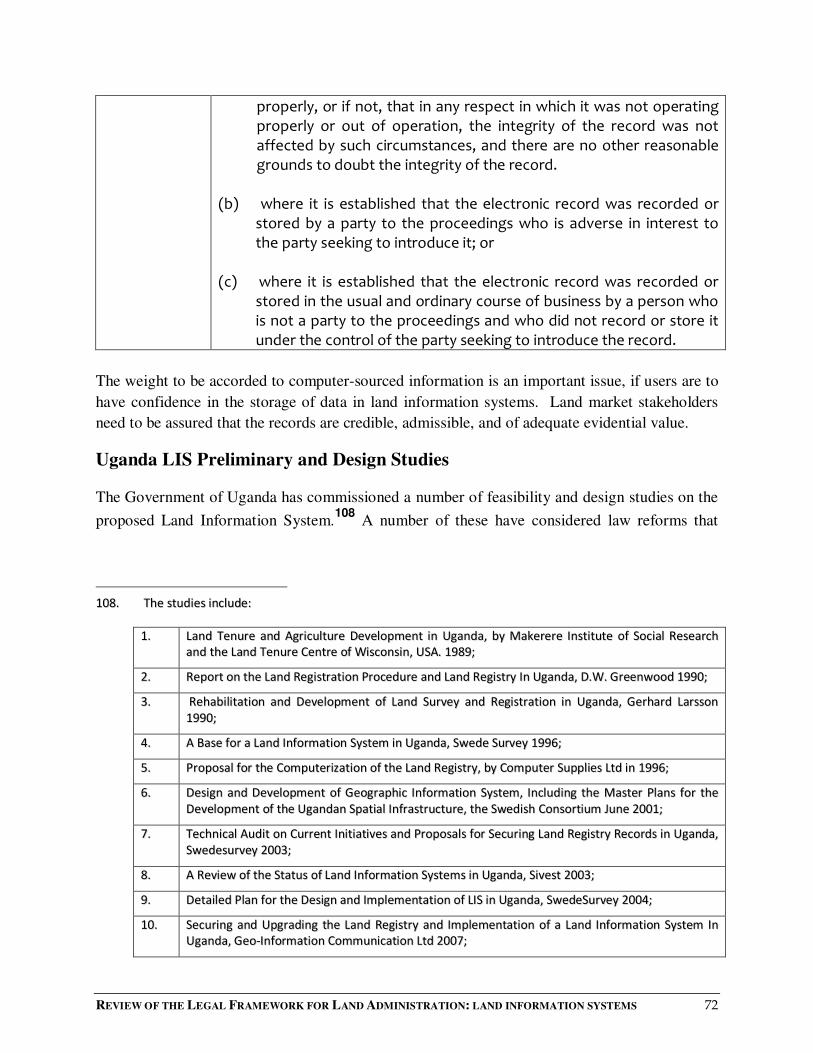
REVIEW OF THE LEGAL FRAMEWORK FOR LAND ADMINISTRATION: LAND INFORMATION SYSTEMS 72
properly, or if not, that in any respect in which it was not operating properly or out of operation, the integrity of the record was not affected by such circumstances, and there are no other reasonable grounds to doubt the integrity of the record.
(b) where it is established that the electronic record was recorded or
stored by a party to the proceedings who is adverse in interest to the party seeking to introduce it; or
(c) where it is established that the electronic record was recorded or
stored in the usual and ordinary course of business by a person who is not a party to the proceedings and who did not record or store it under the control of the party seeking to introduce the record.
The weight to be accorded to computer-sourced information is an important issue, if users are to
have confidence in the storage of data in land information systems. Land market stakeholders
need to be assured that the records are credible, admissible, and of adequate evidential value.
Uganda LIS Preliminary and Design Studies
The Government of Uganda has commissioned a number of feasibility and design studies on the
proposed Land Information System.108
A number of these have considered law reforms that
110088.. TThhee ssttuuddiieess iinncclluuddee::
11.. LLaanndd TTeennuurree aanndd AAggrriiccuullttuurree DDeevveellooppmmeenntt iinn UUggaannddaa,, bbyy MMaakkeerreerree IInnssttiittuuttee ooff SSoocciiaall RReesseeaarrcchh
aanndd tthhee LLaanndd TTeennuurree CCeennttrree ooff WWiissccoonnssiinn,, UUSSAA.. 11998899;;
22.. RReeppoorrtt oonn tthhee LLaanndd RReeggiissttrraattiioonn PPrroocceedduurree aanndd LLaanndd RReeggiissttrryy IInn UUggaannddaa,, DD..WW.. GGrreeeennwwoooodd 11999900;;
33.. RReehhaabbiilliittaattiioonn aanndd DDeevveellooppmmeenntt ooff LLaanndd SSuurrvveeyy aanndd RReeggiissttrraattiioonn iinn UUggaannddaa,, GGeerrhhaarrdd LLaarrssssoonn
11999900;;
44.. AA BBaassee ffoorr aa LLaanndd IInnffoorrmmaattiioonn SSyysstteemm iinn UUggaannddaa,, SSwweeddee SSuurrvveeyy 11999966;;
55.. PPrrooppoossaall ffoorr tthhee CCoommppuutteerriizzaattiioonn ooff tthhee LLaanndd RReeggiissttrryy,, bbyy CCoommppuutteerr SSuupppplliieess LLttdd iinn 11999966;;
66.. DDeessiiggnn aanndd DDeevveellooppmmeenntt ooff GGeeooggrraapphhiicc IInnffoorrmmaattiioonn SSyysstteemm,, IInncclluuddiinngg tthhee MMaasstteerr PPllaannss ffoorr tthhee
DDeevveellooppmmeenntt ooff tthhee UUggaannddaann SSppaattiiaall IInnffrraassttrruuccttuurree,, tthhee SSwweeddiisshh CCoonnssoorrttiiuumm JJuunnee 22000011;;
77.. TTeecchhnniiccaall AAuuddiitt oonn CCuurrrreenntt IInniittiiaattiivveess aanndd PPrrooppoossaallss ffoorr SSeeccuurriinngg LLaanndd RReeggiissttrryy RReeccoorrddss iinn UUggaannddaa,,
SSwweeddeessuurrvveeyy 22000033;;
88.. AA RReevviieeww ooff tthhee SSttaattuuss ooff LLaanndd IInnffoorrmmaattiioonn SSyysstteemmss iinn UUggaannddaa,, SSiivveesstt 22000033;;
99.. DDeettaaiilleedd PPllaann ffoorr tthhee DDeessiiggnn aanndd IImmpplleemmeennttaattiioonn ooff LLIISS iinn UUggaannddaa,, SSwweeddeeSSuurrvveeyy 22000044;;
1100.. SSeeccuurriinngg aanndd UUppggrraaddiinngg tthhee LLaanndd RReeggiissttrryy aanndd IImmpplleemmeennttaattiioonn ooff aa LLaanndd IInnffoorrmmaattiioonn SSyysstteemm IInn
UUggaannddaa,, GGeeoo--IInnffoorrmmaattiioonn CCoommmmuunniiccaattiioonn LLttdd 22000077;;
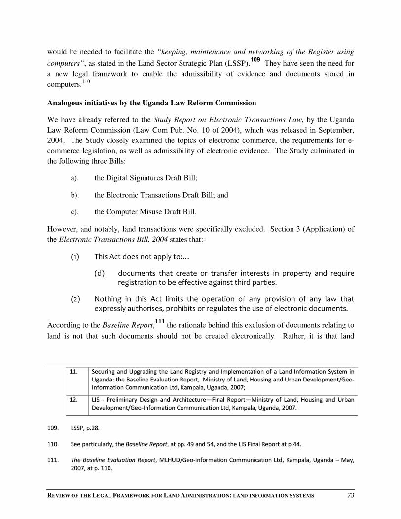
REVIEW OF THE LEGAL FRAMEWORK FOR LAND ADMINISTRATION: LAND INFORMATION SYSTEMS 73
would be needed to facilitate the “keeping, maintenance and networking of the Register using
computers”, as stated in the Land Sector Strategic Plan (LSSP).109
They have seen the need for
a new legal framework to enable the admissibility of evidence and documents stored in
computers.110
Analogous initiatives by the Uganda Law Reform Commission
We have already referred to the Study Report on Electronic Transactions Law, by the Uganda
Law Reform Commission (Law Com Pub. No. 10 of 2004), which was released in September,
2004. The Study closely examined the topics of electronic commerce, the requirements for e-
commerce legislation, as well as admissibility of electronic evidence. The Study culminated in
the following three Bills:
a). the Digital Signatures Draft Bill;
b). the Electronic Transactions Draft Bill; and
c). the Computer Misuse Draft Bill.
However, and notably, land transactions were specifically excluded. Section 3 (Application) of
the Electronic Transactions Bill, 2004 states that:-
(1) This Act does not apply to:…
(d) documents that create or transfer interests in property and require registration to be effective against third parties.
(2) Nothing in this Act limits the operation of any provision of any law that expressly authorises, prohibits or regulates the use of electronic documents.
According to the Baseline Report,111
the rationale behind this exclusion of documents relating to
land is not that such documents should not be created electronically. Rather, it is that land
1111.. SSeeccuurriinngg aanndd UUppggrraaddiinngg tthhee LLaanndd RReeggiissttrryy aanndd IImmpplleemmeennttaattiioonn ooff aa LLaanndd IInnffoorrmmaattiioonn SSyysstteemm iinn
UUggaannddaa:: tthhee BBaasseelliinnee EEvvaalluuaattiioonn RReeppoorrtt,, MMiinniissttrryy ooff LLaanndd,, HHoouussiinngg aanndd UUrrbbaann DDeevveellooppmmeenntt//GGeeoo--
IInnffoorrmmaattiioonn CCoommmmuunniiccaattiioonn LLttdd,, KKaammppaallaa,, UUggaannddaa,, 22000077;;
1122.. LLIISS -- PPrreelliimmiinnaarryy DDeessiiggnn aanndd AArrcchhiitteeccttuurree——FFiinnaall RReeppoorrtt——MMiinniissttrryy ooff LLaanndd,, HHoouussiinngg aanndd UUrrbbaann
DDeevveellooppmmeenntt//GGeeoo--IInnffoorrmmaattiioonn CCoommmmuunniiccaattiioonn LLttdd,, KKaammppaallaa,, UUggaannddaa,, 22000077..
110099.. LLSSSSPP,, pp..2288..
111100.. SSeeee ppaarrttiiccuullaarrllyy,, tthhee BBaasseelliinnee RReeppoorrtt,, aatt pppp.. 4499 aanndd 5544,, aanndd tthhee LLIISS FFiinnaall RReeppoorrtt aatt pp..4444..
111111.. TThhee BBaasseelliinnee EEvvaalluuaattiioonn RReeppoorrtt,, MMLLHHUUDD//GGeeoo--IInnffoorrmmaattiioonn CCoommmmuunniiccaattiioonn LLttdd,, KKaammppaallaa,, UUggaannddaa –– MMaayy,,
22000077,, aatt pp.. 111100..

REVIEW OF THE LEGAL FRAMEWORK FOR LAND ADMINISTRATION: LAND INFORMATION SYSTEMS 74
matters (and the other exclusions112
) require more detailed rules and regulations, or more
safeguards for users. Detailed provisions of this kind were considered not appropriate for the
Electronic Transactions Bill, which were concerned more with ensuring universal access to
internet connectivity and electronic transactions.
Nevertheless, as the Baseline Report consultants themselves note, transactions concerning land
are properly part of e-commerce.
In other jurisdictions, similar justifications have been advanced for excluding land-related
matters from electronic transactions law. Arguments include the following:113
i). The main obstacles to land transactions being carried out electronically are the various
statutory requirements for writing, signature or the use of deeds.
ii). A key rationale for excluding electronic land transactions is the protection of
unsophisticated parties. The exclusion avoids the danger that uninformed homeowners
may be tricked into unwittingly parting with their property at undervalue through a
clickwrap114
contract. The typical homeowner is inexperienced in matters of commerce,
including home sales, and is therefore vulnerable to deception.
We understand that real property has been excluded from the electronic transactions legislation
of many other jurisdictions, but to varying degrees. Canada and New Zealand exclude only those
instruments that require registration. Ireland excludes conveyancing but not contracts.
We do not find the explanations for exclusion entirely convincing, especially as any considered
legislation must deal with the admissibility and evidential weight of electronic records. In our
view, the Study Report in relation to the Uganda ETA Bill is not entirely clear or comprehensive
on these matters. This is (in our view) reflected in a strong criticism in an Opinion in the LIS
Baseline Study that:
• Legislators are not taking seriously the reality that land transactions are part of e-
commerce.
111122.. TThhee ootthheerr eexxcclluuddeedd mmaatttteerrss aarree:: wwiillllss aanndd ccooddiicciillss;; ttrruussttss ccrreeaatteedd bbyy wwiillllss oorr bbyy ccooddiicciillss;; ppoowweerrss ooff
aattttoorrnneeyy;; aanndd nneeggoottiiaabbllee iinnssttrruummeennttss,, iinncclluuddiinngg nneeggoottiiaabbllee ddooccuummeennttss ooff ttiittllee..
111133.. JJooiinntt IIDDAA--AAGGCC RReevviieeww ooff EElleeccttrroonniicc TTrraannssaaccttiioonnss AAcctt SSttaaggee IIII -- EExxcclluussiioonnss uunnddeerr SSeeccttiioonn 44 ooff tthhee EETTAA::
CCoonnssuullttaattiioonn PPaappeerr,, LLRRRRDD NNoo.. 22//22000044.. ““IIDDAA”” iiss aann aaccrroonnyymm ffoorr tthhee IInnffooccoommmm DDeevveellooppmmeenntt AAuutthhoorriittyy ooff
SSiinnggaappoorree,, aanndd ““AAGGCC”” ffoorr tthhee AAttttoorrnneeyy--GGeenneerraall’’ss CChhaammbbeerrss ooff SSiinnggaappoorree..
114. See definition of clickwrap in the section on Access to Land Information. The ULRC Study Report on the
Electronic Transactions Law defines “click through agreements” as follows: A merchant may offer
products, data, software or digital content online, subject to a form agreement accepted by clicking on an
"Accept" button. The user's conduct in downloading the content may constitute acceptance of the form
agreement.
REVIEW OF THE LEGAL FRAMEWORK FOR LAND ADMINISTRATION: LAND INFORMATION SYSTEMS 75
• The lack of an appropriate law to govern land transactions will pose difficulties for
computerization of the land registry.115
It is clear that issues relating to electronic land records, and an e-conveyancing system, are
complex and require review as part of an overall strategy for land-sector legislation.
Possible Solutions
The Uganda ETA Bill Study Report proposes dispensing with the "best evidence" rule in its usual
formulation when applied to computer-generated116
documents. It also proposes, in relation to
computer-generated records117
a statutory merging of the "original document" rule with the
requirement for authentication. Finally, it proposes that the focus should be on the overall
security and reliability of the computer system that produced the document.
Proposals from Australian jurisdictions have included reconsidering whether the best evidence
rule, and the principles as to secondary evidence of the contents of a document, should apply at
all in relation to electronic records, and if so whether clarification is required of what constitutes
an “original” or a “copy” of an electronic record. A study in Queensland, reflecting studies
elsewhere, has considered whether, rather than specifying exceptions to the best evidence rule,
the rule should be abolished and replaced with a comprehensive list of ways in which a party
may adduce evidence of the contents of a document.118
Technological solutions to legal problems
Besides the legal solutions mentioned above, technological solutions have also been suggested to
the issues regarding the admissibility of computer-stored information. One is to place technical
markers automatically on alterations made to a dataset, to improve the reliability of the data.119
Another is to improve the reliability of data captured by scanning. Careful scrutiny of the
integrity and format of the scanning process can help ensure accuracy and credibility, and so help
realize the full advantages of a modern LIS. To elaborate:
111155.. PP.. 111177..
111166.. WWee pprreeffeerr ttoo rreeffeerr ssiimmppllyy ttoo ““ddooccuummeennttss oorr rreeccoorrddss ssttoorreedd iinn ccoommppuutteerrss””.. AAss sseeeenn eeaarrlliieerr,, tthhee hheeaarrssaayy
rruullee ddooeess nnoott ccoonncceerrnn ddooccuummeennttss aanndd rreeccoorrddss ggeenneerraatteedd bbyy ccoommppuutteerr wwiitthhoouutt hhuummaann iinntteerrvveennttiioonn..
TThheerreeffoorree tthhee tteerrmm ccoommppuutteerr--ggeenneerraatteedd mmaayy bbee ccoonnffuussiinngg..
111177.. SSeeee pprreevviioouuss ffoooottnnoottee..
111188.. SSeeee RReecceeiipptt ooff EEvviiddeennccee bbyy QQuueeeennssllaanndd CCoouurrttss -- EElleeccttrroonniicc RReeccoorrddss,, iibbiidd..
111199.. LLeeggaall IIssssuueess RReellaattiinngg ttoo GGIISS,, bbyy MMaarrggaarreett LLyynncchh aanndd KKeennnneetthh EE.. FFoooottee,,
hhttttpp::////wwwwww..ccoolloorraaddoo..eedduu//ggeeooggrraapphhyy//ggccrraafftt//nnootteess//lleeggaall//lleeggaall__ffttoocc..hhttmmll

REVIEW OF THE LEGAL FRAMEWORK FOR LAND ADMINISTRATION: LAND INFORMATION SYSTEMS 76
At the process level: The scan must be produced through a process capable of ensuring the integrity of the record and maintaining it over time. Scanned copies are only as good as the process that produces them, and that process should include authentication and quality assurance.
As regards format: The scan must be kept in a format and environment that makes it readily available for subsequent reference. The electronic file must not require the courts or the user to search out obsolete or rare technology in order to read the file; it must be easy to access. For records that have long retention requirements, this implies either a continued active management strategy to migrate records, or the selection at the start of the process of a recognised long-term format.
Documenting the scanning process
The scanning process must be clearly documented. This might include the following:
• The name, business address and occupation of the person doing the scanning.
• The identity or description of the documents (if the documents are being scanned by file—a description of the file subject, file number, may be appropriate), where they came from, and their condition (ie damaged etc).
• The identify of the object/medium (disc etc) on which the scanned documents are stored.
• The day and time of the scanning.
• Stating (or noting, by a tick in a column or the like) that the scanning was done in the ordinary course of business, using apparatus in good working order.
• A signature by the person scanning the documents, attesting that the processes have been followed and information is true and correct. The signature should be dated.
All of this information could be included in columns of a log book.
Further, there may be need to ensure the continued integrity of the scanned form. This could be by storing the scanned form in a medium or by a method that prevents it being altered, or by maintaining detailed and automated audit logs.
120
These integrity measures121
can be promulgated in a handbook or in subsidiary legislation.
112200.. AAuuttoommaatteedd llooggss aarree oonnee ooff tthhee mmeeaannss uusseedd bbyy tthhee IInntteeggrraatteedd FFiinnaanncciiaall MMaannaaggeemmeenntt SSyysstteemm PPiilloott [[IIFFMMSS]] ttoo
eennhhaannccee sseeccuurriittyy aanndd ttoo ttrraaccee rroogguuee aaccttiioonnss..
112211.. SSoouurrccee,, EElleeccttrroonniicc RReeccoorrddss aass EEvviiddeennccee,, PPuubblliicc RReeccoorrdd OOffffiiccee VViiccttoorriiaa -- AAddvviiccee ttoo VViiccttoorriiaann AAggeenncciieess,, PPRROOAA
0033//0088 �� MMaayy 22000033 �� VVeerrssiioonn 11PP..

REVIEW OF THE LEGAL FRAMEWORK FOR LAND ADMINISTRATION: LAND INFORMATION SYSTEMS 77
RECOMMENDATIONS (Computer Records as Evidence in Court)
In view of the technological challenges of setting up and maintaining a secure digitized LIS, and one that will inspire confidence in its integrity:
1. In the short-to-medium term:
a) The manual records should remain primary evidence of land transactions.
b) Digital evidence should be admissible as secondary evidence where the court is satisfied that:
i) the person seeking to introduce the evidence can authenticate the reliability and security of the computer system that generated, processed or stored the evidence; and
ii) the evidence is of the type and in the form of information which is acted on in the ordinary course of business.
2. In the longer term, after the computer-based LIS is fully operational and its use and reliability generally accepted, the Minister by statutory instrument may make rules accepting computer records as primary evidence.
5.3.4 Standards for Data, Metadata and Applications
The concept of “standards” is not new. They have been common in business and government for
many years. One benefit of standards is that they are usually developed through a consultative
process (with other "experts"), and provide a basis from which to develop national or discipline-
oriented profiles. As standards become adopted within the wider community, software programs
are often developed to help in implementing them.122
Standards are generally developed in a hierarchy. Global standards, such as ISO and OGC, are
broad in nature. An example is ISO/TC211 which aims at standardising environmental metadata
and is responsible for geospatial data standards.
Standards developed at regional level conform to global standards, but usually include more
detail than global standards. National standards conform to regional standards, but are more
detailed again. And so on, up to local government or corporate standards.
In many countries, the task of coordinating standards is the responsibility of government. When a
new standard is to be developed, interested institutions are invited to participate in the process
until agreed specifications are developed. In some countries, such as Sweden, a non-
governmental organization (Swedish Standards Institute) coordinates standards development. In
112222.. SSeeee SSDDII CCooookk BBooookk,, vveerr 22 pp 2288..

REVIEW OF THE LEGAL FRAMEWORK FOR LAND ADMINISTRATION: LAND INFORMATION SYSTEMS 78
Uganda, the Uganda National Bureau of Standards (UNBS), a Government Department,
coordinates standards development.
Standards are necessary in the geospatial industry to ensure that datasets produced by
government institutions or the private sector are inter-operable. Spatial data specifications—such
as map projections, coordinate systems, units, map datums and other data qualities such as
semantics (meanings of concepts in spatial databases)—need to be standardized. Standards are
also required for applications designed to provide access to LIS data and other spatial data
Either because of lack of interest or scarcity of resources, the UNBS has not embarked on a
development of geospatial standards. As a result, no such standards exist in Uganda. The
Department of Lands and Survey, on the other hand, through a provision in the Survey Act, has
been setting and supervising limited standards for the accuracy of cadastral surveys. Within a
vibrant spatial data economy, there is need for standards for geospatial data, to ensure inter-
operability between the various producers and users of spatial data. The LIS institution, in
collaboration with UNBS, should be required to coordinate this role, by organizing various
standards committees so that agreed standards for core geospatial datasets are developed.
Standards should be developed for core datasets such as Roads, Administration Boundaries,
Hydrography, Topgraphical Basemaps, Cadastral Data, Parcel Identification, Documentation of
Datasets, and so on. Apart from spatial reference parameters such as projections, units,
coordinate systems and datums, standards should also be developed for semantics used to
develop the datasets.
In Uganda, governmental institutions and government agencies funded by donors are the major
producers of spatial data. Therefore, they should play a key role in streamlining the
standardization process. One practical way of fast-tracking standards development is to compel
all institutions using public funds to capture spatial data to first seek guidance from the LIS
institution on relevant standards for the production of data sets.
RECOMMENDATION
The LIS law should require the LIS institution to coordinate the development of
standards for the LIS in Uganda. Standards should include geospatial data
standards as well as standards for their metadata. All institutions intending to use
public funds to generate spatial datasets should seek guidance from the LIS
institution. In this way, the LIS institution can ensure that most datasets are
developed to agreed standards.
REVIEW OF THE LEGAL FRAMEWORK FOR LAND ADMINISTRATION: LAND INFORMATION SYSTEMS 79
5.3.5 Copyright and Land Information
Copyright is a branch of intellectual property law. Intellectual property law protects property
interests in intangible things. Specifically for our purposes, it protects the property rights in
creative endeavours of inventors and developers, and gives them certain exclusive economic
rights, enabling them to profit from the creative rights or inventions.123
Intellectual property is a key issue in the context of spatial information. A land information
service is engaged in compiling databases of land information, including map products. These
efforts entail creativity, inventiveness and original endeavour. As already seen, the data content
in land information may be expressed in graphic and textual form.124
Copyright is the exclusive right given to a creator to reproduce, publish, perform, broadcast and
adapt a work. It is primarily concerned with preventing unauthorized duplication or copying of
material. Copyright confers the exclusive right to control the distribution of the whole or a
substantial part of the work, either in its original form or in any form recognizably derived from
the original.
Our concern here is with intellectual property rights in land information. In our view,
intellectual property laws should be enhanced so as to protect the interests of the data producers.
In Uganda, copyright law previously applied to maps, plans and diagrams.125
However, there is
no doubt that copyright law can be applied to many types of land and property information.126
Indeed, all land and property-related information, both in text and in map form, may be subject
to copyright.
Additionally, Geographic Information Systems, incorporating geographical data, involve
hardware, software and duplicative procedures to support the capture, management,
manipulation, analysis, modelling and display of spatially-referenced data.127
To protect
copyright to land information system data, legislation should protect data producers against the
reproduction of that LIS data in any material form, including storage by electronic means. The
legislation should cover data and compilations assembled by the LIS institution or contained in
112233.. GGeeooggrraapphhiicc IInnffoorrmmaattiioonn SScciieennccee:: MMaasstteerriinngg tthhee LLeeggaall IIssssuueess,, bbyy GGeeoorrggee CChhoo,, JJoohhnn WWiilleeyy && SSoonnss,, LLttdd,, 22000055,,
aatt pp..110099,, eett sseeqq..
112244.. LLaanndd rreeggiisstteerrss hhaavvee ttwwoo mmaaiinn ccoommppoonneennttss:: aa tteexxttuuaall ddeessccrriippttiioonn ooff eeaacchh pprrooppeerrttyy;; aanndd aa ggrraapphhiicc
rreepprreesseennttaattiioonn oorr mmaapp,, oofftteenn ccoonnttaaiinniinngg ddiimmeennssiioonnaall iinnffoorrmmaattiioonn..
112255.. UUnnddeerr tthhee rreeppeeaalleedd CCooppyyrriigghhtt AAcctt,, CChhaapptteerr 221155,, LLaawwss ooff UUggaannddaa,, RReevviisseedd EEddiittiioonn,, 22000000..
112266.. DDaallee && MMccLLaauugghhlliinn,, LLaanndd AAddmmiinniissttrraattiioonn ((88..66 IInntteelllleeccttuuaall PPrrooppeerrttyy RRiigghhttss iinn LLaanndd aanndd PPrrooppeerrttyy
IInnffoorrmmaattiioonn))..
112277.. CChhoo,, GGeeooggrraapphhiicc IInnffoorrmmaattiioonn SScciieennccee:: MMaasstteerriinngg tthhee LLeeggaall IIssssuueess,, pp..113311..

REVIEW OF THE LEGAL FRAMEWORK FOR LAND ADMINISTRATION: LAND INFORMATION SYSTEMS 80
its registers. It should also cover the work of other people (including contributors of spatial
data), as well as computer programmes, making copies, and any adaptation of original
material.128
That this can be done is now beyond doubt:129
After some initial uncertainties over the status of data stored in electronic form, it is now possible in many legal systems to protect intellectual property rights and investment in data through copyright law.
Copyright law also allows data producers to protect their investment and to recoup some of the
costs incurred in assembling the data. A substantial investment will have been made in creating
topographic and cadastral maps, and in gathering and storing land-related data. In the case of
Uganda, much of this investment will have been made by donor-funding or development
partners. When the funds from these sources cease, the land information system must find other
funding if it is to remain sustainable. While there are pertinent issues of accessibility to land
information and data by the rural poor, there remains a compelling and overriding case for
maintaining the LIS at a sustainable level. Consequently, the investment in data by data
producers has to be protected through copyright laws, and the costs recovered through copyright
fees.
Payment for the provision of land information is already an established practice in Uganda. For
many years, there has been a fee for making searches and obtaining certified copies. The levying
of fees (by whatever name the fee is called) for data is not a novel concept.
Protection of intellectual property in Uganda now flows from Article 26 of The Constitution
which guarantees protection from deprivation of property. Also, Article 189 of The Constitution
(Functions of the Government and district councils) spells out the functions and services for
which Government is responsible. These are listed in the Sixth Schedule to the Constitution, item
of 6 of which states that copyrights, patents and trademarks and all forms of intellectual
property are the responsibility of the Government.
The legal and regulatory framework for copyright in Uganda is now contained in the Copyright
and Neighbouring Rights Act No.198 of 2006. The purpose of the Act is to repeal and replace
the Copyright Act, Chapter 215, Laws of Uganda, Revised Edition, 2000, and to provide for the
protection of literary, scientific and artistic works and their neighbouring rights.
Section 5 (1) of the Act (Work Eligible for Copyright) lists the literary, scientific and artistic
works that are eligible for copyright. Under Section 5(1)(e) they include computer programmes
and electronic data banks and other accompanying materials. This would seem to extend to LIS
databanks.
112288.. SSeeee ggeenneerraallllyy,, DDaallee && MMccLLaauugghhlliinn,, LLaanndd AAddmmiinniissttrraattiioonn ((88..66 IInntteelllleeccttuuaall PPrrooppeerrttyy RRiigghhttss iinn LLaanndd aanndd
PPrrooppeerrttyy IInnffoorrmmaattiioonn))..
112299.. LLaanndd AAddmmiinniissttrraattiioonn GGuuiiddeelliinneess,, UUNNEECCEE,, 11999966,, PP.. 4488..
REVIEW OF THE LEGAL FRAMEWORK FOR LAND ADMINISTRATION: LAND INFORMATION SYSTEMS 81
However, the general protection provided by the Copyright and Neighboring Rights Act is not in
our view sufficient to protect data in the LIS. This, we consider, requires specific statutory
protection. Furthermore, the copyright provisions have to be integrated with the inter-operability
and inter-agency/custodianship relationships which are essential to a modern LIS requiring input
of spatial information from numerous data producers.
Additionally, copyright protection must be balanced against:
i). rights of access to information, which are provided by the Access to Information Act, No
6 of 2005;
ii). the need to provide access to land information and data to the rural poor and others for
whom access to juridical records is sparse and tenure security limited;
iii). the notion of the Land Register as a public record, as stipulated in the Registration of
Titles Act;
iv). the openness and transparency provisions proposed to be included in the LIS Law; and
v). data-pricing policy.
This balance can, in our view, be achieved only in a stand-alone LIS Law.
Finally, we should note the provisions of the Access to Information Act 6 of 2005, as they relate
to copyright. Under Section 4 (Interpretation) of the Act:
"information" includes written, visual, aural and electronic information;
"record" means any recorded information, in any format, including an electronic format in the possession or control of a public body, whether or not that body created it; and
"proprietary information" means information relating to any manufacturing process, trade secret, trademark, copyright, patent or formula protected by law or by International Treaty to which Uganda is a party;
Section 5 of the Act confers on every citizen of Uganda a general right of access to information
and records in the possession of the State or any public body.
But this general right is subject to the qualification in Section 3, which withholds access to
exempt records and information. Then, Section 27(1) (Protection of commercial information of
third party) makes proprietary information (as defined in section 4) exempt. However, Section
27(2) states that access to a record may not be refused under subsection (1) insofar as the record
consists of information already publicly available.

REVIEW OF THE LEGAL FRAMEWORK FOR LAND ADMINISTRATION: LAND INFORMATION SYSTEMS 82
At present, Section 201 (Searches and certified copies) of the Registration of Titles Act Cap.
230,130
makes the information in the Land Register publicly available. The relationship between
this provision and Section 27 of the Access to Information Act needs to be clarified, in view of
our proposed data-pricing policies for cost recovery in the LIS law.
RECOMMENDATION
The proposed LIS law, by building upon Section 5(1)(e) of the Copyright and
Neighbouring Rights Act No.198 of 2006, should provide for copyright in data in
the LIS, protecting against access to or the reproduction of that data, including
the storing of work in any medium by electronic means, in order to:
i). overcome any doubt in the existing copyright law about copyright to data
in the LIS;
ii). protect the investment in the LIS, the SDI, and the data in them;
iii). help recover some of the costs of maintaining and/or enhancing the LIS,
once established, including ensuring accuracy, volume and quality of data,
at a sustainable level for continuity.
In short, the investment in data by data producers should be protected through
copyright laws and the costs recovered through copyright fees.
The relevant legal provisions should be inserted in the proposed LIS Law, and not
left to the Copyright and Neighboring Rights Act, 2006. The legislation must cater
for the peculiar relationships and issues surrounding the capture, collection,
maintenance, management, manipulation, analysis, modelling, display and
disposal of spatially-referenced data by the LIS agency. The law should set out
conditions under which certain information may be accessed by members of the
public.
The LIS provisions on copyright should be harmonized with the licensing
requirements proposed in relation to access to, custodianship of, and liability for
and the pricing of, land information.
113300.. TThheerree iiss aa ssiimmiillaarr pprroovviissiioonn iinn sseeccttiioonnss 117777 aanndd 117788 ooff oouurr DDrraafftt RReeggiissttrraattiioonn ooff TTiittlleess AAcctt 22001100..

REVIEW OF THE LEGAL FRAMEWORK FOR LAND ADMINISTRATION: LAND INFORMATION SYSTEMS 83
5.3.6 Liability for Land Information
The United Nations Economic Commission for Europe (ECE) observes in its Guidelines on Land
Administration that as registers are increasingly computerized and linked into wide area
networks, the law should define the extent of legal liability for data accuracy.131
The
Commission also observes that in the development of national land information systems, the
organization that is chosen to manage the system must be able to adequately define the legal
liability of both public sector and private sector data providers.
In many land administration systems, the practice has been for data to be guaranteed by the State.
In our view, the same principle should apply in Uganda, while limiting the number of datasets
that should be guaranteed. In our view, Government should guarantee both cadastral and
topographical layers, since they are considered to be fundamental datasets. Our
recommendations hinges on the consideration that without a Government guarantee of quality on
such datasets, their value will be reduced and this will affect the usability of LIS in general.
The ECE also explores several prerequisites for the efficient handling of land information. It
notes that to facilitate the use of land information databases for various land management
applications, it is necessary to address a variety of administrative, juridical and organizational
issues. Notably, one is legal liability for data.
The Commission gives the following brief description of the liability issues:-
“(d) Legal liability
As increasing volumes of data become available and are used by both the public and private sectors in support of decision-making, liability for the accuracy of the data may arise. In some countries the State gives an unequivocal guarantee about the data held in the land registry so that if a mistake occurs, those who suffer in consequence will be paid compensation. The degree to which civil servants can be sued for negligence depends upon the jurisdiction.”
132
Liability in law is a broad concept, embracing almost every type of duty, obligation,
responsibility or risk arising by way of contract, tort or statute.133
While a contract may regulate
the extent of liability through agreed provisions, at common law, legal responsibility generally
exists for an act or omission that causes harm to another person, including by negligence or
113311.. PP.. 3322..
113322.. pp..6688..
113333.. BBllaacckk’’ss LLaaww DDiiccttiioonnaarryy,, 77tthh EEddiittiioonn,, 11999999..
REVIEW OF THE LEGAL FRAMEWORK FOR LAND ADMINISTRATION: LAND INFORMATION SYSTEMS 84
misrepresentation. Liability may also be created by statute.134
Liability generally is measured
against well established legal principles and standards.135
In Uganda, Section 5 of the Access to Information Act, No. 6 of 2005, gives citizens an
entitlement to accurate and up to date information:
5. Right of access.
(1) Every citizen has a right of access to information and records in the possession of the State or any public body, except where the release of the information is likely to prejudice the security or sovereignty of the State or interfere with the right to the privacy of any other person.
(2) For the avoidance of doubt, information and records to which a person is entitled to have access under this Act shall be accurate and up to date so far as is practicable.
We note, however, that the Act does not make it clear whether any liability arises from breach of
the entitlement in subsection (2).
The above discussion raises squarely the question: when does liability for land information/data
occur? It is clear that an LIS organization may potentially be legally accountable for the accuracy
and reliability of the information which it stores, sells or issues to the public. For example,
potential legal liability could arise in the following circumstances:
i). Where harm is caused or economic loss sustained by a mistake in the land information
(including a spatial or GIS dataset), or from a mistake not corrected once discovered.
ii). Where decisions are made on the basis of faulty land information, and the decisions cause
harm or economic loss. Faulty spatial data or analysis can lead to poorly designed
policies. Incorrect data entered into a GIS model may distort the results of an analysis, or
a GIS analysis, while using correct data, may through poor reasoning or design result in
spatial data inadvertently misrepresenting reality.136
iii). Where the information distributed leads to damage or loss, even if that information was
used for purposes for which it was never intended. For example, maps are designed for
specific uses, so that projections, scales, even different expectations of accuracy, make
113344.. SSeeee iinnffrraa,, ffoorr ddiissccuussssiioonn ooff pprroovviissiioonnss ooff tthhee AAcccceessss ttoo IInnffoorrmmaattiioonn AAcctt..
113355.. HHaarrllaann OOnnssrruudd,, GGeeooggrraapphhiicc IInnffoorrmmaattiioonn LLeeggaall IIssssuueess,, HHaarrllaann JJ.. OOnnssrruudd,, DDeeppaarrttmmeenntt ooff SSppaattiiaall IInnffoorrmmaattiioonn
SScciieennccee aanndd EEnnggiinneeeerriinngg,, NNaattiioonnaall CCeenntteerr ffoorr GGeeooggrraapphhiicc IInnffoorrmmaattiioonn aanndd AAnnaallyyssiiss,, UUnniivveerrssiittyy ooff MMaaiinnee,,
UUSSAA,, hhttttpp::////wwwwww..ssppaattiiaall..mmaaiinnee..eedduu//~~oonnssrruudd//ppuubbss//GGIILLeeggaallIIssssuueess..hhttmmll##
113366 .. GGeeooggrraapphhiicc IInnffoorrmmaattiioonn SScciieennccee,, MMaasstteerriinngg tthhee LLeeggaall IIssssuueess,, bbyy GGeeoorrggee CChhoo,, WWiilleeyy,, pp.. 335599..

REVIEW OF THE LEGAL FRAMEWORK FOR LAND ADMINISTRATION: LAND INFORMATION SYSTEMS 85
individual maps appropriate for only particular uses. At times, however, maps may be
used in ways which were not intended by the data producer.
More basically even:
• users may simply be unaware of data errors or may not appreciate what the information
represents;
• users of spatial data may not appreciate how the information has been derived from other
data, or what computations have been performed on the raw data.137
However, it is clear that liability can arise generally for geographic data and information as well
as for products from a land information system.138
And it has been said that, in information
systems, potential liability for harm or economic loss may result as much from use, misuse and
inappropriate uses of accurate information as from decisions made using inaccurate
information.139
This discussion makes it clear that liability under any proposed LIS in Uganda is a genuine issue.
Important factors include:
• Existing staff are not (or have not yet been) exposed to LIS technology and
administrative or service structures associated with a computerized LIS.
• Glaring inconsistencies exist in Ugandan land records. Reliance on the records can easily
lead to loss. For example, at one time, a certain statutory corporation held freehold
certificates of title for the bulk of Akii Bua Road, Nakasero, Kampala, which had been
transferred to that corporation in the 1960s as part of its capitalization. Then in the 1990s
when the policies of disengaging from housing civil servants were in progress, the
Uganda Land Commission issued leasehold grants and the Titles Registry issued
leasehold titles over many of the same properties. Similar inconsistencies were made for
Solent Avenue in Mbuya. A search of the Freehold register would reveal the corporation
as proprietor, while a search of the leasehold register would reveal various civil servants
or former sitting tenants as proprietors.
• Society is becoming increasingly litigious. The propensity for litigation is increasingly
fuelled by burgeoning information capabilities (including the internet).
• Fraudulent practices have been reported in the land registry, cadastral records, and other
land administration records, and continue to bedevil land and real estate transactions in
Uganda.
113377.. LLeeggaall IIssssuueess RReellaattiinngg ttoo GGIISS,, bbyy MMaarrggaarreett LLyynncchh aanndd KKeennnneetthh EE.. FFoooottee,,
hhttttpp::////wwwwww..ccoolloorraaddoo..eedduu//ggeeooggrraapphhyy//ggccrraafftt//nnootteess//lleeggaall//lleeggaall__ffttoocc..hhttmmll
113388.. GGeeoorrggee CChhoo,, WWiilleeyy,, pp.. 335599..
113399.. CChhoo,, aabboovvee..

REVIEW OF THE LEGAL FRAMEWORK FOR LAND ADMINISTRATION: LAND INFORMATION SYSTEMS 86
There is therefore a real need to protect the nascent LIS from the risk of liability claims which
could seriously impede its development.
However, legal liability can be never be eliminated totally. In realisation of this, international
practice is to seek to reduce liability through risk management strategies and sound business
practices.140
One risk management practice is the appropriate use of exclusion clauses, disclaiming liability
for certain actions. In the case of sale, distribution or disposal of spatial information, the relevant
contract could incorporate a disclaimer of liability.
However, questions may arise about the efficacy of disclaimer clauses. Courts have developed
rules protecting consumers against over-zealous exclusion clauses, so that not all clauses are
legally enforceable.141
Certainly they would not protect an LIS institution against complete non-
performance of a contract. A party to a contract who does not carry out its basic contractual
responsibilities cannot rely on an exclusion clause for protection.
A business practice that could help reduce exposure to legal liability, would be for the LIS
authority to produce a handbook containing formal guidelines for dealing with the transfer of
data both externally and internally. These guidelines could inform the LIS institution staff how to
transfer data and what precautions to take before transfer. These guidelines could include details
on:
• Circumstances in which data could or could not be handed out – e.g., if the data is subject
to the Access to Information Act, or if privacy restrictions apply, and what forms are
required. (Privacy, which is discussed elsewhere in this Paper, can impact on liability,
e.g. when privacy or confidentiality is breached without legal justification or protection.)
• Restrictions on the use of information – e.g., if use is for academic purposes, the user
could be required to sign a licence stating that the data, or any derived data, will not be
passed on without the approval of the LIS institution. The LIS institution could also use
the Guidelines to prohibit the on-selling of data to third parties—because if third parties
are injured by reliance on the data, the LIS institution could be held accountable.
• Standard forms and/or licences should be used when distributing data.
The LIS law could also compel all data producers to supply metadata alongside the data. A
minimum set of parameters of metadata should include positional accuracy, attribute accuracy,
114400.. SSeeee,, ffoorr eexxaammppllee,, tthhee rriisskk aallllooccaattiioonn pprroovviissiioonnss ooff tthhee WWoorrlldd BBaannkk SSttaannddaarrdd BBiiddddiinngg DDooccuummeennttss ffoorr
pprrooccuurreemmeenntt,, iinnssttaallllaattiioonn aanndd mmaaiinntteennaannccee ooff IInnffoorrmmaattiioonn TTeecchhnnoollooggyy..
114411.. IInn UUggaannddaa tthhee CCoonnssuummeerr PPrrootteeccttiioonn lleeggiissllaattiioonn iiss yyeett ttoo bbee eennaacctteedd aanndd wwee aarree nnoott aawwaarree aass ttoo wwhheetthheerr aa
pprrooppoosseedd//ppeennddiinngg rreevviieeww ((rreeppeeaall aanndd rreeppllaacceemmeenntt)) ooff tthhee CCoonnttrraacctt AAcctt wwiillll iinnccoorrppoorraattee pprroovviissiioonnss ffoorr
uunnffaaiirr ccoonnttrraacctt tteerrmmss,, ssuucchh aass ppeerrhhaappss,, tthhee UUKK UUnnffaaiirr CCoonnttrraacctt TTeerrmmss AAcctt 11997777..

REVIEW OF THE LEGAL FRAMEWORK FOR LAND ADMINISTRATION: LAND INFORMATION SYSTEMS 87
date and method of collection, intended purpose, and recommended applications. These
principles would require capacity-building among the producers and users of land information.
The LIS institution should develop material in form of handbooks to educate and guide
producers and users of land information on how to create, maintain and disseminate spatial
information. This will minimise any errors or liabilities that may arise.
Liability-reduction and risk-management strategies should also be built into any licences or
standard forms or web page notices, all of which should clearly spell out what a data user can
and cannot do with the data. Limitations could include:-
� restrictions on use;
� restrictions on distribution to others (whether in electronic or soft form, or in derivative
products such as printouts);
� copying of data.
Even in the case of freely available online software, such as PDF Acrobat Reader, or a number of
websites containing freely-available resources (such as, in the land information area, GISDepot,
ESRImaps, Africover, Global Landcover Facility-GLCF, OICRF),142
an intending user must
accept a user agreement before use is allowed. In the OICRF Website, for example, the
intending user feeds in his or her name and e-mail, accepts the terms and conditions of use, and
only then gains access to the document. Other sites require the user to provide an email address,
and data is delivered electronically to that address only after the user has satisfied the access
requirements—and the access requirements typically include the risk-allocation or liability-
management requirements of the data producer. This facilitates the follow-up of any errant user.
These and similar functionalities can be incorporated into the LIS. We describe them here
merely to illustrate potential solutions. They are not intended to replace any LIS system designs
proposed by the System Consultants or supplied by the eventual provider of IT equipment and
components at LIS implementation.
Other potential means of limiting liability could include provisions for:
i). Force majeure—excluding liability of the LIS institution for any event beyond its
reasonable control, including circumstances for which the LIS institution may maintain
disaster recovery.143
114422.. OOIICCRRFF iiss aa FFrreenncchh AAccrroonnyymm ffoorr IInntteerrnnaattiioonnaall OOffffiiccee ooff CCaaddaassttrree aanndd LLaanndd RReeccoorrddss ((OOIICCRRFF))..
hhttttpp::////wwwwww..ooiiccrrff..oorrgg//
114433.. SSeeee,, ffoorr eexxaammppllee,, tthhee ggeenneerraall ccoonnddiittiioonnss ooff tthhee SSttaannddaarrdd BBiiddddiinngg DDooccuummeennttss:: SSuuppppllyy aanndd IInnssttaallllaattiioonn ooff
IInnffoorrmmaattiioonn SSyysstteemmss,, TThhee WWoorrlldd BBaannkk,, MMaarrcchh 22000033..

REVIEW OF THE LEGAL FRAMEWORK FOR LAND ADMINISTRATION: LAND INFORMATION SYSTEMS 88
ii). Exclusion of liability for inappropriate use—covering the use of information or data in a
way which was not intended. This could be combined with a “fit for purpose statement”,
where an explanation is given of the purpose for which the data was produced, so that it
is not used out of its context.144
iii). Capping limits of liability—limiting the provider’s liability to a stated amount. That
amount could be the fees paid or payable by the data user for the data, on the basis that
this is the maximum benefit that the data supplier derives from the transaction. If the
supply is pursuant to a licence, then the liability for damages could be limited to the total
fees paid by the licensee.
In information systems and transactions law, licences are the main medium for controlling access
to and payment for a product. Licence agreements are designed to protect:
• the information from misuse;
• proprietary interests in the information;
• privacy and confidentiality in the information;
• the data producer from liability for the degree of accuracy of the information, or its
subsequent alteration, modification or misuse;
• the content and arrangement of the data.
In terms of intellectual property rights, the licence is also a means of keeping the data out of the
public domain.
The following are two illustrations of the use of licences to protect a land data provider from
liability:
i). Finland. Section 6 (Supply of data as information service) of the Act on the Land
Information System and Related Information Service (453/2002) provides that
conditions concerning the search criterion, other use of the system, and related control
issues, may be included in the licence.
ii). Europe. Article 14 of Directive 2007/2/EC establishing an Infrastructure for Spatial
Information in the European Community (INSPIRE)145
provides that an authority may
require disclaimers or licenses before providing certain services, including:
(a) searches for spatial data sets;
114444.. AAuussttrraalliiaann SSppaattiiaall DDaattaa PPoolliiccyy:: LLeeggaall iissssuueess aarriissiinngg ffrroomm ddaattaa ddeelliivveerryy vviiaa tthhee IInntteerrnneett,, bbyy GGyyppssyy BBhhaallllaa,, FFIIGG
WWoorrkkiinngg WWeeeekk 22000077,, HHoonngg KKoonngg SSAARR,, CChhiinnaa,, MMaayy 22000077.. SSeeee aallssoo IINNSSPPIIRREE DDaattaa PPoolliiccyy && LLeeggaall IIssssuueess
PPoossiittiioonn PPaappeerr,, ((ppaarraaggrraapphh 88..22 LLiiaabbiilliittyy && FFiittnneessss ffoorr PPuurrppoossee))..
114455.. OOffffiicciiaall JJoouurrnnaall ooff tthhee EEuurrooppeeaann UUnniioonn,, LL 110088//11,, 2255..44..22000077 EENN..
REVIEW OF THE LEGAL FRAMEWORK FOR LAND ADMINISTRATION: LAND INFORMATION SYSTEMS 89
(b) view services, making it possible, to display, navigate, zoom in/out, pan, or
overlay viewable spatial data sets and to display legend information and metadata
content;
(c) download services, enabling copies of spatial data sets to be downloaded and
accessed directly;
(d) transformation services, enabling spatial data sets to be transformed with a view
to achieving inter-operability.
An example of an extreme license limiting the product/service provider is the Limitation of
Liability notice on the MapQuest Website:
UNDER NO CIRCUMSTANCES SHALL MAPQUEST, ITS PARENT, AFFILIATES, DIRECTORS, EMPLOYEES, DISTRIBUTORS, SUPPLIERS, AGENTS OR RESELLERS (COLLECTIVELY, THE "MAPQUEST GROUP") BE LIABLE FOR ANY INDIRECT, SPECIAL, INCIDENTAL, CONSEQUENTIAL, OR EXEMPLARY DAMAGES THAT RESULT FROM THE USE OF, MISUSE OF, INABILITY TO USE, OR RELIANCE UPON THIS WEBSITE OR THE MATERIALS, INCLUDING, WITHOUT LIMITATION, DAMAGES FOR LOSS OF USE, DATA, BUSINESS OPPORTUNITIES, OR PROFITS. THIS LIMITATION APPLIES WHETHER THE ALLEGED LIABILITY IS BASED ON CONTRACT, TORT, NEGLIGENCE, STRICT LIABILITY, OR ANY OTHER BASIS…
(See http://www.mapquest.com/features/main.adp?page=legal)
We would not go so far. An appropriate balance needs to be struck between liability-reduction
and risk-management, on the one hand, and the need to assure users about the quality of the land
information on the other. If liability for land information is too heavily disclaimed, its value in
stimulating an efficient land market may be undermined.
Existing liability management practice in the Uganda Land Registry
Traditionally, the Land Registry has issued the following disclaimer:
As only personal searches are provided for under the Registration of Titles Act, this information is given on the understanding that no liability shall arise or be accepted from mistakes or misstatements therein.
No similar disclaimer appears to be used in the Departments of Land Administration (including
valuation), Surveys & Mapping, Physical Planning.
Section 22 of the Survey Bill, 2005, contains a provision for immunity from civil and criminal
liability for the Commissioner, District Surveyors and authorised officers. The provision states
that they are not, in a personal capacity, liable to any civil or criminal proceedings for any act
done in good faith in the performance of their duties.
REVIEW OF THE LEGAL FRAMEWORK FOR LAND ADMINISTRATION: LAND INFORMATION SYSTEMS 90
RECOMMENDATIONS
The proposed LIS law should provide a framework for responsibility for data
quality, and liability for errors.
The Government should guarantee the fundamental cadastral layer, but with
appropriate liability and risk management provisions to ensure that the cost of
any liability claims arising out of the provision of land information does not
undermine the sustainability of the LIS.
The LIS law needs to strike an appropriate balance between liability-reduction
and risk-management on the one hand, and the need to assure users about the
quality of the land information on the other hand. If land information is too heavily
disclaimed, its value in stimulating an efficient land market may be undermined;
but if the Government cannot guarantee quality, the value of the data is also
undermined.
In order to reduce exposure to contractual legal liability, the proposed law should
require the issue of a handbook containing formal staff guidelines for the transfer
of data both externally and internally. These guidelines should inform staff of the
LIS provider how to transfer data and what precautions to take before transfer.
These guidelines may include details on:
• circumstances in which the data can be released;
• restrictions on use, particularly in relation to on-selling data to third
parties;
• standard forms and/or licences to be used when distributing data.
Liability-reduction and risk-management strategies should also be built into any
licence or standard forms or web page. Notices should clearly spell out what a
data user can and cannot do with the data. Conduct regulated or prohibited can
include:
� restrictions on use;
� restrictions on distribution to others (whether in electronic or soft form, or
whether by way of derivative products such as printouts);
� copying of data.
Finally, providers of land information services (including all types of spatial data)
should be compelled by law to provide meta-data, prescribing a minimum set of
basic data description parameters.
REVIEW OF THE LEGAL FRAMEWORK FOR LAND ADMINISTRATION: LAND INFORMATION SYSTEMS 91
5.3.7 Access to Land Information
Earlier, we emphasized the focal role of land-related information within Land Management,
Land Information Management, and the overall Land Administration framework. Land
Information Management includes the responsibility to ensure access to land information is
adequately catered for. Matters relevant to land information include:
i. Physical access to land information, in the sense of search, retrieval, distribution and use.
Distribution and use impacts on data-sharing, privacy and confidentiality, as well as on
the legal protection of access to data.
ii. Pricing of land information, including issues of affordability and whether the information
is priced beyond the reach of sections of the community.
iii. The distance which land information users have to travel to reach the nearest land
information service.
The LIS law needs to prescribe rights of access to data. This includes prescribing who is
authorized to enter or change entries on the registers; and who (if anyone) may use the
information for purposes beyond those for which it was provided.
Privacy and confidentiality
Privacy and confidentiality are key issues which must be tackled in any significant review of
access to land information.
Important considerations include the following:
i). Land information must be readily available, as it is crucial for the social and economic
benefit of the community, including the operation of an efficient land market.
ii). However, confidentiality must be respected. The rights of land-owners (and other
subjects of land-related information and data) must not be impinged upon by unnecessary
intrusion, or by misuse of information.
Technological innovation has enormously expanded the potential uses of land information. This
also increases the potential for abuse. Thus:
Geo-information is a double-edged sword, regarding its powers in providing instant access to vast amounts of data and the opportunity to abuse, to misinform, and to invade the privacy of individuals on a greater scale than ever before.
146
114466.. LLeeggaall AAssppeeccttss ooff AAcccceessss ttoo GGeeoo--iinnffoorrmmaattiioonn wwiitthhiinn IInnddoonneessiiaann SSppaattiiaall DDaattaa IInnffrraassttrruuccttuurree,, bbyy RR..
AAbbdduullhhaarriissaa ,, BB.. vvaann LLooeenneennbb aanndd JJ.. ZZeevveennbbeerrggeenncc,, IISSPPRRSS WWoorrkksshhoopp oonn SSeerrvviiccee aanndd AApppplliiccaattiioonn ooff SSppaattiiaall
DDaattaa IInnffrraassttrruuccttuurree,, XXXXXXVVII ((44//WW66)),, OOcctt..1144--1166,, HHaannggzzhhoouu,, CChhiinnaa,, qquuoottiinngg CChhoo,, GG..,, 11999988,, GGeeooggrraapphhiicc
IInnffoorrmmaattiioonn SSyysstteemm aanndd tthhee LLaaww,, JJoohhnn WWiilleeyy aanndd SSoonnss..

REVIEW OF THE LEGAL FRAMEWORK FOR LAND ADMINISTRATION: LAND INFORMATION SYSTEMS 92
While made in relation to geo-information, this statement is equally true in relation to LIS data.
Legislation is therefore required to balance the benefits of a modern land information system
against the need to protect personal information.147
In Uganda the right of access to information flows from Article 41 of The Constitution, 1995.
More recently, Parliament enacted the Access to Information Act, No. 6 of 2005 to give effect to
article 41 of the Constitution, by providing a right of access to information held by organs of the
State, other than exempt records and information.
The right of access to information under Act No. 6 of 2005 is, however, qualified. Specifically,
the release of the information must not:-
• prejudice the security or sovereignty of the State; or
• interfere with the right to the privacy of any other person.148
Earlier, we noted the provisions of the Access to Information Act, No. 6 of 2005 as they relate to
copyright. We will not repeat that discussion here, except to mention Section 201 of the
Registration of Titles Act Cap. 230.149
This section makes the information in the Land Register
publicly available, by conferring a right of search.
There is a need to reconcile the publicity requirements for the Register with control of access. A
key aspect of both land registration and cadastral legislation is that registers should be searchable
by the public.150
The law should require a land register to be open to public inspection. This promotes a better
property market performance and lower transaction costs.151
114477.. IIssssuueess iinn LLaanndd IInnffoorrmmaattiioonn MMaannaaggeemmeenntt PPaappeerr NNoo.. 55:: PPrriivvaaccyy,, CCoonnffiiddeennttiiaalliittyy aanndd AAcccceessss ttoo IInnffoorrmmaattiioonn iinn
LLaanndd IInnffoorrmmaattiioonn SSyysstteemmss,, AAuussttrraalliiaa NNeeww ZZeeaallaanndd LLaanndd IInnffoorrmmaattiioonn CCoouunncciill,, JJuullyy 11999922..
114488.. SSeeccttiioonn 55..
114499.. EEllsseewwhheerree wwee hhaavvee pprrooppoosseedd rreeppllaacciinngg tthhiiss pprroovviissiioonn wwiitthh sseeccttiioonnss 117777 aanndd 117788 ooff tthhee DDrraafftt RReeggiissttrraattiioonn
ooff TTiittlleess AAcctt 22000088 ((nnooww DDrraafftt RReeggiissttrraattiioonn ooff TTiittlleess AAcctt 22001100))..
115500.. LLIISS BBaasseelliinnee SSuurrvveeyy RReeppoorrtt,, PP..8899--9911.. SSeeee aallssoo,,
hhttttpp::////wwwwww..uunneeccee..oorrgg//hhllmm//wwppllaa//sseessssiioonnss//11sstt%%2200sseessssiioonn//pp77--9999--55ee..ppddff
115511.. SSeeee aallssoo tthhee SSccoottttiisshh ppeerrssppeeccttiivvee iinn ‘‘KKeeyy AAssppeeccttss ooff LLaanndd RReeggiissttrraattiioonn aanndd CCaaddaassttrraall LLeeggiissllaattiioonn’’,, bbyy KKeenn
YYoouunngg,, RReeggiisstteerrss ooff SSccoottllaanndd,, UUNNEECCEE//MMOOLLAA WWoorrkksshhoopp oonn MMaannaaggiinngg aanndd DDeevveellooppiinngg EEffffeeccttiivvee RReeggiissttrraattiioonn
aanndd CCaaddaassttrraall SSeerrvviicceess,, SSeepptteemmbbeerr,, 11999999..

REVIEW OF THE LEGAL FRAMEWORK FOR LAND ADMINISTRATION: LAND INFORMATION SYSTEMS 93
What constitutes personal information?
The Access to Information Act does not define ‘personal information’. However, Section 24
(Access subject to conditions) provides an indication of its meaning by allowing a request for
information or records containing personal information relating to the person requesting the
information. In so doing, it gives effect to the Individual Participation Principle, which derives
from OECD Guidelines on the Protection of Privacy and Transborder Flows of Personal Data.
Within the land information context, personal information may be characterised as information
about an individual whose identity is apparent or can reasonably be ascertained from the
information.152
Land information systems generally collect and store information which can
lead to a person’s identification. This may include a person's name, and an identifier of the
property in which that person has an interest (title reference, lot number, valuation number, street
address).
A land information system must support dissemination of land information; but it must also
respect personal information.153
Achieving a balance can be difficult, all the more so when a
land information system may provide material as extensive (and as revealing) as:
• the extent of a person's interest in the property (½ share, full owner, joint-tenant, etc);
• financial matters (mortgages and charges over the property), property values, rates and
taxes, etc; and
• land use matters (developmental intentions, planning permissions, etc).
Emphasis on land-related data, not personal data
A fine line often exists between data that is perceived as personal and data that is perceived as
non-personal. While it is inevitable that land information systems hold personal data (e.g. names,
addresses) in order to function efficiently, the emphasis should be on land-related data. In our
view, personal data should be held only as an adjunct to land-related data and to enhance the
land-related data.
To illustrate different international practices,154
in the Netherlands and Sweden the amount for
which a property is mortgaged is treated as public information and can be seen by anyone who
views the computerized registers. In England the information is regarded as private and is not
publicly available; yet in Scotland that information (including also land price information) is
115522.. IIssssuueess iinn LLaanndd IInnffoorrmmaattiioonn MMaannaaggeemmeenntt PPaappeerr NNoo.. 55:: PPrriivvaaccyy,, CCoonnffiiddeennttiiaalliittyy aanndd AAcccceessss ttoo IInnffoorrmmaattiioonn iinn
LLaanndd IInnffoorrmmaattiioonn SSyysstteemmss,, AAuussttrraalliiaa NNeeww ZZeeaallaanndd LLaanndd IInnffoorrmmaattiioonn CCoouunncciill ((AANNZZLLIICC)),, JJuullyy 11999922..
115533.. CCaann IInntteerrnnaattiioonnaall LLeessssoonnss bbee lleeaarrnntt ffrroomm tthhee DDeevveellooppmmeenntt ooff NNaattiioonnaall LLaanndd IInnffoorrmmaattiioonn SSyysstteemmss??,, MMaarrttiinn
RRaallpphhss aanndd PPeetteerr WWyyaatttt..
115544.. UUNNEECCEE LLaanndd AAddmmiinniissttrraattiioonn GGuuiiddeelliinneess,, pp.. 3322..
REVIEW OF THE LEGAL FRAMEWORK FOR LAND ADMINISTRATION: LAND INFORMATION SYSTEMS 94
public.155
In Uganda a search of the Register is usually done for due diligence purposes, to
ascertain the existence of encumbrances on the land; and if a mortgage is registered, the searcher
may obtain a copy.
What is the major concern, given that our Land Register has always been open?
Why should the continued provision of information, which has been publicly available for many
years, be now seen as violating privacy standards? In our view, the need for concern arises from
the powerful tools of the modern LIS. Land information can now be more vigorously collected,
collated, updated and maintained, and accessibility is being revolutionized by ICTs. The volume
of information now readily accessible is enormous, compared to the days of manual registers and
manual searches. The power of the computer has revolutionized both the quantity of material
and the ease with which it can be accessed and disseminated. Therein lies the threat to personal
privacy. This is coupled with the additional possibility of manipulating digital information for
improper purposes.
This gives rise to a related issue: when is supply or disclosure of information justified?
In our view, the proposed LIS law needs to reflect three key principles. They are:
i. Accountability
Land information managers should be accountable for any breach of measures that regulate
access to land information.156
ii. Restriction of access to land information by direct marketers
Modern direct marketing techniques have the potential to misuse personal information. Land
information managers should be required to withhold the supply of personal data from direct
marketers or others who are trying to gain access to 'mailing lists'.
Preventing personal information from falling into the hands of direct marketers may be difficult,
but should not be impossible. One way may be to require the person seeking information to state
the purpose for which it is needed, or to request the enquirer to obtain the individual consents of
the land data subjects.
iii Internal access controls
115555.. TThhee SSccoottttiisshh ppeerrssppeeccttiivvee aasskkss tthhee qquueessttiioonn -- SShhoouulldd rreeggiisstteerrss bbee ooppeenn ttoo tthhee ppuubblliicc?? iinn ‘‘KKeeyy AAssppeeccttss ooff LLaanndd
RReeggiissttrraattiioonn aanndd CCaaddaassttrraall LLeeggiissllaattiioonn’’,, bbyy KKeenn YYoouunngg,, RReeggiisstteerrss ooff SSccoottllaanndd,, UUNNEECCEE//MMOOLLAA WWoorrkksshhoopp oonn
MMaannaaggiinngg aanndd DDeevveellooppiinngg EEffffeeccttiivvee RReeggiissttrraattiioonn aanndd CCaaddaassttrraall SSeerrvviicceess,, SSeepptteemmbbeerr,, 11999999..
115566.. SSeeee IIssssuueess iinn LLaanndd IInnffoorrmmaattiioonn MMaannaaggeemmeenntt PPaappeerr NNoo.. 55:: PPrriivvaaccyy,, CCoonnffiiddeennttiiaalliittyy aanndd AAcccceessss ttoo
IInnffoorrmmaattiioonn iinn LLaanndd IInnffoorrmmaattiioonn SSyysstteemmss,, AANNZZLLIICC,, 11999922.. SSeeee aallssoo SSeeccttiioonn 1144 ooff tthhee SSoouutthh AAffrriiccaann SSppaattiiaall
DDaattaa IInnffrraassttrruuccttuurree AAcctt NNoo.. 5544 ooff 22000033..
REVIEW OF THE LEGAL FRAMEWORK FOR LAND ADMINISTRATION: LAND INFORMATION SYSTEMS 95
The focus of access and privacy controls should not be limited to third parties who seek the
supply of information. Internal access controls may be necessary, since an errant employee may
access and abuse data, or supply and/or manipulate it for 'backdoor' marketing. The collusion of
internal participants in the Land Registry has been much written about.157
The Baseline Survey
reports that:
Many previous studies ... confirm that Uganda did not avoid many of the problems indicated above. These are: the continuous degradation of land registers, “backdoor” corruptive practices, cumbersome and long procedure of land acquisition, title registration and as a result fraudulent certificates and frauds with the land rights are the realities of the land administration system in Uganda.158 The overview of national press shows that some of the officials from the land registries and administration, local communities can be involved in such practices.
159
The Inspector-General’s Report on Investigations into Alleged Mismanagement of the Land
Registry in the Ministry of Water, Lands & Environment, March, 2007, also mentions internal
collusion (see section 5.2.2, p.25, section 5.2.4.10 at p.32, and section 7.10 at p.52).
Controls will be needed within the LIS organization to ensure that information is not used
internally in a way that impinges on privacy. One approach would be to publish the internal
controls in the manual or handbook we have mentioned elsewhere, alongside managerial and
ICT-access controls.
Handbook
We have already mentioned the concept of a handbook. Its provisions could be given legal
effect by way of regulations or subsidiary legislation under the proposed LIS Law. The
handbook could include such admonitions as:
a) Data collectors, custodians and users must not use or disclose personal
information for any purpose other than that for which it was collected and
provided.
b) Data provided must be adequate, relevant and not excessive in relation to the
purpose for which it is requested.
115577.. PPrroojjeecctt AApppprraaiissaall DDooccuummeenntt oonn aa PPrrooppoosseedd CCrreeddiitt ttoo tthhee GGoovveerrnnmmeenntt ooff UUggaannddaa ffoorr aa SSeeccoonndd PPrriivvaattee
SSeeccttoorr CCoommppeettiittiivveenneessss PPrroojjeecctt,, RReeppoorrtt NNuummbbeerr:: 2299663399--UUGG,, ddaatteedd JJuullyy 77,, 22000044..
115588.. BBaasseelliinnee EEvvaalluuaattiioonn RReeppoorrtt,, aatt pp.. 2288..
115599.. IIbbiidd,, aatt pp..5500--5511,, sseeccttiioonn 55..33..33.. FFrraauudduulleenntt pprraaccttiicceess pprroobblleemm iinn llaanndd aaddmmiinniissttrraattiioonn..

REVIEW OF THE LEGAL FRAMEWORK FOR LAND ADMINISTRATION: LAND INFORMATION SYSTEMS 96
c) Data must be processed in accordance with the rights of the data subjects (ie, the
people about whom information is kept); and those subjects should be protected
from unauthorized or unlawful processing and against accidental loss, destruction
or damage of information.
d) Data must not be transferred to a country outside Uganda or East Africa, unless
that country ensures an adequate level of protection for the rights and freedoms of
data subjects in relation to the processing of personal data.160
Use of License Agreements to regulate access
As mentioned earlier, licensing agreements can be used to curb access, and to prohibit re-
organization, combination, manipulation and distribution of land information in a way that would
contravene privacy or confidentiality concerns.
For example, real estate agents, or promoters of mortgage schemes, or developers of housing or
building schemes, have the potential to obtain access to information collected and stored in land
information systems, which can lead to the identification of individuals. Licensing agreements
can provide useful protection here, in tandem with other measures in the legal and regulatory
framework.161
Duties and obligations in licensing agreements could be backed up by incorporating a right of
indemnity for the data provider, which could be enforced by civil litigation.
Developing user awareness of access restrictions
A land administration system is not primarily for the benefit of the authority charged with its
implementation, but for the community as a whole. The community must therefore be made
aware of how it works.
This awareness must feed into community participation in the system. For example, when land
parcels are legally subdivided or when transfers of land or property take place, the authorities
must be informed and the registers updated accordingly. This applies both to sales and
inheritance. In many countries, merely passing laws to this effect is insufficient. The system is
only kept up-to-date with the active support of the public.
When land reform occurs, those affected must be actively involved. Public meetings must be
held to explain the reasons for the changes, and the media (such as radio and television) should
be used to broadcast details.
116600.. FFoorr iitteemmss ((cc)) aanndd ((dd)),, sseeee BBaasseelliinnee EEvvaalluuaattiioonn RReeppoorrtt aatt pp 110077..
116611.. SSeeee aallssoo oouurr DDrraafftt FFiinnaall IIssssuueess PPaappeerr oonn aa pprrooppoosseedd RReeaall EEssttaattee AAggeennttss LLaaww..
REVIEW OF THE LEGAL FRAMEWORK FOR LAND ADMINISTRATION: LAND INFORMATION SYSTEMS 97
We have seen how the growth of land information systems and the dissemination of information
held in land and property registers threaten individual privacy. The public must understand the
reasons for the level of information that is placed in the public domain, or else they may be
tempted to find ways to keep the information off the registers. This could undermine the
confidence that others have in the system, and significantly reduce the benefits of the system.
One mechanism for keeping the public informed is the distribution of leaflets explaining the
system—how it works, and how the public should use it. More detailed “practice leaflets” may
be issued to lawyers and other professionals, so that they may better understand the procedures
they must operate.
It is essential that all parties concerned be aware of the costs, benefits and procedures to be
followed in a land administration system. Promotion of the system requires careful planning. A
land administration system requires effective marketing if its full benefits are to be realized.
Access and the distribution of Land Information Services
Lack of physical access to land information services is a genuine problem in a developing
country such as Uganda. It can threaten the success of an LIS project. The facts are quite grim.
For example, a land-user in Nebbi or Pader may not be able to lodge a caveat without first
traveling to Kampala to have it embossed with stamp duty. In addition to lodgement fees and
charges, travelling and accommodation costs will be incurred.
While this may be blamed on the revenue regulatory framework and its inefficiencies, a
consequence is inefficiency in the land market and the dilution of its principal objectives.
Decentralization of the LIS in Uganda
The 2004 proposal for the design of a modern land information system for Uganda162
laid out a
plan for decentralization of the LIS in Uganda. The plan recommended a link between the sub-
county land recorder and the districts. 163
That would allow the land recorder to get information
from the system and also report changes to the district land office for updating the system.
The Land Act 1998 (LA98) established a decentralized system of land administration
corresponding to the decentralization structure under the Local Governments Act, 1997. Below
the District Land Boards and District Land Office, the LA98 established the institution of the
Recorder to deliver land services at the sub-county/division level. The sub-county chief—the
senior civil servant at sub-county level—is the land recorder, responsible for recording, for
116622.. AA CCoonncceepptt ffoorr aa NNaattiioonnaall LLaanndd IInnffoorrmmaattiioonn SSyysstteemm iinn UUggaannddaa,, SSwweeddeessuurrvveeyy PPrroojjeecctt TTeeaamm,, MMaarrcchh 22000044..
116633.. IIbbiidd..

REVIEW OF THE LEGAL FRAMEWORK FOR LAND ADMINISTRATION: LAND INFORMATION SYSTEMS 98
example, certificates of customary ownership. But with some bleakness, the LIS Baseline
Survey notes that:-
The land recorders are not functioning at all [and] although the sub-county chiefs are in place with other duties, they do not even know that they are supposed to act as recorders or what the role entails.164
This has had detrimental consequences for land reform and land administration policies and
frameworks established after The Constitution 1995. It has also contributed greatly to the failure
of the dispute resolution mechanisms under the LA98. While it is not our task here to audit the
success of reform and land administration policies and actions, we must record our view that the
introduction of new (and in the case of the LIS, very expensive) projects and frameworks will
not succeed if engineered only at the macro level. There must also be complete integration of the
system at regional and local level. Only then will the goal of stimulation of a truly national
efficient land market be achieved.
RECOMMENDATIONS
The LIS law must balance the benefits of a modern land information system with
the protection of personal data.
In achieving the balance, the LIS law must also reconcile the need for openness and completeness of information with control of access to personal information, recognising that aggregation of integrated land and spatial data can result in infringement of privacy. The LIS law must institute internal controls within the LIS organization to ensure that information is not used internally in a way that impinges on privacy. The internal controls could be published in a manual or handbook, along with managerial and ICT-access controls. The handbook could be given binding force by a statutory instrument made by the Minister. The LIS law should make land information managers accountable for complying with measures which control access to land information, but without unduly obstructing the performance of their services. The LIS law should ensure that land information managers withhold the supply of 'personal' data from 'direct marketeers' or from use for 'mailing lists'. The LIS law should provide for licensing agreements to prevent licensees from re-organizing, combining, manipulating and distributing land information in ways that breach privacy or confidentiality. The LIS law should address difficulties of physical access to land information.
116644.. BBaasseelliinnee SSuurrvveeyy,, pp.. 1199..

REVIEW OF THE LEGAL FRAMEWORK FOR LAND ADMINISTRATION: LAND INFORMATION SYSTEMS 99
5.4 Technical/Technological Issues
5.4.1 Implementation Approach
Experience from other countries shows that implementation of an LIS is an expensive
undertaking that requires considerable time and resources. In many countries, the process takes
between 5-10 years or more, before a sizeable output is realised. During the implementation,
innovative approaches may need be tested in small areas, before they can eventually be rolled out
at national level.
Rather than embark on an ambitious project where a large amount of information is entered into
the LIS causing data management challenges, we recommend an incremental approach, where
priority and manageable information is entered first. More information can then be added
progressively as the system matures.
In Uganda, the LIS priority should be focused on preventing further degradation of land records,
by systematic scanning, digitising, rehabilitating and filing. This should be done in pilot districts,
where the issues can be tested in a preliminary design of LIS. Pilot districts should be selected
on the basis of: volumes of land records and transactions; land tenure systems; and accessibility
to information communication technology infrastructure.
Recovery of records beyond pilot districts and data conversion should then follow, once a final
LIS design has been reached. While developing the LIS, one priority should be evolving a Parcel
Data Management System design that captures title registration data, including cadastral maps.
RECOMMENDATION
We recommend a phased implementation of the LIS that starts with securing and rehabilitating existing land records in pilot areas, with later implementation beyond the pilot areas after issues have been identified and addressed.
5.4.2 Parcel Identification
A uniform and consistent parcel identification number (PIN) is required to link all information in
the LIS. Currently, a variety of systems are used for identifying parcels. In a land information
system, variations in parcel identification may lead to confusion.
The need for a PIN is emphasized in the LSSP, and is recommended in all previous reports
carried out in the Ministry. However, it has not yet been implemented.
While considering the format of a suitable PIN for the LIS in Uganda, major considerations are
that the PIN must be:
• controlled by the system, unique, and not reusable;
• simple, user-driven, flexible and capable of being updated; and

REVIEW OF THE LEGAL FRAMEWORK FOR LAND ADMINISTRATION: LAND INFORMATION SYSTEMS 100
• inexpensive to implement.
Given these qualities, some previous studies have suggested a PIN based on District-County-
Subcounty/Township-Block and Plot Number. Although this PIN may be easy to remember, it
may raise administrative issues. Administrative boundaries such as counties and districts change
from time to time. However, this could be addressed by freezing political boundaries at some
point in time, and basing all subsequent PINs on those fixed boundaries. (If necessary, the
database could include an additional field to track later changes in administrative units.) We
recommend this form of Parcel Identification Number.
RECOMMENDATION
The LIS law should implement a uniform and consistent Parcel Identification Number (PIN) to identify parcels across all registers and land tenure systems. It should be based on District–(County)-Subcounty/Township-Block and Plot Number.The PIN should be used by all the Departments in the Ministry of Lands Housing and Urban Development, Local Governments and other Institutions as the only method of identifying parcels for accessing information stored for each parcel of land.
5.5 Financing and sustainability issues
If a Land Information System is to be implemented in a sustainable manner, funding mechanisms
must be in place to assist in the structuring of the short and long term financing of each
component.
Successful implementation of an LIS to some extent depends on ability of the LIS
institution/community on selling the benefits/gains of an LIS to the financiers. In developing
countries, the main potential financiers of LIS implementation are governments, and
international funding agencies, and (to a lesser extent) private users.
In developing countries it may be erroneous to assume that LIS activities should be funded
purely from fees levied on private LIS users. This is because the private sector in developing
countries is normally under-developed and utilization of spatial data is limited to a small
community of users. Such a small community cannot finance expensive activities associated
with LIS data collection. It is therefore inevitable that the government should fund specific
aspects of LIS. Even in some developed countries such as France, mapping activities are still
funded by government.
Recommendation:
We recommend that LIS funding mechanisms should initially be based on the consideration that LIS components are for the public good and hence require government funding.

REVIEW OF THE LEGAL FRAMEWORK FOR LAND ADMINISTRATION: LAND INFORMATION SYSTEMS 101
6 Summary of recommendations
SUBJECT RECOMMENDATION
Definition of Land
Administration.
This issues Paper adopts the following definition of Land
Administration:
“the process of determining, recording and disseminating information
about ownership, value and use of land, when implementing land
management policies”
Definition of LIS
We recommend the following LIS definition:
a tool for legal, administrative and economic decision-making and an
aid for planning and development. A land information system consists,
on the one hand, of a database containing spatially referenced land-
related data for a defined area and, on the other, of procedures and
techniques for the systematic collection, updating, processing and
distribution of the data. The base of a land information system is a
uniform spatial referencing system, which also simplifies the linking of
data within the system with other land-related data.
Form of Land
Information System
(LIS)
On the basis of the international best practice, our judgment and on
the basis of recommendations in Government commissioned reports,
we recommend that the Ministry begin with a parcel-based LIS, to be
incrementally transformed into a multi-purpose cadastre or universal
LIS.
Governance Structure
for the LIS organization
- A statutory Authority
or Semi-Autonomous
Institution?
We recommend the development of a semi-autonomous institution
(Uganda Land Information Infrastructure—ULII) with a secretariat—
The Uganda Land Information Centre (ULIC)—hosted by the Ministry
of Lands, Housing and Urban Development. The Institution should be
administered by a steering committee appointed by the Minister. Key
staff of the Centre (Secretariat) could be hired on contract basis and
given contracts that are pegged to performance.
Running Parallel
Manual &
Computerized Land
Recording Systems
The paper-based manual records should continue to be the principal
legal registers until the proposed computerised Land Information
System has reached maturity. Until then, efforts should be made to
ensure that both the paper-based records and the electronic records
are accurate and are synchronized.
The legal framework for establishing and maintaining an electronic
register of titles has already been set out in the draft Registration of
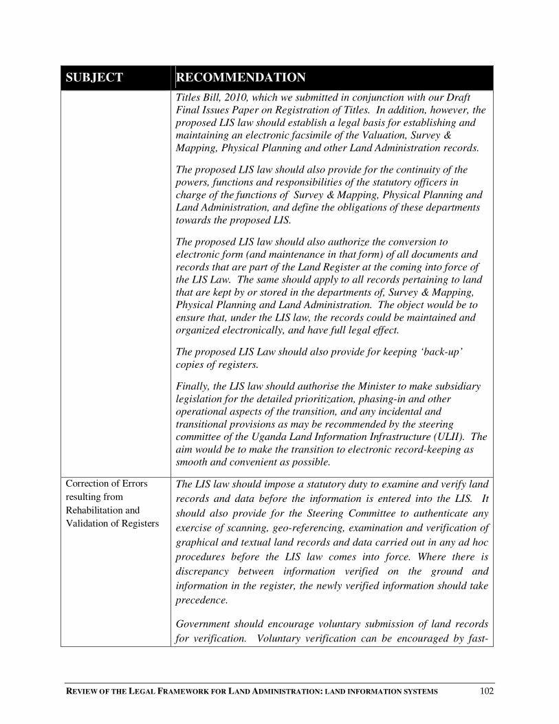
REVIEW OF THE LEGAL FRAMEWORK FOR LAND ADMINISTRATION: LAND INFORMATION SYSTEMS 102
SUBJECT RECOMMENDATION
Titles Bill, 2010, which we submitted in conjunction with our Draft
Final Issues Paper on Registration of Titles. In addition, however, the
proposed LIS law should establish a legal basis for establishing and
maintaining an electronic facsimile of the Valuation, Survey &
Mapping, Physical Planning and other Land Administration records.
The proposed LIS law should also provide for the continuity of the
powers, functions and responsibilities of the statutory officers in
charge of the functions of Survey & Mapping, Physical Planning and
Land Administration, and define the obligations of these departments
towards the proposed LIS.
The proposed LIS law should also authorize the conversion to
electronic form (and maintenance in that form) of all documents and
records that are part of the Land Register at the coming into force of
the LIS Law. The same should apply to all records pertaining to land
that are kept by or stored in the departments of, Survey & Mapping,
Physical Planning and Land Administration. The object would be to
ensure that, under the LIS law, the records could be maintained and
organized electronically, and have full legal effect.
The proposed LIS Law should also provide for keeping ‘back-up’
copies of registers.
Finally, the LIS law should authorise the Minister to make subsidiary
legislation for the detailed prioritization, phasing-in and other
operational aspects of the transition, and any incidental and
transitional provisions as may be recommended by the steering
committee of the Uganda Land Information Infrastructure (ULII). The
aim would be to make the transition to electronic record-keeping as
smooth and convenient as possible.
Correction of Errors
resulting from
Rehabilitation and
Validation of Registers
The LIS law should impose a statutory duty to examine and verify land
records and data before the information is entered into the LIS. It
should also provide for the Steering Committee to authenticate any
exercise of scanning, geo-referencing, examination and verification of
graphical and textual land records and data carried out in any ad hoc
procedures before the LIS law comes into force. Where there is
discrepancy between information verified on the ground and
information in the register, the newly verified information should take
precedence.
Government should encourage voluntary submission of land records
for verification. Voluntary verification can be encouraged by fast-

REVIEW OF THE LEGAL FRAMEWORK FOR LAND ADMINISTRATION: LAND INFORMATION SYSTEMS 103
SUBJECT RECOMMENDATION
tracking into the LIS and providing a fast-track desk for verified titles.
Updating of the LIS
The proposed LIS Law should establish and detail the statutory duty to
update the information in the LIS. The provision should include a
framework for the custodians and the data producers who supply
datasets to the LIS to update their databases. The statutory duty should
particularly apply to data custodians and other producers of datasets
who are either local governments or public authorities, or private
persons who use public funds to capture data.
Custodianship of Land
Information
The proposed LIS law should clearly define “ownership” and
“custodianship” of land information and other spatial data and then
provide for its custodianship. It should also provide for:
• the duties and responsibilities of a custodian;
• the interrelationship between various custodians, and the
relationship between them and the LIS organization;
• the protection of data in the custody of a custodian;
• the interrelationship between custodianship of land
information, copyright over land information, and liability in
relation to land information;
• any related matters.
Funding and Pricing The long-term funding strategy for the LIS organization should
gradually and progressively be based on collection of fees for
registration, search and delivery of information, and from the sale of
information to other authorities and the business sector. However,
since it is the duty of the government to provide certain spatial
information for national development, Government should subsidize
certain key functions which may not be commercially viable. These
functions may include production of a national base map. The capacity
of the LIS organization to fund itself should be evaluated at the end of
the third phase of the LIS implementation project.
Pricing policy should eventually be based on cost-recovery. At an
appropriate time after operationalisation of the LIS, and when
confidence has been built and a critical mass of transactions achieved,
the cost of access to the LIS might be driven by commercial demand.

REVIEW OF THE LEGAL FRAMEWORK FOR LAND ADMINISTRATION: LAND INFORMATION SYSTEMS 104
SUBJECT RECOMMENDATION
An appropriate cost recovery mechanism should then be implemented.
The LIS Committee, in consultation with stakeholders, should develop
the detailed pricing mechanism.
Pricing policy should also take into account the risks of liability posed
by decentralization, particularly potential liability for the performance
of DLO functions.
Admissibility of
Computer Records as Evidence in Court
In view of the technological challenges of setting up and maintaining a
secure digitized LIS, and one that will inspire confidence in its
integrity:
1. In the short-to-medium term:
a) The manual records should remain primary evidence of
land transactions.
b) Digital evidence should be admissible as secondary
evidence where the court is satisfied that:
iii) the person seeking to introduce the evidence can
authenticate the reliability and security of the
computer system that generated, processed or
stored the evidence; and
iv) the evidence is of the type and in the form of
information which is acted on in the ordinary
course of business.
2. In the longer term, after the computer-based LIS is fully
operational and its use and reliability generally accepted, the
Minister by statutory instrument may make rules accepting
computer records as primary evidence.
Standards for Data,
Metadata and
Applications
The LIS law should require the LIS institution to coordinate the
development of standards for the LIS in Uganda. Standards should
include geospatial data standards as well as standards for their
metadata. All institutions intending to use public funds to generate
spatial datasets should seek guidance from the LIS institution. In this
way, the LIS institution can ensure that most datasets are developed to
agreed standards.
Copyright and the
Land Information
The proposed LIS law, by building upon Section 5(1)(e) of the
Copyright and Neighbouring Rights Act No.198 of 2006, should
provide for copyright in data in the LIS, protecting against access to
or the reproduction of that data, including the storing of work in any
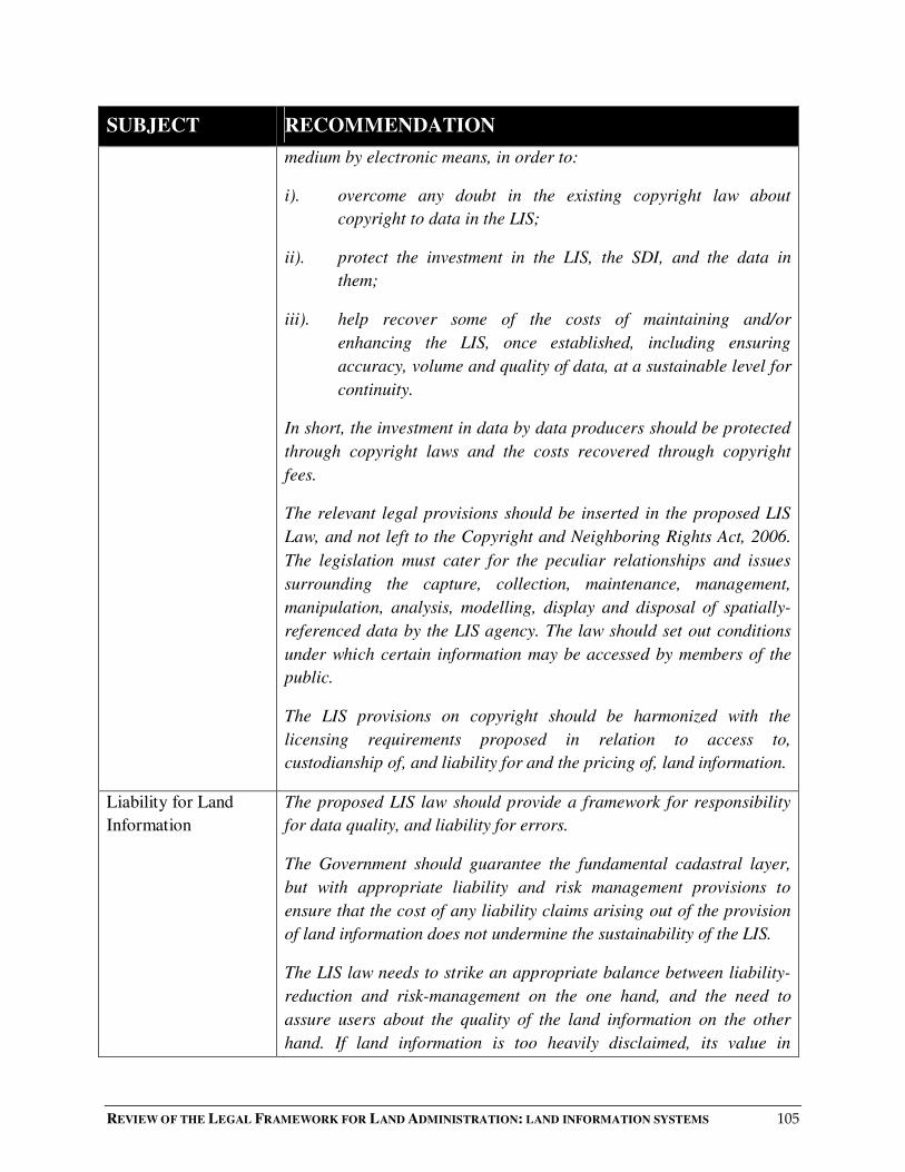
REVIEW OF THE LEGAL FRAMEWORK FOR LAND ADMINISTRATION: LAND INFORMATION SYSTEMS 105
SUBJECT RECOMMENDATION
medium by electronic means, in order to:
i). overcome any doubt in the existing copyright law about
copyright to data in the LIS;
ii). protect the investment in the LIS, the SDI, and the data in
them;
iii). help recover some of the costs of maintaining and/or
enhancing the LIS, once established, including ensuring
accuracy, volume and quality of data, at a sustainable level for
continuity.
In short, the investment in data by data producers should be protected
through copyright laws and the costs recovered through copyright
fees.
The relevant legal provisions should be inserted in the proposed LIS
Law, and not left to the Copyright and Neighboring Rights Act, 2006.
The legislation must cater for the peculiar relationships and issues
surrounding the capture, collection, maintenance, management,
manipulation, analysis, modelling, display and disposal of spatially-
referenced data by the LIS agency. The law should set out conditions
under which certain information may be accessed by members of the
public.
The LIS provisions on copyright should be harmonized with the
licensing requirements proposed in relation to access to,
custodianship of, and liability for and the pricing of, land information.
Liability for Land
Information
The proposed LIS law should provide a framework for responsibility
for data quality, and liability for errors.
The Government should guarantee the fundamental cadastral layer,
but with appropriate liability and risk management provisions to
ensure that the cost of any liability claims arising out of the provision
of land information does not undermine the sustainability of the LIS.
The LIS law needs to strike an appropriate balance between liability-
reduction and risk-management on the one hand, and the need to
assure users about the quality of the land information on the other
hand. If land information is too heavily disclaimed, its value in

REVIEW OF THE LEGAL FRAMEWORK FOR LAND ADMINISTRATION: LAND INFORMATION SYSTEMS 106
SUBJECT RECOMMENDATION
stimulating an efficient land market may be undermined; but if the
Government cannot guarantee quality, the value of the data is also
undermined.
In order to reduce exposure to contractual legal liability, the proposed
law should require the issue of a handbook containing formal staff
guidelines for the transfer of data both externally and internally. These
guidelines should inform staff of the LIS provider how to transfer data
and what precautions to take before transfer. These guidelines may
include details on:
• circumstances in which the data can be released;
• restrictions on use, particularly in relation to on-selling data to
third parties;
• standard forms and/or licences to be used when distributing
data.
Liability-reduction and risk-management strategies should also be
built into any licence or standard forms or web page. Notices should
clearly spell out what a data user can and cannot do with the data.
Conduct regulated or prohibited can include:
� restrictions on use;
� restrictions on distribution to others (whether in electronic or
soft form, or whether by way of derivative products such as
printouts);
� copying of data.
Finally, providers of land information services (including all types of
spatial data) should be compelled by law to provide meta-data,
prescribing a minimum set of basic data description parameters.
Access to Land
Information
The LIS law must balance the benefits of a modern land information
system with the protection of personal data.
In achieving the balance, the LIS law must also reconcile the need for
openness and completeness of information with control of access to
personal information, recognising that aggregation of integrated land
and spatial data can result in infringement of privacy.
The LIS law must institute internal controls within the LIS

REVIEW OF THE LEGAL FRAMEWORK FOR LAND ADMINISTRATION: LAND INFORMATION SYSTEMS 107
SUBJECT RECOMMENDATION
organization to ensure that information is not used internally in a way
that impinges on privacy. The internal controls could be published in
a manual or handbook, along with managerial and ICT-access
controls. The handbook could be given binding force by a statutory
instrument made by the Minister.
The LIS law should make land information managers accountable for
complying with measures which control access to land information,
but without unduly obstructing the performance of their services.
The LIS law should ensure that land information managers withhold
the supply of 'personal' data from 'direct marketeers' or from use for
'mailing lists'.
The LIS law should provide for licensing agreements to prevent
licensees from re-organizing, combining, manipulating and
distributing land information in ways that breach privacy or
confidentiality.
The LIS law should address difficulties of physical access to land
information.
Technical/Technological
Issues, Contents of Data
for LIS and
Implementation
Approach
There should be a phased implementation of the LIS, that starts with
securing and rehabilitating existing land records in pilot areas, with
later implementation beyond the pilot areas after issues have been
identified and addressed.
Parcel Identification The LIS law should implement a uniform and consistent Parcel
Identification Number (PIN) to identify parcels across all registers
and land tenure systems. It should be based on District–(County)-
Subcounty/Township-Block and Plot Number.The PIN should be used
by all the Departments in the Ministry of Lands Housing and Urban
Development, Local Governments and other Institutions as the only
method of identifying parcels for accessing information stored for
each parcel of land.
REVIEW OF THE LEGAL FRAMEWORK FOR LAND ADMINISTRATION: LAND INFORMATION SYSTEMS 108
Appendix 1 : Disposition of comments of LRWG
This Appendix summarises our responses to the comments of the LRWG on our earlier Draft Issues Paper on LIS.
It will be seen that we have generally followed the LRWG’s suggestions. Where we have not done so, reasons are given.
Page Subject Recommendation By
Consultant
LRWG Action Taken
12 Definition of Land
Administration
This Issues Paper adopts the
following definition of Land
Administration.
“the process of determining,
recording and disseminating
information about ownership,
value and use of land, when
implementing land
management policies”
No action required
16 Definition of LIS
We recommend the following
LIS definition: a tool for legal,
administrative and economic
decision-making and an aid for
planning and development. A
land information system
consists, on the one hand, of a
database containing spatially
referenced land-related data
for a defined area and, on the
other, of procedures and
techniques for the systematic
collection, updating,
No action required

REVIEW OF THE LEGAL FRAMEWORK FOR LAND ADMINISTRATION: LAND INFORMATION SYSTEMS 109
Page Subject Recommendation By
Consultant
LRWG Action Taken
processing and distribution of
the data. The base of a land
information system is a
uniform spatial referencing
system, which also simplifies
the linking of data within the
system with other land-related
data.
21 Form of Land
Information System
(LIS)
That the Ministry begin with a
parcel-based LIS, to be
incrementally transformed into
a multipurpose cadastre or
universal LIS.
We agree with the
recommendation because this is
the practice. However, the
mentioned multi-purpose LIS
should be inclusive of issues of
deaths, marriages, etc.
Recommendation modified as
proposed. However, it may
not be appropriate to bind
future development at this
stage by over-specific data.
We have therefore included a
blanket statement that does
not limit the scope of LIS in
terms of information that
should be stored. 165
31 Governance Structure We recommend the
development of a semi-
We recommend the LIS
organization starts out as a semi-
We agree that the LIS should
be a semi-autonomous
116655.. FFoorr iinnffoorrmmaattiioonn,, wwee rreeccoorrdd tthhaatt tthhee LLIISS iinn NNeeww BBrruunnsswwiicckk ((SSeerrvviiccee NNeeww BBrruunnsswwiicckk)) ooppeerraatteess ffoouurr rreeggiissttrriieess ooff ppuubblliicc iinnffoorrmmaattiioonn::
•• tthhee RReeaall PPrrooppeerrttyy RReeggiissttrryy –– ddeeeeddss,, wwiillllss,, ssuubbddiivviissiioonn ppllaannss,, eettcc.. rreellaatteedd ttoo llaanndd ppaarrcceellss iinn NNeeww BBrruunnsswwiicckk;;
•• tthhee PPeerrssoonnaall PPrrooppeerrttyy RReeggiissttrryy –– sseeccuurriittyy iinntteerreessttss,, jjuuddggmmeennttss,, aanndd ootthheerr ccllaaiimmss rreellaatteedd ttoo ppeerrssoonnaall pprrooppeerrttyy ssuucchh aass aauuttoommoobbiilleess,, rreeccrreeaattiioonn vveehhiicclleess,,
aanndd ffuurrnniittuurree;;
•• tthhee CCoorrppoorraattee AAffffaaiirrss RReeggiissttrryy –– ccoorrppoorraattiioonnss,, ppaarrttnneerrsshhiippss,, aanndd bbuussiinneessss nnaammeess rreeggiisstteerreedd iinn NNeeww BBrruunnsswwiicckk;;
•• tthhee VViittaall SSttaattiissttiiccss RReeggiissttrryy –– vviittaall eevveennttss ddaattaa ((bbiirrtthhss,, ssttiillllbbiirrtthhss,, mmaarrrriiaaggeess,, aanndd ddeeaatthhss)),, vviittaall eevveennttss cceerrttiiffiiccaatteess,, cchhaannggee ooff nnaammee,, cchhuurrcchheess//rreelliiggiioouuss
ddeennoommiinnaattiioonnss sseeeekkiinngg ttoo ppeerrffoorrmm mmaarrrriiaaggeess iinn NNeeww BBrruunnsswwiicckk..
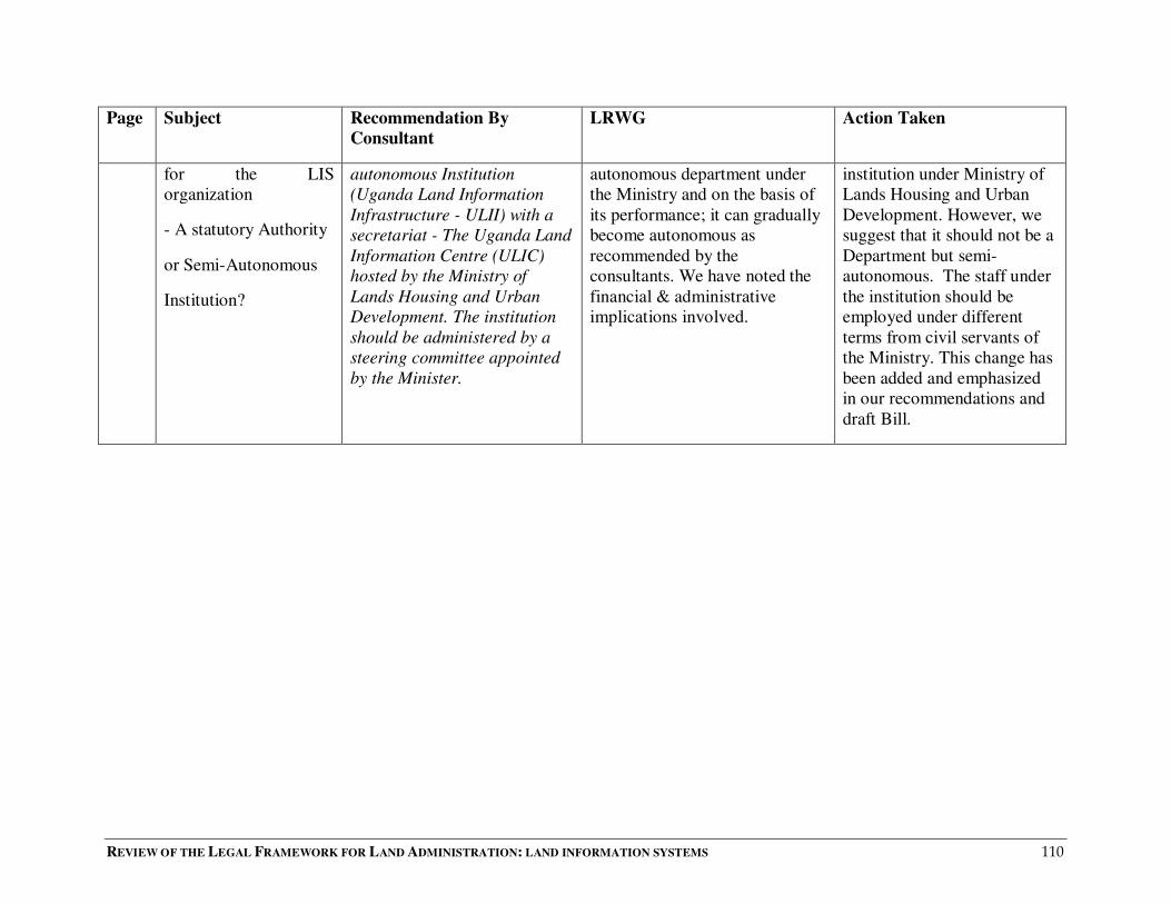
REVIEW OF THE LEGAL FRAMEWORK FOR LAND ADMINISTRATION: LAND INFORMATION SYSTEMS 110
Page Subject Recommendation By
Consultant
LRWG Action Taken
for the LIS
organization
- A statutory Authority
or Semi-Autonomous
Institution?
autonomous Institution
(Uganda Land Information
Infrastructure - ULII) with a
secretariat - The Uganda Land
Information Centre (ULIC)
hosted by the Ministry of
Lands Housing and Urban
Development. The institution
should be administered by a
steering committee appointed
by the Minister.
autonomous department under
the Ministry and on the basis of
its performance; it can gradually
become autonomous as
recommended by the
consultants. We have noted the
financial & administrative
implications involved.
institution under Ministry of
Lands Housing and Urban
Development. However, we
suggest that it should not be a
Department but semi-
autonomous. The staff under
the institution should be
employed under different
terms from civil servants of
the Ministry. This change has
been added and emphasized
in our recommendations and
draft Bill.

REVIEW OF THE LEGAL FRAMEWORK FOR LAND ADMINISTRATION: LAND INFORMATION SYSTEMS 111
Page Subject Recommendation By
Consultant
LRWG Action Taken
37-38 Running Parallel
Manual &
Computerized Land
Recording Systems
The paper-based manual
records shall continue to be
the principal legal registers
until the proposed
computerized LIS has reached
maturity. Until it achieves
sustainability, the facsimile
digital or computerized LIS
under development should be
used to enhance the efficiency
and integrity of the paper-
based manual records and to
ensure that the paper-based
records and the electronic
records are at the same level
of accuracy, and are
synchronized.
The legal provisions for
keeping an electronic register
of titles have been catered for
by the draft Registration of
Titles Bill, 2008 (now, Draft
Registration of Titles Bill
2010). Nevertheless, the
proposed LIS law should
establish a legal basis and
authority for the establishment
and maintenance of the
electronic facsimile records of
the Valuation, Survey &
We agree with the
recommendation in principle,
though both record systems
should be left to co-exist. The
integrity and accuracy of the two
records should be maintained, i.e
the paper-based and electronic
records should bear the same
information.
Concern noted; this action is
catered for in our
recommendations.

REVIEW OF THE LEGAL FRAMEWORK FOR LAND ADMINISTRATION: LAND INFORMATION SYSTEMS 112
Page Subject Recommendation By
Consultant
LRWG Action Taken
Mapping, Physical Planning
and Land Administration
authorities.
The proposed LIS Law should
also provide for the continuity
of the powers, functions and
responsibilities of the statutory
officers in charge of the
functions of Survey &
Mapping, Physical Planning
and Land Administration and
define the obligations of these
departments towards the
proposed LIS.
The proposed LIS law shall
also authorize the conversion
to and maintenance as
electronic documents or
records for all documents and
records that were part of the
Land Register as at the coming
into force of the LIS Law and
all records pertaining to Land
that are currently kept by or
stored in the departments of
Valuation, Survey & Mapping,
Physical Planning and Land
Administration so that
pursuant to the LIS Law they

REVIEW OF THE LEGAL FRAMEWORK FOR LAND ADMINISTRATION: LAND INFORMATION SYSTEMS 113
Page Subject Recommendation By
Consultant
LRWG Action Taken
may be maintained,
represented and organized
electronically in accordance
with the LIS Law and have
legal effect and be operative
under the LIS Law.
The proposed LIS Law should
also provide for the keeping of
‘disaster’ copies of registers.
The Law should also provide
for the Minister to make
subsidiary legislation
regarding the detailed
prioritization, phasing or other
operational aspects of the
transition and any such
incidental, supplemental,
consequential and transitional
provision as may be
recommended by the steering
committee of the Uganda Land
Information Infrastructure
(ULII), so to make the
transition to electronic record-
keeping as smooth and
convenient as possible for both
users and Land Registry.
There is no department of
valuation. It is a division whose
functions fall under Land
Administration department.
There is no ‘disaster’ copy. We
have ‘back-up’ copies, whether
electronic or manual.
Recommended to delete the last
words “for both users & Land
Registry” so as to avoid
complications.
Noted and error corrected
Corrected
Complied
40 Correction of Errors The LIS law should impose a The verification process should It is anticipated that these

REVIEW OF THE LEGAL FRAMEWORK FOR LAND ADMINISTRATION: LAND INFORMATION SYSTEMS 114
Page Subject Recommendation By
Consultant
LRWG Action Taken
resulting from
Rehabilitation and
Validation of Registers
statutory duty of examination
and verification of land
records and data before the
information is entered into the
LIS. These provisions should
also provide for the
authentication by the Steering
Committee of any exercise of
scanning, geo-referencing,
examination and verification of
graphical and textual land
records and data which was
carried out in any ad hoc
procedures before the coming
into force of the LIS Law.
Where there is discrepancy
between the information
verified on the ground and the
information in the register, the
new verified information
should take precedence.
Government should present to
the stakeholders the
desirability of incorporating
provisions in the LIS law for
voluntary submission of land
records for verification. The
attractiveness of voluntary
verification of land records
can be reinforced by fast-
be handled by technical persons
from the respective departments
having representatives in the
steering committee, i.e. Heads of
the various departments, e.g.
land administration, land
registry, Survey & mapping,
physical planning and Uganda
Land Commission.
user departments will be part
of the steering committee of
the LIS Authority. However,
for clarity, we have specified
them.
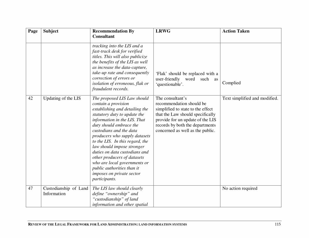
REVIEW OF THE LEGAL FRAMEWORK FOR LAND ADMINISTRATION: LAND INFORMATION SYSTEMS 115
Page Subject Recommendation By
Consultant
LRWG Action Taken
tracking into the LIS and a
fast-track desk for verified
titles. This will also publicize
the benefits of the LIS as well
as increase the data-capture,
take-up rate and consequently
correction of errors or
isolation of erroneous, flak or
fraudulent records.
‘Flak’ should be replaced with a
user-friendly word such as
‘questionable’.
Complied
42 Updating of the LIS
The proposed LIS Law should
contain a provision
establishing and detailing the
statutory duty to update the
information in the LIS. That
duty should embrace the
custodians and the data
producers who supply datasets
to the LIS. In this regard, the
law should impose stronger
duties on data custodians and
other producers of datasets
who are local governments or
public authorities than it
imposes on private sector
participants.
The consultant’s
recommendation should be
simplified to state to the effect
that the Law should specifically
provide for un update of the LIS
records by both the departments
concerned as well as the public.
Text simplified and modified.
47 Custodianship of Land
Information
The LIS law should clearly
define “ownership” and
“custodianship” of land
information and other spatial
No action required
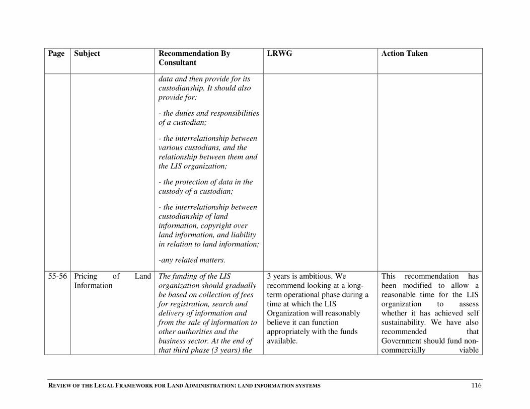
REVIEW OF THE LEGAL FRAMEWORK FOR LAND ADMINISTRATION: LAND INFORMATION SYSTEMS 116
Page Subject Recommendation By
Consultant
LRWG Action Taken
data and then provide for its
custodianship. It should also
provide for:
- the duties and responsibilities
of a custodian;
- the interrelationship between
various custodians, and the
relationship between them and
the LIS organization;
- the protection of data in the
custody of a custodian;
- the interrelationship between
custodianship of land
information, copyright over
land information, and liability
in relation to land information;
-any related matters.
55-56 Pricing of Land
Information
The funding of the LIS
organization should gradually
be based on collection of fees
for registration, search and
delivery of information and
from the sale of information to
other authorities and the
business sector. At the end of
that third phase (3 years) the
3 years is ambitious. We
recommend looking at a long-
term operational phase during a
time at which the LIS
Organization will reasonably
believe it can function
appropriately with the funds
available.
This recommendation has
been modified to allow a
reasonable time for the LIS
organization to assess
whether it has achieved self
sustainability. We have also
recommended that
Government should fund non-
commercially viable
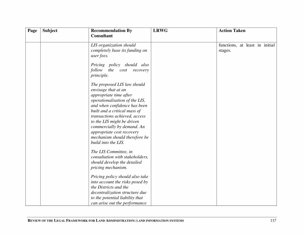
REVIEW OF THE LEGAL FRAMEWORK FOR LAND ADMINISTRATION: LAND INFORMATION SYSTEMS 117
Page Subject Recommendation By
Consultant
LRWG Action Taken
LIS organization should
completely base its funding on
user fees.
Pricing policy should also
follow the cost recovery
principle.
The proposed LIS law should
envisage that at an
appropriate time after
operationalisation of the LIS,
and when confidence has been
built and a critical mass of
transactions achieved, access
to the LIS might be driven
commercially by demand. An
appropriate cost recovery
mechanism should therefore be
build into the LIS.
The LIS Committee, in
consultation with stakeholders,
should develop the detailed
pricing mechanism.
Pricing policy should also take
into account the risks posed by
the Districts and the
decentralization structure due
to the potential liability that
can arise out the performance
functions, at least in initial
stages.

REVIEW OF THE LEGAL FRAMEWORK FOR LAND ADMINISTRATION: LAND INFORMATION SYSTEMS 118
Page Subject Recommendation By
Consultant
LRWG Action Taken
of DLO functions and this
factor be included in the cost
of the data.
72 Admissibility of
Computer Records as
Evidence in Court
In view of the technological
challenges of setting up and
maintaining a secure digitized
LIS, and one that will inspire
confidence in its integrity, it is
recommended that:
1. In the short to medium term:
a) The manual records remain
primary evidence of land
transactions.
b) Digital evidence be
admissible as secondary
evidence where Court is
satisfied that:
i) The person seeking to
introduce the computer based
evidence can authenticate to
the reliability and security of
the computer system that
generated, processed or stored
the evidence in issue.
ii) The evidence is of the type
and in the form which has been
In the spirit of harmonising the
Cyber proposed laws (i.e
Electronic Transactions Bill)
with this recommendation, we
suggest that manual records
should be the only acceptable
evidence in Court. The
Electronic Transactions Bill is to
the effect that “The Act does not
apply to: . . . (d) documents that
create or transfer interests in
property and require registration
to be effective against third
parties.”
In our view, by suggesting
that manual records remain
the only evidence, we would
be undermining the process
for computerization of the
Land Registry and LIS.
Therefore, we have retained
our recommendation and
hope that this will be further
discussed by other
stakeholders.

REVIEW OF THE LEGAL FRAMEWORK FOR LAND ADMINISTRATION: LAND INFORMATION SYSTEMS 119
Page Subject Recommendation By
Consultant
LRWG Action Taken
consistently acted or relied
upon in the ordinary course of
business.
2. In the long run, and after the
computer based LIS has been
fully set up and its use and
reliability generally accepted,
the Minister can by statutory
instrument make rules for the
acceptance of computer
records as primary evidence.
74 Standards for Data,
Metadata and
Applications
The LIS law should provide for
the LIS institution to
coordinate the development of
standards for LIS and geo-
spatial data in Uganda. All
institutions intending to use
public funds to generate
spatial datasets should seek
guidance from the LIS
Institution. In this way, the
Institution will ensure that
most datasets are developed to
agreed standards.
We agree with this
recommendation but add that
there is need for further details
as to what standards are
envisaged by the consultants.
Standards are required for data
and record storage and use. The
PIN is one of the Standards.
More details have been added
on what standards to develop
78 Copyright and the
Neighbouring Rights
Act
We recommend that the
proposed LIS law by building
on Section 5(i) (e) of the
Copyright and Neighbouring
We have identified a weakness
in this provision and agree that
there is a need for protection of
Spatial Data Information but
No action required in this
Report.

REVIEW OF THE LEGAL FRAMEWORK FOR LAND ADMINISTRATION: LAND INFORMATION SYSTEMS 120
Page Subject Recommendation By
Consultant
LRWG Action Taken
Rights Act No.198 of 2006
provisions for copyright to the
data in the LIS, against the
access or the reproduction of
that LIS data in any material
form, including the storing of
work in any medium by
electronic means in order to:-
i). avoid any doubt in the
existing copyright law about
copyright to the data in the
LIS.
ii). protect the investment in
the LIS, the SDI, and the data
therein;
iii). facilitate the recovery of
some of the costs of
maintaining the LIS and or
enhancing the LIS, once
established, including the
accompanying considerations
like accuracy, volume and
quality of data, at a
sustainable level for
continuity. Consequently, the
investment in data by data
producers be protected
through copyright laws and the
apparently the laws in this regard
are inadequate.
LIS works are copyrightable
under sections 5 (1)(e) & (h) and
8 of the Copyright and
Neighbouring Rights Act. Much
as it was noted that public works
are generally not copyrightable
(sec. 7 – Copyright Act & sec.
201 R.T.A), it was agreed that
the main purpose of copyrighting
LIS works is to raise revenue.
We suggest that the law should
set out conditions under which
certain information may be
accessed by members of the
public.
Modification made

REVIEW OF THE LEGAL FRAMEWORK FOR LAND ADMINISTRATION: LAND INFORMATION SYSTEMS 121
Page Subject Recommendation By
Consultant
LRWG Action Taken
costs recovered through
copyright fees.
The pertinent legal provisions
be inserted into the proposed
LIS Law, as opposed to relying
solely on the statutory
framework in the general
Copyright and Neighbouring
Rights Act, 2006 so as to cater
for the peculiar relationships
and issues surrounding the
capture, collection,
maintenance, management,
manipulation, analysis,
modelling, display and
disposal of spatially referenced
data by the LIS agency. These
relationships and issues are
not appropriately and
sufficiently provided for by the
Copyright and Neighbouring
Rights Act, 2006.
The LIS provisions on
copyright should also be
harmonized with the licensing
requirements proposed in
respect of access to,
custodianship of, liability for
and the pricing of land

REVIEW OF THE LEGAL FRAMEWORK FOR LAND ADMINISTRATION: LAND INFORMATION SYSTEMS 122
Page Subject Recommendation By
Consultant
LRWG Action Taken
information.
86 Liability for Land
Information
The proposed LIS legislation
should clearly define a
framework of responsibility for
data quality and liability for
errors.
The Government should
guarantee the fundamental
cadastral layer but with a
measure of liability and risk
management provisions to
ensure that the cost of liability
claims arising out the land
information does not derail the
LIS. An appropriate balance
needs to be struck between
liability and risk management
provisions and the need to
assure users about the quality
of the land information. If the
land information is so heavily
disclaimed, its value for
purposes of stimulating an
efficient land market may be
undermined. If the Government
cannot guarantee quality, this
may reduce the value of the
data.

REVIEW OF THE LEGAL FRAMEWORK FOR LAND ADMINISTRATION: LAND INFORMATION SYSTEMS 123
Page Subject Recommendation By
Consultant
LRWG Action Taken
In order to reduce contractual
legal liability exposure the
proposed law should prescribe
for the issue of a handbook
containing a formal set of
guidelines to be established,
not only dealing with the
transfer of data externally but
also internally. These
guidelines should inform the
staff of the NLIC how to
transfer data and what
precautions to take before
transfer. These guidelines may
include details on:
- under what circumstances
the data could be handed out
- restrictions on use.
NLIC can also use these
Guidelines to prohibit the on-
selling of data to third parties,
because if they are injured by
reliance on the data NLIC
could be held inconvenienced;
Standard forms and/or licenses
could be used when
distributing data.
We propose that for better
implementation of the system,
LIS Centre should issue a
handbook to guide the users and
producers on creation,
maintenance and dissemination
of information, so as to minimise
any errors or liabilities that may
arise.
Adjusted.

REVIEW OF THE LEGAL FRAMEWORK FOR LAND ADMINISTRATION: LAND INFORMATION SYSTEMS 124
Page Subject Recommendation By
Consultant
LRWG Action Taken
Liability reduction and risk
management strategies should
also be built into License or
standard forms or web page
notices which clearly spell out
what a data user can do and is
not allowed to do with the
data. The risk allocation or
liability management
proscription inbuilt into these
functionalities can include:-
- Restrictions on use;
- Restrictions on distribution to
others (whether in electronic
or soft form or derivative
products such as printouts);
-Copying of data.
Finally, providers of LIS
including all types of spatial
data should be compelled by
the law, to provide meta-data
prescribing a minimum set of
basic data description
parameters.
94 Access to Land Legislation is required so as to
attain (or at the least, make an
effort) to strike the necessary
No action required
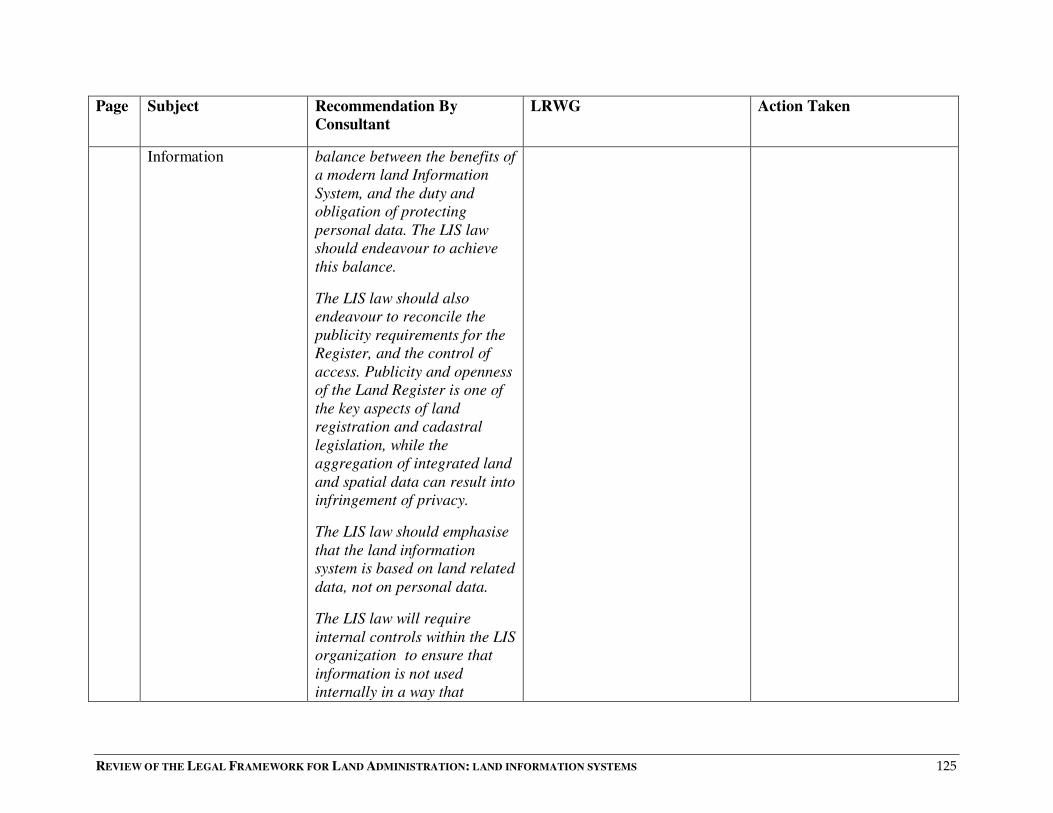
REVIEW OF THE LEGAL FRAMEWORK FOR LAND ADMINISTRATION: LAND INFORMATION SYSTEMS 125
Page Subject Recommendation By
Consultant
LRWG Action Taken
Information
balance between the benefits of
a modern land Information
System, and the duty and
obligation of protecting
personal data. The LIS law
should endeavour to achieve
this balance.
The LIS law should also
endeavour to reconcile the
publicity requirements for the
Register, and the control of
access. Publicity and openness
of the Land Register is one of
the key aspects of land
registration and cadastral
legislation, while the
aggregation of integrated land
and spatial data can result into
infringement of privacy.
The LIS law should emphasise
that the land information
system is based on land related
data, not on personal data.
The LIS law will require
internal controls within the LIS
organization to ensure that
information is not used
internally in a way that

REVIEW OF THE LEGAL FRAMEWORK FOR LAND ADMINISTRATION: LAND INFORMATION SYSTEMS 126
Page Subject Recommendation By
Consultant
LRWG Action Taken
impinges on privacy. A
suggested approach is to
publish the internal controls in
the manual or handbook
mentioned in the Liability
section, alongside the
managerial and ICT access
controls. The handbook may be
given legislative binding force
via a statutory instrument
made by the Minister.
The LIS law should make land
information managers
accountable for complying
with measures which give
effect to (or have been put in
place for) controlling access to
land information without
unduly imperiling the
performance of their services,
as would demotivate or
demoralize personnel.
The LIS law and land
information managers should
withhold the supply of
‘personal’ data which is held
in the system from ‘direct
marketeers’ or where it is
intended to be used for

REVIEW OF THE LEGAL FRAMEWORK FOR LAND ADMINISTRATION: LAND INFORMATION SYSTEMS 127
Page Subject Recommendation By
Consultant
LRWG Action Taken
‘mailing lists’.
The LIS law should procure
the use licensing agreements to
curb the access, (including the
further access beyond the
second party) reorganization,
combination, manipulation and
distribution of land
information in such way as
would contravene privacy or
confidentiality concerns.
The LIS should address access
in terms of physical distance,
particularly in Uganda where
Land Registries are not even
available at the District level.
95 Technical/Technological
Issues, Contents of Data
for LIS and
Implementation
Approach
The Consultants recommend
phased implementation that
starts with securing and
rehabilitation of land records,
validating existing records for
four pilot areas and
implementation beyond pilot
areas after issues identified in
a preliminary design have
been addressed.
The recommendation for four
pilot districts should be more
detailed with regard to why four
areas have been chosen.
The number of pilot districts
has been removed.
Considerations for selection
of pilot districts have been
included.
96 Parcel Identification A uniform and consistent
Parcel Identification Number
The Uniformity in the PIN
should also encompass
Change implemented.
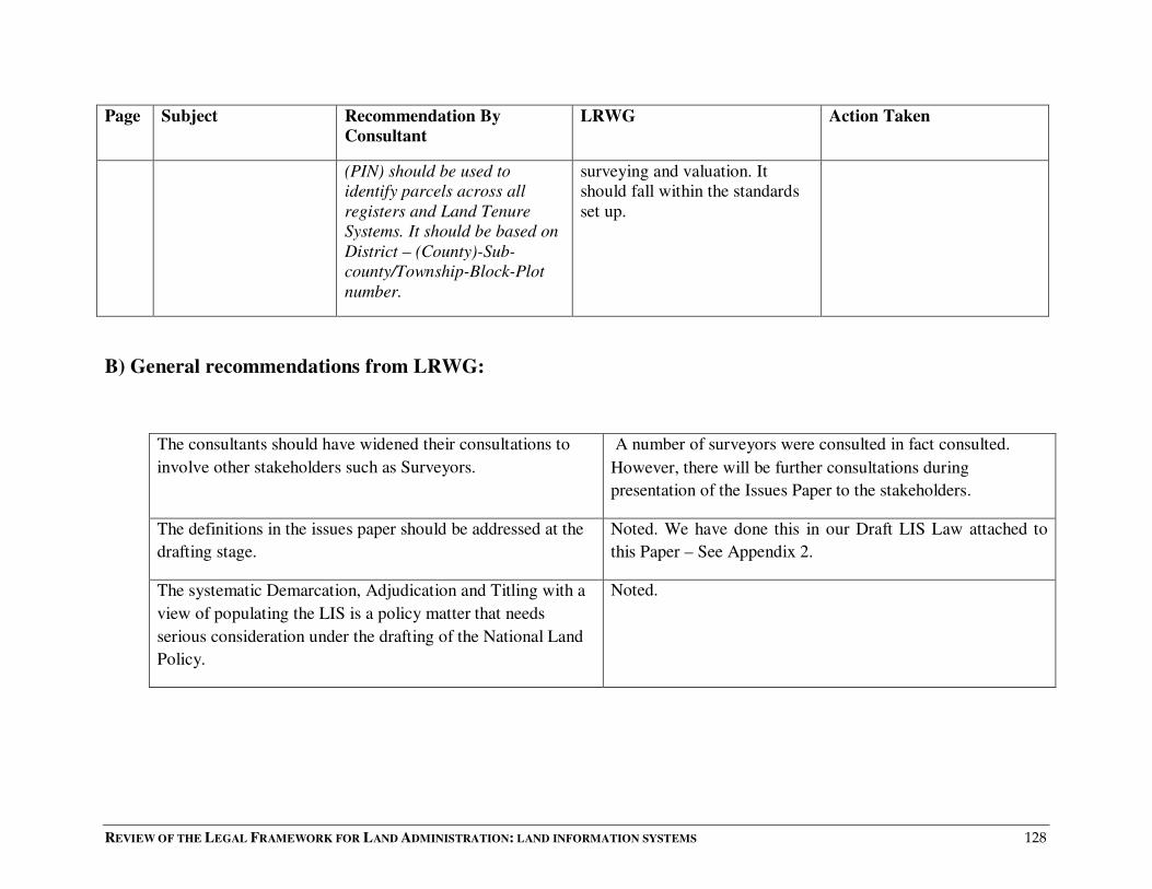
REVIEW OF THE LEGAL FRAMEWORK FOR LAND ADMINISTRATION: LAND INFORMATION SYSTEMS 128
Page Subject Recommendation By
Consultant
LRWG Action Taken
(PIN) should be used to
identify parcels across all
registers and Land Tenure
Systems. It should be based on
District – (County)-Sub-
county/Township-Block-Plot
number.
surveying and valuation. It
should fall within the standards
set up.
B) General recommendations from LRWG:
The consultants should have widened their consultations to
involve other stakeholders such as Surveyors.
A number of surveyors were consulted in fact consulted.
However, there will be further consultations during
presentation of the Issues Paper to the stakeholders.
The definitions in the issues paper should be addressed at the
drafting stage.
Noted. We have done this in our Draft LIS Law attached to
this Paper – See Appendix 2.
The systematic Demarcation, Adjudication and Titling with a
view of populating the LIS is a policy matter that needs
serious consideration under the drafting of the National Land
Policy.
Noted.

REVIEW OF THE LEGAL FRAMEWORK FOR LAND ADMINISTRATION: LAND INFORMATION SYSTEMS 129
Comments
There should be some unit to take care of the infrastructure The LIS centre will be responsible for the Infrastructure.
That the land registry being independent was not considered. This Paper (and our Draft Final Issues Paper on Registration
of Titles) considers the status of the Land Registry. The Land
Registry will remain a Department in the Ministry.
The different departments feeding the LIS should not be
removed from them.
We are not sure what is meant by this comment.
That all the departments should be connected to the system as
it is done in the Ministry of Finance.
The proposed LIS is developed along the same principles as
IFMS of the Ministry of Finance.
That the technical officers responsible for verification of
records and steering them in the system should be people that
the information can be relied upon.
We agree.
That the three year pilot project is okay and if it is stretched
to 10 years then the programme will be overstretched
Noted.
That before going into LIS all land in Uganda should be first
surveyed and marked
Systematic Demarcation should continue as the LIS is being
developed. The data from SD will directly feed into the LIS.
That LIS is not a body, it is a system. We consider that is has elements of both: it can be seen as a
system, but it can also be a body or infrastructure.
That the quality checks should be done by the departments. Noted.
That there is no bar to having two check ups. Noted.

REVIEW OF THE LEGAL FRAMEWORK FOR LAND ADMINISTRATION: LAND INFORMATION SYSTEMS 130
The consultants should give comparative studies i.e how it is
done in other countries
We do in fact cite considerable literature from other countries.
The element of the district should not be left to the district.
Districts are not efficient. Data bases should be developed at
the district and fed into the main frame.
Noted. This can be done under our recommendations.
That there is need to rely on manual evidence than electronic
evidence.
This is catered for in our recommendations, where manual
evidence is considered to be primary evidence.
The issue of secondary evidence should be done away with. This needs further discussion. Otherwise, we cannot justify
computerizing land records.
If the law does not permit online search, then the system
becomes useless.
We agree. The law should permit online searches.
That focus should be put on legalizing the system. Noted.
The system should be implemented when the responsible
officers are ready.
Noted.
Software capturing all the participants should be in place Noted.
A further search [further research?] should be done. LIS
should correspond with GIS.
We see these two terms as synonymous.
The consultants should look at the E-commerce Electronic
Signature Bill.
OK
LIS should not give you the identity of the user. This is open to debate. An open Register leads to greater
transparency and confidence in the integrity of the system.
Currently, it is easy to get the name of the property owner.
REVIEW OF THE LEGAL FRAMEWORK FOR LAND ADMINISTRATION: LAND INFORMATION SYSTEMS 131
Appendix 2 : National Land Information Infrastructure Bill

REVIEW OF THE LEGAL FRAMEWORK FOR LAND ADMINISTRATION: LAND INFORMATION SYSTEMS 132
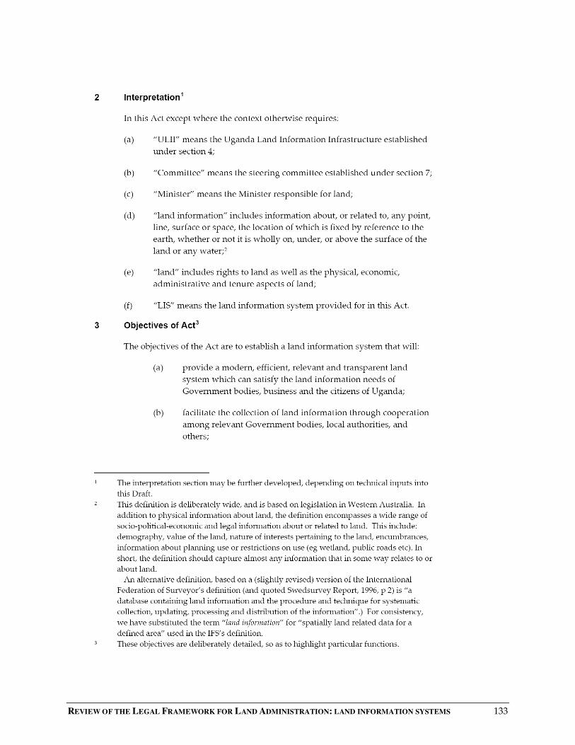
REVIEW OF THE LEGAL FRAMEWORK FOR LAND ADMINISTRATION: LAND INFORMATION SYSTEMS 133
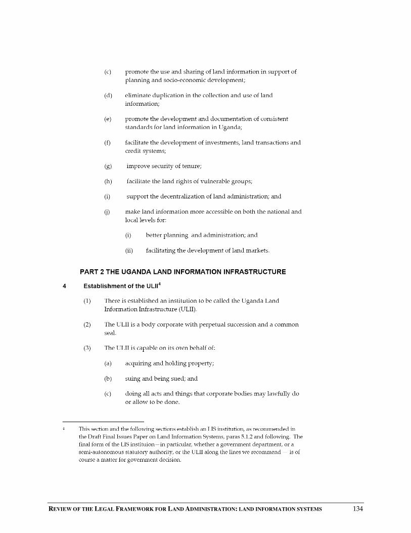
REVIEW OF THE LEGAL FRAMEWORK FOR LAND ADMINISTRATION: LAND INFORMATION SYSTEMS 134

REVIEW OF THE LEGAL FRAMEWORK FOR LAND ADMINISTRATION: LAND INFORMATION SYSTEMS 135
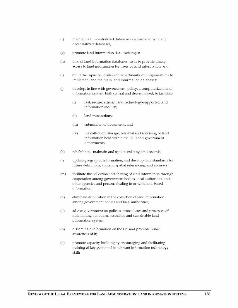
REVIEW OF THE LEGAL FRAMEWORK FOR LAND ADMINISTRATION: LAND INFORMATION SYSTEMS 136
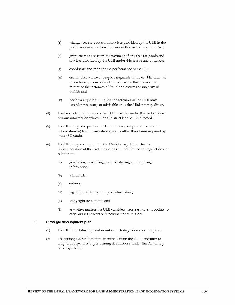
REVIEW OF THE LEGAL FRAMEWORK FOR LAND ADMINISTRATION: LAND INFORMATION SYSTEMS 137
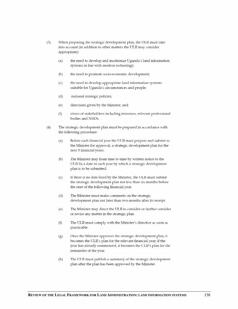
REVIEW OF THE LEGAL FRAMEWORK FOR LAND ADMINISTRATION: LAND INFORMATION SYSTEMS 138
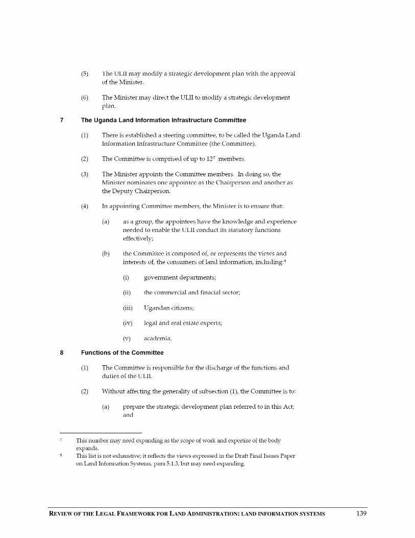
REVIEW OF THE LEGAL FRAMEWORK FOR LAND ADMINISTRATION: LAND INFORMATION SYSTEMS 139

REVIEW OF THE LEGAL FRAMEWORK FOR LAND ADMINISTRATION: LAND INFORMATION SYSTEMS 140

REVIEW OF THE LEGAL FRAMEWORK FOR LAND ADMINISTRATION: LAND INFORMATION SYSTEMS 141

REVIEW OF THE LEGAL FRAMEWORK FOR LAND ADMINISTRATION: LAND INFORMATION SYSTEMS 142

REVIEW OF THE LEGAL FRAMEWORK FOR LAND ADMINISTRATION: LAND INFORMATION SYSTEMS 143
REVIEW OF THE LEGAL FRAMEWORK FOR LAND ADMINISTRATION: LAND INFORMATION SYSTEMS 144

REVIEW OF THE LEGAL FRAMEWORK FOR LAND ADMINISTRATION: LAND INFORMATION SYSTEMS 145
REVIEW OF THE LEGAL FRAMEWORK FOR LAND ADMINISTRATION: LAND INFORMATION SYSTEMS 146
REVIEW OF THE LEGAL FRAMEWORK FOR LAND ADMINISTRATION: LAND INFORMATION SYSTEMS 147
REVIEW OF THE LEGAL FRAMEWORK FOR LAND ADMINISTRATION: LAND INFORMATION SYSTEMS 148
REVIEW OF THE LEGAL FRAMEWORK FOR LAND ADMINISTRATION: LAND INFORMATION SYSTEMS 149

REVIEW OF THE LEGAL FRAMEWORK FOR LAND ADMINISTRATION: LAND INFORMATION SYSTEMS 150
REVIEW OF THE LEGAL FRAMEWORK FOR LAND ADMINISTRATION: LAND INFORMATION SYSTEMS 151
REVIEW OF THE LEGAL FRAMEWORK FOR LAND ADMINISTRATION: LAND INFORMATION SYSTEMS 152

REVIEW OF THE LEGAL FRAMEWORK FOR LAND ADMINISTRATION: LAND INFORMATION SYSTEMS 153