final environmental assessment surface transportation ... · final environmental assessment surface...
TRANSCRIPT

FINAL ENVIRONMENTAL ASSESSMENT
SURFACE TRANSPORTATION BOARD FINANCE DOCKET NO. 34936
Northern Columbia Basin Railroad Project
Grant County, Washington
EXECUTIVE SUMMARY
Co-Lead Agencies Surface Transportation Board – Section of Environmental Analysis
and Washington State Department of Transportation
Decision ID No. 39924 Service Date: 5/8/2009


Northern Columbia Basin Railroad Project Final Environmental Assessment Executive Summary
Prepared by the
Surface Transportation Board Section of Environmental Analysis
and the
Washington State Department of Transportation
May 2009

For more information:
� Call Christa Dean with the Surface Transportation Board at (202) 245-0299 � Write to: Surface Transportation Board Attn: Christa Dean Section of Environmental Analysis 395 E Street, SW, Room 1108 Washington, DC 20423-0001 Attn: Finance Docket No. 34936 � Fax: (202) 245-0454; or � E-mail: [email protected] � Call Elizabeth Phinney with the WSDOT State Rail and Marine Office at (360) 705-7902 � Write to: WSDOT State Rail and Marine Office P.O. Box 47407 Olympia, WA 98504-7407 � Fax: (360) 705-6821; or � E-mail: [email protected]

Materials can be provided in alternative formats: large print, Braille, cassette tape, or on
computer disk for people with disabilities by calling the Office of Equal Opportunity (OEO)
at (360) 705-7097. Persons who are deaf or hard of hearing may contact OEO through
the Washington Relay Service at 7-1-1.
Title VI
WSDOT ensures full compliance with Title VI of the Civil Rights Act of 1964 by
prohibiting discrimination against any person on the basis of race, color,
national origin or sex in the provision of benefits and services resulting
from its federally assisted programs and activities.
For questions regarding WSDOT's Title VI Program, you may
contact the Department's Title VI Coordinator at (360) 705-7098.

This page intentionally left blank.

Northern Columbia Basin Railroad Project May 2009 Final Environmental Assessment Page i
Table of Contents
Executive Summary ..............................................................ES-1
Background ..................................................................................................ES-1 What is the Northern Columbia Basin Railroad Project? ............................ES-2 What is the purpose and need of the proposed action? ................................ES-7 What alternatives were considered?.............................................................ES-7 What potential environmental impacts could result from the Build Alternative?......................................................................................ES-16 Environmentally Preferred Alternative......................................................ES-21 Conclusion .................................................................................................ES-22
Exhibits
Exhibit ES.1 Project Location................................................................................ES-5 Exhibit ES.2 Alternatives Developed Following Public Review ..........................ES-9 Exhibit ES.3 Comparison of Segment 1 Alternatives and Alignment
Modification ...................................................................................ES-11

May 2009 Northern Columbia Basin Railroad Project Page ii Final Environmental Assessment
This page intentionally left blank.

Northern Columbia Basin Railroad Project May 2009 Final Environmental Assessment Page ES-1
Executive Summary
Background
On August 28, 2008, the Port of Moses Lake (Port) filed a petition with the Surface Transportation Board (STB) seeking an exemption under 49 U.S.C. 10502 from the prior approval requirements of 49 U.S.C. 10901 for the construction and acquisition of approximately 11.5 miles of rail line in Grant County, Washington.1 The proposed rail line includes the acquisition and rehabilitation of approximately three miles of existing track (also known as Segment 3) that is currently owned by the Columbia Basin Railroad Company (CBRW). CBRW intends to file a verified notice of exemption to operate over the rail lines that are the subject of the Port’s Petition for Exemption.
The STB, pursuant to 49 U.S.C. 10901 and 10502,2 is the federal agency responsible for granting authority for the construction and operation of new rail line facilities, and WSDOT is responsible for operating and improving the state’s transportation systems. Accordingly, as co-lead agencies,3 the STB’s Section of Environmental Analysis (SEA) and the Washington State Department of Transportation (WSDOT) prepared a Preliminary Environmental Assessment (EA), dated November 7, 2008, to ensure that any final STB decision approving the proposed rail line construction and operation complies with the statutory requirements of the National Environmental Policy Act of 1969,4 the Council on Environmental Quality guidelines,5 the STB’s environmental regulations,6 Executive Orders,7 and other applicable rules and regulations.
1 The proposed rail line includes the acquisition of approximately 0.5 miles of existing track, for which no construction or rehabilitation is planned. Accordingly, the 0.5-mile rail segment was not evaluated in this environmental review. 2 Under 49 U.S.C. 10901, the STB has exclusive licensing authority for the construction and operation of new rail lines. Under 49 U.S.C. 10502, the STB can issue an exemption from the prior approval requirements of 49 U.S.C. 10901 if the statutory standards of Section 10502 are met. 3 The STB and WSDOT are co-lead agencies pursuant to 40 CFR 1501.5(b). 4 40 CFR 1500 et seq. 5 43 CFR § 1508.9(b). 6 49 CFR Part 1105. 7 Executive Order (EO) 12898 (Federal Register 1994), Federal Actions to Address Environmental Justice
in Minority Populations and Low-Income Populations.

May 2009 Northern Columbia Basin Railroad Project Page ES-2 Final Environmental Assessment
Because WSDOT is a state agency, this EA was also prepared to comply with the statutory requirements of the Washington State Environmental Policy Act,8 WSDOT requirements,9 and other applicable state rules and regulations.
The EA was made available to agencies, Tribes, the public, and other interested parties for a 30-day public comment period. SEA and WSDOT received 29 comments on the EA, which were carefully reviewed in preparing the recommendations contained in this Final EA. If the mitigation measures contained in this Final EA are imposed by the STB, SEA and WSDOT believe that any potential environmental impacts resulting from the proposed rail project would not be significant; therefore, preparation of an Environmental Impact Statement is not necessary.
This Final EA is designed to be read in conjunction with the EA, which provides more detailed information on the proposed action and alternatives to agency decision-makers and the public. The EA, issued on November 7, 2008, describes the proposed project’s purpose and need, the proposed action and alternatives, the existing environment, and the potential environmental impacts associated with the proposed action and alternatives. This Final EA responds to public and agency comments; develops and analyzes new alternatives and modified routes; clarifies, corrects, or adds to information that was in the EA, primarily regarding wetland impacts, impacts to irrigated farmland, and cumulative impacts; modifies ten mitigation measures that were in the EA; and includes one additional mitigation measure.
What is the Northern Columbia Basin Railroad Project?
The proposed project, known as the Northern Columbia Basin Railroad (NCBR) Project, includes the construction of two new rail line segments and the acquisition and refurbishment of an existing rail segment to provide rail access to land designated and zoned for industrial use along Wheeler Road (Road 3 NE) and at the Grant County International Airport (GCIA).10 Although CBRW operates rail lines in the City of Moses Lake and Grant County, the industrial areas along Wheeler Road (Road 3 NE) and the eastern side of the GCIA are not currently served by rail.
8 Revised Code of Washington (RCW) 43.21C. 9 WSDOT’s Environmental Procedures Manual outlines the department’s legal requirements related to
natural and man-made environmental resources. The Environmental Procedures Manual provides
guidance on environmental procedures for WSDOT and its environmental consultants. The Environmental
Procedures Manual may be viewed online at http://www.wsdot.wa.gov/Publications/Manuals/M31-11.htm. 10 Two airports are located in the project vicinity. The larger airport, Grant County International Airport (GCIA), is located north and west of Randolph Road. Moses Lake Municipal Airport is located north of Wheeler Road (Road 3 NE) and east of Crab Creek / Parker Horn. GCIA is the airport that would be accessed by the proposed project.

Northern Columbia Basin Railroad Project May 2009 Final Environmental Assessment Page ES-3
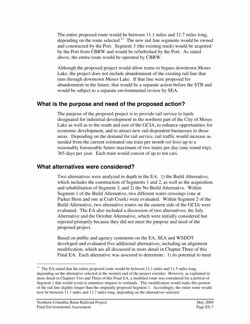
The proposed project is shown on Exhibit ES.1 and includes the following:
• Segment 1 – Building a new rail line between the community of Wheeler and Parker Horn (a water body and an arm of Moses Lake) or Crab Creek to join the existing line (Segment 3);
• Segment 2 – Extending the existing track, which currently terminates just south of the GCIA, to the industrial lands located east of the GCIA; and
• Segment 3 – Refurbishing the existing track between Parker Horn and the GCIA.

May 2009 Northern Columbia Basin Railroad Project Page ES-4 Final Environmental Assessment
This page intentionally left blank.

P a r k e r Ho
r n
Cr
ab
C
re
ek
Grant CountyInternat ional
Ai rport
Segment 2
Segment 3
Segment 1
Wheeler Road
Wheeler
Str
atfo
rd R
d
(Road 3 NE)
Alternative1A
Alternative 2A
Roa
d K
Roa
d L
Broadway
Project LocationExhibit ES.1
Northern Columbia Basin Railroad Project
D:\G
ISD
ATA
\pro
ject
s\w
ash\
wsd
ot\M
oses
Lake
\map
_doc
s\m
xd\F
igur
es\E
A_F
igur
es\E
XH
IBIT
_ES
_1_P
roje
ct_l
ocat
ion.
mxd
- 4/
9/20
09 @
12:
41:1
9 P
M
ProjectLocation
GrantCounty
Pasco
Tacoma
Seattle Spokane
LegendSegment 1Alternative 1ASegment 2Alternative 2A
Segment 3Existing RailCity of Moses LakeWater BodySurface Waterway
C i t yo f
M o s e s L a k e
0 2,000 4,000 6,000
Feet

May 2009 Northern Columbia Basin Railroad Project Page ES-6 Final Environmental Assessment
This page intentionally left blank.
Northern Columbia Basin Railroad Project May 2009 Final Environmental Assessment Page ES-7
The entire proposed route would be between 11.1 miles and 11.7 miles long, depending on the route selected.11 The new rail line segments would be owned and constructed by the Port. Segment 3 (the existing track) would be acquired by the Port from CBRW and would be refurbished by the Port. As stated above, the entire route would be operated by CBRW.
Although the proposed project would allow trains to bypass downtown Moses Lake, the project does not include abandonment of the existing rail line that runs through downtown Moses Lake. If that line were proposed for abandonment in the future, that would be a separate action before the STB and would be subject to a separate environmental review by SEA.
What is the purpose and need of the proposed action?
The purpose of the proposed project is to provide rail service to lands designated for industrial development in the northern part of the City of Moses Lake as well as to the south and east of the GCIA, to enhance opportunities for economic development, and to attract new rail-dependent businesses to those areas. Depending on the demand for rail service, rail traffic would increase as needed from the current estimated one train per month (or less) up to a reasonably foreseeable future maximum of two trains per day (one round trip), 365 days per year. Each train would consist of up to ten cars.
What alternatives were considered?
Two alternatives were analyzed in depth in the EA: 1) the Build Alternative, which includes the construction of Segments 1 and 2, as well as the acquisition and rehabilitation of Segment 3, and 2) the No Build Alternative. Within Segment 1 of the Build Alternative, two different water crossings (one at Parker Horn and one at Crab Creek) were evaluated. Within Segment 2 of the Build Alternative, two alternative routes on the eastern side of the GCIA were evaluated. The EA also included a discussion of two alternatives, the July Alternative and the October Alternative, which were initially considered but rejected primarily because they did not meet the purpose and need of the proposed project.
Based on public and agency comments on the EA, SEA and WSDOT developed and evaluated five additional alternatives, including an alignment modification, which are all discussed in more detail in Chapter Three of this Final EA. Each alternative was assessed to determine: 1) its potential to meet
11 The EA stated that the entire proposed route would be between 11.1 miles and 11.5 miles long, depending on the alternative selected at the western end of the project corridor. However, as explained in more detail in Chapters Two and Three of this Final EA, a modified route was considered for a portion of Segment 1 that would avoid or minimize impacts to wetlands. This modification would make this portion of the rail line slightly longer than the originally proposed Segment 1. Accordingly, the entire route would now be between 11.1 miles and 11.7 miles long, depending on the alternatives selected.

May 2009 Northern Columbia Basin Railroad Project Page ES-8 Final Environmental Assessment
the purpose and need for the proposed project, 2) the engineering and constructability of the line, and 3) potential environmental impacts. A summary of all alternatives considered for the proposed rail project is provided below. The location of alternatives is shown in Exhibit ES.2. Exhibit ES.3 provides, in table format, a comparison among the alternatives.
Build Alternative
The Build Alternative includes the proposed action and other alternatives that would require new rail line construction. The proposed acquisition and rehabilitation of the existing line (Segment 3) is also part of the proposed action and is described below.
Segment 1 and Alternatives
Segment 1 – Segment 1 would consist of approximately 4.5 miles of new track between the community of Wheeler and Parker Horn (a water body and an arm of Moses Lake) in order to join the existing line (Segment 3). Maximum grade for Segment 1 would be 1.7 percent. The bridge crossing at Parker Horn would be located close to the State Route (SR) 17 bridge and would primarily have an impact on fish, wildlife and vegetation; visual quality; water quality; and wetlands. SEA and WSDOT developed mitigation measures, which are provided in Chapter 5 of this Final EA, in order to avoid or mitigate impacts of Segment 1.
Segment 1 with the Alternative 1A water crossing – Because of the sensitive wetland habitat in and around Parker Horn, SEA and WSDOT developed an alternate water crossing. The alternate crossing, known as Alternative 1A, would diverge from Segment 1 at Reference Point (RP) 3.8, then would continue west, south of Road 4 NE (Cherokee Road), crossing at the mouth of Crab Creek, which is approximately 1,000 feet farther to the north than the Segment 1 water crossing at Parker Horn. The maximum grade for Alternative 1A would be 1.7 percent. In general, when comparing the Segment 1 water crossing at Parker Horn and the Alternative 1A water crossing at Crab Creek, commenters stated a preference for Alternative 1A because of its minimized impacts to wetlands, water resources, potential habitat for the northern leopard frog, and land use.12
12 The Port, the Washington Department of Fish and Wildlife, and a number of public citizens expressed a preference for Alternative 1A.

Cr
ab
C
re
ek
Wheeler Road (Road 3 NE)
Wheeler
Str
atfo
rd R
d
Pa r k
er H
or
n
Road 4 NE (Cherokee Road)
Roa
d N
Roa
d L
Roa
d K
Broadway
Alternatives DevelopedFollowing Public Review
Exhibit ES.2Northern Columbia Basin Railroad Project
D:\G
ISD
ATA
\pro
ject
s\w
ash\
wsd
ot\M
oses
Lake
\map
_doc
s\m
xd\F
igur
es\E
A_F
igur
es\E
XH
IBIT
_ES
_2_A
ltern
ativ
es_D
evel
oped
_fol
low
ing_
publ
ic_r
evie
w.m
xd -
4/6/
2009
@ 1
2:37
:36
PM
ProjectLocation
GrantCounty
Pasco
Tacoma
Seattle Spokane
C i t yo f
M o s e s L a k e
0 2,000 4,000 6,000
Feet
LegendSegment 1Alternative 1ASegment 3Ecology ModificationNorth Bypass Alternative
South Bypass AlternativeRoad N Bypass AlternativePiercy AlternativeExisting CBRW Scalley LeadExisting RailWater Body
Surface Waterway

May 2009 Northern Columbia Basin Railroad Project Page ES-10 Final Environmental Assessment
This page intentionally left blank.

Northern Columbia Basin Railroad Project May 2009 Final Environmental Assessment Page ES-11
Exhibit ES.3 Comparison of Segment 1 Alternatives and Alignment Modification
Segment 1 Segment 1 with Alternative 1A
July October Ecology
Modification North Bypass South Bypass Road N Bypass Piercy
Recommended Alternative:
Segment 1 with Ecology
Modification and
Alternative 1A
Distance of line in miles
4.5 4.5 9.7 7.0 4.7 5.26 4.2 4.9 5.17 4.7
Right of way acquisitions/ relocations
Affected parcels: 21 Relocations: 3 business / 0 residences Acres of right of way required: 55
Affected parcels: 19 Relocations: 3 business / 0 residences Acres of right of way required: 55
Affected parcels: 24 Relocations: unknown Acres of right of way required: 58
Affected parcels: 24 Relocations: unknown Acres of right of way required: 58
Affected parcels: 17 Relocations: 3 business / 0 residences Acres of right of way required: 58
Affected parcels: 39 Relocations: 2 businesses / 5 residences Acres of right of way required: 63.5
Affected parcels: 23 Relocations: 6 businesses / 2 residences Acres of right of way required: 51
Affected parcels: 26 Relocations: 2 businesses / 4 residences Acres of right of way required: 59
Affected parcels: 26 Relocations: 6 businesses / 0 residences Acres of right of way required: 62
Affected parcels: 26 Relocations: 3 businesses / 0 residences Acres of right of way required: 57
Compatibility with existing and planned land uses
Generally yes (land is intended mostly for industrial uses)
Generally yes (land is intended mostly for industrial uses)
Generally no (land is zoned mostly for agriculture and rural residential)
Generally no (land is zoned mostly for agriculture and rural residential)
Generally yes (land is intended mostly for industrial uses)
Generally no (land is zoned mostly for agriculture and rural residential)
Generally yes (land is intended mostly for industrial uses.)
Generally no (land is zoned mostly for agriculture and rural residential)
Generally yes (land is intended mostly for industrial uses)
Generally yes (land is intended mostly for industrial uses)
Acres of wetlands within the 100-foot right of way
6.27 acres 4.65 acres 0.9 acres 4.8 acres 4.4 acres 6.6 acres 4.2 acres 4.4 acres 6.3 acres 2.8 acres
Acres of encroachment into the Gloyd Seeps Wildlife Area
None None 7.2 acres 10.5 acres None None None None None None
Number of water crossings
7 (1 drain, 5 irrigation canals, and Parker Horn)
7 (1 drain, 5 irrigation canals, and Crab Creek)
6 (5 irrigation canals and Crab Creek)
5 (4 irrigation canals and Crab Creek)
7 (1 drain, 5 irrigation canals, and Parker Horn)
5 (1 drain, 3 irrigation canals, and Parker Horn)
7 (1 drain, 5 irrigation canals, and Parker Horn)
4 (1 drain, 2 irrigation canals, and Parker Horn)
4 (1 drain, 2 irrigation canals, and Parker Horn)
7 (1 drain, 5 irrigation canals, and Crab Creek)
Number of public at-grade road crossings
4 4 12 10 4 5 4 4 5 4
Meets the Purpose and Need
Yes Yes No No Yes No Yes No Yes Yes

May 2009 Northern Columbia Basin Railroad Project Page ES-12 Final Environmental Assessment
This page intentionally left blank.

Northern Columbia Basin Railroad Project May 2009 Final Environmental Assessment Page ES-13
July Alternative and October Alternative – The July and October Alternatives were developed based on public comments received during the scoping process and were discussed in the EA as alternative locations considered for the proposed action. Both of these alternatives are northern routes that would entirely bypass the existing developed area of Moses Lake, and portions of each of these alternatives would be located within the former Northern Pacific Railway Wheeler-Adrian rail line right of way. However, the July Alternative and October Alternative were both eliminated from further analysis in the EA because they did not meet the purpose and need for the proposed rail project, which is to provide rail service to industrial areas in the City of Moses Lake and to enhance opportunities for economic development. Moreover, in comparison with Segment 1, the July Alternative and the October Alternative are both longer in length and would impact a larger area, including the Gloyd Seeps Wildlife Area.
Ecology Modification – The Ecology Modification was developed in response to a comment received from the Washington State Department of Ecology. This modification of an approximately one-mile portion of Segment 1 (between RP 2.7 and RP 3.6) would shift the rail line to the east in order to minimize impacts to wetlands and would have a corresponding decrease in impacts to wildlife habitat. If Segment 1 was constructed with the Ecology Modification, it would still meet the purpose and need of the proposed project.
North Bypass Alternative – The North Bypass Alternative was developed as a result of public comments received on the EA, and it would consist of approximately 5.26 miles of new track. This alternative would start approximately 0.5 miles east of Road L, pass along the east side of the Moses Lake Municipal Airport, and then head north and west past Road 4 NE (Cherokee Road) through land zoned for Rural Residential use. It would then descend into the Parker Horn basin, crossing Road 4 NE (Cherokee Road) near Road K. South of Road 4 NE (Cherokee Road), this alternative would curve to the west to rejoin the alignment of Segment 1. SEA and WSDOT determined that the North Bypass Alternative would not meet the project’s purpose and need for providing rail access to lands designated for industrial development in the northern part of the City of Moses Lake.
South Bypass Alternative – This alternative was developed as a result of public comments received on the EA, and it would consist of approximately 4.2 miles of new track. The South Bypass Alternative would modify the alignment of Segment 1 in the area between the irrigation canal crossing and the proposed bridge over Parker Horn. This alternative would continue west keeping to the south of Wheeler Road, and then would head north/northwest to parallel the east side of SR 17, finally curving to the northwest to the Segment 1 bridge over Parker Horn.

May 2009 Northern Columbia Basin Railroad Project Page ES-14 Final Environmental Assessment
The South Bypass would meet the purpose and need of the proposed project but would present greater engineering challenges from a constructability standpoint. For example, approximately 0.4 miles of this route would need to be constructed at a 3 percent grade, which is steeper than the 2 percent grade that is generally acceptable for railroad track. This gradient would likely negatively affect rail operations and limit the size and type of freight that could be shipped. It would not be possible to reduce the gradient along this alignment without substantial grading, which, in that portion of the bypass close to SR 17, would require constructing the rail line at the bottom of a graded trench beside the highway. The trench would eliminate the Stream C mitigation site,13 and any impacts to the Stream C mitigation site would likely be considered significant by permitting agencies. Accordingly, SEA and WSDOT eliminated the South Bypass from further review because the construction of this alternative is not considered reasonable or feasible from a constructability standpoint.
Road N Bypass Alternative – The Road N Bypass was developed as a result of public comments received on the EA, and it would consist of approximately 4.9 miles of new track. Beginning approximately 0.2 miles east of Road N near the community of Wheeler, this alternative would cross Wheeler Road, curve to the north to follow the west side of Road N, then turn to the west to parallel Road 4 NE (Cherokee Road). Near Road L, this alternative would descend into a cut needed to keep the grade west of the Moses Lake Municipal Airport at 2 percent. The cut would require a highway bridge over the rail line at Road L, as well as a “cut and cover tunnel” at the north end of the airport’s runway and taxiway facilities to prevent the rail line from becoming an obstruction to the air space for the airport approach. From this point, the Road N Bypass Alternative would continue to parallel Road 4 NE (Cherokee Road) and descend toward Road K to join Segment 1. This alternative was eliminated from further review because it would not meet the purpose and need of the proposed rail project.
Piercy Alternative – The Piercy Alternative would consist of approximately 5.17 miles of track, and it was developed as a result of a public comment received on the EA. The beginning portion of this alternative would utilize the existing CBRW Scalley Lead, which is an existing track that is approximately 1.5 miles long, and it would travel westward along parcel lines through the Moses Lake Industrial Park to connect to the western portion of the proposed Segment 1, near RP 3.
13 Stream C was realigned and improved in 2006 to mitigate impacts to aquatic resources resulting from the SR 17 Pioneer Road to Stratford Road Project Improvements. WSDOT, 2008. Northern Columbia
Basin Railroad Project: Wetlands Discipline Report. Prepared by HDR Engineering, Inc. and Jones & Stokes. The Wetlands Discipline Report may be obtained from the WSDOT Rail & Marine Office.

Northern Columbia Basin Railroad Project May 2009 Final Environmental Assessment Page ES-15
The Scalley Lead includes segments of 3 percent grade, which is steeper than the 2 percent grade that is generally acceptable for railroad through track, and two 12 degree curves, which is greater than the 8 to 10 degree curves acceptable for track, which together would limit the size and type of freight that could potentially use the track. In addition, the Scalley Lead passes through an area where industrial buildings and facilities are located closer than 50 feet from the track. These buildings would require extensive modification or demolition to accommodate a through track. Furthermore, the industries actively use the track area to transport goods and materials across the tracks between the buildings; therefore the use of the Scalley Lead as a through track would present a safety hazard to workers and disrupt existing industrial operations. The Piercy Alternative would require renovation and substantial improvements to the Scalley Lead, as well as to an existing railroad spur, and would result in extensive modifications or demolition of up to three industrial buildings/facilities next to the Scalley Lead and the demolition of at least three existing industrial buildings in the Industrial Park.
This alternative would meet the purpose and need for the proposed project. It was also determined to be feasible, but it is not considered reasonable because it is not practical based on technical and economic factors. Therefore, the Piercy Alternative was not carried forward for further review.
Segment 2 and Alternative
Segment 2 – The construction of Segment 2 would consist of approximately 3.1 miles of new track that would extend the existing track (Segment 3), which currently terminates just south of the GCIA, to the industrial lands located east of the GCIA. It would begin at a turnout installed at the north end of Segment 3, and then it would cross Forbes Road and proceed east before curving to the northeast to cross Randolph Road. The line would generally follow Randolph Road around the east side of the GCIA. South of Tyndall Road, Segment 2 would head northwest, away from Randolph Road to the west of Moses Lake Industries, then it would run north and east, parallel to Randolph Road, before ending approximately 6,000 feet from the Tyndall Road crossing. Maximum grade for Segment 2 would be 1.7 percent.
Segment 2 is approximately 0.4 miles shorter than Alternative 2A, which is described below. Additionally, Segment 2 would require the acquisition of less property than Alternative 2A (approximately 38 acres compared to 45 acres for Alternative 2A), and Segment 2 would have the potential to disturb fewer hazardous materials sites (one site compared to two sites for Alternative 2A).
Alternative 2A – This alternate alignment for the north end of Segment 2 would consist of approximately 3.6 miles of new track. Alternative 2A would re-cross Randolph Road approximately 700 feet north of the intersection of Randolph Road and Tyndall Road, and then it would curve to the north and

May 2009 Northern Columbia Basin Railroad Project Page ES-16 Final Environmental Assessment
extend approximately 7,000 feet before ending. Maximum grade for Alternative 2A would be 1.7 percent. Because Alternative 2A is longer than Segment 2 and it would also have the potential to disturb more hazardous material waste sites, SEA and WSDOT determined that Segment 2 would have fewer environmental impacts.
Segment 3
Segment 3 – For Segment 3, approximately 3.0 miles of the existing CBRW rail line between Parker Horn and the GCIA would be rehabilitated.
No Build Alternative
Under the No Build Alternative, the proposed project would not be constructed and environmental impacts associated with the construction and operation of the proposed rail line would not occur. Under this alternative, rail service would continue on the existing CBRW system, but there would be no potential for rail service to lands designated for industrial development in the northern part of the City of Moses Lake or to the lands to the south and east of the GCIA. Rehabilitation of the existing line would not be precluded under this alternative and could take place in the future.
What potential environmental impacts could result from the Build Alternative?
SEA and WSDOT identified and evaluated potential environmental impacts associated with the proposed action and alternatives. Chapter Five of the EA provided a detailed discussion of potential impacts, and Chapter Four in this Final EA provides additional information regarding potential impacts to wetlands and irrigated farmland, as well as supplementary information about cumulative impacts. Chapter Three in this Final EA contains a more detailed discussion about the new alternatives and their potential environmental impacts.
The following is an overview of potential environmental impacts that could result from the proposed rail project.
Air Quality, Energy, Noise, and Visual Quality
Grant County is in attainment for all criteria air pollutants. Because the proposed project is expected to result in a maximum of two trains per day (one round trip) for the foreseeable future, impacts to air quality and from energy use and noise are not expected to be significant. This Final EA includes measures to minimize dust and noise during construction and to revegetate disturbed areas following construction.

Northern Columbia Basin Railroad Project May 2009 Final Environmental Assessment Page ES-17
Cultural, Historic, and Archaeological Resources
A cultural resources survey of the project area was prepared and sent for review to the Washington Department of Archaeology and Historic Preservation (State Historic Preservation Office or SHPO), the Colville Confederated Tribes, the Confederated Tribes and Bands of the Yakama Nation, the Confederated Tribes of the Warm Springs Reservation of Oregon, and the Wanapum Tribe. Based on the results of the survey and initial consultations with the SHPO, the project team determined that there are no prehistoric archaeological sites, historic period archaeological sites, or traditional cultural properties located within the project area.
However, the project team identified 20 potential historic resources (sites that are 50 years old or older) within the study area. One of those resources, the Columbia Basin East Low Canal Feeder Canals system, has been determined to be eligible for listing on the National Register of Historic Places (NRHP), under Criterion A, for its association with events that have made a significant contribution to the broad patterns of our history. Following consultations with the SHPO pursuant to 36 CFR Part 800, the SEA determined that the proposed rail line construction and operation would not have an adverse effect on the Columbia Basin East Low Canal Feeder Canals system, and in a letter dated April 7, 2009, the SHPO concurred that the current project as proposed would have no adverse effect on the Columbia Basin East Low Canal. This letter is included in Appendix A.
Because there are certain land parcels that the project team was unable to evaluate, the SHPO recommended that SEA and WSDOT develop a programmatic agreement (PA) to ensure that cultural resources are assessed on these parcels prior to initiation of construction. See 36 CFR 800.4(b)(2) and 800.14. Moreover, SEA and WSDOT developed an alternative alignment for Segment 1, which modifies approximately 0.94 miles of Segment 1 (also known as the Ecology Modification). In the event that Segment 1 is constructed with the Ecology Modification, the line would cross land parcels that are not currently accessible, that cannot be adequately investigated prior to the completion of the planning process, and that may contain NRHP-eligible historic properties. Accordingly, SEA and WSDOT have prepared a PA pursuant to the requirements of Section 106 of the National Historic Preservation Act, 16 U.S.C. 470f. SEA and WSDOT are continuing to work with the SHPO to finalize the PA, and the STB will not make any final decision until the PA is executed. However, SEA and WSDOT are including a copy of the Draft PA’s Stipulations in Appendix C.
In addition, in the event that any unanticipated historic or cultural properties, archaeological sites, human remains, funerary items, or assorted artifacts are discovered during the proposed construction activities, the Port would be required to cease work and notify the SHPO, SEA, WSDOT, interested

May 2009 Northern Columbia Basin Railroad Project Page ES-18 Final Environmental Assessment
federally-recognized Tribes, and consulting parties, if any, in order to coordinate as appropriate to protect those resources.
Fish, Wildlife, and Vegetation
The proposed project is not expected to result in any adverse impacts to federally-listed threatened or endangered species or critical habitats. The U.S. Fish and Wildlife Service (USFWS) indicated that it had no official comment regarding the proposed rail project but stated that there is no requirement for Section 7 consultation pursuant to the Endangered Species Act where a federal agency concludes that the proposed project would have “no effect” on federally-listed species.
The proposed project does have the potential to adversely affect the following state priority species: bald eagles, burrowing owls, Yuma myotis, Townsend’s big-eared bat, and the northern leopard frog.14 However, through design measures and the implementation of mitigation measures recommended by SEA and WSDOT, these impacts would be minimized or avoided.
Construction of the proposed crossing at Crab Creek for Alternative 1A would affect a substantially smaller area than construction of the proposed crossing at Parker Horn for Segment 1 because Crab Creek is less than half as wide as Parker Horn. Alternative 1A would, therefore, have fewer impacts on biological resources and wetland habitat. In addition, construction of Segment 1 using the Ecology Modification would impact fewer wetlands and further minimize impacts to northern leopard frog habitat.
Hazardous Materials
As stated in the EA, 19 hazardous materials sites were found within the study area. Of these 19 sites, 13 were determined to be at low risk, four were determined to be at moderate risk, and two were determined to be at high risk of being disturbed by the proposed construction activities. To mitigate or avoid such risks, SEA and WSDOT have incorporated measures into the mitigation, including consultation and coordination with the U.S. Environmental Protection Agency’s Region 10 Office and the Washington State Department of Ecology (Ecology), to ensure that appropriate investigation and mitigation are conducted prior to finalizing design plans and construction specifications. In addition, to minimize any impacts associated with accidental spills of hazardous materials, preparation of a Spill Prevention Control and Countermeasures Plan and an emergency response plan would be required.
14 State priority species include those species that are state endangered, threatened, sensitive, or candidate species.

Northern Columbia Basin Railroad Project May 2009 Final Environmental Assessment Page ES-19
Land Use
Construction of the proposed project would not have significant land use impacts. Although the route would cross existing farmland, the farmland is not prime or unique and the land is zoned primarily for industrial use. The proposed project would require between 93 and 103 acres of right of way, depending on which alternative is selected. One business along Wheeler Road and two businesses in the newly developing Major Plat would need to be relocated and an operating gravel quarry would be crossed by the Ecology Modification, if that modification is selected; however, no residences would be acquired and no residents would be displaced.15 To mitigate or avoid land use impacts, the Port would be required to negotiate with any landowners whose property would be affected or whose land access or irrigation systems would be severed. In addition, the Port would be required to abide by all requirements of the Uniform Relocation Assistance and Real Property Acquisition Policies Act of 1970.
Social Elements and Environmental Justice
Along Segments 1 and 2, the proposed project would not divide or separate any community or population groups. Along Segment 3, the existing rail line serves as a physical barrier between the Longview neighborhood and Longview Elementary School. Impacts along Segment 3 would be limited because the rail line already exists in this location, and because the rail traffic is expected to be low (two trains per day or one round trip) for the foreseeable future. SEA and WSDOT have included mitigation measures in this Final EA to address safety concerns, including the following measures: coordination with Longview Elementary School, the City of Moses Lake, and community organizations to ensure that railroad safety programs and other measures are implemented.
Grant County and the City of Moses Lake have greater minority and low-income populations than Washington State as a whole. Some of these populations are located within the study area for Segment 3. Because the rail line in Segment 3 already exists, and because the rail traffic is expected to be low (two trains per day or one round trip) for the foreseeable future, the proposed project would not have an adverse impact on these populations.
15 The EA stated that one business would be affected by the proposed project. Ongoing construction in the Crittenden Major Plat has resulted in the construction of two industrial buildings in Segment 1 that would be affected, for a total of three. If Segment 1 is constructed using the Ecology Modification, a gravel quarry would also be affected.

May 2009 Northern Columbia Basin Railroad Project Page ES-20 Final Environmental Assessment
Traffic
The Build Alternative would require eight new at-grade crossings of public roads and would include the upgrade of two existing crossings.16 Accordingly, the Port would be required to install the necessary signs, lighting, and safety warnings for all at-grade crossings. SEA and WSDOT have also incorporated mitigation measures for the proposed construction period to ensure minimal disruption to traffic along public roadways. The proposed rail operations of two trains per day (one round trip) of up to ten cars would not be expected to cause significant traffic delays or accident impacts due to the low traffic levels expected on the route.
Water Resources
Segment 1 would cross six irrigation canals and two drainage ditches. The Port would be required to install culverts or bridges or otherwise ensure that irrigation and drainage water would not be affected.
The proposed project would build a bridge across Parker Horn for Segment 1 or across Crab Creek for Alternative 1A. The bridge would be designed to ensure that stormwater did not enter the water body. Specific design and construction measures would prevent impacts to the water during bridge construction.
Construction could result in the washing of sediments into waterways. To avoid or minimize impacts to water resources, best management practices and other mitigation measures would be implemented to control erosion and sedimentation, as well as to prevent the release of any contaminants, during construction and operation of the proposed project.
The Port would be required to coordinate with federal, state, and local agencies to obtain all necessary permits for work in and around water resources, including submittal of Clean Water Act permit applications to the U.S. Army Corps of Engineers and Ecology, and the Hydraulic Project Approval from the Washington Department of Fish and Wildlife. The Port would also be required to comply with local agency requirements mandated by the State of Washington’s Growth Management Act and the Shoreline Management Act.
Wetlands
Wetlands are found along Segment 1 and Alternative 1A on either side of Parker Horn and Crab Creek, as well as on the northern part of the Ecology Modification. Construction of Segment 1 across Parker Horn would have a direct adverse impact on 3.02 acres of Category 3 wetlands and would have indirect adverse impacts, such as fragmentation or shading, on an additional
16 The EA stated that seven new at-grade road/rail crossings would be constructed. Ongoing construction within the Crittenden Major Plat has resulted in the recent completion of a new public road (Hamilton Road) that would also be crossed by Segment 1 of the proposed project.

Northern Columbia Basin Railroad Project May 2009 Final Environmental Assessment Page ES-21
3.25 acres of wetlands within 50 feet of the proposed track, for a total impact area of 6.27 acres. Construction of Alternative 1A across Crab Creek would have direct adverse impacts on approximately 2.14 acres of Category 3 wetlands and would have indirect adverse impacts on approximately 2.514 acres of wetlands within 50 feet of the proposed track, for a total impact area of 4.654. However, in response to public and agency comments on the EA, SEA and WSDOT developed a modification of an approximately one-mile portion of Segment 1 (between RP 2.7 and RP 3.6) that would shift the rail line to the east in order to minimize impacts to wetlands. As stated above, this is known as the Ecology Modification, and it is described in detail in Chapter Three of this Final EA. Accordingly, if Segment 1 was constructed using the Alternative 1A crossing at Crab Creek and combined with the Ecology Modification, it would affect a total of 2.8 acres of wetlands.
Wetlands that would be affected by the project function at low to moderate levels of hydrology, habitat, and water quality. Although these functions would be degraded by the proposed project, the magnitude of those impacts would be limited because these wetlands have already been exposed to impacts from human disturbance, such as agricultural use and road construction.
To mitigate impacts to wetlands, SEA and WSDOT have included mitigation measures in this Final EA, such as the preparation of a Wetland Mitigation Plan that would describe measures to compensate for wetlands affected directly or indirectly by the proposed project.
Permit Conditions
One new mitigation measure was added to ensure that the conditions of all permits required by state, local, or federal agencies are included in any construction documents that the Port provides to contractors.
Environmentally Preferred Alternative
For Segment 1, WSDOT and SEA identified the Alternative 1A water crossing, combined with the Ecology Modification, as the environmentally preferred alignment. The Alternative 1A crossing of Crab Creek was identified as the preferred water crossing because this alternative would result in fewer environmental impacts than the Segment 1 crossing of Parker Horn.
• Construction of Alternative 1A would impact a substantially smaller area than construction of the proposed crossing of Parker Horn for Segment 1 because Crab Creek is less than half as wide as Parker Horn. The bridge over Parker Horn for Segment 1 would be 865 feet long with 21 spans, with 19 of those located over the floodplain. The bridge for Alternative 1A would be 475 feet long, which is considerably shorter than the bridge for Segment 1, and would have 11 spans with ten piers in the floodplain.

May 2009 Northern Columbia Basin Railroad Project Page ES-22 Final Environmental Assessment
Alternative 1A would therefore have fewer impacts on biological and water resources.
• The construction of Alternative 1A would have fewer impacts related to sedimentation and turbidity because the water channel is narrower than Segment 1 (170 feet for Alternative 1A compared to 500 feet for Segment 1).
• Alternative 1A would also have fewer impacts on wetlands and potential habitat for the northern leopard frog than Segment 1: a total of 0.5 acres for the bridge across Crab Creek compared to a total of 2.1 acres for the Segment 1 bridge across Parker Horn.
• Alternative 1A would have fewer visual impacts on the Coulee Corridor National Scenic Byway because it is located further away (2,000 feet rather than 150 feet for Segment 1).
• The Washington Department of Fish and Wildlife indicated a preference for Alternative 1A because it would have fewer impacts to designated critical areas (wetlands) and waters of the state (Crab Creek).
• In general, when comparing the Segment 1 water crossing at Parker Horn and the Alternative 1A water crossing at Crab Creek, public comments stated a preference for Alternative 1A because of its minimized impacts to wetlands, water resources, and land use.
The Ecology Modification would impact approximately 2.3 acres of Wetland A, and the corresponding 0.94-mile segment of Segment 1 would impact approximately 4.2 acres of Wetland A. Accordingly, the Ecology Modification was also identified as part of the environmentally preferred alignment for Segment 1 because it would reduce wetland impacts and would have a corresponding decrease in impacts to wildlife habitat.
For Segment 2, SEA and WSDOT identified Segment 2 as the environmentally preferred alternative when compared with Alternative 2A. Segment 2 is approximately 0.4 miles shorter than Alternative 2A, and would require the acquisition of less property than Alternative 2A (approximately 38 acres compared to 45 acres for Alternative 2A). In addition, Segment 2 would have the potential to disturb fewer hazardous materials sites (one site compared to two sites for Alternative 2A).
Conclusion
Based on an independent analysis of all information available at this time, including comments received on the EA, SEA and WSDOT conclude that the proposed construction, acquisition, and operation of approximately 11.5 miles of rail line in Grant County, Washington, would not result in any significant

Northern Columbia Basin Railroad Project May 2009 Final Environmental Assessment Page ES-23
environmental impacts if the mitigation measures recommended in this Final EA are implemented.
For the Build Alternative, the environmentally preferred route would include Segment 1 (utilizing the Alternative 1A water crossing at Crab Creek and the Ecology Modification), Segment 3, and Segment 2 (rather than Alternative 2A). Given the similarity of most of the environmental impacts associated with the Ecology Modification and the impacts associated with the corresponding 0.94 mile portion of, Segment 1, and given the moderate to negligible nature of potential impacts, neither alternative has emerged as markedly preferable.
Accordingly, if the STB decides to grant final approval for this project, SEA and WSDOT recommend that the STB grant permission for the Port to construct and CBRW to operate over the Build Alternative, including Segment 1 (utilizing the Alternative 1A water crossing) or Segment 1 (utilizing both the Alternative 1A water crossing and the Ecology Modification), Segment 3, and Segment 2. SEA and WSDOT also recommend that, in any final decision approving the proposed rail project, the STB impose conditions requiring the Port to implement the mitigation measures contained in this document.

May 2009 Northern Columbia Basin Railroad Project Page ES-24 Final Environmental Assessment
This page intentionally left blank.