final guidance manual for stream-bank repair · stream-bank repair guidance manual for the private...
TRANSCRIPT
May 5, 2005
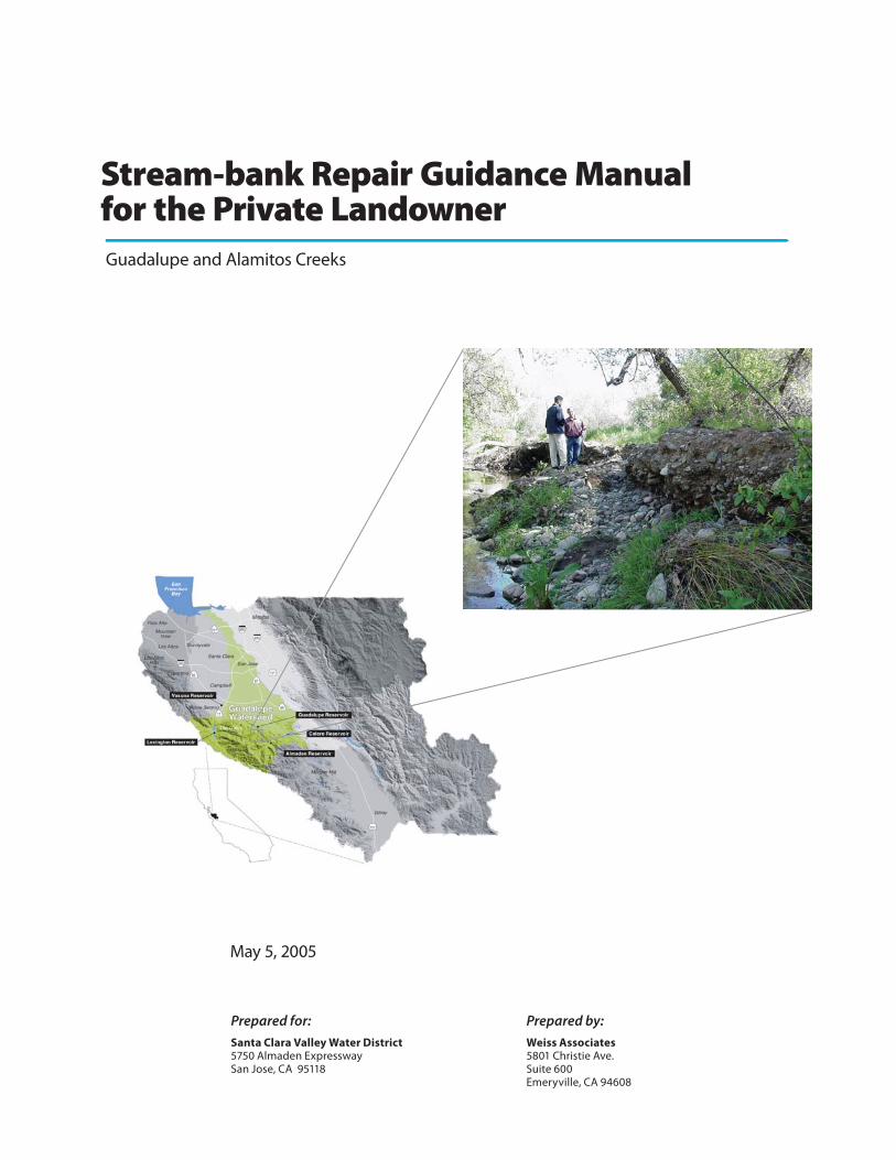
Stream-bank Repair Guidance Manualfor the Private LandownerGuadalupe and Alamitos Creeks
Santa Clara Valley Water District5750 Almaden ExpresswaySan Jose, CA 95118
Prepared for: Prepared by:
Weiss Associates5801 Christie Ave.Suite 600Emeryville, CA 94608
STREAM-BANK REPAIR GUIDANCE MANUAL FOR THE PRIVATE LANDOWNER GUADALUPE AND ALAMITOS CREEKS
May 5, 2005
DISCLOSURE:
This document was prepared under Agreement Number 02-121-252-0 between the California State Water Resources Control Board and the Santa Clara Valley Water District. The dollar amount of this Agreement is $348,782.00, and the dollar amount for the subcontract for preparation of the Guidance Manual document is $48,490.00.
Funding for this project has been provided in part by the U.S. Environmental Protection Agency (USEPA) pursuant to Assistance Agreement No. C998998901-0 and any amendments thereto which has been awarded to the State Water Resources Control Board (SWRCB) for the implementation of California's Nonpoint Source Pollution Control Program. The contents of this document do not necessarily reflect the views and policies of the USEPA or the SWRCB, nor does mention of trade names or commercial products constitute endorsement or recommendation for use.
For any questions concerning the contents of this Guidance Manual, please contact the Santa Clara Valley Water District Community Project Review Unit:
Santa Clara Valley Water District Community Projects Review Unit
5750 Almaden Expressway San Jose, CA 95118
(408) 265 2600, ext. 2253

STREAM-BANK REPAIR GUIDANCE MANUAL FOR THE PRIVATE LANDOWNER GUADALUPE AND ALAMITOS CREEKS
ii
CONTENTS Page
1. Introduction to the Guidance Manual 1 1.1 Cooperation and Successful Stream-bank Maintenance 1 1.2 Landowner’s Role 1 1.3 Guidance Manual Objectives 1 1.4 Developing the Guidance Manual 2 1.5 Organization of the Guidance Manual 2
2. Understanding Mercury in the Guadalupe River Watershed 3 2.1 Thinking Like a Watershed 3 2.2 Mercury in the Coast Range Mountains 4 2.3 Quicksilver, Gold Miners and Mercury Pollution 4 2.4 Understanding the Dangers of Mercury 5 2.5 How Mercury Moves in the Watershed, a Conceptual Model 6 2.6 Impaired Water Bodies and a Mercury TMDL 7
3. Guidance for Planning and Constructing Stream-bank Repair Projects 8 3.1 When Should You Repair Your Stream-bank? 8 3.2 Design of Stream-bank Repair 9 3.3 Obtaining Permits for Stream-bank Repair 14 3.4 Mitigation Measures and Best Management Practices 19 3.5 Hazardous Waste Determination and Handling for Sediment Containing Mercury 22 3.6 Cost and Schedule Summary 24
4. Case Histories of Stream-bank Repair Work 27 4.1 Demonstration Project Permitting 27 4.2 Almaden Expressway Project 27 4.3 Graystone Lane Project 32
5. Bibliography and References 36
APPENDICES
Appendix A Mercury Load Reduction Reporting Form
Appendix B Permitting Agencies
Appendix C Glossary of Terms
STREAM-BANK REPAIR GUIDANCE MANUAL FOR THE PRIVATE LANDOWNER GUADALUPE AND ALAMITOS CREEKS
iii
IMPORTANT CONCEPTS OUTLINED IN THIS MANUAL
The Santa Clara Valley Water District (District) and private landowners along Guadalupe and Alamitos Creeks (Guadalupe Landowners) maintain the aesthetic and natural diversity of the Guadalupe River Watershed. The District prepared this Guidance Manual to help Guadalupe Landowners perform stream-bank repair projects. As a landowner in the Guadalupe River Watershed, you may need to conduct work on stream-banks that contain mercury left behind from mining activities. The following important concepts will assist you in removing mercury pollution from the watershed:
• Establish the Purpose of Your Project. Is it to repair eroded stream-banks? Is it to remove mercury-contaminated sediment? Is it to landscape your stream-bank?
• See if You Can Get Help from the District. The District may provide technical expertise, help implement your project, and may enter into a cost-sharing agreement with you if funding is available and they determine that the proposed project will benefit not only your property, but the environment and the watershed.
• Hire Qualified Professionals. While the Guidance Manual provides useful information about stream-bank repair, it is not a substitute for hiring qualified and experienced professionals.
• Get to the Root of the Problem. Erosion along stream-banks can be a symptom of another problem up the watershed. You should determine the cause of erosion at your stream-bank.
• Use a Watershed-friendly Design. Your designer should incorporate criteria that improve the quality of the stream and reduce mercury on the stream-bank. Design options should consider the following: incorporate living materials and vegetation into structures; use native vegetation for erosion control; and avoid using concrete or rock revetments wherever possible.
• Permitting and JARPA. Work conducted in or around a creek or stream requires permits from local, state, and/or federal agencies. The San Francisco Bay Area Joint Aquatic Resource Permit Application (JARPA) consolidates information required by permitting agencies into a single application. Using JARPA will make your permit application process easier.
• Don’t Forget about CEQA. You may need to perform an environmental review of your project mandated under the California Environmental Quality Act (CEQA). CEQA reviews can be simple and inexpensive or complex and costly, depending on the complexity of your project.
• Mitigation and Best Management Practices. Most likely, you will need to implement mitigation measures and best management practices to minimize environmental impacts.
• Excavated Sediment Might Be Hazardous Waste. Sometimes mercury concentrations in your stream-bank are so high that you must manage any stream-bank soil you disturb as hazardous waste. Hazardous waste rules are complicated. Only qualified professionals should make the determination of whether waste is hazardous or not.
• Know the Dollar Costs of Your Project as Early as Possible. Costs associated with stream-bank projects can vary widely – especially in the Guadalupe River Watershed – depending on the levels of mercury contamination. It is important for you, the landowner, to be aware of these costs before proceeding with a stream-bank repair project.
• Your Watershed Loves Native Vegetation. Vegetation is the most common (and effective) technique to prevent erosion along your stream-bank. It can provide ideal habitat for birds and other animals. PLEASE – only use native vegetation to avoid introduction of non-native invasive plants that can take over and degrade existing habitat along miles of stream.
STREAM-BANK REPAIR GUIDANCE MANUAL FOR THE PRIVATE LANDOWNER GUADALUPE AND ALAMITOS CREEKS
1
1. Introduction to the Guidance Manual
1.1 Cooperation and Successful Stream-bank Maintenance We all have an interest in improving the condition of the Guadalupe River Watershed. Local conservation groups, Guadalupe Landowners, the District, and regulatory agencies including the U.S. Army Corps of Engineers (Corps), the United States Environmental Protection Agency (EPA), and the San Francisco Bay Regional Water Quality Control Board share common goals.
The District and Guadalupe Landowners are responsible for maintaining the aesthetic and natural diversity of the Guadalupe River Watershed while protecting the land around streams and creeks from erosion. When the District and the Guadalupe Landowners fulfill this responsibility, the result is improved water quality for Guadalupe creeks, rivers, reservoirs, and ultimately the San Francisco Bay.
The District prepared this Guidance Manual to describe the need for stream-bank repair in order to reduce mercury pollution in the Guadalupe River Watershed and to explain the mechanics of implementing these repair projects. The manual also outlines the ways we can work together to reduce mercury pollution in the watershed.
1.2 Landowner’s Role You, as a private landowner, can reduce mercury pollution in the Guadalupe River and the San Francisco Bay through stream-bank repair projects. This Guidance Manual provides useful information about stream-bank repair, but it is no substitute for hiring qualified professionals to design, plan, and perform construction activities.
Your watershed is a complex system. Improper repair of your stream-bank may cause erosion at your neighbor’s stream-bank. Cooperation between landowners for stream-bank repair projects makes repair more effective. Coordinating projects can make permitting easier and may even reduce your cost.
The District developed a mechanism for private landowners to document their contributions to reducing mercury in the watershed: the Mercury Load Reduction Reporting Form in Appendix A. This form can be used to report mercury quantities removed from the watershed. This information will be useful for the District and the San Francisco Bay Regional Water Quality Control Board when developing policies for reducing mercury in the watershed.
1.3 Guidance Manual Objectives This Guidance Manual is an educational document to assist Guadalupe Landowners planning stream-bank repair projects.
The District hopes to accomplish the following objectives:
• Provide landowners with tools necessary to plan for stream-bank repair; • Educate landowners about mercury and stream-bank erosion and repair in the watershed;
STREAM-BANK REPAIR GUIDANCE MANUAL FOR THE PRIVATE LANDOWNER GUADALUPE AND ALAMITOS CREEKS
2
• Encourage communication between landowners, the District, and permitting agencies; and • Demonstrate the importance of designing and building bank repair projects that use natural
materials and vegetation.
1.4 Developing the Guidance Manual The District worked in concert with the members of the Guadalupe River Watershed Mercury Total Maximum Daily Load (TMDL) Work Group to prepare this Guidance Manual. The goal of the Work Group is to reduce mercury in the watershed. This manual aims to assist in this effort by encouraging Guadalupe Landowners to consider mercury pollution reduction when performing stream-bank repair projects.
1.5 Organization of the Guidance Manual The Guidance Manual is organized into the following sections:
Important Concepts
Section 1: Introduction to the Guidance Manual
Section 2: Understanding Mercury in the Guadalupe River Watershed
Section 3: Guidance for Planning and Constructing Stream-bank Repair Projects
Section 4: Case Histories of Stream-bank Repair Work
Section 5: Bibliography and References

STREAM-BANK REPAIR GUIDANCE MANUAL FOR THE PRIVATE LANDOWNER GUADALUPE AND ALAMITOS CREEKS
3
2. Understanding Mercury in the Guadalupe River Watershed
2.1 Thinking Like a Watershed
The Guadalupe River Watershed originates in the eastern Santa Cruz Mountains near the summit of Loma Prieta, at an elevation of 3,790 feet. Rainwater flows down the mountains to near sea level at the confluence of the Guadalupe River and the Alviso Slough. Between Loma Prieta and the Alviso Slough are six reservoirs—Almaden, Guadalupe, Calero, Lexington, Vasona, and Lake Elsman—and hundreds of miles of streams and creeks tributary to the Guadalupe River. The Guadalupe River Watershed has a total drainage area of 170 square miles and includes the Cities of San Jose, Santa Clara, and Los Gatos.
Figure 1. The Guadalupe River Watershed Water flow in the watershed varies seasonally and annually. Reservoirs, streams, and creeks fill during winter rainstorms and water volumes and flows are reduced during dry summers. Annual precipitation also varies between flood and drought years. To compensate for these changes in water flow, watersheds have a natural tendency to change with time. Some areas of the watershed erode, including stream-banks, and the sediment is deposited downstream, typically in reservoirs.
STREAM-BANK REPAIR GUIDANCE MANUAL FOR THE PRIVATE LANDOWNER GUADALUPE AND ALAMITOS CREEKS
4
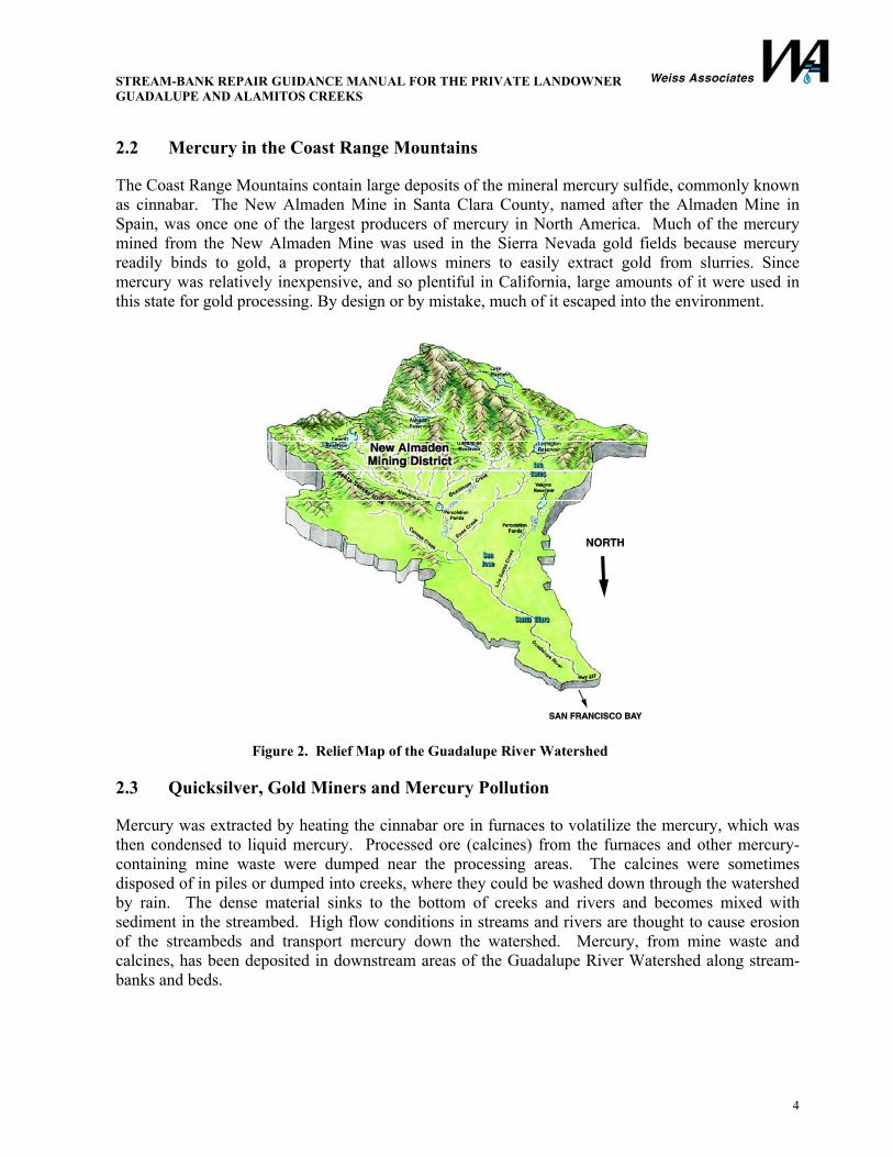
2.2 Mercury in the Coast Range Mountains
The Coast Range Mountains contain large deposits of the mineral mercury sulfide, commonly known as cinnabar. The New Almaden Mine in Santa Clara County, named after the Almaden Mine in Spain, was once one of the largest producers of mercury in North America. Much of the mercury mined from the New Almaden Mine was used in the Sierra Nevada gold fields because mercury readily binds to gold, a property that allows miners to easily extract gold from slurries. Since mercury was relatively inexpensive, and so plentiful in California, large amounts of it were used in this state for gold processing. By design or by mistake, much of it escaped into the environment.
Figure 2. Relief Map of the Guadalupe River Watershed
2.3 Quicksilver, Gold Miners and Mercury Pollution
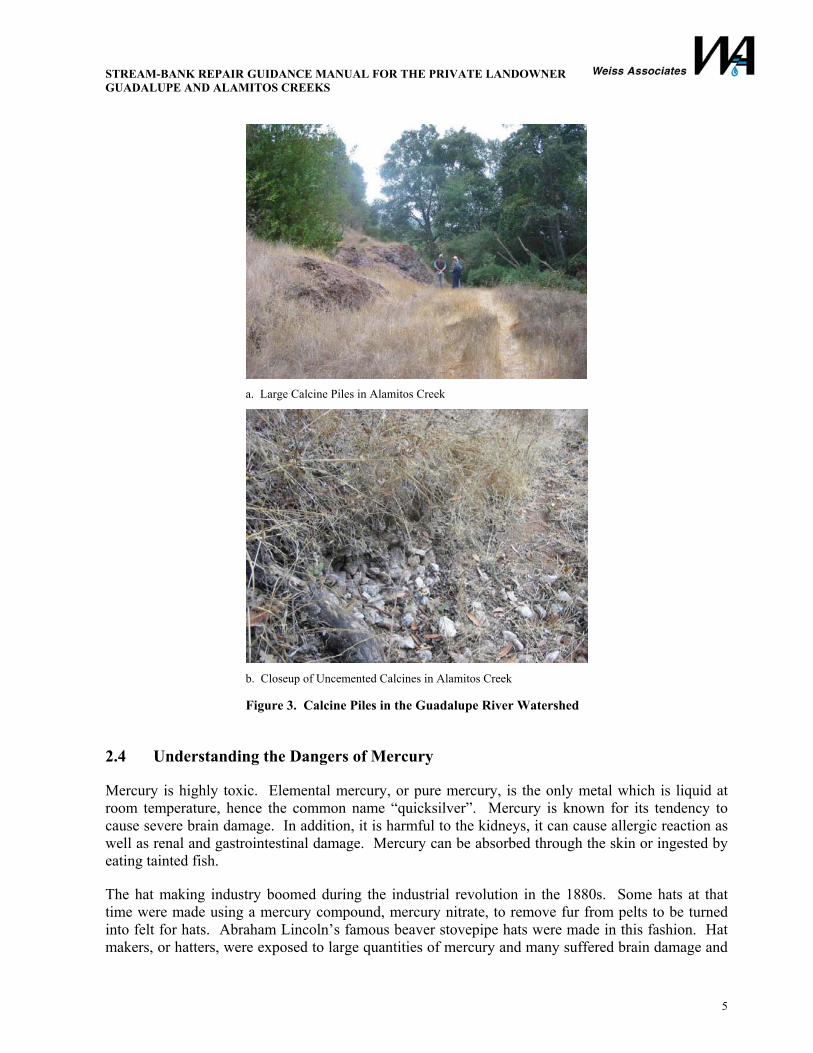
Mercury was extracted by heating the cinnabar ore in furnaces to volatilize the mercury, which was then condensed to liquid mercury. Processed ore (calcines) from the furnaces and other mercury-containing mine waste were dumped near the processing areas. The calcines were sometimes disposed of in piles or dumped into creeks, where they could be washed down through the watershed by rain. The dense material sinks to the bottom of creeks and rivers and becomes mixed with sediment in the streambed. High flow conditions in streams and rivers are thought to cause erosion of the streambeds and transport mercury down the watershed. Mercury, from mine waste and calcines, has been deposited in downstream areas of the Guadalupe River Watershed along stream-banks and beds.
STREAM-BANK REPAIR GUIDANCE MANUAL FOR THE PRIVATE LANDOWNER GUADALUPE AND ALAMITOS CREEKS
5
a. Large Calcine Piles in Alamitos Creek
b. Closeup of Uncemented Calcines in Alamitos Creek
Figure 3. Calcine Piles in the Guadalupe River Watershed
2.4 Understanding the Dangers of Mercury
Mercury is highly toxic. Elemental mercury, or pure mercury, is the only metal which is liquid at room temperature, hence the common name “quicksilver”. Mercury is known for its tendency to cause severe brain damage. In addition, it is harmful to the kidneys, it can cause allergic reaction as well as renal and gastrointestinal damage. Mercury can be absorbed through the skin or ingested by eating tainted fish.
The hat making industry boomed during the industrial revolution in the 1880s. Some hats at that time were made using a mercury compound, mercury nitrate, to remove fur from pelts to be turned into felt for hats. Abraham Lincoln’s famous beaver stovepipe hats were made in this fashion. Hat makers, or hatters, were exposed to large quantities of mercury and many suffered brain damage and

STREAM-BANK REPAIR GUIDANCE MANUAL FOR THE PRIVATE LANDOWNER GUADALUPE AND ALAMITOS CREEKS
6
went mad. The expression “mad as a hatter” was subsequently coined and immortalized in Lewis Carroll’s Alice’s Adventures in Wonderland.
2.5 How Mercury Moves in the Watershed, a Conceptual Model
Most mercury in the watershed consists of insoluble mercury sulfides from mine wastes that have accumulated in reservoirs and sediment in stream-banks, stream bottoms, and floodplains. Mercury tends to be absorbed into sediments in the water bodies. Because of this tendency, the movement of mercury is closely related to the transport of sediments. One of the effects of reservoirs is to trap sediment eroded in the watershed so it is not transported downstream.
During high flow from large runoff events, mercury-containing sediment is transported downstream in the creeks and in the Guadalupe River. Erosion of the banks of these creeks and rivers adds significantly to the total transport of mercury. Mercury is also transported during low-flow conditions, but much less so than during high flow.
Figure 4. Mercury Movement in the Watershed Insoluble mercury in sediment is toxic. Soluble mercury accumulated in the food chain is more toxic. There are two steps for mercury to enter the food chain and become hazardous to humans: (1) the change of mercury from an inorganic form to a more bioavailable form – called methylation; and (2) the uptake of mercury into the food chain out of the water by algae and the subsequent biomagnification.
Reservoir bottoms are layered, with a new layer placed each year by water and sediment from the high-flow winter season. This process is called stratification. The lower layers of the reservoir become depleted of oxygen. Certain naturally occurring bacteria thrive in this environment. The chemistry that occurs in sediment layers may form a new organic compound, called methyl mercury. Methyl mercury is soluble in water. The process of converting insoluble mercury into soluble methyl mercury is called methylation.

STREAM-BANK REPAIR GUIDANCE MANUAL FOR THE PRIVATE LANDOWNER GUADALUPE AND ALAMITOS CREEKS
7
The methyl mercury is thought to enter the cells of plants (algae) at the base of the food chain and accumulate through the food chain. The algae absorb methyl mercury from the water, the zooplankton eats the algae, small fish eat the zooplankton, and the large fish eat the small fish. All the while – the mercury moves up the food chain and accumulates. Predatory fish contain the most mercury because they eat many small fish, who eat lots of plankton, who eat lots of algae. This process is called biomagnification and is illustrated in the figure below.
Figure 5. Bioaccumulation of Mercury in the Food Chain
Private landowners should be aware that fish caught in parts of the Guadalupe River Watershed should not be eaten. The Santa Clara County Parks Department has posted fish advisory signs and distributed fliers to warn park visitors of the hazards of eating mercury-contaminated fish. The same problem is occurring in the San Francisco Bay and is evidenced by postings at fish markets and grocery stores.
2.6 Impaired Water Bodies and a Mercury TMDL
Section 303 of the Clean Water Act includes a provision for the TMDL program. The program requirements and guidance from the USEPA dictate that, for all impaired water bodies, a total load needs to be allocated to each and all sources so that water quality standards are met.
The San Francisco Bay Regional Water Quality Control Board and the USEPA have identified the San Francisco Bay as an impaired water body for mercury pollution and have worked to identify tributaries contributing to mercury pollution. As described above, because of historic mining operations, the Guadalupe River Watershed is a significant contributor to mercury pollution in the Bay. Mercury concerns in the Guadalupe River Watershed can most efficiently be addressed by undertaking a single TMDL project that concurrently addresses all mercury sources.

STREAM-BANK REPAIR GUIDANCE MANUAL FOR THE PRIVATE LANDOWNER GUADALUPE AND ALAMITOS CREEKS
8
3. Guidance for Planning and Constructing Stream-bank Repair Projects
3.1 When Should You Repair Your Stream-bank?
Creeks, streams, and rivers undergo shape changes over time to seek balance with the environment around them. Natural phenomenon like rainfall, runoff, and sediment input alter stream flow forms. Similarly, human influences, from agriculture, residential and commercial development, road and highway construction, dams, and flood control modifications affect stream processes. The pictures below illustrate examples of stream-bank conditions that can contribute excessive sediment and mercury to Alamitos Creek. Some erosion is normal in streams. Undercut banks and fallen trees can provide important habitat for native aquatic species. Only a qualified professional should determine whether erosion is in need of repair.
Think about the big picture! Erosion of your stream-bank is an effect; proper design of a repair project should determine the cause. Simply addressing erosion on your property may contribute to erosion of your neighbor’s property.
a. Undercutting of Calcine Bank Along Alamitos Creek
b. Eroding Bank on Alamitos Creek
Figure 6. Stream-bank Conditions Requiring Repair
STREAM-BANK REPAIR GUIDANCE MANUAL FOR THE PRIVATE LANDOWNER GUADALUPE AND ALAMITOS CREEKS
9
3.2 Design of Stream-bank Repair
3.2.1 Understanding Your Objective
Before embarking on a stream-bank repair project, you must establish the purpose of your project and outline objectives you would like to achieve. Some objectives could include:
• Protecting your property or structures; • Restoring eroded banks; • Protecting existing banks from erosion; • Removing mercury-contaminated sediment; • Restoring riparian habitat; and • Removing invasive vegetation or species.
3.2.2 Hiring a Qualified Designer
Many stream-bank repair practices can cause unintended effects in local or downstream areas of the watershed. For this reason, landowners should consult professionals with experience in stream-bank repair. If you are hiring a designer or engineer, consider asking them some of these questions:
• What qualifications do you have for conducting stream-bank repair?
Good: A California Professional Civil Engineer License is required, but that alone is not sufficient qualification.
Bad: No license is required!!
• What is your experience designing and constructing bank repair projects in the Guadalupe River Watershed?
Good: My firm (or I) has worked for the District on many occasions.
Bad: Very limited, but all watersheds are the same.
• Have you worked on projects requiring removal, handling, and proper disposal of mercury contamination?
Good: The New Almaden Mine was good for the local economy, but its mercury legacy is bad for the fish and plants and may increase your repair costs if you are disposing of soil.
Bad: I don’t eat the fish, but mercury has nothing to do with stream-bank repair.
• Are you able to obtain the required permits?
Good: Yes, I have worked with the Corps, District, Department of Fish and Game and San Francisco Bay Regional Water Quality Control Board on numerous occasions and understand their requirements.
Bad: Permits are not required for work on private property.
STREAM-BANK REPAIR GUIDANCE MANUAL FOR THE PRIVATE LANDOWNER GUADALUPE AND ALAMITOS CREEKS
10
• Are you familiar with habitats, species, and vegetation in the Guadalupe River Watershed?
Good: Yes, I am fascinated by the District’s wetland restoration projects and we design with mitigation measures to protect the wetland and riparian habitats.
Bad: Yeah, but you may want to remove any vegetation from the stream-bank before I come to survey it.
3.2.3 Stream-bank Repair Concepts and Materials
3.2.3.1 Science of Creeks, Streams, and Reservoirs
Hydrology is the study of the properties, distribution, and effects of water on the earth’s surface (creeks or streams), in the soil and underlying rocks (groundwater), and in the atmosphere (precipitation). The hydraulic characteristics of streams and creeks vary widely by season. Stream-bank repair projects should be designed to maintain stability during a range of flows from high frequency, lower discharge flows to larger flood events.
Geomorphology is the study of the evolution and configuration of landforms, which includes the banks and beds of streams in the Guadalupe River Watershed. Natural processes like wind and rain, as well as human activities cause changes to landforms throughout the watershed. High-velocity water flow and shear stress (water pressure against the bank) are significant contributors to both bed and bank erosion in some parts of the watershed, which leads to sediment deposition in others.
The principal hydraulic design parameters for stream-bank repair are water velocity and shear stress and your designer should make sure that the stabilization technique will withstand the anticipated range of these parameters at your site.
3.2.3.2 Types of Construction Materials
Materials often need to be imported to the stream-bank repair site, including clean soil, logs or root wads, native vegetation, rock, gravel, sand, geotextile erosion control blankets and matting, among many others. It is essential you remember that anything you put into the stream-bank will contact flowing water and has the potential to pollute the stream. You should always query your designer or contractor to ensure they are using materials in a manner that will not pollute the stream.
Historically, rock riprap, concrete or other rigid structures have been used at the toe of stream-banks subject to erosion. In more recent years, the District began employing use of logs, root wad systems, and other less-rigid structures that incorporate natural and living materials to provide structure and stability to protect the toe of stream-banks. These materials provide better habitat for vegetation and species than rock or riprap. To the extent that your design objectives are met, you should try to incorporate natural and living materials into your stream-bank protection.
STREAM-BANK REPAIR GUIDANCE MANUAL FOR THE PRIVATE LANDOWNER GUADALUPE AND ALAMITOS CREEKS
11
3.2.3.3 Types of Vegetation
Vegetation protects stream-banks in three ways; the roots bind soils together preventing erosion, branches and leaves provide protection from rain splash erosion, and exposed stalks, stems and branches provide resistance to stream flow, causing flow velocity to slow and lose erosive energy, or shear stress, by deforming plants rather than eroding bank material. Vegetation can also negatively affect flood conveyance capacity in a stream and any use of vegetation should take this into consideration.
Grasses are effective in preventing erosion along areas at the top of stream-banks where water rarely flows. On lower edges of the bank, which are often inundated by water, woody plants are more effective for providing habitat, but can impede stream conveying flood flows. Some tree species, like willows and cottonwoods prefer growing closer to the stream while others, like oaks prefer being higher up the bank. Non-native plants are a serious problem in the Guadalupe River Watershed. You cannot introduce new vegetation species into the watershed. The District has information available to help you select appropriate vegetation along the stream-bank.
3.2.4 Stream-bank Repair Techniques
Successful stream-bank repair integrates natural materials such as rocks and logs with native vegetation to prevent erosion while providing valuable habitat. Some common bank stabilization techniques are described below: log toes, live log crib walls, root wads, rock toes, brush mattresses and vegetation. Techniques commonly used at the toe of the bank are presented first and softer techniques used higher up the bank follow. Each situation requiring stream-bank repair is unique and there is no one-size-fits all remedy. Repair projects usually require a combination of these techniques. The District Community Projects Review Unit can provide more detailed information on the techniques presented here, as well as other natural material methods.
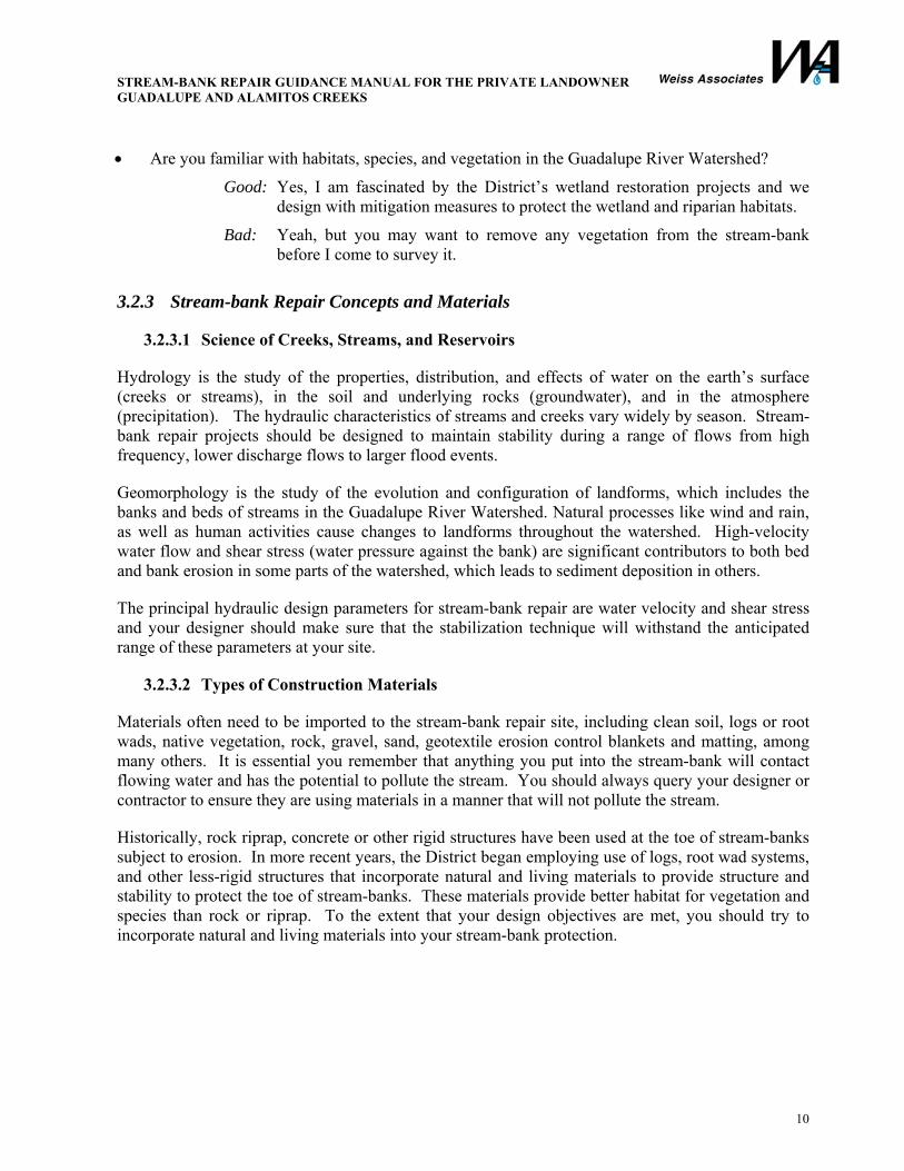
Log Toes utilize a large log, or group of logs to protect the toe of a stream-bank from erosion. A log toe is a natural alternative to a rock toe and is potential habitat for fish or vegetation. Log toes are typically used in conjunction with other vegetative controls for erosion protection on areas higher up the stream-bank.
Figure 7. Log Toe
STREAM-BANK REPAIR GUIDANCE MANUAL FOR THE PRIVATE LANDOWNER GUADALUPE AND ALAMITOS CREEKS
12
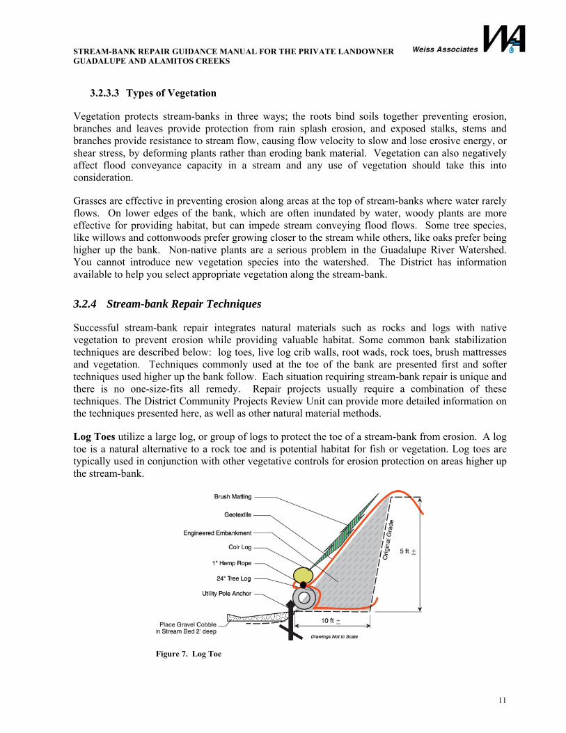
Crib walls are interlocking log boxes. The crib forms a rigid structure resistant to erosive forces. Cribbing is useful in areas of very steep banks where sloping back the bank is not a practical option. Crib walls create a natural appearance, offer immediate stream-bank protection, and encourage woody species growth. Crib walls do not adjust to toe scour and may require use of a rock toe. Crib walls should be used in conjunction with vegetative erosion control measures for areas higher up the stream-bank.
Figure 8. Live Log Crib Wall Root wads are a good method to improve fish habitat and prevent stream-bank erosion. Root wads create a very natural looking bank with time. A toe trench is usually dug and anchor logs are placed diagonal to the stream-bank. Roots are then placed along the bank across anchor logs and are anchored using boulders or cables. Root wads should be used with vegetative erosion control measures for areas higher up the stream-bank.
Figure 9. Root Wad
STREAM-BANK REPAIR GUIDANCE MANUAL FOR THE PRIVATE LANDOWNER GUADALUPE AND ALAMITOS CREEKS
13
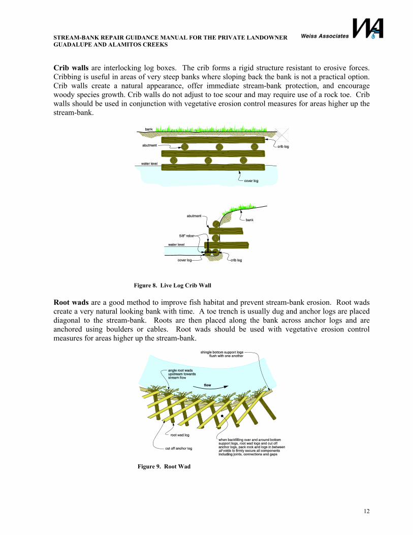
Rock toes and armoring utilize large boulders to resist erosive forces at the toe and along stream-banks. The expected stream velocity determines the size of the boulders. Rock toes do not typically provide exceptional habitat for species and vegetation. Rock toes and armoring are used in areas where log structures may lead to bank erosion. The rock toes and armoring should incorporate gravel backing with geotextile fabrics to prevent erosion of bank material behind the armoring. Whenever possible, rock toes and armoring should be used in conjunction with vegetative erosion control measures for areas higher up the stream-bank.
Figure 10. Rough Construction Detail for a Rock Toe
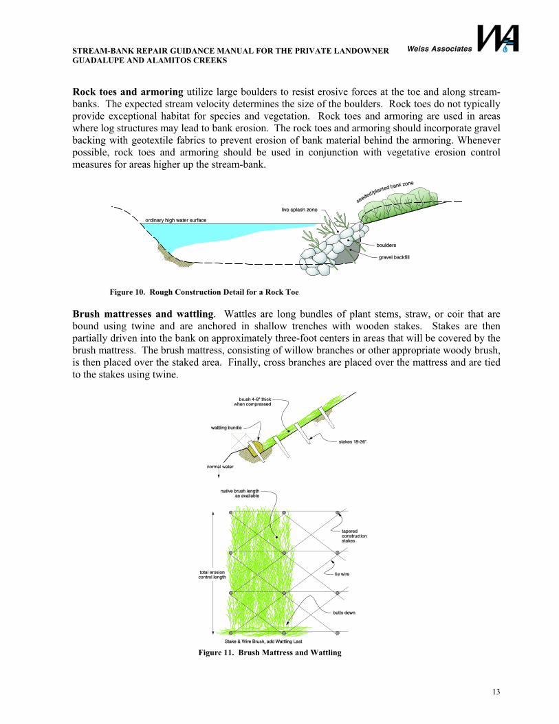
Brush mattresses and wattling. Wattles are long bundles of plant stems, straw, or coir that are bound using twine and are anchored in shallow trenches with wooden stakes. Stakes are then partially driven into the bank on approximately three-foot centers in areas that will be covered by the brush mattress. The brush mattress, consisting of willow branches or other appropriate woody brush, is then placed over the staked area. Finally, cross branches are placed over the mattress and are tied to the stakes using twine.
Figure 11. Brush Mattress and Wattling
STREAM-BANK REPAIR GUIDANCE MANUAL FOR THE PRIVATE LANDOWNER GUADALUPE AND ALAMITOS CREEKS
14
Vegetation: Vegetation is the most common technique employed to prevent erosion along areas near the top of the stream-bank. These areas are subject to low erosive forces and rigid structures are not usually required to prevent erosion. You may only use native vegetation appropriate for the Guadalupe Watershed. Planting methods include use of cuttings, transplants, live staking, and direct seeding. Plants are chosen on the basis of moisture tolerance and effectiveness at controlling erosion. You may need to cut back the slope of your stream-bank. The slope of the bank affects the quantity and quality of vegetation on stream-banks. Vegetation generally prefers a soft slope: a three foot horizontal run for a one foot rise (3:1) is adequate for many types of stream-bank vegetation.
3.3 Obtaining Permits for Stream-bank Repair
3.3.1 Permits You May Need to Complete the Project
If you are working in or around a creek or stream, you will likely need permits from a local, state, and/or federal agency. Permits are needed for major repair work such as sediment removal, vegetation management, and stream-bank protection. Other stream maintenance activities, such as large-scale trash removal, fence and access repair, and revegetation may be subject to permit or notification requirements.
3.3.2 Practical Points to Help You Obtain Permits for Your Project
• Learn the rules. Familiarize yourself with applicable state, local, and federal agency permitting requirements. Determine which agencies may be involved in your project. Take time to study the protocols and regulations of these agencies. Become familiar with the agency staff and learn how they function. Read previous staff reports, permit conditions, and studies relating to your project or similar projects.
• Review possible exemptions for your project. When you review regulations and permitting requirements potentially applicable to your project, look for exemptions that may apply to your project. Exemptions are often found at the beginning of a chapter or section of a regulation dealing with a specific topic. If you find an exemption that you believe is applicable to your project, make sure that you confirm this with the agency in charge of enforcing the particular regulation. Get their confirmation in writing.
• Contact the agencies in charge of granting permits for your project. You may need to obtain different permits for your project from a number of agencies. Contact the agencies that may be in charge of your project to determine who will be involved. Ask about the agency’s permitting process, obtain relevant forms, and discuss potential timelines for obtaining your permits. Do not expect to get schedule commitments at this stage, but at least get an idea of the how the process works and a general feel for how long it may take.
• Inquire about an expedited permit review. Often an expedited permit review may be obtained by hiring a third party to review your project (for example, San Jose Building Department). If your project is time sensitive, ask the agency in charge of the required permits if an expedited permit process exists. Keep in mind that not all agencies allow a shortened review or your project may not quality for such a review.

STREAM-BANK REPAIR GUIDANCE MANUAL FOR THE PRIVATE LANDOWNER GUADALUPE AND ALAMITOS CREEKS
15
• Write a complete project description. A complete project description is crucial. Include drawings, photographs and other supporting materials to assist the regulatory agencies in understanding what your project entails.
• Consult early and become familiar with agency staff. Consultation with permitting and regulatory agencies should begin as early as possible in planning your project. An in-person meeting is the best way to discuss your project. Try to have plans, maps, photographs of the project location, and other information available at the meeting. You can also request that a staff person meet you at the site.
• Reduce adverse environmental impacts. Design your project to eliminate or reduce as many potential health concerns and environmental impacts as possible. Consider environmentally superior alternatives like those discussed in Section 3.2.4. These methods are also generally easier and faster to permit. Incorporate the suggestions you received during early consultation. Retain a competent consultant.
• Do not approach the process with an adversarial attitude. It is counterproductive to resist the permit process as you are going through it. Agency staff can better serve you if you are cooperative through the permitting process.
• Pay attention to details. Follow all the rules. Respond promptly to requests for information. Be on time for meetings with representatives of the regulating agencies. Do not cut corners. Get in writing all dates, procedures, fees, etc.
• Be willing to negotiate. Recognize that government regulators may have a great deal of authority over your project, but that they are willing to negotiate. You should be, too.
• When in doubt, ask. If you are not sure whether your project needs a permit or whether it is regulated at all, ask. Get written confirmation. Going ahead without following the proper guidelines will ultimately cost you time, money, and goodwill.
• Keep good records. Keep notes of conversations and meetings. Ask for interpretations of rules to be written by the agency representatives. An easy way to do this is to confirm conversations by email.
3.3.3 Prohibited Activities
Before you decide to do work near a creek or river, you should consider that it is illegal to place, store, or dispose of materials of any kind on the banks of or into a watercourse. Prohibited materials include dirt, soil, and concrete; pool and spa water; paints, solvents, and soaps; yard and animal waste; automobile and machinery fluids; and firewood and building materials. If your project requires you to stockpile soil or building materials, you must obtain approval and ensure that you comply with best management practices that prevent pollution from entering the waterway and damaging the ecosystem.
STREAM-BANK REPAIR GUIDANCE MANUAL FOR THE PRIVATE LANDOWNER GUADALUPE AND ALAMITOS CREEKS
16
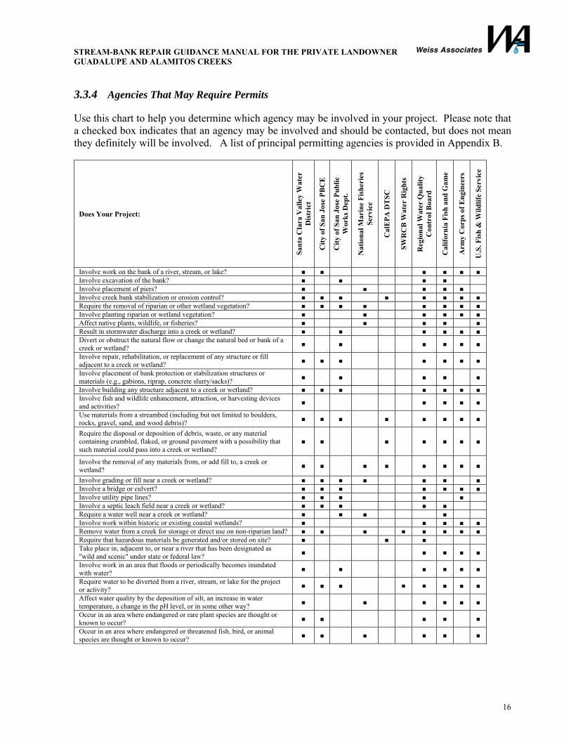
3.3.4 Agencies That May Require Permits
Use this chart to help you determine which agency may be involved in your project. Please note that a checked box indicates that an agency may be involved and should be contacted, but does not mean they definitely will be involved. A list of principal permitting agencies is provided in Appendix B.
Does Your Project:
Sant
a C
lara
Val
ley
Wat
er
Dis
tric
t
City
of S
an J
ose
PBC
E
City
of S
an J
ose
Publ
ic
Wor
ks D
ept.
Nat
iona
l Mar
ine
Fish
erie
s Se
rvic
e
Cal
EPA
DT
SC
SWR
CB
Wat
er R
ight
s
Reg
iona
l Wat
er Q
ualit
y C
ontr
ol B
oard
Cal
iforn
ia F
ish
and
Gam
e
Arm
y C
orps
of E
ngin
eers
U.S
. Fis
h &
Wild
life
Serv
ice
Involve work on the bank of a river, stream, or lake? ■ ■ ■ ■ ■ ■ Involve excavation of the bank? ■ ■ ■ ■ Involve placement of piers? ■ ■ ■ ■ ■ Involve creek bank stabilization or erosion control? ■ ■ ■ ■ ■ ■ ■ ■ Require the removal of riparian or other wetland vegetation? ■ ■ ■ ■ ■ ■ ■ ■ Involve planting riparian or wetland vegetation? ■ ■ ■ ■ ■ ■ Affect native plants, wildlife, or fisheries? ■ ■ ■ ■ ■ Result in stormwater discharge into a creek or wetland? ■ ■ ■ ■ ■ ■ Divert or obstruct the natural flow or change the natural bed or bank of a creek or wetland? ■ ■ ■ ■ ■ ■
Involve repair, rehabilitation, or replacement of any structure or fill adjacent to a creek or wetland? ■ ■ ■ ■ ■ ■ ■
Involve placement of bank protection or stabilization structures or materials (e.g., gabions, riprap, concrete slurry/sacks)? ■ ■ ■ ■ ■
Involve building any structure adjacent to a creek or wetland? ■ ■ ■ ■ ■ ■ ■ Involve fish and wildlife enhancement, attraction, or harvesting devices and activities? ■ ■ ■ ■ ■
Use materials from a streambed (including but not limited to boulders, rocks, gravel, sand, and wood debris)? ■ ■ ■ ■ ■ ■ ■ ■
Require the disposal or deposition of debris, waste, or any material containing crumbled, flaked, or ground pavement with a possibility that such material could pass into a creek or wetland?
■ ■ ■ ■ ■ ■ ■
Involve the removal of any materials from, or add fill to, a creek or wetland? ■ ■ ■ ■ ■ ■ ■ ■
Involve grading or fill near a creek or wetland? ■ ■ ■ ■ ■ ■ ■ Involve a bridge or culvert? ■ ■ ■ ■ ■ ■ ■ Involve utility pipe lines? ■ ■ ■ ■ ■ Involve a septic leach field near a creek or wetland? ■ ■ ■ ■ ■ Require a water well near a creek or wetland? ■ ■ ■ ■ Involve work within historic or existing coastal wetlands? ■ ■ ■ ■ ■ Remove water from a creek for storage or direct use on non-riparian land? ■ ■ ■ ■ ■ ■ ■ ■ Require that hazardous materials be generated and/or stored on site? ■ ■ ■ Take place in, adjacent to, or near a river that has been designated as "wild and scenic" under state or federal law? ■ ■ ■ ■ ■
Involve work in an area that floods or periodically becomes inundated with water? ■ ■ ■ ■ ■ ■
Require water to be diverted from a river, stream, or lake for the project or activity? ■ ■ ■ ■ ■ ■ ■ ■
Affect water quality by the deposition of silt, an increase in water temperature, a change in the pH level, or in some other way? ■ ■ ■ ■ ■ ■
Occur in an area where endangered or rare plant species are thought or known to occur? ■ ■ ■ ■ ■
Occur in an area where endangered or threatened fish, bird, or animal species are thought or known to occur? ■ ■ ■ ■ ■ ■
STREAM-BANK REPAIR GUIDANCE MANUAL FOR THE PRIVATE LANDOWNER GUADALUPE AND ALAMITOS CREEKS
17
3.3.5 San Francisco Bay Area Joint Aquatic Resource Permit Application
As discussed earlier, projects in or near creeks and even intermittent streams can be regulated by many agencies, local agencies, such as the Santa Clara Valley Water District, City of San Jose, state agencies, such as the San Francisco Bay Regional Water Quality Control Board, and California Department of Fish and Game, and federal agencies, such as the Corps and U.S. Fish and Wildlife Service, to name a few. For projects with an aquatic component, such as work near a creek or stream, a single application called the San Francisco Bay Area Joint Aquatic Resource Permit Application (JARPA) has been designed to replace individual applications for state, regional, and federal agencies. Since the Guadalupe River Watershed ultimately flows to the San Francisco Bay, the JARPA can be used for projects in the watershed. You should take advantage of this consolidated application to streamline your project permit application process.
If your project requires local approval, such as the City of San Jose or Santa Clara Valley Water District approval, be sure to check with these agencies about what they will need you to include in the application, since the JARPA document does not consider City of San Jose or the Santa Clara Valley Water District requirements.
3.3.6 California Environmental Quality Act
In addition to obtaining permits for your project, you will also have to comply with an environmental review of your project mandated under the California Environmental Quality Act (CEQA). The purpose of the CEQA review is to identify and prevent significant potential environmental impacts from proposed projects. The agency responsible for the CEQA review is called the lead agency, and it is usually the agency with the most involvement in the project. The local municipality’s planning department usually handles the CEQA review.
Once the lead agency is identified, all other involved agencies, whether state or local, become responsible, or trustee, agencies. Responsible and trustee agencies must consider the environmental document prepared by the lead agency and do not, except in rare instances, prepare their own environmental documents.
There are four scenarios that are likely to occur as you comply with the CEQA requirements:
1. Your project is exempt from CEQA. Exemptions are listed in the CEQA Guidance. Documentation of exemptions should be obtained from the lead agency.
2. A Negative Declaration is issued by the lead agency for your project. A Negative Declaration can be issued if your project will have no significant impact on the environment.
Hint: If at any time along the permitting or review process, you find that your proposed project can have a significant impact on the environment, and by redesigning your project, the impact can be eliminated or reduced to insignificant, you will save yourself time and money by redesigning your project.

STREAM-BANK REPAIR GUIDANCE MANUAL FOR THE PRIVATE LANDOWNER GUADALUPE AND ALAMITOS CREEKS
18
3. A Mitigated Negative Declaration is issued for your project. This means that there are significant impacts from your project on the environment, but mitigation measures during implementation can be adopted to mitigate these measures. A mitigation monitoring and reporting plan is required to ensure that all mitigation measures are implemented.
4. An Environmental Impact Report (EIR) is required to study the significant impacts of your project on the environment. Various alternatives to your project must be identified and evaluated. An EIR is the most time consuming and complicated scenario of the four discussed.
If your project is not exempt from CEQA, and requires either a Negative Declaration, a Mitigated Negative Declaration or an EIR, it will be subject to public comment and review. You should determine if the impacts of your proposal have already been studied by an approving agency as part of another, often more comprehensive project or plan. If so, the CEQA compliance for your projects may already be covered by the prior studies.
3.3.7 District Maintenance Easements
If you would like assistance from the District in conducting repair or maintenance on your stream-bank property, you may contact the District and discuss the proposed work with them. All easements are reviewed by District staff and undergo an approval process.
In order to help you conduct repair or maintenance on your property, the District will request dedication of a maintenance easement that allows them access and the ability to work on your land or the stream-bank alongside your land. Before the District can accept an easement for access to and work on your property, they will conduct a Hazardous Substance Liability Assessment (HSLA) to determine the presence or absence of hazardous materials on your property that could create an environmental liability for the District. The HSLA includes a site visit, an interview with the property owner about historical uses of your property and a record search to determine if documented contamination or activities likely to create such contamination may have occurred on the property. All easements are reviewed by District staff and approved by the District CEO. Board of Directors’ approval is not usually required for dedication of an easement.
You should be aware that granting a maintenance easement to the District does not obligate the District to conduct maintenance on your property, it only allows the District to conduct work on your land. Stream-bank protection projects are prioritized by the District based on the overall condition of the watershed and the need to conduct other work in the Districts jurisdiction. Requests for work can be submitted to the District via their website; however, these request are typically for minor projects. If you have a substantial repair or major maintenance that you would like to discuss with the District and would like to negotiate an agreement for assistance, it is best to contact the District and review the details of your project with the District staff in person.

STREAM-BANK REPAIR GUIDANCE MANUAL FOR THE PRIVATE LANDOWNER GUADALUPE AND ALAMITOS CREEKS
19
3.4 Mitigation Measures and Best Management Practices
This section provides simple guidelines to minimize the occurrence of flooding and sediment disturbance. Proper use of mitigation measures and best management practices can have a tremendous beneficial impact, protecting life, health, environment, property, and public services. The District has developed numerous mitigation measures as part of their Stream Maintenance Program, from which the discussion below was adapted. You can find more detailed information on mitigation measures at the District web site: www.valleywater.org.
3.4.1 General Stream-bank Maintenance Best Management Practices • Imitate natural features—When restoring a damaged section of a stream-bank, imitate natural
stream features such as channel meanders, appropriate width and depth, and vegetation. These natural features give a channel natural stability.
• Work windows—To avoid and minimize impact to species, in-channel work should be conducted during the dry season between June 15th and October 15th. Do not use heavy equipment during spawning or migration seasons.
• Gravel—Avoid disturbing the creek bed and restore spawning gravels to work site areas. • Stream access—Stream access points can contribute to unwanted sediment in the stream.
− Use established access point wherever possible. − If a temporary project access point is necessary, create the access point as close to the work
area as possible to minimize running of equipment down stream channels and to minimize adverse impacts such as tree removal. Restore the access point to a natural, stable condition.
− Prevent soil from being tracked onto streets near work sites from construction entrances. • Dust control—Dust can have an adverse impact on water quality and create a nuisance.
− Water active maintenance areas so that they are sufficiently moist to prevent dust. − Sweep paved maintenance site access roads if there is visible soil material on the roadway. − Cover trucks hauling sediment, ensure tailgates are closed, and brush off excess dirt or
sediment. • Potentially odorous sediments—Avoid stockpiling sediments highly enriched with decaying
organic matter. • Groundwater management—Direct pumped water to specifically constructed infiltration basins,
holding ponds, or areas with vegetation. • Material storage—Remove all building materials, debris, lumber, and other materials within
48 hours of completing your work. • Mercury—In known areas of soils containing mercury, remediate the soils if the disturbed or
excavated soils are exposed to flood flows. Be sure to use adequate erosion control measures on exposed soil as part of the project. Wear adequate protective equipment. Consult the Santa Clara Valley Water District for disposal guidance.
3.4.2 Removing Sediment Removal of sediment is an important part of stream-bank maintenance. Disturbance of sediments in certain reaches of the Guadalupe River can expose soils containing mercury to aquatic life, wildlife, and even humans. Below are pointers on sediment removal.
STREAM-BANK REPAIR GUIDANCE MANUAL FOR THE PRIVATE LANDOWNER GUADALUPE AND ALAMITOS CREEKS
20
• Gravel bars—Gravel in isolated accumulations normally does not cause flow problems and should not be removed. In some cases, sediment bar accumulation can force flows against a stream-bank leading to undercutting and erosion. Removal or modification of these features should only occur following careful review of potential impacts and receipt of necessary permits.
• Dredging—Do not dredge the stream. Dredging the stream will destroy fish habitat, increase water temperature, expose mercury-laden sediment, and hurt overall water quality.
• Sediment storage—Sediments should be stored and transported in a manner that minimizes water-quality impacts. − Stockpile wet sediments outside of flowing or dewatered streams so water can drain or
evaporate before removal. − Control water drainage from material stockpiles outside the channel so that dirty water does
not flow back into the creek or local storm drains. − Sweep up dirt and mud instead of hosing it down the street.
• Channelizing (i.e., dredging and straightening) the stream, while effective for conveying flows, increases the water velocity, making it difficult for aquatic habitat.
3.4.3 Vegetation Management Vegetation provides soil stabilization, plays a significant role in reducing sediments from runoff entering the stream, provides habitat, and adds to overall natural appearance. Below are some specific instructions.
• Rooted trees—When necessary, trees along the stream can be trimmed and maintained as part of routine maintenance. Do not remove any rooted trees, dead or alive, unless they are leaning into the channel and are an imminent threat to life, property, or infrastructure. If you suspect a tree must be removed, contact the Water District.
• Affixed logs—Logs that are permanently or securely attached to the stream-bank provide valuable habitat. Removal of large logs from the channel is viewed as an impact of fish habitat and mitigation may be required. Do not remove affixed logs unless directed by the District.
3.4.4 Protecting Stream-banks Bank protection prevents unwanted erosion at a particular site. Rooted trees can play an important and effective role in providing bank protection. In addition, trees and vegetation provide wildlife and aquatic habitat.
• Concrete—Concrete can preclude growth of bank vegetation and should be avoided in stream-bank repair.
• Revegetation—Trees, shrubs, and plants can play an important role in stabilizing and protecting stream banks. You may be required to replace removed trees and monitor their growth for survival.
• Seeding—Stream-banks may inevitably become scraped during repair. To help protect the bank, an erosion control seed mix should be used. Consult the District to determine an appropriate seed mix for your project.
• Erosion Control—Exposed soils along stream-banks can erode very quickly. Erosion control measures such as geotextile blankets, mulch, coir rolls and silt fences should be used in conjunction with seeding or planting to minimize exposed soils.
STREAM-BANK REPAIR GUIDANCE MANUAL FOR THE PRIVATE LANDOWNER GUADALUPE AND ALAMITOS CREEKS
21
3.4.5 Follow-Up Maintenance It is important not to neglect the stream-bank repair work that has been done. Follow-up maintenance is just as critical to the success of this work as any other aspect of it. Minor maintenance activities will help ensure the success of your project.
• Trees—Care should be taken to avoid pruning trees unless it is necessary to the survival of the plant or to protect existing property and/or infrastructure as trees can provide shaded riverine aquatic habitat.
• Trash and debris removal—Sometimes accumulation of debris in the channel can cause erosion on nearby banks. − Regularly remove debris such as trash and human debris. − Do not put yard waste in the creeks or on the banks where they are likely to wash into the
stream. − Retain woody material such as live leaning trees, dead trees, tree trunks, large limbs, and
stumps unless they are threatening a structure or impede reasonable access. − Leave stumps, snags, and branches in the channel as they can create fish habitat. − Make sure that woody debris does not impede water flow and does not contribute to
erosion. − Leave woody vegetation in place if it does not contribute to flooding. − You can remove small logs that are not rooted, embedded, jammed, or waterlogged;
however, this practice can be viewed as an impact to aquatic species and you may need to provide mitigation.
• Mulching − Woody debris from the site may be suitable mulching material. − Use bark and other wood products as needed to prevent erosion of bare soil after
construction is completed. − Use at least 3 inches of bark or mulch in areas that are not seeded. − Use weed-free certified mulch. − Do not use Eucalyptus, Walnut, or Tree of Heaven as they produce an allelopathic
compound which can be toxic to aquatic organisms and other plants. • Rodent control—Burrowing rodents can damage levees on streams and canals and may be a
nuisance. Do not use rodenticides. Consult the District on ways to reduce unwanted rodents. • Revegetation management—Replace dead or dying plants and weeds, remove non-native plant
colonizers, and ensure that all plants receive sufficient water. Irrigate as needed throughout the plant-establishing period and try to plant natives in the fall or early winter, if possible.
3.4.6 Monitoring BMP Effectiveness Monitoring is important in assessing whether the techniques described above are achieving their intended goals. The two most important things you can monitor are vegetation and erosion.
• Revegetation monitoring—You should monitoring revegetation for an extended period after native plants are installed to ensure they remain alive and healthy. You can do this yourself by simple visual inspection.
STREAM-BANK REPAIR GUIDANCE MANUAL FOR THE PRIVATE LANDOWNER GUADALUPE AND ALAMITOS CREEKS
22
• Erosion monitoring—Periodically, you should see if your stream-bank maintenance project is performing as you intended, especially after large storms. You can do this yourself by simple visual inspection.
• Aquatic habitat monitoring—Note any loss of aquatic or wildlife habitat after your stream-bank repair project is complete. Please consult the District if you notice severe changes to these habitats.
3.5 Hazardous Waste Determination and Handling for Sediment Containing Mercury
Stream-bank repair in the Guadalupe River Watershed often includes excavation of material that cannot be reused onsite as backfill because of mercury contamination. Sometimes mercury (or other metal or pesticide) concentrations are so high that you must manage the material as hazardous waste.
Handling, transportation and disposal of hazardous waste is regulated at the federal level by the EPA, at the state level by the CalEPA Department of Toxic Substances Control (DTSC) and at the local level by Santa Clara County Hazardous Materials Compliance Division (HMCD). California has unique criteria for hazardous waste, which are more stringent than the federal criteria. The HMCD can help you with these criteria.
Rules regarding hazardous waste classification are complicated and only qualified professionals should make the determination of whether a waste is hazardous. Once a waste is determined to be hazardous, you, as the owner, have legal obligations for managing the waste in accordance with applicable laws and regulations. It is your responsibility to ensure that waste is properly identified, characterized, and disposed of in accordance with applicable laws and regulations. You can be subject to severe penalties if you do not handle waste properly.
3.5.1 Sediment Sampling Techniques for Mercury Proper identification of contaminated sediment is critical during the planning phases of stream-bank projects. Samples are collected to determine the extent of mercury contamination. Disposal costs are much higher if the sediment requires hazardous waste management. Thus, you should sample bank material before it is excavated (in-situ) to separate contaminated material from clean material.
Usually a two-phased approach is taken for collecting samples: in-situ sampling and stockpile sampling. In-situ sampling takes a relatively undisturbed sample in place, while soil stockpile sample takes a sample from a soil stockpile. Multiple in-situ samples should be taken—the amount depends on how large of an area you plan to repair. When sampling from a soil stockpile, multiple samples should be taken from multiple locations in the stockpile and then be mixed. This is known as a composite sample. The state-certified laboratory can composite this sample for you. You should not composite in-situ samples.
Persons collecting samples of potentially hazardous waste need to have special training and certification (see 29 CFR 1910 et al.). You should contact a qualified professional to collect samples.
STREAM-BANK REPAIR GUIDANCE MANUAL FOR THE PRIVATE LANDOWNER GUADALUPE AND ALAMITOS CREEKS
23
3.5.2 Determining Whether You Have Hazardous Waste Because of Mercury You should be aware that both state and federal regulations contain criteria to determine whether waste is hazardous. These criteria include threshold concentrations for leachable mercury—mercury that can dissolve in water and migrate. Wastes that exceed these thresholds are considered hazardous and must be managed accordingly.
You should make sure that any laboratory you are using is state-certified!
The USEPA Toxicity Characteristic Leaching Procedure (TCLP) and the California Waste Extraction Test (WET) are the primary testing methods for determining if sediment is hazardous for mercury. In both the federal TCLP and state WET procedures, the soluble threshold for mercury is 0.2 mg/L. If the extractable portion of the waste exceeds 0.2 mg/L, then the waste is classified as hazardous.
In addition to the leachate test, California requires testing of total mercury concentration in waste. Mercury waste with leachate concentration less than 0.2 mg/L can still be classified as hazardous if the Total Threshold Limit Concentration (TTLC) is greater than 20 mg/kg. In most circumstances, you will be required to run all three tests described above—TCLP, STLC (WET), and TTLC—to determine whether your waste is hazardous.
California’s criteria for determining whether a waste is hazardous or not is contained in California Code of Regulations (CCR), Title 22, Division 4.5, Chapter 11, and the EPA’s criteria are found in the Code of Federal Regulations (CFR), Title 40, section 261 et al. You should contact the DTSC (Berkeley office), USEPA (Region IX), or the Santa Clara County Hazardous Materials Compliance Division if you require further information:
Santa Clara County Hazardous Materials Compliance Division, (408) 918-3400 CalEPA DTSC, www.dtsc.ca.gov, 1-(800)-72-TOXIC
US EPA, www.epa.gov, (866)-EPA-WEST
3.5.3 Disposal Options Sediment disposal options from your stream-bank repair project will vary depending on whether your sediment is considered hazardous or not. Most likely, your sediment will need to be disposed at a landfill. If the sediments are deemed highly toxic, they will have to be disposed of at a landfill specifically designed for hazardous materials/wastes. If the sediments have no detectable mercury, or other contaminant threshold exceedances, you may able to reuse the sediment as backfill for your stream-bank repair projects. You may not, under any circumstance, reuse the sediment in your stream-bank repair efforts if it is classified as hazardous.
In California, hazardous waste may only be disposed of in a hazardous waste landfill, designated as a Class I landfill. If your sediment is non-hazardous, you may be able to dispose of your sediment to a Class II or Class III landfill. Class II landfills are designed to accept limited hazardous wastes while Class III landfills are typically designed to accept non-hazardous wastes, including sediment and soils. The DTSC or the HMCD can guide you in selecting a landfill for your hazardous or non-hazardous disposal needs. In accordance with applicable regulations, each landfill determines its own waste acceptance criteria and testing requirements. It is prudent that you check with the landfills prior to beginning your stream-bank repair projects to assess the typical costs associated with hazardous/non-hazardous sediment disposal.
STREAM-BANK REPAIR GUIDANCE MANUAL FOR THE PRIVATE LANDOWNER GUADALUPE AND ALAMITOS CREEKS
24
3.5.4 Reuse Options
Uncontaminated sediment maybe re-used if approved by the state and local agencies. Please check with your local agency if you would like to re-use non-hazardous sediment for your stream-bank repair project. Typical uses may be backfill or construction fill. Sediment reuse and landfill disposal will require you to test for total and soluble metals, pesticides, organophosphorous compounds, PAHs, and other physical characteristics.
3.5.5 Administrative Activities
The State of California and Santa Clara County take hazardous waste very seriously, and so should you. The following information is included to provide you with guidance on the proper general administrative procedures associated with hazardous waste handling.
• Generator Permit—Obtain a permit from the Santa Clara County Hazardous Materials Compliance Division. Fees will be based on the quantity of waste generated.
• State/EPA ID—Obtain a provisional (one-time-only), permanent, or emergency ID number by calling Cal/EPA (DTSC) or EPA. You will be sent an application.
• Waste analysis—Determine if waste generated is hazardous based on state-certified laboratory analysis. Maintain written records of all applicable information and reasoning.
• Storage—Sediment that is hazardous waste must be kept covered. Label storage areas properly, segregate wastes by hazard type, and provide secondary containment where appropriate.
• Accumulation—All waste should be disposed of immediately. • Transportation—Use a Uniform Hazardous Waste Manifest for transporting waste. Obtain
copies of manifests from your disposal contractor. Ensure your disposal contractor and the disposal facility are appropriately licensed.
• Recordkeeping—All records must be maintained for 3 years.
3.6 Cost and Schedule Summary Costs and schedule associated with completing stream-bank repair projects vary widely depending on the level of complexity, such as construction techniques, endangered species or plants, or for the Guadalupe River Watershed, the levels of mercury contamination.
3.6.1 Project Schedule The schedule for your project can vary greatly depending on the complexity of your project. Below are some simple guidelines for a normal stream-bank repair project. You should require your designer to prepare an estimated project schedule with their cost proposal. This schedule should be updated frequently.
• Design—Plan for four weeks to three months to find an engineer or designer and for them to prepare design documents.
• Planning and Permitting—Planning and permitting are often the most time-consuming part of your project. Plan for four months to a year to complete the planning or permitting process.
• Construction—It can take from one month to six months to complete construction of your project. Time needs to be allowed to collect bids from contractors, for contractor to mobilize,
STREAM-BANK REPAIR GUIDANCE MANUAL FOR THE PRIVATE LANDOWNER GUADALUPE AND ALAMITOS CREEKS
25
and for construction activities and demobilization / site restoration. Construction can only occur during certain portions of the year—usually the dry summer months.
3.6.2 Project Cost
It is important to obtain a detailed scope and cost proposal that describes labor rates, planned tasks, and total budget of your project. You should obtain competing quotes from designers to get a good sense of the costs and make sure that the proposed budgets are in line with the prevailing costs. As with any service, costs vary by region, firm, demand, and many other factors. Also, as mentioned earlier, the nature and level of complexity of your particular project will play an important role in the costs.
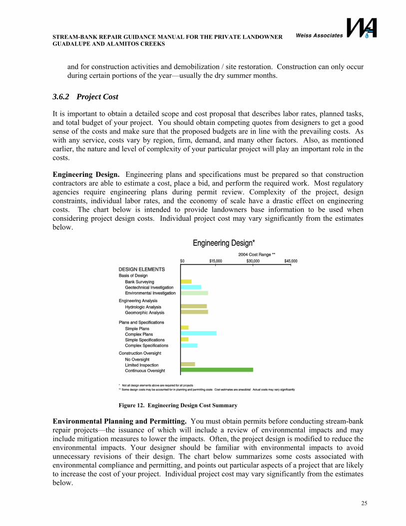
Engineering Design. Engineering plans and specifications must be prepared so that construction contractors are able to estimate a cost, place a bid, and perform the required work. Most regulatory agencies require engineering plans during permit review. Complexity of the project, design constraints, individual labor rates, and the economy of scale have a drastic effect on engineering costs. The chart below is intended to provide landowners base information to be used when considering project design costs. Individual project cost may vary significantly from the estimates below.
Figure 12. Engineering Design Cost Summary
Environmental Planning and Permitting. You must obtain permits before conducting stream-bank repair projects—the issuance of which will include a review of environmental impacts and may include mitigation measures to lower the impacts. Often, the project design is modified to reduce the environmental impacts. Your designer should be familiar with environmental impacts to avoid unnecessary revisions of their design. The chart below summarizes some costs associated with environmental compliance and permitting, and points out particular aspects of a project that are likely to increase the cost of your project. Individual project cost may vary significantly from the estimates below.

STREAM-BANK REPAIR GUIDANCE MANUAL FOR THE PRIVATE LANDOWNER GUADALUPE AND ALAMITOS CREEKS
26
Figure 13. Environmental Planning and Permitting Cost Summary
Project Construction. For most projects, construction costs are the most significant portion of the overall project costs. Time of year, overall industry demand, proximity to construction materials, and the economy of scale have a huge effect on construction costs. The chart below presents a snapshot of potential construction costs that you may encounter, based on the District’s experience. Individual project cost may vary significantly from the estimates below.
Figure 14. Project Construction Cost Summary
STREAM-BANK REPAIR GUIDANCE MANUAL FOR THE PRIVATE LANDOWNER GUADALUPE AND ALAMITOS CREEKS
27
4. CASE HISTORIES OF STREAM-BANK REPAIR WORK
The District conducts numerous stream-bank repair projects each year as part of their Stream Maintenance Program. In 2003/2004, the District received grant funding to demonstrate how proper stream-bank repair can reduce mercury loading in the Guadalupe River Watershed. The District identified candidate projects, and ultimately selected two that would reduce mercury loading by sediment removal and bioengineering repair techniques.
The first project was completed in 2003 along Alamitos Creek downstream of Almaden Expressway (Almaden Expressway). The second was completed in 2004 along Alamitos Creek upstream of Graystone Lane (Graystone Lane).
The construction activities for these projects are detailed in the following sections.
4.1 Demonstration Project Permitting In 2001, the District obtained multi-year permits to conduct routine maintenance activities in waterways within its jurisdiction. An Environmental Impact Report was prepared for the Stream Maintenance Program to comply with CEQA. Routine maintenance is defined as regular practices, such as sediment removal and erosion control, implemented using Best Management Practices on a recurring basis. The goal of the demonstration projects was to show how routine maintenance techniques reduce mercury loading, thus the demonstration projects were performed in accordance with permits already obtained by the District.
You, as a landowner conducting work on private land, will not be able to perform maintenance projects under the general permit obtained by the District. Thus, you will need to obtain individual permits from regulatory agencies and comply with CEQA (see Section 3.3).
4.2 Almaden Expressway Project
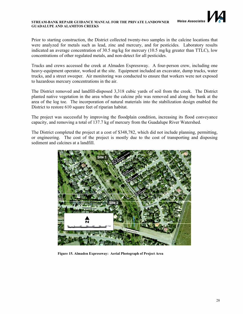
The District identified two sites along Alamitos Creek, downstream of Almaden Expressway, where calcine deposits were located. Site 1 included a calcine deposit along the east side of the stream-bank and a calcine mound in the floodplain. Site 2 included a calcine deposit upstream of Site 1 on the east side of the stream-bank. The aerial photograph below shows the site locations relative to Almaden Expressway.
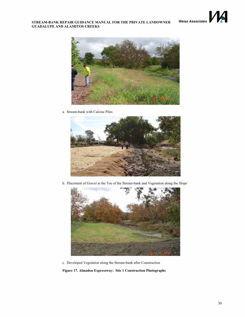
The District evaluated the flow conditions at Sites 1 and 2 and determined that the calcine piles could be removed to reduce mercury in the floodplain and that some bank stabilization would be required to stabilize the eastern stream-banks. District engineers determined that a gravel and cobble mix would be required at the toe for stabilization and that vegetation along the floodplain would be sufficient to stabilize areas above normal creek flow. As-built construction drawings and photographs are included below.
STREAM-BANK REPAIR GUIDANCE MANUAL FOR THE PRIVATE LANDOWNER GUADALUPE AND ALAMITOS CREEKS
28
Prior to starting construction, the District collected twenty-two samples in the calcine locations that were analyzed for metals such as lead, zinc and mercury, and for pesticides. Laboratory results indicated an average concentration of 30.5 mg/kg for mercury (10.5 mg/kg greater than TTLC), low concentrations of other regulated metals, and non-detect for all pesticides.
Trucks and crews accessed the creek at Almaden Expressway. A four-person crew, including one heavy-equipment operator, worked at the site. Equipment included an excavator, dump trucks, water trucks, and a street sweeper. Air monitoring was conducted to ensure that workers were not exposed to hazardous mercury concentrations in the air.
The District removed and landfill-disposed 3,318 cubic yards of soil from the creek. The District planted native vegetation in the area where the calcine pile was removed and along the bank at the area of the log toe. The incorporation of natural materials into the stabilization design enabled the District to restore 610 square feet of riparian habitat.
The project was successful by improving the floodplain condition, increasing its flood conveyance capacity, and removing a total of 137.7 kg of mercury from the Guadalupe River Watershed.
The District completed the project at a cost of $348,782, which did not include planning, permitting, or engineering. The cost of the project is mostly due to the cost of transporting and disposing sediment and calcines at a landfill.
Figure 15. Almaden Expressway: Aerial Photograph of Project Area

STREAM-BANK REPAIR GUIDANCE MANUAL FOR THE PRIVATE LANDOWNER GUADALUPE AND ALAMITOS CREEKS
29
a. Calcine Pile Removal at Site 1
b. Calcine Pile Removal at Site 2
c. Stream-bank Repair Using Gravel/Cobble Toe
Figure 16. Almaden Expressway: Site 1 “As-built” Construction Drawings
STREAM-BANK REPAIR GUIDANCE MANUAL FOR THE PRIVATE LANDOWNER GUADALUPE AND ALAMITOS CREEKS
30
a. Stream-bank with Calcine Piles
b. Placement of Gravel at the Toe of the Stream-bank and Vegetation along the Slope
c. Developed Vegetation along the Stream-bank after Construction
Figure 17. Almaden Expressway: Site 1 Construction Photographs
STREAM-BANK REPAIR GUIDANCE MANUAL FOR THE PRIVATE LANDOWNER GUADALUPE AND ALAMITOS CREEKS
31
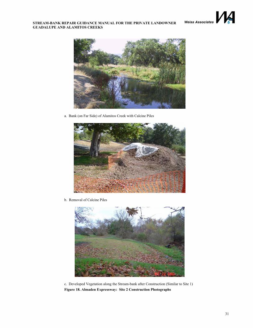
a. Bank (on Far Side) of Alamitos Creek with Calcine Piles
b. Removal of Calcine Piles
c. Developed Vegetation along the Stream-bank after Construction (Similar to Site 1) Figure 18. Almaden Expressway: Site 2 Construction Photographs
STREAM-BANK REPAIR GUIDANCE MANUAL FOR THE PRIVATE LANDOWNER GUADALUPE AND ALAMITOS CREEKS
32
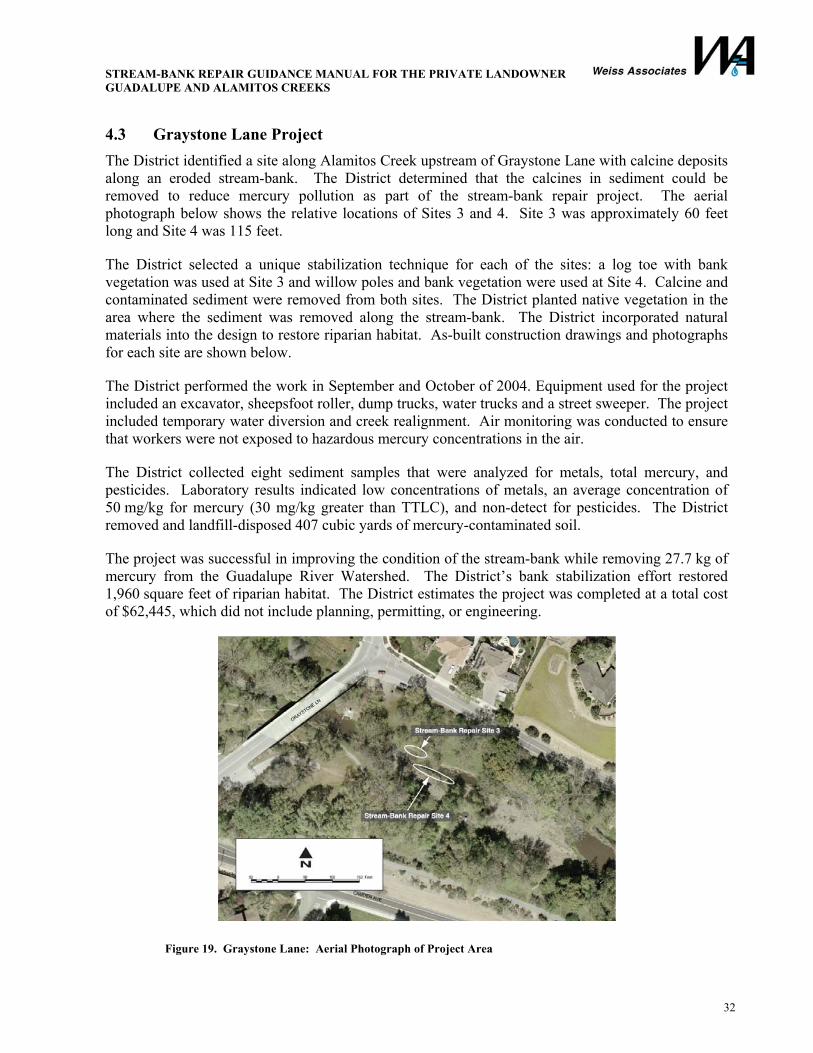
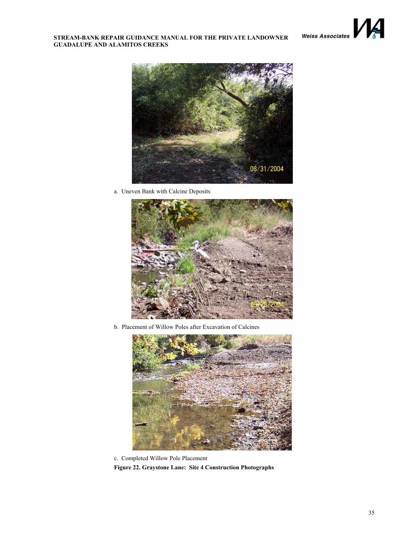
4.3 Graystone Lane Project The District identified a site along Alamitos Creek upstream of Graystone Lane with calcine deposits along an eroded stream-bank. The District determined that the calcines in sediment could be removed to reduce mercury pollution as part of the stream-bank repair project. The aerial photograph below shows the relative locations of Sites 3 and 4. Site 3 was approximately 60 feet long and Site 4 was 115 feet.
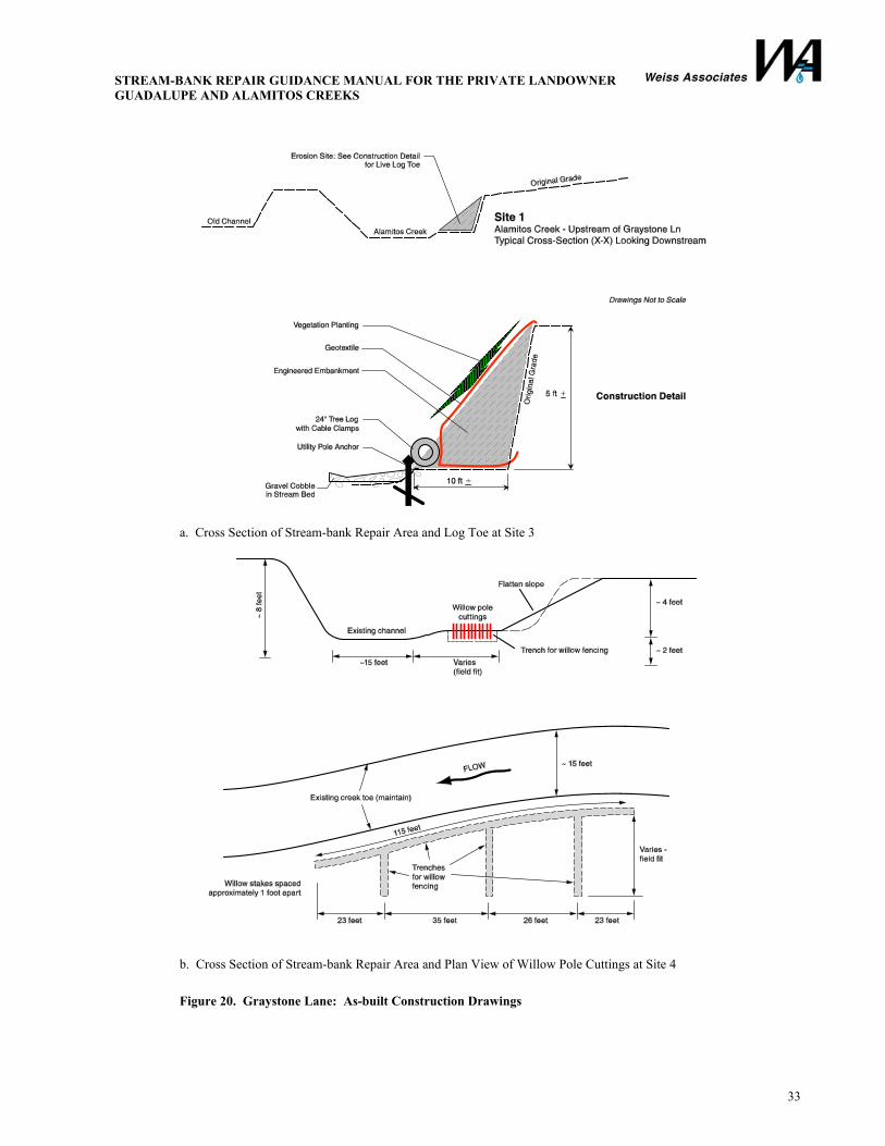
The District selected a unique stabilization technique for each of the sites: a log toe with bank vegetation was used at Site 3 and willow poles and bank vegetation were used at Site 4. Calcine and contaminated sediment were removed from both sites. The District planted native vegetation in the area where the sediment was removed along the stream-bank. The District incorporated natural materials into the design to restore riparian habitat. As-built construction drawings and photographs for each site are shown below.
The District performed the work in September and October of 2004. Equipment used for the project included an excavator, sheepsfoot roller, dump trucks, water trucks and a street sweeper. The project included temporary water diversion and creek realignment. Air monitoring was conducted to ensure that workers were not exposed to hazardous mercury concentrations in the air.
The District collected eight sediment samples that were analyzed for metals, total mercury, and pesticides. Laboratory results indicated low concentrations of metals, an average concentration of 50 mg/kg for mercury (30 mg/kg greater than TTLC), and non-detect for pesticides. The District removed and landfill-disposed 407 cubic yards of mercury-contaminated soil.
The project was successful in improving the condition of the stream-bank while removing 27.7 kg of mercury from the Guadalupe River Watershed. The District’s bank stabilization effort restored 1,960 square feet of riparian habitat. The District estimates the project was completed at a total cost of $62,445, which did not include planning, permitting, or engineering.
Figure 19. Graystone Lane: Aerial Photograph of Project Area
STREAM-BANK REPAIR GUIDANCE MANUAL FOR THE PRIVATE LANDOWNER GUADALUPE AND ALAMITOS CREEKS
33
a. Cross Section of Stream-bank Repair Area and Log Toe at Site 3
b. Cross Section of Stream-bank Repair Area and Plan View of Willow Pole Cuttings at Site 4
Figure 20. Graystone Lane: As-built Construction Drawings
STREAM-BANK REPAIR GUIDANCE MANUAL FOR THE PRIVATE LANDOWNER GUADALUPE AND ALAMITOS CREEKS
34
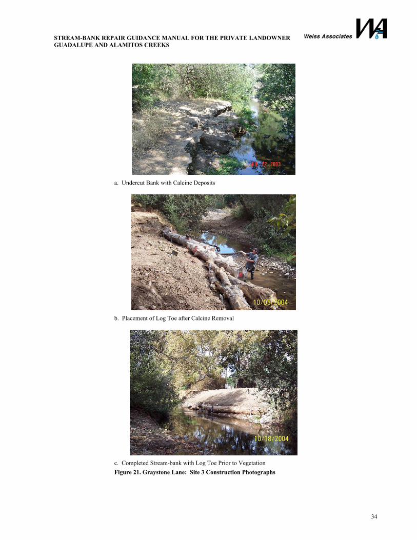
a. Undercut Bank with Calcine Deposits
b. Placement of Log Toe after Calcine Removal
c. Completed Stream-bank with Log Toe Prior to Vegetation Figure 21. Graystone Lane: Site 3 Construction Photographs
STREAM-BANK REPAIR GUIDANCE MANUAL FOR THE PRIVATE LANDOWNER GUADALUPE AND ALAMITOS CREEKS
35
a. Uneven Bank with Calcine Deposits
b. Placement of Willow Poles after Excavation of Calcines
c. Completed Willow Pole Placement Figure 22. Graystone Lane: Site 4 Construction Photographs
STREAM-BANK REPAIR GUIDANCE MANUAL FOR THE PRIVATE LANDOWNER GUADALUPE AND ALAMITOS CREEKS
36
5. BIBLIOGRAPHY AND REFERENCES
California Department of Conservation, Office of Mine Reclamation, June 2000. California’s Abandoned Mines: A Report on the Magnitude and Scope of the Issue in the State, Volume I.
CalEPA Department of Toxic Substance Control, October 2001. Draft Mercury Report.
California Department of Transportation (CALTRANS), May 1, 2001. Chapter 870: Channel and Shore Protection-Erosion Control In Highway Design Manual.
California Regional Water Quality Control Board, April 30, 2004. Mercury in San Francisco Bay: Total Maximum Daily Load (TMDL) Proposed Basin Plan Amendment.
Code of Federal Regulations, Title 29 – Occupational Health and Safety Administration, Section 1910 – Hazardous Waste Operations and Emergency Response.
Franti, Thomas G. Surface Waters Management Specialist, Bioengineering for Hillslope, Streambank and Lakeshore Erosion Control. http://ianrpubs.unl.edu/soil/g1307.htm
Province of British Columbia, 1995. The Streamkeepers Handbook: A Practical Guide to Stream and Wetland Care.
San Francisco Bay Area Regional Water Quality Control Board, April 2003. A Primer on Stream and River Protection For the Regulator and Program Manager. Technical Reference Circular W. D. 02 - #1.
Santa Clara Valley Water District, May 17, 2002. Best Management Practices under the Stream Maintenance Program. Stream Maintenance Program.
Santa Clara Valley Water District, Bank Protection Program: Appendix for Bank Protection Measures.
Tetra Tech, Inc., June 7, 2004. Technical Memorandum 4.3: Draft Final Conceptual Model Report. Guadalupe River Watershed Mercury TMDL Project, Agreement No. A2643G.
UK River Restoration Center, A Manual of River Restoration Techniques.
US Army Corps of Engineers, October 15, 1993. Engineer Manual, Engineering and Design, River Hydraulics. EM 110-2-1416.
US Army Corps of Engineers, March 1995. Application of Methods and Models for Prediction of Land Surface Erosion and Yield. Hydraulic Engineering Center.
US Army Corps of Engineers, April 1997. Bioengineering for Streambank Erosion Control: Report 1, Guidelines.” (USACE), Waterways Experiment Station, Technical Report EL-97-8. Allen, Hollis H., and James R. Leech.
US Department of Transportation, December 2001. River Engineering for Highway Encroachments, Chapter 6: River Stabilization and Bank Protection.
United States Department of Agriculture (USDA) Natural Resources Conservation Service, Plant Materials Center, May 1998. The Practical Streambank Bioengineering Guide: User’s Guide for Natural Streambank Stabilization Techniques in the Arid and Semi-Arid Great Basin and Intermountain West. Bengrup, Gary, and J. Chris Hoag, Aberdeen, Idaho.
STREAM-BANK REPAIR GUIDANCE MANUAL FOR THE PRIVATE LANDOWNER GUADALUPE AND ALAMITOS CREEKS
APPENDIX A
MERCURY LOAD REDUCTION REPORTING FORM
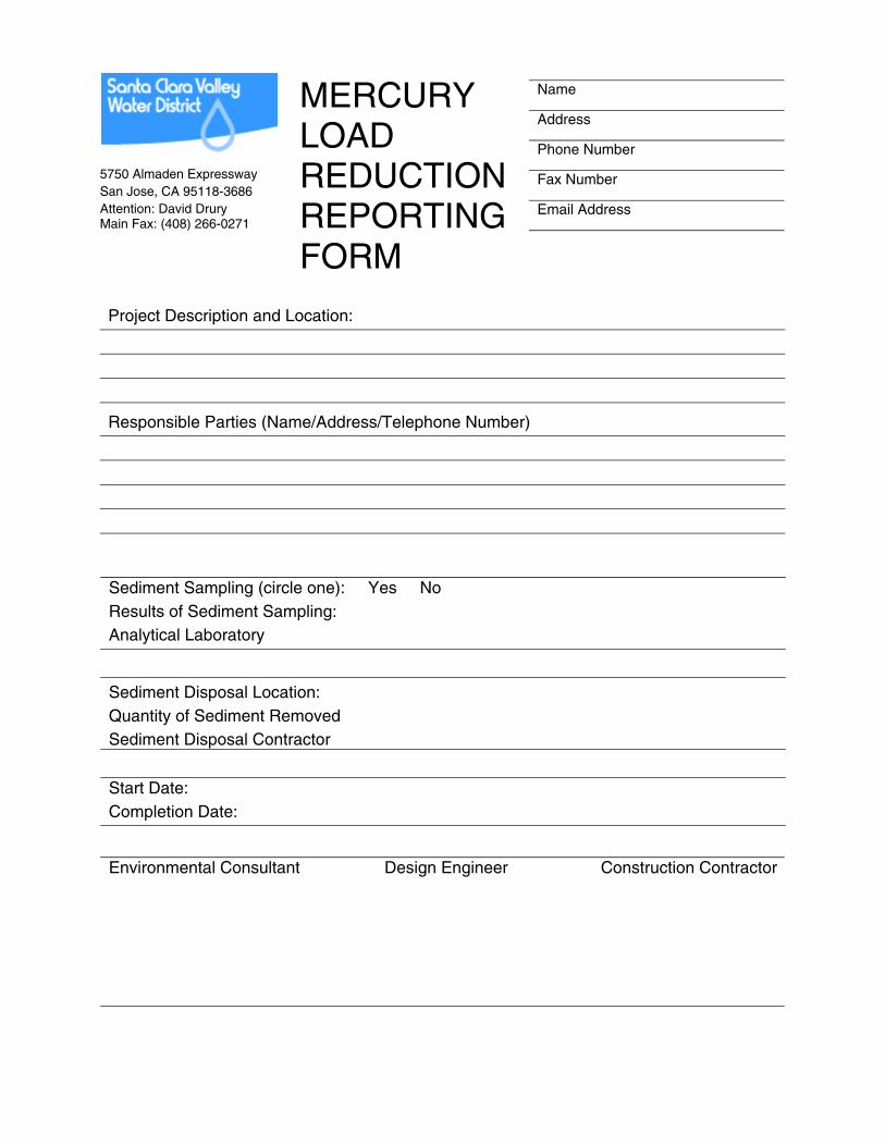
Name
Address
Phone Number
Fax Number
Email Address
MERCURY LOAD REDUCTION REPORTING FORM
Project Description and Location:
Responsible Parties (Name/Address/Telephone Number)
Environmental Consultant Design Engineer Construction Contractor
5750 Almaden Expressway San Jose, CA 95118-3686 Attention: David Drury Main Fax: (408) 266-0271
Sediment Sampling (circle one): Yes No Results of Sediment Sampling: Analytical Laboratory
Sediment Disposal Location: Quantity of Sediment Removed Sediment Disposal Contractor
Start Date: Completion Date:

STREAM-BANK REPAIR GUIDANCE MANUAL FOR THE PRIVATE LANDOWNER GUADALUPE AND ALAMITOS CREEKS
APPENDIX B
PERMITTING AGENCIES
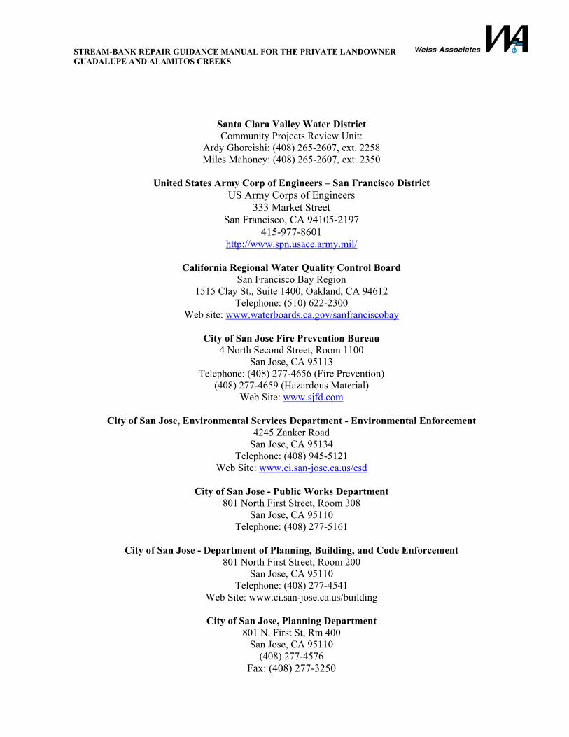
STREAM-BANK REPAIR GUIDANCE MANUAL FOR THE PRIVATE LANDOWNER GUADALUPE AND ALAMITOS CREEKS
Santa Clara Valley Water District Community Projects Review Unit:
Ardy Ghoreishi: (408) 265-2607, ext. 2258 Miles Mahoney: (408) 265-2607, ext. 2350
United States Army Corp of Engineers – San Francisco District
US Army Corps of Engineers 333 Market Street
San Francisco, CA 94105-2197 415-977-8601
http://www.spn.usace.army.mil/
California Regional Water Quality Control Board San Francisco Bay Region
1515 Clay St., Suite 1400, Oakland, CA 94612 Telephone: (510) 622-2300
Web site: www.waterboards.ca.gov/sanfranciscobay
City of San Jose Fire Prevention Bureau 4 North Second Street, Room 1100
San Jose, CA 95113 Telephone: (408) 277-4656 (Fire Prevention)
(408) 277-4659 (Hazardous Material) Web Site: www.sjfd.com
City of San Jose, Environmental Services Department - Environmental Enforcement
4245 Zanker Road San Jose, CA 95134
Telephone: (408) 945-5121 Web Site: www.ci.san-jose.ca.us/esd
City of San Jose - Public Works Department
801 North First Street, Room 308 San Jose, CA 95110
Telephone: (408) 277-5161
City of San Jose - Department of Planning, Building, and Code Enforcement 801 North First Street, Room 200
San Jose, CA 95110 Telephone: (408) 277-4541
Web Site: www.ci.san-jose.ca.us/building
City of San Jose, Planning Department 801 N. First St, Rm 400
San Jose, CA 95110 (408) 277-4576
Fax: (408) 277-3250
STREAM-BANK REPAIR GUIDANCE MANUAL FOR THE PRIVATE LANDOWNER GUADALUPE AND ALAMITOS CREEKS
APPENDIX C
GLOSSARY OF TERMS
STREAM-BANK REPAIR GUIDANCE MANUAL FOR THE PRIVATE LANDOWNER GUADALUPE AND ALAMITOS CREEKS
GLOSSARY
algael: pertaining to algae
allelopathic: the inhibition of growth in one species of plants by chemicals produced by another species
anoxic condition: without oxygen
anthropogenic: man made
bank zone: zone near bank of waterway
bioaccumulation: the accumulation of a substance in various tissues of a living organism
BMP: best management practices
calcines: spent ore after mercury is reclaimed
channel meanders: to move or cause to move in a sinuous, spiral, or circular manner
channelization: to make into a channel
cinnabar: a heavy reddish mercury sulfide, HgS, which is the principal ore of mercury
Clean Water Act (CWA): a federal law that establishes the basic structure for regulating discharges of pollutants into the waters of the United States.
Compensatory Mitigation: A process where new wetlands are created to replace ones that have been removed.
Geomorphology: the study of the evolutional configuration of landforms
Hydrodynamics: a branch of science that deals with the dynamics of fluids in motion
infiltration basins: area where water is allowed to infiltrate into the water table or evaporate
In Situ sampling: in place, minimally disturbed sampling
leachate test: a test that approximates leaching behavior in landfills
mercury sulfide: the principal ore of mercury
methyl mercury: a form of mercury that is taken up by plant and aquatic life and accumulates in fish
methylation: the process by which inorganic mercury becomes methyl mercury
mitigation: to reduce the effects of an action
rodenticides: chemicals use to reduce population of unwanted rodents
salmonids: members of the family Salmonidae, such as Atlantic salmon, rainbow trout, etc.
splash zone: area susceptible to splashing
stockpile: to place material into a pile for use later
strata: a layer of soil
stratification: layering of soil
terrace zone: upper perched zone of soil
toe zone: bottom of a slope
tributaries: in the context of water, a stream or creek that feeds into another larger body of water is said to be a tributary
volatilize: to evaporate
water way: as used in this document, a stream, creek or river
watershed: The region draining into a river, river system, or other body of water