final laois kilkenny environmental report the final planning... · environmental report for...
TRANSCRIPT

Environmental Report for Laois-Kilkenny Reinforcement Project
AOS Planning Ltd Page 13 Introduction
2 INTRODUCTION
2.1 PREAMBLE
This Environmental Report has been prepared to accompany a planning application by EirGrid plc to An Bord Pleanála for approval to develop the Laois – Kilkenny Reinforcement Project. This project consists of the following 8 units (see Figure 2.1 for an illustration of the proposal and its component units):
• Unit 1: New 400/110kV GIS substation, Coolnabacky near Portlaoise Co. Laois. • Unit 2: New 400kV line connection to Coolnabacky from the existing Moneypoint-Dunstown
400kV line (c. 1.4km). • Unit 3: New 110kV connection to Coolnabacky substation from the existing Athy-Portlaoise 110kV
line. • Unit 4: A new 110kV / 38kV / MV substation in Moatpark, Ballyragget, Co. Kilkenny adjacent to
the existing 38kV /MV substation. • Unit 5: A new 110kV overhead line between Ballyragget and Coolnabacky (c. 26km). • Unit 6: An uprate to the existing Ballyragget-Kilkenny 110kV overhead line (c. 22km). • Unit 7: A new bay in the existing Kilkenny 110kV station. • Unit 8: Modifications to existing Athy-Portlaoise 110kV line.
2.2 PURPOSE OF THE ENVIRONMENTAL REPORT
The Environmental Report sets out a description of the proposed development, an outline of the main alternatives studied by the developer (and an indication of the main reasons for this choice), a description of aspects of the environment which could be potentially affected by the proposed development, a description of the potential effects of the proposed development on the environment, a description of the forecasting methods used to assess the potential effects on the environment referred to above, a description of the measures envisaged to prevent, reduce and offset any potential adverse effects on the environment and a non-technical summary of this information. In addition, the Environmental Report addresses the concerns identified in the Stage 1 Lead Consultants Report (May 2011), which was carried out for the project and identified the most significant constraints within the study area, and in the Stage 2 Lead Consultants Report (February 2012), which considered the emerging preferred route corridor. It also addresses concerns raised in submissions received during the consultation process. The potential impacts of the operation and construction phases of the proposed development have been assessed and summarised under the following environmental topics:
• Human Beings and Population • Landscape and Visual Impact • Cultural Heritage • Ecology • Soils and Geology • Water (Hydrology and Hydrogeology) • Material Assets • Air and Climatic Factors • Interaction of the foregoing
Mitigation measures have been integrated into the project with a preference given to measures that avoid potential environmental effects over measures that reduce and remedy potential environmental effects. Assessments were carried out on the basis of available access and information, i.e. on the basis of conditions that could be reasonably viewed or inferred from aerial photography, published reports and direct observation during site visits.

Environmental Report for Laois-Kilkenny Reinforcement Project
AOS Planning Ltd Page 14 Introduction
Figure 2.1 Layout of Project Units

Environmental Report for Laois-Kilkenny Reinforcement Project
AOS Planning Ltd Page 15 Introduction
The study team commissioned to prepare this Environmental Report is listed below: Role Personnel Company Lead Consultant Shane McLoughney ESBI ER Manager Ciara Kellett/David L’Estrange AOS Planning Specialist Topics Human Beings and Population
Ciara Kellett AOS Planning
Flora and Fauna Dr. Patrick Crushell Wetland Surveys Ireland Soils, Geology and Hydrogeology
Brian Tiernan AWN Consulting
Water and Hydrology Brian Tiernan AWN Consulting
Air Quality and Climate Rose Walsh ESBI Noise and Vibration Rose Walsh, Jarlath Doyle, Eugene
McKeown, Paddy Kavanagh ESBI
Landscape and Visual Impact Conor Skehan Environmental Impact Services
Waste Management Rose Walsh ESBI Traffic Rose Walsh & Aecom ESBI Cultural Heritage Miriam Carroll and Annette Quinn Tobar Archaeological
Services Interactions & Cumulative Effects
All Consultants
Table 2.1 Study Team Commissioned to Prepare this Report
2.3 OUTLINE DESCRIPTION OF PROJECT
As detailed above the proposed Laois – Kilkenny Reinforcement Project will consist of 8 units. The following are detailed description of these units. Photographs are provided at the end of this section to illustrate some of the infrastructure being described.
2.3.1 UNIT 1 ‘NEW 400/110KV GIS SUBSTATION, ‘COOLNABACKY’ NEAR PORTLAOISE CO. LAOIS.’
This substation is proposed in a 6.7 hectares field in the townland of Coolnabacky near the town of Timahoe, Co. Laois. The substation installation will consist of two steel framed buildings within a 117m x 98m plan area secured by a 2.6m high palisade fence. One of the buildings will house the 400 kV switchgear (electrical equipment) whilst the other building will house the 110kV switchgear (electrical equipment). A 400kV gantry and associated line equipment will be required to divert the 400kV overhead lines into the 400kV GIS building. The support gantrys will be located outdoors behind the 400kV building. The installation also includes two 400/110kV, 500MVA transformers and two shunt reactors. These will be positioned in bunded enclosures between the two steel framed buildings. The enclosures shall be (plan area 25m x 10m each) for transformers and (plan area 14m x 10m each) for shunt reactors. Both shall be surrounded on three sides by fire walls approximately 10m high. The 400kV indoor station (building dimensions 64m x 15.3m x 12m) will be equipped with 8 bays (2 no. lines (Moneypoint & Dunstown), 2 no. transformers, 2 shunt reactors, and 2 spare bays). The 110kV indoor station (building dimensions 50m x 11.5m x 12m) will also be equipped with 8 bays (3 no. lines (Athy, Portlaoise, Ballyragget), 2 no. transformers and 3 spare bays).

Environmental Report for Laois-Kilkenny Reinforcement Project
AOS Planning Ltd Page 16 Introduction
It is proposed to store excavated material on site in the form of berms. The berms volume will be approximately 11000m³ over a plan area of 5000m². It is proposed that 8 separate sedimentation/attenuation ponds (average area 110m²) will be constructed on site. A group of 4 northwest of the substation and 4 to the east of the compound. Two of these ponds will be used temporarily to treat the runoff from the berm, with the remaining 6 used to treat surface water being discharged from the compound prior to entry into the water streams. The proposed access to the station shall be via a modification to the existing road (that currently serves a farmstead with dwelling and a disused sand/gravel quarry near the station site) in the townlands of Esker and Coolnabacky. The access road will be 1.2km (total area = 0.865Ha) from the R426 (public road) to the substation compound gates (bringing the total development area for Coolnabacky 400/110kV substation to 7.6 hectares). The modifications to the existing road shall include:
• Moving the junction (at the public road) south by 25m with 160m of new access road to be created to accommodate this new junction.
• Expansion of an existing bend to accommodate turning circles of large vehicles. • New section of road 250m through land owner’s property to accommodate large vehicles.

Environmental Report for Laois-Kilkenny Reinforcement Project
AOS Planning Ltd Page 17 Introduction
Figure 2.2 Outline of the Proposed Coolnabacky Substation
2.3.2 UNIT 2 ‘NEW 400KV LINE CONNECTION TO COOLNABACKY FROM THE EXISTING MONEYPOINT-DUNSTOWN 400KV LINE’
The connection to the proposed Coolnabacky substation from the Moneypoint – Dunstown 400kV line will be made by way of 400kV overhead line. This will be achieved by 2 new single circuit spans (280m and 295 m respectively) connecting to 1.2km of 400kV double circuit line which brings the 400kV circuits onto a support gantry in Coolnabacky 400/110kV substation. The proposal includes 2 new 400kV single circuit angle masts (MDC2 & MDC8) of heights 37.25m & 32.25m respectively, 2 new 400kV double circuit angle masts (MDC3 & MDC7) both 55.5m in height and three new 400kV intermediate masts (MDC4, MDC5 & MDC6) all 57.75m in height. One of the existing 400kV intermediate masts on the existing 400 kV line and approximately 150m of 400kV overhead line between the 2 connection points to the Moneypoint – Dunstown 400kV line will be removed. The line and structure positions were selected to minimise impact on the environment by paralleling an existing transmission line and avoiding locating support structures in hedges. This line route is also the

Environmental Report for Laois-Kilkenny Reinforcement Project
AOS Planning Ltd Page 18 Introduction
shortest possible – see figure 2.1. This 'unit' is necessary to connect the existing 400 kV line into the new 400/110 kV substation
Figure 2.3 Photomontage of the proposed 400kV connection to Coolnabacky Substation
2.3.3 UNIT 3 ‘NEW CONNECTION TO COOLNABACKY FROM THE EXISTING ATHY-PORTLAOISE 110KV LINE’
The proposed Coolnabacky substation is situated beside the Athy – Portlaoise 110kV line. It is proposed to replace intermediate polesets AP98 and AP99 with lattice steel line/cable interface masts approximately 21m in height (both these structures contained on the Coolnabacky site). Short lengths of cable will connect the new line/cable interface masts AP98 (100m) and AP99 (190m) into the 110kV building within the Coolnabacky compound – see figure 2.1. Approximately 150m of existing overhead line will be removed between AP98 and AP99. This 'unit' is necessary to connect the existing 110 kV line into the new 400/110 kV substation.

Environmental Report for Laois-Kilkenny Reinforcement Project
AOS Planning Ltd Page 19 Introduction
Figure 2.4 Photograph of a 110kV earthwire line/cable interface mast (used whenever a circuit converts from an overhead line to an underground cable).
2.3.4 UNIT 4 ‘A NEW 110KV / 38KV / MV SUBSTATION IN BALLYRAGGET, CO. KILKENNY ADJACENT TO AND REPLACING THE EXISTING 38KV /MV SUBSTATION WHICH WILL BE DECOMMISSIONED’
The new Ballyragget 110kV / 38kV / MV substation will be constructed adjacent to the existing 38kV /MV substation in the townland of Moatpark near Ballyragget. The site area is approx. 1.5 hectares. The existing 38kV / MV Ballyragget substation will ultimately be decommissioned and replaced. This new substation will be in a compound of 61m x 70m plan area secured by a 2.6m high palisade fence. The substation compound will contain 1 no. 31.5MVA and 1 no. 5MVA transformer positioned in

Environmental Report for Laois-Kilkenny Reinforcement Project
AOS Planning Ltd Page 20 Introduction
transformer bunds and 1 no. 200A Arc Suspension Coil between the substation buildings. 2 no. lightning masts 14m in height will also be placed in the compound. The 110 kV electrical swtichgear equipment will be housed in a steel framed building (dimensions 50m x 11.5m by 12m high) designed for 6 no. Line Bays, 2 no. Transformer Bays, a coupler Bay and busbar. The 38 kV and MV switchgear equipment will be housed in a block built building (dimensions 24.5m x 8m by 7m high). This building will be designed for 8 no. 38 kV Line Bays, 2 no. 38kV/MV Transformer Bays, 1 no. 38 kV Sectionaliser Bay and 1 no. 38 kV Riser Bay along with 2 no. MV Transformer Bays, 10 no. MV Line Bays, 2 no. MV House Transformer Bays, 1 no. MV Sectionaliser Bay and 1 no. MV Riser Bay. Access to the station will be via a new access road (60m long) from an existing gate to the substation field. The existing gate will be modified by removing sections of hedgerow, chainlink fence and a section of block wall to the left and right to allow the required sightlines to be achieved. The foul water treatment on site will be via a septic tank and percolation area. The surface water treatment on site will be via soakaway areas. On completion and energisation of the new Ballyragget substation the existing 38kV substation will be dismantled. Two of the 38kV end masts in this substation will be retained with line-cable interfacing equipment being mounted on them.
Figure 2.5 Layout of the proposed Ballyragget 110kV/38kV/ MV substation
Environmental Report for Laois-Kilkenny Reinforcement Project
AOS Planning Ltd Page 21 Introduction
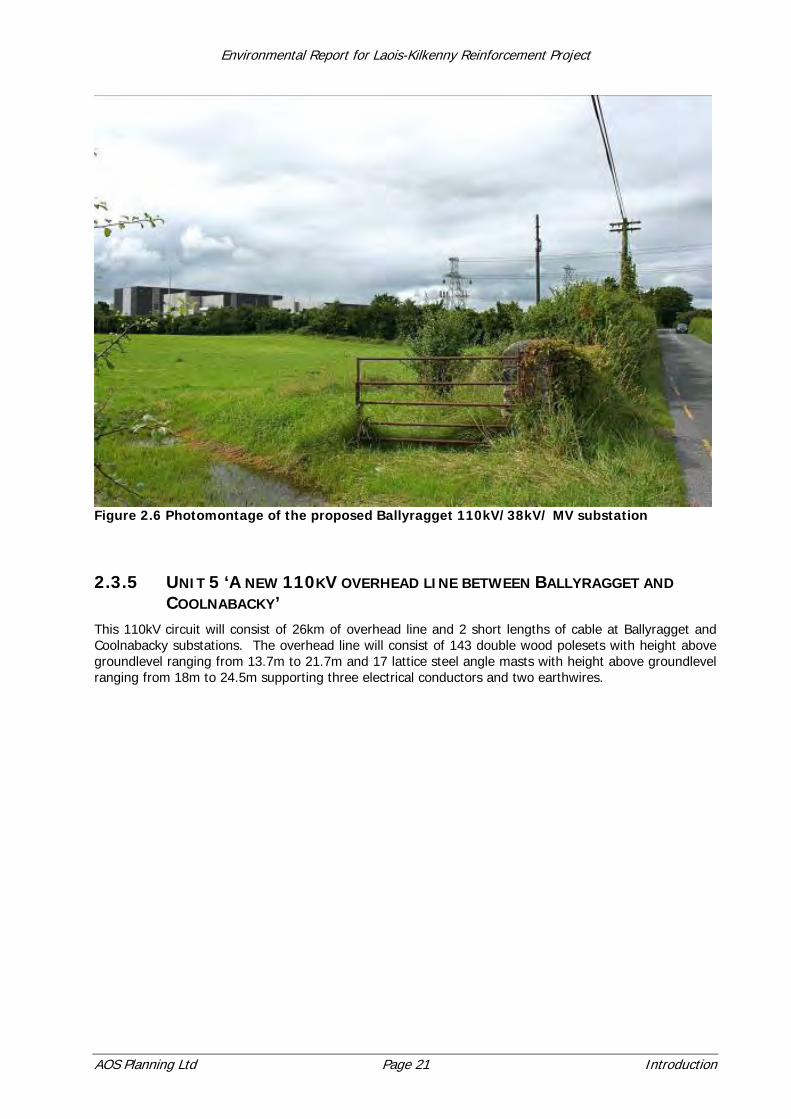
Figure 2.6 Photomontage of the proposed Ballyragget 110kV/38kV/ MV substation
2.3.5 UNIT 5 ‘A NEW 110KV OVERHEAD LINE BETWEEN BALLYRAGGET AND COOLNABACKY’
This 110kV circuit will consist of 26km of overhead line and 2 short lengths of cable at Ballyragget and Coolnabacky substations. The overhead line will consist of 143 double wood polesets with height above groundlevel ranging from 13.7m to 21.7m and 17 lattice steel angle masts with height above groundlevel ranging from 18m to 24.5m supporting three electrical conductors and two earthwires.
Environmental Report for Laois-Kilkenny Reinforcement Project
AOS Planning Ltd Page 22 Introduction
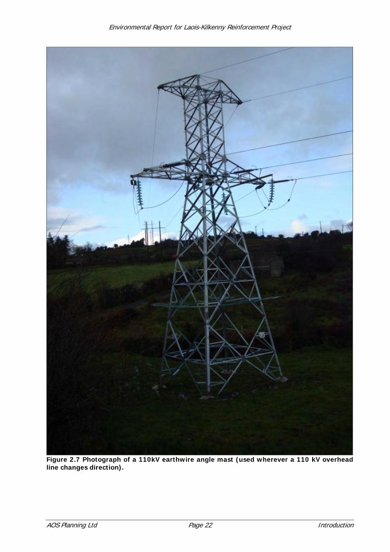
Figure 2.7 Photograph of a 110kV earthwire angle mast (used wherever a 110 kV overhead line changes direction).
Environmental Report for Laois-Kilkenny Reinforcement Project
AOS Planning Ltd Page 23 Introduction
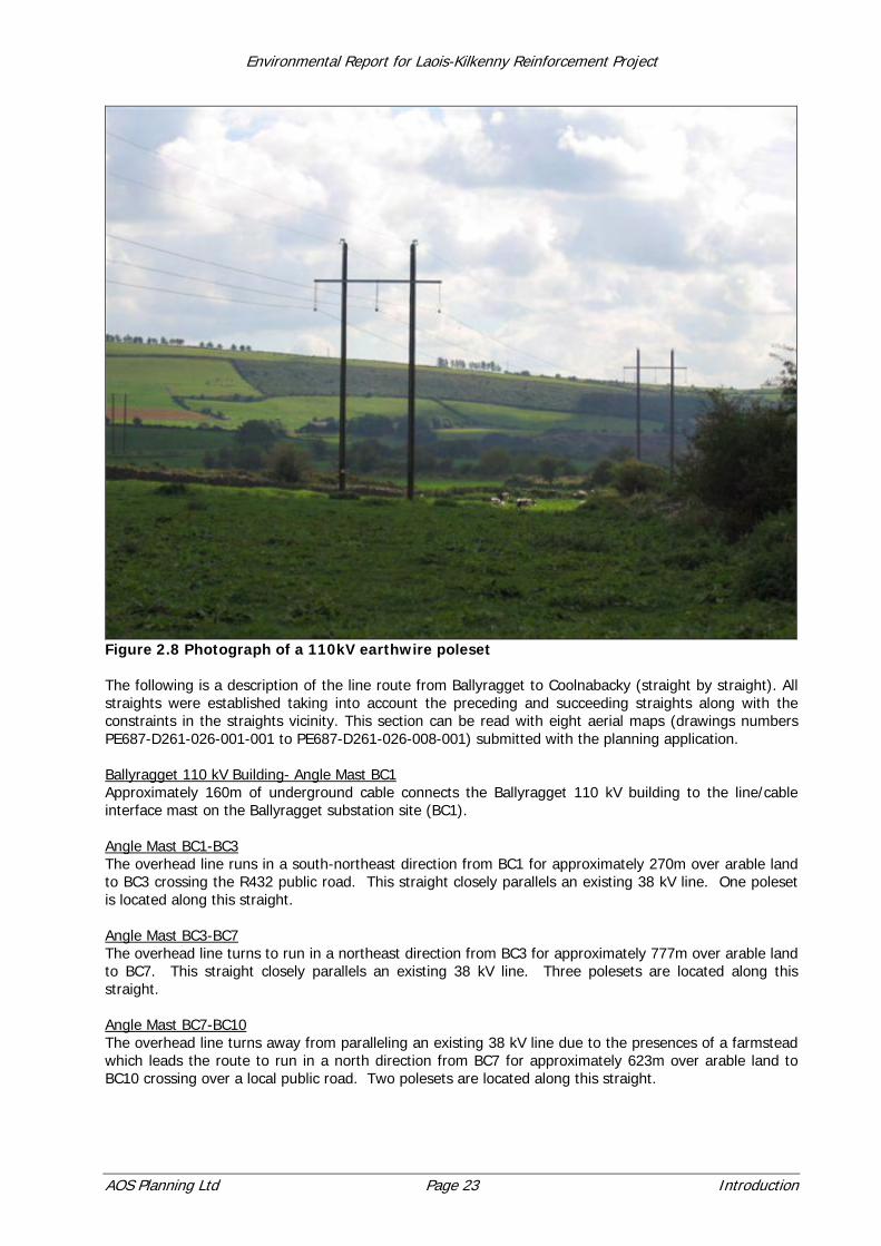
Figure 2.8 Photograph of a 110kV earthwire poleset The following is a description of the line route from Ballyragget to Coolnabacky (straight by straight). All straights were established taking into account the preceding and succeeding straights along with the constraints in the straights vicinity. This section can be read with eight aerial maps (drawings numbers PE687-D261-026-001-001 to PE687-D261-026-008-001) submitted with the planning application. Ballyragget 110 kV Building- Angle Mast BC1 Approximately 160m of underground cable connects the Ballyragget 110 kV building to the line/cable interface mast on the Ballyragget substation site (BC1). Angle Mast BC1-BC3 The overhead line runs in a south-northeast direction from BC1 for approximately 270m over arable land to BC3 crossing the R432 public road. This straight closely parallels an existing 38 kV line. One poleset is located along this straight. Angle Mast BC3-BC7 The overhead line turns to run in a northeast direction from BC3 for approximately 777m over arable land to BC7. This straight closely parallels an existing 38 kV line. Three polesets are located along this straight. Angle Mast BC7-BC10 The overhead line turns away from paralleling an existing 38 kV line due to the presences of a farmstead which leads the route to run in a north direction from BC7 for approximately 623m over arable land to BC10 crossing over a local public road. Two polesets are located along this straight.
Environmental Report for Laois-Kilkenny Reinforcement Project
AOS Planning Ltd Page 24 Introduction
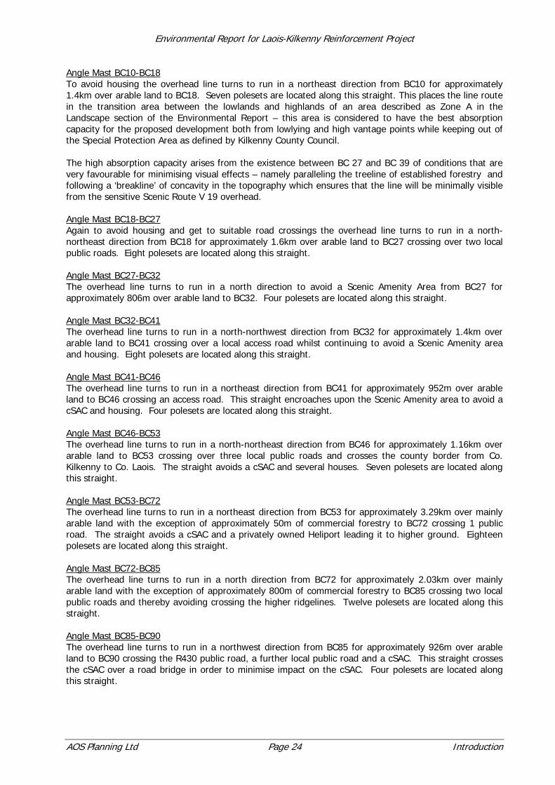
Angle Mast BC10-BC18 To avoid housing the overhead line turns to run in a northeast direction from BC10 for approximately 1.4km over arable land to BC18. Seven polesets are located along this straight. This places the line route in the transition area between the lowlands and highlands of an area described as Zone A in the Landscape section of the Environmental Report – this area is considered to have the best absorption capacity for the proposed development both from lowlying and high vantage points while keeping out of the Special Protection Area as defined by Kilkenny County Council. The high absorption capacity arises from the existence between BC 27 and BC 39 of conditions that are very favourable for minimising visual effects – namely paralleling the treeline of established forestry and following a ‘breakline’ of concavity in the topography which ensures that the line will be minimally visible from the sensitive Scenic Route V 19 overhead. Angle Mast BC18-BC27 Again to avoid housing and get to suitable road crossings the overhead line turns to run in a north-northeast direction from BC18 for approximately 1.6km over arable land to BC27 crossing over two local public roads. Eight polesets are located along this straight. Angle Mast BC27-BC32 The overhead line turns to run in a north direction to avoid a Scenic Amenity Area from BC27 for approximately 806m over arable land to BC32. Four polesets are located along this straight. Angle Mast BC32-BC41 The overhead line turns to run in a north-northwest direction from BC32 for approximately 1.4km over arable land to BC41 crossing over a local access road whilst continuing to avoid a Scenic Amenity area and housing. Eight polesets are located along this straight. Angle Mast BC41-BC46 The overhead line turns to run in a northeast direction from BC41 for approximately 952m over arable land to BC46 crossing an access road. This straight encroaches upon the Scenic Amenity area to avoid a cSAC and housing. Four polesets are located along this straight. Angle Mast BC46-BC53 The overhead line turns to run in a north-northeast direction from BC46 for approximately 1.16km over arable land to BC53 crossing over three local public roads and crosses the county border from Co. Kilkenny to Co. Laois. The straight avoids a cSAC and several houses. Seven polesets are located along this straight. Angle Mast BC53-BC72 The overhead line turns to run in a northeast direction from BC53 for approximately 3.29km over mainly arable land with the exception of approximately 50m of commercial forestry to BC72 crossing 1 public road. The straight avoids a cSAC and a privately owned Heliport leading it to higher ground. Eighteen polesets are located along this straight. Angle Mast BC72-BC85 The overhead line turns to run in a north direction from BC72 for approximately 2.03km over mainly arable land with the exception of approximately 800m of commercial forestry to BC85 crossing two local public roads and thereby avoiding crossing the higher ridgelines. Twelve polesets are located along this straight. Angle Mast BC85-BC90 The overhead line turns to run in a northwest direction from BC85 for approximately 926m over arable land to BC90 crossing the R430 public road, a further local public road and a cSAC. This straight crosses the cSAC over a road bridge in order to minimise impact on the cSAC. Four polesets are located along this straight.

Environmental Report for Laois-Kilkenny Reinforcement Project
AOS Planning Ltd Page 25 Introduction
Angle Mast BC90-BC112 The overhead line turns to run in a north-northeast direction from BC90 for approximately 4.13km over mainly arable land with the exception of approximately 940m of commercial forestry to BC112 crossing one local road. This straight has a low amount of constraints which allows for a long straight. Twenty one polesets are located along this straight. Angle Mast BC112-BC117 The overhead line turns to run in a northwest direction from BC112 for approximately 770m over arable land to BC117 crossing a local regional public road. This straight establishes a suitable road crossing point while avoiding housing associated views towards the Special Area of Development Control. Four polesets are located along this straight. Angle Mast BC117-BC141 The overhead line turns to run in a north-northeast direction from BC117 for approximately 4.28km over mainly arable land with the exception of approximately 835m of commercial forestry to BC141 crossing two public roads. This straight has a low amount of constraints which allows for a long straight and is influenced by housing at road crossings. Twenty three polesets are located along this straight. Angle Mast BC141-BC150 The overhead line turns to run in an east direction from BC141 for approximately 1.6km over arable land to BC150 (in the Coolnabacky substation site) crossing the R426 public road. This straight also has a low amount of constraints which allows for a long straight and is influenced by housing at road crossings. Eight polesets are located along this straight. Angle Mast BC150-Coolnabacky 110 kV Building Approximately 190m of underground cable connects the line/cable interface mast on the site (BC150) to the 110 kV building in the Coolnabacky compound. The structures proposed can be identified using the Detail Description Schedule document (Volume 1, doc number: PE687-F0261-R261-018-001) to establish the correct structure drawing. All relevant structure drawings are included in the planning application.
2.3.6 UNIT 6 ‘AN UPRATE TO THE EXISTING BALLYRAGGET-KILKENNY 110KV OVERHEAD LINE’
This section will consist of the replacement of all the structures along the existing line with similar structures along the same alignment. The 110kV circuit will consist of 21.9km of overhead line and 2 short lengths of cable at Ballyragget and Kilkenny substations. The overhead line will consist of 90 double woodpole structures with height above groundlevel ranging from 13.7m to 21.7m and 14 lattice steel angle masts with height above groundlevel ranging from 13m to 24.5m supporting three electrical conductors. For approximately the first 1.73km out of Ballyragget and approximately the first 1.84km out of Kilkenny the structures will support three electrical conductors and two earthwires.

Environmental Report for Laois-Kilkenny Reinforcement Project
AOS Planning Ltd Page 26 Introduction
Figure 2.9 Photograph of a 110kV non-earthwire angle mast

Environmental Report for Laois-Kilkenny Reinforcement Project
AOS Planning Ltd Page 27 Introduction
Figure 2.10 Photograph of a 110kV non-earthwire poleset The following is a description of the line route from Ballyragget to Kilkenny (straight by straight). The majority of this line route is on the existing Ballyragget – Kilkenny alignment. This section can be read with eight aerial maps (drawings numbers PE687-D261-026-001-001 to PE687-D261-026-008-001) submitted with the planning application. Ballyragget 110kV Building-Angle Mast BK1 Approximately 215m of underground cable connects the Ballyragget 110kV building to the line/cable interface mast (BK1) proposed in private lands across the R432 public road. Approximately 35m of the cable will be outside the ESB owned site. Angle Mast BK1-BK4 The overhead line runs in an east direction from BK1 for approximately 580m over arable land to BK4 crossing over an abandoned railway line. Two polesets are located along this straight. This straight is first of two straights that do not follow the original alignment. Angle Mast BK4-BK11 The overhead line turns clockwise to run in a southeast direction from BK4 for approximately 1.14km over arable land to BK11 crossing over a local public road and the R694 public road. Six polesets are located along this straight. Angle Mast BK11-BK19 The overhead line turns clockwise to run in a south direction from BK11 for approximately 1.42km over arable land to BK19 crossing over a local public road. Seven polesets are located along this straight.
Environmental Report for Laois-Kilkenny Reinforcement Project
AOS Planning Ltd Page 28 Introduction
Angle Mast BK19-BK40 The overhead line turns anticlockwise to run in a south-southeast direction from BK19 for approximately 4.67km over arable land to BK40 crossing over four local public roads and two access roads. Twenty polesets are located along this straight. Angle Mast BL40-BK46 The overhead line turns anticlockwise to run in a southeast direction from BK40 for approximately 1.21km over arable land to BK46. Five polesets are located along this straight. Angle Mast BK46-BK51 The overhead line turns clockwise to run in a south-southeast direction from BK46 for approximately 1.23km over arable land to BK51 crossing over a local public road, the N78 public road, the Dinin River and a cSAC at two locations. Four polesets are located along this straight. Angle Mast BK51-BK62 The overhead line turns clockwise to run in a south-southeast direction from BK51 for approximately 2.62km over arable land to BK62 crossing one local public road. Ten polesets are located along this straight. Angle Mast BK62-BK71 The overhead line turns anticlockwise to run in a southeast direction from BK62 for approximately 1.99km over arable land to BK71 crossing two local public roads and a local access road. Eight polesets are located along this straight. Angle Mast BK71-BK79 The overhead line turns clockwise to run in a south-southeast direction from BK71 for approximately 1.72km over arable land to BK79. Seven polesets are located along this straight. Angle Mast BK79-BK89 The overhead line turns anticlockwise to run in a south-southeast direction from BK79 for approximately 2.3km over arable land to BK89 crossing two local public roads. Nine polesets are located along this straight. Angle Mast BK89-BK94 The overhead line turns anticlockwise to run in a southeast direction from BK89 for approximately 1.19km over arable land to BK94. Four polesets are located along this straight. Angle Mast BK94-BK102 The overhead line turns clockwise to run in a south-southeast direction from BK94 for approximately 1.57km over arable land to BK102 crossing one local public road, one access road and the N10 public road. Four polesets are located along this straight. Angle Mast BK102-BK104 The overhead line turns clockwise to run in a southeast direction from BK102 for approximately 275m over arable land to BK104 in the Kilkenny substation site. One poleset is located along this straight. This straight is second of two straights that do not follow the original alignment. Angle Mast BK104-Kilkenny 110kV substation Approximately 50m of underground cable connects the line/cable interface mast on the site (BK104) to the 110kV equipment in the Kilkenny 110kV substation compound. The structures proposed can be identified using the Detail Description Schedule document (Volume 1, doc number: PE687-F0261-R261-018-001) to establish the correct structure drawing. All relevant structure drawings are included in the planning application.
Environmental Report for Laois-Kilkenny Reinforcement Project
AOS Planning Ltd Page 29 Introduction
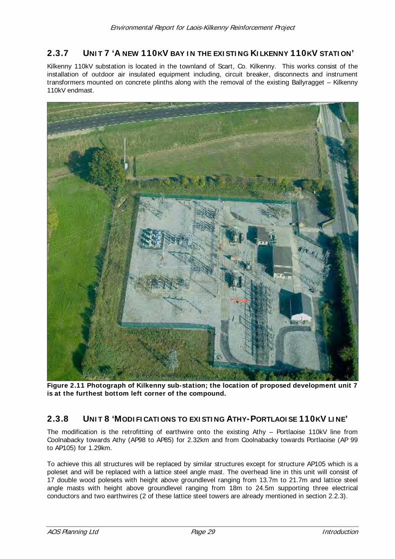
2.3.7 UNIT 7 ‘A NEW 110KV BAY IN THE EXISTING KILKENNY 110KV STATION’ Kilkenny 110kV substation is located in the townland of Scart, Co. Kilkenny. This works consist of the installation of outdoor air insulated equipment including, circuit breaker, disconnects and instrument transformers mounted on concrete plinths along with the removal of the existing Ballyragget – Kilkenny 110kV endmast.
Figure 2.11 Photograph of Kilkenny sub-station; the location of proposed development unit 7 is at the furthest bottom left corner of the compound.
2.3.8 UNIT 8 ‘MODIFICATIONS TO EXISTING ATHY-PORTLAOISE 110KV LINE’ The modification is the retrofitting of earthwire onto the existing Athy – Portlaoise 110kV line from Coolnabacky towards Athy (AP98 to AP85) for 2.32km and from Coolnabacky towards Portlaoise (AP 99 to AP105) for 1.29km. To achieve this all structures will be replaced by similar structures except for structure AP105 which is a poleset and will be replaced with a lattice steel angle mast. The overhead line in this unit will consist of 17 double wood polesets with height above groundlevel ranging from 13.7m to 21.7m and lattice steel angle masts with height above groundlevel ranging from 18m to 24.5m supporting three electrical conductors and two earthwires (2 of these lattice steel towers are already mentioned in section 2.2.3).
Environmental Report for Laois-Kilkenny Reinforcement Project
AOS Planning Ltd Page 30 Introduction
Angle Mast AP99-AP105 The overhead line runs in a northwest direction from AP99 for approximately 1.29km over arable land to AP105. Five polesets are located along this straight. Angle Mast AP98-AP85 The overhead line runs in a southeast direction from AP98 for approximately 2.32km over arable land to AP85 crossing over one local public road. Twelve polesets are located along this straight. The structures proposed can be identified using the Detail Description Schedule document (Volume 1, doc number: PE687-F0261-R261-018-001) to establish the correct structure drawing. All relevant structure drawings are included in the planning application.