final report rm 2018:03e · tional military exercise ace 17 in the air-space north-west of...
TRANSCRIPT
Final report RM 2018:03e Serious incident involving a near collision on 25 May 2017 between Swedish and French fighter aircraft during the interna-tional military exercise ACE 17 in the air-space north-west of Arvidsjaur, Norrbotten County. File no. M-14/17
16 March 2018

RM 2018:03e
Postadress/Postal address Besöksadress/Visitors Telefon/Phone Fax/Facsimile E-post/E-mail Internet P.O. Box 6014 Sveavägen 151 +46 8 508 862 00 +46 8 508 862 90 [email protected] www.havkom.se SE-102 31 Stockholm Stockholm Sweden
SHK investigates accidents and incidents from a safety perspective. Its investigations are aimed at preventing a similar event from occurring in the future, or limiting the effects of such an event. The investigations do not deal with issues of guilt, blame or liability for damages.
The report is also available on SHK´s web site: www.havkom.se
ISSN 1400-5719
This document is a translation of the original Swedish report. In case of discrepancies between this translation and the Swedish original text, the Swedish text shall prevail in the interpretation of the report.
Photos and graphics in this report are protected by copyright. Unless other-wise noted, SHK is the owner of the intellectual property rights.
With the exception of the SHK logo, and photos and graphics to which a third party holds copyright, this publication is licensed under a Creative Commons Attribution 2.5 Sweden license. This means that it is allowed to copy, distribute and adapt this publication provided that you attribute the work.
The SHK preference is that you attribute this publication using the follow-ing wording: “Source: Swedish Accident Investigation Authority”.
Where it is noted in the report that a third party holds copyright to photos, graphics or other material, that party’s consent is needed for reuse of the material.
Cover photo no. 3 - © Anders Sjödén/Swedish Armed Forces.

RM 2018:03e
Content
General observations and delimitations ......................................................................... 5
The investigation ............................................................................................................ 6
SUMMARY ..................................................................................................... 12
1. FACTUAL INFORMATION .......................................................................... 14
1.1 History of the flight .......................................................................................... 14 1.1.1 Preconditions ....................................................................................... 14 1.1.2 Sequence of events .............................................................................. 19 1.1.3 The sequence of events from the perspective of HAMMER (the
Gripen group) ...................................................................................... 23 1.1.4 The sequence of events from the perspective of GUSTO (the
Mirage two-ship) ................................................................................. 26 1.1.5 The sequence of events from the perspective of the tactical control ... 29 1.1.6 The sequence of events from the perspective of the Mission
Commander ......................................................................................... 30 1.2 Injuries to persons ............................................................................................ 31 1.3 Damage to aircraft............................................................................................ 31 1.4 Other damage ................................................................................................... 31 1.5 Personnel information ...................................................................................... 31
1.5.1 Qualifications and duty time of the pilots ........................................... 31 1.5.2 Passengers ............................................................................................ 31 1.5.3 Other personnel ................................................................................... 32
1.6 Aircraft information ......................................................................................... 32 1.6.1 Aircraft A – Gripen general ................................................................. 32 1.6.2 Aircraft B – Mirage 2000 general ........................................................ 33 1.6.3 Description of parts or systems related to the occurrence (Gripen –
HAMMER) .......................................................................................... 33 1.6.4 Description of parts or systems related to the occurrence (Mirage –
GUSTO) .............................................................................................. 35 1.7 Meteorological information ............................................................................. 36 1.8 Aids to navigation ............................................................................................ 37 1.9 Communications .............................................................................................. 37 1.10 Aerodrome information ................................................................................... 38 1.11 Flight recorders ................................................................................................ 38
1.11.1 Cockpit Voice Recorder ...................................................................... 38 1.12 Site of occurrence ............................................................................................ 38 1.13 Medical and pathological information ............................................................. 39 1.14 Fire ................................................................................................................... 39 1.15 Survival aspects ............................................................................................... 39 1.16 Tests and research ............................................................................................ 39 1.17 Organisational and management information .................................................. 39
1.17.1 The exercise in general ........................................................................ 40 1.17.2 The Mission Commander’s (MC) workload........................................ 41 1.17.3 Principles for tactical control and flight information during the ACE
exercise ................................................................................................ 41 1.17.4 Changes within the airspace during the exercise ................................. 42 1.17.5 Planning documentation for the blue forces. ....................................... 42 1.17.6 Principles for separation ...................................................................... 44 1.17.7 Operational Risk management Method (ORM) .................................. 46
1.18 Additional information..................................................................................... 48

RM 2018:03e
4 (67)
1.18.1 Actions taken ....................................................................................... 48 1.19 Special methods of investigation ..................................................................... 50
2. ANALYSIS ..................................................................................................... 51
2.1 Introduction ..................................................................................................... 51 2.2 The exercise ACE 17 ....................................................................................... 51 2.3 Preconditions ................................................................................................... 52
2.3.1 Planning and preparations in general .................................................. 52 2.3.2 ACO and ATO .................................................................................... 52 2.3.3 The detailed planning for the blue forces ............................................ 53
2.4 The near collision incident .............................................................................. 53 2.4.1 General preconditions ......................................................................... 54 2.4.2 The sequence of events according to recorded data ............................ 54 2.4.3 The event from the perspective of HAMMER .................................... 55 2.4.4 The event from the perspective of GUSTO ........................................ 57 2.4.5 The event from the perspective of the tactical control ........................ 58
2.5 Organisation and management ........................................................................ 59 2.5.1 The exercise in general ........................................................................ 59 2.5.2 MC’s workload.................................................................................... 60 2.5.3 Principles for tactical control and flight information .......................... 60 2.5.4 Planning of airspace changes during the exercise ............................... 60 2.5.5 Principles for separation ...................................................................... 61 2.5.6 Operational risk management method (ORM) .................................... 62
2.6 Actions taken after the event ........................................................................... 62 2.7 Overall assessment of the event....................................................................... 62
3. CONCLUSIONS ............................................................................................. 64
3.1 Findings ........................................................................................................... 64 3.2 Causes and Contributing Factors ..................................................................... 65
3.2.1 Causes ................................................................................................. 65 3.2.2 Contributing Factors ............................................................................ 65
4. SAFETY RECOMMENDATIONS ................................................................ 67

RM 2018:03e
5 (67)
General observations and delimitations The Swedish Accident Investigation Authority (Statens haverikommission – SHK) is a state authority with the task of investigating accidents and incidents with the aim of improving safety. SHK accident investigations are intended to clarify, as far as possible, the sequence of events and their causes, as well as damages and other consequences. The results of an investigation shall provide the basis for decisions aiming at preventing a similar event from occurring in the future, or limiting the effects of such an event. The investigation shall also provide a basis for assessment of the performance of rescue services and, when appropriate, for improvements to these rescue services.
SHK accident investigations thus aim at answering three questions: What happened? Why did it happen? How can a similar event be avoided in the future?
SHK does not have any supervisory role and its investigations do not deal with issues of guilt, blame or liability for damages. Therefore, accidents and inci-dents are neither investigated nor described in the report from any such per-spective. These issues are, when appropriate, dealt with by judicial authorities or e.g. by insurance companies.
The task of SHK also does not include investigating how persons affected by an accident or incident have been cared for by hospital services, once an emer-gency operation has been concluded. Measures in support of such individuals by the social services, for example in the form of post crisis management, also are not the subject of the investigation.
Investigations of aviation incidents are governed mainly by Regulation (EU) No 996/2010 on the investigation and prevention of accidents and incidents in civil aviation and by the Accident Investigation Act (1990:712). The investiga-tion is carried out in accordance with Annex 13 of the Chicago Convention.
Delimitations The planning and implementation of flight operations during the international exercise Arctic Challenge Exercise 2017 (ACE 17) used joint operation orders (EXOPORD – Exercise Operation Order) and special instructions (SPINS – Special Instructions) for all participants. SHK has therefore chosen in this investigation not to more closely discuss general national regulations for the armed forces concerned. SHK has, however, chosen to discuss the specific risk management methods that were used by the host countries for ACE 17.
During the exercise, the participants were divided into “blue” and “red” forces. Since the incident only involved two groups from the blue force, SHK has chosen not to more closely discuss activities or planning of the red forces.
The US Navy’s Tactical Air Operations Centre (TAOC) that participated in the exercise has not been more closely discussed since SHK believes that the unit’s operations did not have any decisive impact on the sequence of events. The reason for this is that the unit did not have any tactical control responsibility for the aircraft involved during the incident.

RM 2018:03e
6 (67)
The investigation SHK was informed on 29 May 2017 that a serious incident between French and Swedish fighter aircraft had occurred in the exercise area ACE Center, north-west of Arvidsjaur, Norrbotten County, on 25 May 2017 at 15:00 hrs.
The incident has been investigated by SHK represented by Mr Jonas Bäckstrand, Chairperson, Mr Nicolas Seger, Investigator in Charge, Mr Gideon Singer, Operations Investigator from 16 August 2017, and Mr Stefan Carneros, Military Investigator from 30 October 2017.
Mr Ismo Aaltonen has participated as Finland’s accredited representative on behalf of the Safety Investigation Authority of Finland.
Mr Roger Sjöberg has participated as an advisor for the Swedish Armed Forces.
During the initial stage of the investigation, SHK contacted the French military safety investigation authority, BEAD1 Air. BEAD Air made reference to the French Armed Forces, which appointed the head of squadron at the French squadron in question as contact person for the investigation. In connection with the meeting with the interested parties (see below), SHK was informed that the military attaché at the French Embassy in Stockholm, Mr Fabrice Cohéléach, would henceforth be France’s contact person.
Investigation material Interviews have been conducted with the pilots concerned, their superiors, the Swedish Air Surveillance and Control (STRIL), the exercise management and their safety organisation.
SHK has acquainted itself with the sequence of events through recordings of self-reported position data presented on D-ACMI2, audio files from the tactical control and Gripen’s recording systems and also exercise documentation from the management for ACE 17. The investigation team has conducted an orien-tation session on a Mirage 2000 simulator and a review of the sequence of events in Gripen’s mission support system for planning and debriefing (MSS3).
A meeting with the interested parties was held on 25 October 2017. At the meeting SHK presented the facts discovered during the investigation, available at the time.
1 BEAD Air (Bureau Enquêtes Accidents Défense – air). 2 D-ACMI (Debriefing – Air Combat Maneuvering Instrumentation) – A tool for following up and
analysing military air combat operations and that utilises downloaded data from aircraft concerned. 3 MSS (Mission Support System) – Gripen’s mission support system for planning and debriefing.

RM 2018:03e
7 (67)
Abbreviations, terms and definitions AAR – Air-to-Air Refueling Area.
A/A – Air to Air.
ACO – Air/Airspace Control Order – An order implementing the airspace control plan for the exercise.
A/G – Air to Ground.
ASC 890 – Swedish Airborne Surveillance and Control unit.
ATO – Air Tasking Order – A method used to task and disseminate to compo-nents, subordinate units, and command and control agencies projected sorties, capabilities and/or forces to targets and specific missions. Källa: DOD Dictionary of Military and Associated Terms as of June 2017.
AWG – Airspace Working Group – The working group that prepared the air-space plan for ACE 17.
BENO MSN – Be No Mission – A line indicating the limit between two sepa-rate mission areas which shall not be crossed.
C2 – Command and Control – The authority, responsibilities and activities of military commanders in the direction and co-ordination of military forces and in the implementation of orders related to the execution of operations. Source: AJP-3.3.5, ALLIED JOINT DOCTRINE FOR AIRSPACE CONTROL, Edition B Version 1, MAY 2013.
CAP – Combat Air Patrol – An aircraft patrol provided over an objective area, the force protected, the critical area of a combat zone, or in an air defense area, for the purpose of intercepting and destroying hostile aircraft before they reach their targets.
COMAO – Composite Air Operations.
CRC – Control and Reporting Centre – A subordinate air control element of the tactical air control centre from which radar control and warning operations are conducted within its area of responsibility. Source: AAP-06 2016.
D-ACMI – Debriefing-Air Combat Maneuvering Instrumentation – A software used to monitor and analyze military air combat activity with the use of down-loaded data from aircraft. The system compiles data and presents the desired event in a time-synchronized manner.
DCA – Defensive Counter Air.

RM 2018:03e
8 (67)
ELEVATOR – In VMC (Visual Meteorologocal Conditions) aircrew may use the term “elevator (w/direction)”. This is a request from fighter to ACI/GCI to get bearing, range, altitude and track direction to the closest adversary group in requested direction. Based on this information, the aircraft may elect to climb/descend as required to desired altitude. SA on BLUE aircraft is assumed, and is not included in this request unless specifically requested. Source: ACE 17, SPECIAL INSTRUCTIONS (SPINS) Change 3.
FER – Final Exercise Report.
FLOT – Forward Line of Own Troops – A line which indicates the most for-ward positions of friendly forces in any kind of military operation at a specific time. Source: AAP-6 2016.
HMD – Helmet Mounted Display.
L16 – Link 16 – A military data link system, NATO Link 16, providing infor-mation about position and status of other units connected to the system.
Loose Advisory Control – A tactical control method where the pilot in command is responsible for, amongst other things:
• Keeping separation to the lateral and vertical boundaries of the exer-cise area.
• Deconfliction between other military aircrafts participating in the exercise or transiting through the exercise area.
• Navigation in accordance with current ACO for deconfliction. Source: ACE 17, SPECIAL INSTRUCTIONS (SPINS) Change 3.
NAOC – Norwegian Air Operation Center – The center in Reitan responsible for planning and the issuing of ACO and ATO for the exercise.
OCA – Offensive Counter Air.
PM Wave – Post Meridiem Wave – Exercise wave during the afternoon.
QNH – Barometric pressure reduced to mean sea level.
RBFA – Rear Boundary of Forward Area – An airspace boundary between e.g. the refuelling areas and the remainder of the exercise area.
ROZ – Restricted Operations Zone – An area with restrictions for specific activities or operators, e.g. refuelling areas.
SA – Situation Awareness – A pilot’s continuous perception of self and aircraft in relation to the dynamic environment of flight, threats and mission, and the ability to forecast, then execute tasks based on that perception. Source: McMillan, G. R. (1994). Report of the Armstrong Laboratory Situation Aware-ness Integration (SAINT) Team (Briefing Transcript). In Situation Awareness: Papers and Annotated Bibliography (U). Armstrong Laboratory, Wright-Patterson AFB: OH.

RM 2018:03e
9 (67)
SPINS – Special Instructions.
TAOC – Tactical Air Operation Centre – in this context, a United States unit, with the callsign EARTHQUAKE, participating in the exercise.
TC – Transit Corridor – Airspace corridors, usually in the outer portion of the exercise area, used for a safe transition.
WAM – Wide Area Multilateration – A ground based system using signals from aircraft to determine their position through triangulation, meaning meas-uring the time difference in response to a number of reception stations on the ground.
.
RM 2018:03e
10 (67)
Final report RM 2018:03e
Time of occurrence 25/05/2017, 15:00 hrs in daylight Note: All times are given in Swedish daylight saving time (UTC4 + 2 hours)
Place North-west of Arvidsjaur, Norrbotten County, (position 6542N 01851E, 6 650 metres above mean sea level)
Weather According to SMHI’s analysis at Flight Level 230: wind 300°/35 knots, visibility > 50 km, temperature minus 35°C, no significant clouds between Flight Levels 160 and 270, QNH5 1 007 hPa
Aircraft: Group A (four aircraft) Registration, type 215/831/222/283, JAS 39 Gripen Call sign (in formation order) HAMMER (11, 13, 12, 14) Model C/D Class, Airworthiness Military fighter aircraft Operator Swedish Armed Forces Type of flight Military exercise flight Persons on board: 1/2/1/1 Crew member 1/1/1/1 Passengers 0/1/0/0 Injuries to persons None Damage to aircraft No damage Other damage No damage All pilots had a valid military certificate and were competent on the type with valid OPC6.
The pilots had flown the type for at least eight years and accumulated at least 700 flying hours on Gripen.
All pilots had at least eight hours’ continuous rest time every night during the 72 hours before the event.
4 UTC (Coordinated Universal Time). 5 QNH (Barometric pressure reduced to mean sea level). 6 OPC (Operator Proficiency Check) – The operator’s check of the pilot’s competence.

RM 2018:03e
11 (67)
Aircraft: Group B (two aircraft) Registration, type 102 (F-UHKR), 113 (F-UHYO),
Mirage 2000 Call sign (in formation order) Gusto (55, 56) Model C RDI Class, Airworthiness Military fighter aircraft Operator French Air Force Type of flight Military exercise flight Persons on board: 1/1 Crew member 1/1 Passengers 0/0 Injuries to persons None Damage to aircraft No damage Other damage No damage All pilots had a valid military certificate and were competent on the type with valid OPC.
The pilots had flown the type for at least two years and accumulated at least 300 flying hours on Mirage 2000.
Both pilots had at least eight hours’ continuous rest time every night during the 72 hours before the event.
RM 2018:03e
12 (67)
SUMMARY A serious near collision incident occurred on 25 May 2017 during the interna-tional military exercise Arctic Challenge Exercise 2017 (ACE 17), in the air-space north-west of Arvidsjaur in Norrbotten County, Sweden.
A group consisting of four Swedish Gripen aircraft was flying south in level flight during its return to base phase after an aerial combat mission. At the same time, a group consisting of two French Mirage aircraft were flying north during a descent after completion of aerial refuelling.
One of the Mirage aircraft passed very close to one of the Gripen aircraft. The aircraft had visual contact with each other just before passage. Neither of the pilots performed any evasive manoeuvres.
The maintenance of separation between the aircraft was based on an overall airspace separation that was planned by the exercise management and was published in the form of an Airspace Control Order (ACO) and an Air Tasking Order (ATO). The Mission Commander (MC) for the exercise and his team then performed the detailed planning that was published in the form of a coor-dination card. The two aircraft groups interpreted the information received in different ways. This was in part due to their digital maps not showing the same information. Furthermore, important information was lacking in both the Air-space Control Order and the Air Tasking Order.
The event occurred in the exercise area that applied a tactical control method called “Loose Advisory Control”, which means, among other things, that the pilots themselves had responsibility for maintaining their own separation in relation to the exercise area’s lateral and vertical boundaries and to other mili-tary aircraft that were participating in the exercise.
The Mirage group, whose radar sensors were inactive, called the tactical control to get information about other traffic, but never received any response. The Mirage group executed the descent since they considered themselves to have a good situation awareness (SA).
According to NATO’s manual regarding exercise rules for aerial combat, the pilots could ensure their separation with other aircraft based on situational awareness (SA), geography, timing, on-board systems, GCI/AEW, visual contact, other fighters, or any other appropriate aid.
The cause of the event was that the exercise management underestimated the risks of separation infringement during the administrative flight phases of the exercise, which led to the exercise being conducted with latent collision risks.
Contributing factors were that:
• ACO was changed daily and lacked procedures and routes for transi-tion between aerial refuelling and combat missions, and between combat missions and egress for the return to base.

RM 2018:03e
13 (67)
• The limited content in ACO and ATO resulted in an extensive work-load for the MC team.
• The term SA was not clearly defined, which gave the participants scope for different interpretations of, e.g., the altitude change proce-dure, ELEVATOR.
Safety recommendations
The Swedish Armed Forces is recommended, in consultation with the Finnish and Norwegian armed forces, to:
• Examine the need of clarifying the term SA (Situation Awareness) in the exercise rules contexts in which the term is used. (RM 2018:03 R1)
• Examine the need to address risks regarding administrative flight phases in connection with exercises and operations. (RM 2018:03 R2)
• Examine the need to conduct a simulation in order to validate the separation plan before the exercise. (RM 2018:03 R3)
• Evaluate the need and the possibilities to share recognized air picture with more participating units. (RM 2018:03 R4)

RM 2018:03e
14 (67)
1. FACTUAL INFORMATION
1.1 History of the flight
1.1.1 Preconditions The event occurred in connection with an international military air exercise, called ACE 17 (Arctic Challenge Exercise 2017).
ACE is a recurrent multinational air exercise that takes place in the northern parts of Finland, Norway and Sweden and that was also conducted in 2013 and 2015. The exercise was conducted as part of the Nordic cooperation and a cross-border agreement called Cross Border Training that exists between the countries.
ACE 17 was conducted during the period 22 May to 2 June 2017. During ACE 17, just over 100 aircraft from several countries partici-pated, as well as support flights and ground units. In addition to the Swedish and French aircraft, units also participated from the Belgian, British, Canadian, Dutch, Finnish, German, Norwegian, Spanish, Swiss and US air forces (see Figure 1).
Figure 1. ACE 17 logotype. Source: Armed Forces (Finland).
The aim of ACE is to exercise and train units and C2 (Command and Control7) in the orchestration and conduct of air operations and to practice tactics and command and control procedures.
7 C2 (Command and Control) – The powers, responsibilities and activities of military officers to lead and
coordinate military units and to implement orders related to the execution of missions.

RM 2018:03e
15 (67)
The fighter aircraft proceeded from three different airports; Luleå in Sweden (ESPA), Rovaniemi in Finland (EFRO) and Bodø in Norway (ENBO). The tactical control in the respective countries controlled the aircraft to and from the exercise area.
Within the combat areas themselves there was only an information service, called “Loose Advisory Control”, which meant that the pilots were responsible for maintaining their own separation in relation to the exercise area’s lateral and vertical boundaries and to other military aircraft that were participating in the exercise. The pilots also had the possibility, where necessary, to request information about other traffic from the tactical control.
The planning for the exercise was commenced at the beginning of the year with a series of planning conferences in Oslo to lay the founda-tions for the exercise and to secure experience from previous exer-cises.
The geographical extent of the exercise area is shown in Figure 2.

RM 2018:03e
16 (67)
Figure 2. The geographical exercise area for ACE CENTRE within Sweden marked with a broad grey line. Source: Armed Forces (Sweden).

RM 2018:03e
17 (67)
The exercise area’s demarcations regarding the airspace are shown in Figure 3.
Figure 3. ACE 17 airspace areas. Source: Armed Forces (Finland).
The event occurred during the fourth day of the exercise and during the afternoon session PM Wave8. The exercise was planned as an operation with several missions that, among other things, covered aerial combat, combating ground targets and aerial refuelling.
As part of the safety management, the Finnish and Swedish air forces performed risk analyses in order to identify and limit risks during the exercise. These are presented in more detail in section 1.17.
The airspace planning was conducted by the Norwegian Air Opera-tions Center (NAOC), where an Airspace Working Group (AWG) issued both Airspace Control Orders (ACO) and Air Tasking Orders (ATO).
The detailed planning ahead of each session was performed by specially designated commanders (including in the role of MC – Mission Commander and Airboss) with associated staff as described in more detail in section 1.17.
The Deconfliction Plan between the aircraft was based on pre-planning of elements in time and space.
8 PM Wave (Post Meridiem Wave) – Refers to exercise sessions during the afternoon.
RM 2018:03e
18 (67)
The Deconfliction Plans consist in principle of ACO (Airspace Control Order), ATO (Air Tasking Order) and Coordination card.
The session in question was preceded by meetings and reviews (briefings) in various steps. The briefings had a particular focus, among other things, on separation, safety and on administrative and tactical procedures. Since the participants proceeded from three different bases, the briefings were conducted through video telecon-ference (VTC).
The exercise participants were divided into a blue and a red force. Each side was assigned its own areas, airspaces, flight altitudes and times as well as aerial refuelling areas and refuelling times.
The blue forces’ planned missions are shown in Figures 4 and 5, which show sortie scope as well as participating aircraft and groups of aircraft, including assigned times and altitudes.
The Swedish group, which consisted of four JAS 39 Gripen (a four-ship), had the call sign HAMMER 11. The four-ship’s members were called HAMMER 11, 12, 13 and 14. The four-ship’s mission is shown in Figures 4 and 5, marked in green. Upon the meeting with the French Mirage aircraft (the passage), the group had a formation in the order HAMMER 11, 13, 12, 14.
The French group, which consisted of two Mirage 2000C (a two-ship), had the call sign GUSTO 55. The two-ship’s members were called GUSTO 55 and 56. The two-ship’s mission is shown in Figures 4 and 5, marked in blue.
The coordination card shows that HAMMER was assigned an aerial combat mission (A/A9) at an altitude block of 22 000–24 000 feet10 while GUSTO was assigned a ground attack mission (A/G11) at a holding pattern altitude of 16 000 feet.
During the exercise, “Force QNH” was used, which meant that all participants used the same altitude reference regarding altimeter setting.
The time allocation table (see Figure 5) shows that HAMMER was to be finished with its mission and return to the base at around the same time as GUSTO was to commence its attack mission.
9 A/A (Air to Air) – Refers to aerial combat between airborne units. 10 Foot – Unit that corresponds to 0.3048 metres. 11 A/G (Air to Ground) – Refers to the combating of ground targets from the air.

RM 2018:03e
19 (67)
Figure 4. Time coordination card for the blue forces. Source: Armed Forces (Sweden).
Figure 5. Time allocation table. The times in the table are given in UTC, which means that two hours are to be added to obtain local time at the time of the exercise. Source: Armed Forces (Sweden).
1.1.2 Sequence of events According to the D-ACMI12 system, GUSTO 55 and HAMMER 12 passed each other at 14.59.53 hrs, and the closest measured distance was about 150 metres horizontally and 30 metres vertically. The posi-tion image is shown in Figure 6.
The D-ACMI position is based on downloaded navigation data from the aircraft. The measured horizontal distance has an uncertainty on account of differences in the flight groups’ air navigation equipment that can amount to 50–60 metres.
12 D-ACMI (Debriefing – Air Combat Maneuvering Instrumentation) – A tool for following up and
analysing air combat operations.
1505 10204 4Y 1135 1145 25JAKAL 05 4*F16 A/A 600+ NIL
35-36 HE 35-36PANTER 25 2*F18 A/A 602+ NIL 2425 10334
HE 11-12DALTON 35 2*JAS39 A/A 402+ NIL 2435 10268 16Y
HW 35-3610240 6Y 1120 1130 23 35-36FANG 11 4*F16 A/A 402+ NIL 1511
80K ROZ 9H DROGUE SINGLE HOSE
60k 80K ON REQROZ 7H BOOM
31-34
22-24
31-34
15
4-16, 20-2
LO+10-13
112Y/47Y 26KFT
LO+10-13
4-16, 20-2
25KFT
41Y 1120 1130
111Y/48Y 0915
104Y 1120 1125
1145
AA TAC
36Y
TAXI T/O IN ALT
1123 1133
23Y 24
21
22
0905
113Y/50Y
15Y
21
4172 EFRO
1140
COBO72 A-310 AAR
KC135M AAR
A330-V AAR EGVN 0840 0850 26KFT ROZ 8H DROGUE
KDC-10 AAR EHEH
LO+10
1*ASC-890 2474 35 20
LO+10
1*C295 4173
1*C130 1572
HW16*SDB 1525 10304 14-16, 20-21
1*DA-20 1574
2*JAS-39 AG 202+ 12Y 1125 1135
HC08Y 1240 1250 20
HW261125 1135
4*GR4 A/G 002+ STORM SHADOW 1515 10234
HE
4*JAS-39 A/G 202+ 32*SDB 1521 10300
10310
10Y
26Y
1205 33
1155 324121
151120 1130 30102242*RAF
16
13-14
25-26 HW / HW
A/G 202+ 12*SB38 4157
24
HE
HW 25-2625-26
4*F16 A/A 600+ NIL 1501
002+ 2*GBU-24
31-34 /25-26
13-14
31-34 / 25-26
14-16, 20-21
NIL 2405 10264
31
25-26 HE / HE
23
35-36
25-26
# / TYPE
10220
10330
4*M2000-5 A/A 402+ NIL
AA WPN AG WPN
HC 16
21Y
DateHOLD PT
HE 25-26
402+
MSN
11-12
4*JAS-39 A/A 402+ NIL 2411 10270 HC 22-24
WILLOW 73
YETI 72
SKIBOX 74
4155 NIL
4*F18 A/G 202+ 8*GBU-31
2*M2000C A/G
BLUE COORDINATION CARDCALLSIGN
MJÖLNIR2017-05-25
MC
4*JAS-39 A/A
HC 35-36
BOW57
VERMIN15DMC.push AL
Package9Ch
MODE 3 STN HOLD ALT
STORK 51 4151
4*F18 A/A 602+ NIL 2421PANTHER 21
2.push
HAMMER 11
10200JAKAL 01
17Y
02Y 1140 1150
DALTON 05
21
GATOR 21
VERMIN 15
60K
STEEL 21
TEXACO71
BOW 57
GUSTO 55
GOLD 25
TECHNO 74
SHELL73
QUID77
39Y
38Y 1155
1200
1155 1205
11581148
1150
1205 1215
1240 1250
PUSH 1
1300Z-> B21-24 1300-1330 25 ENBOJAKAL 05 W2 1300 22-24
1315-1400 24 ESPAE1 1315 31-34PANTER 25
1300-1400 21 ESPA1300 11-12DALTON 35
23 ENBO31-34 1235 1240-1330FANG 11 W1 1235
ON STA
TOT
1240-1330
1255-1335
1330-1400
1225-1300
E2
W2
1330-40
2 1240-1250
1340-1350
2 1240-1250
B21-24
1240-1250
1315-132539
20
21
ALT
20 ENBO
EFRO1330-40
32 EFRO
TGT 1 TOT
BASE
EGRESS
23
ENBO
TGT
1138
121031-34
22-24
TARC TIME TARC ALT
22-24
TARC TIME TARC ALT
1230-1400
W1
VERMIN 15
WILLOW 73
1228
1228 31-34
31-341229-45
STORK 51 E1 1235
E2 1335 21-24
YETI 72
31 EFRO
PANTHER 21 E2 1245 21-24 ESPA
HAMMER 11 W2
JAKAL 01
E1 21 ESPA
22 ESPA
TECHNO 74
GUSTO 55 E
E
STEEL 21
24
15
1300Z->W2 1325 1330-1400
33 EFRO1309
1233
16
E 1330
BC W 1234 14-16, 20-21
E 1233 13-14
LO+10-13
DALTON 05
INFLIGHT
FREQ'S
BOW 57
GATOR 21
CALLSIGN
IN ORDER OF PUSH / ROLLCALL
ENBO
GOLD 25 BC W 1234
6
14-16, 20-21 ENBO
E 1305 LO+10
E 1229 20
E 1305 LO+10
49 ENBO
30 EFRO
26 ENBO
6 1240-1250
SKIBOX 74 ROZ1 20
51
ROZ 1
49
1 2 3
PUSH2
BACKE
BACK W
AAR W2
BACK E
AAR SLOMO
SWEEP W2
W1 AAR
AAR E1
AAR E2
E1
E1 AAR
AAR W1
FLOW A/AALT TO

RM 2018:03e
20 (67)
Figure 6. The position image according to D-ACMI centred around HAMMER 12 during the incident at 15:00 hrs. (The Mirage two-ship GUSTO 55/56 is flying north and Gripen HAMMER 12 south). Source: Armed Forces (Sweden).
A schematic vertical position image of the event before, during and after the incident is presented in Figures 7, 8 and 9. The images are not to scale.
Figure 7. Vertical schematic position image before the incident at approximately 14:58 hrs.

RM 2018:03e
21 (67)
Figure 8. Vertical schematic position image during the incident at approximately 15:00 hrs.
Figure 9. Vertical schematic position image after the incident at approximately 15:02 hrs.
The Swedish Armed Forces’ analysis of Air Navigation Services of Sweden’s (LFV) readings of the aircraft's position according to WAM13 measurements shows that the distance was about 0.08 Nm (150 m) at the same altitude.
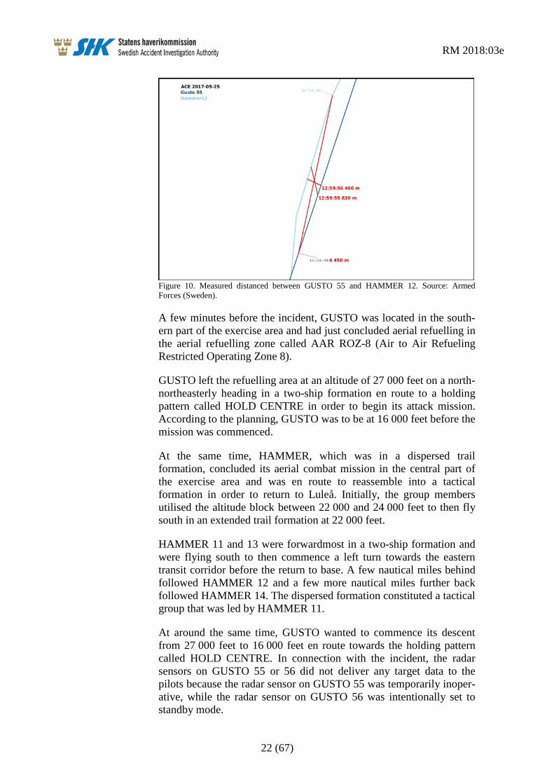
SHK has also examined transponder data where the distance between GUSTO 55 and HAMMER 12 was measured to be 480 metres during the passage (see Figure 10).
13 WAM (Wide Area Multilateration) – A ground-based system that uses the signals transmitted from an
aircraft in order to determine its position by means of triangulation, which entails measuring the time difference of responses to a number of receiving stations on the ground.
RM 2018:03e
22 (67)
Figure 10. Measured distanced between GUSTO 55 and HAMMER 12. Source: Armed Forces (Sweden).
A few minutes before the incident, GUSTO was located in the south-ern part of the exercise area and had just concluded aerial refuelling in the aerial refuelling zone called AAR ROZ-8 (Air to Air Refueling Restricted Operating Zone 8).
GUSTO left the refuelling area at an altitude of 27 000 feet on a north-northeasterly heading in a two-ship formation en route to a holding pattern called HOLD CENTRE in order to begin its attack mission. According to the planning, GUSTO was to be at 16 000 feet before the mission was commenced.
At the same time, HAMMER, which was in a dispersed trail formation, concluded its aerial combat mission in the central part of the exercise area and was en route to reassemble into a tactical formation in order to return to Luleå. Initially, the group members utilised the altitude block between 22 000 and 24 000 feet to then fly south in an extended trail formation at 22 000 feet.
HAMMER 11 and 13 were forwardmost in a two-ship formation and were flying south to then commence a left turn towards the eastern transit corridor before the return to base. A few nautical miles behind followed HAMMER 12 and a few more nautical miles further back followed HAMMER 14. The dispersed formation constituted a tactical group that was led by HAMMER 11.
At around the same time, GUSTO wanted to commence its descent from 27 000 feet to 16 000 feet en route towards the holding pattern called HOLD CENTRE. In connection with the incident, the radar sensors on GUSTO 55 or 56 did not deliver any target data to the pilots because the radar sensor on GUSTO 55 was temporarily inoper-ative, while the radar sensor on GUSTO 56 was intentionally set to standby mode.

RM 2018:03e
23 (67)
GUSTO then attempted to get information concerning nearby aircraft ahead of its descent through a radio call (ELEVATOR call) to the tactical control. The call was made both on the primary and secondary frequencies (with call sign EARTHQUAKE and EAGLE, respec-tively). SHK has listened to the sound recordings but it has not been possible to perceive any response to GUSTO’s call.
The close passage occurred between GUSTO 55 and HAMMER 12 (which was third in the formation) at approximately 22 000 feet.
After the passage, HAMMER and GUSTO continued as planned.
The incident was reported verbally after the session and then in writing according to applicable procedures.
The event was also raised at the major debriefing (MASS DEBRIEF) the same day.
The incident occurred at position 6542N 01851E, 22 000 feet (6 650 metres) above mean sea level.
1.1.3 The sequence of events from the perspective of HAMMER (the Gripen group) The sequence of events from HAMMER’s perspective has been documented through the group’s radio communications, Gripen recordings and through interviews with all pilots.
HAMMER’s electronic map image that was presented on the tactical indicator is shown in Figure 11. The map is oriented in the aircraft’s longitudinal axis and displays a view in a roughly southerly direction with its own position marked as a black triangle in the centre.
The planned route is displayed with blue lines. Airspace boundaries are indicated with red and brown lines. Aircraft belonging to its own forces are indicated in green, where filled green symbols, e.g. D/22, represent HAMMER’s group members, and green symbols without filling represent other aircraft.

RM 2018:03e
24 (67)
Figure 11. Gripen’s digital map at about the time of the incident. Source: Armed Forces (Sweden).
The aircraft’s map image was created via a planning service and a support system (Mission Support System) by means of Airspace Control Orders and Air Tasking Orders (ACO/ATO), and with adap-tation to the aircraft’s and the mission’s limitations.
The interviews show that the HAMMER group was finished with the aerial combat mission in the western area and was in the process of reassembling ahead of the return to Luleå. As a part of the aerial combat tactics, the group was dispersed during the egress of the mission and return to base and monitored the formation by means of the aircraft's own radar and information via data link.

RM 2018:03e
25 (67)
All group members maintained the assigned altitude of 22 000 feet in accordance with the mission planning and considered the flight phase an administrative flight phase14 for reassembly and reversion to a routine return to base.
The group leader perceived the red line east of the group as being a hard boundary that was not to be passed (BENO MSN15), so as not to conflict with other aircraft from the blue force. The digital map shows the pre-programmed route for return to base in blue. The route went between two lines that formed an east-west corridor to then continue in a northbound direction all the way to a report point marked W9 (see Figure 11).
The group members have related that the mission transitioned to a calmer reassembly phase ahead of the return to base. They perceived that they were separated in altitude from other traffic and therefore refrained from locking the radar on this.
The Gripen aircraft were equipped with a data link system, NATO Link 16, which provides information on flight position and status of other units connected to the data link.
The interviews show that GUSTO did not appear in the data link system since the Mirage aircraft were neither equipped with Link 16 nor defined as link targets by the tactical control.
The incident report shows that the group head for HAMMER was following the GUSTO two-ship on the radar and observed that they had left their cruising altitude of 27 000 feet and were beginning to descend towards the HAMMER group in the direction of the western part of the combat area (West Lane).
By means of radar target data presented on his helmet display (HMD16), the group leader discovered the Mirage two-ship visually at a vertical distance of less than 2 000 feet and informed his group of this via radio.
The Mirage two-ship formation passed above the first two HAMMER members and was discovered visually shortly thereafter as a very close passage by the third HAMMER member (HAMMER 12). HAMMER 12 did not perform any evasive manoeuvre.
The fourth HAMMER member that was a few more nautical miles further back, as the last aircraft in the trail, saw the passing Mirage aircraft below with good separation.
14 Administrative flight phase – Refers to a flight phase to and from combat area. 15 BENO MSN (Be No Mission) – Refers to a line that may not be encroached during the mission. 16 HMD (Helmet Mounted Display).

RM 2018:03e
26 (67)
The pilots have stated that the radio traffic on the administrative frequency was strained and that many were trying to communicate simultaneously with the tactical control without always being able to perceive any response.
In interviews with pilots and fighter controllers, it has also been pointed out that the tactical control TAOC, with the call sign EARTHQUAKE, had limited radio coverage and delivered misleading aircraft positions on Link 16.
1.1.4 The sequence of events from the perspective of GUSTO (the Mirage two-ship) The sequence of events from GUSTO’s perspective has been docu-mented through the group’s radio communications and interviews with both pilots.
The digital map that was available to the Mirage pilots during the session is shown in Figure 12. The map is north-oriented without specifically showing the aircraft’s own position. The incident took place roughly between the points on the map designated ACE RBFA17 and HOLD CENTRE.
GUSTO’s planned route is displayed as blue lines with numbered navigation points. The airspace boundaries and demarcation lines are shown in red, while orange-coloured lines mark corridors. In addition to this, markings are presented for holding pattern, ground targets and various reference points in the form of letters and numbers.
17 RBFA (Rear Boundary of the Forward Area).

RM 2018:03e
27 (67)
Figure 12. The digital map that was available to the Mirage pilots during the mission on their electronic knee boards. Source: Armed Forces (France).
The interviews show that the GUSTO two-ship was finished with the aerial refuelling mission in the central area (ROZ8) and was to be reassembled ahead of the attack mission.
According to the time allocation table (see Figure 5), the attack mission was to proceed from the holding pattern HOLD CENTRE at an altitude of 16 000 feet at 15:09 hrs.
The two-ship wingman had his radar in standby mode since the two-ship was in close formation and so as not to disturb the two-ship leader with radar warnings. Besides this, the two-ship leader’s radar was temporarily inoperative, which entailed that the two-ship had no radar capability whatsoever during the initial approach towards the holding pattern.
The Mirage aircraft did not have access to their radar sensors during the descent phase, nor were they equipped with the data link system, L16. This meant that the pilots needed to rely on radio contact with the tactical control and on its own visual scanning of the airspace.
The interviews show that the pilots assessed that they had a good situation awareness (SA18) and that they did not expect that there would be other aircraft on the route to the holding pattern.
18 SA (Situation Awareness) – Refers, among other things, to the pilot’s awareness of his position in
relation to the surroundings.

RM 2018:03e
28 (67)
The incident report shows that GUSTO, as planned, left the flight altitude of 27 000 feet and descended on heading 040° to the assigned altitude of 16 000 feet in the corridor (between two orange-coloured lines – see Figure 12) between Point D (hidden under the text ACE RBFA) and the holding pattern HOLD CENTRE. According to the same incident report, GUSTO 55 and 56 discovered four oncoming aircraft at close quarters.
The two-ship leader has related that he called the tactical control with a request for traffic information ahead of the altitude change (ELEVATOR CALL) but never perceived any response, either on the primary or on the secondary frequency.
The two-ship leader’s decision, as planned, to leave 27 000 feet and descend quickly to 16 000 feet was based on the fact that it was neces-sary to arrive in time and to be at the right altitude ahead of the attack mission. Besides this, the two-ship leader perceived that he had a good SA with reference to the weather and his mental picture of the surrounding traffic. He has related that he trusted the exercise’s Deconfliction Plan and that he was aware that it was the pilots them-selves who were responsible for the separation in the area.
The GUSTO members, whose radar units were not active, did not have visual contact with HAMMER 12 until some seconds before the passage.
The interviews show that GUSTO’s two-ship leader spotted two Gripen aircraft in formation under him and on his left side. A couple of seconds later, a third Gripen aircraft was spotted. The meeting with the third Gripen aircraft was perceived as very close and the distance was estimated at between 200 and 300 metres at the same altitude.
GUSTO did not perform any evasive manoeuvres. The two-ship leader has explained that an evasive manoeuvre would not have changed anything. Besides this, he considered that an evasive manoeuvre to the right was not appropriate with reference to his two-ship wingman who was flying on the right side of him.
After the passage, the GUSTO members were worried about where the fourth Gripen aircraft was located, but they never obtained visual contact with it.
After the incident, GUSTO continued with the planned mission and subsequently returned to Rovaniemi.

RM 2018:03e
29 (67)
1.1.5 The sequence of events from the perspective of the tactical control During the exercise, the tactical control responsibility in the Swedish part of the exercise area was delegated from the Norwegian control centre (NAOC) to the Swedish tactical control unit (CRC – Control and Reporting Centre) with the call sign EAGLE (see Figure 13).
Figure 13. Tactical control responsibility during ACE 17. Source: Armed Forces (Finland).
As a part of the exercise, other units also received partial responsi-bility during the session in question. The US unit, TAOC, with the call sign EARTHQUAKE, was, amongst other things, responsible for providing flight information upon request within that part of the combat area in which the incident took place, while EAGLE only had backup responsibility.
In addition to these ground units, a radar surveillance and control air-craft was in the air. The aircraft constituted an airborne radar and tactical control platform with the designation ASC 890. The unit was in the air during the afternoon session, but its main task was only to reconnoitre with its own radar in the area’s northern sector and assist EARTHQUAKE with recognized air picture on Link 16.
According to interviews with the Swedish fighter controller, he perceived that GUSTO requested flight information ahead of an alti-tude change (ELEVATOR) from EARTHQUAKE without receiving any response.
When GUSTO commenced its descent, the fighter controller discov-ered that the groups were on collision course but assumed that these had visual contact with each other and therefore took no action.
During the passage, HAMMER and GUSTO were on different tactical control frequencies in accordance with the applicable planning.
The fighter controller has also related that the frequency that was to be used for the transition from the aerial refuelling area to the holding pattern HOLD CENTRE was a tactical frequency that might have been jammed.

RM 2018:03e
30 (67)
According to EAGLE’s report, GUSTO concluded its aerial refuelling at 14:55 hrs and called EARTHQUAKE on the aerial refuelling frequency with a request to be permitted to leave the area.
It is furthermore apparent from the report that aircraft could leave the aerial refuelling frequency and transfer to the check-in frequency instead of the tactical frequency. This constituted a complicating factor for the fighter controller, who was thereby not sure which frequency GUSTO was on.
1.1.6 The sequence of events from the perspective of the Mission Commander It is apparent from the Airspace Control Orders (ACO) and Air Tasking Orders (ATO) that were handed out to the participants at 13:00 hrs the day before the afternoon exercise session (PM Wave) that the basic planning was only an overview and presupposed that much of the detailed planning work would be done by the Mission Commander (MC) for the exercise.
Since the participants proceeded from the three bases Luleå, Rovaniemi and Bodø, some of the planning was conducted via video teleconference.
The Mission Commander’s task was to plan the missions, allocate flying units, weapons and targets and to perform the detailed planning of tactics, airspace and coordinate other resources, such as aerial refuelling.
Within the limited time ahead of the briefing, the Mission Comman-der’s team needed to plan, test, analyse and have the planning approved by the AIRBOSS for the exercise.
The interviews with several of the key persons show that their percep-tion of how the missions were to be carried out in practice differed, particularly with regard to the administrative flight phases into and out of the combat area.
It is also apparent from the interviews that some details were only conveyed verbally during the review or only to individual pilots after the review.
It is also apparent that the Mission Commander believed that the sepa-ration line (BENO MSN) was supposed to end further north than the position indicated by the briefing card’s coordinates and that the egress procedure was not presented during the review.
According to interview information, the GUSTO pilots had a separate meeting with the Mission Commander after the joint review and asked how the flight from the refuelling area to the attack mission was intended to be carried out. The Mission Commander then explained the procedure, which was then also applied by GUSTO.

RM 2018:03e
31 (67)
1.2 Injuries to persons None.
1.3 Damage to aircraft No damage.
1.4 Other damage No damage, no environmental impact.
1.5 Personnel information
1.5.1 Qualifications and duty time of the pilots
Group A (Gripen, call sign HAMMER)
JAS Gripen Pilots
Age Total flying hours
On the type
Latest 90 days
Type rating year
Latest OPC19
Hammer 11 37 1680 1270 36 2008 Aug. 2016 Hammer 12 41 1940 1005 38 2006 Aug. 2016 Hammer 13 44 2000 755 46.5 2003 Dec. 2016 Hammer 14 47 2200 1100 20 2001 Dec. 2016
All pilots had a valid military certificate with flight operational and medical eligibility.
All pilots had at least eight hours’ continuous rest time every night during the 72 hours before the event.
Group B (Mirage, call sign GUSTO)
Mirage Pilots
Age Total flying hours
On the type
Latest 90 days
Type rating year
Latest OPC
Gusto 55 31 990 600 50 2013 Jul. 2016 Gusto 56 29 850 360 65 2015 Feb. 2017
All pilots had a valid military certificate with flight operational and medical eligibility.
All pilots had at least eight hours’ continuous rest time every night during the 72 hours before the event.
1.5.2 Passengers HAMMER 12 had one passenger who did not have any operational role during the mission.
19 OPC (Operator Proficiency Check) – The operator’s check of the pilot’s competence.

RM 2018:03e
32 (67)
1.5.3 Other personnel Relevant units during the incident were the Swedish tactical control unit (EAGLE), the US Navy’s tactical control unit (EARTHQUAKE) and the airborne surveillance control aircraft ASC 890 (SKIBOX).
The Swedish tactical control personnel were to some extent involved in the event and were actors in the ACE 17 exercise as regards plan-ning and implementation.
However, the tactical control had no separation responsibility in the area in question during the afternoon session but could, where neces-sary, provide a picture of flight position to calling aircraft.
Members from EAGLE and SKIBOX have been interviewed. Since the tactical control personnel did not conduct tactical control in the area in question, their personnel information is not reported.
1.6 Aircraft information
1.6.1 Aircraft A – Gripen general JAS 39 Gripen is a single-engine multirole fighter aircraft manufactured by Saab AB, (see Figure 14). The A and C versions are single-seaters, while the B and D versions are two-seaters. The aircraft is 14.1 metres long and has a span of 8.4 metres. Maximum permitted take-off weight is 14 000 kg.
Figure 14. Gripen C. Photo: Saab AB.
The aircraft’s sensors and navigation system considered to be relevant to the occurrence are described in section 1.6.3.

RM 2018:03e
33 (67)
1.6.2 Aircraft B – Mirage 2000 general Mirage 2000 is a single-engine multirole fighter aircraft manufactured by Dassault Aviation, (see Figure 15). The model C RDI is a single-seat fighter version with multifunction Doppler radar. The aircraft is 14.6 metres long and has a span of 9.1 metres. Maximum permitted take-off weight is 16 500 kg.
Figure 15. Mirage 2000C RDI. Photo: Armed Forces (France).
The aircraft’s sensors and navigation system considered to be relevant to the occurrence are described in section 1.6.4.
1.6.3 Description of parts or systems related to the occurrence (Gripen – HAMMER) The aircraft is equipped with an inertial navigation system with GPS (INS/GPS). Navigation points are presented to the pilot in different ways in the cockpit, including in the tactical indicator (TI) and on the display indicator (Head Up Display – HUD), (see Figure 16).

RM 2018:03e
34 (67)
Figure 16. Gripen C cockpit. Navigation display in the centre with HUD above and in front of the front windscreen. Photo: Saab AB.
The aircraft is equipped with a main sensor in the form of a multi-function pulse-Doppler radar that, among other things, can detect and follow several aerial targets simultaneously. The aircraft is also equipped with a helmet display (Helmet Mounted Display – HMD) called COBRA. On the helmet display, flight and radar target data, among other things, can be presented to the pilot in the form of various visual symbols, see Figure 17.
Figure 17. Gripen Cobra helmet display (HMD). Photo: Saab AB.

RM 2018:03e
35 (67)
The navigation system on Gripen is fully integrated with the presenta-tion and manoeuvring system. The planned route as well as underlying map documentation is loaded via the planning and debriefing system (Mission Support System – MSS).
1.6.4 Description of parts or systems related to the occurrence (Mirage – GUSTO) The aircraft is, among other things, equipped with an inertial naviga-tion system (INS), with 10 primary and 10 secondary navigation points that are presented to the pilot in different ways in the cockpit, including in the display indicator (Head Up Display – HUD), see Figure 18.
The aircraft is equipped with a main sensor in the form of a multi-function pulse-Doppler radar that, among other things, can detect and follow several aerial targets simultaneously.
In connection with the event, the radar sensor on GUSTO 55 was temporarily inoperative, while the radar sensor on GUSTO 56 was intentionally set to standby mode.
The temporary functional interruption to GUSTO 55’s radar was restored later during the flight in question and did not occasion any maintenance measures.
Figure 18. Mirage 2000C RDI cockpit. Photo: Armed Forces (France).

RM 2018:03e
36 (67)
The pilot also has access to a GPS-equipped Samsung Note 8 tablet, (see Figure 19).
The tablet was equipped with a multi-layered map application called Alliance that contained maps, relevant points and polygons from the ACE 17 documentation. The application was developed by the French Air Force for its needs, and the mission planning was done on a computer called Mission Planning Computer and was downloaded to the pilots’ tablets ahead of every mission.
Figure 19. The navigation application in a Note 8 tablet used by the French Air Force in Mirage 2000C. Photo: Armed Forces (France).
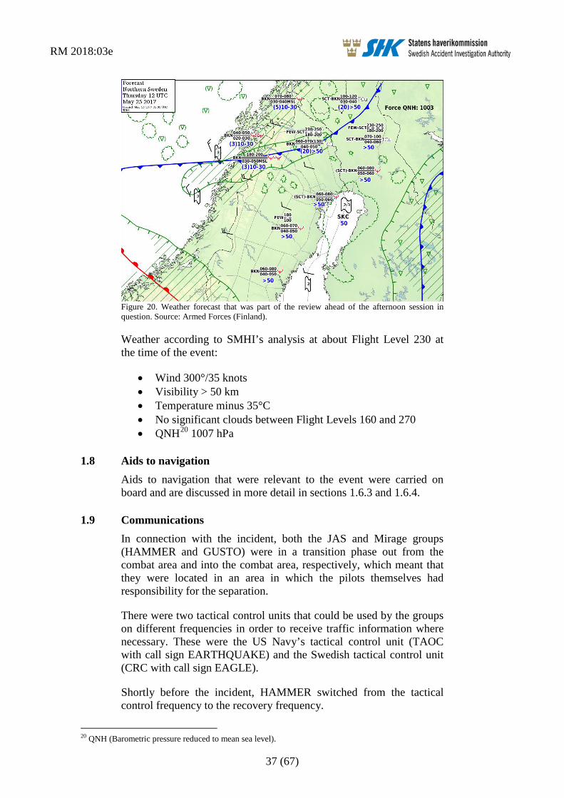
1.7 Meteorological information The forecast that was applicable at the time of the incident is shown in Figure 20.
The forecast shows, among other things, that there would not be any clouds above Flight Level 180 in the area in which the incident took place.
RM 2018:03e
37 (67)
Figure 20. Weather forecast that was part of the review ahead of the afternoon session in question. Source: Armed Forces (Finland).
Weather according to SMHI’s analysis at about Flight Level 230 at the time of the event:
• Wind 300°/35 knots • Visibility > 50 km • Temperature minus 35°C • No significant clouds between Flight Levels 160 and 270 • QNH20 1007 hPa
1.8 Aids to navigation Aids to navigation that were relevant to the event were carried on board and are discussed in more detail in sections 1.6.3 and 1.6.4.
1.9 Communications In connection with the incident, both the JAS and Mirage groups (HAMMER and GUSTO) were in a transition phase out from the combat area and into the combat area, respectively, which meant that they were located in an area in which the pilots themselves had responsibility for the separation.
There were two tactical control units that could be used by the groups on different frequencies in order to receive traffic information where necessary. These were the US Navy’s tactical control unit (TAOC with call sign EARTHQUAKE) and the Swedish tactical control unit (CRC with call sign EAGLE).
Shortly before the incident, HAMMER switched from the tactical control frequency to the recovery frequency.
20 QNH (Barometric pressure reduced to mean sea level).

RM 2018:03e
38 (67)
GUSTO called EARTHQUAKE several times on the primary and the secondary frequency before the altitude change in order to get traffic information, but never obtained any contact. Only after the passage of HAMMER 12 did GUSTO call the frequency that applied for the attack mission.
In connection with the incident, HAMMER and GUSTO were on different frequencies. The only common frequency for the groups was the emergency frequency called GUARD. No communication has been registered on this frequency during the sequence of events.
It has emerged through the interviews that there were disruptions in the radio traffic, that it was at times strained and that a frequency change was sometimes necessary in order to obtain contact. Deliberate interference of radio frequencies is common during this type of exer-cise.
The Swedish tactical control unit, CRC EAGLE, constituted a backup to that of the US unit, EARTHQUAKE. Limited radio coverage meant that they could not hear each other.
1.10 Aerodrome information Not applicable.
1.11 Flight recorders SHK has only examined recordings from the D-ACMI tool that is used to follow up and analyse military air combat operations and that utilises downloaded data from aircraft concerned, from the Gripen’s mission support system for planning and debriefing (MSS) and from navigation applications. The aircraft’s crash-protected memory units have not been recovered since the above recordings have been consid-ered sufficient for the investigation.
1.11.1 Cockpit Voice Recorder The sound recording from the MSS system shows that the group leader for HAMMER informed his group members of the oncoming GUSTO two-ship by directing them to look up. This was done approximately 20 seconds before the passage.
SHK has not been able to gain access to GUSTO’s sound recordings as these were no longer available when they were requested.
1.12 Site of occurrence The incident occurred in the airspace north-west of Arvidsjaur, at position 6542N 01851E, 22 000 feet (6 650) metres above mean sea level.

RM 2018:03e
39 (67)
1.13 Medical and pathological information Nothing indicates that the mental and physical condition of the pilots were impaired before or during the flight.
1.14 Fire Not applicable.
1.15 Survival aspects Not applicable.
1.16 Tests and research Not applicable.
1.17 Organisational and management information
Figure 21. Organisational chart for the exercise, ACE 17. Source: Armed Forces (Finland).
The ACE 17 organisation consisted of a staff and exercise participants (see Figure 21). The organisation is described in the Exercise Opera-tion Order – EXOPORD.
The staff consisted of delegates from the three host nations, with Finland having the main responsibility.
The Exercise Director (EXDIR) is the highest person responsible for the management and steering of the exercise and for the exercise as a whole. He also has the mandate to abort or modify the exercise or parts of it if safety so requires.
Under the Exercise Director there are three Deputy Exercise Directors (DEP EXDIR) and also operational directors (DIR OPS – Director Operations).

RM 2018:03e
40 (67)
The operational directors are responsible for the management and day-to-day direction of the staff and are to review the planning and provide direction and guidance to the staff as regards the implementation of the exercise. They are also to keep the Exercise Director informed of safety-related factors.
The flight safety organisation that is under the Exercise Director consists of a Chief of Safety and flight safety officers for each wing (WFSO – Wing Flight Safety Officer) and for each squadron (FSO).
An AIRBOSS with a staff from the three host countries is directly responsible for the exercise’s planning and implementation.
It was part of the responsibility of AIRBOSS to coordinate the exer-cise with the Norwegian airspace centre in Reitan (NAOC) before and during the afternoon sessions that are composite aerial combat missions (COMAO21). AIRBOSS was also responsible for approving the separation plan (Deconfliction Plan) ahead of each sortie and for the participants being informed of the plan.
The Norwegian airspace centre together with a flight safety staff was responsible for the planning, drawing up and distribution of the Air-space Control Order (ACO) and the Air Tasking Order (ATO).
The active exercise participants, which consisted of flying units and tactical control and which were to be exercised daily, were led by a Mission Commander (MC) appointed each day for the blue and for the red forces.
The Mission Commander was responsible, among other things, for planning, briefing, implementation and debriefing of the missions. An important role was to draw up a separation plan in order to ensure a safe planning for separation, including during flight to and from the exercise area. The Mission Commander was to then inform AIRBOSS of the separation plan and have it approved by him.
1.17.1 The exercise in general Interviews with the exercise management and the three countries’ safety officers show that the afternoon’s exercise was complex and that the details of the administrative flight phases22 between different missions were presumably not entirely clear. The formal briefings were conducted in accordance with the planned time schedule. It has also emerged that some of the information was not presented in the briefings’ presentation material but was only conveyed verbally.
21 COMAO (Composite Air Operations). 22 Administrative flight phases refer to air transport routes between different mission elements and
combat areas and to and from the air bases.

RM 2018:03e
41 (67)
According to interviews with the exercise management, neither was the procedure for the pilots’ radio calls to get information about the nearest aircraft ahead of an altitude change (ELEVATOR CALL) entirely clear and could also deviate from national procedures. It was unclear if these radio calls were mandatory and whether they were dependent on whether visual or instrument meteorological conditions prevailed.
The briefing images for aerial combat (Offensive Counter Air – OCA) and ground attack missions (Strike) show that HAMMER and GUSTO were planned to be in the same area at a close point in time (see Figure 22).
Figure 22. Briefing images for aerial combat and ground attack missions (HAMMER and the push time for GUSTO are circled in purple). Source: Armed Forces (Sweden).
The images show that the blue forces were divided into two areas (lanes), west and east, that were demarcated by a line called BENO MSN (BENO Mission) which was not allowed to be crossed during the mission.
1.17.2 The Mission Commander’s (MC) workload The Military Flight Safety Inspectorate in Sweden (FLYGI) conducted a supervision of the exercise and drew up a report. In its report, FLYGI has written that the Mission Commander (MC) had an unrea-sonable responsibility. Several of those interviewed have also related that the Mission Commander had a high workload because the plan-ning work for separation was complicated and extensive. In SHK’s interviews with the Mission Commander, he has related that the plan-ning work intensified after 18:00 hrs and was very intensive during the following morning.
1.17.3 Principles for tactical control and flight information during the ACE exercise During the exercise, both in the combat area and for some of the administrative flight phases, a tactical control method called “Loose Advisory Control” was applied, which meant that the controller was only to provide traffic information upon request from the pilots.
RM 2018:03e
42 (67)
Surveillance aircraft, including ASC 890, used Link 16, a data link system that, where necessary, provides information on flight position and status of other aircraft that are also connected to the system, and could thereby follow and link L16-equipped aircraft and generate own targets with the use of their own radar and IFF (Identification Friend or Foe).
During the afternoon session on 25 May, the US Navy’s tactical control unit (TAOC EARTHQUAKE) had main control responsibility in the exercise area. At its disposal, it had primary radar and L16 in order to reconnoitre and follow flight operations, and radio for communication. As previously mentioned, the Mirage 2000 aircraft lacked L16 equipment and therefore could not be followed directly by means of the L16 system.
1.17.4 Changes within the airspace during the exercise According to interviews with the management staff for ACE 17, one of the exercise goals was to train the transition from a defensive war under attack to a more offensive behaviour that entailed a movement of the front line north. This resulted in a dynamic airspace with changes of important boundaries and safety lines during the course of the exercise. Two separate combat areas (east and west) also made possible parallel missions for the blue forces.
The design of the airspace as shown in the Airspace Control Order (ACO) was admittedly changed very little, but the tactical lines were changed from day to day by the Mission Commanders (MC) and their staffs.
1.17.5 Planning documentation for the blue forces. The afternoon session of the blue forces was planned and presented to the exercise participants by means of, among other things, a coordina-tion card (Blue Coordination Card) and airspace images (see Figures 23–25).
Between the various blue forces was a separation line (BENO MSN) that separated the eastern and the western combat areas and that was not to be crossed. Information on the separation line was included on the coordination card and was there defined by means of coordinates and airborne alert for aerial combat (CAP – Combat Air Patrol), see Figure 23. However, that information was not shown in the air-space picture (Figure 25) that was presented during the briefings.
In addition to this, the coordination card also gives the coordinates of entry and exit points to and from the aerial refuelling area (Functions A–O in Figure 23) where point D was used by GUSTO in the transi-tion from the aerial refuelling zone ROZ8 to the combat area (see also Figure 25).

RM 2018:03e
43 (67)
Figure 23. Coordination card for the blue forces (Blue Coordination card) with coordinates for airspace division with separation line (BENO MSN), entry and exit points for aerial refuelling and holding patterns for aerial combat (CAP). Source: Armed Forces (Sweden).
Figure 24. Map documentation from the Airspace Control Order for mass briefing of the exer-cise participants (PM mission day 4, 25 May CH3). Source: Armed Forces (Sweden).

RM 2018:03e
44 (67)
Figure 25. Coordination card with map documentation for the afternoon session of the blue forces (Blue Coordination card) with aerial refuelling zones and entry and exit points for these. Source: Armed Forces (Sweden).
1.17.6 Principles for separation During ACE 17, there were just over 100 aircraft that were located in the same airspace and that took off and landed at three different bases. The exercise management considered it a complex challenge to sepa-rate the units in a safe and clear manner.
The airspace division and the separation rules were established by the exercise’s operation order (EXOPORD) and were supplemented with special instructions called SPINS (Special Instructions). In addition to this are the generally accepted rules for altitude separation between aircraft, which normally entail a vertical separation of 1 000 feet.
The following is shown in NATO’s manual 75-2-123 regarding exer-cise rules for aerial combat:
Fighters may not transit or enter the altitude/altitude block of any adversary unless at least one of the following conditions is met:
(1) Fighter is beyond 10 NM with all adversaries entering the engagement.
23 Allied Command Europe Manual 75-2-1, Fighting Edge Air-to-Air Training Rules, 23 February 2011.

RM 2018:03e
45 (67)
(2) Adversary is within 10 NM, but not a factor (i.e. no potential collision) based on situational awareness, geography, timing, on-board systems, GCI/AEW, visual contact, other fighters, or any other appropriate aid.
(3) Visual contact is established.
(4) Fighter verbally confirms adversary’s hard altitude direct with the adversary and maintains 1 000 feet vertical separation.
The most common method for separating military aircraft is to define different altitude blocks for different groups and missions.
The principle for separation is shown in Figure 26. The airspace has been divided up into five different blocks in which separation between red and blue units is defined. At low altitude, the terrain is also taken into account. These blocks are necessary since the tactical control has a passive role and the position of the opposing forces is intentionally not known.
In addition to the blocks are limited areas (with a centre point and a defined radius) in which aircraft can change altitude between the blocks in order to carry out missions such as aerial refuelling, holding pattern or reassembly for combat (REGEN) in a specific area.
Another method for separation is time separation. Different groups receive different times for specified coordinates or phases in the combat. These times are planned in order to avoid collision risks. SHK has not found any information that the separation planning has been tested through simulation before implementation.
Within the same block, “Lanes” for units from the same force (blue or red) can also be defined in order to facilitate more parallel missions within the same altitude block at the same time. Such “Lanes” can be separated by means of a BENO MSN line.
It is also apparent from SPINS that the flying units may change alti-tude in real time based on their own situation awareness (SA), which can be obtained by means of their own sensors, ELEVATOR infor-mation from the tactical control or in other ways, such as visual information.
RM 2018:03e
46 (67)
Figure 26. The principle for separation during ACE 17 by means of altitude blocks. Source: Armed Forces (Finland).
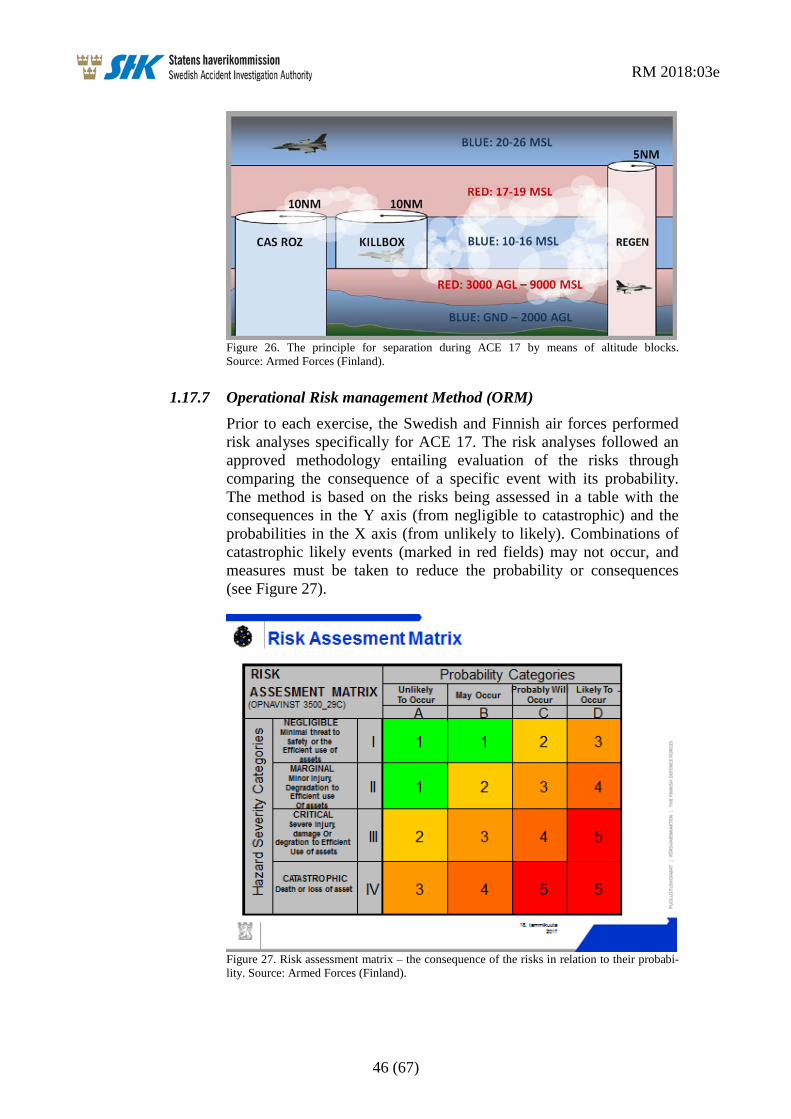
1.17.7 Operational Risk management Method (ORM) Prior to each exercise, the Swedish and Finnish air forces performed risk analyses specifically for ACE 17. The risk analyses followed an approved methodology entailing evaluation of the risks through comparing the consequence of a specific event with its probability. The method is based on the risks being assessed in a table with the consequences in the Y axis (from negligible to catastrophic) and the probabilities in the X axis (from unlikely to likely). Combinations of catastrophic likely events (marked in red fields) may not occur, and measures must be taken to reduce the probability or consequences (see Figure 27).
Figure 27. Risk assessment matrix – the consequence of the risks in relation to their probabi-lity. Source: Armed Forces (Finland).

RM 2018:03e
47 (67)
As a part of the safety work ahead of the exercise, the safety organisa-tion identified and categorised the various risks according to the method above. The risk analysis was common to the flight operational and tactical control units.
Some of the risks that concerned the incident in question were captured and analysed and were assessed to be acceptable for the exercise. Besides this, measures were taken to reduce the effects or probabilities of these events.
By way of example, it can be mentioned that the risks of altitude deviations, collisions in the air and radio interference were included in the analysis (see Figures 28 and 29).
Figure 28. Identified risks regarding altitude deviations and collision in the air with measures to reduce the risks. Source: Armed Forces (Finland).

RM 2018:03e
48 (67)
Figure 29. Identified risks regarding radio interference with measures to reduce the risks. Source: Armed Forces (Finland).
1.18 Additional information
1.18.1 Actions taken
The ACE 17 organisation The exercise management has published a final report called Final Exercise Report (FER) for ACE 17. The report encompasses an evalu-ation of the exercise, but not specifically of the incident now in ques-tion. The following is a summary of the recommendations in the report:
• During planning conferences, the challenging nature of VTC planning and operations in a high-risk environment should be emphasized.
• For future exercises, it is tactically preferable that fast jets participating in the exercise have L16 capability.
• ATO must be timely available on Squadron level so that ambitious timelines shall not be corrupted. The admin process of the ATO has to be reviewed and improved (printing, CD burning).
• For the next ACE there should be a standing ACO for the DCA days and after that a second one for the remainder of the exercise (OCA phase). This will enable the participating forces to concentrate on tactical elements of the sortie to maximize training value for all participants, also to improve flight safety.
RM 2018:03e
49 (67)
• At the beginning of the exercise, it is important to have an experienced MC run the first planning session and have all the necessary materials available for planning.
• There needs to be Positive Control24 available in future exer-cises. The related problems have been identified, and measures aimed at overcoming this problem have already been initiated for ACE 19.
• TAOC Integration to C2 was a challenge due to the technical difficulties in the first period of the exercise. In future ACE exercises, new controlling systems which operate in Swedish airspace must be evaluated before the exercise starts.
The Swedish Armed Forces The Swedish Armed Forces has investigated the incident in question and has made the following recommendations in its report “Simplified investigation ACE 17”:
R1 Same ACO throughout the exercise period.
R2 ACO should to a large degree manage flight paths and altitudes between
• Bases and the exercise area • Aerial refuelling and holding area
R3 FSL25 should be given power to control aircraft (CLOSE ADVISORY CONTROL) in the area when FSL considers it appropri-ate.
R4 Ensure radio and radar coverage in the flight safety-critical areas, such as AAR, TRANSIT CORRIDOR and HOLDING AREA.
FLYGI (Military Flight Safety Inspectorate) FLYGI has reviewed the exercise, but not specifically the incident in question, as part of its supervisory tasks. The following is shown in “FLYGI report after supervision of exercise ACE 2017” regarding forthcoming exercises:
Ahead of forthcoming exercises of this character with a large number of aircraft from many nations and sometimes with an exercise management that has significant elements from other nations, it is important from the perspective of FLYGI that the exercise planning is integrated more between designated exercise management and the central operator managements including the central flight safety function. The new process for exercise planning should be promptly established and implemented in accordance with the Supreme
24 Positive Control – Fighter controller is responsible for collision avoidance, ie. restrict or control aircraft
to maintain separation. This flight safety method is the one normally used in controlled airspace. 25 FSL – Fighter Controller.

RM 2018:03e
50 (67)
Commander’s (ÖB) decision. The perceived pressure on the organi-sation to increase operational effect, as well as the task of cooperating with other nations, mean that the work and the follow-up of a sound flight safety culture becomes especially important.
1.19 Special methods of investigation Not applicable.

RM 2018:03e
51 (67)
2. ANALYSIS The analysis discusses the serious incident involving a near collision that occurred on 25 May 2017 between Swedish and French fighter aircraft during the international military exercise ACE 17 in the air-space north-west of Arvidsjaur. The Swedish aircraft consisted of a four-ship of JAS Gripen, with the call sign HAMMER, while the French aircraft consisted of a two-ship of Mirage 2000 with the call sign GUSTO.
2.1 Introduction The purpose of the analysis is to create a logical connection between the factual information and the conclusions in order to provide answers to why the incident occurred, as well as which events and conditions have contributed to the incident.
The delimitations that have been presented in the report’s introduction also apply to the report’s analysis section. The analysis therefore does not discuss general national regulations for the armed forces concerned, the activities and planning of the red forces or the US Navy’s tactical control unit (TAOC).
2.2 The exercise ACE 17 The event occurred during the international military exercise ACE 17 (Arctic Challenge Exercise 2017) that took place in the northern part of Finland, Norway and Sweden. It was the third time the exercise was conducted. During ACE 17, more than 100 aircraft participated from more than ten countries as well as ground units for tactical control and support, among others. The exercise was multinational and aimed to practise and train these units in a dynamic and credible environment.
The objective of ACE 17 was also for pilots from several nations to conduct joint exercises with different aircraft types in large composite air forces in which tactics and procedures are practised in a realistic threat environment with simulated anti-aircraft systems. The fighter aircraft that participated proceeded from Luleå in Sweden, Rovaniemi in Finland and Bodø in Norway.
An exercise of this scope is complex and places great demands on planning, coordination and control.
Besides this, the Nordic countries have for many years conducted joint exercises in the same area as part of a cooperation called Cross Border Training. Despite this, it is a major challenge to conduct exercises of this kind, particularly considering the fact that there might be cultural aspects and certain language barriers that can lead to varying percep-tions regarding the interpretation of common exercise rules and brief-ings.

RM 2018:03e
52 (67)
2.3 Preconditions
2.3.1 Planning and preparations in general The planning for the exercise was commenced at the beginning of the year with exercise conferences to lay the foundations for the exercise and to secure experience from previous ACE exercises that were conducted in 2013 and 2015. SHK notes that there were thereby good conditions and plenty of time for the ACE 17 organisation to perform an adequate planning of the exercise in general.
The tactical control in the respective countries controlled the aircraft to and from the exercise area. Within the combat areas themselves there was only information service, called “Loose Advisory Control”, which means that the pilots themselves had responsibility for main-taining their own separation in relation to the exercise area’s lateral and vertical boundaries and to other military aircraft that were partici-pating in the exercise. The pilots also had opportunity, where neces-sary, to request information about other traffic from the tactical control. The separation between the aircraft was based on pre-planning in time and space in accordance with a separation plan called “Deconfliction Plan”.
SHK is of the view that “Loose Advisory Control” places great demands both on a detailed and precise pre-planning of the separation plans in time and space, particularly as the combat scenarios change from day to day during the course of the exercise, and also for the separation plans to be communicated with the exercise participants in a clear and structured manner. There is therefore cause to address in more detail how this was conducted.
The separation plans consist in principle of ACO (Airspace Control Order), ATO (Air Tasking Order) and Coordination card.
2.3.2 ACO and ATO The defining of the airspace’s demarcations, with restriction areas and specific corridors, was carried out by a working group called AWG (Airspace Working Group), and was communicated to the participants in the form of a control order for the airspace called ACO (Airspace Control Order). The same working group also issued the Air Tasking Order called ATO. ACO and ATO were to be distributed to the participants at 13:00 hrs the day before the afternoon exercise (PM Wave). However, according to interview information, there were some delays in the distribution.

RM 2018:03e
53 (67)
SHK has noted that ACO and ATO only covered basic information about the airspace and the combat missions. This meant that an exten-sive planning work remained for the specially designated persons (MC – Mission Commander and Airboss) with associated staff who had the task of performing the detailed planning for the entire PM Wave. Besides this, the late distribution limited the available planning time.
Since the participants proceeded from the three bases Luleå, Rovaniemi and Bodø, the various briefing steps were conducted via video teleconference (VTC). This made it possible for all those concerned to participate. At the same time, one should be aware that such a solution places high demands on the participants since a direct interaction does not come as naturally as in the case of a physical meeting. It is also possible that the VTC environment, which places high demands on a disciplined behaviour, can contribute to the absence of spontaneous questions.
2.3.3 The detailed planning for the blue forces The detailed planning for the blue forces ahead of PM Wave was compiled and presented to the participants in the form of a coordina-tion card called “Blue Coordination Card”, which is a part of the sepa-ration plan.
The card shows that the HAMMER four-ship had the same altitude blocks during the entire session (22 000–24 000 feet), while GUSTO was to conclude the aerial refuelling procedure at 27 000 feet to then carry out a ground attack mission at 16 000 feet. It is furthermore apparent that HAMMER was to conclude its combat mission at 13:00 hrs UTC (15:00 local time) to then return to Luleå. At the same time, GUSTO was to conclude the aerial refuelling at 12:55 hrs UTC (14:55 local time) and fly on to its holding pattern in order to reach the departure point for the ground attack mission at 13:09 hrs UTC (15:09 local time).
It is also apparent from the briefing images (see Figure 22) that both groups were to be located in the same area at around the same time.
This means that already in the planning stage there was a potential conflict in time and altitude between HAMMER and GUSTO in around the same area, which according to SHK shows that there were deficiencies in the separation plan.
2.4 The near collision incident The Swedish four-ship consisted of four members designated HAMMER 11, 12, 13 and 14. In connection with the near collision incident, the group was in a trail formation in the order HAMMER 11, 13, 12, 14, in which HAMMER 11 and 13 formed a two-ship.

RM 2018:03e
54 (67)
The French group consisted of two members designated GUSTO 55 and 56 and had a two-ship formation in which GUSTO 55 was leading the formation and had GUSTO 56 on its right side.
2.4.1 General preconditions In connection with the near collision incident, visibility was good. There were no clouds at the altitudes in question. Since the exercise was conducted with “Loose Advisory Control”, the pilots were responsible for the separation in relation to other aircraft.
Under the given conditions, the separation can be achieved in different ways. Visual separation is based on the pilot visually discovering and avoiding other aircraft. Besides this, the pilots can make use of on-board systems, such as radar and data link L16 and request infor-mation from the tactical control through special calls called “ELEVATOR call” in order to improve their own position picture in relation to other aircraft.
Situation awareness (SA) is often used as a term regarding the pilot’s own perception of where he is located, usually based on the visual impression, sensor information, radio communications or a picture of the surroundings that has been created over time. This is then to be related to combat targets and a future picture of how the situation will change.
The term SA also occurred in connection with the exercise ACE 17 as one of several possible ways of ensuring adequate separation in rela-tion to the adversary’s aircraft. However, the term is only intended to be applied in connection with aerial combat (Fighting Edge), as shown in section 1.17.5.
SHK considers it doubtful whether it is possible to maintain an acceptable level of SA in connection with loss or absence of sensors such as on-board radar and L16. This particularly applies in situations where the radio communication is not functioning satisfactorily.
2.4.2 The sequence of events according to recorded data The sequence of events was reported immediately after the session by the pilots based on their own visual estimates of the distance between the aircraft. The pilots discovered each other late and estimated the lateral distance to be very close or between 100 and 300 metres.
SHK has also examined the measured passage as it was recorded by position data that was downloaded from the respective aircraft’s memory unit and where the sequence was recreated by a debriefing system called D-ACMI. Through the simulation it was possible to measure the minimum distance between GUSTO 55 and HAMMER 12 to be 150 metres laterally and 30 metres vertically.

RM 2018:03e
55 (67)
The measurement accuracy regarding the aircraft’s navigation position is dependent on the navigation system itself on board each aircraft. The Gripen aircraft are equipped with a combined inertial platform (INS) and a GPS receiver, which normally gives small position errors. The Mirage aircraft are equipped with an inertial platform (INS) that gives the position but, among other things, contains an inherent posi-tion error that grows with time (integration drift) which can amount to approximately 600–900 metres per hour (counted from the start-up time for the system). SHK cannot subsequently assess the size of the navigation error that the inertial navigation system had during the passage and has therefore also examined other sources in order to estimate the distance.
LFV’s WAM system consists of surveillance sensors by means of which an aircraft’s position is determined via triangulation, which entails measuring the time difference between responses to a number of receiving stations on the ground. The principle is the same as for normal mobile phones whereby location is done by means of triangu-lation.
The accuracy in WAM is higher than in traditional radar and provides coverage in places in Sweden where there has not previously been any coverage or where the coverage has been poor. The WAM system had good signal coverage in the area in which the incident occurred, and it has been possible to analyse the relevant distances. Based on the analysis of WAM data, it was possible to estimate the distance between the closest GUSTO and HAMMER aircraft to be approxi-mately 150 metres laterally.
Besides this, SHK has examined transponder data from the aircraft from the time of the incident. By means of these data, the distance between GUSTO 55 and HAMMER 12 can be estimated to be 480 metres during the passage.
From compiled data and interview information, SHK is able to draw the conclusion that the passage was so close that it constituted a collision risk and that the late discovery entailed that the passage was not controlled in terms of separation.
2.4.3 The event from the perspective of HAMMER According to the briefing documentation and interviews with the Gripen pilots, the HAMMER group had just concluded an aerial combat mission in the western part of the combat area and was in the process of reassembling the group ahead of egress to Luleå.
According to the interviews, the group leader’s intention was to leave the combat area south and turn east towards the eastern transit corridor when they had passed the southern end of the separation line BENO MSN.

RM 2018:03e
56 (67)
From the briefing material, SHK is able to note that such a line existed and that it extended south towards the aerial refuelling area. Based on the interviews and the combat planning, it is also possible to assume that BENO MSN was a line that separated parallel blue missions in two different areas (eastern and western “lanes”) and that the line was not allowed to be passed.
Gripen’s digital map (see Figure 11) shows the BENO MSN line in red (in the centre of the map) and the planned route for the flight home in blue. These confirm HAMMER’s intention to continue south and turn east, where the separation line ends.
SHK has noted that some of the ACO/ATO lines were missing on HAMMER’s flight map. The restriction areas for aerial refuelling and the transit corridors south of these were missing. According to the interviews, the Gripen team believed that that these did not concern HAMMER’s mission and therefore chose not to include these lines on the map.
SHK believes that the absence of restriction areas on HAMMER’s electronic map constituted a possible flight safety risk since the map did not make the pilots aware that they could come right next to the aerial refuelling operations and to aircraft en route into or out of these areas (see Figure 25).
SHK has also not been able to find more detailed routes for egress in the briefing material or ACO/ATO. Together with the lack of infor-mation in HAMMER’s digital map, this can explain the chosen route during the egress that went through a corridor-like area south of BENO MSN.
Due to the nature of the mission, the group was dispersed and was flying in a long trail in which the relative position of the members could be monitored by means of their own radar and data link infor-mation (see Figure 11). During the incident, HAMMER 11 and 13 had already joined a close tactical formation, while HAMMER 12 and 14 were following the first two-ship at a distance, with HAMMER 12 being third a few nautical miles after the two-ship and HAMMER 14 a few more nautical miles further back. The group maintained the allo-cated altitude of 22 000 feet.
According to interview information, HAMMER 11 followed the GUSTO two-ship by means of its radar shortly before the incident and noted that the two-ship was beginning to descend and was approach-ing HAMMER’s own altitude. HAMMER 11 discovered GUSTO visually by means of its helmet display (HMD) and had time to inform the other group members via radio. The radio call was transmitted on the HAMMER frequency and therefore could not be heard by GUSTO.

RM 2018:03e
57 (67)
SHK has listened to the radio recording (on Gripen MSS) but does not find that the radio call was sufficiently detailed to help HAMMER 12 or 14 to localise the GUSTO two-ship. Hammer 14 obtained visual contact with GUSTO, which passed him at a much lower altitude, and continued the connection to the rest of the group.
SHK therefore draws the conclusion that there was a high collision risk and that there was not sufficient time to perform an evasive manoeuvre.
2.4.4 The event from the perspective of GUSTO According to the briefing documentation and interviews with the Mirage pilots, the GUSTO group had just concluded the aerial refuel-ling in the central area (ROZ8) and was en route back to the combat area in order to carry out an attack mission.
The time coordination card shows that GUSTO was to descend to 16 000 feet in order to be able to begin the attack from the PUSH point at the right altitude after the aerial refuelling, which was conducted at a higher altitude.
The interviews show that GUSTO 55’s radar was temporarily inopera-tive at the time of the incident, while GUSTO 56 had its radar in standby mode so as not to disturb the two-ship leader. Despite this, it is apparent from interviews that the two-ship leader considered him-self to have a good situation awareness (SA) based on his perceived picture of the situation. GUSTO chose to change altitude without succeeding in getting traffic information from the tactical control, which was permitted according to the exercise rules regarding ELEVATOR CALL under visual conditions.
The recordings of the radio communications show that GUSTO 55, as an extra measure, requested information on the aerial refuelling radio channel concerning nearby aircraft according to the ELEVATOR procedure, but never perceived any response from the tactical control. After several attempts to obtain contact with the tactical control, GUSTO changed frequency to the secondary frequency and reported on this frequency about one minute after the incident.
The digital map for Mirage (see Figure 12) shows a corridor (drawn with orange-coloured lines) from the aerial refuelling area to the combat area and past holding pattern CENTRE. The planned route to the attack target appears in blue with the navigation points 14 to 18. These confirm GUSTO’s intention to fly according to the route and descend in order to be at the right altitude ahead of the attack mission. Also seen are the exit points E, F and G, while point D is presumably hidden underneath the text ACE RBFA. The coordinates for point D, as shown in the briefing material and the coordination card, can be considered to be a logical exit point from the central aerial refuelling area north.

RM 2018:03e
58 (67)
SHK has noted that some of the lines on the Mirage map were missing and that some lines were found only on this map. BENO MSN, which divided the combat area, was missing on the map, whilst it has not been possible to trace the orange-coloured corridor towards HOLD CENTRE (between the navigation points 14 and 15) back to the exer-cise planning documentation.
According to the interviews, GUSTO considered the chosen route to be correct and this was also confirmed verbally during the planning in connection with a meeting with MC before the flight.
GUSTO’s planning and the implementation of the transition between the aerial refuelling and the attack mission were in line with the information in the on-board digital map.
However, the discrepancies between the formal briefing material and the digital map resulted in GUSTO descending through altitude blocks and areas that were also intended for other exercise participants, which resulted in a risk of separation infringement in relation to other aircraft and thereby a possible collision risk. This risk would probably have been dealt with if GUSTO had had an active radar.
The frequency changes that were made by GUSTO’s group leader in connection with the altitude change might have contributed to him partly focusing on the aircraft’s radio panel at the same time as the two-ship wingman was focusing on the two-ship leader.
In summary, SHK believes that there were several circumstances that impeded GUSTO’s opportunities to have an adequate situation aware-ness in connection with the event.
2.4.5 The event from the perspective of the tactical control It is clearly stated in special instructions (SPINS) for the exercise that the “Loose Advisory Control” principle applied to all the control units during PM Wave. This means that the tactical control was not controlling the traffic in a traditional manner, but only had the role of information source if airborne units made specific calls. The instruc-tions emphasise the pilots’ strict responsibility for the separation between the aircraft, both in the exercise area and during transitions to and from the combat area.
As shown by ACO and ATO for the applicable time period, TAOC with the call sign EARTHQUAKE had the main control responsibility for traffic information in the case of calls from the participants during the event. In the combat areas in question, CRC EAGLE had the role of backup on the frequencies. In addition to these, the reconnaissance aircraft ASC 890 had a secondary role to follow and compile the data link communication (L16) and monitor the northern part of the combat area.
RM 2018:03e
59 (67)
Interviews with several members of CRC EAGLE and review of CRC recordings and the unit’s formal report show that the CRC EAGLE operators were aware of the collision risk that developed shortly before the passage, but assumed that the aircraft had visual contact with each other and therefore did not take any action.
The recordings also show that the reception regarding the radio traffic from EARTHQUAKE was intermittent and that other means of communication with TAOC had certain deficiencies.
SHK notes that CRC EAGLE acted in accordance with the instruc-tions in SPINS regarding the division of responsibility between the tactical control and the pilots as regards the separation. EAGLE’s assumption that GUSTO had visual contact with HAMMER was understandable under the prevailing circumstances and weather conditions.
2.5 Organisation and management The exercise’s organisation and management have previously been described in the introduction of section 1.17. SHK notes that the structure of the organisation follows the description shown in the operation order for the exercise, called Exercise Operation Order (EXOPORD).
2.5.1 The exercise in general Interviews with the exercise management and safety officers have shown that the exercise was complex and that the details of the administrative flight phases (air transport routes between combat missions) between different missions were not entirely clear. It has also emerged that the procedure to change altitude, called ELEVA-TOR, was not entirely clear. The ambiguities consisted in it being unclear if radio calls were mandatory and if these were dependent on the meteorological conditions (IMC/VMC). It has also emerged that there were different perceptions regarding corridors and demarcation lines, “BENO lines”.
SHK believes that an exercise of the size now in question, with many participants from many different countries, places very high demands on the exercise management to ensure that administrative flight phases and altitude change procedures are described and explained to all participants in a clear and unambiguous manner. The ambiguities have probably been due to the fact that the Airspace Control Order (ACO) was changed from day to day and to its not containing sufficiently detailed information in this regard.
RM 2018:03e
60 (67)
2.5.2 MC’s workload Several of the persons that SHK has interviewed have stated that they considered MC to have a high workload because the planning work for separation was complicated and extensive. FLYGI (Military Flight Safety Inspectorate) has drawn up a supervision report regarding the exercise. In the report, FLYGI notes that MC had an unreasonable responsibility. In SHK’s interview, MC related that the work was very intensive and extensive.
SHK believes that the exercise’s complexity and scope make it neces-sary to relieve MC’s planning by integrating as much information as possible in the Airspace Control Order (ACO) and in the Air Tasking Order (ATO), particularly with regard to separation and transit corri-dors.
2.5.3 Principles for tactical control and flight information During the exercise, the “Loose Advisory Control” principle was applied for some of the administrative flight phases and for the combat area. Besides this, Link 16 was used in order to be able to follow L16-equipped aircraft. However, GUSTO was not equipped with this system.
SHK’s view is that the exercise management should consider whether it is necessary to exercise Positive Control during a greater part of the administrative flight phases. Furthermore, SHK believes that there is a need to streamline the use of data link systems in order to make information available to more participating units.
2.5.4 Planning of airspace changes during the exercise The Airspace Control Order (ACO) was changed from day to day during the course of the exercise. It was necessary for some changes of this kind to take place with reference to the exercise’s complexity, dynamics and scope.
Admittedly, ACO for PM Wave did contain certain transit corridors, aerial refuelling areas and demarcating lines. However, there was no information on how the transition from the aerial refuelling area to the combat area was to be conducted, nor on how the transition from the combat area to the transit corridors published in ACO was to be conducted.
This resulted in MC with associated staff, in addition to the tactical planning, also having to plan some of the administrative flight phases.
SHK believes that the exercise management did not utilise all existing opportunities as regards creating an ACO with as few changes as possible from day to day and with more detailed information for procedures for some of the administrative flight phases.

RM 2018:03e
61 (67)
2.5.5 Principles for separation It is a complex task to separate aircraft in a safe and clear manner in a major exercise with just over 100 participating aircraft. This can, among other things, be resolved with different altitude blocks for different groups and missions, and with time separation.
SHK has not found any information that the separation planning was tested through simulation before the exercise was implemented and believes that the exercise management should consider the opportuni-ties for introducing such a solution.
During certain phases of the exercise it was necessary to change alti-tude, e.g. in connection with aerial refuelling. Altitude change could be made based on situation awareness (SA) or after having requested flight information through the ELEVATOR procedure.
Situation awareness (SA) as a term is often used as a term for the pilot’s self-perception of where he is located, usually based on the visual impression, the sensor information, the radio traffic or a picture of the surroundings created over a period. This is then to be related to the planned intentions and the future prediction of how the situation will change.
SHK has not found any clear and uniform description in the exercise material of what the term SA entails. Interviews have shown that the term was interpreted differently by the exercise participants. SHK believes that if the term SA is to be used in order to achieve adequate separation, the term is to be defined and explained to all participants ahead of the exercise so that it is interpreted in a uniform manner.
Performing an altitude change only based on one’s own perception of the situation and without support from sensor data or confirmation from another source is assessed by SHK to constitute an unnecessarily increased collision risk.
The ELEVATOR procedure is clearly described in SPINS and assumes that the pilots have situation awareness (SA) regarding their own force (blue in this case). Information referring to their own force is therefore not included in the traffic information in ELEVATOR, unless this is specifically requested.
Since GUSTO requested traffic information (ELEVATOR) without specifically requesting information in relation to its own force, a response from the tactical control would probably not have contained any information on HAMMER.
RM 2018:03e
62 (67)
2.5.6 Operational risk management method (ORM) Prior to the exercises of ACE 17, the Swedish and Finnish air force carried out risk analyses that were common to the air-operational and the tactical control units.
The risk analyses followed an approved method (the so-called Opera-tional Risk Management method – ORM), which evaluates the risks by comparing how serious the consequences of a particular event might be, with the likelihood for the specific event to occur.
Certain safety risks were identified and assessed to be acceptable. Regarding other risks, measures were taken to reduce the effects or probabilities of these risks. Among others, the risks of altitude devia-tions, collisions in the air and radio interference were included in the risk analysis.
Making a risk analysis does not mean that risks are completely elimi-nated. On the other hand, it increases possibility of detecting and managing different risks, which reduces the likelihood and conse-quences of incidents and accidents. SHK believes, however, that there could be a safety-promoting effect if all countries that organise the exercise participate in a joint risk analysis (ORM).
2.6 Actions taken after the event The event was reported by GUSTO, HAMMER and EAGLE and was discussed during debriefing the same day.
SHK has not found any information that shows that the exercise management took immediate action after the event in order to prevent similar separation infringements and thereby increase flight safety during the remainder of the current day’s exercise.
2.7 Overall assessment of the event The event in question was a near collision incident in which, under the prevailing circumstances, there was a high probability that an accident would occur.
The incident occurred in connection with administrative flight phases where HAMMER was en route to its home base and where GUSTO was en route to the combat area after aerial refuelling.
Both HAMMER and GUSTO considered themselves to be correctly following the instructions that they had received.
There were no established separation procedures according to the Air-space Control Order (ACO) for how the transition from the aerial refuelling area to the combat area was to be conducted. There were also no established separation procedures for how the transition from the combat area to the transit corridors published in ACO was to be conducted.

RM 2018:03e
63 (67)
The responsibility for establishing these separation procedures there-fore rested with the Mission Commander (MC), while Airboss was responsible for approving these. These tasks were to be performed within a very narrow time frame and subsequently presented to all participants via the video teleconference system (VTC).
The exercise management had capability to establish procedures for flight between the three air bases and the waypoints in the published corridors that surrounded the exercise area. The same applies to the procedures within the restriction zones for aerial refuelling. According to SHK, this indicates that the exercise management also had capabil-ity to establish clear and safe procedures for flight to and from the combat area and the aerial refuelling areas. The absence of such procedures was a factor contributing to the serious incident.
SHK believes this constituted a fundamental flight safety risk in the planning work ahead of ACE 17. These deficiencies are particularly apparent, firstly, because experience has been gained from two previ-ous exercises of this nature in the same area and secondly, because the time to prepare and plan the exercise has been ample.

RM 2018:03e
64 (67)
3. CONCLUSIONS
3.1 Findings a) The pilots were qualified to perform the flights.
b) The aircraft had no technical deficiencies that prevented the flights.
c) In connection with the event, the radar sensor on GUSTO 55 was temporarily inoperative, while the radar sensor on GUSTO 56 was intentionally set to standby mode.
d) The incident occurred in daylight with visual meteorological conditions and good visibility.
e) The planning for the ACE 17 exercise was commenced in good time.
f) The exercise management had access to lessons learned from previous ACE exercises in 2013 and 2015.
g) The exercise management applied the tactical control principle “Loose Advisory Control”, which meant that the pilots were responsible for the separation.
h) ACO and ATO were changed daily, were drawn up in time, but were distributed to the flying units with some delays.
i) Work with planning and separation ahead of PM Wave entailed a high workload for MC.
j) The separation plan (Deconfliction Plan) for PM Wave on 25 May, which was approved by the AIRBOSS, was not complete and resulted in risks of separation infringement between the flying units around the time of the incident.
k) SHK has not found any information in the Mass Brief documenta-tion regarding certain safety-critical details such as procedures and routes for transition between aerial refuelling and combat missions, and between combat missions and egress for the return to base.
l) The VTC system that was used for planning and briefing might have limited the inclination to pose questions and develop discus-sions.
m) HAMMER’s and GUSTO’s digital maps exhibited differences that entailed that each group had different pictures of the situation.
RM 2018:03e
65 (67)
n) HAMMER’s digital map showed that the pre-planned route during the egress went through a corridor-like area that was not defined as a transit corridor in ACO.
o) HAMMER’s digital map lacked information on the aerial refuel-ling areas.
p) GUSTO’s digital map showed that the pre-planned route during the transition from the aerial refuelling area to the combat area followed a corridor-like area that was not defined as a transit corridor in ACO for the PM Wave.
q) GUSTO called the tactical control and requested traffic infor-mation (ELEVATOR CALL) before the altitude change without receiving a clear response. According to the exercise rules, it was permitted to change altitude without traffic information under visual conditions.
r) GUSTO changed altitude based only on its own situation aware-ness (SA), which was based on the perceived traffic situation. During the incident, sensor information to contribute to SA was lacking.
s) The passage between GUSTO 55 and HAMMER 12 was uncon-trolled and entailed an immediate collision risk.
t) It was not clearly defined what was meant by a good situation awareness (SA), even though this was a condition for the altitude change procedure (ELEVATOR).
u) A joint operational risk management method was used only by the Swedish and Finnish air forces.
3.2 Causes and Contributing Factors
3.2.1 Causes The cause of the event was that the exercise management underesti-mated the risks of separation infringement during the administrative flight phases of the exercise, which led to the exercise being conducted with latent collision risks.
3.2.2 Contributing Factors ACO was changed daily and lacked procedures and routes for transi-tion between aerial refuelling and combat missions, and between combat missions and egress for the return to base.
The limited content in ACO and ATO resulted in the MC team obtaining an extensive workload.

RM 2018:03e
66 (67)
The term SA was not clearly defined, which gave the participants scope for making different interpretations of, e.g. the altitude change procedure, ELEVATOR.

RM 2018:03e
67 (67)
4. SAFETY RECOMMENDATIONS
The Swedish Armed Forces is recommended, in consultation with the Finnish and Norwegian armed forces, to:
• Examine the need of clarifying the term SA (Situation Aware-ness) in the exercise rules contexts in which the term is used. (RM 2018:03 R1)
• Examine the need to address risks regarding administrative flight phases in connection with exercises and operations. (RM 2018:03 R2)
• Examine the need to conduct a simulation in order to validate the separation plan before the exercise. (RM 2018:03 R3)
• Evaluate the need and the possibilities to share recognized air picture with more participating units. (RM 2018:03 R4)
The Swedish Accident Investigation Authority respectfully requests to receive, at the latest 19 June 2018, information regarding measures taken in response to the safety recommendations included in this report. On behalf of the Swedish Accident Investigation Authority,
Jonas Bäckstrand Nicolas Seger