final report - sei.org · dbo demanda bioquímica de oxígeno dem digital elevation model ... ideam...
TRANSCRIPT
1
FINAL REPORT
COOPERATIVE AGREEMENT NUMBER AID-514-A-12-00002 WITH
STOCKHOLM ENVIRONMENT INSTITUTE U.S. (SEI-US)
September 2015
This publication was produced for review by the United States Agency for International
Development.
It was prepared by SEI.
RÍOS DEL PÁRAMO AL VALLE,
POR URBES Y CAMPIÑAS
Building climate adaptation capacity
in water resources planning
2
‘RÍOS DEL PÁRAMO AL VALLE, POR URBES Y
CAMPIÑAS’
BUILDING CLIMATE ADAPTATION
CAPACITY IN WATER RESOURCES
PLANNING
COOPERATIVE AGREEMENT NUMBER AID-514-A-12-00002 WITH
STOCKHOLM ENVIRONMENT INSTITUTE U.S. (SEI-US)
Submitted to:
The United States Agency for International Development – USAID
Prepared by:
The Stockholm Environment Institute
Language:
The document is in English
DISCLAIMER:
This document is made possible by the generous support of the American people through the U.S.
Agency for International Development (USAID). The contents of this document are the sole opinion
of SEI and do not necessarily reflect the views of USAID or the U.S. Government.

3
CONTENTS
List of Tables .................................................................................................................... 5
List of Figures .................................................................................................................. 6
Acronyms ......................................................................................................................... 7
Glossary of terms ............................................................................................................ 9
Acknowledgements ....................................................................................................... 13
Executive summary ....................................................................................................... 15
Introduction .................................................................................................................... 18
Context of the program ................................................................................................. 20
Methods .......................................................................................................................... 27
Results............................................................................................................................ 34
Context Otún Watershed .............................................................................................. 37
The program - Otún Watershed ................................................................................ 38
Performance of adaptation options - Otún Watershed............................................... 39
Lessons learned and recommendations.................................................................... 43
Major accomplishments ............................................................................................ 44
Context La Vieja Watershed ......................................................................................... 47
The program – La Vieja watershed ........................................................................... 48
Performance of adaptation options – La Vieja watershed ......................................... 49
Lessons learned – La Vieja ....................................................................................... 55
Major accomplishments ............................................................................................ 56
Context Alto Magdalena ............................................................................................... 58
The program – Alto Magdalena ................................................................................. 60
Performance of adaptation options – Alto Magdalena ............................................... 64
Lessons learned and recommendations – Alto Magdalena ....................................... 65
Major accomplishments ............................................................................................ 65
Context Magdalena-Cauca ........................................................................................... 68
The program ............................................................................................................. 70
Performance of adaptation actions – Magdalena Cauca ........................................... 71
Lessons learned ....................................................................................................... 74
Major accomplishments ............................................................................................ 75
4
Monitoring and evaluation ............................................................................................ 78
The Project Performance Management Plan ................................................................ 78
Evaluating outcomes, Lessons Learned AND Reccomendations .............................. 82
Managerial lessons learned .......................................................................................... 82
Technical lessons learned ............................................................................................ 85
Governance lessons learned ........................................................................................ 88
Recommendations regarding best practices ................................................................. 92
Discussion and Conclusions ........................................................................................ 95
References ..................................................................................................................... 98

5
LIST OF TABLES
Table 1. Summary of watershed areas, population, average streamflow and identified
adaptations ...................................................................................................................... 23
Table 2. Summary of WEAP model building and deployment process ............................. 34
Table 3. Otún watershed XLRM ....................................................................................... 38
Table 4. La Vieja watershed XLRM. ................................................................................. 49
Table 5. Alto Magdalena watershed and tributaries under study, and planning processes
being supported ............................................................................................................... 59
Table 6. Alto Magdalena XLRM ....................................................................................... 61
Table 7. Project Indicators, targets and cumulative numbers ........................................... 79
Table 8. List of selected publications and hyperlinks ........................................................ 86
Table 9. Lessons learned per component from indicators ................................................ 91
Table 10. Qualitative assessment of levels of empowerment of RDS steps. Example for CAM
........................................................................................................................................ 96
6
LIST OF FIGURES
Figure 1. Map with study sites location: La Vieja, Alto Magdalena and Magdalena Cauca 21
Figure 2. RDS steps, timing, and participation levels. ...................................................... 29
Figure 3. Otún watershed location in Colombia ................................................................ 37
Figure 4. Vulnerability map for Otún River at the diversion point ...................................... 41
Figure 5. Average of streamflow contribution from páramo for the six GCMs used at Nuevo
Libaré intake at Río Otún. ................................................................................................ 42
Figure 6. La Vieja watershed location ............................................................................. 47
Figure 7. Water quality profile for La Vieja for 2040 with the implementation of strategies 50
Figure 8. Vulnerability map of urban demands in Rio La Vieja ......................................... 53
Figure 9. Change in vulnerability of urban demand with e-flows (QE) and reduction of
unaccounted water (RIANF) in the Rio La Vieja ............................................................... 54
Figure 10. Alto Magdalena watershed location ................................................................. 58
Figure 11. Regional indicators ERA using WEAP, and legend of each indicator. ............. 63
Figure 12. Map of the Magdalena River Basin showing the upstream hydropower reservoirs
(existing and projected), location of the low floodplains system, gauge stations referenced
in the text. ........................................................................................................................ 69
Figure 13. Existing and potential small hydro development in Colombia .......................... 70
Figure 14. Simulated impacts of upstream regulation between 1% and 30% (expressed as
total reservoir volume / average yearly runoff) in wetland dynamics. ................................ 72
Figure 15. Flow alteration with respect to PCH ................................................................ 73
Figure 16. Flow alteration and IHAs due to small hydro in Rio Aipe ................................. 74
Figure 17. Schematic of the two-layer soil moisture model including a surface storage
component, showing the different hydrologic inputs and outputs...................................... 75
Figure 18. Number of WEAP Downloads per year in Colombia and in project cities......... 80
Figure 19. Management and administration structure ...................................................... 83
Figure 20. Levels of competence and resources investment to build capacity applied to RDS
........................................................................................................................................ 92
7
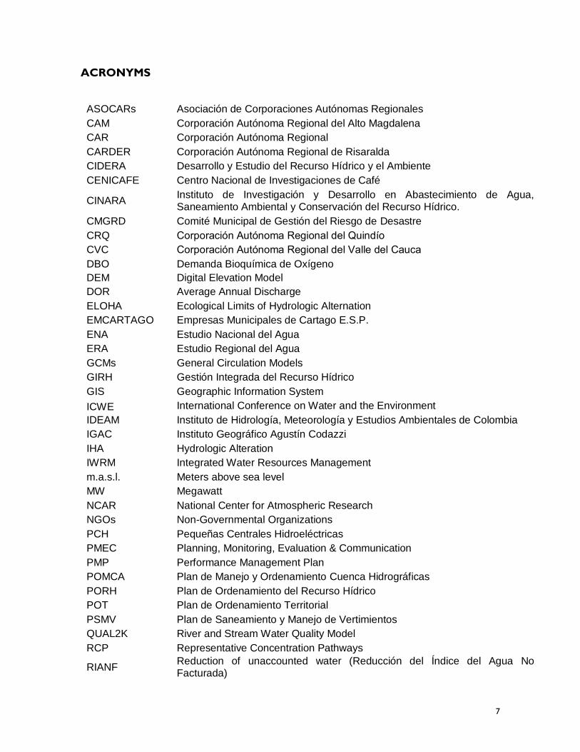
ACRONYMS
ASOCARs Asociación de Corporaciones Autónomas Regionales
CAM Corporación Autónoma Regional del Alto Magdalena
CAR Corporación Autónoma Regional
CARDER Corporación Autónoma Regional de Risaralda
CIDERA Desarrollo y Estudio del Recurso Hídrico y el Ambiente
CENICAFE Centro Nacional de Investigaciones de Café
CINARA Instituto de Investigación y Desarrollo en Abastecimiento de Agua, Saneamiento Ambiental y Conservación del Recurso Hídrico.
CMGRD Comité Municipal de Gestión del Riesgo de Desastre
CRQ Corporacion Autonoma Regional del Quindio
CVC Corporacion Autonoma Regional del Valle del Cauca
DBO Demanda Bioquímica de Oxígeno
DEM Digital Elevation Model
DOR Average Annual Discharge
ELOHA Ecological Limits of Hydrologic Alternation
EMCARTAGO Empresas Municipales de Cartago E.S.P.
ENA Estudio Nacional del Agua
ERA Estudio Regional del Agua
GCMs General Circulation Models
GIRH Gestión Integrada del Recurso Hídrico
GIS Geographic Information System
ICWE International Conference on Water and the Environment
IDEAM Instituto de Hidrología, Meteorología y Estudios Ambientales de Colombia
IGAC Instituto Geográfico Agustín Codazzi
IHA Hydrologic Alteration
IWRM Integrated Water Resources Management
m.a.s.l. Meters above sea level
MW Megawatt
NCAR National Center for Atmospheric Research
NGOs Non-Governmental Organizations
PCH Pequeñas Centrales Hidroeléctricas
PMEC Planning, Monitoring, Evaluation & Communication
PMP Performance Management Plan
POMCA Plan de Manejo y Ordenamiento Cuenca Hidrográficas
PORH Plan de Ordenamiento del Recurso Hídrico
POT Plan de Ordenamiento Territorial
PSMV Plan de Saneamiento y Manejo de Vertimientos
QUAL2K River and Stream Water Quality Model
RCP Representative Concentration Pathways
RIANF Reduction of unaccounted water (Reducción del Índice del Agua No Facturada)

8
RDM Robust Decision Making
SEI Stockholm Environment Institute
TNC The Nature Conservancy
UAESPNN Unidad Administrativa Especial del Sistema de Parques Nacionales Naturales
UNFCCC United Nations Framework Convention to Combat Climate Change
Univalle Universidad del Valle, Cali, Colombia
USAID United States Agency for International Development
UTP Universidad Tecnológica de Pereira, Colombia
WEAP Water Evaluation And Planning System
WH Watt-hour
WWF Wild World Foundation
XLRM Exogenous Factors Levers, Relationships and Metrics.
9
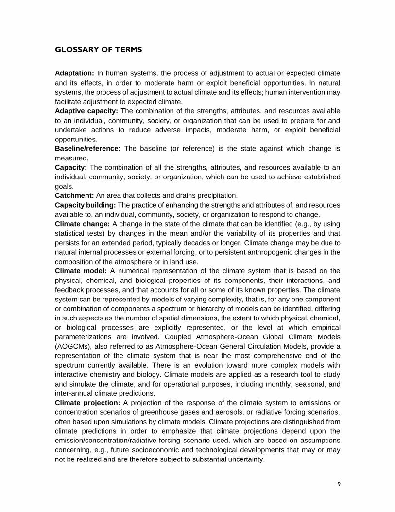
GLOSSARY OF TERMS
Adaptation: In human systems, the process of adjustment to actual or expected climate
and its effects, in order to moderate harm or exploit beneficial opportunities. In natural
systems, the process of adjustment to actual climate and its effects; human intervention may
facilitate adjustment to expected climate.
Adaptive capacity: The combination of the strengths, attributes, and resources available
to an individual, community, society, or organization that can be used to prepare for and
undertake actions to reduce adverse impacts, moderate harm, or exploit beneficial
opportunities.
Baseline/reference: The baseline (or reference) is the state against which change is
measured.
Capacity: The combination of all the strengths, attributes, and resources available to an
individual, community, society, or organization, which can be used to achieve established
goals.
Catchment: An area that collects and drains precipitation.
Capacity building: The practice of enhancing the strengths and attributes of, and resources
available to, an individual, community, society, or organization to respond to change.
Climate change: A change in the state of the climate that can be identified (e.g., by using
statistical tests) by changes in the mean and/or the variability of its properties and that
persists for an extended period, typically decades or longer. Climate change may be due to
natural internal processes or external forcing, or to persistent anthropogenic changes in the
composition of the atmosphere or in land use.
Climate model: A numerical representation of the climate system that is based on the
physical, chemical, and biological properties of its components, their interactions, and
feedback processes, and that accounts for all or some of its known properties. The climate
system can be represented by models of varying complexity, that is, for any one component
or combination of components a spectrum or hierarchy of models can be identified, differing
in such aspects as the number of spatial dimensions, the extent to which physical, chemical,
or biological processes are explicitly represented, or the level at which empirical
parameterizations are involved. Coupled Atmosphere-Ocean Global Climate Models
(AOGCMs), also referred to as Atmosphere-Ocean General Circulation Models, provide a
representation of the climate system that is near the most comprehensive end of the
spectrum currently available. There is an evolution toward more complex models with
interactive chemistry and biology. Climate models are applied as a research tool to study
and simulate the climate, and for operational purposes, including monthly, seasonal, and
inter-annual climate predictions.
Climate projection: A projection of the response of the climate system to emissions or
concentration scenarios of greenhouse gases and aerosols, or radiative forcing scenarios,
often based upon simulations by climate models. Climate projections are distinguished from
climate predictions in order to emphasize that climate projections depend upon the
emission/concentration/radiative-forcing scenario used, which are based on assumptions
concerning, e.g., future socioeconomic and technological developments that may or may
not be realized and are therefore subject to substantial uncertainty.
10
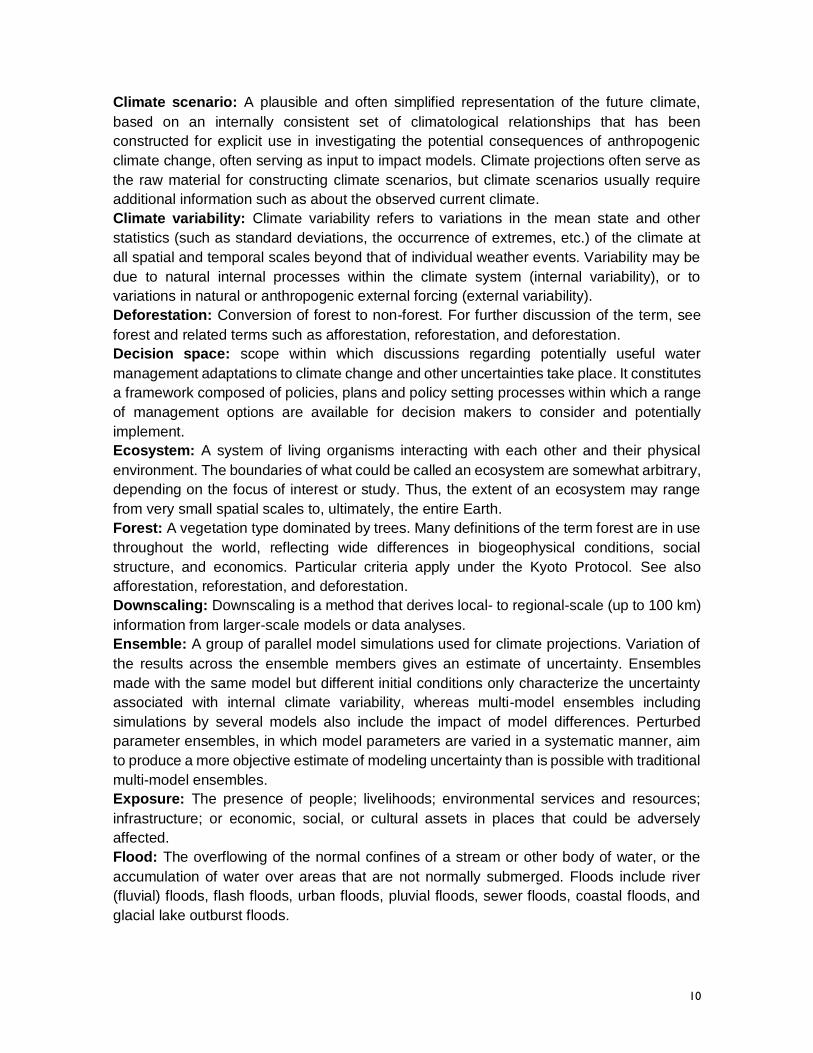
Climate scenario: A plausible and often simplified representation of the future climate,
based on an internally consistent set of climatological relationships that has been
constructed for explicit use in investigating the potential consequences of anthropogenic
climate change, often serving as input to impact models. Climate projections often serve as
the raw material for constructing climate scenarios, but climate scenarios usually require
additional information such as about the observed current climate.
Climate variability: Climate variability refers to variations in the mean state and other
statistics (such as standard deviations, the occurrence of extremes, etc.) of the climate at
all spatial and temporal scales beyond that of individual weather events. Variability may be
due to natural internal processes within the climate system (internal variability), or to
variations in natural or anthropogenic external forcing (external variability).
Deforestation: Conversion of forest to non-forest. For further discussion of the term, see
forest and related terms such as afforestation, reforestation, and deforestation.
Decision space: scope within which discussions regarding potentially useful water
management adaptations to climate change and other uncertainties take place. It constitutes
a framework composed of policies, plans and policy setting processes within which a range
of management options are available for decision makers to consider and potentially
implement.
Ecosystem: A system of living organisms interacting with each other and their physical
environment. The boundaries of what could be called an ecosystem are somewhat arbitrary,
depending on the focus of interest or study. Thus, the extent of an ecosystem may range
from very small spatial scales to, ultimately, the entire Earth.
Forest: A vegetation type dominated by trees. Many definitions of the term forest are in use
throughout the world, reflecting wide differences in biogeophysical conditions, social
structure, and economics. Particular criteria apply under the Kyoto Protocol. See also
afforestation, reforestation, and deforestation.
Downscaling: Downscaling is a method that derives local- to regional-scale (up to 100 km)
information from larger-scale models or data analyses.
Ensemble: A group of parallel model simulations used for climate projections. Variation of
the results across the ensemble members gives an estimate of uncertainty. Ensembles
made with the same model but different initial conditions only characterize the uncertainty
associated with internal climate variability, whereas multi-model ensembles including
simulations by several models also include the impact of model differences. Perturbed
parameter ensembles, in which model parameters are varied in a systematic manner, aim
to produce a more objective estimate of modeling uncertainty than is possible with traditional
multi-model ensembles.
Exposure: The presence of people; livelihoods; environmental services and resources;
infrastructure; or economic, social, or cultural assets in places that could be adversely
affected.
Flood: The overflowing of the normal confines of a stream or other body of water, or the
accumulation of water over areas that are not normally submerged. Floods include river
(fluvial) floods, flash floods, urban floods, pluvial floods, sewer floods, coastal floods, and
glacial lake outburst floods.
11
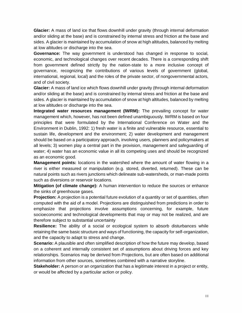
Glacier: A mass of land ice that flows downhill under gravity (through internal deformation
and/or sliding at the base) and is constrained by internal stress and friction at the base and
sides. A glacier is maintained by accumulation of snow at high altitudes, balanced by melting
at low altitudes or discharge into the sea.
Governance: The way government is understood has changed in response to social,
economic, and technological changes over recent decades. There is a corresponding shift
from government defined strictly by the nation-state to a more inclusive concept of
governance, recognizing the contributions of various levels of government (global,
international, regional, local) and the roles of the private sector, of nongovernmental actors,
and of civil society.
Glacier: A mass of land ice which flows downhill under gravity (through internal deformation
and/or sliding at the base) and is constrained by internal stress and friction at the base and
sides. A glacier is maintained by accumulation of snow at high altitudes, balanced by melting
at low altitudes or discharge into the sea.
Integrated water resources management (IWRM): The prevailing concept for water
management which, however, has not been defined unambiguously. IWRM is based on four
principles that were formulated by the International Conference on Water and the
Environment in Dublin, 1992: 1) fresh water is a finite and vulnerable resource, essential to
sustain life, development and the environment; 2) water development and management
should be based on a participatory approach, involving users, planners and policymakers at
all levels; 3) women play a central part in the provision, management and safeguarding of
water; 4) water has an economic value in all its competing uses and should be recognized
as an economic good.
Management points: locations in the watershed where the amount of water flowing in a
river is either measured or manipulation (e.g. stored, diverted, returned). These can be
natural points such as rivers junctions which delineate sub-watersheds, or man-made points
such as diversions or reservoir locations.
Mitigation (of climate change): A human intervention to reduce the sources or enhance
the sinks of greenhouse gases.
Projection: A projection is a potential future evolution of a quantity or set of quantities, often
computed with the aid of a model. Projections are distinguished from predictions in order to
emphasize that projections involve assumptions concerning, for example, future
socioeconomic and technological developments that may or may not be realized, and are
therefore subject to substantial uncertainty
Resilience: The ability of a social or ecological system to absorb disturbances while
retaining the same basic structure and ways of functioning, the capacity for self-organization,
and the capacity to adapt to stress and change.
Scenario: A plausible and often simplified description of how the future may develop, based
on a coherent and internally consistent set of assumptions about driving forces and key
relationships. Scenarios may be derived from Projections, but are often based on additional
information from other sources, sometimes combined with a narrative storyline.
Stakeholder: A person or an organization that has a legitimate interest in a project or entity,
or would be affected by a particular action or policy.
12
Streamflow: Water flow within a river channel, for example expressed in m3 /s. A synonym
for river discharge.
Sustainable Development (SD): The concept of sustainable development was introduced
in the World Conservation Strategy (IUCN 1980) and had its roots in the concept of a
sustainable society and in the management of renewable resources. Adopted by the WCED
in 1987 and by the Rio Conference in 1992 as a process of change in which the exploitation
of resources, the direction of investments, the orientation of technological development, and
institutional change are all in harmony and enhance both current and future potential to meet
human needs and aspirations. SD integrates the political, social, economic and
environmental dimensions.
Uncertainty: An expression of the degree to which a value (e.g., the future state of the
climate system) is unknown. Uncertainty can result from lack of information or from
disagreement about what is known or even knowable. It may have many types of sources,
from quantifiable errors in the data to ambiguously defined concepts or terminology, or
uncertain projections of human behavior. Uncertainty can therefore be represented by
quantitative measures, for example, a range of values calculated by various models, or by
qualitative statements, for example, reflecting the judgment of a team of experts.
Vulnerability: Vulnerability is the degree to which a system is susceptible to, and unable to
cope with, adverse effects of climate change, including climate variability and extremes.
Vulnerability is a function of the character, magnitude, and rate of climate change and
variation to which a system is exposed, its sensitivity, and its adaptive capacity.
Water consumption: Amount of extracted water irretrievably lost during its use (by
evaporation and goods production). Water consumption is equal to water withdrawal minus
return flow.
References for Glossary of Terms
Glossary of Terms used in the IPCC Fourth Assessment Report (Glossary of Synthesis
Report).
IPCC, 2014: Annex II: Glossary [Mach, K.J., S. Planton and C. von Stechow (eds.)]. In:
Climate Change 2014: Synthesis Report. Contribution of Working Groups I, II and III to the
Fifth Assessment Report of the Intergovernmental Panel on Climate Change [Core Writing
Team, R.K. Pachauri and L.A. Meyer (eds.)]. IPCC, Geneva, Switzerland, pp. 117-130
Special Report on Managing the Risks of Extreme Events and Disasters to Advance Climate
Change Adaptation (SREX)
13
ACKNOWLEDGEMENTS
Water management in Colombia, as well as in Latin America, is evolving to catch up with
growing pressures posed by economic activity and development. As part of that evolution,
in 2010 we were contacted by the universities in La Vieja – the watershed where traditionally
coffee has been grown in Colombia - who were starting to use WEAP in their efforts to
modernize water resources planning and regional support for the water authorities, CARs.
In July of that year we met Carlos Sabas from Universidad Tecnológica de Pereira (UTP)
on a fateful day – his brother had died the day before and the Soccer World Cup Final was
capturing the attention of all Colombians. Despite all these extraordinary events, Carlos
attended the meeting which was crucial to discuss a joint research agenda and to start
networking with local actors. After that day we continued in communication with the La Vieja
team, that included Juan Mauricio Castaño also from UTP, Gabriel Lozano from
UniQuindío Alberto Galvis from CINARA and Jorge Marulanda and Adalberto Arroyave
from Aguas y Aguas de Pereira. Together we proposed a technical support project to build
tools and capacity on water management adaptation to the DGP (Developments Grant
Program) of USAID Washington. In early 2011 we met the USAID team led by Chris
Abrahms who indicated their interest in our proposal, and in May that year we received
communication from him about the intention to add two more components to our program:
work with CAM to support the climate action plan under the leadership of Claudia Martinez
from E3 and work with TNC for WEAP technical enhancements for the Magdalena-Cauca
initiative under the leadership of Tomas Walschburger and Juliana Delgado. We finalized
the contract in mid-2012 and developed work plans the end of that year. In 2013 we reached
out to IDEAM as a key boundary partner, and established contacts with Omar Vargas, Maria
Teresa Martinez and Vicky Guerrero from the different sub directorates leading on
hydrology, climatology and adaptation activities respectively. In addition to acknowledging
the crucial role of the above mentioned individuals, we acknowledge:
- The hard work of the research technicians and students in La Vieja, including Juliana
Valencia, Norma Castro, Cesar Rodriguez and Maria Fernanda Jaramillo.
- The honest contributions to keep the project grounded within the CARs from Abelino
Arias, Angelica Mocada, Epifanio Marín, Amparo Duque, Jose Alberto Riascos,
Paola Patinho, and Lina Alarcón.
- The commitment from the CAM director at that time Rey Ariel Borbon and his
management team including Carlos Cuellar (who became the CAM director in 2014)
and Edisney Silva to establish a WEAP team formed by Carlos Vargas, Freddy
Medina, Paula Anacona, Cesar Barreiro, and Oscar Moncayo.
- The timely contributions from the IDEAM technical team including Jose Franklin
Ruiz, Hector Fabio Aristizabal, Andrea Rodriguez and Guillermo Armenta.
- The clever collaboration for WEAP enhancements from Hector Angarita from TNC.
- The genuine support for climate scenarios from David Yates from NCAR.
- Our own technical team from SEI, including Francisco Flores, Laura Forni, Bart
Wickel, and Jack Sieber, and our local consultants Luisa Cusguen and Nilo Lima.
Finally, we acknowledge the crucial role of the USAID representatives Marta Albanese,
Daniel Lopez, Danielle Spinard and Miguel Atuesta who made administrative matters run
14
smoothly. In particular we acknowledge the constant appeal to ensure the program
demonstrated impact and derived lessons for the future, made by Carolina Figueroa.
The actors mentioned in this acknowledgements are leaders in water management in
Colombia, and their enhanced knowledge through this program on how to integrate climate
into watershed planning will serve Colombia in the adaptation efforts that will be a crucial
part of a sustainable peace in the country in years to come.
Sincerely,
Marisa Escobar and David Purkey
15
EXECUTIVE SUMMARY
The Rios del Páramo al Valle program operated from 2012-2015 applying a participatory
planning process developed by the Stockholm Environment Institute, SEI, referred to as
Robust Decision Support, RDS, in support of capacity building and tool development that
can support climate adaptation in Colombian watersheds. This process integrated the
contributions from academic institutions and Corporaciones Autónomas Regionales, CARs,
and helped create regional and national leaders with long-term capacity to manage and plan
the development of watersheds while integrating climate considerations. Working in close
coordination with the technicians and decision makers from the CARs, the program
evaluated and prioritized a viable set of adaptation alternatives that can reduce climate
vulnerability, laying a foundation for sustainable development and the conservation of
vulnerable ecosystems.
The RDS process was useful to clarify the steps required to develop useful information about
watershed adaptation. By interacting with CARs, it was clear that the rich legal framework
for watershed development in Colombia can be overwhelming (Blanco, 2008). Local
autonomous authorities’ participating in the project complied with national level requirements
to the best of their knowledge and capacity by often relying upon contracts with external
consultants for support. In contrast, this program’s WEAP-based RDS approach sought to
enhance CARs participation through capacity building activities that will lead to them
obtaining and understanding the building blocks of watershed adaptation analysis.
Identifying the decision space – which is defined here as the scope within which watershed
actors can discuss potentially useful water management adaptations to climate change and
other uncertainties and choose to implement the most promising alternatives -, mapping the
regional actors, defining the key scenarios of uncertainty and action, and building tools within
the first year of the program gave the initial baseline information. During the second year,
the focus was on generating a large dataset of cases, defined by external pressures such
as climate and by available adaptation options, in order to understand the key locations of
high climate vulnerability and to discover key adaptation options. Sharing this information in
useful and dynamic graphs provided a vehicle to communicate complex information with
decision makers at the regional and national levels. The complete process responded to the
needs to incorporate regional knowledge from actors into decision making about water
management (Lynam et al., 2007).
Adaptation actions in the different watersheds ranged from watershed conservation to
wastewater treatment plants. Preserving e-flows was highlighted as a necessary option to
maintain ecosystem health. In addition to climate, population growth and hydropower
development at a small and large scale are increasing the challenges for water systems
management.
The process generated impact by promoting the use of WEAP and other program tools in
the planning of watersheds outside of the original project case studies, such as Bolo Frayle.
Other planning instruments influenced by the project related to the territorial planning of
municipalities, as was the case for the Salento EOT. At the national level, the use of the
tools for regional water studies - ERAs, and the consideration for use of ENA to support for
16
the national water studies, demonstrate the potential for scaling of the project outcomes to
the country level.
SEI teamed up with TNC to build a model of the Magdalena River Basin using SEI’s Water
Evaluation And Planning (WEAP) system. Along with ecosystem impacts, the project team
set out to study flood risks. The Mompos Depression is highly vulnerable to extreme floods,
and in 2010–2013, a particularly wet “La Niña” led to severe floods that caused numerous
deaths and widespread property damage in the lower Magdalena basin. Since those floods,
several studies have been conducted to identify ways to reduce flood risks, and some
identified the development of hydropower dams as a potentially helpful measure. But those
studies did not look at flood dynamics in the basin as a whole, nor did they fully consider
climate change. Initial results of the WEAP analysis show that hydropower dams could
substantially reduce water flows during the dry months, and thus harm wetland ecosystems.
But the dams would not protect lowland communities from extreme floods during periodic
high flow events, because upstream reservoirs would have to release water for dam safety.
The project had an approach that was gender-focused, which enabled both women and men
to influence policy and decision-making; and employ strategies that respond to gender-
based vulnerabilities and promote inclusion. In different stages of the RDS process, gender
considerations were mainstreamed. In particular, three key aspects were included within
specific activities: 1) actor mapping identifying female participation in water management in
order to set up a baseline condition, 2) information recording gender to track contributions
and interventions at the watershed level, and 3) generating conditions for female
participation in technical aspects of the project in order to promote female leadership in
watershed management.
All project indicators were achieved and some were exceeded indicating compliance with
the project Performance Management Plan - PMP (Appendix 1). In particular, stories of
change produced at the request of USAID as part of the Cooperative Agreement (Appendix
2) document the achievement of the main capacity building objectives of the program.
Universities and CARs in La Vieja also achieved join work plans for future work applying the
WEAP-based RDS framework in response to future water management planning and
decision making challenges (Appendix 3). Technical results were reported and published in
fact sheets and discussion briefs summarized for technical and lay audiences, including
decision makers (Appendix 4). Scientific progress in terms of modelling and tools to support
water management decision making was reported upon in peer reviewed articles submitted
to scientific journals (Appendix 5).
Lessons learned at different levels of the project suggest possibilities for potential
improvements. At the management level, it is clear that a focus on young professionals and
on working with academic legacy institutions is important for the continuity of the program in
the long term. Also, CARs engagement will have to be revaluated in future applications to
ensure stronger commitments to participate by devoting personnel’s time to the project.
At the technical level, although the end product of a model building exercise is comparable
to having a laboratory for watershed analysis, it is important that the process is streamlined
to reduce time spent and avoid frustration. The consolidation of a community of practice may
17
lead to opportunities to improve the automation of the process, which will in turn contribute
to streamlining steps for obtaining results. The lack of data, including socio-economic
information, continues to hinder trust in modeling tools; this can be overcome by further
characterizing uncertainties associated with data. Finally, the presentation of results to
different audiences needs to be further refined to reach larger audiences.
Regarding governance, key recommendations relate to clarifying the linkages between
watershed planning and current mandated planning instruments, and to including climate
consideration in these instruments. The Colombian water governance system, decentralized
to the CARs, creates opportunities for regional management and challenges for integration
at the national level, and requires a strengthening of learning exchange between regional
and national experiences. For instance, the leadership of IDEAM within IWRM efforts is key.
Finally, the exploration of how to navigate adaptation funding would be an important next
step for any watershed climate adaptation study.
Building capacity in climate adaptation for watershed planning requires time and effort.
Participating actors in this project were exposed to the process in order to gain competence.
The learning curve is still on an upward slope and requires additional efforts in order to scale
up. The continuity that young professionals and legacy institutions, such as the universities
that will continue working to apply the concepts of RDS to support climate adaptation after
the program ends as part of their research, teaching and public engagement, can provide
will be key to taking those additional steps needed to achieve higher levels of competence
in analyzing the best alternatives for watershed adaptation using a set of technically sound
tools.
18
INTRODUCTION
In 1992, participants at the International Conference on Water and the Environment
published what has become known as the Dublin Statement on Water and Sustainable
Development (ICWE, 1992). This statement, with its references towards defining fresh water
as a finite and vulnerable resource, essential to sustain life, which should be managed
through broadly participatory approaches, with full recognition of the essential role of women
in water management and acknowledgement of water as an economic good, motivated the
emergence of Integrated Water Resources Management (IWRM) as a frame for public policy
setting involving water resources (Blanco, 2008). Fundamentally IWRM requires a broad
and coordinated view of water and watershed management that allows for water allocation
to support economic activities, while maintaining ecosystem integrity and the water security
of future generations (Jonch-Clausen, 2004).
In Colombia, the response to the Dublin Statement and the emergence of IWRM is evident
in the evolving institutional and legal framework related to water and watersheds in the
country (Ministerio de Ambiente, Vivienda y Desarrollo Territorial, 2010), leading to the
promulgation of several new mandated planning process to be undertaken at the scale of
watersheds, and municipalities located within watershed. There still is, however, work to do
to achieve the promise of IWRM to coordinate water resources management planning and
decision making amongst policy actors and economic sectors (Blanco, 2008).
Acknowledging that pending work should not be viewed as an indictment of Colombia and/or
Colombian water managers; most countries of the world find themselves in a similar position.
Since Dublin, however, efforts to implement IRWM have increasingly confronted the growing
recognition that climate change creates a large amount of uncertainty that should, in
principle, be considered within the participatory processes anticipated by the Dublin
Statement.
The challenges that climate change poses for countries that are pursuing sustainable
development related to water, such as Colombia, are real (Steinhoff et al., 2015). They are
akin to changing the rules of the game in the middle of a match, as seen most clearly in the
decision by the Colombian Ministry of the Environment and Sustainable Development to
exclude explicit requirements to consider climate change within recently published guidance
documents related to several mandated water and watershed plans. They simply did not
feel that they had enough information and insight to craft defensible guidelines at this point
in time. As such, the formulation of IWRM-based protocols to identify adaptation strategies
to respond to climate change impacts on hydrology, water management and water quality is
a pending and necessary task (Ludwig et al., 2014).
At the global level, the Nairobi Work Program of the United Nations Framework Convention
to Combat Climate Change (UNFCCC) has initiated an effort (UNFCC, 2009) to compile
resources that can support watershed planners, water managers, water utilities, irrigation
districts, water users, environmental regulatory agencies and NGO, and stakeholders in
general in considering the complexities of climate change in planning and decision making
process. Universities and research institutes are key partners in this effort as many have
19
received support to develop the tools required to respond to this complexity. For example,
funding from the U.S. National Science Foundation allowed the RAND Corporation to tailor
a generic strategic decision making under uncertainty framework (Lempert et al., 2003)
referred to as Robust Decision Making (RDM) to the needs of the water management
community (Lempert and Groves, 2010). At the core of this effort is the Water Evaluation
and Planning (WEAP) system (Yates et al., 2005) developed by the Stockholm Environment
Institute. WEAP itself was updated, with support from the U.S. Environmental Protection
Agency Office of Global Change Research, to better accommodate climate uncertainty in
the evaluation of water management options. In complex water management settings such
as California, RDM and WEAP have demonstrated promise in assisting decision makers in
implementing IWRM-based processes with full consideration of climate uncertainty.
This report synthesizes three years of experience by the Stockholm Environment Institute,
along with a large set of Colombian partners, to explore how these specific tools might
contribute to a similar evolution in Colombia. With the support of USAID-Colombia, the SEI
team deployed these tools at a number of scales across the Colombian water management
landscape. As part of this deployment, substantial attention was focused on (i) building the
capacity of Colombian institutions to master these tools, (ii) demonstrating the utility of these
tools within formal water and watershed planning and decision making processes in
Colombia, and (iii) connecting local experiences using these tools to the national level
discourse modifying these formal water and watershed planning and decision making
processes to better accommodate the complexity associated with climate change.
The activities documented in this report suggest that a new approach for water resource
planning and decision making is emerging that can work across Colombia. The Rios del
Páramo al Valle project created an opportunity for the exploration of innovative participatory
processes, advanced water system modeling and novel communication approaches
towards that end. Evidence of increased technical capacity and of an enhanced ability to
evaluate adaptation alternatives at the watershed level suggests that the methods and
techniques tested in this project can be both replicable and broadly useful in Colombia. This
is not, however, a step-by-step guidance document; it is rather a story of change that can
illuminate new possibilities for water managers in Colombia, and beyond, as they seek to
integrate climate change considerations into their efforts to respond to the ideals contained
in the Dublin Statement.
20
CONTEXT OF THE PROGRAM
Since the creation of the Colombian Ministry of Environment and Sustainable Development
in 1993, there has been an evolution of legislation to replace the 1984 Decree 1594 which,
along the lines of other clean water legislation in other countries focused on water quality,
with new and more extensive powers to plan for the management of water and watersheds.
In large measure, these reforms were motivated by the Dublin Statement and subsequent
discussions at the 1992 UN Conference on Sustainable Development in Rio de Janeiro,
Brazil. Since its creation, the Ministry has crafted several environmental planning
instruments related to water, watershed and land use, such as the POMCA (Plan de
Ordenamiento y Manejo de Cuencas Hidrográficas – Decree 2759 of 2002), PORH (Plan
de Ordenamiento del Recurso Hídrico – Decree 3930 of 2010), POT (Plan de Ordenameinto
Territorial – Law 388 of 1997) and PSMV (Plan de Saneamiento y Manejo de Vertimientos
– Resolution 1433 of 2004). Guidance for the implementation of these plans provided by the
Ministry to the local authorities (mandated to deliver them) make allusion to the importance
of participatory processes, and to an integrated approach to improving outcomes related to
water quality and quantity, ecosystems, and disaster risk reduction. What these guidance
documents do not contain is a mandate to consider climate change as part of the
development of these plans. The Ministry simply did not feel confident that they had enough
information and insight to propose defensible guidelines at this time.
In addition, the typical manner in which local authorities develop these plans is by contracting
with external consultants who seek to implement the Ministry guidelines as closely as
possible, focusing the majority of available resources on data collection and an assessment
of current conditions. The result is that very little space is left for innovation to consider
climate change in the development of these instruments and that little capacity for analyzing
the complexity of climate adaptation is created. This is the context within which SEI
implemented the Rios del Páramo al Valle project. SEI offered a framework and structure
that integrated climate change within the principles of IWRM. Based on its prior positive
experience using the WEAP-based Robust Decision Making approach, SEI designed the
project to focus on deploying this technique at a variety of scales within the Magdalena-
Cauca River Basin system.
Within the Magdalena-Cauca Basin, the project focused on two distinct sub-regions: the La
Vieja-Otún watersheds in the Cauca Sub-Basin and Alto Magdalena watershed (Figure 1).
Both are important coffee growing regions, but they are distinct in many ways. La-Vieja-
Otun’s major challenges are water quality and ecosystem protection while multi-sector water
allocation are the key challenges in the Alta Magdalena watershed. Both watersheds lie
within high -performing Corporaciones Autónomas Regionales – CARs, regional
government organizations in charge of resource use permitting – which are responsible for
coordinating water and watershed planning and decision making. This made them ideal
locations for the sort of innovation contemplated within the original project design. By
focusing on these sub-regions, the project was able to address emerging concerns of
numerous important target stakeholders in these watershed systems charged with
managing natural resources to the benefit of their constituencies, now and in the face of a
changing climate. In particular, key actors such as managers of Colombia’s high Andean
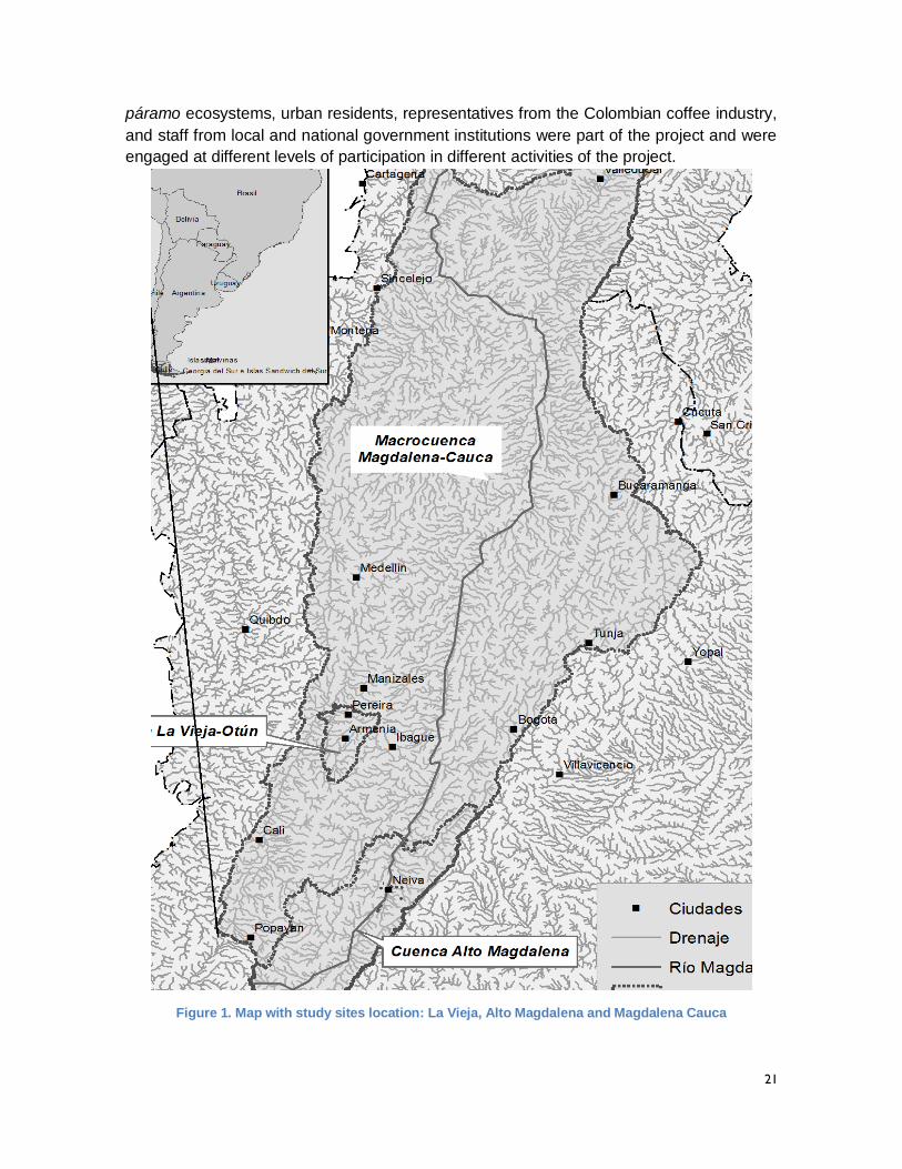
21
páramo ecosystems, urban residents, representatives from the Colombian coffee industry,
and staff from local and national government institutions were part of the project and were
engaged at different levels of participation in different activities of the project.
Figure 1. Map with study sites location: La Vieja, Alto Magdalena and Magdalena Cauca
22
The Rio Otun watershed is the source of water supply for the city of Pereira. The municipal
utility, Aguas y Aguas, diverts water for the City of Pereira and other smaller communities,
as well for a hydropower producer, and transfers untreated wastewater to the Rio Consota
(a Rio La Vieja tributary). The water quality in the Rio Consota is important due to the fact
that the river flows into lower Rio La Vieja, which is the source of water supply for the
downstream city of Cartago. Including the Rio Otun in the project design allowed for the
consideration of two specific issues of significant concern to CARS in Colombia: reversing
water quality degradation downstream of urban centers and conserving paramo ecosystems
as an effective climate change adaptation. The basin offered a compelling setting to
investigate water management and climate change challenges that are common to many
regions of Colombia.
In the Rio La Vieja watershed, the project worked with the three CARS (Corporación
Autónoma Regional del Valle del Cauca, CVC, Corporación Autónoma Regional del
Quindío, CRQ y Corporación Autónoma Regional de Risaralda, CARDER) that have shared
jurisdiction for managing the basin. The watershed has a total area of 2,900 km2 with a main
stem river length of 101 km running from south to north through the Eje Cafetero. The total
population of 1,140,000 inhabitants within the watershed is distributed across 21
municipalities. The Rio La Vieja has 23 tributaries that descend from the western flank of
the Andean Cordillera Central, fed by climate sensitive glacier and páramo ecosystems that
provide valuable contributions to vital dry season base flows in the watershed. Due to the
sensitivity of these ecosystems to changing climatic conditions and to pressure from land
use change, the focus on páramos as a priority ecosystem is a good complement to the
water quality challenges faced in the La Vieja system.
In the Alto Magdalena watershed, the project focused on supporting the water component
of the Climate Action Plan that was being developed by the local CAR. This watershed spans
an area of 22,200 km2 which encompass the whole Huila Department as well as areas from
the Cauca Department within the Rio Paez sub-watershed and from the Tolima Department
with the Rio Patá and Cabrera sub-watersheds. With a population of approximately 765,000
inhabitants, this region of Colombia is of particular importance at a national level because
of the current and potential hydropower production capacity available in the Huila
Department. There are also important agricultural productions systems, particularly for
coffee, rice, aquaculture, and livestock. Finally, as the source of the vitally important
Magdalena River, the Alta Magdalena watershed produces 555 m3/s of water, on average,
affording enormous benefit to downstream water users and ecosystems, and to the nation.
A key dimension of the project was its consideration of climate change at the larger
Magdalena-Cauca River Basin scale. In particular the project focused on implementing new
functionality in WEAP to characterize floodplain inundation as function of flows through time
along a river network. Based on information available on recent flooding in the lower
Magdalena system, work was carried out to conceptualize, design, implement and test new
functionality in WEAP that would allow for assessing how downstream conditions might be
impacted by climate change and various water management proposals in the upper
watershed, in particular hydropower development. In addition to this focus on downstream
floodplains, SEI also enhanced WEAP to link the tool to the Indicators of Hydrologic
23
Alteration (IHA) software developed by TNC as part of its Ecological Limits of Hydrologic
Alternation (ELOHA) initiative. TNC has classified sub-basins within the Magdalena-Cauca
system in terms of their ecological integrity and importance and has assessed which IHA
indicators are most critical for each classification. Working in close collaboration with TNC,
SEI programmed routines into WEAP that permit the estimation of critical IHA metrics under
different future climate change and water management conditions. These two
enhancements are powerful contributors to efforts to factor ecosystem sustainability into
emerging IWRM protocols in Colombia.
The context within which the Rios del Páramo al Valle project operated, and the scales at
which the project engaged, constitute a powerful learning laboratory for testing a set of
decision support processes as well as provides analytical tools that allow local Colombian
environmental management institutions to contribute to an emerging national discourse on
climate change and water management in Colombia. The success of a national Symposium
at which the “bottom-up” experiences of SEI and its partners were presented suggests that
the project achieved this goal.
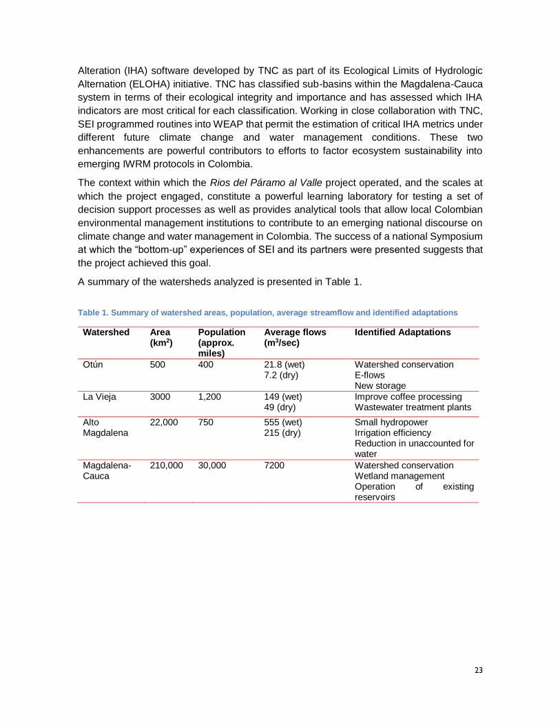
A summary of the watersheds analyzed is presented in Table 1.
Table 1. Summary of watershed areas, population, average streamflow and identified adaptations
Watershed Area (km2)
Population (approx. miles)
Average flows (m3/sec)
Identified Adaptations
Otún 500 400 21.8 (wet) 7.2 (dry)
Watershed conservation E-flows New storage
La Vieja 3000 1,200 149 (wet) 49 (dry)
Improve coffee processing Wastewater treatment plants
Alto Magdalena
22,000 750 555 (wet) 215 (dry)
Small hydropower Irrigation efficiency Reduction in unaccounted for water
Magdalena-Cauca
210,000 30,000 7200 Watershed conservation Wetland management Operation of existing reservoirs
24
Box. Rios del Páramo al Valle: An agreement that achieved its goal and objectives
The goal of the project was to build regional capacity to support the sustained integration of climate change adaptation into
water management plans and strategies within Corporaciones Autónomas Regionales (regional environmental authorities
in Colombia) focusing on the Rio La Vieja and Alto Magdalena watersheds, and to extend the benefits of that learning to all
Corporaciones in Colombia (Figure 1). The activities included an evaluation of climate change adaptation alternatives for
water resources planning, the development of analytical tools and capacity building. As indicated in detail the ‘Context of
the Program’ section of this report, we worked with several partners to achieve these goals and we briefly restate here
what we did, how we did it and with whom. In Rio La Vieja we worked with three main partners. First, EIS – a research
group within Universidad Tecnológica de Pereira - transferred capacity through workshops and co-learning with CARDER
and Aguas y Aguas to build WEAP models to identify climate adaptations for the Otún and La Vieja watersheds. Second,
CIDERA – a University of Quindío research group – collaborated with CRQ in data transfer and promoted the use of the
WEAP systems modeling approach to identify adaptation options in terms of water quantity. Third, CINARA from UniValle
worked closely with CVC to build capacity in water quality modeling to identify and promote adaptations to improve water
quality conditions in urban and rural coffee runoff areas. In Alto Magdalena, we promoted co-learning, cooperation and
participative research with CAM in the development and implementation of the water component of the Huila 2050
Climate Action Plan. At the Magdalena-Cauca level we worked with TNC to build and improve WEAP routines to
understand the effect of upstream management and adaptation in downstream flooding of the Mompos Depression. Figure
19 of the report shows how we collaborated with partners to achieve each component.
In order to meet the project goal, 3 specific objectives were formulated and achieved after project implementation, as
described below:
i. Assess current understanding of climate change and variability effects on water resources in the Rio La Vieja and
Alto Magdalena watersheds using an innovative, participatory, problem formulation framework.
Current understanding of climate change and variability effects on water resources was achieved by implementing
workshops that applied participatory research techniques with a set of stakeholders that were identified as relevant in water
management decision making. Stakeholders were guided with questions and conceptual frameworks based on uncertainty
characterization, the livelihoods framework and the ecosystem services framework to define key components of the water
system to be considered. Such a process led to a complete characterization of the most relevant watershed elements that
could be affected by climate change and variability. In the ‘Methods’ section of this report we present the details of the
methodology applied, in particular the application of the XLRM framework within the Robust Decision Support framework.
Components were divided into those that are outside of the control of water managers (Xs in the XLRM framework such
as climate change and population growth), those that can be acted upon with adaptation strategies (Ls in the XLRM
framework such as infrastructure or páramo conservation), and the metrics to evaluate impacts (Ms in the XLRM framework
such as reliability of water supply). In the ‘Results’ section of this report there is detail about the watershed characterization
that resulted from applying this methods, and a summary of XLRM results for the three basins is presented in Tables 3, 4
and 6.
ii. Develop analytical tools based on WEAP to explore links between climate change, the conservation of priority
ecosystems and the sustainable management of water resources in the Rio La Vieja and Alto Magdalena
watersheds.
Development of analytical tools based on WEAP was achieved by investing a large portion of the grant’s time and resources
into generating WEAP models of the watersheds under study. The WEAP model building was accompanied by a series of
training opportunities tailored to the Corporaciones’ needs and availability. Climate information was downscaled and input
into the models at the appropriate spatial scale to represent variability within the different parts of the watershed. Climate
information was generated during capacity building workshops designed to create awareness of the complexity of climate
data and climate model output and to provide approaches to untangle such complexity. Other tools focused on automating
the generation of WEAP outputs associated with climatic and non-climatic scenarios, and on visualizing the outputs of big
data generated by the multiple scenario model runs. Developing and using these quantitative tools helped in evaluating the
climate change implications within watersheds and understanding the most effective adaptation options at the watershed
scale. The analysis indicated that most effective adaptations for these watersheds are closely linked to development
processes and ongoing conservation efforts in Colombia. In Otún, adaptation priorities are watershed conservation, e-flows
prioritization, and new storage infrastructure. In La Vieja, improved coffee processing and wastewater treatment plants are
the best adaptation options to improve water quality conditions. In Alto Magdalena, small hydropower, irrigation efficiency
and reduction in unaccounted for water were the main adaptations identified (listed in Table 1 of this report). The details
of these outputs are in the ‘Results’ section of this report.
25
iii. Build the capacity of local partners to the point where these partners can contribute to additional capacity
building activities and needed institutional articulation of actions for climate change response at the regional and
national level.
The RDS process included several steps that required knowledge about approaches to first characterize the watershed
context, prepare the required data, and build tools, and second, to investigate the performance of adaptation actions that
could be implemented (Figure 2). Each step and its associated approach included a capacity building method that helped
internalize the concepts. Actor mapping used surveys that highlighted the connections between actors involved in water
management. Problem formulation included a participatory workshop that generated knowledge about the key components
of the watershed for all participants (mentioned in i). Model construction, climate scenarios definition, ensemble analysis
and output exploration included a set of workshops, field visits and events that led to a clear understanding of climatic and
non-climatic variables that could alter watershed hydrologic services (mentioned in ii). Capacity building in decision support
was achieved by designing regional workshops in Cartago in Dec 2014 and in Neiva in Feb 2015 – that were attended by
key watershed stakeholders and decision makers identified in the actor mapping process - and a national symposium in
Bogotá in Jan 2015 where decision makers from a range of implicated national level organizations shared their approach to
using the information produced to inform decisions about the future planning of the watersheds including climate
considerations (a list of key stakeholders involved in these events is located in Appendix 6 of this report. Also, these
events as well as updates about the actors’ are continually reported in the project’s blog http://weap-lavieja-
otun.blogspot.com/). The overall RDS process steps were implemented with the boundary partners leaving them on a path
to higher competence levels (Figure 20), and also giving them a level of power to use these tools for future analysis (Table
10). By linking SEI‐US’s expertise in water resources adaptation to climate change together with local expertise in the Rio
La Vieja, Alto Magdalena and Magdalena-Cauca watersheds, the project responded to needs identified for Climate Change
Sector Adaptation activities under the 2011 DGP, including capacity building, tool and guidance development and
dissemination, applied research and analysis in support of adaptation activities.
The above goals connected directly to USAID goals and priorities. USAID seeks to support the Government of Colombia
in improving living conditions and strengthening the presence and efficiency of the state. Improving the adaptive capacity of
Corporaciones in the economically consolidated Eje Cafetero and Alto Magdalena created a platform for similar
improvements in regions where increasing the provision of basic services, increasing licit livelihoods and strengthening local
institutions is critical. The project also strengthened environmental governance for the conservation of protected areas in
Colombia.
26
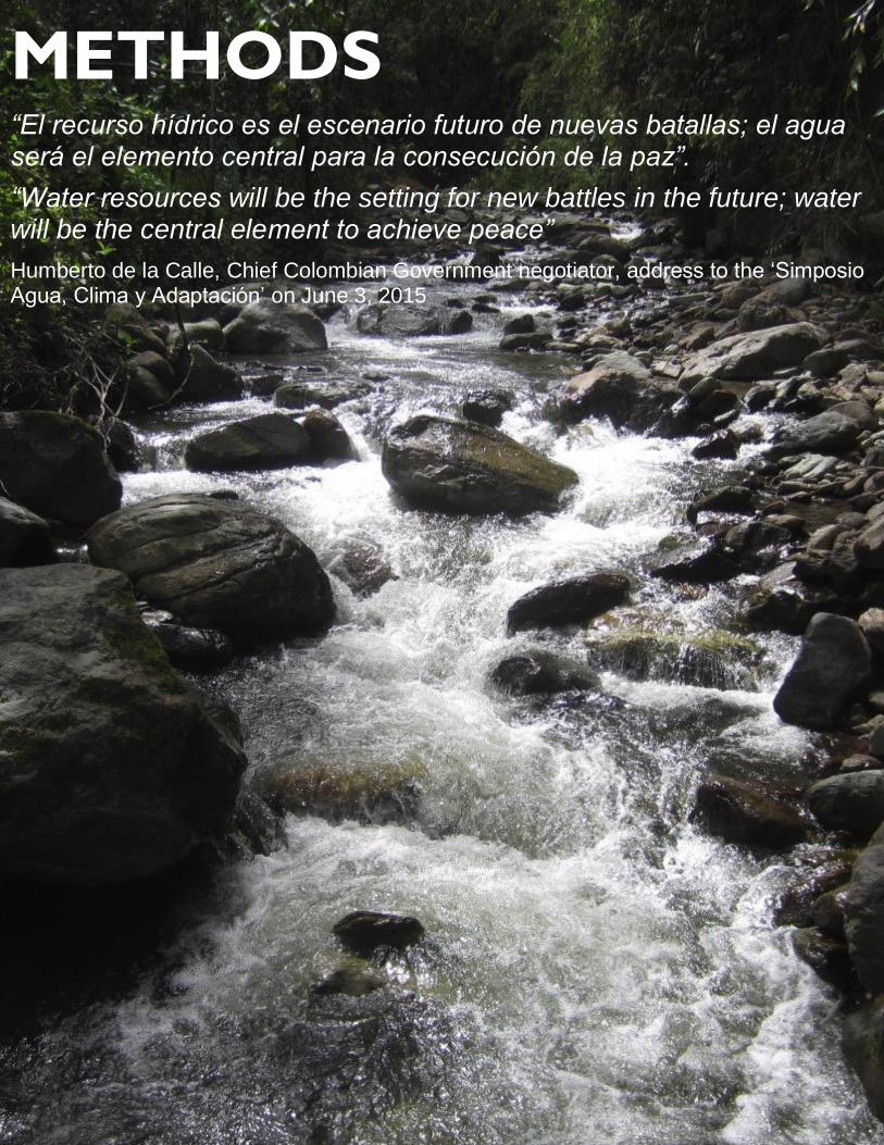
METHODS “El recurso hídrico es el escenario futuro de nuevas batallas; el agua será el elemento central para la consecución de la paz”.
“Water resources will be the setting for new battles in the future; water will be the central element to achieve peace”
Humberto de la Calle, Chief Colombian Government negotiator, address to the ‘Simposio Agua, Clima y Adaptación’ on June 3, 2015
27
METHODS
As described in the previous section, the context for the project was the need and
opportunity to include climate change considerations in the process of water and watershed
planning and decision making at various scales in Colombia, with a geographic focus on the
Magdalena-Cauca River Basin. The primary goal of the project was to build capacity for
partners in the watersheds listed in Table 1, as part of a participatory planning process, to
deploy, test, and potentially replicate the experience gained by SEI to help water, watershed
and ecosystem managers in other parts of the world identify water management
adaptations1. Both the prior experience and the efforts in Colombia were based upon the
application of SEI’s Water Evaluation and Planning (WEAP) system within a participatory
planning process referred to as Robust Decision Support (RDS).
The SEI practice of RDS is based on a theoretical decision making under uncertainty
framework referred to as Robust Decision Making (RDM). RDM emerged from a program
on strategic decision making under conditions of deep uncertainty within the RAND
Corporation (Lempert et al., 2003). The starting point for the RDM framework is that
traditional decision making approaches based on an assessment of the likely probabilities
of future conditions do not respond well to a situation such as climate change, where there
is no consensus about the likelihood of specific climate futures. SEI work with RDS has
involved applying RDM theory to the challenge of water and watershed planning and
decision making under climate change in a way that responds directly to the IWRM appeal
for participatory water and watershed planning, based on a large body of literature (Folke et
al., 2005; Pahl-Wostl, 2009; Pahl-Wostl et al., 2007).
Before presenting the key features of the RDS approach, it would be useful to present some
context for understanding how participation in a project is crucial for incorporating social
learning and capacity building (Bouwen and Taillieu, 2004; Lee, 1999; Lynam et al., 2007;
Stringer et al., 2006). One useful framework, shown in the legend of Figure 2, defines a
progression of levels of stakeholder engagement in a research project. The levels are
relevant to analysis carried out in support of decision making processes as well. The lowest,
and unfortunately perhaps the most common, level of engagement is characterized as
information extraction. While soliciting information from informed stakeholders is necessary
to the process of conducting useful analysis, if these stakeholders are not connected to the
analysis it is difficult to assign it much relevance or credibility. The highest level, Participatory
Action Research, involves granting full control of the design and execution of analysis to
stakeholders. Between these two poles, are varying levels of stakeholder engagement in
the analytical process. In implementing the RDS approach in Colombia, the project
attempted to operate at all the levels of participation from Information Extraction to
Participatory Research.
1 While the project contributed to the identification of specific adaptation actions, the project was not
designed to actually realize them on the ground.
28
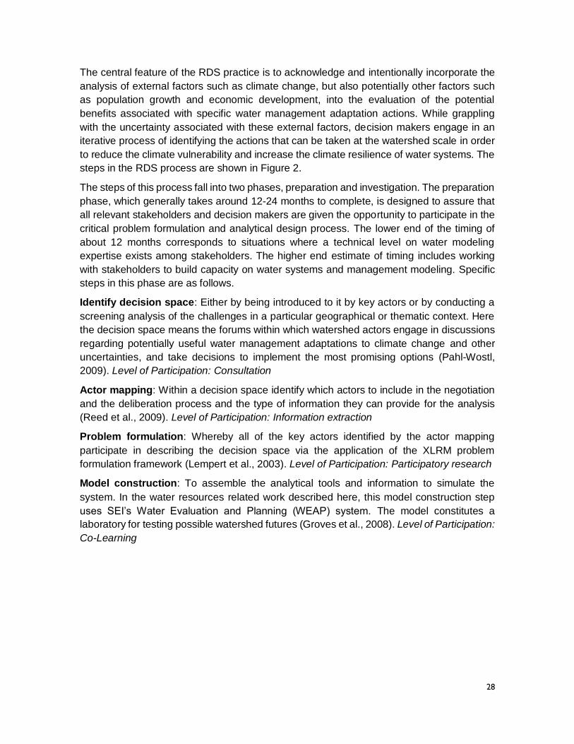
The central feature of the RDS practice is to acknowledge and intentionally incorporate the
analysis of external factors such as climate change, but also potentially other factors such
as population growth and economic development, into the evaluation of the potential
benefits associated with specific water management adaptation actions. While grappling
with the uncertainty associated with these external factors, decision makers engage in an
iterative process of identifying the actions that can be taken at the watershed scale in order
to reduce the climate vulnerability and increase the climate resilience of water systems. The
steps in the RDS process are shown in Figure 2.
The steps of this process fall into two phases, preparation and investigation. The preparation
phase, which generally takes around 12-24 months to complete, is designed to assure that
all relevant stakeholders and decision makers are given the opportunity to participate in the
critical problem formulation and analytical design process. The lower end of the timing of
about 12 months corresponds to situations where a technical level on water modeling
expertise exists among stakeholders. The higher end estimate of timing includes working
with stakeholders to build capacity on water systems and management modeling. Specific
steps in this phase are as follows.
Identify decision space: Either by being introduced to it by key actors or by conducting a
screening analysis of the challenges in a particular geographical or thematic context. Here
the decision space means the forums within which watershed actors engage in discussions
regarding potentially useful water management adaptations to climate change and other
uncertainties, and take decisions to implement the most promising options (Pahl-Wostl,
2009). Level of Participation: Consultation
Actor mapping: Within a decision space identify which actors to include in the negotiation
and the deliberation process and the type of information they can provide for the analysis
(Reed et al., 2009). Level of Participation: Information extraction
Problem formulation: Whereby all of the key actors identified by the actor mapping
participate in describing the decision space via the application of the XLRM problem
formulation framework (Lempert et al., 2003). Level of Participation: Participatory research
Model construction: To assemble the analytical tools and information to simulate the
system. In the water resources related work described here, this model construction step
uses SEI’s Water Evaluation and Planning (WEAP) system. The model constitutes a
laboratory for testing possible watershed futures (Groves et al., 2008). Level of Participation:
Co-Learning
29
Figure 2. RDS steps, timing, and participation levels.
Color coding indicates level of participation according to legend and approximate time for each step
is included. Steps are shown in a linear way, but they overlap and can be iterative.
3 + months
2 months
2 months
2 months
6-12 months
3 months
3 months
3 months
Quantifies plausible future ranges of the identified uncertainties. In the work reported on here, a key part of the activity is the generation of appropriately scaled future climate projections.
Whereby all of the key actors identified by the actor mapping participate in describing the decision space.
Either by being introduced to it by key actors or by conducting a screening analysis of the challenges in a particular geographical or thematic context. Here the decision space means the opportunities to pursue discussions regarding management changes.
Identify decision space
Actor mapping
Within the decision space identifies which actors to include in the negotiation with deliberation process and the type of information they can provide to the analysis.
Problem formulation
Model construction
To assemble the analytical tools and information to simulate the system. In the water resources related work described here, this model construction step uses SEI’s Water Evaluation and Planning (WEAP) system.
Scenario definition
Ensemble analysis
Within which the model constructed is run to combine of all future uncertainties and actions, including the case when no action is taken. This case is critical in assessing the baseline vulnerability of the current system in the face of uncertainties.
Output exploration
Uses innovative and interactive data discovery tools to explore the model results. This exploration is carried with key actors in the decision space.
Decision support
Within which the model constructed is run to combine of all future uncertainties and actions, including the case when no action is taken. This case is critical in assessing the baseline vulnerability of the current system in the face of uncertainties.
Info
rmat
ion
ext
ract
ion
Co
-Lea
rnin
g
Co
op
erat
ion
Co
op
erat
ion
Co
-Lea
rnin
g
Co
-Lea
rnin
g
Co
nsu
ltat
ion
Approximate duration24-36 months
Participation level legend ExampleParticipatory (Action) Research Research is directed by participants, with the researcher acting as a facilitatorCo-Learning Working together to define problems and find solutions
CooperationWorking with people to determinate priorities, but the process is directed by the researchers
Consultation Local opinions are sought and some dialogue occursInformation Extraction Researchers ask people questions and process the information
INVESTIGATION PHASE
Incr
ease
d
par
tici
pat
ion
PREPARATION PHASE
Par
tici
pat
ory
Res
ear
ch
30
Scenario definition quantifies plausible future ranges of the identified uncertainties. In the
work reported on here, a key part of the activity is the generation of future climate projections
scaled appropriately for evaluating climate change adaptations at the watershed scale
(Peterson et al., 2003).
Level of Participation: Cooperation
Two items referenced in this description of the RDS Preparation Phase warrant further
presentation. The first is the XLRM problem formulation framework. XLRM is a tool
developed by the RAND Corporation that divides a decision making process into four
components.
X (eXogenous factors) represents the uncertain factors outside the direct control of the
actors within a particular decision making process but which have the potential to
influence outcomes.
L (Levers) represents the specific actions that are available to these actors as they seek
to improve conditions or outcomes in the face of future uncertainty.
R (Relationships) is the suite of analytical tools deployed to capture the exogenous
factors and represent the levers identified by the actors, which when deployed produce
estimates of…
M (Metrics of Performance), which are the means by which individual actors will evaluate
the outcomes associated with a specific action considered as part of the decision making
process.
The R component of the XLRM framework pertains to the tools used to support the analysis
carried out as part of the effort to evaluate the performance specific adaptation actions.
These often include models of the watershed/water management system in question. Under
the current project, the primary model or analytical tool deployed was the Water Evaluation
and Planning (WEAP) system which has been developed and supported within SEI for over
25 years. WEAP is an integrated hydrologic/water resources modeling platform that
represents both the natural hydrologic or rainfall-runoff processes in a watershed as well as
the physical and regulatory systems put in place to balance available supplies and existing
demands as part of a multi-objective water allocation system. Over the years WEAP has
been expanded to allow for the representation of groundwater hydrology, surface water
quality, plant biomass production and many other processes at play within a watershed. In
each of the Colombian watersheds, SEI worked in close collaboration with local technical
experts to develop applications of the WEAP software.
At different points in the RDS Preparation Phase, gender considerations were
mainstreamed. In particular: 1) the actor mapping exercise was designed to identify the roles
that female currently play in the management of water resources within a watershed,
allowing for the definition of a baseline condition; 2) the results of the actor mapping were
used to promote female participation in the problem formulation exercise and in technical
aspects of the project in order to promote female leadership in watershed management; 3)
during the problem formulation, contributions were logged by gender in order to differentiate
female perspectives from those held by men. Together these efforts led to greater
awareness of gender issues among project partners and to greater participation of women
31
on project activities. SEI is very proud of the level to which the project created opportunities
for women to lead on the critical issues of climate change and water management.
In the RDS process, once the modeling platform has been constructed and calibrated based
on historical climatic and hydrologic data sets, and potential future scenarios have been
defined, the process switches to the Investigation Phase. During this phase, which takes
approximately 12 months to complete, the models are run for each of several adaptation
strategies articulated by the key actors (always including the ‘no action’ option in order to
create a baseline for comparison), under each scenario related to future climate and non-
climate (e.g. population growth rate, per capita consumption, regional economic
development) uncertainties of concern. A set of scenarios produces a large data base of
results covering many dimensions of performance (e.g. demand satisfaction, reservoir
storage levels, hydropower generation, and ecosystem health), that are explored using
innovative data visualization techniques which provide critical inputs to the decision making
process. Specific steps in this phase include:
Ensemble analysis: Within which the model constructed is run to combine all future
uncertainties and actions, including the case when no action is taken. This case is critical in
assessing the baseline vulnerability of the current system in the face of uncertainties.
Level of Participation: Cooperation
Output exploration: Uses innovative and interactive data discovery tools to explore the
model results. This exploration is carried out in a participatory and dynamic fashion with key
actors in the decision space.
Level of Participation: Co-Learning
Decision support: Based on the exploration of the outcomes, which are evaluated within
the decision space, the performance of specific management actions can be evaluated
relative to the no-action baseline and to each other. Upon viewing the results, actors can
decide to either reformulate the problem or to accept a particular recommendation for a
preferred course of action.
Level of Participation: Co-Learning
The exploration of WEAP outputs is simultaneously the most exciting and the most
challenging step in the RDS process. It involves exploring, in close collaboration with
watershed actors, the output of multiple model runs covering all combinations of future
scenarios and possible adaptation responses, covering several dimensions of performance.
The amount of information to digest is substantial and traditional techniques for sharing
scientific and technical information with decision makers (maps, X-Y graphs, data tables)
are not well suited. In the project, SEI and its watershed partners worked with a leading edge
data exploration and visualization software package called Tableau. The sorts of graphics
produced to support the evaluation of adaptation actions in project watershed are presented
in the results section of this report. In addition to these sophisticated dynamic data
visualizations, the project produced a whole series of fact sheets that distilled the key
messages into more traditional media. These are found in the Appendices to this report.
In testing the RDS method as part of this project, SEI and its partners tried to directly relate
the steps in the process to both the connections between the various water and watershed
32
planning instruments mandated by Colombian Law (POMCA, PORH, POT, PSMV) and to
the guidance documents pertaining to the formulation of each individual instrument. As such,
the project was able to produce results that are feeding directly into national level dialogues
pertaining to climate change and water management in Colombia.
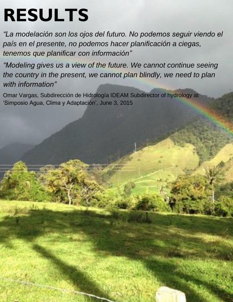
33
RESULTS
“La modelación son los ojos del futuro. No podemos seguir viendo el
país en el presente, no podemos hacer planificación a ciegas,
tenemos que planificar con información”
“Modeling gives us a view of the future. We cannot continue seeing
the country in the present, we cannot plan blindly, we need to plan
with information”
Omar Vargas, Subdirección de Hidrología IDEAM Subdirector of hydrology at
‘Simposio Agua, Clima y Adaptación’, June 3, 2015
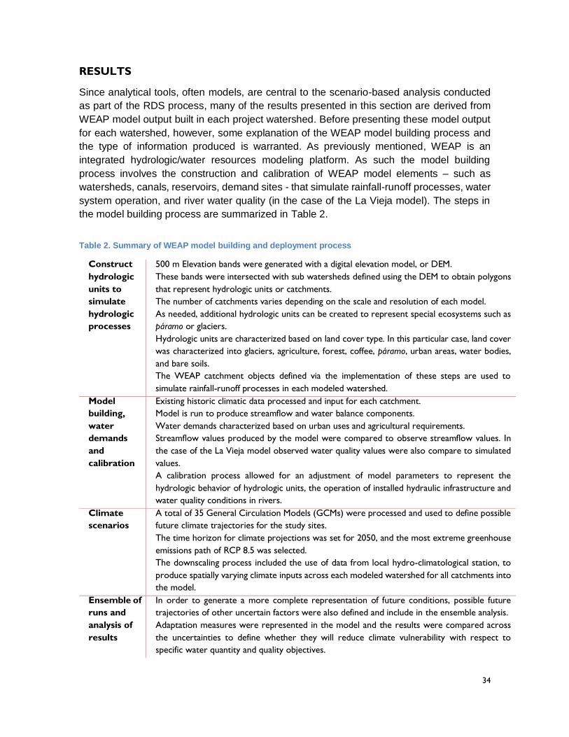
34
RESULTS
Since analytical tools, often models, are central to the scenario-based analysis conducted
as part of the RDS process, many of the results presented in this section are derived from
WEAP model output built in each project watershed. Before presenting these model output
for each watershed, however, some explanation of the WEAP model building process and
the type of information produced is warranted. As previously mentioned, WEAP is an
integrated hydrologic/water resources modeling platform. As such the model building
process involves the construction and calibration of WEAP model elements – such as
watersheds, canals, reservoirs, demand sites - that simulate rainfall-runoff processes, water
system operation, and river water quality (in the case of the La Vieja model). The steps in
the model building process are summarized in Table 2.
Table 2. Summary of WEAP model building and deployment process
Construct
hydrologic
units to
simulate
hydrologic
processes
500 m Elevation bands were generated with a digital elevation model, or DEM.
These bands were intersected with sub watersheds defined using the DEM to obtain polygons
that represent hydrologic units or catchments.
The number of catchments varies depending on the scale and resolution of each model.
As needed, additional hydrologic units can be created to represent special ecosystems such as
páramo or glaciers.
Hydrologic units are characterized based on land cover type. In this particular case, land cover
was characterized into glaciers, agriculture, forest, coffee, páramo, urban areas, water bodies,
and bare soils.
The WEAP catchment objects defined via the implementation of these steps are used to
simulate rainfall-runoff processes in each modeled watershed.
Model
building,
water
demands
and
calibration
Existing historic climatic data processed and input for each catchment.
Model is run to produce streamflow and water balance components.
Water demands characterized based on urban uses and agricultural requirements.
Streamflow values produced by the model were compared to observe streamflow values. In
the case of the La Vieja model observed water quality values were also compare to simulated
values.
A calibration process allowed for an adjustment of model parameters to represent the
hydrologic behavior of hydrologic units, the operation of installed hydraulic infrastructure and
water quality conditions in rivers.
Climate
scenarios
A total of 35 General Circulation Models (GCMs) were processed and used to define possible
future climate trajectories for the study sites.
The time horizon for climate projections was set for 2050, and the most extreme greenhouse
emissions path of RCP 8.5 was selected.
The downscaling process included the use of data from local hydro-climatological station, to
produce spatially varying climate inputs across each modeled watershed for all catchments into
the model.
Ensemble of
runs and
analysis of
results
In order to generate a more complete representation of future conditions, possible future
trajectories of other uncertain factors were also defined and include in the ensemble analysis.
Adaptation measures were represented in the model and the results were compared across
the uncertainties to define whether they will reduce climate vulnerability with respect to
specific water quantity and quality objectives.

35
The sorts of results that are produced through the deployment of WEAP as part of a
scenario based analysis include:
1. Streamflow values at various points in the watershed.
2. The contributions of various parts of the watershed and various land-
use/ecosystem types to these streamflow values.
3. Water storage and diversion patterns associated with the operation of hydraulic
infrastructure in order to satisfy demands in the watershed.
4. The level of demand associated with various use of water in the watershed and the
level of satisfaction of that demand.
5. The ecological status of river reaches using Indicators of Hydrologic Alteration.
6. River water quality at various points in a watershed.
These are the model outputs that are used to estimate the value of performance metrics
articulated by stakeholders as part of the problem-formulation step of the RDS process.
Values are generated for each model run, or case, in an ensemble of cases, where a case
combines a specific set of assumptions about the future based on the uncertainties
identified in the problem-formulation step and a single management response proposed by
the stakeholders. The ensemble is designed to generate model output for cases that span
the range of uncertainties defined by stakeholders and the set of management responses
they propose. The results of these ensembles are presented and analyzed for each project
watershed in the following sections.
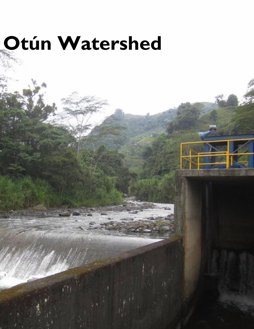
36
Otún Watershed
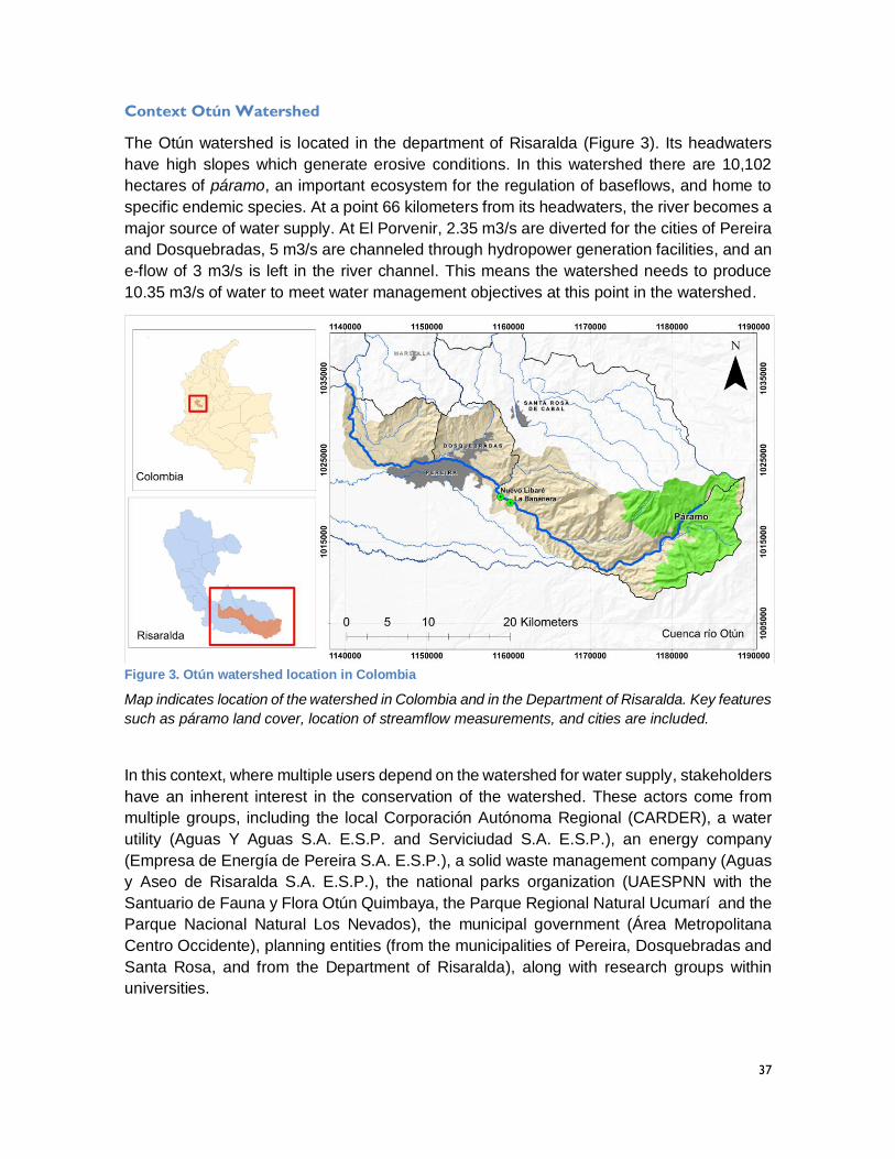
37
Context Otún Watershed
The Otún watershed is located in the department of Risaralda (Figure 3). Its headwaters
have high slopes which generate erosive conditions. In this watershed there are 10,102
hectares of páramo, an important ecosystem for the regulation of baseflows, and home to
specific endemic species. At a point 66 kilometers from its headwaters, the river becomes a
major source of water supply. At El Porvenir, 2.35 m3/s are diverted for the cities of Pereira
and Dosquebradas, 5 m3/s are channeled through hydropower generation facilities, and an
e-flow of 3 m3/s is left in the river channel. This means the watershed needs to produce
10.35 m3/s of water to meet water management objectives at this point in the watershed.
Figure 3. Otún watershed location in Colombia
Map indicates location of the watershed in Colombia and in the Department of Risaralda. Key features
such as páramo land cover, location of streamflow measurements, and cities are included.
In this context, where multiple users depend on the watershed for water supply, stakeholders
have an inherent interest in the conservation of the watershed. These actors come from
multiple groups, including the local Corporación Autónoma Regional (CARDER), a water
utility (Aguas Y Aguas S.A. E.S.P. and Serviciudad S.A. E.S.P.), an energy company
(Empresa de Energía de Pereira S.A. E.S.P.), a solid waste management company (Aguas
y Aseo de Risaralda S.A. E.S.P.), the national parks organization (UAESPNN with the
Santuario de Fauna y Flora Otún Quimbaya, the Parque Regional Natural Ucumarí and the
Parque Nacional Natural Los Nevados), the municipal government (Área Metropolitana
Centro Occidente), planning entities (from the municipalities of Pereira, Dosquebradas and
Santa Rosa, and from the Department of Risaralda), along with research groups within
universities.
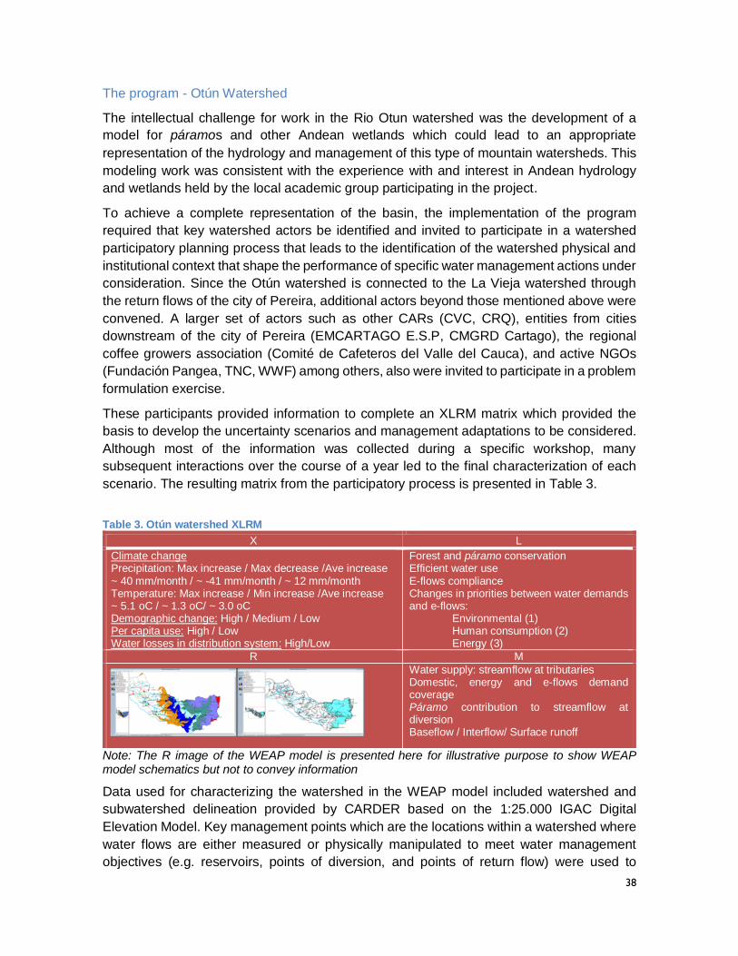
38
The program - Otún Watershed
The intellectual challenge for work in the Rio Otun watershed was the development of a
model for páramos and other Andean wetlands which could lead to an appropriate
representation of the hydrology and management of this type of mountain watersheds. This
modeling work was consistent with the experience with and interest in Andean hydrology
and wetlands held by the local academic group participating in the project.
To achieve a complete representation of the basin, the implementation of the program
required that key watershed actors be identified and invited to participate in a watershed
participatory planning process that leads to the identification of the watershed physical and
institutional context that shape the performance of specific water management actions under
consideration. Since the Otún watershed is connected to the La Vieja watershed through
the return flows of the city of Pereira, additional actors beyond those mentioned above were
convened. A larger set of actors such as other CARs (CVC, CRQ), entities from cities
downstream of the city of Pereira (EMCARTAGO E.S.P, CMGRD Cartago), the regional
coffee growers association (Comité de Cafeteros del Valle del Cauca), and active NGOs
(Fundación Pangea, TNC, WWF) among others, also were invited to participate in a problem
formulation exercise.
These participants provided information to complete an XLRM matrix which provided the
basis to develop the uncertainty scenarios and management adaptations to be considered.
Although most of the information was collected during a specific workshop, many
subsequent interactions over the course of a year led to the final characterization of each
scenario. The resulting matrix from the participatory process is presented in Table 3.
Table 3. Otún watershed XLRM
X L
Climate change Precipitation: Max increase / Max decrease /Ave increase ~ 40 mm/month / ~ -41 mm/month / ~ 12 mm/month Temperature: Max increase / Min increase /Ave increase ~ 5.1 oC / ~ 1.3 oC/ ~ 3.0 oC Demographic change: High / Medium / Low Per capita use: High / Low Water losses in distribution system: High/Low
Forest and páramo conservation Efficient water use E-flows compliance Changes in priorities between water demands and e-flows:
Environmental (1) Human consumption (2)
Energy (3)
R M
Water supply: streamflow at tributaries Domestic, energy and e-flows demand coverage Páramo contribution to streamflow at diversion Baseflow / Interflow/ Surface runoff
Note: The R image of the WEAP model is presented here for illustrative purpose to show WEAP model schematics but not to convey information
Data used for characterizing the watershed in the WEAP model included watershed and
subwatershed delineation provided by CARDER based on the 1:25.000 IGAC Digital
Elevation Model. Key management points which are the locations within a watershed where
water flows are either measured or physically manipulated to meet water management
objectives (e.g. reservoirs, points of diversion, and points of return flow) were used to
39
delineate subwatersheds. In addition, the SRTM 90 m resolution was used to refine the
definition of sub-watershed boundaries.
The resulting monthly hydrology and systems operation model downstream to the point of
multipurpose diversion represents the supply system for the cities of Pereira and
Dosquebradas, and the energy and ecological requirements. The model was built using
climate inputs and physical characteristics to analyze climate change vulnerability in terms
of the system’s capacity to produce water supply for the city of Pereira, and to meet other
management objectives. In addition, a model of daily flows representing the páramo
hydrology was included to estimate the water contribution of this strategic ecosystem.
The two resulting models for the basin included a monthly model for the Otún watershed,
and a daily model of the páramo above 3,000 m.a.s.l. Both models include a characterization
of uncertainties and strategies that produce outputs for different performance metrics. These
uncertainties, strategies and metrics were identified through the XLRM problem formulation
process (M in Table 3).
Performance of adaptation options - Otún Watershed
After an analysis of different adaptation options, it was possible to identify that actions
already taken in the watershed since 1950 - including the conservation of exiting páramo
and forest landscapes and efficient water use - are largely maintaining the functionality of
the watershed, which in turn is maintaining a water supply and demand balance despite
climate and other future uncertainties, with some exceptions under more extreme future
scenarios.
In this context, one adaptation strategy evaluated for the future of the Otún watershed was
to explore how water allocation priorities could be adjusted to ensure future system
performance. This strategy acknowledges a key management challenge in this watershed
which is the continuous provision of water services for urban consumption as well as for the
needs of instream ecosystem below the main water diversion. The strategy assigned
priorities in the following order: 1st to environment, 2nd to water consumption, 3rd to energy.
This regulatory adaptation is a change from current conditions where there is an expectation
that all uses will be satisfied which translates into confused and ad hoc decision making at
moments when supplies are constrained.
Figure 4 shows a Tableau dashboard that illustrates results for the Otún watershed and its
assessed vulnerability where this regulatory adaptation strategy is implemented. Each
column shows one of the 7 system performance metrics identified by stakeholders and each
row shows a combination of external factors about which there is uncertainty, covering a
range of possible futures. In this case, the rows incorporate all possible combinations of the
four key uncertainties, combining 6 climate projections, 3 demographic change trajectories,
2 per capita use assumptions, and 2 hypotheses related to water losses in the distribution
system, for a total of 72 scenarios. The figure’s colors denote the level of vulnerability as a
percentage of times the system underperforms relative to user-defined performance
thresholds. The red indicates failures occurred with respect to a threshold more than 50%
of the time and the green indicates failures occurring less than 50% of the time.
40
Results indicate that with this regulatory adaptation of water allocation priorities, the main
vulnerability of the system is for energy provision, as this user would not receive water until
the needs of the cities were met and the instream flow requirements were satisfied. The
vulnerability map (Figure 4) for this adaptation option maintains e-flow coverage (2nd
column), urban coverage of Pereira (3rd column), and urban coverage of Dosquebradas (4th
column) at low vulnerability levels (failures much less than 50% of the time under all
scenarios). However, the energy coverage (5th column with requirement of 5 m3/s) shows
high vulnerability for most uncertainty scenarios.
A close look at the páramo contribution to the río Otún estimated at the multipurpose
diversion point shows that the páramo ecosystem contributes about 40% of the total
streamflow (Figure 5). For critical dry years in the climate scenarios, base flow contributions
from páramo make up to 80% of total flows in the low flow month of September. This
highlights the importance of efforts to invest in ‘soft adaptation measures’ such as land
acquisition programs and restoration of associated strategic ecosystems. The low
vulnerability of the water supply system for the city of Pereira is evidently a consequence of
the historic efforts made by local actors in maintaining a healthy watershed.
Based on the vulnerability analysis results, an adaptation strategy based on maintaining a
priority allocation of 1st to environment, 2nd to water consumption, 3rd to energy is
recommended. This type of adaptation measure requires continuous concertation of the
parties involved. The results obtained are being shared and socialized with key actors to
develop concrete operation rules of the system that conform to this recommendation. Other
adaptation options designed to reduce the vulnerability of the energy sector are begin
explored, such as variable concessions. This type of adaptation would recognize hydrologic
variability adjusting operations to generate more electricity in periods with higher average
flows, and setting restrictions for production during dry spells in a manner which reduces the
financial burden on the power company.
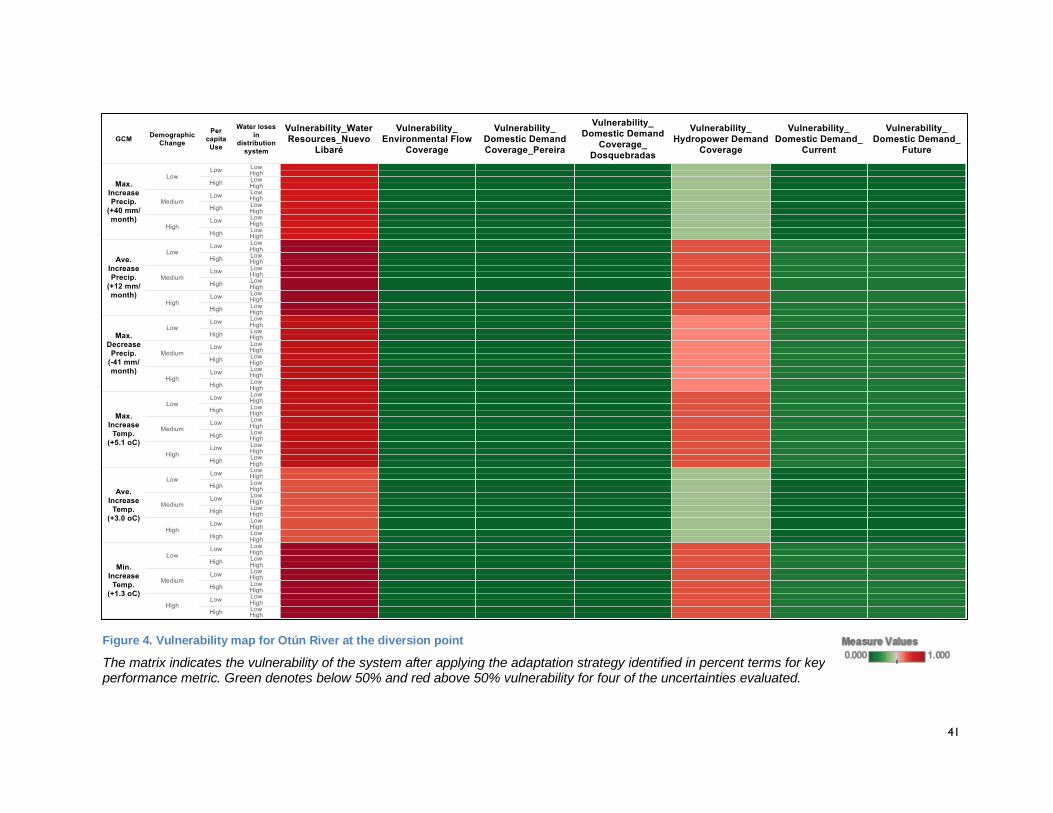
41
Figure 4. Vulnerability map for Otún River at the diversion point
The matrix indicates the vulnerability of the system after applying the adaptation strategy identified in percent terms for key performance metric. Green denotes below 50% and red above 50% vulnerability for four of the uncertainties evaluated.
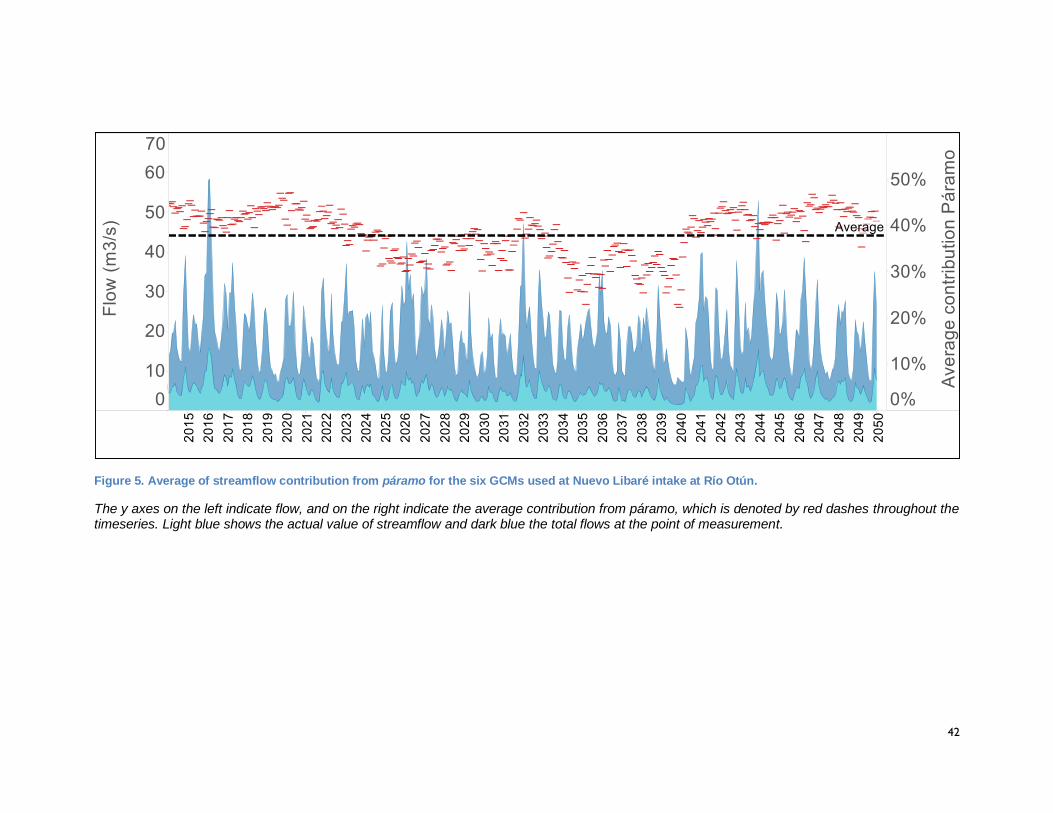
42
Figure 5. Average of streamflow contribution from páramo for the six GCMs used at Nuevo Libaré intake at Río Otún.
The y axes on the left indicate flow, and on the right indicate the average contribution from páramo, which is denoted by red dashes throughout the timeseries. Light blue shows the actual value of streamflow and dark blue the total flows at the point of measurement.
43
Lessons learned and recommendations
The application of the RDS program in the Otún watershed highlighted the fact that, prior to
the project, local institutions and academia did not possess the technical capacities to
identify watershed scale climate adaptation options. In addition to the modeling knowledge
to produce information for decision making under uncertainty, the learning through the
participatory methodology provided sufficient regional knowledge to enable future
applications of the RDS process in the region.
The process also highlighted that climate change is not only a challenge requiring a technical
solution. It poses environmental, cultural and political challenges that requires that societies
evolve and that institutions transform to confront the adaptation challenges. For instance,
technical and participatory process efforts enabled a constructive dialogue with the IDEAM,
which evolved from a guarded position in terms of data sharing to an open disposition to
cooperate with regional institutions. The willingness to share data, as part of the new
National Hydrologic Information System that was being developed by IDEAM in parallel to
project implementation, bodes well for the construction of WEAP models in support of RDS
processes in other watersheds. However, results also have implications for other key
stakeholders, such as those inhabiting the páramo areas. Despite the importance of
páramos, conflicts associated with land use persist even within protected areas which
threatened the current conservation efforts. Since working with communities was beyond
the scope of this project, a recommendation is to develop a process oriented to improve
water governance that reaches out to those that live in water supply regions of the
watershed. These efforts should create greater outreach than existing efforts led by the local
CARs and water utilities and is entirely consistent with the recognition that in post-conflict
Colombia the ability of residents to ensure livelihoods in rural areas will determine the
opportunity for development and stability downstream
Despite the progress made, there are challenges for ensuring the sustainability of the tools
for carrying out climate analysis into the future - in particular their need for continuous
updating -, and of the capacity built with technical groups within key water management
institutions – which require time and support to transition from understanding the modeling
and analysis carried out on the project to using it as part of their daily activities.
For the tools to remain useful, it will be necessary to continue updating the WEAP model of
the Otún river. Updating of the climate and adaptation analysis tools can be achieved as
long as climatic information gathered within the watershed is improved with new instruments.
The data produced can be used to improve the calibration and validation of the models. A
goal here is to improve analysis of the páramos which currently possess a low density of
hydro-climatologic stations leading to a situation where the existing historical information is
scarce. The importance of páramo for its hydrologic regulation capacity calls for improved
quantity, quality and availability of information. It is key that instrumentation programs, which
include installing equipment and recording hydro-meteorological data, of these ecosystems
are strengthened through monitoring initiatives.
One way to face the challenge of capacity building is to strengthen regional universities. In
this particular case, the research center that participated in the project is using the models
44
built and the WEAP training materials available to train new professionals. To date, over 100
students in the 2nd year of a 5 year program have been trained in the basic use of WEAP.
This group is also using the models to support new research questions about climate
adaptation such as comparative studies of small subwatersheds that have different
responses based on land use practices. This type of new analysis may lead to new
opportunities to support decision making by CARs and water utilities in their planning efforts.
Major accomplishments
This Otún river component of the project
resulted in two models being built, one
based on a monthly that provides
information at the multipurpose water
diversion, and one at daily time step for
páramo hydrology. Both models are ready
to be used, updated and refined for
decision-making support.
Regarding capacity building, the project led
to a decision to teach WEAP at a
hydroclimatologic course available through
environmental studies at the university.
Through this course, it has been possible to
train more than 100 students in the basic
modules of the tool. For this, the local
university has generated 3 videos for
building a base model (Video 1, Video 2,
Video 3), which explain the general
functions and highlight its potential use in
integrated water resources management.
Students have shown great interest in
deepening their knowledge about WEAP. A
total of three students have used WEAP in
their theses. In addition to the academic learning, several WEAP training sessions were
given to local CAR and water utilities. Basic WEAP modules of model conceptualization
were covered during these sessions, including basic water quality modeling and Tableau
Visualization. A total of six sessions with an average assistance of eight people were given.
Regarding planning instruments, the PORH of the Otún river was contracted and finished in
a process parallel to the project, using the WEAP model. This parallel implementation
highlighted the importance of incorporating climate analysis and RDS into watershed
planning. Although the specifications of this planning instrument required conventional
scenario analysis, climate analysis was incorporated using the RDS process. This PORH
represents an opportunity for the Otún river planning processes in that this effort led to the
construction of a model on a daily timescale for the whole watershed, which built upon the
monthly watershed and daily páramo models achieved within the scope of the project. This
Evidence of impact
One of the mandated water related plans in
Colombia is the Water Resources
Management Plan (abbreviated as PORH in
Spanish). This plan involves a participatory
process whereby water allocation and
management actions designed to meet water
quality and aquatic ecosystem objectives are
set. CARDER, the CAR with jurisdiction in
the Rio Otún watershed, developed a PORH
and decided to contract with UTP so that the
WEAP model constructed under the current
project, deployed within the RDS framework,
could be used to support the development of
the plan. That there is both an interest in and
the capacity to use these tools in this way
confirms the impact of the project in this
region. Moreover, the output of this
endeavor led to the incorporation of climate
considerations in water and territorial
planning. Before the project a more standard
plan based on guidelines that did not include
climate change considerations would have
been the only option available to pursue.
45
project deepened the RDS learning within the local CAR and allowed for the incorporation
of climate uncertainty as a key variable in water and land use planning of the territory. This
is the sort of local, bottom-up, learning that can inform national level policy and incorporate
climate change considerations into nationally mandated environmental planning
instruments.
A unique feature of project activity in the Rio Otún watershed was the participation of the
water supply utility for the City of Pereira, Aguas y Aguas. For a number of years, this partner
has been considering various water management options to prepare Pereira for changing
future conditions defined primarily by population growth and changing regulations related to
water quality and environmental flows. As part of the project, these actions were examined
through the lens of climate change uncertainty as well, leading colleagues within Aguas y
Aguas to consider them not just as potential water management options but as potential
climate change adaptation measures (this is detailed in Appendix 1 where project indicators
are described and SEI-13 corresponds to the description of these adaptation measures).
This analysis, and the associated revaluation of these actions, motivated the decision to
include them amongst a set of climate change adaptation actions identified by the project.
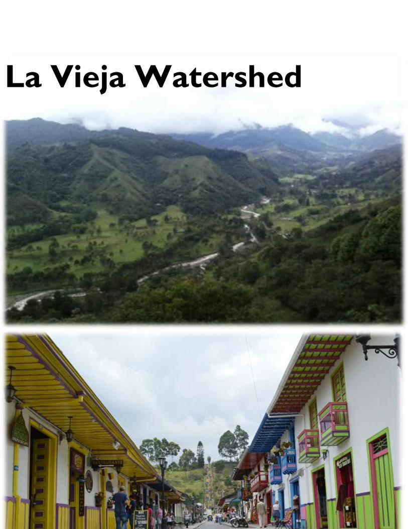
46
La Vieja Watershed
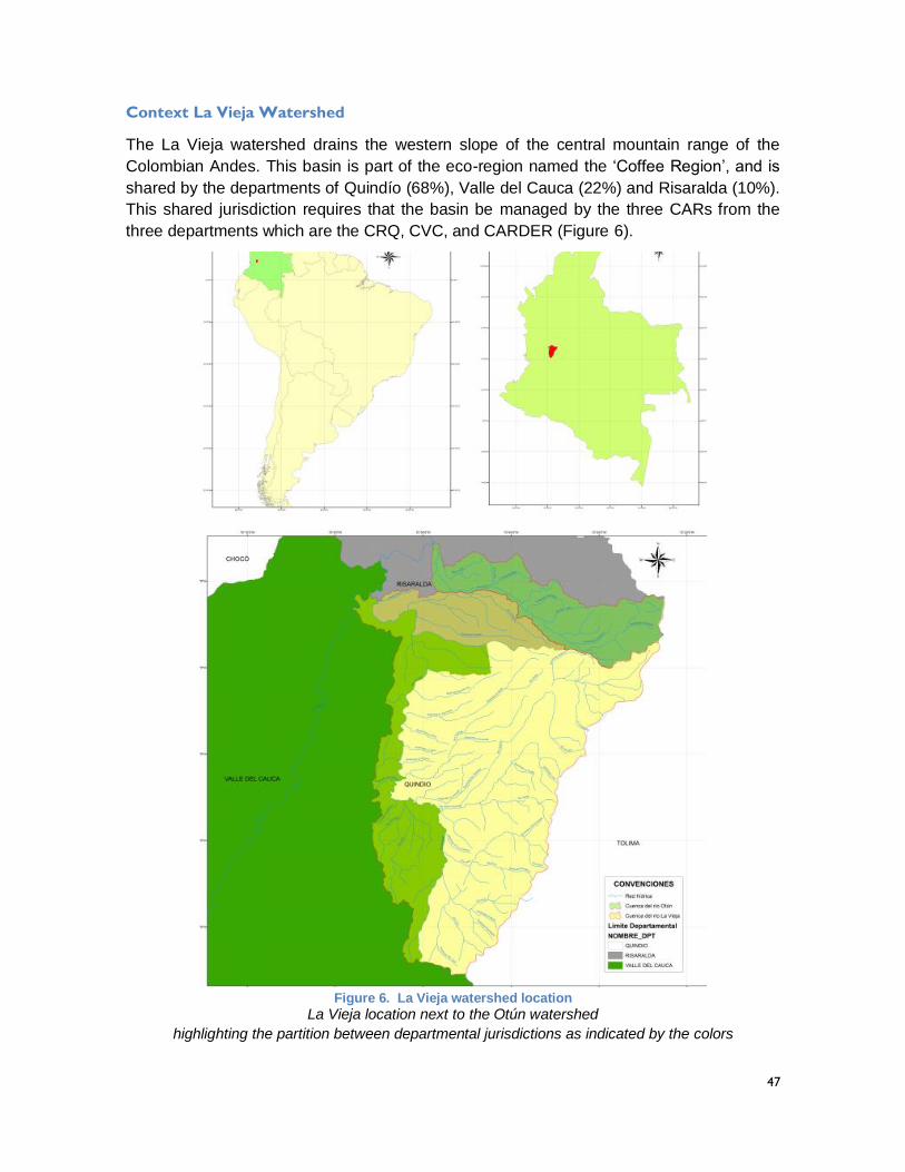
47
Context La Vieja Watershed
The La Vieja watershed drains the western slope of the central mountain range of the
Colombian Andes. This basin is part of the eco-region named the ‘Coffee Region’, and is
shared by the departments of Quindío (68%), Valle del Cauca (22%) and Risaralda (10%).
This shared jurisdiction requires that the basin be managed by the three CARs from the
three departments which are the CRQ, CVC, and CARDER (Figure 6).
Figure 6. La Vieja watershed location
La Vieja location next to the Otún watershed
highlighting the partition between departmental jurisdictions as indicated by the colors
48
The La Vieja river mainstem is formed by the confluence of the Quindío and Barragan rivers,
and it is one of the main tributaries to the Cauca River, with 360 km of first order drainage
which inflow to the main stem, and a water supply production of 34 litters/s/km2 which is
equivalent to a hydrologic supply of 2.975,74 Mm3/year.
Actors from the watershed were convened to provide information to contextualize the climate
change challenges and adaptation options. Interactions through participatory engagement
with a similar set of actors in the Otun River case led to the identification of key watershed
features and development trajectories which were classified as either uncertain factors or
potential adaptation options. In addition to water utilities, government institutions, and
research groups, representatives from the coffee sector provided their perspective and
shared information relevant to water use and water pollution associated with coffee
production.
The program – La Vieja watershed
The most relevant aspect of the program in this watershed was the modeling of wastewater
treatment and water quality integrated within the quantification of the water supply and
demand of the system. This activity required modeling elements – such as watersheds,
canals, reservoirs, demand sites - to represent wastewater treatment and water quality in
WEAP – in particular the critical elements of the wastewater system of the city of Pereira
and of the water intake for the downstream city of Cartago - in addition to the rainfall runoff
estimations. The water quality modeling aspect was advanced by CINARA, a research group
known nationwide for their experience in water quality and wastewater treatment, while the
water quantity component was advanced by CIDERA, a leading Quindío-based research
team with experience in water management.
Water quality modeling required representations of wastewater discharges throughout the
watershed including those associated with coffee growing and processing. Water quantity
modeling required creating a model structure for the Rio La Vieja, connected to the Otún
watershed, to represent water demand and supply which then could be connected to the
water quality modeling. The two challenges of water quality and quantity required parallel
analysis that were ultimately integrated. The model was built as a step towards the
consideration of climate uncertainty for this region developed through the application of the
RDS participatory process and the subsequent definition of the ensemble of scenarios.
The end result was an integrated WEAP-QUAL2K model that could be used for the
evaluation of water quantity and quality of the La Vieja watershed. Using this model enabled
the evaluation of the benefits of specific strategies to control water quality impacts at the
watershed scale that emerged from the participatory process and the completion of an
XLRM contextualization (Table 4).
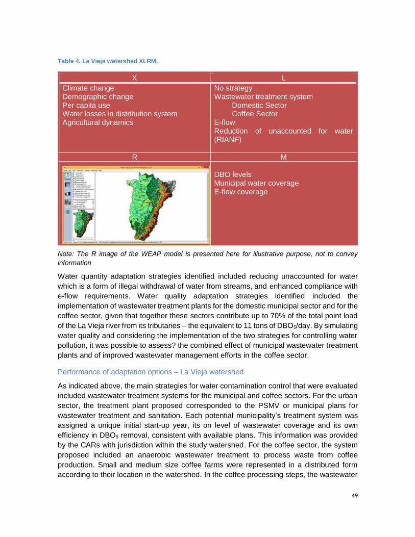
49
Table 4. La Vieja watershed XLRM.
X L
Climate change Demographic change Per capita use Water losses in distribution system Agricultural dynamics
No strategy Wastewater treatment system
Domestic Sector Coffee Sector
E-flow Reduction of unaccounted for water (RIANF)
R M
DBO levels Municipal water coverage E-flow coverage
Note: The R image of the WEAP model is presented here for illustrative purpose, not to convey
information
Water quantity adaptation strategies identified included reducing unaccounted for water
which is a form of illegal withdrawal of water from streams, and enhanced compliance with
e-flow requirements. Water quality adaptation strategies identified included the
implementation of wastewater treatment plants for the domestic municipal sector and for the
coffee sector, given that together these sectors contribute up to 70% of the total point load
of the La Vieja river from its tributaries – the equivalent to 11 tons of DBO5/day. By simulating
water quality and considering the implementation of the two strategies for controlling water
pollution, it was possible to assess? the combined effect of municipal wastewater treatment
plants and of improved wastewater management efforts in the coffee sector.
Performance of adaptation options – La Vieja watershed
As indicated above, the main strategies for water contamination control that were evaluated
included wastewater treatment systems for the municipal and coffee sectors. For the urban
sector, the treatment plant proposed corresponded to the PSMV or municipal plans for
wastewater treatment and sanitation. Each potential municipality’s treatment system was
assigned a unique initial start-up year, its on level of wastewater coverage and its own
efficiency in DBO5 removal, consistent with available plans. This information was provided
by the CARs with jurisdiction within the study watershed. For the coffee sector, the system
proposed included an anaerobic wastewater treatment to process waste from coffee
production. Small and medium size coffee farms were represented in a distributed form
according to their location in the watershed. In the coffee processing steps, the wastewater

50
treatment plan simulated efforts to treat wastewater resulting from processing the cherries
to obtain the bean for commercialization. These plants were represented to include a DBO5
removal efficiency of 70% (Cenicafé, 1999). This strategy envisaged a gradual application
of wastewater treatment, assuming that by 2025 50% of small and median size coffee
growers had treatment implemented, and by 2050 all had implemented the strategy.
For the 2011-2040 period the scenario in which no wastewater management strategies were
implemented shows a visible decline in water quality because of the increase in population
(Figure 7 – blue line). This trend is exacerbated by higher municipal residual load and an
increase in contaminant load given an increase in coffee production. The evaluation of the
DBO5 for the same period with municipal wastewater treatment plants implemented shows
an improvement in the water quality in the river along its profile (red line). Implementing the
wastewater system treatment for the coffee sector shows a reduction in DBO5 and an
improvement in water quality along the main stem of the river (green line). This strategy
presents better results in terms of reducing DBO5 than the municipal wastewater system
treatment for this watershed. However, the combination of both wastewater treatment
strategies show even greater water quality performance along the La Vieja (purple line).
With this strategy, DBO5 is reduced up to 2 mg/L with respect to the no-action trend in the
outlet to the Cauca River at the 90th km downstream of the headwaters of the river.
Figure 7. Water quality profile for La Vieja for 2040 with the implementation of strategies
X axes indicate the longitudinal direction of La Vieja River from upstream (left) to downstream (right)
to the confluence with Rio Cauca. Each line of the long profile indicates a different scenario as
Pija
o R
iver
Esp
ejo
Riv
er
Ro
ble
Riv
er
Bu
enav
ista
Riv
er
Bar
bas
Riv
er
Ces
tilla
l Riv
er
Co
nso
ta R
iver
0.0
0.5
1.0
1.5
2.0
2.5
3.0
3.5
4.0
4.5
5.0
0 10 20 30 40 50 60 70 80 90
DB
O5
(mg
/L)
Distance (Km)
Trend Scenario - Without StrategyStrategy municipal wastewater treatmentStrategy coffee sector wastewater treatmentCombination of both wastewater treatment strategiesHistorical record
Acceptable
Regular
Poor
Very poor
Confluence of the rivers Quindío and Barragán
Mu
nic
ipal
was
tew
ater
Arm
enia
Mu
nic
ipal
was
tew
ater
Per
eira
51
described by the legend and the colors. Key features are indicated such as wastewater inflows and
river confluences.
For the water quantity analysis, it was necessary to integrate a model that included the Otún
and La Vieja watersheds. This model included the same level of uncertainties as those
described for the Otún system, but including an additional uncertainty associated to the
increase in agricultural areas under coffee production. For the integrated model of water
quantity, the reduction in unaccounted for water and enhanced e-flows were included as
potential water management adaptations to climate change (Table 4, corresponding to the
Ls or strategies).
The integrated model included 37 tributaries to the Rio La Vieja and 17 urban demands, 4
hydropower demands represented by small hydropower plants on the Quindío River, as well
as agricultural and coffee production water demands. Allocation priority was given first to e-
flows, followed by human consumption and finally to other water uses.
The combination of the uncertainties and adaptation strategies (from Table 4) generated a
combination of 1728 possible scenarios, which were run as part of an automated ensemble.
The set of scenarios produced a large dataset of outputs for each of the performance metrics
identified by stakeholders as part of the participatory process (from Table 4), that were
analyzed using a visualization tool.
The main results of the watershed climate vulnerability analysis of the 16 urban demands
for the time horizon investigated indicated that the towns of Armenia, Circasia, La Tebaida
and Salento have higher vulnerability in terms of supply constraints under most uncertainty
scenarios analyzed (Figure 8). . Each column shows one of the 16 system performance
metrics, in this case associated with urban demands for the municipalities in Quindío. Each
row shows a combination of external factors about which there is uncertainty to encompass
a range of possible future scenarios. All the metrics and uncertainties were defined by
stakeholders. This graphic incorporated four dimensions of uncertainty; in this case rows
incorporate all possible combinations of the four designated uncertainties combining 6
climate alternatives, 4 demographic change scenarios, 2 sets of assumptions related to per
capita water use, and 2 hypotheses related to water losses in the distribution system, for a
total of 96 scenarios. The figure’s colors denote the level of vulnerability as a percentage of
times the system underperforms with respect to a threshold performance level defined by
stakeholders. The red scale indicates the level of vulnerability (deep red, higher
vulnerability).
Given the projections of vulnerability for the urban demands, various adaptation options
were analyzed for possible reductions in vulnerability. In Figure 9, the vulnerability range is
represented in the following color scheme: green represents a positive change (reduction in
vulnerability), a red color represents a negative change (increase in vulnerability, and gray
colors indicate that there were no significant changes associated with the adaptation action
in question. The intensity in color varies from dark green (large improvement) to red (large
increase in vulnerability). These results provide a dynamic interface to interact with
stakeholders regarding the implications of specific adaptation actions. In this particular case,
the two adaptation options are presented in the columns and compared against each other.
52
The RIANF 2 (reduction of unaccounted water) option reduces vulnerability to urban
demands, while complying with e-flows would increase it.
Here it is worth noting that the options to increase e-flow requirements would be pursued
primarily to improve ecological and water quality conditions in the rivers downstream of the
points of water diversion. This is a key performance metric as it is in other rivers in Colombia.
Absent any change to either reduce the demands associated with water diversions or to
increase the supply of water available at the point of diversion, there would be a direct
tradeoff between the diversion of water and the decision to let it pass in order to improve
downstream conditions. Fortunately this is not the case as there are opportunities to
decrease demands (the case of reducing unaccounted for water was considered as part of
this analysis), and investments to improve conditions in the upper watershed could yield
more water at the points of diversion during key low flow periods. This strategy will be
considered as part of land-use planning efforts being undertaken using the tools developed
by this project in collaboration with municipalities located in the upper portions of the
watershed (POTs or in the case of smaller municipalities EOTs).
2 This strategy is well studied in the literature, and includes reducing the unaccounted water by
reducing non-authorized water use, improving water use quantification, reducing water meter reading errors, improving data management, and reducing water losses in conveyance systems, among other strategies
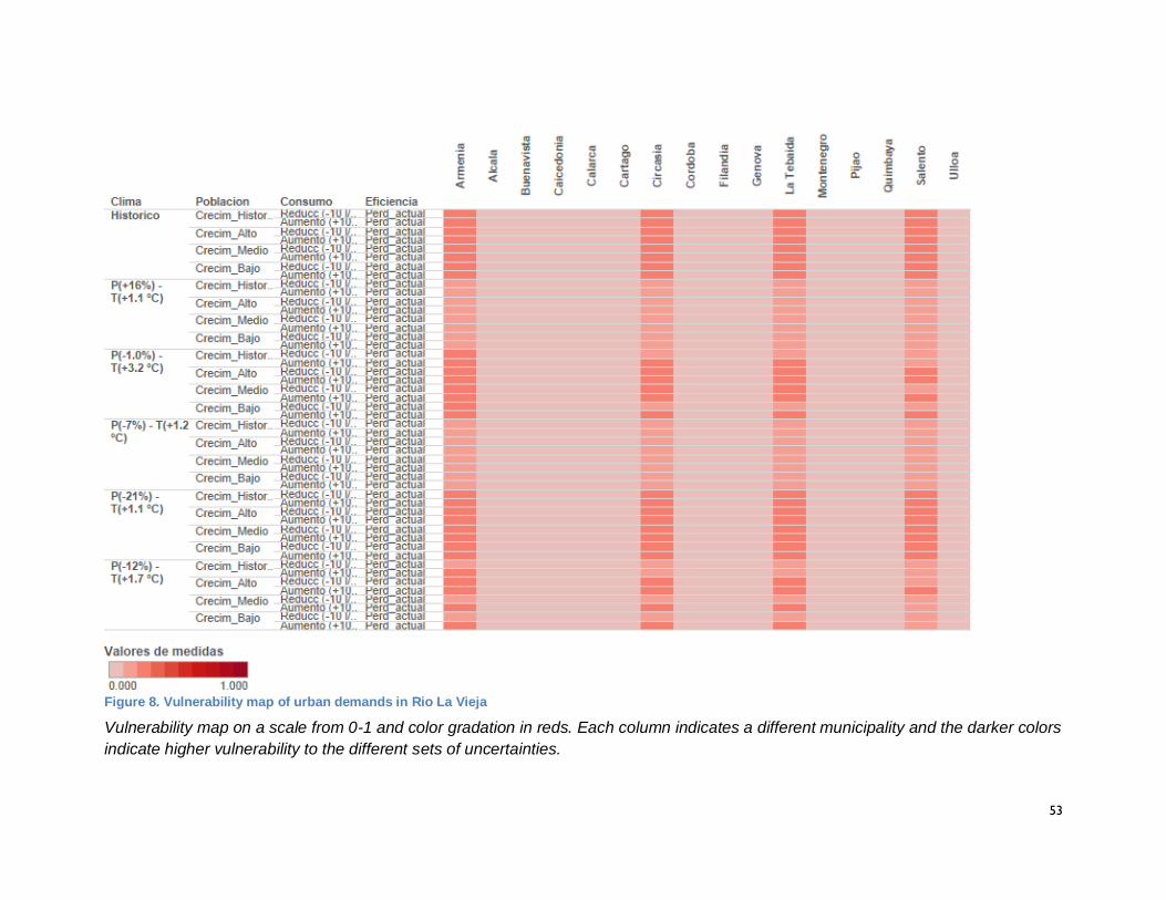
53
Figure 8. Vulnerability map of urban demands in Rio La Vieja
Vulnerability map on a scale from 0-1 and color gradation in reds. Each column indicates a different municipality and the darker colors
indicate higher vulnerability to the different sets of uncertainties.
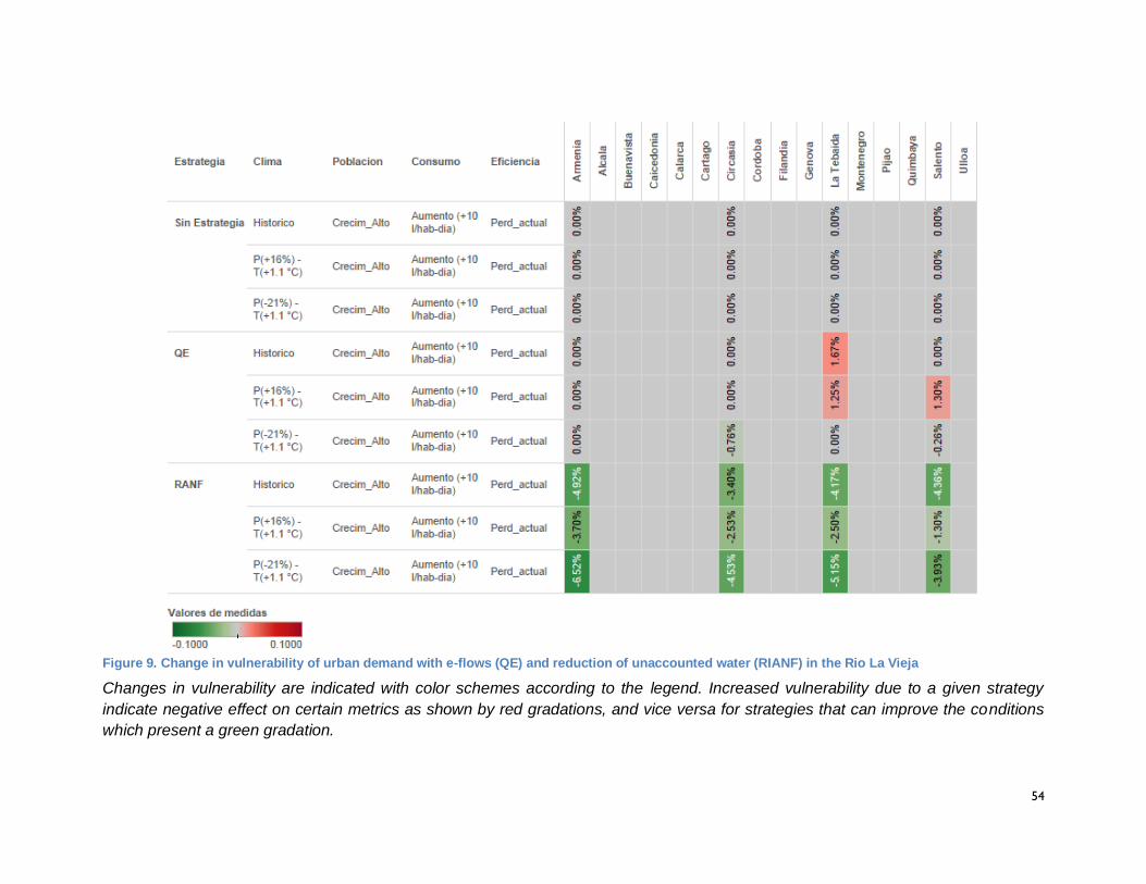
54
Figure 9. Change in vulnerability of urban demand with e-flows (QE) and reduction of unaccounted water (RIANF) in the Rio La Vieja
Changes in vulnerability are indicated with color schemes according to the legend. Increased vulnerability due to a given strategy
indicate negative effect on certain metrics as shown by red gradations, and vice versa for strategies that can improve the conditions
which present a green gradation.
55
Lessons learned – La Vieja
For the coffee sector, and particularly small and medium coffee farmers, to be able to
implement new wastewater treatment strategies it will need to obtain economic resources.
Additionally, the evident reduction in climate vulnerability in terms of water quality from
coffee treatment wastewater treatment plants, calls for greater control by the environmental
authorities over wastewater from the coffee sector to comply with water quality objectives.
These may requires mechanisms such as establishing contaminant loads by sector, and
implementing programs to incentivize the adoption of treatment technologies.
For the implementation of the combined strategy of the domestic and coffee sectors, it is
necessary to develop a financial plan to implement each of the strategies individually. This
evaluation should include a cost-benefit analysis of the gradual implementation of the
strategies by sector to guide the selection and ultimate financing of the projects.
The water quality analysis could also be complemented by introducing additional water
pollution control measures such as domestic wastewater reuse, implementation of low water
use devices within households and cleaner production within the industrial sector. The tools
and capacity are already in place in the region to continue this analytical process which can
provide invaluable information about regional decisions for adaptation. The combination of
such strategies, implemented at a watershed scale, could result in a more effective cost-
benefit strategy that can help achieve water quality objectives responsive to societal needs.
Urban demands present higher vulnerability in the towns of Salento, Circasia, Armenia and
La Tebaiada. These municipalities are all dependent on the Quindío watershed and are of
great economic importance to the region in terms of tourism and as economic development
centers. As such, the Quindío river presents higher levels of stress over water resources
which can have implications for economic activities. The tradeoff is that the scenarios
analyzed give a higher priority to e-flows. In this case, based on the uncertainties and
adaptation strategies considered, it was possible to maintain e-flows at the points of greater
diversions in the Quindío river. However other points of diversions including the Tebaida
diversion, PCH El Bosque, PCH Campestre and La Unión were not able to sustain required
e-flows within the river below these points of diversion under the different scenarios.
According to the climate scenarios and economic growth trends obtained for La Vieja and
its tributaries, if nothing is done there will be implications in terms of reduction of water supply
and increases in water pollution levels as a result of socioeconomic activities of the region.
This situation should be the departure point to create an action plan that seeks to increase
stakeholders’ engagement in water resources and the environment planning efforts, and to
mobilize funds to support the adaptation actions that they identify.
56
Major accomplishments
With the La Vieja WEAP model, CRQ,
CARDER, CVC now have a management
and planning tool to support decisions for
water resources, providing a greater
understanding of the functions of the water
system and enabling a supply-demand
analysis at a temporal and spatial scale that
encompasses climate effects at the
watershed dimension.
The inter-institutional and interdisciplinary
work during the implementation of the project
was complex and constituted a challenge
throughout the project. This reflected the
difficulties in terms of coordination to
implement integrated water resources
management.
Key accomplishments of the project were the
strengthening of research team capacities,
the production of tools for decision making
and the capacity-building to use them for
future planning processes. The flexibility of
WEAP to work on integrated water quality
and water quantity representations led to an
integrated model that can help understand
the dynamics of a complex, interconnected
system.
Finally, an important outcome of the project is the development of research and academic
programs. This has created a regional capacity to apply knowledge and tools in academic
programs such as sanitary and environmental engineering programs at the undergraduate
and graduate levels, as well as in integrated water resources and in environmental modeling.
Evidence of impact
Activity in the La Vieja system produced two
key indicators of impact. The first involved a
decision to transfer the experience to
another location, as demonstrated by the
CVC decision to use the WEAP-based RDS
approach, through a contract with UniValle,
to develop a PORH for the Bolo-Frayle sub
watershed. The second involved the
decision by single municipality in the La Vieja
sub-watershed, Salento, to refine the
analysis conducted at the watershed scale in
support of a EOT, which is the land use plan
for a smaller community. Rather than
develop their own analysis of climate change
inputs, this important headwater community
used the project analysis to carry out a more
refined level of analysis. One important
evidence of impact is that prior to the
project, local water managers had never
succeeded in carrying out and integrating
water quantity/water quality analysis as part
of a watershed planning effort. Now they
have important technical capacity in place
for future planning efforts.
57
Alto Magdalena Watershed
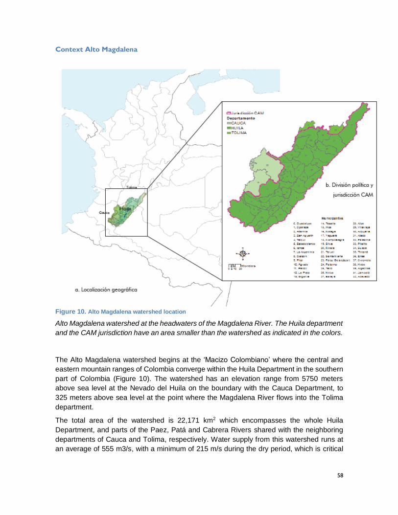
58
Context Alto Magdalena
Figure 10. Alto Magdalena watershed location
Alto Magdalena watershed at the headwaters of the Magdalena River. The Huila department
and the CAM jurisdiction have an area smaller than the watershed as indicated in the colors.
The Alto Magdalena watershed begins at the ‘Macizo Colombiano’ where the central and
eastern mountain ranges of Colombia converge within the Huila Department in the southern
part of Colombia (Figure 10). The watershed has an elevation range from 5750 meters
above sea level at the Nevado del Huila on the boundary with the Cauca Department, to
325 meters above sea level at the point where the Magdalena River flows into the Tolima
department.
The total area of the watershed is 22,171 km2 which encompasses the whole Huila
Department, and parts of the Paez, Patá and Cabrera Rivers shared with the neighboring
departments of Cauca and Tolima, respectively. Water supply from this watershed runs at
an average of 555 m3/s, with a minimum of 215 m/s during the dry period, which is critical
59
as this water contributes substantially to the larger, and vitally important Magdalena-Cauca
basin.
Since the Alto Magdalena is a large area,
the development of mandated water and
watershed planning instruments is
typically defined at smaller scales within
subwatersheds where water
management institutions, agriculture
communities and urban entities can
actually exert water management actions
to improve water management
outcomes. As a result, adaptation
measures and watershed modeling were
considered not only for the mesoscale of
the Alto Magdalena watershed but also
for some of its tributaries including: the
Río Neiva: the Río Ceibas; and The Río
Aipe (Table 5). The problem formulation
in these basins was developed during an
initial overarching XLRM participatory
process that took place in October 2013.
As a consequence, the higher level
watershed context developed for the Alto
Magdalena watershed needed to be
scaled down to the individual
subwatersheds in which the project set
out to support planning processes For
this, other participatory processes of
consultation, cooperation and co-
learning occurred through meetings, visits and work with relevant actors.
One example of the detailed work done for the Rio Ceibas watershed shows how the higher
level institutional contextualization exercise was scaled down to work with communities. This
activity required the adjustment of the technical RDS steps using a more colloquial language
to communicate with local actors. The output of this work provided insights into relevant
aspects of this watershed as part of the effort undertaken by the local CAR to implement a
POMCA in the basin.
Table 5. Alto Magdalena watershed and tributaries under study, and planning processes being supported
Watershed Area (km2) Planning process being supported
Alto Magdalena 22,171 Huila Climate Action Plan
Evidence of impact
Colombia invested a great deal of effort in
the development of National Water Study
(ENA) that attempted to calculate some high
level indicators related to the status of water
resources within the country. Having done
so, the goal was to disaggregate this
information by sub-watershed as part of a
Regional Water Evaluation (ERA). Both
efforts rely heavily on the use of historical
data and have limited utility if forward
looking estimates of key indicators cannot
be linked to model output. For the Rio
Neiva sub-watershed in Huila, SEI supported
the CAM in estimating changes in ERA
indicators from WEAP output under future
scenarios. This work was featured at a
national workshop on innovation for ERA
implementation organized by IDEAM, at
which several other CARS expressed their
desire to use a similar approach to
developing ERAs within their jurisdictions.
This prompted IDEAM to include WEAP in
a National Water Modeling Center to
support the development of ERAs and other
plans. This would not have happened
without this project.
60
Río Neiva 1,062 Regional Water Study (ERA)
Río Ceibas 1,200 Integrated watershed plan (POMCA)
Río Aipe 705 Small hydro development and licensing
The program – Alto Magdalena
The program in the Alto Magdalena watershed followed the structure of the program
implemented in the Otún-La Vieja region. The efforts sought to support the development
and implementation of the Climate Action Plan for the Huila Department under the
leadership of the CAM. Efforts to implement the proposed program had three primary
objectives:
1. Develop a set of analytical tools that could be used by the CAM and other regional
partners to support the preparation of planning documents for the Huila Department.
2. Build the capacity of experts within the CAM and in other institutions in the Huila Region
to use these tools.
3. Work with local academic experts to use the analytical tools to develop the Huila 2050
Climate Action Plan and respond to other regional needs.
Although the work in this region, as in La Vieja region, followed the RDS approach, the
administration of the project was organized through a direct collaboration with the CAM.
Activities in Huila between SEI and the CAM led to the creation of a team of CAM technicians
that could carry out the technical work in parallel with local universities in Huila, as opposed
to being dependent on these academic partners. As a consequence, the CAM involvement
in project implementation was much more substantial that the involvement of CARs in La
Vieja. The university partner had a more focused technical role – as opposed to the mixed
administration, training, and technical role played by the university partners in La Vieja - to
support the application of the WEAP software to a specific subwatershed in the Alto
Magdalena region to investigate the specific issue of potential climate change impacts on
coffee production in Huila.
Due to the focus on the Huila 2015 Plan, the work in Huila was connected to an integrated
assessment of climate change mitigation and adaptation opportunities. One of the outcomes
of activity in Huila was a contribution to a new planning document: the Huila 2050 Climate
Action Plan, which was not legally required by national policy. This document included action
lines directly related to the project work in terms of calling for the construction of tools for the
evaluation of watershed adaptation actions and the support of efforts to develop mandated
water and watershed planning instruments. The action lines of the Huila 2040 plan were
supported by the project included modeling of the Alto Magdalena basin under climate
scenarios and other future uncertainties, modeling of the Ceibas watershed with a focus on
climate adaptation to support the POMCA, and the assessment of hydropower potential
under climate change scenarios.
The collaborative development and deployment with the CAM team of the analytical tool kit
that considered water management adaptation opportunities in the Huila 2050 Climate
Action Plan followed the RDS process. After an assessment and mapping of the key actors,
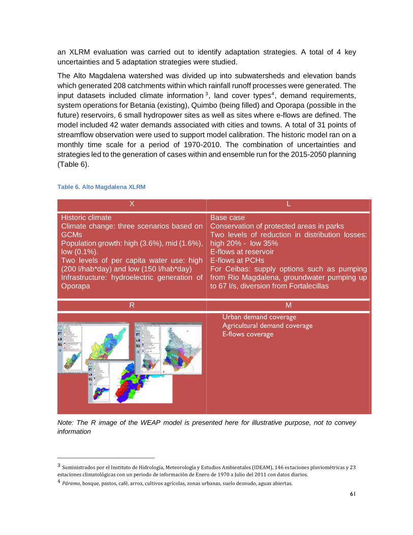
61
an XLRM evaluation was carried out to identify adaptation strategies. A total of 4 key
uncertainties and 5 adaptation strategies were studied.
The Alto Magdalena watershed was divided up into subwatersheds and elevation bands
which generated 208 catchments within which rainfall runoff processes were generated. The
input datasets included climate information 3, land cover types4, demand requirements,
system operations for Betania (existing), Quimbo (being filled) and Oporapa (possible in the
future) reservoirs, 6 small hydropower sites as well as sites where e-flows are defined. The
model included 42 water demands associated with cities and towns. A total of 31 points of
streamflow observation were used to support model calibration. The historic model ran on a
monthly time scale for a period of 1970-2010. The combination of uncertainties and
strategies led to the generation of cases within and ensemble run for the 2015-2050 planning
(Table 6).
Table 6. Alto Magdalena XLRM
X L
Historic climate Climate change: three scenarios based on GCMs Population growth: high (3.6%), mid (1.6%), low (0.1%). Two levels of per capita water use: high (200 l/hab*day) and low (150 l/hab*day) Infrastructure: hydroelectric generation of Oporapa
Base case Conservation of protected areas in parks Two levels of reduction in distribution losses: high 20% - low 35% E-flows at reservoir E-flows at PCHs For Ceibas: supply options such as pumping from Rio Magdalena, groundwater pumping up to 67 l/s, diversion from Fortalecillas
R M
Urban demand coverage
Agricultural demand coverage
E-flows coverage
Note: The R image of the WEAP model is presented here for illustrative purpose, not to convey
information
3 Suministrados por el Instituto de Hidrología, Meteorología y Estudios Ambientales (IDEAM), 146 estaciones pluviométricas y 23
estaciones climatológicas con un periodo de información de Enero de 1970 a Julio del 2011 con datos diarios. 4 Páramo, bosque, pastos, café, arroz, cultivos agrícolas, zonas urbanas, suelo desnudo, aguas abiertas.
62
In addition to the Alto Magdalena model, and through the identification of key planning
processes being advanced by the CAM, the project generated windows of analysis with
greater detail in some watersheds. Some of these were linked to the action lines of the Huila
2015 Plan. For instance, the Ceibas model focused on supporting the POMCA formulation
process by including climate change adaptation elements, and included the Fortalecillas
river to consider the development of a potential diversion point. Also, the Aipe model focused
on the evaluation of small hydropower and included the indices of hydrologic alteration
(IHAs) which are useful inputs for e-flow definitions that might accompany a decision to
develop specific small hydropower projects.
Other detailed watershed models were developed in collaboration with the CAM and to
support other planning processes. The Rio Neiva model focused on the regional water
evaluation (ERA for its acronym in Spanish), a set of indicators that follow IDEAM guidelines
that is being implemented as a pilot exercise in the region (Figure 11).
Figure 11 shows how various values of the proposed IDEAM ERA indicators vary according
to subwatershed within the Rio Neiva system as a function of different future scenarios, in
tabular and map-based formats. Information on the suite of water management options
considered using the various model developed in the Alto Magdalena region and the lessons
learned in the process is also presented in tables below.
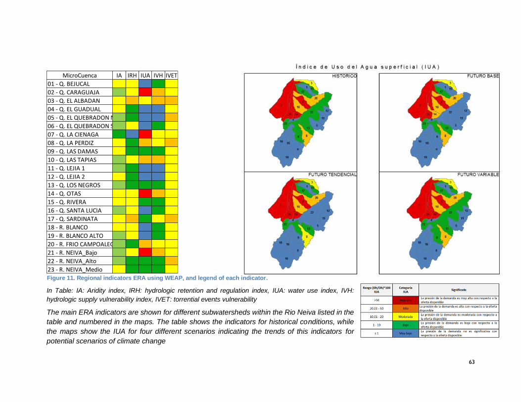
63
In Table: IA: Aridity index, IRH: hydrologic retention and regulation index, IUA: water use index, IVH:
hydrologic supply vulnerability index, IVET: torrential events vulnerability
The main ERA indicators are shown for different subwatersheds within the Rio Neiva listed in the
table and numbered in the maps. The table shows the indicators for historical conditions, while
the maps show the IUA for four different scenarios indicating the trends of this indicators for
potential scenarios of climate change
Figure 11. Regional indicators ERA using WEAP, and legend of each indicator.
Note: IA: Aridity index, IRH: hydrologic retention and regulation index, IUA: water use index, IVH: hydrologic supply vulnerability index, IVET: torrential
events vulnerability
MicroCuenca IA IRH IUA IVH IVET
01 - Q. BEJUCAL
02 - Q. CARAGUAJA
03 - Q. EL ALBADAN
04 - Q. EL GUADUAL
05 - Q. EL QUEBRADON NORTE
06 - Q. EL QUEBRADON SUR
07 - Q. LA CIENAGA
08 - Q. LA PERDIZ
09 - Q. LAS DAMAS
10 - Q. LAS TAPIAS
11 - Q. LEJIA 1
12 - Q. LEJIA 2
13 - Q. LOS NEGROS
14 - Q. OTAS
15 - Q. RIVERA
16 - Q. SANTA LUCIA
17 - Q. SARDINATA
18 - R. BLANCO
19 - R. BLANCO ALTO
20 - R. FRIO CAMPOALEGRE
21 - R. NEIVA_Bajo
22 - R. NEIVA_Alto
23 - R. NEIVA_Medio
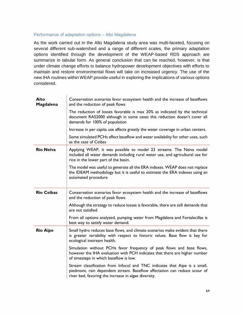
64
Performance of adaptation options – Alto Magdalena
As the work carried out in the Alto Magdalena study area was multi-faceted, focusing on
several different sub-watershed and a range of different scales, the primary adaptation
options identified through the development of the WEAP-based RDS approach are
summarize in tabular form. As general conclusion that can be reached, however, is that
under climate change efforts to balance hydropower development objectives with efforts to
maintain and restore environmental flows will take on increased urgency. The use of the
new IHA routines within WEAP provide useful in exploring the implications of various options
considered.
Alto
Magdalena
Conservation scenarios favor ecosystem health and the increase of baseflows
and the reduction of peak flows
The reduction of losses favorable is max 20% as indicated by the technical
document RAS2000 although in some cases this reduction doesn’t cover all
demands for 100% of population
Increase in per capita use affects greatly the water coverage in urban centers.
Some simulated PCHs affect baseflow and water availability for other uses, such
as the case of Ceibas
Río Neiva Applying WEAP, it was possible to model 23 streams. The Neiva model
included all water demands including rural water use, and agricultural use for
rice in the lower part of the basin.
The model was useful to generate all the ERA indexes. WEAP does not replace
the IDEAM methodology but it is useful to estimate the ERA indexes using an
automated procedure
Río Ceibas Conservation scenarios favor ecosystem health and the increase of baseflows
and the reduction of peak flows
Although the strategy to reduce losses is favorable, there are still demands that
are not satisfied
From all options analyzed, pumping water from Magdalena and Fortalecillas is
best way to satisfy water demand.
Río Aipe Small hydro reduces base flows, and climate scenarios make evident that there
is greater variability with respect to historic values. Base flow is key for
ecological instream health.
Simulation without PCHs favor frequency of peak flows and base flows,
however the IHA evaluation with PCH indicates that there are higher number
of timesteps in which baseflow is low.
Stream classification from Infocol and TNC indicates that Aipe is a small,
piedmont, rain dependent stream. Baseflow affectation can reduce scour of
river bed, favoring the increase in algae diversity.

65
Lessons learned and recommendations – Alto Magdalena
As in the case of adaptation options, the range over which the WEAP-based RDS approach
was applied suggest that lessons learned pertaining to water management in the basin can
best be presented in tabular form.
Alto
Magdalena
Work on the Alto Magdalena model supporting CAM staff, defining additional
details required from the model, and supporting the implementation of
scenarios
It is key to evaluate strategies to buy land for conservation in strategic zones.
It is important to advance an economic estimate of prioritized strategies such
as conservation, reduction in distribution system, small hydropower and e-
flows.
It is key to refine the information about reservoirs operated in series such as
Betania and Quimbo
Río Neiva The validation of WEAP for extracting ERA indicators was reviewed by IDEAM.
It has the potential to be implemented in different regions in Huila, as well as in
other regions of Colombia.
Río Ceibas Work on Ceibas model supporting CAM personnel in the definition of climate
scenarios derived from the XLRM and on scenario runs
The update of watershed land cover to a finer scale will be available within the
POMCA process.
Climatologic information for 2012-2014 can also be updated in the model
Regarding supply alternatives for Neiva, the diversion point could be moved to
another point in the basin so the water transfer can happen by gravity.
Updating the streamflow and location of local aqueducts
Economic evaluation for strategies specially the three options for urban water
supply for Neiva.
Río Aipe Work on the Aipe model supporting CAM personnel in its progress defining
IHAs to identify streamflow aspects that could be affected by PCHs and other
watershed uses
Major accomplishments
The manner in which the project engaged in the Alto-Magdalena region was dramatically
different than the manner in which the project was implemented in the Rio Otun and La Vieja
watersheds. The biggest difference was the manner in which the local CAR, the CAM
committed staff to work in direct collaboration with the project team, as opposed to relying
on partners within local universities to implement the required technical analysis. This meant
that while progress on capacity development was less rapid, CAM staff had other
responsibilities beyond collaborating with the project, the results are more substantial in
terms of the development of capacity within the CAR.
66
During the last three months of the project, at the requires of the CAM, the project team
engaged in developing and supporting the implementation of the work plans whereby the
CAM is using the WEAP-based RDS approach to integrate explicit climate change
consideration within three POMCAs under development: the Rio Ciebas, the Rio Neiva, and
the Rio Suaza. On a regular basis, SEI staff are meeting, via teleconference, with the WEAP
team within the CAM to refine the models developed during the project for the task at hand.
Collaboration to design POMCA specific data visualization tools in Tableau is also occurring.
This is a major accomplishment, as the CAM staff, not external consultants and not partners
within local universities, are doing the work to add what will prove to be a unique and
innovative set of POMCAs that can be shared with national level authorities as examples of
bottom up learning that can advance the manner in which POMCAs are developed across
Colombia. In a manner similar to the innovations realized by the CAM with respect to the
ERA process being management by IDEAM, the CAM is emerging as a real center of
excellence within the CARs community in terms of grappling with the implications of climate
change within its standard watershed planning and decision making work flow.
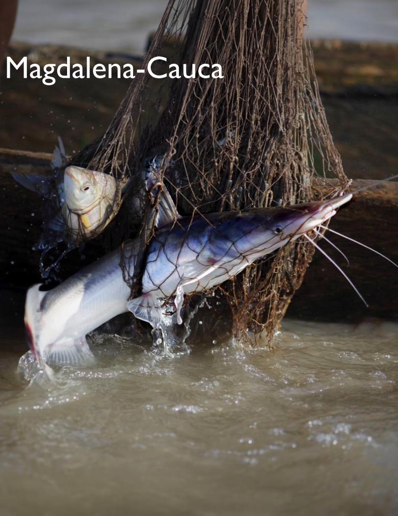
67
Magdalena-Cauca
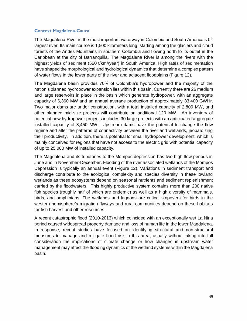
68
Context Magdalena-Cauca
The Magdalena River is the most important waterway in Colombia and South America’s 5 th
largest river. Its main course is 1,500 kilometers long, starting among the glaciers and cloud
forests of the Andes Mountains in southern Colombia and flowing north to its outlet in the
Caribbean at the city of Barranquilla. The Magdalena River is among the rivers with the
highest yields of sediment (560 t/km²/year) in South America. High rates of sedimentation
have shaped the morphological and hydrological dynamics that determine a complex pattern
of water flows in the lower parts of the river and adjacent floodplains (Figure 12).
The Magdalena basin provides 70% of Colombia’s hydropower and the majority of the
nation’s planned hydropower expansion lies within this basin. Currently there are 26 medium
and large reservoirs in place in the basin which generate hydropower, with an aggregate
capacity of 6,360 MW and an annual average production of approximately 33,400 GWHr.
Two major dams are under construction, with a total installed capacity of 2,800 MW, and
other planned mid-size projects will contribute an additional 120 MW. An inventory of
potential new hydropower projects includes 30 large projects with an anticipated aggregate
installed capacity of 8,450 MW. Upstream dams have the potential to change the flow
regime and alter the patterns of connectivity between the river and wetlands, jeopardizing
their productivity. In addition, there is potential for small hydropower development, which is
mainly conceived for regions that have not access to the electric grid with potential capacity
of up to 25,000 MW of installed capacity.
The Magdalena and its tributaries to the Mompos depression has two high flow periods in
June and in November-December. Flooding of the river associated wetlands of the Mompos
Depression is typically an annual event (Figure 12). Variations in sediment transport and
discharge contribute to the ecological complexity and species diversity in these lowland
wetlands as these ecosystems depend on seasonal nutrients and sediment replenishment
carried by the floodwaters. This highly productive system contains more than 200 native
fish species (roughly half of which are endemic) as well as a high diversity of mammals,
birds, and amphibians. The wetlands and lagoons are critical stopovers for birds in the
western hemisphere’s migration flyways and rural communities depend on these habitats
for fish harvest and other resources.
A recent catastrophic flood (2010-2013) which coincided with an exceptionally wet La Nina
period caused widespread property damage and loss of human life in the lower Magdalena.
In response, recent studies have focused on identifying structural and non-structural
measures to manage and mitigate flood risk in this area, usually without taking into full
consideration the implications of climate change or how changes in upstream water
management may affect the flooding dynamics of the wetland systems within the Magdalena
basin.
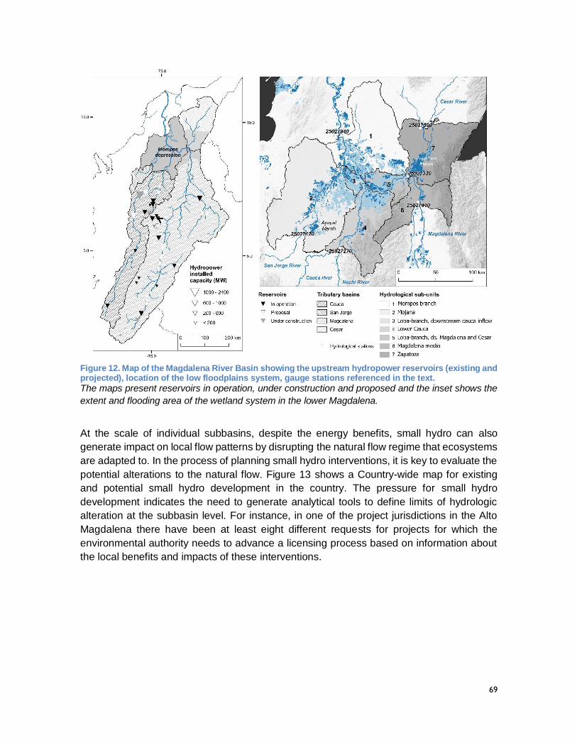
69
Figure 12. Map of the Magdalena River Basin showing the upstream hydropower reservoirs (existing and projected), location of the low floodplains system, gauge stations referenced in the text.
The maps present reservoirs in operation, under construction and proposed and the inset shows the
extent and flooding area of the wetland system in the lower Magdalena.
At the scale of individual subbasins, despite the energy benefits, small hydro can also
generate impact on local flow patterns by disrupting the natural flow regime that ecosystems
are adapted to. In the process of planning small hydro interventions, it is key to evaluate the
potential alterations to the natural flow. Figure 13 shows a Country-wide map for existing
and potential small hydro development in the country. The pressure for small hydro
development indicates the need to generate analytical tools to define limits of hydrologic
alteration at the subbasin level. For instance, in one of the project jurisdictions in the Alto
Magdalena there have been at least eight different requests for projects for which the
environmental authority needs to advance a licensing process based on information about
the local benefits and impacts of these interventions.
70
Figure 13. Existing and potential small hydro development in Colombia
Map shows potential locations for small hydro in Colombia as of 2012. These include plants under
construction and those in earlier stages of design and feasibility. Source: Research on small hydro in
Colombia, by Ernesto Torres Quintero, UniLibre.
http://www.unilibre.edu.co/revistaingeniolibre/revista-12/ar9.pdf
The program
The program for the Magdalena-Cauca watershed focused on two main components to
support the analysis of hydropower pressures in the system. The first component focused
on the impact of large scale hydropower by adding functionality to WEAP to enable analysis
of floodplain inundation as a function of flows through time along a river network, and
potentially other variables of the hydrologic cycle such as evaporation, infiltration and
movement between flooding areas. The added WEAP functionality was based on a storage
and transfer approach. This divides the river by storage function: main channel, over bank
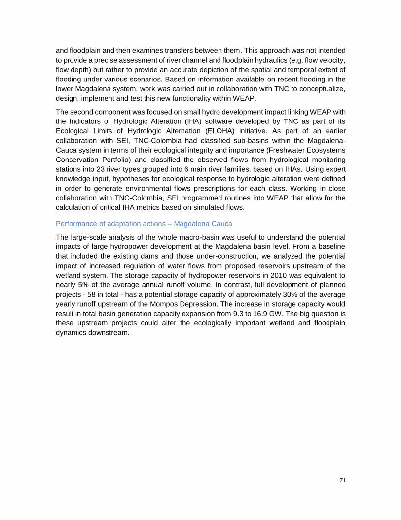
71
and floodplain and then examines transfers between them. This approach was not intended
to provide a precise assessment of river channel and floodplain hydraulics (e.g. flow velocity,
flow depth) but rather to provide an accurate depiction of the spatial and temporal extent of
flooding under various scenarios. Based on information available on recent flooding in the
lower Magdalena system, work was carried out in collaboration with TNC to conceptualize,
design, implement and test this new functionality within WEAP.
The second component was focused on small hydro development impact linking WEAP with
the Indicators of Hydrologic Alteration (IHA) software developed by TNC as part of its
Ecological Limits of Hydrologic Alternation (ELOHA) initiative. As part of an earlier
collaboration with SEI, TNC-Colombia had classified sub-basins within the Magdalena-
Cauca system in terms of their ecological integrity and importance (Freshwater Ecosystems
Conservation Portfolio) and classified the observed flows from hydrological monitoring
stations into 23 river types grouped into 6 main river families, based on IHAs. Using expert
knowledge input, hypotheses for ecological response to hydrologic alteration were defined
in order to generate environmental flows prescriptions for each class. Working in close
collaboration with TNC-Colombia, SEI programmed routines into WEAP that allow for the
calculation of critical IHA metrics based on simulated flows.
Performance of adaptation actions – Magdalena Cauca
The large-scale analysis of the whole macro-basin was useful to understand the potential
impacts of large hydropower development at the Magdalena basin level. From a baseline
that included the existing dams and those under-construction, we analyzed the potential
impact of increased regulation of water flows from proposed reservoirs upstream of the
wetland system. The storage capacity of hydropower reservoirs in 2010 was equivalent to
nearly 5% of the average annual runoff volume. In contrast, full development of planned
projects - 58 in total - has a potential storage capacity of approximately 30% of the average
yearly runoff upstream of the Mompos Depression. The increase in storage capacity would
result in total basin generation capacity expansion from 9.3 to 16.9 GW. The big question is
these upstream projects could alter the ecologically important wetland and floodplain
dynamics downstream.
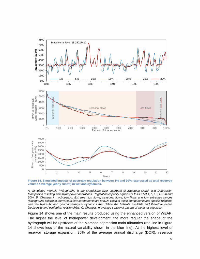
72
Figure 14. Simulated impacts of upstream regulation between 1% and 30% (expressed as total reservoir volume / average yearly runoff) in wetland dynamics.
A. Simulated monthly hydrographs in the Magdalena river upstream of Zapatosa Marsh and Depression Momposina resulting from hydropower operations. Regulation capacity equivalent to DOR of 1, 5, 10, 15, 20 and 30%. B. Changes in hydroperiod. Extreme high flows, seasonal flows, low flows and low extremes ranges (background colors) of the various flow components are shown. Each of these components has specific relations with the hydraulic and geomorphological dynamics that define the habitats available and therefore define biodiversity and ecological relationships. C. Changes in average seasonal pattern of wetlands regulation
Figure 14 shows one of the main results produced using the enhanced version of WEAP.
The higher the level of hydropower development, the more regular the shape of the
hydrograph will be upstream of the Mompos depression main tributaries (red line in Figure
14 shows less of the natural variability shown in the blue line). At the highest level of
reservoir storage expansion, 30% of the average annual discharge (DOR), reservoir
500
1500
2500
3500
4500
5500
6500
7500
8500
1985 1987 1989 1991 1993 1995
Str
eam
flo
w (
m3/s
)
1% 5% 10% 15% 20% 25% 30%
Magdalena River @ 25027410
0
1000
2000
3000
4000
5000
6000
0% 10% 20% 30% 40% 50% 60% 70% 80% 90% 100%
Riv
er
to f
loodpla
in
wate
r tr
ansfe
r (
m3/s
)
Percent of time exceeded
Ext
rem
e h
igh
flow
s
Seasonal flows Low flows
Ext
rem
e l
ow
flow
s
0
500
1000
1500
2000
2500
3000
3500
4000
1 2 3 4 5 6 7 8 9 10 11 12
Riv
er
to f
loodpla
in w
ate
r
transfe
r (m
³/s)
Month
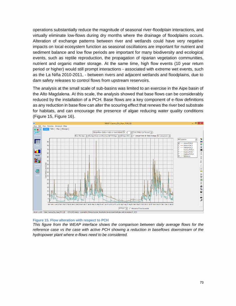
73
operations substantially reduce the magnitude of seasonal river-floodplain interactions, and
virtually eliminate low-flows during dry months where the drainage of floodplains occurs.
Alteration of exchange patterns between river and wetlands could have very negative
impacts on local ecosystem function as seasonal oscillations are important for nutrient and
sediment balance and low flow periods are important for many biodiversity and ecological
events, such as reptile reproduction, the propagation of riparian vegetation communities,
nutrient and organic matter storage. At the same time, high flow events (10 year return
period or higher) would still prompt interactions - associated with extreme wet events, such
as the La Niña 2010-2011, - between rivers and adjacent wetlands and floodplains, due to
dam safety releases to control flows from upstream reservoirs.
The analysis at the small scale of sub-basins was limited to an exercise in the Aipe basin of
the Alto Magdalena. At this scale, the analysis showed that base flows can be considerably
reduced by the installation of a PCH. Base flows are a key component of e-flow definitions
as any reduction in base flow can alter the scouring effect that renews the river bed substrate
for habitats, and can encourage the presence of algae reducing water quality conditions
(Figure 15, Figure 16).
Figure 15. Flow alteration with respect to PCH
This figure from the WEAP interface shows the comparison between daily average flows for the
reference case vs the case with active PCH showing a reduction in baseflows downstream of the
hydropower plant where e-flows need to be considered.
74
Figure 16. Flow alteration and IHAs due to small hydro in Rio Aipe
This figure is a WEAP result comparing the 52 RVA – Range of Variability Approach – indicators for
the pre-and post -alteration on the scenario of a small hydro plant. Positive numbers indicate the
increase in frequency and negative values indicate the decrease in frequency of each indicator. This
graphs shows a significant increase in the frequency of low flow counts (indicator number 40).
Lessons learned
The case study at the Magdalena-Cauca basin scale reveals that the hydrological dynamics
of water storage in the floodplains at a monthly to decadal scale are driven by variations in
climate at basin scale and can be represented with enhancements made to WEAP. This
makes WEAP the first platform able to successfully resolve the floodplain water balance at
medium-to-large scales (~10,000 km2), while linking the simulation of these dynamics to
simulated representation of water management practices. In terms of management
implications our model estimated that the deployment of existing and potential upstream
hydropower infrastructure pose a similar impact to water flows in floodplains in the Mompos
as dry periods (~15.000 million m3). This suggests the need to establish basin scale water
allocation rules during dry periods to allow for the preservation of floodplain ecosystems
dynamics. By providing an improved understanding of the linkages between climate
variability, water system operations, and the floodplain dynamics, these new routines
provide insights that can guide the implementation of infrastructure development as well as
ecosystem conservation projects. Both are critical to the sustainable development of a
country like Colombia, and many others.
The case study application of IHA at the scale of the Aipe sub-basin is a simple
demonstration of an analysis derived from this new functionality. Knowing the potential
impact of small hydro in one region could facilitate large scale analysis of the cumulative
effects of multiple small hydro using the existing tools.
1. RVA Low
2. RVA Middle
3. RVA High
Hydrologic Alteration
Rio Aipe Nodes: QE PCH Aipe, Scenario: Activa PCH_0, River: Rio Aipe
1.
Jan
uary
Flo
w,
Med
ian
2.
Feb
ruar
y F
low
, M
edia
n
3.
Mar
ch F
low
, M
edia
n
4.
Apr
il F
low
, M
edia
n
5.
May
Flo
w,
Med
ian
6.
Jun
e F
low
, M
edia
n
7.
Jul
y F
low
, M
edia
n
8.
Aug
ust
Flo
w,
Med
ian
9.
Sep
tem
ber
Flo
w,
Med
ian
10.
Oct
ober
Flo
w,
Med
ian
11.
Nov
embe
r F
low
, M
edia
n
12.
Dec
embe
r F
low
, M
edia
n
13.
Jan
uary
Flo
w,
Mea
n
14.
Feb
ruar
y F
low
, M
ean
15.
Mar
ch F
low
, M
ean
16.
Apr
il F
low
, M
ean
17.
May
Flo
w,
Mea
n
18.
Jun
e F
low
, M
ean
19.
Jul
y F
low
, M
ean
20.
Aug
ust
Flo
w,
Mea
n
21.
Sep
tem
ber
Flo
w,
Mea
n
22.
Oct
ober
Flo
w,
Mea
n
23.
Nov
embe
r F
low
, M
ean
24.
Dec
embe
r F
low
, M
ean
25.
Ann
ual 1
-day
Min
imum
26.
Ann
ual 3
-day
Min
imum
27.
Ann
ual 7
-day
Min
imum
28.
Ann
ual 3
0-da
y M
inim
um
29.
Ann
ual 9
0-da
y M
inim
um
30.
Ann
ual 1
-day
Max
imum
31.
Ann
ual 3
-day
Max
imum
32.
Ann
ual 7
-day
Max
imum
33.
Ann
ual 3
0-da
y M
axim
um
34.
Ann
ual 9
0-da
y M
axim
um
35.
Num
ber
of Z
ero
Day
s
36.
Bas
e F
low
Ind
ex
37.
Ann
ual M
ean
Flo
w
38.
Jul
ian
Dat
e of
Ann
ual M
inim
um
39.
Jul
ian
Dat
e of
Ann
ual M
axim
um
40.
Low
Pul
se C
ount
41.
Low
Pul
se D
urat
ion,
Med
ian
(day
s)
42.
Low
Pul
se D
urat
ion,
Mea
n (d
ays)
44.
Hig
h P
ulse
Cou
nt
45.
Hig
h P
ulse
Dur
atio
n, M
edia
n (d
ays)
46.
Hig
h P
ulse
Dur
atio
n, M
ean
(day
s)
48.
Ris
e R
ate,
Med
ian
49.
Fal
l Rat
e, M
edia
n
50.
Ris
e R
ate,
Mea
n
51.
Fal
l Rat
e, M
ean
52.
Num
ber
of R
ever
sals
9.0
8.5
8.0
7.5
7.0
6.5
6.0
5.5
5.0
4.5
4.0
3.5
3.0
2.5
2.0
1.5
1.0
0.5
0.0
-0.5
-1.0
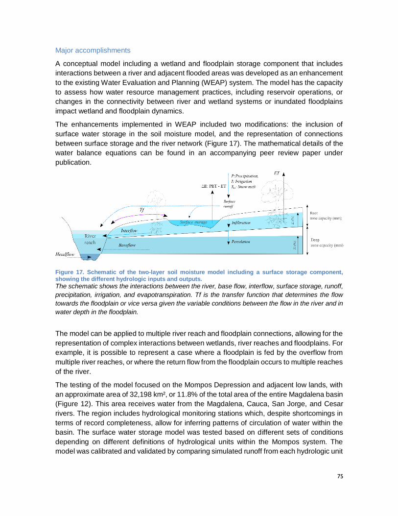
75
Major accomplishments
A conceptual model including a wetland and floodplain storage component that includes
interactions between a river and adjacent flooded areas was developed as an enhancement
to the existing Water Evaluation and Planning (WEAP) system. The model has the capacity
to assess how water resource management practices, including reservoir operations, or
changes in the connectivity between river and wetland systems or inundated floodplains
impact wetland and floodplain dynamics.
The enhancements implemented in WEAP included two modifications: the inclusion of
surface water storage in the soil moisture model, and the representation of connections
between surface storage and the river network (Figure 17). The mathematical details of the
water balance equations can be found in an accompanying peer review paper under
publication.
Figure 17. Schematic of the two-layer soil moisture model including a surface storage component, showing the different hydrologic inputs and outputs.
The schematic shows the interactions between the river, base flow, interflow, surface storage, runoff,
precipitation, irrigation, and evapotranspiration. Tf is the transfer function that determines the flow
towards the floodplain or vice versa given the variable conditions between the flow in the river and in
water depth in the floodplain.
The model can be applied to multiple river reach and floodplain connections, allowing for the
representation of complex interactions between wetlands, river reaches and floodplains. For
example, it is possible to represent a case where a floodplain is fed by the overflow from
multiple river reaches, or where the return flow from the floodplain occurs to multiple reaches
of the river.
The testing of the model focused on the Mompos Depression and adjacent low lands, with
an approximate area of 32,198 km², or 11.8% of the total area of the entire Magdalena basin
(Figure 12). This area receives water from the Magdalena, Cauca, San Jorge, and Cesar
rivers. The region includes hydrological monitoring stations which, despite shortcomings in
terms of record completeness, allow for inferring patterns of circulation of water within the
basin. The surface water storage model was tested based on different sets of conditions
depending on different definitions of hydrological units within the Mompos system. The
model was calibrated and validated by comparing simulated runoff from each hydrologic unit
76
with observed runoff over a 20 year period (1985-2005). The resulting statistics fell within
acceptable ranges for the calibration and validation periods.
Much of the functionality of the stand-alone version of IHA has been incorporated into
WEAP. Indicators of Hydrologic Alteration (IHA) is a software program that provides useful
information for those trying to understand the hydrologic impacts of human activities or trying
to develop environmental flow recommendations for water managers. Nearly 2,000 water
resource managers, hydrologists, ecologists, researchers and policy makers from around
the world have used this program to assess how rivers, lakes and groundwater basins have
been affected by human activities over time – or to evaluate future water management
scenarios.
In WEAP, an IHA analysis can either look at streamflow statistics for a single period, or can
compare statistics for two different periods or two scenarios. The two-period analysis
typically splits the record into a period before substantial alteration of the historic streamflow
("pre-impact"), which could be caused by reservoir construction or re-operation, withdrawals
from the river, land use or climate changes that would influence runoff to the river, and a
period after the alternation had begun ("post-impact"). In this way, historical changes to
streamflow can be quantified and characterized. If a historical streamflow record is not
available, it is possible to use WEAP's catchment hydrology to reconstruct the natural
streamflow that existed before alteration. In a
two-scenario analysis, it is possible to construct
scenarios of change and use IHA to analyze
their impact on historic or current flows. This
involves choosing the scenario that will be the
reference scenario (typically, this will represent
the pre-impact state, or a baseline to compare
against). Flows from the reference scenario
are then used to calculate the Environmental
Flow Components thresholds for the RVA
analysis, which is the Range of Variability
Approach that leads to identifying the
boundaries of historical variation and compares
that the variation of given scenarios.
Flooding and IHA analysis in WEAP are
available to all users that download and use
WEAP. With a user base of 18,000 people, an
average of 10 WEAP downloads per day, and
a total of 950 WEAP users in Colombia, these
enhancements are likely to have a high impact
for water management practitioners. The
WEAP 2015 version available now has these
enhancements, and a user guide that explains
how to use them.
Evidence of impact
Collaborative work with the TNC at the
scale of the Magdalena-Cauca River Basin
has prompted several initiatives that have
used SEI tools and expanded the impact of
this project. Partners in Antioquia have
applied WEAP in several other sub-
watersheds in the basin, extending the level
of coverage of modeling at the sub-
watershed scale. Modeling work at the
basin and sub-watershed scales has
prompted IDEAM to contract with
CENIGAA, a project partner in the Alto-
Magdalena work, to develop protocols for
the inclusion of WEAP models with an
National Water Modeling Center being
launched by IDEAM. The development of
planning protocols is a lengthy process,
involving conversations between actors at
various levels. The project has certainly
shaped this discourse as the WEAP-based
RDS process is being applied beyond the
limits of the project watersheds.

77
78
MONITORING AND EVALUATION
The information contained in the prior results section is compelling and useful as it
demonstrates how the project watersheds may be vulnerable to climate change and other
uncertainties and how various water management action might reduce this vulnerability. It
also shows the degree to which project partners were able to take on the task of deploying
the WEAP model within the RDS framework in a manner which allows for explicit
consideration of climate change and other uncertainties. From a technical perspective these
results offer solid evidence of capacity development in Colombia. This section analyzes how
this capacity development corresponds to the objectives originally laid out for the project and
offers lessons learned and recommendations on best practice that will enable the impact of
the project to be increased at both the watershed and national scales.
The Project Performance Management Plan
The official Project PMP was tracked via regular updates to the USAID MONITOR system
and complemented by the use of an internal SEI system PMEC (Planning, Monitoring,
Evaluation and Communications) that must be used to implement any SEI project. The
PMEC system is based on an Outcome Mapping approach5, which utilizes a series of logical
steps easily embedded within a structured, web-based tool. Essentially, interactions with
this website at various points in the project implementation process generate a relational
database containing information on the overall aims and of the project, progress towards
meeting the aims of the project evaluated against agreed milestones and success criteria,
linked to actions taken by the project team. A key feature of the PMEC system is its reference
to Boundary Partners, to which specific changes realized through project implementation
are ascribed. As PMEC includes several reporting dimensions related to Boundary Partners
that are not explicitly tracked in MONITOR, information from PMEC has been used as part
of the evaluation of project impact.
With respect to the official Project PMP, as reflected in the USAID MONITOR system, the
primary focus for the project was to respond to Development Objective 4 (DO-4) Colombian
Efforts to Sustainably Manage the Country’s Environmental Resources Reinforced. Within
DO-4, the pertinent SubIRs were IR 4.1 Environmental governance strengthened and 4.2
Climate change mitigation and adaptation improved. To these official USAID SubIRs several
SEI indicators related to specific Boundary Partners included in the project PMEC have been
added. The combination of USAID SubIRs and SEI indicators, along with progress towards
each of the project targets, are shown in Table 7. The information contained in this table is
expanded upon in Appendix 1, which includes narrative descriptions of how progress was
achieved with respect to each USAID SubIR and SEI Indicator.
5 Outcome mapping (OM) is a methodology for planning and assessing development programming
that is oriented towards change and social transformation. For more information: http://www.outcomemapping.ca/
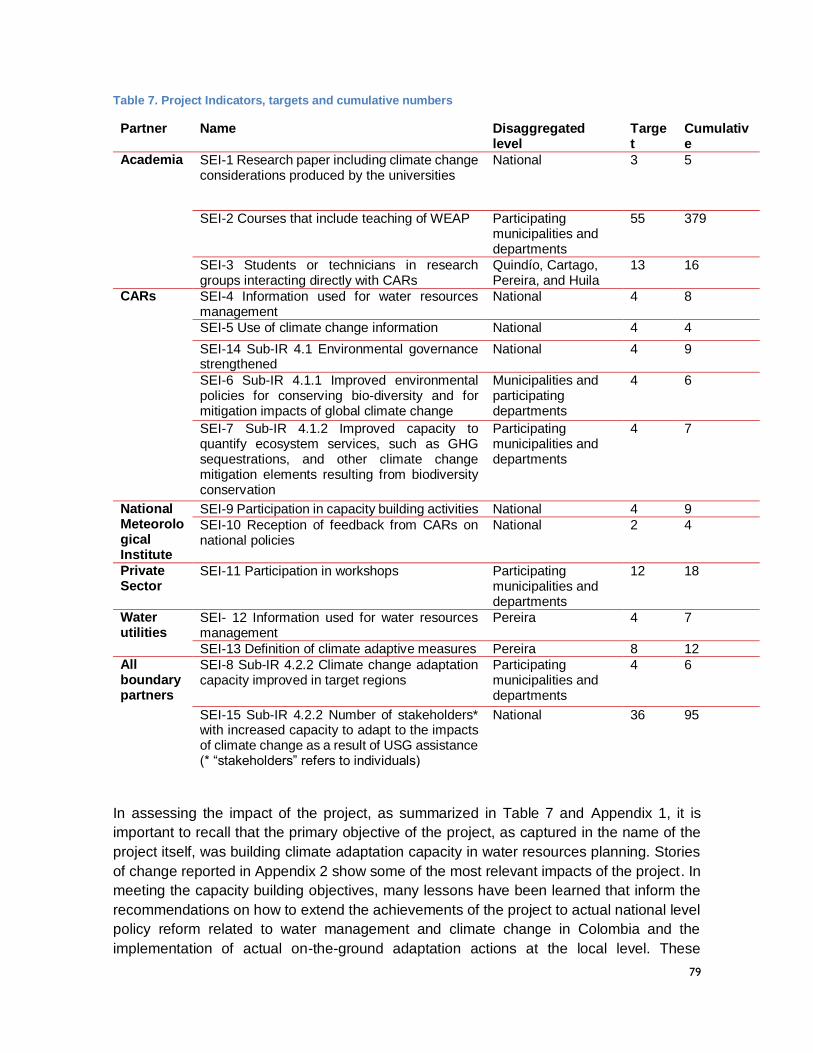
79
Table 7. Project Indicators, targets and cumulative numbers
Partner Name Disaggregated level
Target
Cumulative
Academia SEI-1 Research paper including climate change considerations produced by the universities
National 3 5
SEI-2 Courses that include teaching of WEAP Participating municipalities and departments
55 379
SEI-3 Students or technicians in research groups interacting directly with CARs
Quindío, Cartago, Pereira, and Huila
13 16
CARs SEI-4 Information used for water resources management
National 4 8
SEI-5 Use of climate change information National 4 4
SEI-14 Sub-IR 4.1 Environmental governance strengthened
National 4 9
SEI-6 Sub-IR 4.1.1 Improved environmental policies for conserving bio-diversity and for mitigation impacts of global climate change
Municipalities and participating departments
4 6
SEI-7 Sub-IR 4.1.2 Improved capacity to quantify ecosystem services, such as GHG sequestrations, and other climate change mitigation elements resulting from biodiversity conservation
Participating municipalities and departments
4 7
National Meteorological Institute
SEI-9 Participation in capacity building activities National 4 9
SEI-10 Reception of feedback from CARs on national policies
National 2 4
Private Sector
SEI-11 Participation in workshops Participating municipalities and departments
12 18
Water utilities
SEI- 12 Information used for water resources management
Pereira 4 7
SEI-13 Definition of climate adaptive measures Pereira 8 12 All boundary partners
SEI-8 Sub-IR 4.2.2 Climate change adaptation capacity improved in target regions
Participating municipalities and departments
4 6
SEI-15 Sub-IR 4.2.2 Number of stakeholders* with increased capacity to adapt to the impacts of climate change as a result of USG assistance (* “stakeholders” refers to individuals)
National 36 95
In assessing the impact of the project, as summarized in Table 7 and Appendix 1, it is
important to recall that the primary objective of the project, as captured in the name of the
project itself, was building climate adaptation capacity in water resources planning. Stories
of change reported in Appendix 2 show some of the most relevant impacts of the project. In
meeting the capacity building objectives, many lessons have been learned that inform the
recommendations on how to extend the achievements of the project to actual national level
policy reform related to water management and climate change in Colombia and the
implementation of actual on-the-ground adaptation actions at the local level. These
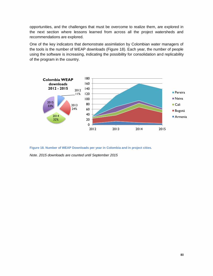
80
opportunities, and the challenges that must be overcome to realize them, are explored in
the next section where lessons learned from across all the project watersheds and
recommendations are explored.
One of the key indicators that demonstrate assimilation by Colombian water managers of
the tools is the number of WEAP downloads (Figure 18). Each year, the number of people
using the software is increasing, indicating the possibility for consolidation and replicability
of the program in the country.
Figure 18. Number of WEAP Downloads per year in Colombia and in project cities.
Note. 2015 downloads are counted until September 2015
201211%
201324%
201432%
201533%
Colombia WEAP
downloads
2012 - 2015
0
20
40
60
80
100
120
140
160
180
2012 2013 2014 2015
Pereira
Neiva
Cali
Bogotá
Armenia
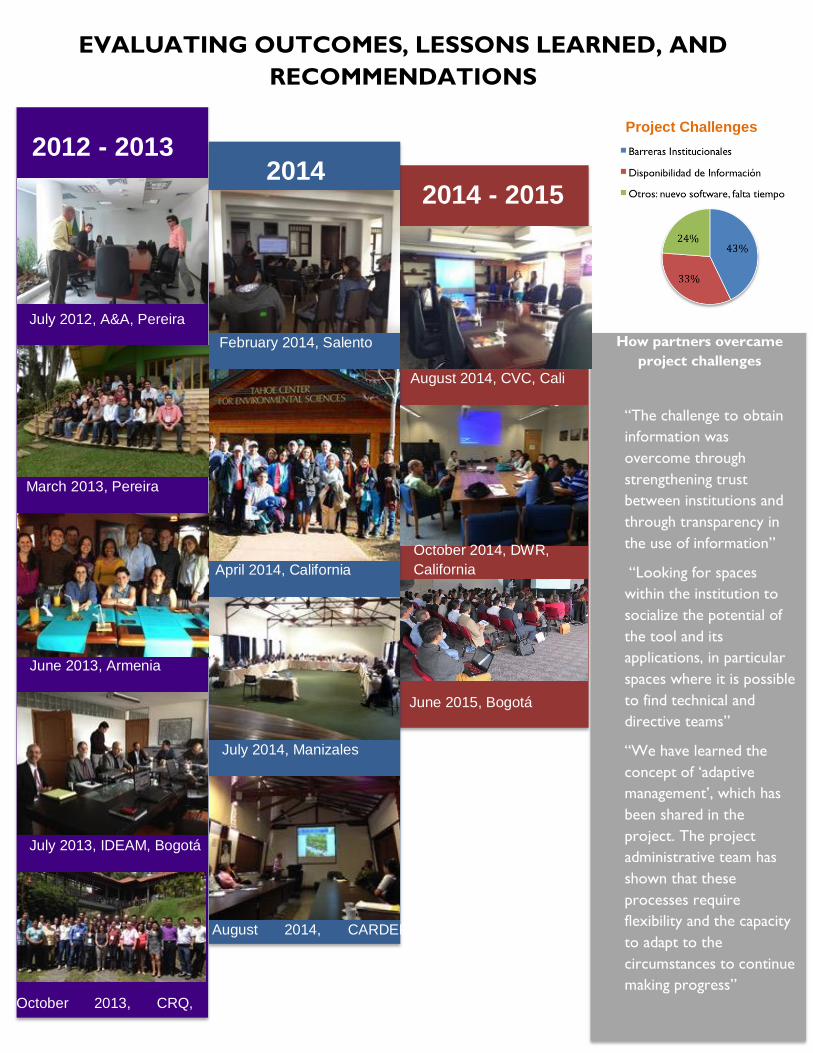
81
“The challenge to obtain
information was
overcome through
strengthening trust
between institutions and
through transparency in
the use of information”
“Looking for spaces
within the institution to
socialize the potential of
the tool and its
applications, in particular
spaces where it is possible
to find technical and
directive teams”
“We have learned the
concept of ‘adaptive
management’, which has
been shared in the
project. The project
administrative team has
shown that these
processes require
flexibility and the capacity
to adapt to the
circumstances to continue
making progress”
2012 - 2013
July 2012, A&A, Pereira
March 2013, Pereira
June 2013, Armenia
July 2013, IDEAM, Bogotá
October 2013, CRQ,
Armenia
February 2014, Salento
April 2014, California
July 2014, Manizales
August 2014, CARDER,
Pereira
August 2014, CVC, Cali
2014
October 2014, DWR,
California
How partners overcame
project challenges
Project Challenges
EVALUATING OUTCOMES, LESSONS LEARNED, AND
RECOMMENDATIONS 2014 - 2015
June 2015, Bogotá
82
EVALUATING OUTCOMES, LESSONS LEARNED AND
RECCOMENDATIONS
After nearly three years of collaboration on the project, which involved partners from
universities, local CARS, and other water management entities, a number of valuable
lessons have been learned that are relevant to continued efforts to better integrate climate
change considerations into water resources planning and decision making in Colombia.
These can be organized into three distinct categories: Managerial lessons; technical
lessons; and governance lessons. Each of these categories are explored individually in the
following sections based on information derived from different sources. These sources
include: anecdotal experiences, a formal project satisfaction survey, and a specific survey
on lessons learned circulated amongst the project partners at the end of project
implementation.
Managerial lessons learned
In order to provide a context for the presentation of managerial lessons learned, some
description of how the project was managed is required. The project was managed through
a cooperative agreement, under which USAID interacted directly with the project
management team within SEI. USAID reviewed and approved annual work plans,
suggesting adjustments to increase the likelihood of achieving our objectives and meeting
our indicators. SEI’s project management team included a Program Coordinator, a Technical
Backstop, and a Financial Administrator. Other technical staff from SEI were involved in
different stages of the project to support WEAP software enhancement (floodplain routines,
IHA integration), WEAP model building in the project watersheds, model output visualization,
and program monitoring and evaluation. SEI does not have a permanent presence in
Colombia, but its implementation approach is consistent with SEI’s organizational profile as
an international research institute possessing substantial in-house capabilities of long-term
research staff located in its research centers around the world. This is in contrast to a
perhaps more typical USAID project business model whereby managerial leadership and
technical expertise is secured through a team of contracted short-term hires posted in
country.
That said, SEI did contract with a number of young Colombian professionals to implement
various parts of the project, particularly those implemented in the Alto Magdalena sub-
watershed. This represented an important management arrangement as it gave SEI a more
permanent presence in Colombia. Perhaps more importantly, however, this arrangement
contributed to the kernel of a cohort of technical experts that will continue to implement
WEAP-based RDS methodology after the project ends. This kernel was further enhanced in
the La Vieja-Otun set of activities, through the establishment of formal sub-contracting
arrangements with three universities which in turn hired 2-3 young professionals to work on
the project. In both regions, these on-the-ground partners worked in close collaboration with
colleagues within the local CARs and other local water management agencies to implement
the WEAP-based RDS approach, supported by visits from SEI in-house staff at key
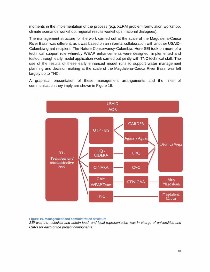
83
moments in the implementation of the process (e.g. XLRM problem formulation workshop,
climate scenarios workshop, regional results workshops, national dialogues).
The management structure for the work carried out at the scale of the Magdalena-Cauca
River Basin was different, as it was based on an informal collaboration with another USAID-
Colombia grant recipient, The Nature Conservancy-Colombia. Here SEI took on more of a
technical support role whereby WEAP enhancements were designed, implemented and
tested through early model application work carried out jointly with TNC technical staff. The
use of the results of these early enhanced model runs to support water management
planning and decision making at the scale of the Magdalena-Cauca River Basin was left
largely up to TNC.
A graphical presentation of these management arrangements and the lines of
communication they imply are shown in Figure 19.
Figure 19. Management and administration structure
SEI was the technical and admin lead, and local representation was in charge of universities and
CARs for each of the project components.
USAID
AOR
SEI -
Technical and administrative
lead
UTP - EIS
CARDER
Otún La Vieja
Aguas y Aguas
UQ -CIDERA
CRQ
CINARA CVC
CAM
WEAP TeamCENIGAA
Alto Magdalena
TNCMagdalena
Cauca
84
While the organizational structure of this project is interesting, more important are the
managerial lessons learned it prompted. These include the following.
A focus on building the capacity of early career young professionals is useful
On this project ten different young Colombian professionals were engaged in project
implementation, either through direct contracts with SEI or as part of teams assembled by
universities contracted by SEI. Each of them made great strides in assimilating the skills
needed to implement the WEAP-based RDS approach and some of them have taken these
skills and applied them to other similar activities beyond those undertaken as part of the
project. In addition, they have established professional and inter-personal connections
amongst themselves which creates a nascent professional network working on climate
change and water management in Colombia. Beyond this core group of 10, additional actors
included other young professionals within the local CARs, the Ministry of the Environment
and Sustainable Development, and IDEAM who participated in many of the events
organized by the project. As these young professionals advance along their career
trajectories they will bring the experienced gained on the project with them to increasing high
levels of engagement and responsibility.
Working with universities creates legacy institutions
Engaging universities as project partners poses both challenges and opportunities.
Challenges stem mainly from the fact that the primary function of a university is to generate
new knowledge, less to applying existing knowledge to concrete problems. As such it is
sometimes difficult to align the incentives of a researcher with those held by a water
manager. Increasingly, however, universities in Colombia and elsewhere are being asked
to justify the relevancy of their research through collaboration with actual managers and
decisions-makers. In Colombia, a number of CARS and other water management entities
have actually developed very strong and productive relationships with universities (e.g.
CARDER and UTP; CVC and UniValle). Assuming that these trends continue, universities
can play the role of legacy institutions for the learning achieved during project
implementation, particularly if they capitalize on opportunities to develop classroom and
research opportunities for students on the subject, as all of the project’s university partners
have done. Young professionals benefitting from these opportunities should be connected
to the nascent professional networks created by the early career young professionals
associated with the project.
As CARs are key to on-the-ground change, their engagement needs to be strengthened
However substantial a role universities can play in supporting the consideration of climate
change in Colombian water resources planning and management, in the end the ultimate
responsibility for these functions rests with government institutions, specifically CARS with
jurisdiction over individual watersheds and municipalities located within them. Given the
important role played by the CARs, the experiences gained during project implementation
suggest that the manner in which they engage in the application of the WEAP-based RDS
process needs to be re-evaluated. In particular, technical staff within the CARs need to be
more active participants in the process so that the technique can be taken up instead of
85
simply being understood. This would require more substantial and sustained capacity
building directed towards key technicians with the CARs, and a commitment from their
management to allow these staff to engage in the process to a much higher degree. As part
of the commitments derived from the project, universities and CARs put together work plans
and recommendations that are reported on Appendix 3. This sort of work is akin to the way
the integration of GIS into the internal capacity of the CARs evolved a decade or so ago.
What once seemed like an innovative technology is now part of the standard workflow within
a CAR. The WEAP-based RDS approach needs to experience a similar evolution.
Technical lessons learned
Most of the technical results are presented in previous sections in this report, and were also
published in the form of fact sheets or discussion briefs that served as communication tools
with stakeholders and higher level decision making bodies. The Appendix 4 and 5 contain
fact sheets and submitted peer review articles that compile the details of the technical work
done. Also, Table 8 compiles published information produced by the project with relevant
hyperlinks. While the Results section of this report and the Appendices clearly demonstrated
that a high level of technical capacity was achieved by a cohort of young Colombian
professionals to implement the WEAP-based RDS process, a number of important lessons
related to the technical process itself did emerge. This is to be expected, for as previously
mentioned the integration of climate change considerations into participatory IWRM efforts
at the watershed scale remains a work in progress, both in Colombia and around the world.
As part of an evolution of the project impact, the following conclusions can be drawn.
Constructing a watershed model takes work; opportunities exist to streamline the process
The work required to construct an integrated hydrologic/water resources model such as
WEAP is not inconsequential. Much of the time invested by the young Colombian colleague
contracted by the project was spent working on model construction, calibration and
deployment in response to the problem formulation developed in collaboration with key
actors in each project watershed. A large part of the effort was associated with gathering
and processing the spatial information and time series data required to construct a model.
SEI has developed a set of tools and techniques for accomplishing these required tasks,
which were shared with the partners in Colombia. There is a real opportunity to automate
some of these tasks within the software itself in order to facilitate the model building process.
Automating the model building process based on available information and data sources in
the Colombian context would facilitate the uptake of the tool within the CARs.
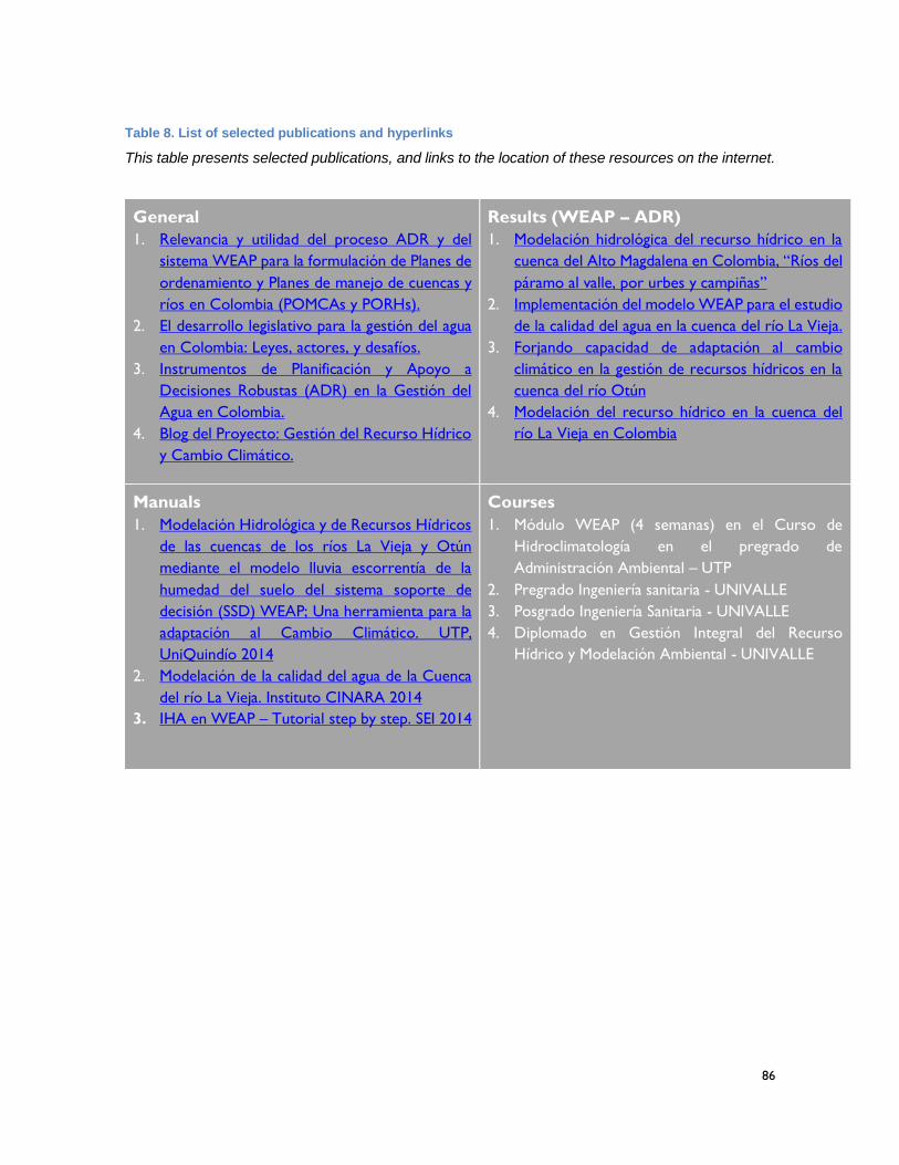
86
Table 8. List of selected publications and hyperlinks
This table presents selected publications, and links to the location of these resources on the internet.
General
1. Relevancia y utilidad del proceso ADR y del
sistema WEAP para la formulación de Planes de
ordenamiento y Planes de manejo de cuencas y
ríos en Colombia (POMCAs y PORHs).
2. El desarrollo legislativo para la gestión del agua
en Colombia: Leyes, actores, y desafíos.
3. Instrumentos de Planificación y Apoyo a
Decisiones Robustas (ADR) en la Gestión del
Agua en Colombia.
4. Blog del Proyecto: Gestión del Recurso Hídrico
y Cambio Climático.
Results (WEAP – ADR)
1. Modelación hidrológica del recurso hídrico en la
cuenca del Alto Magdalena en Colombia, “Ríos del
páramo al valle, por urbes y campiñas”
2. Implementación del modelo WEAP para el estudio
de la calidad del agua en la cuenca del río La Vieja.
3. Forjando capacidad de adaptación al cambio
climático en la gestión de recursos hídricos en la
cuenca del río Otún
4. Modelación del recurso hídrico en la cuenca del
río La Vieja en Colombia
Manuals
1. Modelación Hidrológica y de Recursos Hídricos
de las cuencas de los ríos La Vieja y Otún
mediante el modelo lluvia escorrentía de la
humedad del suelo del sistema soporte de
decisión (SSD) WEAP; Una herramienta para la
adaptación al Cambio Climático. UTP,
UniQuindío 2014
2. Modelación de la calidad del agua de la Cuenca
del río La Vieja. Instituto CINARA 2014
3. IHA en WEAP – Tutorial step by step. SEI 2014
Courses
1. Módulo WEAP (4 semanas) en el Curso de
Hidroclimatología en el pregrado de
Administración Ambiental – UTP
2. Pregrado Ingeniería sanitaria - UNIVALLE
3. Posgrado Ingeniería Sanitaria - UNIVALLE
4. Diplomado en Gestión Integral del Recurso
Hídrico y Modelación Ambiental - UNIVALLE
87
The development of a community of practice related to watershed modeling is key
It should never be assumed, however, that the development of a good watershed model will
ever become a push button exercise. Such a level of automation based on readily available
information and data would never foreclose opportunities for individuals with extremely
relevant local knowledge to contribute useful and important insights to the model building
process. Gaining access to the collected experience/insights held by these individuals would
be greatly facilitated, however, through the creation of a WEAP/RDS community of practice.
In some respects the emerging network of young professionals associated with the project
already operates as an informal community of practice, as these individuals were in regular
communication during the project. Formalizing these relationships through on-line platforms
or periodic user conferences could improve the quality of information exchange and the
efficiency of the model building process. As more technical staff within the CARs take up the
approach, they could be connected to this community of practice. Appendix 6 compiles the
complete list of partners that constitute the community of practice generated by the project,
including those that were directly involved as boundary partners in the project through
contracts, and other key partners that participated throughout the project, and that were
exposed to the results presented during the Symposium on Water, Climate and Adaptation
in June 2015.
Care needs to be taken to characterize uncertainties created by a lack of monitoring data
While Colombia is by no means the worst case in terms of the availability of the information
required to construct and calibrate a model such as WEAP, there are gaps in the existing
data and constraints in the ability of technical analysts to access what is available. While
progress could be made in improving access to existing data, to which the development of
IDEAMS National Water Information Platform is contributing greatly, Colombia, like all parts
of the world, will never possess all of the data required to construct a perfect model. As such,
greater care should be taken in the future to develop techniques to convey to decision
makers the uncertainty in model output stemming from incomplete model input data. This
was not a central activity of the current project based on the assumption that the
uncertainties associated with climate change and other factors were greater than the
uncertainties produced by the quality of the model input data itself. Still this assumption
should be tested and more clearly justified in the future as it has implications for decision
making.
Socio-economic metrics need to be included in the evaluation of adaptation options
During the implementation of the project, a great deal of time was spent characterizing the
vulnerability of the current systems within the project watersheds to climate change and
other uncertainties with respect to hydrologic, ecologic and water management metrics of
performance. From this baseline vulnerability assessment the ability of specific management
responses to reduce the level of vulnerability with respect to these current conditions was
assessed. The exercise made it possible to analyse how specific adaptations could improve
future levels of performance with respect to metrics such as the ecological condition in key
river reaches, the level of satisfaction of specific demands and water quality; and to compare
these improvements across the suite of proposed actions. The comparison across potential
88
management actions, however, requires that some consideration be given to the financial
costs and benefits associated with each evaluated course of actions, along with some
consideration of metrics related to social equity. In the future, these sorts of indicators should
be more fully evaluated as part of the implementation of the WEAP-based RDS approach.
Different ways of presenting model results to different audiences are needed
The use of WEAP within an ensemble of model runs, that generates a range of cases
defined by different future scenarios and management responses, produces a large amount
of data. One of the most challenging, and most exciting, parts of the RDS process is the
development of data visualization tools that support participatory and dynamic exploration
of these model outputs as part of a process of co-learning amongst key stakeholders
regarding promising adaptation actions. During the project, the Tableau software was used
to build these data exploration tools, to great success when the target audiences were
technical partners and technical collaborators within the CARs. There needs to be a
recognition, however, that non-technical audiences, specifically politicians and policy
makers, may not have the time to dedicate to understanding expansive data exploration.
Different communications approaches are required to transmit learning about climate
change and water management to these actors. While the project experimented with new
media approaches such as blogging and old approaches such a publishing fact sheets, more
work could be done to identify the most promising communication techniques for each
critical audience.
Governance lessons learned
The number of academic papers published on approaches to integrate climate change
considerations into water resources planning and decision making suggests that this topic
constitutes a compelling, and pressing, research agenda (Bouwen and Taillieu, 2004; Folke
et al., 2005; Lempert and Schlesinger, 2000; Nilsson et al., 2009; Pahl-Wostl et al., 2007).
This project, however, was not intended to be a pure research endeavor. The Project PMP
included a group of indicators related to actual policy setting and governance, with the
expectation that over time governance mechanisms would be created to realize actual on-
the-ground water management adaptations to climate change. As such, several governance
related lessons can also be articulated.
The linkages between water and watershed planning instruments needs to be clarified
There are a number of mandated planning instruments of relevance to the water and
watershed planning in Colombia. Four of particular relevance include the POMCA, the
PORH, the POT and the PSMV, although others touch upon the themes of water and
watersheds as well. As part of the implementation of the current project, SEI and its partners
invested a great deal of effort in understanding how these various plans fit together and how
the WEAP-based RDS approach could help to strengthen the connections between them.
The output of this thinking was a fact sheet, found in Appendix 4, which lays out how this
might occur. The key conclusion is that while there are practical reasons for keeping these
plans separate, there is a great deal of overlap that must be recognized if the IWRM
aspiration of integrated, multi-actor, multi-objective water management is to be achieved in
89
Colombia. Key questions of information flows between the plans, and issues of subsidiarity,
need to be clarified if these plans are to meet that objective. A strong case could be made
that a consistent watershed model developed on a platform such as WEAP could provide a
valuable shared foundation upon which individual plans could be constructed.
Technical guidelines associated with these instruments need to include climate change
As previously mentioned, the Ministry of the Environment and Sustainable Development in
Colombia considered including climate change considerations in recently published
guidance documents associated with the POMCA and the PORH, only to decide against
doing so based on the conclusion that the proper protocols are not yet well enough
formulated. This was a logical decision, but one which creates real opportunities for
innovation. More important than mandating specific climate change analytical protocols for
the POMCAs and PORHs is whether climate change considerations can be gradually
incorporated within the steps described within guidance documents published by the
Ministry. In particular, innovative analytical tools and participatory processes developed and
tested at the local watershed level, such as those described in this document, need to be
encouraged and accommodated. As part of the project, SEI published a fact sheet that lays
out how the WEAP-based RDS process could help create the scalable framework for
considering climate change, while also supporting the current promulgated steps in the plan
formulation processes. There is ample opportunity to test this approach in a watershed
where the project engaged, in particular in the Alto-Magdalena region where the local CAR
remains in communication with SEI about using the WEAP-based RDS approach as part of
ongoing POMCA development efforts.
Co-learning between local level experience and national level policy is nascent
In the last months of the project, SEI and its partners organized a set of dialogues with
national level actors working in the field of water and watershed management and climate
change around the activities carried out in each of the project watersheds. The forum
provided an opportunity for the experience gained by project partners at the local level to be
shared with those responsible for setting national level policy. The reaction was extremely
positive. One consistent theme from the dialogues, which touched upon both the technical
details of the work conducted and on its relevance for water governance, was that learning
accomplished at the local level can usefully contribute to the national level discourse on
appropriate policy responses to climate change. The Ministry is hungry to know about these
experiences. Still the connection between bottom-up and top-down learning is nascent.
There is an urgent need to connect these poles, however, as another theme of the dialogues
was the importance of local land and water management in a post-conflict Colombia. This
point was reinforced during the meeting by the government delegation involved in on-going
peace negotiations who pointed out the central role that natural resources and the
environment are playing in the emerging terms of the peace agreement. While nascent, the
connection between national goals and local experience needs to be cultivated by
connecting staff within national level institutions with colleagues working in local watersheds.
IDEAM play a key role in efforts to consider climate change within IWRM activities
90
One key actor in the strengthening of these connections is IDEAM. As the organization with
the mandate to generate and supply information relevant to local water and watershed
planning, SEI and its partners took pains to include IDEAM in the activities undertaken at
the local level. Two important examples include the organization of a climate scenarios
workshop at which the IDEAM staff responsible for developing national scale climate
projections for Colombia had the opportunity to hear about the needs local water managers
have for climate projections with an appropriate spatial and temporal resolution to support
watershed planning. The workshop connected both sets of actors with colleagues within the
National Center for Atmospheric Research in the United States who have a long experience
of downscaling large-scale GCM output for use in watershed level models such as WEAP.
This connection continues to develop. A second example of how the experience of the
project connects to the objectives of IDEAM stemmed from the use of WEAP in the Alto-
Magdalena region to support the development of an ERA (Estudio Nacional de Agua) in the
Huila Department. The ERAs are an IDEAM initiative designed to develop a disaggregated
set of indicators that can serve as a baseline for the various water and watershed plans
mandated in Colombia. Based on the local experience in Huila, IDEAM is now planning to
include WEAP in the National Water Modeling Center it is developing to support the
development of ERA and other watershed level investigations. The connections forged with
IDEAM pertaining to the WEAP-based RDS method during project implementation must be
cultivated.
The creation of capacity to secure funding for promising adaptation actions is required
While the project accomplished much in terms of building the capacity of local partners to
introduce climate change considerations into water and watershed planning, and contributed
usefully to emerging national level discourse on the subject, the fact remains that
participatory processes, analysis and plans will be needed to motivate real, on-the-ground
changes that can reduce the vulnerabilities created by climate change. A number of
international, regional, and national funds have been set up to provide funding for
adaptation. The process of setting up these funds has brought the issue of additionality to
the fore, namely the need to demonstrate that any specific action offers climate change
adaptation capacity beyond the normal set of benefits that would accrue from any particular
project. This is a high standard, and one that is increasingly based on some level of technical
analysis. As part of its broad set of activities in the Andean Region, SEI has deployed in-
house staff with high levels of experience and knowledge of emerging climate adaptation
funds to help argue how the WEAP-based RDS approach can be used to strengthen
adaptation plans and therefore to secure necessary adaptation funding. This argument need
to be refined and transferred to local water managers so that they can translate the
promising actions highlighted in the Results section of this report into on-the-ground
projects.
A compilation of the some key elements of these lessons learned, from all three categories,
is shown in Table 9.
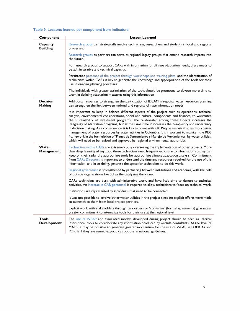
91
Table 9. Lessons learned per component from indicators
Component Lesson Learned
Capacity Building
Research groups can strategically involve technicians, researchers and students in local and regional processes.
Research groups as partners can serve as regional legacy groups that extend research impacts into the future.
For research groups to support CARs with information for climate adaptation needs, there needs to be administrative and technical capacity.
Persistence presence of the project through workshops and training plans, and the identification of
technicians within CARs is key to generate the knowledge and appropriation of the tools for their use in ongoing planning processes.
The individuals with greater assimilation of the tools should be promoted to devote more time to work in defining adaptation measures using this information
Decision
Making
Additional resources to strengthen the participation of IDEAM in regional water resources planning
can strengthen the link between national and regional climate information needs.
it is important to keep in balance different aspects of the project such as operations, technical analysis, environmental considerations, social and cultural components and finances, to warrantee
the sustainability of investment programs. The relationship among these aspects increases the integrality of adaptation programs, but at the same time it increases the complexity and uncertainty
in decision making. As a consequence, it is key to count with a RDS-type analysis that lead to a better management of water resources by water utilities in Colombia. It is important to maintain the RDS
framework in the formulation of 'Planes de Saneamiento y Manejo de Vertimientos’ by water utilities, which will need to be revised and approved by regional environmental authorities.
Water Management
Technicians within CARs are extremely busy overseeing the implementation of other projects. More than deep learning of any tool, these technicians need frequent exposure to information so they can
keep on their radar the appropriate tools for appropriate climate adaptation analysis. Commitment from CARs Directors is important to understand the time and resources required for the use of this
information, and in so doing, generate the space for technicians to do this work.
Regional governance is strengthened by partnering between institutions and academia, with the role
of outside organizations like SEI as the catalyzing think tank.
CARs technicians are busy with administrative work, and have little time to devote to technical
activities. An increase in CAR personnel is required to allow technicians to focus on technical work.
Institutions are represented by individuals that need to be connected
It was not possible to involve other water utilities in the project since no explicit efforts were made to outreach to them from local project partners.
Explicit work with stakeholders through task orders or ‘convenios’ (formal agreements) guarantees greater commitment to internalize tools for their use at the regional level
Tools Development
The use of WEAP and associated models developed during project should be seen as internal institutional tools to corroborate any information produced by outside consultants. At the level of
MADS it may be possible to generate greater momentum for the use of WEAP in POMCAs and PORHs if they are named explicitly as options in national guidelines.
92
Recommendations regarding best practices
As with any new challenge, Colombia’s journey towards a full consideration of the risks
posed by climate change and other uncertainties to water management will move along a
series of steps as indicated in Figure 18. While a decade or so ago the global water
management community was largely unaware of these risks, represented by the ground
floor of ‘unconscious incompetence’ in terms of the looming challenges, when the current
project was initiated the Colombian water management community found itself on the first
step, that of ‘conscious incompetence’. There was a general awareness of the problem but
little resolution on what should be done. The decision of the Ministry of the Environment and
Sustainable Development not to explicitly include climate change considerations in its
guidance documents for the formulation of POMCA’s and PORH’s reflected this. The efforts,
undertaken with partners in the project watersheds, was an attempt to move up to the level
of conscious competence, where actual approaches for responding to the challenges posed
by climate change were understood and accepted as useful. This has been accomplished,
which for a project where capacity building was the primary objective, constitutes an
enormous success.
Figure 20. Levels of competence and resources investment to build capacity applied to RDS
Moving to the next level of ‘unconscious competence’ is still a work in progress (Figure 20).
What will this look like? It would see the agencies and stakeholders involved in implementing
Colombia’s IWRM aspirations actually integrating climate change considerations into their
normal workflows and discussions. More specifically, it would see the WEAP-based RDS
approach being seamlessly integrated into the planning and decision-making processes
underway in Colombian watersheds in response to clear guidance from national policy
makers that makes this sort of effort mandatory, rather than discretionary. Once experience
is gained along these lines, Colombia will be primed to move to the final step of ‘reflective
conscious competence’ whereby consensus is reached around the best courses of action
to reduce water management vulnerability to climate change and resources can be
mobilized to implement these actions on the ground.
This section on recommended best practices has been constructed with an eye towards
moving the water management community in Colombia up these two final steps. If
93
successful, Colombia would take its place as one of the world leaders in the water and
climate arena. In order to get to the level of ‘unconscious competence’ from the current
‘conscious competence’, several best practices should be followed.
Identify key technical personnel within each institution: If the use of tools like WEAP
is to become part of the standard work flow within CARs, much as GIS analysis has
become, staff will need to be assigned to the effort. These staff will need to have a
background training in hydrology and water resources and some experience using
models. They will also need to be allocated time and resources by the Directors of the
CARs to work on this activity so as not to be diverted onto other projects.
Organize milestone training events: Under the current project some effort was made
to train technicians within the CARs on the use of WEAP within the RDS approach, to
varying degrees of success. The most successful case was that of Alto-Magdalena
where the local CAR actually assembled a WEAP team to work regularly on the project
in collaboration with the SEI team. Still, if this approach is to be fully internalized with
CARs, more formal and sustained training will be required. The partner universities,
acting as legacy institutions, or the emerging IDEAM National Water Modeling Center
could develop a curriculum of activities that provides a depth of knowledge on key
concepts (i.e. climate uncertainty, watershed modeling) and within a period r of roughly
6-12 months that would provide enough time for the concepts to be assimilated.
Maintain presence at the CAR: To support the integration of the WEAP-RDS approach
into standard workflows within the CARs, it is advisable to maintain a persistent presence
within the organizations for some time. The person could be dedicated to assisting in-
house staff to define work plans, monitor progress and solve problems that are
encountered. Such an individual could be engaged through external project funding, as
part of a university outreach function, or within the new IDEAM National Water Modeling
Center.
Plan regular meetings with CARs Directors: The Directors of CARs in Colombia
occupy a complex position defined by technical realities and political complexities. Many
of them have a legal background or management training, and are not typically well
versed in issues related to modeling. If the approach is to become part of the standard
work flow and discussions within watershed, however, these Directors need to be
conversant with the approach and understand how it facilitates the consideration of
climate change within the standard CAR’s functions. Quarterly, half day updates with
technical teams within the CARs are advised.
Generate opportunities for exchange of ideas about climate adaptation at the
watershed level: The emerging community of practice fostered through the project is a
critical component of future success. This community of practice should facilitate
knowledge exchange between watersheds where the approach is being applied, and
across policy scales. On a technical level exchanges of experience between watersheds
could focus on modeling techniques or on the sorts of adaptation actions that are
emerging as promising in different locations. On a policy level, such exchanges could
focus on how learning at the watershed level can contribute to the refinement of national
94
policy and the creation of national level systems to support climate informed water
management at the watershed level. In this sort of community of practice, an
organization such as ASOCARS could play a central role.
Draw stories of change to highlight the impact in terms of planning before and
after: One of the key outcomes of the project is the existence of 40 individuals fully
aware of the RDS process and with capacity to articulate climate adaptation needs in
Colombia. By bringing together a set of stories of change from these individuals, and
providing them opportunities to showcase these, it is possible to, in the words of one
project partner ‘give an answer to the community as to whether a project is viable or not
in terms of it climate adaptive capacity’. The effort to disseminate these stories of change
can be facilitated through more intentional use of new media such as blogs and Twitter
feeds.
Once the practice of considering climate change is integrated into the standard workflows
and discussions surrounding climate change and water management in Colombia, the stage
will be set for taking the last step in the development of competence, ‘reflective conscious’
capacity. Best practices required to make this step will include:
Make water central to the national debate: Colombia is rich in water resources with 6
times more water supply per capita than any other country in the world, and 3 times more
than others in Latin America (Blanco, 2008). However, some rivers have been greatly
altered: the Magdalena and Cauca have witnessed a 40% reduction in water supply and
rivers in the Chocó region present high levels of mercury contamination. Despite an
appropriate legal framework provided by the 99 Law of 1993 and the creation of the
CARs, problems remain. The largest water user in the country is the agriculture sector
with 54%, followed by the urban sector with 29% and industrial sector with 13%. It needs
to be recognized that in spite of the rich endowment of water, Colombia must manage
its resources in order to provide water of sufficient quantity and quality to support these
activities. All the more so in post-conflict Colombia, where improving rural livelihoods will
be critical.
Recognize how land use planning is going to impact on water management: Land
use and land distribution is at the core of the conflict in Colombia and it is also at the
core of the peace process. Colombia has 114 millions of hectares, and could use 20 for
agricultural production. However, the country is using only using 5 million hectares. 40
millions of hectares are being used to support extensive cattle ranching, which could be
accomplished on 5 million of hectares if livestock production systems were improved.
There are 35 million of hectares that could be used for other activities, such as the
conservation of ecosystems that underpin water resources in the country. Among the
proposed activities in the post-conflict era are actions to coordinate land use planning.
The focus on land use planning highlights one of the key challenges for water
management, which is to recognize its close relation to land use planning.
Connect program themes to realities of the peace process in the country: All
regions in Colombia are witnessing the peace process and are expectant as to its
outcomes and final resolution. In this particular case, connecting the symposium themes
95
of water and adaptation to the peace process generated the opportunity to increase
awareness about the importance of watershed planning for more sustainable progress.
The management of land and water resources must be a focal part of implementing the
peace.
Prepare a clear, written articulation of the priorities and how these have been
developed: Once the importance of water and watershed management is firmly
established in post-conflict policies in Colombia, the stage will be set to begin the sorts
of actions and adaptations identified through the implementation of the WEAP-based
RDS process as implemented by local CARs. Templates should be developed which
clearly articulate how these actions fit within national policies and are justified in terms
of the concept of additionality required to secure adaptation funding support from various
sources.
Maintain contact with national government focal points for adaptation fund: The
national focal points for the various sources of adaptation funds are key actors with
whom relationships must be developed and maintained. As CARs develop proposals
for water management adaptations to climate change, grounded in emerging national
policies and in the implementation of peace agreements, these focal points should be
briefed on the proposed actions and the manner in which the WEAP-based RDS process
justifies their selection for funding support.
If these best practices are followed it should be possible to (i) enable CARs and other local
water management institutions to identify promising adaptation actions to reduce the
vulnerability of watersheds to climate change and other uncertainties; and (ii) connect these
actions to emerging national policy initiatives in a post-conflict Colombia in a manner which
motivates financial support from sources of climate adaptation funding.
DISCUSSION AND CONCLUSIONS
As part of USAID’s efforts to support Colombian efforts to reinforce the management of the
countries’ environmental resources, the Rios del Páramo al Valle program established a
participatory and technical process to strengthen environmental governance and to improve
climate adaptation. The process, derived from SEI’s RDS practice, filled in a gap in the ability
of partners to provide a broad, coordinated view of watershed management that integrates
climate adaptation considerations. The application of the process led to (i) building the
capacity of Colombian institutions to master a set of tools for climate adaptation analysis, (ii)
demonstrating the utility of these tools within formal water and watershed planning and
decision making processes in Colombia, and (iii) connecting local experiences using these
tools to the national level discourse on formal water and watershed planning and decision
making processes and the need to better integrate the impact of climate change.
To illustrate the empowerment achieved by Colombian institutions using the tools, we offer
an analogy from practical applications of management theory about empowerment (Apello,
2014). The RDS steps were shared through consistent capacity building efforts in order to
achieve full assimilation by local groups. However, empowerment in the use of the tools
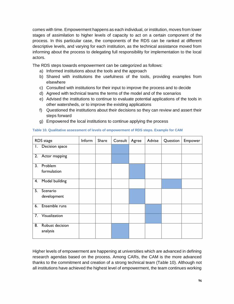
96
comes with time. Empowerment happens as each individual, or institution, moves from lower
stages of assimilation to higher levels of capacity to act on a certain component of the
process. In this particular case, the components of the RDS can be ranked at different
descriptive levels, and varying for each institution, as the technical assistance moved from
informing about the process to delegating full responsibility for implementation to the local
actors.
The RDS steps towards empowerment can be categorized as follows:
a) Informed institutions about the tools and the approach
b) Shared with institutions the usefulness of the tools, providing examples from
elsewhere
c) Consulted with institutions for their input to improve the process and to decide
d) Agreed with technical teams the terms of the model and of the scenarios
e) Advised the institutions to continue to evaluate potential applications of the tools in
other watersheds, or to improve the existing applications
f) Questioned the institutions about their decisions so they can review and assert their
steps forward
g) Empowered the local institutions to continue applying the process
Table 10. Qualitative assessment of levels of empowerment of RDS steps. Example for CAM
RDS stage Inform Share Consult Agree Advise Question Empower
1. Decision space
2. Actor mapping
3. Problem
formulation
4. Model building
5. Scenario
development
6. Ensemble runs
7. Visualization
8. Robust decision
analysis
Higher levels of empowerment are happening at universities which are advanced in defining
research agendas based on the process. Among CARs, the CAM is the more advanced
thanks to the commitment and creation of a strong technical team (Table 10). Although not
all institutions have achieved the highest level of empowerment, the team continues working
97
and communicating with SEI to move forward in the use of the RDS process. SEI is
supporting their efforts as they move forward to provide continuity.
In our view, while the full capacity to act on each of the stages may not have been achieved
by all involved parties, the trajectory has been set. We observe that the momentum created
by the effort will guarantee a path towards higher levels of empowerment in the application
of the RDS process of the actors involved, and the consequent replication in other regions
of Colombia for better planning of watershed adaptation. Whereas a decade or so ago, water
managers in Colombia and other parts of the world had only a limited idea that climate
change needed to be considered within IWRM based water and watershed planning
processes, an exciting community of practice has been created in Colombia that is now
committed to meet the challenge.
98
REFERENCES
Apello, J., 2014. #Workout: Games, Tools & Practices to Engage People, Improve Work, and Delight Clients (Management 3.0) (Kindle Location 6602). Happy Melly Express. Kindle Edition.
Blanco, J., 2008. Integrated Water Resource Management in Colombia: Paralysis by Analysis? Int. J. Water Resour. Dev. 24, 91–101. doi:10.1080/07900620701747686
Bouwen, R., Taillieu, T., 2004. Multi-party collaboration as social learning for interdependence: developing relational knowing for sustainable natural resource management. J. Community Appl. Soc. Psychol. 14, 137–153. doi:10.1002/casp.777
Folke, C., Hahn, T., Olsson, P., Norberg, J., 2005. ADAPTIVE GOVERNANCE OF SOCIAL-ECOLOGICAL SYSTEMS. Annu. Rev. Environ. Resour. 30, 441–473. doi:10.1146/annurev.energy.30.050504.144511
Groves, D.G., Yates, D., Tebaldi, C., 2008. Developing and applying uncertain global climate change projections for regional water management planning. Water Resour. Res. 44, W12413. doi:10.1029/2008WR006964
ICWE, 1992. Development Issues for the 21st Century. The Dublin Statement and Report of the Conference, Dublin, Ireland, 26-31 January 1992. World Meteorological Organization, Geneva.
Jonch-Clausen, T., 2004. Integrated Water Resources Management (IWRM) and Water Efficiency Plans by 2005: Why, What and How? Global Water Partnership.
Lee, K., 1999. Appraising Adaptive Management. Conserv. Ecol. 3.
Lempert, R.J., Groves, D.G., 2010. Identifying and evaluating robust adaptive policy responses to climate change for water management agencies in the American west. Technol. Forecast. Soc. Change 77, 960–974. doi:10.1016/j.techfore.2010.04.007
Lempert, R.J., Popper, S.W., Bankes, S.C., 2003. Shaping the Next One Hundred Years: New methods for quantitative, long-term policy analysis. RAND, Santa Monica, CA.
Lempert, R.J., Schlesinger, M.E., 2000. Robust Strategies for Abating Climate Change. Clim. Change 45, 387–401(15).
Ludwig, F., van Slobbe, E., Cofino, W., 2014. Climate change adaptation and Integrated Water Resource Management in the water sector. J. Hydrol. 518, 235–242. doi:10.1016/j.jhydrol.2013.08.010
Lynam, T., De Jong, Wil, Sheil, D., Kusumanto, T., Evans, K., 2007. A Review of Tools for Incorporating Community Knowledge, Preferences, and Values into Decision Making in Natural Resources Management. Ecol. Soc. 12.
Ministerio de Ambiente, Vivienda y Desarrollo Territorial, 2010. Politica Nacional para la Gestión del Recurso Hídrico.
Nilsson, M., Wiklund, H., Finnveden, G., Jonsson, D.K., Lundberg, K., Tyskeng, S., Wallgren, O., 2009. Analytical framework and tool kit for SEA follow-up. Environ. Impact Assess. Rev. 29, 186–199. doi:10.1016/j.eiar.2008.09.002
Pahl-Wostl, C., 2009. A conceptual framework for analysing adaptive capacity and multi-level learning processes in resource governance regimes. Glob. Environ. Change 19, 354–365. doi:10.1016/j.gloenvcha.2009.06.001
99
Pahl-Wostl, C., Sendzimir, J., Jeffrey, P., Aerts, J., Berkamp, G., Cross, K., 2007. Managing change toward adaptive water management through social learning. Ecology and Society. Ecol. Soc. 12.
Peterson, G.D., Cumming, G.S., Carpenter, S.R., 2003. Scenario Planning: a Tool for Conservation in an Uncertain World. Conserv. Biol. 17, 358–366. doi:10.1046/j.1523-1739.2003.01491.x
Reed, M.S., Graves, A., Dandy, N., Posthumus, H., Hubacek, K., Morris, J., Prell, C., Quinn, C.H., Stringer, L.C., 2009. Who’s in and why? A typology of stakeholder analysis methods for natural resource management. J. Environ. Manage. 90, 1933–1949. doi:10.1016/j.jenvman.2009.01.001
Steinhoff, D.F., Monaghan, A.J., Clark, M.P., 2015. Projected impact of twenty-first century ENSO changes on rainfall over Central America and northwest South America from CMIP5 AOGCMs. Clim. Dyn. 44, 1329–1349. doi:10.1007/s00382-014-2196-3
Stringer, L., Dougill, A., Fraser, E., Hubacek, K., Prell, C., Reed, M., 2006. Unpacking “Participation” in the Adaptive Management of Social–ecological Systems: a Critical Review. Ecol. Soc. 11.
UNFCC, 2009. The Nairobi Work Programme.
Yates, D., Purkey, D., Sieber, J., Huber-Lee, A., Galbraith, H., 2005. WEAP 21--A Demand, Priority, and Preference-Driven Water Planning Model: Part 2, Aiding Freshwater Ecosystem Service Evaluation. Water Int. 30, 501–502.
100
U.S. Agency for International Development
Bogotá, Colombia