final site inspection report addendum … afb/2019-03-01...final addendum 01 to the final site...
TRANSCRIPT

Contract FA8903-16-D-0027 Task Order 0004
Prepared for:
Air Force Civil Engineer Center
JBSA Lackland, Texas
March 2019
FINAL
SITE INSPECTION REPORT ADDENDUM 01
CANNON AIR FORCE BASE, NM
Site Inspection of Aqueous Film Forming Foam (AFFF) Release Areas Environmental
Programs Worldwide

This page intentionally left blank.

FINAL
ADDENDUM 01 TO THE FINAL SITE INSPECTION REPORT
SITE INSPECTION OF AQUEOUS FILM FORMING FOAM (AFFF) RELEASE AREAS
ENVIRONMENTAL PROGRAMS WORLDWIDE
CANNON AIR FORCE BASE CLOVIS, NEW MEXICO
Project No. RPMO20167118
Prepared for:
Air Force Civil Engineer Center Joint Base San Antonio – Lackland, Texas
Prepared by:
Amec Foster Wheeler Programs, Inc.
Contract FA8903‐16‐D‐0027 Task Order 0004
March 2019

Site Inspection of Aqueous Film Forming Foam (AFFF) Release Areas Final Addendum 01 to the Final Site Inspection Report
Cannon Air Force Base, Clovis, New Mexico March 2019
Page iii
TABLE OF CONTENTS
ACRONYMS ......................................................................................................................................... vi
EXECUTIVE SUMMARY ...................................................................................................................... viii
1.0 INTRODUCTION ....................................................................................................................... 1 PROJECT OBJECTIVES .................................................................................................................... 2 PROJECT SCOPE ............................................................................................................................. 3
2.0 BACKGROUND ......................................................................................................................... 5 INITIAL SITE INSPECTION ............................................................................................................... 5 HYDROGEOLOGIC SETTING ........................................................................................................... 5 POTENTIAL RECEPTORS ................................................................................................................. 7
3.0 EXPANDED SI FIELD ACTIVITIES AND ANALYTICAL PROTOCOL .................................................. 9 AFFF RELEASE AREA 14: BASEWIDE GROUNDWATER ................................................................. 14 3.1.1 Sampling Summary ................................................................................................................................ 14 3.1.2 Analytical Results ................................................................................................................................... 14 3.1.3 Conclusions ............................................................................................................................................ 14 OFF‐BASE WATER SAMPLING ...................................................................................................... 15 3.2.1 Sampling Summary ................................................................................................................................ 15 3.2.2 Analytical Results ................................................................................................................................... 15 3.2.3 Conclusions ............................................................................................................................................ 15
4.0 MIGRATION/EXPOSURE PATHWAYS AND TARGETS ............................................................... 17 GROUNDWATER EXPOSURE CONCLUSIONS ............................................................................... 17
5.0 SUMMARY AND CONCLUSIONS ............................................................................................. 19
6.0 REFERENCES .......................................................................................................................... 21

Site Inspection of Aqueous Film Forming Foam (AFFF) Release Areas Final Addendum 01 to the Final Site Inspection Report
Cannon Air Force Base, Clovis, New Mexico March 2019
Page iv
FIGURES
Figure 1.0‐1 Installation Location Map Figure 2.1‐1 2017 Groundwater Analytical Results (On‐Base) Figure 2.2‐1 2013 Groundwater Elevation Contours (Irrigation Season) Figure 2.2‐2 2015 Groundwater Elevation Contours (Non‐Irrigation Season) Figure 2.3‐1 Off‐Base Well Survey (New Mexico Office of State Engineer) Figure 3.0‐1 On‐Base Groundwater Sample Locations Figure 3.0‐2 Off‐Base Sample Locations Figure 3.1‐1 2018/2019 Groundwater Analytical Results (On‐Base) Figure 3.2‐1 2018 Off‐Base Water Sample Analytical Results (1.0‐mile) Figure 3.2‐2 2018 Off‐Base Water Sample Analytical Results (4.0‐mile)
TABLES
Table 1.0‐1 Regulatory Screening Values (Page 2 in Report) Table 2.1‐1 Summary of 2017 Groundwater Analytical Testing Results (Tables Section) Table 2.3‐1 Off‐Base Well Locations – New Mexico Office of State Engineer (Tables Section) Table 3.0‐1 Monitoring Well Construction Details (Tables Section) Table 3.0‐2 Groundwater Elevations (Tables Section) Table 3.0‐3 Off‐Base Sampling Location Summary (Tables Section) Table 3.1‐1 Summary of Expanded Site Inspection Groundwater Analytical
Testing Results (On‐Base) (Tables Section) Table 3.1‐2 Summary of Off‐Base Analytical Testing Results (Tables Section) Table 4.0‐1 Conceptual Site Model: Installation‐Wide Summary (Tables Section) Table 5.0‐1 Summary of Analytical Results and Screening Level Exceedances (Page 19 in Report)

Site Inspection of Aqueous Film Forming Foam (AFFF) Release Areas Final Addendum 01 to the Final Site Inspection Report
Cannon Air Force Base, Clovis, New Mexico March 2019
Page v
APPENDICES
Appendix A Photograph Logs Appendix B Field Forms
B‐1 Field Activity Daily Logs B‐2 Daily PFAS Protocol Checklists B‐3 Tailgate Safety Meeting Reports B‐4 Soil Boring/Monitoring Well Records B‐5 Well Development Forms B‐6 Water Quality Sampling Instrument Calibration Forms B‐7 Groundwater Sampling Records
Appendix C Laboratory Analytical Reports (DVD) Appendix D Data Validation Reports
D‐1 December 2018 Data Validation Report (Groundwater Confirmation Sampling) D‐2 September 2018 Data Validation Report (August 2018 Private Well Sampling) D‐3 October 2018 Data Validation Report (September 2018 Private Well Sampling) D‐4 March 2019 Data Validation Report (MW‐Y)

Site Inspection of Aqueous Film Forming Foam (AFFF) Release Areas Final Addendum 01 to the Final Site Inspection Report
Cannon Air Force Base, Clovis, New Mexico March 2019
Page vi
ACRONYMS
AFB Air Force Base AFCEC Air Force Civil Engineer Center AFFF Aqueous Film Forming Foam Amec Foster Wheeler Amec Foster Wheeler Programs, Inc. and its affiliate Amec Foster
Wheeler Environment & Infrastructure Inc. collectively amsl above mean sea level bgs below ground surface BRAC Base Realignment and Closure Cascade Cascade Environmental CoC Chain‐of‐Custody DL detection limit DO Dissolved Oxygen DoD Department of Defense ELAP Environmental Laboratory Accreditation Program FTA Fire Training Area HDPE high‐density polyethylene IDW Investigation‐Derived Waste IRP Installation Restoration Program ISWP Installation‐Specific Work Plan ISWPA Installation‐Specific Work Plan Addendum LC‐MS/MS Liquid Chromatography and Tandem Mass Spectrometry LHA Lifetime Health Advisory LOQ limit of quantification µg/L micrograms per liter Maxxam Maxxam Analytical NMED New Mexico Environment Department NMOSE New Mexico Office of the State Engineer PFAS per‐ and polyfluorinated alkyl substances PFBS perfluorobutanesulfonic acid PFOA perfluorooctanoic acid

Site Inspection of Aqueous Film Forming Foam (AFFF) Release Areas Final Addendum 01 to the Final Site Inspection Report
Cannon Air Force Base, Clovis, New Mexico March 2019
Page vii
PFOS perfluorooctanesulfonic acid PID photoionization detector PPE personal protective equipment PVC polyvinyl chloride ORP Oxygen Reduction Potential QPP Quality Program Plan RSL Regional Screening Level SI Site Investigation SIR Site Investigation Report SOP Standard Operating Procedure USAF United States Air Force USDA United States Department of Agriculture USEPA United States Environmental Protection Agency USGS United States Geological Survey

Site Inspection of Aqueous Film Forming Foam (AFFF) Release Areas Final Addendum 01 to the Final Site Inspection Report
Cannon Air Force Base, Clovis, New Mexico March 2019
Page viii
EXECUTIVE SUMMARY
This Addendum 01 to the Final Site Inspection (SI) Report (SIR) was prepared by Amec Foster Wheeler Programs, Inc., together with affiliate Wood Environmental & Infrastructure Solutions, Inc. (formerly known as Amec Foster Wheeler Environment & Infrastructure, Inc.)1, collectively referred to as Amec Foster Wheeler, under Contract No. FA8903‐16‐D‐0027, Task Order 0004, to document the results of expanded SI activities conducted at Cannon Air Force Base (AFB) in Clovis, Curry County, New Mexico.
Based on a review of the per‐ and polyfluorinated alkyl substances (PFAS) groundwater analytical data obtained during the November/December 2017 SI at Cannon AFB, it was determined that further evaluation of perfluorooctanesulfonic acid (PFOS) and perfluorooctanoic acid (PFOA) in groundwater at, and downgradient of, the installation was required. Concentrations of PFOS and PFOA were detected above the United States Environmental Protection Agency (USEPA) Lifetime Health Advisory (LHA) value of 0.07 micrograms per liter (µg/l); the maximum concentrations of PFOS and PFOA were 24 µg/l and 3.1 µg/l respectively. Subsequent discussions between the Air Force Civil Engineer Center (AFCEC), Cannon AFB and Amec Foster Wheeler determined that further evaluation would consist of installing and sampling a groundwater monitoring well on Cannon AFB at the installation boundary; conducting resampling of six existing monitoring wells where PFOS and PFOA were detected at concentrations above screening levels; and, collection of water samples at off‐base properties southeast (downgradient) of Cannon AFB where groundwater is used as a source of drinking water for human consumption.
The data presented in this SIR Addendum 01 were collected and evaluated in accordance with the Final Addendum 01 Installation‐Specific Work Plan (ISWPA) (Amec Foster Wheeler, 2018a) and the General Quality Program Plan (QPP) (Amec Foster Wheeler, 2018b) and are meant to supplement the findings presented in the Final SIR (Amec Foster Wheeler, 2018c). An overview of PFAS and a discussion of the background for each of the aqueous film forming foam (AFFF) release areas were provided in the Final SIR (Amec Foster Wheeler, 2018c).
The purpose of the expanded SI was to evaluate the potential for off‐base migration of PFOS and/or PFOA downgradient of AFFF Release Areas 1 (Former Fire Training Area [FTA] No. 2), 2 (Former FTA No. 3), 3 (Former FTA No. 4), 5 (Former Sewage Lagoons) and 11 (Active FTA). Sixteen PFAS compounds were analyzed as part of the expanded SI activities in accordance with USEPA method 537.1 and in accordance with the General QPP (Amec Foster Wheeler, 2018b); however, only analytes with applicable toxicity
1 Amec Foster Wheeler Environment & Infrastructure, Inc. changed its name on 6 April 2018 to Wood Environment & Infrastructure Solutions, Inc., to reflect Wood Group’s acquisition of Amec Foster Wheeler. All resource documents created and activities conducted under Amec Foster Wheeler Environment & Infrastructure, Inc. remain in place, will be referred to Amec Foster Wheeler, and are executed under Wood Environment & Infrastructure Solutions, Inc.

Site Inspection of Aqueous Film Forming Foam (AFFF) Release Areas Final Addendum 01 to the Final Site Inspection Report
Cannon Air Force Base, Clovis, New Mexico March 2019
Page ix
values (i.e., PFOS, PFOA and perfluorobutanesulfonic acid [PFBS]) were screened against human health risk‐based criteria and discussed in this addendum.
Expanded SI PFAS Analytical Results
The presence of PFOS, PFOA, and/or PFOS+PFOA at concentrations above the USEPA LHA value of 0.07 µg/L was confirmed in on‐base groundwater monitoring wells MW‐Ca, MW‐D, MW‐Ga, MW‐Pa, MW‐Sa, and MW‐Ta. The concentrations of PFOS, PFOA and/or PFOS+PFOA were generally consistent with the concentrations detected in November/December 2017 and reported in the Final SIR (Amec Foster Wheeler, 2018c).
Analytical results for newly installed MW‐Y confirmed the presence of PFOS, PFOA and PFOS+PFOA at the installation boundary, downgradient of the former sewage lagoon area (AFFF release area 5) where PFOS and/or PFOS+PFOA were detected above the LHA in 2017. The maximum concentrations of PFOS (0.13 µg/l), PFOA (0.0617 µg/l) and PFOS+PFOA (0.192 µg/L) were detected in the duplicate sample; the concentrations of PFOS and PFOS+PFOA exceeded the LHA value.
PFOS, PFOA, and/or PFOS+PFOA were detected at concentrations above the LHA in three off‐base water samples (CANON‐RES650‐01‐SP‐08292018, CANON‐RES650‐02‐SP‐08292018 and CANON‐RES948‐01‐SP‐08282018), confirming that groundwater impacted with PFOS or PFOA at concentrations above the LHA values has migrated off‐base to the southeast.
PFBS was not detected in groundwater at concentrations above UESPA Tap Water Regional Screening Levels (RSLs) in on‐base or off‐base water samples.
Groundwater Receptors
Human receptors via the ingestion pathway were confirmed to be present downgradient of Cannon AFB. Due to the detections of PFOS, PFOA and/or PFOS+PFOA at concentrations exceeding the USEPA LHA values in off‐base properties where groundwater is used as a source of drinking water, the United States Air Force implemented emergency response measures to immediately provide alternative sources of drinking water for impacted property owners. Bottled water was immediately offered to impacted property owners to mitigate the ingestion exposure. Routine bottled water delivery service is ongoing at one of the affected properties and will continue until longer term water treatment technologies are implemented. The second property declined the bottled water service; however, they informed the Air Force that instead of bottled water, they prohibited consumption of water for all personnel at the property, a condition that will also continue until water treatment systems are installed.
Due to PFOS, PFOA and/or PFOS+PFOA concentrations exceeding screening levels in the Basewide Groundwater, the Interim Response Action initiated during the expanded SI will be followed by the next phase of the CERCLA process, Remedial Investigation, to determine the extent of concentrations exceeding screening levels in groundwater that is a source of drinking water.

Site Inspection of Aqueous Film Forming Foam (AFFF) Release Areas Final Addendum 01 to the Final Site Inspection Report
Cannon Air Force Base, Clovis, New Mexico March 2019
Page 1
1.0 INTRODUCTION
This Addendum 01 to the Final Site Inspection (SI) Report (SIR) was prepared by Amec Foster Wheeler Programs, Inc., together with affiliate Wood Environmental & Infrastructure Solutions, Inc. (formerly known as Amec Foster Wheeler Environment & Infrastructure, Inc.)2, collectively referred to as Amec Foster Wheeler, under Contract No. FA8903‐16‐D‐0027, Task Order 0004, to document the results of expanded SI activities conducted at, and downgradient of, Cannon Air Force Base (AFB) in Clovis, Curry County, New Mexico (Figure 1.0‐1). Based on a review of the per‐ and polyfluorinated alkyl substances (PFAS) groundwater analytical data obtained during the November/December 2017 SI at Cannon AFB, it was determined that further evaluation of perfluorooctanesulfonic acid (PFOS) and perfluorooctanoic acid (PFOA) in groundwater at, and downgradient of the installation was required to evaluate the potential for off‐base migration. Subsequent discussions between the Air Force Civil Engineer Center (AFCEC), Cannon AFB and Amec Foster Wheeler determined that further evaluation would consist of installing and sampling a groundwater monitoring well on Cannon AFB at the installation boundary; conducting resampling of six existing monitoring wells at the installation where PFOS, PFOA and/or PFOS+PFOA were detected at concentrations above screening levels; and, collection of samples from private water supply wells located southeast (downgradient) of the installation boundary.
The data presented in this SIR Addendum 01 were collected and evaluated in accordance with the Final Addendum 01 Installation‐Specific Work Plan (ISWP) (Amec Foster Wheeler, 2018a) and the General Quality Program Plan (QPP) (Amec Foster Wheeler, 2018b) and are meant to supplement the findings presented in the Final SIR (Amec Foster Wheeler, 2018c). An overview of PFAS, a discussion of the background for each of the aqueous film forming foam (AFFF) release areas, and previous PFAS analytical results were provided in the Final SIR (Amec Foster Wheeler, 2018c).
The United States Environmental Protection Agency (USEPA) Office of Water issued drinking water Lifetime Health Advisory (LHA) values for PFOS and PFOA in May 2016 that replaced the 2009 Provisional HA values. The LHA values for PFOS and PFOA are 0.07 micrograms per liter (µg/L) for each constituent; however, when these two chemicals co‐occur in a drinking water source, a conservative and health‐protective approach is recommended that compares the sum of the concentrations (PFOS + PFOA) to the LHA value (0.07 μg/L). The LHA values are non‐regulatory concentrations of drinking water contaminants at or below which adverse health effects are not anticipated to occur over specific exposure durations (e.g., a lifetime). They serve as informal technical guidance to assist federal, state, and local officials, and managers of public or community water systems in protecting public health when emergency spills or
2 Amec Foster Wheeler Environment & Infrastructure, Inc. changed its name on 6 April 2018 to Wood Environment & Infrastructure Solutions, Inc., to reflect Wood Group’s acquisition of Amec Foster Wheeler. All resource documents created and activities conducted under Amec Foster Wheeler Environment & Infrastructure, Inc. remain in place, will be referred to Amec Foster Wheeler, and are executed under Wood Environment & Infrastructure Solutions, Inc.
Site Inspection of Aqueous Film Forming Foam (AFFF) Release Areas Final Addendum 01 to the Final Site Inspection Report
Cannon Air Force Base, Clovis, New Mexico March 2019
Page 2
other contamination situations occur. A LHA document provides information on the environmental properties, health effects, analytical methodology, and treatment technologies for removing drinking water contaminants. Lifetime Health Advisory values are not to be construed as legally enforceable federal standards and are subject to change as new information becomes available (USEPA, 2016a and 2016b).
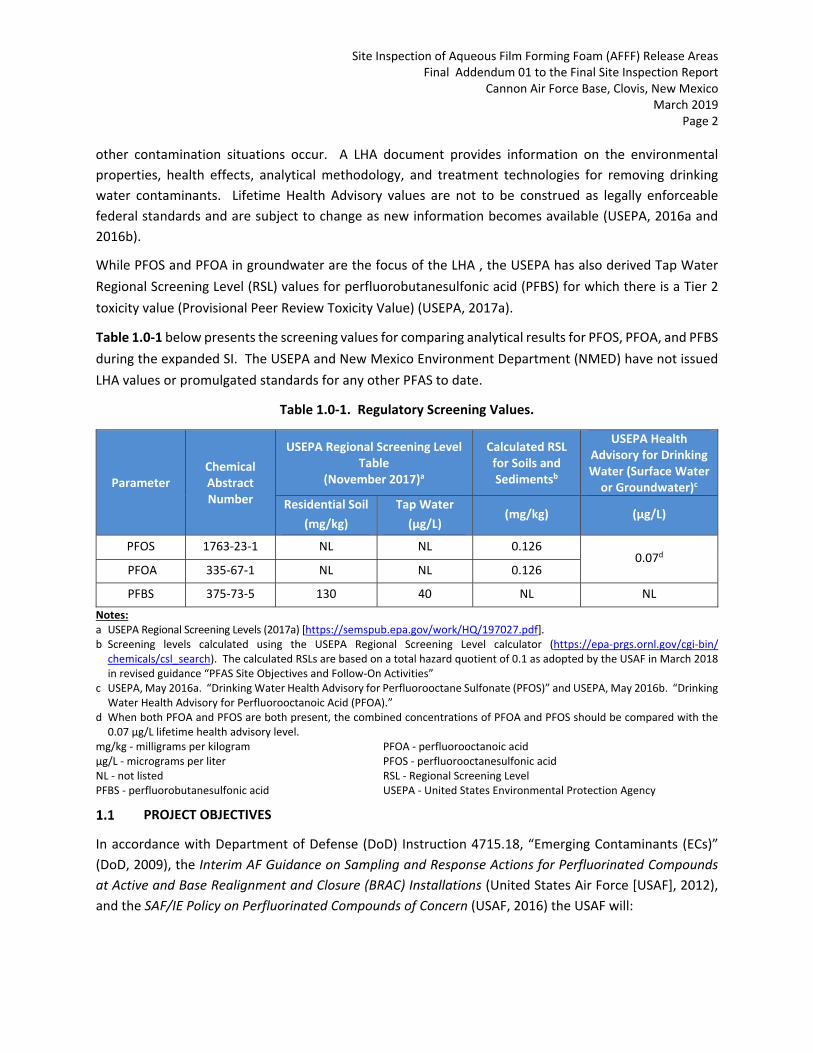
While PFOS and PFOA in groundwater are the focus of the LHA , the USEPA has also derived Tap Water Regional Screening Level (RSL) values for perfluorobutanesulfonic acid (PFBS) for which there is a Tier 2 toxicity value (Provisional Peer Review Toxicity Value) (USEPA, 2017a).
Table 1.0‐1 below presents the screening values for comparing analytical results for PFOS, PFOA, and PFBS during the expanded SI. The USEPA and New Mexico Environment Department (NMED) have not issued LHA values or promulgated standards for any other PFAS to date.
Table 1.0‐1. Regulatory Screening Values.
Parameter Chemical Abstract Number
USEPA Regional Screening Level Table
(November 2017)a
Calculated RSL for Soils and Sedimentsb
USEPA Health Advisory for Drinking Water (Surface Water
or Groundwater)c Residential Soil
(mg/kg) Tap Water
(µg/L) (mg/kg) (µg/L)
PFOS 1763‐23‐1 NL NL 0.126 0.07d
PFOA 335‐67‐1 NL NL 0.126
PFBS 375‐73‐5 130 40 NL NL Notes: a USEPA Regional Screening Levels (2017a) [https://semspub.epa.gov/work/HQ/197027.pdf]. b Screening levels calculated using the USEPA Regional Screening Level calculator (https://epa‐prgs.ornl.gov/cgi‐bin/ chemicals/csl_search). The calculated RSLs are based on a total hazard quotient of 0.1 as adopted by the USAF in March 2018 in revised guidance “PFAS Site Objectives and Follow‐On Activities”
c USEPA, May 2016a. “Drinking Water Health Advisory for Perfluorooctane Sulfonate (PFOS)” and USEPA, May 2016b. “Drinking Water Health Advisory for Perfluorooctanoic Acid (PFOA).”
d When both PFOA and PFOS are both present, the combined concentrations of PFOA and PFOS should be compared with the 0.07 µg/L lifetime health advisory level.
mg/kg ‐ milligrams per kilogram PFOA ‐ perfluorooctanoic acid µg/L ‐ micrograms per liter PFOS ‐ perfluorooctanesulfonic acid NL ‐ not listed RSL ‐ Regional Screening Level PFBS ‐ perfluorobutanesulfonic acid USEPA ‐ United States Environmental Protection Agency
PROJECT OBJECTIVES
In accordance with Department of Defense (DoD) Instruction 4715.18, “Emerging Contaminants (ECs)” (DoD, 2009), the Interim AF Guidance on Sampling and Response Actions for Perfluorinated Compounds
at Active and Base Realignment and Closure (BRAC) Installations (United States Air Force [USAF], 2012), and the SAF/IE Policy on Perfluorinated Compounds of Concern (USAF, 2016) the USAF will:

Site Inspection of Aqueous Film Forming Foam (AFFF) Release Areas Final Addendum 01 to the Final Site Inspection Report
Cannon Air Force Base, Clovis, New Mexico March 2019
Page 3
1) Identify locations where there is a reasonable expectation that there may have been a release of PFOS or PFOA associated with USAF actions;
2) Determine if there is unacceptable risk to human health and the environment; and,
3) Address releases that pose an unacceptable risk, including offsite migration.
The primary objectives of this expanded SI were to:
Determine whether PFOS, PFOA and/or PFOS+PFOA are present in groundwater further downgradient of monitoring wells where the presence of these constituents was confirmed at concentrations above the LHA); and,
Determine if PFOS and/or PFOA are present in groundwater at concentrations exceeding the LHA value in off‐base water wells where groundwater is currently used as a drinking water source for human consumption.
PROJECT SCOPE
In order to evaluate the potential for off‐base migration of PFOS, PFOA, and PFBS, expanded SI activities included:
The installation and sampling of one permanent monitoring well (MW‐Y) located at the installation boundary, southeast of monitoring wells MW‐Ga and MW‐Pa where PFOS, PFOA and PFOS+PFOA in groundwater were detected at concentrations exceeding the LHA. The monitoring well will be screened in the Ogallala Formation with construction consistent with existing on‐base monitoring wells.
Confirmation groundwater sampling was conducted at the six monitoring wells (MW‐Ca, MW‐D, MW‐Ga, MW‐Pa, MW‐Sa, and MW‐Ta) where PFOS, PFOA and/or PFOS+PFOA were previously detected at concentrations exceeding the LHA.
Conducting an off‐base well inventory survey and sampling of off‐base water wells where groundwater was being used as a source of drinking water for human consumption.
This SIR Addendum 01 discusses and provides a comparison of the expanded analytical results to screening values for PFOS, PFOA, and PFBS in groundwater (on‐base and off‐base). The remaining PFAS do not have screening values; therefore, only the results of PFOS, PFOA, and PFBS are discussed in detail and presented in tables and figures. However, all data are presented in the laboratory analytical reports provided in this SIR Addendum 01.

Site Inspection of Aqueous Film Forming Foam (AFFF) Release Areas Final Addendum 01 to the Final Site Inspection Report
Cannon Air Force Base, Clovis, New Mexico March 2019
Page 4
This page intentionally left blank.

Site Inspection of Aqueous Film Forming Foam (AFFF) Release Areas Final Addendum 01 to the Final Site Inspection Report
Cannon Air Force Base, Clovis, New Mexico March 2019
Page 5
2.0 BACKGROUND
Complete details on site location, setting, history and previous investigations performed at Cannon AFB are summarized in the SIR (Amec Foster Wheeler, 2018c).
INITIAL SITE INSPECTION
Data collection activities conducted during the initial SI consisted of collecting soil, sediment, surface water and/or groundwater samples at the AFFF release areas summarized in the SIR. The initial SI field activities were conducted in November and December 2017.
Review of analytical results of the initial SI indicated that PFOS, PFOA and/or PFBS are present in soil and groundwater at Cannon AFB in excess of applicable USEPA RSLs and LHA values. PFOS in surface soil was detected above the calculated RSL in AFFF release areas 2, 3, 4, 5, 9, and 11. PFOS in subsurface soil was detected above the calculated RSL in AFFF Release Area 5. PFOA and PFBS were detected in soil below the calculated RSLs, based on a residential scenario, at all AFFF release areas.
Between 30 November and 14 December 2017, groundwater samples were collected from 18 existing monitoring wells at Cannon AFB. The validated groundwater analytical results revealed the presence of PFOS, PFOA and/or the sum of PFOS and PFOA (PFOS+PFOA) at concentrations exceeding the LHA value of 0.07 µg/l in six monitoring wells (MW‐Ca, MW‐D, MW‐Ga, MW‐Pa, MW‐Sa, and MW‐Ta). Two monitoring wells, MW‐Ga and MW‐Pa are located in the east‐central portion of the installation, southeast of the former sewage lagoon area (AFFF Release Area 5); and the remaining four monitoring wells (MW‐Ca, MW‐D, MW‐Sa and MW‐Ta) are located in the southeast corner of the installation, southeast of both the active fire training area (FTA), and former FTAs including; FTA No. 2 (Installation Restoration Program [IRP] Site FT‐07), FTA No. 3 (IRP Site FT‐08) and FTA No. 4 (IRP Site FTA‐4).
PFBS was detected in groundwater at concentrations below the Tap Water Regional Screening Level (RSL) in 11 of 18 monitoring wells sampled.
Groundwater analytical results for PFOS, PFOA, PFOS+PFOA and PFBS (2017) are shown on Figure 2.1‐1, and provided in Table 2.1‐1.
HYDROGEOLOGIC SETTING
Cannon AFB is located in the Southern High Plains physiographic region of east‐central New Mexico, near the center of the Llano Estacado sub‐province (United States Geological Survey [USGS], 2006). The predominant geological formations in the vicinity of the installation consist of the Blackwater Draw, Ogallala, and Chinle Formations.
The surface soils at Cannon AFB are predominantly fine sandy loams of the Amarillo series, which consist of deep, well drained, moderately permeable soils derived from the sandy deposits of the Blackwater Draw Formation (United States Department of Agriculture [USDA], 2017). The Quaternary age Blackwater

Site Inspection of Aqueous Film Forming Foam (AFFF) Release Areas Final Addendum 01 to the Final Site Inspection Report
Cannon Air Force Base, Clovis, New Mexico March 2019
Page 6
Draw Formation is the uppermost geological unit at the installation and is composed primarily of eolian sand deposits ranging in thickness from 0 to 80 feet (USGS, 2006).
The Blackwater Draw Formation generally overlies the Tertiary age Ogallala Formation. The Ogallala is comprised of eolian sand and silt, and fluvial and lacustrine derived sand, silt, clay, and gravel, and generally ranges in thickness from 30 to 600 feet in eastern New Mexico (AECOM, 2011). The Ogallala Formation is the main water‐yielding unit of the Southern High Plains Aquifer and lies unconformably atop the upper unit of the Chinle Formation (USGS, 2016). The Triassic Age Chinle Formation forms the bottom of the unconfined Southern High Plains Aquifer in the area of the installation and consists primarily of clay with some intermixed sand and silt, and ranges in thickness from 0 to 400 feet in eastern New Mexico (USGS, 2016).
The lower portion of the Ogallala is part of the Southern High Plains Aquifer that extends across parts of southeast New Mexico and northwest Texas, which in turn is part of the larger High Plains Aquifer that extends continuously from Wyoming and South Dakota into New Mexico and Texas. In the vicinity of Cannon AFB, the Southern High Plains Aquifer is an unconfined aquifer that serves as the primary regional aquifer for both potable and irrigation water. The underlying Chinle Formation, serves as the basal confining layer (aquitard) in eastern New Mexico (AECOM, 2011).
At Cannon AFB, the depth to groundwater ranges from approximately 280 to 350 feet below ground surface (FPM, 2017). Groundwater flow in the vicinity of Cannon AFB, is generally towards the southeast, with localized easterly and southerly flow components and is heavily influenced by the pumping of groundwater supplied, center‐pivot irrigation wells located downgradient (southeast) of the installation (USGS, 2016).
Previous studies have been conducted to evaluate the hydrologic properties of the Southern High Plains Aquifer and to investigate potential seasonal fluctuations in groundwater flow direction associated with irrigation in the vicinity of Cannon AFB (USGS, 2016). The groundwater flow contours depicted in Figure 2.2‐1 and Figure 2.2‐2 were interpreted by the USGS to document findings from groundwater monitoring during both the irrigation and non‐irrigation seasons. Figure 2.2‐1 shows groundwater elevation contours interpreted by the USGS from data collected in July 2013 to represent a typical irrigation season; and, Figure 2.2‐2 shows groundwater elevation contours interpreted by the USGS from data collected in January 2015 for a typical non‐irrigation season (USGS, 2016). As shown in both Figure 2.2‐1 and Figure 2.2‐2, the groundwater within the Ogallala Formation, at and near the installation, generally flows to the southeast during both the irrigation and non‐irrigation seasons. Additionally, Figures 2.2‐1 and 2.2‐2 identify the presence of a northwest‐southeast trending groundwater trough that is evident in the southeast corner of the installation, extending several miles to the southeast. According to the USGS, this groundwater trough is the hydraulic expression of a Tertiary age paleochannel, which is a feature common within the Southern High Plains Aquifer that contains coarser, more hydraulically conductive, materials than the surrounding subsurface materials (USGS, 2016).

Site Inspection of Aqueous Film Forming Foam (AFFF) Release Areas Final Addendum 01 to the Final Site Inspection Report
Cannon Air Force Base, Clovis, New Mexico March 2019
Page 7
Data collected during the November/December 2017 SI indicated that the depth to the uppermost groundwater at the installation ranges from approximately 287 feet below ground surface (bgs) at MW‐X located in the southwest quadrant to 350 feet bgs at MW‐V located in the northwest quadrant. Groundwater elevation ranged from 3981.45 feet above mean sea level (amsl) in MW‐X (southwest quadrant of installation) to 3933.68 feet amsl in MW‐Sa located in the southeast corner of the installation. Groundwater flow within this uppermost groundwater unit was generally towards the southeast, consistent with the data available from the USGS.
POTENTIAL RECEPTORS
Human receptors via the ingestion pathway are not present at Cannon AFB as the primary drinking water source for Cannon AFB is groundwater extracted from the Ogallala Aquifer using seven water supply wells located on‐base, up‐gradient of the identified AFFF release areas. The installation water supply wells were previously sampled as part of the Third Unregulated Contaminant Monitoring Rule for PFAS with no detections reported.
A review of water well records available from the New Mexico Office of the State Engineer (NMOSE), Water Rights Reporting System, identified the presence of 777 wells within 4‐miles of the installation boundary. Of these 777 wells, 88 were identified as being potentially downgradient of the identified AFFF release areas and are shown on Figure 2.3‐1. Details regarding well locations, depth, ownership and use are provided in Table 2.3‐1. Of the downgradient wells identified within 4‐miles of the installation boundary, 10 wells are identified as ‘domestic’ or ‘domestic and livestock’ water supply wells, including one domestic and livestock water supply well located within 1.0‐mile of the installation boundary; 13 wells were identified as ‘dairy’; two were identified as ‘monitoring’; and 63 were identified as ‘irrigation.’
The residents of the properties downgradient of the installation that currently obtain drinking water from the ‘domestic’ or ‘domestic and livestock’ wells are considered potential receptors via the groundwater ingestion pathway. Additionally, since no municipal water supply was identified in the area downgradient of the installation, it was assumed that residents of properties in this area were potentially using unregistered wells (i.e., wells that are not included in the NMOSE Water Rights Reporting System) or other types of wells (i.e., irrigation wells) for domestic purposes. In order to ensure that all potential drinking water wells were identified, an off‐base reconnaissance consisting of a well inventory survey (door‐to‐door) was conducted within approximately 4.0 miles downgradient of the installation. The results of the well inventory survey are summarized in Section 3.0.

Site Inspection of Aqueous Film Forming Foam (AFFF) Release Areas Final Addendum 01 to the Final Site Inspection Report
Cannon Air Force Base, Clovis, New Mexico March 2019
Page 8
This page intentionally left blank.

Site Inspection of Aqueous Film Forming Foam (AFFF) Release Areas Final Addendum 01 to the Final Site Inspection Report
Cannon Air Force Base, Clovis, New Mexico March 2019
Page 9
3.0 EXPANDED SI FIELD ACTIVITIES AND ANALYTICAL PROTOCOL
Expanded SI activities were conducted at Cannon AFB between 28 August 2018 and February 14, 2019. Photographic documentation of the expanded SI activities is provided in Appendix A and field documentation is provided in Appendix B. Inspection activities were recorded by field personnel on field activity daily logs (Appendix B‐1). Daily PFAS protocol checklists were completed to ensure PFAS were not introduced by Amec Foster Wheeler employees or subcontractors in accordance with SOP AFW‐01 (PFAS)–Field Sampling Protocols to Avoid Cross‐Contamination of PFAS (Appendix B‐2). A tailgate safety meeting was conducted each morning prior to beginning work, with the tailgate safety meeting reports provided in Appendix B‐3.
Permanent Monitoring Well Installation and Well Development
One permanent groundwater monitoring well (MW‐Y) was installed at the installation boundary, in a location downgradient of the former sewage lagoon area (AFFF release area 5) where PFOS and/or PFOS+PFOA were detected in groundwater above the LHA in 2017. The monitoring well was installed to evaluate the potential for PFOS and/or PFOS+PFOA to have migrated off‐base relative to the former sewage lagoon area.
The monitoring well was installed by Cascade Environmental (Cascade), a New Mexico licensed driller using rotosonic methodology. Soil cores were continuously collected to the total depth of the well boring, screened with a portable photoionization detector (PID) for volatile organic vapors, and logged by a qualified geoscientist in accordance with the Unified Soil Classification System. Drilling information, PID readings, and geologic logging observations are included in the Soil Boring/Monitoring Well records provided in Appendix B‐4.
The monitoring well was constructed using four‐inch diameter, schedule 80, flush threaded polyvinyl chloride (PVC) riser casing and type 304, stainless steel, continuous slot, wire wrap flush threaded well screen possessing a 0.010‐inch slot width (#10 slot) and end cap. The monitoring well screen length was 40 feet and the top of the screen was set approximately 3 feet above the field observed depth of the water table. The riser casing and screen were set in a minimum 8‐inch diameter borehole. The annular space surrounding the well screen was backfilled with clean 20/40 silica sand during rotosonic drill casing withdrawal to approximately 3 feet above the top of the well screen. An approximate 8‐foot bentonite transition seal was then installed above the sand pack and allowed to hydrate overnight before sealing the remaining borehole annulus with a cement/bentonite grout to grade.
The monitoring well was completed with an above‐grade surface completion consisting of a steel protective casing with a 3‐foot by 3‐foot by 6‐inch concrete pad set in the ground. The monitoring well was installed in accordance with SOP AFW‐04, Monitoring Well Installation (Appendix D, General QPP) and in accordance with New Mexico Administrative Code Title 19, 027, 0004 and applicable rules and regulations for well construction outlined by the New Mexico Office of the State Engineer/Interstate

Site Inspection of Aqueous Film Forming Foam (AFFF) Release Areas Final Addendum 01 to the Final Site Inspection Report
Cannon Air Force Base, Clovis, New Mexico March 2019
Page 10
Stream Commission. Monitoring well construction details are presented in Table 3.0‐1 and are illustrated in the Soil Boring/Monitoring Well Records provided in Appendix B‐4.
The new monitoring well was developed after the grout had been allowed to set for a minimum of 72 hours. Development was completed by surging and pumping with a stainless‐steel submersible pump fitted with disposable high‐density polyethylene (HDPE) tubing in accordance with SOP AFW‐05 (PFAS), Monitoring Well Development (Appendix D, General QPP). Water quality parameters (pH, specific conductance, temperature, oxidation‐reduction potential [ORP], dissolved oxygen [DO], and turbidity) of the development water were measured and recorded on a well development log, and a minimum of three saturated casing volumes of water was purged from the well during development. The development information was recorded on a Well Development form provided in Appendix B‐5.
On‐Base Groundwater Sampling
Groundwater sampling conducted as part of the expanded SI activities was completed during two separate mobilizations. The first mobilization was conducted between 22 and 27 October 2018 and consisted of collecting groundwater confirmation samples from the six monitoring wells (MW‐Ca, MW‐D, MW‐Ga, MW‐Pa, MW‐Sa, and MW‐Ta) where PFOS, PFOA and/or PFOS+PFOA were previously detected at concentrations exceeding the LHA. The second mobilization was conducted between 11 and 14 February 2019 and consisted of development and sampling of the newly installed monitoring well (MW‐Y).
Prior to collecting groundwater samples, depth to water measurements were collected from each well sampled. Groundwater elevation data is summarized in Table 3.0‐2.
Groundwater samples from the first mobilization were collected with a stainless steel Grundfos SQE submersible pump fitted with stainless steel drop piping. The stainless steel drop piping was connected to a galvanized steel and a brass manifold which was connected to a flow‐through cell whereby recovered groundwater was monitored for pH, temperature, specific conductivity, DO, and ORP. Turbidity was measured using a separate turbidity meter.
Groundwater samples from the second mobilization were collected with the same model of pump used during the first mobilization, which was attached to HDPE tubing using a stainless steel hose clamp. The tubing was connected directly to a flow‐through cell at the well head whereby recovered groundwater was monitored for pH, temperature, specific conductivity, DO, and ORP. Turbidity was measured with a separate turbidity meter.
Groundwater sampling equipment was calibrated prior to use, with the resulting data recorded on water quality sampling instrument calibration forms contained in Appendix B‐6. Purge water was pumped into a storage trailer tank through a 1‐inch hose. Depth to water measurements, and field parameters, were monitored until groundwater indicator parameters reached stabilization criteria in accordance with SOP AFW‐03 (PFAS)‐Groundwater Sampling (Appendix D, General QPP). The flow‐through cell was then

Site Inspection of Aqueous Film Forming Foam (AFFF) Release Areas Final Addendum 01 to the Final Site Inspection Report
Cannon Air Force Base, Clovis, New Mexico March 2019
Page 11
removed and groundwater samples were collected directly into laboratory‐provided HDPE containers from the brass discharge port. The sample containers were sealed, labeled, packed on ice in an insulated cooler, and delivered to Maxxam under chain‐of‐custody (CoC) protocol. Groundwater sampling activities were documented on Groundwater Sampling Logs provided in Appendix B‐7.
Off‐Base Private Well Survey and Groundwater Sampling
The off‐base private well inventory survey and sampling was conducted during two separate mobilizations, the first mobilization was conducted between 27 and 30 August 2018 and the second was conducted between 25 and 27 September 2018. The private well survey area encompassed approximately 4.0‐miles downgradient (southeast) of the AFFF release areas where PFOS, PFOA and/or PFOS+PFOA were detected at concentrations above the LHA in 2017. During the door‐to‐door well inventory survey, a total of 21 property owners indicated they utilized wells for domestic (i.e., drinking water) purposes. Several property owners indicated that one or more wells were being utilized for domestic purposes, resulting in a total of 25 sampling locations being identified, in comparison to the 10 domestic wells identified in the NMOSE Water Rights Reporting System.
Prior to the Amec Foster Wheeler reconnaissance, Cannon AFB personnel coordinated with local property owners to communicate the background and purpose of the well inventory survey and to obtain permission from property owners to conduct water sampling on their property. A total of 19 primary water samples from 16 properties were collected during the first mobilization. Properties that could not be accessed during the first mobilization were revisited during the second mobilization and an additional six primary water samples were collected from six properties.
Private water supply sampling was conducted in accordance with SOP‐AFW‐13 (PFAS), Private and Public Water Supply Well Sampling (Appendix D, General QPP). The water samples were collected by filling sample containers directly from sample ports at each identified location. Amec Foster Wheeler personnel relied on information provided by property owners to select the most appropriate sampling location at each of the properties, with preference being to collect samples from tap or spigot locations, at, or near, the well head or pump house and before the water supply is introduced into any storage tanks or treatment units. In some instances, samples were required to be collected from manifolds at storage tanks due to conditions encountered in the field such as the well heads being inaccessible (i.e., buried or represented a confined space condition) or were not fitted with sampling ports. A summary of sample locations is provided in Table 3.0‐3.
Prior to collecting each sample, the sampling port was allowed to flush for at least 15 minutes. The flow rate was measured and recorded to calculate the purge volume. During purging, a minimum of three sets of water quality parameters (pH, specific conductance, temperature, ORP, and DO) were collected. Groundwater sampling equipment was calibrated prior to use, with the resulting data recorded on water quality sampling instrument calibration forms contained in Appendix B‐6. Following purging, the samples

Site Inspection of Aqueous Film Forming Foam (AFFF) Release Areas Final Addendum 01 to the Final Site Inspection Report
Cannon Air Force Base, Clovis, New Mexico March 2019
Page 12
were collected directly from the sample port into laboratory‐supplied containers. Private well sample collection logs were completed for each sample and copies are included in Appendix B‐7.
Surveying
The newly installed monitoring well was surveyed by a New Mexico Licensed Professional Surveyor (Amec Foster Wheeler, Albuquerque, New Mexico) for horizontal coordinates, ground surface elevations and top of riser elevation. Horizontal coordinates were surveyed based on New Mexico State Plane Coordinate System, East Zone, United States Survey Feet, North American Datum of 1983. The elevation data were collected based on North American Vertical Datum of 1988. Survey data for the existing monitoring wells was provided by Cannon AFB personnel (Table 3.0‐1).
The horizontal coordinates for the off‐base sampling locations were recorded in the field using a hand‐held global positioning system.
Total Sample Counts
The following provides a summary of samples collected during expanded SI activities at Cannon AFB:
13 water samples (including six primary groundwater samples, one duplicate sample and six equipment blank samples) were collected in October 2018 as part of the groundwater confirmation sampling effort;
Three groundwater samples (including one duplicate sample and one equipment blank) were collected in February 2019 following installation of MW‐Y;
53 water samples (including 25 primary groundwater samples, three duplicate samples and 25 field blanks [one per primary sample]), were collected in August and September 2018 at off‐base sampling locations. The field blanks were initially held at the laboratory and subsequently analyzed for those primary samples where PFOS and/or PFOA were detected at concentrations exceeding the LHA.
Samples collected during the expanded SI were analyzed for the same 16 PFAS compounds as identified in the SIR.
Groundwater samples collected from base monitoring wells were analyzed by Maxxam and the off‐base water samples were analyzed by Vista Analytical, both are DoD Environmental Laboratory Accreditation Program (ELAP) certified laboratories. Samples were analyzed by Modified USEPA Method 537 using Liquid Chromatography and Tandem Mass Spectrometry (LC‐MS/MS). The LC‐MS/MS method provides acceptable detection limits to confirm the presence of the PFAS listed above.
Analytical results for PFOS, PFOA, and PFBS are discussed in the following sections. The laboratory analytical reports for all PFAS constituents are included in Appendix C.
Co‐occurrence of PFOS and PFOA (PFOS + PFOA) in aqueous samples was reported using the following guidelines:

Site Inspection of Aqueous Film Forming Foam (AFFF) Release Areas Final Addendum 01 to the Final Site Inspection Report
Cannon Air Force Base, Clovis, New Mexico March 2019
Page 13
1. If PFOS and PFOA are both detected at concentrations at or above the laboratory detection limit (DL) in groundwater, then the reported concentration for PFOA was added to the reported concentration for PFOS.
2. If only PFOS or only PFOA is detected at or above the DL in groundwater, then the concentration of the detected analyte only is reported.
3. If neither PFOA nor PFOS are detected at concentrations at or above the DL, then co‐occurrence was reported as Not Detected.
Data Validation and Usability Assessment
Analytical laboratory data from groundwater confirmation samples collected and analyzed for PFAS in October 2018 were validated by Amec Foster Wheeler in December 2018. A total of 13 water samples were collected during the groundwater confirmation sampling event, including one field duplicate, and six field blanks. During validation, Amec Foster Wheeler evaluated a total of 112 data records from field samples. No data were qualified during the validation and 100 percent of the data were considered fully usable without qualification. A copy of the data validation report is included as Appendix D‐1.
Analytical laboratory data from drinking water samples collected and analyzed for PFAS in August 2018 were validated by Amec Foster Wheeler in September 2018. During validation, Amec Foster Wheeler evaluated a total of 352 data records from field samples and J qualified six records (1.7 percent) as estimated values because of analyte concentrations between the DL and limit of quantification (LOQ). No PFOS, PFOA or PFBS data were qualified. All data were considered fully usable with the qualification identified. A copy of the September 2018 data validation report is included as Appendix D‐2.
Analytical laboratory data from drinking water samples collected and analyzed for PFAS in September 2018 were validated by Amec Foster Wheeler in October 2018. During validation, Amec Foster Wheeler evaluated a total of 112 data records from field samples and J qualified one record (0.9 percent) as an estimated value because of a detection of PFOA in sample CANON‐RES1591‐01‐SP‐09262018 between the DL and LOQ. All data were considered fully usable with the qualification identified. A copy of the October 2018 data validation report is included as Appendix D‐3.
Analytical laboratory data from PFAS sampling of newly installed monitoring well (MW‐Y) were validated by Amec Foster Wheeler in March 2019. A total of three water samples were collected during this sampling event, including one field duplicate, and one equipment blank. During validation, Amec Foster Wheeler evaluated a total of 32 data records from field samples. No data were qualified during the validation and 100 percent of the data were considered fully usable without qualification. A copy of the data validation report is included as Appendix D‐4.
Investigation‐Derived Waste
Investigation‐Derived Waste (IDW) generated during the expanded SI activities conducted on the Installation consisted of soil cuttings from monitoring well installation, well development water,
Site Inspection of Aqueous Film Forming Foam (AFFF) Release Areas Final Addendum 01 to the Final Site Inspection Report
Cannon Air Force Base, Clovis, New Mexico March 2019
Page 14
groundwater sampling purge water, equipment decontamination water, disposable personal protective equipment (PPE), and other miscellaneous refuse.
Used PPE and other miscellaneous refuse were placed in plastic bags and discarded into an on‐site sanitary trash container for disposal at a sanitary landfill. Soil IDW was containerized in a 25 cubic yard roll‐off box and liquid IDW was staged in a 4,000‐gallon poly‐tank. Composite groundwater and soil IDW samples were collected from the staged IDW generated during the expanded SI. The samples were laboratory analyzed by Maxxam for PFAS and by CT Laboratories in Baraboo, Wisconsin for volatile organic compounds, semi‐volatile organic compounds, pesticides, herbicides, and metals, polychlorinated biphenyls, total petroleum hydrocarbons (gasoline range organics and diesel range organics), flashpoint, pH, sulfide, and cyanide, to determine the applicable disposal options (Appendix C).
The IDW is currently being managed on‐site pending receipt of analytical results. Waste disposal manifests will be provided under separate cover, following off‐base transport and disposal.
AFFF RELEASE AREA 14: BASEWIDE GROUNDWATER
3.1.1 Sampling Summary
Six existing on‐base groundwater monitoring wells; MW‐Ca, MW‐D, MW‐Ga, MW‐Pa, MW‐Sa, and MW‐Ta were resampled between 22 and 27 October 2018 to confirm the presence and concentrations of PFOS, PFOA and/or PFOS+PFOA that were detected at concentrations exceeding the LHA during the initial SI. The sample locations are shown on Figure 3.0‐1.
A groundwater sample was also collected from the newly installed monitoring well (MW‐Y) on February 13, 2019. This monitoring well was installed at the installation boundary to determine the presence of PFOS and PFOA in groundwater, downgradient of the former sewage lagoon area (AFFF release area 5), where PFOS and/or PFOS+PFOA were detected in groundwater at concentrations exceeding the LHA during the initial SI. The location of MW‐Y is shown on Figure 3.0‐1.
3.1.2 Analytical Results
Nine groundwater samples (including two field duplicates) were collected for PFOS and PFOA analysis. Groundwater analytical results are provided in Table 3.1‐1 and illustrated on Figure 3.1‐1.
3.1.3 Conclusions
The results of the groundwater sampling confirmed the presence of PFOS, PFOA, and/or PFOS+PFOA at concentrations exceeding the LHA in the six wells which were resampled. The concentrations of PFOS, PFOA and/or PFOS+PFOA were comparable to those reported in each monitoring well sampled in December 2017 and as reported in the Final SIR (Amec Foster Wheeler, 2018c).
The results of groundwater sampling from newly installed MW‐Y confirmed the presence of PFOS, PFOA, PFOS+PFOA and PFBS, downgradient of the former sewage lagoon area (AFFF release area 5), where PFOS

Site Inspection of Aqueous Film Forming Foam (AFFF) Release Areas Final Addendum 01 to the Final Site Inspection Report
Cannon Air Force Base, Clovis, New Mexico March 2019
Page 15
and/or PFOS+PFOA were previously detected in groundwater above the LHA. The concentrations of PFOS and PFOS+PFOA in groundwater at MW‐Y exceeded the LHA.
PFBS was not detected above the Tap Water RSL in groundwater.
OFF‐BASE WATER SAMPLING
3.2.1 Sampling Summary
A total of 25 groundwater samples were collected at off‐base locations where groundwater was being used as the primary drinking water. The sampling locations are shown on Figure 3.0‐2.
3.2.2 Analytical Results
A total of 28 groundwater samples (including three field duplicates) were collected for PFOS and PFOA analysis. The analytical results are provided in Table 3.1‐2 and illustrated on Figures 3.2‐1 and 3.2‐2.
3.2.3 Conclusions
The concentrations of PFOS, PFOA, and/or PFOS+PFOA in groundwater exceeded the LHA in three of the off‐base samples (CANON‐RES650‐01‐SP‐08292018, CANON‐RES650‐02‐SP‐08292018 and CANON‐RES948‐01‐SP‐08282018). PFBS was not detected above the Tap Water RSL in off‐base sample locations. Off‐base groundwater sampling results confirm that groundwater impacted with PFOS, PFOA and/or PFOS+PFOA at concentrations above the LHA values has migrated off‐base to the southeast.

Site Inspection of Aqueous Film Forming Foam (AFFF) Release Areas Final Addendum 01 to the Final Site Inspection Report
Cannon Air Force Base, Clovis, New Mexico March 2019
Page 16
This page intentionally left blank.

Site Inspection of Aqueous Film Forming Foam (AFFF) Release Areas Final Addendum 01 to the Final Site Inspection Report
Cannon Air Force Base, Clovis, New Mexico March 2019
Page 17
4.0 MIGRATION/EXPOSURE PATHWAYS AND TARGETS
An updated base‐wide conceptual site model table is provided as Table 4.0‐1. The table provides an overview of the facility, physical description, AFFF release area, land use, exposure, and ecological profiles for Cannon AFB. The table has been updated to include information collected during the expanded SI. A detailed description of soil, sediment and surface water relative to source area conditions are provided in the SIR (Amec Foster Wheeler, 2018c).
GROUNDWATER MIGRATION PATHWAY
PFOS and PFOA, once in groundwater, are highly mobile and will migrate near the same velocity as groundwater due to their high solubility and low partition coefficient value (i.e., soil/water as compared to other traditional chemicals such as benzene). Groundwater flow velocity in the vicinity of Cannon AFB is estimated to be on the order of 0.9 feet per day (ft/day). This estimate is based on an average hydraulic conductivity for the Ogallala aquifer of 60 feet/day (USGS, 1995), a hydraulic gradient of 0.003 feet per foot (AECOM, 2011), and an effective porosity of 0.2 (estimated based on Cannon AFB geology). PFOS and PFOA are chemically and biologically stable in the environment and resist typical environmental degradation processes. PFBS is generally less toxic and less bioaccumulative in wildlife and humans (USEPA, 2017b).
During the expanded SI activities, PFOS, PFOA, and/or PFBS were detected in groundwater at six existing basewide monitoring wells. PFOS, PFOA, and/or PFOS+PFOA exceeded the LHA value of 0.07 µg/L in monitoring wells MW‐Ga and MW‐Pa located east of the former sewage lagoons and in monitoring wells MW‐Ca, MW‐D, MW‐Sa and MW‐Ta, all located in the southeast corner of the installation. These findings were consistent with those reported in the Final SIR (Amec Foster Wheeler, 2018c). PFBS was detected at concentrations below the USEPA Tap Water RSL in all groundwater samples collected during the expanded SI activities.
Based on the current PFOS and PFOA analytical results, groundwater at Cannon AFB is impacted with PFOS, PFOA and/or PFOS+PFOA at concentrations above the LHA at locations downgradient of the former sewage lagoon area (AFFF release area 5) and the fire training areas (former and active) located in the southeast corner of the installation (AFFF release areas 1, 2, 3 and 11). Although groundwater is regulated basewide by NMED, AFFF release areas 1, 2, 3, 5 and 11 are considered groundwater release areas for pathway analysis.
The primary groundwater exposure targets include off‐base property owners located within the Tertiary‐age paleochannel, immediately southeast of the Cannon AFB installation boundary, and downgradient of AFFF release areas 1, 2, 3, 5, and 11. Potential exposure routes in drinking water include ingestion of impacted groundwater.
GROUNDWATER EXPOSURE CONCLUSIONS
Human receptors via the ingestion pathway are present downgradient of Cannon AFB.

Site Inspection of Aqueous Film Forming Foam (AFFF) Release Areas Final Addendum 01 to the Final Site Inspection Report
Cannon Air Force Base, Clovis, New Mexico March 2019
Page 18
Due to the detections of PFOS, PFOA and/or PFOS+PFOA at concentrations exceeding the LHA values in off‐base properties where groundwater is used as a source of drinking water, the USAF implemented emergency response measures and immediately offered bottled water to impacted property owners to mitigate the ingestion exposure.
Routine bottled water delivery service is ongoing at one of the affected properties and will continue until longer term water treatment technologies are implemented. The second property declined the bottled water service; however, they informed the Air Force that instead of bottled water, they prohibited consumption of water for all personnel at the property, a condition that will also continue until water treatment systems are installed.

Site Inspection of Aqueous Film Forming Foam (AFFF) Release Areas Final Addendum 01 to the Final Site Inspection Report
Cannon Air Force Base, Clovis, New Mexico March 2019
Page 19
5.0 SUMMARY AND CONCLUSIONS
As stated in Section 1.0, the objectives of this expanded study were to:
Determine whether PFOS and/or PFOA are present in groundwater further downgradient of monitoring wells where the presence of PFOS, PFOA and/or PFOS+PFOA was confirmed at concentrations above the LHA); and,
Determine if PFOS and/or PFOA are present in groundwater at concentrations exceeding the LHA value in off‐base water wells where groundwater is currently used as a drinking water source for human consumption.
A total of 18 existing monitoring wells, representing the basewide groundwater, were sampled for PFOS and PFOA. Most of the monitoring wells sampled are located downgradient of known and/or suspected AFFF release areas, including Landfill #4, the Former Sewage Lagoons, North Playa Lake Outfall, South Playa Lake Outfall, the current FTA, and Former FTAs 2‐4. Based on the analytical results from these 18 monitoring wells, a release of AFFF was confirmed in the Basewide Groundwater impacting groundwater that is a known source of drinking water, which could create a potential hazard to human health. Due to PFOS and/or PFOA concentrations exceeding screening levels in the Basewide Groundwater, the Interim Response Action initiated during the expanded SI will be followed by the next phase of the CERCLA process, Remedial Investigation, to determine the extent of PFOS and/or PFOA concentrations exceeding screening levels in groundwater that is a source of drinking water.
Section 3 of this SIR Addendum 01 detailed the analytical results for PFOS and PFOA included in this expanded SI. A summary table (Table 5.0‐1) is also provided below which lists specific exceedances by area and media, fulfilling the objectives of the expanded SI.

Site Inspection of Aqueous Film Forming Foam (AFFF) Release Areas Final Addendum 01 to the Final Site Inspection Report
Cannon Air Force Base, Clovis, New Mexico March 2019
Page 20
Table 5.0‐1. Summary of Analytical Results and Screening Level Exceedances.
Location ID Parameter
Maximum Detected
Concentration
Screening Value Units
Number of Samples*/ Number of
Exceedances
Exceeds Screening
Level
Potentially Complete
DW Exposure Pathway
Recommen‐dation
AFFF Release Area 14
Groundwater ‐ Existing Wells PFOS 25 0.07 µg/L 6/4 Yes
Yes Advance to RI
PFOA 2.8 0.07 µg/L 6/4 Yes PFOS+PFOA 27 0.07 µg/L 6/6 Yes
PFBS 0.97
40 µg/L 6/0 No
Off‐Base Survey Area
Off‐Base PFOS 1.1 0.07 µg/L 25/3 Yes
Yes Interim Response Action
PFOA 0.539 0.07 µg/L 25/2 Yes PFOS+PFOA 1.649 0.07 µg/L 25/3 Yes
PFBS 0.210 40 µg/L 25/0 No Notes: * includes normal and field duplicate samples (count does not include QC samples) AFFF – aqueous film forming foam DW – Drinking Water J – The analyte was positively identified and the associated numerical value is the approximate concentration of the analyte in the sample µg/L – micrograms per liter ND – not detected PFBS – perfluorobutanesulfonic acid PFOS – perfluorooctanesulfonic acid PFOA – perfluorooctanoic acid
Groundwater Receptors
Human receptors via the ingestion pathway are present downgradient of Cannon AFB. Due to the detections of PFOS, PFOA and/or PFOS+PFOA at concentrations exceeding the LHA values in off‐base properties where groundwater is used as a source of drinking water, the USAF implemented emergency response measures to mitigate immediate exposure. Bottled water was immediately offered to impacted property owners to mitigate the ingestion exposure. Routine bottled water delivery service is ongoing at one of the affected properties and will continue until longer term water treatment technologies are implemented. The second property declined the bottled water service; however, they informed the Air Force that instead of bottled water, they prohibited consumption of water for all personnel at the property, a condition that will also continue until water treatment systems are installed.

Site Inspection of Aqueous Film Forming Foam (AFFF) Release Areas Final Addendum 01 to the Final Site Inspection Report
Cannon Air Force Base, Clovis, New Mexico March 2019
Page 21
6.0 REFERENCES
AECOM, 2011. Facility‐Wide Long Term Groundwater Monitoring Plan. March.
Amec Foster Wheeler Environment & Infrastructure, Inc. (Amec Foster Wheeler), 2017a. Final Site Inspection of Aqueous Film Forming Foam (AFFF) Release Areas, Environmental Programs
Worldwide, Installation‐Specific Work Plan, Cannon Air Force Base, Clovis, New Mexico, June.
Amec Foster Wheeler, 2017b. Final Site Inspection of Film Forming Foam (AFFF) Release Areas Quality
Program Plan, March.
Amec Foster Wheeler, 2018a. Final Site Inspection of Aqueous Film Forming Foam (AFFF) Release Areas,
Environmental Programs Worldwide, Installation‐Specific Work Plan Addendum 01, Cannon Air
Force Base, Clovis, New Mexico, June.
Amec Foster Wheeler, 2018b. Final Site Inspection of Film Forming Foam (AFFF) Release Areas Quality
Program Plan Revision 2, August.
Amec Foster Wheeler, 2018c. Final Site Inspection of Aqueous Film Forming Foam (AFFF) Release Areas,
Environmental Programs Worldwide, Site Inspection Report, Cannon Air Force Base, Clovis, New
Mexico, August.
DoD, 2009. Department of Defense, Instruction Number 4715.18 Emerging Contaminants (ECs), 11 June.
FPM, 2017. 2016 Biennial Groundwater Monitoring and Annual Landfill Inspection Report. Cannon Air Force Base, New Mexico. RCRA Permit No. NM7572124454. February.
NMED, 2011. Monitoring Well Construction and Abandonment Guidelines, New Mexico Environment Department, Ground Water Quality Bureau. United States Air Force (USAF), 2012. Interim USAF
Guidance on Sampling and Response Actions for Perfluorinated Compounds at Active and Base
Realignment and Closure Installations, August.
USAF, 2016. SAF/IE Policy on Perfluorinated Compounds (PFCs) of Concern, August.
USAF, 2018. Guidance of PFAS Site Inspection Objectives and Follow‐On Activities, April.
United States Department of Agriculture (USDA), 2017. Soil Survey, Natural Resources Conservation Service, Web Soil Survey https://websoilsurvey.nrcs.usda.gov
United States Geological Survey (USGS), 1995. Ground Water Atlas of the United States, Arizona, Colorado,
New Mexico, Utah; High Plains Aquifer. https://pubs.usgs.gov/ha/ha730/
USGS, 2016. Potentiometric Surfaces, Summer 2013 and Winter 2015, and Select Hydrographs for the Southern High Plains Aquifer, Cannon Air Force Base, Curry County, New Mexico, 2016.
USEPA, 2014. USEPA Fact Sheet. Emerging Contaminants Fact Sheet – PFOS and PFOA, March.
USEPA, 2016a. Drinking Water Health Advisory for Perfluorooctane Sulfonate (PFOS), 19 May.

Site Inspection of Aqueous Film Forming Foam (AFFF) Release Areas Final Addendum 01 to the Final Site Inspection Report
Cannon Air Force Base, Clovis, New Mexico March 2019
Page 22
USEPA, 2016b. Drinking Water Health Advisory for Perfluorooctanoic Acid (PFOA), 19 May.
USEPA, 2017a. Regional Screening Levels (RSLs) – Generic Tables (November 2017). Retrieved from https://www.epa.gov/risk/regional‐screening‐levels‐rsls‐generic‐tables‐november‐2017.
USEPA, 2017b. Assessing and Managing Chemicals under TSCA, Per‐ and Polyfluoroalkyl Substances
(PFASs) under TSCA. Updated 13 March. https://www.epa.gov/assessing‐and‐managing‐chemicals‐under‐tsca/and‐polyfluoroalkyl‐substances‐pfass‐under‐tsca, accessed on 12 April, 2017.

FIGURES

This page intentionally left blank.

FIGURE ACRONYMS
AFFF aqueous film forming foam ft bgs feet below ground surface µg/L micrograms per liter PFAS per- and polyfluorinated alkyl substances PFBS perfluorobutanesulfonic acid PFOA perfluorooctanoic acid PFOS perfluorooctanesulfonic acid
FIGURE NOTES
Purple shaded = Exceeds applied USEPA Health Advisory Value or RSL Groundwater elevations in NAVD88 (feet) A Higher concentration observed in field duplicate sample J = The analyte was positively identified and the associated numerical value is the approximate concentration of the analyte in the sample Off-base well locations are provided from the New Mexico Office of State Engineer’s Water Rights Database. Well use codes shown on figures include: DAI DAIRY OPERATION DOL 72-12-1 DOMESTIC AND LIVESTOCK WATERING DOM 72-12-1 DOMESTIC ONE HOUSEHOLD IRR IRRIGATION MON MONITORING WELL PUB 72-12-1 CONSTRUCTION OF PUBLIC WORKS

This page intentionally left blank.

Symbol KeyCannon AFB Installation Boundary
Site Inspection of AqueousFilm Forming Foam (AFFF)
Release AreasEnvironmental Programs WorldwideSite Inspection Report Addendum 01
FIGURE 1.0-1Installation Location MapCannon Air Force Base
Clovis, New Mexico
_̂NM
TX
CO
OK
KS
Se rvice Laye r Cre dits:Copyr ight:© 201 3 Nat io nal
Geog rap hic Socie ty, i-cu bed
Pa
th:
H:\
Pro
jects
\77
53
03
10
1_
US
AF
_A
ctive
_P
FC
s\0
00
6_
Ca
nn
on
\MX
Ds\S
IR_
Ad
d1
\Fig
ure
1-0
-1 -
Site
Lo
ca
tio
n.m
xd
Project: 775303101.CNFO01
Date: 3/1/2019By: M.Vavraµ0 3,0001,500 Feet
Air Force Civil Engineer Center2261 Hughes Ave., Suite 163JBSA Lackland, Texas 78236
Service Layer Credits: Copyright:© 2013National Geographic Society, i-cubed
FOR OFFICIAL USE ONLY (FOUO). This document contains information
which must be protectedIAW the Privacy Act of 1974 (5 U.S.C. 552a), DoD 5400.11R, AFI 33-332, and AFI 31-401.

@A?
@A?
@A?
@A?
@A?@A?
@A?
@A?
@A?
@A?
@A?
@A?
@A?
@A?
@A?
@A?
@A?
@A?
Well H
Well E
Well D
Well Ua
Well X
Well V
Well Ra
Well Pa
Well Oa
Well Sa
Well F
Well W
Well Na
Well G
Well Ta
Well C
Well B
Well A
Site Inspection of AqueousFilm Forming Foam (AFFF)
Release AreasEnvironmental Programs WorldwideSite Inspection Report Addendum 01
FIGURE 2.1-12017 Groundwater Analytical
Results (On-Base)Cannon Air Force Base
Clovis, New Mexico
Sample DateSample Depth
(ft bgs)
PFOS(μg/L)
PFOA(μg/L)
PFOA+PFOS (μg/L)
PFBS(μg/L)
11/30/2017 361 0.015 U 0.01 U ND 0.015 U
MW‐V
Sample DateSample Depth
(ft bgs)
PFOS(μg/L)
PFOA(μg/L)
PFOA+PFOS (μg/L)
PFBS(μg/L)
12/1/2017 361 0.015 U 0.01 U ND 0.015 U
MW‐W
Sample DateSample Depth
(ft bgs)
PFOS(μg/L)
PFOA(μg/L)
PFOA+PFOS (μg/L)
PFBS(μg/L)
12/2/2017 341 0.015 U 0.01 U ND 0.015 U
MW‐E
Sample DateSample Depth
(ft bgs)
PFOS(μg/L)
PFOA(μg/L)
PFOA+PFOS (μg/L)
PFBS(μg/L)
12/5/2017 341 0.041 0.0019 J 0.06 J 0.0074 B
MW‐H
Sample DateSample Depth
(ft bgs)
PFOS(μg/L)
PFOA(μg/L)
PFOA+PFOS (μg/L)
PFBS(μg/L)
11/30/2017 321 0.015 UJ 0.01 UJ ND 0.015 UJ
MW‐X
Sample DateSample Depth
(ft bgs)
PFOS(μg/L)
PFOA(μg/L)
PFOA+PFOS (μg/L)
PFBS(μg/L)
12/6/2017 321 0.015 U 0.01 U ND 0.0062 B
MW‐A
Sample DateSample Depth
(ft bgs)
PFOS(μg/L)
PFOA(μg/L)
PFOA+PFOS (μg/L)
PFBS(μg/L)
12/13/2017 341 0.015 U 0.023 0.023 0.079 B
MW‐B
Sample DateSample Depth
(ft bgs)
PFOS(μg/L)
PFOA(μg/L)
PFOA+PFOS (μg/L)
PFBS(μg/L)
12/13/2017 341 0.79 3.1A 3.85A 0.29
MW‐D
Sample DateSample Depth
(ft bgs)
PFOS(μg/L)
PFOA(μg/L)
PFOA+PFOS (μg/L)
PFBS(μg/L)
12/13/2017 346 0.015 U 0.01 J 0.01 J 0.048 B
MW‐Ua
Sample DateSample Depth
(ft bgs)
PFOS(μg/L)
PFOA(μg/L)
PFOA+PFOS (μg/L)
PFBS(μg/L)
12/13/2017 356 0.015 U 0.24 0.24 0.37
MW‐Ta
Sample DateSample Depth
(ft bgs)
PFOS(μg/L)
PFOA(μg/L)
PFOA+PFOS (μg/L)
PFBS(μg/L)
12/14/2017 356 0.15 B 1.5 1.65 0.71
MW‐Sa
Sample DateSample Depth
(ft bgs)
PFOS(μg/L)
PFOA(μg/L)
PFOA+PFOS (μg/L)
PFBS(μg/L)
12/14/2017 346 24 2.2 26.2 0.84
MW‐Ca
Sample DateSample Depth
(ft bgs)
PFOS(μg/L)
PFOA(μg/L)
PFOA+PFOS (μg/L)
PFBS(μg/L)
12/4/2017 346 0.087 JA 0.045 J 0.13 0.049 Q
LF25‐MW‐Pa
Sample DateSample Depth
(ft bgs)
PFOS(μg/L)
PFOA(μg/L)
PFOA+PFOS (μg/L)
PFBS(μg/L)
12/5/2017 346 0.0086 J 0.042 0.0506 J 0.096 B
LF03‐MW‐Oa
Sample DateSample Depth
(ft bgs)
PFOS(μg/L)
PFOA(μg/L)
PFOA+PFOS (μg/L)
PFBS(μg/L)
12/6/2017 341 0.13 0.071 0.201 0.11 B
MW‐Ga
Sample DateSample Depth
(ft bgs)
PFOS(μg/L)
PFOA(μg/L)
PFOA+PFOS (μg/L)
PFBS(μg/L)
12/12/2017 341 0.015 U 0.01 U ND 0.015 U
MW‐Fa
Sample DateSample Depth
(ft bgs)
PFOS(μg/L)
PFOA(μg/L)
PFOA+PFOS (μg/L)
PFBS(μg/L)
12/3/2017 326 0.015 U 0.01 U ND 0.015 U
LF25‐MW‐RbSample Date
Sample Depth
(ft bgs)
PFOS(μg/L)
PFOA(μg/L)
PFOA+PFOS (μg/L)
PFBS(μg/L)
12/3/2017 341 0.015 U 0.01 U ND 0.015 U
LF04‐MW‐Na
Docum
ent P
ath: H:\P
rojects\77
5303
101_
USAF_
Active_
PFC
s\00
06_C
annon\MXDs\SIR_A
dd1\Figure 2-1-1 - G
W Results.mxd
μProject: 775303101.CNFO01
By: M.Vavra Date: 3/1/2019
0 1,000 2,000Feet
Air Force Civil Engineer Center
2261 Hughes Ave., Suite 163JBSA Lackland, Texas 78236
Symbol Key
@A? Monitoring Well
@A?Monitoring Well with PFASExceedance
AFFF Release Area
AFFF Release Area(Approximate)
Cannon AFB InstallationBoundary
ft bgsug/L PFASPFOSPFOAPFBS
U
JB
ND
A
feet below ground surfacemicrograms per literPer- and Polyfluoroalkyl SubstancesPerfluorooctanesulfonic acidPerfluorooctanoic acidPerfluorobutanesulfonic acidThe analyte was analyzed for but was notdetected above the reported limit of detection.The result is estimatedThe analyte was found in an associated blankPFOA+PFOS could not be calculated due tonon-detectsA higher concenteration was observed in thefield duplicate sample and is shown
Service Layer Credits: Source: Esri, DigitalGlobe,GeoEye, Earthstar Geographics, CNES/Airbus DS,USDA, USGS, AeroGRID, IGN, and the GIS User
Community
FOR OFFICIAL USE ONLY (FOUO). This document contains information
which must be protectedIAW the Privacy Act of 1974 (5 U.S.C. 552a), DoD 5400.11R, AFI 33-332, and AFI 31-401.

@A?
@A?
@A?
@A?@A?@A?
@A?@A?
@A?
@A?
@A?
@A?
@A?
@A?
@A?
@A?
@A?
@A?
MW-E
MW-A
MW-Ua
MW-X
MW-Pa
MW-Na
MW-Oa
MW-Sa
MW-Fa
MW-W
MW-Rb
MW-Ga
MW-TaMW-Ca
MW-B
MW-D
MW-H
MW-Y
3970
3970
3970
3990
400
0
3860
399
0
3870
3980
3980
3880
3890
3900
3910
3920
3930
3940
3950
3960
3970
Site Inspection of AqueousFilm Forming Foam (AFFF)
Release AreasEnvironmental Programs WorldwideSite Inspection Report Addendum 01
FIGURE 2.2-12013 Groundwater ElevationContours (Irrigation Season)
Cannon Air Force BaseClovis, New Mexico
Docum
ent P
ath: H:\P
rojects\77
5303
101_
USAF_
Active_
PFC
s\00
06_C
annon\MXDs\SIR_A
dd1\Figure 2-2-1 - S
ummer Con
tours.mxd
μProject: 775303101.CNFO01
By: M.Vavra Date: 3/5/2019
0 3,000 6,000Feet
Service Layer Credits: Source: Esri, DigitalGlobe, GeoEye,Earthstar Geographics, CNES/Airbus DS, USDA, USGS,
AeroGRID, IGN, and the GIS User Community
Air Force Civil Engineer Center
2261 Hughes Ave., Suite 163JBSA Lackland, Texas 78236
Symbol Key
@A? Monitoring Well
Approximate Groundwater ElevationContour - Summer (USGS July 2013)
Approximate Groundwater FlowDirection (USGS 2013)
AFFF Release AreaAFFF Release Area (Approximate)Cannon AFB Installation Boundary1-Mile Installation Boundary4-Mile Installation Boundary
FOR OFFICIAL USE ONLY (FOUO). This document contains information
which must be protectedIAW the Privacy Act of 1974 (5 U.S.C. 552a), DoD 5400.11R, AFI 33-332, and AFI 31-401.

@A?
@A?
@A?
@A?@A?@A?
@A?@A?
@A?
@A?
@A?
@A?
@A?
@A?
@A?
@A?
@A?
@A?
MW-E
MW-A
MW-Ua
MW-X
MW-Pa
MW-Na
MW-Oa
MW-Sa
MW-Fa
MW-W
MW-Rb
MW-Ga
MW-TaMW-Ca
MW-B
MW-D
MW-H
MW-Y
3850
400
0
3990
3860
399
0
3980
3870
388
0
3980
3970
389
0
397
0
390039
10
3920
3930
3940
39503960
Site Inspection of AqueousFilm Forming Foam (AFFF)
Release AreasEnvironmental Programs WorldwideSite Inspection Report Addendum 01
FIGURE 2.2-22015 Groundwater Elevation
Contours (Non-Irrigation Season)Cannon Air Force Base
Clovis, New Mexico
Docum
ent P
ath: H:\P
rojects\77
5303
101_
USAF_
Active_
PFC
s\00
06_C
annon\MXDs\SIR_A
dd1\Figure 2-2-2 - S
ummer Con
tours.mxd
μProject: 775303101.CNFO01
By: M.Vavra Date: 3/5/2019
0 3,000 6,000Feet
Service Layer Credits: Source: Esri, DigitalGlobe, GeoEye,Earthstar Geographics, CNES/Airbus DS, USDA, USGS,
AeroGRID, IGN, and the GIS User Community
Air Force Civil Engineer Center
2261 Hughes Ave., Suite 163JBSA Lackland, Texas 78236
Symbol Key
@A? Monitoring Well
Approximate Groundwater ElevationContour - Winter (USGS January 2015)
Approximate Groundwater Flow Direction(USGS 2015)
AFFF Release AreaAFFF Release Area (Approximate)Cannon AFB Installation Boundary1-Mile Installation Boundary4-Mile Installation Boundary
FOR OFFICIAL USE ONLY (FOUO). This document contains information
which must be protectedIAW the Privacy Act of 1974 (5 U.S.C. 552a), DoD 5400.11R, AFI 33-332, and AFI 31-401.

@A?
@A?
@A?
@A?@A?@A?
@A?@A?
@A?
@A?
@A?
@A?
@A?
@A?
@A?
@A?
@A?
@A? @A?@A?
@A?@A?
@A?
!( !(
!(
!(!(
!(
!(
!(
!(
!(
!(
!(
!(
!(
!(
!(
!(!(!(
!(
!(
!(
!(
!(
!(
!(
!(
!(
!(
!(
!(
!(
!(
!(
!(
!(
!(
!(
!(
!( !(
!(
!(
!(
!(
!(
!(!(
!(
!(
!(
!(
!(
!(
!(
!(
!(
!(
!(
!(
!(
!(
!(
!(
!(
!(
!(
!(
!(
!(
!(
!(
!(
!(
!(
!(
!(
!(
!(
!(
!(
!(
!(
!(
!(
!(
!(
!(
!(!(
!(!(
!(
!(
!(
!( !(
!(
!(
!(
!(
!(!( !(
!(
!(
!(
!(
!(
!(
!(
!(
!(
!(
!(
!(
!(
!(!(
!(
!(
!(
!(
!(
!(
!(
!(!(!(!(
!(
!(
!(
!(
!(
!(
!(
!(
!(
!(
!(
!(
!(
!(
!(
!(
!(
!(!(
!(
!(
!(
!(
!(
!(
!(
!(
!(
!(
!(
!(
!(
!(
!(
!(
!(
!(
!(
!(
!(
!(
!(
!(
!(!(!(!(!(!( !(!(!(!(!(!(!(!( !(!( !(!(!(!(!(!(!(!( !(
!(
!(
!(
!(
!(
!(
!(
!(
!(
!(
!(
!(
!(!(
!(
!(!(
!(
!(
!(
!(
!(
!(!(
!(
!( !(
!(
!(
!(
!(
!(
!(
!(
!(
!(
!(
!(
!(
!(
!(
!(
!(
!(
!(
!(
!(
!(
!(
!(
!(!(
!(
!(
!(
!(
!(!(!(
!(
!(
!(
!(
!(
!(
!(
!(
!(
!(
!(
!(
!(
!(
!(
!(
!(
!(
!(
!(!(
!(
!(
!(
!(
!(
!(
!(
!(
!(
!(
!(
!(
!(
!(
!(
!(
!(!(
!(!(
!(
!( !(!(
!(
!(
!(
!(
!(
!(
!(
!(
!(
!(
!(
!(
!(
!(!(
!(!(
!(
!(
!(
!(
!(
!(
!(
!(
!(
!(
!(
!(
!(
!(
!(
!(
!(
!(
!(!(!(
!(
!( !(
!(
!(
!(
!(
!(
!(
!(
!(
!A
!A
@A?
MW-E
MW-A
MW-Ua
MW-X
MW-Pa
MW-Na
MW-Oa
MW-Sa
MW-Fa
MW-W
MW-Rb
MW-Ga
MW-TaMW-Ca
MW-B
MW-D
MW-H
54
3
85
81
37
56
34
22
55
44
63
66
14
19
4
8
9
7
12
5
64
82
79
62
76
80
68
69
1626
18
21
30 3110
13
60
57
27
38
75
70
46
51
43
45
50
59
23
24
48
41
42
53
35
52
39
40
67
15
25
73
29
11
32
2
78
83
86
8777
72
65 74
88
84
1
6
36
71
49
33
28
61
20
17
47
58
Site Inspection of AqueousFilm Forming Foam (AFFF)
Release AreasEnvironmental Programs WorldwideSite Inspection Report Addendum 01
FIGURE 2.3-1Off-Base Well Survey(New Mexico Office of
State Engineer)Cannon Air Force Base
Clovis, New Mexico
Docum
ent P
ath: H:\P
rojects\77
5303
101_
USAF_
Active_
PFC
s\00
06_C
annon\MXDs\SIR_A
dd1\Figure 2-3-1 - W
ell S
urvey.mxd
μProject: 775303101.CNFO01
By: M.Vavra Date: 3/5/2019
0 3,000 6,000Feet
Service Layer Credits: Source: Esri, DigitalGlobe, GeoEye,Earthstar Geographics, CNES/Airbus DS, USDA, USGS,
AeroGRID, IGN, and the GIS User Community
Air Force Civil Engineer Center
2261 Hughes Ave., Suite 163JBSA Lackland, Texas 78236
Symbol Key
@A? Monitoring Well with PFAS Exceedance
@A? Monitoring Well
Approximate Groundwater Elevation Contour- Winter (USGS January 2015)
Approximate Groundwater Flow Direction(USGS 2015)
AFFF Release Area
AFFF Release Area (Approximate)
Cannon AFB Installation Boundary
1-Mile Installation Boundary
4-Mile Installation Boundary
Potentially Contaminated Groundwater inDowngradient Direction
NM Water Rights Database
!( DOM
!( DAI
!( DOL
!( IRR
!A MON
PUB
!( Wells Upgradient of Identified Contamination
FOR OFFICIAL USE ONLY (FOUO). This document contains information
which must be protectedIAW the Privacy Act of 1974 (5 U.S.C. 552a), DoD 5400.11R, AFI 33-332, and AFI 31-401.
MW-Y

@A?
@A?
@A?
!@A?
@A?@A?
!@A?!@A?
@A?
!@A?
@A?
@A?
!@A?
@A?
@A?
!@A?
@A?
@A?
!@A?
Eureka Ave
C R
R
Arcadia Ave
Casablanca Ave
Terminal Ave
E Argentia Ave
Sextant AveTrident Ave
En
gin
eers
Wa
y
Octagon Ave
Hirosh
ima
St
E P
eri
me
ter
Rd
Libe
rato
r Ave
Casablanca Ave
No Perimeter Rd
Co Rd 8
Cu
rry
Rd
P
W P
eri
met
er
Rd
D L
Ingr
am B
lvd
S Perimeter Rd
Olym
pic
Runw
ay 2
2/04
Taxi
way R
Taxiway C
Taxiway D
Runway 13/31
Taxiway F
Taxiway A
Taxiway B
MW-H
MW-E
MW-A
MW-D
MW-B
MW-Ua
MW-Ta
MW-X
MW-Ga
MW-V
MW-Rb
MW-Pa
MW-Na
MW-Oa
MW-Sa
MW-Fa
MW-W
MW-Ca
MW-Y
Symbol Key
!@A? Monitoring Well Location Sampledfor Follow On Activites
@A? Monitoring Well Location
RoadsAFFF ReleaseAFFF Release Area(Approximate)
Cannon AFB InstallationBoundaryLandfill 5
Site Inspection of AqueousFilm Forming Foam (AFFF)
Release AreasEnvironmental Programs WorldwideSite Inspection Report Addendum 01
FIGURE 3.0-1On-Base Groundwater
Sample LocationsCannon Air Force Base
Clovis, New Mexico
Se rvice Laye r Cr edits:So urce : Esri,Dig italGlo be, GeoEye ,Ea rths tarGeog rap hics,CNES/Airb us DS,USDA, USGS,
Path: H:\P
rojects\77
530310
1_USAF_
Active_
PFC
s\00
06_C
anno
n\MXDs\SIR_A
dd1\Figure 3-0-1 - Add01
Sam
ple Locations.m
xd
Project: 775303101.CNFO01
Date: 3/5/2019By: M.Vavraμ0 1,000 2,000500 Feet
Air Force Civil Engineer Center
2261 Hughes Ave., Suite 163JBSA Lackland, Texas 78236
Service Layer Credits: Source: Esri, DigitalGlobe,GeoEye, Earthstar Geographics, CNES/Airbus DS,USDA, USGS, AeroGRID, IGN, and the GIS User
Community
FOR OFFICIAL USE ONLY (FOUO). This document contains information
which must be protectedIAW the Privacy Act of 1974 (5 U.S.C. 552a), DoD 5400.11R, AFI 33-332, and AFI 31-401.

@A?
@A?
@A?
@A?
@A?@A?
@A?@A?
@A?
@A?
@A?
@A?
@A?
@A?
@A?
@A?
!H
!H
!H
!H
!H
!H
!H
!H
!H
!H
!H
!H!H
!H
!H!H
!H
!H
!H
!H
!H
!H
!H
!H
!H
@A?
MW-H
MW-E
MW-A
MW-Ua
MW-Pa
MW-Na
MW-Oa
MW-Sa
MW-Fa
MW-Ga
MW-Rb
MW-B
MW-TaMW-Ca
MW-D
MW-W
CANON-RES748-01-SP
CANON-RES730-01-SP
CANON-RES948-01-SP
CANON-RES778-01-SP
CANON-RES738-01-SP
CANON-RES1358-01-SP
CANON-RES650-01-SP
CANON-RES650-02-SP
CANON-RES725-01-SP
CANON-RES717-01-SP
CANON-RES682-01-SP
CANON-RES648-01-SP
CANON-RES1369-02-WH
CANON-RES1369-01-SP
CANON-RES1461-01-SP
CANON-RES1591-01-SP
CANON-RES1495-01-SP
CANON-RES1349-01-SP
CANON-RES1310-01-SP
CANON-RES546-01-SP
CANON-RES1331-01-WH
CANON-RES650-03-SP
CANON-RES692-01-SP
CANON-RES1397-01-SP
CANON-RES1369-03-WH
3980
38
60
3970
3980
3960
3870
3880
389
0
3960
3970
3900
391039
20
39303940
3950
W Brady Ave
Ora Dr
Pioneer Dr
Appaloosa Dr
Bri
an
ne
Dr
Ora
Dr
Oxb
ow
Ln
Homestead Rd
Settler Pl
Sky
line
Dr
Con
est
oga
Trl
Heritage Rd
Ad
am
s S
t
Rose Dr
Curry Road 4
Sumac Trl
Grove St
Curry Rd 5
Curry Road 8
Jesse Ave
S Perimeter Rd
Cur
ry R
oa
d P
Pio
nee
r R
d
Cottonwood Dr
Cr
P
S W
hea
ton
St
Curry Road 7
Cur
r y R
d N
Cur
ry R
d W
Sta
te H
wy
46
7
Curry Road 9
Curry Road 7
Curry Road 6
Cur
ry R
d M
Site Inspection of AqueousFilm Forming Foam (AFFF)
Release AreasEnvironmental Programs WorldwideSite Inspection Report Addendum 01
FIGURE 3.0-2Off-Base Sample Locations
Cannon Air Force BaseClovis, New Mexico
Docum
ent P
ath: H:\P
rojects\77
5303
101_
USAF_
Active_
PFC
s\00
06_C
annon\MXDs\SIR_A
dd1\Figure 3-0-2 - O
ff-Base Sam
ple Locations.mxd
μProject: 775303101.CNFO01
By: M.Vavra Date: 3/5/2019
0 2,000 4,000Feet
Service Layer Credits: Source: Esri, DigitalGlobe, GeoEye,Earthstar Geographics, CNES/Airbus DS, USDA, USGS,
AeroGRID, IGN, and the GIS User Community
Air Force Civil Engineer Center
2261 Hughes Ave., Suite 163JBSA Lackland, Texas 78236
FOR OFFICIAL USE ONLY (FOUO). This document contains information
which must be protectedIAW the Privacy Act of 1974 (5 U.S.C. 552a), DoD 5400.11R, AFI 33-332, and AFI 31-401.
Symbol Key
!H Off-Base Sample Location
@A? Monitoring Well with PFAS Exceedance
@A? Monitoring Well
Approximate Groundwater ElevationContour - Summer (USGS, 2016)Approximate Groundwater Flow Direction(USGS 2015)Approximate Parcel Boundaries
AFFF Release Area
AFFF Release Area (Approximate)
Cannon AFB Installation Boundary
1-Mile Installation Boundary
4-Mile Installation Boundary
MW-Y

@A?
@A?
@A?
@A?
@A?@A?
@A?
@A?
@A?
@A?
@A?
@A?
@A?
@A?
@A?
@A?
@A?
@A?
@A?
MW-Y
MW-H
MW-E
Well D
MW-Ua
MW-X
MW-V
MW-Rb
Well Pa MW-Oa
Well Sa
MW-Fa
MW-W
MW-Na
Well G
Well Ta
Well C
MW-B
MW-A
Site Inspection of AqueousFilm Forming Foam (AFFF)
Release AreasEnvironmental Programs WorldwideSite Inspection Report Addendum 01
FIGURE 3.1-12018/2019 Groundwater
Analytical Results (On-Base)Cannon Air Force Base
Clovis, New Mexico
Docum
ent P
ath: H:\P
rojects\77
5303
101_
USAF_
Active_
PFC
s\00
06_C
annon\MXDs\SIR_A
dd1\Figure 3-1-1 - C
onfirm Sam
ple Results.m
xd
μProject: 775303101.CNFO01
By: M.Vavra Date: 3/5/2019
0 1,000 2,000Feet
Service Layer Credits: Source: Esri, DigitalGlobe, GeoEye,Earthstar Geographics, CNES/Airbus DS, USDA, USGS,
AeroGRID, IGN, and the GIS User Community
Air Force Civil Engineer Center
2261 Hughes Ave., Suite 163JBSA Lackland, Texas 78236
ft bgsug/L PFASPFOSPFOAPFBS
U
A
feet below ground surfacemicrograms per literPer- and Polyfluoroalkyl SubstancesPerfluorooctanesulfonic acidPerfluorooctanoic acidPerfluorobutanesulfonic acidThe analyte was analyzed for but was notdetected above the reported limit of detection.A higher concenteration was observed in thefield duplicate sample and is shown
Sample DateSample Depth
(ft bgs)
PFOS(μg/L)
PFOA(μg/L)
PFOA+PFOS (μg/L)
PFBS(μg/L)
10/23/2018 346 0.051 0.024 0.075 0.023
LF25‐MW‐PA
Sample DateSample Depth
(ft bgs)
PFOS(μg/L)
PFOA(μg/L)
PFOA+PFOS (μg/L)
PFBS(μg/L)
10/22/2018 341 0.13 0.056 0.186 0.1
MW‐GA
Sample DateSample Depth
(ft bgs)
PFOS(μg/L)
PFOA(μg/L)
PFOA+PFOS (μg/L)
PFBS(μg/L)
10/27/2018 346 25A 2 27A 0.66A
MW‐CA
Sample DateSample Depth
(ft bgs)
PFOS(μg/L)
PFOA(μg/L)
PFOA+PFOS (μg/L)
PFBS(μg/L)
10/27/2018 341 0.96 2.8 3.76 0.18
MW‐D
Sample DateSample Depth
(ft bgs)
PFOS(μg/L)
PFOA(μg/L)
PFOA+PFOS (μg/L)
PFBS(μg/L)
10/24/2018 356 0.081 1.6 1.681 0.97
MW‐SA
Sample DateSample Depth
(ft bgs)
PFOS(μg/L)
PFOA(μg/L)
PFOA+PFOS (μg/L)
PFBS(μg/L)
10/23/2018 356 0.015 U 0.34 0.34 0.54
MW‐TA
FOR OFFICIAL USE ONLY (FOUO). This document contains information
which must be protectedIAW the Privacy Act of 1974 (5 U.S.C. 552a), DoD 5400.11R, AFI 33-332, and AFI 31-401.
Symbol Key
@A? Monitoring Well
@A?Monitoring Well withPFAS Exceedance
AFFF Release Area
AFFF Release Area(Approximate)
Cannon AFBInstallation Boundary
Sample DateSample Depth
(ft bgs)
PFOS(μg/L)
PFOA(μg/L)
PFOA+PFOS (μg/L)
PFBS(μg/L)
2/13/2019 330 0.13A 0.0617A 0.192A 0.0606A
MW‐Y

@A?
@A?
@A?
@A?
@A?@A?
@A?
@A?
@A?
@A?
@A?
@A?
@A?
@A?
@A?
@A?
!H
!H
!H
!H
!H
!H
!H
!H
!H!H
!H
!H
@A?MW-Y
Ora
Dr
Jesse Ave
Curry Road 8
S Perimeter Rd
Curry Road 9
Cur
ry R
d P
Cur
ry R
d W
Curry Road 7 State Hwy 467
Pe
ri me
ter R
d
ato
CANON-RES948-01-SP
CANON-RES778-01-SP
CANON-RES738-01-SP
CANON-RES650-01-SP
CANON-RES650-02-SP
CANON-RES725-01-SP
CANON-RES717-01-SP
CANON-RES682-01-SP
CANON-RES1495-01-SP
CANON-RES1591-01-SP
CANON-RES650-03-SP
CANON-RES692-01-SP
MW-H
Well E
MW-A
MW-D
MW-B
MW-Ua
MW-Ca
MW-Ta
MW-Ga
MW-Rb
MW-Pa
MW-Na
MW-Oa
MW-Sa
MW-Fa
MW-W
3960
3980
3980
3900
3970
3970
3910
3920
3930
3960
3940
3950
Site Inspection of AqueousFilm Forming Foam (AFFF)
Release AreasEnvironmental Programs WorldwideSite Inspection Report Addendum 01
FIGURE 3.2-12018 Off-Base Water
Sample AnalyticalResults (1.0-Mile)
Cannon Air Force BaseClovis, New Mexico
Docum
ent P
ath: H:\P
rojects\77
5303
101_
USAF_
Active_
PFC
s\00
06_C
annon\MXDs\SIR_A
dd1\Figure 3-2-1 - O
ff-Base Sam
ple Results NW.mxd
μProject: 775303101.CNFO01
By: M.Vavra Date: 3/5/2019
0 1,000 2,000Feet
Service Layer Credits: Copyright:É 2013 NationalGeographic Society, i-cubed
Source: Esri, DigitalGlobe, GeoEye, Earthstar Geographics,CNES/Airbus DS, USDA, USGS, AeroGRID, IGN, and the
Air Force Civil Engineer Center
2261 Hughes Ave., Suite 163JBSA Lackland, Texas 78236
FOR OFFICIAL USE ONLY (FOUO). This document contains information which must be protectedIAW the Privacy Act of 1974 (5 U.S.C. 552a), DoD 5400.11R,
AFI 33-332, and AFI 31-401.
Symbol Key
!H Off-Base Sample Location
@A? Monitoring Well with PFAS Exceedance
@A? Monitoring Well
Approximate Groundwater Elevation Contour -Summer (USGS, 2016)
Approximate Groundwater Flow Direction(USGS 2015)
Approximate Parcel Boundaries
AFFF Release Area
AFFF Release Area (Approximate)
Cannon AFB Installation Boundary
1-Mile Installation Boundary
4-Mile Installation Boundary
Sample DatePFOS(μg/L)
PFOA(μg/L)
PFOA+PFOS (μg/L)
PFBS(μg/L)
8/28/2018 0.0953 0.0506 0.146 0.0641
CANON‐RES948‐01‐SP‐08282018
Sample DatePFOS(μg/L)
PFOA(μg/L)
PFOA+PFOS (μg/L)
PFBS(μg/L)
9/26/2018 0.00417 U 0.00793 J 0.00793 J 0.00862
CANON‐RES1591‐01‐SP‐09262018
Sample DatePFOS(μg/L)
PFOA(μg/L)
PFOA+PFOS (μg/L)
PFBS(μg/L)
8/28/2018 0.00439 U 0.00439 U ND 0.00439 U
CANON‐RES778‐01‐SP‐08282018
Sample DatePFOS(μg/L)
PFOA(μg/L)
PFOA+PFOS (μg/L)
PFBS(μg/L)
8/29/2018 0.0042 U 0.0042 U ND 0.0164
CANON‐RES717‐01‐SP‐08292018
Sample DatePFOS(μg/L)
PFOA(μg/L)
PFOA+PFOS (μg/L)
PFBS(μg/L)
8/28/2018 0.00463 U 0.00463 U ND 0.0111
CANON‐RES738‐01‐SP‐08282018
Sample DatePFOS(μg/L)
PFOA(μg/L)
PFOA+PFOS (μg/L)
PFBS(μg/L)
8/29/2018 0.0041 U 0.0041 U ND 0.0145
CANON‐RES725‐01‐SP‐08292018
Sample DatePFOS(μg/L)
PFOA(μg/L)
PFOA+PFOS (μg/L)
PFBS(μg/L)
8/29/2018 0.00427 U 0.00427 U ND 0.00427 U
CANON‐RES692‐01‐SP‐08292018
Sample DatePFOS(μg/L)
PFOA(μg/L)
PFOA+PFOS (μg/L)
PFBS(μg/L)
9/25/2018 0.0042 U 0.0042 U ND 0.0042 U
CANON‐RES1495‐01‐SP‐09252018
Sample DatePFOS(μg/L)
PFOA(μg/L)
PFOA+PFOS (μg/L)
PFBS(μg/L)
8/29/2018 0.404 0.267 0.671 0.137
CANON‐RES650‐02‐SP‐08292018
Sample DatePFOS(μg/L)
PFOA(μg/L)
PFOA+PFOS (μg/L)
PFBS(μg/L)
8/29/2018 1.11 0.539 1.65 0.210
CANON‐RES650‐01‐SP‐08292018
Sample DatePFOS(μg/L)
PFOA(μg/L)
PFOA+PFOS (μg/L)
PFBS(μg/L)
8/29/2018 0.00442 U 0.00442 U ND 0.00442 U
CANON‐RES650‐03‐SP‐08292018
Sample DatePFOS(μg/L)
PFOA(μg/L)
PFOA+PFOS (μg/L)
PFBS(μg/L)
8/29/2018 0.0042 U 0.0042 U ND 0.0042 U
CANON‐RES682‐01‐SP‐08292018
ug/L PFASPFOSPFOAPFBS
U
JND
micrograms per literPer- and Polyfluoroalkyl SubstancesPerfluorooctanesulfonic acidPerfluorooctanoic acidPerfluorobutanesulfonic acidThe analyte was analyzed for but was notdetected above the reported limit of detection.The result is estimatedPFOA+PFOS could not be calculated due tonon-detects

!H
!H
!H
!H
!H!H
!H
!H
!H
!H
!H
!H
!H
Ora Dr
Rose Dr
Grove St
Jesse Ave
Curry Road 7
Sta
te H
wy
46
7
Curry Road 7
Cur
ry R
d N
Curry Road 5
Curry Road 6
Cur
ry R
d M
Curry Road 8 39503950
3920
3860
3910
3900
3870
3940
3930
3920
3910
3900
38
80
3890
3930
CANON-RES748-01-SP
CANON-RES730-01-SP
CANON-RES1358-01-SP
CANON-RES1369-02-WH
CANON-RES1369-01-SP
CANON-RES1461-01-SP
CANON-RES1349-01-SP
CANON-RES1310-01-SP
CANON-RES546-01-SP
CANON-RES1331-01-WH
CANON-RES648-01-SP
CANON-RES1369-03-WH
CANON-RES1397-01-SP
Site Inspection of AqueousFilm Forming Foam (AFFF)
Release AreasEnvironmental Programs WorldwideSite Inspection Report Addendum 01
FIGURE 3.2-22018 Off-Base Water
Sample AnalyticalResults (4.0-Mile)
Cannon Air Force BaseClovis, New Mexico
Docum
ent P
ath: H:\P
rojects\77
5303
101_
USAF_
Active_
PFC
s\00
06_C
annon\MXDs\SIR_A
dd1\Figure 3-2-2 - O
ff-Base Sam
ple Results SE.m
xd
μProject: 775303101.CNFO01
By: M.Vavra Date: 3/5/2019
0 1,000 2,000Feet
Service Layer Credits: Copyright:É 2013 NationalGeographic Society, i-cubed
Source: Esri, DigitalGlobe, GeoEye, Earthstar Geographics,CNES/Airbus DS, USDA, USGS, AeroGRID, IGN, and the
Air Force Civil Engineer Center
2261 Hughes Ave., Suite 163JBSA Lackland, Texas 78236
FOR OFFICIAL USE ONLY (FOUO). This document contains information which must be protectedIAW the Privacy Act of 1974 (5 U.S.C. 552a), DoD 5400.11R,
AFI 33-332, and AFI 31-401.
Symbol Key
!H Off-Base Sample Location
@A? Monitoring Well with PFAS Exceedance
@A? Monitoring Well
Approximate Groundwater Elevation Contour -Summer (USGS, 2016)
Approximate Groundwater Flow Direction(USGS 2015)
Approximate Parcel Boundaries
AFFF Release Area
AFFF Release Area (Approximate)
Cannon AFB Installation Boundary
1-Mile Installation Boundary
4-Mile Installation Boundary
ug/L PFASPFOSPFOAPFBS
U
JND
micrograms per literPer- and Polyfluoroalkyl SubstancesPerfluorooctanesulfonic acidPerfluorooctanoic acidPerfluorobutanesulfonic acidThe analyte was analyzed for but was notdetected above the reported limit of detection.The result is estimatedPFOA+PFOS could not be calculated due tonon-detects
Sample DatePFOS(μg/L)
PFOA(μg/L)
PFOA+PFOS (μg/L)
PFBS(μg/L)
8/28/2018 0.00435 U 0.00435 U ND 0.00435 U
CANON‐RES748‐01‐SP‐08282018
Sample DatePFOS(μg/L)
PFOA(μg/L)
PFOA+PFOS (μg/L)
PFBS(μg/L)
8/28/2018 0.00413 U 0.00413 U ND 0.00413 U
CANON‐RES730‐01‐SP‐08282018
Sample DatePFOS(μg/L)
PFOA(μg/L)
PFOA+PFOS (μg/L)
PFBS(μg/L)
8/28/2018 0.00435 U 0.00435 U ND 0.00435 U
CANON‐RES1358‐01‐SP‐08282018
Sample DatePFOS(μg/L)
PFOA(μg/L)
PFOA+PFOS (μg/L)
PFBS(μg/L)
8/30/2018 0.00413 U 0.00413 U ND 0.00413 U
CANON‐RES1397‐01‐SP‐08302018
Sample DatePFOS(μg/L)
PFOA(μg/L)
PFOA+PFOS (μg/L)
PFBS(μg/L)
8/30/2018 0.00424 U 0.00424 U ND 0.00424 U
CANON‐RES1369‐01‐SP‐08302018
Sample DatePFOS(μg/L)
PFOA(μg/L)
PFOA+PFOS (μg/L)
PFBS(μg/L)
8/30/2018 0.00431 U 0.00431 U ND 0.00431 U
CANON‐RES1369‐02‐WH‐08302018Sample Date
PFOS(μg/L)
PFOA(μg/L)
PFOA+PFOS (μg/L)
PFBS(μg/L)
8/30/2018 0.0041 U 0.0041 U ND 0.0041 U
CANON‐RES1369‐03‐WH‐08302018
Sample DatePFOS(μg/L)
PFOA(μg/L)
PFOA+PFOS (μg/L)
PFBS(μg/L)
8/30/2018 0.0100 0.0155 0.0255 0.0103
CANON‐RES648‐01‐SP‐08302018
Sample DatePFOS(μg/L)
PFOA(μg/L)
PFOA+PFOS (μg/L)
PFBS(μg/L)
8/30/2018 0.00417 U 0.00417 U ND 0.00417 U
CANON‐RES1461‐01‐SP‐08302018
Sample DatePFOS(μg/L)
PFOA(μg/L)
PFOA+PFOS (μg/L)
PFBS(μg/L)
9/26/2018 0.00413 U 0.00413 U ND 0.00413 U
CANON‐RES1331‐01‐WH‐09262018
Sample DatePFOS(μg/L)
PFOA(μg/L)
PFOA+PFOS (μg/L)
PFBS(μg/L)
9/26/2018 0.00413 U 0.00413 U ND 0.00413 U
CANON‐RES1349‐01‐SP‐09262018
Sample DatePFOS(μg/L)
PFOA(μg/L)
PFOA+PFOS (μg/L)
PFBS(μg/L)
9/27/2018 0.00413 U 0.00413 U ND 0.00413 U
CANON‐RES1310‐01‐SP‐09272018
Sample DatePFOS(μg/L)
PFOA(μg/L)
PFOA+PFOS (μg/L)
PFBS(μg/L)
9/26/2018 0.00427 U 0.00427 U ND 0.00427 U
CANON‐RES546‐01‐SP‐09262018

TABLES

This page intentionally left blank.

Table 2.1‐1Summary of 2017 Groundwater Analytical Testing Results
Site Inspection of Aqueous Film Forming Foam (AFFF) Release Areas Addendum 01 Site Inspection Report, Cannon Air Force Base, New Mexico
AFFF Area Location Sample ID
Sample Date
Sample Depth (ft.)
Sample Type
LF03‐MW‐OA CANON14‐GW‐010 05‐Dec‐17 346.0‐346.0 N 0.0086 J 0.042 0.0506 0.096 B
LF04‐MW‐NA CANON14‐GW‐009 03‐Dec‐17 341.0‐341.0 N 0.015 U 0.01 U ND 0.015 U
CANON14‐GW‐011 04‐Dec‐17 346.0‐346.0 N 0.085 J 0.045 J 0.13 J 0.049 Q
CANON‐FD‐GW‐002 04‐Dec‐17 346.0‐346.0 FD 0.087 J 0.042 J 0.129 J 0.046 Q
LF25‐MW‐RB CANON14‐GW‐012 03‐Dec‐17 326.0‐326.0 N 0.015 U 0.01 U ND 0.015 U
MW‐A CANON14‐GW‐001 06‐Dec‐17 321.0‐321.0 N 0.015 U 0.01 U ND 0.0062 B
MW‐B CANON14‐GW‐002 13‐Dec‐17 341.0‐341.0 N 0.015 U 0.023 0.023 0.079 B
MW‐CA CANON14‐GW‐003 14‐Dec‐17 346.0‐346.0 N 24 2.2 26.2 0.84
CANON14‐GW‐004 13‐Dec‐17 341.0‐341.0 N 0.79 2.8 3.59 0.29
CANON‐FD‐GW‐001 13‐Dec‐17 341.0‐341.0 FD 0.75 3.1 3.85 0.28
MW‐E CANON14‐GW‐005 02‐Dec‐17 341.0‐341.0 N 0.015 U 0.01 U ND 0.015 U
MW‐FA CANON14‐GW‐006 12‐Dec‐17 341.0‐341.0 N 0.015 U 0.01 U ND 0.015 U
MW‐GA CANON14‐GW‐007 06‐Dec‐17 341.0‐341.0 N 0.13 0.071 0.201 0.11 B
MW‐H CANON14‐GW‐008 05‐Dec‐17 341.0‐341.0 N 0.041 0.019 J 0.06 J 0.0074 B
MW‐SA CANON14‐GW‐013 14‐Dec‐17 356.0‐356.0 N 0.15 B 1.5 1.65 0.71
MW‐TA CANON14‐GW‐014 13‐Dec‐17 356.0‐356.0 N 0.015 U 0.24 0.24 0.37
MW‐UA CANON14‐GW‐015 13‐Dec‐17 346.0‐346.0 N 0.015 U 0.01 J 0.01 J 0.048 B
MW‐V CANON14‐GW‐016 30‐Nov‐17 361.0‐361.0 N 0.015 U 0.01 U ND 0.015 U
MW‐W CANON14‐GW‐017 01‐Dec‐17 361.0‐361.0 N 0.015 U 0.01 U ND 0.015 U
MW‐X CANON14‐GW‐018 30‐Nov‐17 321.0‐321.0 N 0.015 UJ 0.01 UJ ND 0.015 UJ
Notes:PFAS analysis by Modified USEPA Method 537 using Liquid Chromatography and Tandem Mass Spectrometry1Health Advisory from USEPA Office of Water, 2016a and 2016b, Health Advisories (HAs) for drinking water.
1. If both PFOA and PFOS are detected at or above the detection limit (DL), then the sum of PFOA+PFOS is reported
3. If neither PFOA nor PFOS is detected at or above the DL, then PFOA + PFOS is reported as "ND" representing Not DetectedFD ‐ field duplicate sampleft ‐ feetID ‐ identification
µg/L ‐ micrograms per literN ‐ normal field sampleQ ‐ The analyte is both B qualified because of blank detections and J qualified as an approximate concentration.U ‐ The analyte was analyzed for but was not detected above the reporting limit of detection (LOD).
2USEPA Residential Screening Levels (November 2017a) [https://www.epa.gov/risk/regional‐screening‐levels‐rsls‐generic‐tables‐november‐2017]
PFOS+PFOA = Co‐occurrence of PFOA and PFOS (PFOA+PFOS) in aqueous samples is reported using the following guidelines:
B ‐ The analyte was detected in the sample and an associated blank and the concentration detected in the sample was less than ten times the concentration detected in the blank.
UJ ‐ The reported quantitation limit is approximate and may or may not represent the actual limit of quantitation necessary to accurately and precisely measure the analyte in the sample.
J ‐ The analyte was positively identified and the associated numerical value is the approximate concentration of the analyte in the sample.
2. If only PFOS or only PFOA is detected at or above the DL in groundwater, then the concentration of the detected analyte only is reported
Highlighted cells indicate concentrations exceeding USEPA Health Advisory
14
14
LF25‐MW‐PA
MW‐D
µg/L µg/L µg/L µg/L
EPA RSL Tapwater2: NA NA NA 40Health Advisory1: 0.07 0.07 0.07 NA
Analyte:
Perfluoroo
ctan
esulfonic acid (PFO
S)
Perfluo
rooctano
ic acid (PFO
A)
PFOS+PFOA
Perfluorob
utan
esulfonic acid (PFBS)
Page 1 of 1

Table 2.3‐1Off‐Base Well Locations ‐ New Mexico Office of State Engineer
Site Inspection of Aqueous Film Forming Foam (AFFF) Release AreasAddendum 01 Site Inspection Report, Cannon AFB, Clovis, New Mexico
Map Reference Number1
Well IDNMOSE POD Reference ID
UTM Easting (Zone 13 North)
UTM Northing (Zone 13 North)
Use Total Depth
(feet bgs)
First Water
(feet bgs)Construction Date
1 00279 247375 656441.00 3805826.00 Irrigation 375 ‐‐ 1954‐12‐312 00305 216681 656549.00 3805526.00 Irrigation 352 ‐‐ 1981‐12‐313 00279 247373 656447.00 3805224.00 Irrigation 385 ‐‐ 1965‐12‐074 00145 152677 657060.00 3805035.00 Irrigation ‐‐ ‐‐ Unknown5 00145 152682 656764.00 3804527.00 Irrigation 358 ‐‐ 2001‐04‐146 00145 247102 657369.00 3804735.00 Irrigation ‐‐ ‐‐ Unknown7 00145 152680 657067.00 3804433.00 Irrigation ‐‐ ‐‐ Unknown8 00145 152678 657670.00 3804439.00 Irrigation ‐‐ ‐‐ Unknown9 00145 152679 656869.00 3804224.00 Irrigation 368 280 1996‐07‐1410 00164 175129 656478.00 3803213.00 Irrigation 410 ‐‐ 1996‐03‐0711 00145 209101 657080.00 3803628.00 Irrigation ‐‐ ‐‐ Unknown12 00145 152681 657484.00 3803835.00 Irrigation 374 250 1994‐02‐1213 00164 175130 656694.00 3802615.00 Irrigation 390 ‐‐ 1966‐09‐29
14 01070 130453 656894.00 3802615.00Domestic and Livestock
373 298 1996‐10‐19
15 00403 195840 657097.00 3802622.00 Irrigation 440 325 2004‐05‐2116 00403 170641 657173.40 3802570.70 Irrigation 320 ‐‐ Unknown17 00403 170651 657193.00 3802925.00 Dairy 380 260 1992‐05‐1518 00403 170652 657221.70 3802892.00 Dairy ‐‐ ‐‐ Unknown19 00403 190079 657394.00 3803126.00 Irrigation ‐‐ ‐‐ Unknown20 02100 248510 658296.00 3803446.00 Irrigation 398 ‐‐ Unknown21 00158 168103 658296.00 3803446.00 Irrigation 398 ‐‐ 1963‐02‐2822 00158 248512 658496.00 3803446.00 Irrigation ‐‐ ‐‐ Unknown23 00364 183417 658793.00 3803756.00 Irrigation 355 ‐‐ 1963‐12‐2324 00364 183487 658892.00 3803655.00 Irrigation 395 ‐‐ 2003‐06‐1125 00403 196343 657405.00 3802322.00 Irrigation 440 ‐‐ Unknown26 00403 170642 657501.00 3802628.00 Irrigation ‐‐ ‐‐ Unknown27 00438 176383 657109.00 3801818.00 Irrigation 280 ‐‐ 1952‐06‐3028 02450 304855 657881.60 3802255.10 Monitoring 380 350 2016‐12‐1329 00463 204796 657905.00 3802635.00 Irrigation ‐‐ ‐‐ Unknown30 00158 168104 658699.00 3803252.00 Irrigation 407 ‐‐ 1966‐11‐0531 00158 168105 659101.00 3803259.00 Irrigation 415 ‐‐ 1980‐02‐0632 01868 210448 659301.00 3803459.00 Domestic 411 343 2005‐06‐14
33 02359 291974 659521.50 3803504.20Domestic and Livestock
418 ‐‐ 2015‐02‐04
34 00494 248179 659697.00 3803668.00 Irrigation 390 ‐‐ 1969‐03‐3135 00303 187086 657917.00 3801832.00 Irrigation 362 ‐‐ 1954‐06‐3036 00463 247802 658571.30 3802273.90 Irrigation 400 290 2008‐11‐0737 00897 107848 660107.00 3803472.00 Domestic ‐‐ ‐‐ Unknown38 00438 176384 657719.00 3801223.00 Irrigation 260 ‐‐ 1954‐04‐30
Page 1 of 3

Table 2.3‐1Off‐Base Well Locations ‐ New Mexico Office of State Engineer
Site Inspection of Aqueous Film Forming Foam (AFFF) Release AreasAddendum 01 Site Inspection Report, Cannon AFB, Clovis, New Mexico
Map Reference Number1
Well IDNMOSE POD Reference ID
UTM Easting (Zone 13 North)
UTM Northing (Zone 13 North)
Use Total Depth
(feet bgs)
First Water
(feet bgs)Construction Date
39 00303 187088 657917.00 3801632.00 Irrigation 379 ‐‐ 1999‐06‐2540 00303 187089 658320.00 3801838.00 Irrigation 386 308 2000‐09‐2841 00303 190095 658421.00 3801739.00 Dairy 375 ‐‐ 1996‐12‐1542 00143 187064 658723.00 3801844.00 Irrigation 365 ‐‐ 1963‐02‐2843 00293 171597 659121.00 3802251.00 Dairy 405 ‐‐ Unknown44 00293 248672 659321.00 3802251.00 Dairy 450 345 2006‐10‐2945 00293 171598 659314.00 3802654.00 Dairy 435 ‐‐ 1965‐10‐0446 00293 171551 659517.00 3802660.00 Dairy 411 300 1999‐05‐1947 00293 171595 659813.00 3803165.00 Dairy ‐‐ ‐‐ Unknown48 00293 182013 659813.00 3803165.00 Dairy 400 ‐‐ Unknown49 00293 255242 659913.00 3803069.00 Dairy 433 372 2010‐08‐1450 00293 171599 659907.00 3803272.00 Dairy 429 335 2004‐10‐2251 00293 171596 660107.00 3803272.00 Dairy 420 ‐‐ Unknown52 00303 187087 658532.00 3801033.00 Irrigation 362 ‐‐ 1965‐10‐1553 00143 187065 658735.00 3801039.00 Irrigation 355 ‐‐ 1964‐12‐3154 00143 247155 659031.00 3801544.00 Irrigation 370 305 2004‐08‐2455 00293 248613 659826.00 3802360.00 Dairy 409 300 1999‐05‐2256 02238 267126 660076.40 3802891.20 Domestic 412 362 2011‐12‐1557 01320 175345 660316.00 3802876.00 Irrigation 426 320 2000‐09‐15
58 00142 171660 659838.00 3801556.00 Irrigation 370 ‐‐ 1963‐02‐28
59 00142 172253 659838.00 3801556.00 Irrigation 380 ‐‐ Unknown
60 00142 175252 659933.00 3801862.00 Irrigation 366 ‐‐ 2000‐06‐16
61 02450 304856 660077.70 3801920.50 Monitoring 340 305 2016‐12‐1462 01334 163137 660330.00 3802071.00 Domestic ‐‐ ‐‐ Unknown63 01520 190040 660632.00 3802373.00 Irrigation 402 ‐‐ 1976‐05‐06
64 01308 159559 661122.00 3802888.00 Irrigation 395 300 2002‐03‐12
65 00366 166743 660337.00 3801868.00 Irrigation 414 ‐‐ 1999‐01‐28
66 01520 190075 660933.00 3802277.00 Irrigation 406 ‐‐ 2003‐06‐2767 00172 247136 659056.00 3799934.00 Irrigation 350 ‐‐ 1963‐07‐31
68 01106 170482 659549.00 3800448.00 Irrigation ‐‐ ‐‐ Unknown
69 01106 170483 659749.00 3800648.00 Irrigation ‐‐ ‐‐ Unknown
70 00142 174285 660140.00 3801260.00 Irrigation 417 ‐‐ 2001‐07‐18
Page 2 of 3

Table 2.3‐1Off‐Base Well Locations ‐ New Mexico Office of State Engineer
Site Inspection of Aqueous Film Forming Foam (AFFF) Release AreasAddendum 01 Site Inspection Report, Cannon AFB, Clovis, New Mexico
Map Reference Number1
Well IDNMOSE POD Reference ID
UTM Easting (Zone 13 North)
UTM Northing (Zone 13 North)
Use Total Depth
(feet bgs)
First Water
(feet bgs)Construction Date
71 00366 247867 660337.00 3801668.00 Irrigation 410 330 2004‐08‐04
72 00366 166740 660544.00 3801465.00 Irrigation 380 ‐‐ 1972‐06‐05
73 01654 199510 660740.00 3801873.00 Domestic 376 315 2005‐02‐23
74 00366 166747 660940.00 3801873.00 Irrigation 408 ‐‐ 1999‐01‐21
75 00388 247670 659864.00 3799946.00 Irrigation ‐‐ ‐‐76 01335 163144 660364.00 3800258.00 Domestic 340 289 2000‐12‐01
77 00366 166739 660659.00 3800763.00 Irrigation ‐‐ ‐‐ Unknown
78 00366 166735 660754.00 3800869.00 Irrigation 363 330 1965‐11‐21
79 01333 163131 660954.00 3801069.00 Domestic 373 287 2001‐02‐03
80 00411 170471 661949.00 3801892.00 Irrigation 346 ‐‐ 1966‐01‐31
81 00060 224485 661942.00 3802096.00 Irrigation 373 ‐‐ 2006‐06‐0382 00060 163065 662142.00 3802096.00 Irrigation 367 ‐‐ 1993‐09‐14
83 00366 166736 660564.00 3800058.00 Irrigation 350 ‐‐ 1966‐09‐26
84 00366 166750 660869.00 3800166.00 Irrigation 359 275 1999‐01‐16
85 00763 246677 660863.00 3800568.00 Domestic 341 227 1991‐12‐24
86 00366 166737 661159.00 3800875.00 Irrigation 357 ‐‐ 1969‐01‐06
87 00366 166738 661468.00 3800776.00 Irrigation 363 ‐‐ 1995‐01‐25
88 00366 166749 661761.00 3801081.00 Irrigation 388 274 1999‐01‐14
Notes:Wells identified include only those wells located downgradient of groundwater release areas within 4 miles of the Cannon AFB installation bound1 Map Reference Number pertains to reference numbers shown on Figure 4.2‐1 of this SIRNMOSE = New Mexico Office of State EngineerPOD = Point of DiversionWater well data available from the New Mexico Water Rights Reporting System (NMWRRS) online (http://nmwrrs.ose.state.nm.us/index.html); a
Page 3 of 3
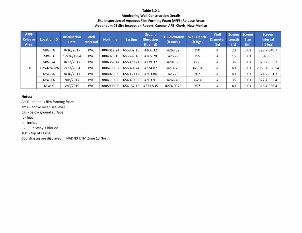
Table 3.0‐1Monitoring Well Construction Details
Site Inspection of Aqueous Film Forming Foam (AFFF) Release AreasAddendum 01 Site Inspection Report, Cannon AFB, Clovis, New Mexico
AFFF Release
AreaLocation ID
Installation Date
Well Material
Northing EastingGround
Elevation (ft amsl)
TOC elevation (ft amsl)
Well Depth (ft bgs)
Well Diameter
(in)
Screen Length
(ft)
Screen Size (in)
Screen Interval (ft bgs)
MW‐CA 8/16/2017 PVC 3804012.24 655902.16 4266.32 4269.32 350 4 20 0.01 329.7‐349.7
MW‐D 12/16/1984 PVC 3804023.15 655699.10 4265.20 4266.9 355 4 15 0.01 340‐355
MW‐GA 8/27/2017 PVC 3806357.44 655978.71 4279.37 4281.88 355.5 4 35 0.01 320.2‐355.2
LF25‐MW‐PA 2/21/2004 PVC 3806290.62 656074.74 4274.07 4274.73 361.54 4 60 0.01 296.54‐356.54
MW‐SA 8/16/2017 PVC 3804025.09 656050.12 4263.86 4266.3 362 4 40 0.01 321.7‐361.7
MW‐TA 8/8/2017 PVC 3804119.85 656079.96 4263.91 4266.48 362.4 4 35 0.01 327.4‐362.4
MW‐Y 2/6/2019 PVC 3805999.08 656157.13 4271.535 4274.0975 357 4 40 0.01 316.4‐356.4
Notes:AFFF ‐ aqueous film forming foamamsl ‐ above mean sea levelbgs ‐ below ground surfaceft ‐ feetin ‐ inchesPVC ‐ Polyvinyl ChlorideTOC ‐ top of casingCoordinates are displayed in NAD 83 UTM Zone 13 North
14

Table 3.0‐2Groundwater Elevations
Site Inspection of Aqueous Film Forming Foam (AFFF) Release AreasAddendum 01 Site Inspection Report, Cannon AFB, New Mexico
AFFF Release
Area
Location IDWell Depth
(ft bgs)
Ground Surface Elevation (ft amsl)
TOC elevation (ft amsl)
Depth to Groundwater
(ft btoc)
Groundwater Elevation (ft amsl)
Date Measured
MW‐CA 350 4266.32 4269.32 337.01 3932.31 10/27/2018
MW‐D 355 4265.20 4266.9 330.5 3936.4 10/27/2018
MW‐GA 355.5 4279.37 4281.88 324.42 3957.46 10/22/2018
LF25‐MW‐PA 361.54 4274.07 4274.73 318.62 3956.11 10/23/2018
MW‐SA 362 4263.86 4266.3 334.96 3931.34 10/24/2018
MW‐TA 362.4 4263.91 4266.48 334.17 3932.31 10/23/2018
MW‐Y 357 4271.535 4274.0975 322.09 3952.0075 2/13/2019
Notes:
AFFF ‐ aqueous film forming foam
amsl ‐ above mean sea level
bgs ‐ below ground surface
btoc ‐ below top of casing
ft ‐ feet
TOC ‐ top of casing
14
Page 1 of 1

Table 3.0‐3Off‐Base Sampling Summary
Site Inspection of Aqueous Film Forming Foam (AFFF) Release Areas Addendum 01 Site Inspection Report, Cannon Air Force Base, New Mexico
Samples CollectedAnecdotal Use
DescriptionSample Date Sampling Summary
CANON‐RES748‐01‐SP Domestic 28‐Aug‐18Well is located between two residential properties. The sample was collected from a spigot located approximately 10 feet from the wellhead (not equipped with sampling port). Primary, duplicate and MS/MSD samples were collected at this location.
CANON‐RES730‐01‐SPDomestic, Irrigation, and
livestock28‐Aug‐18
Sample collected at the residential property. Resident detailed the piping setup from the well as being underground until it reached the garage, where the sand separator and large storage tank are located. Setup included a drain on the sand‐separator where the well water came into the property, prior to a storage tank. The drain was opened and sample collected from spigot located before the tank.
CANON‐RES948‐01‐SPDomestic, Irrigation, and
livestock28‐Aug‐18
Sample collected at the dairy complex. Property owner identified location for sampling at dairy storage tank where multiple irrigation wells south of dairy feed water via a single 8" line to the referenced tank. The closest sampling point was located at the storage tank after the manifold where water is diverted to multiple locations on the dairy.
CANON‐RES778‐01‐SP Domestic 28‐Aug‐18Sample collected from a spigot located approximately 50’ south of the residence, and approximately 25’ east of the well. Resident identified that water at the spigot did not pass through holding tanks or any pretreatment prior to the spigot location.
CANON‐RES738‐01‐SPDomestic, Irrigation, and
livestock28‐Aug‐18
Sample collected from the residential property from an exterior spigot outside utility room. The well is located adjacent to the house but was not equipped for direct sampling. A storage tank was present inside with no sampling ports. The outdoor spigot was identified as only feasible sampling location.
CANON‐RES1358‐01‐SP Domestic 28‐Aug‐18Sample collected at the residential property. Wellhead was inaccessible (buried). Sample was therefore required to be collected from a spigot inside the wellhouse, located approximately 8ft away from the well.
CANON‐RES650‐01‐SP Dairy 29‐Aug‐18
Sample was collected at the dairy complex from a manifold believed to be up gradient/side gradient of the storage tank. However, the entire piping system could not be observed during the sampling effort and the sample location was based on limited visual observations (aboveground piping) and description from the dairy operator. No sample ports were accessible in the pump‐house shed (located immediately adjacent to the sample point), and therefore the sample port behind the central storage tank was utilized (the other two large storage tanks did not have similar piping/sample ports behind them). The storage tanks were reportedly fed by multiple wells.
CANON‐RES650‐02‐SP Domestic 29‐Aug‐18Sample collected from a spigot located behind the residence in the pool area. The well vault was inaccessible at the time of sampling due to confined space concerns.
CANON‐RES650‐03‐SP Domestic 29‐Aug‐18Sample collected at a residential property. The well (no sample port) was situated immediately outside a run‐down shed with the tank and associated piping. Due to the insulation wrapping‐it is unknown if there were sample ports on the tank itself, therefore the closest spigot (on an abondoned/condemned house) was utilized as the sample point.
CANON‐RES692‐01‐SP Domestic 29‐Aug‐18The well at this location fed the dairy office building and a residential property. The sample was collected from a spigot on the office exterior as the wellhead was inaccessible.
CANON‐RES725‐01‐SP Domestic 29‐Aug‐18Sample was collected from an exterior spigot located between a residence and maintenance shop. The well vault was inaccessible and the residence was unoccupied at the time of sampling.
CANON‐RES717‐01‐SP Domestic 29‐Aug‐18
This well was located in the agricultural field north of the 725 property. Details indicated a water line ran from this well all the way to the newer 717 residence, over 100 yards away. This well also represented a confined space situation, but this time was also shown as a hazard due to biological hazards (black widow spiders) in addition to the unknown atmosphere. Sample collected from outdoor spigot at the 717 residence. A duplicate sample was also collected at this location.
Page 1 of 2

Table 3.0‐3Off‐Base Sampling Summary
Site Inspection of Aqueous Film Forming Foam (AFFF) Release Areas Addendum 01 Site Inspection Report, Cannon Air Force Base, New Mexico
Samples CollectedAnecdotal Use
DescriptionSample Date Sampling Summary
CANON‐RES682‐01‐SP Domestic and Livestock 29‐Aug‐18One well serviced three properties identified. Sample was collected from the only operational spigot on the tank located inside the well house. No other viable sampling points were identified.
CANON‐RES1397‐01‐SP Domestic 30‐Aug‐18Sample collected at a residential property. The well distribution system includes a sand separator and large storage tank. The wellhead/sand separator were not equipped for sampling and therefore the sample was collected from outdoor spigot from shed where the distribution system was housed.
CANON‐RES1369‐01‐SP Domestic 30‐Aug‐18
Sample collected from a spigot on an exterior wall of a residence. The water that feeds this residence is reportedly from the storage tanks on the dairy property, which are supplied by three wells. Two wells were equipped with sample ports at the wellhead and were sampled. The third well was not equipped with sampling ports and therefore a sample was collected from a spigot at the residence.
CANON‐RES1369‐02‐WHDomestic, Irrigation, and
livestock30‐Aug‐18 Sample collected from a spigot directly at the wellhead.
CANON‐RES1369‐03‐WHDomestic, Irrigation, and
livestock30‐Aug‐18 Sample collected from a spigot directly at the wellhead.
CANON‐RES648‐01‐SP Domestic 30‐Aug‐18Sample collected from a residential property. One well services the property; however, the wellhead was not equipped for sampling. Sample was collected at an outdoor spigot at the home.
CANON‐RES1461‐01‐SPDomestic, Irrigation, and
livestock30‐Aug‐18
Water distribution system consisted of three wells that feed into a storage tank system that provided water to a dairy and residence. No wells were equipped with sample ports. The system had a sand separator prior to the large tanks and therefore the sample was collected from the valve prior to tanks.
CANON‐RES1495‐01‐SP Domestic 25‐Sep‐18One well was identified at the residential property. The well was sampled from a spigot located in the well pit in line with pressure tank.
CANON‐RES546‐01‐SP Domestic 26‐Sep‐18Sample collected at a residential property. Wellhead was inaccessible for sampling. Sample was collected from a spigot adjacent to the well pit, after the pressure tank.
CANON‐RES1331‐01‐WH Domestic, Livestock 26‐Sep‐18Sample collected at the dairy complex. The well was fitted with with a spigot directly at the well, and thus the sample was collected prior to the sand separator or storage tanks.
CANON‐RES1349‐01‐SP Domestic 26‐Sep‐18Sample collected at a residential property. Wellhead was inaccessible for sampling, inside a well pit. Sample was collected from a spigot adjacent to the well pit, after the pressure tank.
CANON‐RES1591‐01‐SP Domestic 26‐Sep‐18Sample collected at a residential property. Well was inaccessible for sampling and no sample locations were present in the well house. Sampling was conducted from outdoor spigot on west exterior of the house.
CANON‐RES1310‐01‐SPDomestic, Irrigation, and
livestock27‐Sep‐18
Sample collected at a residential property. No sample ports were identified on the well. An adjacent spigot was non‐operable. Resident indicated the nearest operable sampling port (spigot) was in the barn on the opposite side of the residence.
Page 2 of 2
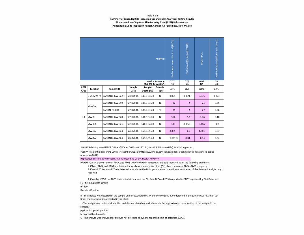
Table 3.1‐1Summary of Expanded Site Inspection Groundwater Analytical Testing Results
Site Inspection of Aqueous Film Forming Foam (AFFF) Release Areas Addendum 01 Site Inspection Report, Cannon Air Force Base, New Mexico
AFFF Area
Location Sample IDSample
DateSample
Depth (ft.)Sample
Type
LF25‐MW‐PA CANON14‐GW‐022 23‐Oct‐18 346.0‐346.0 N 0.051 0.024 0.075 0.023
CANON14‐GW‐019 27‐Oct‐18 346.0‐346.0 N 22 2 24 0.65
CANON‐FD‐003 27‐Oct‐18 346.0‐346.0 FD 25 2 27 0.66
MW‐D CANON14‐GW‐020 27‐Oct‐18 341.0‐341.0 N 0.96 2.8 3.76 0.18
MW‐GA CANON14‐GW‐021 22‐Oct‐18 341.0‐341.0 N 0.13 0.056 0.186 0.1
MW‐SA CANON14‐GW‐023 24‐Oct‐18 356.0‐356.0 N 0.081 1.6 1.681 0.97
MW‐TA CANON14‐GW‐024 23‐Oct‐18 356.0‐356.0 N 0.015 U 0.34 0.34 0.54
1Health Advisory from USEPA Office of Water, 2016a and 2016b, Health Advisories (HAs) for drinking water.
PFOS+PFOA = Co‐occurrence of PFOA and PFOS (PFOA+PFOS) in aqueous samples is reported using the following guidelines1. If both PFOA and PFOS are detected at or above the detection limit (DL), then the sum of PFOA+PFOS is reported
FD ‐ field duplicate sampleft ‐ feetID ‐ identification
µg/L ‐ micrograms per literN ‐ normal field sampleU ‐ The analyte was analyzed for but was not detected above the reporting limit of detection (LOD).
B ‐ The analyte was detected in the sample and an associated blank and the concentration detected in the sample was less than ten times the concentration detected in the blank.
J ‐ The analyte was positively identified and the associated numerical value is the approximate concentration of the analyte in the sample.
2. If only PFOS or only PFOA is detected at or above the DL in groundwater, then the concentration of the detected analyte only is reported
3. If neither PFOA nor PFOS is detected at or above the DL, then PFOA + PFOS is reported as "ND" representing Not Detected
2USEPA Residential Screening Levels (November 2017a) [https://www.epa.gov/risk/regional‐screening‐levels‐rsls‐generic‐tables‐november‐2017]
Analyte:
Perfluoroo
ctanesulfonic acid (P
FOS)
Perfluoroo
ctanoic acid (P
FOA)
PFOS+PFOA
Perfluorob
utanesulfonic acid (P
FBS)
Health Advisory: 0.07 0.07 0.07 NAEPA RSL Tapwater¹: NA NA NA 40
µg/L µg/L µg/L µg/L
Highlighted cells indicate concentrations exceeding USEPA Health Advisory
14
MW‐CA

Table 3.1‐2Summary of Off‐Base Analytical Testing Results
Site Inspection of Aqueous Film Forming Foam (AFFF) Release Areas Addendum 01 Site Inspection Report, Cannon Air Force Base, New Mexico
Sample IDSample
DateSample
Type
CANON‐RES1310‐01‐SP‐09272018 27‐Sep‐18 N 0.00413 U 0.00413 U ND 0.00413 U
CANON‐RES1331‐01‐WH‐09262018 26‐Sep‐18 N 0.00413 U 0.00413 U ND 0.00413 U
CANON‐RES1349‐01‐SP‐09262018 26‐Sep‐18 N 0.00413 U 0.00413 U ND 0.00413 U
CANON‐RES1358‐01‐SP‐08282018 28‐Aug‐18 N 0.00435 U 0.00435 U ND 0.00435 U
CANON‐RES1369‐01‐SP‐08302018 30‐Aug‐18 N 0.00424 U 0.00424 U ND 0.00424 U
CANON‐RES1369‐02‐WH‐08302018 30‐Aug‐18 N 0.00431 U 0.00431 U ND 0.00431 U
CANON‐RES1369‐03‐WH‐08302018 30‐Aug‐18 N 0.0041 U 0.0041 U ND 0.0041 U
CANON‐RES1397‐01‐SP‐08302018 30‐Aug‐18 N 0.00413 U 0.00413 U ND 0.00413 U
CANON‐RES1461‐01‐SP‐08302018 30‐Aug‐18 N 0.00417 U 0.00417 U ND 0.00417 U
CANON‐RES1495‐01‐SP‐09252018 25‐Sep‐18 N 0.0042 U 0.0042 U ND 0.0042 U
CANON‐RES‐DUP‐01‐09252018 25‐Sep‐18 FD 0.00417 U 0.00417 U ND 0.00417 U
CANON‐RES1591‐01‐SP‐09262018 26‐Sep‐18 N 0.00417 U 0.00793 J 0.00793 J 0.00862
CANON‐RES546‐01‐SP‐09262018 26‐Sep‐18 N 0.00427 U 0.00427 U ND 0.00427 U
CANON‐RES648‐01‐SP‐08302018 30‐Aug‐18 N 0.01 0.0155 0.0255 0.0103
CANON‐RES650‐01‐SP‐08292018 29‐Aug‐18 N 1.11 0.539 1.649 0.21
CANON‐RES650‐02‐SP‐08292018 29‐Aug‐18 N 0.404 0.267 0.671 0.137
CANON‐RES650‐03‐SP‐08292018 29‐Aug‐18 N 0.00442 U 0.00442 U ND 0.00442 U
CANON‐RES682‐01‐SP‐08292018 29‐Aug‐18 N 0.0042 U 0.0042 U ND 0.0042 U
CANON‐RES692‐01‐SP‐08292018 29‐Aug‐18 N 0.00427 U 0.00427 U ND 0.00427 U
CANON‐RES717‐01‐SP‐08292018 29‐Aug‐18 N 0.0042 U 0.0042 U ND 0.0164
CANON‐FD‐02‐08292018 29‐Aug‐18 FD 0.00417 U 0.00417 U ND 0.0147
CANON‐RES725‐01‐SP‐08292018 29‐Aug‐18 N 0.0041 U 0.0041 U ND 0.0145
CANON‐RES730‐01‐SP‐08282018 28‐Aug‐18 N 0.00413 U 0.00413 U ND 0.00413 U
CANON‐RES738‐01‐SP‐08282018 28‐Aug‐18 N 0.00463 U 0.00463 U ND 0.0111
µg/L µg/L µg/L µg/L
NA NA NA 40NA
Perfluoroo
ctanesulfonic acid (P
FOS)
Perfluoroo
ctanoic acid (P
FOA)
PFOS+PFOA
Perfluorob
utanesulfonic acid (P
FBS)
0.07 0.07 0.07
Page 1 of 2

Table 3.1‐2Summary of Off‐Base Analytical Testing Results
Site Inspection of Aqueous Film Forming Foam (AFFF) Release Areas Addendum 01 Site Inspection Report, Cannon Air Force Base, New Mexico
Sample IDSample
DateSample
Typeµg/L µg/L µg/L µg/L
NA NA NA 40NA
Perfluoroo
ctanesulfonic acid (P
FOS)
Perfluoroo
ctanoic acid (P
FOA)
PFOS+PFOA
Perfluorob
utanesulfonic acid (P
FBS)
0.07 0.07 0.07
CANON‐RES748‐01‐SP‐08282018 28‐Aug‐18 N 0.00435 U 0.00435 U ND 0.00435 U
CANON‐FD‐01‐08282018 28‐Aug‐18 FD 0.00431 U 0.00431 U ND 0.00431 U
CANON‐RES778‐01‐SP‐08282018 28‐Aug‐18 N 0.00439 U 0.00439 U ND 0.00439 U
CANON‐RES948‐01‐SP‐08282018 28‐Aug‐18 N 0.0953 0.0506 0.1459 0.0641
1Health Advisory from USEPA Office of Water, 2016a and 2016b, Health Advisories (HAs) for drinking water.
Highlighted cells indicate concentrations exceeding USEPA Health AdvisoryPFOS+PFOA = Co‐occurrence of PFOA and PFOS (PFOA+PFOS) in aqueous samples is reported using the following guidelines1. If both PFOA and PFOS are detected at or above the detection limit (DL), then the sum of PFOA+PFOS is reported2. If only PFOS or only PFOA is detected at or above the DL in groundwater, then the concentration of the detected analyte only is reported3. If neither PFOA nor PFOS is detected at or above the DL, then PFOA + PFOS is reported as "ND" representing Not DetectedFD ‐ field duplicate sampleft ‐ feetID ‐ identification
J ‐ The analyte was positively identified and the associated numerical value is the approximate concentration of the analyte in the sample.µg/L ‐ micrograms per literN ‐ normal field sampleU ‐ The analyte was analyzed for but was not detected above the reporting limit of detection (LOD).
B ‐ The analyte was detected in the sample and an associated blank and the concentration detected in the sample was less than ten times the concentration detected in the blank.
2USEPA Residential Screening Levels (November 2017a) [https://www.epa.gov/risk/regional‐screening‐levels‐rsls‐generic‐tables‐november‐2017]
Page 2 of 2
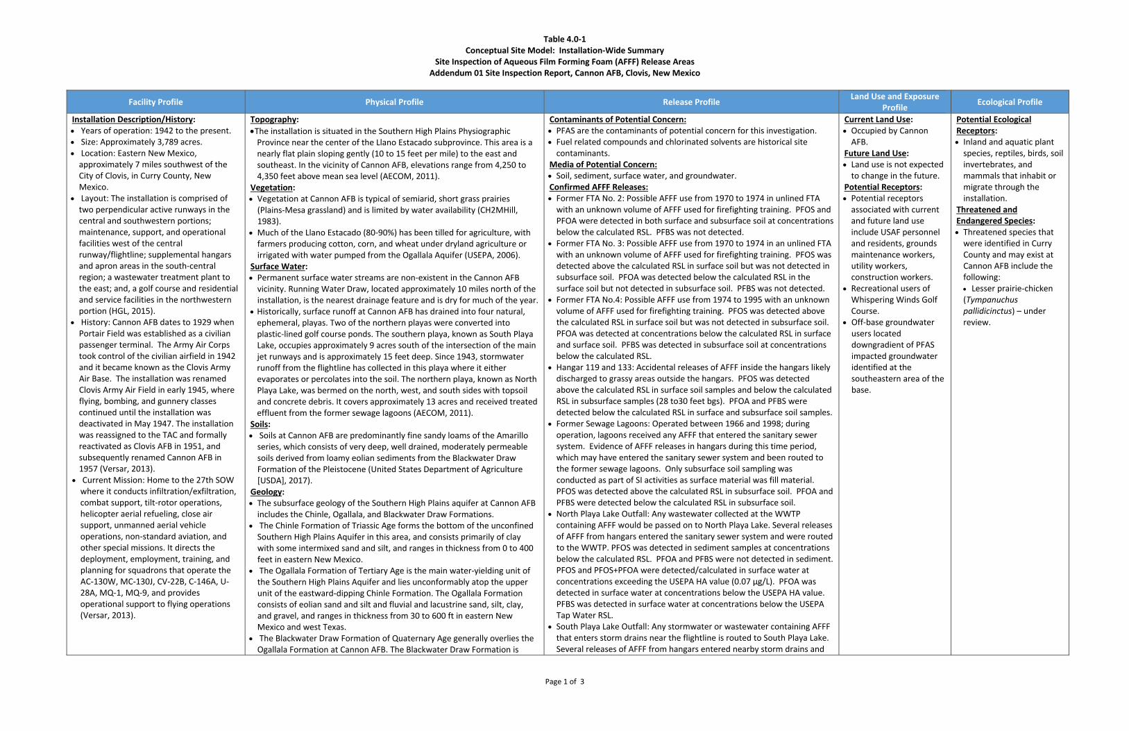
Table 4.0‐1 Conceptual Site Model: Installation‐Wide Summary
Site Inspection of Aqueous Film Forming Foam (AFFF) Release Areas Addendum 01 Site Inspection Report, Cannon AFB, Clovis, New Mexico
Page 1 of 3
Facility Profile Physical Profile Release Profile Land Use and Exposure Profile Ecological Profile
Installation Description/History: Years of operation: 1942 to the present. Size: Approximately 3,789 acres. Location: Eastern New Mexico, approximately 7 miles southwest of the City of Clovis, in Curry County, New Mexico.
Layout: The installation is comprised of two perpendicular active runways in the central and southwestern portions; maintenance, support, and operational facilities west of the central runway/flightline; supplemental hangars and apron areas in the south‐central region; a wastewater treatment plant to the east; and, a golf course and residential and service facilities in the northwestern portion (HGL, 2015).
History: Cannon AFB dates to 1929 when Portair Field was established as a civilian passenger terminal. The Army Air Corps took control of the civilian airfield in 1942 and it became known as the Clovis Army Air Base. The installation was renamed Clovis Army Air Field in early 1945, where flying, bombing, and gunnery classes continued until the installation was deactivated in May 1947. The installation was reassigned to the TAC and formally reactivated as Clovis AFB in 1951, and subsequently renamed Cannon AFB in 1957 (Versar, 2013).
Current Mission: Home to the 27th SOW where it conducts infiltration/exfiltration, combat support, tilt‐rotor operations, helicopter aerial refueling, close air support, unmanned aerial vehicle operations, non‐standard aviation, and other special missions. It directs the deployment, employment, training, and planning for squadrons that operate the AC‐130W, MC‐130J, CV‐22B, C‐146A, U‐28A, MQ‐1, MQ‐9, and provides operational support to flying operations (Versar, 2013).
Topography: The installation is situated in the Southern High Plains Physiographic Province near the center of the Llano Estacado subprovince. This area is a nearly flat plain sloping gently (10 to 15 feet per mile) to the east and southeast. In the vicinity of Cannon AFB, elevations range from 4,250 to 4,350 feet above mean sea level (AECOM, 2011).
Vegetation: Vegetation at Cannon AFB is typical of semiarid, short grass prairies (Plains‐Mesa grassland) and is limited by water availability (CH2MHill, 1983).
Much of the Llano Estacado (80‐90%) has been tilled for agriculture, with farmers producing cotton, corn, and wheat under dryland agriculture or irrigated with water pumped from the Ogallala Aquifer (USEPA, 2006).
Surface Water: Permanent surface water streams are non‐existent in the Cannon AFB vicinity. Running Water Draw, located approximately 10 miles north of the installation, is the nearest drainage feature and is dry for much of the year.
Historically, surface runoff at Cannon AFB has drained into four natural, ephemeral, playas. Two of the northern playas were converted into plastic‐lined golf course ponds. The southern playa, known as South Playa Lake, occupies approximately 9 acres south of the intersection of the main jet runways and is approximately 15 feet deep. Since 1943, stormwater runoff from the flightline has collected in this playa where it either evaporates or percolates into the soil. The northern playa, known as North Playa Lake, was bermed on the north, west, and south sides with topsoil and concrete debris. It covers approximately 13 acres and received treated effluent from the former sewage lagoons (AECOM, 2011).
Soils: Soils at Cannon AFB are predominantly fine sandy loams of the Amarillo series, which consists of very deep, well drained, moderately permeable soils derived from loamy eolian sediments from the Blackwater Draw Formation of the Pleistocene (United States Department of Agriculture [USDA], 2017).
Geology: The subsurface geology of the Southern High Plains aquifer at Cannon AFB includes the Chinle, Ogallala, and Blackwater Draw Formations.
The Chinle Formation of Triassic Age forms the bottom of the unconfined Southern High Plains Aquifer in this area, and consists primarily of clay with some intermixed sand and silt, and ranges in thickness from 0 to 400 feet in eastern New Mexico.
The Ogallala Formation of Tertiary Age is the main water‐yielding unit of the Southern High Plains Aquifer and lies unconformably atop the upper unit of the eastward‐dipping Chinle Formation. The Ogallala Formation consists of eolian sand and silt and fluvial and lacustrine sand, silt, clay, and gravel, and ranges in thickness from 30 to 600 ft in eastern New Mexico and west Texas.
The Blackwater Draw Formation of Quaternary Age generally overlies the Ogallala Formation at Cannon AFB. The Blackwater Draw Formation is
Contaminants of Potential Concern: PFAS are the contaminants of potential concern for this investigation. Fuel related compounds and chlorinated solvents are historical site contaminants.
Media of Potential Concern: Soil, sediment, surface water, and groundwater. Confirmed AFFF Releases: Former FTA No. 2: Possible AFFF use from 1970 to 1974 in unlined FTA with an unknown volume of AFFF used for firefighting training. PFOS and PFOA were detected in both surface and subsurface soil at concentrations below the calculated RSL. PFBS was not detected.
Former FTA No. 3: Possible AFFF use from 1970 to 1974 in an unlined FTA with an unknown volume of AFFF used for firefighting training. PFOS was detected above the calculated RSL in surface soil but was not detected in subsurface soil. PFOA was detected below the calculated RSL in the surface soil but not detected in subsurface soil. PFBS was not detected.
Former FTA No.4: Possible AFFF use from 1974 to 1995 with an unknown volume of AFFF used for firefighting training. PFOS was detected above the calculated RSL in surface soil but was not detected in subsurface soil. PFOA was detected at concentrations below the calculated RSL in surface and surface soil. PFBS was detected in subsurface soil at concentrations below the calculated RSL.
Hangar 119 and 133: Accidental releases of AFFF inside the hangars likely discharged to grassy areas outside the hangars. PFOS was detected above the calculated RSL in surface soil samples and below the calculated RSL in subsurface samples (28 to30 feet bgs). PFOA and PFBS were detected below the calculated RSL in surface and subsurface soil samples.
Former Sewage Lagoons: Operated between 1966 and 1998; during operation, lagoons received any AFFF that entered the sanitary sewer system. Evidence of AFFF releases in hangars during this time period, which may have entered the sanitary sewer system and been routed to the former sewage lagoons. Only subsurface soil sampling was conducted as part of SI activities as surface material was fill material. PFOS was detected above the calculated RSL in subsurface soil. PFOA and PFBS were detected below the calculated RSL in subsurface soil.
North Playa Lake Outfall: Any wastewater collected at the WWTP containing AFFF would be passed on to North Playa Lake. Several releases of AFFF from hangars entered the sanitary sewer system and were routed to the WWTP. PFOS was detected in sediment samples at concentrations below the calculated RSL. PFOA and PFBS were not detected in sediment. PFOS and PFOS+PFOA were detected/calculated in surface water at concentrations exceeding the USEPA HA value (0.07 µg/L). PFOA was detected in surface water at concentrations below the USEPA HA value. PFBS was detected in surface water at concentrations below the USEPA Tap Water RSL.
South Playa Lake Outfall: Any stormwater or wastewater containing AFFF that enters storm drains near the flightline is routed to South Playa Lake. Several releases of AFFF from hangars entered nearby storm drains and
Current Land Use: Occupied by Cannon AFB.
Future Land Use: Land use is not expected to change in the future.
Potential Receptors: Potential receptors associated with current and future land use include USAF personnel and residents, grounds maintenance workers, utility workers, construction workers.
Recreational users of Whispering Winds Golf Course.
Off‐base groundwater users located downgradient of PFAS impacted groundwater identified at the southeastern area of the base.
Potential Ecological Receptors: Inland and aquatic plant species, reptiles, birds, soil invertebrates, and mammals that inhabit or migrate through the installation.
Threatened and Endangered Species: Threatened species that were identified in Curry County and may exist at Cannon AFB include the following: Lesser prairie‐chicken (Tympanuchus pallidicinctus) – under review.

Table 4.0‐1 Conceptual Site Model: Installation‐Wide Summary
Site Inspection of Aqueous Film Forming Foam (AFFF) Release Areas Addendum 01 Site Inspection Report, Cannon AFB, Clovis, New Mexico
Page 2 of 3
Facility Profile Physical Profile Release Profile Land Use and Exposure Profile Ecological Profile
AFFF Use: AFFF containing PFAS was used for firefighting training activities, testing of firefighting equipment, extinguishing petroleum fires, and in fire suppression systems at several installation buildings.
Fourteen potential AFFF release areas were recommended for SI at Cannon AFB: Former FTA No. 2; Former FTA No. 3; Former FTA No. 4; Hangars 119 and 133; Former Sewage Lagoons; North Playa Lake Outfall; South Playa Lake Outfall; Whispering Winds Golf Course Outfall. Hangar 109; Active FTA; Landfill #4; Perimeter Road Fuel Spill Flightline Crash Areas; and, Basewide Groundwater
composed primarily of eolian sand deposits, and ranges in thickness from 0 to 80 feet in eastern New Mexico.
A caliche layer is typically present in the unsaturated zone of the Blackwater or Ogallala Formations in New Mexico.
Hydrogeology: The lower portion of the Ogallala Formation is the primary regional aquifer for both potable and irrigation water.
The Ogallala Aquifer is part of the Southern High Plains Aquifer that extends across parts of southeast New Mexico and northwest Texas, which in turn is part of the larger High Plains Aquifer that extends continuously from Wyoming and South Dakota into New Mexico and Texas.
Cannon AFB is underlain by the portion of the Ogallala Aquifer designated the Curry County Underground Water Basin. The Ogallala Aquifer is a water table, or unconfined, aquifer with the underlying Chinle redbeds serving as the basal confining layer in eastern New Mexico.
At Cannon AFB, the depth to groundwater is approximately 300 feet bgs. The saturated thickness in 1990 ranged from 93 to 143 feet, but continues to decrease. Groundwater flow is generally from northwest to southeast (FPM, 2014).
Depth to water measurements collected in November and December 2017 as part of the SI ranged from 287.78 feet below top of casing (btoc) in monitoring well MW‐X located in the southwest portion of the installation to 351.80 feet btoc in monitoring well MW‐H located on the south side of the former sewage lagoon. The calculated groundwater elevations ranged from 3981.45 feet above mean sea level (amsl) in MW‐X to 3929.38 feet amsl at MW‐H.
Meteorology: Average annual rainfall is 17.9 inches/year in Clovis, New Mexico. Average number of days with measurable rainfall is 54 days. Average high temperature of 92°F occurs in July, while an average low of 23.4°F occurs in January.
were routed to the lake. PFOS and PFOA were detected in both surface and subsurface soil at concentrations below the calculated RSL. PFBS was not detected in surface or subsurface soil.
Whispering Winds Golf Course Outfall: The golf course began receiving effluent from the WWTP plant in approximately 2002. Currently, the golf course stores effluent in a storage tank on the eastern portion of the course. Effluent is regularly used for golf course irrigation and filling the two golf course ponds. A release of AFFF into any of the hangar floor trenches or fire station stalls would be routed through the WWTP. As such, effluent from the WWTP used at the golf course may contain AFFF. PFOS was detected in sediment samples at concentrations below the calculated RSL. PFOA and PFBS were not detected in sediment. PFOS and PFOS+PFOA were detected/calculated in surface water at concentrations below the USEPA HA value (0.07 µg/L). PFOA and PFBS were not detected in surface water.
Hangar 109: A recent release of AFFF inside the hangar/mechanical rooms resulted in AFFF being released outside the hangar and draining to grassy areas outside the hangar. PFOS was detected above the calculated RSL in surface soil but was not detected in subsurface soil samples. PFOA and PFBS were detected below the calculated RSL in the surface soil sample and was not detected in the subsurface soil sample.
Landfill No. 4: Landfill is located immediately north of the North Playa Lake. Cover was irrigated using water from North Playa Lake where wastewater from WWTP (potentially including AFFF) was discharged. Groundwater was sampled downgradient of the landfill (monitoring well LF04‐MW‐Na). No PFOS, PFOA, or PFBS were detected.
Active FTA: Lined evaporation pond located south of the FTA where AFFF/water mix is collected and left to evaporate has been repaired in the past. Any damage to liner would result in AFFF being released to environment. In addition, an extreme flood event in May 2015 likely resulted in the evaporation pond overflowing, allowing residual AFFF to infiltrate into surrounding soil. PFOS was detected above the calculated RSL in surface soil and below the calculated RSL in subsurface soil. PFOA was detected in surface soil at concentrations below the calculated RSL and was not detected in subsurface soil. PFBS was not detected in surface or subsurface soil.
Perimeter Road Fuel Spill: AFFF was sprayed from crash fire trucks onto a fuel spill associated with an overturned tanker trunk on the southeast side of Perimeter Road. No PFOS, PFOA or PFBS were detected in surface or subsurface soil.
Flightline Crash Areas: Cannon AFB Fire Department noted three separate crash areas along the flightline where AFFF was released during crash response activities. No soil sampling was conducted relative to the crash sites. Results of groundwater monitoring from locations downgradient of the crash sites is summarized below.
Basewide Groundwater: Groundwater was evaluated for all identified AFFF release areas; however, since groundwater at Cannon AFB is regulated basewide by NMED rather than specific to individual areas of

Table 4.0‐1 Conceptual Site Model: Installation‐Wide Summary
Site Inspection of Aqueous Film Forming Foam (AFFF) Release Areas Addendum 01 Site Inspection Report, Cannon AFB, Clovis, New Mexico
Page 3 of 3
Facility Profile Physical Profile Release Profile Land Use and Exposure Profile Ecological Profile
concern, a separate AFFF release area (Release Area 14) was identified for evaluating the presence of PFAS in basewide groundwater. PFOS, PFOA, and/or PFBS were detected in groundwater at 11 existing basewide monitoring wells. PFOS, PFOA and PFOS+PFOA exceeded the USEPA HA value (0.07 µg/L) in six monitoring wells: MW‐Ga and LF25‐MW‐Pa located southeast of the sewage lagoon area; and at monitoring wells MW‐Ca, MW‐D, MW‐Sa and MW‐Ta located in the southeast corner of the installation. Confirmation sampling was completed for MW‐Ga, LF25‐MW‐Pa, MW‐Ca, MW‐D, MW‐Sa, and MW‐Ta. PFOS, PFOA and/or PFOS+PFOA exceeded the USEPA HA value (0.07 µg/L) again in all six monitoring wells.
Analytical results from groundwater sampling of newly installed monitoring well (MW‐Y) confirmed the presence of PFOS, PFOA and PFOS+PFOA. The concentrations of PFOS and PFOS+PFOA exceeded the USEPA HA value (0.07 µg/L). The monitoring well is located at the installation boundary, downgradient (southeast) of the former sewage lagoon area.
Off‐Base Groundwater: 25 water samples were collected from off‐base properties, downgradient of Cannon AFB where groundwater was used as a source of drinking water. PFOS, PFOA and/or PFOS+PFOA exceeded the USEPA HA value (0.07 µg/L) in three sample locations.
Primary Release Pathways: Release or application of AFFF to the ground at potential source areas. Infiltration of PFAS deeper into the soil column over time and reaching groundwater.
AFFF washed into drainage, stormwater, and sewer systems. Secondary Release Pathways: Irrigation utilizing water from the WWTP. Irrigation utilizing impacted groundwater

APPENDICES

Due to file size restrictions, the Appendices have been removed and are uploaded as (Part 2) of this document.