final staff report & comments
TRANSCRIPT
FINAL STAFF REPORT & COMMENTS SUBMITTED TO: HENDERSONVILLE REGIONAL PLANNING COMMISSION
BY: CITY OF HENDERSONVILLE DEVELOPMENT REVIEW STAFF
STAFF REPORT
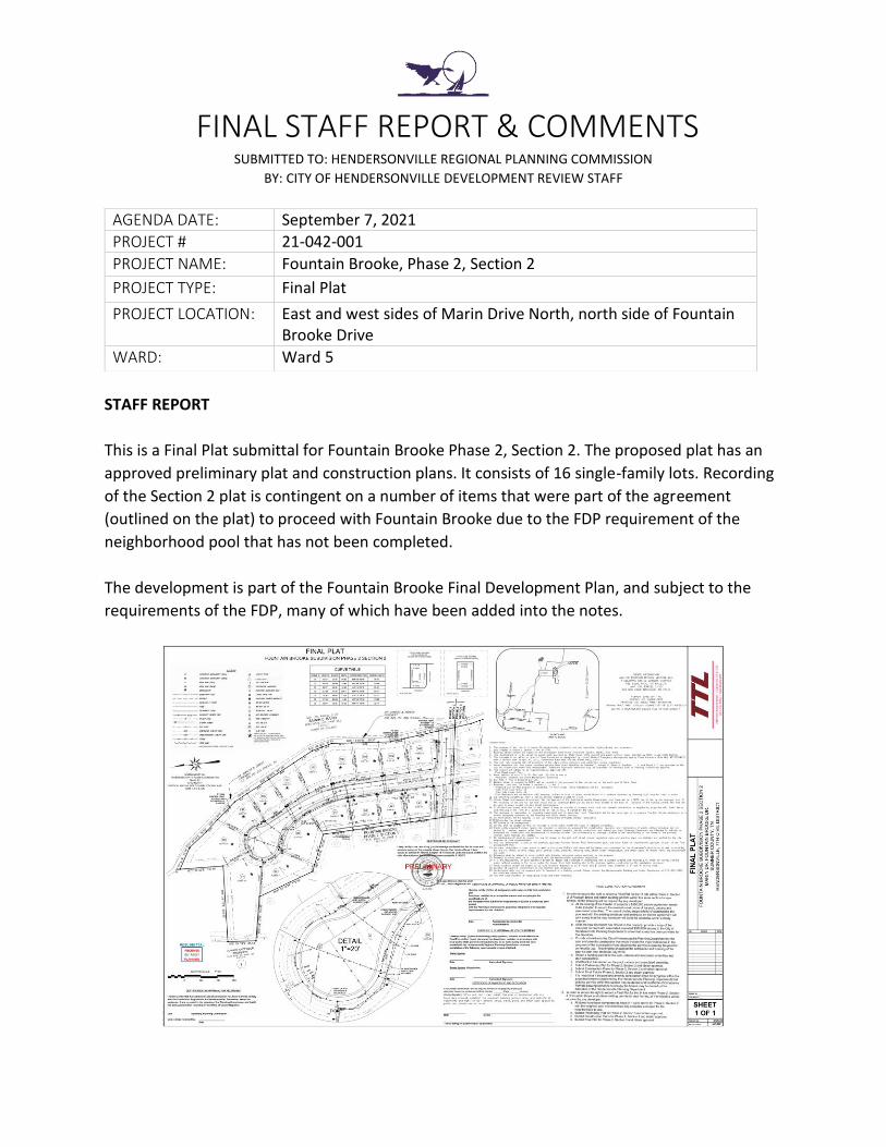
This is a Final Plat submittal for Fountain Brooke Phase 2, Section 2. The proposed plat has an
approved preliminary plat and construction plans. It consists of 16 single-family lots. Recording
of the Section 2 plat is contingent on a number of items that were part of the agreement
(outlined on the plat) to proceed with Fountain Brooke due to the FDP requirement of the
neighborhood pool that has not been completed.
The development is part of the Fountain Brooke Final Development Plan, and subject to the
requirements of the FDP, many of which have been added into the notes.
AGENDA DATE: September 7, 2021
PROJECT # 21-042-001
PROJECT NAME: Fountain Brooke, Phase 2, Section 2
PROJECT TYPE: Final Plat
PROJECT LOCATION: East and west sides of Marin Drive North, north side of Fountain Brooke Drive
WARD: Ward 5
STAFF COMMENTS
PLANNING DEPARTMENT
1. Retaining wall and any construction plan changes will need to meet review requirements
and typical city standards to be approved, and wall must be constructed prior to recording
of plat. Material to be used to be reviewed for approval by staff if acceptable, as well as
approval of fencing/rail type for the top of the wall. Plat will need to be amended prior to
recording to adequately show any changes per construction plans.
2. To date, no permit has been received for the construction of the pool per pool construction
agreement and notes. No plats will be recorded until specific items listed on pool
construction agreement are met.
3. Preliminary note on Engineer’s stamp must be removed on document to be recorded.
Submitted by Grant Green, AICP, Senior Planner (September 2, 2021)
PUBLIC WORKS
1. Final Plat will not be recorded until the revised construction plans reflecting grading
changes and retaining wall plans are submitted and approved by City staff. Final plat may
require revision prior to recording to reflect any changes in the revised construction plans.
2. Add street numbers.
Submitted by Sarah Lock, PE, City Engineer (September 2, 2021)
FIRE DEPARTMENT
1. No comments.
Submitted by Shane Nolan, Fire Inspector (September 2, 2021)
UTILITY DISTRICT
1. WHUD.
Submitted by David Brigance, HUD Construction Supervisor (August 11, 2021)

FINAL STAFF REPORT & COMMENTS SUBMITTED TO: HENDERSONVILLE REGIONAL PLANNING COMMISSION
BY: CITY OF HENDERSONVILLE DEVELOPMENT REVIEW STAFF
STAFF REPORT
This submittal by Pulte Homes is a revision to a previously renewed Final Plat for Phase 2, which
is and has been under construction (the renewal was approved in September 2019). This
proposed Final Plat is for Phase 2B, from the 2019 approval which split Phase 2 into 2A and 2B.
It is part of the previously approved Norman Creek Final Development Plan.
Phase 2B is south of Norman Way (a portion of which was included in 2A), which is part of the
east-west collector north of 386 that will connect Anderson Road (and eventually Durham
Farms) to Saundersville Road, via Norman Creek, Fountain Brooke, the Baird property, and
Forest Park.
AGENDA DATE: September 7, 2021
PROJECT # 21-070-001
PROJECT NAME: Norman Creek, Phase 2B
PROJECT TYPE: Final Plat
PROJECT LOCATION: North and south sides of Macy Drive, east and west sides of Keats Court
WARD: Ward 5
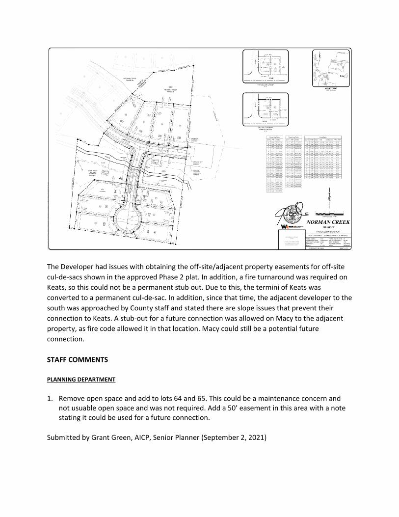
The Developer had issues with obtaining the off-site/adjacent property easements for off-site
cul-de-sacs shown in the approved Phase 2 plat. In addition, a fire turnaround was required on
Keats, so this could not be a permanent stub out. Due to this, the termini of Keats was
converted to a permanent cul-de-sac. In addition, since that time, the adjacent developer to the
south was approached by County staff and stated there are slope issues that prevent their
connection to Keats. A stub-out for a future connection was allowed on Macy to the adjacent
property, as fire code allowed it in that location. Macy could still be a potential future
connection.
STAFF COMMENTS
PLANNING DEPARTMENT
1. Remove open space and add to lots 64 and 65. This could be a maintenance concern and
not usuable open space and was not required. Add a 50’ easement in this area with a note stating it could be used for a future connection.
Submitted by Grant Green, AICP, Senior Planner (September 2, 2021)

PUBLIC WORKS
1. Provide Benchmark and Location
2. Provide deed book/page number for recorded stormwater inspection and maintenance
agreement prior to recording of final plat.
3. Show underground electric.
Submitted by Sarah Lock, PE, City Engineer (September 2, 2021)
FIRE DEPARTMENT
1. No comments.
Submitted by Shane Nolan, Fire Inspector (September 2, 2021)
UTILITY DISTRICT
1. WHUD.
Submitted by David Brigance, HUD Construction Supervisor (August 11, 2021)

FINAL STAFF REPORT & COMMENTS SUBMITTED TO: HENDERSONVILLE REGIONAL PLANNING COMMISSION
BY: CITY OF HENDERSONVILLE DEVELOPMENT REVIEW STAFF
STAFF REPORT
The Forest Park development has an approved Preliminary Development Plan, and is a 263.66-
acre tract of land located west of Saundersville Road, behind the large home sites which are
across the road from Saundersville Station. The site’s land use is Suburban Living Character Area
and is currently zoned Single-Family Residential Planned Development (SR-1 PD). The Forest
Park PDP was approved with 626 residential units (460 single-family detached, 12 single-family
villas, 42 two-unit villas, and 112 (18%) attached cottages). A total of 95.88 acres (36%) is
proposed to be set aside as open space. The resulting density for Forest Park is 2.37 units per
acre.
AGENDA DATE: September 7, 2021
PROJECT # 21-068-001
PROJECT NAME: Forest Park
PROJECT TYPE: FDP
PROJECT LOCATION: 1635 Saundersville Road, Parcel 137 038.00, 038.01, 052.00
WARD: Ward 5

The proposed Final Development Plan includes some layout changes, and unit type changes
that are relatively minor and are not a substantial amendment based on the Zoning Ordinance.
This includes an additional 6.71 acres of open space from the approved plan. Single-family
homes have increased from 460 to 464, single-family villas have been reduced from 12 to 0,
two-unit villas have increased from 42 to 58, and attached cottages have been reduced from
112 to 104, with the same total number of residential units (626) and same overall density (2.37
units per acre).
In addition, the location of the “empty-nester” targeted area has been adjusted, and location of
the pool has been relocated to closer to the front of subdivision.
Turn lanes will be added to Saundersville Road and the entrance of Forest Park per the
submitted drawing. This is per the recommendations of the traffic study to handle the
projected volume of traffic with completion of the east-west Norman Way connector. This
includes dedicated left and right turn lanes onto Saundersville Road and dedicated left and right
turn lanes onto Norman Way from Saundersville, all with significant room for queuing/stacking
of vehicles.
A small number of estate lots in the 626 total unit count are outside of the city limits/on the
boundary, but the developer has stated these will be added in if a future annexation is
approved at a later date.

The developer has agreed to pay $3,500 per unit ($500 per unit to be paid within 90 days of
FDP approval: $313,000, $500 per unit to be paid at first plat recording for Forest Park:
$313,000), and $2,500 per building permit: $1,565,000).
ESTIMATED NEXT STEPS IN THIS PROCESS:
Please note the following potential schedule for approval, which is dependent on the holiday meeting schedule and other factors: FDP to BOMA General Committee: September 14, 2021, estimated FDP to BOMA 1st Reading: September 28, 2021, estimated
STAFF COMMENTS
PLANNING DEPARTMENT
1. Provide lot size chart for each lot showing that each meets the minimum requirement for
SR-1 PD (7,500 sf for single family, 2,400 for each TH/villa unit).
2. Some of the ten red lots, identified on page 4, are outside of city limits will require an
annexation request and revision request to FDP\new separate plan. Approved number of
lots cannot be recouped in open space or by reducing size of lots in existing PD.
3. Clarify that the agreed negotiated fees are per unit (626) and not per lot. Add the total for
each phase of payment (e.g. $2,9191,000 total; $313,000 by 90 days after FDP approval,
etc.)
4. Staff may require raised landscaped medians for the turn lanes at Saundersville Road at the
construction plan phase.
5. Utilities will need to be moved outside of the 6’ grass strip.
6. Show where the trail system will be located, and show a cross section of the trail.
7. Provide landscaping plan to be reviewed by the Planning Department.
8. Include details of both amenity centers, including brick/stone percentages.
9. Submit copy of recorded covenants and restrictions for Forest Park.
Submitted by Grant Green, AICP, Senior Planner; and Keith Free, MPA, AICP, Planning Director
(September 2, 2021)
PUBLIC WORKS
1. Amenity and open space area’s post development ownership needs to be clearly defined
(this should include maintenance and ownership responsibilities of closed drainage systems,
ditches, and box culverts).
2. Sheets C3.0 – C3.4: Proposed gas lines are not shown on the development plan. Confirm natural gas service will not be extended into the community OR show proposed gas utility locations.
3. Sheets C4.0 – C4.4: Confirm post development conditions will not contribute to increased: flood flows, heights, duration, or damages in the project vicinity.
4. Sheets C4.0 – C4.4: Confirm Box Culvert Sizes 5. Sheets C4.0 – C4.4: Add note confirming all work within existing streams will be performed
in accordance with Local, State, and Federal environmental permitting requirements 6. Sheets C4.0 – C4.4: Confirm that all proposed building lots will comply with Hendersonville
Subdivision Regulations Article III: Section 3-102.104 regarding development on steep slopes (>25%)
7. Sheet C4.2: Contours labeled incorrectly (5 adjacent contours with same elevation of 580’) 8. Sheets C7.0 – C7.1: Traffic control regulation devices and/or special engineering features
related to transportation circulation patterns need to be clearly defined 9. PDP showed channelized right turn lane into Forest Park from Saundersville Road.
Submitted by Sarah Lock, PE, City Engineer (September 2, 2021)

FIRE DEPARTMENT
1. IFC 2018 D107.1 – Developments of one or two-family dwellings where the number of
dwelling units exceeds 30 shall be provided with two separate and approved fire apparatus
access roads and shall meet the requirements of Section D104.3 & D107.2 Remoteness.
(Illustrate changes on plans)
2. Hendersonville Subdivision Regulations 3-107.201 – For residential districts or residential
subdivisions, provide a hydrant at each street intersection with intermediate hydrants so that
they are not over five hundred (500) feet apart. (Illustrate changes on plans)
3. All Cul-de-sac’s shall meet the IFC minimum specifications of 96 feet.
4. Fire Apparatus Access roads shall have a minimum unobstructed width of 24’ (that’s 24 feet of asphalt) plus the 2 feet of rollover curb and gutter. The sections you are showing with the Roadway types as Place or Alley need to reflect that. (Illustrate changes on plans)
5. IFC 2018 503.2.4 -Turning Radius: Provide a truck turning template using the Hendersonville Fire Department template. (Illustrate changes on plans)
Submitted by Shane Nolan, Fire Inspector (September 2, 2021)
UTILITY DISTRICT
1. WHUD.
Submitted by David Brigance, HUD Construction Supervisor (August 11, 2021)

FINAL STAFF REPORT & COMMENTS SUBMITTED TO: HENDERSONVILLE REGIONAL PLANNING COMMISSION
BY: CITY OF HENDERSONVILLE DEVELOPMENT REVIEW STAFF
STAFF REPORT
This site is located off of Indian Lake Boulevard, behind Aventura Apartments and south-west of
the Hobby Lobby shopping center. It is in Phase 3F of the Indian Lake Village Planned
Development and is zoned Mixed Commercial, Planned Development (MXC-PD).
CURRENTLY APPROVED FDP
AGENDA DATE: September 7, 2021
PROJECT # 21-066-001
PROJECT NAME: Indian Lake Village, Phase 3G, Area 9, Lot 46
PROJECT TYPE: FDP Amendment & Add-Use (Multi-Family Residential)
PROJECT LOCATION: West of Indian Lake Blvd., south of Saundersville Road
WARD: Ward 6
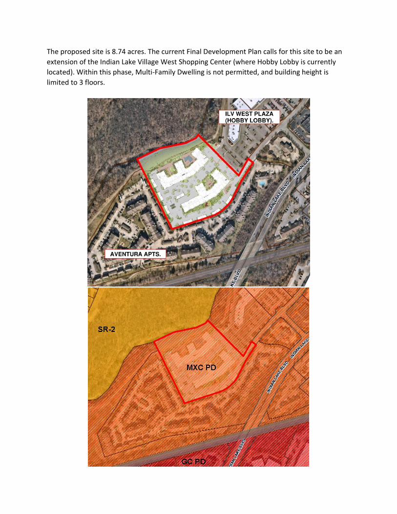
The proposed site is 8.74 acres. The current Final Development Plan calls for this site to be an
extension of the Indian Lake Village West Shopping Center (where Hobby Lobby is currently
located). Within this phase, Multi-Family Dwelling is not permitted, and building height is
limited to 3 floors.

The applicant, Tenn Holdings, is proposing to amend the FDP by calling this area out as a new
Phase 3G, adding Multi-Family Dwelling to the List of Permitted Uses, and increasing the
number of allowed rental units. They are proposing a 247-unit multi-family apartment
development, consisting of two four-story buildings totaling 330,600 square feet.
Residential Unit Count – Amendment Requested
In addition to adding Multi-family Dwelling as a Permitted Use, the applicant is requesting to
amend the FDP to increase the total number of rental units. Because rental units are a subset of
residential units, upping the total number of rental units will also cause the total number of
residential units to go up by the same amount. The overall ILV planned development is
currently restricted to a total of 1,200 residential units. Of those, up to 600 may be rental units.
All the rental unit entitlements have been built out, so the number of allowed rental units now
stands at zero. 176 of the single-family entitlements remain unbuilt. In the proposed
amendment, the applicant is proposing to increase the total number of allowed rental units
from 0 to 247. Below is a breakdown showing the current overall residential and rental unit
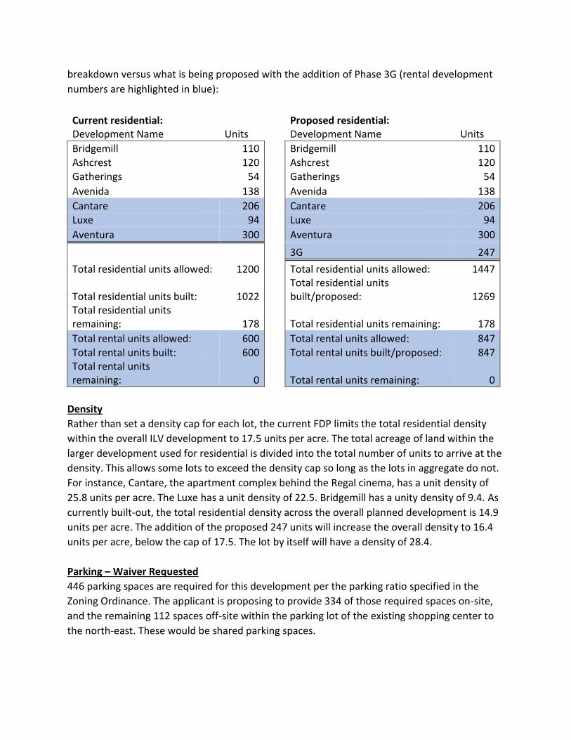
breakdown versus what is being proposed with the addition of Phase 3G (rental development
numbers are highlighted in blue):
Current residential: Proposed residential: Development Name Units Development Name Units
Bridgemill 110 Bridgemill 110 Ashcrest 120 Ashcrest 120 Gatherings 54 Gatherings 54
Avenida 138 Avenida 138
Cantare 206 Cantare 206 Luxe 94 Luxe 94
Aventura 300 Aventura 300
3G 247
Total residential units allowed: 1200 Total residential units allowed: 1447
Total residential units built: 1022
Total residential units built/proposed: 1269
Total residential units remaining: 178 Total residential units remaining: 178
Total rental units allowed: 600 Total rental units allowed: 847 Total rental units built: 600 Total rental units built/proposed: 847 Total rental units remaining: 0 Total rental units remaining: 0
Density
Rather than set a density cap for each lot, the current FDP limits the total residential density
within the overall ILV development to 17.5 units per acre. The total acreage of land within the
larger development used for residential is divided into the total number of units to arrive at the
density. This allows some lots to exceed the density cap so long as the lots in aggregate do not.
For instance, Cantare, the apartment complex behind the Regal cinema, has a unit density of
25.8 units per acre. The Luxe has a unit density of 22.5. Bridgemill has a unity density of 9.4. As
currently built-out, the total residential density across the overall planned development is 14.9
units per acre. The addition of the proposed 247 units will increase the overall density to 16.4
units per acre, below the cap of 17.5. The lot by itself will have a density of 28.4.
Parking – Waiver Requested
446 parking spaces are required for this development per the parking ratio specified in the
Zoning Ordinance. The applicant is proposing to provide 334 of those required spaces on-site,
and the remaining 112 spaces off-site within the parking lot of the existing shopping center to
the north-east. These would be shared parking spaces.
The Zoning Ordinance allows shared parking under the following circumstances:
1. Approval is obtained from the Planning Department that confirms that the use of such
facility by each user does not take place at the same hours during the same days of the
week.
• Staff is unable to fully confirm this. The businesses on the south-west end of the
shopping center parking lot where the applicant is proposing shared parking
include Nest Décor, Music City Kids Club (a daycare), and Tuesday Morning.
There appear to be two vacant tenant spaces on that end of the building. While
it can be said that overnight hours are when the heaviest demand for apartment
parking would occur, and that during most of those hours these businesses
would be closed, there still would be overlapping daytime and evening hours
when the businesses would be open and there would be demand for both retail
and apartment parking at the same time.
• While the shared parking proposal does not meet the strict letter of this
requirement, because this is a Planned Unit Development the Planning
Commission has the leeway to grant some latitude and allow the shared parking
proposal.
2. The users of the shared parking facility shall sign an agreement, approved by the City
Attorney, expressing the intent to share parking facilities. The agreement shall be
recorded with the Register of Deeds.
• The applicant has indicated that the owner of the shopping center has agreed to
the shared parking agreement. The agreement will be required to be executed in
conjunction with the site plan.
The applicant has prepared a shared parking study on sheet PD6.2. Peak usage of the shopping
center lot was analyzed. The study, performed in July of this year, indicates that at the current
vacancy rate of 15%, peak parking at the shopping center on weekends uses 122 spaces, and
peak parking on weekdays uses 102 spaces. They also analyzed what those numbers would be
assuming 100% occupancy, and found those to be 290 spaces needed on weekends, and 240
spaces on weekdays. This would leave 150 spaces available for use by the apartment. A total of
112 of these spaces would be needed for the apartment use as shared parking
The applicant is requesting a waiver to allow the proposed shared parking in lieu of providing all
the parking on-site.
Building Materials – Waiver Requested
The Indian Lake Village Development Guide requires that a minimum of 65% of each building
façade be brick and/or stone. (75% is the requirement for buildings under 75,000 square feet.
The two proposed buildings are 156,400 sf and 174,000). The two proposed buildings fall well

short of that requirement. The fronts of the two buildings have 25% brick, while the sides and
rears of each building have 10% brick. The remaining percentages are made up by a variety of
Hardie board types and colors.
The apartment building adjacent to this one, Aventura, meets the required 65% brick. Cantare,
located behind the Regal cinema, received a waiver to allow lower percentages on many of the
building facades. They vary in range from 50% to 75%. The average was 51%-53%. The Luxe
apartment building, on Cinema Drive, ranges from 76% - 82%. The applicant is requesting a
waiver to allow the proposed 25% and 10% brick.
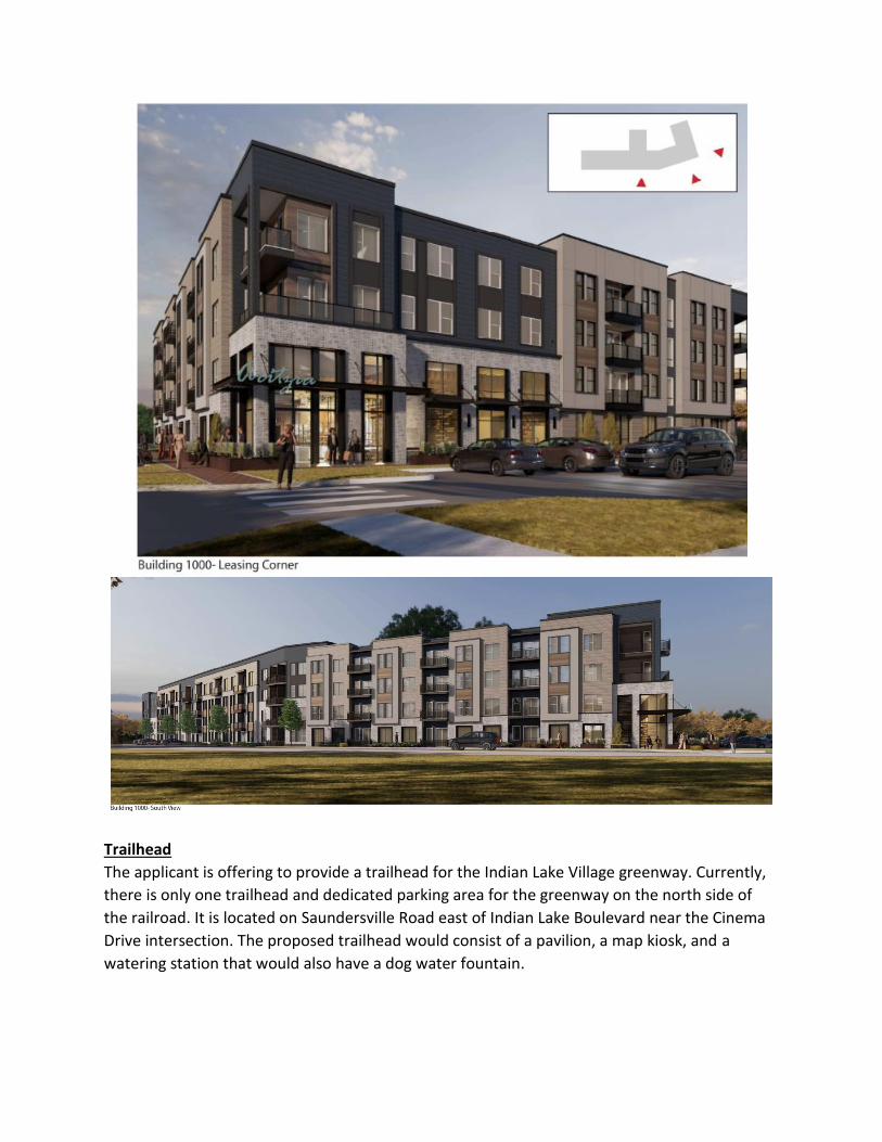
Trailhead
The applicant is offering to provide a trailhead for the Indian Lake Village greenway. Currently,
there is only one trailhead and dedicated parking area for the greenway on the north side of
the railroad. It is located on Saundersville Road east of Indian Lake Boulevard near the Cinema
Drive intersection. The proposed trailhead would consist of a pavilion, a map kiosk, and a
watering station that would also have a dog water fountain.
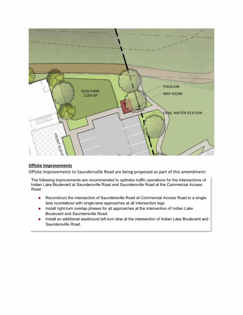
Offsite Improvements
Offsite improvements to Saundersville Road are being proposed as part of this amendment:

ESTIMATED NEXT STEPS IN THIS FINAL DEVELOPMENT PLAN APPROVAL PROCESS:
Please note: Since the addition of the Multi-family Residential use to Phase 3G and the
increase in the number of rental units are inextricably linked, BOMA consideration of the FDP
amendment will include consideration of adding the use.
1. BOMA General Committee Meeting (September 14, 2021 estimated)
2. BOMA Regular Meeting – 1st Reading (September 28, 2021 estimated).
STAFF COMMENTS
PLANNING DEPARTMENT
1. Verify that you will meet the minimum required clubhouse square footage of 4,490 sf.
2. Required landscaping must be on-site, or, you must obtain a landscape easement to
accommodate proposed off-site landscaping (see along NE property line).
3. A screened and fenced parking and storage area for boats, trailers and campers is required.
A minimum of 1 space for each 8 dwelling units must be provided (31 spaces). This
requirement may be waived by the Planning Commission if the developer agrees to prohibit
the parking of boats, trailers and campers at any location within the development and a
contingency plan is provided for said parking and storage area. In the event that the
prohibition is not being enforced, the Planning Commission may require the
implementation of the contingency plan.
4. Club house facilities with a minimum floor space of twenty square feet for each dwelling
unit is required. Show how you will meet this requirement. Provide a floor plan.
5. Itemize and show all proposed off-site improvements on the plan.
6. If the Planning Commission approves the shared parking proposal, an executed agreement
will be required in conjunction with the submittal of the site plan. If the Planning
Commission does not approve the shared parking proposal, redesign the site to provide all
required parking on-site.
7. Provide more detail on the hardscape and landscaping at the center of the proposed round-
a-bout. Continue to work with staff on design.
8. Because revised plans were submitted just prior to finalization of staff comments, more
staff comments may be forthcoming.
9. Building elevations of the proposed garage units have not been provided. Submit elevations
and address any staff comments arising out of that review.
10. Building elevations for the proposed garages were submitted too late for staff to complete a
review, but overall the garages are too basic. Work with staff to upgrade the garages in the
following areas: materials, windows, doors, detailing, articulation. Materials generally shall
follow the direction given by the Planning Commission in regard to brick percentage on the
main buildings.
Submitted by Timothy Whitten, RLA, AICP, Assistant Planning Director (September 2, 2021)
PUBLIC WORKS
1. Confirm proposed conditions will not result in any increase to drainage runoff or base flood elevations relative to the originally approved development master plan as referenced in the 7/28/05 flood study.
2. Amenity and open space area’s post development ownership needs to be clearly defined 3. Sheet PD 6.0: Traffic control regulation devices and/or special engineering features related
to transportation circulation patterns need to be clearly defined 4. Sheet PD 6.1: Proposed gas lines are not shown on the development plan. Confirm natural
gas service will not be extended into the community OR show proposed gas utility locations. 5. Sheet PD 6.1: Add note confirming all work within existing streams will be performed in
accordance with Local, State, and Federal environmental permitting requirements 6. Recommendations from the intersection reconfiguration evaluation are to be designed and
constructed as part of this project. Please add a note to reflect this.
7. Provide a brief statement of background and conclusion to the trip generation comparison.
Submitted by Sarah Lock, PE, City Engineer (September 2, 2021)

FIRE DEPARTMENT
1. Provide details regarding Secondary Fire Access into Aventura at Indian Lake Apts.
Submitted by Shane Nolan, Fire Inspector (September 2, 2021)
UTILITY DISTRICT
1. Project area needs to be master metered.
Submitted by David Brigance, HUD Construction Supervisor (August 11, 2021)

FINAL STAFF REPORT & COMMENTS SUBMITTED TO: HENDERSONVILLE REGIONAL PLANNING COMMISSION
BY: CITY OF HENDERSONVILLE DEVELOPMENT REVIEW STAFF
STAFF REPORT
This site plan submittal follows upon BOMA approval of the Final Development Plan
amendment to add Motor Vehicle Dealership to the List of Permitted Uses for the subject lot.
The proposed layout is for a 243-space parking lot. No building or structure is proposed. The
existing fence will be retained, and new stone columns added every 36 feet along the fence
line. The columns will match the existing stone columns at the south-east corner of the site
where the Monthaven Park entry feature is located.
AGENDA DATE: September 7, 2021
PROJECT # 21-045-001
PROJECT NAME: Hallmark Hyundai Parking Lot Expansion
PROJECT TYPE: Site Plan
PROJECT LOCATION: East of Center Point Road, north side of West Main Street
WARD: Ward 3
STAFF COMMENTS
PLANNING DEPARTMENT
1. Light poles shall be located within landscape islands.
2. Number of tree inches being removed appears to be incorrect, based on information
provided. Please revise.
3. 175.5 tree inches to be paid into tree bank. This amount may change subject to an accurate
accounting of trees to be removed.
4. Address previous landscape comments.
5. If proposed ponds are to be retention, provide fountains for water circulation.
6. Because revised plans were submitted just prior to finalization of staff comments, more
staff comments may be forthcoming and must be addressed prior to building permit
application.
7. Submit revised landscape and irrigation plan conforming to revised layout. Address any
additional staff comments arising from that review.
8. Add note to plan: “No vehicles shall be parked or displayed outside of the defined paved
parking lot”.
Submitted by Timothy Whitten, RLA, AICP, Assistant Planning Director (September 2, 2021)
PUBLIC WORKS
1. Sheets C1.0: Include all of the City of Hendersonville Notes as shown.
2. Sheet CS.1: Include the Northing and Easting for the benchmark.
3. Sheet C2.0: Add to the ‘curb, sidewalk, and fence to be removed’ note that the removal is
only for the location of the driveway entrance. Show for the other driveway entrance as
well.
4. Sheet C3.0: Add a detail for the sidewalk.
5. Sheet C4.0: Provide details on the detention ponds, all calculations must be submitted for
review.
6. Sheet C4.0: Grate elevation for structure No. 5 and the spot elevation near it do not match
the proposed contours.
7. Sheet C4.0: Include Northings and Eastings for the proposed storm sewer structures.
8. Sheet C5.0: Show proposed electric connection to existing and proposed electric.
9. Sheet L2.0: Trees and lights shall be separated by at least 14 ft; revise as necessary.

10. Provide certified drainage calculations showing post-development flow does not exceed
pre-development flow for the 25-year, 24-hour storm event.
Submitted by Sarah Lock, City Engineer (September 2, 2021)
FIRE DEPARTMENT
1. IFC 2018 503.2.4 -Turning Radius: Provide a truck turning template using the Hendersonville Fire Department template throughout the property.
Submitted by Shane Nolan, Fire Inspector (September 2, 2021)
UTILITY DISTRICT
1. No comments.
Submitted by David Brigance, HUD Construction Supervisor (August 11, 2021)

FINAL STAFF REPORT & COMMENTS SUBMITTED TO: HENDERSONVILLE REGIONAL PLANNING COMMISSION
BY: CITY OF HENDERSONVILLE DEVELOPMENT REVIEW STAFF
STAFF REPORT
This property is located in Volunteer Park at Arrowhead. It will be located the east end of
Mustang Lane and is zoned Estate Residential (ER).
The proposed fire station is approximately 7,600 square feet. The structure will contain 3 bays
(pending Board of Zoning Appeals approval) and will be almost 32 feet in height for the bay
area and approximately 20 feet for the remainder of the building.
AGENDA DATE: September 7, 2021
PROJECT # 21-067-001
PROJECT NAME: Hendersonville Fire Station #7
PROJECT TYPE: Site Plan
PROJECT LOCATION: East side of Drakes Creek Road, south side of Mustang Lane
WARD: Ward 6


STAFF COMMENTS
PLANNING DEPARTMENT
1. Provided NES-approved electric service plan.
2. Approval of the site plan is contingent on Board of Zoning Appeals approval of the variance
request from the front setback line of 40’ to 24’.
3. Update landscape plans to show landscape island and reconfigured parking area.
4. Denote location of HVAC units and provide screening.
5. Will there be a dumpster enclosure? If so, show the location and provide detail. Enclosure
shall be brick to match the building and 2’ higher than containers.
6. Provide street names.
7. Provide Sumner 911 verified address for this site.
8. Provide sidewalk, curb, and gutter unless waived by City.
9. Provide sample of retaining wall block.
10. Show underground electric.
Submitted by Sydny Simpson, Planner; and Timothy Whitten, RLA, AICP, Assistant Planning
Director (September 2, 2021)

PUBLIC WORKS
1. Sheets C0.00 and C1.01: Two ADA spaces specified in the Site Data tables but only one ADA
space is provided, edit tables if only one ADA space is required.
2. Sheet C0.01: Include City of Hendersonville General Notes.
3. Sheet C0.02: Show Northing and Easting for project benchmarks.
4. Sheet C0.04: Include the road cut on Mustang Lane.
5. Sheet C1.01: Dimension portions of driveway and parking lot not including ALT #1 as shown.
6. Sheet C1.01: Label the radius of the break in parking spaces.
7. Sheet C1.01 and C5.11: Light Duty asphalt paving included in legend and in detail, but not
shown being used. Remove from legend and detail if not used.
8. Sheet C2.01: Label the slopes, lengths, and ground covers for the ditches.
9. Sheet C2.01: Provide outfall protection at concentrated discharge points if velocities
necessitate.
10. Sheet C2.01: Set back structure A-1 so the endwall is not constructed in the stream.
11. Sheet C2.01: Provide Northings and Eastings for storm structures.
12. Sheet C2.01: Label the direction of the storm sewer pipes correctly in the pipe table.
13. Sheet C5.12: Retaining wall detail references Handrail/Guardrail Detail, remove from detail
or add note stating these are not required, if they are not required.
14. Sheets L1.0, L2.0, and L3.0: Show stream buffers.
15. Sheets E00.02 and E00.03: Clip the survey so the details do not overlap with the lines and
text.
Submitted by Sarah Lock, PE, City Engineer (September 2, 2021)
FIRE DEPARTMENT
1. Show FDC at agreed location.
Submitted by Shane Nolan, Fire Inspector (September 2, 2021)
UTILITY DISTRICT
1. Fire Hydrant needs to be located on private fire service line. The fireline meter needs to be
a Sensus C2 omni meter.
2. Grinder pump needs to a be a Barnes system.
Submitted by David Brigance, HUD Construction Supervisor (August 11, 2021)

FINAL STAFF REPORT & COMMENTS SUBMITTED TO: HENDERSONVILLE REGIONAL PLANNING COMMISSION
BY: CITY OF HENDERSONVILLE DEVELOPMENT REVIEW STAFF
STAFF REPORT
This site is located on Saundersville Road, across the street from Skin Solutions. It is in Phase 6
of the Indian Lake Village planned development, and is zoned Mixed Commercial, Planned
Development (MXC-PD).
AGENDA DATE: September 7, 2021
PROJECT # 21-069-001
PROJECT NAME: Twice Daily #6188 Saundersville
PROJECT TYPE: Site Plan
PROJECT LOCATION: North side of Saundersville Road, south side of Vietnam Veterans Blvd.
WARD: Ward 5

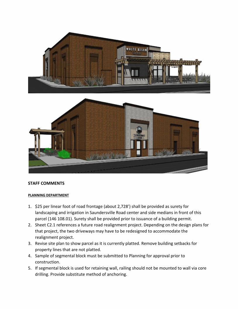
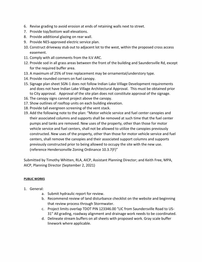
Twice Daily is proposing a fuel station and 5,062 square foot convenience market on this site.
According to the current Indian Lake Village Final Development Plan, fuel stations are limited to
one on Indian Lake Village (now held by Twice Daily at the corner of Indian Lake Boulevard and
Saundersville Road) and one on Saundersville Road east of Stop 30. If this site plan is approved,
no more fuel stations will be allowed within Indian Lake Village.
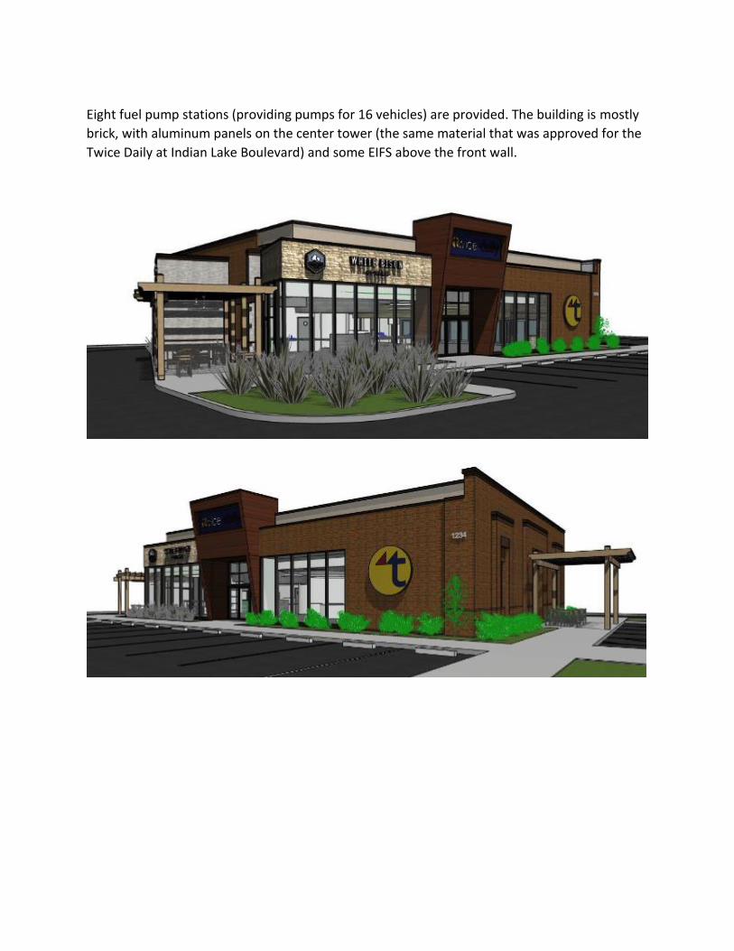
Eight fuel pump stations (providing pumps for 16 vehicles) are provided. The building is mostly
brick, with aluminum panels on the center tower (the same material that was approved for the
Twice Daily at Indian Lake Boulevard) and some EIFS above the front wall.
STAFF COMMENTS
PLANNING DEPARTMENT
1. $25 per linear foot of road frontage (about 2,728’) shall be provided as surety for
landscaping and irrigation in Saundersville Road center and side medians in front of this
parcel (146 108.01). Surety shall be provided prior to issuance of a building permit.
2. Sheet C2.1 references a future road realignment project. Depending on the design plans for
that project, the two driveways may have to be redesigned to accommodate the
realignment project.
3. Revise site plan to show parcel as it is currently platted. Remove building setbacks for
property lines that are not platted.
4. Sample of segmental block must be submitted to Planning for approval prior to
construction.
5. If segmental block is used for retaining wall, railing should not be mounted to wall via core
drilling. Provide substitute method of anchoring.
6. Revise grading to avoid erosion at ends of retaining walls next to street.
7. Provide top/bottom wall elevations.
8. Provide additional glazing on rear wall.
9. Provide NES-approved electric service plan.
10. Construct driveway stub out to adjacent lot to the west, within the proposed cross access
easement.
11. Comply with all comments from the ILV ARC.
12. Provide sod in all grass areas between the front of the building and Saundersville Rd, except
for the required buffer area.
13. A maximum of 25% of tree replacement may be ornamental/understory type.
14. Provide rounded corners on fuel canopy.
15. Signage plan sheet SGN-1 does not follow Indian Lake Village Development requirements and does not have Indian Lake Village Architectural Approval. This must be obtained prior to City approval. Approval of the site plan does not constitute approval of the signage.
16. The canopy signs cannot project above the canopy. 17. Show outlines of rooftop units on each building elevation. 18. Provide tall evergreen screening of the vent stack. 19. Add the following note to the plan: “Motor vehicle service and fuel center canopies and
their associated columns and supports shall be removed at such time that the fuel center
pumps and tanks are removed. New uses of the property, other than those for motor
vehicle service and fuel centers, shall not be allowed to utilize the canopies previously
constructed. New uses of the property, other than those for motor vehicle service and fuel
centers, shall remove the canopies and their associated support columns and supports
previously constructed prior to being allowed to occupy the site with the new use.
(reference Hendersonville Zoning Ordinance 10.3.7(F)”
Submitted by Timothy Whitten, RLA, AICP, Assistant Planning Director; and Keith Free, MPA,
AICP, Planning Director (September 2, 2021)
PUBLIC WORKS
1. General: a. Submit hydraulic report for review. b. Recommend review of land disturbance checklist on the website and beginning
that review process through Stormwater.
c. Project limits overlap TDOT PIN 123346.00 "LIC from Saundersville Road to US-31" All grading, roadway alignment and drainage work needs to be coordinated.
d. Delineate stream buffers on all sheets with proposed work. Gray scale buffer linework where applicable.

e. Confirm the common access easement will accommodate for access to the drainage area for maintenance of vegetation and drainage structures (including heavy machinery).
f. Show intersection sight distance triangles for both driveways with landscaping.
g. Add details for pavement markings.
h. Prior to Final U&O, stormwater maintenance agreement must be recorded with
the county and the deed/page numbers provided to the Public Works
Department.
i. Per Final Plat for Lot 41, Lawrence IL Holdings, LLC and JCBD Investments, LLC or their successors/assigns are responsible for the installation of street lights, landscaping and irrigation along the portion of Saundersville Road shown on this plat and must be installed or surety provided prior to issuance of a building permit for each lot. At the time 50% or more of the street frontage is developed (site plan approved), street lights, landscaping and irrigation shall be completed for all remaining street frontage along the portion of Saundersville Road adjacent to the lots shown on this plat.
j. Coordinate with Public Works regarding Final Plat for Lot 41 note regarding payment for one (1) inch of final topping and striping required prior to final site plan approval.
2. Sheet C3: a. Coordinate with proposed intersection improvements (including proposed
signals) of TDOT PIN 123346.00 "LIC from Saundersville Road to US-31". b. Provide detail regarding ADA compliant landing and crossing at western
entrance. Ensure cross slope, spacing, and detectable warning requirements are met.
c. Show truncated dome detectable warning and reference design standard at applicable locations (TYP.)
d. Confirm stop bar behind pedestrian path of travel at eastern exit. e. Add signage prohibiting left turn from eastern exit. f. Update with all current City of Hendersonville general construction notes. g. Add spot elevations for ADA parking, access aisle, and sidewalk to ensure ADA
compliance.
h. Add sidewalk detail and specify max slopes.
i. Recommend crosswalk markings for pedestrian crossing at the drive thru.
j. Dimension the right-in/right-out drive lanes.
k. Add stop signs and detail.
l. Show stream buffers on proposed sheets and delineate work requiring ARAP for
completion (i.e. 9’ retaining wall which appears to be within proposed stream
buffer, and encapsulation as a result of proposed driveway culverts).
3. Sheet C4: a. Confirm bottom of retaining wall elevations at storm crossings and call out
vertical separation of structures and pipes.

b. Provide specifications for the Kraken water quality unit including maintenance requirements.
c. Revise note 14 to 3H:1V maximum slope unless otherwise specified. d. Confirm RIM elevations and structure depths accommodate the proposed storm
pipes at all locations. Some calculated depths appear to be smaller than proposed connecting pipes.
e. Add type of inlet and design standard/detail references to all structures. f. Add detail for ENDWALL CAST TO RETAINING WALL.
g. Show box culverts and add detail for TDOT STD-17-114.
h. Provide detail for box culvert termini within retaining walls at driveways. i. Show PUDE over detention.
4. Sheet C5: a. Confirm vertical separation of proposed sanitary sewer & storm line at crossing.
5. Sheet C6.2 a. Confirm outlet velocity and required rip-rap apron dimensions.
6. Sheet C7: a. Design elevations for pond outlet structure need to be included in the detail. b. Pond outlet structure (ST-19) calls for 42" RCP on sheet C4. Confirm size and
resolve discrepancy. 7. Sheet C7.1
a. Call out blue reflective traffic paint for the handicap symbol detail. b. Add note specifying sign to be ADA, MUTCD and TCA compliant.
8. Sheets C8-C8.1: a. Reduce retaining wall profile grid line weight to facilitate review of proposed
grades (TYP.)
Submitted by Sarah Lock, PE, City Engineer (September 2, 2021)
FIRE DEPARTMENT
1. IFC 2018 503.2.4 -Turning Radius: Provide a truck turning template using the Hendersonville Fire Department template throughout the property.
2. Hendersonville Subdivision Regulations 3-107.1 – Provide a utility plan that indicates the location of the proposed hydrants, fire service main sizes, lengths, locations, weights,
materials, point of connection to city main; the sizes, types and locations of valves, valve
indicators, regulators, meters, and valve pits; and the depth that the top of the pipe is laid below grade.
3. Hendersonville Subdivision Regulations 3-107.201 – For commercial districts or commercial
subdivisions, provide (1) or more hydrants at each street intersection depending on the required fire flow, with intermediate hydrants so that they are not over three hundred (300)
feet apart.
4. IFC 2018 912.2.1 - Provide Sprinkler system FDC on street (address) side of building

5. IFC 2018 507.5.1.1 - Provide Sprinkler system FDC within 100 ft of fire hydrant
Submitted by Shane Nolan, Fire Inspector (September 2, 2021) UTILITY DISTRICT
1. Sewer Note 11 needs to be changed to 2018 specifications.
2. Note 13 needs to have ductile iron removed and replaced with C900.
3. Note 15 needs to be changed to 2018 specifications.
4. Note 18 needs to be changed to David Brigance.
5. Water Note 4 should be Type K soft copper from main to meter.
6. Meters and backflows are to be located in the right-of-way.
Submitted by David Brigance, HUD Construction Supervisor (August 11, 2021)