fire in the arctic: the effect of wildfire across diverse
TRANSCRIPT
Fire in the Arctic: The effect of wildfire across diverse aquatic ecosystems of the Northwest Territories
S.E. Tank,1,2 D. Olefeldt,3 W.L. Quinton,4 C. Spence,5 N. Dion,6 C. Ackley,4 K. Burd,3 R. Hutchins,1 and S. Mengistu1
1Department of Biological Sciences, University of Alberta, Edmonton, Alberta
3Department of Renewable Resources, University of Alberta, Edmonton, Alberta
4Centre for Cold Regions and Water Science, Wilfred Laurier University, Waterloo, Ontario
5Environment and Climate Change Canada, Saskatoon, Saskatchewan
6Water Resources Department, Government of Northwest Territories, Yellowknife, Northwest Territories
Suggested citation:
Tank, S.E., Olefeldt, D., Quinton, W.L., Spence, C., Dion, N., Ackley, C., Burd, K., Hutchins, R., and Mengistu, S., 2018. Fire in the Arctic: The effect of wildfire across diverse aquatic ecosystems of the Northwest Territories. Polar Knowledge: Aqhaliat 2018, Polar Knowledge Canada, p. ##–##.
Abstract
During the summer of 2014, the southern Northwest Territories (NWT) experienced an unprecedented
wildfire season, with burned areas spread across two ecoregions (the Taiga Plains and Taiga Shield) and a
landscape underlain by a mosaic of permafrost coverage, vegetation type, and previous fire history. Our
study was conducted across the Dehcho, Tłı̨chǫ-Wek’èezhii, and Akaitcho Regions of the NWT, which
encompass the most significantly burned areas from the 2014 fire season. Within these regions, we
worked in paired burned–unburned catchments on the Taiga Plains and Taiga Shield to examine
responses to fire within ground and surface waters. We additionally examined water quality across a
series of 50 catchments that were stratified across ecoregion and by fire history, and varied in within-
catchment characteristics such as wetland extent. This sampling scheme — which covers as significant a
range of landscape variability as possible — is allowing us to differentiate the effects of wildfire from
other landscape variables that cumulatively impact aquatic ecosystem health. While wildfire had a clear
effect on the chemical composition of pore waters, this effect was diminished at the stream outlet and at

the landscape scale. Rather than having an overriding effect on water quality, wildfire appears to be one
of many landscape variables that act in concert to determine water quality in the southern NWT.
Résumé
À l’été 2014, le sud des Territoires du Nord-Ouest (T.N.-O.) a connu une saison de feux de forêt sans
précédent, qui a ravagé des zones réparties dans deux écorégions (les plaines de la taïga et le bouclier de
la taïga). Ces zones couvraient un paysage composé de pergélisol, de divers types de végétation et de
terres incendiées précédemment. Notre étude a été menée dans les régions du Dehcho, du Tłı chǫ-
Wek’èezhii et de l’Akaitcho des T.N.-O., qui comprennent les zones les plus brûlées de la saison des feux
de forêt de 2014. Dans ces régions, nous avons travaillé dans des bassins versants brûlés et non brûlés
jumelés sur les plaines de la taïga et le bouclier de la taïga pour examiner les réactions aux feux dans les
eaux de surface et les eaux souterraines. Nous avons également examiné la qualité de l’eau dans une série
de 50 bassins versants stratifiés en fonction de l’écorégion et de l’historique des feux, et variés en matière
de caractéristiques au sein des bassins versants, comme l’étendue des terres humides. Ce plan
d’échantillonnage, qui couvre un éventail aussi important que possible de variabilité des paysages, nous
permet de différencier les effets des feux de forêt d’autres variables des paysages qui ont un effet
cumulatif sur la santé de l’écosystème aquatique. Bien que les feux de forêt aient eu un effet évident sur la
composition chimique des eaux interstitielles, cet effet était moindre à la sortie du cours d’eau et à
l’échelle du paysage. Plutôt que d’avoir un effet prédominant sur la qualité de l’eau, les feux de forêt
semblent être l’une des nombreuses variables du paysage qui agissent de concert pour déterminer la
qualité de l’eau dans le sud des T.N.-O.
Introduction
During the summer of 2014, the southern Northwest Territories (NWT) experienced an unprecedented
wildfire season, with a burn footprint that spread across two ecoregions (the Taiga Plains and Taiga
Shield), and a landscape underlain by a mosaic of permafrost coverage, vegetation type, and previous fire
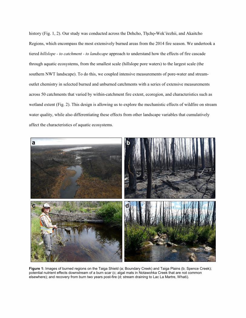
history (Fig. 1, 2). Our study was conducted across the Dehcho, Tłı̨chǫ-Wek’èezhii, and Akaitcho
Regions, which encompass the most extensively burned areas from the 2014 fire season. We undertook a
tiered hillslope - to catchment - to landscape approach to understand how the effects of fire cascade
through aquatic ecosystems, from the smallest scale (hillslope pore waters) to the largest scale (the
southern NWT landscape). To do this, we coupled intensive measurements of pore-water and stream-
outlet chemistry in selected burned and unburned catchments with a series of extensive measurements
across 50 catchments that varied by within-catchment fire extent, ecoregion, and characteristics such as
wetland extent (Fig. 2). This design is allowing us to explore the mechanistic effects of wildfire on stream
water quality, while also differentiating these effects from other landscape variables that cumulatively
affect the characteristics of aquatic ecosystems.
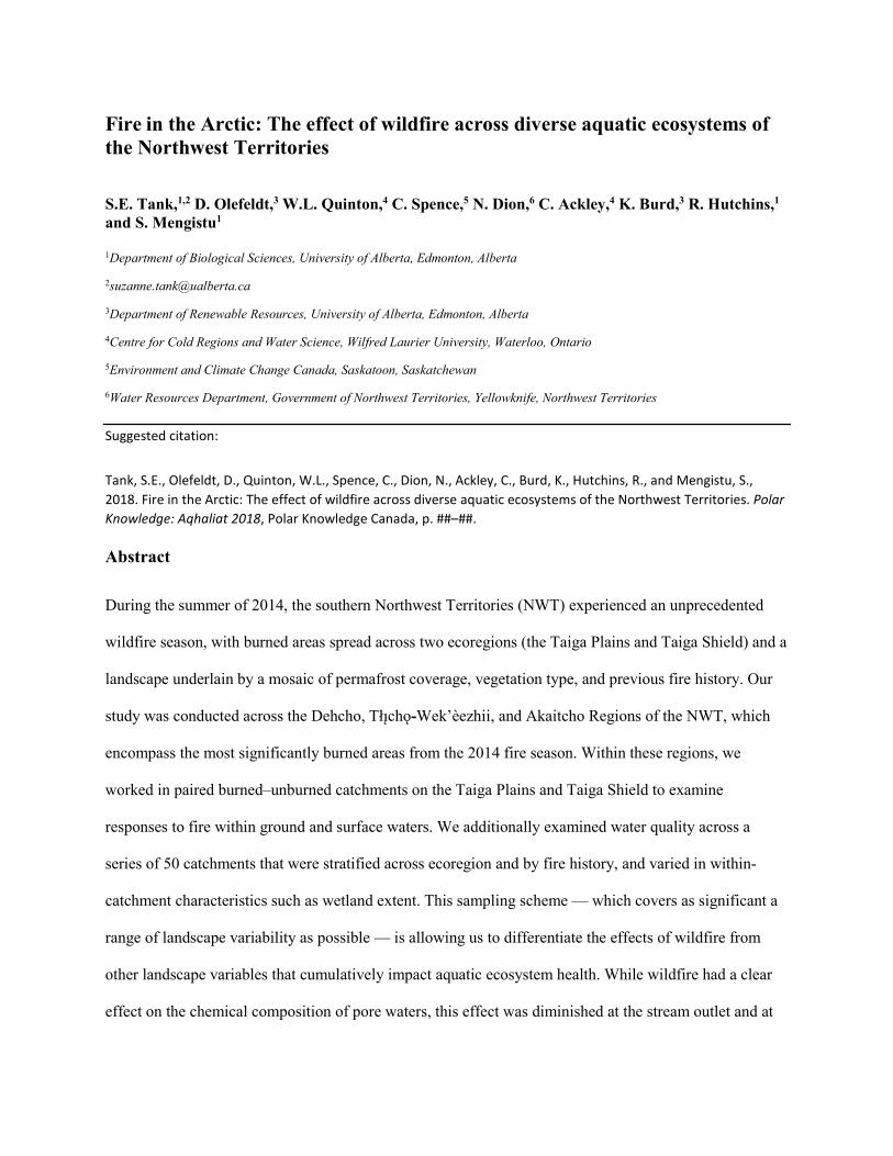
Figure 1: Images of burned regions on the Taiga Shield (a; Boundary Creek) and Taiga Plains (b; Spence Creek); potential nutrient effects downstream of a burn scar (c; algal mats in Notawohka Creek that are not common elsewhere); and recovery from burn two years post-fire (d; stream draining to Lac La Martre, Whatì).
Figure 2: (a) Sampling locations superimposed on the 2013–2016 fire perimeters (the paired burned-unburned catchments that were the focus of our intensive measurements are indicated in blue; the 50 synoptic sampling locations are indicated in orange) and (b) Fire history for the region, with the more detailed area of panel (a) indicated by a box.
Previous research has shown that wildfire can substantially alter the chemistry of downslope freshwater
ecosystems. For example, combustion of organic layers and loss of vegetation can increase nutrients
(Betts and Jones 2009; Fig. 2) and toxins like mercury (Kelly et al. 2006) but decrease organics (Betts and
Jones 2009) in recipient aquatic ecosystems, although results can also be mixed (e.g., Olefeldt et al.
2013). Following wildfire, the burn scar is also more susceptible to permafrost thaw than adjacent
undisturbed areas, because the loss of tree canopy allows greater energy loading at the ground surface,
while the blackened ground also absorbs more energy. The resultant deepening of active layers can
further affect the chemistry of water flowing from land to streams, as soils that were previously frozen
become available for contact with water. In On the Taiga Shield, soils typically consist of organic
horizons down to bedrock, with thin mineral soils. In contrast, deep peatlands are abundant on the Taiga
Plains, but the underlying soil is composed of thick mineral tills. Thus, the effect of wildfire might be
expected to fundamentally differ between these two regions, with increases in organics where deepening
or lengthening flow paths enable access to organic soils, and increases in inorganic nutrients (e.g., nitrate
and phosphate) and ions where water is routed through inorganic horizons. Deepening thaw can also

encourage the establishment of taliks (i.e., a perennially thawed layer between the overlying active layer
and underlying permafrost; Gibson 2017), which can enable the flow of water and associated chemical
constituents throughout the year. These wildfire-associated changes in water chemistry are important
because changes in within-stream concentrations of nutrients, organics, sediments, and contaminants may
in turn alter the ecological functioning of freshwater systems (see, for example, Minshall et al. 2001,
Allen et al. 2005, Kelly et al. 2006, Smith et al. 2011, and Silins et al. 2014).
Although the influence of wildfire on water chemistry has been investigated in some northern hillslope
systems and within small Subarctic catchments, including in Alaska (Betts and Jones 2009, Koch et al.
2014), it has been poorly studied in the NWT. This is of concern from an NWT-specific perspective,
because the Subarctic landscape is composed of a diversity of region-specific landscape features, which
may act cumulatively and in distinct ways to influence downslope water chemistry. Given that wildfire
frequency is increasing in northern Canada (Kasischke and Turetsky 2006; Flannigan et al. 2009), it is
imperative that we undertake region-specific assessments of its effect on aquatic and other ecosystem
components. Such targeted assessments will help to predict how fire might affect aquatic ecosystems
across diverse landscape types, and thus, also understand changes in natural resources (food webs, fish)
and infrastructure (drinking water) that might result.
Methods
Our cascading hillslope - to catchment - to landscape design took a three-tiered approach. First, we
worked within targeted burned and unburned sites on the Taiga Plains (Notawohka and Scotty Creeks)
and Taiga Shield (Boundary and Baker Creeks; Fig. 2) to examine the effects of wildfire on ground
temperature, snow accumulation, frost-table depth, and the chemical composition of water available for
runoff downslope to streams (i.e., mobile pore water). Second, we undertook frequent measures of
stream-outlet chemistry within these paired catchments, to better understand the fine-scale response of
catchments to wildfire. Finally, we undertook a synoptic survey of 50 burned and unburned catchments

(Fig. 2) during June-July of 2016 and May-June of 2017, with a subset of these catchments being
additionally sampled in August and September of 2016. This work was carried out as a collaborative
effort between academic researchers, Federal government scientists, and aquatic scientists from the
Government of the Northwest Territories (GNWT). Residents of the communities of Jean Marie River,
Fort Simpson, Whatì, Wekweètì, and Gamètì were also integral to project planning and sample collection,
as outlined below.
To target water available for movement downslope, pore-water samples were collected at the water table
using MacroRhizon samplers (0.15 µm pore size; Rhizosphere Research Products, Wageningen, the
Netherlands) (Burd et al. 2018) or by filtering water collected from pit samples (Sartorius 0.45 µm).
Samples for this component were analyzed at the University of Alberta, either in individual laboratories
or at the CALA-accredited (ISO 17025) Biogeochemical Analytical Service Laboratory (BASL). Our
targeted paired burned-unburned catchments were sampled weekly for four weeks following the onset of
flow in the spring, and monthly thereafter in each of 2015, 2016, and 2017. Paired catchment-outlet
samples were collected using protocols established by the GNWT Water Resources Division, and the
samples were analyzed at the GWNT Taiga Environmental Laboratory. Pre-existing (Baker Creek,
unburned) and project-specific (Boundary Creek, burned) meteorological stations on the Taiga Shield
collected air temperature, relative humidity, net radiation, wind speed, and rainfall, and were coupled with
frost-table measurements in burned and unburned terrains in Baker, Boundary, and Scotty Creeks.
For our 50-site synoptic surveys, we accessed all possible streams located near Highways 1 and 3, and
additionally worked with the communities of Whatì, Wekweètì, and Gamètì to access stream sites from
the lakes on which these communities are located. Sampling locations were stratified across burned and
unburned terrains. Chemistry samples were collected following standard protocols, field-filtered (pre-
combusted Whatman GF/F filters, 0.7 µm pore size), and stored chilled, in the dark, for later analysis at
the University of Alberta’s BASL.
To allow us to calculate constituent export and normalize total constituent flux by watershed area (i.e.,
yield; Tank et al. 2012), we also measured discharge at each site. Of the four paired catchment sites,
discharge data are actively collected by the Water Survey of Canada at Scotty and Baker Creeks. For
Boundary and Notawohka Creeks, discharge was determined using in-stream pressure transducers and the
development of stage-discharge rating curves. For the 50 synoptic sites, point discharge was measured
concurrent with water chemistry sample collection using a FlowTracker2 hand-held Acoustic Doppler
Velocimeter (SonTek Inc., San Diego, CA) and the cross-sectional area-velocity method.
Catchment boundaries were delineated from a 20-metre digital elevation model (http://geogratis.gc.ca),
using ArcGIS (10.5) with the hydrology toolbox. Catchment-outlet coordinates acquired during sample
collection were used as pour points for the delineations. Catchment delineations were used to derive
catchment characteristics, including slope and percent cover of various landscape types (Canadian Land
Cover, circa 2000 (Vector) - GeoBase Series). Catchment fire scar areas were extracted from National
Fire Database GIS layers provided by the Canadian Forest Service.
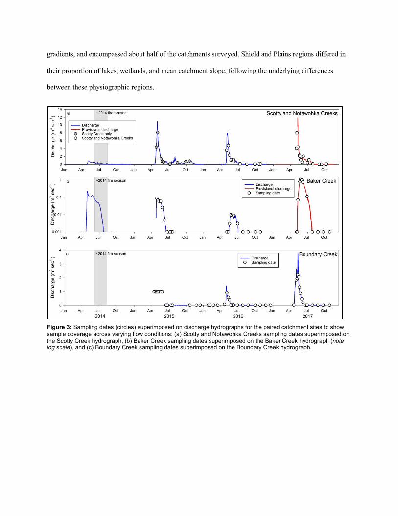
Preliminary results
Collaboration with government partners and community assistance allowed us to achieve strong temporal
and spatial coverage in our sampling efforts. Our paired catchment work successfully captured initial
spring flows in 2015, which represented the first runoff pulse following the 2014 wildfire season (Fig. 3).
Subsequent sampling enabled excellent coverage of the spring freshet in 2016 and 2017, and continued
collection throughout each of the three sample years in cases where flows continued under ice (e.g.,
Boundary Creek; Fig. 3). Our synoptic survey effectively captured a range of landscapes within each of
the Taiga Plains and Taiga Shield. For example, the within-watershed coverage of lakes and wetlands
varied from levels near zero percent to greater than 80% of the catchment, while mean catchment slope —
an important regulator of water residence on the landscape — varied across a substantial gradient in each
of the two ecoregions (Fig. 4). Wildfire-affected catchments were well distributed across these landscape
gradients, and encompassed about half of the catchments surveyed. Shield and Plains regions differed in
their proportion of lakes, wetlands, and mean catchment slope, following the underlying differences
between these physiographic regions.
Figure 3: Sampling dates (circles) superimposed on discharge hydrographs for the paired catchment sites to show sample coverage across varying flow conditions: (a) Scotty and Notawohka Creeks sampling dates superimposed on the Scotty Creek hydrograph, (b) Baker Creek sampling dates superimposed on the Baker Creek hydrograph (note log scale), and (c) Boundary Creek sampling dates superimposed on the Boundary Creek hydrograph.
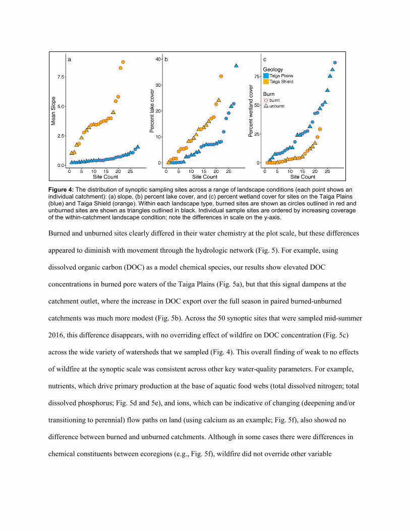
Figure 4: The distribution of synoptic sampling sites across a range of landscape conditions (each point shows an individual catchment): (a) slope, (b) percent lake cover, and (c) percent wetland cover for sites on the Taiga Plains (blue) and Taiga Shield (orange). Within each landscape type, burned sites are shown as circles outlined in red and unburned sites are shown as triangles outlined in black. Individual sample sites are ordered by increasing coverage of the within-catchment landscape condition; note the differences in scale on the y-axis.
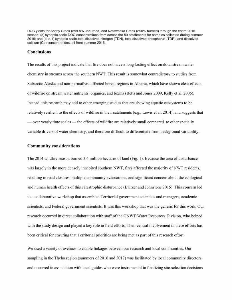
Burned and unburned sites clearly differed in their water chemistry at the plot scale, but these differences
appeared to diminish with movement through the hydrologic network (Fig. 5). For example, using
dissolved organic carbon (DOC) as a model chemical species, our results show elevated DOC
concentrations in burned pore waters of the Taiga Plains (Fig. 5a), but that this signal dampens at the
catchment outlet, where the increase in DOC export over the full season in paired burned-unburned
catchments was much more modest (Fig. 5b). Across the 50 synoptic sites that were sampled mid-summer
2016, this difference disappears, with no overriding effect of wildfire on DOC concentration (Fig. 5c)
across the wide variety of watersheds that we sampled (Fig. 4). This overall finding of weak to no effects
of wildfire at the synoptic scale was consistent across other key water-quality parameters. For example,
nutrients, which drive primary production at the base of aquatic food webs (total dissolved nitrogen; total
dissolved phosphorus; Fig. 5d and 5e), and ions, which can be indicative of changing (deepening and/or
transitioning to perennial) flow paths on land (using calcium as an example; Fig. 5f), also showed no
difference between burned and unburned catchments. Although in some cases there were differences in
chemical constituents between ecoregions (e.g., Fig. 5f), wildfire did not override other variable

landscape characteristics to cause a clear effect on water chemistry across the synoptic sites that we
investigated.
It is worth noting that the synoptic study results that we present were collected during relatively low-flow
mid-summer conditions, when connectivity between streams and the landscape can be low, and also two
summers following the 2014 burn season (i.e., for samples collected during summer 2016; Fig. 1d shows
a typical catchment two years post-fire). Our paired catchment work did suggest that constituents
including DOC, ions, and selected metals were elevated in the spring runoff period immediately post-fire
(see, for example, the evidence of increased nutrients immediately post-fire in Fig. 1c). However, this
effect was short lived. Across the southern NWT, it appears that wildfire is but one of many landscape
controls on the functioning of aquatic ecosystems, and that this disturbance does not have an overriding
effect on water quality at the multi-year scale.
Figure 5: Constituent concentrations and yields (area-normalized exports) across burned (B) and unburned (UB) sites, for sampling at scales ranging from pore waters to the broad landscape: (a) pore-water concentrations of dissolved organic carbon (DOC) in burned and unburned plots of the Scotty Creek catchment; (b) catchment-outlet
DOC yields for Scotty Creek (>99.8% unburned) and Notawohka Creek (>90% burned) through the entire 2016 season; (c) synoptic-scale DOC concentrations from across the 50 catchments for samples collected during summer 2016; and (d, e, f) synoptic-scale total dissolved nitrogen (TDN), total dissolved phosphorus (TDP), and dissolved calcium (Ca) concentrations, all from summer 2016.
Conclusions
The results of this project indicate that fire does not have a long-lasting effect on downstream water
chemistry in streams across the southern NWT. This result is somewhat contradictory to studies from
Subarctic Alaska and non-permafrost affected boreal regions in Alberta, which have shown clear effects
of wildfire on stream water nutrients, organics, and toxins (Betts and Jones 2009, Kelly et al. 2006).
Instead, this research may add to other emerging studies that are showing aquatic ecosystems to be
relatively resilient to the effects of wildfire in their catchments (e.g., Lewis et al. 2014), and suggests that
— over yearly time scales — the effects of wildfire are relatively small compared to other spatially
variable drivers of water chemistry, and therefore difficult to differentiate from background variability.
Community considerations
The 2014 wildfire season burned 3.4 million hectares of land (Fig. 1). Because the area of disturbance
was largely in the more densely inhabited southern NWT, fires affected the majority of NWT residents,
resulting in road closures, multiple community evacuations, and significant concern about the ecological
and human health effects of this catastrophic disturbance (Baltzer and Johnstone 2015). This concern led
to a collaborative workshop that assembled Territorial government scientists and managers, academic
scientists, and Federal government scientists. It was this workshop that was the genesis for this work. Our
research occurred in direct collaboration with staff of the GNWT Water Resources Division, who helped
with the study design and played a key role in field efforts. Their central involvement in these efforts has
been critical for ensuring that Territorial priorities are being met as part of this research effort.
We used a variety of avenues to enable linkages between our research and local communities. Our
sampling in the Tłı̨chǫ region (summers of 2016 and 2017) was facilitated by local community directors,
and occurred in association with local guides who were instrumental in finalizing site-selection decisions
and assisting with our access to local lands. Work in the Dehcho occurred in collaboration with members
of the Jean Marie River First Nation who assisted with sampling a local stream (Spence Creek) that
burned extensively during the 2014 fire. We have found these partnerships to be critical for ensuring that
sampling efforts are appropriately targeting areas of concern. These linkages are also ongoing in
associated projects.
Acknowledgements
This research would not have occurred without the assistance of community directors in the Tłı̨chǫ region
(April Alexis and Shirley Dokum, Whatì; Gloria Ekendia-Gon, Gamètì; Adeline Football, Wekweètì) and
Chief Gladys Norwegian in Jean Marie River. These individuals identified community members who
were instrumental in guiding our use of local lands and assisting us to identify streams within each of the
communities where we conducted this work. Wayne and Lynn McKay were also critical for our paired
sampling on the Taiga Plains. In the Tłı̨chǫ region, we were fortunate to have Lloyd Bishop (Whatì),
Alfred Arrowmaker (Gamètì), and William Quitte (Wekweètì) directly involved in our sampling efforts.
In Jean Marie River, we were fortunate to have Derek Norwegian, Bill Norwegian, Douglas Norwegian,
Richard Sanguez, Stanley Sanguez, and Borris Sanguez assisting with our sampling efforts. Funding for
this research was from Polar Canada, the Cumulative Impacts Monitoring Program, the Campus Alberta
Innovates Program, and the Natural Sciences and Engineering Research Council of Canada, as well as in-
kind support from the GNWT.
References
Allen, E.W., Prepas, E.E., Gabos, S., Strachan, W.M.J., and Zhang, W.P. 2005. Methyl mercury concentrations in macroinvertebrates and fish from burned and undisturbed lakes on the Boreal Plain. Canadian Journal of Fisheries and Aquatic Sciences 62:1963–1977. doi: 10.1139/f05-103.
Baltzer, J. and Johnstone, J. 2015. The 2014 NWT fires: Developing a research framework. Workshop report provided to the Government of the Northwest Territories. 11 pp.
Betts, E.F. and Jones, J.B. Jr. 2009. Impact of wildfire on stream nutrient chemistry and ecosystem metabolism in boreal forest catchments of interior Alaska. Arctic, Antarctic, and Alpine Research 41:407–417. doi: 10.1657/1938-4246-41.4.407.
Burd, K., Tank, S.E., Dion, N., Quinton, W.L., Spence, C., Tanentzap, A.J., and Olefeldt, D. 2018. Seasonal shifts in export of DOC and nutrients from burned and unburned peatland-rich catchments, Northwest Territories, Canada. Hydrology and Earth System Science 22:4455–4472. Available at https://doi.org/10.5194/hess-22-4455-2018, 2018.
Flannigan, M., Stocks, B., Turetsky, M., and Wotton M. 2009. Impacts of climate change on fire activity and fire management in the circumboreal forest. Global Change Biology 15:549–560. doi: 10.1111/j.1365-2486.2008.01660.x.
Gibson, K. 2017. Long-term effects of wildfire on permafrost stability and carbon cycling in northern peatlands. M.Sc. thesis, University of Alberta. 98 pp.
Kasischke, E.S. and Turetsky, M.R. 2006. Recent changes in the fire regime across the North American boreal region: Spatial and temporal patterns of burning across Canada and Alaska. Geophysical Research Letters 33:L09703. doi: 10.1029/2006gl025677.
Kelly, E.N., Schindler, D.W., St. Louis, V.L., Donald, D.B., and Vlaclicka, K.E. 2006. Forest fire increases mercury accumulation by fishes via food web restructuring and increased mercury inputs. Proceedings of the National Academy of Science 103:19380–19385. doi: 10.1073/pnas.0609798104.
Koch, J.C., Kikuchi, C.P., Wickland, K.P., and Schuster, P. 2014. Runoff sources and flow paths in a partially burned, upland boreal catchment underlain by permafrost. Water Resources Research 50:8141–8158. doi: 10.1002/2014wr015586.
Lewis, T.L., Lindberg, M.S., Schmutz, J.A., and Bertram, M.R. 2014. Multitrophic resilience of boreal lake ecosystems to forest fires. Ecology 95:1253–1263.
Minshall, G.F., Brock, J.T., Andrews, D.A., and Robinson, C.T. 2001. Water quality, substratum, and biotic responses of five central Idaho (USA) streams during the first year following the Mortar Creek fire. International Journal of Wildland Fire 10:185–199. doi: 10.1071/wf01017.
Olefeldt, D., Devito, K.J., and Turetsky, M.R. 2013. Sources and fate of terrestrial dissolved organic carbon in lakes of a Boreal Plains region recently affected by wildfire. Biogeosciences 10:6247–6265. doi: 10.5194/bg-10-6247-2013.
Silins, U., Bladon, K.D., Kelly, E.N., Esch, E., Spence, J.R., Stone, M., et al. 2014. Five-year legacy of wildfire and salvage logging impacts on nutrient runoff and aquatic plant, invertebrate, and fish productivity. Ecohydrology 7:1508–1523. doi: 10.1002/eco.1474.
Smith, H.G., Sheridan, G.J., Lane, P.N.J., Nyman, P., and Haydon S. 2011. Wildfire effects on water quality in forest catchments: A review with implications for water supply. Journal of Hydrology 396:170–192. doi: 10.1016/j.jhydrol.2010.10.043.
Tank, S.E., Frey, K.E., Striegl, R.G., Raymond, P.A., Holmes, R.M., McClelland, J.W., et al. 2012. Landscape-level controls on dissolved carbon flux from diverse catchments of the circumboreal. Global Biogeochemical Cycles 26:GB0E02. doi: 10.1029/2012GB004299.