fisher slough floodgate report for water year 2011
TRANSCRIPT

Fisher Slough Floodgate Report for Water Year 2011
Eric Beamer and Rich Henderson Skagit River System Cooperative
LaConner, WA
March 1, 2012
Report prepared for: The Nature Conservancy (TNC) under Grant Agreement # WA-S-110323-123
Fisher Slough floodgates, photo by Rich Henderson

Final Report March 2012 i
Table of Contents Acknowledgements ......................................................................................................................... ii Abstract .......................................................................................................................................... iii Introduction ..................................................................................................................................... 5
Fisher Slough Floodgate and its Operation ................................................................................. 6 Hydraulic Project Approval Criteria ........................................................................................... 6
Methods........................................................................................................................................... 7 Water Surface Elevation ............................................................................................................. 8 Floodgate Door Angle Openness ................................................................................................ 9 Water Velocity .......................................................................................................................... 11 Water Depth .............................................................................................................................. 11 Floodgate Operation.................................................................................................................. 12 Skagit River and Nookachamps Creek Gage Height ................................................................ 12
Analysis Methods.......................................................................................................................... 12 Fall/Winter Flood Control Period ............................................................................................. 12 Spring Juvenile Chinook Salmon Migration Period ................................................................. 13 Summer Irrigation Period ......................................................................................................... 14
Instrument Measurement Accuracy .............................................................................................. 14 Floodgate Door Angle Openness .............................................................................................. 14 Water Surface Elevation ........................................................................................................... 16
Floodgate Operations Results ....................................................................................................... 17 Fall/Winter Flood Control Period ............................................................................................. 17
Floodgate Door Openness ..................................................................................................... 17 Spring Juvenile Chinook Salmon Migration Period ................................................................. 18
Floodgate Door Openness ..................................................................................................... 18 Water Velocity ...................................................................................................................... 18 Water Depth .......................................................................................................................... 18
Summer Irrigation Period ......................................................................................................... 23 Floodgate Door Openness ..................................................................................................... 23
Discussion, Conclusions, & Recommendations ........................................................................... 23 Comparison of Floodgate Results with HPA Criteria............................................................... 23
Fall/Winter Flood Control Period ......................................................................................... 23 Spring Juvenile Chinook Salmon Migration Period ............................................................. 24 Summer Irrigation Period ..................................................................................................... 24
Appropriateness of HPA Criteria .............................................................................................. 25 Adult Salmon ........................................................................................................................ 25 Juvenile Salmon .................................................................................................................... 25 Flood Protection, Drainage, and Irrigation ........................................................................... 28
References ..................................................................................................................................... 28 Appendix 1. Fisher Slough Floodgate Operation Logs ................................................................ 30 Appendix 2. Skagit River Streamflow Gage Results for WY 2011 ............................................. 32 Appendix 3. Nookachamps Creek Streamflow Gage Results for WY 2011 ................................ 34 Appendix 4. Floodgate Door Opening Width ............................................................................... 35

Final Report March 2012 ii
Acknowledgements We thank The Nature Conservancy:
• For monitoring funding and access sites • Kris Knight, Joelene Diehl and Jenny Baker (Mount Vernon office) for their help with
training in the use of floodgate monitoring equipment and assistance in the field We thank Skagit River System Cooperative staff:
• Bruce Brown, Jason Boome, Jeremy Cayou, Len Rodriquez, Ric Haase, and Josh Demma for their involvement with velocity data collection
• Karen Wolf for help with photos, maps, and report editing

Final Report March 2012 iii
Abstract This report describes floodgate monitoring efforts for the Fisher Slough floodgate, located in the South Fork Skagit River tidal delta. Monitoring results relate to measurements of floodgate door openness, water depth, water velocity, water surface elevation, and floodgate operation for Water Year (WY) 2011, the period of October 1, 2010 through September 30, 2011. The floodgate was originally installed to provide flood protection from Skagit River floods to the Fisher Slough basin. In 2009, old barn-style doors were replaced with self-regulating floodgates designed to improve fish passage through the gates while still maintaining flood protection. We compare monitoring results to floodgate operational criteria that were established based on fish passage and flood protection needs. We also discuss monitoring results and criteria in order to provide information useful to adaptively manage the Fisher Slough floodgate, if necessary, to achieve and balance its multiple objectives of fish passage, flood protection, drainage, and irrigation. Monitoring instruments used to collect water surface elevation and floodgate door openness data were shown to collect results accurately with one exception. Instrumentation on the south floodgate door did not measure door openness accurately and should be replaced or repaired. Fisher Slough floodgate operation met all Hydraulic Project Approval criteria established for all three operational time periods in WY 2011 (see table immediately below), demonstrating good management and maintenance of the floodgate structure throughout the water year and that the floodgate’s design is synchronized with Hydraulic Project Approval criteria. The newly replaced floodgate structure is capable of achieving the criteria. While all Hydraulic Project Approval criteria were met at Fisher Slough, we are concerned whether some specific values of some criteria are appropriate for a conclusion that juvenile salmon upstream passage opportunity is adequate when criteria are met. Therefore, we offer discussion and recommendations to help with future monitoring and floodgate operation at the site. More specific or different criteria related to water velocity, floodgate door openness width, and the tidal stages when doors are open are recommended. It is likely water velocity conditions on ebb tides (especially larger ebbs) at the Fisher Slough floodgates do not allow for upstream movement of fry-sized Chinook salmon even when floodgate doors are open. We recommend monitoring water velocity as part of the floodgate monitoring plan in order to better determine the conditions that allow juvenile salmon upstream migration potential. How wide a floodgate door is open likely relates to fish passage opportunity at floodgate sites. Yet, Fisher Slough criteria related to door openness only states when doors should be open (seasonally with a minimum water elevation for gate closure) and how long they should be open (percent of time), not how wide they should be open or whether variation in openness influences fish passage opportunity. We recommend calculating floodgate door openness results stratified by tidal stage and percentage of the channel width that is available for fish movement.

Final Report March 2012 iv
Summary of Fisher Slough floodgates and their operational criteria for WY 2011 (from WDFW Hydraulic Project Approval No. 114361-5).
Floodgate Operation
Period
Were criteria met in WY 2011?
Gate opening
Water velocity
Water depth % of time gates
shall be open Minimum gate
closure elevation
Fall/
Win
ter F
lood
C
ontro
l (O
ct. 1
- Feb
28/
29)
Does not apply
Yes
Floodgates were never closed when WSE was less than the minimum closure setting of
+7.5 ft NAVD88 during normal operational periods
Does not apply
Does not apply
Sprin
g Ju
veni
le C
hino
ok
Mig
ratio
n (M
arch
1-M
ay 3
1)
Yes
Floodgates were open
greater than 90% of the time during normal operational periods
Yes
Floodgates were open >99% of the time when WSE was
less than the minimum closure setting of +9.5 ft NAVD88 during normal
operational periods
Likely yes, based on spot
measurement of velocity
Yes
Water depth
exceeded minimum depth criterion 100%
of the time
Sum
mer
Irrig
atio
n (J
un. 1
-Sep
t. 30
)
Does not apply
The 100% gate open
criterion does not apply this year due to
construction activities at the site per WDFW
approval
Floodgates were open 14-16% of the time
(depending on which door)
Does not apply
Does not apply
Does not apply

Final Report March 2012 5
Introduction This report describes floodgate monitoring efforts for the Fisher Slough floodgates located in the South Fork Skagit River tidal delta (Figure 1) and compares monitoring results to floodgate operational criteria that were established based on fish passage and flood protection needs. We report results for the monitoring period 10/01/2010 through 09/30/2011, known as Water Year (WY) 2011, and include results related to floodgate door openness, water depth, water velocity, water surface elevation, and floodgate operation. We also discuss monitoring results and criteria in order to provide information useful to adaptively manage the Fisher Slough floodgate, if necessary, to achieve and balance its multiple objectives of fish passage, flood protection, drainage, and irrigation.
Figure 1. Fisher Slough site location.

Final Report March 2012 6
Fisher Slough Floodgate and its Operation The floodgate structure (Figure 2) at Fisher Slough was originally installed to provide flood protection from Skagit River floods to the Fisher Slough basin. In 2009, old barn-style doors were replaced with self-regulating floodgates designed to improve fish passage through the gates while still maintaining flood protection. There are three floodgate doors and two submerged flapgates on the floodgate headwall. The floodgate doors are regulated by a float and arm system that holds the doors open at a certain water level (depending on the setting of the float). The float is located upstream of the floodgate headwall and the water level upstream of the floodgates determines when the float engages. When the water level upstream of the floodgates is lower than the float setting, the float is in the down position and the arms hold the floodgate doors open. When the upstream water level rises above the float setting the float rises, the arms on the floodgate doors retract, and the doors are free-swinging. The water level up- and down-stream of the floodgate headwall is generally at the same level when the float is triggered and the arms retract. The float can also be disengaged (chained in the “up” position) so that the doors swing freely at any water level. Any situation in which the doors are free swinging is referred to as the “gravity system” in this report. The float can be set so that the doors are propped open at any water level. There is no mechanism by which to hold the floodgate doors closed; they are either 1) held open below a certain water level and then free-swinging above that water level or 2) free-swinging at all water levels. When free swinging or operating in the gravity system, the gates close when the water level is higher on the river (downstream) side of the headwall than on the slough (upstream) side, and open when the water level is higher on the slough side of the headwall. The submerged flapgates are located below the middle and southern floodgates. The southern flapgate can be propped open during summer to provide fish passage when water levels fall below the floodgates’ sills.
Hydraulic Project Approval Criteria A Water Year has three operational periods with differing floodgate and fish passage criteria specified in Washington Department of Fish and Wildlife (WDFW) Hydraulic Project Approval (HPA) No. 114361-5. The operation criteria for each of these time periods are shown in Table 1. These criteria were set based on both fish passage and flood protection needs as reviewed by the Fisher Slough Technical Advisory Committee and agreed upon by Dike District 3 and WDFW.

Final Report March 2012 7
Table 1. Fish passage and floodgate operation criteria for Fisher Slough floodgates (from WDFW HPA No. 114361-5).
Period Fish Passage Criteria or Floodgate Setting
Fall/
Win
ter
Floo
d C
ontro
l (O
ct. 1
-Feb
. 28
/29)
Gate opening A/: gates shall have a minimum closure setting at +7.5 ft NAVD88
Sprin
g Ju
veni
le C
hino
ok
Mig
ratio
n (M
arch
1-M
ay 3
1)
Gate openingA/: gates shall remain open 90% of the time and have a minimum closure setting equal to the MHHW elevation for the site (+9.5 ft NAVD88 = +11.0 ft MLLW) Water Velocity: discharge velocity through the floodgates shall not be greater than 8 ft/sec (2.44 m/sec) Water Depth: depth associated with low tide conditions shall not be less than 0.5 ft (0.15 meters) for more than 10% of the time across the sill or openings of floodgate structures
Sum
mer
Ir
rigat
ion
(Jun
. 1-S
ept.
30)
Gate opening: gates shall remain open
A/Except during those instances when the NOAA Hydrologic Prediction Service web-page shows that the predicted flood flow in the Skagit River at the Mount Vernon gage is above 28 feet and for up to 7 days after Skagit River has dropped below 28 feet. Under these flood contingency conditions, the floodgate float can be disengaged so that the floodgate doors close anytime there is flow moving upstream or when water levels are higher downstream of the floodgates than upstream of the floodgates. This serves as flood protection to prevent high Skagit River flows from backing up into Fisher Slough and causing flooding.
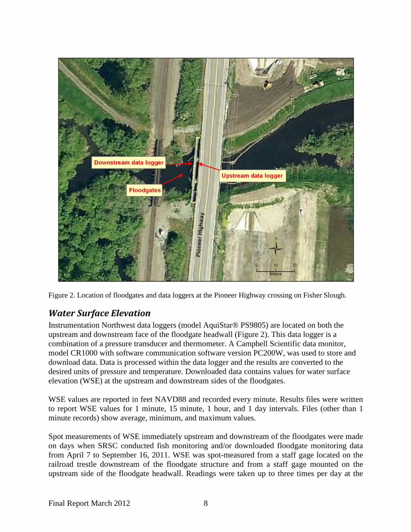
Methods This section describes collection methods for each data type. Onsite data loggers (e.g., level loggers, potentiometers) were used to collect data immediately upstream and downstream of the Fisher Slough floodgates (Figure 2). Data types reported are water surface elevation and floodgate door angle openness. Water temperature measurement was integrated with loggers used to measure water surface elevation, but we do not report water temperature results in this floodgate operations report.
Final Report March 2012 8
Figure 2. Location of floodgates and data loggers at the Pioneer Highway crossing on Fisher Slough.
Water Surface Elevation Instrumentation Northwest data loggers (model AquiStar® PS9805) are located on both the upstream and downstream face of the floodgate headwall (Figure 2). This data logger is a combination of a pressure transducer and thermometer. A Campbell Scientific data monitor, model CR1000 with software communication software version PC200W, was used to store and download data. Data is processed within the data logger and the results are converted to the desired units of pressure and temperature. Downloaded data contains values for water surface elevation (WSE) at the upstream and downstream sides of the floodgates. WSE values are reported in feet NAVD88 and recorded every minute. Results files were written to report WSE values for 1 minute, 15 minute, 1 hour, and 1 day intervals. Files (other than 1 minute records) show average, minimum, and maximum values. Spot measurements of WSE immediately upstream and downstream of the floodgates were made on days when SRSC conducted fish monitoring and/or downloaded floodgate monitoring data from April 7 to September 16, 2011. WSE was spot-measured from a staff gage located on the railroad trestle downstream of the floodgate structure and from a staff gage mounted on the upstream side of the floodgate headwall. Readings were taken up to three times per day at the

Final Report March 2012 9
start of the ebb, during the ebb, and near low tide as the fish monitoring crew traveled up and down the slough during their fish sampling day. Spot measurement results were plotted against the WSE recorded by the floodgate monitoring data logger to check logger accuracy.
Floodgate Door Angle Openness Precision Sales Inc. potentiometers (model SP030B) were used to measure floodgate door angle openness for each of the three floodgate doors (Figure 3). Potentiometers are mounted near the top of the hinge on each floodgate door. A Campbell Scientific data monitor, model CR1000 with the software version PC200W, was used to store and download the data. Downloaded data contains values for the angle of openness for each floodgate door in degrees. Completely closed doors have a measurement angle of zero degrees. Doors completely open (i.e., at a right angle to the face of the floodgate bulkhead wall) measure 90 degrees. Data were recorded every minute. Results files were written to report floodgate door angle openness values for 1 minute, 15 minute, 1 hour, and 1 day intervals. Files (other than 1 minute records) show average, minimum, and maximum values.
Figure 3. Fisher Slough floodgate doors. Spot checks of floodgate door angle openness were made between April 7 and September 6, 2011, on each day that fish monitoring occurred. A protractor was constructed to measure door angle openness (Figures 4 and 5), to be compared to data logger results for the same door and

Final Report March 2012 10
time. The protractor is a 180-degree half circle with a 2-foot radius, mounted on an 8-foot 2”x 2” pole. A brace at the base of the pole ensured that the pole remained perpendicular to the base. A 2”x 2” shim mounted along the base helped hold the protractor away from the door jam. Spot measurement results were plotted against the floodgate door angle openness recorded by data loggers to check logger accuracy.
Figure 4. Protractor in use at the north floodgate door.

Final Report March 2012 11
Figure 5. View from the top of the protractor on the north floodgate door. Door angle openness in this instance is 35 degrees.
Water Velocity Spot measurements of water velocity at each floodgate door were made on days SRSC conducted fish monitoring from April 7 through June 20, 2011. Water velocity measurements were taken just below the water surface using a Swoffer Model 2100 for each of the three floodgate doors. Depending on the width of floodgate door opening, 2 to 5 velocity measurements were taken across the width of each door opening. Measurements were taken up to three times per day at the start of the ebb (just after high tide), during the ebb, and close to low tide as the fish monitoring crew traveled up and down Fisher Slough during their fish sampling day. These water velocity measurements were averaged for each door and time period sampled. Velocity measurements were never taken when water current direction was flowing upstream.
Water Depth The water depth across the sill or opening of the floodgate doors was calculated from WSE results described above. The minimum water depth criteria stated in the HPA for the Spring Juvenile Chinook Migration period is 0.5 feet over the top of the sill at a low tide period. The

Final Report March 2012 12
elevation of the sill is 4.3 feet NAVD88 so the minimum elevation requirement is met with a WSE level of 4.8 feet NAVD88 or greater. WSE data from the upstream pressure transducer was used for these calculations.
Floodgate Operation In WY 2011, the floodgates were operated according to the Draft Operations and Maintenance Plan, including during flood contingency operating periods. The only deviation to standard operations resulted from construction and restoration activities at the site in October 2010 and between June and October 2011. A summary of floodgate setting changes by date and reasons for the changes is provided in Appendix 1 Table 1. Beginning in December 2010, floodgate monitoring equipment was calibrated monthly, always during a high tide or high Skagit River flow event (Appendix 1 Table 2).
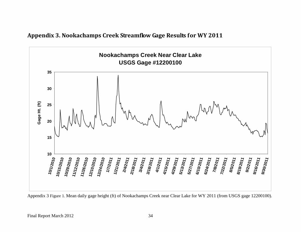
Skagit River and Nookachamps Creek Gage Height Because Skagit River flows influence WSE at Fisher Slough, predictions of Skagit River gage height is a condition of floodgate management at Fisher Slough at all time periods of the year. Allowances are made under the HPA rules to disengage the floodgate doors when the Skagit River is predicted to rise above 28 ft NAVD88 at the USGS gage at Mount Vernon, WA. This floodgate management practice protects areas upstream of the floodgate site from Skagit River backwater flooding. We included in this report Skagit River gage height results for WY 2011 (Appendix 2 Table 1 and Figure 1) to compare with changes to floodgate operation settings (recorded in the operations log), although the actual measured river levels (http://waterdata.usgs.gov/wa/nwis/uv/?station=12200500) do not always match the predicted river levels. Several lowland watersheds (Carpenter Creek and tributaries, Fisher Creek and tributaries) also contribute to water level and flow rates in Fisher Slough from areas upstream of the floodgate site. There are no real-time stream gages in these watersheds, but Nookachamps Creek (located immediately east of Carpenter Creek and Fisher Creek watersheds) does have a real-time stream gage. We used Nookachamps Creek stream gage height data (http://waterdata.usgs.gov/wa/nwis/uv/?station=12200100) for WY 2011 as a surrogate for relative stream flow for watersheds upstream of the floodgate site (Appendix 3 Figure 1).
Analysis Methods This section describes analysis methods performed on floodgate monitoring data to determine whether HPA criteria described in Table 1 were met for each management period in WY 2011. Due to observed limits in the data logger measurement resolution for floodgate door angle openness, we used a minimum of 5 degrees as the threshold for a floodgate door to be considered ‘open’ (personal communication with Kris Knight, email of March 24, 2011).
Fall/Winter Flood Control Period The Fall/Winter Flood Control period is from October 1 through February 28/29. The Fisher Slough floodgates were operated three different ways during this period in WY 2011: 1) construction, 2) normal, and 3) flooding.

Final Report March 2012 13
During construction activities for Fisher Slough restoration between October 1 and October 13, 2010 the float was disengaged and floodgate doors operated as a gravity system. After the construction period concluded, the floodgates were returned to the normal Fall/Winter Flood Control criteria, with doors set to close when WSE downstream of the floodgates was greater than 7.5 ft NAVD88. During the flooding period, when Skagit River flow was predicted to be higher than 28 ft (based on NOAA Hydrologic Prediction Service), the float was disengaged and the floodgate was operated as a gravity system to prevent backwater flooding within the Fisher Slough and Hill Ditch areas. Due to the prediction of a significant flooding threat in December 2010, the floodgate float was disengaged and operated as a gravity system to prevent backwater flooding upstream of floodgates starting on December 11, 2010 and lasting for 30 days. Normal floodgate operation settings for the Fall/Winter Flood Control Period were then re-established on January 10, 2011. Only one HPA criterion is specified in Table 1 for the Fall/Winter Flood Control Period: minimum floodgate closure setting. Therefore, we calculated:
• Percent of time WSE was less than 7.5 ft NAVD88 immediately downstream1
Though not specified as criteria in the HPA but relevant to fish passage (especially upstream movement of adult salmon), we also calculated the following statistics during the flooding and normal periods described above:
of the Fisher Slough floodgate structure and at least one of the three floodgate doors was open
• Percent of time doors were open • Average (and standard deviation) of floodgate door angle openness in degrees (only for
observations when doors were open)
Spring Juvenile Chinook Salmon Migration Period The Spring Juvenile Chinook Migration period is from March 1 through May 31. During the Spring Juvenile Chinook Migration period there was no high flow event for WY 2011, so the floodgate float remained engaged. According to the HPA for this period there are four criteria to evaluate (Table 1): 1) floodgate door openness, 2) minimum floodgate closure setting 3) water depth, and 4) water velocity. Therefore, we calculated:
• Percent of time WSE was less than 9.5 ft NAVD88 immediately downstream1 of the Fisher Slough floodgate structure and at least one of the three floodgate doors was open
• Percent of time doors were open • Average (and standard deviation) of floodgate door angle openness in degrees (only for
observations when doors were open) • Average water velocity by floodgate door, tidal stage, and date
1 Although the float mechanism triggering door closure is on the upstream side of the floodgate headwall, the cause and need for door closure is from backwater flooding, either tidal or Skagit River discharge, which comes from the downstream side of the headwall. Thus, we used WSE results on the downstream side of the headwall to calculate results for this HPA criterion. Independent of gate closure setting level, floodgate doors are always capable of opening to drain water in the downstream direction due to head or water pressure differences created by runoff from the upstream side of the headwall.
Final Report March 2012 14
• Percent of time water depth across the floodgate sill was greater than 0.5 feet • Average (and standard deviation) depth of water over the floodgate sill
Though not specified as criteria in the HPA but relevant to fish passage (especially upstream movement of juvenile salmon), we calculated two simplified tidal stages (ebb and non-ebb, which includes flooding and slack periods) for all floodgate data (WSE and door openness). We then stratified floodgate door openness (i.e., percent of time doors are open, door angle openness) by these tidal stages to better link floodgate results to upstream movement potential of juvenile salmon. Water depth criteria and door angle openness were fully evaluated per the HPA criteria. However, due to a lack of available funding, only spot measurements of water velocity through the floodgate were collected; therefore velocity estimates were calculated with limited data stratified by tidal stage (ebb and non-ebb).
Summer Irrigation Period The Summer Irrigation period is from June 1 through September 30 each year. Only one HPA criterion is specified in Table 1: floodgates are to remain open during this time period. However, with WDFW HPA approval, in WY 2011 the floodgates were not operated according to standard summer operations, due to restoration construction activities. The floodgates were operated two different ways during the Summer Irrigation period: 1) between June 1 and June 27 floodgate doors were set to close when WSE > 9.5 ft NAVD88; and 2) between June 27 and September 30 the floodgates were operated as a gravity system while Fisher Slough restoration construction occurred. Construction activities were completed in October 2011 and floodgates will be operated per standard summer operations in WY 2012. Therefore, we calculated:
• Floodgate door opening o Percent of time doors were open:
When operated as ‘Spring Juvenile Chinook Migration period’ When operated as ‘gravity system’
o Average (and standard deviation) of floodgate door angle openness in degrees (only for observations where doors were open): When operated as ‘Spring Juvenile Chinook Migration period’ When operated as ‘gravity system’
Instrument Measurement Accuracy In this section we report results from comparisons of field-based spot observations to data logger measurements to determine instrument measurement accuracy. We compare floodgate door angle openness for all three floodgate doors (north, middle, south) and water surface elevation both upstream and downstream of the floodgate structure.
Floodgate Door Angle Openness Data loggers measuring floodgate door angle openness were consistent with field observation using a protractor for the north and middle floodgate doors, but not the south door (Figure 6). Data loggers monitoring the south door consistently reported door openness angle less than what it really was and even recorded the door was closed when it was not.

Final Report March 2012 15
Per both TNC and SRSC field observations of door function, the south door appears to open and close most similarly to the middle door. For this report, door angle openness results for the middle floodgate door best represent the south floodgate door; however instrumentation on the south floodgate door should be repaired.
y = 1.0642xR² = 0.9778
0
10
20
30
40
50
60
70
80
0 10 20 30 40 50 60 70 80data
mon
itor
reco
rded
deg
ree
of o
penn
ess
measured degree of openness
Angle Open Middle Door
y = 1.015xR² = 0.9958
0
10
20
30
40
50
60
70
80
0 10 20 30 40 50 60 70 80
date
mon
itor r
ecor
ded
degr
ee o
f ope
nnes
s
measured degree of openness
Angle Open North Door
y = 0.3352xR² = 0.6053
0
10
20
30
40
50
60
70
80
0 10 20 30 40 50 60 70 80
data
mon
itor
reco
rded
deg
ree
of o
penn
ess
measured degree of openness
Angle Open South Door
Figure 6. Floodgate door angle openness at Fisher Slough showing comparison of data monitor-recorded degree of openness (y-axis) to measured angle openness using a protractor (x-axis) for each of the three floodgate doors. Solid blue lines are 1:1 ratio, dashed lines are regression lines, and blue diamonds are field observations of angle openness versus angle openness recorded by floodgate data logger.

Final Report March 2012 16
Water Surface Elevation Spot measurements of WSE observed on staff gages upstream and downstream of the Fisher Slough floodgate indicate that data logger (level logger-based) calculations of WSE are accurate and within an approximate ±0.1 foot resolution at both upstream and downstream sites (Figure 7).
y = 1.0029xR² = 0.9963
5
6
7
8
9
10
11
5 6 7 8 9 10 11
Reco
rded
WSE
NAV
D88
ft
Observed gage height NAVD88 ft.
A. Fisher Slough WSE comparison at downstream side of floodgate
y = 1.0071xR² = 0.9939
5
6
7
8
9
10
11
5 6 7 8 9 10 11
Reco
rded
WSE
NAV
D88
ft
Observed gage height NAVD88 ft.
B. Fisher Slough WSE comparison at upstream side of floodgate
Figure 7. Comparison of observed staff gage height (x-axis) and data logger-measured values (y-axis) of WSE immediately downstream (panel A) and upstream (panel B) of the floodgate at Fisher Slough in 2011. Solid blue lines are 1:1 ratio, dashed lines are regression lines, and blue diamonds are field
Final Report March 2012 17
observations of gage height versus WSE recorded by floodgate data logger. Spot measured WSE observations were recorded prior to any recalibration of floodgate door monitoring equipment. Log of recalibrations are shown in Appendix 1, Table 2.
Floodgate Operations Results In this section we describe floodgate monitoring results by floodgate operation periods identified in Table 1.
Fall/Winter Flood Control Period October 1, 2010 – February 28, 2011 In-stream construction at Fisher Slough was finished on October 13, 2010 and normal floodgate operation settings for the Fall/Winter Flood Control period were resumed at that time. Floodgates were set to close at 7.5 feet NAVD88 according to HPA criteria shown in Table 1. Floodgates were operated in flood control mode during December and January. Data from floodgate monitoring equipment were downloaded on Feb. 28, 2011 and at that time batteries were changed. The settings for WSE should have been re-calibrated at that time but this step was forgotten. This omission was noticed when floodgate settings were changed for the Spring Juvenile Chinook Migration period on March 1, 2011. This resulted in 9.5 hours of inadequate data for the Fall/Winter Flood Control period (not used in the following calculations).
Floodgate Door Openness During normal operation period, the percent of time WSE was less than 7.5 ft NAVD88 immediately downstream of the Fisher Slough floodgate structure and at least one of the three floodgate doors was open = 100%2
• Percent of time north door was open:
Door openness results for each door are:
o During flooding period = 72.50% o During normal period = 82.30%
• Percent of time middle door was open: o During flooding period = 48.60% o During normal period = 63.13%
• Mean door angle openness (and standard deviation) by door and period, and number of observations
o North door (when door was open): During flooding period = 38.6 (20.3) degrees, n=31,661 During normal period = 34.8 (19.3) degrees, n=127,496
o Middle door (when door was open): During flooding period = 32.2 (18.3) degrees, n=21,248 During normal period = 26.6 (14.9) degrees, n=97,632
2 Based on observed instrument measurement resolution shown in Figure 7, we used the WSE criterion (7.5 ft NAVD88) plus 0.1 feet to calculate this statistic.

Final Report March 2012 18
Spring Juvenile Chinook Salmon Migration Period March 1, 2011 – May 31, 2011
Floodgate Door Openness The floodgates were set to close at 9.5 ft NAVD88 for the entire operating period. During normal operation period, the percent of time WSE was less than 9.5 ft NAVD88 immediately downstream of the Fisher Slough floodgate structure and at least one of the three floodgate doors was open = 99.3%3
o North door (when door was open):
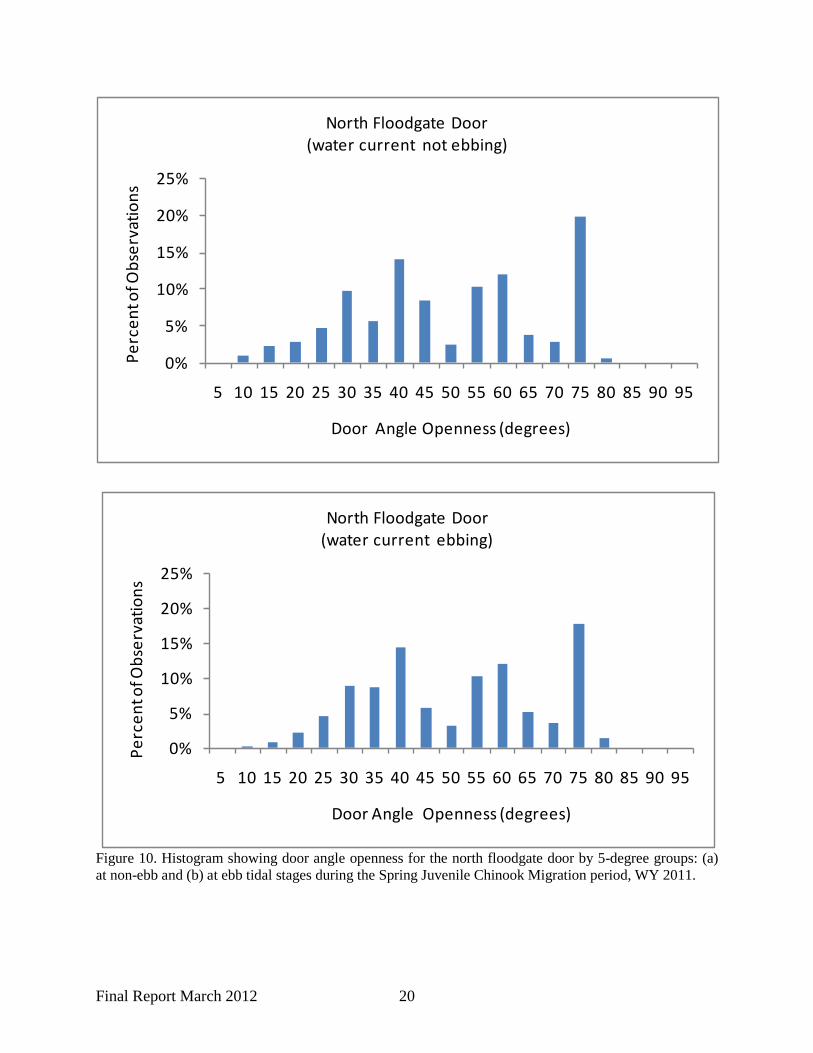
Overall, the north and middle doors were open 92.3% and 93.4% of the time, respectively (Figure 8). A breakdown of the percent of time doors were either open or closed by tidal stage is shown in Figure 9. Mean door angle openness (and standard deviation) by door and tidal stage, and number of observations:
During ebb conditions = 46.5 (19.8) degrees, n=63,483 During non-ebb conditions = 43.1 (22.4) degrees, n=68,028
o Middle door (when door was open): During ebb conditions = 40.1 (17.6) degrees, n=63,483 During non-ebb conditions = 33.5 (18.5) degrees, n=68,028
Frequency distributions of door angle openness by tidal stage are shown in Figures 10 and 11.
Water Velocity Water velocity was spot-measured 15 times from April 7 to June 20, 2011 (Figure 12). Water velocity ranges varied by tidal stage as follows:
• High tide = 0.00-0.93 ft/sec • Small ebb flows ( ~0.5 ft drop in WSE) = 0.43-0.64 ft/sec • Larger ebb flows (2-3 ft drops in WSE) = 1.20-1.80 ft/sec
Water Depth We found water depth across the floodgate sill was greater than 0.5 ft 100% of the time. Average (and standard deviation) of water depth across the floodgate sill was 3.9 (1.3) feet.
3 Based on observed instrument measurement resolution shown in Figure 7, we used the WSE criterion (9.5 ft NAVD88) plus 0.1 feet to calculate this statistic.

Final Report March 2012 19
6.64%
93.36%
Middle Floodgate Door
7.31%
92.69%
North Floodgate Door
Door closed Door open
Figure 8. Percent of time Fisher Slough floodgate doors are open or closed for all tidal periods during the Spring Juvenile Chinook Migration period, WY 2011.
46.58%
5.14%
46.11%
2.16%
North Floodgate Door
Non-ebb, Door open
Non-ebb, Door closed
Ebb, Door open
Ebb, Door closed
46.94%
4.78%
46.41%
1.86%
Middle Floodgate Door
Figure 9. Percent of time Fisher Slough floodgate doors are open or closed by tidal stage during the Spring Juvenile Chinook Migration period, WY 2011.
Final Report March 2012 20
0%
5%
10%
15%
20%
25%
5 10 15 20 25 30 35 40 45 50 55 60 65 70 75 80 85 90 95
Perc
ent o
f Obs
erva
tions
Door Angle Openness (degrees)
North Floodgate Door(water current not ebbing)
0%
5%
10%
15%
20%
25%
5 10 15 20 25 30 35 40 45 50 55 60 65 70 75 80 85 90 95
Perc
ent o
f Obs
erva
tions
Door Angle Openness (degrees)
North Floodgate Door(water current ebbing)
Figure 10. Histogram showing door angle openness for the north floodgate door by 5-degree groups: (a) at non-ebb and (b) at ebb tidal stages during the Spring Juvenile Chinook Migration period, WY 2011.
Final Report March 2012 21
0%
5%
10%
15%
20%
25%
5 10 15 20 25 30 35 40 45 50 55 60 65 70 75 80 85 90 95
Perc
ent o
f Obs
erva
tions
Door Angle Openness (degrees)
Middle Floodgate Door(water current not ebbing)
0%
5%
10%
15%
20%
25%
5 10 15 20 25 30 35 40 45 50 55 60 65 70 75 80 85 90 95
Perc
ent o
f Obs
erva
tions
Door Angle Openness (degrees)
Middle Floodgate Door(water current ebbing)
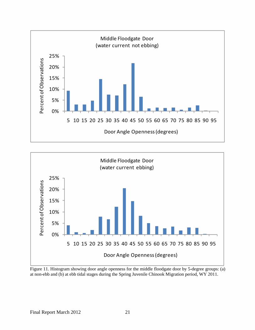
Figure 11. Histogram showing door angle openness for the middle floodgate door by 5-degree groups: (a) at non-ebb and (b) at ebb tidal stages during the Spring Juvenile Chinook Migration period, WY 2011.

Final Report March 2012 22
6
7
8
9
10
11
12:00:00 AM 6:00:00 AM 12:00:00 PM 6:00:00 PM 12:00:00 AM
Wat
er Su
rfac
e El
evat
ion
NAVD
88 fe
etWSE at Fisher Slough floodgates on April 7, 2011
WSE Downstrream of floodgate
avg velocity = 1.80 ft/sec
5
6
7
8
9
10
11
12:00:00 AM 6:00:00 AM 12:00:00 PM 6:00:00 PM 12:00:00 AM
Wat
er Su
rfac
e El
evat
ion
NAVD
88 fe
et
WSE at Fisher Slough floodgates on April 22, 2011
WSE Downstrream of floodgate
avg velocity = 0 ft/secavg velocity = 0.38 ft/sec
avg velocity = 1.12 ft/sec
6
7
8
9
10
11
12:00:00 AM 6:00:00 AM 12:00:00 PM 6:00:00 PM 12:00:00 AM
Wat
er Su
rfac
e El
evat
ion
NAVD
88 fe
et
WSE at Fisher Slough floodgates on May 7, 2011
WSE Downstrream of floodgate
avg velocity = 0.93 ft/secavg velocity = 1.35 ft/sec
avg velocity = 1.37 ft/sec
6
7
8
9
10
11
12:00:00 AM 6:00:00 AM 12:00:00 PM 6:00:00 PM 12:00:00 AM
Wat
er Su
rfac
e El
evat
ion
NAVD
88 fe
et
WSE at Fisher Slough floodgates on June 7, 2011
WSE Downstrream of floodgate
avg velocity = 0.00 ft/sec
avg velocity = 0.60 ft/sec
6
7
8
9
10
11
12:00:00 AM 6:00:00 AM 12:00:00 PM 6:00:00 PM 12:00:00 AM
Wat
er Su
rfac
e El
evat
ion
NAVD
88 fe
et
WSE at Fisher Slough floodgates on June 20, 2011
WSE Downstrream of floodgate
avg velocity = 0.00 ft/sec
avg velocity = 0.43 ft/sec avg velocity = 0.17 ft/sec
6
7
8
9
10
11
12:00:00 AM 6:00:00 AM 12:00:00 PM 6:00:00 PM 12:00:00 AM
Wat
er Su
rfac
e El
evat
ion
NAVD
88 fe
et
WSE at Fisher Slough floodgates on May 23, 2011
WSE Downstrream of floodgate
avg velocity = 0.43 ft/sec
avg velocity = 0.64 ft/sec
avg velocity = 0.50 ft/sec
Figure 12. Average velocity measured at floodgate doors at Fisher Slough on fish sampling days. The value shown is the combined average velocity taken at all three of the doors on each day. High flow conditions at Fisher Slough on May 7 and May 23 make the velocity higher for all tidal stages those days.

Final Report March 2012 23
Summer Irrigation Period June 1, 2011 – September 30, 2011
Floodgate Door Openness The floodgates were operated differently for the Summer Irrigation Period during WY2011 than in other years due to construction dewatering. They were set at 9.5 ft. NAVD88 (Spring Juvenile Chinook Migration period) or as a gravity system. Overall, the north and middle doors were open 16.2% and 13.7% of the time, respectively. Breakdown of the percent of time doors were open by period:
• Percent of time north door was open: o When operated as ‘Spring Juvenile Chinook Migration period’ = 74.28% o When operated as ‘gravity system’ = 5.90%
• Percent of time middle door was open: o When operated as ‘Spring Juvenile Chinook Migration period’ = 62.73% o When operated as ‘gravity system’ = 0.41%
Mean door angle openness (and standard deviation) by door and period, and number of observations:
o North door (when door was open): When operated as ‘Spring Juvenile Chinook Migration period’ = 13.3 (4.3)
degrees, n=38,262 When operated as ‘gravity system’ = 7.9 (1.3) degrees, n=137,414
o Middle door (when door was open): When operated as ‘Spring Juvenile Chinook Migration period’ = 12.4 (4.3)
degrees, n=38,262 When operated as ‘gravity system’ = 6.4 (1.9) degrees, n=38.262
Discussion, Conclusions, & Recommendations
Comparison of Floodgate Results with HPA Criteria In this section we discuss how well Fisher Slough floodgate operation in WY 2011 met defined HPA criteria for the site.
Fall/Winter Flood Control Period Fisher Slough floodgate HPA criteria were met for the Fall/Winter Flood Control period in WY 2011. Only one HPA criterion is defined for this period: minimum floodgate closure elevation. Minimum floodgate closure elevation: Under normal operation during this period (i.e., not flooding periods), the floodgates should have a minimum closure setting of 7.5 ft NAVD88. This means when WSE was less than 7.5 ft NAVD88 immediately downstream of the Fisher Slough floodgate structure, at least one of the three floodgate doors should have been open. We found this to be true 100% of the time.

Final Report March 2012 24
The percent of time floodgates were open during the flooding period seems high; however, the gates were likely open due to a high volume of tributary runoff, which raised water levels in the slough and exerted water pressure on the upstream side of the floodgates. The Nookachamps Creek stream gage results (Appendix 3, Figure 1) suggest peaks in runoff from the Carpenter and Fisher Creek watersheds coincided with Skagit River condition that triggered management of the floodgates as a flooding period.
Spring Juvenile Chinook Salmon Migration Period Fisher Slough floodgate HPA criteria were met for the Spring Juvenile Chinook Salmon Migration period in WY 2011. Four HPA criteria are defined for this period: minimum floodgate closure elevation, percent of time floodgate doors are open, water velocity, and water depth. Minimum floodgate closure elevation: Under normal operation during this period (i.e., not flooding periods), the floodgates should have a minimum closure setting of 9.5 ft NAVD88. This means when WSE was less than 9.5 ft NAVD88 immediately downstream of the Fisher Slough floodgate structure, at least one of the three floodgate doors should have been open. We found this to be true 99.3% of the time. Percent of time floodgate doors are open: Floodgate doors were open more than 90% of the time (the HPA criterion for door openness) during the Spring Juvenile Chinook Migration period. The north door was open 92% and the middle door was open 93% of the time. Water velocity: Our 15 different spot measurements of water velocity suggest that water velocities at the Fisher Slough floodgates did not likely exceed the 8 ft/sec HPA criteria. Water depth
Summer Irrigation Period
: The water depth criterion of not less than 0.5 ft of water over the floodgate sill for more than 10% of the time was met. In fact, water depth never was less than 0.5 ft; average water depth during this management period was 3.9 feet of water over the sill and the minimum depth was 1.4 feet across the sill.
Only one HPA criterion is defined for the Summer Irrigation period: percent of time floodgate doors are open. Percent of time floodgate doors are open: Floodgates were open 14 to 16% of the time during this period (depending on which door). The criterion for floodgates to be open 100% of the time during this period does not apply to WY 2011 per WDFW approval due to habitat restoration construction activities occurring within the site. Between June 27 and September 30, 2011, the floodgates operated as a gravity system. Because water was diverted out of Fisher Slough for construction purposes, there was no flow to push the gates open and so they remained closed. This explains the extremely low values for percentage of time that floodgate doors were open during this period (0.4% - 6.0%, depending on which door).

Final Report March 2012 25
Appropriateness of HPA Criteria This section discusses issues with current HPA criteria for future monitoring and adaptively managing Fisher Slough floodgate operation, if necessary, to achieve and balance the site’s multiple objectives of fish passage, flood protection, drainage, and irrigation.
Adult Salmon It is unknown whether the HPA criteria adequately meet upstream fish passage needs of migrating adult salmon because no direct monitoring of adult salmon fish passage at the floodgate is done. It is assumed adult salmon are passing through the floodgates and spawning successfully in watersheds associated with Fisher Slough because young of year coho salmon have been caught by beach seine upstream of the floodgates in all years of fish monitoring in the vicinity of the floodgates (Beamer et al. 2010, Beamer et al. 2011). Also, our water velocity results, measured in transition areas (i.e., door opening) on ebb tides, are lower than velocity criteria specified for adult salmon upstream passage within culverts for Washington, Oregon, and British Columbia (criteria cited in Giannico and Souder 2005). Additional monitoring (e.g., spawner surveys, tracking tagged adult salmon) could be implemented to investigate adult salmon fish passage; however, we believe this is not currently a high priority for Fisher Slough monitoring.
Juvenile Salmon All Fisher Slough floodgate HPA criteria were met for the Spring Juvenile Chinook Migration period in WY 2011. These criteria are related to: 1) water depth, 2) water velocity, and 3) floodgate door openness. However, we are concerned whether specific values of some HPA criteria are appropriate for a conclusion that juvenile salmon upstream passage opportunity is adequate when HPA conditions are met. Therefore, we offer the following discussion to help with future monitoring and floodgate operation at the site. Water Depth The HPA depth criterion was exceeded in WY 2011 a hundred percent of the time. Minimum water depth is likely not a juvenile Chinook salmon fish passage problem at Fisher Slough floodgates even though the 0.5 ft HPA depth criterion is shallow for juvenile Chinook salmon presence in Skagit estuary habitat (Beamer et al. 2005). Fisher Slough floodgates are attached to a headwall adjacent to a highway bridge which is different than gates attached to a culvert which would be the length of the highway’s width (approx. 10-12 meters). Juvenile Chinook salmon moving past Fisher Slough’s floodgates only need to slip over a narrow headwall not navigate the length of a culvert. Deeper depth criteria may be more important in flood and tide gates systems using culverts rather than headwalls. Water Velocity Our 15 different spot measurements of water velocity suggest that water velocities at the Fisher Slough floodgates were not likely exceeding the 8 ft/sec HPA criterion. However, the criterion may not be appropriate for upstream passage of juvenile salmon, especially fry-sized Chinook salmon.
Final Report March 2012 26
Upstream juvenile salmon movement potential during ebb periods will depend on fish size and water velocity magnitude. If water velocity exceeds a fish’s swimming ability, then the fish cannot move upstream. Fish also may exhibit a behavioral response against moving upstream on ebbing (downstream) flows. For example, while fish may physically be capable of swimming against the current, behaviorally they may not respond with upstream movement. If this behavior in fish occurs, then fish passage opportunity is not realized under this type of flow condition. Generally, we expect fry sized juvenile salmon to disperse within estuaries based on water current direction, with the capability to swim against the current for short distances to realize important ecological functions such as foraging or to avoid predation. Our spot measurements of water velocity in Fisher Slough on the larger ebb flows (1.20-1.80 ft/sec for 2-3 ft drops) exceed velocities correlated with juvenile Chinook salmon rearing in the Skagit estuary (0.20 m/sec or 0.66 ft/sec; Beamer et al. 2005, Figure D.II.3, page 58 ). Other researchers have found results similar to Beamer’s in both lab and field studies. Macdonald et al. (1987) suggest water current speeds of 0.40-0.60 m/sec (1.31-1.97 ft/sec) are too strong to be favorable for juvenile wild Chinook. Flagg and Smith (1979) found, in a laboratory setting, that critical fatigue swimming speed was estimated to be 0.27 m/sec (0.89 ft/sec) for small juvenile Chinook (45 mm fork length). In 1999, Bates (cited in Giannico and Souder 2005) recommended a maximum water velocity for structures like floodgates of 1.3 ft/sec (0.4 m/sec) to enable juvenile salmon longer than 60 mm in fork length to migrate upstream, and that the maximum be only 1.1 ft/sec (0.43 m/sec) for fry less 60 mm in fork length. It is likely that water velocity conditions on ebb tides (especially larger ebbs) at the Fisher Slough floodgates do not allow for upstream movement of fry-sized Chinook salmon, even when floodgate doors are open. We recommend monitoring water velocity as part of the floodgate monitoring plan in order to better determine the conditions that allow juvenile salmon upstream migration potential. Water velocity should ideally be measured within the floodgate structure as well as in transition areas (i.e., door opening) and be stratified by tidal stage. Velocity monitoring should ideally include measurements within a nearby reference site (i.e., a channel without any hydraulic control structure). When is a Floodgate Door Open? The length of time a floodgate door is open and how wide that door is open likely relates to fish passage opportunity at floodgate sites. Fisher Slough floodgate HPA criteria related to door openness refer to when doors should be open and how long they should be open; we were not given any guidance on what qualifies as ‘open.’ In our methods, we described using a minimum door angle measurement of 5 degrees (equivalent to an opening width of slightly more than 10 inches) to define an ‘open’ floodgate door. The 5 degree value is greater than the 2.5 degree minimum door angle measurement used by Shannon-Wilson in their WY 2010 Fisher Slough Floodgate Monitoring Technical Memo. The final design recommendation report for Fisher Slough (Tetra Tech 2008) suggested “locations through which fish must swim must be at least 12 inches wide”, but this definition was apparently not included in Fisher Slough’s HPA.

Final Report March 2012 27
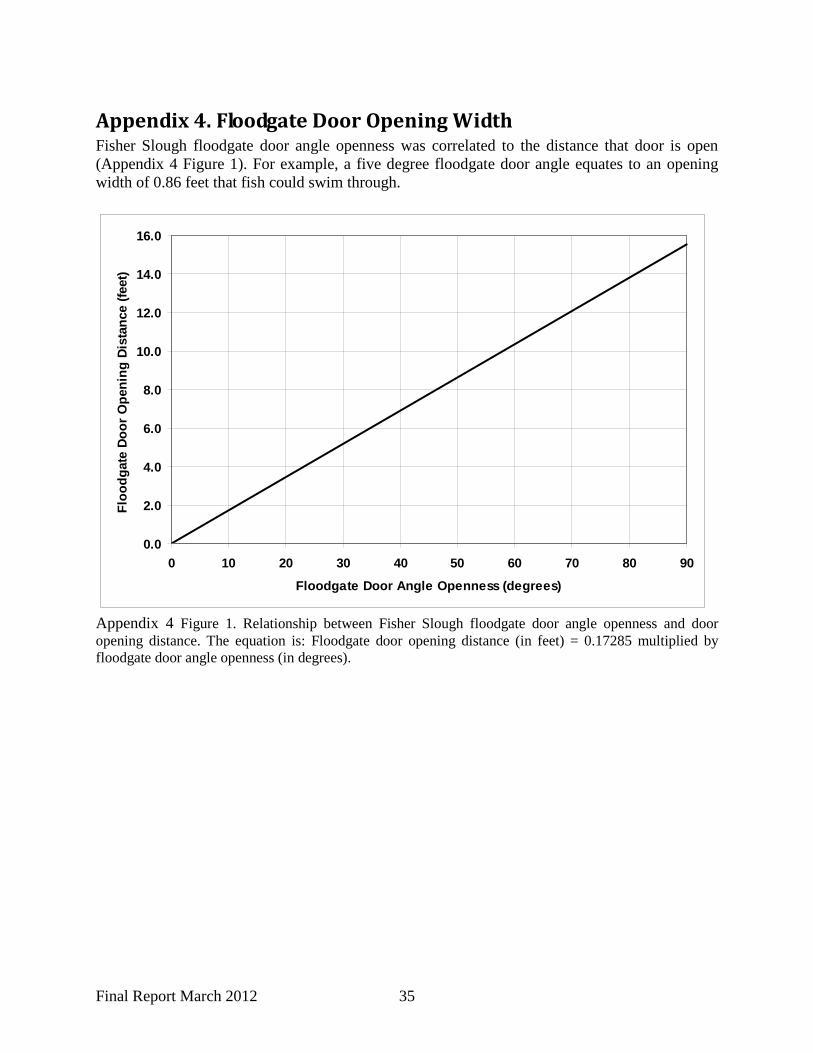
What is an appropriate amount of door openness for allowing upstream juvenile salmon passage opportunity? We do not currently have an answer to this question, but floodgate monitoring results coupled with fish monitoring results could, over time, give guidance. In order to discuss this question further, we offer the following way to summarize floodgate openness results in order to further quantify fish passage opportunity: Fisher Slough channel width averages approximately 58 ft in the vicinity of the floodgate structure. Floodgate door opening distance4 averaged: 7.5 ft, 5.8 ft, and 5.8 ft respectively for the north, middle, and south doors on non-ebb tidal stages in the Spring Juvenile Chinook Migration period. This means, on average, there is 19.1 feet of open water channel width within the 58 foot-wide channel; about 33% of the channel width is open for fish to find a way upstream. Does this average condition provide adequate opportunity for fish to find their way upstream? This condition is two-thirds less of an opportunity for fish, compared to channels without floodgate or any type of culvert structure. Not all conditions are average. Door angle openness varied from a minimum of 5 - 10 degrees to a maximum of 80 - 90 degrees, depending on which door and tidal stage (Figures 10 and 11). This translates roughly into an estimate that 4% to 75% of the channel width is open for fish to find a way upstream. These wide ranging conditions all qualify when calculating the percentage of time that floodgate doors are open and are assumed to provide fish passage opportunity. We recommend calculating a channel width standardized gate openness result, such as is described above as percent of the channel width that is open for fish to find a way upstream. This is especially important to complete in years when fish monitoring at the site occurs. Over time (and with other floodgate or tidegate monitoring sites) this type of result will help determine an appropriate criterion for door openness.
We believe the statistic “percentage of time floodgates are open during non-ebb flow periods” is a more accurate indicator of upstream juvenile salmon passage opportunity at the Fisher Slough floodgates because young fry-sized salmon are not likely to migrate against ebb flows. We recommend this statistic be calculated as part of future floodgate monitoring at Fisher Slough.
Percent of Time Floodgate Doors are Open On one end of the spectrum, juvenile Chinook salmon cannot move upstream through the floodgate structure when its doors are closed. This condition occurred about 7% of the time in WY 2011 (Figure 8). On the other end of the spectrum, juvenile Chinook salmon can move upstream through the floodgate structure when its doors are open and either: a) water flow is moving upstream, or b) has a velocity low enough to allow upstream fish movement. This condition occurred at Fisher Slough approximately 46% to 47% of the time (Figure 9) and coincides to non-ebb tidal stage periods. The 46% to 47% result may, or may not, be an appropriate target for upstream juvenile Chinook passage.
4 Average door angle openness results were converted to width using the regression equation shown in Appendix 4 Figure 1.

Final Report March 2012 28
Over time (and with other floodgate or tidegate monitoring sites) these results will help determine an appropriate criterion for “percent of time doors should be open.”
Flood Protection, Drainage, and Irrigation The Fisher Slough floodgates are designed to provide functions related to flood protection from backwater influence of the Skagit River, local watershed drainage capability and flood storage, and irrigation as well as fish passage. Floodgate HPA criteria were established with all these factors in mind. It is outside the scope of work for this monitoring report to present discussion of the non-fish objectives of the floodgate as they may be related to HPA criteria. However, it is necessary to understand the integration of all necessary functions the floodgate provides to the Fisher Slough area in order to adaptively manage floodgate operation and HPA criteria at this site.
References Bates, K. 1999. Flap gates. Pages 13-1–13-4 in Fishway design guidelines for Pacific salmon. Notes from fish passageways and diversion studies. USFWS, Keaneysville, West Virginia. Beamer, E, R Henderson, and K Wolf. 2010. Juvenile salmon, estuarine, and freshwater fish utilization of habitat associated with the Fisher Slough Restoration Project, Washington 2009. Skagit River System Cooperative, LaConner, WA. Available at www.skagitcoop.org/. Beamer, E, R Henderson, and K Wolf. 2011. Juvenile salmon, estuarine, and freshwater fish utilization of habitat associated with the Fisher Slough restoration project in 2010. Skagit River System Cooperative, LaConner, WA. Available at www.skagitcoop.org/. Beamer, E, A McBride, C Greene, R Henderson, G Hood, K Wolf, K Larsen, C Rice, and K Fresh. 2005. Delta and nearshore restoration for the recovery of wild Skagit River Chinook salmon: linking estuary restoration to wild Chinook salmon populations. Appendix to the Skagit Chinook Recovery Plan. Available at www.skagitcoop.org/. Flagg, TA, and LS Smith. 1979. Changes in swimming performance, critical fatigue levels, and metabolic rates during the parr-smolt transformation of Toutle (acclerated underyearling) coho salmon (Oncorhynchus kisutch). Appendix F in FY 1978-79 Report: Project 817, A study to assess status of smoltification and fitness for ocean survival of Chinook, coho, and steelhead. National Marine Fisheries Service, Seattle. Giannico, G. and J. Souder. 2005. Tidegates in the Pacific Northwest: operation, types, and environmental effects. Oregon Seagrant Report # T-05-001. 32 pages. Macdonald, JS, IK Birtwell, and GM Kruzynski. 1987. Food and habitat utilization by juvenile salmonids in the Campbell River estuary. Canadian Journal of Fisheries and Aquatic Science 44:1233-1246.

Final Report March 2012 29
Tetra Tech. 2008. Fisher Slough Final Floodgate Design Recommendations Report. Report to The Nature Conservancy, Skagit Field Office, Washington Chapter. 73 pages.

Final Report March 2012 30
Appendix 1. Fisher Slough Floodgate Operation Logs Appendix 1 Table 1. Operations and maintenance log for Fisher Slough floodgates in WY 2011 (October 1, 2010 through September 30, 2011).
Date Time
Name of person
completing work Change to float setting Period
10/1/2010
Float disengaged since August 16 to prevent water from entering construction area – preparing for siphon construction
Fall/
Win
ter f
lood
con
trol
10/13/2010 Dave Olson, Kris Knight
Float re-engaged after in-water construction completed and floodgates set to close at 7.5 ft NAVD88, per floodgate operation schedule and HPA permit (floodgates were to be back operating by Oct 15). Checked setting on 10/14/10 at high tide at Noon - water elevation upstream of gates between 7.4 and 7.5 NAVD88.
12/11/2010 morning Dave Olson, Darrin Morrison
Float hoisted up for flood protection with forecast of flooding on Skagit - Skagit was above flood stage 12/13/10 at nearly 30 ft.
1/10/2011 14:30 Dave Olson, Darrin Morrison
Float re-engaged after being raised because of flood threat when river rose above 28 ft. Setting remains where gates will close at or near 7.5 ft NAVD88
3/1/2011 15:30 Dave Olson and Kris Knight
Changed floodgate setting for Spring Chinook Migration Operational Setting so gates close at ~9.5 ft NAVD88.
Sprin
g ju
veni
le C
hino
ok m
igra
tion
3/2/2011 20:30 Kris Knight Lowered gate setting since the setting appeared to be too high when gates were observed propped open by arms at a water elevation at 10.5 the afternoon of 3/2/11
3/5/2011 05:15 Kris Knight Lowered gate setting since gates were still open at a 10.4 high tide. North gate much farther open than middle and south gates which where held open by arms
3/7/2011 06:15 Kris Knight Lowered gate setting again because gates still open at 10.4 high tide. After adjustment south and middle gates 0.5 degrees open but north gate still 50 degrees open
3/8/2011 06:30 Kris Knight Lowered gate setting 5 turns because south and middle gates were closed at upstream elevation of 9.8 ft NAVD88 (but north gate was still held open slightly - measuring 1.8 degrees open)
3/18/2011 15:30 Kris Knight Lowered gate setting since it still appears they are not closing soon enough
3/29/2011 15:45 Kris Knight Lowered gate setting since it still appeared gates were not closing soon enough
5/16/2011 12:25 Kris Knight Raised gate setting 4 turns after recently observing gates closing at water surface elevation upstream of gates at approximately 9.1 - 9.5 ft NAVD88
6/27/2011 Between 13:00 and
15:00
Dave Olson Float/gates were disengaged due to construction activities. They began taking down south levee and a 22 ft river was forecasted at Mt. Vernon. Per our agreement with WDFW, we were allowed to disengage gates in this situation.
Sum
mer
irrig
atio
n
9/30/2011 Float remained disengaged due to construction related activities

Final Report March 2012 31
Appendix 1 Table 2. Floodgate monitoring equipment calibration log.
Date Time Level Logger or Potentiometer Reading prior to
calibration Actual (staff gage or estimate of gate
angle openness) Reading after change in
calibration Staff
12/20/2010 16:00 downstream pressure transducer 10.91 10.7 10.65 KK
12/20/2010 16:00 upstream pressure transducer 10.56 10.3 10.3 KK
12/20/2010 16:15 north gate potentiometer (measured in degrees) 2.97 0 0.1 KK
12/20/2010 16:15 middle gate potentiometer (measured in degrees) 12.43 0 0.1 KK
12/20/2010 16:15 south gate potentiometer (measured in degrees) 0 0 0 KK
2/10/2011 09:15 downstream pressure transducer 9.15 9.25 9.25 KK/RH
2/10/2011 09:15 upstream pressure transducer 9.38 9.25 9.25 KK/RH
2/10/2011 09:15 north gate potentiometer (measured in degrees) 20 ~20 20 KK/RH
2/10/2011 09:15 middle gate potentiometer (measured in degrees) 0 ~5 0 KK/RH
2/10/2011 09:15 south gate potentiometer (measured in degrees) 2 ~5 2 KK/RH
2/28/2011 14:30 changed batteries and neglected to check water level calibration after changing batteries - water levels are incorrect between 2/28 at 14:30 and 3/1 at 15:05 KK/RH
3/1/2011 04:00 north gate potentiometer (measured in degrees) 8 8 8 KK
3/1/2011 04:00 middle gate potentiometer (measured in degrees) 0 2 2 KK
3/1/2011 04:00 south gate potentiometer (measured in degrees) 5 5 5 KK
3/1/2011 15:05 downstream pressure transducer 6.98 8.7 8.7 KK
3/1/2011 15:05 upstream pressure transducer 5.13 8.7 8.7 KK
3/1/2011 16:00 south gate potentiometer (measured in degrees) 0 - 6 ~37.5 37.5 KK
3/7/2011 06:15 north gate potentiometer (measured in degrees) 57.94 57 57.94 KK
3/7/2011 06:15 middle gate potentiometer (measured in degrees) 0.5 0.5 0.5 KK
3/7/2011 06:15 south gate potentiometer (measured in degrees) 40 0.5 0.5 KK
3/7/2011 06:15 downstream pressure transducer 10.62 10.35 10.35 KK
3/7/2011 06:15 upstream pressure transducer 10.35 10.35 10.35 KK
3/8/2011 06:30 middle gate potentiometer (measured in degrees) 0 0 0.1 KK
3/8/2011 06:30 south gate potentiometer (measured in degrees) 0.6 0 0.1 KK
3/17/2011 15:50 downstream pressure transducer 9.53 9.95 9.95 KK
3/21/2011 06:31 downstream pressure transducer 12.62 12.35 12.35 KK
3/21/2011 06:31 north gate potentiometer (measured in degrees) 1.98 0 0.1 KK
3/21/2011 06:31 middle gate potentiometer (measured in degrees) 0 0 0.1 KK
3/21/2011 06:31 south gate potentiometer (measured in degrees) 0.07 0 0.1 KK
3/22/2011 07:04 middle gate potentiometer (measured in degrees) 4.27 0 0.1 KK
3/23/2011 08:12 north gate potentiometer (measured in degrees) 0.79 0 0.1 KK
4/3/2011 18:05 downstream pressure transducer 9.76 9.7 9.76 RH
4/3/2011 18:05 upstream pressure transducer 9.7 9.7 9.7 RH
4/3/2011 18:20 north gate potentiometer (measured in degrees) 73.24 60 73.24 RH
4/3/2011 18:20 middle gate potentiometer (measured in degrees) 42.77 30 42.77 RH
4/3/2011 18:20 south gate potentiometer (measured in degrees) 18.26 30 18.26 RH
4/5/2011 07:25 downstream pressure transducer 10.3 10.3 10.3 RH
4/5/2011 07:25 upstream pressure transducer 10.3 10.3 10.3 RH
4/5/2011 07:28 north gate potentiometer (measured in degrees) 73.33 70 73.33 RH
4/5/2011 07:28 middle gate potentiometer (measured in degrees) 71.44 45 71.44 RH
4/5/2011 07:28 south gate potentiometer (measured in degrees) 21.61 45 21.61 RH
4/18/2011 18:20 north gate potentiometer (measured in degrees) 0 0 0.1 RH
4/18/2011 18:20 middle gate potentiometer (measured in degrees) 6.81 0 0.1 RH
4/18/2011 18:20 south gate potentiometer (measured in degrees) 2.15 0 0.1 RH
5/2/2011 10:04 downstream pressure transducer 6.14 6.4 6.14 RH
5/2/2011 10:04 upstream pressure transducer 6.37 6.4 6.37 RH
5/2/2011 10:04 north gate potentiometer (measured in degrees) 37 38.71 38.71 RH
5/2/2011 10:04 middle gate potentiometer (measured in degrees) 35 40.21 40.21 RH
5/2/2011 10:04 south gate potentiometer (measured in degrees) 45 12.96 12.96 RH
6/1/2011 17:25 middle gate potentiometer (measured in degrees) 0 0 0.01 RH
6/1/2011 17:30 downstream pressure transducer 9.3 9.3 9.3 RH
6/1/2011 17:31 upstream pressure transducer 8.7 8.7 8.7 RH
6/1/2011 17:32 north gate potentiometer (measured in degrees) 3.5 2.5 3.5 RH
6/1/2011 17:37 south gate potentiometer (measured in degrees) 0 0.01 0.01 RH
7/8/2011 09:27 downstream pressure transducer 10.02 10 10.02 RH
7/8/2011 09:27 upstream pressure transducer 10.02 10 10.02 RH
7/8/2011 09:29 north gate potentiometer (measured in degrees) 4.09 4 4.09 RH
7/8/2011 09:29 middle gate potentiometer (measured in degrees) 1.2 1 1.2 RH
7/8/2011 09:29 south gate potentiometer (measured in degrees) 0 2 0 RH
8/1/2011 09:30 downstream pressure transducer 7.45 9.1 9.00 RH
8/1/2011 09:30 upstream pressure transducer 5.52 5.45 5.45 RH
8/1/2011 09:30 north gate potentiometer (measured in degrees) 1.38 0 0.01 RH
8/1/2011 09:30 middle gate potentiometer (measured in degrees) 0.65 0 0.01 RH
8/1/2011 09:30 south gate potentiometer (measured in degrees) 0 0 0.01 RH
9/6/2011 12:10 downstream pressure transducer 6.44 6.3 6.44 RH
9/6/2011 12:13 upstream pressure transducer 5.15 5.1 5.15 RH
9/6/2011 12:20 north gate potentiometer (measured in degrees) 0.314 0 0.314 RH
9/6/2011 12:20 middle gate potentiometer (measured in degrees) 0 0 0 RH
9/6/2011 12:20 south gate potentiometer (measured in degrees) 2.53 0 2.53 RH

Final Report March 2012 32
Appendix 2. Skagit River Streamflow Gage Results for WY 2011 Appendix 2 Table 1. Daily average Skagit River gage height from the gage located at Mount Vernon, WA. Areas highlighted in yellow indicate days where the gage height exceeded the flood stage of 28 feet.
Fall/Winter flood Control Period Spring Juvenile Chinook
Migration Period Summer Irrigation Period Day of Month
Oct 2010
Nov 2010
Dec 2010
Jan 2011
Feb 2011
Mar 2011
Apr 2011
May 2011
Jun 2011
Jul 2011
Aug 2011
Sept 2011
1 15.02 16.5 16.13 15.05 17.55 15.61 22.31 14.13 18.01 22.34 19.67 14.09 2 13.98 20.33 15.43 15.08 17.12 14.62 20.37 13.97 18.17 21.32 18.96 13.79 3 13.21 18.6 14.98 15.05 16.8 14.65 18.65 14.21 18.22 21.54 18.67 13.91 4 12.88 16.44 14.58 15.18 17.61 14.8 17.39 14.20 18.58 21.46 18.52 14.20 5 12.72 15.87 14.32 14.95 19.8 15.14 17.50 14.10 19.44 20.83 18.69 13.45 6 12.3 15.74 14.32 14.82 18.9 14.93 17.07 14.39 20.46 20.76 18.67 14.31 7 12.18 17.72 14.22 16.95 19.14 14.83 16.47 16.01 21.59 21.71 18.48 14.32 8 11.94 18.35 15.11 17.22 19.04 14.79 15.70 16.97 21.45 21.68 17.91 14.33 9 11.9 17.09 17.93 16.42 18.09 14.88 15.33 16.59 20.63 20.61 17.78 14.47
10 16.02 16.06 18.35 15.99 17.68 16.02 14.95 16.35 19.70 19.54 17.68 14.49 11 19.85 15.36 17.28 15.72 17.18 17.4 15.55 16.01 19.68 18.88 17.38 14.53 12 16.74 15.26 21.68 15.65 17.03 16.71 15.49 16.91 19.60 18.62 17.16 14.51 13 15.09 14.53 29.25 17.06 17.76 16.58 14.87 16.30 19.29 18.74 16.99 14.30 14 14.55 14.76 26.76 21.59 17.71 18.03 14.62 15.95 20.48 19.33 16.98 14.19 15 14.86 15.51 22.63 23.82 18.3 17.84 14.59 18.04 20.24 19.34 16.80 13.49 16 14.7 19.41 20.03 24.23 17.92 18.22 14.65 19.37 19.43 20.00 16.08 12.99 17 15.33 19.45 18.67 29.21 17.31 17.69 15.14 18.59 19.34 20.70 16.11 12.87 18 15.07 18.68 16.97 28.59 17.11 17.33 14.91 18.09 18.55 20.36 15.85 12.72 19 15.26 17.51 16.66 23.77 16.82 16.49 14.57 17.39 19.16 20.66 15.70 12.77 20 14.55 16.7 16.47 20.99 16.54 15.49 14.34 17.23 19.38 20.45 15.67 12.83 21 14.75 16.02 15.73 20.69 16.52 15.6 14.14 18.00 19.57 20.65 15.83 12.71 22 14.4 15.55 15.04 21.02 16.51 14.95 13.34 18.11 20.54 21.28 16.05 12.62 23 14.14 15.44 15.06 19.96 16.47 15.16 13.50 17.78 21.06 20.45 16.35 13.14 24 14.91 15.05 15.22 19.37 16.31 14.78 13.94 17.62 21.04 19.83 16.54 14.44 25 16.63 14.87 15.59 19.99 16.1 14.69 14.13 17.34 20.16 20.18 15.65 14.04 26 18 14.93 15.72 19.33 15.98 14.97 14.42 17.83 19.24 20.14 15.99 13.08 27 16.67 15.09 15.64 18.87 15.97 14.67 14.48 17.81 18.91 19.16 15.44 16.42 28 16.01 14.94 15.62 18.53 16.06 14.51 14.54 17.64 19.81 18.32 15.43 16.18 29 15.74 14.68 15.5 19.25 14.5 14.43 16.87 20.95 18.42 14.74 15.04 30 15.16 14.86 15.35 19.31 16.22 14.18 16.56 22.46 18.96 14.94 13.77 31 15.8 15.06 18.77 21.42 16.57 19.42 14.66

Final Report March 2012 33
10
15
20
25
30
35
Gage
ht.
(ft)
Skagit River at Mount Vernon USGS Gage #1220500
flood stage at 28 ft
Appendix 2 Figure 1. Mean daily gage height (ft) for the Skagit River at Mount Vernon for WY 2011 (from USGS gage # 1220500). Red line shows the flood stage at 28 ft.
Final Report March 2012 34
Appendix 3. Nookachamps Creek Streamflow Gage Results for WY 2011
Nookachamps Creek Near Clear LakeUSGS Gage #12200100
10
15
20
25
30
35
10/1
/201
010
/15/
2010
10/2
9/20
1011
/12/
2010
11/2
6/20
1012
/10/
2010
12/2
4/20
101/
7/20
111/
21/2
011
2/4/
2011
2/18
/201
13/
4/20
113/
18/2
011
4/1/
2011
4/15
/201
14/
29/2
011
5/13
/201
15/
27/2
011
6/10
/201
16/
24/2
011
7/8/
2011
7/22
/201
18/
5/20
118/
19/2
011
9/2/
2011
9/16
/201
19/
30/2
011
Gag
e H
t. (f
t)
Appendix 3 Figure 1. Mean daily gage height (ft) of Nookachamps Creek near Clear Lake for WY 2011 (from USGS gage 12200100).
Final Report March 2012 35
Appendix 4. Floodgate Door Opening Width Fisher Slough floodgate door angle openness was correlated to the distance that door is open (Appendix 4 Figure 1). For example, a five degree floodgate door angle equates to an opening width of 0.86 feet that fish could swim through.
0.0
2.0
4.0
6.0
8.0
10.0
12.0
14.0
16.0
0 10 20 30 40 50 60 70 80 90
Floodgate Door Angle Openness (degrees)
Floo
dgat
e Do
or O
peni
ng D
ista
nce
(feet
)
Appendix 4 Figure 1. Relationship between Fisher Slough floodgate door angle openness and door opening distance. The equation is: Floodgate door opening distance (in feet) = 0.17285 multiplied by floodgate door angle openness (in degrees).