fisheries management plan for the red seakenanaonline.com/files/0058/58416/fisheries...a proposed...
TRANSCRIPT

MOBIS Task Order No. 263-M-00-03-00002-00
U.S. Agency for International Development
Program Support Unit
Egyptian Environmental Policy Program
Fisheries Management Plan for the Red Sea
BY
DR .AHMED BARRANIA & DR. ASHRAF IBRAHEM
Photo of Grouper by Mike Colby
International Resources Group with Winrock International
Washington, DC

EEPP–Program Support Unit i
Table of Contents
Acknowledgements .................................................... Error! Bookmark not defined.
Lists of Tables, Maps, and Figures ............................................................................ iii
Tables................................................................................................................................. iii Maps .................................................................................................................................. iii Figures ............................................................................................................................... iii
Acronyms and Abbreviations ..................................................................................... v
Summary ........................................................................................................................ i
1. Introduction ........................................................................................................... iv
Objectives ............................................................................................................................v Study Area ...........................................................................................................................v Gathering Local Data ...........................................................................................................v
2. Background .......................................................................................................... vii
3. Official Fishery Statistical Data for the Red Sea ............................................... ix
Fisheries Department in Hurghada .................................................................................... ix Fish Production ............................................................................................................................. x Catch Composition ........................................................................................................................ x
4. Fieldwork Findings ............................................................................................... xi
Landing Sites ..................................................................................................................... xi Fishing Fleet .................................................................................................................... xiii Fishing Gear .................................................................................................................... xiv Fishing Grounds and Habitats ......................................................................................... xiv Catch and Target Species...................................................................................................xv Nursery Grounds .............................................................................................................. xix
General ....................................................................................................................................... xix Nursery Grounds in the Study Area ............................................................................................ xx
Fishermen ....................................................................................................................... xxii Wadi el-Gemal–Hamata Protected Area ....................................................................... xxiv Fish Handling and Marketing ........................................................................................ xxiv Fisheries Legislation ........................................................................................................xxv
Sanctions .................................................................................................................................. xxvi Protected Areas Legislation ...................................................................................................... xxx
5. Proposed Fisheries Management Plan for the Study Area ......................... xxxii
Introduction .................................................................................................................. xxxii Key Issues and Constraints for Sustainable Fish Resources ......................................... xxxii
Inadequate Information Base .................................................................................................. xxxii Inadequate Effective Management ......................................................................................... xxxiii Uncontrolled Expansion of Fishing Operations ..................................................................... xxxiii Poor Monitoring, Control, and Surveillance .......................................................................... xxxiii Lack of Integrated Coastal Planning ...................................................................................... xxxiv Lack of Extension, Training, and Public Awareness ............................................................. xxxiv
EEPP–Program Support Unit ii
Overall Objectives for Fisheries Management ............................................................ xxxiv Management Strategy .................................................................................................. xxxiv Management Tasks and Options .................................................................................... xxxv
Registration of Fishing Vessels ............................................................................................... xxxv Licensing Fishermen ............................................................................................................... xxxv Licensing Fishing Vessels ....................................................................................................... xxxv Regulatory Measures for Targeted Species and Sea Cucumbers ........................................... xxxvi Improve Data Collection Systems for Monitoring and Assessment ....................................... xxxvi Training ................................................................................................................................ xxxviii Public Awareness ................................................................................................................... xxxix Evaluation and Review .......................................................................................................... xxxix Required Administrative Actions ........................................................................................... xxxix
Monitoring. Control, and Surveillance .............................................................................. xl Management of the Plan .................................................................................................... xl
Fisheries Management Committee ............................................................................................... xl
References ................................................................................................................ xliii
Appendix 1 Maps of Study Area ............................... Error! Bookmark not defined.
Appendix 2 Photos ...................................................... Error! Bookmark not defined.
Impact of Fisheries ............................................................ Error! Bookmark not defined. Target Species for Hand- and Long-lines .......................... Error! Bookmark not defined. Target Species for Purse-Seiners ....................................... Error! Bookmark not defined. Commercial Gastropods Targeted by Fishermen in the Study Area Error! Bookmark not
defined. Commercial Sea Cucumbers Harvested by Divers in the Study Area .... Error! Bookmark
not defined. Fishing Boats And Gear .................................................... Error! Bookmark not defined.

EEPP–Program Support Unit iii
Lists of Tables, Maps, and Figures
Tables
Table 1 2002 Fish Production by Landing ...........................................................................x
Table 2 Fishing Landing Sites ........................................................................................... xi
Table 3 Location of Landings and Number of Boats in the Study Area ........................... xii
Table 4 Fishing Habitat by Landing Sites ........................................................................ xiv
Table 5 Target Species Fished using Entangle Nets (Trammel, Gill, and Veranda Nets) .xv
Table 6 Target Species Fished using Hand and Long Lines ............................................ xvi
Table 7 Target Species of Fish for Purse-seiners ........................................................... xviii
Table 8 Catch Composition, Fishing Gear, and Aggregation/Season by Fishing Grounds
....................................................................................................................... xviii
Table 9 Nursery Grounds in the Study Area ......................................................................xx
Table 10 Principal Decisions Issued by the Red Sea Governor, the Chairman of GAFRD,
and the Prime Minister Affecting Egypt’s Fisheries ..................................... xxvi
Maps
Map 1 Seasonal Fishing Grounds..................................... Error! Bookmark not defined.
Map 2 Location of Sectors ............................................... Error! Bookmark not defined.
Map 3 Sector 1 Fishing Grounds and Gear ...................... Error! Bookmark not defined.
Map 4 Sector 2 Fishing Grounds and Gear ...................... Error! Bookmark not defined.
Map 5 Sector 3 Fishing Grounds and Gear ...................... Error! Bookmark not defined.
Map 6 Sector 4 Fishing Grounds and Gear ...................... Error! Bookmark not defined.
Map 7 Sector 1 Nursery Grounds ..................................... Error! Bookmark not defined.
Map 8 Sector 2 Nursery Grounds ..................................... Error! Bookmark not defined.
Map 9 Sector 3 Nursery Grounds ..................................... Error! Bookmark not defined.
Map 10 Sector 4 Nursery Grounds ..................................... Error! Bookmark not defined.
Figures
Figure 1 Fishing for Satingray using a sabeeb net ...........................................................55
Figure 2 Fishing for Shark using a sabeeb net .................. Error! Bookmark not defined.
Figure 3 Turtles caught in nets ..........................................................................................55
Figure 4 ............................................................................ Error! Bookmark not defined.
Figure 5 Fishing around coral reefs .................................................................................55
Figure 6 Nets damage coral reefs ...................................... Error! Bookmark not defined.

EEPP–Program Support Unit iv
Figure 7 Adioryx diadema (Crown Squirrelfish) ...............................................................56
Figure 8 Cephalopholis hemistiktos (Halfspotted Grouper).............Error! Bookmark not
defined.
Figure 9 Epinephelus fasciatus (Blacktip Grouper) ..........................................................56
Figure 10 Cararangoides bajad (Orangespotted Jack) ....... Error! Bookmark not defined.
Figure 11 Lethrinus mahsena (Mahsena) ...........................................................................56
Figure 12 Lethrinus nebulosus (Spangled Emperor) ........... Error! Bookmark not defined.
Figure 13 Tylosurus choram (Red Sea Houndfish) ............. Error! Bookmark not defined.
Figure 14 Hemiramphus far (Spotted Halfbeak) ................. Error! Bookmark not defined.
Figure 15 Parupeneus macronema (Longbarbel Goatfish) ................................................57
Figure 16 Mulloides flavolineatus (Yellowstripe Goatfish) Error! Bookmark not defined.
Figure 17 Creninugil cremilabis (Fringelip Mullet) ...........................................................57
Figure 18 Hipposcius harid (Longnose Parrotfish) ............. Error! Bookmark not defined.
Figure 19 Herklotsichthys quadrimaculatus (Fourspot Sardine) .......Error! Bookmark not
defined.
Figure 20 Atherinomorus lacunosus (Robust Silverside) ... Error! Bookmark not defined.
Figure 23 Holothuria scabra ...............................................................................................60
Figure 24 Actinopyga crassa ............................................... Error! Bookmark not defined.
Figure 25 Actinopyga mauritiana ......................................................................................60
Figure 26 Stichopus varigatus ............................................. Error! Bookmark not defined.
Figure 27 Holothuria nobilis ..............................................................................................60
Figure 28 Bohadschia vitensis ............................................ Error! Bookmark not defined.
Figure 29 Artisanal deck boat ............................................. Error! Bookmark not defined.
Figure 30 Gill net (sabeeb) .................................................. Error! Bookmark not defined.
Figure 31 Large purse-seiner .............................................. Error! Bookmark not defined.

EEPP–Program Support Unit v
Acronyms and Abbreviations
ARTFISH Acronym for software developed by the FAO
E east
EEAA Egyptian Environmental Affairs Agency
EEPP Egyptian Environmental Policy Program.
FAO Food And Agriculture Organization (of the UN)
FLD Fishermen License Database
FMC Fisheries Management Committee
FVLD Fishing Vessel License Database
FVRD Fishing Vessel Registration Database
GAFRD General Authority for Fish Resources Development
GEF Global Environmental Facility (of the UN)
hp horsepower
kg kilogram
km kilometer
LE Egyptian Pound(s) (currency)
m meter(s)
MCS Monitoring, Control, and Surveillance
mm millimeter(s)
MSEA Ministry of State for Environmental Affairs
N north
PSU Program Support Unit
UN United Nations
UNCLOS UN Convention of the Law of the Sea
Summary
This report is an overview of the current status of fisheries in the area between Hurghada
and Ras Banas on the Red Sea. It provides information to assist in predicting the
environmental consequences of fishing in the study area and to develop a proposed
management plan to alleviate the detrimental effects of this activity on the marine
environment.
Field visits to 21 landing sites in the study area were made where fishermen and Coast
Guard personnel were interviewed. Published scientific studies and local and national
experts provided part of the presented data.
A detailed description and analysis of the relevant fisheries and fishing operations are
included herewith. These consist of:
Official fisheries statistical data
Landing sites
Fishing fleet and fishing gears
Catch and target species
Nursery grounds
Fishermen
Wadi el-Gemal–Hamata protected area
Fish handling and marketing
Fisheries legislation.
The spatial distribution of fishing activities per fishery as well as important nursery and
spawning areas are illustrated on maps that follow the text.
The local administration faces difficulty in trying to collect accurate data on fisheries due
to the mobility of the fleet, with a relatively large number of boats moving through
different areas at different times. The government lacks both trained enumerators and the
transportation facilities to provide complete data. In addition, there are a considerable
numbers of amateur fishermen scattered along the coast, so available data does not include
the actual landed quantities of fish. Tourist boats are known to fish as well, creating
conflicts between tourist boats operators and professional artisan fishermen as they
compete on the same fishing grounds.
Hurghada’s fishing port, Sakala, is considered to be distinct landing site, with Safaga’s
port lying further south. The fishing fleet operating in the study area is composed of 9

EEPP–Program Support Unit ii
purse-seiners and 420 deck boats with inboard or outboard engines. The principal artisan
fishing methods are hand lining, long-lining, gill nets, and trammel nets. In the south
protected area, gray mullet are fished using veranda nets.
Fishermen coming from Fayoum Governorate have introduced illegal gill nets called
sabeeb, which have a smaller mesh size than the stipulated minimum size. They also use
ring nets on the coral reefs that cause serious damage.
The main fishing grounds are concentrated in the northern protected area of the study area
along the coast and around the Hurghada Islands. Small fishing grounds scattered
southward are mainly fished using hand and long lines.
All habitats are being fished, including coral reefs, hard substrate, soft bottoms,
mangroves, and deep water. The study area fisheries are dominated by reef fishing. Purse-
seiners and artisan vessels operate in the vicinity of the Hurghada Islands and along the
coast, landing pelagic species. There is a marked difference in the catch down the coast,
due primarily to different habitats, but also due to the different gear used.
Twenty-three nursery grounds were identified within the study area. Seventeen of them
are threatened by the fishing and tourism activities. Two mangrove nursery grounds are
located in the marine park, but are being used for animals grazing. The remaining four
nursery grounds are not being used for any activities. Serious action should be taken to
protect and conserve the nursery grounds.
Fisheries resources in the study area are targeted by three groups: local fishermen,
migratory fishermen from other governorates, and visitor fishermen from the Nile Delta
who operate purse-seiners in fishing season, then return to their home villages. Traditional
local fishermen are increasingly leaving for more lucrative opportunities in tourism,
working in the diving industry or in hotels. Newcomers who replace them have less
knowledge about the local ecology and use unsustainable fishing practices. This has led to
an increase in habitat destruction from net damage. Traditional local fishing knowledge is
being irreversibly lost.
The Wadi el-Gemal–Hamata protected area includes three landing sites:
1. Sharm el-Loly’s 55 fishermen operate 11 boats with 40 horsepower (hp)
outboard engines and use trammel nets. Annual landings are estimated at
about 28 tons.
2. Culan village has 20 local fishermen operating four fishing boats with 20–
40 hp outboard engines. They mainly use trammel nets.
3. At Hamata, 50 local and migratory fishermen operate 10 boats with 40 hp
outboard engines and use mainly hand lines and trammel nets. The annual
average landing is estimated at about 25 tons.
Fisheries are governed by laws that dictate the terms and conditions under which fishing
activities may take place and provide for the protection and conservation of living marine
resources. Regulations (or bylaws) set out details concerning fishing activities and

EEPP–Program Support Unit iii
restrictions that apply. Unfortunately, most laws do not have the strength and clarity
needed for effective management or for monitoring, control, and surveillance (MCS).
Penalties for infringements are frequently far too low, undermining respect for
management and control, since there is minimal deterrence. Licensing systems are often
inadequate and poor coordination between governmental bodies results in overlapping
responsibilities and jurisdictions for the implementation of legislation for the marine
environment and coastal zone.
A proposed Fisheries Management Plan for the study area including the Wadi el-Gemal–
Hamata protected area is presented herein. The plan indicates the key issues and
constraints for sustainable fisheries development and conservation. It identifies objectives
for the fisheries and strategies to be employed in order to achieve those objectives. To be
successful, the plan must have active input, support, and acceptance from all stakeholders,
especially the fisherman. The proposed plan identifies the main tasks and options as:
Registering fishing vessels
Licensing fishermen
Licensing fishing vessels
Recommending regulatory measures for targeted species and Sea Cucumbers
Improving data collection systems for monitoring and assessment.
Finally, the report identifies steps to be taken to put the Management Plan into action.

EEPP–Program Support Unit iv
1. Introduction
Within the Egyptian Environmental Policy Program (EEPP), the Program Support Unit
(PSU) provides technical assistance to the Egyptian Environmental Affairs Agency
(EEAA) in the Ministry of State for Environmental Affairs (MSEA). The PSU also has
certain cross-cutting functions related to helping the EEPP as a programmatic whole. To
help it fulfill its role, the PSU sought the services of two specialists in order to describe
the present status of the inshore and offshore fisheries from Hurghada to Ras Banas with
particular focus on the proposed Wadi el-Gemal protected area.
Dr. Ahmed Barrania and Dr. Ashraf Ibrahim were nominated to perform the following
tasks over a period of 3 months:
Task 1—Field surveys and data gathering (undertaken by Dr. Ashraf Ibrahim). The
task consists of fieldwork and desktop study to:
– List the most recent fishing landing information for the study area.
– Summarize current Egyptian fisheries legislation and regulations
pertaining to the Red Sea, with emphasis on reef-based fisheries.
– List and describe the types of fisheries (defined according to gear type,
habitat fished, and whether fishermen were local or visitors).
– List primary target species.
– Illustrate the spatial distribution of fishing activity, per fishery in the
study area.
– Illustrate important nursery and spawning areas as indicated by the
fishermen.
– Estimate the temporal distribution of fishing activity per fishery.
– Estimate the approximate number of fishermen and boats per fishery.
– Describe the incidence of Dugong and turtle by-catch.
– Describe the incidence of destructive fishing techniques.
Task2—Report preparation and management recommendations (undertaken by
Dr. Ahmed Barrania). This included analysis and description of the fieldwork results
and preparation of a fisheries management plan.
EEPP–Program Support Unit v
Objectives
The objective of this report is to present an overview of the current status of fisheries in
the study area and to provide information to assist the PSU–EEAA and their EEAA
partners to predict the environmental consequences of fishing in the study area. Further,
management actions to alleviate the detrimental effects of this activity on the marine
environment are proposed.
Study Area
The study area focused on the coastal and near shore marine areas on the Egyptian side of
the Red Sea and the area’s seasonal fishing grounds, as shown in map 1, appendix 1. It
spanned a distance of about 520 kilometers (km) between 60 km north of Hurghada
(Gemsha ) and north of latitude 23. This includes the Wadi el-Gemal protected area. For
the purposes of this report the study area has been divided into four sectors as shown in
map 2, appendix 1. These are:
1. Sector I extends from north of Hurghada to south of Om el-Hoitata,
including six landing sites: El-Ahiaa, El-Dahar, Hurghada fishing port,
Safaga, Safaga Port, and Om el-Hoitata, as shown in map 3, appendix 1.
2. Sector II extends from El-Gweeh, north of latitude 26.20 to Sharm el-
Kebly, north of latitude 25.50, and includes four landing sites: El-Gweeh,
Quseir, Sharm el-Bahary, and Sharm el-Kebly, as shown in map 4,
appendix 1.
3. Sector Ш extends from Marsa Umm Gheg to Marsa Alam, and includes
four landing sites: El-Shekh Malak, Marsa Umm Gheg, Marsa Alam (old
jetty), and Marsa Alam Port, as shown in map 5, appendix 1.
4. Sector ΙV extend from 24 km south of Marsa Alam to Ras Banas, including
seven landing sites: Kilo 24, South Marsa Alam, Sharm el-Loly, Cul’an
Village and Hamata Port, Sataieh, Ras Banas 1, and Ras Banas 2, as shown
in map 6, appendix 1.
Three landing sites (Sharm el-Loly, Cul’an Village, and Hamata Port) are located within
the Wadi el-Gemal Protected Area.
Gathering Local Data
Dr. Ashraf Ibrahim and Mr. Salah Soliman PSU Community Consultant spent 18 days
visiting 21 landing sites within the study area. They interviewed fishermen, community
leaders, and Coast Guard personnel, asking about the fisheries and fishing operations.
Specific questions elicited information about fishing gear, fishing boats, the number of
fishermen in each area and their origins, fish species targeted, estimates of the catch,
fishing grounds, nurseries, and spawning areas.

EEPP–Program Support Unit vi
National data was obtained from relevant authorities and experts and from previously
published scientific reports.
EEPP–Program Support Unit vii
2. Background
The Red Sea coast is about 780 km in length and extends from the southern protected area
of the Gulf of Suez to the Egyptian–Sudanese border. It has an average width of
approximately 240 km. Because of the presence of coral reefs, fishing takes place in
grounds ranging from a low of 3–5 square miles in area to a high of 10–15 square miles.
Such large areas are transit regions for many species during specific seasons.
Most of Egypt’s Red Sea coast is bordered by more or less flat lands, 3–20 km wide, some
of which can look like depressions (El-Mallaha). Behind these lands are the chain of Red
Sea Mountains. They have some extensions along the coast.
Flat lands along the sea are normally a positive factor for good communications, which are
essential for marketing fish over long distances. They are also interesting areas for the
development of aquaculture in earth ponds. Protected bays resulting from coastal chains of
mountains are interesting areas for aquaculture in floating cages.
There are seven islands adjacent to Hurghada: Giftun Keber, Giftun Saghier, Abu Mingar,
Abu Ramada, Magawish Keber, and Magwish Saghier. This group lies 5-15 km from
shore. The other, Safaga Island, lies approximately 5 km from Safaga.
This group of islands receives various types of pollutants from both sea and land based
sources. A considerable amount of garbage, plastics, and tar balls can be found in shallow
water all around the islands. There is a persistent threat of heavy oil from tanker traffic.
Fishermen in the Hurghada area catch both coral reef and pelagic fishes above the reefs
around the islands.
The most important economic centers in the study area are:
1. Hurghada, the capital of the Red Sea Governorate. Its main activity is
tourism and fishing. Hurghada was associated with the initial tourism boom
that took place during the early 1980s, and is the main center associated
with ongoing tourism developments.
2. Safaga is an important center for the extraction and export of phosphate
from its commercial port. Tourism in Safaga lies mostly to the north of the
urban settlement while the reef areas south of Safaga have good potential
for dive tourism.
3. Quseir is an important mining center. Lately, there have been attempts to
expand tourism and many tourism projects are being established.

EEPP–Program Support Unit viii
The study area displays a wide range of habitats due to the coral reef systems with their
complex and diverse associated fauna. Most are situated along the coast and surrounding
offshore islands. Coral reefs play an important role in the coastal ecosystem, providing
habitats for a wide variety of marine species. They also protect coastal lands from erosion
and storm damage. Corals also create a protected environment for the development of
coastal vegetation such as sea grasses and salt marshes. Mangrove systems contributing
their high primary productivity to the ecosystems of the area and provide important
nursery grounds for a wide range of marine and terrestrial fauna. Sandy beaches provide
nesting grounds for sea turtles. Sea grasses constitute highly productive ecosystems where
many species of living marine resources a abound. They provide important feeding ground
for the marine turtle and many species of Sea Cucumbers that have begun to form the
basis of a new and important artisan fishery in the area recently.
The socio-economic importance of fisheries to the rural communities in the area is
significant. Fishing is dominated by small-scale, artisan activities. Such fisheries are, by
their nature, notoriously difficult to monitor due to the large number of small craft, and the
wide range of landing sites used. Reliable data in many cases are often difficult to obtain.
The area around Hurghada is intensively fished. It has the largest fishermen’s cooperative
society in the study area, with 691 members and more than 100 nonmember fishermen,
but there are many other low intensity fishing communities spread through the area. The
accelerated growth and expansion in urban coastal centers during the 1980s, coupled with
a wide range of human activities—especially tourism and over fishing—have increased
the risk of environmental degradation and depletion of fisheries resources.
Fish production activities in the Red Sea are regulated by the Fisheries Department in
Hurghada, Red Sea Branch, affiliated to the Central Fisheries Department, Red Sea
Region, located in Suez. Both departments are under the supervision of the General
Authority for Fish Resources Development (GAFRD) in Cairo. The Hurghada Fisheries
Department has four divisions: Statistics, Fishermen’s Cooperatives, Fisheries, Marine
Aquaculture, and Financial & Administrative Affairs.
EEPP–Program Support Unit ix
3. Official Fishery Statistical Data for the Red Sea
GAFRD publishes fisheries statistics (monthly and annual yield, fishing vessels and gear,
and number of involved fishermen ) based on a database of information collected from
official landing centers in Hurghada, Safaga, Quseir, Baranis, Shalatin, and Abou Ramad.
Fisheries Department in Hurghada
Under the supervision of GAFRD, the Hurghada office is responsible for collecting
fishery statistics for the Red Sea. Twenty-two enumerators are involved in collecting data
on species composition at main landing sites. These enumerators include five for
Hurghada, two for Safaga, one for Quseir, six for Baranis, and four each for Shalatin and
Abou Ramad in the south.
Effort data are taken from license allocations. The Fisheries Department maintains vessel
registers on vessel specifications, gear, and license conditions. However, it was reported
that many vessels in the southern protected area of the Red Sea coast are unlicensed.
Coast Guard authorities maintain data from fishing vessel logbooks completed by each
boat’s skipper with regard to ground fished and trip dates.
Official figures for landings in main sites are composed of recorded and unrecorded fish
landings. The estimates of unrecorded fish catch include the catch taken by both artisan
fishing boats and tourism boats. Unrecorded landings represent about 60 percent of the
total landings of Hurghada, 95 percent of Safaga, 92 percent in Quseir, and 15 percent of
the Baranis landings.
According to 2002’s official estimates, the fish catch taken by tourism boats were about
5,400 tons in Hurghada, 300 tons in Safaga, 450 tons in Quseir, and 1,440 tons in Baranis.
Reports indicate that around 900 tourist boats fish in Hurghada, 50 in Safaga, 75 in
Quseir, and 240 in Baranis. This situation creates a conflict between tourist boat operators
and professional artisan fishermen as they compete on the same fishing grounds.
One of the problems facing the local administration in trying to collect accurate data on
artisan fisheries is the mobility of the fleet, with a relatively large number of boats moving
to different areas at different times depending on weather and availability of fish.
Furthermore, due to the shortage of enumerators and transportation facilities, available
data does not include the actual landed quantities. Another difficulty arises from the
numbers of amateur, part-time fishermen scattered a long the coast.
EEPP–Program Support Unit x
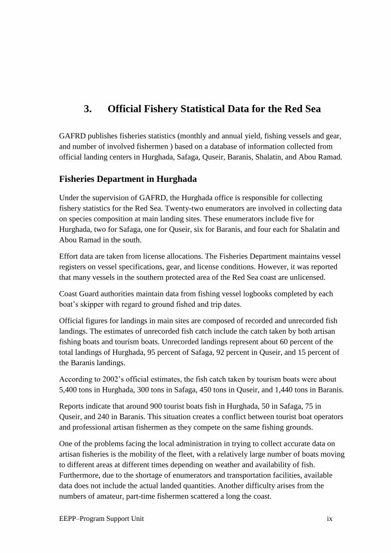
Fish Production
Based on official statistics from the Fisheries Department in Hurghada, the estimated fish
production taken from the study area was about 5,700 tons in 2002. This estimate excludes
fish taken by tourist boats. The distribution of the landings by main fishing areas was as
shown in table 1.
Table 1 2002 Fish Production by Landing
Fishing Area Ton %
Hurghada 3,000 52
Safaga 400 7
Quseir 1,800 32
Marsa Alam–Ras Banas 500 9
Total 5,700 100
Catch Composition
Composition of the landings in the Hurghada area was Parrotfish (Scaridea) 27 percent,
Emperor (Lethrnidae) 20 percent, Grouper (Serranidoe) 18 percent, and Sea Cucumber
(Holothuriodea) 17 percent. Other species represent less than 5percent each of the total
landings. These include Red Mullet (Goat Fish ), Sardinellas, and Tiger Fish.
Composition of landings in the Safaga area was Jacks (Carangidae) 34 percent, Emperor
(Lethrnidea) 27 percent, Parrotfish (Scarida) 15 percent, Grouper (Serranidae) 13 percent,
and Mullet (Mugilidea) 8 percent.
In the Quseir area, the landings consisted of Mullet (Mugilidae) 24 percent, Parrotfish
(Scaridae) 19 percent, Grouper (Serranidae) 15 percent, Jacks (Carangidae) 11 percent,
and Snapper (Lutjandae) 8 percent. Other species included Emperor (Lethrnidae) and
Mojarras (Gerridae).
In the Ras Bans area, Mullet (Mugilidae), Mojarras (Gerridae), and Parrotfish (Scaridae)
are the dominate species.
Many of the species are pictured in appendix 2.
EEPP–Program Support Unit xi
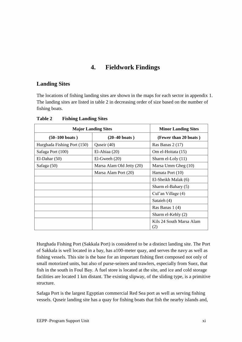
4. Fieldwork Findings
Landing Sites
The locations of fishing landing sites are shown in the maps for each sector in appendix 1.
The landing sites are listed in table 2 in decreasing order of size based on the number of
fishing boats.
Table 2 Fishing Landing Sites
Major Landing Sites Minor Landing Sites
(50–100 boats ) (20–40 boats ) (Fewer than 20 boats )
Hurghada Fishing Port (150) Quseir (40) Ras Banas 2 (17)
Safaga Port (100) El-Ahiaa (20) Om el-Hoitata (15)
El-Dahar (50) El-Gweeh (20) Sharm el-Loly (11)
Safaga (50) Marsa Alam Old Jetty (20) Marsa Umm Gheg (10)
Marsa Alam Port (20) Hamata Port (10)
El-Sheikh Malak (6)
Sharm el-Bahary (5)
Cul’an Village (4)
Sataieh (4)
Ras Banas 1 (4)
Sharm el-Kebly (2)
Kils 24 South Marsa Alam
(2)
Hurghada Fishing Port (Sakkala Port) is considered to be a distinct landing site. The Port
of Sakkala is well located in a bay, has a100-meter quay, and serves the navy as well as
fishing vessels. This site is the base for an important fishing fleet composed not only of
small motorized units, but also of purse-seiners and trawlers, especially from Suez, that
fish in the south in Foul Bay. A fuel store is located at the site, and ice and cold storage
facilities are located 1 km distant. The existing slipway, of the sliding type, is a primitive
structure.
Safaga Port is the largest Egyptian commercial Red Sea port as well as serving fishing
vessels. Quseir landing site has a quay for fishing boats that fish the nearby islands and,

EEPP–Program Support Unit xii
seasonally, southward. The other landing sites are simply beaching sites with no onshore
facilities. Ice facilities are centered in Safaga and Quseir.
Table 3 shows the location of the landing sites.
Table 3 Location of Landings and Number of Boats in the Study Area
Landing Site Position Number of Boats
El-Ahiaa 17.06 N
33.46.22 E
20
Hurghada Fishing Port 13.51 N
33.50.41E
150
El-Dahar 15.42 N
33.49.08 E
50
Safaga Ferry 45.56 N
33.56.42 E
50
Safaga Landing Site 43.33 N
33.56.17 E
100
Om el-Hwitat 38.42 N
33.58.08 E
15
El-Gweeh 22.30N
34.07.58 E
20
Quseir Landing Site 06.12 N
34.17.07 E
40
Om Geish 43.01 N
34.33.12 E
10
Sharm el-Bahari 52.07 N
34.24.50E
5
Sharm el-Kably 50.48 N
34.25.43 E
2
El-Shekh Malek 43.51 N
34.32.36 E
6
Marsa Alam Old Jetty 05.05 N
34.53.04 E
20
Marsa Alam Landing Site 25.04.03 N
34.53.58 E
20
Kilo 24 South Marsa Alam 57.48 N
34.56.08 E
2
Sharm el-Looly 36.35 N 22.06 E
11
Wadi el-Kalaan 24.21.27 N
35.18.21 E
4
Hamata 17.52 N
35.22.06 E
10

EEPP–Program Support Unit xiii
Landing Site Position Number of Boats
Sataih 00.07 N
35.38.51 E
4
Ras Banas 1 23.55.20 N
35.45.55 E
17
Ras Banas 2 56.00 N
35.43.56 E
4
Fishing Fleet
The fishing fleet operating in the study area is composed of:
Purse-seiners—These boats have a typical Mediterranean design, are 26–30 m in
length, and are powered with inboard motors ranging from 300–450 horsepower (hp).
They operate in the fishing grounds near the Hurghada islands by night during the dark
of the moon. The vessels use butagaz lamps placed in two, 6-meter dinghies to attract
the fish (10 lamps on each dinghy ). Lamps are also placed on the seiner. When
enough fish are concentrated under the light, the lamps are put on board a third dinghy
and a ring net is cast to surround each dinghy. The ring net has its bag in the middle
with the purse rope in two parts. The net is hauled on board by hand, starting with the
two wings. Mesh size is 50-mm (stretch) on the wing and 18-mm in the bag. The
mixed polyamide/steel ropes have a diameter of 30-mm and are hauled by trawl winch
and are coiled in two parts on the deck. There are nine of these boats.
During the fishing period of approximately 20 days each month, purse-seiners make a
number of trips, each lasting from 3-4 days. It was reported that the catch per trip is
about 6 tons. From 8 to 10 fishing trips are made per year.
The crew numbers between 25–30 and are generally hired for one season or even just
one trip in Alexandria or Suez.
Trawlers—These boats operate in the same fishing grounds as purse-seiners. Since
their use is not permitted in this area, their catch is not significant. Foul Bay is the
main fishing ground for trawlers in the Egyptian Red Sea.
Artisan Boats–This fishing fleet is composed of about 100 deck boats ranging from
10–15 m in length, with diesel inboard engines of 25–45 hp. In addition there are about
320 smaller deck boats ranging from 6–7 m in length, equipped with outboard engines
of 20–40 hp. There are about 140 craft ranging from 6–7 m in length that are powered
by sails and oars, and 3 large sailing boats between 15-18 m. long.
The principal artisan fishing methods are hand-lining, long-lining, gill netting, and
trammel netting. To a lesser extent, ring nets and lambara are used. In southern part of
the study area, mullet are fished with veranda nets—vertical and horizontally floating
nets. One original fishing method is developing along the Red Sea coast. Foot fishing

EEPP–Program Support Unit xiv
involves a group of 7–10 men wading out onto the coral reef table and catching fish
with nets. The group travels by vehicle, which carries men, nets, and fish. Motorcycles
are also widely used as a mean of transportation to the fishing grounds, especially
among non-professional and part-time fishermen, especially in the Quseir region. A
motorcycle is usually used to carry two fishermen to the fishing site along the shore,
where they fish mainly for lobster and other species. They use torches to attract the
lobster and a spear and prong with four to five points, to catch it.
Fishing Gear
The most important gear used is shown in appendix 3. Classifying fishing boats by fishing
methods is not particularly accurate because the boats can use several times of gear. A
purse-seiner can fish with a trammel net during the day, or with hand lines at anchor. It is
presently impossible to know the exact proportion of the by-catch produced by these
switches.
Fishermen coming from Fayoum Governorate have introduced illegal gill nets called
sabeeb. These have a smaller mesh size than the stipulated minimum. They also use ring
nets on the corals, which cause serious damage.
Artisan vessels fish all along the coast and a fishing trip may last from 1–15 days
depending on the location of the grounds fished as well as type of boat and gear used.
Fishing Grounds and Habitats
Main fishing grounds are concentrated in the northern part of the study area, between
27.50 N and 27.20 N latitude along the coast and around the Hurghada Islands. Hand and
long lines are the dominate fishing gear used, followed by entangle nets. Lesser fishing
grounds are used by purse-seiners. Small fishing grounds are scattered southward and are
mainly fished using hand and long lines and to lesser extent entangle nets and purse-
seining. Maps 3–6 in appendix 1 show these grounds while map 1 illustrates the
distribution of the main fish species by fishing grounds.
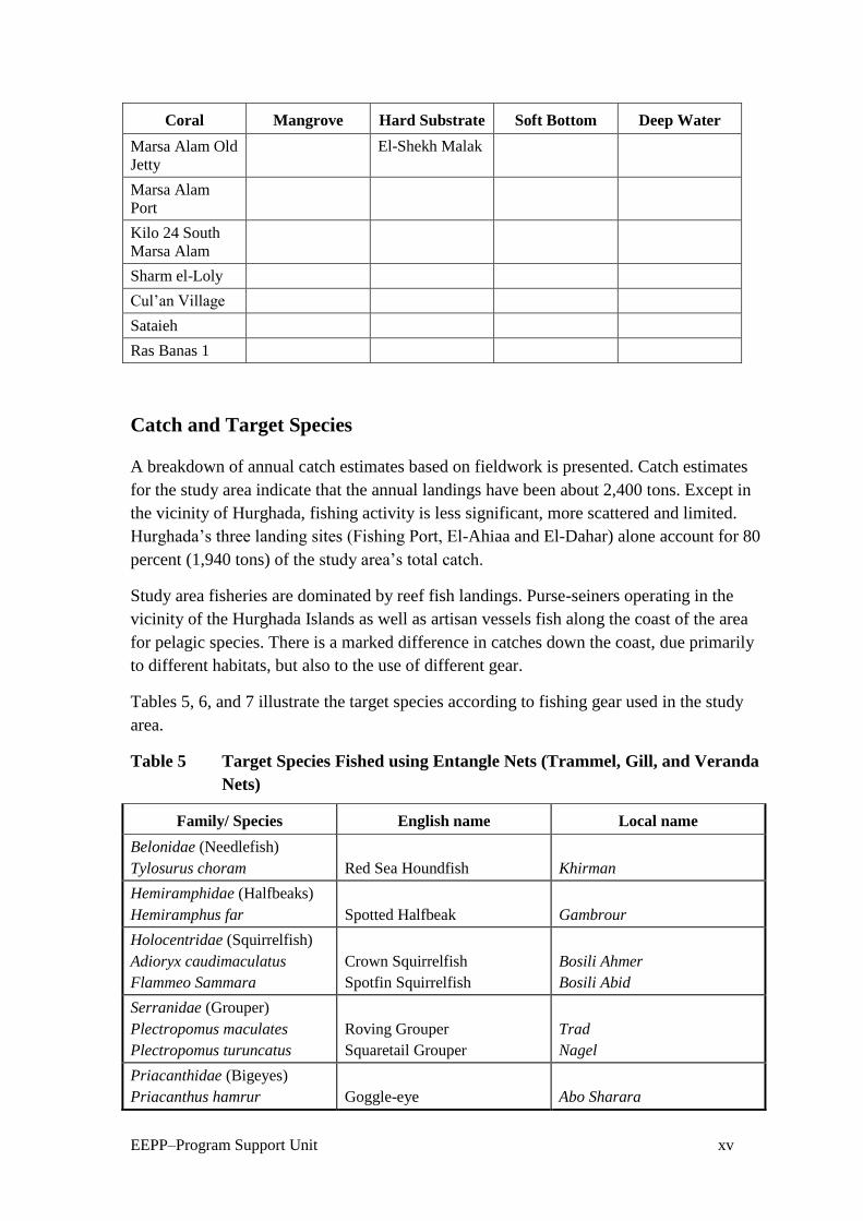
Fishing habitats include the coral reefs, hard substrates, soft bottoms, mangrove forests,
and deep water. Table 4 breaks out fishing habitat by landing sites.
Table 4 Fishing Habitat by Landing Sites
Coral Mangrove Hard Substrate Soft Bottom Deep Water
El-Ahiaa Sharm el-
Bahary
El-Dahar Hurghada Port Hamats Port
Safaga Sharm el-Kebly Safaga Port Ras Banas 2
Quseir Cul’an Village Om el-Hoitata
Marsa Umm
Gheg
El-Gweeh
EEPP–Program Support Unit xv
Coral Mangrove Hard Substrate Soft Bottom Deep Water
Marsa Alam Old
Jetty
El-Shekh Malak
Marsa Alam
Port
Kilo 24 South
Marsa Alam
Sharm el-Loly
Cul’an Village
Sataieh
Ras Banas 1
Catch and Target Species
A breakdown of annual catch estimates based on fieldwork is presented. Catch estimates
for the study area indicate that the annual landings have been about 2,400 tons. Except in
the vicinity of Hurghada, fishing activity is less significant, more scattered and limited.
Hurghada’s three landing sites (Fishing Port, El-Ahiaa and El-Dahar) alone account for 80
percent (1,940 tons) of the study area’s total catch.
Study area fisheries are dominated by reef fish landings. Purse-seiners operating in the
vicinity of the Hurghada Islands as well as artisan vessels fish along the coast of the area
for pelagic species. There is a marked difference in catches down the coast, due primarily
to different habitats, but also to the use of different gear.
Tables 5, 6, and 7 illustrate the target species according to fishing gear used in the study
area.
Table 5 Target Species Fished using Entangle Nets (Trammel, Gill, and Veranda
Nets)
Family/ Species English name Local name
Belonidae (Needlefish)
Tylosurus choram
Red Sea Houndfish
Khirman
Hemiramphidae (Halfbeaks)
Hemiramphus far
Spotted Halfbeak
Gambrour
Holocentridae (Squirrelfish)
Adioryx caudimaculatus
Flammeo Sammara
Crown Squirrelfish
Spotfin Squirrelfish
Bosili Ahmer
Bosili Abid
Serranidae (Grouper)
Plectropomus maculates
Plectropomus turuncatus
Roving Grouper
Squaretail Grouper
Trad
Nagel
Priacanthidae (Bigeyes)
Priacanthus hamrur
Goggle-eye
Abo Sharara

EEPP–Program Support Unit xvi
Family/ Species English name Local name
Haemulidae (Grunts)
Plectorhynchus gaterinus
Plectorhynchus schotaf
Blackspotted Grunt
Minstrel
Tahmal
Tahmal
Sparidae (Progies)
Rhabdosargus sarba
Acanthopagrus bifsciatus
Diplodus noct
Yellowfin Bream
Doublebar Bream
Arabian Pinfish
Botit
Rhabag
Abo nocta
Mullidae
Parupeneus macronema
Parupneus forsskali
Parupeneus cyclostomus
Parupeneus rubescens
Mulloides flavlineatus
Mulloides vanicolensis
Longbarbel Goatfish
Forsskal’s Goatfish
Yellowsaddle Goatfish
Rosy Goatfish
Yellowstrip Goatfish
Yellowfin Goatfish
Embera
Embera
Embera
Embera
Embera
Embera
Gerriedae (Mojarras)
Gerres oyena
Slenderspine Mojarras
Gasa
Mugilidae (Mullet)
Crenimugil crenilabis
Fringelip Mullet
Arabi
Scaridae (Parrotfish)
Hipposcarus harid
Cetoscarus bicolor
Scarus sordidus
Scarus genazonatus
Scarus ghobban
Scarus psiltacus
Longnose Parrotfish
Bicolor Parrotfish
Bullethead Parrotfish
Purplestreak Parrotfish
Bluebarred Parrotfish
Palenose Parrotfish
Wareig
Abohomar
Haridaswed
Hafar
Farhodi
Baid
Acanthuridae
Acanthurus sohal
Zebersoma veliform
Naso unicornis
Sohal
Sailfin Surgeonfish
Bluespine Unicornfish
Sohal
Flafel
Raho (Abo karn)
Siganidae
Siganus rivulatus
Siganus argentus
Siganus luridus
Rivulated Rabbitfish
Forktail Rabbitfish
Squaretail Rabbitfish
Sigan
Shbigy
Hrofy
Table 6 Target Species Fished using Hand and Long Lines
Family/ species English name Local name
Belonidae (Needlefish)
Tylosursus choram
Red Sea Houndfish
Khirman
Hemiramphidae (Halfbeaks)
Hemiramphus far
Spotted Halfbeak
Gambarour
Holocentridae (Squirrelfishes)
Adiryx caudimaculatus
Silverspot Squirrelfish
Kahaia

EEPP–Program Support Unit xvii
Family/ species English name Local name
Serranidae (Grouper)
Cephalopholis argus
Cephalopholis miniata
Cephalopholis hemstikotos
Cephalopholis oligostica
Epinephelus faciatus
Epinephelus microdon
Epinephelus fascoguttatus
Epinephelus summana
Epinephelus malabaricus
Epinephelus areolatus
Epinephelus chlorostigma
Variola louti
Plectropomus maculates
Plectropomus truncatus
Peacock Grouper
Halfspotted Grouper
Coral Grouper
Vermilion Grouper
Blacktip Grouper
Smalltooth Grouper
Brownmarbeled Grouper
Summana Grouper
Malabar Grouper
Areolate Grouper
Brownspotted Grouper
Lunertail Grouper
Roving Grouper
Squaretail Grouper
Nagel
Homrany
Kosher helf
Kosher helf
Abololo
Karna
Fark karna
Bagog
Tween
Kosher tina
Fanoos
Sherifa
Nagel Ahmer
Tarad Shaib
Carangidae (Jacks)
Carangoid bajad
Carangods fulvoguttatus
Caranx melampygus
Caranx sexfaciatus
Orangespotted Jack
Yellowspotted Jack
Bluefin Trevally
Bigeye Trevelly
Biad
Salikh
Girm baiad
Baiad
Lutjandae (Snapper)
Lutjanus flaviflamma
Lutjanus bohar
Dory Snapper
Twinspot Snapper
Herby
Bohar
Haemulidae (Grunt)
Plectorhynchus gaterinus
Plectorhyncus pictus
Blackspotted Grunt
Painted Grunt
Katreen
Shataf
Lethrnidae(Emperor)
Lethrinus elongates
Lethrinus variegates
Lethrinus lentjan
Lethrinus ramak
Lethrinus mahsena
Lethrinus nebulosus
Monotaxis grandoculis
Longnose Emperors
Variegated Emperor
Redspot Emperor
Yellowstripe Emperor
Mahsena
Spangled Emperor
Bigeye Emperor
Khirmy
Dreeny
Khomkhom
Bongoz
Mehsena
Shoor
Aboeen
Sparidae (Progies)
Acanthopagrus bifasciatus
Doublebar Bream
Rabag
Spyraenidae (Burracudas)
Sphyraenae barracuda
Sphyranae putnamiae
Great Barracuda
Chevron Barrcuda
Kenaya
Ogaam
Balistidae (Triggerfish)
Pseudobalistes fuscus
Odnus niger
Blue Triggerfish
Redtooth Triggerfish
Shaaram
Aboariba

EEPP–Program Support Unit xviii
Table 7 Target Species of Fish for Purse-seiners
Family/Species English name Local name
Culpeidae
Sardinella melanura
Clupea sirm
Clupea leigoaster
Spotted Sardinella
Golden striped Sardinella
Red-eye Round Herring
Sardin mofater
Sardin mofater asfer
Moza
Scombridae
Scomber japonicus
Rasterelleger kanagurta
Houtuyn
Indian Mackerel
Shak el-Zore
Bagah
Atherinidae
Atherina forskali
Kashkosha
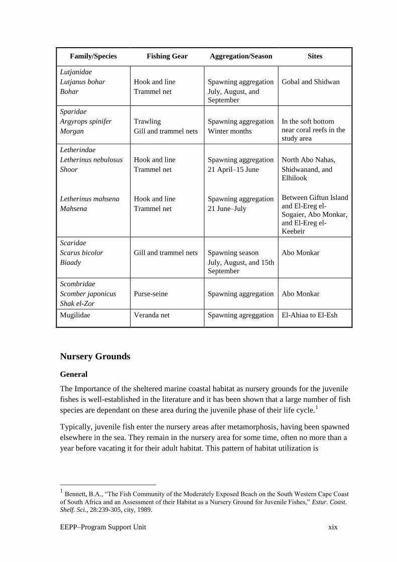
Table 8 illustrates catch composition and fishing gear used in aggregation/season in
different fishing grounds. Note that fishing operations are undertaken in spawning and
feeding aggregation. Deep and detailed studies may be required to identify the proper
fishing times to maximize both biological and economic yields and to ensure sustainability
of the resources.
Table 8 Catch Composition, Fishing Gear, and Aggregation/Season by Fishing
Grounds
Family/Species Fishing Gear Aggregation/Season Sites
Serranidae
Epinephalus twina
Twina
Hook and line
Spawning aggregation
(June and July)
Ras el-Gimsha, Abo
Malh, and Twila
Carangidae
Caranx fullvoguttatus
Slikakaady
Decaperus helenae
Shakora
Hook and line
Purse-seine
Feeding aggregation
Winter months
Spawning aggregation
(May, June, and July)
Gobal, Shidwan
Island, Ras Banas, and
Abo Monkar
Mullidae
Mulloidicthys
auriflamma
Embera baldi
Trammel and gill nets
Near shore feeding
and spawning
aggregation
15 days in May, June,
and July
Sharm el-Arab,
Dishatt Abo Monkar,
Shatt el-Mina,
Gaffateen, and
Shidwan
Gerreidae
Gerres oyena
Gasa
Trammel and gill nets
Spawning aggregation
February, March,
April, and May
Sharm el-Arab,
Dishatt, Abo Monkar,
Shatt el-Mina,
Gaffateen, Shidwan,
and Ras Banas
EEPP–Program Support Unit xix
Family/Species Fishing Gear Aggregation/Season Sites
Lutjanidae
Lutjanus bohar
Bohar
Hook and line
Trammel net
Spawning aggregation
July, August, and
September
Gobal and Shidwan
Sparidae
Argyrops spinifer
Morgan
Trawling
Gill and trammel nets
Spawning aggregation
Winter months
In the soft bottom
near coral reefs in the
study area
Letherindae
Letherinus nebulosus
Shoor
Letherinus mahsena
Mahsena
Hook and line
Trammel net
Hook and line
Trammel net
Spawning aggregation
21 April–15 June
Spawning aggregation
21 June–July
North Abo Nahas,
Shidwanand, and
Elhilook
Between Giftun Island
and El-Ereg el-
Sogaier, Abo Monkar,
and El-Ereg el-
Keebeir
Scaridae
Scarus bicolor
Biaady
Gill and trammel nets
Spawning season
July, August, and 15th
September
Abo Monkar
Scombridae
Scomber japonicus
Shak el-Zor
Purse-seine
Spawning aggregation
Abo Monkar
Mugilidae Veranda net Spawning agreggation El-Ahiaa to El-Esh
Nursery Grounds
General
The Importance of the sheltered marine coastal habitat as nursery grounds for the juvenile
fishes is well-established in the literature and it has been shown that a large number of fish
species are dependant on these area during the juvenile phase of their life cycle.1
Typically, juvenile fish enter the nursery areas after metamorphosis, having been spawned
elsewhere in the sea. They remain in the nursery area for some time, often no more than a
year before vacating it for their adult habitat. This pattern of habitat utilization is
1 Bennett, B.A., “The Fish Community of the Moderately Exposed Beach on the South Western Cape Coast
of South Africa and an Assessment of their Habitat as a Nursery Ground for Juvenile Fishes,” Estur. Coast.
Shelf. Sci., 28:239-305, city, 1989.

EEPP–Program Support Unit xx
considered to occur because sheltered habitat offer advantages over marine environment in
the terms of protection from predators and an abundant food supply.2 3
Nursery grounds for juvenile fish must have certain characteristic features. They must be
rich in food and particularly high in temperature. They are usually found near the shore,
i.e., in sheltered, shallow water. Gibson stated that juveniles are adapted to shallow water
life that allow them to remain in the favorable position of the littoral zone, but the adults
of their species are found in deeper water. Gibson summarized factors affecting the
abundance of juveniles as salinity, temperature, turbulence and wave action, and food
availability.4 Blaber and Blaber summarized the factors affecting juvenile fish in the
nursery grounds as physical and biological parameters, adding that predators are an
important factor.5
The nursery grounds include estuaries and sheltered coastal marine habitat such as sandy
shores, bays, and mangroves. These habitats serve as nursery areas for many juveniles of
marine fish species.6 Many authors have shown that a large number of species—perhaps
100—are dependent on these habitat during the juvenile phase of their life cycles.7
Ahmed studied the nursery grounds in the Gulf of Aqaba in the Egyptian Red Sea and
found that that Sharm el-Mayia Bay and NABAQ mangroves are excellent nursery
grounds for 13 commercial fish species.8
Nursery Grounds in the Study Area
Twenty-three nursery grounds have been identified in the study area. Maps 7–10 in
appendix 1 and table 9 below illustrate their distribution by habitat. Seventeen nursery
grounds are threatened by fishing and tourism activities, two mangrove grounds are
located in marine parks, but are used for animal grazing, the rest are still unused for any
activity. Serious actions should be taken to protect and conserve the nursery grounds.
Table 9 Nursery Grounds in the Study Area
Nursery Position Habitat Activities
Gimsha 39.28 N
33.33.51 E
Seragrass and
seaweed
Fishing
2 Lenanton, R.C.J., “Alternative Non-estuarine Nursery Habitats for Some Commercially and Recreationally
Important Fish Species of Southwestern Australia,” Australian Journal of Marine Freshwater Resources,
33:881-900, city, 1982. 3 Ahmed (other names), “Ecological and Biological Studies on the Juvenile Fishes in South Sinai,” M.Sc.
thesis, Suez Canal University, Suez, 1992. 4 Gibson, R. N., “Recent Studies on the Biology of Inertial Fishes,” Oceanographic Marine Biology Annual
Review, 20:363-414, city, 1982. 5 Blaber, S.J.M. and Blaber, I.G., “Factors Affecting the Distribution of Juvenile Estuaries and Inshore
Fish,” Journal of Fish Biology, 17:134-162, city, 1980. 6 Bennett, 1989.
7 Need to provide a reference for this one—the listed Blaber is 1980.
8 Ahmed, 1992.

EEPP–Program Support Unit xxi
Nursery Position Habitat Activities
Gobit Melaha 31.26 N
33.33.24 E
Seagrass Fishing
Gobit el-Disha 02.47 N
33.53.22 E
Soft bottom Tourism and fishing
Abo Makadig 59.40 N
33.53.56 E
Seagrass Tourism and fishing
Sharm el-Arab 57.56 N
33.55.13 E
Seagrass and coral
patches
Fishing
Soma Bay 50.09 N
33.57.00 E
Seaweed and
Seagrass
Tourism
Mangrove
Rehabilitation
36.56 N
34.00.41 E
Mangroves Marine park
Abo Kalawi 30.32 N
34.03.59 E
Seagrass seaweed Fishing
Mangrove 24.07 N
34.06.54 E
Mangroves Marine park
Asil 56.31 N
34.23.15 E
Coral Tourism
Marsa Wzer 47.09 N
34.29.11 E
Seaweed None
South Om Geish 42.18 N
34.3.22 E
Soft bottom None
Om el-Grifaat
Lagoon
36.00 N
34.36.12 E
Tourism
South Abo Dabab 17.59 N
34.45.06 E
Soft bottom None
Morein Lagoon 23.41 N
34.42.06 E
Tourism
Gabal el-Rosas 12.17 N
34.48.23 E
Soft bottom None
South Gabal el-Rosas 09.11 N
34.51.00 E
Soft bottom None
Kilo 7 South Marsa
Alam
00.47 N
34.55.30 E
Seagrass None
Sharm el-Loly 36.35 N
35.06.36 E
Soft bottom Fishing
Wadi el-Kalaan
Mangrove
21.27 N
35.18.21 E
Mangrove Marine park, animal
grazing, and fishing
Hamata 17.52 N
35.22.06 E
Mangrove Marine park, over-
grazing, and fishing
Wadi Lahmy 12.57 N
35.25.32 E
Mangrove Tourism

EEPP–Program Support Unit xxii
Nursery Position Habitat Activities
Kara el-Hartway 07.53 N
35.29.12 E
Mangrove None
Fishermen
Based on fieldwork data, there are an estimated 2,800 fishermen operating in the study
area. This figure represents regular fishermen operating from fishing vessels as well as
those who use trucks to transport nets and fish to and from fishing grounds, i.e., foot
fishermen. It does not include part-time fishermen or those who operate tourist boats who
also fish.
A breakdown of fishermen by landing site is given. Approximately 46 percent or a total of
1,280 fishermen are based at the Hurghada region’s landing sites, Al-Ahiaa, El-Dahar, and
Hurghada Port. Approximately 90 percent of all fishermen are predominately artisan
fishermen using hand and long lines, gill nets, trammel nets, and veranda nets.
Fisheries resources in the study area targeted by three groups:
1. Local fishermen who originally came from Upper Egypt and are based
mainly in Hurghada, Safaga, and Quseir and settled Bedouin fishermen,
belonging to the Bshari and Abada tribes who are living in Ras Banas in
small groups. The latter group use mainly sail boats with veranda nets, cast
nets, hand lines and longs lines. Production is consumed locally, with some
fish salted or sun dried.
2. Migratory fishermen who came many years ago from Fayoum Governorate
and settled mainly in Hurghada and Safaga. It was reported that about
195 fishermen are fishing from Hurghada and 15 from Safaga. They
usually establish seasonal fishing camps and use fishing boats equipped
with inboard engines. They introduced the use of gill nets that consist of 30
segments of 30 m. long in an illegal mesh size, which are highly
destructive. They also use stand nets on corals, which cause serious damage
to this important habitat. As to date the Red Sea fisheries are open to all,
there is a trend toward gradually increasing their numbers That may present
serious threats to fisheries in the area.
3. Visiting fishermen who operate purse-seiners during the fishing season and
go back to their home villages in the Delta.
Most fishermen in the artisan fleets are related to or belong to one family. For the local
fishermen, there is a noticeable trend toward leaving fishing to work in tourism and other
sectors such as mining and petrol. Reasons cited include limiting fishing grounds and poor
coastal zone management. There are already conflicts between tourism development and
traditional fishing interests. The main coastal stakeholders affected by tourism and reef
recreational activities in particular are the artisan fishing communities. A recent Global
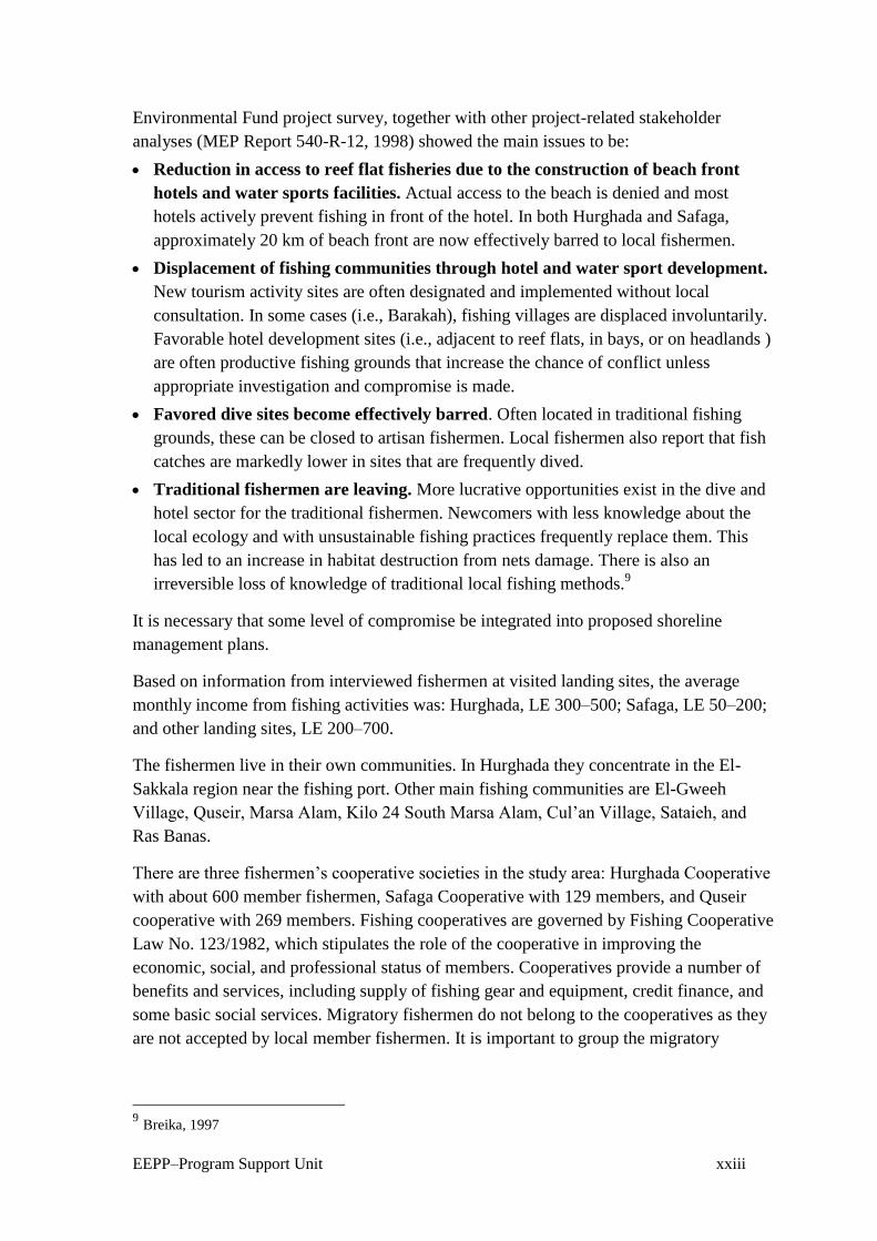
EEPP–Program Support Unit xxiii
Environmental Fund project survey, together with other project-related stakeholder
analyses (MEP Report 540-R-12, 1998) showed the main issues to be:
Reduction in access to reef flat fisheries due to the construction of beach front
hotels and water sports facilities. Actual access to the beach is denied and most
hotels actively prevent fishing in front of the hotel. In both Hurghada and Safaga,
approximately 20 km of beach front are now effectively barred to local fishermen.
Displacement of fishing communities through hotel and water sport development.
New tourism activity sites are often designated and implemented without local
consultation. In some cases (i.e., Barakah), fishing villages are displaced involuntarily.
Favorable hotel development sites (i.e., adjacent to reef flats, in bays, or on headlands )
are often productive fishing grounds that increase the chance of conflict unless
appropriate investigation and compromise is made.
Favored dive sites become effectively barred. Often located in traditional fishing
grounds, these can be closed to artisan fishermen. Local fishermen also report that fish
catches are markedly lower in sites that are frequently dived.
Traditional fishermen are leaving. More lucrative opportunities exist in the dive and
hotel sector for the traditional fishermen. Newcomers with less knowledge about the
local ecology and with unsustainable fishing practices frequently replace them. This
has led to an increase in habitat destruction from nets damage. There is also an
irreversible loss of knowledge of traditional local fishing methods.9
It is necessary that some level of compromise be integrated into proposed shoreline
management plans.
Based on information from interviewed fishermen at visited landing sites, the average
monthly income from fishing activities was: Hurghada, LE 300–500; Safaga, LE 50–200;
and other landing sites, LE 200–700.
The fishermen live in their own communities. In Hurghada they concentrate in the El-
Sakkala region near the fishing port. Other main fishing communities are El-Gweeh
Village, Quseir, Marsa Alam, Kilo 24 South Marsa Alam, Cul’an Village, Sataieh, and
Ras Banas.
There are three fishermen’s cooperative societies in the study area: Hurghada Cooperative
with about 600 member fishermen, Safaga Cooperative with 129 members, and Quseir
cooperative with 269 members. Fishing cooperatives are governed by Fishing Cooperative
Law No. 123/1982, which stipulates the role of the cooperative in improving the
economic, social, and professional status of members. Cooperatives provide a number of
benefits and services, including supply of fishing gear and equipment, credit finance, and
some basic social services. Migratory fishermen do not belong to the cooperatives as they
are not accepted by local member fishermen. It is important to group the migratory
9 Breika, 1997

EEPP–Program Support Unit xxiv
fishermen in some kind of association to facilitate contact between them and other
concerned bodies.
Wadi el-Gemal–Hamata Protected Area
The Wadi el-Gemal–Hamata Protected Area includes three landing sites:
1. Sharm el-Loly, with 55 local fishermen operating 11 boats equipped with
40 hp outboard engines and using trammel nets. The average annual
landings are estimated at about 28 tons composed mainly of Slenderspine
Mojarras (Gasa), Mullet (Arabi), Rabbit Fish (Sigan), Goat Fish (Ember ),
and Emperor (Shoor). The main fishing grounds are Hamraween, Abou
Saan, and Wadi el-Gemal Island, which are also nursery grounds.
2. Cul’an Village, with 20 local fishermen operating four fishing boats
equipped with 20–40 hp outboard engines and mainly using trammel nets.
The average annual landings were estimated at 5 tons composed mainly of
Mullet, Mojarras, Houndfish (Kherman ), Parrotfish (Harid), and Grouper
(Koshar). The main fishing grounds are mangrove habitats and Cul’an
Island.
3. Hamata, with 50 local and migratory fishermen operating 10 fishing boats
with 40 hp outboard engines and mainly using hand lines and trammel nets.
The annual average landings were estimated at about 25 tons composed
mainly of Snapper (Fares) and Jack (Biad). The main fishing grounds are
the deep waters of Koraa el-Hartawi and Hamata. The latter is considered
nursery ground.
Fish Handling and Marketing
Most of the fish is marketed fresh (iced ), and a small part—mainly mullet—is salted
while bigger fish may be dried. Fish are sorted and graded on the boats. The fishermen’s
cooperative society in Hurghada manages the marketing of fish caught by its members
against a commission. A certain quantity of the catch has to be delivered to the Red Sea
Governorate to be sold at a fixed price to local consumers.
At the other landing sites, the fishermen market their own catch directly to consumers
comprised of mine workers, company officials, and tourism villages.
Salted fish are packed in metal tins (15–17 kg in each tin) and sent by truck to be sold to
wholesale merchants mainly in Cairo. The wholesale merchants have their representatives
in the main fishing centers (Hurghada, Quseir, and Baranis) that provide fishermen with
tins and loans and manage salted fish collection and transportation.

EEPP–Program Support Unit xxv
Fisheries Legislation
Fisheries are governed by national laws that dictate the terms and conditions under which
fishing activities may take place and provide for protection and conservation of living
marine resources. Regulations (or by-laws) set out the details concerning fishing activities
and restrictions that apply.
Law enforcement is the responsibility of GAFRD in cooperation with the Ministry of
Defense Frontiers Guard. The Guard is based at the fishing ports and main landing sites.
They issue permits to fishing vessels and record trip duration, area fished, and names of
fishermen on each boat.
The GAFRD was created by Presidential Decree 190/1983. The chairman of the authority
was given the status of first secretary, directly responsible to the Minister of Agriculture.
Presidential Decree 465/83 gave the GAFRD the right and obligation to supervise,
administer, and monitor the waters of Egypt. Presidential Decree 362/1984 declared that
all license fees due from fishermen and fishing vessels are the property of the authority.
In 1983, two laws were created that dealt with the fisheries sector. The first was Law 123,
dealing with fisheries cooperative societies. The second was 124, dealing with fishing,
living aquatic resources, and fish farms.
Law 123 regulates the fishermen’s cooperative societies, to which the majority of
fishermen in Egypt now belong The law deals with the administration, meetings, elections
of the board of directors, distribution of profits, and credit arrangements. It also
established the Fishermen’s Cooperative Union, to which all the cooperative societies
belong.
Law 124 (Fisheries and Fish Farming Organizing Law) deals with all living aquatic
resources, fishing grounds, vessels and methods, pollution, licensing, fees, penalties, and
other matters.
These articles are relevant to the Red Sea:
Article 2: All fishing boats must show clearly, both on their hull and their sail, their
class, license number, and designated fishing area. The class of a boat (sailing and
rowing) is designated according to the size and class of its crew—1st class will not
exceed 27 fishermen crew, 2nd class will not exceed 13 fishermen crew, 3rd class will
not exceed 4 fishermen crew.
Article 7: All fishing is prohibited in areas and seasons as decreed by the Minister of
Agriculture. Use of some fishing gear may be prohibited by such decree as well.
Article 9: All unlawfull fishing gear is prohibited either on board of fishing boats or in
the possession of persons in the fishing areas or nearby.
Article 10: It is prohibited to catch, sell, or have undersized fish or other living aquatic
species, whether fresh or dried and salted.
Article 11: It is prohibited to catch ornamental fish without permission from GAFRD.

EEPP–Program Support Unit xxvi
Article 13: Using harmful materials, poisons, narcotics and explosives…is prohibited
in fishing.
Article 23: All fishing boats must be licensed. Fishermen, whether or not on a boat, are
required to be licensed and to carry a fisherman’s card. The number of vessels using
each type of fishing gear is determined according to the by-law.
Sanctions
– A boat not showing the information identified in Article 2 shall be fined
LE 20.
– A boat fishing without a license shall be fined LE 50 and the responsible
shall be imprisoned for up to 3 months, or one of these two sanctions. In
addition, the boat and fishing tools shall be confiscated.
– Use of unlawful fishing gear or fishing in closed areas or seasons shall
be liable to a fine of LE 100–500, and imprisonment of 3–6 months, or
one of these two sanctions.
– Use of poisons or explosives shall be liable to a fine of LE 500–1,000
and imprisonment of 6–24 months, or one of these two sanctions.
In addition to these specific regulations, the Minister of Agriculture has wide discretionary
powers to regulate the issuance of licenses and to identify fishing areas and seasons.
In 1987, the Minister of Agriculture’s Decree 303 was issued to implement Law124. The
decree deals with detailed fishing methods, fishing grounds, fees, and penalties.
Other authorities have also issued regulations to control fishing activities in the Red Sea as
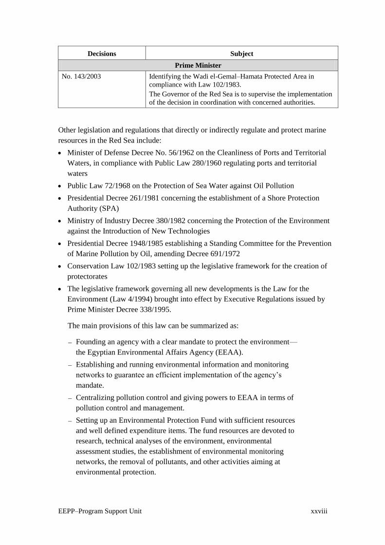
well as to identify Wadi el-Gemal as a protected area. These as summarized in table 10:
Table 10 Principal Decisions Issued by the Red Sea Governor, the Chairman of
GAFRD, and the Prime Minister Affecting Egypt’s Fisheries
Decisions Subject
Red Sea Governor
No. 14/1998 Prohibition of any action or activity that will lead to the
destruction or deterioration of the natural environment of islands
and areas surrounding them as well as mangrove regions.
No. 46/1998 Prohibition against collecting, exposing, and marketing shells,
coral, ornamental fish, and other protected marine species is the
governorate.
No. 95/1998 Prohibiting harpoons for fishing in Egyptian waters.
No. 22/2003 Prohibition of Sea Cucumber fishing for 1 year starting in March
2003.
Chairman of GAFRD

EEPP–Program Support Unit xxvii
Decisions Subject
No. 410/2001 Hurghada and its islands belong to the Red Sea (not to the Gulf
of Suez) and it is permitted to use lines and net as follows:
Ghabriat nets of 20 mesh size, Mowaghat nets with 2 layers of
6 mesh size for the outside layer and 17 mesh size for the other
layer The number of segments of each net shall not exceed
12 units. It is forbidden to use this gear in coral reef regions.
No. 424/2001 Implementing Law 124/1983 in Hurghada Islands as in the case
of Gulf of Suez, except that it is permitted to use lines and nets
in the Hurghada region and its islands as follow: Nets for
Borbon of 20 mesh size, Marabee nets of 14 mesh size,
Mowagehat nets with 2 layers of 6 mesh size for the outside
layer and 17 mesh size for the inside layer, provided that the
number of segments do not exceed 12 units to ensure smooth
operation of small boats.
No. 1741/2001 Closed season for the Gulf of Suez and the Hurghada region and
its islands are as follow:
From 1/6/2001 to 30/9/2001 for trawlers.
From 5/6/2001 to 5/11/2001 for purse-seiners.
From 1/8/2001 to 30/9/2001 for launches using lines (hooks).
From 1/9/2001 to 30/9/2001 for small boats (faloukas) using
lines (hooks).
As for the Red Sea, closed to trawlers from 1/8/2001 to
4/10/2001.
No. 236/2001 Hurghada region and its islands are considered part of the Gulf
of Suez.
Lines are only permitted for fishing in this area. Nets of all kinds
are not permitted.
No. 282/2002 Sea Cucumber fishing is permitted year around with the
exception of April, May, and June (spawning period).
52 boats and 155 foot fishermen are licensed for fishing.
The licenses are identified by region according to the attached
list and through the fishermen’s cooperatives and companies.
They are responsible for the safety of divers during the
operations.
The fee to be paid by fishing boats with a maximum of 5 persons
is LE 5,000/year and LE 500 for on-foot fisherman.
The fee per individual Cucumber taken from Egyptian water is
to be PT 15, distributed as follows: PT 2 for the cooperative,
PT 2 for the Cooperative Union, and the rest for GAFRD. As for
fishing boats taking Cucumbers from outside Egyptian waters
and landing them in fishing ports along the Red Sea coast, the
fee is to be LE 5 per fish box.
Use of trawlers to catch Sea Cucumbers within Egyptian waters
is prohibited.
Minister of Agriculture
No. 410/2002 Prohibiting catching Sea Cucumbers in the protected areas and
around the islands as well as in the coral reef regions of the Red
Sea.
EEPP–Program Support Unit xxviii
Decisions Subject
Prime Minister
No. 143/2003 Identifying the Wadi el-Gemal–Hamata Protected Area in
compliance with Law 102/1983.
The Governor of the Red Sea is to supervise the implementation
of the decision in coordination with concerned authorities.
Other legislation and regulations that directly or indirectly regulate and protect marine
resources in the Red Sea include:
Minister of Defense Decree No. 56/1962 on the Cleanliness of Ports and Territorial
Waters, in compliance with Public Law 280/1960 regulating ports and territorial
waters
Public Law 72/1968 on the Protection of Sea Water against Oil Pollution
Presidential Decree 261/1981 concerning the establishment of a Shore Protection
Authority (SPA)
Ministry of Industry Decree 380/1982 concerning the Protection of the Environment
against the Introduction of New Technologies
Presidential Decree 1948/1985 establishing a Standing Committee for the Prevention
of Marine Pollution by Oil, amending Decree 691/1972
Conservation Law 102/1983 setting up the legislative framework for the creation of
protectorates
The legislative framework governing all new developments is the Law for the
Environment (Law 4/1994) brought into effect by Executive Regulations issued by
Prime Minister Decree 338/1995.
The main provisions of this law can be summarized as:
– Founding an agency with a clear mandate to protect the environment—
the Egyptian Environmental Affairs Agency (EEAA).
– Establishing and running environmental information and monitoring
networks to guarantee an efficient implementation of the agency’s
mandate.
– Centralizing pollution control and giving powers to EEAA in terms of
pollution control and management.
– Setting up an Environmental Protection Fund with sufficient resources
and well defined expenditure items. The fund resources are devoted to
research, technical analyses of the environment, environmental
assessment studies, the establishment of environmental monitoring
networks, the removal of pollutants, and other activities aiming at
environmental protection.

EEPP–Program Support Unit xxix
– Setting up the principles and procedures to be followed in the
preparation of environmental impact assessments of new projects and
extensions to existing projects that have the potential of adversely
affecting the environment.
– Establishing an Environmental Affairs Department in each governorate
to help coordinate and implement EEAA’s mandate at the local level.
Under the Executive Regulations virtually all new construction or extensions to
previous construction require the consent of a competent administrative authority,
which is one of various ministries or governorates depending on the nature and location
of the construction. Each proposal must be accompanied by some form of
environmental impact assessment. The competent administrative authority provides
preliminary screening of the proposal and passes the environmental impact assessment
to the EEAA for evaluation and comment. In the light of these comments, the
competent administrative authority may approve, refuse, or request modifications to the
project. There is an appeals procedure to which EEAA has input but is not otherwise
involved in the final judgment.
Articles 59 and 60 of Law 4 have far-reaching implications for the design of new coastal
resorts. Article 59 prohibits construction of any establishment within 200 m of the
shoreline except with the approval of the General Shore Protection Authority in
coordination with EEAA, following submission by the developer of a detailed
environmental impact assessment of potential impacts to the coastal area and shoreline.
Particular attention must be given to the precautions that are to be taken by the developer
to avoid erosion, sedimentation, and alteration of coastal currents and pollution that could
potentially result from the project. Article 60 prohibits all activities that cause alteration of
the natural shoreline.
Appendix VIII of the Guidelines for Egyptian Environmental Impact Assessment (EEAA,
1997) gives specific guidelines for environmental impact assessments for offshore oil and
gas establishments. Of particular relevance to the GEF Red Sea project is Section 4.2
(Coastal and Marine Ecosystems and Resources). The developer should consider the
following issues:
Fauna and flora, and rare or endangered species within or in areas adjacent to the
project
Sensitive habitats, coral reefs, wetlands, bays, lagoons, marshes, and mangrove
swamps
Species of commercial importance affected by the project
In addition to the biological data, the EIA should consider water quality, currents,
ability to assimilate discharges and maintain desired water quality, and other
significant sources of pollution in the area.

EEPP–Program Support Unit xxx
Protected Areas Legislation
Initiatives include the Egyptian Conservation Law, Law 102/1983, which established the
framework for the creation of protected areas. Implementation of some of the provision of
this law is provided by a 1983 Prime Ministerial Decree.
The regulations defined in Article 11 of Law 102, deal with any action or activity that will
lead to the destruction or deterioration of the natural environment or harm the biota, or
detract from the aesthetic appeal of the protected areas. The rangers in charge of the day-
to-day management of protected areas patrol to guard against the following actions, which
are strictly prohibited:
Hunting, transporting, killing, or disturbing living terrestrial and marine organisms, or
carrying out activities that would lead to their destruction (i.e. spear fishing ).
Damaging, removing, or transporting any living organism or organic material such as
shells, corals, rocks, or soil for any purpose.
Damaging or transporting plants found in a protected area.
Damaging or destroying geographic or geological formations of areas considered as
habitats for animals and plants, or for their reproduction.
Introducing foreign species into protected areas.
Polluting the soil, water, or air of a protected areas.
Construction of any building or establishment in a protected area without the
permission of the relevant administrative body.
It is concluded that a common feature in the study area is that most laws do not have the
strength and clarity needed for effective management and monitoring, control, and
surveillance (MCS). Common concerns include inadequate definition of term such as
‘fishing vessel,’ ‘tourism vessel,’ or ‘fishing activities’ for sound administration and
enforcement of the legal process. Penalties for infringements are frequently far too low,
undermining respect for management and control, since there is minimal deterrence.
Licensing systems are often inadequate. For example, it was reported that many fishing
vessels operating in the study area—especially in the southern part—have no license.
Fisheries observers and enforcement officers’ powers, duties, and responsibilities are in
some cases not described; procedures following seizure and arrest are not specified; and
often there is no option of imposing an ‘administrative penalty’ by the minister
responsible for fisheries rather than initiating a lengthy court process.
Poor coordination between different governmental bodies has often resulted in
overlapping responsibilities and jurisdictions for the implementation of legislation for the
marine environment and coastal zone.
National legislation should also be brought into line with current international initiatives
to promote cooperation in management of shared stocks as required under the United
Nations Convention of the Law of the Sea (UNCLOS) and facilitate implementation of the
EEPP–Program Support Unit xxxi
Food and Agriculture Organization’s (FAO) Code of Conduct for Responsible Fisheries
and the Conservation and Management of Straddling Stocks Agreement.

EEPP–Program Support Unit xxxii
5. Proposed Fisheries Management Plan for the Study Area
Introduction
The management plan defines how the marine resources of the study area, including the
Wadi el-Gemal–Hamata Protected Area, will be managed. It tries to answer the following
questions:
What fisheries resources are available?
How valuable are these resources?
What is the best way to use these resources?
Are the resources being overexploited and the environment being damaged?
Are there resources that are being under-used? Should these be fished more?
The plan is based on information gained from a number of sources including existing
documentation and interviews with officials, fishermen, managers of fishermen’s
cooperatives, and fish traders.
The plan indicates the key issues and constraints for sustainable fisheries development and
conservation. It identifies objectives for the fisheries and the strategy to be employed in
order to achieve those objectives. To be successful, the plan must have the active input,
support, and acceptance from all stakeholders, especially the fishermen. A carefully
planned public awareness program will be essential.
Key Issues and Constraints for Sustainable Fish Resources
There are a number of problems facing the fisheries in the Red Sea. These include
inadequate information, ineffective management, uncontrolled use of resources, poor
control of the resources, lack of planning, and inadequate training and public outreach
activities.
Inadequate Information Base
Fisheries management must be based on an accurate understanding of the resource base
and of the relationship between resources use and natural regeneration, that is the
sustainability of fish levels and methods of exploitation. There is currently very little
reliable data on which to base fishery specific management strategies and measures.
Current data collection systems lack planning and transparency. Data formats are often not
EEPP–Program Support Unit xxxiii
amenable to effective stock assessment or monitoring of fisheries management. A lack of
comprehensive biological and economic statistics is a major constraint to effective
fisheries management. This is compounded by a lack of awareness or application of the
precautionary approach principle.
A fundamental requirement for statistical information on artisan fisheries, for purposes of
resources assessment, planning, and future management, is the establishment and
implementation of an appropriate sampling program. This must be based on a new census
of the size, location, and characteristics of the fishing fleet. The implementation of the
program will require enumerators stationed at, or near the sites selected for sampling.
It is suggested therefore that the present arrangements for fisheries data collection and
analysis be revised. Data should be collected that will allow routine catch, effort, and
CPUE analysis at the species level.
Inadequate Effective Management
Fisheries management policies are not currently well defined, nor are they based on
reliable scientific information. Modern guidelines such as the Code of Conduct for
Responsible Fisheries are not part of legal framework. The adoption of the precautionary
approach has considerable implications for fisheries management authorities. Scientific
advice to fisheries managers should allow for uncertainty in both the understanding of the
state of the stocks and the effect of future management actions. When less is known,
fisheries management authorities should be more cautious. This requires a management
approach less focused on and influenced by short-term considerations, and more
concerned with long-term sustainability of fisheries resources and the environment. Over-
fishing due to over-capacity and ineffective application of controls is the major problem
facing Red Sea fisheries. Many factors attract new entrants from other governorates to the
Red Sea fisheries, leading to uncontrolled effort expended on the resources.
Uncontrolled Expansion of Fishing Operations
Uncontrolled expansion of operations eventually leads to over-exploitation of the
resources. The most appropriate way of regulating fishing is to limit the fishing fleet to a
certain size. It is also appropriate to charge the tourist boats owners who fish for the right
to exploit the common resources and recover some of the cost of managing the fisheries.
This of course may also apply to the artisan fisheries in certain places.
There is anecdotal information concerning fishing and marketing of Sea Cucumber, but
there are conflicting estimates of magnitude. Intensive surveillance could assist in
quantifying the problem, but very little can be done about it without empowered
enforcement officers.
Poor Monitoring, Control, and Surveillance
National authorities are currently unable to undertake effective MCS of artisan fisheries
due to lack of equipment, recurrent financial problems, and a lack of suitably trained

EEPP–Program Support Unit xxxiv
personnel. The allocation of resources for enforcement as well as training of enforcement
officers, particularly in areas of high fishing pressures, should be given priority.
Implementing boat registration and licensing systems can assist surveillance of artisan
fisheries.
Lack of Integrated Coastal Planning
Integrated coastal management is lacking: both the tourism and oil industries are afforded
high priority, but the negative impacts of such activities on coral reefs, nursery grounds,
spawning areas, and fishing grounds are not considered when policy is being made for
these lucrative sectors.
There is a lack of effective communication between those formulating fisheries policy and
the fishing industries and communities which are ultimately affected by the management
measures imposed. This results in poor understanding of the need for and agreement with
management measures. Considerable opportunity exists for increasing the involvement of
fishing communities in the development and implementation of appropriate management
measures for fisheries resources.
Lack of Extension, Training, and Public Awareness
Public awareness of the need for a balance between fisheries and environmental protection
and conservation requires urgent attention. Many of the undesirable activities currently
practiced (such as using gill nets with an illegal mesh size or dumping used gear at sea)
could be reduced considerably if more attention were given to improving extension and
training and public awareness campaigns.
Overall Objectives for Fisheries Management
Global objectives for management of fisheries resources should be designed to:
Ensure that the fisheries are managed in accordance with the principles laid down in
the FAO Code of Conduct for Responsible Fisheries, so that stakeholders enjoy
maximum sustainable benefits.
Promote cooperation between sectors so that fishery and marine resource management
policies are integrated within the decision-making framework of the Coastal Zone
Management Plan of the Red Sea.
Integrate the many uses of marine resources so that they are managed for the equitable
benefit of all stakeholders.
Management Strategy
The strategy to be employed in order to achieve the objectives must be:
Simple, clear, and understandable to all interested parties
Low in cost to implement and administer
Based on elements of the existing national management system (e.g. licensing)
EEPP–Program Support Unit xxxv
Acceptable to the local fisheries societies.
The following strategy is recommended:
Development of a sound information base on which to build a management system
Adoption of a precautionary approach to decision making to ensure that harvesting of
marine resources in the area is sustainable
Adoption of a participatory approach to decision making so that wherever possible,
management decisions are based on consensus among fishermen, authorities, and other
interested parties
Elevation of living standard for artisan fishermen by providing the means to improve
processing, marketing, and distribution of marine products
Encouraging exploitation of under-utilized marine resources
Basing management primarily on controlling the fishing effort through the
establishment of a vessel registration, implementation of licensing requirements
already laid down in national law, and restriction of the number of licenses issued
Development of a sound institutional foundation such as a Fisheries Management
Committee.
Management Tasks and Options
Registration of Fishing Vessels
All fishing boats must be registered. The vessel’s unique registration number must be
fixed on both sides of the bow in accordance with existing legislation. No boat without a
registration number should be permitted to obtain a license to fish commercially. The
fishing vessel registration system would be based on the system already implemented. The
registration system would form the main element of the proposed data collection system
and be the main tool for regulating the fisheries.
Licensing Fishermen
Fishing licenses would be issued preferentially to applicants who are long-term study area
residents. Fishermen from other places would be granted rights only if a license is
available under the license allocation, and the management body—the Fisheries
Management Committee—decides that the activities of the applicant will have no
detrimental impact on the area license holders.
Licensing Fishing Vessels
All fishing boats used for commercial gain must be licensed in accordance with existing
legislation. However, the terms and conditions of the license would specify the target
species, allowable gear, and area/seasonal restrictions.
EEPP–Program Support Unit xxxvi
Regulatory Measures for Targeted Species and Sea Cucumbers
Based on information obtained during field visits as well as from fishery officials, the
following regulatory measures are urgently needed:
Prohibiting use of illegal gill nets called sabeeb
Protecting inshore areas where spawning occurs
Reducing possible growth of over-fishing by protecting juvenile fish
Establishing areas known to be breeding grounds as ‘no take zones’ or closed areas.
It was reported that Sea Cucumbers fisheries are characterized by heavy exploitation.
They were not subject to any form of management at all for a long period. Recently the
Governor of the Red Sea issued a decision prohibiting Sea Cucumber fishing for the year
starting March 2003.
Management measures imposed in Pacific Island fisheries include a minimum allowable
size for dried products (Fiji), export quota restrictions (Solomon Islands), a system of
‘crop rotation,’ in which areas are harvested for a few months then left for the rest of year
(New Caledonia and Fiji). There is little management experience around on which to base
recommendations. However, the following management options should be investigated:
Establish closed areas/seasons (crop rotation)
Maintain a ban on SCUBA and snorkelling diving apparatus
Introduce alternate year total bans for some areas, establishing marine reserves.
Improve Data Collection Systems for Monitoring and Assessment
The many dispersed landing sites, the multitude of species, variations in fish prices, and
unrecorded subsistence catches combine to make data collection systems for artisan
fisheries inaccurate and inordinately expensive in terms of the resources and manpower
needed to maintain them. In addition, the multi-gear nature of many artisan fisheries
makes estimating fishing effort difficult in most cases.
Establishing a system for the collection of reliable data is the single biggest issue to be
addressed in planning for management and future development of the fisheries in the Red
Sea.
A proposed system is built on the sample-based approach, introducing new sample data
collection forms, as well as compulsory data reporting requirements for the fishermen and
other related persons.
Objectives
The proposed data collection system would have as an overall objective the establishment
of a system for the regular collection of catch, effort, economic, financial, and biological
data that would allow monitoring of changes in the fishery and contribute to the
assessment of the status and population dynamics of the resources being exploited.

EEPP–Program Support Unit xxxvii
At the end of 1 full year’s collection and analysis of data, the system should be able to
provide:
1. An inventory of fishing gear, fishing vessels, fishermen, and their
distribution
2. An estimate of total weight of fish caught and fishing effort, broken down
by principal species, fishing gear, and areas fished (to allow spatial
mapping of catch-per-unit of effort) that would enable assessment of the
impact of fishing effort for each of the targeted species groups relative to
available stock, and assess sustainability of the fisheries
3. Estimates of the number of full and part-time artisan fishermen (i.e. those
who pursue fishing as a vocation) and subsistence fishermen
4. Basic trends in the fishery
5. Basic economic and financial indicators, including recurrent costs (fuel,
ice, repairs, and maintenance), fixed costs (fees, duties, and depreciation),
and earnings from sale of catch, to allow analysis of the economic viability
and socio-economic importance of the fishery
6. Biological information for the main species targeted to allow an assessment
of stocks and to set a baseline for future monitoring of the state of the
stocks.
Databases
The data collection system would require the creation of a number of databases:
Fishing vessel register database (FVRD),
Fishing vessel license database (FVLD),
Fishermen license database (FLD),
Various databases containing information from interview/sample forms (catch, effort,
economic data, length–frequency, and biological data).
Data Forms
Many data forms would be needed. These include:
Fishing vessel registration application.
Fishing trip log sheet
Fishing day log sheet
Sales receipt (to be filled by the buyer)
Trip interview (for catch and effort)
Commercial species composition
Length–frequency data
Cost and earning data
Fixed costs.
EEPP–Program Support Unit xxxviii
Data Analysis and Reporting
In recent years there has been considerable progress made in the development of software
packages such as ARTFISH developed by FAO that assist in the analysis of basic data
from artisan fisheries, such as catch, fishing effort, and length and weight data.10
It is recommended that a formal report on the fisheries be produced each year. The report
would present an overall description of the fisheries sector, possibly supplemented by
other publications on specialized topics (e.g. the development of the vessel register,
management systems and their value for conservation, including documentation on the
sampling program and databases, vessel registration summary, and fish stock assessment
report). An overall description of the sector is a basic requirement if the management plan
for the fishery is to be successful.
The data collected and processed will have three main uses: assessment, monitoring, and
management. The annual report should provide information in each of these three areas, as
indicated below:
Assessment of the fisheries: results of scientific analysis of the length frequency data,
coupled with the catch and effort data, would provide an indication of the status (or
health) of the fish stocks and the likely effect fishing mortality is having. Analysis of
the economic data will provide an appraisal of the financial viability of fishing
activities, fishing-related employment, nutritional levels, and calculation of revenues
and fees associated with fishing.
Monitoring: this would focus on changes in fleet structure, gear used, response of the
fishery and resources to management measures, changes in economic values, and
revenues generated by the sector.
Management: management would be supported through identifying the effects of
management regimes, development of new fisheries/techniques, and establishment of
license fee schedules and other regulatory mechanisms.
Main users of the data and the analyses performed would include fisheries policy makers,
fisheries managers, fisheries biologists, economists, private sector investors, as well as the
FMC to decide whether or not management strategies developed are working, and whether
new measures are required.
Training
Basic and refresher training would be needed in the following specific areas:
1. Enumerators need to be trained in interview techniques, use of forms,
species identification, random sampling, length measurements, and
registration and licensing procedures.
10
Approaches, Rules and Techniques for the statistical monitoring of Fisheries. Developed by FAO’s
Fisheries Information Data and Statistics Unit, ARTFISH contains 3 sub-components: ARTPLAN for
training and survey planning; ARTBASIC for handling sample data and producing monthly estimates on
catch and fishing effort, and ARTSER for reporting time series (catch, effort, Values) resulting from
ARTBASIC. It is planned that FAO will provide training in the software to Egypt.

EEPP–Program Support Unit xxxix
2. Marine researchers need to be trained in form design, database design, data
entry, data manipulation and processing, interpretation of results, report
preparation, and use of results in formulating management advice.
3. Fishermen need to be trained in the use of charts to plot fishing positions,
and in how to fill in catch/effort log sheets and sales slips.
Technical assistance will be required in detailed planning and implementation of the
program.
Public Awareness
The close support and cooperation of the societies will be instrumental in successful data
collection. It is essential that the aims of the systems for vessel registration, fishermen’s
licenses, log sheets, sales sheets, and sample interview data be clearly explained to the
fishermen. Their active support, participation, and direct assistance are crucial to the
success of the monitoring plan.
Awareness will be facilitated in the same way as awareness for the Management Plan, i.e.,
through publication of FMC meeting minutes, and by advice passed through the society
system and community leaders.
Although many fisherman interviewed during the course of the mission stated their
understanding of the need for better data collection, scientific investigation of the
fisheries, and increased management, it will be important to clearly explain the idea of
restricted entry to the fishery. Restricted access to fisheries resources, through vessel
registration and fishermen licensing, is a new and unfamiliar concept to the fishermen in
the study area. Objections will undoubtedly be raised in many quarters, especially if the
system is not adequately explained.
Evaluation and Review
The data collection system should be reviewed and modified as needs resources (labor,
funding, and equipment) change. This review should take place at the same time as the
review of the management plan.
Required Administrative Actions
Appropriate legal instruments (e.g. gubernatorial and/or GAFRD resolutions) are needed
to:
1. Require that fish buyers purchase fish only from licensed fishermen; that
the fish have not been caught in violation of any management measures
that may have been prescribed
2. Establish the fishing vessel registration system
3. Delegate authority to the fishermen’s societies in assisting GAFRD to
complete registration and licensing requirements
4. Require that artisan and vocational fishermen fill in sales receipt forms for
every transaction.

EEPP–Program Support Unit xl
All stages should proceed more or less at the same time, once the initial pilot testing phase
is over. Planning of all steps and activities for the new pilot scheme should commence
once the FMC has been established.
Monitoring. Control, and Surveillance
The purpose of an MCS system is to ensure that fishery policy in general and the
conservation and management arrangements for any specific fishery are implemented
fully and expeditiously.
Monitoring involves the continuous collection, measurement, and analysis of data and
information on fishing activities and resource yields. In addition to collecting the data
necessary for implementation of a management plan, those responsible for fisheries
management must ensure data that are collected on a regular and continuous basis.
Effective monitoring requires data on the fishery in terms of the number of fishermen,
gear used, catch, and effort, as well as economic, financial, and biological data.
Control refers to specifying the regulatory terms and conditions under which resources
can be harvested. This includes laws, decrees, regulations, license conditions, and
customary management measures.
The current regulatory framework requires improvement and strengthening so as to better
provide for management and conservation of resources.
Surveillance involves checking and supervising fishing activities to ensure that the
participants in the fishery are complying with all applicable regulatory controls imposed
on fishing activities. Surveillance in the study area requires a suitable approach,
appropriate to the size and value of the fishery, as well as the staff capabilities and
institutional capacity.
Management of the Plan
Fisheries Management Committee
The plan will be managed through consensus. All stakeholders (interested parties) must
study and discuss the issues and jointly make decisions. Establishment of a Fisheries
Management Committee (FMC) is recommended.
The FMC would be responsible for providing advice, and for directing and administering
the management of the fisheries in the study area. It would become the main body
providing guidance on management objectives, strategies, and regulatory measures. Many
countries have successfully established such committees to promote broader and more
comprehensive policy and planning for fisheries management in the framework of coastal
management plans.

EEPP–Program Support Unit xli
Role of the FMC
The FMC would be responsible for implementation, regular revision, and amendment of
the Fisheries Management Plan. Specific executive responsibilities would include the
establishment and administration of a vessel registration system, a fishing vessel and
fishermen’s licensing system, as well as enforcement of all measures particular to specific
fisheries.
The Committee would specifically confer on the issue of concessions requested by
commercial operators, and determine the acceptability of requests for licenses under the
various categories laid down in the existing legislation.
The FMC would be empowered under the fisheries laws of Egypt to set license terms and
conditions and to manage all aspects of the fisheries. The Red Sea would be the first place
in Egypt where such power is delegated to a local body, with wide membership
representing the interests of the fishing communities and other interested parties.
Some management measures would build on the existing traditional management system,
on matters such as gear restrictions and fishing season.
A major problem is the need to improve surveillance. The FMC would strive to improve
the surveillance and enforcement capacity in the area, as part of the overall national efforts
to improve MCS in Egypt.
Establishment of the FMC
The existing fisheries law provides for the establishment of such a body by the Minister of
Agriculture. The FMC could be established through an appropriate Ministerial Decree.
The FMC would be the principal decision-making body in regard to fisheries management
in the area. Terms of reference for the FMC would be to implement the fisheries
management plan. It would have executive powers conferred by the Minister of
Agriculture to execute the vessel register and licensing system.
Membership in the FMC
In order to achieve a balanced, wider perspective on the issue confronting the Fisheries
Department, it is suggested that the committee would include all interested parties.
Membership in the FMC could include presidents of fishermen’s cooperative societies,
fisheries scientists and experts, and representatives from:
GAFRD
Ministry of Environment
Red Sea Governorate
Ministry of Tourism
Ministry of Petrol and Mineral Resources
Local Tourism Associations
Coast Guard Forces

EEPP–Program Support Unit xlii
Ministry of Justice
Fish marketing bodies
Other individuals as required.

EEPP–Program Support Unit xliii
References
“Ecological and Biological Studies on the Juvenile Fishes in South Sinai.” M.Sc. thesis,
Suez Canal University, Suez, 1992.
Strategic Action Program for the Red Sea and Gulf of Aden: Status of the Living Marine
Resources in the Red Sea and Gulf of Aden and their Management, PERSEGA, 2002.
Barrania A., Status Report: Egyptian Red Sea Fisheries, PRESEGA, 1999.
Bennett, B. A., “The Fish Community of the Moderately Exposed Beach on the South
Western Cape Coast of South Africa and an Assessment of their Habitat as a Nursery
Ground for Juvenile Fishes,” Estur. Coast. Shelf. Sci., 28 239-305, city, 1989.
Blaber, S. J. M.. and Blaber, I. G., “Factors Affecting the Distribution of Juvenile
Estuaries and Inshore Fish,”. J. Fish. Biol., 17: 134- 162, city, 1980.
Boesch, D. F. and Turner, R. E., “Dependence of Fishery Species on Salt Marshes: The
Role of Food and Refuges,” Estuaries, 7: 408-4468, city, 1984.
Egyptian Red Sea Coastal and Marine Resources Management Project, Reef Recreation
Management Action Plan. Global Environmental Fund, City?, 1988.
Gibson, R. N., Recent Studies on the Biology of Inertial Fishes,” Oceanographic Marine
Biology Annual Review, 20: 363-414, city, 1982.
Lenanton, R. C. J., “Alternative Non-estuarine Nursery Habitats for Some Commercially
and Recreationally Important Fish Species of Southwestern Australia,” Australian Journal
of Marine Freshwater Resources, 33: 881-900, city, 1982.
MOBIS Task Order No. 263-M-00-03-00002-00
U.S. Agency for International Development
Program Support Unit
Egyptian Environmental Policy Program
Fisheries Management Plan for the Red Sea

EEPP–Program Support Unit xliv
BY
DR .AHMED BARRANIA & DR. ASHRAF IBRAHEM
Photo of Grouper by Mike Colby
International Resources Group with Winrock International
Washington, DC
EEPP–Program Support Unit i
Table of Contents
Acknowledgements .................................................... Error! Bookmark not defined.
Lists of Tables, Maps, and Figures ............................................................................ iii
Tables................................................................................................................................. iii Maps .................................................................................................................................. iii Figures ............................................................................................................................... iii
Acronyms and Abbreviations ..................................................................................... v
Summary ........................................................................................................................ i
1. Introduction ........................................................................................................... iv
Objectives ............................................................................................................................v Study Area ...........................................................................................................................v Gathering Local Data ...........................................................................................................v
2. Background .......................................................................................................... vii
3. Official Fishery Statistical Data for the Red Sea ............................................... ix
Fisheries Department in Hurghada .................................................................................... ix Fish Production ............................................................................................................................. x Catch Composition ........................................................................................................................ x
4. Fieldwork Findings ............................................................................................... xi
Landing Sites ..................................................................................................................... xi Fishing Fleet .................................................................................................................... xiii Fishing Gear .................................................................................................................... xiv Fishing Grounds and Habitats ......................................................................................... xiv Catch and Target Species...................................................................................................xv Nursery Grounds .............................................................................................................. xix
General ....................................................................................................................................... xix Nursery Grounds in the Study Area ............................................................................................ xx
Fishermen ....................................................................................................................... xxii Wadi el-Gemal–Hamata Protected Area ....................................................................... xxiv Fish Handling and Marketing ........................................................................................ xxiv Fisheries Legislation ........................................................................................................xxv
Sanctions .................................................................................................................................. xxvi Protected Areas Legislation ...................................................................................................... xxx
5. Proposed Fisheries Management Plan for the Study Area ......................... xxxii
Introduction .................................................................................................................. xxxii Key Issues and Constraints for Sustainable Fish Resources ......................................... xxxii
Inadequate Information Base .................................................................................................. xxxii Inadequate Effective Management ......................................................................................... xxxiii Uncontrolled Expansion of Fishing Operations ..................................................................... xxxiii Poor Monitoring, Control, and Surveillance .......................................................................... xxxiii Lack of Integrated Coastal Planning ...................................................................................... xxxiv Lack of Extension, Training, and Public Awareness ............................................................. xxxiv

EEPP–Program Support Unit ii
Overall Objectives for Fisheries Management ............................................................ xxxiv Management Strategy .................................................................................................. xxxiv Management Tasks and Options .................................................................................... xxxv
Registration of Fishing Vessels ............................................................................................... xxxv Licensing Fishermen ............................................................................................................... xxxv Licensing Fishing Vessels ....................................................................................................... xxxv Regulatory Measures for Targeted Species and Sea Cucumbers ........................................... xxxvi Improve Data Collection Systems for Monitoring and Assessment ....................................... xxxvi Training ................................................................................................................................ xxxviii Public Awareness ................................................................................................................... xxxix Evaluation and Review .......................................................................................................... xxxix Required Administrative Actions ........................................................................................... xxxix
Monitoring. Control, and Surveillance .............................................................................. xl Management of the Plan .................................................................................................... xl
Fisheries Management Committee ............................................................................................... xl
References ................................................................................................................ xliii
Appendix 1 Maps of Study Area ............................... Error! Bookmark not defined.
Appendix 2 Photos ...................................................... Error! Bookmark not defined.
Impact of Fisheries ............................................................ Error! Bookmark not defined. Target Species for Hand- and Long-lines .......................... Error! Bookmark not defined. Target Species for Purse-Seiners ....................................... Error! Bookmark not defined. Commercial Gastropods Targeted by Fishermen in the Study Area Error! Bookmark not
defined. Commercial Sea Cucumbers Harvested by Divers in the Study Area .... Error! Bookmark
not defined. Fishing Boats And Gear .................................................... Error! Bookmark not defined.

EEPP–Program Support Unit iii
Lists of Tables, Maps, and Figures
Tables
Table 1 2002 Fish Production by Landing ...........................................................................x
Table 2 Fishing Landing Sites ........................................................................................... xi
Table 3 Location of Landings and Number of Boats in the Study Area ........................... xii
Table 4 Fishing Habitat by Landing Sites ........................................................................ xiv
Table 5 Target Species Fished using Entangle Nets (Trammel, Gill, and Veranda Nets) .xv
Table 6 Target Species Fished using Hand and Long Lines ............................................ xvi
Table 7 Target Species of Fish for Purse-seiners ........................................................... xviii
Table 8 Catch Composition, Fishing Gear, and Aggregation/Season by Fishing Grounds
....................................................................................................................... xviii
Table 9 Nursery Grounds in the Study Area ......................................................................xx
Table 10 Principal Decisions Issued by the Red Sea Governor, the Chairman of GAFRD,
and the Prime Minister Affecting Egypt’s Fisheries ..................................... xxvi
Maps
Map 1 Seasonal Fishing Grounds..................................... Error! Bookmark not defined.
Map 2 Location of Sectors ............................................... Error! Bookmark not defined.
Map 3 Sector 1 Fishing Grounds and Gear ...................... Error! Bookmark not defined.
Map 4 Sector 2 Fishing Grounds and Gear ...................... Error! Bookmark not defined.
Map 5 Sector 3 Fishing Grounds and Gear ...................... Error! Bookmark not defined.
Map 6 Sector 4 Fishing Grounds and Gear ...................... Error! Bookmark not defined.
Map 7 Sector 1 Nursery Grounds ..................................... Error! Bookmark not defined.
Map 8 Sector 2 Nursery Grounds ..................................... Error! Bookmark not defined.
Map 9 Sector 3 Nursery Grounds ..................................... Error! Bookmark not defined.
Map 10 Sector 4 Nursery Grounds ..................................... Error! Bookmark not defined.
Figures
Figure 1 Fishing for Satingray using a sabeeb net ...........................................................55
Figure 2 Fishing for Shark using a sabeeb net .................. Error! Bookmark not defined.
Figure 3 Turtles caught in nets ..........................................................................................55
Figure 4 ............................................................................ Error! Bookmark not defined.
Figure 5 Fishing around coral reefs .................................................................................55
Figure 6 Nets damage coral reefs ...................................... Error! Bookmark not defined.
EEPP–Program Support Unit iv
Figure 7 Adioryx diadema (Crown Squirrelfish) ...............................................................56
Figure 8 Cephalopholis hemistiktos (Halfspotted Grouper).............Error! Bookmark not
defined.
Figure 9 Epinephelus fasciatus (Blacktip Grouper) ..........................................................56
Figure 10 Cararangoides bajad (Orangespotted Jack) ....... Error! Bookmark not defined.
Figure 11 Lethrinus mahsena (Mahsena) ...........................................................................56
Figure 12 Lethrinus nebulosus (Spangled Emperor) ........... Error! Bookmark not defined.
Figure 13 Tylosurus choram (Red Sea Houndfish) ............. Error! Bookmark not defined.
Figure 14 Hemiramphus far (Spotted Halfbeak) ................. Error! Bookmark not defined.
Figure 15 Parupeneus macronema (Longbarbel Goatfish) ................................................57
Figure 16 Mulloides flavolineatus (Yellowstripe Goatfish) Error! Bookmark not defined.
Figure 17 Creninugil cremilabis (Fringelip Mullet) ...........................................................57
Figure 18 Hipposcius harid (Longnose Parrotfish) ............. Error! Bookmark not defined.
Figure 19 Herklotsichthys quadrimaculatus (Fourspot Sardine) .......Error! Bookmark not
defined.
Figure 20 Atherinomorus lacunosus (Robust Silverside) ... Error! Bookmark not defined.
Figure 23 Holothuria scabra ...............................................................................................60
Figure 24 Actinopyga crassa ............................................... Error! Bookmark not defined.
Figure 25 Actinopyga mauritiana ......................................................................................60
Figure 26 Stichopus varigatus ............................................. Error! Bookmark not defined.
Figure 27 Holothuria nobilis ..............................................................................................60
Figure 28 Bohadschia vitensis ............................................ Error! Bookmark not defined.
Figure 29 Artisanal deck boat ............................................. Error! Bookmark not defined.
Figure 30 Gill net (sabeeb) .................................................. Error! Bookmark not defined.
Figure 31 Large purse-seiner .............................................. Error! Bookmark not defined.

EEPP–Program Support Unit v
Acronyms and Abbreviations
ARTFISH Acronym for software developed by the FAO
E east
EEAA Egyptian Environmental Affairs Agency
EEPP Egyptian Environmental Policy Program.
FAO Food And Agriculture Organization (of the UN)
FLD Fishermen License Database
FMC Fisheries Management Committee
FVLD Fishing Vessel License Database
FVRD Fishing Vessel Registration Database
GAFRD General Authority for Fish Resources Development
GEF Global Environmental Facility (of the UN)
hp horsepower
kg kilogram
km kilometer
LE Egyptian Pound(s) (currency)
m meter(s)
MCS Monitoring, Control, and Surveillance
mm millimeter(s)
MSEA Ministry of State for Environmental Affairs
N north
PSU Program Support Unit
UN United Nations
UNCLOS UN Convention of the Law of the Sea

EEPP–Program Support Unit 6
Summary
This report is an overview of the current status of fisheries in the area between Hurghada
and Ras Banas on the Red Sea. It provides information to assist in predicting the
environmental consequences of fishing in the study area and to develop a proposed
management plan to alleviate the detrimental effects of this activity on the marine
environment.
Field visits to 21 landing sites in the study area were made where fishermen and Coast
Guard personnel were interviewed. Published scientific studies and local and national
experts provided part of the presented data.
A detailed description and analysis of the relevant fisheries and fishing operations are
included herewith. These consist of:
Official fisheries statistical data
Landing sites
Fishing fleet and fishing gears
Catch and target species
Nursery grounds
Fishermen
Wadi el-Gemal–Hamata protected area
Fish handling and marketing
Fisheries legislation.
The spatial distribution of fishing activities per fishery as well as important nursery and
spawning areas are illustrated on maps that follow the text.
The local administration faces difficulty in trying to collect accurate data on fisheries due
to the mobility of the fleet, with a relatively large number of boats moving through
different areas at different times. The government lacks both trained enumerators and the
transportation facilities to provide complete data. In addition, there are a considerable
numbers of amateur fishermen scattered along the coast, so available data does not
include the actual landed quantities of fish. Tourist boats are known to fish as well,
creating conflicts between tourist boats operators and professional artisan fishermen as
they compete on the same fishing grounds.

EEPP–Program Support Unit 7
Hurghada’s fishing port, Sakala, is considered to be distinct landing site, with Safaga’s
port lying further south. The fishing fleet operating in the study area is composed of 9
purse-seiners and 420 deck boats with inboard or outboard engines. The principal artisan
fishing methods are hand lining, long-lining, gill nets, and trammel nets. In the south
protected area, gray mullet are fished using veranda nets.
Fishermen coming from Fayoum Governorate have introduced illegal gill nets called
sabeeb, which have a smaller mesh size than the stipulated minimum size. They also use
ring nets on the coral reefs that cause serious damage.
The main fishing grounds are concentrated in the northern protected area of the study
area along the coast and around the Hurghada Islands. Small fishing grounds scattered
southward are mainly fished using hand and long lines.
All habitats are being fished, including coral reefs, hard substrate, soft bottoms,
mangroves, and deep water. The study area fisheries are dominated by reef fishing.
Purse-seiners and artisan vessels operate in the vicinity of the Hurghada Islands and
along the coast, landing pelagic species. There is a marked difference in the catch down
the coast, due primarily to different habitats, but also due to the different gear used.
Twenty-three nursery grounds were identified within the study area. Seventeen of them
are threatened by the fishing and tourism activities. Two mangrove nursery grounds are
located in the marine park, but are being used for animals grazing. The remaining four
nursery grounds are not being used for any activities. Serious action should be taken to
protect and conserve the nursery grounds.
Fisheries resources in the study area are targeted by three groups: local fishermen,
migratory fishermen from other governorates, and visitor fishermen from the Nile Delta
who operate purse-seiners in fishing season, then return to their home villages.
Traditional local fishermen are increasingly leaving for more lucrative opportunities in
tourism, working in the diving industry or in hotels. Newcomers who replace them have
less knowledge about the local ecology and use unsustainable fishing practices. This has
led to an increase in habitat destruction from net damage. Traditional local fishing
knowledge is being irreversibly lost.
The Wadi el-Gemal–Hamata protected area includes three landing sites:
5. Sharm el-Loly’s 55 fishermen operate 11 boats with 40 horsepower (hp)
outboard engines and use trammel nets. Annual landings are estimated at
about 28 tons.
6. Culan village has 20 local fishermen operating four fishing boats with 20–
40 hp outboard engines. They mainly use trammel nets.
EEPP–Program Support Unit 8
7. At Hamata, 50 local and migratory fishermen operate 10 boats with 40 hp
outboard engines and use mainly hand lines and trammel nets. The annual
average landing is estimated at about 25 tons.
Fisheries are governed by laws that dictate the terms and conditions under which fishing
activities may take place and provide for the protection and conservation of living marine
resources. Regulations (or bylaws) set out details concerning fishing activities and
restrictions that apply. Unfortunately, most laws do not have the strength and clarity
needed for effective management or for monitoring, control, and surveillance (MCS).
Penalties for infringements are frequently far too low, undermining respect for
management and control, since there is minimal deterrence. Licensing systems are often
inadequate and poor coordination between governmental bodies results in overlapping
responsibilities and jurisdictions for the implementation of legislation for the marine
environment and coastal zone.
A proposed Fisheries Management Plan for the study area including the Wadi el-Gemal–
Hamata protected area is presented herein. The plan indicates the key issues and
constraints for sustainable fisheries development and conservation. It identifies objectives
for the fisheries and strategies to be employed in order to achieve those objectives. To be
successful, the plan must have active input, support, and acceptance from all
stakeholders, especially the fisherman. The proposed plan identifies the main tasks and
options as:
Registering fishing vessels
Licensing fishermen
Licensing fishing vessels
Recommending regulatory measures for targeted species and Sea Cucumbers
Improving data collection systems for monitoring and assessment.
Finally, the report identifies steps to be taken to put the Management Plan into action.
EEPP–Program Support Unit 9
1. Introduction
Within the Egyptian Environmental Policy Program (EEPP), the Program Support Unit
(PSU) provides technical assistance to the Egyptian Environmental Affairs Agency
(EEAA) in the Ministry of State for Environmental Affairs (MSEA). The PSU also has
certain cross-cutting functions related to helping the EEPP as a programmatic whole. To
help it fulfill its role, the PSU sought the services of two specialists in order to describe
the present status of the inshore and offshore fisheries from Hurghada to Ras Banas with
particular focus on the proposed Wadi el-Gemal protected area.
Dr. Ahmed Barrania and Dr. Ashraf Ibrahim were nominated to perform the following
tasks over a period of 3 months:
Task 1—Field surveys and data gathering (undertaken by Dr. Ashraf Ibrahim). The
task consists of fieldwork and desktop study to:
– List the most recent fishing landing information for the study area.
– Summarize current Egyptian fisheries legislation and regulations
pertaining to the Red Sea, with emphasis on reef-based fisheries.
– List and describe the types of fisheries (defined according to gear type,
habitat fished, and whether fishermen were local or visitors).
– List primary target species.
– Illustrate the spatial distribution of fishing activity, per fishery in the
study area.
– Illustrate important nursery and spawning areas as indicated by the
fishermen.
– Estimate the temporal distribution of fishing activity per fishery.
– Estimate the approximate number of fishermen and boats per fishery.
– Describe the incidence of Dugong and turtle by-catch.
– Describe the incidence of destructive fishing techniques.
Task2—Report preparation and management recommendations (undertaken by
Dr. Ahmed Barrania). This included analysis and description of the fieldwork results
and preparation of a fisheries management plan.

EEPP–Program Support Unit 10
Objectives
The objective of this report is to present an overview of the current status of fisheries in
the study area and to provide information to assist the PSU–EEAA and their EEAA
partners to predict the environmental consequences of fishing in the study area. Further,
management actions to alleviate the detrimental effects of this activity on the marine
environment are proposed.
Study Area
The study area focused on the coastal and near shore marine areas on the Egyptian side of
the Red Sea and the area’s seasonal fishing grounds, as shown in map 1, appendix 1. It
spanned a distance of about 520 kilometers (km) between 60 km north of Hurghada
(Gemsha ) and north of latitude 23. This includes the Wadi el-Gemal protected area. For
the purposes of this report the study area has been divided into four sectors as shown in
map 2, appendix 1. These are:
8. Sector I extends from north of Hurghada to south of Om el-Hoitata,
including six landing sites: El-Ahiaa, El-Dahar, Hurghada fishing port,
Safaga, Safaga Port, and Om el-Hoitata, as shown in map 3, appendix 1.
9. Sector II extends from El-Gweeh, north of latitude 26.20 to Sharm el-
Kebly, north of latitude 25.50, and includes four landing sites: El-Gweeh,
Quseir, Sharm el-Bahary, and Sharm el-Kebly, as shown in map 4,
appendix 1.
10. Sector Ш extends from Marsa Umm Gheg to Marsa Alam, and includes
four landing sites: El-Shekh Malak, Marsa Umm Gheg, Marsa Alam (old
jetty), and Marsa Alam Port, as shown in map 5, appendix 1.
11. Sector ΙV extend from 24 km south of Marsa Alam to Ras Banas,
including seven landing sites: Kilo 24, South Marsa Alam, Sharm el-Loly,
Cul’an Village and Hamata Port, Sataieh, Ras Banas 1, and Ras Banas 2,
as shown in map 6, appendix 1.
Three landing sites (Sharm el-Loly, Cul’an Village, and Hamata Port) are located within
the Wadi el-Gemal Protected Area.
Gathering Local Data
Dr. Ashraf Ibrahim and Mr. Salah Soliman PSU Community Consultant spent 18 days
visiting 21 landing sites within the study area. They interviewed fishermen, community
leaders, and Coast Guard personnel, asking about the fisheries and fishing operations.
Specific questions elicited information about fishing gear, fishing boats, the number of
EEPP–Program Support Unit 11
fishermen in each area and their origins, fish species targeted, estimates of the catch,
fishing grounds, nurseries, and spawning areas.
National data was obtained from relevant authorities and experts and from previously
published scientific reports.
EEPP–Program Support Unit 12
2. Background
The Red Sea coast is about 780 km in length and extends from the southern protected
area of the Gulf of Suez to the Egyptian–Sudanese border. It has an average width of
approximately 240 km. Because of the presence of coral reefs, fishing takes place in
grounds ranging from a low of 3–5 square miles in area to a high of 10–15 square miles.
Such large areas are transit regions for many species during specific seasons.
Most of Egypt’s Red Sea coast is bordered by more or less flat lands, 3–20 km wide,
some of which can look like depressions (El-Mallaha). Behind these lands are the chain
of Red Sea Mountains. They have some extensions along the coast.
Flat lands along the sea are normally a positive factor for good communications, which
are essential for marketing fish over long distances. They are also interesting areas for the
development of aquaculture in earth ponds. Protected bays resulting from coastal chains
of mountains are interesting areas for aquaculture in floating cages.
There are seven islands adjacent to Hurghada: Giftun Keber, Giftun Saghier, Abu
Mingar, Abu Ramada, Magawish Keber, and Magwish Saghier. This group lies 5-15 km
from shore. The other, Safaga Island, lies approximately 5 km from Safaga.
This group of islands receives various types of pollutants from both sea and land based
sources. A considerable amount of garbage, plastics, and tar balls can be found in shallow
water all around the islands. There is a persistent threat of heavy oil from tanker traffic.
Fishermen in the Hurghada area catch both coral reef and pelagic fishes above the reefs
around the islands.
The most important economic centers in the study area are:
12. Hurghada, the capital of the Red Sea Governorate. Its main activity is
tourism and fishing. Hurghada was associated with the initial tourism
boom that took place during the early 1980s, and is the main center
associated with ongoing tourism developments.
13. Safaga is an important center for the extraction and export of phosphate
from its commercial port. Tourism in Safaga lies mostly to the north of the

EEPP–Program Support Unit 13
urban settlement while the reef areas south of Safaga have good potential
for dive tourism.
14. Quseir is an important mining center. Lately, there have been attempts to
expand tourism and many tourism projects are being established.
The study area displays a wide range of habitats due to the coral reef systems with their
complex and diverse associated fauna. Most are situated along the coast and surrounding
offshore islands. Coral reefs play an important role in the coastal ecosystem, providing
habitats for a wide variety of marine species. They also protect coastal lands from erosion
and storm damage. Corals also create a protected environment for the development of
coastal vegetation such as sea grasses and salt marshes. Mangrove systems contributing
their high primary productivity to the ecosystems of the area and provide important
nursery grounds for a wide range of marine and terrestrial fauna. Sandy beaches provide
nesting grounds for sea turtles. Sea grasses constitute highly productive ecosystems
where many species of living marine resources a abound. They provide important feeding
ground for the marine turtle and many species of Sea Cucumbers that have begun to form
the basis of a new and important artisan fishery in the area recently.
The socio-economic importance of fisheries to the rural communities in the area is
significant. Fishing is dominated by small-scale, artisan activities. Such fisheries are, by
their nature, notoriously difficult to monitor due to the large number of small craft, and
the wide range of landing sites used. Reliable data in many cases are often difficult to
obtain.
The area around Hurghada is intensively fished. It has the largest fishermen’s cooperative
society in the study area, with 691 members and more than 100 nonmember fishermen,
but there are many other low intensity fishing communities spread through the area. The
accelerated growth and expansion in urban coastal centers during the 1980s, coupled with
a wide range of human activities—especially tourism and over fishing—have increased
the risk of environmental degradation and depletion of fisheries resources.
Fish production activities in the Red Sea are regulated by the Fisheries Department in
Hurghada, Red Sea Branch, affiliated to the Central Fisheries Department, Red Sea
Region, located in Suez. Both departments are under the supervision of the General
Authority for Fish Resources Development (GAFRD) in Cairo. The Hurghada Fisheries
Department has four divisions: Statistics, Fishermen’s Cooperatives, Fisheries, Marine
Aquaculture, and Financial & Administrative Affairs.

EEPP–Program Support Unit 14
3. Official Fishery Statistical Data for the Red Sea
GAFRD publishes fisheries statistics (monthly and annual yield, fishing vessels and gear,
and number of involved fishermen ) based on a database of information collected from
official landing centers in Hurghada, Safaga, Quseir, Baranis, Shalatin, and Abou Ramad.
Fisheries Department in Hurghada
Under the supervision of GAFRD, the Hurghada office is responsible for collecting
fishery statistics for the Red Sea. Twenty-two enumerators are involved in collecting data
on species composition at main landing sites. These enumerators include five for
Hurghada, two for Safaga, one for Quseir, six for Baranis, and four each for Shalatin and
Abou Ramad in the south.
Effort data are taken from license allocations. The Fisheries Department maintains vessel
registers on vessel specifications, gear, and license conditions. However, it was reported
that many vessels in the southern protected area of the Red Sea coast are unlicensed.
Coast Guard authorities maintain data from fishing vessel logbooks completed by each
boat’s skipper with regard to ground fished and trip dates.
Official figures for landings in main sites are composed of recorded and unrecorded fish
landings. The estimates of unrecorded fish catch include the catch taken by both artisan
fishing boats and tourism boats. Unrecorded landings represent about 60 percent of the
total landings of Hurghada, 95 percent of Safaga, 92 percent in Quseir, and 15 percent of
the Baranis landings.
According to 2002’s official estimates, the fish catch taken by tourism boats were about
5,400 tons in Hurghada, 300 tons in Safaga, 450 tons in Quseir, and 1,440 tons in
Baranis.
Reports indicate that around 900 tourist boats fish in Hurghada, 50 in Safaga, 75 in
Quseir, and 240 in Baranis. This situation creates a conflict between tourist boat
operators and professional artisan fishermen as they compete on the same fishing
grounds.

EEPP–Program Support Unit 15
One of the problems facing the local administration in trying to collect accurate data on
artisan fisheries is the mobility of the fleet, with a relatively large number of boats
moving to different areas at different times depending on weather and availability of fish.
Furthermore, due to the shortage of enumerators and transportation facilities, available
data does not include the actual landed quantities. Another difficulty arises from the
numbers of amateur, part-time fishermen scattered a long the coast.
Fish Production
Based on official statistics from the Fisheries Department in Hurghada, the estimated fish
production taken from the study area was about 5,700 tons in 2002. This estimate
excludes fish taken by tourist boats. The distribution of the landings by main fishing
areas was as shown in table 1.
Table 11 2002 Fish Production by Landing
Fishing Area Ton %
Hurghada 3,000 52
Safaga 400 7
Quseir 1,800 32
Marsa Alam–Ras Banas 500 9
Total 5,700 100
Catch Composition
Composition of the landings in the Hurghada area was Parrotfish (Scaridea) 27 percent,
Emperor (Lethrnidae) 20 percent, Grouper (Serranidoe) 18 percent, and Sea Cucumber
(Holothuriodea) 17 percent. Other species represent less than 5percent each of the total
landings. These include Red Mullet (Goat Fish ), Sardinellas, and Tiger Fish.
Composition of landings in the Safaga area was Jacks (Carangidae) 34 percent, Emperor
(Lethrnidea) 27 percent, Parrotfish (Scarida) 15 percent, Grouper (Serranidae) 13
percent, and Mullet (Mugilidea) 8 percent.
In the Quseir area, the landings consisted of Mullet (Mugilidae) 24 percent, Parrotfish
(Scaridae) 19 percent, Grouper (Serranidae) 15 percent, Jacks (Carangidae) 11 percent,
and Snapper (Lutjandae) 8 percent. Other species included Emperor (Lethrnidae) and
Mojarras (Gerridae).
In the Ras Bans area, Mullet (Mugilidae), Mojarras (Gerridae), and Parrotfish (Scaridae)
are the dominate species.
Many of the species are pictured in appendix 2.

EEPP–Program Support Unit 16
4. Fieldwork Findings
Landing Sites
The locations of fishing landing sites are shown in the maps for each sector in appendix
1. The landing sites are listed in table 2 in decreasing order of size based on the number
of fishing boats.
Table 12 Fishing Landing Sites
Major Landing Sites Minor Landing Sites
(50–100 boats ) (20–40 boats ) (Fewer than 20 boats )
Hurghada Fishing Port (150) Quseir (40) Ras Banas 2 (17)
Safaga Port (100) El-Ahiaa (20) Om el-Hoitata (15)
El-Dahar (50) El-Gweeh (20) Sharm el-Loly (11)
Safaga (50) Marsa Alam Old Jetty (20) Marsa Umm Gheg (10)
Marsa Alam Port (20) Hamata Port (10)
El-Sheikh Malak (6)
Sharm el-Bahary (5)
Cul’an Village (4)
Sataieh (4)
Ras Banas 1 (4)
Sharm el-Kebly (2)
Kils 24 South Marsa Alam
(2)
Hurghada Fishing Port (Sakkala Port) is considered to be a distinct landing site. The Port
of Sakkala is well located in a bay, has a100-meter quay, and serves the navy as well as
fishing vessels. This site is the base for an important fishing fleet composed not only of
small motorized units, but also of purse-seiners and trawlers, especially from Suez, that
fish in the south in Foul Bay. A fuel store is located at the site, and ice and cold storage
facilities are located 1 km distant. The existing slipway, of the sliding type, is a primitive
structure.

EEPP–Program Support Unit 17
Safaga Port is the largest Egyptian commercial Red Sea port as well as serving fishing
vessels. Quseir landing site has a quay for fishing boats that fish the nearby islands and,
seasonally, southward. The other landing sites are simply beaching sites with no onshore
facilities. Ice facilities are centered in Safaga and Quseir.
Table 3 shows the location of the landing sites.
Table 13 Location of Landings and Number of Boats in the Study Area
Landing Site Position Number of Boats
El-Ahiaa 17.06 N
33.46.22 E
20
Hurghada Fishing Port 13.51 N
33.50.41E
150
El-Dahar 15.42 N
33.49.08 E
50
Safaga Ferry 45.56 N
33.56.42 E
50
Safaga Landing Site 43.33 N
33.56.17 E
100
Om el-Hwitat 38.42 N
33.58.08 E
15
El-Gweeh 22.30N
34.07.58 E
20
Quseir Landing Site 06.12 N
34.17.07 E
40
Om Geish 43.01 N
34.33.12 E
10
Sharm el-Bahari 52.07 N
34.24.50E
5
Sharm el-Kably 50.48 N
34.25.43 E
2
El-Shekh Malek 43.51 N
34.32.36 E
6
Marsa Alam Old Jetty 05.05 N
34.53.04 E
20
Marsa Alam Landing Site 25.04.03 N
34.53.58 E
20
Kilo 24 South Marsa Alam 57.48 N
34.56.08 E
2

EEPP–Program Support Unit 18
Landing Site Position Number of Boats
Sharm el-Looly 36.35 N 22.06 E
11
Wadi el-Kalaan 24.21.27 N
35.18.21 E
4
Hamata 17.52 N
35.22.06 E
10
Sataih 00.07 N
35.38.51 E
4
Ras Banas 1 23.55.20 N
35.45.55 E
17
Ras Banas 2 56.00 N
35.43.56 E
4
Fishing Fleet
The fishing fleet operating in the study area is composed of:
Purse-seiners—These boats have a typical Mediterranean design, are 26–30 m in
length, and are powered with inboard motors ranging from 300–450 horsepower (hp).
They operate in the fishing grounds near the Hurghada islands by night during the
dark of the moon. The vessels use butagaz lamps placed in two, 6-meter dinghies to
attract the fish (10 lamps on each dinghy ). Lamps are also placed on the seiner. When
enough fish are concentrated under the light, the lamps are put on board a third
dinghy and a ring net is cast to surround each dinghy. The ring net has its bag in the
middle with the purse rope in two parts. The net is hauled on board by hand, starting
with the two wings. Mesh size is 50-mm (stretch) on the wing and 18-mm in the bag.
The mixed polyamide/steel ropes have a diameter of 30-mm and are hauled by trawl
winch and are coiled in two parts on the deck. There are nine of these boats.
During the fishing period of approximately 20 days each month, purse-seiners make a
number of trips, each lasting from 3-4 days. It was reported that the catch per trip is
about 6 tons. From 8 to 10 fishing trips are made per year.
The crew numbers between 25–30 and are generally hired for one season or even just
one trip in Alexandria or Suez.
Trawlers—These boats operate in the same fishing grounds as purse-seiners. Since
their use is not permitted in this area, their catch is not significant. Foul Bay is the
main fishing ground for trawlers in the Egyptian Red Sea.
EEPP–Program Support Unit 19
Artisan Boats–This fishing fleet is composed of about 100 deck boats ranging from
10–15 m in length, with diesel inboard engines of 25–45 hp. In addition there are
about 320 smaller deck boats ranging from 6–7 m in length, equipped with outboard
engines of 20–40 hp. There are about 140 craft ranging from 6–7 m in length that are
powered by sails and oars, and 3 large sailing boats between 15-18 m. long.
The principal artisan fishing methods are hand-lining, long-lining, gill netting, and
trammel netting. To a lesser extent, ring nets and lambara are used. In southern part of
the study area, mullet are fished with veranda nets—vertical and horizontally floating
nets. One original fishing method is developing along the Red Sea coast. Foot fishing
involves a group of 7–10 men wading out onto the coral reef table and catching fish
with nets. The group travels by vehicle, which carries men, nets, and fish. Motorcycles
are also widely used as a mean of transportation to the fishing grounds, especially
among non-professional and part-time fishermen, especially in the Quseir region. A
motorcycle is usually used to carry two fishermen to the fishing site along the shore,
where they fish mainly for lobster and other species. They use torches to attract the
lobster and a spear and prong with four to five points, to catch it.
Fishing Gear
The most important gear used is shown in appendix 3. Classifying fishing boats by
fishing methods is not particularly accurate because the boats can use several times of
gear. A purse-seiner can fish with a trammel net during the day, or with hand lines at
anchor. It is presently impossible to know the exact proportion of the by-catch produced
by these switches.
Fishermen coming from Fayoum Governorate have introduced illegal gill nets called
sabeeb. These have a smaller mesh size than the stipulated minimum. They also use ring
nets on the corals, which cause serious damage.
Artisan vessels fish all along the coast and a fishing trip may last from 1–15 days
depending on the location of the grounds fished as well as type of boat and gear used.
Fishing Grounds and Habitats
Main fishing grounds are concentrated in the northern part of the study area, between
27.50 N and 27.20 N latitude along the coast and around the Hurghada Islands. Hand and
long lines are the dominate fishing gear used, followed by entangle nets. Lesser fishing
grounds are used by purse-seiners. Small fishing grounds are scattered southward and are
mainly fished using hand and long lines and to lesser extent entangle nets and purse-
seining. Maps 3–6 in appendix 1 show these grounds while map 1 illustrates the
distribution of the main fish species by fishing grounds.

EEPP–Program Support Unit 20
Fishing habitats include the coral reefs, hard substrates, soft bottoms, mangrove forests,
and deep water. Table 4 breaks out fishing habitat by landing sites.
Table 14 Fishing Habitat by Landing Sites
Coral Mangrove Hard Substrate Soft Bottom Deep Water
El-Ahiaa Sharm el-
Bahary
El-Dahar Hurghada Port Hamats Port
Safaga Sharm el-Kebly Safaga Port Ras Banas 2
Quseir Cul’an Village Om el-Hoitata
Marsa Umm
Gheg
El-Gweeh
Marsa Alam Old
Jetty
El-Shekh Malak
Marsa Alam
Port
Kilo 24 South
Marsa Alam
Sharm el-Loly
Cul’an Village
Sataieh
Ras Banas 1
Catch and Target Species
A breakdown of annual catch estimates based on fieldwork is presented. Catch estimates
for the study area indicate that the annual landings have been about 2,400 tons. Except in
the vicinity of Hurghada, fishing activity is less significant, more scattered and limited.
Hurghada’s three landing sites (Fishing Port, El-Ahiaa and El-Dahar) alone account for
80 percent (1,940 tons) of the study area’s total catch.
Study area fisheries are dominated by reef fish landings. Purse-seiners operating in the
vicinity of the Hurghada Islands as well as artisan vessels fish along the coast of the area
for pelagic species. There is a marked difference in catches down the coast, due primarily
to different habitats, but also to the use of different gear.
Tables 5, 6, and 7 illustrate the target species according to fishing gear used in the study
area.
Table 15 Target Species Fished using Entangle Nets (Trammel, Gill, and
Veranda Nets)

EEPP–Program Support Unit 21
Family/ Species English name Local name
Belonidae (Needlefish)
Tylosurus choram
Red Sea Houndfish
Khirman
Hemiramphidae (Halfbeaks)
Hemiramphus far
Spotted Halfbeak
Gambrour
Holocentridae (Squirrelfish)
Adioryx caudimaculatus
Flammeo Sammara
Crown Squirrelfish
Spotfin Squirrelfish
Bosili Ahmer
Bosili Abid
Serranidae (Grouper)
Plectropomus maculates
Plectropomus turuncatus
Roving Grouper
Squaretail Grouper
Trad
Nagel
Priacanthidae (Bigeyes)
Priacanthus hamrur
Goggle-eye
Abo Sharara
Haemulidae (Grunts)
Plectorhynchus gaterinus
Plectorhynchus schotaf
Blackspotted Grunt
Minstrel
Tahmal
Tahmal
Sparidae (Progies)
Rhabdosargus sarba
Acanthopagrus bifsciatus
Diplodus noct
Yellowfin Bream
Doublebar Bream
Arabian Pinfish
Botit
Rhabag
Abo nocta
Mullidae
Parupeneus macronema
Parupneus forsskali
Parupeneus cyclostomus
Parupeneus rubescens
Mulloides flavlineatus
Mulloides vanicolensis
Longbarbel Goatfish
Forsskal’s Goatfish
Yellowsaddle Goatfish
Rosy Goatfish
Yellowstrip Goatfish
Yellowfin Goatfish
Embera
Embera
Embera
Embera
Embera
Embera
Gerriedae (Mojarras)
Gerres oyena
Slenderspine Mojarras
Gasa
Mugilidae (Mullet)
Crenimugil crenilabis
Fringelip Mullet
Arabi
Scaridae (Parrotfish)
Hipposcarus harid
Cetoscarus bicolor
Scarus sordidus
Scarus genazonatus
Scarus ghobban
Scarus psiltacus
Longnose Parrotfish
Bicolor Parrotfish
Bullethead Parrotfish
Purplestreak Parrotfish
Bluebarred Parrotfish
Palenose Parrotfish
Wareig
Abohomar
Haridaswed
Hafar
Farhodi
Baid
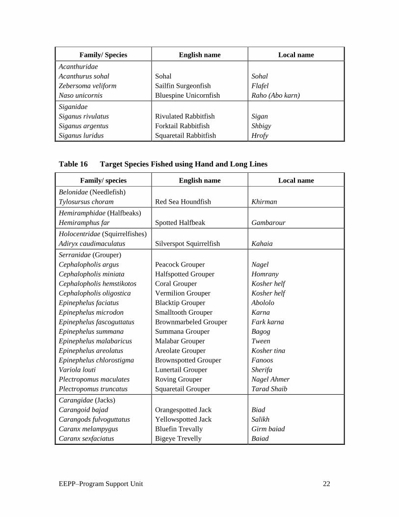
EEPP–Program Support Unit 22
Family/ Species English name Local name
Acanthuridae
Acanthurus sohal
Zebersoma veliform
Naso unicornis
Sohal
Sailfin Surgeonfish
Bluespine Unicornfish
Sohal
Flafel
Raho (Abo karn)
Siganidae
Siganus rivulatus
Siganus argentus
Siganus luridus
Rivulated Rabbitfish
Forktail Rabbitfish
Squaretail Rabbitfish
Sigan
Shbigy
Hrofy
Table 16 Target Species Fished using Hand and Long Lines
Family/ species English name Local name
Belonidae (Needlefish)
Tylosursus choram
Red Sea Houndfish
Khirman
Hemiramphidae (Halfbeaks)
Hemiramphus far
Spotted Halfbeak
Gambarour
Holocentridae (Squirrelfishes)
Adiryx caudimaculatus
Silverspot Squirrelfish
Kahaia
Serranidae (Grouper)
Cephalopholis argus
Cephalopholis miniata
Cephalopholis hemstikotos
Cephalopholis oligostica
Epinephelus faciatus
Epinephelus microdon
Epinephelus fascoguttatus
Epinephelus summana
Epinephelus malabaricus
Epinephelus areolatus
Epinephelus chlorostigma
Variola louti
Plectropomus maculates
Plectropomus truncatus
Peacock Grouper
Halfspotted Grouper
Coral Grouper
Vermilion Grouper
Blacktip Grouper
Smalltooth Grouper
Brownmarbeled Grouper
Summana Grouper
Malabar Grouper
Areolate Grouper
Brownspotted Grouper
Lunertail Grouper
Roving Grouper
Squaretail Grouper
Nagel
Homrany
Kosher helf
Kosher helf
Abololo
Karna
Fark karna
Bagog
Tween
Kosher tina
Fanoos
Sherifa
Nagel Ahmer
Tarad Shaib
Carangidae (Jacks)
Carangoid bajad
Carangods fulvoguttatus
Caranx melampygus
Caranx sexfaciatus
Orangespotted Jack
Yellowspotted Jack
Bluefin Trevally
Bigeye Trevelly
Biad
Salikh
Girm baiad
Baiad

EEPP–Program Support Unit 23
Family/ species English name Local name
Lutjandae (Snapper)
Lutjanus flaviflamma
Lutjanus bohar
Dory Snapper
Twinspot Snapper
Herby
Bohar
Haemulidae (Grunt)
Plectorhynchus gaterinus
Plectorhyncus pictus
Blackspotted Grunt
Painted Grunt
Katreen
Shataf
Lethrnidae(Emperor)
Lethrinus elongates
Lethrinus variegates
Lethrinus lentjan
Lethrinus ramak
Lethrinus mahsena
Lethrinus nebulosus
Monotaxis grandoculis
Longnose Emperors
Variegated Emperor
Redspot Emperor
Yellowstripe Emperor
Mahsena
Spangled Emperor
Bigeye Emperor
Khirmy
Dreeny
Khomkhom
Bongoz
Mehsena
Shoor
Aboeen
Sparidae (Progies)
Acanthopagrus bifasciatus
Doublebar Bream
Rabag
Spyraenidae (Burracudas)
Sphyraenae barracuda
Sphyranae putnamiae
Great Barracuda
Chevron Barrcuda
Kenaya
Ogaam
Balistidae (Triggerfish)
Pseudobalistes fuscus
Odnus niger
Blue Triggerfish
Redtooth Triggerfish
Shaaram
Aboariba
Table 17 Target Species of Fish for Purse-seiners
Family/Species English name Local name
Culpeidae
Sardinella melanura
Clupea sirm
Clupea leigoaster
Spotted Sardinella
Golden striped Sardinella
Red-eye Round Herring
Sardin mofater
Sardin mofater asfer
Moza
Scombridae
Scomber japonicus
Rasterelleger kanagurta
Houtuyn
Indian Mackerel
Shak el-Zore
Bagah
Atherinidae
Atherina forskali
Kashkosha
Table 8 illustrates catch composition and fishing gear used in aggregation/season in
different fishing grounds. Note that fishing operations are undertaken in spawning and
feeding aggregation. Deep and detailed studies may be required to identify the proper

EEPP–Program Support Unit 24
fishing times to maximize both biological and economic yields and to ensure
sustainability of the resources.
Table 18 Catch Composition, Fishing Gear, and Aggregation/Season by Fishing
Grounds
Family/Species Fishing Gear Aggregation/Season Sites
Serranidae
Epinephalus twina
Twina
Hook and line
Spawning aggregation
(June and July)
Ras el-Gimsha, Abo
Malh, and Twila
Carangidae
Caranx fullvoguttatus
Slikakaady
Decaperus helenae
Shakora
Hook and line
Purse-seine
Feeding aggregation
Winter months
Spawning aggregation
(May, June, and July)
Gobal, Shidwan
Island, Ras Banas, and
Abo Monkar
Mullidae
Mulloidicthys
auriflamma
Embera baldi
Trammel and gill nets
Near shore feeding
and spawning
aggregation
15 days in May, June,
and July
Sharm el-Arab,
Dishatt Abo Monkar,
Shatt el-Mina,
Gaffateen, and
Shidwan
Gerreidae
Gerres oyena
Gasa
Trammel and gill nets
Spawning aggregation
February, March,
April, and May
Sharm el-Arab,
Dishatt, Abo Monkar,
Shatt el-Mina,
Gaffateen, Shidwan,
and Ras Banas
Lutjanidae
Lutjanus bohar
Bohar
Hook and line
Trammel net
Spawning aggregation
July, August, and
September
Gobal and Shidwan
Sparidae
Argyrops spinifer
Morgan
Trawling
Gill and trammel nets
Spawning aggregation
Winter months
In the soft bottom
near coral reefs in the
study area

EEPP–Program Support Unit 25
Family/Species Fishing Gear Aggregation/Season Sites
Letherindae
Letherinus nebulosus
Shoor
Letherinus mahsena
Mahsena
Hook and line
Trammel net
Hook and line
Trammel net
Spawning aggregation
21 April–15 June
Spawning aggregation
21 June–July
North Abo Nahas,
Shidwanand, and
Elhilook
Between Giftun Island
and El-Ereg el-
Sogaier, Abo Monkar,
and El-Ereg el-
Keebeir
Scaridae
Scarus bicolor
Biaady
Gill and trammel nets
Spawning season
July, August, and 15th
September
Abo Monkar
Scombridae
Scomber japonicus
Shak el-Zor
Purse-seine
Spawning aggregation
Abo Monkar
Mugilidae Veranda net Spawning agreggation El-Ahiaa to El-Esh
Nursery Grounds
General
The Importance of the sheltered marine coastal habitat as nursery grounds for the juvenile
fishes is well-established in the literature and it has been shown that a large number of
fish species are dependant on these area during the juvenile phase of their life cycle.11
Typically, juvenile fish enter the nursery areas after metamorphosis, having been
spawned elsewhere in the sea. They remain in the nursery area for some time, often no
more than a year before vacating it for their adult habitat. This pattern of habitat
utilization is considered to occur because sheltered habitat offer advantages over marine
environment in the terms of protection from predators and an abundant food supply.12
13
11
Bennett, B.A., “The Fish Community of the Moderately Exposed Beach on the South Western Cape
Coast of South Africa and an Assessment of their Habitat as a Nursery Ground for Juvenile Fishes,” Estur.
Coast. Shelf. Sci., 28:239-305, city, 1989. 12
Lenanton, R.C.J., “Alternative Non-estuarine Nursery Habitats for Some Commercially and
Recreationally Important Fish Species of Southwestern Australia,” Australian Journal of Marine
Freshwater Resources, 33:881-900, city, 1982. 13
Ahmed (other names), “Ecological and Biological Studies on the Juvenile Fishes in South Sinai,” M.Sc.
thesis, Suez Canal University, Suez, 1992.

EEPP–Program Support Unit 26
Nursery grounds for juvenile fish must have certain characteristic features. They must be
rich in food and particularly high in temperature. They are usually found near the shore,
i.e., in sheltered, shallow water. Gibson stated that juveniles are adapted to shallow water
life that allow them to remain in the favorable position of the littoral zone, but the adults
of their species are found in deeper water. Gibson summarized factors affecting the
abundance of juveniles as salinity, temperature, turbulence and wave action, and food
availability.14
Blaber and Blaber summarized the factors affecting juvenile fish in the
nursery grounds as physical and biological parameters, adding that predators are an
important factor.15
The nursery grounds include estuaries and sheltered coastal marine habitat such as sandy
shores, bays, and mangroves. These habitats serve as nursery areas for many juveniles of
marine fish species.16
Many authors have shown that a large number of species—perhaps
100—are dependent on these habitat during the juvenile phase of their life cycles.17
Ahmed studied the nursery grounds in the Gulf of Aqaba in the Egyptian Red Sea and
found that that Sharm el-Mayia Bay and NABAQ mangroves are excellent nursery
grounds for 13 commercial fish species.18
Nursery Grounds in the Study Area
Twenty-three nursery grounds have been identified in the study area. Maps 7–10 in
appendix 1 and table 9 below illustrate their distribution by habitat. Seventeen nursery
grounds are threatened by fishing and tourism activities, two mangrove grounds are
located in marine parks, but are used for animal grazing, the rest are still unused for any
activity. Serious actions should be taken to protect and conserve the nursery grounds.
Table 19 Nursery Grounds in the Study Area
Nursery Position Habitat Activities
Gimsha 39.28 N
33.33.51 E
Seragrass and
seaweed
Fishing
Gobit Melaha 31.26 N
33.33.24 E
Seagrass Fishing
Gobit el-Disha 02.47 N
33.53.22 E
Soft bottom Tourism and fishing
14
Gibson, R. N., “Recent Studies on the Biology of Inertial Fishes,” Oceanographic Marine Biology
Annual Review, 20:363-414, city, 1982. 15
Blaber, S.J.M. and Blaber, I.G., “Factors Affecting the Distribution of Juvenile Estuaries and Inshore
Fish,” Journal of Fish Biology, 17:134-162, city, 1980. 16
Bennett, 1989. 17
Need to provide a reference for this one—the listed Blaber is 1980. 18
Ahmed, 1992.

EEPP–Program Support Unit 27
Nursery Position Habitat Activities
Abo Makadig 59.40 N
33.53.56 E
Seagrass Tourism and fishing
Sharm el-Arab 57.56 N
33.55.13 E
Seagrass and coral
patches
Fishing
Soma Bay 50.09 N
33.57.00 E
Seaweed and
Seagrass
Tourism
Mangrove
Rehabilitation
36.56 N
34.00.41 E
Mangroves Marine park
Abo Kalawi 30.32 N
34.03.59 E
Seagrass seaweed Fishing
Mangrove 24.07 N
34.06.54 E
Mangroves Marine park
Asil 56.31 N
34.23.15 E
Coral Tourism
Marsa Wzer 47.09 N
34.29.11 E
Seaweed None
South Om Geish 42.18 N
34.3.22 E
Soft bottom None
Om el-Grifaat
Lagoon
36.00 N
34.36.12 E
Tourism
South Abo Dabab 17.59 N
34.45.06 E
Soft bottom None
Morein Lagoon 23.41 N
34.42.06 E
Tourism
Gabal el-Rosas 12.17 N
34.48.23 E
Soft bottom None
South Gabal el-Rosas 09.11 N
34.51.00 E
Soft bottom None
Kilo 7 South Marsa
Alam
00.47 N
34.55.30 E
Seagrass None
Sharm el-Loly 36.35 N
35.06.36 E
Soft bottom Fishing
Wadi el-Kalaan
Mangrove
21.27 N
35.18.21 E
Mangrove Marine park, animal
grazing, and fishing
Hamata 17.52 N
35.22.06 E
Mangrove Marine park, over-
grazing, and fishing
Wadi Lahmy 12.57 N
35.25.32 E
Mangrove Tourism

EEPP–Program Support Unit 28
Nursery Position Habitat Activities
Kara el-Hartway 07.53 N
35.29.12 E
Mangrove None
Fishermen
Based on fieldwork data, there are an estimated 2,800 fishermen operating in the study
area. This figure represents regular fishermen operating from fishing vessels as well as
those who use trucks to transport nets and fish to and from fishing grounds, i.e., foot
fishermen. It does not include part-time fishermen or those who operate tourist boats who
also fish.
A breakdown of fishermen by landing site is given. Approximately 46 percent or a total
of 1,280 fishermen are based at the Hurghada region’s landing sites, Al-Ahiaa, El-Dahar,
and Hurghada Port. Approximately 90 percent of all fishermen are predominately artisan
fishermen using hand and long lines, gill nets, trammel nets, and veranda nets.
Fisheries resources in the study area targeted by three groups:
15. Local fishermen who originally came from Upper Egypt and are based
mainly in Hurghada, Safaga, and Quseir and settled Bedouin fishermen,
belonging to the Bshari and Abada tribes who are living in Ras Banas in
small groups. The latter group use mainly sail boats with veranda nets,
cast nets, hand lines and longs lines. Production is consumed locally, with
some fish salted or sun dried.
16. Migratory fishermen who came many years ago from Fayoum
Governorate and settled mainly in Hurghada and Safaga. It was reported
that about 195 fishermen are fishing from Hurghada and 15 from Safaga.
They usually establish seasonal fishing camps and use fishing boats
equipped with inboard engines. They introduced the use of gill nets that
consist of 30 segments of 30 m. long in an illegal mesh size, which are
highly destructive. They also use stand nets on corals, which cause serious
damage to this important habitat. As to date the Red Sea fisheries are open
to all, there is a trend toward gradually increasing their numbers That may
present serious threats to fisheries in the area.
17. Visiting fishermen who operate purse-seiners during the fishing season
and go back to their home villages in the Delta.
Most fishermen in the artisan fleets are related to or belong to one family. For the local
fishermen, there is a noticeable trend toward leaving fishing to work in tourism and other
EEPP–Program Support Unit 29
sectors such as mining and petrol. Reasons cited include limiting fishing grounds and
poor coastal zone management. There are already conflicts between tourism development
and traditional fishing interests. The main coastal stakeholders affected by tourism and
reef recreational activities in particular are the artisan fishing communities. A recent
Global Environmental Fund project survey, together with other project-related
stakeholder analyses (MEP Report 540-R-12, 1998) showed the main issues to be:
Reduction in access to reef flat fisheries due to the construction of beach front
hotels and water sports facilities. Actual access to the beach is denied and most
hotels actively prevent fishing in front of the hotel. In both Hurghada and Safaga,
approximately 20 km of beach front are now effectively barred to local fishermen.
Displacement of fishing communities through hotel and water sport
development. New tourism activity sites are often designated and implemented
without local consultation. In some cases (i.e., Barakah), fishing villages are displaced
involuntarily. Favorable hotel development sites (i.e., adjacent to reef flats, in bays, or
on headlands ) are often productive fishing grounds that increase the chance of
conflict unless appropriate investigation and compromise is made.
Favored dive sites become effectively barred. Often located in traditional fishing
grounds, these can be closed to artisan fishermen. Local fishermen also report that
fish catches are markedly lower in sites that are frequently dived.
Traditional fishermen are leaving. More lucrative opportunities exist in the dive
and hotel sector for the traditional fishermen. Newcomers with less knowledge about
the local ecology and with unsustainable fishing practices frequently replace them.
This has led to an increase in habitat destruction from nets damage. There is also an
irreversible loss of knowledge of traditional local fishing methods.19
It is necessary that some level of compromise be integrated into proposed shoreline
management plans.
Based on information from interviewed fishermen at visited landing sites, the average
monthly income from fishing activities was: Hurghada, LE 300–500; Safaga, LE 50–200;
and other landing sites, LE 200–700.
The fishermen live in their own communities. In Hurghada they concentrate in the El-
Sakkala region near the fishing port. Other main fishing communities are El-Gweeh
Village, Quseir, Marsa Alam, Kilo 24 South Marsa Alam, Cul’an Village, Sataieh, and
Ras Banas.
There are three fishermen’s cooperative societies in the study area: Hurghada
Cooperative with about 600 member fishermen, Safaga Cooperative with 129 members,
19
Breika, 1997

EEPP–Program Support Unit 30
and Quseir cooperative with 269 members. Fishing cooperatives are governed by Fishing
Cooperative Law No. 123/1982, which stipulates the role of the cooperative in improving
the economic, social, and professional status of members. Cooperatives provide a number
of benefits and services, including supply of fishing gear and equipment, credit finance,
and some basic social services. Migratory fishermen do not belong to the cooperatives as
they are not accepted by local member fishermen. It is important to group the migratory
fishermen in some kind of association to facilitate contact between them and other
concerned bodies.
Wadi el-Gemal–Hamata Protected Area
The Wadi el-Gemal–Hamata Protected Area includes three landing sites:
18. Sharm el-Loly, with 55 local fishermen operating 11 boats equipped with
40 hp outboard engines and using trammel nets. The average annual
landings are estimated at about 28 tons composed mainly of Slenderspine
Mojarras (Gasa), Mullet (Arabi), Rabbit Fish (Sigan), Goat Fish (Ember ),
and Emperor (Shoor). The main fishing grounds are Hamraween, Abou
Saan, and Wadi el-Gemal Island, which are also nursery grounds.
19. Cul’an Village, with 20 local fishermen operating four fishing boats
equipped with 20–40 hp outboard engines and mainly using trammel nets.
The average annual landings were estimated at 5 tons composed mainly of
Mullet, Mojarras, Houndfish (Kherman ), Parrotfish (Harid), and Grouper
(Koshar). The main fishing grounds are mangrove habitats and Cul’an
Island.
20. Hamata, with 50 local and migratory fishermen operating 10 fishing boats
with 40 hp outboard engines and mainly using hand lines and trammel
nets. The annual average landings were estimated at about 25 tons
composed mainly of Snapper (Fares) and Jack (Biad). The main fishing
grounds are the deep waters of Koraa el-Hartawi and Hamata. The latter is
considered nursery ground.
Fish Handling and Marketing
Most of the fish is marketed fresh (iced ), and a small part—mainly mullet—is salted
while bigger fish may be dried. Fish are sorted and graded on the boats. The fishermen’s
cooperative society in Hurghada manages the marketing of fish caught by its members
against a commission. A certain quantity of the catch has to be delivered to the Red Sea
Governorate to be sold at a fixed price to local consumers.
EEPP–Program Support Unit 31
At the other landing sites, the fishermen market their own catch directly to consumers
comprised of mine workers, company officials, and tourism villages.
Salted fish are packed in metal tins (15–17 kg in each tin) and sent by truck to be sold to
wholesale merchants mainly in Cairo. The wholesale merchants have their
representatives in the main fishing centers (Hurghada, Quseir, and Baranis) that provide
fishermen with tins and loans and manage salted fish collection and transportation.
Fisheries Legislation
Fisheries are governed by national laws that dictate the terms and conditions under which
fishing activities may take place and provide for protection and conservation of living
marine resources. Regulations (or by-laws) set out the details concerning fishing
activities and restrictions that apply.
Law enforcement is the responsibility of GAFRD in cooperation with the Ministry of
Defense Frontiers Guard. The Guard is based at the fishing ports and main landing sites.
They issue permits to fishing vessels and record trip duration, area fished, and names of
fishermen on each boat.
The GAFRD was created by Presidential Decree 190/1983. The chairman of the authority
was given the status of first secretary, directly responsible to the Minister of Agriculture.
Presidential Decree 465/83 gave the GAFRD the right and obligation to supervise,
administer, and monitor the waters of Egypt. Presidential Decree 362/1984 declared that
all license fees due from fishermen and fishing vessels are the property of the authority.
In 1983, two laws were created that dealt with the fisheries sector. The first was Law 123,
dealing with fisheries cooperative societies. The second was 124, dealing with fishing,
living aquatic resources, and fish farms.
Law 123 regulates the fishermen’s cooperative societies, to which the majority of
fishermen in Egypt now belong The law deals with the administration, meetings,
elections of the board of directors, distribution of profits, and credit arrangements. It also
established the Fishermen’s Cooperative Union, to which all the cooperative societies
belong.
Law 124 (Fisheries and Fish Farming Organizing Law) deals with all living aquatic
resources, fishing grounds, vessels and methods, pollution, licensing, fees, penalties, and
other matters.
These articles are relevant to the Red Sea:
Article 2: All fishing boats must show clearly, both on their hull and their sail, their
class, license number, and designated fishing area. The class of a boat (sailing and

EEPP–Program Support Unit 32
rowing) is designated according to the size and class of its crew—1st class will not
exceed 27 fishermen crew, 2nd class will not exceed 13 fishermen crew, 3rd class will
not exceed 4 fishermen crew.
Article 7: All fishing is prohibited in areas and seasons as decreed by the Minister of
Agriculture. Use of some fishing gear may be prohibited by such decree as well.
Article 9: All unlawfull fishing gear is prohibited either on board of fishing boats or in
the possession of persons in the fishing areas or nearby.
Article 10: It is prohibited to catch, sell, or have undersized fish or other living
aquatic species, whether fresh or dried and salted.
Article 11: It is prohibited to catch ornamental fish without permission from GAFRD.
Article 13: Using harmful materials, poisons, narcotics and explosives…is prohibited
in fishing.
Article 23: All fishing boats must be licensed. Fishermen, whether or not on a boat,
are required to be licensed and to carry a fisherman’s card. The number of vessels
using each type of fishing gear is determined according to the by-law.
Sanctions
– A boat not showing the information identified in Article 2 shall be
fined LE 20.
– A boat fishing without a license shall be fined LE 50 and the
responsible shall be imprisoned for up to 3 months, or one of these two
sanctions. In addition, the boat and fishing tools shall be confiscated.
– Use of unlawful fishing gear or fishing in closed areas or seasons shall
be liable to a fine of LE 100–500, and imprisonment of 3–6 months, or
one of these two sanctions.
– Use of poisons or explosives shall be liable to a fine of LE 500–1,000
and imprisonment of 6–24 months, or one of these two sanctions.
In addition to these specific regulations, the Minister of Agriculture has wide
discretionary powers to regulate the issuance of licenses and to identify fishing areas and
seasons.
In 1987, the Minister of Agriculture’s Decree 303 was issued to implement Law124. The
decree deals with detailed fishing methods, fishing grounds, fees, and penalties.
Other authorities have also issued regulations to control fishing activities in the Red Sea
as well as to identify Wadi el-Gemal as a protected area. These as summarized in table
10:

EEPP–Program Support Unit 33
Table 20 Principal Decisions Issued by the Red Sea Governor, the Chairman of
GAFRD, and the Prime Minister Affecting Egypt’s Fisheries
Decisions Subject
Red Sea Governor
No. 14/1998 Prohibition of any action or activity that will lead to the
destruction or deterioration of the natural environment of islands
and areas surrounding them as well as mangrove regions.
No. 46/1998 Prohibition against collecting, exposing, and marketing shells,
coral, ornamental fish, and other protected marine species is the
governorate.
No. 95/1998 Prohibiting harpoons for fishing in Egyptian waters.
No. 22/2003 Prohibition of Sea Cucumber fishing for 1 year starting in March
2003.
Chairman of GAFRD
No. 410/2001 Hurghada and its islands belong to the Red Sea (not to the Gulf
of Suez) and it is permitted to use lines and net as follows:
Ghabriat nets of 20 mesh size, Mowaghat nets with 2 layers of
6 mesh size for the outside layer and 17 mesh size for the other
layer The number of segments of each net shall not exceed
12 units. It is forbidden to use this gear in coral reef regions.
No. 424/2001 Implementing Law 124/1983 in Hurghada Islands as in the case
of Gulf of Suez, except that it is permitted to use lines and nets
in the Hurghada region and its islands as follow: Nets for
Borbon of 20 mesh size, Marabee nets of 14 mesh size,
Mowagehat nets with 2 layers of 6 mesh size for the outside
layer and 17 mesh size for the inside layer, provided that the
number of segments do not exceed 12 units to ensure smooth
operation of small boats.
No. 1741/2001 Closed season for the Gulf of Suez and the Hurghada region and
its islands are as follow:
From 1/6/2001 to 30/9/2001 for trawlers.
From 5/6/2001 to 5/11/2001 for purse-seiners.
From 1/8/2001 to 30/9/2001 for launches using lines (hooks).
From 1/9/2001 to 30/9/2001 for small boats (faloukas) using
lines (hooks).
As for the Red Sea, closed to trawlers from 1/8/2001 to
4/10/2001.
No. 236/2001 Hurghada region and its islands are considered part of the Gulf
of Suez.
Lines are only permitted for fishing in this area. Nets of all kinds
are not permitted.

EEPP–Program Support Unit 34
Decisions Subject
No. 282/2002 Sea Cucumber fishing is permitted year around with the
exception of April, May, and June (spawning period).
52 boats and 155 foot fishermen are licensed for fishing.
The licenses are identified by region according to the attached
list and through the fishermen’s cooperatives and companies.
They are responsible for the safety of divers during the
operations.
The fee to be paid by fishing boats with a maximum of 5 persons
is LE 5,000/year and LE 500 for on-foot fisherman.
The fee per individual Cucumber taken from Egyptian water is
to be PT 15, distributed as follows: PT 2 for the cooperative,
PT 2 for the Cooperative Union, and the rest for GAFRD. As for
fishing boats taking Cucumbers from outside Egyptian waters
and landing them in fishing ports along the Red Sea coast, the
fee is to be LE 5 per fish box.
Use of trawlers to catch Sea Cucumbers within Egyptian waters
is prohibited.
Minister of Agriculture
No. 410/2002 Prohibiting catching Sea Cucumbers in the protected areas and
around the islands as well as in the coral reef regions of the Red
Sea.
Prime Minister
No. 143/2003 Identifying the Wadi el-Gemal–Hamata Protected Area in
compliance with Law 102/1983.
The Governor of the Red Sea is to supervise the implementation
of the decision in coordination with concerned authorities.
Other legislation and regulations that directly or indirectly regulate and protect marine
resources in the Red Sea include:
Minister of Defense Decree No. 56/1962 on the Cleanliness of Ports and Territorial
Waters, in compliance with Public Law 280/1960 regulating ports and territorial
waters
Public Law 72/1968 on the Protection of Sea Water against Oil Pollution
Presidential Decree 261/1981 concerning the establishment of a Shore Protection
Authority (SPA)
Ministry of Industry Decree 380/1982 concerning the Protection of the Environment
against the Introduction of New Technologies
Presidential Decree 1948/1985 establishing a Standing Committee for the Prevention
of Marine Pollution by Oil, amending Decree 691/1972

EEPP–Program Support Unit 35
Conservation Law 102/1983 setting up the legislative framework for the creation of
protectorates
The legislative framework governing all new developments is the Law for the
Environment (Law 4/1994) brought into effect by Executive Regulations issued by
Prime Minister Decree 338/1995.
The main provisions of this law can be summarized as:
– Founding an agency with a clear mandate to protect the environment—
the Egyptian Environmental Affairs Agency (EEAA).
– Establishing and running environmental information and monitoring
networks to guarantee an efficient implementation of the agency’s
mandate.
– Centralizing pollution control and giving powers to EEAA in terms of
pollution control and management.
– Setting up an Environmental Protection Fund with sufficient resources
and well defined expenditure items. The fund resources are devoted to
research, technical analyses of the environment, environmental
assessment studies, the establishment of environmental monitoring
networks, the removal of pollutants, and other activities aiming at
environmental protection.
– Setting up the principles and procedures to be followed in the
preparation of environmental impact assessments of new projects and
extensions to existing projects that have the potential of adversely
affecting the environment.
– Establishing an Environmental Affairs Department in each governorate
to help coordinate and implement EEAA’s mandate at the local level.
Under the Executive Regulations virtually all new construction or extensions to
previous construction require the consent of a competent administrative authority,
which is one of various ministries or governorates depending on the nature and
location of the construction. Each proposal must be accompanied by some form of
environmental impact assessment. The competent administrative authority provides
preliminary screening of the proposal and passes the environmental impact assessment
to the EEAA for evaluation and comment. In the light of these comments, the
competent administrative authority may approve, refuse, or request modifications to
the project. There is an appeals procedure to which EEAA has input but is not
otherwise involved in the final judgment.
Articles 59 and 60 of Law 4 have far-reaching implications for the design of new coastal
resorts. Article 59 prohibits construction of any establishment within 200 m of the

EEPP–Program Support Unit 36
shoreline except with the approval of the General Shore Protection Authority in
coordination with EEAA, following submission by the developer of a detailed
environmental impact assessment of potential impacts to the coastal area and shoreline.
Particular attention must be given to the precautions that are to be taken by the developer
to avoid erosion, sedimentation, and alteration of coastal currents and pollution that could
potentially result from the project. Article 60 prohibits all activities that cause alteration
of the natural shoreline.
Appendix VIII of the Guidelines for Egyptian Environmental Impact Assessment
(EEAA, 1997) gives specific guidelines for environmental impact assessments for
offshore oil and gas establishments. Of particular relevance to the GEF Red Sea project is
Section 4.2 (Coastal and Marine Ecosystems and Resources). The developer should
consider the following issues:
Fauna and flora, and rare or endangered species within or in areas adjacent to the
project
Sensitive habitats, coral reefs, wetlands, bays, lagoons, marshes, and mangrove
swamps
Species of commercial importance affected by the project
In addition to the biological data, the EIA should consider water quality, currents,
ability to assimilate discharges and maintain desired water quality, and other
significant sources of pollution in the area.
Protected Areas Legislation
Initiatives include the Egyptian Conservation Law, Law 102/1983, which established the
framework for the creation of protected areas. Implementation of some of the provision
of this law is provided by a 1983 Prime Ministerial Decree.
The regulations defined in Article 11 of Law 102, deal with any action or activity that
will lead to the destruction or deterioration of the natural environment or harm the biota,
or detract from the aesthetic appeal of the protected areas. The rangers in charge of the
day-to-day management of protected areas patrol to guard against the following actions,
which are strictly prohibited:
Hunting, transporting, killing, or disturbing living terrestrial and marine organisms, or
carrying out activities that would lead to their destruction (i.e. spear fishing ).
Damaging, removing, or transporting any living organism or organic material such as
shells, corals, rocks, or soil for any purpose.
Damaging or transporting plants found in a protected area.
Damaging or destroying geographic or geological formations of areas considered as
habitats for animals and plants, or for their reproduction.
EEPP–Program Support Unit 37
Introducing foreign species into protected areas.
Polluting the soil, water, or air of a protected areas.
Construction of any building or establishment in a protected area without the
permission of the relevant administrative body.
It is concluded that a common feature in the study area is that most laws do not have the
strength and clarity needed for effective management and monitoring, control, and
surveillance (MCS). Common concerns include inadequate definition of term such as
‘fishing vessel,’ ‘tourism vessel,’ or ‘fishing activities’ for sound administration and
enforcement of the legal process. Penalties for infringements are frequently far too low,
undermining respect for management and control, since there is minimal deterrence.
Licensing systems are often inadequate. For example, it was reported that many fishing
vessels operating in the study area—especially in the southern part—have no license.
Fisheries observers and enforcement officers’ powers, duties, and responsibilities are in
some cases not described; procedures following seizure and arrest are not specified; and
often there is no option of imposing an ‘administrative penalty’ by the minister
responsible for fisheries rather than initiating a lengthy court process.
Poor coordination between different governmental bodies has often resulted in
overlapping responsibilities and jurisdictions for the implementation of legislation for the
marine environment and coastal zone.
National legislation should also be brought into line with current international initiatives
to promote cooperation in management of shared stocks as required under the United
Nations Convention of the Law of the Sea (UNCLOS) and facilitate implementation of
the Food and Agriculture Organization’s (FAO) Code of Conduct for Responsible
Fisheries and the Conservation and Management of Straddling Stocks Agreement.
EEPP–Program Support Unit 38
5. Proposed Fisheries Management Plan for the Study Area
Introduction
The management plan defines how the marine resources of the study area, including the
Wadi el-Gemal–Hamata Protected Area, will be managed. It tries to answer the following
questions:
What fisheries resources are available?
How valuable are these resources?
What is the best way to use these resources?
Are the resources being overexploited and the environment being damaged?
Are there resources that are being under-used? Should these be fished more?
The plan is based on information gained from a number of sources including existing
documentation and interviews with officials, fishermen, managers of fishermen’s
cooperatives, and fish traders.
The plan indicates the key issues and constraints for sustainable fisheries development
and conservation. It identifies objectives for the fisheries and the strategy to be employed
in order to achieve those objectives. To be successful, the plan must have the active input,
support, and acceptance from all stakeholders, especially the fishermen. A carefully
planned public awareness program will be essential.
Key Issues and Constraints for Sustainable Fish Resources
There are a number of problems facing the fisheries in the Red Sea. These include
inadequate information, ineffective management, uncontrolled use of resources, poor
control of the resources, lack of planning, and inadequate training and public outreach
activities.
Inadequate Information Base
Fisheries management must be based on an accurate understanding of the resource base
and of the relationship between resources use and natural regeneration, that is the

EEPP–Program Support Unit 39
sustainability of fish levels and methods of exploitation. There is currently very little
reliable data on which to base fishery specific management strategies and measures.
Current data collection systems lack planning and transparency. Data formats are often
not amenable to effective stock assessment or monitoring of fisheries management. A
lack of comprehensive biological and economic statistics is a major constraint to effective
fisheries management. This is compounded by a lack of awareness or application of the
precautionary approach principle.
A fundamental requirement for statistical information on artisan fisheries, for purposes of
resources assessment, planning, and future management, is the establishment and
implementation of an appropriate sampling program. This must be based on a new census
of the size, location, and characteristics of the fishing fleet. The implementation of the
program will require enumerators stationed at, or near the sites selected for sampling.
It is suggested therefore that the present arrangements for fisheries data collection and
analysis be revised. Data should be collected that will allow routine catch, effort, and
CPUE analysis at the species level.
Inadequate Effective Management
Fisheries management policies are not currently well defined, nor are they based on
reliable scientific information. Modern guidelines such as the Code of Conduct for
Responsible Fisheries are not part of legal framework. The adoption of the precautionary
approach has considerable implications for fisheries management authorities. Scientific
advice to fisheries managers should allow for uncertainty in both the understanding of the
state of the stocks and the effect of future management actions. When less is known,
fisheries management authorities should be more cautious. This requires a management
approach less focused on and influenced by short-term considerations, and more
concerned with long-term sustainability of fisheries resources and the environment. Over-
fishing due to over-capacity and ineffective application of controls is the major problem
facing Red Sea fisheries. Many factors attract new entrants from other governorates to the
Red Sea fisheries, leading to uncontrolled effort expended on the resources.
Uncontrolled Expansion of Fishing Operations
Uncontrolled expansion of operations eventually leads to over-exploitation of the
resources. The most appropriate way of regulating fishing is to limit the fishing fleet to a
certain size. It is also appropriate to charge the tourist boats owners who fish for the right
to exploit the common resources and recover some of the cost of managing the fisheries.
This of course may also apply to the artisan fisheries in certain places.
There is anecdotal information concerning fishing and marketing of Sea Cucumber, but
there are conflicting estimates of magnitude. Intensive surveillance could assist in

EEPP–Program Support Unit 40
quantifying the problem, but very little can be done about it without empowered
enforcement officers.
Poor Monitoring, Control, and Surveillance
National authorities are currently unable to undertake effective MCS of artisan fisheries
due to lack of equipment, recurrent financial problems, and a lack of suitably trained
personnel. The allocation of resources for enforcement as well as training of enforcement
officers, particularly in areas of high fishing pressures, should be given priority.
Implementing boat registration and licensing systems can assist surveillance of artisan
fisheries.
Lack of Integrated Coastal Planning
Integrated coastal management is lacking: both the tourism and oil industries are afforded
high priority, but the negative impacts of such activities on coral reefs, nursery grounds,
spawning areas, and fishing grounds are not considered when policy is being made for
these lucrative sectors.
There is a lack of effective communication between those formulating fisheries policy
and the fishing industries and communities which are ultimately affected by the
management measures imposed. This results in poor understanding of the need for and
agreement with management measures. Considerable opportunity exists for increasing the
involvement of fishing communities in the development and implementation of
appropriate management measures for fisheries resources.
Lack of Extension, Training, and Public Awareness
Public awareness of the need for a balance between fisheries and environmental
protection and conservation requires urgent attention. Many of the undesirable activities
currently practiced (such as using gill nets with an illegal mesh size or dumping used gear
at sea) could be reduced considerably if more attention were given to improving
extension and training and public awareness campaigns.
Overall Objectives for Fisheries Management
Global objectives for management of fisheries resources should be designed to:
Ensure that the fisheries are managed in accordance with the principles laid down in
the FAO Code of Conduct for Responsible Fisheries, so that stakeholders enjoy
maximum sustainable benefits.
Promote cooperation between sectors so that fishery and marine resource
management policies are integrated within the decision-making framework of the
Coastal Zone Management Plan of the Red Sea.

EEPP–Program Support Unit 41
Integrate the many uses of marine resources so that they are managed for the
equitable benefit of all stakeholders.
Management Strategy
The strategy to be employed in order to achieve the objectives must be:
Simple, clear, and understandable to all interested parties
Low in cost to implement and administer
Based on elements of the existing national management system (e.g. licensing)
Acceptable to the local fisheries societies.
The following strategy is recommended:
Development of a sound information base on which to build a management system
Adoption of a precautionary approach to decision making to ensure that harvesting of
marine resources in the area is sustainable
Adoption of a participatory approach to decision making so that wherever possible,
management decisions are based on consensus among fishermen, authorities, and
other interested parties
Elevation of living standard for artisan fishermen by providing the means to improve
processing, marketing, and distribution of marine products
Encouraging exploitation of under-utilized marine resources
Basing management primarily on controlling the fishing effort through the
establishment of a vessel registration, implementation of licensing requirements
already laid down in national law, and restriction of the number of licenses issued
Development of a sound institutional foundation such as a Fisheries Management
Committee.
Management Tasks and Options
Registration of Fishing Vessels
All fishing boats must be registered. The vessel’s unique registration number must be
fixed on both sides of the bow in accordance with existing legislation. No boat without a
registration number should be permitted to obtain a license to fish commercially. The
fishing vessel registration system would be based on the system already implemented.
The registration system would form the main element of the proposed data collection
system and be the main tool for regulating the fisheries.

EEPP–Program Support Unit 42
Licensing Fishermen
Fishing licenses would be issued preferentially to applicants who are long-term study
area residents. Fishermen from other places would be granted rights only if a license is
available under the license allocation, and the management body—the Fisheries
Management Committee—decides that the activities of the applicant will have no
detrimental impact on the area license holders.
Licensing Fishing Vessels
All fishing boats used for commercial gain must be licensed in accordance with existing
legislation. However, the terms and conditions of the license would specify the target
species, allowable gear, and area/seasonal restrictions.
Regulatory Measures for Targeted Species and Sea Cucumbers
Based on information obtained during field visits as well as from fishery officials, the
following regulatory measures are urgently needed:
Prohibiting use of illegal gill nets called sabeeb
Protecting inshore areas where spawning occurs
Reducing possible growth of over-fishing by protecting juvenile fish
Establishing areas known to be breeding grounds as ‘no take zones’ or closed areas.
It was reported that Sea Cucumbers fisheries are characterized by heavy exploitation.
They were not subject to any form of management at all for a long period. Recently the
Governor of the Red Sea issued a decision prohibiting Sea Cucumber fishing for the year
starting March 2003.
Management measures imposed in Pacific Island fisheries include a minimum allowable
size for dried products (Fiji), export quota restrictions (Solomon Islands), a system of
‘crop rotation,’ in which areas are harvested for a few months then left for the rest of year
(New Caledonia and Fiji). There is little management experience around on which to base
recommendations. However, the following management options should be investigated:
Establish closed areas/seasons (crop rotation)
Maintain a ban on SCUBA and snorkelling diving apparatus
Introduce alternate year total bans for some areas, establishing marine reserves.
Improve Data Collection Systems for Monitoring and Assessment
The many dispersed landing sites, the multitude of species, variations in fish prices, and
unrecorded subsistence catches combine to make data collection systems for artisan
fisheries inaccurate and inordinately expensive in terms of the resources and manpower

EEPP–Program Support Unit 43
needed to maintain them. In addition, the multi-gear nature of many artisan fisheries
makes estimating fishing effort difficult in most cases.
Establishing a system for the collection of reliable data is the single biggest issue to be
addressed in planning for management and future development of the fisheries in the Red
Sea.
A proposed system is built on the sample-based approach, introducing new sample data
collection forms, as well as compulsory data reporting requirements for the fishermen
and other related persons.
Objectives
The proposed data collection system would have as an overall objective the establishment
of a system for the regular collection of catch, effort, economic, financial, and biological
data that would allow monitoring of changes in the fishery and contribute to the
assessment of the status and population dynamics of the resources being exploited.
At the end of 1 full year’s collection and analysis of data, the system should be able to
provide:
21. An inventory of fishing gear, fishing vessels, fishermen, and their
distribution
22. An estimate of total weight of fish caught and fishing effort, broken down
by principal species, fishing gear, and areas fished (to allow spatial
mapping of catch-per-unit of effort) that would enable assessment of the
impact of fishing effort for each of the targeted species groups relative to
available stock, and assess sustainability of the fisheries
23. Estimates of the number of full and part-time artisan fishermen (i.e. those
who pursue fishing as a vocation) and subsistence fishermen
24. Basic trends in the fishery
25. Basic economic and financial indicators, including recurrent costs (fuel,
ice, repairs, and maintenance), fixed costs (fees, duties, and depreciation),
and earnings from sale of catch, to allow analysis of the economic
viability and socio-economic importance of the fishery
26. Biological information for the main species targeted to allow an
assessment of stocks and to set a baseline for future monitoring of the state
of the stocks.
Databases
The data collection system would require the creation of a number of databases:
Fishing vessel register database (FVRD),

EEPP–Program Support Unit 44
Fishing vessel license database (FVLD),
Fishermen license database (FLD),
Various databases containing information from interview/sample forms (catch, effort,
economic data, length–frequency, and biological data).
Data Forms
Many data forms would be needed. These include:
Fishing vessel registration application.
Fishing trip log sheet
Fishing day log sheet
Sales receipt (to be filled by the buyer)
Trip interview (for catch and effort)
Commercial species composition
Length–frequency data
Cost and earning data
Fixed costs.
Data Analysis and Reporting
In recent years there has been considerable progress made in the development of software
packages such as ARTFISH developed by FAO that assist in the analysis of basic data
from artisan fisheries, such as catch, fishing effort, and length and weight data.20
It is recommended that a formal report on the fisheries be produced each year. The report
would present an overall description of the fisheries sector, possibly supplemented by
other publications on specialized topics (e.g. the development of the vessel register,
management systems and their value for conservation, including documentation on the
sampling program and databases, vessel registration summary, and fish stock assessment
report). An overall description of the sector is a basic requirement if the management
plan for the fishery is to be successful.
The data collected and processed will have three main uses: assessment, monitoring, and
management. The annual report should provide information in each of these three areas,
as indicated below:
20
Approaches, Rules and Techniques for the statistical monitoring of Fisheries. Developed by FAO’s
Fisheries Information Data and Statistics Unit, ARTFISH contains 3 sub-components: ARTPLAN for
training and survey planning; ARTBASIC for handling sample data and producing monthly estimates on
catch and fishing effort, and ARTSER for reporting time series (catch, effort, Values) resulting from
ARTBASIC. It is planned that FAO will provide training in the software to Egypt.

EEPP–Program Support Unit 45
Assessment of the fisheries: results of scientific analysis of the length frequency
data, coupled with the catch and effort data, would provide an indication of the status
(or health) of the fish stocks and the likely effect fishing mortality is having. Analysis
of the economic data will provide an appraisal of the financial viability of fishing
activities, fishing-related employment, nutritional levels, and calculation of revenues
and fees associated with fishing.
Monitoring: this would focus on changes in fleet structure, gear used, response of the
fishery and resources to management measures, changes in economic values, and
revenues generated by the sector.
Management: management would be supported through identifying the effects of
management regimes, development of new fisheries/techniques, and establishment of
license fee schedules and other regulatory mechanisms.
Main users of the data and the analyses performed would include fisheries policy makers,
fisheries managers, fisheries biologists, economists, private sector investors, as well as
the FMC to decide whether or not management strategies developed are working, and
whether new measures are required.
Training
Basic and refresher training would be needed in the following specific areas:
27. Enumerators need to be trained in interview techniques, use of forms,
species identification, random sampling, length measurements, and
registration and licensing procedures.
28. Marine researchers need to be trained in form design, database design,
data entry, data manipulation and processing, interpretation of results,
report preparation, and use of results in formulating management advice.
29. Fishermen need to be trained in the use of charts to plot fishing positions,
and in how to fill in catch/effort log sheets and sales slips.
Technical assistance will be required in detailed planning and implementation of the
program.
Public Awareness
The close support and cooperation of the societies will be instrumental in successful data
collection. It is essential that the aims of the systems for vessel registration, fishermen’s
licenses, log sheets, sales sheets, and sample interview data be clearly explained to the
fishermen. Their active support, participation, and direct assistance are crucial to the
success of the monitoring plan.

EEPP–Program Support Unit 46
Awareness will be facilitated in the same way as awareness for the Management Plan,
i.e., through publication of FMC meeting minutes, and by advice passed through the
society system and community leaders.
Although many fisherman interviewed during the course of the mission stated their
understanding of the need for better data collection, scientific investigation of the
fisheries, and increased management, it will be important to clearly explain the idea of
restricted entry to the fishery. Restricted access to fisheries resources, through vessel
registration and fishermen licensing, is a new and unfamiliar concept to the fishermen in
the study area. Objections will undoubtedly be raised in many quarters, especially if the
system is not adequately explained.
Evaluation and Review
The data collection system should be reviewed and modified as needs resources (labor,
funding, and equipment) change. This review should take place at the same time as the
review of the management plan.
Required Administrative Actions
Appropriate legal instruments (e.g. gubernatorial and/or GAFRD resolutions) are needed
to:
30. Require that fish buyers purchase fish only from licensed fishermen; that
the fish have not been caught in violation of any management measures
that may have been prescribed
31. Establish the fishing vessel registration system
32. Delegate authority to the fishermen’s societies in assisting GAFRD to
complete registration and licensing requirements
33. Require that artisan and vocational fishermen fill in sales receipt forms for
every transaction.
All stages should proceed more or less at the same time, once the initial pilot testing
phase is over. Planning of all steps and activities for the new pilot scheme should
commence once the FMC has been established.
Monitoring. Control, and Surveillance
The purpose of an MCS system is to ensure that fishery policy in general and the
conservation and management arrangements for any specific fishery are implemented
fully and expeditiously.
Monitoring involves the continuous collection, measurement, and analysis of data and
information on fishing activities and resource yields. In addition to collecting the data

EEPP–Program Support Unit 47
necessary for implementation of a management plan, those responsible for fisheries
management must ensure data that are collected on a regular and continuous basis.
Effective monitoring requires data on the fishery in terms of the number of fishermen,
gear used, catch, and effort, as well as economic, financial, and biological data.
Control refers to specifying the regulatory terms and conditions under which resources
can be harvested. This includes laws, decrees, regulations, license conditions, and
customary management measures.
The current regulatory framework requires improvement and strengthening so as to better
provide for management and conservation of resources.
Surveillance involves checking and supervising fishing activities to ensure that the
participants in the fishery are complying with all applicable regulatory controls imposed
on fishing activities. Surveillance in the study area requires a suitable approach,
appropriate to the size and value of the fishery, as well as the staff capabilities and
institutional capacity.
Management of the Plan
Fisheries Management Committee
The plan will be managed through consensus. All stakeholders (interested parties) must
study and discuss the issues and jointly make decisions. Establishment of a Fisheries
Management Committee (FMC) is recommended.
The FMC would be responsible for providing advice, and for directing and administering
the management of the fisheries in the study area. It would become the main body
providing guidance on management objectives, strategies, and regulatory measures.
Many countries have successfully established such committees to promote broader and
more comprehensive policy and planning for fisheries management in the framework of
coastal management plans.
Role of the FMC
The FMC would be responsible for implementation, regular revision, and amendment of
the Fisheries Management Plan. Specific executive responsibilities would include the
establishment and administration of a vessel registration system, a fishing vessel and
fishermen’s licensing system, as well as enforcement of all measures particular to
specific fisheries.
The Committee would specifically confer on the issue of concessions requested by
commercial operators, and determine the acceptability of requests for licenses under the
various categories laid down in the existing legislation.
EEPP–Program Support Unit 48
The FMC would be empowered under the fisheries laws of Egypt to set license terms and
conditions and to manage all aspects of the fisheries. The Red Sea would be the first
place in Egypt where such power is delegated to a local body, with wide membership
representing the interests of the fishing communities and other interested parties.
Some management measures would build on the existing traditional management system,
on matters such as gear restrictions and fishing season.
A major problem is the need to improve surveillance. The FMC would strive to improve
the surveillance and enforcement capacity in the area, as part of the overall national
efforts to improve MCS in Egypt.
Establishment of the FMC
The existing fisheries law provides for the establishment of such a body by the Minister
of Agriculture. The FMC could be established through an appropriate Ministerial Decree.
The FMC would be the principal decision-making body in regard to fisheries
management in the area. Terms of reference for the FMC would be to implement the
fisheries management plan. It would have executive powers conferred by the Minister of
Agriculture to execute the vessel register and licensing system.
Membership in the FMC
In order to achieve a balanced, wider perspective on the issue confronting the Fisheries
Department, it is suggested that the committee would include all interested parties.
Membership in the FMC could include presidents of fishermen’s cooperative societies,
fisheries scientists and experts, and representatives from:
GAFRD
Ministry of Environment
Red Sea Governorate
Ministry of Tourism
Ministry of Petrol and Mineral Resources
Local Tourism Associations
Coast Guard Forces
Ministry of Justice
Fish marketing bodies
Other individuals as required.

EEPP–Program Support Unit 49
References
“Ecological and Biological Studies on the Juvenile Fishes in South Sinai.” M.Sc. thesis,
Suez Canal University, Suez, 1992.
Strategic Action Program for the Red Sea and Gulf of Aden: Status of the Living Marine
Resources in the Red Sea and Gulf of Aden and their Management, PERSEGA, 2002.
Barrania A., Status Report: Egyptian Red Sea Fisheries, PRESEGA, 1999.
Bennett, B. A., “The Fish Community of the Moderately Exposed Beach on the South
Western Cape Coast of South Africa and an Assessment of their Habitat as a Nursery
Ground for Juvenile Fishes,” Estur. Coast. Shelf. Sci., 28 239-305, city, 1989.
Blaber, S. J. M.. and Blaber, I. G., “Factors Affecting the Distribution of Juvenile
Estuaries and Inshore Fish,”. J. Fish. Biol., 17: 134- 162, city, 1980.
Boesch, D. F. and Turner, R. E., “Dependence of Fishery Species on Salt Marshes: The
Role of Food and Refuges,” Estuaries, 7: 408-4468, city, 1984.
Egyptian Red Sea Coastal and Marine Resources Management Project, Reef Recreation
Management Action Plan. Global Environmental Fund, City?, 1988.
Gibson, R. N., Recent Studies on the Biology of Inertial Fishes,” Oceanographic Marine
Biology Annual Review, 20: 363-414, city, 1982.
Lenanton, R. C. J., “Alternative Non-estuarine Nursery Habitats for Some Commercially
and Recreationally Important Fish Species of Southwestern Australia,” Australian
Journal of Marine Freshwater Resources, 33: 881-900, city, 1982.