flood and erosion risk and decision making in the coastal ... · flood and erosion risk and...
TRANSCRIPT

Flood andFlood and erosionerosion riskrisk andand decisiondecisionmakingmaking inin thethe coastalcoastal zonezone ininconditionsconditions ofof climateclimate changechange
Andrzej CieślakAndrzej CieślakMaritime Office inMaritime Office in GdyniaGdynia
[email protected]@umgdy.gov.pl

Future Pressures on Coastal ZonesFuture Pressures on Coastal Zones
• Overtopping of coastal defences due to sea level rise
• Loss of fronting deposits
• Increased wave forces
• Increased „storminess”
• Change in longshore drift patterns ?
• Increased groundwater levels
• Increased instability of cliffs, alleviated by reduced toe support
• Storm surge / fluvial flooding interaction
• Potential for flash flooding

Coastal Erosion –Blackgang, Isle of Wight

Bonchurch, Isle of WightWinter storm, December 1990
Steephill Cove, Isle of Wight
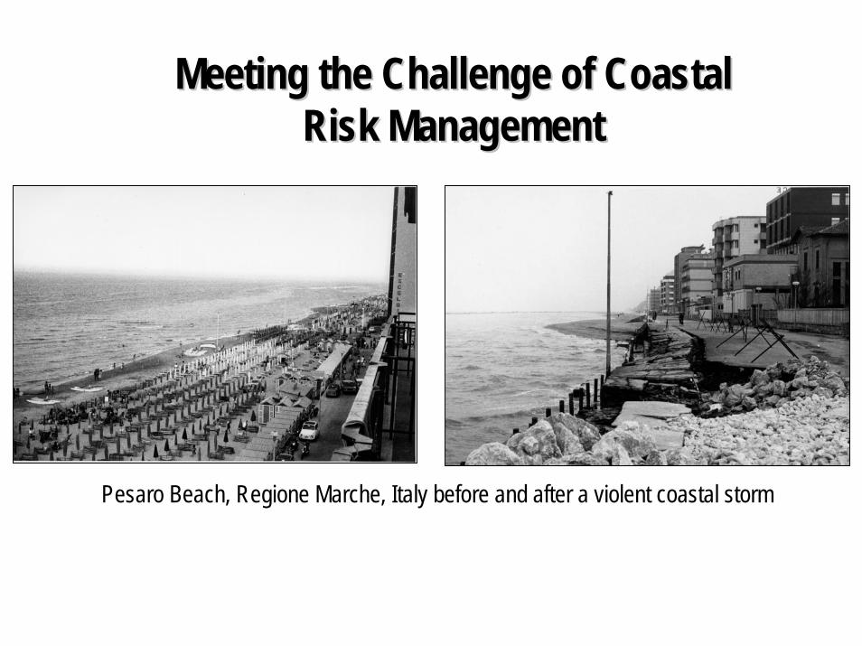
Meeting the Challenge of Coastal Meeting the Challenge of Coastal Risk ManagementRisk Management
Pesaro Beach, Regione Marche, Italy before and after a violent coastal storm
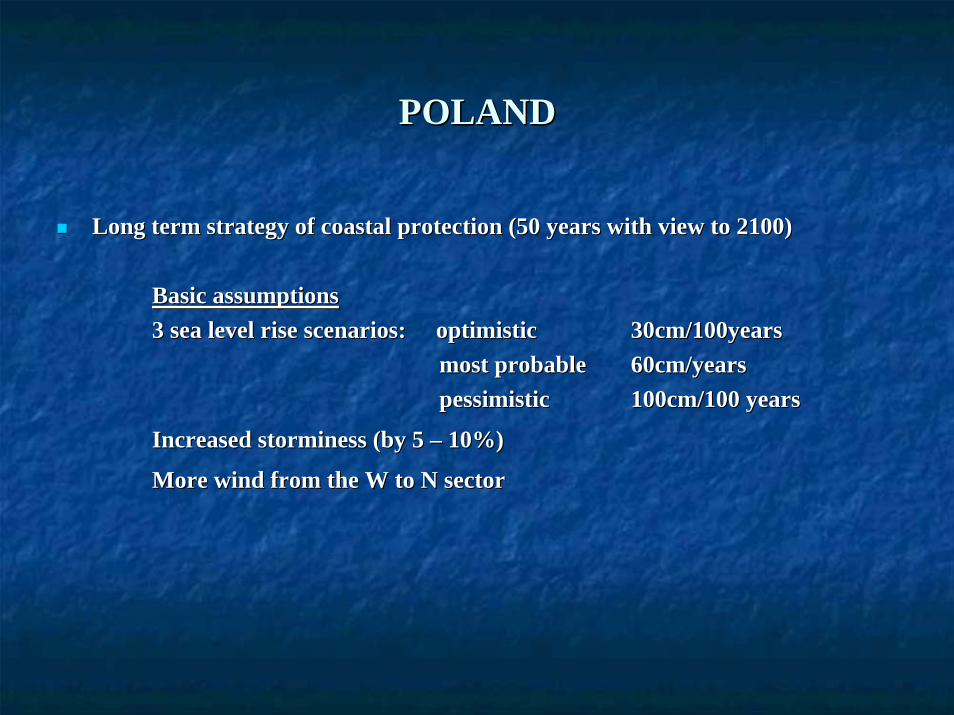
POLANDPOLAND
Long term strategy of coastal protection (50 years with view to Long term strategy of coastal protection (50 years with view to 2100)2100)
Basic assumptionsBasic assumptions3 sea level rise scenarios: optimistic3 sea level rise scenarios: optimistic 30cm/100years30cm/100years
most probablemost probable 60cm/years60cm/yearspessimisticpessimistic 100cm/100 years100cm/100 years
Increased storminess (by 5 Increased storminess (by 5 –– 10%)10%)
More wind from the W to N sectorMore wind from the W to N sector


Basic results of assessmentBasic results of assessment
Possible flooding (to 2.5 m above MSL) 2200 sq.km, in thatPossible flooding (to 2.5 m above MSL) 2200 sq.km, in thatover 20% is of unique natural values at European and national scover 20% is of unique natural values at European and national scalealeover 7% is intensely urbanised & industrialisedover 7% is intensely urbanised & industrialised
Increased groundwater level in low lying areas to +1.25 m above Increased groundwater level in low lying areas to +1.25 m above MSLMSL
Eroded (loss of land) at least 120 sq.kmEroded (loss of land) at least 120 sq.km
Additional risk: increased significant landslides on coastal cliAdditional risk: increased significant landslides on coastal cliffs due to deep ffs due to deep cracking of soil during extended dry periods and deep penetratiocracking of soil during extended dry periods and deep penetration of water n of water
About 300 About 300 thousthous. people in direct risk area. people in direct risk area
Additional ca. 1.7 Additional ca. 1.7 mlnmln. people indirectly involved (jobs!) . people indirectly involved (jobs!)

Main decisionsMain decisions
Maintenance ofMaintenance of coastline 2000 along selected stretches (ca. 30% of the coastline 2000 along selected stretches (ca. 30% of the coast), controlled retreat along the rest of the coastcoast), controlled retreat along the rest of the coastControl developmentControl development in the coastal belt to avoid:in the coastal belt to avoid:
coastal squeezecoastal squeezeuncontrolled development in flooduncontrolled development in flood//erosionerosion// landslidelandslide--prone areasprone areas
Improve construction practicesImprove construction practices to take into account possible sea level rise to take into account possible sea level rise and floodingand floodingActivities in coastal waters cannot decrease coastal safetyActivities in coastal waters cannot decrease coastal safety
Legal instrumentsLegal instruments
Coastal Belt consisting ofCoastal Belt consisting ofTechnical Belt (10m to 1km wide) „ area of land/sea interaction,Technical Belt (10m to 1km wide) „ area of land/sea interaction,designated [primarily] for maintaining a proper level of safety designated [primarily] for maintaining a proper level of safety and state and state of environment”,of environment”,Protective Belt (100m to 2km wide) „area in which human activityProtective Belt (100m to 2km wide) „area in which human activity may may influence the state of the technical belt”.influence the state of the technical belt”.
Maritime administration responsible of management of sea area, cMaritime administration responsible of management of sea area, coastal oastal protection and introducing „sea issues” into spatial plans and protection and introducing „sea issues” into spatial plans and designesdesignes of of structures.structures.

Legal instruments contd.Legal instruments contd.
Coastal Belt defined by law as area of direct risk of flooding. Coastal Belt defined by law as area of direct risk of flooding. All activities All activities require an administrative decision releasing from prohibitions (require an administrative decision releasing from prohibitions (quite strict) in quite strict) in force in such areas. Decision issued by maritime administration.force in such areas. Decision issued by maritime administration.
All local spatial management plans, spatial studies, etc. includAll local spatial management plans, spatial studies, etc. including the Coastal ing the Coastal Belt must be agreed upon with the maritime administration.Belt must be agreed upon with the maritime administration.
All construction permits, changes of use of land, water use permAll construction permits, changes of use of land, water use permits must be its must be agreed upon with the maritime administrationagreed upon with the maritime administration

Main things introduced into plans and designs Main things introduced into plans and designs by by the Maritime Administrationthe Maritime Administration
Spatial plansSpatial plansLevel of safety of hinterland provided by the coastal protectionLevel of safety of hinterland provided by the coastal protection system;system;
Setback lines (related to: coastal protection systems, landslideSetback lines (related to: coastal protection systems, landslide risk on cliffs);risk on cliffs);
Boundaries of safe investment (on cliffs);Boundaries of safe investment (on cliffs);
Marking of areas of direct risk of flooding;Marking of areas of direct risk of flooding;
Statements on level of storm surge flooding and groundwater riseStatements on level of storm surge flooding and groundwater rise;;
Space for drainage systems;Space for drainage systems;

PlansPlans contcont..
Where possible, location of new development outside risk areas;Where possible, location of new development outside risk areas;
Restrictions on uses significantly increasing environmental riskRestrictions on uses significantly increasing environmental risk in case of in case of flooding;flooding;
Minimum height of embankments;Minimum height of embankments;
Highest level of rain and melt water cleaning;Highest level of rain and melt water cleaning;
Special requirements concerning crossing of land/sea interface bSpecial requirements concerning crossing of land/sea interface by cables, y cables, pipelinespipelines
Special requirements on location and use of jetties, piers, etc.Special requirements on location and use of jetties, piers, etc. And related land And related land infrastructure.infrastructure.

Release decisionsRelease decisions
Ground floor level (typically not less than 2.5 m Ground floor level (typically not less than 2.5 m mslmsl, but changes slightly , but changes slightly depending on location);depending on location);
Additional measures to protect against flooding by storm surges Additional measures to protect against flooding by storm surges and and groundwater;groundwater;
Details of location of project/investmentDetails of location of project/investment

Construction permitsConstruction permits
Height of coastal protection systems / flood defences;Height of coastal protection systems / flood defences;
Height of embankments,Height of embankments, hydrotechnichydrotechnic structures and reserve bearing strength structures and reserve bearing strength for increasing height in future;for increasing height in future;
Height of groundHeight of ground floor;floor;
Special solutions to protect buildings, storage areas, etc. agaiSpecial solutions to protect buildings, storage areas, etc. against flooding in nst flooding in case of flood protection system’s breakdown and against high grcase of flood protection system’s breakdown and against high groundwater oundwater level;level;
Protection of rainwater drainage systems against flooding duringProtection of rainwater drainage systems against flooding during storm storm surges.surges.

ThankThank youyou