flood hazard mapping manual in japan
TRANSCRIPT

Flood Hazard Mapping Manual in Japan
June, 2005
Edited by Flood Control Division, River Bureau, Ministry of Land, Infrastructure and Transport (MLIT)
Translated by
International Center for Water Hazard and Risk Management (ICHARM)


iii
Introduction
Japanese natural conditions, such as its topography and climate, are severe. Besides, about 50 % of its total population and about 75% of its assets are concentrated in flood vulnerable areas in the alluvial plains, which account for only 10% of its total land area. Furthermore, as a result of the recent trend of the nuclear family and the increasing urban population, more people, even those who live in a flood-prone area, have no past experience of floods. As the people’s memories of floods fade over time, the awareness to the potential flood risks is also fading away. Consequently, there now is a higher risk that, once a levee breaks during a massive flood, not only many lives and assets will be lost but also an unimaginable scale of social and economical confusion will occur. In recent years, torrential rainfall frequently causes flood disasters, and a quite a few of them cause tremendous damage to the areas, such as inundation in a large urban area and in underground facilities. In order to mitigate those flood disasters, it is important to promote structural measures by constructing flood control facilities such as levees. It is also important, however, to prepare non-structural measures by improving ways to communicate disaster information and better evacuation as well as by enhancing public awareness towards disaster prevention, since there is always a possibility that a levee can breach if a flood exceeds its design capacity. For these reasons, flood records were disclosed as a part of the comprehensive flood control measures, which has been carried out since 1980. In 1991, the river council issued a report entitled “Future Vision of River Development”. In this report, the council argued the need for promoting non-structural measures including enlightening the public on the possible disaster risks caused by floods, tidal waves, tsunami, mudslide, volcanic eruption and others, in order to minimize the damage at the occurrence of a disaster. As a result of this report, the map of flood risk areas along the major rivers throughout Japan was created based on flood simulations and disclosed from 1993 to 1994. As these measures for warning possible flood risks have progressed, public demands for measures to alleviate flood damages grew. Against the backdrop of such situation, “Promotion of Flood Hazard Mapping” and “Guidelines for Flood Hazard Mapping” (Manager of Flood Control Division, River Bureau, the Ministry of Construction) were notified to municipal governments in 1994 to encourage preparation of flood hazard maps. The preparation has been underway in the municipal governments with the support of the Regional Development Bureaus and prefectural governments. In 2000, just after the downpour in the Tokai area, the river council positioned flood hazard mapping as very effective measures for disaster prevention and presented a report entitled “Future Role of Flood Prevention”, which underlined the need for active preparation and disclosure of flood hazard maps. Based on this report, the Flood Fighting Act was partly amended in June 2001, and the inundation risk area system was established. By this amendment, rivers under the control of prefectural governments were also included in the scope of designation as a flood forecasting river. Besides, designation of inundation risk area and its disclosure became mandatory for the flood forecasting rivers. In addition, municipal

iv
disaster prevention plans are now required to include information for helping residents to evacuate quickly and safely, such as means of delivering flood forecast information and evacuation sites, by each inundation risk area. Municipal governments are also required to keep their residents informed of such information. For these reasons, flood hazard maps were positioned as a means to inform residents of information on flood risks and evacuation. Along with the partial amendment of the Flood Fighting Act, “Flood Hazard Mapping Manual” was also amended, and consequently flood hazard maps have been prepared and disclosed by 301 municipalities across Japan as of the end of fiscal year 2003. However, the progress is not necessarily satisfactory. In 2004, a series of downpour that occurred in many places across Japan revealed several problems to be solved. To address such issues, it was decided to amend the Flood Fighting Act so that the local capability of preventing disasters will be improved. The amendment was promulgated in May 2, 2005, and went into effect in July 1 of the same year. By this amendment, municipal governments are now required to designate inundation risk areas not only along large rivers for which flood forecasting is conducted but along also major small- and medium-sized rivers. In addition, the municipal governments are required to keep their residents informed of means of delivering information on flood forecasts and evacuation sites by distributing flood hazard maps that contain such information. The purpose here is to provide residents with sufficient information on disaster prevention so as to help them act appropriately at the occurrence of disaster. To this end, flood hazard mapping is now considered to be even more important than ever. This “Flood Hazard Mapping Manual” was prepared as a technical reference to provide practical guidelines in flood hazard mapping, based on the amended Flood Fighting Act. I hope this manual is helpful for all concerned to successfully prepare and disclose flood hazard maps.
June, 2005 Manager of Flood Control Division, River Bureau, Ministry of Land, Infrastructure and
Transport

v
Mapping Procedure

vi
1. Purposes of the flood hazard mapping manualFlood hazard mapping aims to minimize flood damage as well as to promote non-structural flood control measures which meet local needs and conditions so that it can help effective operation of the inundation risk area system under the Flood Fighting Act, enacted in 1949. The Flood Hazard Mapping Manual provides fundamental information to help prepare flood hazard maps which display information about evacuation and inundation caused by levee breaches and other reasons.
2. Definition In this manual, a “flood hazard map” refers to a map that is prepared primarily to prevent human damage by providing residents with inundation-related information, such as levee braches and flood occurrences, and evacuation information in an easy-to-understand way, primarily in order to prevent human damages. A flood hazard map must satisfy the following conditions. [1] Specifies inundation risk areas. [2] Contains evacuation information. [3] Prepared under the responsibility of municipal chiefs
(including special wards; hereinafter the same)
3. Scope of application of this manual
This manual applies to the preparation of flood hazard maps in municipalities in which inundation may occur because of levee breaches or other reasons.
. 4. Flood hazard mapping (1) The municipal governments prepare flood hazard maps based on their inundation risk
area maps, with the support of the central and prefectural governments. (2) The central and prefectural governments actively support municipal governments’
efforts to prepare flood hazard maps. 5. Necessary information for flood hazard mapsInformation for flood hazard maps is divided into two kinds – general information and area-specific information. General information is required to be included in every flood hazard map while each local municipality can decide what area-specific information should be included depending on its needs. 1) General information General information refers to the minimum information that must be included in all flood hazard maps, as inundation information and evacuation information. - Inundation risk areas and types of damage - Evacuation sites - Dangerous spots along evacuation routes - Ways to deliver evacuation information such as flood forecasting, etc.

vii
- Sources of weather information, etc.Refer to Item 6 below for points to remember when designating evacuation sites. 2) Area-specific information Area-specific information refers to information that is specific in the target area and is useful when residents evacuate. This kind of information is also helpful to promote residents’ awareness of flood disasters in normal times. Chiefs of local municipalities can decide which piece of area-specific information should be included in flood hazard maps. <Information for evacuation> - Inundation information for other areas than inundation risk areas - Evacuation zones - Flood characteristics - Evacuation tips - Information regarding evacuation recommendation, etc. - Information regarding underground spaces - Information regarding facilities for disaster-vulnerable people - Other < Information for disaster education > - Generation mechanism of flood disasters, topography and types of flood - Information about possible risk of floods, types of damage, and past inundation - Meteorological information - Mental preparation for possible flood risks - Other relevant information
6. Points to remember when designating evacuation sitesBefore designating evacuation sites, careful examination is necessary to ensure that the sites are free from the risk of inundation, landslide, storm surges and other disasters, based on the information of inundation risk areas and landslide hazard areas. Also, due consideration should be given to temporary evacuation sites.
7. Wide-area evacuation plan If an inundation risk area spreads across multi municipalities and therefore a large-area evacuation is required, preparation of of a wide-area flood hazard map should be taken into consideration based on a wide-area evacuation plan.
8. Reflecting opinions/suggestions from residentsMunicipal governments should try to reflect as many residents’ opinions/suggestions as
possible in their flood hazard maps.
9. Coordination between flood hazard maps and municipal disaster prevention plans Municipal governments should ensure coordination between their flood hazard maps and municipal disaster prevention plans.
10. Updating information in flood hazard mapsMunicipal governments should appropriately revise their flood hazard maps when changes are made in inundation risk areas or other information.

viii
11. Dissemination to residents Municipal governments should disclose and distribute their flood hazard maps as soon as possible and keep their residents informed of the maps so that it will be utilized effectively.

ix
Structure of this manual
This manual aims to give a concrete explanation of “Guidelines for Flood Hazard Mapping” issued by the Flood Control Division, River Bureau, Ministry of Land,
Infrastructure and Transport, according to the 2005 amendment of the Flood Fighting Act, so as to facilitate smooth and effective flood hazard mapping by
municipal governments.
The primary aim of flood hazard mapping is to prevent human damage at the occurrence of floods. Therefore it is important to provide residents with
inundation/evacuation information in an easy-to-understand manner. In the
Guidelines for Flood Hazard Mapping, the minimum information on flood risks and evacuation is positioned as “general information”.
On the other hand, information specific to local natural/social characteristics are
positioned as “area-specific information”.
In this manual, Chapter 1 describes how to prepare a flood hazard map which covers all general information, following the preparation procedure step by step.
Chapter 2 describes area-specific information, which is important to examine
local characteristics.

x
Contents
Chapter 1 Fundamentals of Flood Hazard Mapping ………………………………….1 Section 1 Purpose of the Flood Hazard Mapping Manual ……………………………….........2 Section 2 Definitions …………………………………………………………………………………7
1. Inundation Risk Area …………………………………………………………………………….7 2. Evacuation Information …………………………………………………………………………7 3. Responsible Body for Flood Hazard Mapping ………………………………………………..8
Section 3 Scope of Application ……………………………………………………………………...9 Section 4 Flood Hazard Mapping …………………………………………………………………11
1. Examination of Basic Issues ………………………………………………………………......12 (1) Basic Conditions ……………………………………………………………………………..12 (2) Preparing a Base Map ………………………………………………………………………12 (3) Computerization of Flood Hazard Maps …………………………………………………13
2. Deciding Information to Be Included ………………………………………………………...14 3. Support to Municipal Governments ………………………………………………………….14
Section 5 Necessary Information for Flood Hazard Maps ……………………………………19
1. Inundation Risk Area and Types of Damage ……………………………………………….20 (1) Inundation Risk Area ……………………………………………………………………….20 (2) Types of Damage …………………………………………………………………………….20
2. Evacuation Site ………………………………………………………………………………….21 3. Dangerous Spot along Evacuation Route ……………………………………………………21 4. Ways to Inform Evacuation Information Including Flood Forecasting, etc. ……………24 5. Information Sources for Weather, etc. ………………………………………………………..25
Section 6 Points to Remember When Designating Evacuation Sites ……………………….27
1. Examining Appropriateness of Evacuation Sites …………………………………………..27 2. Evacuation Site Information Necessary for Flexible Evacuation …………………….....27
(1) Wide-area Evacuation Site across Multiple Municipalities …………………………..27 (2) Temporary/Emergency Evacuation Site ………………………………………………….28 (3) Characteristics of Evacuation Sites ………………………………………………………28
Section 7 Wide-area Evacuation Plan ……………………………………………………………29 Section 8 Reflecting Opinions/Suggestions from Residents ………………………………….31 Section 9 Coordination with Municipal Disaster Prevention Plan ………………………….32 Section 10 Updating Information in Flood Hazard Map ……………………………………...33
Chapter 2 Area-specific Information …………………………………………………39
1. Information for Evacuation ………………………………………………………………………45 (1) Inundation Information for Other Areas than Inundation Risk Areas ………………..45 (2) Evacuation Zone ………………………………………………………………………………..48 (3) Flood Characteristics ………………………………………………………………………….49 (4) Evacuation Tips ………………………………………………………………………………...56 (5) Information regarding Evacuation Recommendation, etc. ………………………………58

xi
(6) Information regarding Underground Spaces ………………………………………………62 (7) Information regarding Facilities for Disaster-Vulnerable People ………………………66
2. Information for Disaster Education ……………………………………………………………. 66 (1) Generation Mechanism of Flood Disasters, Topography and Types of Flood …………66 (2) Information about Possible Flood Risk, Types of Damage, and Past Flood Records ………………………………………………………………………..…70
(3) Meteorological Information …………………………………………………………………..70 (4) Preparation at Normal Times ………………………………………………………………71 (5) Other Relevant Information ………………………………………………………………….73
xii
Figures and Tables
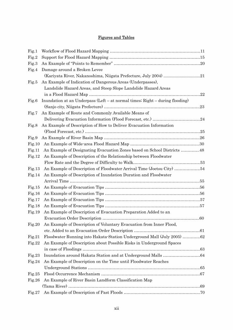
Fig.1 Workflow of Flood Hazard Mapping …………………………………………………………11
Fig.2 Support for Flood Hazard Mapping …………………………………………………………15 Fig.3 An Example of “Points to Remember” ………………………………………………………20
Fig.4 Damage around a Broken Levee
(Kariyata River, Nakanoshima, Niigata Prefecture, July 2004) ................................21
Fig.5 An Example of Indication of Dangerous Areas (Underpasses),
Landslide Hazard Areas, and Steep Slope Landslide Hazard Areas
in a Flood Hazard Map ………………………………………………………………………22
Fig.6 Inundation at an Underpass (Left – at normal times; Right – during flooding)
(Sanjo city, Niigata Prefecture) …………………………………………………………….23
Fig.7 An Example of Route and Commonly Available Means of
Delivering Evacuation Information (Flood Forecast, etc.) ……………………………..24
Fig.8 An Example of Description of How to Deliver Evacuation Information
(Flood Forecast, etc.) …………………………………………………………………………25
Fig.9 An Example of River Basin Map …………………………………………………………….26
Fig.10 An Example of Wide-area Flood Hazard Map …………………………………………...30
Fig.11 An Example of Designating Evacuation Zones based on School Districts …………..48
Fig.12 An Example of Description of the Relationship between Floodwater
Flow Rate and the Degree of Difficulty to Walk………………………………………….53
Fig.13 An Example of Description of Floodwater Arrival Time (Joetsu City) ……………….54
Fig.14 An Example of Description of Inundation Duration and Floodwater
Arrival Time …………………………………………………………………………………..55
Fig.15 An Example of Evacuation Tips ……………………………………………………………56
Fig.16 An Example of Evacuation Tips ……………………………………………………………56
Fig.17 An Example of Evacuation Tips …………………………………………………………....57
Fig.18 An Example of Evacuation Tips ……………………………………………………………57
Fig.19 An Example of Description of Evacuation Preparation Added to an
Evacuation Order Description ……………………………………………………………..60
Fig.20 An Example of Description of Voluntary Evacuation from Inner Flood,
etc. Added to an Evacuation Order Description …………………………………………61
Fig.21 Floodwater Running into Hakata-Station Underground Mall (July 2005) ………….62
Fig.22 An Example of Description about Possible Risks in Underground Spaces
in case of Floodings …………………………………………………………………………..63
Fig.23 Inundation around Hakata Station and at Underground Malls ………………………64
Fig.24 An Example of Description on the Time until Floodwater Reaches
Underground Stations ……………………………………………………………………….65
Fig.25 Flood Occurrence Mechanism ………………………………………………………………67 Fig.26 An Example of River Basin Landform Classification Map
(Tama River) ……………………………………………………………………………………69
Fig.27 An Example of Description of Past Floods ………………………………………………..70

xiii
Fig.28 An Example of Description of Preparation at normal times
for Future Floods ………………….71
Fig.29 An Example of Description of Preparation at normal times
for Future Floods ………………….72
Table 1 Use of Flood Hazard Maps …………………………………………………………………..3
Table 2 Major Forms of Flood Hazard Map ……………………………………………………….12
Table 3 Related Material List ……………………………………………………………………….16
Table 4 General Information for Flood Hazard Maps …………………………………………...19
Table 5 Detailed Items of Area-specific Information …………………………………………….44
Table 6 Flood Types and Their Characteristics …………………………………………………..50
Table 7 Examples of Evacuation Order, etc. ………………………………………………………59

xiv
References
Reference 1 Inundation Risk Area System Improved by the Amendment of
the Flood Fighting Act ……………………………………………………………………...4
Reference 2 Tsunami/Storm Surge Hazard Mapping Manual ……………………………….10
Reference 3 Map Use Procedures in Accordance with the Survey Law ……………………….14
Reference 4 Colors for different Inundation Depths …………………………………………….21
Reference 5 Inundation Information for Other Areas than Inundation Risk Areas ………..45 Reference 6 Source Information of Flood Records (Clearing House) ………………………….47
Reference 7 Changes in Runoff Patterns Caused by Basin Urbanization ……………………68
Reference 8 Operation at the Occurrence of Floods Beyond Designed Storage Capacity ….73

Chap.1 Fundamentals of Flood Hazard Mapping
1
Chapter 1 Fundamentals of Flood Hazard Mapping

Chap.1 Fundamentals of Flood Hazard Mapping Sec.1 Purpose of the Flood Hazard Mapping Manual
2
1. Purpose of the flood hazard mapping manual Flood hazard mapping aims to minimize flood damage as well as to promote non-structural flood control measures which meet local needs and conditions so that it can help effective operation of the inundation risk area system under the Flood Fighting Act, enacted in 1949. The Flood Hazard Mapping Manual provides fundamental information to help prepare flood hazard maps which display information about evacuation and inundation caused by levee breaches and other reasons.
In recent years, torrential rainfall frequently causes flood disasters, and quite a few of them cause tremendous damage to the areas. In order to mitigate those flood disasters, it is important to promote structural measures by constructing flood control facilities such as levees. It is also important, however, to prepare non-structural measures by improving ways to communicate disaster information and better evacuation as well as by enhancing public awareness towards disaster prevention, since there is always a possibility that a levee can breach if a flood exceeds its design capacity. For non-structural measures to function effectively, it is essential to inform residents in an easy-to-understand way about evacuation procedures and inundation caused by levee breaches and other reasons. Also, residents should be educated regularly about disasters to keep aware of disaster prevention and be able to evacuate on their own decision. Such everyday preparation for disasters will enable residents to evacuate smoothly and quickly in time of emergency. Flood hazard maps can be an extremely effective tool to promote non-structural measures. It should be kept in mind, however, that for flood hazard maps to serve their purposes effectively, they should be created based on the viewpoint of residents and proper selection of information for residents’ quick and smooth evacuation. Selected information should be displayed for residents to understand easily and quickly. It is also important to inform residents on a daily basis about flood hazard maps and to educate them about how they can utilize in time of emergency (see Table 1).
This manual should be revised from time to time to include updated information.

Chap.1 Fundamentals of Flood Hazard Mapping
Sec.1 Purpose of the Flood Hazard Mapping Manual
3
Table 1 Use of Flood Hazard Maps Time Public sector Residents
N o r m a l t i m e
- Implementation of flood hazard maps into local disaster prevention plans and flood prevention plans - Promotion of building a flood-resistant community - Revision of evacuation sites/routes - Review of evacuation/rescue methods for
disaster vulnerable people including bedridden elderly people and physically challenged people
- Development of communication methods/systems for evacuation information - Dissemination of knowledge about disaster prevention - Promotion of public awareness toward disaster prevention - Nurture of voluntary disaster prevention groups - Information provision, advice, and guidance to flood fighting groups - Organization of flood fighting corps and fire fighting corps - Promotion of disaster education and evacuation drills
Residents should try to: - Have a better understanding about past inundation and inundation risk in their living areas. - Minimize damage by preparing emergency goods in case of flooding.- Provide disaster education and conduct evacuation drills for themselves. - Choose land use and building styles after considering possible flood risk in their living areas.
Before / After evacuation recommendation
- Information provision (weather information, flood forecasting, etc.) - Consideration for disaster-vulnerable people- Confirmation of inundation areas/depths and evacuation sites/routes in case of flooding
- Confirm evacuation sites/routes and emergency goods. - Decide voluntarily to evacuate based on weather information and flood forecasting.
- Provision of evacuation information - Opening of evacuation sites - Evacuation guidance
Evacuate to a best possible evacuation site by a safest possible route based on evacuation recommendation/order. If not evacuating, residents are expected to take whatever measures available for them to protect their own lives.
Issuing of evacuation recommendation
Chap.1 Fundamentals of Flood Hazard Mapping Sec.1 Purpose of the Flood Hazard Mapping Manual
4
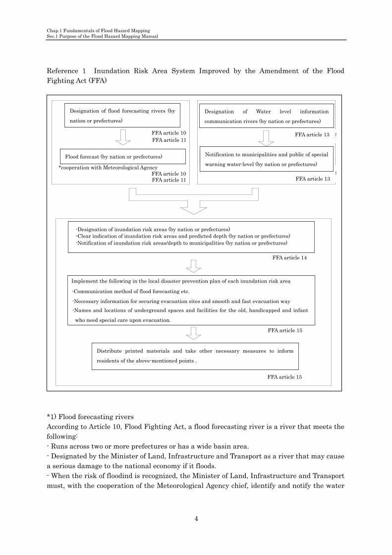
Reference 1 Inundation Risk Area System Improved by the Amendment of the Flood Fighting Act (FFA)
*1) Flood forecasting rivers According to Article 10, Flood Fighting Act, a flood forecasting river is a river that meets the following: - Runs across two or more prefectures or has a wide basin area. - Designated by the Minister of Land, Infrastructure and Transport as a river that may cause a serious damage to the national economy if it floods. - When the risk of floodind is recognized, the Minister of Land, Infrastructure and Transport must, with the cooperation of the Meteorological Agency chief, identify and notify the water
洪水予報河川*1) ( )の指定 国又は都道府県
( )洪水予報の実施 国又は都道府県
、※気象庁と協議し 協同で実施
水位情報周知河川*2) ( )の指定 国又は都道府県
特別警戒水位*3) 、の通知 周知の実施(国又は都道府県)
水防法第10条水防法第11条
水防法第10条水防法第11条
水防法第13条
水防法第13条
( )■浸水想定区域の指定 国又は都道府県 (■浸水想定区域及び想定される浸水深の明示 国又は都道府県)
(■浸水想定区域及び想定される浸水深の関係市町村への通知 国又は都道府県)
水防法第14条
■浸水想定区域ごとに以下の事項を市町村地域防災計画に定める・洪水予報等の伝達方法・避難場所その他洪水時の円滑かつ迅速な避難の確保を図るために必要な事項
、 、・地下街等又は主として高齢者 障害者 乳幼児その他の特に防災上の配慮を要す る者が利用する施設で当該施設利用者の円滑かつ迅速な避難の確保が必要と認
、 められる場合にあっては これら施設の名称及び所在地
水防法第15条
■市町村地域防災計画に定められた上記事項を住民に周知させるため印刷物の配 布その他の必要な措置を講じる
水防法第15条
FFA article 11 FFA article 10
*cooperation with Meteorological Agency
Flood forecast (by nation or prefectures)
Designation of flood forecasting rivers (by
nation or prefectures)
FFA article 11 FFA article 10
FFA article 13
Designation of Water level information
communication rivers (by nation or prefectures)
Notification to municipalities and public of special
warning water-level (by nation or prefectures)
FFA article 13
-Notification of inundation risk areas/depth to municipalities (by nation or prefectures) -Clear indication of inundation risk areas and predicted depth (by nation or prefectures) -Designation of inundation risk areas (by nation or prefectures)
FFA article 14
Implement the following in the local disaster prevention plan of each inundation risk area
-Communication method of flood forecasting etc.
-Necessary information for securing evacuation sites and smooth and fast evacuation way
Distribute printed materials and take other necessary measures to inform
residents of the above-mentioned points .
FFA article 15
FFA article 15
-Names and locations of underground spaces and facilities for the old, handicapped and infant
who need special care upon evacuation.

Chap.1 Fundamentals of Flood Hazard Mapping
Sec.1 Purpose of the Flood Hazard Mapping Manual
5
level, flow rate and other conditions of the river to the governors concerned. - Once the river floods, the Minister of Land, Infrastructure and Transport must, with the cooperation of the Meteorological Agency chief, identify and notify the water level, flow rate and other conditions of the river, as well as inundation risk areas and their inundation depth, to the governors concerned. - The Minister of Land, Infrastructure and Transport must notify the public of such information on the river by calling for the cooperation of mass media, when necessary. According to Article 11, Flood Fighting Act, a flood forecasting river is a river that meets the following: - Not designated as a flood forecasting river in the above by the Ministry of Land, Infrastructure and Transport, but has a wide basin area. - Designated by the governor concerned as a river that may cause a serious damage if it floods - When the risk of floods is recognized, the governor must, with the cooperation of the Meteorological Agency chief, identify and notify the water level, flow rate and other conditions of the river to the flood control/watermark administrator specified in the prefectural flood prevention plan. - The governor must notify the public of such information on the river by calling for the cooperation of mass media, when necessary. *2) Water level information communication rivers According to Article 13, Flood Fighting Act, a water level information communication river is a river that meets the following: - Not designated as a flood forecasting river, but is a class-A river that runs outside the zone designated by the River Law. - Designated by the Minister of Land, Infrastructure and Transport as a river that may cause a serious damage to the national economy if it floods. - When the water level of the river reaches a specified special warning water-level, the Minister of Land, Infrastructure and Transport must notify it along with the water level, flow rate and other conditions of the river to the governors concerned. - The Minister of Land, Infrastructure and Transport must notify the public of such information on the river by calling for the cooperation of mass media, when necessary. Also: - Not designated as a water level information communication river in the above by the Minister of Land, Infrastructure and Transport, but is a class-A or class-B river that runs in the zone designated by the River Law. - Designated by the governor concerned as a river that may cause a serious damage if it floods - When the water level of the river reaches a specified special warning water-level, the governor must notify it along with the water level, flow rate and other conditions of the river to the flood control/watermark administrator specified in the prefectural flood prevention plan. - The governor must notify the public of such information on the river by calling for the cooperation of mass media, when necessary.

Chap.1 Fundamentals of Flood Hazard Mapping Sec.1 Purpose of the Flood Hazard Mapping Manual
6
*3) Special warning water-level A water level beyond the warning water-level, which calls for a special warning against the occurrence of a flood disaster. (Article 13, Flood Fighting Act)
Flood forecasting river Predictable rivers of flood risks
Water level information communication river Not predictable rivers of flood risks
Publication of water-level Publication of water-level
Flood advisory
Flood warning Reaching
information
Warning water-level
Designated water-level
Provide the water-level condition of present time as a
reference of evacuation.
Announce flood warning officially as a reference of
evacuation using future water-level predict.
Dangerous water-level
Special warnig water-level
As reference of evacuation
Reach in a given period of time
period of timeReach in a given
Provide information based on special warning
water-level considering necessary time for evacuation.
Dangerous water-level

Chap.1 Fundamentals of Flood Hazard Mapping
Sec.2 Definition
7
2. Definitions In this manual, a “flood hazard map” refers to a map that is prepared primarily to
prevent human damage by providing residents with inundation-related information, such as levee braches and flood occurrences, and evacuation information in an easy-to-understand way. A flood hazard map must satisfy the following conditions: [1] Specifies inundation risk areas. [2] Contains evacuation information. [3] Prepared under the responsibility of the municipal chiefs. (including special wards; hereinafter the same)
There is no clear definition of a “hazard map”. It is referred to in various ways as a “disaster prevention map”, “disaster prevention record”, “disaster map” and so on. Target disasters include floods, landslides, earthquakes, volcanic disasters, and tsunamis. Hazard maps of different types are prepared in various organizations depending on their respective purposes. Present hazard maps are a result of the accumulation of disaster research findings and related information, and the recent development in forecasting technology; yet, they are still at the developmental stage and haven’t reached to the complete form. Hazard maps that have been disclosed so far were prepared independently in accordance with their respective targets and purposes. In the future, however, it is desirable to develop such individually unique hazard maps into a comprehensive one.
The flood hazard map described in this manual aims to help municipal governments to minimize
human damage by flood disasters. The manual describes a method for such governments to provide their
residents, in an easy-to-understand manner, with inundation/evacuation information and other
information required for evacuation from inundation risk areas.
1. Inundation risk area An “inundation risk area” is an area where inundation is expected to occur if the specific river in the area floods due to rainfall (Flood control plans generally concern floods due to rainfall). Such a area is designated by the central or prefectural governments in accordance with the Flood Fighting Act and notified to the municipal governments concerned. Note that, however, inundation may occur in areas other than inundation risk areas in case of rainfall exceeding the design rainfall, tributary floods, storm surge or inland floods. 2. Evacuation information Evacuation information refers to information that is useful for residents to evacuate at the occurrence of floods. Such information includes flood forecast communication methods and

Chap.1 Fundamentals of Flood Hazard Mapping Sec.2 Definition
8
evacuation sites, as well as information necessary to secure smooth and rapid evacuation. 3. Responsible body for flood hazard mapping Flood hazard maps aim to help residents to evacuate at the occurrence of floods. Therefore chiefs of municipal governments, who are responsible for disaster prevention in the area, are also responsible for preparing and disclosing flood hazard maps. Paragraph 4, Article 15, Flood Fighting Act specifies as follows: The chiefs of municipal governments whose district areas include inundation risk areas are required to familiarize their residents with the information that the municipal disaster prevention plans are required to include by Paragraph 1, Article 15, Flood Fighting Act, in accordance with the MLIT Ordinance. For this aim, the municipal governments must take necessary measures such as distributing pamphlets containing such information.
Chap.1 Fundamentals of Flood Hazard Mapping
Sec.3 Scope of application of this manual
9
3. Scope of application This manual applies to the preparation of flood hazard maps in municipalities in which
an inundation may occur because of levee breaches or other reasons.
The “river” here refers to flood forecasting rivers and water level information communication rivers that are designated by the central or prefectural governments in accordance with the Flood Fighting Act. However, the content of this manual may also apply to other rivers that may cause inundation damage. The content of this manual is intended for the municipal governments whose district areas include inundation risk areas designated in accordance with the Flood Fighting Act. However, other municipal governments may use this manual for preparing flood hazard maps if their district areas may suffer from inundation damage. This manual does not consider inundation damage caused by tsunamis or storm surges. However, if measures against such inundation damage are necessary because of respective local conditions, it is desirable to give consideration to them separately first and eventually incorporate them to develop comprehensive hazard maps.
The governments whose district areas include landslide warning areas are required to include information necessary for preventing landslide damage in their hazard maps. See “The Landslide Hazard Mapping Manual (tentative title)” for information to be included.
Chap.1 Fundamentals of Flood Hazard Mapping Sec.3 Scope of application of this manual
10
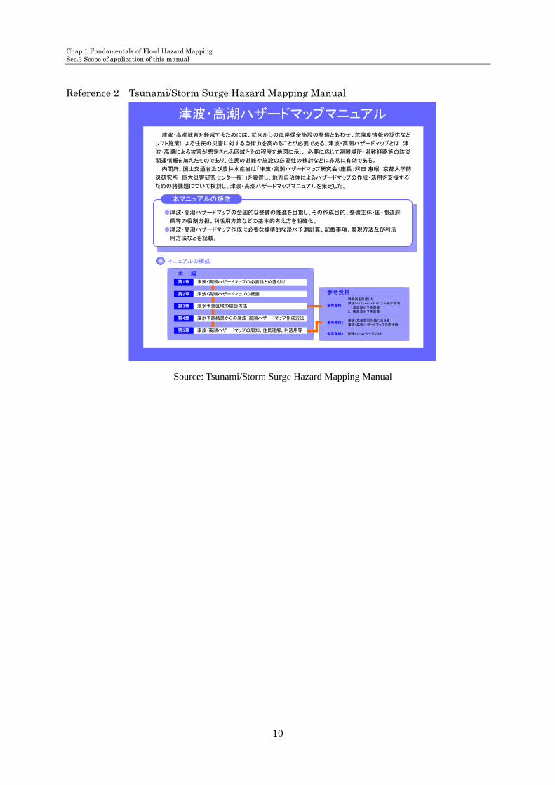
Reference 2 Tsunami/Storm Surge Hazard Mapping Manual
津波・高潮ハザードマップマニュアル
、 、津波・高潮被害を軽減するためには 従来からの海岸保全施設の整備とあわせ 危険度情報の提供など
。 、ソフト施策による住民の災害に対する自衛力を高めることが必要である 津波・高潮ハザードマップとは 津
、波・高潮による被害が想定される区域とその程度を地図に示し 必要に応じて避難場所・避難経路等の防災
、 。関連情報を加えたものであり 住民の避難や施設の必要性の検討などに非常に有効である
、 「 ( :内閣府 国土交通省及び農林水産省は 津波・高潮ハザードマップ研究会 座長 河田 惠昭 京都大学防
)」 、災研究所 巨大災害研究センター長 を設置し 地方自治体によるハザードマップの作成・活用を支援する
、 。ための諸課題について検討し 津波・高潮ハザードマップマニュアルを策定した
本マニュアルの特徴
● 、 、津波・高潮ハザードマップの全国的な整備の推進を目指し その作成目的 整備主体・国・都道府
、 。県等の役割分担 利活用方策などの基本的考え方を明確化
● 、 、津波・高潮ハザードマップ作成に必要な標準的な浸水予測計算 記載事項 表現方法及び利活
。用方法などを記載
マニュアルの構成
本 編
津波・高潮ハザードマップの必要性と位置付け第1章
津波・高潮ハザードマップの概要第2章
浸水予測区域の検討方法第3章
浸水予測結果からの津波・高潮ハザードマップ作成方法第4章
、 、 津波・高潮ハザードマップの周知 住民理解 利活用等第5章
参考資料時系列を考慮した数値シミュレーションによる浸水予測1. 津波浸水予測計算2. 高潮浸水予測計算
参考資料1
津波・高潮防災対策における津波・高潮ハザードマップの活用例
参考資料2
関連ホームページリスト参考資料3
Source: Tsunami/Storm Surge Hazard Mapping Manual

Chap.1 Fundamentals of Flood Hazard Mapping
Sec.4 Flood Hazard Mapping
11
4. Flood hazard mapping (1) The municipal governments prepare flood hazard maps based on their inundation risk
area maps, with the support of the central and prefectural governments. (2) The central and prefectural governments actively support municipal governments’ efforts
to prepare flood hazard maps.
Municipal governments prepares flood hazard maps by making use of information on inundation risk areas, which is provided by the central and prefectural governments, and disclose and disseminate the hazard maps to their residents. The maps should reflect the revision of their municipal disaster prevention plans and suggestions from the residents. The maps should also be updated when necessary. The central and prefectural governments actively support municipal governments to facilitate smooth preparation of flood hazard maps. “The Guidelines for Issuing an Evacuation Order and Preparing a Communication Manual” and “The Guidelines for Supporting Evacuation of Disaster-Vulnerable People” are stipulated in “The Report on Communication and Evacuation Support for Elderly People at the Occurrence of a Torrential Rain” issued by the Cabinet Office. They are also useful for sorting out related issues.
Fig.1 Workflow of flood hazard mapping
基本事項の検討
記載項目の検討
洪水ハザードマップの作成
公表・周知
市町村地域防災計画との整合
住民等からの意見の反映
記載内容の更新
国及び都道府県からの浸水想定区域図等に関する情報提供
Provision of
Information about
inundation risk area
maps from the
central or prefectural
governments.
Alignment with local
disaster prevention
plans
Reflection of needs
from residents
Inspection of basic contents
Inspection of entry
Making of flood hazard map
Publicity announcement
Update of entry

Chap.1 Fundamentals of Flood Hazard Mapping Sec. Flood Hazard Mapping
12
1. Examination of basic issues (1) Basic conditions Before actual preparation of flood hazard maps, basic conditions need to be identified based on inundation records and evacuation situations at the time of past floods, inundation risk areas and topography. Flood hazard maps are intended for floods that may occur in inundation risk areas that are designated by the central or prefectural governments in accordance with the Flood Fighting Act and then notified to the municipal governments concerned. It is desirable that a flood hazard map covers the whole municipal district. However, it may cover only a limited area that contains inundation risk areas and evacuation sites if the inundation risk areas account for only a part of the municipal district. On the other hand, if an inundation risk area lies across multiple municipalities, the municipal governments concerned may need to jointly develop a wide-area flood hazard map. Information on inundation risk areas and evacuation sites/routes, which are basic elements of flood hazard maps, are indicated on the map. It is because flood hazard maps are assumed to be used at the time of evacuation. Therefore, it is desirable to examine how and how much information shoud be displayed when deciding a form of flood hazard maps. Table 2 shows the major forms of flood hazard maps.
Table 2 Major forms of flood hazard map
Form General description Other
Map type
A0- to A1-size topographic map with related information added
- Can show the whole target area in a single page - Can contain only a limited amount of information
Pamphlet type
B5- to A4-size pamphlet map with related information added
- Difficult to show the whole target area in a single page - Can contain a large amount of information
Pamphlet + map
B5- to A4-size pamphlet with A0- to A1-size map inserted
- Can show the whole target area in a single page - Can contain a large amount of information
(2) Preparing a base map The map scale should be 1:10,000 to 1:15,000 because, with a scale smaller than this, each house can not be identified and therefore it is difficult to identify evacuation routes. It is preferable not to adopt a map scale of 1:25,000 to 1:50,000 unless unavoidable, because it is impossible to identify each house and road, which must be identifiable for evacuation, in maps of this scale. The size of a base map should be approximately A0 to A1 for the map type. However, A1 size is preferable because it is easier to handle.

Chap.1 Fundamentals of Flood Hazard Mapping
Sec.4 Flood Hazard Mapping
13
If a topographic map on which a base map is based is old and does not sufficiently exhibit the current conditions of topography, houses, roads, etc., the base map must be revised. Note that certain procedures may be required by the Survey Law or other laws to use a map for the base map. (3) Computerization of flood hazard maps Flood hazard maps are printed on paper, but they should also be converted into electronic data to facilitate disclosure via the Internet and updating of hazard maps. For this reason, municipal governments should promote conversion of inundation risk area maps provided by the central and prefectural governments into electronic data and should make use of such electronic data when preparing flood hazard maps.

Chap.1 Fundamentals of Flood Hazard Mapping Sec. Flood Hazard Mapping
14
Reference 3 Map use procedures in accordance with the Survey Law
In general, procedures based on the Survey Low are required for using or printing a map developed at a public organization. For using a map developed by the Geographical Survey Institute as a base map, onto which inundation risk areas are printed later, the approval for use is required in accordance with Article 30 of the Survey Law. Use of a map for flood hazard mapping will be approved without any difficulty because the purpose is highly public. Similarly, for using a map developed by national or local public organizations other than the Geographical Survey Institute, an approval will be required in accordance with Article 44 of the Survey Law. Naturally, any approval is not required when a municipal government uses a map developed by themselves. The Copyright Law Paragraph 10 stipulates that maps are included in copyrighted works. For using a commercial map for flood hazard mapping, the municipal government must obtain “permission for the use” according to Paragraph 63 of the same law or perform necessary procedures for “use as a reference” according to Paragraph 32 of the same law. 2. Deciding information to be included Municipal governments should give due consideration to decide what information items are to be included in their flood hazard maps in order to make them useful enough to ensure smooth and rapid evacuation in case of floods. Information for flood hazard maps is divided into tow kinds: “general information,” which are basically required to be included, and “area-specific information,” from which local municipalities decide what should be included depending their own conditions. See Chapter 1 Section 5 for details of general information and Chapter 2 for area-specific information.
3. Support to municipal governments Municipal governments are responsible for preparing flood hazard maps by making used of inundation risk area-related information developed by the Regional Development Bureau and prefectural governments. The diagram in Figure 2 shows the relationship between municipal governments and river administrators in the Regional Development Bureau and prefectural governments. River administrators provide inundation information and various materials necessary for flood hazard mapping to municipal governments. Based on such information, municipal governments revise their local disaster prevention plans and prepare, disclose and disseminate flood hazard maps.

Chap.1 Fundamentals of Flood Hazard Mapping
Sec.4 Flood Hazard Mapping
15
Fig.2 Support for flood hazard mapping
協力・支援
河川管理者
国及び都道府県
市町村長
市町村防災会議
浸水想定区域 内水はん濫外水はん濫浸水実績
等
浸水情報の提供
市町村地域防災計画の見(直し 法第15 )条第1項
洪水ハザードマップの作成
洪水ハザードマップの公表・普及
River manager
prefectures Country or
Local chiefs
Local disaster prevention council
Cooperation
and support
Inundation risk area Flood record
Making of flood hazard map
Publicity and distribution of FHM
Outside water flood Inside water flood
etc
Review of local disaster prevention plan (Law no.15, article 1)
Provision of flood information

Chap.1 Fundamentals of Flood Hazard Mapping Sec. Flood Hazard Mapping
16
Table 3 is a list of materials useful for examining basic issues and preparing a flood hazard map.
Table 3 Related material list
Purpose Information to be identified Material Prepared or issued by
Remarks
Base map
Background map General map
1:2500-scale topographic map
Municipal government
Substitutable with urban plan
1:10000-scale topographic map
Municipal government, Geographical Survey Institute
1:25000-scale topographic map
Geographical Survey Institute
Inu
ndation
inform
ation
Inundation record
Overflow, overtopping, levee break point, inundation area, inundation depth Damage state Hourly water level and hourly rainfall at major spots along the river
Material for investigating inundation record Same as above Flood record
Municipal government, river administrator Same as above River administrator
Inundation prediction
Flood analysis results (inundation area, flood water depth, inundation depth, etc.) Flood spread state Longitudinal inundation depth Flow rate of flood water
Inundation risk area, flood hazard area map, flood analysis material
River administrator
Evacu
ation in
formation
Evacuation zone
Block number, school district, neighborhood association, etc.
Related material
Municipal government
Calculation of number of residents who will need to evacuate
Population by area Households by area
Census data Census data, house map
Municipal government Municipal government, etc.

Chap.1 Fundamentals of Flood Hazard Mapping
Sec.4 Flood Hazard Mapping
17
Evacuation site
Evacuation site Type of public facilities (nursery school, elementary/junior high/high school, university, civic hall, assembly hall, gymnasium, etc.)
Municipal disaster prevention planRelated material
Municipal government Same as above
Dangerous spot along evacuation route
Steep slide landslide hazard area, mudslide hazard mountain stream Road that has been closed because of floods Area where landslide has occurred before Underpass Bridge
Related material Past flood investigation record Same as above House map, road ledger, etc.River ledger, etc.
Municipal or prefectural government Same as above Same as above Municipal government, road administrator Municipal government, river administrator
Information delivery method
Delivery route/method of information (inundation forecasts and evacuation information)
Municipal disaster prevention plan, flood control plan
Municipal government
Information on underground malls, etc
Information on underground mall (location, system for delivering evacuation information from underground mall administrator)
Fire defense plan, layout
Underground mall administrator
Evacuation criteria
Evacuation criteria Evacuation record (issuance state of evacuation order, issuance notification method, opening/reception state of evacuation sites)
Municipal disaster prevention plan, flood control plan Past flood evacuation record
Municipal government Municipal government
Facilities for disaster-vulnerable people
Population of disaster-vulnerable people by area Type of facilities for disaster-vulnerable people (hospital, nursing home, facilities for physically challenged people, etc.)
Related material Same as above
Municipal government Same as above
Chap.1 Fundamentals of Flood Hazard Mapping Sec. Flood Hazard Mapping
18
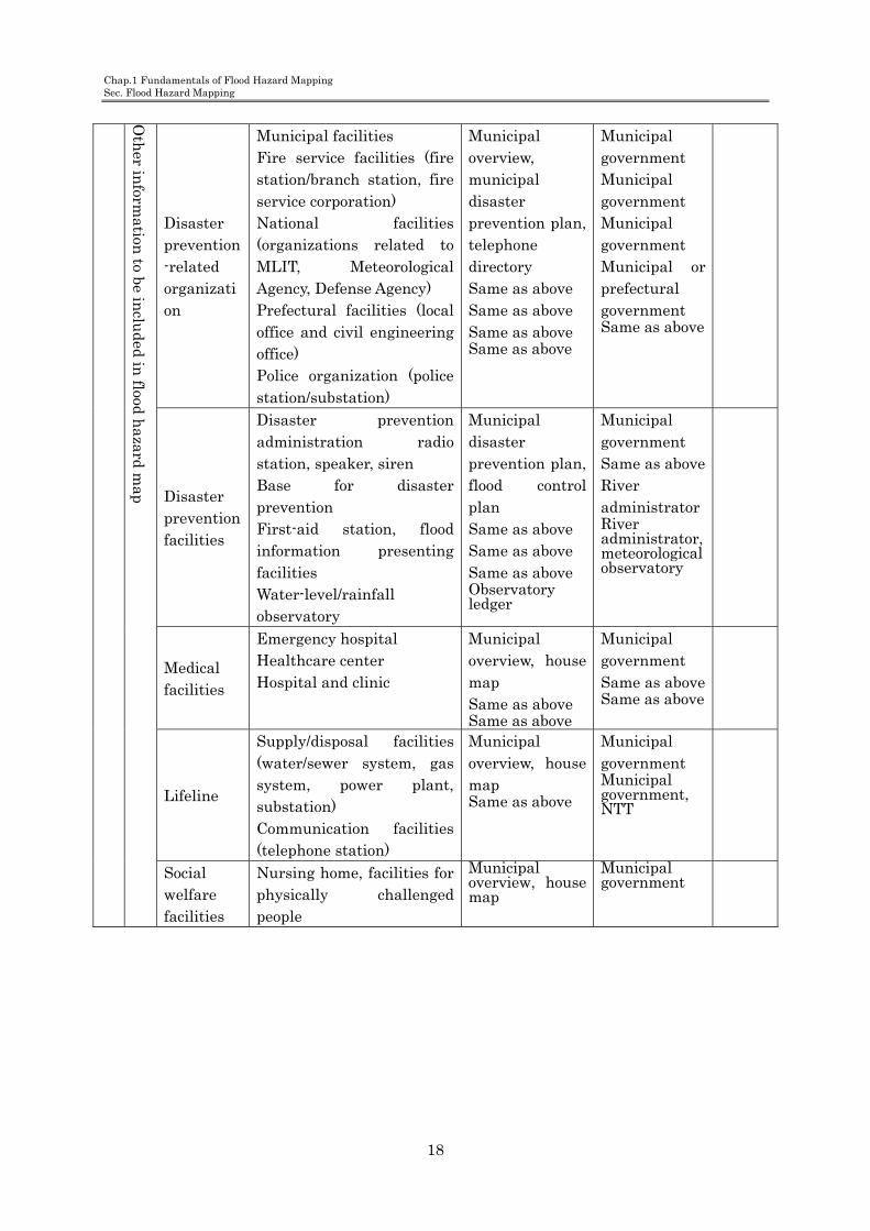
Oth
er inform
ation to be in
cluded in
flood hazard m
ap
Disaster prevention-related organization
Municipal facilities Fire service facilities (fire station/branch station, fire service corporation) National facilities (organizations related to MLIT, Meteorological Agency, Defense Agency) Prefectural facilities (local office and civil engineering office) Police organization (police station/substation)
Municipal overview, municipal disaster prevention plan, telephone directory Same as above Same as above Same as above Same as above
Municipal government Municipal government Municipal government Municipal or prefectural government Same as above
Disaster prevention facilities
Disaster prevention administration radio station, speaker, siren Base for disaster prevention First-aid station, flood information presenting facilities Water-level/rainfall observatory
Municipal disaster prevention plan, flood control plan Same as above Same as above Same as above Observatory ledger
Municipal government Same as above River administrator River administrator, meteorological observatory
Medical facilities
Emergency hospital Healthcare center Hospital and clinic
Municipal overview, house map Same as above Same as above
Municipal government Same as above Same as above
Lifeline
Supply/disposal facilities (water/sewer system, gas system, power plant, substation) Communication facilities (telephone station)
Municipal overview, house map Same as above
Municipal government Municipal government, NTT
Social welfare facilities
Nursing home, facilities for physically challenged people
Municipal overview, house map
Municipal government

Chap.1 Fundamentals of Flood Hazard Mapping
Sec.5 Necessary Information for Flood Hazard Map
19
5. Necessary information for flood hazard maps Information for flood hazard maps is divided into two kinds – general information and area-specific information. General information is required to be included in every flood hazard map while each local municipality can decide what area-specific information should be included depending on its needs. 1) General information General information refers to the minimum information that must be included in all flood hazard maps. - Inundation risk areas and types of damage - Evacuation sites - Dangerous spots along evacuation routes - Ways to inform evacuation information such as flood forecasting, etc. - Sources of weather information, etc. 2) Area-specific information — See Chapter 2.
The principle purpose of flood hazard maps is to prevent human loss in flooding. For that reason, it is important for the maps to be able to inform residents in an easy-to-understand way about inundation and evacuation. This manual lists up minimum information related to evacuation and risk in flooding as “general information". All flood hazard maps must include the general information listed in Table 4.
Table 4 General information for flood hazard maps
Type of information Contents
・ Inundation risk area and types of damage
Designated areas, inundation depth, types of damage (Coloring for different inundation depths should follow that for inundation risk areas.)
・ Evacuation sites Names, addresses, telephone numbers, etc. of evacuation facilities
・ Dangerous spots along evacuation routes
Mudslide hazard areas, steep slope landslide hazard areas, underpasses, etc.
・ Ways to inform evacuation information including flood forecasting, etc.
Communication routes/means for flood forecasting, water level information, evacuation order, evacuation instruction, etc.
・ Sources of weather information, etc.
Names and addresses, website addresses, cell-phone website addresses, etc. of water level/precipitation stations

Chap.1 Fundamentals of Flood Hazard Map Sec.5 Necessary Information for Flood Hazard Map
20
1. Inundation risk area and types of damage (1) Inundation risk area Among information items related to inundation risk areas, the area and depth of inundation must be described in flood hazard maps. Coloring of inundation depth should be in accordance with the inundation risk area map provided by the central or prefectural governments (see Reference 4). There may be a case where, at around the confluence of a nationally-administered river and a prefecturally-administered river, an inundation risk area is designated along each of the two rivers. In such a case, examination will be required to decide either to prepare one flood hazard map covering both of the inundation risk areas or to separately prepare a flood hazard map for each inundation risk area, depending on respective local conditions.
(2) Types of damage If a river levee brakes, flood water will flow out over land with such a powerful energy that it may destroy houses. Therefore people who live near the levee must complete evacuation before the levee breaks. Similarly, residents in areas where a considerable amount of flood water flows into and accumulates need to rapidly evacuate. These information should be included in flood hazard maps as “points to be remembered” so that residents are aware of such issues in advance. Examples of “points to be remembered” are shown below (Figure 3 and Reference 4).
Fig.3 An example of “points to remember”
If a levee breaks during flooding, houses near the levee may be destroyed or carried away by the onrush of flood water. If you stay in your house in stead of evacuating, it may risk your life.
When there is a possibility of flood occurrence, try earlier on to collect information on rainfall at upstream as well as at your area and the water level of the river. Also pay attention to evacuation information notified by the municipal government. Start evacuating as early as possible and be sure to complete evacuation before a levee break occurs.
Early evacuation will save your life

Chap.1 Fundamentals of Flood Hazard Mapping
Sec.5 Necessary Information for Flood Hazard Map
21
Fig.4 Damage around a broken levee (Kariyata River, Nakanoshima, Niigata Prefecture, July 2004)
(Source: “Flood Damage Report 2004” by Japan River Association, March 2005)
For unique topographical reasons, some areas exhibit flood characteristics which deserve special attention, such as a fast flow rate of flood water and a fast increase rate of flood water level. Flood hazard maps for those areas should include such information because it is very effective to help residents to evacuate in an appropriate manner at an appropriate timing. See Chapter 2 for details of flood characteristics of rivers.
2. Evacuation site Refer to Chapter 1 Section 6 for points to remember when designating evacuation sites.
3. Dangerous spot along evacuation route “Dangerous spots along evacuation routes” refers to places which may pose a risk to safe evacuation of local residents.
Reference 4 Colors for different inundation depths
Depth range Color
sample (CMYK)
Below 0.5m Y50
0.5 to below 1.0 m Y30,C10
1.0 to below 2.0 m C20
2.0 to below 5.0 m
(2.0 to below 3.0 m)C40
(3.0 to below 4.0 m) C30,M10
(4.0 to below 5.0 m) M20
5.0 m or higher C20,M20
(Source: “Inundation Risk Area Mapping Manual” prepared by MLIT River Bureau Flood Control Division in July 2001)
凡 例
浸水した場合に想定される
水深(ランク別)
0.5m 未満の区域
0.5~1.0m未満の区域
1.0~2.0m未満の区域
2.0~5.0m未満の区域
5.0m以上の区域
浸水想定区域の指定の対象となる洪水予報河川

Chap.1 Fundamentals of Flood Hazard Map Sec.5 Necessary Information for Flood Hazard Map
22
Possible dangerous spots include landslide warning/hazard areas (mudslide hazard areas, steep slope landslide hazard areas, etc.), roads that have been closed because of flooding, and underpasses and ditches where flood water depth is expected to become deeper than that in other areas during inundation. Dangerous spots to be included in flood hazard maps as general information are: places where mudslide is expected to occur during flooding, and places where the conditions during flooding will be so different from those in normal times that dangers are difficult to predict during evacuation, which could result in endangering human lives. Municipal governments whose district areas contain landslide warning areas should include, in their hazard map, information necessary for preventing landslide damage in addition to information on landslide hazard areas. See “The Landslide Hazard Mapping Manual (tentative name)” for information to be included.
Fig.5 An example of indication of dangerous areas (underpasses), landslide hazard areas, and steep slope landslide hazard areas in a flood hazard map
(Source: Yamagata city flood evacuation map, issued by Yamagata city on March 2004)
Chap.1 Fundamentals of Flood Hazard Mapping
Sec.5 Necessary Information for Flood Hazard Map
23
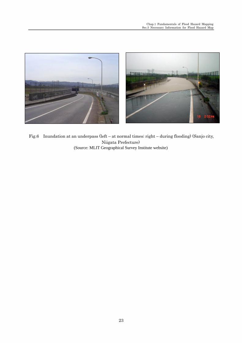
Fig.6 Inundation at an underpass (left – at normal times; right – during flooding) (Sanjo city, Niigata Prefecture)
(Source: MLIT Geographical Survey Institute website)
Chap.1 Fundamentals of Flood Hazard Map Sec.5 Necessary Information for Flood Hazard Map
24
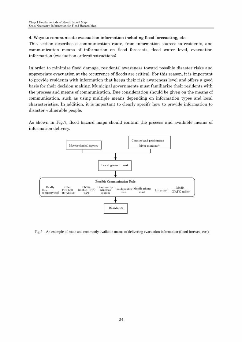
4. Ways to communicate evacuation information including flood forecasting, etc. This section describes a communication route, from information sources to residents, and communication means of information on flood forecasts, flood water level, evacuation information (evacuation orders/instructions). In order to minimize flood damage, residents’ awareness toward possible disaster risks and appropriate evacuation at the occurrence of floods are critical. For this reason, it is important to provide residents with information that keeps their risk awareness level and offers a good basis for their decision-making. Municipal governments must familiarize their residents with the process and means of communication. Due consideration should be given on the means of communication, such as using multiple means depending on information types and local characteristics. In addition, it is important to clearly specify how to provide information to disaster-vulnerable people. As shown in Fig.7, flood hazard maps should contain the process and available means of information delivery.
Fig.7 An example of route and commonly available means of delivering evacuation information (flood forecast, etc.)
Meteorological agency
Country and prefectures
(river manager)
Local government
Residents
Media Internet Mobile phone
mail (CATV, radio) Loudspeaker
van
Phone (moble, PHS)
FAX
Silen Fire bellBanderole
Possible Communication Tools
Orally (fire company etc)
Community wireless system

Chap.1 Fundamentals of Flood Hazard Mapping
Sec.5 Necessary Information for Flood Hazard Map
25
Fig.8 An example of description of how to deliver evacuation information (flood forecast, etc.)
(Source: Shizuoka city flood evacuation map [issued by Shizuoka city in Mach 2004])
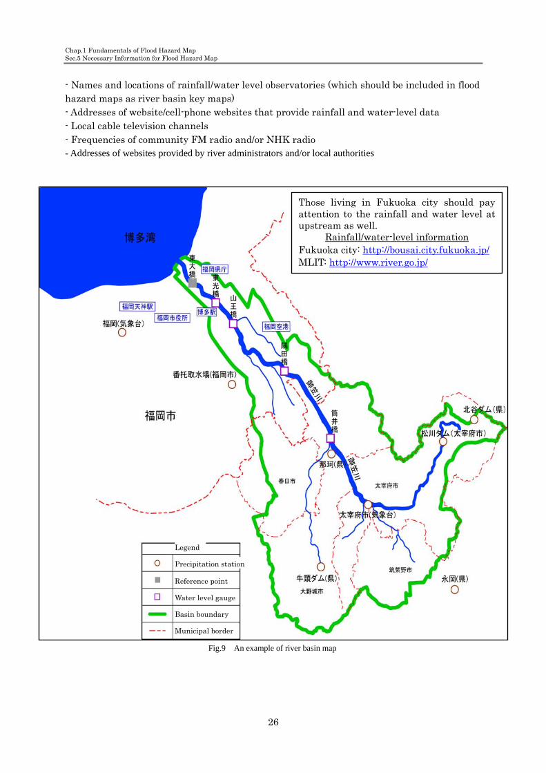
5. Information sources for weather, etc. It is important for municipal governments and residents to proactively try to collect information instead of only receiving information provided by the national and prefectural governments. In particular, dissemination of the sources and means of related information, such as weather information, is important to enhance residents’ awareness of acting independently and taking care of themselves. For this reason, the sources and means of related information should be included in flood hazard maps. Including information on the rainfall at the time of past floods and inundation in flood hazard maps is also helpful for residents to understand possible flood risks under a cirtain rainfall condition in their living areas. It is also effective to craft river basin maps which include target municipalities and the locations of rain/water gauge stations. Such maps will help residents to have better understanding of the area that each target basin covers and the characteristics of each target river, including the time period until upstream rainfall reaches a target municipality and the rainfall at which the risk of disaster occurrence increases. In addition, since information on upstream rainfall and river water levels is important for residents to identify the flood risk and decide when to evacuate, it is recommended to include how to get such information in flood hazard maps. The source and means of related information that may be added in flood hazard maps include the following:
How the evacuation and meteorological information is conveyed.
Media agencies
Shizuoka city disaster prevention measurement
office
Shizuoka-ken Local office
MLIT
Shizuoka local meteorological office
flood prevention Fire service
team
Shizuoka-ken
Homepage
MLIT Homepage Disaster prevention information of river http://www.river.go.jp
TV radio
Residents
PCMobile phone
PC Mobile phone
Loudspeaker van, silen Multiple radio
The way of evacuation advisory and direction
The way of flood warning (meteorological information)
Chap.1 Fundamentals of Flood Hazard Map Sec.5 Necessary Information for Flood Hazard Map
26
- Names and locations of rainfall/water level observatories (which should be included in flood hazard maps as river basin key maps) - Addresses of website/cell-phone websites that provide rainfall and water-level data - Local cable television channels - Frequencies of community FM radio and/or NHK radio - Addresses of websites provided by river administrators and/or local authorities
Fig.9 An example of river basin map
Those living in Fukuoka city should pay attention to the rainfall and water level at upstream as well.
Rainfall/water-level information
Fukuoka city: http://bousai.city.fukuoka.jp/ MLIT: http://www.river.go.jp/
Legend
Precipitation station
Reference point
Water level gauge
Basin boundary
Municipal border
Chap.1 Fundamentals of Flood Hazard Map
Sec.6 Points to remember when designating evacuation sites
27
6. Points to remember when designating evacuation sites Before designating evacuation sites, careful examination is necessary to ensure that
the sites are free from the risk of inundation, landslide, storm surges and other disasters, based on the information of inundation risk areas and landslide hazard areas. Also, due consideration should be given to temporary evacuation sites.
Evacuation sites are for residents to escape flood waters. Therefore it is important to clearly specify the names and locations of evacuation sites in flood hazard maps in an easy-to-understand manner so that it will help residents to safely and appropriately evacuate at the occurrence of floods. Giving careful examination of evacuation sites during flood hazard mapping helps enhance the awareness of disaster prevention among municipal personnel in charge of disaster prevention as well as residents in the area. 1. Examining the appropriateness of evacuation sites In general, evacuation sites specified in municipal disaster prevention plans are often designated mainly for earthquakes. Therefore examination should be given in advance to ensure that they are free from the risks of inundation or landslide based on information on inundation risk areas, landslide hazard areas and the structure of evacuation sites. Also, such examination results should be reflected in municipal disaster prevention plans. It may be helpful to remember that appropriate evacuation sites are not necessarily required to be outside inundation areas; single-story or higher robust buildings in case of inundation of 50 cm or less, or two-story or higher robust buildings in case of inundation of around 2 m may be used as appropriate evacuation sites as well.
Note that, however, examination must be given also to how to secure rescue and medial aid in case of
evacuation sites being isolated.
2. Evacuation site information necessary for flexible evacuation The following points should be examined, if necessary, and add easy-to-understand information that helps residents to take flexible evacuation actions. (1) Wide-area evacuation sites across multiple municipalities When evacuation is required at a stage where the actual conditions of floods are not clear, it is most desirable to evacuate to shelters outside the inundation risk area. In such a case, wide-area evacuation across municipal boundaries may need to be considered. In such a case, municipal governments should develop a wide-area evacuation plan (wide-area flood hazard map) after identifying inundation conditions in all the areas concerned and implementing coordination for sharing evacuation sites with the neighboring municipal governments. Refer to Chapter 1 Section 7 for points to remember when

Chap.1 Fundamentals of Flood Hazard Mapping Sec,6 Points to remember when designating evacuation sites
28
establishing a wide-area evacuation plan. Ultimately, evacuation sites should be located in a wide-area flood hazard map, which covers neighboring municipal districts as well, after consultation with the neighboring municipal governments.
(2) Temporary/emergency evacuation site When evacuation is required at a stage where the actual flood conditions are not clear or based on the anticipated flow rate and depth of flood water, residents may need to temporarily evacuate to private facilities equipped with robust buildings, levees, or roads if they are higher than the predicted depth of flood water. Examination for securing such sites may be required in some cases. If there is not sufficient time for evacuation or the depth of flood water is too deep to evacuate, it may not be appropriate to evacuate to pre-determined evacuation sites. In such a case, residents need to take appropriate actions flexibly depending on the situation, such as evacuating to the second floor of their houses or to a nearby building. Adding such instructions in flood hazard maps is important to prevent accidents from occurring during evacuation. Before adding information on temporary evacuation sites in flood hazard maps, municipal governments should gain a permission of the administrators of private facilities regarding the use of facilities in case of a disaster. An agreement should be made in accordance with respective local conditions. Once the use of facilities is accepted, a letter of agreement should be signed by both parties. In consultation for the permission of using such facilities as emergency evacuation sites, municipal governments may take the initiative throughout the process. Another option is to allow residents to participate in the consultation, and in such a case, municipal governments can take full responsibility only for concluding the designation. The need of flexible evacuation actions, such as temporarily evacuating to the second floor of their houses or to a nearby building, should be instructed as “points to remember” in flood hazard maps. (3) Characteristics of evacuation site Information on evacuation sites should contain the following items. It will be helpful for residents to take appropriate evacuation actions. - Whether a municipal official arrangement plan has been developed - Whether a relief material distribution plan has been developed - Whether a disaster information delivery plan has been developed - Timing of opening evacuation sites (primary evacuation sites, secondary evacuation sites, etc.)

Chap.1 Fundamentals of Flood Hazard Mapping
Sec.7 Wide-area Evacuation Plan
29
7. Wide-area evacuation plan If an inundation risk area spreads across multi municipalities and therefore a large-area evacuation is required, preparation of of a wide-area flood hazard map should be taken into consideration based on a wide-area evacuation plan.
A wide-area evacuation across multiple municipal districts may be required in the following cases: - When an inundation area may extend a large area across multiple municipal districts and cooperation between municipal governments is essential - When most of a municipal district is inundated and few evacuation sites can be secured within the district. - When a municipal district is cut off into segments because of flooding and it is difficult to evacuate to an evacuation site within the district without crossing the river - When there is an area in a municipal district near which evacuation sites are not available and evacuating to neighboring municipal districts is more appropriate When either of the above holds true, it is desirable to consider preparing a wide-area flood hazard map on the assumption that a wide-area evacuation will be required in case of flooding. Information sharing among municipal governments is particularly important. Municipal governments should take appropriate measures to provide smooth and sufficient administrative services, including providing information on evacuees from neighboring municipalities to their original municipal government (See Figure 10).

Chap.1 Fundamentals of Flood Hazard Mapping Sec.7 Wide-area Evacuation Plan
30
Fig.10 An example of wide-area flood hazard map (Source: “Fujimi city flood hazard map” issued by Fujimi city in July 2001)

Chap.1 Fundamentals of Flood Hazard Mapping
Sec.8 Reflecting Opinions/Suggestions from Residents
31
8. Reflecting opinions/suggestions from residents Municipal governments should try to reflect as residents’ opinions/suggestions as possible
in their flood hazard maps.
The primary purpose of flood hazard mapping is to prevent human damage by providing residents with disaster-related information, such as a levee break and floods, in an easy-to-understand manner. For this reason, appropriate measures should be taken to collect opinions/suggestions from residents and to reflect local characteristics, such as local circumstances and past experience of disasters, in flood hazard maps. Where such measures are appropriately taken, the process of flood hazard mapping will help municipal officials involved in disaster prevention and residents to gain better understanding of inundation characteristics in the area and to improve their awareness of disaster prevention. Some of the ways to gather suggestions form residents are as follows: - Disclosing related information to residents - Holding briefing session to resident representatives (community association chiefs, etc.) - Consulting academic experts who know well about local circumstances and disaster prevention - Establishing a flood hazard map examination committee made of academic experts, Regional Development Bureau staff, prefectural and municipal officers, flood fighters, fire fighters, voluntary disaster prevention group members, flood control-related agency staff, local representatives, etc. - Conducting questionnaire and/or interview to residents - Other
Chap.1 Fundamentals of Flood Hazard Mapping Sec.9 Coordination with Municiple Disaster Prevention Plan
32
9. Coordination between flood hazard maps and municipal disaster prevention plan Municipal governments should ensure coordination between their flood hazard maps and
municipal disaster prevention plans.
Municipal governments should make revisions to their municipal disaster prevention plans based on inundation/evacuation information and disaster prevention-related issues that are identified in the process of flood hazard mapping. Also, municipal governments should ensure coordination between their flood hazard maps and municipal disaster prevention plans. “Revision of municipal disaster prevention plans in accordance with a partial amendment of the Flood Fighting Act” (Act No.165 of 2001, effective October 31, 2001) issued by the Fire and Disaster Management Agency may be helpful for the purpose above. In addition, municipal flood control plans, which stipulate fundamental issues for local flood control in accordance with the Flood Fighting Act Article 32, may form a part of the municipal disaster prevention plans (Windstorm and Flood section). Therefore flood control administrators should ensure coordination between flood hazard maps and flood control plans.

Chap.1 Fundamentals of Flood Hazard Mapping
Sec.10 Updating Information of Flood Hazard Map
33
10. Updating information in flood hazard map Municipal governments should appropriately revise their flood hazard maps when
changes are made in inundation risk areas or other information.
The flood hazard map should be appropriately revised in either of the following cases: - When changes are made in inundation information, such as the designation of inundation risk areas - When changes are made in the municipal disaster prevention plan, such as a new designation or change of evacuation sites - When an improvement is required at the stage of dissemination to the residents or actual use of the map in case of flooding, even if no change is made in those two cases above. When flood hazard maps are revised, residents should be promptly notified about the revision.

Chap.1 Fundamentals of Flood Hazard Mapping 「Examples」
34
[Case 1] Shizuoka city flood evacuation map (flood hazard map) (Shizuoka city, Shizuoka Prefecture) ------------------------------------------------------- p. 35 [Case 2] Nakano ward flood hazard map (Nakano ward, Tokyo) ------------------ p. 37
Examples of Flood Hazard Maps (The examples are flood hazard maps which are close to the ones made based on
the concept of “gerenal information.”)

Chap.1 Fundamentals of Flood Hazard Mapping
「Examples」
35
[Case 1] Shizuoka city flood evacuation map (flood hazard map) (Shizuoka city, Shizuoka Prefecture)
Basic conditions Form: Map type, double-side printing Paper size: A1 Inundation information: inundation risk area map and the past record of inundation caused by inland floods Characteristics: Evacuation sites in the inundation risk area are indicated as well. Predicted inundation depth at each evacuation site is shown in the evacuation site list.
(Source: “Shizuoka city flood evacuation map” issued by Shizuoka city in March 2004)
Larger view is shown
in the next page.

Chap.1 Fundamentals of Flood Hazard Mapping 「Examples」
36
Chap.1 Fundamentals of Flood Hazard Mapping
「Examples」
37
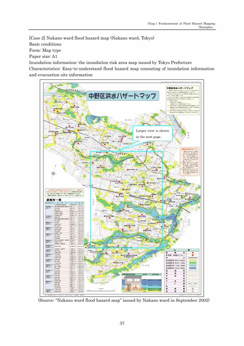
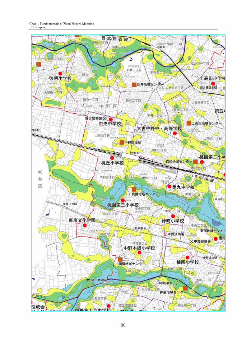
[Case 2] Nakano ward flood hazard map (Nakano ward, Tokyo) Basic conditions Form: Map type Paper size: A1 Inundation information: the inundation risk area map issued by Tokyo Prefecture Characteristics: Easy-to-understand flood hazard map consisting of inundation information and evacuation site information
(Source: “Nakano ward flood hazard map” issued by Nakano ward in September 2002)
Larger view is shown
in the next page.
Chap.1 Fundamentals of Flood Hazard Mapping 「Examples」
38

Chap.2 Area-specific Information
39
Chapter 2 Area-specific Information

Chap.2 Area-specific Information
40
5. Necessary information for flood hazard maps Information for flood hazard maps is divided into two kinds – general information and area-specific information. General information is required to be included in every flood hazard map while each local municipality can decide what area-specific information should be included depending on its needs. 1) General information — See Chapter 1. 2) Area-specific information Area-specific information refers to information that is specific in the target area and is useful when residents evacuate. This kind of information is also helpful to promote residents’ awareness of flood disasters in normal times. Chiefs of local municipalities are responsible for deciding which area-specific information should be included in flood hazard maps. <Information for evacuation> - Inundation information for other areas than inundation risk areas - Evacuation zones - Flood characteristics - Evacuation tips - Information regarding evacuation recommendation, etc. - Information regarding underground spaces - Information regarding facilities for disaster-vulnerable people - Other <Information for disaster education> - Generation mechanism of flood disasters, topography and types of flood - Information about possible risk of floods, types of damage, and past inundation - Meteorological information - Mental preparation for possible flood risks - Other relevant information
In this flood hazard mapping manual, information about natural and social characteristics of the target area is referred to as “area-specific information”. This kind of information includes two sub-types of information, namely, “information for evacuation” and “information for disaster education”. As the names tell us, the former helps residents to evacuate smoothly and quickly, and the latter is helpful in educating residents and enhancing their awareness of disaster prevention in normal times. The chief of each local municipality can decide which pieces of area-specific information should be displayed on their flood hazard maps after closely examining the main purpose of their preparing flood hazard maps. Local characteristics to consider typically include natural characteristics such as flood characteristics of rivers in each community and social characteristics such as residents’ experience of floods and the level of the community’s maturity. Before choosing pieces of information for flood hazard maps, it is necessary to

Chap.2 Area-specific Information
41
consider such area-specific information including possible risks during flooding, residents’ awareness of disaster prevention, and the current situation of the community.
The following are useful viewpoints in considering natural and social characteristics specific to each
area.

Chap.2 Area-specific Information
42
<Useful viewpoints regarding natural characteristics> - Flood characteristics of rivers Topography and inundation are very closely linked to each other like the two sides of the same coin. Inundation affects topography; on the other hand, topography also affects how inundation occurs. Area topographies are roughly classified into three types based on the types of inundation: a) Expanding type: Flooding water expands from a levee breach to the inland area. b) Flowing-down type: Flooding water flows down in the inland area along the river course. c) Retention type: Flooding water accumulates in a certain area. Which pieces of information (the flow velocity of flooding water, the propagation velocity to downstream areas, the ascension rate of inundation, reservoir filling time, etc.) to be included in flood hazard maps should be judged after considering types of inundation and the size of inundation areas. - Area-specific inundation characteristics Area-specific inundation characteristics particularly refer to types of inundation an area suffers for area-specific topographical reasons. This concept classifies areas into two types, namely, the areas that are possible to be inundated by landside water and the areas that are not. The areas prone to landside water inundation may be inundated even before levee breaches. Thus, local municipalities should decide on inclusion of information about inundation causes and inundation areas by landside water while considering possible influence of landside water on residents’ safe evacuation. <Useful viewpoints regarding social characteristics> - Past flood experience In recent years, there seems a tendency that areas or residents that have little experienced with past flood disasters suffer severer damage. Considering such tendency, local municipalities should decide on inclusion of information about flood characteristics of local rivers; how to make an evacuation decision upon evacuation recommendation: generation mechanism of flood disasters: possible risk of flooding; and how to understand weather information. - Local communities In recent years, quite a few communities are found to be still immature and have not nurtured a strong bond among their residents. Considering that, local municipalities should decide on inclusion of information about tips for evacuation (inviting neighbors when evacuating, etc.) and facilities for disaster-vulnerable people. - Underground spaces, etc.

Chap.2 Area-specific Information
43
The existence of underground spaces (underground malls and other underground facilities available to the general public) varies from area to area. Local municipalities with underground spaces should identify their exact locations and consider whether their flood hazard maps should include information about possible risk which people should be aware of when in such spaces during flooding.
Table 5 shows detailed items of information described so far.

Chap.2 Area-specific Information
44
Table 5 Detailed items of area-specific information
Type Information to be included in flood hazard maps
Inform
ation for evacu
ation
- Inundation information in other areas than inundation risk areas (inundation record [levee break point, inundation area], inundation forecast, inland flood, inundation-prone area, etc.)
Inundation area
Date of occurrence
Cause of floods
- Evacuation zone Evacuation zone
- Flood characteristics of rivers
Flow rate of flood waters
Flood propagation speed
Inundation depth
Increase rate of inundation depth
Inundation duration
- Evacuation tips Points to remember when evacuating
- Information regarding evacuation recommendation, etc.
Conditions for issuance of evacuation order/instructions
Details of evacuation order/instruction and action guidelines
- Information regarding underground spaces
Name
Location
Flood risk
- Information regarding facilities for disaster-vulnerable people
Name
Location
Inform
ation for disaster edu
cation
- Flood generation mechanisms, topography and types of flood
Flood generation mechanisms
Process of levee break
- Information about possible risks of floods, types of damage, and past inundation
Damage record
Rainfall state
Inundation state
Damage state
Photographs of flood damages
Evacuation state during past floods
- Meteorological information Details of weather forecasting/warning
- Mental preparation for possible flood risks
Mental preparation at normal times

Chap.2 Area-specific Information
45
1. Information for evacuation (1) Inundation information for areas other than inundation risk areas Inundation risk areas are designated by the central or prefectural governments in accordance with the Flood Fighting Act and notified to the municipal governments concerned. Besides inundation risk areas, however, there are also other areas assumed to have higher flood risks (inundation-prone areas, inland flood hazard areas, etc.) based on past inundation records and local characteristics. Adding information on such areas in addition to inundation risk areas in flood hazard maps is helpful for residents to safely evacuate. Note that, however, the following issues should be remembered when using such inundation information. - Use of inundation records Due consideration should be given to decide whether to use multiple flood/inundation records collectively or to use only major flood/inundation records separately before actually adding inundation area/depth records in flood hazard maps. - Use of flood analysis results Flood analysis results may have been adjusted by the grid square method. In such a case, re-adjustment of results according to actual topographies is necessary before adding the data to flood hazard maps. Refer to “The Inundation Risk Area Mapping Manual” issued by the MLIT River Bureau Flood Control Division in July 2001 for details of re-adjustment.
Reference 5 Inundation information for other areas than inundation risk areas
Process of inundation prediction by simulation
Item Details
Disclosure of “flood hazard maps”
1993-94
For all the rivers administered by the central government throughout Japan, hazard areas were identified by simulation with the design rainfall (an amount of rainfall assumed to occur approximately once in 100 to 200 years) and disclosed in “flood hazard area maps”. This information is available as “flood simulation results” via CD-ROM and the Internet.
Disclosure of “inundation risk area maps” After the amendment of the Flood Fighting Act in July
2001
Intended for the flood forecasting rives, in accordance with the Flood Fighting Act. Inundation areas and inundation depths are shown on maps with a scale of 1:10000.
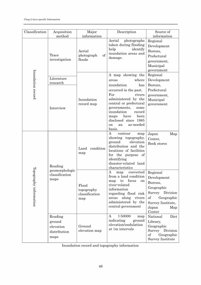
Chap.2 Area-specific Information
46
Inundation record and topography information
Classification Acquisition method
Major information
Description Source of information
Inu
ndation
record
Trace investigation
Aerial photograph of floods
Aerial photographs taken during flooding help identify inundation areas and damage.
Regional Development Bureau, Prefectural government, Municipal government
Inundation record map
A map showing the areas where inundation has occurred in the past. For rivers administered by the central or prefectural governments, some inundation record maps have been disclosed since 1985 on an as-needed basis.
Regional Development Bureau, Prefectural government, Municipal government
Literature research
Interview
Topography in
formation
Reading geomorphologic classification maps
Land condition map
A contour map showing topography, ground elevation distribution and the locations of facilities for the purpose of identifying disaster-related land characteristics
Japan Map Center, Book stores
Flood topography classification map
A map converted from a land condition map to focus on river-related information regarding flood risk areas along rivers administered by the central government
Regional Development Bureau, Geographic Survey Division of Geographic Survey Institute, Japan Map Center
Reading ground elevation distribution maps
Ground elevation map
A 1:50000 map indicating ground elevation/undulation at 1m intervals
National Diet Library, Geographic Survey Division of Geographic Survey Institute

Chap.2 Area-specific Information
47
Reference 6 Source information of flood records (Clearing House)
(Source: MLIT website [Designation/disclosure state of inundation risk areas along major rivers]) Flood information that has been disclosed is available on the MLIT website (URL: http://www.mlit.go.jp/river/saigai/tisiki/syozaiti/index.html), where you can check the designation/disclosure status, information sources, and contacts for inquiries of the following items: - Inundation records - Flood hazard maps Information disclosed on the Internet is equipped with a link to show details.

Chap.2 Area-specific Information
48
(2) Evacuation zone Specifying evacuation zones should be done in a unit which is familiar to residents, such as residential district (blocks, etc.), school district, or neighbor association. Such zoning is effective to facilitate mutual cooperation among residents during evacuation and at evacuation sites. (See Figure 11.) It is desirable to collect opinions from residents to decide whether to include the areas or buildings in the evacuation zones in the following cases: - When the area is not designated as the inundation risk area but has a higher risk of isolation when surrounding areas are inundated. - When the area suffers inundation below floor level (below 50 cm). - When the floors of a robust, high-story building are considered to escape inundation.
Fig.11 An example of designating evacuation zones based on school districts (Source: “Shirane hazard map” issued by Niigata city in March 2005)
- :小学校区
●番号:避難場所

Chap.2 Area-specific Information
49
(3) Flood characteristics Flood types can be classified into the following three categories based on local topographic conditions and flood water behaviors during flooding; “diffusion type”, “flowing-down type” and “retention type”. Each type has characteristics in the flow rate of flood waters, speed of propagation to downstream areas, inundation duration, and increase rate of inundation depth at water storage areas. Notifying residents of flood characteristics of a river, as shown in Table 6, is very effective to encourage residents to take evacuation actions on an appropriate timing. Therefore such information should be added in flood hazard maps if the target river has particular flood characteristics. Note that flood water behaviors considerably vary depending on various factors including river-bed gradient and the existence of driftwood in addition to the flood types. It is important to provide appropriate information specific to each river in an appropriate manner. For details of flood water behaviors and levee break characteristics of rapid rivers, refer to “The Guidelines for Specifying Inundation Risk Areas along Rapid Rivers” (issued by MLIT Hokuriku Regional Development Bureau in October 2003).

Chap.2 Area-specific Information
50
Table 6 Flood types and their characteristics
Flood type General characteristics
Points to remember
diff
usi
on t
ype
[General characteristics] - Often seen in flood plains with a large low-lying area, such as alluvial fans, natural levee areas, and deltas. - Flood waters spread widely. - The flow rate of flood waters is relatively slow except around a levee break spot. [Points to remember] - Adding information on flood water arrival time in the flood hazard map will be helpful for residents to identify an appropriate timing to evacuate.
Flo
win
g-do
wn
typ
e
[General characteristics] - Often seen in flood plains with a large land gradient or with a small flatland, such as valley bottom plains. - In most cases, flood waters flow down with a large depth and high speed. It may generate such a large energy that can flow houses away. [Points to remember] - Adding information on the floodwater flow rate and energy amount to be generated in the flood hazard map will be helpful for residents to identify the risks in evacuating on foot and the possibility of house collapse.
Ret
enti
on t
ype
[General characteristics] - Often seen in a flood area surrounded by hills or natural levees. - Inundation duration is relatively long. [Points to remember] - Information on the increase rate of inundation depth will be helpful for residents to identify the water level at which point evacuation is no longer possible. - Adding information on inundation duration in the flood hazard map is effective to enhance residents’ awareness to possible flood risks.
Asakawa River
Chikuma River
Tedori River

Chap.2 Area-specific Information
51
1) Energy generated by floodwaters Floodwater energy is generally calculated with the depth and flow rate of floodwaters. The energy to be generated will become large if either of the elements is considerably large even when the other is relatively small. It is desirable to add information on the floodwater energy in flood hazard maps as a degree of difficulty to walk in floodwaters, as shown in Fig.12. It helps residents understand possible dangers caused by floodwaters and decide whether they will be able to safely evacuate on foot. In general, the flow rate and depth of floodwaters tend to become larger around levees and in steep areas. In such places, a considerable amount of energy will be applied to inland facilities and houses during flooding, and there are risks that houses may collapse or be washed away. Therefore it is important to add such information in flood hazard maps to warn residents that they must evacuate as early as possible in case of flooding. Note that municipal governments should make use of inundation risk area information available from the Regional Development Bureaus and prefectural governments when examining the issues above. 2) Propagation speed of floodwaters (floodwater arrival time) Indicating the assumed propagation speed of floodwaters is effective to encourage early evacuation. It should be indicated clearly by, for example, classifying the target area into “within 30 min” “30 min to 1 hr” and “1 to 2 hrs” sections, as shown in Fig.13. Floodwaters that have overflowed in the upstream may flow down through inland areas. Therefore it is important to indicate the floodwater arrival time from each of levee break points so that residents are aware of the inundation characteristics in their living areas, such as the floodwater arrival time. 3) Increase speed of inundation depth Specifying the predicted increase speed of inundation depth in flood hazard maps is very effective to encourage early evacuation, because residents can understand when evacuation on foot becomes difficult after an inundation starts. 4) Inundation duration Indicating predicted inundation duration in and around the living area, as shown in Fig.14, is helpful to identify the need of evacuation and to predict the prospects of restoration. Adding predicted floodwater arrival time by each levee break point, as shown in Fig.14, will be helpful for residents to identify how long it will take floodwaters overflowing in the upstream to reach their living areas through inlands. It is also effective to notify residents of how far they should evacuate. Information items described above are calculated by each grid square in flood simulation. When the grid square method is taken, smaller grid squares enable more detailed

Chap.2 Area-specific Information
52
descriptions. With the isopleth method, accurate descriptions of the above information are impossible because the relationship with ground elevation is not clear, unlike water depth. Still, it is possible to describe it by the isopleth method with a reasonable, if not perfect, accuracy by taking topography and other elements into account. Therefore consideration should be given to employment of the isopleth method.

Chap.2 Area-specific Information
53
Fig. 12 An example of description of the relationship between floodwater flow rate and the degree of difficulty to walk
(Source: “Himegawa river flood hazard map” [Ome-cho, Itoigawa City, March 2001])
Flow velocity and difficulty of on-foot evacuation
Flow velocities are flood flow rates expected in residential areas in case of levee breaches along the Hime River due to heavy rain.
Water depth > 0.8m: On-foot evacuation is difficult.
Water depth > 0.8m: On-foot evacuation is difficult.
Water depth < 0.8m: On-foot evacuation is possible.
Difficulty of on-foot evacuation is evaluated in relation to flow velocity and water depth.
Legend
On-foot evacuation is difficult.
On-foot evacuation is possible.
Water depth > 0.8m
Water depth < 0.8m
Max. flow velocity (m/sec)
Mesh size: 250 x 250m
Difficulty of on-foot evacuation
e.g. At the water depth of 0.5m, on-foot evacuation is possible up to the flow velocity of 0.7m/sec.
On-foot evacuation is difficult.
On-foot evacuation is possible

Chap.2 Area-specific Information
54
Fig. 13 An example of description of floodwater arrival time (Joetsu City) (Source: Joetsu City Seki River flood evacuation map [Joetsu City, June 1996])
How fast can the floodwaters reach your area?
This figure shows how fast the
floodwaters may spread over areas
when levee breaches occur along the
rivers of Seki, Hokura and Yashiro.
Most riverside areas may be flooded
in 30 minutes. Residents living near the
levees or in low lands should take extra
care.
The figure also shows major roads
that may be flooded over 50cm.
Flood arrival times & flood-risk roads
In 30 minutes
In 1 hour
In 2 hours
Major roads
Roads to be flooded over 50cm
Emergency heliports

Chap.2 Area-specific Information
55
Fig.14 An example of description of inundation duration and floodwater arrival time (Source: Flood hazard map for Shonai River and Shinkawa River [Nagoya City, June 2002])

Chap.2 Area-specific Information
56
(4) Evacuation tips Describing points to remember during evacuation and everyday preparation for possible disaster risks in flood hazard maps is effective to ensure safe and smooth evacuation. The following are sample evacuation tips: - Neighborhood cooperation Keeping good communication and mutual assistance among neighbors are important to minimize disaster damage in the area (see Fig.15).
Fig.15 An example of evacuation tips (Source: Sapporo City flood hazard map [Sapporo City, July 2004])
- Evacuation support for disaster-vulnerable people Quick delivery of information is required for disaster-vulnerable people including the elderly, the physically/mentally challenged, and infants so that they can evacuate early enough to avoid damage. For this reason, it is important to describe the means of communication to disaster-vulnerable people in flood hazard maps, as shown in Fig.16.
Fig.16 An example of evacuation tips (Source: “Guidelines for evacuation support for disaster-vulnerable people” [Cabinet Office,
March 2005])
Other:
(Contact information of care insurance company, etc,)
Evacuation site
Evacuation information (warning, etc.) will be provided by & obtained from:
Mr./Ms. (name) (Vice-president of the neighborhood association); also by the (name) care center.
*Hearing-impaired people must be informed in person.
Evacuation supporters’ house
Evacuation supporters’ house
Evacuation shelter
(assembly hall)
Watch out for manholes when it’s raining hard.
Watch out for flooded areas
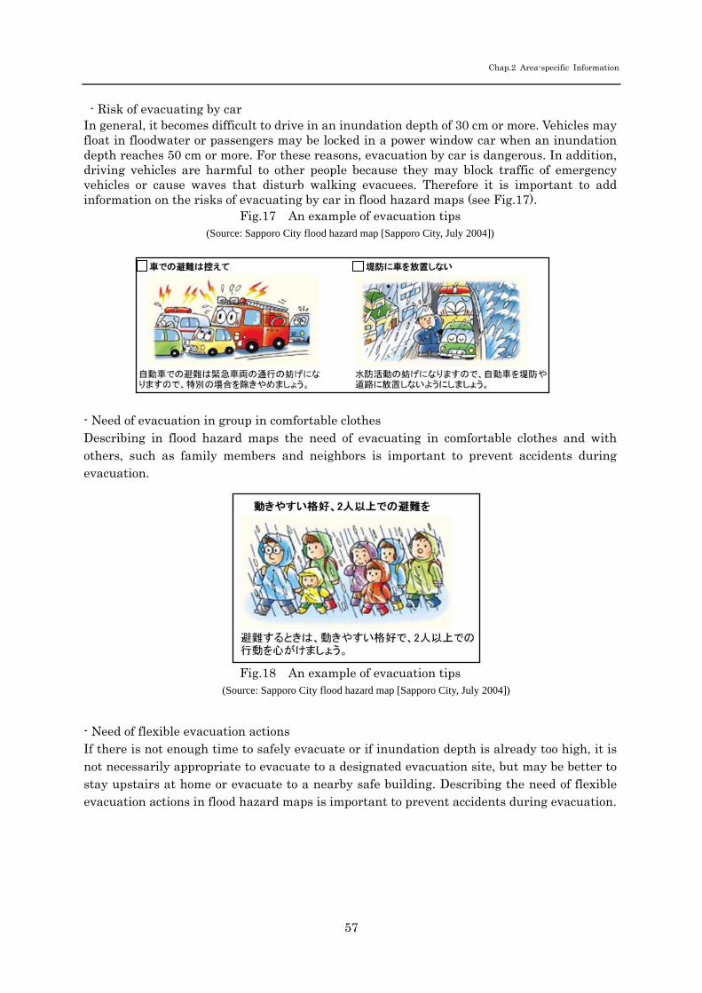
Chap.2 Area-specific Information
57
- Risk of evacuating by car In general, it becomes difficult to drive in an inundation depth of 30 cm or more. Vehicles may float in floodwater or passengers may be locked in a power window car when an inundation depth reaches 50 cm or more. For these reasons, evacuation by car is dangerous. In addition, driving vehicles are harmful to other people because they may block traffic of emergency vehicles or cause waves that disturb walking evacuees. Therefore it is important to add information on the risks of evacuating by car in flood hazard maps (see Fig.17).
Fig.17 An example of evacuation tips (Source: Sapporo City flood hazard map [Sapporo City, July 2004])
- Need of evacuation in group in comfortable clothes Describing in flood hazard maps the need of evacuating in comfortable clothes and with others, such as family members and neighbors is important to prevent accidents during evacuation.
Fig.18 An example of evacuation tips (Source: Sapporo City flood hazard map [Sapporo City, July 2004])
- Need of flexible evacuation actions If there is not enough time to safely evacuate or if inundation depth is already too high, it is not necessarily appropriate to evacuate to a designated evacuation site, but may be better to stay upstairs at home or evacuate to a nearby safe building. Describing the need of flexible evacuation actions in flood hazard maps is important to prevent accidents during evacuation.
Chap.2 Area-specific Information
58
(5) Information regarding evacuation recommendation, etc. Municipal governments should identify conditions under which residents should start evacuating and criteria for issuing an evacuation recommendation based on information available from organizations concerned as well as information that they collect by themselves. Describing the issuance criteria of evacuation recommendations in flood hazard maps will help residents evaluate circumstances during disaster and start evacuating at an appropriate timing. It is desirable to describe under what conditions evacuation recommendations (including evacuation recommendations/orders for disaster-vulnerable people), which are stipulated in municipal disaster prevention plans and flood control plans, will be issued. In addition, actions to be taken after an issuance of a evacuation recommendation should be described.
Table 7 summarizes the issuance conditions of evacuation recommendations/orders and actions to be taken by residents, based on “The Guidelines for Developing Evacuation Recommendation Issuance/Notification Manual” (the Cabinet Office, March 2005). Figs.19 and 20 shows an example of description of evacuation recommendations.

Chap.2 Area-specific Information
59
Table 7 Examples of evacuation order, etc. (Source: “Guidelines for Developing Evacuation Recommendation Issuance/Notification
Manual” [the Cabinet Office, March 2005]) Conditions for issuance Actions to be taken by residents
Information on evacuation preparation (intended for
disaster-vulnerable people)
- A stage where disaster-vulnerable people, especially those who take longer time for evacuation should start evacuating; the risk of human damage is expected to be rapidly increasing at this stage.
- Disaster-vulnerable people, especially those who take longer time for evacuation should start evacuating to a designated evacuation site. (Those who are to support them should start supporting their evacuation.) - Residents other than the above should start preparation for evacuation, including contacting other family members and preparing emergency goods
Evacuation recommendation
- A stage where residents who can evacuate by themselves should also start evacuating; the risk of human damage is clearly high.
- Residents who can evacuate by themselves should also start evacuating to a designated evacuation site.
Evacuation order
- The risk of human damage is extremely high, judging from premonitory phenomena and the urgent situations at the time. - The risk of human damage is extremely high, judging from local characteristics, e.g. the area is located right next to levees - Human damage has occurred
- Residents who started evacuation upon the evacuation recommendation should complete evacuation as quickly and securely as possible. - Residents who have not started evacuation should immediately start evacuation. If there is not enough time to safely evacuate, they should take whatever actions possible to be safe.
* Unexpected things may occur under natural phenomena. It is not necessarily appropriate to evacuate to a designated evacuation site; it is sometimes better to stay upstairs at home or evacuate to a nearby safe building, depending on the circumstances.

Chap.2 Area-specific Information
60
Fig.19 An example of description of evacuation preparation added to an evacuation order description
(Source: Yamagata City flood evacuation map [Yamagata City, March 2004]) Note) Municipal governments should give due consideration to decide what information should be included in the flood
hazard map, referring to Table 7.
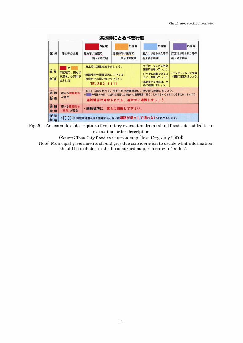
Chap.2 Area-specific Information
61
Fig.20 An example of description of voluntary evacuation from inland floods etc. added to an evacuation order description
(Source: Tosa City flood evacuation map [Tosa City, July 2000]) Note) Municipal governments should give due consideration to decide what information
should be included in the flood hazard map, referring to Table 7.

Chap.2 Area-specific Information
62
(6) Information regarding underground spaces Since underground malls are closed spaces, once inundation starts, the water level rises particularly fast, and therefore there is a considerably high risk of flood accident. In addition, people in underground malls are often too late to recognize the flood risk because it is difficult for them to gain information on weather forecasts, river conditions and others. Furthermore, there are higher risks during evacuation from such places because floodwater catchments often get in the way of evacuation routes, which may cause serious and fatal damage. Therefore, when various underground facilities available for the general public exist in an inundation risk area and when there is a need to ensure smooth and rapid evacuation in case of flooding, the names and locations of the facilities must be specified in flood hazard maps. If flood hazard maps become too crowded with such information to see other inundation data, pamphlets specifically designed for underground facilities may be prepared separately and distributed to residents. If underground facilities are inundated, safe and quick evacuation from such places is more difficult than evacuation on the ground. Indicating the possible flood risks at underground facilities with photographs and illustrations, as shown in Figs.21 and 22, is helpful to ensure safe and smooth evacuation from such places.
Fig.21 Floodwater running into Hakata-station underground mall (July 2005) (Source: “Flood Damage Report 2003” by Japan River Association, March 2004)

Chap.2 Area-specific Information
63
Fig.22 An example of description of possible risks in underground spaces in case of floodings
(Source: “Possible Risks in Underground Spaces in Case of Inundation” by the Japan Building Disaster
Prevention Association, June 2000)
豪雨・洪水時に地下街等は危険でIt is dangerous to be in underground malls when storm rain and floodning.

Chap.2 Area-specific Information
64
Figure 23 is a sample map that indicates the locations of facilities whose underground sections were inundated and facilities whose ground and underground sections were both inundated. (This map is not used in a flood hazard map, but may be useful as a reference.)
Fig.23 Inundation around Hakata Station including its underground malls (Source: “Investigation material for 6.29 Hakata-station-area inundation investigation coordination
meeting”)
Inundation around Hakata Station due to the June 29 storm

Chap.2 Area-specific Information
65
Fig.24 An example of description of the time until floodwater reaches underground stations
(Source: Flood hazard map for Shonai R iver and Shinkawa River [Nagoya City, June 2002])
What will become of the subway?
What will become of the underground mall?
The chart and tables below show how fast the floodwaters may reach each station after levee breaches occur along the Shonaigawa River.
Flood reaches in:
1 hour 1~2 hours 2~3 hours 3~4 hours 4~6 hours Over 6 hours No flooding
Chap.2 Area-specific Information
66
(7) Information on facilities for disaster vulnerable people When there are facilities for disaster vulnerable people (i.e. those who need support in case of disaster), such as the elderly, the physically/mentally challenged and infants, in inundation risk areas, and when there is a need to ensure smooth and rapid evacuation in case of flooding, the names and locations of the facilities should be included in flood hazard maps. If the flood hazard map becomes too crowded with such information to see other inundation data, pamphlets specifically containing information on those facilities should be prepared separately and distributed to residents. Examining detailed information other than the names and locations of facilities for disaster vulnerable people is useful for municipal governments to establish evacuation plans. When examining such information, it is desirable to refer to the “The Guidelines for Supporting Evacuation of Disaster Vulnerable People” prepared by the “study panel on information delivery and evacuation support to the elderly, etc. in case of downpour or other disaster”.
2. Information for disaster education (1) Generation mechanism of flood disasters, topography and types of flood Describing basic information on floods, such as inland floods, the factors and process of levee break, and local topography, in flood hazard maps is effective to enhance awareness to possible flood risks and understanding of local flood characteristics among residents. 1) Flood generation mechanism Figure 25 is an example describing the generation mechanism of floods caused by continual rain or downpour and the flood generation process in urban areas. Inclusion of such description in flood hazard maps helps residents to predict the occurrence of flood in their living areas based on weather information and to evacuate on an appropriate timing. Other useful information on floods includes the relationship between the precipitation in the upstream area and the river water level in the living area, rainfall intensity, and differences in runoff patterns caused by different land uses, as shown in Reference 7. Describing such information in flood hazard maps is very effective because it will provide a good basis for residents to take voluntary actions.

Chap.2 Area-specific Information
67
Fig.25 Flood occurrence mechanism (Source: “Kanto Region Flood Handbook 2003” by MLIT Kanto Regional Development Bureau River Administration Division, October 2003)
長雨による洪水の発生過程 集中豪雨による洪水の発生過程
都市部による洪水の発生過程
Flood by long rain
Flood in urban areas
Flood by torrential rainfall

Chap.2 Area-specific Information
68
Reference 7 Changes in runoff patterns caused by basin urbanization
Changes in runoff patterns caused by basin urbanization (along Tsurumi River)
The above graph indicates that the flood discharge increases and the peak flood discharge appears earlier as development in the basin proceeds. Note that the overflow from river channels is not taken into consideration in the analysis above.
S41.6実績降雨
100
90
80
70
60
50
40
30
20
10
0
雨量
(mm
/hr)
0
500
1000
1500
2000
06/28
2 4 6 8 10 12 14 16 18 20 22 06/29
2 4 6 8
時刻
末吉
橋地
点洪
水流
量(m
3/s)
雨量S41( 市街化率25%)現況(市街化率84%)
Rainfall in June 1966
Flood discharge in 1966
(Urbanization 25%)
Calculated flood discharge in
current situatiin
(Urbanization 84%)
Precipitation (mm/hr)
Time

Chap.2 Area-specific Information
69
2) Topographic characteristics identified by river basin landform classification maps Most plains in Japan which are prone to floods are depositional plains formed by erosion, transportation and deposition of sediment by streamflow or shore current. Sedimentation occurs mainly during flooding. Alluvial fans, natural levees and deltas are formed by natural forces applied repeatedly during floods. Since those natural forces, such as floods, which creates landform do not drastically change, if levee break or flooding occurs again, inundation tends to affect the landform basically in the same manner as when the previous inundation shaped the present-day landform. For this reason, it is possible to predict the state and characteristics of floods by gaining understanding of topographical distribution in a certain area. Topographical characteristics can be clarified by classifying an area by its form, structure and formation period. Basin landform classification maps (see Fig.26) and land condition maps are useful to this end, enabling identifying the relationship between topographical characteristics and floods. Currently it is also possible to identify micro-topography based on precise altitude data acquired by airborne laser scanning.
Fig.26 An example of river basin landform classification map (Tama River)
(Source: “River basin landform classification map” [the Ministry of Construction Kanto Regional Construction Bureau, Geographical Survey Institute, 1977])

Chap.2 Area-specific Information
70
(2) Information about possible flood risks, types of damage, and past flood records Information such as possible flood risks, types of damage, and past flood records are also helpful in enhancing residents’ awareness toward floods and reminding them of past flood experience. Figure 27 is an example carrying information of such kind. The figure includes records/photos on damage, rainfall, inundation, and evacuation. Inclusion of the relationship between presipitation and food types in flood hazard maps will also useful if there are past records available about such relationship.
Fig.27 An example of description of past floods
(Source: Yamagata City flood evacuation map [Yamagata City, March 2004]))
(3) Meteorological Information Information such as rainfall and the relationship between the upstream and downstream water levels as well as weather information and warning issuance criteria will be helpful for residents to predict the probability of flood occurrence in their living areas and to evacuate early enough.

Chap.2 Area-specific Information
71
(4) Preparation at normal times Figures 28 and 29 are examples showing in advance what we should prepare and what we should do when a flood occurs. Including such information in flood hazard maps is effective to enhance residents’ awareness to the need of mutual assistance in the community and among neighbors during evacuation. When preparing such information, local characteristics should be taken into consideration.
Fig.28 An example of description of preparation at normal times for future floods

Chap.2 Area-specific Information
72
(Source: Yamagata City flood evacuation map [Yamagata City, March 2004])
Fig.29 An example of description of preparation at normal times for future floods (Source: Yamagata City flood evacuation map [Yamagata City, March 2004])
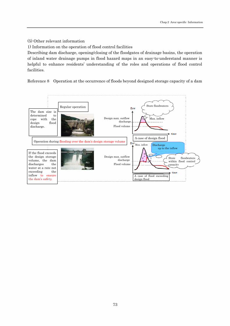
Chap.2 Area-specific Information
73
(5) Other relevant information 1) Information on the operation of flood control facilities Describing dam discharge, opening/closing of the floodgates of drainage basins, the operation of inland water drainage pumps in flood hazard maps in an easy-to-understand manner is helpful to enhance residents’ understanding of the roles and operations of flood control facilities. Reference 8 Operation at the occurrence of floods beyond designed storage capacity of a dam
Regular operation
Operation during flooding over the dam’s design storage volume
Design max. outflow discharge
Flood volume
The dam size is determined to cope with the design flood discharge.
If the flood exceeds the design storage volume, the dam discharges the water at a rate not exceeding the inflow to ensure the dam’s safety.
Max. inflow
A case of design flood
A case of flood exceeding design flood
Discharge up to the inflow
Store floodwaters
Store floodwaterswithin flood controlcapacity
Max. inflow
Design max. outflow
discharge
Flood volume