flood investigation report for - wirral
TRANSCRIPT

Regeneration & Environment
FLOOD INVESTIGATION REPORTDECEMBER 5TH FLOODS
FLOOD INVESTIGATION REPORT
FOR DECEMBER 5TH 2013

Regeneration & Environment
FLOOD INVESTIGATION REPORTDECEMBER 5TH FLOODS
1.0 INTRODUCTION 1.1 LEAD LOCAL FLOOD AUTHORITY INVESTIGATION
Wirral Borough Council as the Lead Local Flood Authority has a responsibility to record and report flood incidents as detailed below from within Section 19 of the FWMA:
Section 19 (1) On becoming aware of a flood in its area, a lead local flood authority must, to the extent that it considers it necessary or appropriate, investigate—
(a) Which risk management authorities have relevant flood risk management functions, and (b) Whether each of those risk management authorities has exercised, or is proposing to exercise, those functions in response to the flood.
(2) Where an authority carries out an investigation under subsection (1) it must— (a) Publish the results of its investigation, and (b) Notify any relevant risk management authorities.
A flood investigation is necessary after the widespread flooding along the Wirral coastline on 5th December 2013 caused internal flooding to more than 18 properties within 1 km2. In addition the flooding caused disruption due to the closure of promenade highways at West Kirby, Meols, Hoylake and New Brighton and also caused the closure of businesses at marine Point, New Brighton. This report provides a concise review of the responsibilities of all risk management authorities involved, and an outline of their past or proposed actions. The report also makes recommendations for further work, particularly with regard to response actions.
1.2 LOCATION
Widespread coastal flooding was experienced during the flood incident on Thursday 5th December 2013 with the townships of West Kirby and New Brighton particularly affected. At West Kirby the crest of the sea wall was exceeded by tide levels with green water flowing freely across the closed highway and causing flooding to residential properties and damage to their boundary walls. Further upstream within the Dee Estuary, properties experienced some degree of damage and erosion however properties here are situated well above tide levels and were not flooded during this incident. Along north Wirral the sea defences at Meols and Hoylake were overtopped causing the closure of the coastal promenades due to flooding. Wallasey Embankment was impassable but was not overtopped. At New Brighton, there was spray overtopping along the entire length of Kings Parade sea wall from Harrison Drive to Victoria Road. The overtopping flooded Kings Parade and also Ian Fraser Walk. The containment wall constructed as part of Marine Point

Regeneration & Environment
FLOOD INVESTIGATION REPORTDECEMBER 5TH FLOODS
development was also exceeded causing flooding to businesses, car parks and adjacent highways. Within the Mersey Estuary overtopping and flooding of adjacent promenades was experienced from New Brighton upstream as far as The Dell at Rock Ferry including areas at Seacombe and Birkenhead.
Figure 1 Flooding Locations
Regeneration & Environment
FLOOD INVESTIGATION REPORTDECEMBER 5TH FLOODS
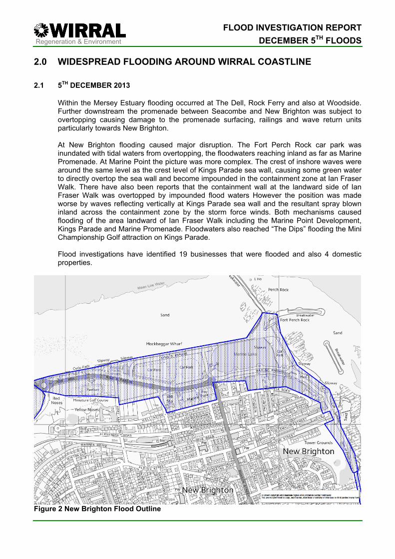
2.0 WIDESPREAD FLOODING AROUND WIRRAL COASTLINE 2.1 5TH DECEMBER 2013 Within the Mersey Estuary flooding occurred at The Dell, Rock Ferry and also at Woodside.
Further downstream the promenade between Seacombe and New Brighton was subject to overtopping causing damage to the promenade surfacing, railings and wave return units particularly towards New Brighton.
At New Brighton flooding caused major disruption. The Fort Perch Rock car park was
inundated with tidal waters from overtopping, the floodwaters reaching inland as far as Marine Promenade. At Marine Point the picture was more complex. The crest of inshore waves were around the same level as the crest level of Kings Parade sea wall, causing some green water to directly overtop the sea wall and become impounded in the containment zone at Ian Fraser Walk. There have also been reports that the containment wall at the landward side of Ian Fraser Walk was overtopped by impounded flood waters However the position was made worse by waves reflecting vertically at Kings Parade sea wall and the resultant spray blown inland across the containment zone by the storm force winds. Both mechanisms caused flooding of the area landward of Ian Fraser Walk including the Marine Point Development, Kings Parade and Marine Promenade. Floodwaters also reached “The Dips” flooding the Mini Championship Golf attraction on Kings Parade.
Flood investigations have identified 19 businesses that were flooded and also 4 domestic
properties.
Figure 2 New Brighton Flood Outline

Regeneration & Environment
FLOOD INVESTIGATION REPORTDECEMBER 5TH FLOODS
The road closure implemented at the west end of Kings Parade forced traffic onto a diversionary route along Coastal Drive, however this traffic was forced to return to Kings Parade at the Clown Roundabout where the effects of overtopping and flooding were severe.
There was no damage to the coastal defences at New Brighton. However, promenade
surfacing, railings, benches and the marine lake pontoon were all damaged. Along north Wirral between Harrison Drive and Meols coastal defences held, with minimal
damage recorded and there was no flooding experienced between these locations. In Meols the sea wall received superficial damage along the majority of its length and the
integrity of the structure was not compromised with the exception of approximately 25 metres at Sandhey Slipway. Here, 25m of sea wall coping was lost and the promenade surfacing also destroyed. The ground below the promenade was also washed out at this location; however, this washout did not extend as far landward as the highway. There were multiple locations along Meols Parade where promenade surfacing, steps and railings were damaged.
At West Kirby, private frontages at Lingdale Road experienced significant damage to their
defences and erosion of a garden to within 10m of the property. Lingdale Court also received superficial damage to their private defence although the main structure remained undamaged.
At South Parade there was flooding along its entire length from Riversdale Road in the north
to Sandy Lane at the south. The marine lake provides some protection to South Parade, causing waves to break offshore, however the attained tide levels on 5th December were such that the crest level of the outer lake wall and the sea wall at South Parade was exceeded with waves moving across the highway and breaking against the boundary walls of the private residences along South Parade.
Flood investigations have identified 4 businesses that were flooded and also 8 residential properties that suffered internal flooding. Although there was minimal damage to coastal defences there was significant damage to council assets at South Parade. Promenade railings, benches, surfaces and shelters were all damaged along the entire length. The boundary walls to many private properties were also demolished as a result of the breaking waves. Within the Dee Estuary south of West Kirby further damage occurred to private defences at West Kirby Sailing Club and Beach Walk. Council coastal defence assets in the form of rock armour revetments at Macdona Drive, Cubbins Green and Shore Road all experienced displacement, washout and movement of the armourstone. Following the midday high water conditions changed such an extent that the following high water, just after midnight on 6th December 2013 did not cause any further damage or flooding.
Figure 3 West Kirby Flood Outline

Regeneration & Environment
FLOOD INVESTIGATION REPORTDECEMBER 5TH FLOODS
2.1 METEOROLOGICAL CONDITIONS
Figure 4 Analysis Chart 1200 GMT 5 December 2013 On Wednesday 4th December at 7:41 a Flood Guidance Statement was issued by the Flood Forecasting Centre (FFC) advising of severe gales and large waves combined with high water levels on Thursday 5th December.
Later that morning the Environment Agency invited members of the Merseyside Local Resilience Forum to a teleconference to share information on the likely effects of the predicted flood event. This conference identified that a low-pressure surge was likely to raise predicted tide levels of 9.9m above Chart Datum for the midday high water by approximately 1 metre.
The EA issued Flood Alerts for the whole of the Wirral via the Irish Sea and Dee Estuary Alerts and also the Mersey Estuary Alert on the afternoon of the 4th December. The Mersey Estuary Flood Alert was subsequently upgraded to a Flood Warning for the Mersey Estuary that evening. There is no specific targeted flood warning area covering the properties flooded at New Brighton and West Kirby
On Thursday 5th December the Flood Forecasting Centre upgraded their assessment of flood risk to “Medium” for northwest England, advising of a medium likelihood of significant impacts due to coastal flooding.
Wind speeds reached Force 8 (39-46 mph), gusting to Force 10 (55-63 mph) in a westerly direction during the day and the predicted low-pressure surge caused already high tide levels to increase by 1.2m. Recorded tide levels at Liverpool show the attained tide level to be 11.1m ACD.

Regeneration & Environment
FLOOD INVESTIGATION REPORTDECEMBER 5TH FLOODS
Figure 5 Recorded Wind Speeds at Hilbre Island
Figure 6 Surge Forecast

Regeneration & Environment
FLOOD INVESTIGATION REPORTDECEMBER 5TH FLOODS
Figure 7 Attained Tide Level The likely occurrence of a still water level of a tide of this height in any one year is between 2% and 4%, however on the 5th December the storm force winds significantly increased the height of offshore and inshore waves. Waves with heights of 4.6 m were recorded within Liverpool Bay and although these will have reduced in stature as they were transformed inshore the joint probability of waves of this height combining with the 11.1m ACD still water level is between 1.0% and 0.5% in any one year. This is often referred to as a 1:100 to 1:200 return period.

Regeneration & Environment
FLOOD INVESTIGATION REPORTDECEMBER 5TH FLOODS
3.0 CAUSE OF FLOODING 3.1 SEA FLOODING
The low-pressure induced surge caused already high tide levels to be increased by over 1.2m with a still water level of 11.1m ACD recorded at Liverpool. Wave action raised water levels even further and the westerly winds of Force 8, gusting Force 10 leading up to the midday high water were the factor that caused spray overtopping at New Brighton and caused defences to be overtopped at West Kirby, Hoylake and Meols.
4.0 ROLES AND RESPONSIBILITIES 4.1 LEAD LOCAL FLOOD AUTHORITY
As a lead local flood authority, Wirral Council has a role in overseeing the management of local flood risk.
Wirral Council was aware of the conditions which were to cause the widespread tidal flooding as a result of the guidance received from the Flood Forecasting Centre and from their own internal monitoring of tide levels and meteorological conditions.
As the LLFA Wirral Council used all available information to advise the Highway Authority of the likelihood of flooding so that road closures could be implemented. Wirral Council also attended the EA led Merseyside Local Resilience Forum teleconference and advised on the measures in place on Wirral in preparation for the overtopping event.
After the event Wirral Council as LLFA followed up on initial information provided by the Environment Agency and conducted a full investigation to determine the extent and location (internal or external) of flooding.
For this particular significant flood event the government, through the Department for Communities and Local Government have implemented various Flood Support Schemes to assist those affected with the costs of recovery. Wirral Council is administering four of the schemes to benefit affected householders and businesses.
4.2 HIGHWAY AUTHORITY
Wirral Council has a duty to maintain the highway under Section 41 of the Highway Act 1980.
Road closures were implemented at Rock Ferry, New Brighton, Meols, Hoylake and West Kirby on the morning of the 5th December. Highway inspectors were also in position to ensure the traffic complied with the closures. The Variable Messaging System at New Brighton was also activated. At New Brighton a diversionary routes along Coastal Drive was implemented.

Regeneration & Environment
FLOOD INVESTIGATION REPORTDECEMBER 5TH FLOODS
Flood water drained away through the existing highway and public sewer drainage systems once the tide had receded; and only a small number of road gullies required follow up cleansing to remove deposited flood debris After the tide had receded Wirral Council arranged for removal of tide-borne debris from highways and promenades. Roads remained closed until they were assessed as safe for vehicles.
4.2 ENVIRONMENT AGENCY
The Environment Agency have responsibility for the issue of Flood Alerts and where applicable, Flood Warnings to properties.
The Environment coordinated the Merseyside Local Resilience Forum on the day prior to the flood event and also issued Flood Alerts for the Irish Sea and Dee Estuary and also the Mersey Estuary on the afternoon of the 4th December. The Mersey Estuary Flood Alert was subsequently upgraded to a Flood Warning for the Mersey Estuary that evening.
The EA monitored flooding during the event, providing an initial list of affected properties for further investigation. The EA also assisted during the early stages of investigation with survey work on flood outlines and also determining flood depths.
5.0 RECOMMENDATIONS The various recommendations arising from this investigation are that:
• Wirral Council, as Lead Local Flood Authority implements, where appropriate, the governments Flood Support Scheme measures
• Environment Agency introduces a targeted Flood Warning Area for New Brighton specifically around Marine Point
• Environment Agency seeks to improve take up of the existing Flood Warning Area at West Kirby
• Environment Agency rebrands its Flood Alerts for the Dee Estuary and north Wirral to make the locations more familiar to Wirral residents.
• Wirral Council, as Highways Authority considers how diversionary routes at New Brighton and West Kirby can best implemented to reduce risks to traffic.
• Wirral Council, as Highways Authority considers the placement of non-temporary road closure measures at West Kirby and New Brighton.
• Wirral Council investigates how best to manage the risk to people and vehicles using coastal car parks.