flood profile interpretation and the eloma … · flood profile interpretation and the eloma...
TRANSCRIPT

FLOOD PROFILE INTERPRETATIONAND THE eLOMA PROCESS
© 2009 National Flood Determination Association

2© 2009 National Flood Determination Association
The NFDA “Flood Profile Interpretation and the eLOMA Process” training and “Flood Insurance Study (FIS) Assessment” (collectively, the “Training and Assessment”) have been instituted by the NFDA solely for the purpose of furthering the objectives of the NFDA’s eLOMA program. The Training and Assessment were produced by NFDA using current public information and contain secondary representations of FEMA forms, maps, profiles, and tables (collectively, the “FEMA Materials”). As a result of FEMA periodically updating and revising the FEMA Materials, the basis for the Training and Assessment may become outdated. Therefore, the most current and primary sources for the FEMA Materials should be consulted to assure use of the most recently updated version of the FEMA Materials and for the official instructions for proper use thereof. The NFDA does not guarantee or represent that successful completion of the Training and Assessment will provide continued access to FEMA’s eLOMA tool nor that the Training and Assessment is useful for any particular purpose outside of what is stated herein. In no event shall the NFDA be liable for the use of the Training and Assessment or any portion thereof and the applicant shall hold the NFDA harmless and defend them against any claim, including attorney’s fees, made against them because of the Training and Assessment and the use of the FEMA Materials.
DisclaimerBy accessing, utilizing , or completing this training or assessment, you agree to the following:

INTRODUCTION
• The technical requirements of the eLOMA process warrant a standardized review and preparation in order to ensure proper submittal of eLOMA applications.
• This tutorial and accompanying assessment are designed to acquaint the Certified Professional with some of the technical aspects of submitting eLOMA applications.
3© 2009 National Flood Determination Association

WHAT YOU WILL LEARN
• What is required for an eLOMA.• How to read an Elevation Certificate (EC).• How to use a Flood Insurance Study (FIS) to
determine Base Flood Elevation (BFE).• Helpful tips for eLOMA applications.
4© 2009 National Flood Determination Association

IMPORTANT FACTS TO REMEMBER
• Using FEMA’s Mapping Information Platform (MIP), check that there are currently no effective LOMCs or pending LOMC applications that affect the eLOMA subject.
• What you input into the eLOMA application is what will be published on the final document.
• All initial applications will be audited.• Each subsequent application may be subject
to immediate audit.
5© 2009 National Flood Determination Association
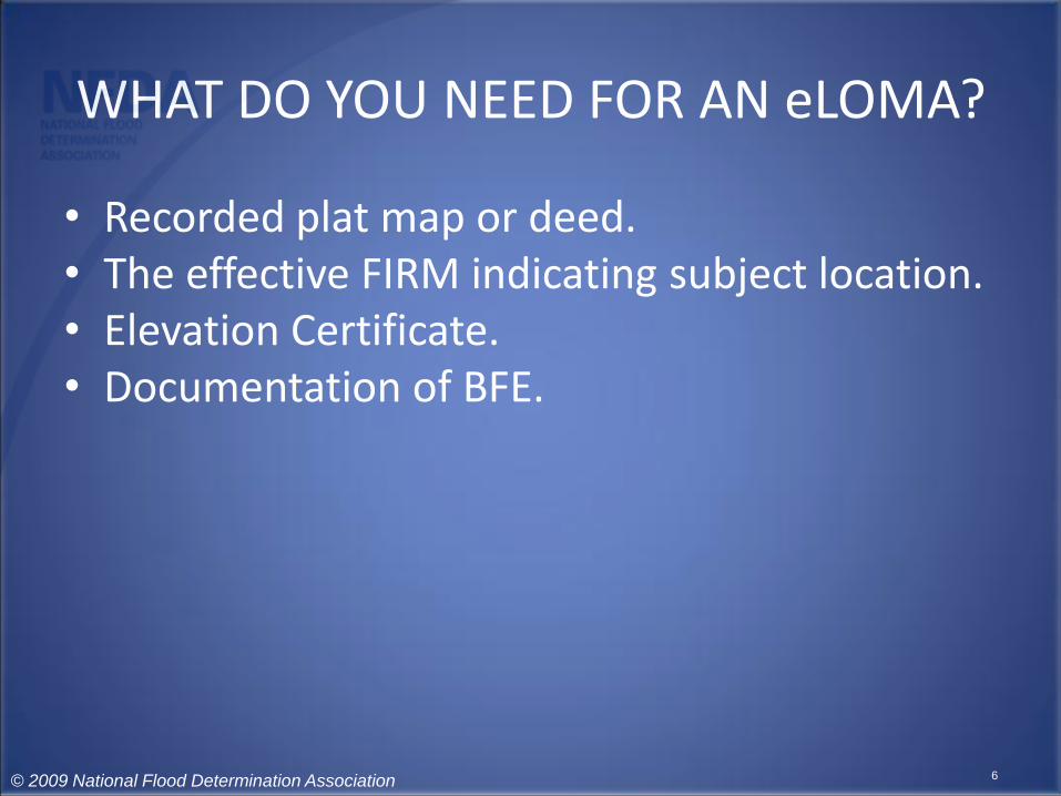
WHAT DO YOU NEED FOR AN eLOMA?
• Recorded plat map or deed.• The effective FIRM indicating subject location.• Elevation Certificate.• Documentation of BFE.
6© 2009 National Flood Determination Association

PLAT MAP / DEED
• The purpose of the deed or plat map is to identify the property and show that it is legally / officially recorded.
• Each must have recordation stamp.• Deed must include legal description.
– In this situation, the deed must be accompanied by a map of the property (tax map, plat map, or survey).
7© 2009 National Flood Determination Association

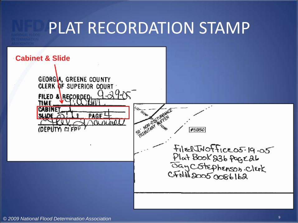
PLAT RECORDATION STAMP
8© 2009 National Flood Determination Association
PLAT RECORDATION STAMP
Cabinet & Slide
9© 2009 National Flood Determination Association

PLAT RECORDATION STAMP
Or Plat Book & Page
10© 2009 National Flood Determination Association

PLAT RECORDATION STAMP
Date filed
11© 2009 National Flood Determination Association

PLAT RECORDATION STAMP
And Community Official
12© 2009 National Flood Determination Association

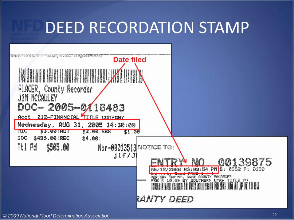
DEED RECORDATION STAMP
13
© 2009 National Flood Determination Association

DEED RECORDATION STAMP
Document Number
14© 2009 National Flood Determination Association

DEED RECORDATION STAMP
Or Book & Page
15© 2009 National Flood Determination Association
DEED RECORDATION STAMP
Date filed
16© 2009 National Flood Determination Association

DEED RECORDATION STAMP
And Community Official
17© 2009 National Flood Determination Association

EFFECTIVE FIRM• Is the subject for removal in a floodway?
Note: No part of the subject (whether it is the structure or the entire parcel) can be in the floodway.– If the floodways are not shown on the FIRM, you will
need to consult the Flood Boundary and Floodway Maps which can be obtained with the FIS.
• Verify that there is no LOMC pending for, or currently affecting this property.
• For a copy of the effective FIRM, visit FEMA’s Map Service Center.
18© 2009 National Flood Determination Association

EFFECTIVE FIRM
Parcel and
Structure must
be scaled
on FIRM
19© 2009 National Flood Determination Association

EFFECTIVE FIRM
And each map
must include the
North Arrow
and Scale
20© 2009 National Flood Determination Association

ELEVATION CERTIFICATE
• Sections A – D must be complete to support an eLOMA application.
• Here is what you will need from the Elevation Certificate (EC):– Latitude / Longitude
• Needs to be independently verified (Google Earth, Precision Mapping, TopoZone, etc).
– Base Flood Elevation (BFE)• Needs to be independently verified using the Flood
Insurance Study (FIS).
21© 2009 National Flood Determination Association

ELEVATION CERTIFICATE
• Here is what you will need from the Elevation Certificate (EC):– Vertical Datum
• Elevations entered for structure / property must reference the same vertical datum as used on effective FIRM.
• Use Vertcon (http://www.ngs.noaa.gov/cgi-bin/VERTCON/vert_con.prl) if conversion is necessary .
– Lowest Adjacent Grade (LAG)– Signature and Seal of licensed surveyor, licensed
engineer, or architect.
22© 2009 National Flood Determination Association

23© 2009 National Flood Determination Association
Section A5 indicates
Latitude / Longitude

24© 2009 National Flood Determination Association
eLOMA application requires
a decimal format
25© 2009 National Flood Determination Association
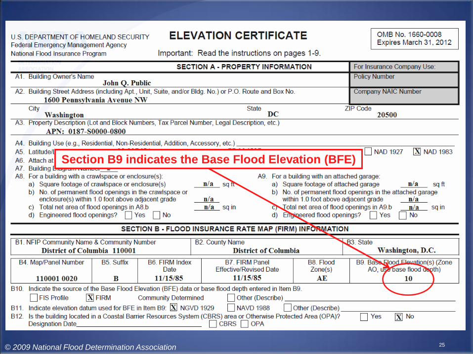
Section B9 indicates the Base Flood Elevation (BFE)
26© 2009 National Flood Determination Association
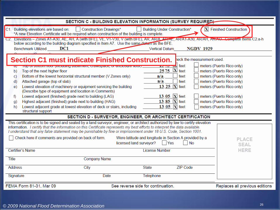
Section C1 must indicate Finished Construction.

27© 2009 National Flood Determination Association
Section C2 indicates Vertical Datum

28© 2009 National Flood Determination Association
Section C2-F indicates
the Lowest Adjacent
Grade (LAG) next to
building

29© 2009 National Flood Determination Association
Section C2-H indicates
the lowest elevation of
deck or stairs

30© 2009 National Flood Determination Association
In situations where
these differ, always go
with the lowest
elevation

31© 2009 National Flood Determination Association
Section D
indicates
Licensed
Professional
information
and signature

32© 2009 National Flood Determination Association
Section D also includes the Seal

ELEVATION CERTIFICATE
• The most recent version of the Elevation Certificate (EC) reflects two separate LAG measurements. Make sure to use the lower of the two in your calculations, and on the eLOMA application.
• It should be noted that FEMA does not require the use of a specific version of the EC when applying for a LOMA. Previous versions of the certificate are acceptable as long as they contain the required information.
33© 2009 National Flood Determination Association

VERIFYING THE BFE
• What you will need to know:– Determine the flood source by name.– Verify the BFE with the appropriate flood source
profile / stillwater elevation table.– Determine the 500-year elevation to identify the
Resultant Zone.
34© 2009 National Flood Determination Association

RESULTANT ZONE
• If the subject elevation is below BFE…– Select the zone that the subject is shown in on the
effective FIRM.
• If the subject elevation is above BFE…– The resultant zone should be Zone X/C if the LAG or
Lowest Lot Elevation (LLE) is above BFE and above the 500-Year elevation, or if there is no 500-Year elevation listed in the FIS report.
– The resultant zone should be Zone X (shaded)/B only when the LAG or LLE is above BFE but below the 500-Year elevation.
35© 2009 National Flood Determination Association
HOW TO READ AN FIS
• Now we will practice how to determine the information necessary for the eLOMA process.
• Please refer to the Flood Insurance Study (FIS) for Flood County, USA for the following examples.– This FIS is available on the NFDA website and
FEMA’s Map Service Center site.
• The object of removal (Subject) in all examples is the structure.
36© 2009 National Flood Determination Association

SUBJECT ONE
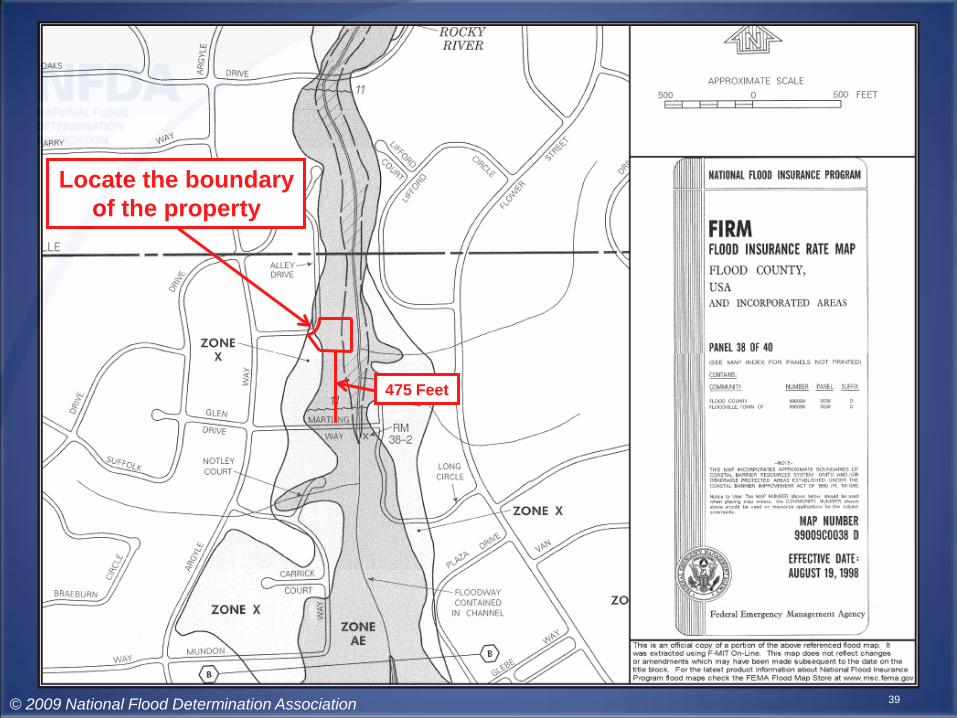
• Elmer Flood just purchased a house at 1301 Alley Dr in Floodville, USA, 12345. His new house is 625 feet upstream from Martling Way bridge, adjacent to Rocky River.
• First, we will locate the parcel boundary and subject with respect to the nearby flood source and the floodway.
37© 2009 National Flood Determination Association

38
Identify the
flood source
(Rocky River)
© 2009 National Flood Determination Association
39
Locate the boundary
of the property
475 Feet
© 2009 National Flood Determination Association

40
Locate the
subject
475 Feet
© 2009 National Flood Determination Association

41
Determine if the
subject is in the
floodway
475 Feet
© 2009 National Flood Determination Association

42
625 Feet
Determine the distance
along the stream
centerline from the
profile feature
to the upstream edge
of the subject
475 Feet
© 2009 National Flood Determination Association

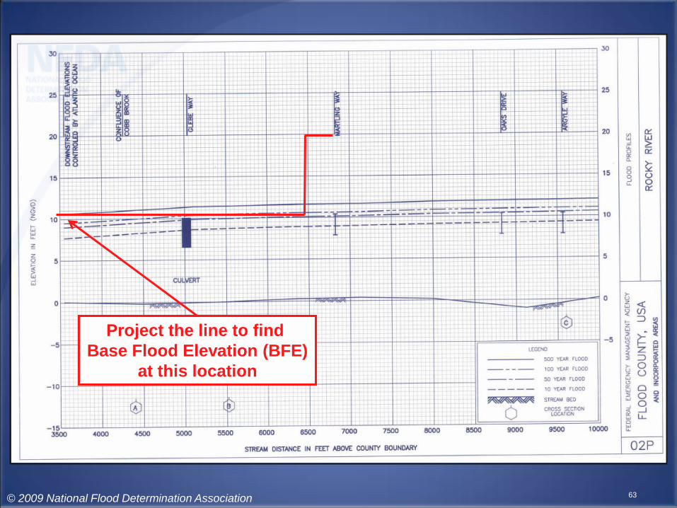
SUBJECT ONE
• Now, we will need to locate the applicable information on Flood Profile 02P for Rocky River :– Base Flood Elevation (BFE)– 500 Year (.2%) Elevation– Resultant Zone
• This will depend on the Lowest Adjacent Grade (LAG) in relation to the BFE and the 500 Year Elevation.
43© 2009 National Flood Determination Association

44
Take some time to locate the Elevation In Feet,
Stream Distance in Feet, and both the 500 and
100 Year Flood lines
© 2009 National Flood Determination Association

45
Identify the profile feature
© 2009 National Flood Determination Association

46
Property is located 625 feet
upstream of Martling Way
© 2009 National Flood Determination Association

47
Intersect 100 Year flood profile
at this location
© 2009 National Flood Determination Association

48
Project the line to find
Base Flood Elevation (BFE)
at this location
© 2009 National Flood Determination Association

49
BFE = 10.8
© 2009 National Flood Determination Association

50
Project the line to find
500 Year Flood (.2%)
elevation at this location
© 2009 National Flood Determination Association

51
500 Year = 11.7
© 2009 National Flood Determination Association

SUBJECT TWO
• Mr. Rogers just moved into his new house at 2323 Long Circle in Floodville, USA, 12345. His new house is 325 feet downstream from Martling Way Bridge, adjacent to Rocky River.
• Again, we will first locate the structure and parcel with respect to the nearby flood source and the floodway.
52
© 2009 National Flood Determination Association

53
Identify the
flood source
(Rocky River)
© 2009 National Flood Determination Association

54
Locate the boundary
of the property
300 feet
© 2009 National Flood Determination Association

55
Locate the subject
300 feet
© 2009 National Flood Determination Association

56
Determine the distance
along the stream
centerline from the
profile feature to the
upstream edge
of the subject
325 feet
300 feet
© 2009 National Flood Determination Association

57
Base Flood Elevation (BFE)
from FIRM is 11 feet
325 feet
300 feet
© 2009 National Flood Determination Association

SUBJECT TWO
• Now, we will need to locate the applicable information on Flood Profile 02P for Rocky River :– Base Flood Elevation (BFE)– 500 Year (.2%) Elevation– Resultant Zone
• This will depend on the Lowest Adjacent Grade (LAG) in relation to the BFE and the 500 Year Elevation.
58
© 2009 National Flood Determination Association

59
Again, take some time to locate the Elevation In Feet,
Stream Distance in Feet, and both the 500 and
100 Year Flood lines.
© 2009 National Flood Determination Association

60
Identify the profile feature
© 2009 National Flood Determination Association

61
Property is located 325 feet
downstream of Martling Way
© 2009 National Flood Determination Association

62
Intersect 100 Year flood profile
at this location
© 2009 National Flood Determination Association
63
Project the line to find
Base Flood Elevation (BFE)
at this location
© 2009 National Flood Determination Association
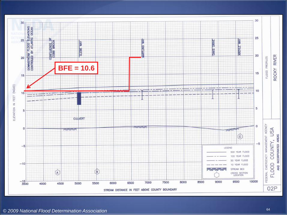
64
BFE = 10.6
© 2009 National Flood Determination Association

65
Project the line to find
500 Year Flood (.2%)
elevation at this location
© 2009 National Flood Determination Association
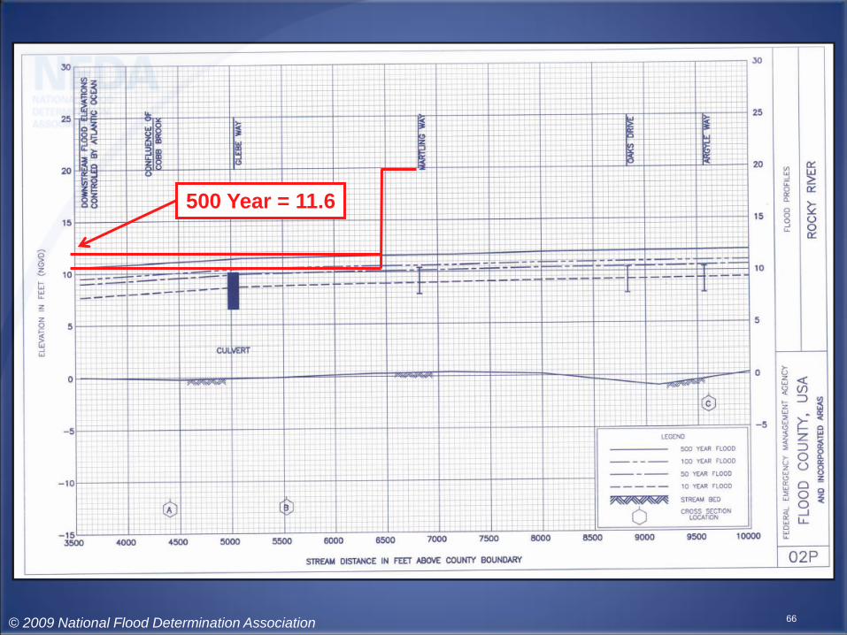
66
500 Year = 11.6
© 2009 National Flood Determination Association

SUBJECT THREE
• Mr. Smith just moved into his new house at 2075 Dairy Road in Floodville, USA, 12345. His property is adjacent to Silver Lakes.
• Again, we will first locate the structure and parcel with respect to the nearby flood source.
67© 2009 National Flood Determination Association

68
Locate the boundary
of the property
© 2009 National Flood Determination Association

69
Locate the subject
© 2009 National Flood Determination Association

70
Base Flood Elevation (BFE)
from FIRM is 10 feet
© 2009 National Flood Determination Association

71
The flood source is
Silver Lakes
© 2009 National Flood Determination Association

SUBJECT THREE
• Now, we will locate the applicable information on the Summary of Stillwater Elevations table:– Base Flood Elevation (BFE)– 500 Year (.2%) Elevation– Resultant Zone
• This will depend on the Lowest Adjacent Grade (LAG) in relation to the BFE and the 500 Year Elevation.
72
© 2009 National Flood Determination Association

73
Locate the Flooding Source
as identified on the FIRM.
© 2009 National Flood Determination Association

74
Identify the BFE
© 2009 National Flood Determination Association

75
Identify the 500 Year (.2%) elevation
© 2009 National Flood Determination Association

SUBJECT FOUR
• Ms. Waldo lives at 2638 Mundon Way in Floodville, USA, 12345. Her house is 435 feet upstream of Glebe Way, adjacent to Rocky River.
• We will now locate the structure and parcel with respect to the nearby flood source and the floodway.
76
© 2009 National Flood Determination Association

77
Flooding source is
Rocky River
© 2009 National Flood Determination Association

78
Locate the boundary of
the property
810 feet
© 2009 National Flood Determination Association

79
810 feet
Locate the subject
© 2009 National Flood Determination Association

80
810 feet
Determine the distance
along the stream
centerline from the
profile feature to the
upstream edge
of the subject
435 feet
© 2009 National Flood Determination Association

81
810 feet
435 feet
Nearest BFEs
on FIRM
© 2009 National Flood Determination Association

SUBJECT FOUR
• Now, we will need to locate the applicable information on Flood Profile 02P for Rocky River :– Base Flood Elevation (BFE)– 500 Year (.2%) Elevation– Resultant Zone
• This will depend on the Lowest Adjacent Grade (LAG) in relation to the BFE and the 500 Year Elevation.
82
© 2009 National Flood Determination Association

83
Identify the profile feature
© 2009 National Flood Determination Association

84
Property is located 435 feet
upstream of Glebe Way
© 2009 National Flood Determination Association

85
Intersect 100 Year flood profile
at this location
© 2009 National Flood Determination Association
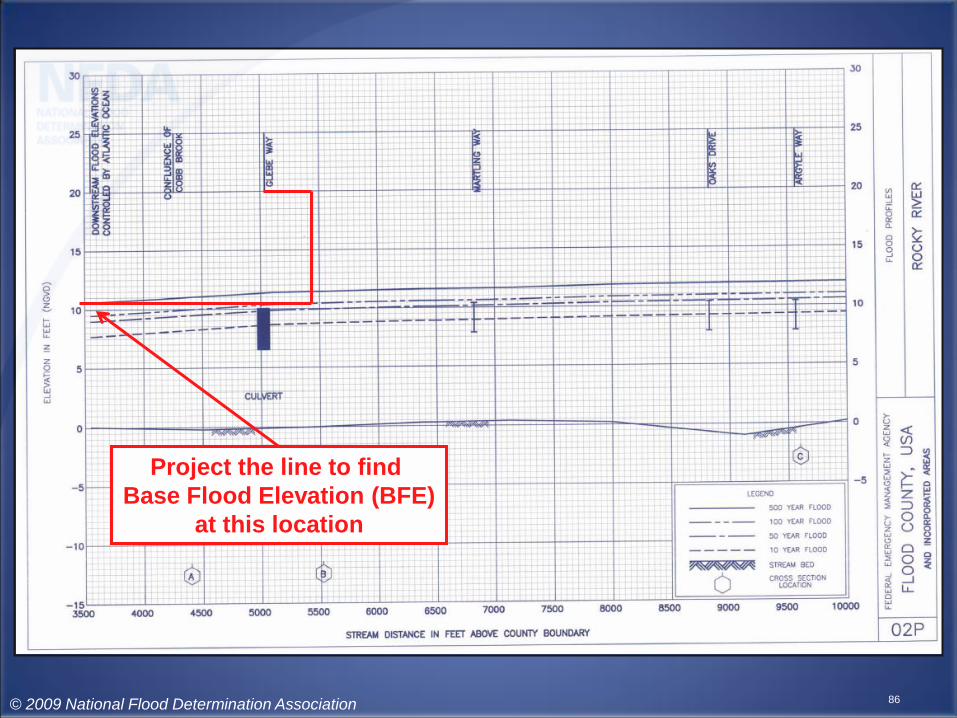
86
Project the line to find
Base Flood Elevation (BFE)
at this location
© 2009 National Flood Determination Association

87
BFE = 10.5
© 2009 National Flood Determination Association

88
Project the line to find
500 Year Flood (.2%)
elevation at this location
© 2009 National Flood Determination Association

89
500 Year = 11.5
© 2009 National Flood Determination Association

ZONE AH SUBJECT
• Mr. Bremer lives at 2161 Royal Oaks Dr in Floodville, USA, 12345. His house is 220 feet from Bass Circle, adjacent to Retention Pond No 1.
• We will now locate the structure and parcel with respect to the nearby flood source.
90© 2009 National Flood Determination Association
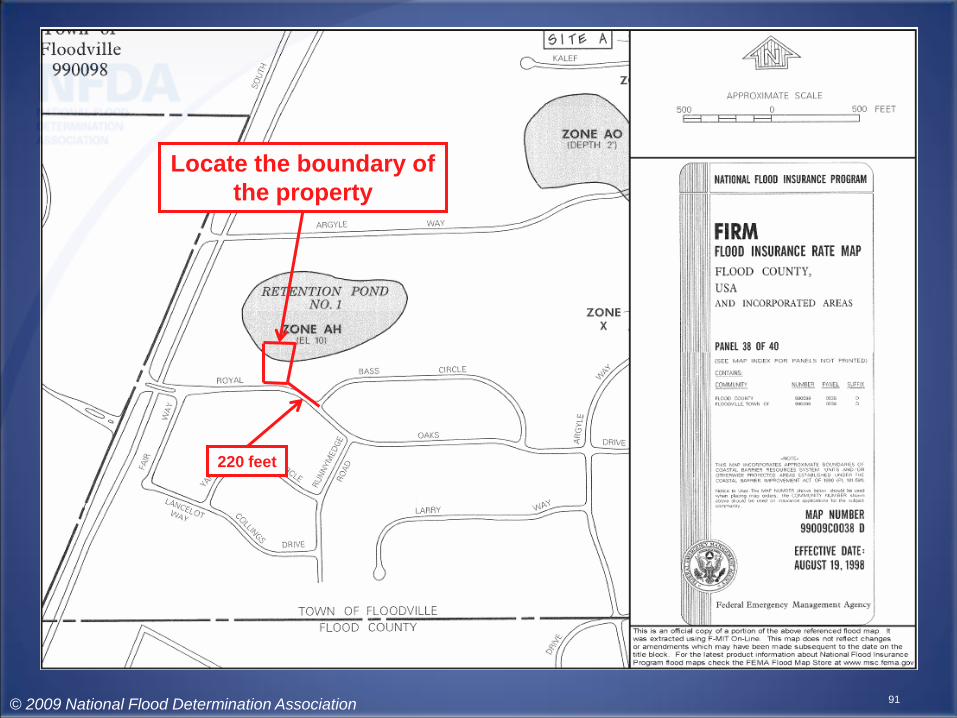
91
Locate the boundary of
the property
220 feet
© 2009 National Flood Determination Association

92
220 feet
Locate the subject
© 2009 National Flood Determination Association

93
220 feet
Flooding Source is
Retention Pond No. 1
© 2009 National Flood Determination Association

94
220 feet
ZONE AH
Elevation 10 feet
© 2009 National Flood Determination Association
ZONE AH SUBJECT
• Because this subject lies in an AH zone, the BFE can be taken straight from the FIRM.
• If you wish to verify it, the BFE will be found on the Summary of Stillwater Elevations table in the FIS. This is a useful exercise in order to verify the resultant zone. You will note on the table that there is no 500-Year elevation.
95© 2009 National Flood Determination Association
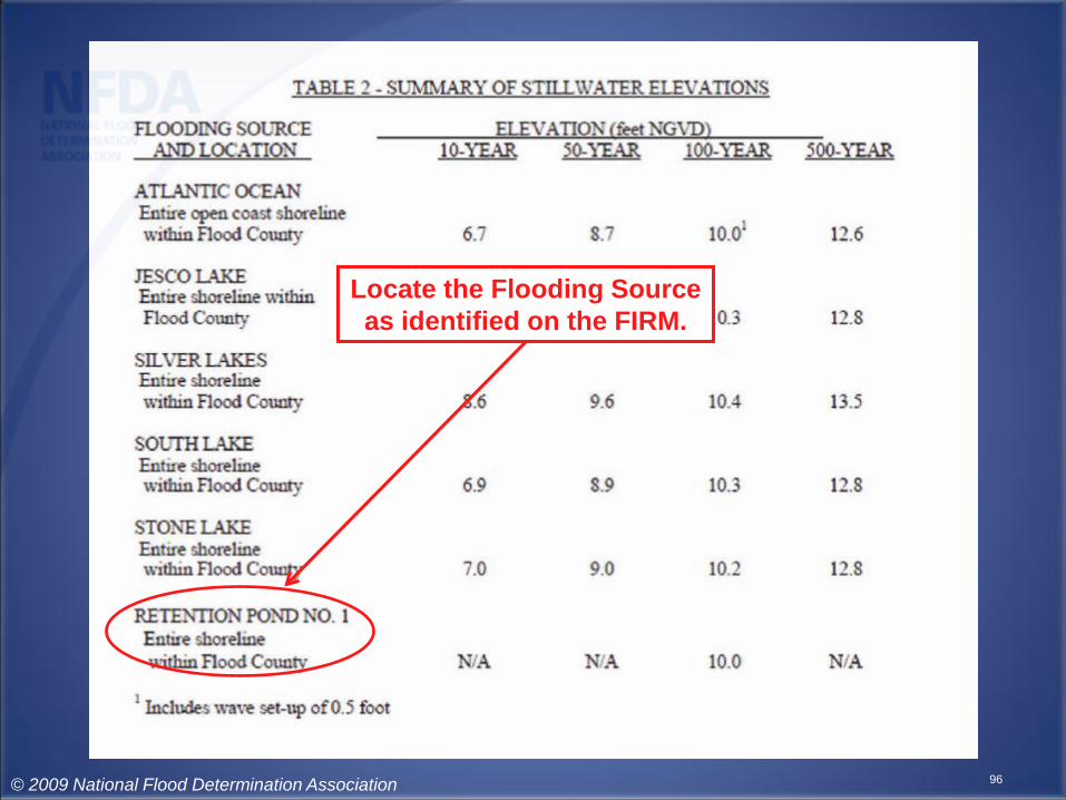
96
Locate the Flooding Source
as identified on the FIRM.
© 2009 National Flood Determination Association
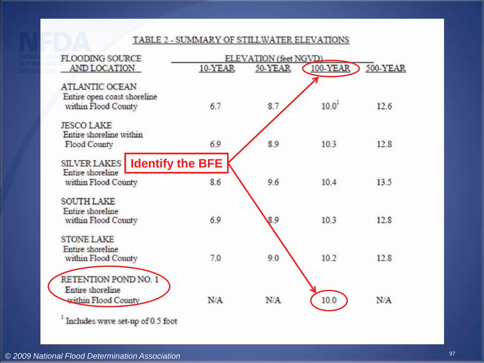
97
Identify the BFE
© 2009 National Flood Determination Association
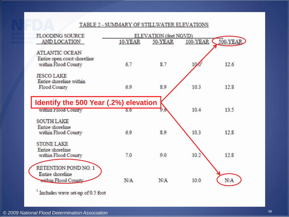
98
Identify the 500 Year (.2%) elevation
© 2009 National Flood Determination Association

DON’T FORGET
• Verify, via the MIP, that no current LOMC or pending application affects your eLOMA subject.– If the FIRM affecting your subject has been revised
by a LOMR, you cannot use eLOMA.
• What you input into the eLOMA application is what will be published on the final document.
• All initial applications will be audited.• Each subsequent application may be subject
to immediate audit.99© 2009 National Flood Determination Association

DON’T FORGET
• You cannot use eLOMA if your request involves Dual Communities, or if your Subject lies in an area that has been annexed by a community other than the one reflected on the current FIRM.
• The object of the eLOMA request, whether it is the structure or the entire parcel, cannot lie within the mapped Floodway.
100© 2009 National Flood Determination Association

DON’T FORGET
• If the subject for removal is the entire parcel, the Lowest Lot Elevation (LLE) must be at or above BFE.
• If the subject for removal is the structure, the Lowest Adjacent Grade (LAG) must be at or above BFE.
• Always verify the BFE shown on the Elevation Certificate using the community’s Flood Insurance Study (FIS).
101© 2009 National Flood Determination Association