flood risk management in italy - minambiente.it · flood risk management in italy: tools for the...
TRANSCRIPT

FLOOD RISK MANAGEMENT IN ITALY:
TOOLS FOR THE HYDROGEOLOGICALLAND PLANNING
Water is a vital element and a precious resource, but, at times, a danger to be controlled and above all avoided.
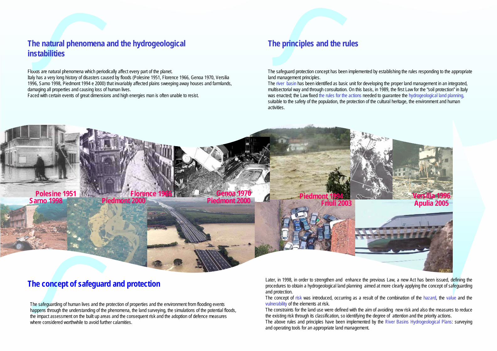
Polesine 1951 Florence 1966 Genoa 1970Sarno 1998 Piedmont 2000
Floods are natural phenomena which periodically affect every part of the planet. Italy has a very long history of disasters caused by floods (Polesine 1951, Florence 1966, Genoa 1970, Versilia 1996, Sarno 1998, Piedmont 1994 e 2000) that invariably affected plains sweeping away houses and farmlands, damaging all properties and causing loss of human lives.Faced with certain events of great dimensions and high energies man is often unable to resist.
Piedmont 2000
The natural phenomena and the hydrogeological instabilities
Piedmont 1994 Versilia 1996Friuli 2003
The safeguard protection concept has been implemented by establishing the rules responding to the appropriate land management principles.The river basin has been identified as basic unit for developing the proper land management in an integrated,multisectorial way and through consultation. On this basis, in 1989, the first Law for the “soil protection” in Italywas enacted; the Law fixed the rules for the actions needed to guarantee the hydrogeological land planning, suitable to the safety of the population, the protection of the cultural heritage, the environment and human activities.
The concept of safeguard and protection
The safeguarding of human lives and the protection of properties and the environment from flooding events happens through the understanding of the phenomena, the land surveying, the simulations of the potential floods, the impact assessment on the built up areas and the consequent risk and the adoption of defence measures where considered worthwhile to avoid further calamities.
Apulia 2005
Later, in 1998, in order to strengthen and enhance the previous Law, a new Act has been issued, defining theprocedures to obtain a hydrogeological land planning aimed at more clearly applying the concept of safeguardingand protection. The concept of risk was introduced, occurring as a result of the combination of the hazard, the value and thevulnerability of the elements at risk.The constraints for the land use were defined with the aim of avoiding new risk and also the measures to reduce the existing risk through its classification, so identifying the degree of attention and the priority actions.The above rules and principles have been implemented by the River Basins Hydrogeological Plans: surveyingand operating tools for an appropriate land management.
The principles and the rules

When for instance we estimate that the return period of a flood event in a given area is 30-50 years, the probability of occurrence of such event is high; consequently this area can be defined a “high (flood) hazard area”.
Vice versa, the probability of a flood occurrence with an estimated return period of 300-500 years is low; consequently the areaaffected can be defined a “low (flood) hazard area”.
The HAZARD MAPSHAZARD MAPS therefore cover the geographical areas which have been flooded, which could be flooded with an indication of the probability, taking into account the existing flood defence structures. These areas shall be shown according to the three following scenarios:• Frequently occurring flood events (HIGH PROBABILITY, likely return period 30-50 years);• Less frequently occurring flood events (MEDIUM PROBABILITY, likely return period 100-200 yrs);• Extreme flood events (LOW PROBABILITY, likely return period 300-500 years).
For each scenario the degree of danger will also be provided by expressing the water depth, theflow velocity or the combination of these and the identification of areas which could be subject to bank erosion and debris flow deposition.
The MAP OF PROPERTIESMAP OF PROPERTIESEXPOSED TO FLOODINGEXPOSED TO FLOODING
shows the properties identified within the “flood hazard areas”, as the properties exposed to flooding, since potentially affected by that event.The elements defining the exposed properties are: the value(people, properties, infrastructures, industrial activities, the environment) and the vulnerability (the capability of theproperties to withstand the forces due to the event). Thecombination of these elements are understood to be theconsequences, in other words the effect of the event on theexposed properties.
The RISK MAPSRISK MAPSare provided, according to the following four risk classifications:
R1 – moderate risk: social, economic and environmental damages are low;R2 – medium risk: probability of minor damages to buildings infrastructures andenvironment, not compromising human safety, use and economic activities;R3 – high risk: envisaged problems to human safety; damages to buildings andinfrastructures compromising their use and provoking hold-up of socio-economic activities and severe damages to the environment; R4 – very high risk: envisaged losses of human lives and severe lesions to persons; severe damages to buildings, infrastructures and the environment and socio-economic activities destruction.
Flood riskFlood risk is the damage expected to people, properties, the environment, infrastructures,industrial activities, considered as the combinationof the probability of a flood event (hazard) and of the potential adverse consequences (value xvulnerability) to human health, the environment, theinfrastructures and the economic activity associated with a flood event.
Flood hazard is the probability of occurrence of a potentially damaging flood event.The hazard expresses the probability that a damaging flood of a given severity occurs in a given timeframe (return period Tr). The return period is statistically defined as an inverse function of the probability, which can be consequently identified by the frequency of the flood event:
whereP = probability of flood event occurrenceTr = return periodf = frequency (the number of the occurring events in a given timeframe)
fT
PP
Tr
r ==⇒= 11

(1%)
(3%)
(6%)
The Ministry of the Environment and Land Protection – Directorate forSoil Protection plans, finances and controls the actions aimed at the hydrogeological riskreduction.
• hazard and risk maps forfloods, landslides andavalanches, showing allscenarios;
• provisions regarding land use in“high risk” and “high hazard”areas to prevent the increasingor generation of risk;
• priority actions for riskreduction, identified accordingto the degree of risk ( overNo.10.000 for a value of morethan 11 billions Euros);
• budgeted expenses for all theactions identified and required(over 40 billions Euros).
On the basis of the Plans, the Map of the areas at high hydrogeological critical state has been prepared to support the priority actions.Only to face up these actions, a planned strategy of the requiredinitiatives will be needed, to befinancied by EU, National, Regional, Local and Private Funds.
Surveying, monitoring and land management are continuous actions which, time after time, must go on.
The results achieved towards the hydrogeological risk management
Italy has completed the hydrogeological land planning allowing the floods, landslides and avalanches risk management. The River Basin Hydrogeological Plans provided the following results:
Prioritizing actions and scheduling allocation of financial available resources.
A very high riskcontains also mediumand high risk, hencerepresents the objective of the priorityactions.
A high hazardcontains also mediumand low hazard, hencerepresents the priorityobjective of attentionto avoid the risk whichdoesn’t exist.
We must not generate the risk which does not exist.
The assessment of the priority actions
The attention level and the priority actions are identified on the basis of the hazard degree determining the degree of risk.

Ministry of the Environment and Land ProtectionDIRECTORATE FOR SOIL PROTECTION
Via Cristoforo Colombo, 4400147 ROME (Italy)
Telephone +39 06 5722 2601Fax +39 06 5722 2620
Website www.minambiente.it
Respecting rules contributes to a more lasting and secure socio-economic development.
May
2006