flood risk reduction in germany - dkkv · lessons learned from the 2002 disaster in the elbe region...
TRANSCRIPT

Lessons Learned from the 2002 Disaster in the Elbe Region
Flood Risk Reduction in Germany
Summary of the Study
LESSONS LEARNED
LESSONS LEARN
ED
FEBR
UA
RY 2004 DK
KV
Publication
29e
German Committee for Disaster ReductionGerman Committee for Disaster Reduction
29
e
Flood Risk Reduction inG
ermany

LESSONS LEARNEDDKKV Publication
29 e
Lessons Learned from the 2002 Disaster in the Elbe Region
Flood Risk Reduction in Germany
German Committee for Disaster Reduction
Summary of the Study

The following persons were directly involved in the study:
BTU Cottbus, Chair for Hydrology and Water Management Prof. Dr. rer. nat. habil. Uwe GrünewaldDr.-Ing. Michael KaltofenDipl.-Hydr. Sabine Schümberg
GeoForschungsZentrum Potsdam, Hydrological Engineering DepartmentDr.-Ing. Bruno MerzDr. rer. nat. Heidi KreibichDipl.-Geoökol. Theresia PetrowDr. rer. nat. Annegret Thieken
Christian-Albrechts University, Kiel, Disaster Research Centre Dr. Willi StreitzDr. Wolf R. Dombrowsky
Responsible for summary:
Prof. Dr. rer. nat. habil. Uwe Grünewald, Dipl.-Hydr. Sabine Schümberg
Dipl.-Geoökol. Theresia Petrow, Dr. rer. nat. Annegret Thieken (chapter 3)
Dr. Wolf R. Dombrowsky (chapter 6)
Editing:Birgit zum Kley-Fiquet, German Committee for Disaster Reduction, Bonn
Dipl.-Geogr. Inga Drews, German Committee for Disaster Reduction, Bonn
Dr. rer. nat. Edzard Hangen, BTU Cottbus
Grafic design:90/60/90 AGENTUR FÜR IDEALE FORMGEBUNG - www.906090-design.com
Translation: Peter Logan, Bonn
The study was drawn up with the friendly support of the German Red Cross (DRK) and theFederal Foreign Office.
ISBN: 3-933181-34-8All rights of the publisher and the author reserved© German Committee for Disaster Reduction 2004
Bonn, February 2004
Publisher: Deutsches Komitee für Katastrophenvorsorge e. V. (DKKV) German Committee for Disaster Reduction
Secretariat: Tulpenfeld 4 Phone + 49 (0)2 28-24 34-8 27/-8 2653113 Bonn Fax + 49 (0)2 28-24 34-8 36
[email protected], [email protected], INTERNET: www.dkkv.org
PUBLISHING DETAILS

PREFACE
SELECTED RECOMMENDATIONS
1 BACKGROUND AND AIM . . . . . . . . . . . . . . . . . . . . . . . . . . . . . . . . . . . . . . . . . . . . . . . . . . . . . . . . . . . . . . . . 8
2 EXTREME FLOODING EVENTS IN THE ELBE REGION . . . . . . . . . . . . . . . . . . . . . . . . . . . . . . . . . . . . . . . . . 12
3 PREVENTATIVE MEASURES FOR MINIMISING DAMAGE . . . . . . . . . . . . . . . . . . . . . . . . . . . . . . . . . . . . . . 16
4 REDUCTION OF EXTREME RUNOFF AND FLOODING THROUGH NATURAL
RETENTION AND TECHNICAL FLOOD PROTECTION . . . . . . . . . . . . . . . . . . . . . . . . . . . . . . . . . . . . . . . . . . . 24
5 FLOOD WARNINGS AND EARLY WARNING SYSTEMS AS ELEMENTS FOR
RISK REDUCTION THROUGH PROVIDING INFORMATION . . . . . . . . . . . . . . . . . . . . . . . . . . . . . . . . . . . . . 28
6 THE ANALYSIS OF DISASTER PREVENTION AS A NETWORK AND AS A
FORM OF COMMUNICATION . . . . . . . . . . . . . . . . . . . . . . . . . . . . . . . . . . . . . . . . . . . . . . . . . . . . . . . . . . . . . 32
REFERENCES . . . . . . . . . . . . . . . . . . . . . . . . . . . . . . . . . . . . . . . . . . . . . . . . . . . . . . . . . . . . . . . . . . . . . . . . . . . . . . 34
This version of the study is a summary of the interdisciplinary study “Flood Disaster Reduction in Germany – Lessons
Learned from the 2002 Disaster in the Elbe Region”, which was updated to take into consideration the status of
the debate as of 20.12.03. The full version was published in November 2003 as leaflet 29 in the publication series
of the German Committee for Disaster Reduction (ISBN: 3-933181-32-1).
CONTENTS OF THE SUMMARY

The Elbe floods in 2002 clearly emphasised that large-
scale disasters can afflict every country, even in Europe.
The total damage costs of around 10 billion euros, the
realisation that our infrastructure was so vulnerable and
also the disruptions to the planning of many people's
livelihoods through natural disasters also placed the
issue of disaster reduction on the daily agenda.
A great deal has happened since the 2002 Elbe floods:
The damage has been partly repaired, the affected
Länder (states), rural districts and municipalities, as well
as the organisations involved in overcoming the disaster,
have each compiled the facts from their perspectives,
have evaluated this material and, where necessary, have
drawn their conclusions from this experience.
The German Committee for Disaster Reduction (DKKV)
is the platform and coordinating point for the debate on
disaster reduction, above all in an international context,
but also in Germany. With this “Lessons Learned” study
DKKV is for the first time providing a complete overview
of flood risk reduction in Germany, using the example
of the 2002 Elbe floods. An interdisciplinary team was
set up, consisting of independent scientists, who evalu-
ated the numerous reports available on the Elbe floods
and – through supplementing these with their own sur-
veys and analyses – drew up a comprehensive picture
of what should be taken into consideration for the future
of flood risk reduction in Germany. Above all this study
underlines what we can do better in Germany.
The study does not provide an exact list of everything
that happened or did not happen on the Elbe, but,
instead, above all tries to work out structural failings
using case studies and to use these to derive applicable
statements.
I would like to express my great thanks to all participants
who contributed information to this study. And I am par-
ticularly grateful to the German Red Cross, which
financed this study in the knowledge that only frank-
ness and transparency can enable us to recognise how
to act better in the future – an awareness that we did
not find everywhere during the preparation of this study.
I hope that this study will find widespread public
recognition and above all will provoke a lively debate
amongst all those involved and between the various par-
ties: citizens, the official authorities, science, industry,
the media and not least policymakers at all levels.
Dr. Irmgard Schwaetzer
Ex Federal Minister
Chairperson of the German Committee for Disaster
Reduction
Preface
LESSONS LEARNED — Flood Risk Reduction in Germany
| ... 4 ... |

DKKV Publication [ SELECTED RECOMMENDATIONS ]
| ... 5 ... |
Selected Recommendations for Improved Flood Risk Reduction in Germany
What our society needs is a transparent debate on risks. The basis for this is to disclose dangers and
vulnerabilities, together with a consistent debate on protection objectives. This requires sufficiently precise
data for planning, evaluation and cooperation as well as the weighing up of conflicting interests. Such flood
risk management includes all aspects of flood risk reduction and disaster response. The previously prevalent
separate view of precaution and response must be overcome.
In particular the following aspects have to be taken into consideration:
The reduction of potential damage has top priority. Risk reduction through spatial planning as an
important instrument for this purpose, has to be strengthened. In future statutory regulations on
keeping floodplains undeveloped must be clearly defined. For better implementation of risk
reduction through spatial planning synergy effects between flood risk reduction and other interests,
above all nature protection, landscape conservation or drinking water protection should be sought
and used. Financial and insurance incentives are required for rebuilding in another place or for
resettlements, in order to achieve a reduction of damage potential in the flood plains rather than
just stagnation.
Measures and recommendations have to be comprehensively weighted in accordance with their
importance for flood risk management, in particular in accordance with the effectiveness of the
measures vis-à-vis space, time, and process intensity. Measures for evaluating effectiveness must
be worked out, to be able to assess their importance. Measures for flood risk reduction and
response must be assessed in accordance with specific catchment areas and with regard to their
interaction. “Flood protection concepts” (for instance MÜLLER 2003) must take into consideration
the broad range of flood risk reduction measures.
Limits to natural retention, in particular its limited effectiveness in the case of extreme discharges,
must be recognised and accepted. Demands for “climate protection” must be made in connection
with flood risk reduction. However, both of these should not be allowed to serve as an alibi for
preventing or reducing catchment area-related flood risk reduction and flood risk reduction covering
different watercourses.
Technical flood protection equipment is essential for reducing extreme flooding. However, their
limitations and risks must be made transparent. Clear responsibilities must be created and the
dimensioning of the equipment must be more closely related to the protection objectives. The
equipment must be maintained: Here the dikes in particular are not up to standard. There must
be frank information about existing weak points.
Possibilities and limits for taking action must be emphasised. The usual HQ(100) observations must
be also supplemented by further scenarios as well as by cases of failure. Presentations of danger
situations should be intensified and should take place permanently and be linked with
precautionary strategies and response possibilities.
SELECTED RECOMMENDATIONS
LESSONS LEARNED — Flood Risk Reduction in Germany
| ... 6 ... |
Warning systems for specific dangers and regions, ranging from gathering data and forecasts right
through to the reaction of affected persons should be expanded. Here, specific action must be
incorporated in integrated concepts. Technical security and material and action-orientation of
communication must be improved.
For successfully implementing protection concepts, a discussion process must be introduced that
involves the whole of society and involves the whole population. Here the principles of
sustainability and objectivity have proved their value. Quick suppression and forgetting of negative
situations must be countered.
Flood risk reduction and flood response are cross-sectional tasks and require a great deal of
communication, cooperation and management. All participants from different specialist and spatial
areas must be better integrated with each other. Interfaces are weak points, and must be regularly
tested for functionality and then updated.
Own private precautions, constructional, behavioural and (insurance-aided) risk reduction should be
systematically developed and stimulated as a component of flood risk reduction. Own precautions
are neither encouraged nor rewarded sufficiently. It depends a great deal on whether flood dangers
and limitations are recognised and whether possibilities for taking action are known. In the
elementary damage insurance, insurance premiums and deductibles should be oriented not only to
the risk but also the extent of own precautions, for instance to more intensely promote preventative
building measures. To make sure that solidarity becomes more effective in individual cases, it must
be ensured that private and commercial precautions can be integrated in (state) disaster response
well before the disaster. How, for instance, private persons can be legally insured while carrying out
relief work or how company fire brigades can be integrated if necessary, must be clarified.
Under the primate of flood protection obligated to clear protection goals the interests of a broad
range of political areas must be integrated in the drawing up of flood risk reduction concepts at an
early stage. Impacts not only on nature and the landscape but also on industry and settlement
development caused by flooding and flood protection measures requires an interdisciplinary space-
oriented risk management (KARL AND POHL 2003), which does not demand any competition but,
rather, a stronger integration of water (resources) management, land (resources) management and
spatial planning.
Action covering whole river catchment areas and extending across borders is essential for
“preventative flood protection” and for preventative flood risk reduction. Above all in achieving and
implementing transnational programmes such as “INTERREG-Rhein-Maas-Aktivitäten” (IRMA -
Interregional Rhine-Maas Activities), for which from 1997 to 2002 a total of 153 projects with a total
budget of € 356 million were worked out (ERNST AND NAGEL 2003), the special problems of risk
management and risk communication became evident (POHL 2003). But also in the case of such
smaller transnational projects like ODRAREGIO, with a comparably small cost of € 235,000 during a
period from December 1999 to June 2001, one-sided orientations, for instance towards developing
“spatially-organising networks” (HEILLAND AND NEUMÜLLER 2003) are unmistakable. It is to be
hoped that the Elbe-Labe-Initiative (ELLA), earmarked to begin 2004 within the framework of the
INTERREG IIIb programme, will not only provide transnational but also usable results, for instance
through “network-forming activities” (MALEK 2003).
SELECTED RECOMMENDATIONS

DKKV Publication [ SELECTED RECOMMENDATIONS ]
| ... 7 ... |
Solidarity with subsequent generations requires decisions on flood risk reduction concepts despite
great uncertainties. First of all this means that we must learn from disasters and above all design
reconstruction, so that a higher level of disaster reduction is achieved. Today's flood risk reduction
should not be allowed to restrict future generations' possibilities of taking action. Flexible systems
and expandable concepts are therefore required.
“The notion that “everything should get better, but nothing should change” also does not achieve the objective
in the case of flood protection.” (LAWA 1995, page 24).
In order that there are not just “improvements everywhere but also that something really changes”, all demands
must be considered, weighed up against each other according to social, economic and ecological criteria and
finally subordinated to the common good – and not to individual sectoral, regional or local interests.
SELECTED RECOMMENDATIONS

| ... 8 ... |
The floods of August 2002 in Central Europe caused total
damage of 21.1 billion euros and 37 fatalities (MÜNCHE-
NER RÜCK [MUNICH RE] 2003, updated) and, in contrast
to the Odra flooding in 1997 in the German-Polish border
area (GRÜNEWALD ET AL. 1998) had a disastrous impact
in the catchment areas of the Rivers Vlatava, Elbe and
Danube (Tab. 1). It destroyed confidence - not only
amongst those directly affected by the disaster — in the
security of people's living conditions and institutions
responsible for protection against flooding, and clearly
underlined just how susceptible our highly technical and
highly organised society is to extreme natural dangers.
In particular the shortcomings of flood disaster manage-
ment in Germany were once again clearly evident. We
have to learn from such events in order to identify as
many findings relevant to future disasters, compile this
information and as far as possible come to specific
conclusions and use these to create improved measures
for preventative action.
From safety mentality to risk culture
The danger of damaging flood waters is also ever present
in the river catchment areas of Central Europe, and
cannot be absolutely ruled out, even by comprehensive
protection measures. The traditional approach to flood
protection is shaped by a safety mentality. That is, flood
protection is frequently conceived in such a way that
one appears to be safe if the event should occur once
again. The protection is aimed at design values (for
instance, the 100-year flood), without a detailed analysis
and debate about other possible damage scenarios and
other protection objectives. Such an approach is cha-
racterised by suppressing and ignoring the complete
spectrum of dangers and by a sectoral way of looking
at things.
This traditional safety mentality or promise of protection
must be countered by a risk culture, which is aware of
the threat posed by flooding and which enables risks
and their changes as well as preventative measures to
1 Background and aim
LESSONS LEARNED — Flood Risk Reduction in Germany
TABLE 1Tab. 1: Damage caused by theAugust 2002 floods in Germanyand the Czech Republic
DKKV Publication [1 BACKGROUND AND AIM ]
| ... 9 ... |
be presented and evaluated transparently in an inter-
disciplinary dialogue. This includes the ability to
collectively deal with uncertainties. This requires risk
competence, i.e. the ability to correctly assess the
danger potential and to reduce it following an analysis
of social considerations.
The word risk is used in different connotations in
colloquial usage and the scientific community. In ever-
yday language risk means the possibility of suffering
damage. In safety science risk means two aspects,
namely the probability of damage occurring and the
magnitude of the damage (for instance PLATE AND MERZ
2001). The risk arises from the interaction of danger and
vulnerability (Fig. 1).
Such a risk culture is based on three sets of questions:
• What can happen? – Risk analysis – • What should not be allowed to happen?
What safety for what price? – Risk evaluation –• What is the best way of dealing with the risk?
– Dealing with the risk –
Common aspects can be identified for these three sets
of questions:
• Constructive, public risk communication is
necessary, and risks must be made public. Threats
and their impacts and possibilities of disaster risk
reduction should be made transparent and debated,
integrated in political opinion forming and publicly
communicated.
• Risks and possibilities of reducing them change over
time. This is all the more reason for continuous
(political, societal and financial) commitment. It is
not sufficient to simply react to specific events, i.e.
only take action after damage has been incurred.
• Ultimately the change of paradigm from safety
mentality and promises of protection to a risk
culture means closer cooperation between risk
reduction and coping with risks. Concentration on
the apparent controllability of flooding or protection
against flooding is to be replaced by strategies to
cope with flood waters. This would mean that the
separation between those involved with flood risk
reduction and those involved with coping with the
floods, which is found in many places today, would
become less important.
• Finally the debate on flood risk should be linked
with the debate on other natural risks and
technological risks. The objective would be the
coherent management of all risks that people in a
specific region are subjected to.
FIGURE 1Fig. 1: Risk as the result of theinteraction between danger andvulnerability

| ... 10 ... |
LESSONS LEARNED — Flood Risk Reduction in Germany
Flood risk management in Germany
The two main elements of flood risk management are
flood risk reduction and coping with floods (Fig. 2).
These two elements are integrated in the cycle of dis-
aster management. This means, for instance, that recon-
struction after the disaster already has to contain the
foundations for improved preventative measures.
Preventative measures against flooding above all means:
• Spatial measures: keeping constructional
development out of floodplains as far as possible
• Constructional measures: ensuring appropriately
adapted construction methods in areas prone to
flooding
• Risk reduction measures: own financial provisions
(backed by insurance)
• Behavioural measures: explaining, preparing for and
practicing how to cope with flood-related danger
situations
• Informational measures: alarming, warning and
informing about impending events
• Increasing natural water retention in catchment
areas
• Technical flood protection: constructional facilities
for water retention (such as dams, storage
reservoirs, polders).
Coping with flood disasters above all means:
• Averting disastrous impacts of flooding
• Help for victims
• Construction aid
• Reconstruction
Damage caused by extreme flooding can only be reduced
through a sensible integration of reduction and coping
measures.
Germany has a federal system, which means that
governmental tasks are divided between the Federal
Government and the State Governments of the Länder.
As part of Germany's environmental policy the Federal
Ministry for the Environment, Nature Conservation and
Nuclear Safety deals with general policy matters
affecting water management and cross-border coop-
eration in this area.
Beyond these basic policy matters flood reduction and
prevention is the concern of the Länder or states. After
the various Länder had for decades pursued a policy
that involved developing flood plains, for instance by
building enterprise zones and housing estates as well
as authorising more and more building of dikes and
extension of rivers, the Water Resources Act was
amended in 1996.
Even before the amendment the Länderarbeitsgemein-
schaft Wasser (Working Association of the Länder on
Water), which represented all German Länder (states),
formulated “Guidelines for a Future-Oriented Flood Pro-
tection” (LAWA 1995). This contains all the main ele-
ments of risk prevention and reduction similar to the
above definitions. In addition individual German Länder
(states) and river basin commissions formulated pro-
grammes of action for a sustainable flood protection that
contained similar terms such as “spatial measures” and
“technical flood protection”, but also the confusing term
“further-reaching prevention” (Fig. 3). It suggests a
“regulated sequence of measures” in the sense of “first
one and then the other”, which is by no means correct
in the case of flood risk reduction.
FIGURE 2
Fig. 2: The cycle of flood risk management
DKKV Publication [1 BACKGROUND AND AIM ]
| ... 11 ... |
On the contrary, sustainable flood reduction requires a
“balanced coexistence” for different levels of danger
(small, medium and large-scale flooding, respectively
with different recurrence intervals, in water catchment
areas of varying sizes and regional characteristics) to be
developed across sectoral areas and to be partly
implemented on a flexible basis (Tab. 2).
This study indicates that there is not enough coop-
eration, communication and management in either
reduction or in coping with flood disasters in Germany.
In both cases there is a lack of interdisciplinary action
across different specialist, administrative and spatial
boundaries and in particular across the different state
borders of the Länder (states).
TABLE 2Tab. 2: Examples of differentiatedmeasures for flood risk reductionin the case of different floodrecurrence intervals (T in years)(KRON 2003, altered)
Fig. 3: The three-pillared concept for water protection in Bavaria (BStMLU 2002) and the Saxon flood protection strategy (SMUL 2003a)
FIGURE 3
| ... 12 ... |
Floods are part of the natural hydrological cycle, which
is prone to extraordinary temporal and spatial variations.
They are natural events, which mankind has always been
subjected to and will also be subjected to in the future.
Extreme floods are above all due to heavy precipitation,
combined with unfavourable hydrological antecedent
conditions in the water catchment areas. Although the
anthropogenous influences that have prevailed in the
waters and their catchment areas in recent decades have
partly aggravated flood water discharge, particularly in
small catchment areas, they do not trigger off flooding.
Unusually heavy and abundant rainfall across wide areas
of the subbasin of the upper River Elbe, combined with
soils that were already relatively saturated, caused
extreme flooding on the River Elbe and its tributaries in
August 2002. The flood situation intensified dramatically
there within a few hours on 12 August and presented
an unprecedented challenge to those responsible for
dealing with the situation. Initially the tributaries of
the River Elbe in the Ore Mountains and the River
Mulde were affected, and then later the River Elbe itself.
The alarm was raised in many rural districts and
municipalities.
From a meteorological point of view this event can be
explained as the result of the flooding-prone “large-scale
weather patterns in Central European” TM “Low over
Central Europe” and TRM “Trough over Central Europe”.
Although the frequency of such flooding-prone large-
scale weather patterns (TRM and TM) are relatively low
in the months of June to September — less than 4 %,
when they do occur they bring sustained and heavy
precipitation over large areas, and throughout history
LESSONS LEARNED — Flood Risk Reduction in Germany
2 Extreme flooding events in the Elbe Region
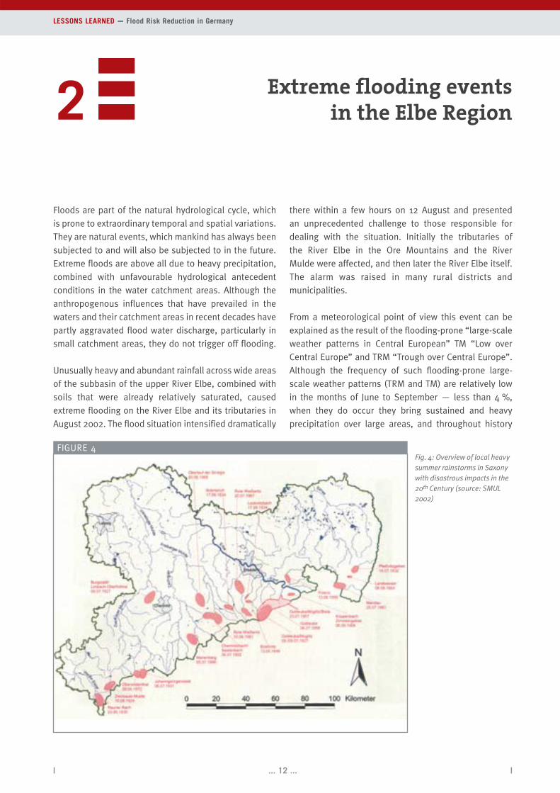
FIGURE 4Fig. 4: Overview of local heavysummer rainstorms in Saxonywith disastrous impacts in the20th Century (source: SMUL2002)

DKKV Publication [2 EXTREME FLOODING EVENTS IN THE ELBE REGION ]
| ... 13 ... |
they have repeatedly caused extreme flooding in the
affected river basins (GRÜNEWALD 2003).
With regard to the events that took place, initially a
differentiation must be made between two flooding
events: one with very quickly rising flood water dis-
charges in the tributaries and valleys of the Upper River
Elbe and the River Mulde and a separate event with
much slower rising waters in the River Elbe itself. Finally
there was a third event involving the subsequent rising
of the ground water, which caused considerable pro-
blems in urban areas.
Extreme floods concentrated over a particular period of
time are by no means new occurrences in Central Europe
and in the basin of the River Elbe. Important historic floods
when the river in Dresden exceeded a water level of 8 m
also occurred in August 1501, in February 1655, in March
1784, in February 1799, in March 1845 (greatest known
historic flood with W = 877 cm and Q = 5,700 m³/s, ice
flood) in February 1862 and in September 1890 (SMUL
2002). Heavy summer rainstorms have also repeatedly
caused limited flooding in the Ore Mountains and the
catchment of the River Mulde (Fig. 4). Widely known —
particularly in Saxony — are the devastating and torren-
tial floodings which appeared to occur exactly every 30
years in the catchments of the River Gottleuba and the
River Müglitz in the years 1897, 1927 and 1957, and
which in 1927 had a particularly disastrous impact,
causing 152 deaths.
After initial speculations of 7,000 m³/s for the August
2002 floods, it is now estimated that the peak discharge
in Dresden was 4,680 m³/s (BFG [GERMAN FEDERAL
HYDROLOGY INSTITUTE] 2002), which is relatively close
to the summer floods of September 1890, with a flow of
4,400 m³/s and the water flows in August 2002 in
Prague, Decin and Usti fitted in with the long-term river
flow patterns. Records indicate that this magnitude of
discharge recurs every 150 to a maximum of 200 years
(UMWELTATLAS [ENVIRONMENTAL ATLAS] 2002), but the
peak water level of 940 cm was higher than all previously
observed values. The apparent discrepancy between an
(after all) “unusually large flow” and a water level in
summer 2002 surpassing all previous records in the
urban area of Dresden can be explained by a drastically
reduced flood water transfer potential: Increasingly it
has been confirmed that the causes for this reduction
are pronounced alluvial deposits — for instance around
the Carola, Augustus and Marien bridges — as well as
vegetation cover. Also the construction of sports com-
plexes as well as, for instance, the stacked container
offices of the building site for the new congress hall
considerably narrowed the inlet to the Ostra flood
channel. Other weak points are the bridge profiles, which
do not allow enough water flow through them or which
have been subsequently altered in ways which reduce
the amount of water that can flow through them (Fig. 5).
Because other priorities had been set (amongst others, for
nature conservation, recreation) there were no measures
undertaken to minimise flooding >
FIGURE 5
Fig. 5: Examples of restricted flood water transfer potential in the urban area of Dresden: alluvial deposits in the city centre, bridge narrowing crosssection on Lockwitz brook (photos: U. Grünewald 2003)
(= removal of sediments deposited there over the years)
and bridge profiles and outlets were also not kept clear.
Only after the end of October 2003, for instance,
following “lengthy negotiations between nature conser-
vation authorities and the Radebeul State Environment
Office” (SÄCHSISCHE ZEITUNG, 22.10.2003, page 13)
could measures be commenced to partly remove alluvial
deposits that raised water levels and altered the flow of
waters. This is complicated by the complexity and variety
of competences governing the management of water
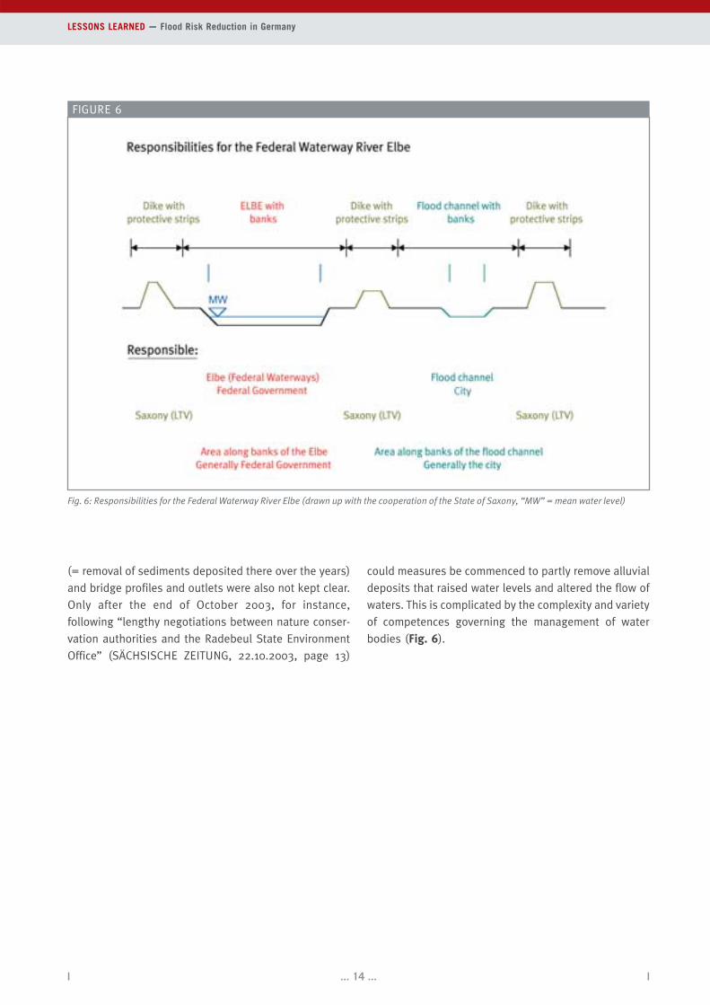
bodies (Fig. 6).
| ... 14 ... |
LESSONS LEARNED — Flood Risk Reduction in Germany
Fig. 6: Responsibilities for the Federal Waterway River Elbe (drawn up with the cooperation of the State of Saxony, “MW” = mean water level)
FIGURE 6

DKKV Publication [2 EXTREME FLOODING EVENTS IN THE ELBE REGION ]
| ... 15 ... |
Lessons Learned for evaluating results
Extreme precipitation of great intensity and concentrated on a specific area in the basin of the River
Elbe together with almost saturated soils led to extreme discharges in August 2002.
A look at the past reveals that there had already been comparable extreme flooding in the basin of
the River Elbe on previous occasions.
The unprecedented water level 9.40 m in the urban area of Dresden was apparently encouraged by
a reduced flood water transfer potential. This was caused by the combined effects of alluvial
deposits, vegetation cover in the flood profile, constructions in the flood channel, etc. Flood
profiles, flood channels, forelands, water channels under bridges, etc. have to be more consistently
designed to cope with floods than they have been up to now.
The splitting of responsibilities between the Federal Government, Government of the State of
Saxony and the local authorities and the partly unclear designation of competence along
(navigable) river reaches and the river catchments must be done away with, and instead clearly
defined objectives and clear definitions of priorities are required.
SUMMARY

| ... 16 ... |
The general increase in damage caused by natural dis-
asters is related to the number of people who live in
exposed areas and accumulate value there (MÜNCHENER
RÜCK [MUNICH RE] 2003). This particularly applies to
damage through flooding because, for instance, in
Germany building land is often offered in attractive
locations in flood plains.
Keeping constructional development out of flood plains
is the task of risk reduction through spatial planning
(LAWA 1995). However, even with the existing values in
the flood plains susceptibility to damage can be reduced
and prevented. Here preventative measures in con-
struction and adapted behaviour come into play. If flood
damage is incurred despite all preventative measures,
risk reduction can provide financial compensation: Here
in particular the possibility of insurance-backed risk
reduction should be considered.
Risk reduction through spatial planning
Risk reduction through spatial planning influences the ex-
tent to which areas are used and for what purpose they
are used. In areas prone to flooding preserving those areas
that are still not built on is the most effective method of
limiting an increase in potential damage (e.g. EGLI 2002).
International waters such as the River Elbe require cross-
border cooperation in managing river basins. Commis-
sions, such as the International Committee for the Pro-
tection of the River Elbe work on an interdisciplinary and
cross-border basis, and make recommendations (IKSE
2003), which, however, are not binding for Germany or
the Czech Republic. This means that although good work
is carried out, the effectiveness of this work remains
limited. The only binding Directive at European level is
the EU Water Framework Directive (WFD). However, it
primarily focuses on improving water quality. Preven-
tative flood protection, amongst other things, is not
specifically formulated as an objective or otherwise
anchored in the Directive and therefore scarcely plays a
role in the current version (EU 2000). A positive approach
of the WFD is to deal with the entire natural catchment
area as a whole. Because of its size the catchment area
of the River Elbe was subdivided into coordination areas
(Fig. 7), for each of which a Land (state) is allocated as
responsible body. However, this constitutes a partial
deviation from the approach of treating the entire catch-
ment area as a whole, since the new coordination areas
orient to the existing administrative borders (boundaries
of the Länder (states). This makes it more difficult to
LESSONS LEARNED — Flood Risk Reduction in Germany
3 Preventative measures forminimising damage
FIGURE 7
Fig. 7: Coordination zones in the catchment area of the River Elbe(source: IKSE basic map, Federal Institute for Hydrology Koblenz DLM1000 of the Federal Institute for Hydrology. Czech HydrologicalInstitute (CHMU), Prague 2003)

DKKV Publication [3 PREVENTATIVE MEASURES FOR MINIMISING DAMAGE ]
| ... 17 ... |
deal with the catchment area on an interspatial and inter-
disciplinary basis.
In the Federal Republic of Germany the different admin-
istrative levels in the form of Land (state) planning,
regional planning and urban development planning
decide on how the areas are used. The Federal Govern-
ment merely lays down the framework conditions.
The Länder (states) hence independently decide upon
implementation of plans within this framework, which
means “each makes its own”. However, they leave
enough room for manoeuvre for the actual implemen-
tation of the regulations. Since the regional spatial
planning can hardly interfere with the existing building
areas and also can only stipulate measures to be
implemented at local level when they were deemed to
be essentially regional, the communal level of adminis-
tration is in charge of this area of regulations. The local
authorities therefore play the key role in assigning the
use of these areas. Here flood protection is only one
point among many others and it often has financial dis-
advantages for the local authority, so that in reality risk
reduction through spatial planning still remains a “strong
instrument in weak hands”.
The various local authorities deal differently with the
knowledge about the danger of flooding and building in
the flood plain areas — usually, however, with too litt-
le emphasis placed on considerations with a view to
changing land use.
In particular the development before the 2002 floods
around the local authority of Röderau-Süd in Saxony
reflects the extent to which awareness for the problem has
abated. The experiences of previous floods were ignored
and a housing estate as well as an enterprise zone were
planned and approved, and then built in the floodplain of
the River Elbe (Fig. 8). Now compensation has been and
is being paid to the residents to move and settle in another
area. There is no recognisable standard approach for
similar situations or for the whole of Germany.
FIGURE 8
Fig. 8: Röderau-Süd 16.8.2002 (photo: A. Schröter)

| ... 18 ... |
LESSONS LEARNED — Flood Risk Reduction in Germany
In Dessau, in Saxony-Anhalt, no building areas have
been designated since 1990 in the floodplains at the
junction of the Mulde and Elbe rivers (STADTPLANUNGS-
AMT DESSAU [DESSAU TOWN PLANNING OFFICE] 2003,
personal communication). The flood plain of the River
Mulde covers various other protected areas. It appears
that there are positive synergy effects here between risk
reduction through spatial planning, urban reconstruction
and landscape conservation. Together with preventative
action this has meant that this area has been left
undeveloped, thus preserving the remaining available
water retention areas.
In several Länder (states) initiatives for risk reduction
through spatial planning were carried out after the flood
in 2002. One instrument used for this purpose is the set
of modern danger maps, which are now, for instance
also being drawn up in Brandenburg, Saxony and
Saxony-Anhalt. Mostly flood areas for floods that recur
every 100 years are shown, but also others with other
flooding intervals. Sometimes these maps also indicate
the flood levels and the flood waterflow velocities on
the flooded areas. However, there are no standard
national criteria for these maps. Also there is a great
deal of scepticism regarding the publication of these
maps because, for instance, there are worries that they
could have a negative impact on land prices.
Following the flood events, the German Federal Govern-
ment drew up a 5-point plan for improving preventative
flood protection (BMU [FEDERAL MINISTRY FOR THE
ENVIRONMENT, NATURE CONSERVATION AND NUCLEAR
SAFETY] 2003). On this basis a draft for an Artikelgesetz
(a law that applies to several different laws or contains
very different contents) was drawn up (BMU 2003a). This
envisages amendments in the Water Resources Act,
Town and Country Planning Code, Federal Regional
Planning Act, Federal Waterways Act and in the Law
governing the German Weather Service.
The Artikelgesetz proposes the correct approach towards
strengthening risk reduction through spatial planning as
an instrument for flood risk reduction. Above all the
regulations for dealing with the issues of areas prone
to flooding and the possibilities of minimising damage
must be regarded as a positive initiative. Also the efforts
of regional spatial planning authorities to define areas
prone to flooding are simplified and supported on a
nationwide basis. Another positive approach is the pro-
posal to integrate flood protection, flood-related
construction and flood risk reduction in one law (BDLA
[FEDERATION OF GERMAN LANDSCAPE ARCHITECTS]
2003). Currently these are anchored in different laws
independently of each other.
Preventative building measures
Where settlements already exist in areas prone to flood-
ing, preventative building measures can reduce the
existing danger potential in the short term and for
a sustained period of time. Preventative building
measures are most effective in areas with frequent flood
events and low levels at which floods occur (IKSR
[International Commission for the Protection of the Rhine]
2002). In particular when new settlements are being built
or during extensive urban renewal, for instance an ele-
vated configuration (Fig. 9) or also the construction of
buildings without cellars should be considered.
Permanent or mobile barriers can be used to keep water
out of whole urban areas or also out of individual
buildings — such as those that have been repeatedly
perfected in Cologne on the Rhine. Moveable con-
structions are stored on site or in special storage spaces.
In Dresden, too, concepts were also developed after the
2002 floods, for instance for protecting the main railway
station and city centre with the help of mobile walls
(UMWELTAMT DRESDEN [DRESDEN ENVIRONMENTAL
OFFICE] 2003, personal communication).
The improvement of the stability of a building counters
the dangers caused by buoyancy, water pressure, flood
pressure, erosion and washing out of free-standing ele-
ments. When groundwater rises above the foundations
of the building, the walls and the foot of the building
Fig. 9: Proposal for a residential building for flood-prone areas, sett-lement house type (source: KREILING ARCHITEKTEN 2003)
FIGURE 9
DKKV Publication [3 PREVENTATIVE MEASURES FOR MINIMISING DAMAGE ]
| ... 19 ... |
are subjected to buoyancy forces and water pressure
(BMVBW [FEDERAL MINISTRY FOR TRANSPORT, CON-
STRUCTION AND HOUSING] 2002). Counter measures
that can be undertaken include anchoring the buildings
or ensuring that the buildings themselves are very heavy.
To prevent penetration of surface water and ground-
water, any openings in the buildings must be raised or
sealing measures must be implemented. Backpressure
preventers stop backpressure in the sewage networks
and hence prevent water entering the buildings.
Buildings are sealed using bitumen or strips of plastic
(“black” basement waterproofing) or by constructing
the foot and walls of buildings out of concrete that is
almost non-permeable (“white” basement water-
proofing) (BMVBW 2002). However, water should only
be kept out of the buildings as long as they are still
stable. If the water level continues to rise, they must be
flooded with clean water or the outside water must be
allowed to penetrate.
If the water cannot be prevented from penetrating into
the building, the damage can be substantially reduced
by building usage adapted to flooding, i.e. by only having
low-value utilisation in the endangered storeys. Elec-
trical connections, heating and energy, gas and water
supply installations must be moved to the upper storeys.
In addition water-repellent or waterproof building
materials and internal finishing work, mobile interior
fittings and compact furniture (MURL 2000) should be
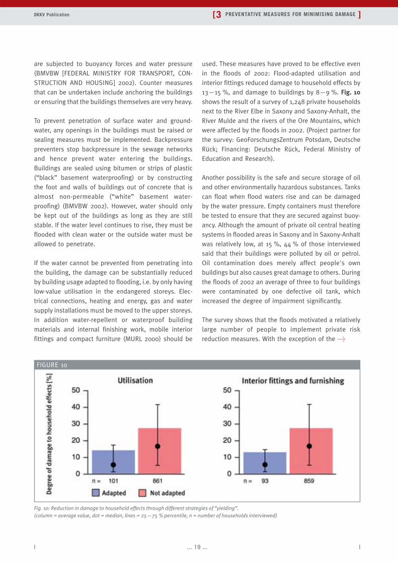
used. These measures have proved to be effective even
in the floods of 2002: Flood-adapted utilisation and
interior fittings reduced damage to household effects by
13—15 %, and damage to buildings by 8—9 %. Fig. 10shows the result of a survey of 1,248 private households
next to the River Elbe in Saxony and Saxony-Anhalt, the
River Mulde and the rivers of the Ore Mountains, which
were affected by the floods in 2002. (Project partner for
the survey: GeoForschungsZentrum Potsdam, Deutsche
Rück; Financing: Deutsche Rück, Federal Ministry of
Education and Research).
Another possibility is the safe and secure storage of oil
and other environmentally hazardous substances. Tanks
can float when flood waters rise and can be damaged
by the water pressure. Empty containers must therefore
be tested to ensure that they are secured against buoy-
ancy. Although the amount of private oil central heating
systems in flooded areas in Saxony and in Saxony-Anhalt
was relatively low, at 15 %, 44 % of those interviewed
said that their buildings were polluted by oil or petrol.
Oil contamination does merely affect people's own
buildings but also causes great damage to others. During
the floods of 2002 an average of three to four buildings
were contaminated by one defective oil tank, which
increased the degree of impairment significantly.
The survey shows that the floods motivated a relatively
large number of people to implement private risk
reduction measures. With the exception of the >
FIGURE 10
Fig. 10: Reduction in damage to household effects through different strategies of “yielding”. (column = average value, dot = median, lines = 25—75 % percentile, n = number of households interviewed)

| ... 20 ... |
LESSONS LEARNED — Flood Risk Reduction in Germany
adapted utilisation of the endangered storeys, a higher
percentage of households with severe construction
damage implemented risk reduction measures. It is
apparent that these risk reduction measures are being
implemented parallel to renovation. Generally increased
and improved information and financial incentives
should be used to encourage preventative building
measures. Possibilities for self-protection are, for
instance, presented in the following brochures:
• “Hochwasserschutzfibel — Planen und Bauen von Ge-
bäuden in hochwassergefährdeten Gebieten”, Bundes-
ministerium für Verkehr-, Bau- und Wohnungswesen
(Flood protection primer — Planning and con-
structing buildings in areas prone to flooding,
published by the Federal Ministry of Transport,
Building and Housing),
• “Hochwasserfibel — Bauvorsorge in hochwasserge-
fährdeten Gebieten”, Ministerium für Umwelt, Raum-
ordnung und Landwirtschaft des Landes Nordrhein-
Westfalen (Flood primer — Preventative building
measures in areas prone to flooding, published by
the North Rhine-Westphalia Ministry for the
Environment, Regional Planning and Agriculture),
• “Hochwasserhandbuch — Leben, Wohnen and Bauen
in hochwassergefährdeten Gebieten”, Ministerium für
Umwelt und Forsten Rheinland-Pfalz (Flood manual —
Living, dwelling and building in areas prone to
flooding, published by the Rhineland-Palatinate
Ministry for the Environment and Forestry),
• “Hochwasser-Merkblatt für Bewohner gefährdeter Ge-
biete der Stadt Köln” (Flood leaflet for residents of
endangered areas. Published by the City of Cologne).
Such information possibilities should be developed for
all Länder (states) of Germany, should be constantly
updated and then suitably presented to potentially
affected persons.
Behavioural risk prevention
Behavioural risk prevention is the “basis for taking
measures to minimise damage before the next event
occurs” (IKSR 2002). It is the instrument that is used
after natural disasters to prevent a common state of
affairs, i.e. “today everyone is talking about it, tomorrow
it is forgotten”. At an early enough stage potentially
endangered people should be informed of the possi-
bilities of behavioural risk prevention. Everyone should
know what to do. For instance, a check list indicating
which things should be available for an emergency or
what should be done in the event of a flood.
An integral part of behavioural risk prevention is
adequate and punctual flood warnings (see chapter 5),
which still enable damage to be reduced shortly before
the event occurs. According to a survey of private
households covering the “River Elbe in Saxony and
Saxony-Anhalt” and the “Ore Mountains and River
Mulde”, 40—50 % of people affected by floods did not
know what to do on the basis of warnings by the
authorities. Here there is an urgent need to provide
people with better information. This is particularly
important in areas where flood waters appear after a
short time. Communicating information about risks of
flooding is an important requirement for increasing
people's own risk reduction in households and
companies. Brochures, information tables and high
water marks, as well as staging of disaster protection
Fig. 11: High water marks on the Water Palace of Schloss Pillnitz, Saxony(photo: U. Grünewald 2003)
FIGURE 11

DKKV Publication [3 PREVENTATIVE MEASURES FOR MINIMISING DAMAGE ]
| ... 21 ... |
exercises, comparison and updating of information
chains, amongst other measures, complement the
possibilities of behavioural risk prevention.
After the floods in 2002 the authorities worked on
information and reaction chains to ensure that in the
event of an emergency everyone knows what information
can be obtained from whom and to whom this infor-
mation should then be forwarded. These chains must be
tested in regular exercises on the basis of “testing before
it is too late” to determine that they are up to date and
function properly.
High water marks are a reminder of past floods, and
usually located on historical buildings, where they show
the maximum flood levels of the past (Fig. 11). They are
a possibility of heightening and maintaining awareness
for the existing danger of flooding at the places where
previous flooding occurred. It would be worthwhile
putting such marks in the inner cities. But, for instance,
the “Ostthüringer Zeitung” (30.8.2003) accurately de-
scribes the situation, when it notes that there is a great
deal of scepticism regarding this. However, for today's
mobile society these are important sources of infor-
mation for learning about a place's history of flooding.
Risk reduction
Financial precautions are needed to prevent “the resi-
dual risk finishing us off” and to prevent a flood endan-
gering people's very livelihoods. Since 1991 in Germany
a so-called “extended elementary insurance”, enables
people to extend their householder's insurance or
household and personal effects insurance to include
insurance cover for damage caused by flooding. To
prevent this insurance cover only being wanted by those
who have a high risk, this product provides compre-
hensive cover against several natural dangers. Currently
there is no insurance obligation, which means that the
rare incidence of such events leads many endangered
people to do without insurance protection (IKSR 2002).
According to information from the Gesamtverband der
Deutschen Versicherungswirtschaft — GDV (Federation
of German Insurance Industry) in Germany in the ele-
mentary damage sector there is currently an insurance
density of approximately 10 % for household effects and
4 % for residential buildings. However, historically the
insurance density in Baden-Württemberg and in the
Länder (states) in Eastern Germany is considerably
higher. Out of all private households interviewed in
Saxony and Saxony-Anhalt 50 % of households prone to
flooding were insured (i.e. considerably more than the
German average).
Just because in principle elementary damage insurance
is available does not mean that everyone can get
insurance cover. In particular buildings that are par-
ticularly at risk are exempted from insurance cover or
can only be insured if high risk surcharges are paid. The
prerequisite for a plausible insurance rating for a
building is a good zoning of the risk. Since up to now
nationwide danger maps for flooding in Germany are not
available, the insurance industry had a Zonierungs-
system für Überschwemmung, Rückstau und Starkregen
— ZÜRS (zoning system for flooding, backpressure and
heavy rainfall) developed under the auspices of the GDV
in 1999. In addition to the ZÜRS Zone the number of
previous incidences of damage and the distance to
waters plays an important role in risk assessment.
According to our survey, following the floods of 2002
the risk was more conscientiously assessed, above all
through using the ZÜRS.
Surveys carried out in April/May 2003 indicated that
flood water damage was dealt with more quickly for
insured private households than for non-insured
households. They were also more satisfied with the
compensation for damage.
Within the framework of flood risk reduction, insurance
should be combined with other preventative measures.
A common means of promoting own private precaution
on the part of the insured party is to include a deductible
in the policy: in the event of any damage the insured
party has to pay for some of the damage himself, and
it is therefore in his interest to keep the damage as low
as possible. It would be ideal to link the deductible with
the risk of danger, so that particularly risk-prone
households had the highest incentive to take their own
precautions, for instance in the form of building
precautions and behavioural risk prevention.
The insurance conditions for risk reduction against flood
damage were investigated, with surveys involving appro-
ximately 120 primary insurance companies and differ-
entiating between private households and companies.

| ... 22 ... |
LESSONS LEARNED — Flood Risk Reduction in Germany
Out of the interviewed primary insurance companies
only 14 % of the companies had voluntarily rewarded
policyholders for flood protection measures. There are
many reasons for the limited stimulation of own pre-
cautions by the insurance industry: On the one hand the
household and personal effects and the building
insurance is a mass segment in which the elementary
damage sector is not very important for the companies.
The results of the survey gave the impression that poli-
cies for the extended elementary damage insurance, as
a mass segment, are handled according to a relatively
rigid formula that allows little room for manoeuvre for
negotiating. On the other hand, it must be assumed that
many primary insurance companies themselves are not
adequately informed about damage risk and damage
avoidance in the elementary sector. Here there are differ-
ences compared to the reinsurance industry. For instance,
Munich Re already developed an accumulative model for
the whole of Germany, which can be used for calculating
numerous scenarios (KRON AND THUMERER 2001).
“When floods occur an insured person carries his
television down into the cellar, while a person without
insurance carries it upstairs!” Such comments insinuate
that people with insurance cover are not willing to avoid
flood damage. However, the results of our survey
revealed that there is no significant difference between
insured and non-insured private households regarding
the emergency measures they implement, not only with
regard to the type of measures but also regarding the
amount of work they invest. Before the floods in 2002
insured people even tended to be better informed about
private precautionary measures to reduce damage in the
event of floods and were more likely to have taken long-
term measures than those who were not insured.
After the floods of 2002 government emergency aid and
private donations played a big role in providing compen-
sation. However, this undermines incentives, to take out
private insurance cover against elementary damage and
implement measures to reduce damage (MECHLER AND
WEICHSELGARTNER 2003). Since the current voluntary
elementary damage insurance has up to now not led to
a clear increase in insurance density, a more effective
solution must be sought.
Currently a nationwide mandatory insurance against ele-
mentary damage is being debated for insuring private
flood damage. The insurance industry has abandoned
its reservations about a mandatory insurance policy and
is taking part in negotiations through the GDV (2003,
personal communication). A nationwide insurance cover
for elementary damage and the inclusion of the risk of
storm tides is envisaged (cf. SCHWARZE AND WAGNER
2003). To encourage precautionary measures against
flood risk as a whole, the conditions should be designed
to reward private flood protection measures.

DKKV Publication [3 PREVENTATIVE MEASURES FOR MINIMISING DAMAGE ]
| ... 23 ... |
SUMMARY
Lessons Learned regarding measures for damage reduction
Risk reduction through spatial planning measures has a chance if they are integrated in a
comprehensive and convincing concept and precautionary measures against flooding are given more
weight in comparison with other areas of interest.
Various maps are being drawn up for flood danger. It would be worthwhile using standard, national
criteria here.
A public debate is required on the possible extreme events and their varying intensity depicted in
these maps.
Precautionary building measures considerably reduce damage to household effects and buildings.
Since oil contamination does not remain restricted to the premises where damage is incurred, more
attention has to be paid to securing tanks.
Insurance companies currently provide too little encouragement or reward for precautionary
behaviour or private precautionary building measures. Nevertheless, the floods of 2002 revealed
that insured persons had taken better precautionary measures than uninsured persons and
implemented a similar amount of emergency measures. This contradicts the widespread notion that
an insured person is not interested in reducing damage.
A very positive development is that private households increase their private precautionary
measures after a flood.
There is a great need for information on how to provide protection against flooding in an
emergency situation. Regular information events and thematic exhibitions heighten awareness
about flooding.
According to surveys carried out in April/May 2003, flood damage was dealt with more quickly in
the case of insured private households than for uninsured ones. The former were also more
satisfied with the damage compensation.
A concept for a more effective risk reduction must be worked out for Germany. The introduction of a
mandatory insurance is currently being debated.

| ... 24 ... |
Natural retention
The motto “More room for rivers” has become the gover-
ning principle for reducing discharge and flooding (for
instance BMU [FEDERAL MINISTRY FOR THE ENVIRON-
MENT, NATURE CONSERVATION AND NUCLEAR SAFETY]
2003a). Here the prime and general focus is on rever-
sing human interference, for instance the impact caused
by the settlement of flood plains, building of dikes along
riverbanks, the sealing of the ground, “forest dieback”
and the straightening of rivers.
In the draft of the Artikelgesetz of the Federal Ministry
for the Environment, Nature Conservation and Nuclear
Safety (BMU 2003a) the key objective is “to leave more
room for rivers, particularly their natural flood plains, or
to give this space back to them”. Accordingly in par-
ticular measures, for instance for moving dikes further
away from river banks and conservation or restoration
of flood plains, are to be included in the flood protection
plans (ibid, Section 31d, sub-section 1). However, the
effectiveness of these possibilities for flood risk
reduction are still overestimated, particularly in the
event of extreme flooding.
Natural water retention is primarily frequently associated
with restoring flood plains. Here the positive impact is
tangible even when the flood levels are low. Conse-
quently these areas are frequently flooded, albeit for a
short time, even when flood water levels are low. This
makes these measures particularly important in an
ecological sense for appropriately adapted valuable ri-
parian woodlands. For instance, currently moving back
the dike at Lenzen is creating approximately 300 hectares
of natural flood plains, which, amongst other things, pro-
LESSONS LEARNED — Flood Risk Reduction in Germany
4Reduction of extreme runoff and
flooding through natural retention and technical flood protection
FIGURE 12
Fig. 12: View across the highlands in the upper catchment area of the River Muglitz (photo: S. Schümberg 2003)

DKKV Publication [4 REDUCTION OF EXTREME RUNOFF AND FLOODING ... ]
| ... 25 ... |
vides a habitat for a large riparian woodland. However,
from the point of view of flood protection these
expanded flood plains can only provide a limited delay
in the advance of the flood waters and a slight reduction
of their peak flows.
Other natural water retention measures, such as refor-
estation through planting mixed forest, must be seen in
a very similar light. For instance, mining operations
carried out since the 15th Century in the upper reaches
of the River Müglitz undoubtedly drastically reduced
forest stand there (Fig. 12). Here a comprehensive refor-
estation programme (protective forest with different tree
species) on the areas currently primarily used for arable
farming can improve the water retention capability of
the landscape.
There should also be a differentiated assessment of
other measures aimed at increasing the natural storage
capacity of the catchment areas, for instance ploughless
technologies, conservational tillage techniques, altered
crop rotation. Their prime advantage is that they pro-
vide a better local storage of water for the water manage-
ment of the catchment area. Undoubtedly this can
increase retention of flood water in the case of minor
precipitation events. However, it is astonishing how
confidently claims are made that such flood water dis-
charges as those encountered in August 2002 in the
River Elbe basin could have been drastically reduced.
The latest “DBU project for an innovative preven-
tative flood protection”, costing € 3.5 million, can
be regarded as symptomatic of this misconception
(http://www.presseportal.de /story.htx?nr=508485). By
proposing the solution “Reducing dangerous peaks of
natural disasters with natural methods”, the public are
led to believe that such measures would be able to
reduce extreme discharges in the river catchment areas
by more than just a few percent.
Technical flood protection
The important objective of reducing runoff and flooding
is to minimise the runoff volume of flood water. In the
case of extreme events it is too large to be completely
retained in the natural or artificial storage zones in the
catchment areas. However a targeted reduction of the
peak flow level can be achieved through controlled water
retention measures, such as polders, dams, etc. (Fig. 13),
by initially letting most of the rising flood waters through
and then storing water shortly before the peak water
level is reached. The available storage volume and how
accurately the progress of the flood waters is forecasted
naturally limit the effectiveness of these >
FIGURE 13
Fig. 13: Construction site for the flood water retention basin above Lauenstein (photo: S. Schümberg 2003)

| ... 26 ... |
LESSONS LEARNED — Flood Risk Reduction in Germany
measures. In contrast, the natural retention areas dis-
cussed above cannot be deliberately controlled. Their
flood retention volume is used up at the beginning of
the flooding and therefore only accounts for limited
reductions in peak water levels or, in unfavourable
circumstances, to no reductions at all.
At the time of the floods in 2002 the dams, retention
basins and reservoirs managed by the state dam
administration of Saxony had a total volume of appro-
ximately 576 million m³, with a usual flood protection
ivolume of 121 million m³. It was reported that at the
beginning of the floods in August 2002 all water
retention facilities had the available capacities envis-
aged for flood protection (for instance VON KIRCHBACH
ET AL. 2002). They could only be enlarged to a limited
extent without damage to people downstream because
of the short advance warning period for the ensuing
heavy precipitation.
Nevertheless the flood protection volumes that existed
in 2002 were able to reduce the peak flow and delay it.
This not only won valuable time for emergency measures
but also prevented a simultaneous confluence of peak
flows from tributaries and main rivers.
The topography around the lower reaches of rivers
means that dams cannot be built here to provide reser-
voir space for controlled water retention. Here it is
possible and necessary to turn areas along the river-
banks into polders. The effectiveness of these (flood)
polders and the principle of their use are comparable
with flood water retention basins. For instance, the
better they can be controlled and the nearer they are to
the objects they are intended to protect, the more
effective they are.
This was impressively demonstrated in August 2002 as the
peak flood level was reduced by more than half a metre
on the River Elbe at Wittenberge when the Havel weirs and
polders, which were erected as a preventative measure in
1955, were used for the first time. In addition this is a
positive example of well prepared cooperation across the
borders of Brandenburg and Saxony-Anhalt, which was
also consistently implemented during the disaster.
A real lesson learned was the necessity for flood-adapted
agriculture in the polder areas, that is, for instance, that
the existing surface and underground biomass should
be so limited that the oxygen consumption caused by
biodegradation in the water in the flooded polders does
not have an impact on the aquatic fauna and there is
also no danger of negative consequences for the river
when the disaerobic flood water drains off the polders.
In 2002 the flood protection, or more precisely, the
security provided by the dikes proved to be a “weak link
in the chain”. Problematic here is the increased accu-
mulation of value behind dikes that are regarded as
secure. During the flooding of the River Elbe in 2002
many stretches of these dikes proved to be insecure. For
instance, in Saxony the dikes burst or the flood waters
rose over the tops of them in 131 cases, mostly in the
catchment area of the River Mulde. The main problem
of the dikes, which had been built over the course of
centuries, was their poor condition. This was above all
caused by severe root penetration, inhomogeneous
structure and weak points in the ground, lack of seal-
ing and damage caused by burrowing animals, which
combined to make the dikes far more permeable than
they should have been.
Even before the floods in August 2002 it was estimated
that in the entire German catchment area of the River
Elbe only a small part of the 730 kilometres of dikes
along the Elbe and 480 kilometres of reservoir dikes
fulfilled the standards of the German industrial norm
DIN 19712 (IKSE [INTERNATIONAL COMMISSION FOR THE
PROTECTION OF THE ELBE] 2001). The enormous effort
and expense for repairing the dikes — the International
Commission for the Protection of the Elbe (IKSE 2001,
page 42) estimated that DM 900 million was required
to repair all installations along the Elbe in Germany —
did not allow this situation to be quickly alleviated.
Despite the latest calls for action by specialists (e.g.
HEERTEN 2003), a rapid and thorough improvement of
the dikes' condition is unlikely. It is therefore particularly
important to keep the disaster protection authorities
informed at all times on the state of the dikes in their
respective areas of responsibility. This is the only way
to be able to react better in the event of flooding.
DKKV Publication [4 REDUCTION OF EXTREME RUNOFF AND FLOODING ... ]
| ... 27 ... |
Lessons Learned about reduction of runoff and flooding
Decentral natural retention measures have a compensating impact on the water balance. However, it
only has a limited significance regarding flood risk reduction when extreme events occur.
Dams, flood water retention basins and controllable polders are particularly suitable for reducing
peaks of extreme floods, and hence also for securing major protection objectives.
Agricultural land use on polders should be designed to suit the requirements of flood protection
and keep subsequent damage to a minimum.
Time-consuming and expensive repairs to dikes should be supplemented by consistent dike
maintenance and preventative planning and management, taking into consideration disaster
reduction aspects. Further accumulation of damage potential behind higher and “safer dikes”
should be avoided.
The implementation of the motto “More room for rivers” requires a “Flood risk reduction round
table”, that is a more balanced approach and greater coordination. Programmatically it must above
all orient towards a consistent flood risk reduction obligated to fulfilling protection objectives.
SUMMARY

| ... 28 ... |
LESSONS LEARNED — Flood Risk Reduction in Germany
5 Flood warnings and early warning systems as elements for risk reduction through
providing information
For a successful flood forecasting system, flood
reporting and flood prevention system — internationally
known as flood early warning system for short — five
components must interact with each other: noting the
situation, developing forecasts, warning helpers and
affected people, taking the correct action and behavio-
ur adapted to the situation (Tab. 3). However, the whole
system is more than simply a series of individual
components. Although each component should as far as
possible be state-of-the-art, the decisive factor is their
interaction. Often there is a one-sided investment in the
development of flood forecasting systems without
adequately taking into consideration the distribution of
warnings and forecasts or their implementation
(GRÜNEWALD, BRODERSEN ET AL. 2001).
What weaknesses in particular wereapparent during the 2002 floods in theElbe area?
Criticism was levelled from various sources that the
weather warnings of the German Weather Service in
August 2002 were too late or too imprecise. The reason
for this was that although the models provided infor-
mation about impending extreme weather situations,
that in turn also led to increased awareness among the
forecasting meteorologists, the accuracy was evidently
not sufficient for an earlier warning (RUDOLPH AND RAPP
2003). Hence a preliminary warning of a rainstorm was
only issued on 11 August 2002, at 13:59 CET and at
23:08 CET this was updated to a rainstorm warning.
Further updated storm warnings were issued from 12 to
14 August 2002. However, the dramatic increase of
runoff, for instance in the Rivers Müglitz and Weißeritz
already occurred on 12 August 2003.
In the catchment area of the River Elbe there are 214
flood reports and forecasting gauges (IKSE 2001). In the
case of the August floods of 2002 many automatic
gauges failed because they were flooded or because of
power blackouts.
During the floods of 2002 forecasts for the gauges of
the River Elbe were complicated because the so-called
“stage-discharge relations” for the water levels that were
reached had often never existed before. However, the
flood forecasting model used for the River Elbe requires
discharges as input data that can be calculated from the
water levels of the gauges upstream of the respective
forecasted gauge. Hence, these stage-discharge rela-
tions first had to be extrapolated, which led to numerous
error possibilities. In the reaches of the River Elbe in
Mecklenburg-West Pomerania, for instance, water level
forecasts were made that were almost half a metre
higher than the actual water levels that were reached
(INNENMINISTERIUM MECKLENBURG-VORPOMMERN
[MINISTRY OF THE INTERIOR OF MECKLENBURG-WEST
POMERANIA] 2002), which led to many complicated pro-
tection measures being implemented that were not
really required.
In the tributaries of the Upper River Elbe, such the Rivers
Gottleuba, Müglitz and Weißeritz with catchment areas of
less than 300 km² only prompt precipitation forecasts in
conjunction with suitable hydrological rainfall runoff models
can contribute to an improvement of advance warning.
There was strong criticism regarding the flood reports
and the forwarding of these reports. Examples are, for
instance, cited by VON KIRCHBACH ET AL. (2002). For
example, forecasts were issued that had long since been
overtaken by a long mark where the event was actually
taking place illustrating the poor feedback of the rural
districts to the flood forecast centres. Reports were
delayed at intermediate stations and reached the dis-
aster protection staff too late. In addition, because of
the responsibility of different flood forecast centres for
the same river area (for instance the River Mulde)
forecasts were not consistent with each other.

DKKV Publication [5 FLOOD WARNINGS AND EARLY WARNING SYSTEMS ... ]
| ... 29 ... |
People did not receive information or received it too late,
particularly on the tributaries of the River Elbe. Warnings
did not contain any instructions on what to do, which
meant that emergency measures were not implemented,
even where they would have been possible. Furthermo-
re, the non-existence of a working siren warning system
was criticised. The cooperation of the individual disaster
protection units with each other and with the help orga-
nisations and support units also proved to be poor
(chapter 6).
Table 3: Components and factors of a flood early warning system (source: altered according to PARKER ET AL. 1994)
TABLE 3

| ... 30 ... |
LESSONS LEARNED — Flood Risk Reduction in Germany
What activities were introduced after thefloods in 2002?
The German Weather Service (DWD) is further devel-
oping the numerical weather forecast models and
meteorological processes. In particular they are working
on an improvement of the precipitation forecast,
especially taking radar data into account. The monitoring
network of the automatic online precipitation stations is
being expanded to fulfil requirements here. This is
intended to enable a better spatial differentiation in the
forecasts of rainfall depths.
The warning management of the German Weather Ser-
vice was improved (with 4 warning levels: Early warning
— 48 to 120 hours, Advance warning — 12 to 48 hours,
Weather warning and Storm warning — generally up 12
hours before the event, as well as warning at rural dis-
trict level). Weather warnings can be called up free of
charge on the Internet.
Plans envisage that, in addition to the routine forecasts
on expected precipitation, the German Weather Service
will also provide Saxony's Flood Centre with information
about whether extreme precipitation events will occur
and also the degree of their probability. “This warning
is very important for the rivers in the Ore Mountains and
for controlling the dams” (SMUL 2003).
Flood warning gauges should be designed to be flood-
proof and be fitted with redundant data collection, trans-
mission and power supply systems. The Länder (states)
most severely affected have already begun to take suit-
able action. Flood reports, the latest water levels and
discharges as well as alarm levels of flood warning
gauges are available free of charge on the Internet in
graphic form or as tables.
To enable a faster and more effective flood forecast to
be drawn up for an area, in Saxony the four existing
regional Land (state) Flood Centres were integrated
in one Landeshochwasserzentrum — LHWZ (State Flood
Centre) for all of Saxony's rivers (SMUL 2003). This sim-
plifies data compilation and shortens the message
channels. The setting up of this LHWZ is planned to be
complete in June 2004.
The European Flood Forecasting System (EFFS) is being
supplemented for the River Elbe basin with EU funding
provided by the EU Institute for the Environment and
Sustainability (IES) in Ispra/Italy (SÄCHSISCHE STAATS-
REGIERUNG [SAXONY'S STATE GOVERNMENT] 2003b).
Building on the EFFS the IES in Ispra has been working
since 2003 on the development of a prototype for a
European Flood Warning System EFAS. This is intended
to enable a forecast for an impending flood up to 10
days in advance.
The flood routing model “ELBA” currently used in
Germany is to be updated with new stage-discharge
relations and supplemented with new components (for
instance Pretziener Weir) by the end of 2003. In addition
a new flood forecast model “WAVOS” (water level fore-
cast system) is to be worked out for the River Elbe in
Germany from the national border to the backwater area
of the Geesthacht Weir on the basis of a hydrodynamic
model (1st version by the beginning of 2005). Apart from
enabling forecasts based at the gauges, this will also
make it possible to make forecasts at any required cross-
section of the River Elbe. The influence of dike breaches
and the controlling of flood polders can be taken into
consideration. The forecast period on the River Mulde is
to be extended by an additional 6 to 12 hours on top
of the current 6 to 12 hours, primarily through improved
rainfall-runoff relations (IKSE 2003).
In October 2001 the Federal Government began oper-
ating the first set-up phase of a satellite-aided warning
system (SatWas) to provide a nationwide warning of the
population. In a further expansion phase of SatWas the
control and monitoring centres of the Ministries of the
Interior of the different Länder (states) were fitted with
transmission systems by the end 2002. “In addition from
2002, following the success in integrating the public
radio stations, the private radio stations were also in-
cluded in this warning system” (SCHULZ 2003, page 6).
“This makes it possible to issue warnings via the radio
stations on a nationwide basis or limited to regions
(SÄCHSISCHE STAATSREGIERUNG 2003a, page 36). Now
in the implementation of decisions by the Conference of
Interior Ministers of 6 June 2002 a Gemeinsames Melde-
und Lagezentrum von Bund und Ländern — GMLZ (Joint
Centre of the State Governments and the Federal
Governments for Reporting and Assessing the Situation),
aimed at “optimising crisis management in Germany”
has been set up (MITSCHKE 2003).

DKKV Publication [5 FLOOD WARNINGS AND EARLY WARNING SYSTEMS ... ]
| ... 31 ... |
Lessons Learned about flood warning and early warning systems
Research is required for further improving the quantitative, area-specific precipitation forecasts.
Action has to be taken regarding working out reliable gauge-discharge relations at flood forecast
gauges. They have a decisive impact on the quality of forecasts and are the prerequisite for
reasonably fixing design parameters.
Simple reliable monitoring processes that can be quickly carried out have to be developed and
used for discharge measurements during floods.
Improving and expanding the existing flood forecasting models for the River Elbe and its tributaries
as well as the development of new models must lead to an improvement of advance warning times,
to a stable, user-friendly operation of models and ultimately to reliable forecasts.
Combining decentralised flood forecasting centres in one Land (state) flood centre concentrates
competence and personnel.
Flood warnings should be issued in standard formulations, in particular in the neighbouring Länder
(states) and in the same river catchment area, and should contain appropriate recommendations for
action for the recipients. It is easier to quickly issue “Standard report texts” and these are also
more easily understood.
The message channels should be kept short and should, for instance, lead directly from the flood
forecasting centres to the subordinate disaster protection authorities.
Redundant transmission possibilities should be provided for transmitting flood level warnings
and reports.
Official warnings should be clearly recognisable as such and should be issued via as many
information media as possible.
An initial warning of the population via sirens is above all recommendable for regions with short
warning times.
The reaction of all those involved, including the affected population, should be improved through
appropriate behavioural precaution (for instance informing the public, training, practice and
information).
SUMMARY

| ... 32 ... |
The “Elbe flood of 2002”, just like the “Odra flood of
1997”, was quite rightly regarded as proof of solidarity
and help. In Saxony alone 2002 more than 23,000
members of the fire brigade and 11,000 personnel from
the relief organisations Arbeiter-Samariter-Bund (ASB),
German Red Cross (DRK), Deutscher Lebensrettungs-
gesellschaft (DLRG), Johanniter Unfallhilfe (JUH) and
Malteser Hilfsdienst (MHD) provided help.
However, to really understand how disaster protection
functions, one has to investigate how the vast numbers
and broad variety of people helping is coordinated to
form a single task-oriented entity. In methodical terms
this is not a trivial undertaking. One could not directly
watch the service “disaster protection” being provided,
even if one had enough observers available at a suf-
ficient number of suitable revealing places. Actually one
would only see helpers working but not the more
widespread processes of management, communication,
cooperation and logistics, which come before and after
their deployment.
The task was therefore to use a method that was able
to take the great variety of selective operations taking
place on site, as seen “at ground level” and then still
reveal the “bird's eye view”, for instance of the whole
Elbe flood. A suitable instrument for this is the analysis
of the available deployment reports. They are prepared
at all levels and for all participants and also “aggre-
gated”, i.e. compiled according to specific aspects and
used with specific interest as arguments in the discourse
of the subsequent analysis of the event.
Hence deployment reports not only indicate how the
members of taskforces themselves assessed their
deployment but also how they want this to be evaluated
by their superiors, and by administrative bodies,
policymakers, media and the public. In addition to the
dimensions that can be analysed in terms of content,
the so-called network analysis can be used to show
which relations existed between the participants: The
deployment reports indicate who communicated,
cooperated with whom, in what circumstance, or had
any other type of relation with another participant. The
frequency and intensity of such relations allow
conclusions to be made on how the participants
interacted with each other, with their resources and the
actual circumstances.
Detailed examination of the content and network ana-
lyses showed that the participants do not really
cooperate but, rather, primarily act in an organisation-
oriented and resource-oriented way. Primarily each par-
ticipant gets involved with the others in his or her
organisation, i.e., public authority to public authority,
fire brigade to fire brigade, German Red Cross to German
Red Cross, etc. However, this is far less because of better
knowledge of their own system and far more because
of the internal, personal structure of disaster protection
itself. In principle disaster protection is keeping to the
plan, which when required will have to be put into
practice ad hoc by the planned responsible agencies. In
order to avoid errors, each participant sticks to those
people he or she knows and, even more so, personal
acquaintances, i.e. sticks to comrades of their own
organisations or the colleagues at the same level of hie-
rarchy or administration. The greater the uncertainties
are concerning an unknown situation, the greater the
temptation is to informally clarify the issues in advance.
The so-called “informal channel” is the most efficient
medium in this situation. However, the tangible increase
in shifting whole implementation steps to informal
channels complicates the overall situation, because this
means that not only a documentable grasp and
presentation of the situation but also functionally
structured communication is lost in the process.
On the basis of the key dimensions “communication”,
“cooperation”, “use of resources” and “management
process” the real interrelations during the Elbe flood in
LESSONS LEARNED — Flood Risk Reduction in Germany
6 The analysis of disaster prevention asa network and as a form of communication

2002 were analysed and four structural failings were
identified:
• Poor coordination of corporate disaster protection
participants
• Self-orientation with decreasing orientation to the
situation as a whole and to superordinated
protection objectives
• Weaknesses of value-setting official channels of
disaster protection
• Isolation through increasing centralisation of the
operative-tactical subsystem.
The self-orientation of the participants due to functional
uncertainties explains the lack of real cooperation and
failure of communication. Participants concentrate on
their own area and sector of tasks, because they believe
that there they have their own conditions more under
control. This means that they lose sight of requirements
for the overall situation, and things are overvalued from
the ground-level view. Above all nobody believes in a
neutral overall perspective, which could legitimise
objectives for action that would imply disadvantages. All
participants therefore try to “keep their own nests
clean”, so that it cannot be proved that they acted wron-
gly. But this forces them into the isolation of self-
orientation while the expert work and management
becomes increasingly centralised, i.e. moves from the
lowest to the highest disaster protection authority, so
that real action on site and management become
separated, and from time to time even purely fictional:
what happens on site is not the same as that prescribed
and presented by the staff.
DKKV Publication [6 THE ANALYSIS OF DISASTER PREVENTION ... ]
| ... 33 ... |
Lessons Learned from the analysis of the disaster prevention
The following recommendations are envisaged for overcoming these failings:
In the long term the conflicts of interests between the regional and local authorities and disaster
protection organisations have to be countered through standard national disaster protection
regulations. This can be achieved by defining clear responsibilities and a protection investment
policy that rules out overlapping tasks and distributes resources according to protection
requirements.
It has to be ensured that equipment is complementary throughout the whole of Germany. The relief
organisations must guarantee the overview of qualifications and equipment of the task forces
through obligations to provide nationwide, consistent, standard, internal statistics on disaster
protection organisations, which preferably refers to predefined interfaces to geographical
information systems which contain maps with protection related data.
The so-called “soft” capabilities and skills (motivation, social and communicative competence,
discipline, etc.) of task forces and management have to be trained. The legitimacy of regulations
should be communicated to increase their acceptance.
A procedure for taking into account the common overall goal of disaster protection should be
developed to remove barriers. The basis for this would be a clear protection provision and the
introduction of an objective measuring of “disaster”, for instance a scale of damage similar to the
“Mercalli Scale” used for classifying earthquakes. This could help to overcome the existing
problems of unclear facts of the case according to disaster protection laws of the Länder (states).
The evaluation of approaches should be ensured through reliable and valid procedures.
SUMMARY

B-DBDLA (2003): Bund Deutscher Landschaftsarchitekten: Weniger Sandsäcke – mehr Vorsorge. Stellungsnahme zum
geplanten Gesetz zur Verbesserung des vorbeugenden Hochwasserschutzes, 8.9.2003.
BFG (2002): Bundesanstalt für Gewässerkunde: Das Augusthochwasser 2002 im Elbegebiet. Koblenz, 48 pp.
BMU (2003): Bundesministerium für Umwelt, Naturschutz und Reaktorsicherheit: 5-Punkte-Programm der
Bundesregierung: Arbeitsschritte zur Verbesserung des vorbeugenden Hochwasserschutzes. 7 pp.
BMU (2003a): Bundesministerium für Umwelt, Naturschutz und Reaktorsicherheit: Gesetz zur Verbesserung des
vorbeugenden Hochwasserschutzes, Referentenentwurf, 33 pp.
BMVBW (2002): Bundesministerium für Verkehr-, Bau- und Wohnungswesen: Hochwasserschutzfibel – Planen und
Bauen von Gebäuden in hochwassergefährdeten Gebieten. Berlin, 41 pp.
BStMLU (2002): Bayerisches Staatsministerium für Landesentwicklung und Umweltfragen: Nachhaltiger
Hochwasserschutz. International Conference on prevention of flood hazards by integrating socio-economic and
environmental considerations. Budapest, 30.11.–1.12.2002.
E-GEG (2000): Europäische Gemeinschaft: Richtlinie 2000/60/EG des europäischen Parlaments und des Rates vom
23.10.2000 zur Schaffung eines Ordnungsrahmens für Maßnahmen der Gemeinschaft im Bereich der
Wasserpolitik (WRRL). 72 pp.
EGLI, T. (2002): Hochwasserschutz durch nachhaltiges Schadenpotenzialmanagement. Internationales Symposium
2002 in Zürich: Moderne Methoden und Konzepte im Wasserbau. 9 pp.
ERNST, S., A. NAGEL (2003): Vorbeugender Hochwasserschutz: Eine grenzüberschreitende Herausforderung am
Beispiel des erfolgreichen IRMA-Programms (INTERREG Rhein-Maas Aktivitäten). In: Kongress-Dokumentation
acqua alta, International Congress for Flood Protection, Climate, Disaster and River Management,
Munich 11/2003, ISBN 3-930448-49-1, p. 88–90.
GDV (2003) Expert interview with R. Schönberger (15.8.2003).
GRÜNEWALD, U., M. KALTOFEN, W. ROLLAND, S. SCHÜMBERG, ET AL. (1998): Ursachen, Verlauf und Folgen des
Sommer-Hochwassers 1997 an der Oder sowie Aussagen zu bestehenden Risikopotentialen. Eine interdisziplinäre
Studie. Deutsches IDNDR-Komitee für Katastrophenvorbeugung e. V., IDNDR-Reihe H. 10b (long version),
Bonn, 187 pp.
GRÜNEWALD, U., C. BRODERSEN, S. SCHÜMBERG, A. SCHMITT, ET AL. (2001): Zum Entwicklungsstand und zu
den Anforderungen an ein grenzüberschreitendes operationelles Hochwasservorhersagesystem im
Einzugsgebiet der Oder. Schriftenreihe des DKKV – Deutsches Komitee für Katastrophenvorsorge e. V., H. 23,
Bonn, 104 pp.
GRÜNEWALD, U. (2003): Die “Augustfluten 2002 im Elbegebiet” – in welches Licht haben sie uns gestellt und in
welches sollten wir sie stellen? Lecture delivered on Hydrology Day, 20./21.3.2003 in Freiburg. In: Forum für
Hydrologie und Wasserbewirtschaftung, Bd. 1 Vorträge, ISBN 3-924063-59-1, H. 4/2003, p. 151–160.
LESSONS LEARNED — Flood Risk Reduction in Germany
| ... 34 ... |
References

DKKV Publication [ REFERENCES ]
| ... 35 ... |
H-IHEERTEN, G. (2003): Sichere Flussdeiche für lang einstauende Hochwasser. In: Wasserwirtschaft 12/2003. p. 16–
21.
HEILAND, P., J. NEUMÜLLER (2003): Flussgebietsweite Raumordnerische Netzwerke zum Hochwasserschutz an
Elbe und Oder. In: Kongress-Dokumentation acqua alta, International Congress for Flood Protection, Climate,
Disaster and River Management, Munich 11/2003, ISBN 3-930448-49-1, p. 91–92.
IKSE (2001): Internationale Kommission zum Schutz der Elbe (publisher): Bestandsaufnahme des vorhandenen
Hochwasserschutzniveaus im Einzugsgebiet der Elbe. Magdeburg, 1/2001, 74 pp.
IKSE (2003): Internationale Kommission zum Schutz der Elbe (publisher): Das Extremhochwasser der Elbe vom August
2002 – Schlussfolgerungen zur Verbesserung des Hochwasserschutzes aus Sicht der IKSE. Magdeburg, 6/2003, 6 pp.
IKSR (2002): Internationale Kommission zum Schutz des Rheins: Hochwasservorsorge. Maßnahmen und ihre
Wirksamkeit. Koblenz, 50 pp.
INNENMINISTERIUM MECKLENBURG-VORPOMMERN (2002): Abschlussbericht des Innenministeriums
Mecklenburg-Vorpommern zum Elbhochwasser im August 2002. 11 pp.
K-LKARL, H., J. POHL (publisher) (2003): Raumorientiertes Risikomanagement in Technik und Umwelt. Katastrophen-
vorsorge durch Raumplanung. Forschungs- und Sitzungsberichte Bd. 220, Akademie für Raumforschung und
Landesplanung, Hannover 2003, ISBN: 3-88838-049-9, 282 pp.
KREILING ARCHITEKTEN (2003): Wohngebäude für Hochwassergebiete. Ein Beitrag zum nachhaltigen Bauen.
Heuchelheim, Berlin, 2003, 20 pp.
KRON, W. (2003): Maßnahmen zum Hochwasserschutz und zur Hochwasservorsorge. Hinweise zu dieser Studie, 1 p.
KRON, W., T. THUMERER, (2001): Überschwemmung in Deutschland. Risikomodellierung und Kumul-Kontrolle für
Hochwasser-Gebiete. – Versicherungswirtschaft H. 17/2001, p. 1,370–1,377.
LAWA (1995) Länderarbeitsgemeinschaft Wasser: Leitlinien für einen zukunftsweisenden Hochwasserschutz –
Hochwasser – Ursachen und Konsequenzen. Stuttgart, 24 pp.
LFU (2003): Landesanstalt für Umweltschutz Baden-Württemberg (publisher): Erfahrungsaustausch und
Zusammenarbeit der Länder zur Verbesserung der Hochwasservorhersage für große Flussgebiete. Karlsruhe,
139 pp. (draft not published).
MMALEK, O. (2003): Aktionsplan Hochwasserschutz im Einzugsgebiet der Elbe. Präsentation Internationaler Fluss-
gebietskommissionen. In: Kongress-Dokumentation acqua alta, International Congress for Flood Protection,
Climate, Disaster and River Management, Munich 11/2003, ISBN 3-930448-49-1, p. 133–138.
MECHLER, R., J. WEICHSELGARTNER (2003): Disaster Loss Financing in Germany – The Case of the Elbe River
Floods 2002. IIASA Interim Report IR-03-021, International Institute for Applied Systems Analysis, Austria, 44 p.
MITSCHKE, T. (2003): GMLZ soll Krisenmanagement optimieren. In: Notfallvorsorge 3/2003, p. 18–19.
MÜLLER, U. (2003): Was haben wir gelernt? – Ein Jahr nach der Hochwasserkatastrophe in Sachsen. In: Wasser-
wirtschaft 12/2003, p. 9–15.
MÜNCHENER RÜCK (2003) updated: Münchener Rückversicherungs-Gesellschaft: topics Jahresrückblick
Naturkatastrophen 2002. 10. Jahrgang, Munich, 48 pp. Updated by W. Kron on 24.10.2003: Damage report.
LESSONS LEARNED — Flood Risk Reduction in Germany
| ... 36 ... |
MURL (2000) Ministerium für Umwelt, Raumordnung und Landwirtschaft des Landes Nordrhein-Westfalen:
Hochwasserfibel – Bauvorsorge in hochwassergefährdeten Gebieten. Düsseldorf, 45 pp.
P-RPARKER ET AL. (1994): Real-time hazard management: flood forecasting, warning and response. In: Penning-Rowsell,
E. C. und M. Fordham (Eds.) (1994): Floods across Europe. Hazard assessment, modelling and management.
Middlesex University Press, London: p. 135–166.
PLATE, E. J., B. MERZ (publisher) (2001): Naturkatastrophen – Ursachen, Auswirkungen und Vorsorge.
E. Schweizerbart’sche Verlagsbuchhandlung, Stuttgart, ISBN 3-510-65195-2, 475 pp.
POHL, J. (2003): Risikomanagement in Stromtälern. In: KARL, H., J. POHL (publisher) (2003): Raumorientiertes
Risikomanagement in Technik und Umwelt. Katastrophenvorsorge durch Raumplanung. Forschungs- und
Sitzungsberichte, Bd. 220, Akademie für Raumforschung und Landesplanung, Hannover 2003,
ISBN: 3-88838-049-9, p. 196–218.
RUDOLPH, B., J. RAPP (2003): Das Jahrhunderthochwasser der Elbe: Synoptische Wetterentwicklung und
klimatologische Aspekte. In: DWD (publisher): Klimastatusbericht 2002, Offenbach, 4/2003, p. 173–188.
S-ZSÄCHSISCHE STAATSREGIERUNG (2003a): Bericht der Sächsischen Staatsregierung zur Hochwasserkatastrophe
im August 2002. Dresden, 2/2003, Teil 1, 72 pp.
SÄCHSISCHE STAATSREGIERUNG (2003b): Bericht der Sächsischen Staatsregierung zur Hochwasserkatastrophe im
August 2002. Dresden, 2/2003, Teil 2, 50 pp.
SCHULZ, J. (2003): Warnsysteme in Gegenwart und Zukunft. In: Notfallvorsorge 3/2003, p. 5–7.
SCHWARZE, R., G. WAGNER (2003): Marktkonforme Versicherungspflicht für Naturkatastrophen – Bausteine einer
Elementarschadenversicherung. Wochenbericht DIW, 12, p. 183–189.
SMUL (2002): Sächsisches Staatsministerium für Umwelt und Landwirtschaft: Hochwasserschutz in Sachsen.
Materialien zur Wasserwirtschaft. Dresden, 46 pp.
SMUL (2003): Sächsisches Staatsministerium für Umwelt und Landwirtschaft:
http://www.smul.sachsen.de/de/wu/umwelt/wasser/inhalt_re_926.html vom 24.7.2003.
SMUL (2003a): Sächsisches Staatsministerium für Umwelt und Landwirtschaft: Elbeflut 2002 und ihre Konsequenzen
bezüglich des vorsorgenden Hochwasserschutzes im Freistaat Sachsen. Lecture by K. Jeschke at the Water
Congress, Berlin 2003, documentation of the lectures at the congress.
STADTPLANUNGSAMT DESSAU (2003): Expert interview with Ch. Jahn (6.8.2003).
UMWELTAMT DRESDEN (2003): Expert interview with J. Seifert (23.7.2003).
UMWELTATLAS (2002): Vorläufiges, fachlich ermitteltes Überschwemmungsgebiet der Elbe für ein Hochwasser,
das statistisch einmal in 100 Jahren auftritt, einschließlich des Abflussbereiches. Sonderdruck Umweltatlas 2002,
Dresden 3 pp.
VON KIRCHBACH, H.-P., S. FRANKE, H. BIELE, L. MINNICH, ET AL. (2002): Bericht der Unabhängigen Kommission
der Sächsischen Staatsregierung Flutkatastrophe 2002. Dresden, 250 pp.

LESSONS LEARNEDDKKV Publication
29 e

Lessons Learned from the 2002 Disaster in the Elbe Region
Flood Risk Reduction in Germany
Summary of the Study
LESSONS LEARNED
LESSONS LEARN
ED
FEBR
UA
RY 2004 DK
KV
Publication
29e
German Committee for Disaster ReductionGerman Committee for Disaster Reduction
29
e
Flood Risk Reduction inG
ermany