flooding survey june 1990 - environmentdata.org3038/obj/20001274.pdf · river catchment areas welsh...
TRANSCRIPT
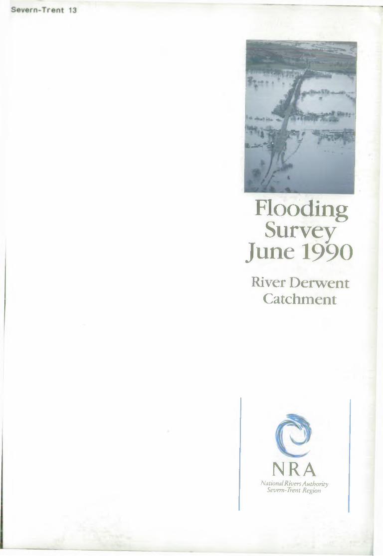
Flooding Survey
June 1990River Derwent
Catchment
NRANational Rivers Authority
Severn-Trent Region
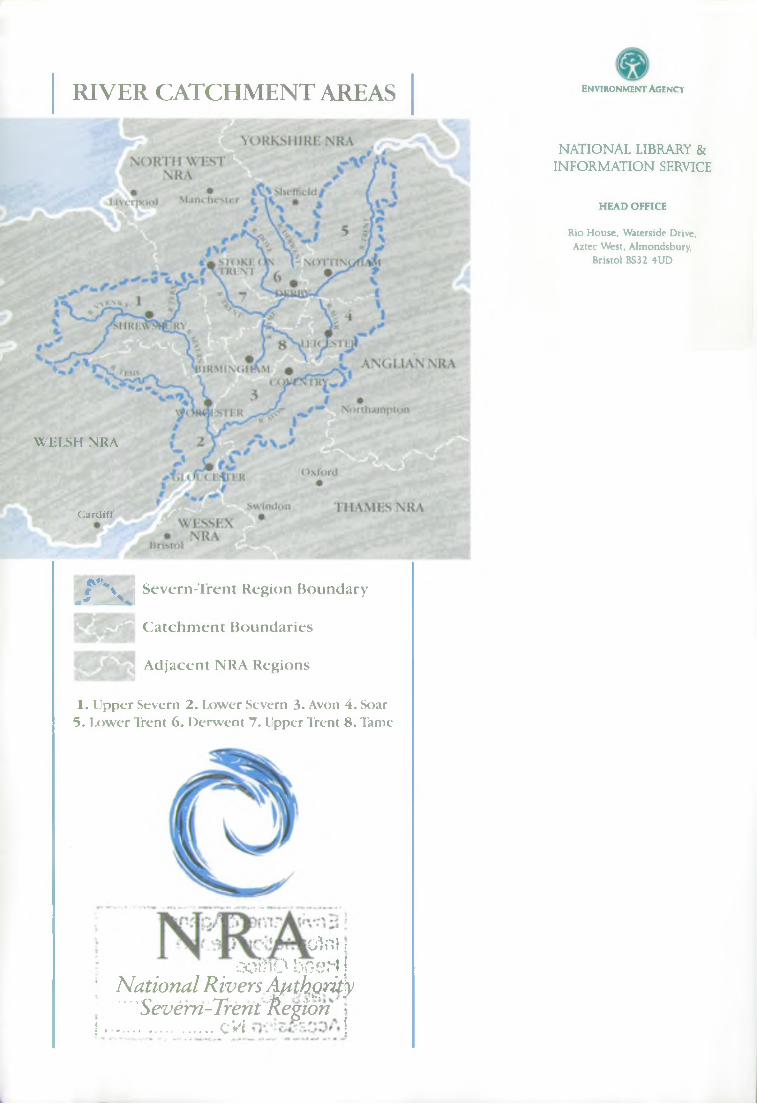
RIVER CATCHMENT AREAS
WELSH NRA
C a r d if f
r \. ' H a
Severn-Trent Region Boundary
C a tc h m e n t Boundaries
A djacent NRA Regions
1. Upper Severn 2. Lower Severn 3. Avon 4. Soar5. Lower Trent 6. Derwent 7. Upper Trent 8. Tame
O l O l :
CornO bosrt j ; National RiversA^thgrity
Severn-Trent Region *j .......................cVI j
En v ir o n m e n t Agency
NATIONAL LIBRARY & INFORMATION SERVICE
HEAD OFFICE
Rio House, Waterside Drive, Aztec West. Almondsbury,
Bristol BS32 4UD
FLOODING SURVEY
JUNE 1990
SECTION 136(1) WATER ACT 1989
(Supersedes Section 24(5) Water Act 1973
Land Drainage Survey dated January 1986)
RIVER DERWENT CATCHMENT
AND DERBYSHIRE
FLOOD DEFENCE DEPARTMENT NATIONAL RIVERS AUTHORITY SEVERN-TRENT REGION SAPPHIRE EAST 550 STREETSBROOK ROAD SOUHULLW MIDLANDS B91 1QT ENVIRONMENT AGENCY
Environment Agency information Centre Head Otfice
Class N o .....................
ession No
099805
CONTENTS
Contents
List of Tables
List of Associated Reports
List of Appendices
References
Glossary of Terms
Preface
CHAPTER 1 SUMMARY
1.1 Introduction
1.2 Coding System
1.3 Priority Categories
1.4 Summary of Problem Evaluations
1.5 Summary by Priority Category
1.6 Identification of Problems and their Evaluation
CHAPTER 2 THE SURVEY
2.1 Introduction
2.2 Purposes of Survey
2.3 Extent of Survey
2.4 Procedure
2.5 Hydrological Criteria
2.6 Hydraulic Criteria
2.7 Land Potential Category
2.0 Improvement Costs
2.9 Benefit Assessment
2.10 Test Discount Rate
2.11 Benefit/Cost Ratios
2.12 Priority Category
2.13 Inflation Factors
CHAPTER 3 GENERAL DESCRIPTION
3.1 Description of the Region
3.2 Description of the Dove and Derwent Basins
CHAPTER 4 THE NATIONAL RIVERS AUTHORITY'S SUPERVISORY ROLE
4.1 Introduction
4.2 Land Drainage Bye-1aws
4.3 Statutory Consents
4.4 Planning Liaison and Development Control
CHAPTER 5 MAIN RIVER SYSTEM
5.1 Statutory Provisions
5.2 Principles for Main River Extension
5.3 Local Authority Improvements
CHAPTER 6 THE LAND DRAINAGE ROLE OF LOCAL AUTHORITIES
6.1 Interaction with the National Rivers Authority's role
6.2 Powers of District Councils
6.3 Powers of County Councils
6.4 Maintenance of the Flow of Watercourses
Sec24/7

CHAPTER 7 INTERNAL DRAINAGE BOARDS
7.1 Consti tution
7.2 Income
7.3 Designated Watercourses
7.4 Maintenance of the Flow of Watercourses
CHAPTER 8 FLOOD DEFENCE MAINTENANCE
8.1 Objectives
8.2 Responsibility for Maintenance
8.3 Maintenance Programmes
CHAPTER 9 FLOOD DEFENCE AND CONSERVATION
9.1 Introducti on
9.2 Statutory Provisions for Nature Conservation
9.3 Liaison with Conservation Interests
CHAPTER 10 FLOOD WARNING SYSTEM
CHAPTER 11 PROGRAMMING OF FUTURE WORK
LIST OF TABLES
1 Summary of Problem Evaluations
2 Summary by Priority Category - non-main river
3 Summary by Priority Category - main river
4 Land Potential Categories
LIST OF ASSOCIATED REPORTS
Lower Trent Catchment and Nottinghamshire
River Avon Catchment and Warwickshire
River Soar Catchment and Leicestershire
River Tame Catchment and West Midlands
Upper Trent Catchment and Staffordshire
Upper Severn Catchment, Powys and Shropshire
Lower Severn Catchment, Gloucestershire and Hereford and Worcester
LIST OF APPENDICES
A1 Problem Descriptions and Evaluations
A2 Schedule of Main River
A3 Conservation Sites
A4 Coding System
A5 Sources of Finance
A6 Conservation
Sec24/7

REFERENCES
1 "Interim Report - Section 24(5) Survey" - Published by Severn-Trent Water Authority,
July 1978.
2 "Flood Studies Report" Vols I-V, Natural Environmental Research Council (1975).
3 "The Benefits of Flood Alleviation" - E C Penning- Rowsell and J B Chatterton,
published by Saxon House, Teakfield Ltd.
4 "Medway Letter" - Ministry of Agriculture and Fisheries (1933). Available in
Wisdom's "Land Drainage", Sweet and Maxwell, London (1966).
5 DoE Circular 17/82 - "Development in Flood Risk Areas - Liaison between Planning
Authorities and Water Authorities" published in 1982.
Sec24/7
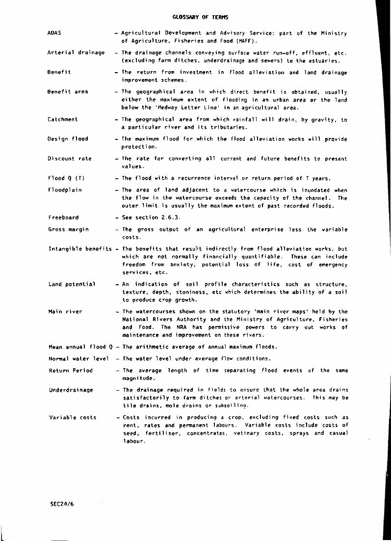
GLOSSARY OF TERMS
ADAS
Arteri al drai nage
Benefit
Benefit area
Catchment
Design flood
Discount rate
Flood Q (T)
FIoodplai n
F reeboard
Gross margin
Intangible benefits
Land potential
Main river
Mean annual flood Q
Normal water level
Return Peri od
Underdrai nage
Variable costs
- Agricultural Development and Advisory Service: part of the Ministry
of Agriculture, Fisheries and Food (MAFF).
- The drainage channels conveying surface water run-off, effluent, etc.
(excluding farm ditches, underdrainage and sewers) to the estuaries.
- The return from investment in flood alleviation and land drainage
improvement schemes.
- The geographical area in which direct benefit is obtained, usually
either the maximum extent of flooding in an urban area or the land
below the 'Medway Letter Line' in an agricultural area.
- The geographical area from which rainfall will drain, by gravity, to
a particular river and its tributaries.
- The maximum flood for which the flood alleviation works will provide
protection.
- The rate for converting all current and future benefits to present
values.
- The flood with a recurrence interval or return period of T years.
- The area of land adjacent to a watercourse which is inundated when
the flow in the watercourse exceeds the capacity of the channel. The
outer limit is usually the maximum extent of past recorded floods.
- See section 2.6.3.
- The gross output of an agricultural enterprise less the variable
costs.
- The benefits that result indirectly from flood alleviation works, but
which are not normally financially quantifiable. These can include
freedom from anxiety, potential loss of life, cost of emergency
services, etc.
- An indication of soil profile characteristics such as structure,
texture, depth, stoniness, etc which determines the ability of a soil
to produce crop growth.
- The watercourses shown on the statutory 'main river maps' held by the
National Rivers Authority and the Ministry of Agriculture, Fisheries
and Food. The NRA has permissive powers to carry out works of
maintenance and improvement on these rivers.
- The arithmetic average of annual maximum floods.
- The water level under average flow conditions.
- The average length of time separating flood events of the same
magni tude.
- The drainage required in fields to ensure that the whole area drains
satisfactorily to farm ditches or arterial watercourses. This may be
tile drains, mole drains or subsoiling.
- Costs incurred in producing a crop, excluding fixed costs such as
rent, rates and permanent labours. Variable costs include costs of
seed, ferti1i ser, concentrates, veti nary costs, sprays and casual
labour.
SEC24/6
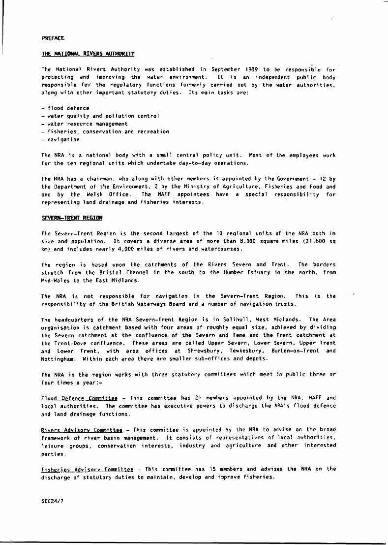
PREFACE
THE NATIONAL RIVERS AUTHORITY
The National Rivers Authority was established in September 1989 to be responsible for
protecting and improving the water environment. It is an independent public body
responsible for the regulatory functions formerly carri ed out by the water authori ties,
along with other important statutory duties. Its main tasks are:
- flood defence
- water quality and pollution control
- water resource management
- fisheries, conservation and recreation
- navigation
The NRA is a national body with a small central policy unit. Most of the employees work
for the ten regional units which undertake day-to-day operations.
The NRA has a chairman, who along with other members is appointed by the Government - 12 by
the Department of the Environment, 2 by the Ministry of Agriculture, Fisheries and Food and
one by the Welsh Office. The MAFF appointees have a special responsibility for
representing land drainage and fisheries interests.
SEVERN-TRENT REGION
The Severn-Trent Region is the second largest of the 10 regional units of the NRA both in
size and population. It covers a diverse area of more than 8,000 square miles (21,600 sq
km) and includes nearly 4,000 miles of rivers and watercourses.
The region is based upon the catchments of the Rivers Severn and Trent. The borders
stretch from the Bristol Channel in the south to the Humber Estuary in the north, from
Mid-Wales to the East Midlands.
The NRA is not responsible for navigation in the Severn-Trent Region. This is the
responsibility of the British Waterways Board and a number of navigation trusts.
The headquarters of the NRA Severn-Trent Region is in Solihull, West Midlands. The Area
organisation is catchment based with four areas of roughly equal size, achieved by dividing
the Severn catchment at the confluence of the Severn and Teme and the Trent catchment at
the Trent-Dove confluence. These areas are called Upper S e v e r n , Lower Severn, Upper Trent
and Lower Trent, with area offices at Shrewsbury, Tewkesbury, Burton-on-Trent and
Nottingham. Within each area there are smaller sub-offices and depots.
The NRA in the region works with three statutory committees which meet in public three or
four times a year:-
Flood Defence Committee - This committee has 21 members appointed by the NRA, MAFF and
local authorities. The committee has executive powers to discharge the NRA's flood defence
and land drainage functions.
Rivers Advisory Committee - This committee is appointed by the NRA to advise on the broad
framework of river basin management. It consists of representatives of local authorities,
leisure groups, conservation interests, industry and agriculture and other interested
parti es.
Fisheries Advisory Committee - Thi s commi ttee has 15 members and advises the NRA on the
discharge of statutory duties to maintain, develop and improve fisheries.
SEC24/7
NRASEVERN-TRENT
REGION LOWER TRENT AREAJ
@ REGIONAL HEADQUARTE
# AREA OFFICES, g M AJOR SUB
OFFICES.
LEAMINGTON
LOWER.SEVERN AREA
Regional Headquarters
Sapphire East
550 Streetsbrook Road
Solihull B91 1QT
• Tel: 021 711 2324
Upper Severn Area Office
Hafren House
Welshpool Road
Shelton
Shrewsbury SY3 8BB
Tel: (0743) 272828
Lower Severn Area Office
Southwick Park
Gloucester Road
Tewkesbury GL20 70G
Tel: (0684) 850951
Upper Trent Area Office
The Poplars
21 Rolleston Road
Burton-on-Trent
DEI3 0AY
Tel: (0283) 37191
Lower Trent Area Office
Trentside
Scarrington Road
Off Ladybay Bridge
West Bridgford
Nottingham NG2 5FA
Tel: (0602) 455722

CHAPTER 1
SUMMARY

1.0 SUmftRY
1.1 Introduction
1.1.1 This updated survey is one of eight surveys on the major river catchments in
the Severn-Trent Region. Each survey provides information appertaining
principally to a major catchment, extended to include the whole of the major
County associated with it.
1.1.2 The primary purpose of the surveys is the identification and evaluation of
flooding and land drainage problems and this summary provides information to
facilitate rapid assimilation and comparison of costs, benefit/cost ratios and
priority categories of these problems.
1.1.3 This survey supersedes the 1980 survey and the 1982 and 1986 revisions
1.2- Coding S y s t a
1.2.1 Every problem identified has been given a code number. The code numbers
appropriate to each problem were originally classified in the "Interim Report
of Survey"1 of July 1978. That original classification remains unchanged for
this Report but numbers have been added where new problems have been
identified since the publication of the Interim Report. The codes applicable
to catchments and County and Oistrict Councils are shown in Appendix A4 and
the format of the code is as follows:
x X X
Catchment County
eg 1 83
Upper Severn Salop
1.3 Priority Categories
1.3.1 In order to establish a range of priorities to which an individual improvement
scheme can relate, all improvement schemes have been categorised on the basis
of:
(i) the size of the benefit/cost ratio
(ii) the cost of the arterial part of the improvement works (i e . excluding
field drainage and ditching costs).
These categories are shown below.
Category by Benefit/Cost Ratio
CATEGORY BENEFIT/COST RATIO
GREATER THAN LESS THAN
1 2.02 1.0 2.03 1.0
X X X X X
Oistrict Number
310 27
Oswestry Problem No.
SEC24/7
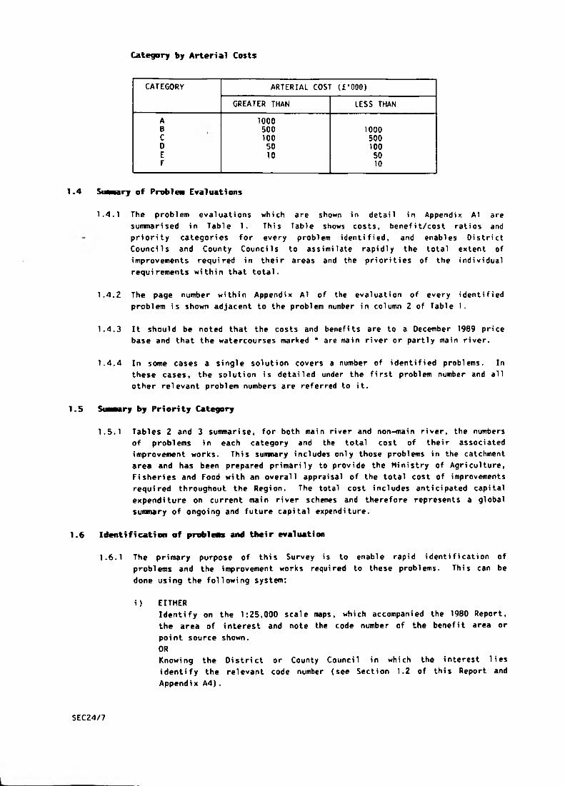
Category by Arterial Costs
CATEGORY ARTERIAL COST (£ ’000)
GREATER THAN LESS THAN
A 1000B 500 1000C 100 500D 50 100E 10 50F 10
1.4 S m e a r y of P r o b l n Evaluations
1.4.1 The problem evaluations which are shown in detail in Appendix AT are
summarised in Table 1. This Table shows costs, benefit/cost ratios and
priority categories for every problem identified, and enables Oistrict
Councils and County Councils to assimilate rapidly the total extent of
improvements required in their areas and the priorities of the individual
requirements within that total.
1.4.2 The page number within Appendix A1 of the evaluation of every identified
problem is shown adjacent to the problem number in column 2 of Table 1*
1.4.3 It should be noted that the costs and benefits are to a December 1969 price
base and that the watercourses marked * are main river or partly main river.
1.4.4 In some cases a single solution covers a number of identified problems. In
these cases, the solution is detailed under the first problem number and all
other relevant problem numbers are referred to it.
1.5 S w a r y by Priority Category
1.5.1 Tables 2 and 3 summarise, for both main river and non-main river, the numbers
of problems in each category and the total cost of their associated
improvement works. This summary includes only those problems in the catchment
area and has been prepared primarily to provide the Ministry of Agriculture,
Fisheries and Food with an overall appraisal of the total cost of improvements
required throughout the Region. The total cost includes anticipated capital
expenditure on current main river schemes and therefore represents a global
sumnary of ongoing and future capital expenditure.
1.6 Identification of probleas and their evaluation
1.6.1 The primary purpose of this Survey is to enable rapid identification of
problems and the improvement works required to these problems. This can be
done using the following system:
i) EITHER
Identify on the 1:25,000 scale maps, which accompanied the 1980 Report,
the area of interest and note the code number of the benefit area or
point source shown.
ORKnowing the District or County Council in which the interest lies
identify the relevant code number (see Section 1.2 of this Report and
Appendix A4).
SEC24/7
ii) Refer to the "Summary of Problem Evaluations" in Table 1 for brief
details of costs, benefit/cost ratios and priority categories for the
requisite watercourses in that District. All costs and benefits are at a
December 1989 price base.
iii) Further information on individual schemes will be found in the detailed
reports in Appendix A 1 . The relevant page is shown in the "Summary of
Problem Evaluations".
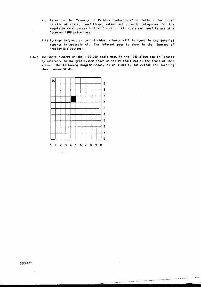
1.6.2 The sheet numbers on the 1:25,000 scale maps in the 1980 album can be located
by reference to the grid system shown on the rainfall map at the front of that
album. The following diagram shows, as an example, the method for locating
sheet number SK 46.
9
8
7
6
5
4
3
2
1
0
0 1 2 3 4 5 6 7 8 9 0
SK
■
SEC24/7
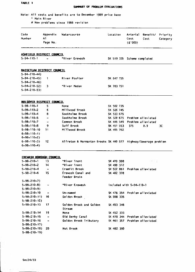
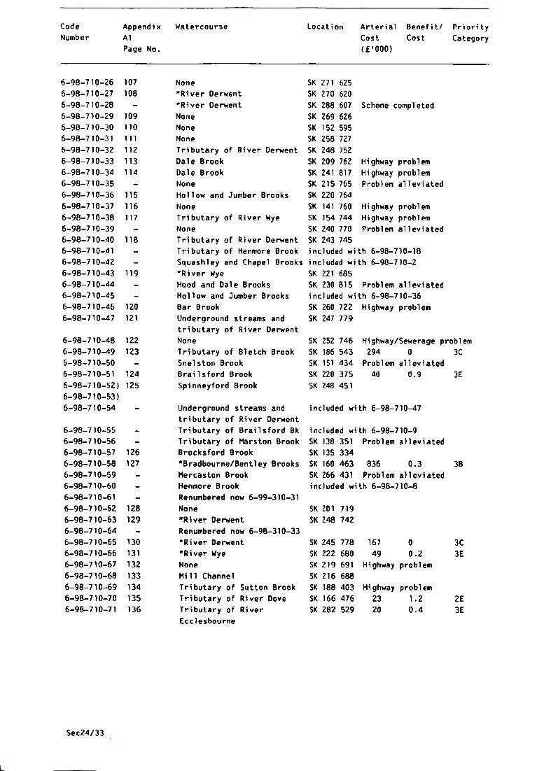
TABLE 1
S WM AR Y OF PROBLEM EVALUATIONS
Note: All costs and benefits are to December 1989 price base
* Main River
# New problems since 1986 revision
Code
Number
Appendi x
A1
Page No.
Watercourse Location Arterial Benefit/
Cost Cost
(£ * 000)
Priori ty
Category
ASHFIELD DISTRICT COUNCIL
5-94-110-1 — "River Erewash SK 519 335 Scheme completed
BASSETLAW DISTRICT. COUNCIL
5_94_210-44)
5-94-210-45) 1 River Poulter SK 647 755
5-94-210-46)
5-94-210-52) 3 •River Meden SK 703 751
5-94-210-53)
BOLSOVER DISTRICT COUNCIL
5-98-110-1 5 None SK 502 735
5-98-110-2 6 Mi 1lwood Brook SK 526 745
5-98-110-4 8 Sookholme Brook SK 533 675
5-98-110-5 - Sookholme Brook SK 520 675 Problem alleviated5-98-110-7 - Common Brook SK 445 549 Problem alleviated
5-98-110-8 9 Suff Brook SK 451 553 375 0.9 3C5-98-110-10 11 Millwood Brook SK 495 762
6-98-110-1)
6-98-110-2)
6-98-110-3) 12 Alfreton & Normanton Brooks SK 440 577 Highway/Sewerage problem
6-98-110-4)
EREWASH BQROUQi COUNCIL
5-98-210-1 13 •River Trent SK 470 308
5-98-210-2 14 •River Trent SK 490 312
5-98-210-4 - Cramfit Brook SK 522 861 Problem alleviated
5-98-210-6
5-98-210-7)
15 Erewash Canal and
Feeder Drain
SK 482 378
5-98-210-8)
5-98-210-9)- •River Erewash included with 5-94-110-1
5-98-210-10 - Un-named SK 476 354 Problem alleviated
5-98-210-11)
5-98-210-12)
16 Golden Brook SK 508 335
5-98-210-13 17 Golden Brook and Golden
Stream
SK 453 346
5-98-210-14 19 None SK 452 333
5-98-210-15 - Old Derby Canal SK 470 344 Problem alleviated
5-98-210-16
5-98-210-17)— Golden Brook Tributary SK 461 357 Problem alleviated
5-98-210-18)
5-98-210-19)
20 Nut Brook SK 482 390
Sec24/33

Code
Number
Appendix Watercourse
A1
Page No.
Location Arterial Benefit/ Priority
Cost Cost Category
( £ ’000)
5-98-210-20) 21 Sow Brook SK 464, 398 118 - -0;8
5-98-210-21)
5-98-2)0-22) 22 Stanley Brook SK 452 411
5-98-210-23)
6-98-210-1) - "Ock Brook SK 420 345 Scheme completed
6-98-210-2)
6-98-210-3 23 Ock Brook SK 422 359 Sewerage problem
6-98-210-4 24 Ock Brook SK 424 356 118 0
6-98-210-5 - Ock Brook included with 6-98-210-3
6-98-210-6 - Un-named tributary of
Ock Brook
SK 428 363 Problem alleviated
6-98-210-7 25 None SK 420 353 Highway problem
6-98-210-8 26 Un-named tributary of
Ock Brook
SK 423 366 Highway problem
6-98-210-9 27 Collier Brook SK 426 341
6-98-210-10 - "Bottle Brook SK 360 406 Scheme completed
6-98-210-11 28 Un-named SK 443 334 Sewerage problem
6-98-210-12 29 "Rivers Derwent & Trent SK 452 315
6-98-210-13 - "Bottle Brook included with 6-98-210-10
6-98-210-14 30 Boosemoor Brook SK 370 400 49 0.6
6-98-210-15 31 Lees Brook SK 402 374
6-98-210-16 - "Ock Brook included with 6-98-210-1
6-98-210-17 32 Dam Brook SK 370 388 236 0.1
6-98-210-18 33 Un-named trib of Ock Brook SK 422 356
6-98-210-19 34 None SK 416 347
AKBER VALLEY DISTRICT COUNCIL
5-98-310-1 - "River Erewash included wi th 5-94-110-1
5-98-310-3)
5-98-310-4) - "River Erewash included with 5-94-110-1
5-98-310-5)
5-98-310-6) 35 Bailey Brook SK 425 478 447 2.2
5-98-310-7)
5-98-310-9 37 Bi rchwood Brook SK 438 541
6-98-310-1 38 Windley Brook SK 311 450 66 0.3
6-98-310-2 39 Buckland Hollow Brook SK 376 518
6-98-310-3 40 Flagshaw Brook SK 281 388
6-98-310-4 - None SK 289 390 Problem allevi
6-98-310-5 41 Franker Brook SK 307 468
6-98-310-6 42 Coppice Brook Tributaries SK 393 500
6-98-310-7 43 River Ecclesbourne SK 294 478 32 0.7
6-98-310-8 - "Bottle Brook i ncluded wi th 6-98-210-10
6-98-310-9 44 "River Amber SK 387 566
6-98-310-10 45 Gypsy Brook SK 395 445
6-98-310-11 46 Park Brook SK 384 438
6-98-310-12 47 Park Brook SK 397 434
6-98-310-13 48 Shipley Brook SK 330 477 10 0.5
6-98-310-14 - None included wi th 6-98-310-4
1C
3D
3E
3E
Sec24/33
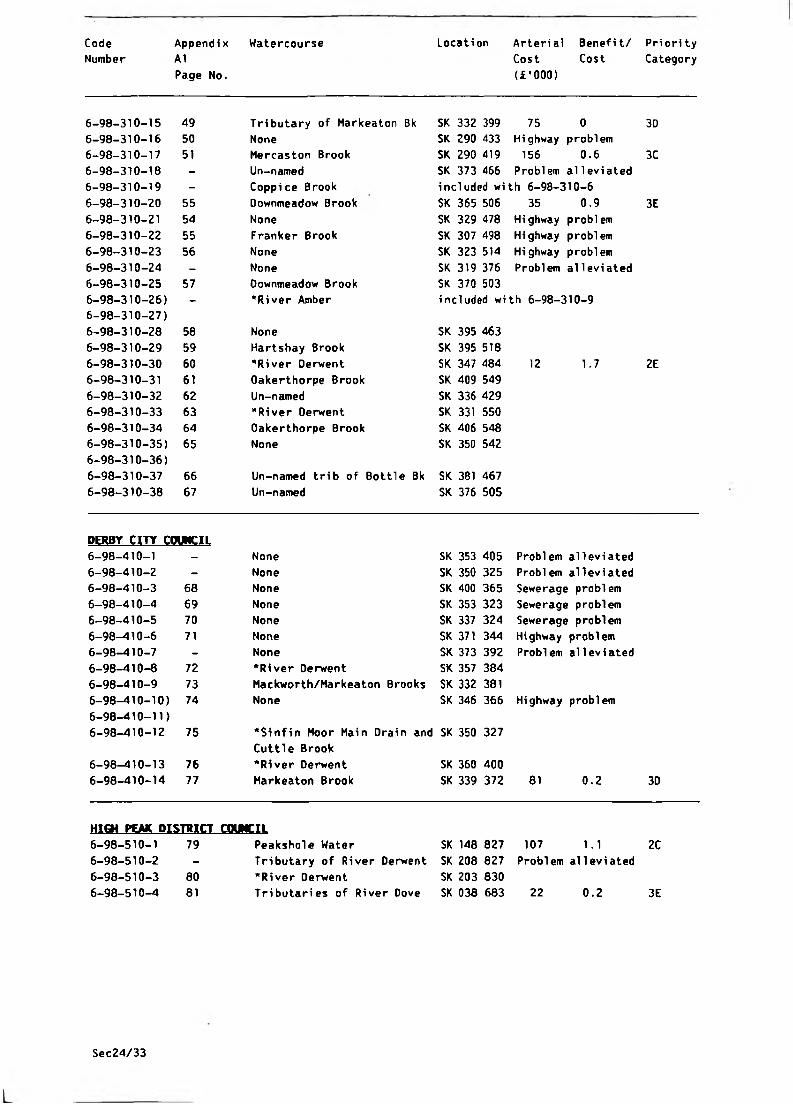
Code Appendi x Watercourse Locati on Arterial Benefit/ Priori ty
Number A1
Page No.
Cost Cost
(£’000)
Category
6-98-310-15 49 Tributary of Markeaton Bk SK 332 399 75 0 3D
6-98-310-16 50 None SK 290 433 Highway problem
6-98-310-17 51 Mercaston Brook SK 290 419 156 0.6 3C
6-98-310-18 - Un-named SK 373 466 Problem alleviated
6-98-310-19 - Coppice Brook included with 6-98-310-6
6-98-310-20 55 Downmeadow Brook SK 365 506 35 0.9 3E
6-98-310-21 54 None SK 329 478 Highway problem
6-98-310-22 55 Franker Brook SK 307 498 Highway problem
6-98-310-23 56 None SK 323 514 Highway problem
6-98-310-24 - None SK 319 376 Problem alleviated
6-98-310-25 57 Downmeadow Brook SK 370 503
6-98-310-26) - •River Amber included with 6-98-310-9
6-98-310-27)
6-98-310-28 58 None SK 395 463
6-98-310-29 59 Hartsbay Brook SK 395 518
6-98-310-30 60 "River Derwent SK 347 484 12 1.7 2E
6-98-310-31 61 Oakerthorpe Brook SK 409 549
6-98-310-32 62 Un-named SK 336 429
6-98-310-33 63 "River Derwent SK 331 550
6-98-310-34 64 Oakerthorpe Brook SK 406 548
6-98-310-35) 65 None SK 350 542
6-98-310-36)
6-98-310-37 66 Un-named trib of Bottle Bk SK 381 467
6-98-310-38 67 Un-named SK 376 505
DERBY CITY COUNCIL
6-98-410-1 - None SK 353 405 Problem alleviated
6-98-410-2 - None SK 350 325 Problem alleviated
6-98-410-3 68 None SK 400 365 Sewerage problem
6-98-410-4 69 None SK 353 323 Sewerage problem
6-98-410-5 70 None SK 337 324 Sewerage problem
6-98-410-6 71 None SK 371 344 Highway problem
6-98-410-7 - None SK 373 392 Problem alleviated
6-98-410-8 72 "River Derwent SK 357 384
6-98-410-9 73 Mackworth/Markeaton Brooks SK 332 381
6-98-410-10) 74 None SK 346 366 Highway problem
6-98-410-11)
6-98-410-12 75 "Sinfin Moor Main Drain and
Cuttle Brook
SK 350 327
6-98-410-13 76 "River Derwent SK 360 400
6-98-410-14 77 Markeaton Brook SK 339 372 81 0.2 3D
HIGH P C M DISTRICT COUNCIL
6-98-510-1 79 Peakshole Water SK 148 827 107 1.1 2C
6-98-510-2 - Tributary of River Derwent SK 208 827 Problem alleviated
6-98-510-3 80 "River Oerwent SK 203 830
6-98-510-4 81 Tributaries of River Dove SK 038 683 22 0.2 3E
Sec24/33

Code Appendi x Watercourse Locati on Arterial Benefit/ Priori ty
Number A1
Page No.
Cost Cost
{£'000)
Category
6-98-510-5 82 River Wye SK 082 725
.
6-98-510-6 - Tributary of Peakshole
Water
SK 168 837 Problem alleviated
6-98-510-7 - Peakshole Water included with 6-98-510-1
6-98-510-8 - Tributary of Peakshole included with 6-98-510-6
Water
6-98-510-9 83 None SK 209 836 Highway problem
6-98-510-10 - Tributary of Peakshole
Water
SK 161 834 Problem alleviated
6-98-510-11 84 Grinds and Lady Booth Bks SK 125 854
6-98-510-12 85 Tributary of River Wye SK 063 723
6-98-510-13 - Tributary of River Noe SK 168 845 Problem alleviated
NORTH-EAST DERBYSHIRE DISTRICT COUNCIL
6-98-610-1 86 Westwood Brook SK 417 601
6-98-610-2 - None SK 419 574 Problem alleviated
6-98-610-3 - Tributaries of Westwood Bk SK 418 604 Problem alleviated
6-98-610-4 - Press Brook SK 389 630 Problem alleviated
6-98-610-5 87 Press Brook SK 378 644
6-98-610-6 88 Press Brook SK 371 644 Highway problem
DERBYSHIRE DALES DISTRICT COUNCIL
6-98-710-1 89 Tributary of Bentley Brook SK 183 411 29 0.1 3E
6-98-710-2) - Squashley and Chapel Brooks SK 135 409 Problem alleviated
6-98-710-3)
6-98-710-4 90 "River Dove SK 165 312
6-98-710-5 91 Tributary of Cubley Brook SK 180 362 72 0.1 3D
6-98-710-6 92 None SK 188 363 Highway problem
6-98-710-7 - Tributary of Cubley Brook SK 165 383 Problem alleviated
6—98—/10—8 - "Henmore Brook SK 215 474 Scheme completed
6-98-710-9 - Tributary of Brailsford Bk SK 239 415 Problem alleviated
6-98-710-10 93 "River Wye SK 195 697
6-98-710-11 94 Tributary of River Wye SK 152 756
6-98-710-12 95 Hannage Brook SK 288 533 208 0.2 3C
6-98-710-13 96 Dale Brook SK 231 754 55 0.6 3D
6-98-710-14 97 Tributary of River Derwent SK 247 761
6-98-710-15 98 Tributary of River Derwent SK 245 762
6-98-710-16 99 "River Derwent SK 244 761
6-98-710-17 - Tributaries of River Dove SK 120 341 Problem alleviated
6-98-710-18 100 Tributary of Henmore Brook SK 167 449 107 0.4 3C
6-98-710-19 101 Shi rley Brook SK 214 408
6-98-710-20 102 Tributary of Hilton Brook SK 228 367 23 0.8 3E
6-98-710-21 103 Marston Brook SK 127 370 Highway problem
6-98-710-22 104 None SK 279 721 Highway problem
6-98-710-23 - None SK 286 616 Problem alleviated
6-98-710-24 105 None SK 279 623 Highway/Sewerage problem
6-98-710-25 106 Tributary of River Derwent SK 244 577
Sec24/33
Code
Number
Appendix Watercourse
A1
Page No.
Location Arterial Benefit/ Priority
Cost Cost Category
<£'000)
6-98-710-26 107 None SK 271 625
6-98-710-27 108 "River Derwent SK 270 620
6-98-710-28 - "River Derwent SK 288 607 Scheme completed
6-98-710-29 109 None SK 269 626
6-98-710-30 110 None SK 152 595
6-98-710-31 111 None SK 258 727
6-98-710-32 112 Tributary of River Derwent SK 248 752
6-98-710-33 113 Dale Brook SK 209 762 Highway problem
6-98-710-34 114 Dale Brook SK 241 817 Highway problem
6-98-710-35 - None SK 215 765 Problem alleviated
6-98-710-36 115 Hollow and Jumber Brooks SK 220 764
6-98-710-37 116 None SK 141 760 Highway problem
6-98-710-38 117 Tributary of River Wye SK 154 744 Highway problem
6-98-710-39 - None SK 240 770 Problem alleviated
6-98-710-40 118 Tributary of River Derwent SK 243 7456-98-710-41 - Tributary of Henmore Brook included with 6-98-710-18
6-98-710-42 - Squashley and Chapel Brooks included with 6-98-710-2
6-98-710-43 119 "River Wye SK 221 6856-98-710-44 - Hood and Dale Brooks SK 230 815 Problem alleviated
6-98-710-45 - Hollow and Jumber Brooks included with 6-98-710-36
6-98-710-46 120 Bar Brook SK 260 722 Highway problem
6-98-710-47 121 Underground streams and
tributary of River Derwent
SK 247 779
6-98-710-48 122 None SK 252 746 Highway/Sewerage problem
6-98-710-49 123 Tributary of Bletch Brook SK 186 543 294 0 3C
6-98-710-50 - Snelston Brook SK 151 434 Problem alleviated
6-98-710-51 124 Brailsford Brook SK 220 375 40 0.9 3E
6-98-710-52) 125 Spinneyford Brook SK 248 451
6-98-710-53)
6-98-710-54 - Underground streams and included with 6-98-710-47
tributary of River Derwent
6-98-710-55 - Tributary of Brailsford Bk included wi th 6-98-710-96-98-710-56 - Tributary of Marston Brook SK 138 351 Problem alleviated
6-98-710-57 126 Brocksford Brook SK 135 334
6-98-710-58 127 "Bradbourne/Bentley Brooks SK 160 463 836 0.3 3B
6-98-710-59 - Mercaston Brook SK 266 431 Problem alleviated
6-98-710-60 - Henmore Brook included with 6-98-710-8
6-98-710-61 - Renumbered now 6-99-310-31
6-98-710-62 128 None SK 201 719
6-98-710-63 129 "River Derwent SK 248 742
6-98-710-64 - Renumbered now 6-98-310-33
6-98-710-65 130 "River Derwent SK 245 778 167 0 3C
6-98-710-66 131 "River Wye SK 222 680 49 0.2 3E6-98-710-67 132 None SK 219 691 Highway problem
6-98-710-68 133 Mill Channel SK 216 688
6-98-710-69 134 Tributary of Sutton Brook SK 188 403 Highway problem
6-98-710-70 135 Tributary of River Dove SK 166 476 23 1.2 2E6-98-710-71 136 Tributary of River SK 282 529 20 0.4 3E
Ecclesbourne
Sec24/33

Code Appendix Watercourse Locati on Arterial Benefit/
Number A 1
Page No.
Cost Cost
(£'000)
6-98-710-72 137 Hannage Brook SK 284 527
6-98-710-73 - Tributary of River Noe SK 187 839 Problem alleviated
6-98-710-80 138 Un-named SK 263 649
6-98-710-81 139 •River Wye SK 220 670
6-98-710-82 140 River lathkill SK 240 650
6-98-710-83 141 Cubley Brook SK 164 375
6-98-710-84 - Un-named tributary of included with 6-98-710-5
Cubley Brook
6-98-710-85 - River Derwent included with 6-98-710-64
6-98-710-86 142 Un-named SK 286 612
6-98-710-87 143 Bradbourne Brook SK 175 499
6-98-710-88 - Tributary of Hannage Bk SK 283 537 Problem alleviated
6-98-710-89 - Un-named SK 325 594 Problem alleviated
6-98-710-90 144 Tributary of Henmore Bk SK 173 458
6-98-710-91 - Un-named SK 215 681 Problem alleviated
6-98-710-92 - Un-named SK 307 603 Problem alleviated
6-98-710-93 145 #Un-named SK 223 686
6-98-710-94 146 #None SK 308 613
6-98-710-95 147 #None SK 195 700
SOUTH DERBYSHIRE DISTRICT COUNCIL
6-98-810-1 148 Roadside Ditches SK 212 333 Highway problem
6-98-810-2 149 •River Derwent SK 428 326
6-98-810-3 150 •River Dove SK 190 301
6-98-810-4 151 Twyford, Doles and Hell Bks SK 326 285
6-98-810-5 152 Tributary of River Trent SK 294 285 1016
6-98-810-6 153 •River Trent SK 353 284 52 0.1
6-98-810-7 - Tributary of River Trent included with 6-98-810-5
6-98-810-8 - Twyford, Doles and Hell Bks included with 6-98-810-4
6-98-810-9 154 •River Trent SK 370 286 23 0.3
6—38—8 i0—10 155 None SK 430 300
6-98-810-11) - Twyford, Doles and Hell Bks included with 6-98-810-4
6-98-810-12)
6-98-810-13 - •Hilton Brook SK 261 281 Scheme completed
6-98-810-14 156 None SK 274 332 Highway problem
6-98-810-15 - Twyford, Doles and Hell Bks included with 6-98-810-4
6-98-810-16 - Roadside Ditches included with 6-98-810-1
6-98-810-17 157 None SK 235 355 Highway problem
6-98-810-18) 158 •River Dove and Egginton SK 273 277
6-98-810-19) Brook
6-98-810-20 - Tributary of River Dove SK 216 308 Problem alleviated
6-98-810-21 159 •Etwall and Egginton Brooks SK 264 336 755 0.7
6-98-810-22 - Tributary of River Trent SK 441 301 Problem alleviated
6-98-810-23 - Twyford, Doles and Hell Bks included with 6-98-810-4
6-98-810-24 160 Thulston Brook SK 410 320
6-98-810-25 - Un-named SK 252 381 Problem alleviated
6-98-810-26 161 Un-named SK 194 311
6-98-810-27 162 Shardlow Parish Dyke SK 431 304
6-98-810-28 163 Thulston Brook SK 390 320
7-98-810-1 164 None SK 280 255 Highway problem
7-98-810-2 165 None SK 350 191 Highway problem
Sec24/33

Code Appendix Watercourse Locati on Arterial Benefit/ Priori ty
Number A1
Page No.
Cost Cost
{£'000)
Category
7-98-810-3 166 Hooborough Brook SK 294 127 216 0.4 3C7-98-810-5 - •Repton Brook SK 305 270 Scheme completed7-98-810-6 - Milton Brook SK 341 273 Problem alleviated7-98-810-7 167 Ramsley Brook SK 393 272
STAFFORDSHIRE MOORLAIOS DISTRICT COUNCIL
6-99-110-1 168 River Tean and Cecilly Bk SJ 997 429 956 0.7 3B
6-99-110-2 - Endon and Horton Brooks SJ 928 532 Problem alleviated
6-99-110-3 170 River Churnet Headwaters SJ 986 626 236 0.5 3C6-99-110-4) 171 Ditches draining to SJ 933 548 Highway problem
6-99-110-5) Horton Brook
6-99-110-6 172 Dingle Brook and Canal
feeder
SJ 955 579
6-99-110-7 173 Horton Brook SJ 936 576 317 1.1 1C
6-99-U 0-8 174 Tributary of River Churnet SK 956 587 7 0.7 3F
6-99-110-9 - Endon and Horton Brooks included with 6-99-110-2
6-99-110-10 - Tributary of River Tean SK 028 379 Problem al1evi ated
6-99-110-11 175 Tributary of River Tean SK 016 395 Highway problem
6-99-110-12) - River Tean and Cecilly Bk included with 6-99-110-1
6-99-110-13)
6-99-110-14 - Endon and Horton Brooks included with 6-99-110-2
6-99-110-15 - Ditches draining to included with 6-99-110-4
Horton Brook
6-99-110-16 - Tributary of River Churnet included with 6-99-110-8
6-99-110-17 - Ditches draining to included with 6-99-110-4
Horton Brook
6-99-110-18 176 •River Churnet SK 072 427 17 0.3 3E
6-99-110-19 177 Cotton Brook SK 055 450 176 0.4 3C6-99-110-20 178 "River Churnet SK 053 446 55 0.3 3D
6-99-110-21 179 River Mani fold SK 098 613
6-99-110-22 180 River Mani fold SK 106 593
6-99-110-23 181 Tributary of River Hamps SK 051 5546-99-110-24 182 River Mani fold SK 101 588
6-99-110-25 183 Tributary of River Dove SK 071 666
6-99-110-26 184 None SK 139 547
6-99-110-27 - Endon and Horton Brooks included with 6-99-110-2
6-99-110-28 - "River Churnet SJ 973 572 Problem alleviated
6-99-110-29 - Endon and Horton Brooks included with 6-99-110-2
6-99-110-30 185 Leek Brook SJ 985 539 23 1.5 2E
6-99-110-31 186 •River Churnet SJ 980 572
6-99-110-32 187 Ball Brook SJ 987 568 Highway/Sewerage problem
6-99-110-33 188 Ball Brook SJ 992 567 Highway/Sewerage problem6-99-110-34 189 River Hamps SK 080 504 796 0.1 3B
6-99-110-35 - River Churnet SK 071 425 Problem alleviated
6-99-110-36 190 Un-named SJ 979 573 49 3.4 IE
6-99-110-41 - •River Tean SK 020 370 Problem alleviated
6-99-110-42 191 •River Churnet SJ 987 503
6-99-110-43 192 •River Churnet SJ 981 523
Sec24/33

Code
Number
Appendix Watercourse
A1
Page No.
Location Arterial Benefit/ Priority
Cost Cost Category
( £ ’000 )
EAST STAFFORDSHIRE DISTRICT COUNCIL
6-99-310-1 - •Rolleston Brook SK 208 262 Scheme compl eted6-99-310-2 193 Westlands Brook SK 100 407 78 0.2 3D
6-99-310-3 194 None SK 212 289 Highway problem6-99-310-4 - •River Churnet SK 108 401 Problem alleviated6-99-310-5 195 None SK 096 407 Highway/Sewerage problem6-99-310-6 - Tributaries of River Tean SK 029 378 Problem alleviated
6-99-310-7 196 River Tean SK 065 359 677 1.9 2B
6-99-310-8 - •River Tean SK 087 348 Scheme completed
6-99-310-9 - River Tean included with 6-99-310-7
6-99-310-10 197 None SK 085 335
6-99-310-11 - •Picknall Brook SK 088 330 Scheme completed
6-99-310-12 198 Tributary of Marchington Bk SK 106 309 35 0.7 3E
6-99-310-13 - Marchington Brook SK 137 308 Problem alleviated
6-99-310-14 199 Marchington Brook SK 131 302
6-99-310-15 200 •River Dove SK 221 288
6-99-310-16 201 None SK 240 277 Hi ghway problem
6-99-310-17 202 None SK 210 251 Hi ghway problem
6-99-310-19 203 •River Dove SK 161 301
6-99-310-20 204 •River Churnet SK 110 411
6-99-310-30 205 •River Dove SK 258 276
6-99-310-31 206 Croxden/Nothi11/Alders
Brooks
SK 066 395 505 1.2 2B
6-99-310-32 207 Mill Fleam SK 118 427
6-99-310-33 - Un-named SK 089 360 Problem alleviated
6-99-310-34 208 Un-named SK 154 453
6-99-310-35 209 #Marchington Brook SK 142 314
Sec24/33
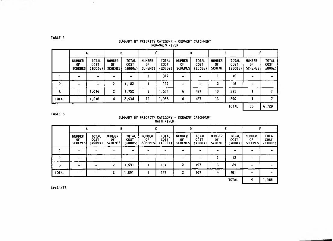
TABLE 2SUMMARY BY PRIORITY CATEGORY - DERWENT CATCHMENT
NON-MAIN RIVER
A B C D E F
NUMBEROF
SCHEMES
TOTALCOST(£000s)
NUMBEROF
SCHEMES
TOTALCOSTUOOOs)
NUMBEROF
SCHEMES
TOTALCOSTUOOOs)
NUMBEROF
SCHEMES
TOTALCOST(£000s)
NUMBEROF
SCHEME
TOTALCOSTUOOOs)
NUMBEROF
SCHEMES
TOTALCOSTUOOOs)
1 - - - - 1 317 - - 1 49 - -
2 - - 2 1,182 1 107 - - 2 46 - -
3 1 1,016 2 1,752 8 1,531 6 427 10 295 1 7
TOTAL 1 1,016 4 2,934 10 1,955 6 427 13 390 1 7
TOTAL 35 6,729
TABLE 3SUMMARY BY PRIORITY CATEGORY - DERWENT CATCHMENT
MAIN RIVER
A B C D E F
NUMBEROF
SCHEMES
TOTAL COST (£000s)
NUMBEROF
SCHEMES
TOTALCOSTUOOOs)
NUMBEROF
SCHEMES
TOTAL COST {£00Os)
NUMBEROF
SCHEMES
TOTALCOSTUOOOs)
NUMBEROF
SCHEME
TOTAL COST UOOOs)
NUMBEROF
SCHEMES
TOTALCOSTUOOOs)
) - - - - - - - - - - - -
2 - - - - - - - - 1 12 - -
3 - - 2 1,591 1 167 2 107 3 89 - -
TOTAL - - 2 1,591 1 167 2 107 4 101 - -
TOTAL 9 1,966
Sec24/37
CHAPTER 2
THE SURVEY

2 -0 THE SURVEY
2.1 Introduction
2.1.1 The requi rement for a Survey resul ts from the Water Act 1989, whi ch al so
created the National Rivers Authority. Under Section 136(1) of the above Act
the National Rivers Authority has a duty to carry out from time to time, a
survey of its area in relation to flood defence functions.
2.1.2 The Ministry of Agriculture, fisheries and Food i ssued Guidance Notes for
Water Authorities in carrying out the original Survey and, wherever possible,
suggested procedures were adopted and information incorporated within the
reports.
2.1.3 In carrying out the Survey the Authority was required to:
1 Consult every local authority whose area is wholly or partially included
in the area of the Water Authority.
2 Have regard to structure plans and local plans under the Town and Country
Planning Act 1971.
2.2 Purposes of the Survey
2.2.1 The primary purpose of the Survey is to identify and evaluate flooding
problems, both for existing problems and for potential problems which may
occur as a result of increased run-off from development. Information is
provided which summarises the principal solutions, costs, benefits and
priorities.
Z.2.2 The Surveys are required by the Ministry of Agriculture, Fisheries and Food to
provide a comprehensive and logical basis for long-term planning of drainage
improvements and flood alleviation.
2.2.3 The Survey will be used by this Authority to ensure rational phasing of
improvements on main river, and will provide a firm basis for the supervisory
role exercised by the Authority over all matters relating to its flood defence
functions on all watercourses throughout the region.
2.2.4 The Survey provides comprehensive information on both main river and non-main
river and can, therefore, be used by all drainage authorities and drainage
bodi es (local authori ties) for determi ni ng capi tal works programmes of
watercourse improvements in conjunction with the Authority’s own programme of
works.
2.2.5 The Authority will make use of the survey in considering any changes to the
main river network.
SEC24/7

2.3 Extent of the Survey
2.3.1 The Authority exercises a general supervisory role over all matters relating
to land drainage. The Survey, therefore, identifies and examines not only
problems on main river but also on other watercourses having existing or
potential land drainage and flood alleviation problems.
2.3.2 No limit has been fixed by the Ministry of Agriculture, Fisheries and Food for
a lower order of problems which should be considered by the Survey, but it has
been indicated that a "broad brush" approach is preferable to detailed
i nvesti gati ons of a minority of 1 arge probl ems. Thi s accords wi th the
Authority's view of its own requirements and thus the lower limit has been
fixed as flooding affecting a single property or inadequate arterial
conditions affecting twenty hectares of agricultural land. However, where
specific requests have been made to investigate problems of lesser order these
have been included wherever possible.
2.3.3 The Survey has investigated those watercourses which are currently in a
satisfactory condition but where future development could necessitate
improvements. This has been limited to those developments which have planning
permission or have been identified in Structure and Local Plans and are likely
to proceed in the near future.
2.3.4 The Survey covers only those drainage inadequacies which occur on arterial
watercourses. Where drainage inadequacies on agricultural land can be
resolved by underdrainage alone, these have not been included within the
Survey.
2.4 Procedure
2.4.1 Of the information on drainage deficiencies required for this Survey, a
considerable proportion was available wi thin this Authori ty. This is
particularly so of the problems on main river but also applies to major
problems on non-main river. There are, however, many kilometres of non-main
river on which this Authority had no information and which have, in many
cases, had little or no maintenance work carried out on them. In order to
ensure comprehensive coverage on such watercourses, in addition to main river,
all bodies having land drainage interests were asked to provide information on
drainage deficiencies. These include:
1 Ministry of Agriculture, Fisheries and Food
2 Internal Drainage Boards.
3 County Councils.
4 District Councils.
5 Parish Councils.
6 British Waterways Board.
7 National Farmers' Union.
6 Country Landowners Association.
9 Bri ti sh Coal.
SEC24/7
2.4.2 In July 1978, an 'Interim Report' was circulated to local authorities and many
other organisations and bodies as part of the Authority's statutory duty under
Section 24 of the Water Act 1973. This Report identified all drainage
deficiencies which had been notified to the Authority and provided brief
details of location and type of problem.
2.4.3 The primary purpose of the Interim Report was to seek views and couwnents on
the identi fied problems so that these could be taken into account in
determining solutions. Provision was also made to incorporate additional
problem areas in subsequent Reports to ensure their comprehensiveness. All
relevant comments have, therefore, been incorporated in the problem
evaluations in Appendix A1 including those of the Nature Conservancy Council,
County Conservation Trusts, Countryside Commission and fisheries, navigation
and many other interests, in addition to those scheduled in Section 2.4.1.
Wherever possible, the costs identified for the improvement works have
included the cost of making provi si on for al 1 i nterests whi ch have been
noti fied.
2.4.4 Every problem identified in the Interim Report and those notified since its
publication have been investigated by visiting the site and carrying out land
surveys as necessary. The extent of the investigation has largely been
determined by the extent of the problems and the benefits which will result.
Many minor problems have, therefore, not been examined in detail because of
the high cost of providing the necessary improvement works. There are also
many cases where flooding cannot be attributed to inadequacies in the arterial
watercourse drainage system. In these situations, the solutions to the
problems are outside the scope of this Survey and have not been determined.
However, an indication is given, in each case, of the cause of the problem and
these have been brought to the attention of the appropriate authority (eg.
Highway Authority, British Coal, etc).
2.5 Hydrological Criteria
2.5.1 The wean annual flow for a n sites of major importance, for which flow records
are available, have been calculated using the appropriate method formulated in
the "Flood Studies Report"^.
2.5.2 For sites of minor importance and sites having no available flow records, the
mean annual flood has been calculated from catchment characteristics using the
"Flood Studies Report" six parameter equation.
2.5.3 In all cases, the relationship between Q(T) (the flood of return period T) and
Q (the mean annual flood) has been derived from the “Flood Studies Report"
regional growth curves.
2.6 Hydraulic Criteria
2.6.1 Urban f1ood al1evi ati on schemes have been desi gned, wherever possi ble, to
contain the 1 in 100 years flood. It is recognised that, in the final
analysis, the design frequency chosen will be that which maximises the excess
of benefit over cost but, within the scope of this Survey, this has not been
possible other than in schemes of the very highest priority.
2.6.2 Culverts have generally been designed for the following flood return
frequencies. (These standards have varied dependent upon economic or physical
constraints):
SEC24/7
1 Flooding of property and urban areas in general - 1 in 100 years.
All areas of high agricultural value including horticultural areas - 1 in
100 vears.100 years
Other agricultural areas - 1 in 25 years.
4 A combi nation of floodi ng transport systems and agri cul tural areas may
justify a standard of up to 1 in 50 years.
2.6.3 For the Survey purposes the following criteria have been adopted:
1 In agri cultural areas the pipe outfal 1 s for fi eld drainage systems are
designed to be 150mm above normal water level. Where there is no field
drainage system an average freeboard of 1,500mm between normal water
level and ground level has been used. The freeboard requirements for
under-drainage purposes may result in larger channel capacities than
those required purely for flood alleviation purposes.
2 For the construction of floodbanks freeboard is dependent on the
confidence limits of data used for design purposes, and for major
floodbanks is normally 500mm. Small freeboards have been considered in
appropriate cases. In al 1 other cases, channel capacity is the design
flood discharge with no additional freeboard.
Z.7 Land Potential Category
2.7.1 The successful growth of crops depends on a suitable soil environment for
germination, root anchorage and plant growth. Cropping systems are dependent
on soil potential and similarly drainage standards can be linked to soil
profile characteristics such as structure, texture, depth, stoniness and
wetness. The Ministry of Agriculture, Fisheries and Food has assessed
standards for field drainage and flood protection based upon the relationship
between cropping and soi 1 or 1 and potential as indicated in Table 4. In
providing these individual assessments the Ministry has pointed out that they
are subjective and will need to be verified by detailed in-field
investigations before any scheme can be agreed for grant aid purposes.
Table 4 Land Potential Categories
a Land potential low (Normally pasture land)
1 in 2 years
a5 Land potential low/medium (Normally low grade arable land)
1 in 5 years
b Land potential medium/high (Normally high grade arable land)
1 in 5/10 years
c Land potential very high (Very high grade arable and horticultural land)
1 in 25/100 years
SEC24/7

2.8 I^iroveMflt Costs
2.0.1 Costs of improvement schemes have been estimated on a standard unit cost basis
wherever possi ble and appropriate in order to ensure uni formi ty and
comparability of all schemes. The unit cost approach has been adopted for
excavation of new channels, construction of floodbanks, bridges, pumping
stations, culverts, revetment work, etc. It has not been possible to use unit
costing for regrading and remodelling of existing channels or for channel
clearance of undergrowth and trees as these are iterns which vary from
watercourse to watercourse.
2.8.2 All costs include for design and supervision which on average is approximately
10% of the cost of the improvement works.
2.8.3 All costs are at a price base of December 1989.
2.8.4 The cost of field drainage for existing problems has been assessed by the
Ministry of Agriculture, Fisheries and Food and has been included within the
total cost of the improvement works. Field drainage costs for new problems
have been assessed using a nomograph produced by Silsoe College for the
Authority in 1984. Ditching costs have not been included unless this
constitutes a significant proportion of the overall cost.
2.8.5 Wherever possible, the total cost of the improvement works includes the cost
of maki ng provi si on for navi gati on, fi sheries, conservati on and other
interests of which the Authority has been notified.
2.9 Benefit Assessment
2.9.1 Benefit areas for urban problems have been determined largely from local
knowledge of the extent and depth of past floods. These have been
extrapolated where necessary to estimate the extent of floods with return
periods in excess of recorded events. The stage/damage estimates and
subsequent evaluation of annual average benefits have been derived from
methods formulated in the manual entitled "The Benefits of Flood Alleviation:■i
A Manual of Assessment Techniques" .
2.9.2 The areas which are likely to benefit in both agricultural and urban areas are
shown on the overlays to the maps in the 1980 album. The locations of small
areas of urban flooding and miscellaneous minor flooding problems are shown
with a dot enclosed in a circle and identified with the appropriate code
number. In the case of large urban flooding problems and agricultural
drainage problems, the areas shown on the overlays and identified by code
numbers are the areas which will benefit from drainage improvements.
2.9.3 Areas of inland agricultural land which will derive benefit from drainage
operations have been defined, for the purpose of this Survey, as follows:
i) Land within an area bounded by a line 2.4m above the highest recorded
flood level as defined in the "Medway Letter"^.
i i) Where no floodi ng has occurred but normal water levels restrict outfal1
condi ti ons for f i el d drai ns, the benefi t area i s the area bounded by a
line 2.4m above bank top level.
SEC24/7

2.9.4 Annual average benefits for agricultural areas have been assessed by the
Ministry of Agriculture, Fisheries and Food from the land potential (see
Table 4) and from the potential change in gross margin which will result from
improved drainage. These assessments will require verification by detailed
studies if schemes are incorporated in capital programmes.
2.9.5 The maximum benef i ts from most agri cul tural improvement schemes can be
achieved only if the individual farmers carry out ditching and install field
drainage following the improvement to the receiving watercourses. In practise
the benefits will, therefore, be phased in as field drainage is installed and
due account will be taken of this phasing when individual detailed schemes are
prepared.
2.9.6 If the improvement of a watercourse is an essential pre-requisite of planning
permission for any housing or industrial development, such that without the
improvement planning permission would not be approved, then the benefits
attributable to future development by the off-site improvement of watercourse
have been assessed as a proportion of the increase in the value of the land
after planning permission is granted.
2.9.7 The benefits have been assessed, for both urban and agricultural problems,
using a base date of December 1989- It should be appreciated that benefits,
particularly in agricultural schemes, may not follow normal inflationary
trends.
2.10 Test Discount Rate
2.10.1 The test discount rate which has been used for the assessment of the net
present value of future costs and benefits is the Government's recommended
current rate for public investment of 6£. The life of improvement schemes,
other than those involving pumping stations, has been assumed as 50 years for
the purpose of the net present value analysis.
2.10.2 Maintenance costs after improvements have been carried out are assumed, on
average, to be of a similar order to those before. In some cases, maintenance
costs will be lower whereas in others, particularly where maintenance has been
neglected in the past, costs will be higher.
2.11 Benefit/Cost Ratios
2.11.1 The compari son of benef i t wi th cost enables an assessment to be made of the
worthwhileness of any proposed improvement. For the purpose of this Survey a
scheme is considered as being possibly viable if the benefit to cost ratio is
greater than unity. However, if an improvement scheme progresses to a capital
programme it may be necessary to compare it with benefit/cost ratios for other
competing schemes to enable a choice to be made.
2.11.2 The greater the excess of benefit over cost the higher the return for capital
employed and, therefore, in purely economi c terms, a scheme having a high
benefit/cost ratio would have a higher priority than a scheme having a lower
value. However, due weight must also be given to other factors such as risk
to human 1i fe, ameni ty and envi ronmental consi derati ons. These factors are
intangible and require a subjective assessment, in conjunction with economic
factors, to determine the overall priorities of schemes.
SEC24/7

2.12 Priority Category
2.12.1 The Survey has made no attempt to determine priorities which take into account
intangible benefits; schemes have been categorised solely on the basis of
tangible benefits which can be assessed in purely economic terms. It will be
the responsi bi1i ty of the promoting authori ty to determine the weight to be
given to intangible benefits and, therefore, the overall priorities to be
attached to schemes in its area.
2.13 Inflation Factors
2.13.1 Costs and Benefits for problems contained in the 1986 revision have been
updated to a December 1989 price base as follows:
Arterial Costs - Baxter (Regional) Index
Underdrainage Costs - Retail Price Index
Agricultural Benefit - Using information supplied by Silsoe College based on
changes in weighted gross margins
Urban and Road Benefits - Retail Price Index.
SEC24/7
CHAPTER 3
GENERAL DESCRIPTION

■

3.0 GENERAL DESCRIPTION
3.1 Description of the Region
3.1.1 The boundary of the Severn-Trent Region of the National Rivers Authori ty is
formed by the watersheds of the River Trent and the River Severn. The area of
21,600 sq. km extends from the Humber estuary in the north to the Severn
estuary in the south, and is bounded by the Anglian, Yorkshire, North West,
Welsh, Wessex and Thames Regions of the NRA. The Severn-Trent Region is
divided into eight catchments the boundaries of which are the watersheds of
the major sub-catchments of the River Severn and the River Trent. These
catchments and the location of the region is shown in Fig.l.
3.1.2 The Severn-Trent Region of the National Rivers Authority is responsible for
the two major tidal estuaries of the River Severn and the River Trent but
other than these areas it has no coast line. The River Trent is tidal as far
as Cromwell Lock, about eight kilometres downstream of Newark, and the River
Severn is tidal as far as Gloucester.
3.1.3 The highest part of the Trent region is the Pennines in the north west where
the River Derwent rises at an altitude of 630 metres. ATtitude decreases
across the Trent basin to the River Trent itself and then rises in the east to
a height of between 60 metres and 120 metres. In the central region the
catchments of the Rivers Severn and Trent are separated at the headwaters of
the River Tame and the River Stour by a ridge of between 200 metres and 270
metres high.
3.1.4 The topography of the Severn basin is dominated by the Welsh Hills in the west
at a maximum elevation of 830 metres and the Cotswold Hills in the south-east
at an elevation of 330 metres. A prominent feature in the south-west is the
Malvern Hills which rise to a height of 430 metres.
3.1.5 The average annual rainfall over the whole of the region is 775mm and this
ranges from a maximum of over 2,000mm in the Welsh Hills to approximately
COuffim in the Trent Valley in the rain shadow of the Pennines. I'he variation
is largely associated with altitude. The lowlands generally have little
seasonal variation but upland areas are wetter in winter than in summer.
Similarly, in the upland areas, snowfall is a significant form of
precipitation.
3.1.6 The geology of the region varies from the resistant Pre-Cambrian and
Palaeozoic rocks in west Shropshire to the softer clays, shales and limestone
bands of the Lower Lias in east Leicestershire and Warwickshire. The
Pre-Cambrian and Palaeozoic rocks are characterised by the rugged landscape of
Wales, the Border Counties and the carboniferous limestone formations in
Derbyshire, while the more recent formations in the east have weathered to
form the rolling scarps and vales typical of Leicestershire.
3.1.7 The total population of the Region is 8.3 million people with some 2.5 million
in the Severn catchment and 5.8 mi 11ions in the Trent. Approximately 2.6
million people live in the West Midlands conurbation which straddles both
catchments. The other major centres of population are Nottingham (280,000),
Leicester (282,000), Stoke-on-Trent (250,000) and Derby (215,000). Many of
these conurbati ons, and parti cul arly that of the Black Country area, are
situated in the vicinity of the headwaters of major rivers and have a
significant effect on the river flows throughout their lengths.
SEC24/7
3.1.8 The National Rivers Authority assumes a direct responsibility for 3,573 km of
main river on which capital improvements and maintenance are carried out as
necessary. Areas which have been protected from flooding, to various
standards, on this length of main river total over 1,000 sq. km. Much of this
area is protected by floodbanks of which the total length is 820 km, all of
which is maintained on a regular basis by the Authority.
3 , Z Description of the Dove and Derwent Basins
3.2.1 The catchment areas of the Rivers Dove and Derwent both generally have steep
gradients, resulting in short time of concentration. The rivers are young in
geological terms, are fast flowing and have high dominant discharges. The
Dove f 1 ows for hal f of its 1 ength over Keuper Marl, f requentl y wi th gravel
seams at normal water level. These factors allow erosion and consequent
shoaling, and the river regime is unstable in its lower reaches. Larger
erosions have jeopardised the stability of flood defences and it has been
necessary to stabi1i se the banks at many points by stone revetments. By
comparison, the 1 ower reaches of the Derwent require 1 ess extensive and less
costly maintenance.
3.2.2 The floodplains of both rivers and their tributaries are restricted in their
upper reaches resulting in little storage. Consequently, the more serious
flood incidents cause considerable damage due to the depth and velocity of the
water. A notable example occurred in August 1971 on the River Hamps at
Waterhouses when, after a thunderstorm, flooding up to three metres deep
severely damaged property in the village. Matlock, too, has suffered from
extensive flooding but an improvement scheme has now been completed, which
provides protection from floods up to a frequency of once in 50 years.
3.2.3 The floodplains of the lower reaches of the Dove and the Derwent are very
wide. Extensive earth embankments have been constructed to protect villages
and agricultural land from flooding in the Dove valley between Egginton and
Marchington. These areas are protected from flooding of severities up to that
of the one in one hundred year event. Other areas of farmland are protected
by minor banks against much smaller floods. Through Derby, the Derwent is
confined generally to its natural channel by flood defences, because
development has encroached within the floodplain close to the river.
3.2.4 In order to al1eviate flooding from the River Churnet, the NRA propose to
carry out an improvement scheme in Leek commencing in 1991,
SEC24/7
CHAPTER 4
THE NATIONAL RIVERS AUTHORITY’S
SUPERVISORY ROLE


4.0 THE NATIONAL RIVERS AUTHORITY'S SUPERVISORY ROLE
4.1 Introduction
4.1.1 Section 136(1) of the Water Act 1989 states that the National Rivers Authority
shall exercise a general supervision over all matters relating to flood
defence. Thi s general supervi si on i nc1udes al 1 watercourses, both mai n and
non-main, and is exercised in part by consenting to works on or in
watercourses, by the enforcement of bye-laws and by liaison with Planning
Authorities responsible for development control.
4.2 Land Drainage Bye-laws
4.2.1 Section 34 of the Land Drainage Act 1976 (as amended by the Water Act 1989)
allows Drainage Authorities to "make such bye-laws as they consider necessary
for securing the effi cient working of the drai nage system in thei r area".
Consent is required in compliance with particular bye-laws covering control of
certain operations in or adjacent to rivers or the floodplain of rivers
(generally confined to main rivers). Such operations include erection of
fences, tree pi anti ng, di sposal of rubbi sh, excavation af fecti ng the bed and
banks of rivers, erection of jetties or walls, etc.
4.2.2 In order to eliminate minor inconsistencies in the bye-laws inherited from the
Severn and Trent River Authorities, the Severn Trent Water Authority made new
bye-laws which were confirmed by the Ministry of Agriculture, Fisheries and
Food on the 26 April 1979. 8y the provisions of the Water Act 1989 these
Byelaws are now enforced by the National Rivers Authority, Severn-Trent
Region. All references to Severn Trent Water Authority, STWA or Water
Authority should now read National Rivers Authority.
4.3 Statutory Consents
4.3.1 It is essential that a rational and consistent approach is adopted for
standards not only on main rivers but also on ncrs-main rivers, wnere
alterations to existing conditions can seriously affect the main river system
downstream. The maximum benefits can be achieved only if all works which
require consent are identified, so that a consistent standard can be attained
throughout the region.
4.3.2 The issue of a Land Drainage Consent implies that, if the work is carried out
in accordance with the drawings and documents submitted, there will be no
detriment to land drainage operations or consequential flooding. Prior to
issue of a consent Local Authorities, Internal Drainage Boards, Navigation
Authorities and others are consulted as necessary.
4.3.3 A Consenting Manual has been produced for the Authority's internal use which
detaiIs princi pies to be adopted and formali ses the Authori ty' s poli cy on
various types of development so that consistent advice can be given to
planners.
SEC24/7
4.4 Planning Liaison and Development Control
4.4.1 In addition to exercising control over drainage works by consenting
procedures, the Authority also seeks to control operations likely to adversely
affect drainage interests through its planning consultation with Local
Authorities. The Town & Country Planning General Development Order 1988
obliges local planning authorities to consult the NRA before determining
pi anni ng appli cati ons. The majori ty of new developments whi ch requi re land
drai nage improvements are identi fi ed in thi s way and advi ce is gi ven to the
planners about the effects of the proposals in relation to flooding and land
drai nage.
4.4.2 The Department of the Environment Circular 17/82^ issued in 1982 emphasised
the need for Planning Authorities to consult the Water Authorities in respect
of development and caravan and camping sites in flood risk areas, and the
effects of run-off from new developments. The National Rivers Authority must
now be consulted on such matters.
4.4.3 The major floodplain areas are identified on the maps which accompanied the
1980 report. In general, the areas shown envelop those areas which have been
flooded by past recorded events. They do not, therefore, relate to a
particular frequency flood event.
4.4.4 Many areas within floodplains have been protected by improvement schemes which
will, in general terms, consi st of either channel improvements or flood
embankments. These areas are also identified on the maps and the level of
protection is indicated.
4.4.5 In particular, Local Authorities are advised that, for developments which are
likely to increase the risk of flooding, the developer should be informed that
works will be required to watercourses to remedy the situation. If these
works are outside the area of the application, the developer is required to
show that provision has been made to carry out the works, as conditions
applicable to such works cannot be applied to planning permissions. If the
developer does not make arrangements for the watercourse improvement the
Planning Authority can refuse the application.
4.4.6 Where works are required to a non-main watercourse to accommodate the
additional run-off from developments, the developer may carry out the work, by
agreement wi th the ri pari an owners, at hi s own expense. I f agreement is not
possible he may request the Local Authority to carry out the works and
reimburse the authori ty accordi ngly. In the case of main river, works wi11
normally be carried out by the National Rivers Authority with an appropriate
contribution from the developer.
4.4.7 At the present time, negotiations take place between the developer(s) and the
National Rivers Authority or Local Authority into the proportion of the
improvement cost of the of f-si te watercourse whi ch is to be met by the
developer{ s).
SEC24/7
CHAPTER 5
MAIN RIVER SYSTEM

5.0 MAIN RIVER SYSTEM
5.1 Statutory Provisions
The main river system is the system of watercourses identified on the
statutory set of main river maps held by the National Rivers Authority and the
Ministry of Agriculture, Fisheries and Food (MAFF). Main river powers extend
to any structure in the bed or bank of the watercourse which controls the flow
of water into or out of the watercourse. Powers for carrying out work on main
river are exercisable by the National Rivers Authority and by others with the
Authority's consent.
The main river map may be altered by the Ministry of Agriculture, Fisheries
and Food at the request of the National Rivers Authority. Before doing so,
the Minister must give notice of his intention and this is usually carried out
by advertising in local newspapers. All objections to the proposals will be
considered by the Minister.
In relation to watercourses which are not designated as main river the
Authori ty has certain regulatory powers but has no powers to carry out work
using Flood Defence finance.
A 1:250,000 scale map showing the main river system within the Severn-Trent
Region as at January 1990 is available.
5.2 Principles for Main River Extension
5.2.1 The following criteria are used by the National Rivers Authority, Severn-Trent
Region in deciding whether to make an application to MAFF for changing the
status of a watercourse from non-main to main river.
1 Main River shall be continuous from the estuary to a suitable point (eg a
bridge or other structure) where:-
(a) the population in the remainder of the upstream catchment is less than
10,000or
(b) the average width of flood plain in the remainder of the upstream
catchment is less than 300 metres per kilometre of watercourse
or(c) there is no single community greater than 3,000 persons further upstream.
Whichever is the furthest point upstream.
2 Main river shall also extend upstream to the point of discharge of:-
(a) outfalls from sewage works with an average daily flow greater than 5
megali tres
(b) untreated water reservoirs that impound more than 1,000 megalitres
(c) the downstream outfall of an internal drainage board.
3 Where balancing storage is provided as an essential part of the system of
surface water drainage, consideration should be given to extending main
river up to the point of intake of such balancing storage.
5.1.1
5.1.2
5.1.3
SEC24/7
4 However, a flexible approach will be adopted and consideration may also
be given to extension of main river in particular circumstances (eg to
recei ve the surface water drai nage from a motorway, an embanked
watercourse or to be the upstream boundary of urban areas for development
control and byelaw purposes).
5.3 Local Authority Improvements
5.3.1 Where non-main watercourses accord with the above policy, and improvements are
carried out by Local Authorities to standards approved by this Authority, the
Authority may recommend to the Ministry of Agriculture, Fisheries and Food
that the watercourses should be included as part of the main river system.
SEC24/7
CHAPTER 6
THE LAND DRAINAGE ROLE
OF LOCAL AUTHORITIES


6.0 THE LAND DRAINAGE ROLE OF LOCAL AUTHORITIES
6.1 Interaction with the National Rivers Authority's role
6.1.1 The powers available to Local Authorities (both District and County Councils)
under the Land Drainage Act 1976 (as amended by the Water Act 1989) for
carryi ng out works of mai ntenance and improvement on non-mai n rivers are
complementary to- those of the National Rivers Authority on main river. In
almost all cases the powers are permissive, but most Councils now accept the
responsibility that this implies and are prepared to carry out improvement
schemes in conjunction wi th those of the Nati onal Rivers Authori ty on main
river. In this way, many serious impediments to the overal 1 drai nage system
are gradually being eliminated.
6.Z Powers of District Councils
6.2.1 District and Metropolitan District Councils have powers under Section 98 of
the Land Drainage Act 1976 (as amended by the Water Act 1989) to carry out
works on non-main river for the purpose of preventing flooding or remedying or
mitigating any damage caused by flooding.
6.3 Powers of County Councils
6.3.1 County Councils have powers under Section 99 of the Land Drainage Act 1976 (as
amended by the Water Act 1989) to execute land drainage schemes, at the
request of owners and occupiers who will benefit from the schemes.
6.3.2 Section 100 of the Land Orainage Act 1976 (as amended by the Water Act 1989)
enables County Councils to execute land drainage works compulsorily for the
improvement of agricultural land, and apportion any expenses among the
benefi ci aries.
6.3.3 County Councils may exercise Section 98 powers by agreement with, or by
default of, a District Council.
6.4 Maintenance of the Flow of Watercourses
6.4.1 Where the proper flow of water in a non-main river is impeded, both District
and County Councils may, under Section 18, of the Land Drainage Act 1976 (as
amended by the Water Act 1989), serve notice on the person concerned to remedy
the situation.
SEC24/7

CHAPTER 7
INTERNAL DRAINAGE BOARDS


7.0 INTERNAL DRAINAGE BOARDS
7.1 Constitution
7.1.1 Many Internal Drainage Boards were first constituted in the nineteenth century
by individual Acts of Parliament. However, all Internal Drainage Boards are
today constituted, or continued in being, in accordance with the provisions of
the Land Drainage Act 1976 (as amended by the Water Act 1989) which defines
Internal Drainage Districts as such areas as will derive benefit or avoid
danger as a result of drainage operations. These areas are generally located
in lowland regions where special drainage problems exist and where collective
benefit will be derived from drainage operations.
7.1.2 Within the Region there are 32 Internal Districts of which 24 are in the Trent
catchment and eight are in the Severn catchment. In most cases a District is
administered by a Board consisting of elected members but the Sow and Penk
District is administered directly by this Authority.
7.1.3 The basis for the determination of Internal Drainage District boundaries was
laid down by the Minister of Agriculture and Fisheries in 1933 in a decision
letter known as the "Medway Letter" This letter, which is now regarded as
the authoritative pronouncement for all cases which have arisen since then,
identified the area of benefit or avoidance of danger by reason of drainage
operations by reference to flood contours (in relation to freshwater drainage)
or tide levels (in relation to sea defence and salt water inundations).
7.2 Income
7.2.1 The income of Internal Drainage Boards is derived in the main from:
i) Drainage rates levied on land and buildings within the Drainage District.
ii) Ministry of Agriculture, Fisheries and Food grant aid for capital schemes
undertaken by the Boards.
i i i) Contributions, in appropriate cases, from the Nati onal Rivers Authori ty
towards the cost incurred by the Boards in handling water flowing through
the District from upland areas.
7.3 Designated Watercourses
7.3.1 The Boards are empowered under Section 6 of the Land Drainage Act 1976 (as
amended by the Water Act 1989) to exercise a general supervision over all
matters relati ng to the drainage of land wi thi n thei r Di stri cts, and are
empowered by Section 17 of that Act to carry out work on all non-main river
watercourses within their area. In practice, most Boards designate certain
watercourses in their area on which they carry out regular maintenance and
other minor watercourses are left to riparian owners to maintain or improve.
7.4 Maintenance of the Flow of Watercourses
7.4.1 Where the proper flow of water is impeded, an Internal Drainage Board may
serve notice under Section 18, Land Drainage Act 1976 (as amended by the Water
Act 1989), on the person concerned to remedy the situation. This applies to
all watercourses in the Drainage District other than main river on which
notice would normally be served by the National Rivers Authority.
SEC24/7
CHAPTER 8
FLOOD DEFENCE MAINTENANCE

8.0 FLOOD DEFENCE MAINTENANCE
8.1 Objectives
The main objectives for flood defence maintenance can be summarised as follows:
- to preserve the stability, continuity and integrity of flood defences
- to ensure the satisfactory operation of pumping stations, outfalls, sluices and
other flood defence structures.
- to ensure that the river systems (channels, floodplain and washland) are capable
of containing and transmitting flood waters and tidal surges up to the appropriate
target return period.
- in carrying out its operations to preserve and 'further' the river environment.
8.Z Responsibility for Maintenance
The Authority is given powers under Section 17, Land Drainage Act 1976 (as amended by
the Water Act 1989) to maintain watercourses designated as main river. It does not
have similar powers for the maintenance of non-main rivers which are normally
considered the responsibility of the riparian owners although Internal Drainage
Boards, District Councils and, in certain cases County Councils have permissive
powers on these watercourses.
8.3 Maintenance Prograves
An Asset Management Plan is being developed which will identify maintenance
expenditure profiles which will ensure an appropriate Level of Service (LOS) for
Flood Defence.
This Level of Service is expressed in terms of a target flood capacity which is
calculated from an analysis of the land use benefiting from flood protection.
A major survey of Flood Defence Assets will be carried-out as part of this Asset
Management Plan. Many of these assets are approaching the end of their original
design life, therefore, this survey will confirm whether the current maintenance
practices are adequate or not.
The Asset Management Plan will determine:-
- the target Level of Service
- the existing Level of Service
- the gap or shortfall between the target and existing Level of Service
- objective maintenance programmes appraised by cost benefit techniques. These will
be further refined, following full consultation, to ensure that balanced programmes
are produced which accommodate environmental interests.
The Region has recently commissioned a new Rivers Information and Maintenance System
(RIMS) which assists this development of objective maintenance programmes.
SEC24/7
In addi ti on the Region carries out Best Operational Practi ce Reviews to ensure that
ful 1 benefi t is taken of any new developments in the i ndustry; the resul tant cost
savings enable our operations to extend over more of the main river network.
Furthermore, post project appraisals are carried-out to ensure that the various
models and techniques which have been developed and used are valid.
The Region also funds an annual environmental enhancement programme.
SEC24/7
CHAPTER 9
FLOOD DEFENCE AND
CONSERVATION


9.0 FLOOD DEFENCE AND CONSERVATION
9.1 Introduction
9.1.1 When carrying out improvements to watercourses due regard is taken of other
interests which may be affected by such improvements. Other functions of the
NRA are consul ted duri ng the detai1ed design phase of schemes. However, i n
the past, conservation interests relating to watercourses have not always
received their due regard and for this reason particular emphasis has been
given in this Survey to these aspects. Therefore, the problem evaluations in
Appendix Al give speci fi c information on conservation and envi ronmental
interests where these may be affected by the suggested improvements. In
addition, statutory conservation sites and County Trust Reserves are
deli neated on the maps whi ch accompanied the 1980 report and schedul ed i n
Appendix A3.
9.2 Statutory Provisions for Nature Conservation
9.2.1 Section 8(1) of the Water Act 1989 states that the National Rivers Authority
has a duty to "further the conservation and enhancement of natural beauty and
the conservation of flora, fauna and geological and physiographical features
of special interest".
9.2.2 Guidance notes on land drainage and conservation have been circulated jointly
by the Department of the Environment, MAFF and the Welsh Offices to all Water
Authorities and Internal Drainage Boards in relation to duties under previous
legislation. These guidelines are currently being updated to take into
account the Water Act 1989.
9.2.3 The relevant functions of the Nature Conservancy Council and the Countryside
Commission are given in Appendix A6.
9.2.4 The Authority’s standard land drainage consent form has been amended to inform
applicants cf the need to comply with any duties or responsibilities for the
conservation or protection of the environment (including flora and fauna).
9.3 Liaison with Conservation Interests
9.3.1 The Authority attaches great importance to liaison with conservation interests
for all land drainage proposals which affect watercourses. These may be
summarised as:
i) Improvement schemes identified in the 5 year capital programme for flood
defence.
ii) Maintenance work on watercourses.
iii) Proposals for main river variations.
iv) Water Act 1989, Section 136(1) Flooding Survey.
SEC24/7
9.3.2 The Authority's area staff have been issued with guidelines on the
consultation which is necessary between area staff and conservation/recreation
staff where works involve improvement or maintenance of rivers and
watercourses.
9.3.3 The principal links between the area offices and conservation and amenity
bodies are the Area Conservation and Recreation Officers.
SEC24/7
CHAPTER 10
FLOOD WARNING SYSTEM

10.0 FLOOD HARMING SYSTEM
10.1 Investigations have shown that within the Severn-Trent Region of the National Rivers
Authority considerable public benefit can accrue from' accurate, reliable and well
disseminated flood forecasts which provide the general public with adequate warning
of flood events. The warnings can provide time for items to be moved from ground
floors of residential and commercial properties, for boat owners to secure their
crafts, campers and caravanners to evacuate sites, etc.
10.2 The National Rivers Authority has powers to provide and operate a flood warning
system by Section 32 of the Land Drainage Act, 1976 (as amended by the Water Act
1989). The main provisions of the system which operates throughout the Region are:
i) To monitor weather conditions and flows and levels in rivers and to forecast
future water levels.
ii) To provide warnings of potential floods in areas likely to be affected.
iii) To provide an advice and information service to the general public.
iv) To deploy area staff and equipment as necessary.
v) To liaise with other emergency services.
10.3 The procedure for issuing warnings is normally initiated by the Meteorological Office
providing forecasts of rainfall or snowmelt. This information, together with the
continual assessment of the detailed catchment situation by the interrogation of the
network of rainfall and river flow and level recorders, enables the Authority to
forecast and monitor the progression of floods through the river basins.
10.4 When danger areas have been assessed this information has to be passed to the public
in those areas. This service is normally provided by the Police who advise the
public by loudspeaker, local radio broadcasts and other appropriate methods. This
system, however, cannot operate in some areas where localised storms can outpace the
forecasting and warning procedure. Therefore, the service is limited to those areas
where more than 4 hours warning can be given.
10.5 It is particularly difficult to provide warnings for transient groups of people such
as caravanners, campers and boaters. When sites for caravans and camping are being
considered the Authority will always advise planning authorities against their
location in areas which are subject to periodic inundation. The protection of such
sites from flooding is normally difficult, expensive and contrary to Authority policy
regarding the use and management of floodplains. The joint OoE/MAFF/WO Circular
17/82 highlights this special risk problem.
10.6 Although major benefits can be attributed to a reliable flood warning system, such a
system cannot, in itself, be considered as a satisfactory alternative to structural
improvements which will reduce the risk of flooding. The Authority's policy is to
continue to provide increased flood alleviation measures, at the same time as
providing an effective flood forecasting service, w h i c h will give early warning of
flooding in unprotected areas and also in the event that flood defences are likely to
be overtopped.
SEC24/7
CHAPTER 11
PROGRAMMING OF FUTURE WORK

11.0 PROGRAMMING OF FUTURE WORK
11.1 This Survey has identified and evaluated a wide range of flood defence problems
throughout the Regi on, The responsibi1i ty for resolvi ng the probl ems and f i nanci ng
the improvement works falls initially upon the riparian owner although drainage
authorities have permissive powers to undertake works.
11.2 In many cases, the necessity for improvement is often due to increased channel flows
resulting from developments in the upstream catchment, which, in recent years, have
been approved by planning departments of Local Authori ties. Where improvements due
to development are required on main river, responsibility is normally accepted by
this Authority, whereas on non-main river the responsibility is normally that of the
District Council in urban areas, and the County Council in agricultural areas (other
than in Drainage Districts where the Internal Drainage Board has a responsibility).
11.3 Improvement works on watercourses in individual catchments need to be co-ordinated to
ensure that works in one area are compatible with those in another. This Authority
is the body responsible for the co-ordination and supervision of flood defence
throughout the area, and publishes annually its 5 year programme. The co-ordinating
role can be carried out effectively only if all drainage bodies produce programmes of
work which satisfactorily integrate to provide the maximum benefit to flood defence.
This Survey provides the basis for the determination of such programmes of work.
11.4 Financing of flood defence works varies, dependent on the drainage body promoting the
work. Most improvements, other than those needed as a requirement of future
development, are eligible for grant aid from the Ministry of Agriculture, Fisheries
and Food providing the improvement can be shown to have a satisfactory benefit/cost
ratio (see Section 2.11). The sources of finance generally available to drainage
bodies are indicated in Appendix A5.
11.5 In the future, the Survey will be updated at intervals of approximately three years.
In order to ensure this operation is kept to a minimum in terms of manpower and
financial resources, the Authority wishes to be kept informed of all improvement
schemes which have been completed and of any additional problems which may be
identified from time to time.
SEC24/7
APPENDIX A1
PROBLEM DESCRIPTIONS
AND EVALUATIONS

IDENTIFICATION
Problem code ni^>er(s) Watercourse:Location:
OS Map reference:
NATURE OF PROBLEM
5-94-210-44/45/46, 5-98-110-3
River Poulter (non-main river)
Hardwick Grange/Nether Langwith
District Councils)
SK 647 755 and SK 528 703
(Bassetlaw and Bolsover
There was risk of flooding to property in the Village of Nether Langwith in February 1977.
The River Poulter is in an area liable to some effects of mining subsidence.
(i>
(ii)
( i )(i i)
DESIGN STANDARDS
(a) Urban
(b) Agricultural
(c) Land potential category
ECONOMIC EVALUATION (December 1989 price base)
(a) Costs
(b) Present value of benefits
Channel
Structures
Channel
Structures
Arterial works
Field drainage
Agri cul ture
Buildings
i i i) Roads/Rai1 ways
(c) Benefit/cost ratio(d) Priority category
1 i n
1 i n
1 i n
1 i n
years
years
years
years
IMPROVEMENT WORKS
Whilst a certain amount of flooding occurs in the locality of Nether Langwith no reports of
serious flooding of property have beer, received.
There could be some risk under conditions more severe than 1977, but it is considered that
this could be alleviated by improved maintenance of the watercourse rather than needing
extensive works. There are, however, areas of poor drainage upstream (5-98-110-3).
DEVELOPMENT
Future development in the catchment is not expected to have any significant effect on river
f1ows.
BENEFITS
The urban benefits are small and the agricultural benefits negligible.
SUBSIDENCE
This reach of the River Poulter flows through an area which is indicated as being liable to
future subsidence.
Sec24/23 1
5-94-210-44/46 are known sites of natural history interest.
FISHERIES
Parts of the Poulter can be considered a good coarse fishery.
CONSERVATION
Sec24/23 2

5-94-210-52/53, 5-94-510-1/2/3/4, 5-98-110-9
River Meden (main river)
West Orayton/Pleasley (Bassetlaw, Mansfi el d and Bolsover
District Councils)
SK 703 751, SK 496 633
NATURE OF PROBLEM
IDENTIFICATION
Problem code nuaber(s): Watercourse:Location:
OS Map reference:
The lower reaches of the River Meden were improved in 1964, but other than some pioneer
improvement work, minor channel improvement at Gleadthorpe and subsidence remedial works,
no substantial improvements have been carried out on the upper reaches. Eight properties
have been reported as affected by flooding at Pleasley and some at Warsop. Apart from
these areas the River Meden flows mainly through a rural valley where the problems are lack
of freeboard, and surface water drainage problems resulting from mining subsidence. In
addition the structural stability of the Mill Dam at Pleasley is suspect.
DESIGN STANDARDS
(i) Channel
(i i) Structures
(i) Channel
(i i) Structures
(a) Urban
(b) Agri cultural
(c) Land potential category
ECONOMIC EVALUATION (December 1989 price base)
(a) Costs
(b) Present value of benefits
i) Arterial works
i i) Field drai nage
i) Agriculture
i i) BuiIdi ngs
i i i) Roads/RaiIways
(c) Benefit/cost ratio(d) Priority category
1 in 100 years
1 in years
1 in 2 years
1 i n 10/25 years
a
IMPROVEHNT WORKS
STWA carried out a capital scheme from Church Warsop to Hind Carr Wood and a small scheme
at Pleasley Vale. The section from Thoresby Lake to Sudby along with improvements at
Pleasley was not improved due to insufficient benefits. Both schemes were rechargeable to
Bri ti sh Coal.
CONSERVATION
Officially designated SSSI's exist at Warsop Vale (Hills, Holes & Sookholme
Brook, SK 555 678) and Thoresby Lane (SK 630 703). Consultations will take place prior to
any scheme design with the Nature Conservancy Council and any other interested bodies, on
the possible effects of drainage work.
A County Site of Natural History Interest is located at SK 544 660 (Oxpasture Subsidence).
A site of natural history interest is located within the benefit area.
SUBSIDENCE
The Meden is liable to the effects of future mining subsidence.
Sec24/23 3
FISHERIES
Thoresby Lake is a good trout fishery. From Warsop downstream the Meden is a good coarse
fi shery.
Sec24/23 4
IDENTIFICATION
5-98-110-1
None
Elmton (Bolsover District Council)
SK 502 735
NATURE OF PROBLEM
Probl em code nuaber(s): Watercourse:Location:
OS Hap reference:
Flooding of an unclassified road and part of a field occurs on infrequent occasions. There
is a sati sfactory diversion and the benefi ts from improvements wi 11 not justi fy an
improvement scheme. No watercourse is involved.
DESIGN STAMMRDS
( i )
(i i)
( i )<ii>
(a) Urban
(b) Agricultural
(c) Land potential category
ECONOMIC EVALUATION (December 1989 price base)
(a) Costs
(b) Present value of benefits
Channel
Structures
Channel
Structures
(i) Arterial works
(ii) Field drainage
(i) Agriculture
(ii) Buildings
(iii) Roads/Railways
(c) Benefit/cost ratio(d) Priority category
1 in
1 i n
1 i n
1 i n
years
years
years
years
Sec24/23 5
5-98-110-2
Millwood Brook (non-main river)
Creswell (Bolsover District Council)
SK 526 745
NATURE OF PROBLEM
IDENTIFICATION
Proble* code nuaber(s): Watercourse:Location:
OS Map reference:
Flooding of 14 properties along the A616 in Cresswell occurred in February 1977, The
flooding is caused by a watercourse which passes through a series of inadequate and silted
culverts. Water unable to pass through these culverts overflows onto the A616 and then
into adjacent properties.
Further fl oodi ng occurred in Apri1 1981 i nvolvi ng basements and threateni ng property
upstream.
DESIGN STANDARDS
(a) Urban (i) Channel 1 j n 10 years
(ii) Structures 1 i n 10 years
(b) Agricultural (i) Channel 1 i n years
(ii) Structures 1 i n years
(c) Land potential category
ECONOMIC EVALUATION (December 1989 price base)
(a ) Costs (i) Arterial works £
(ii) Field drainage £ £(b) Present value of benefits (i) Agri culture £
(ii) BuiIdings £
(iii) Roads/Railways £ £(c) Benefit/cost ratio(d ) Pri ori ty category
IMPROVEMENT WORKS
The improvements considered would take the form of regrading of 1.86 km of channel,
contruction of 320 m of floodbank, and the cleaning out and repair of existing culverts and
bridges. The works would be carried out to protect against a 10 year event only, as the
location and lengths of some of the existing culverts would appear to make it economically
unsound to provide 100 year protection by channel improvements. It may, however, be
possible to provide storage for flows above the 10 year magnitude at a site upstream of
Creswell, the Hoi 1inhi11/Markland Grips area. From a visual inspection this site appears
to be sui table but a detai led investi gat ion of the potential of the area needs to be
undertaken.
Flows were calculated using the unit hydrograph method. The design scheme costed above
will provide for a capacity of 3.5 cumecs (100 year = 6.2 cumecs).
Bolsover Oistrict Council have cleaned out the existing culverts and regraded a length of
channel which has reduced the extent and frequency of flooding. A scheme for the
construction of floodbanks has been completed.
Sec24/23 6
DEVELOPMENT
27 ha of residential development is proposed in the Creswell/Clowne area.
BENEFITS
Prior to improvements, 14 properties would have been affected by a 10 year flood and some
50 shops, commercial premises and dwellings might have suffered flood damage during a
100 year event.
SUBSIDENCE
The Millwood Brook is partly within an area which could be subject to mining subsidence,
the area including Hoi 1inhi11/Markland Grips.
RECREATION, FISHERIES AM) AICNITY
These facilities would not be affected by improvement works but if a flood storage scheme
is adopted these may offer the possibility of some improvement in some amenity aspects.
CONSERVATION
A site of Special Scientific Interest is recorded at Hollinhill and Markland Grips.
Cresswell Craggs is downstream of the length considered.
Sec24/23 7

IDENTIFICATION
Problea code nuaber(s): Watercourse:Location:
OS Hap reference:
NATURE OF PROBLEM
5-98-110-4
Sookholme Brook {non-main river)
Shirebrook {Bolsover District Council)
SK 533 675
An inadequate culvert on this tributary of the River Meden caused flooding at a Water
Reclamation Works and an industrial site. The Local Authority have carried out
improvements to the culvert and a section of the watercourse. A further improvement in
conditions may be achieved by improvements to Sookholme Brook downstream of the Reclamation
Works (5-94-510-6).
DESIGN STANDARDS
(i) Channel
{i i) Structures
(i) Channel
(i i) Structures
(a) Urban
(b) Agricultural
(c) Land potential category
ECONOMIC EVALUATION (December 1989 price base)
(a) Costs
(b) Present value of benefits
1 i n
1 i n
1 in
1 i n
years
years
years
years
i) Arteri al works
i i) Fi eld drai nage
i) Agricul ture
i i) BuiIdings
i i i) Roads/Railways
(c) Benefit/cost ratio(d ) P H ori ty category
CONSERVATION
The Nottinghamshire Trust for Nature Conservation has designated this area a high grade
County Site for Natural History Interest.
SUBSIDENCE
The watercourse is in an area which might be subject to future mining subsidence.
FISHERIES
Part of the brook course is fished.
Sec24/23 8
IDENTIFICATION
5-98-110-8
Suff Brook (non-main river)
Pinxton Wharf (Bolsover District Council)
SK 451 553 to SK 453 543
NATURE OF PROBLEM
Problea code nuber(s): Watercourse:Location:
OS Map reference:
At times of high flows in the River Erewash, the Suff Brook backs up through the railway
embankment and frequently floods properties, gardens and roads. Some flooding can also be
attributed to Erewash water being unable to drain due to blocked culverts. Past mining
subsidence has also created low areas which pond flood water.
DESIGN STAfDARDS
(a) Urban ( U Channel
(ii) Structures
(b) Agricultural O ) Channel
(ii) Structures
(c) Land potential category
ECONOMIC EVALUATION (December 1989 price base)
(a ) Costs (i) Arterial works £
(ii) Field drainage £
(b) Present value of benefits (i) Agri culture £
(ii) Buildings £
(Hi) Roads/Railways £
Uv) New Development £
(c) Benefit/cost ratio(d) Priority category
i m p r o v e m e n t WORKS
1 in 100 years
1 in 100 years
1 in years
1 in years
374,780
25,020
300,250
£374.780
0.9
3C
Investigations have shown that the existing channel is inadequate and should be enlarged
and regraded for 0.9 km. This also includes several bridges which need to be rebuilt.
The culvert beneath the railway at Pinxton Wharf has subsided and is inadequate to accept
the design flows. It should be reconstructed and two blocked off culverts within the
adjacent scrap yard re-opened. Some regrading work is necessary immediately downstream of
the railway embankment within the derelict canal which carries the watercourse through to
the Erewash. The estimated flood discharge is 4.7 cumecs (100 year) from a catchment area
of 1.2 sq km.
DEVELOPMENT
Development in the Suff Brook catchment as indicated in the Structure Plan has been taken
into account in the proposals, although some of the development has already proceeded in
anticipation of the improvement.
BENEFITS
The benefits have been calculated based upon an estimated eight properties which would
flood in the 100 year event. The agricultural areas, which are permanent pasture, are not
expected to benefit from these improvements.
Sec24/23 9
RECREATION, FISHERIES AM) AICNITY
The Pinxton Wharf site is part of the Nottinghamshire County Councils amenity development
of the disused Pinxton Canal. Part of Suff Brook contains coarse fish.
Sec24/23 10
5-98-110-10
Millwood Brook (non-main river)
Clowne (Bolsover District Council)
SK 495 762
NATURE OF PROBLEM
IDENTIFICATION
Problea code nt^er(s):
Watercourse:Location:
OS Nap reference:
There are three interrelated land drainage problems at Clowne:
1) Flooding of Rotherham Road (A618) due to insufficient freeboard.
2) The retained high water level of Harlesthorpe Dam.
3) Flooding of Station Road, due mainly to inadequate culvert openings and channel
capaci ty.
(i)
(ii)
(i)
(ii)
DESIGN STANDARDS
(a) Urban
(b) Agri cultural
(c) Land potential category
ECONOMIC EVALUATION (December 1989 price base)
(a) Costs
(b) Present value of benefits
Channel
Structures
Channel
Structures
(i>
(ii)
( O
(ii)
Arterial works
Field drainage
Agri culture
Bui 1 dings
{iii) Roads/Rai Iways
(c) Benefit/cost ratio(d) Priority category
1 in 100 years
1 in 100 years
1 in years
1 in years
IHPROVEfCNT WORKS
Problem 1 Improvement works have been completed and appear successful.
Problem 2 A Panel 1 Engineer's Report has been prepared and it is understood that the
owner has carried out some of the recommendations. The District Council is
monitoring the situation.
Problem 3 Improvement works have been completed and appear successful.
FISHERIES
There is an active fishing lake at Harlesthorpe Dam which is privately owned.
Sec24/23 11
IDENTIFICATION
Problea code ni^>er(s): 6-98-110-1/2/3/4
Watercourse: Alfreton and Normanton Brooks (non-main river)
Location: Blackwell {Bolsover District Council)
OS Hap reference: SK 440 577 to SK 449 568
NATURE OF PROBLEM
Ford and Water Lanes, agricultural land and a sewage works suffer from flooding, most
recently in 1975. In 1979 5TWA completed the 'main river' works on the Alfreton Brook
downstream of Fordingbridge Lane {channel works 1 in 10 years; structures 1 in 25 years)
which will accommodate augmented river flows due to increased run-off from the Alfreton and
Mansfield areas.
DESIGN STAMMRDS
(a) Urban (i) Channel 1 i n years
(ii) Structures 1 i n years(b) Agricultural (i) Channel 1 i n years
(i i) Structures 1 i n years(c) Land potenti al category
ECONOMIC EVALUATION (December 1989 price base)
(a) Costs (i) Arterial works £
(i i ) Field drainage £ I(b) Present value of benefits (i) Agri culture £
(ii) Buildi ngs £(iii) Roads/Rai1ways £ i
(c) Benefit/cost ratio
(d) Pri ori ty category
IMPROVEMENT WORKS
Non-main river improvements have been carried out by Nottinghamshire County Council and
Bolsover District Council between SK 443 578 and SK 449 568. These works were completed in
1979 and since then no further flooding problems have occurred.
The original inadequate road culvert beneath Water Lane has been replaced with twin 600 mm
diameter culverts. This has considerably reduced the risk of flooding from a tributary of
Normanton Brook. Flooding of the road and some gardens still occurs but this is due to a
sewerage problem and/or inadequate road drainage. No further land drainage works are
proposed.
FISHERIES
The fisheries interest at these sites has improved as a result of the land drainage scheme.
Sec24/23 12

IDENTIFICATION
Proble» code niafcer(s): Watercourse:Location:OS Nap reference:
NATURE OF PROBLEM
5-98-210-1
River Trent (main river) =
Sawley (Erewash Borough Council)
SK 470 308
The A453 trunk road is affected by major floods. This road is in the floodplain of the
River Trent and the benefits from flood alleviation will not justify the extensive
improvement works required.
DESIGN STANDARDS
(a) Urban
(b) Agricultural
(c) Land potential category
ECONOMIC EVALUATION (December 1989 price base)
(i)
(i i)
(i)(i i)
Channel
Structures
Channel
Structures
1 i n
1 i n
1 in
1 in
years
years
years
years
(a) Costs
(b) Present value of benefits
(c) Benefit/cost ratio(d) Priority category
) Arterial works
i) Field drainage
) Agri cul ture
i) Buildings
i i) Roads/Rai1ways
Sec24/23 13
5-98-210-2 and 5-98-310-2
River Trent (main river)
Sawley (Erewash Borough Council)
SK 490 312
NATURE OF PROBLEM
IDENTIFICATION
Problea code nuHber(s): Watercourse:Location:
OS Hap reference:
Several properties including public houses are situated in the River Trent floodplain at
the junction of the Erewash Canal and the River Trent. The area has become a centre for
water-based recreational activities and any flood risk to property is that which would
reasonably be expected in view of its location.
For practical purposes any alleviation measures should be directed towards providing
adequate flood warning in order to minimise damage.
DESIGN STANDARDS
M >
(ii)
(i>
(ii)
(a) Urban
(b) Agri cultural
(c) Land potential category
ECONOMIC EVALUATION (December 1989 price base)
(a ) Costs
(b) Present value of benefits
Channel
Structures
Channel
Structures
i) Arterial works
i i) Field drainage
i) Agri culture
i i) Bui 1 dings
i i i) Roads/Rai1 ways
(c) Benefit/cost ratio(d) Priority category
IMPROVEMENT WORKS
1 i n
1 in
1 in
1 i n
years
years
years
years
The former STWA completed a scheme for raising minor flood defences to a 1 in 10 year
standard.
CONSERVATION
This site adjoins a small area of marsh which is of some local interest.
Sec24/23 14
IDENTIFICATION
Problea code ntaber(s): Watercourse:Location:
OS Hap reference:
NATURE OF PROBLEM
Erewash Canal and Feeder Drain (non-main river)
Sandiacre (Erewash Borough Council)
SK 482 378
5-98-210-6
Poor drainage and some surface flooding affects approximately 4 ha of wasteland and 1 ha of
pasture. Drainage improvements are considered both uneconomical and impractical as they
would involve the loweri ng of the Erewash Canal water 1evel and improvement to the
downstream overflow arrangements.
DESIGN STAM1ARDS
(i) Channel
(i i) Structures
(i) Channel
{i i) Structures
(a) Urban
(b) Agricultural
(c) Land potential category
ECONOMIC EVALUATION (December 1989 price base)
(a) Costs
(b) Present value of benefits
Arterial works
Field drainage
Agri culture
Buildings
i i i) Roads/RaiIways
(c) Benefit/cost ratio(d) Pri ori ty category
FISHERIES
The lower reaches of the canal are extensively fished.
1 in
1 in
1 in
1 in
years
years
years
years
Sec24/23 15
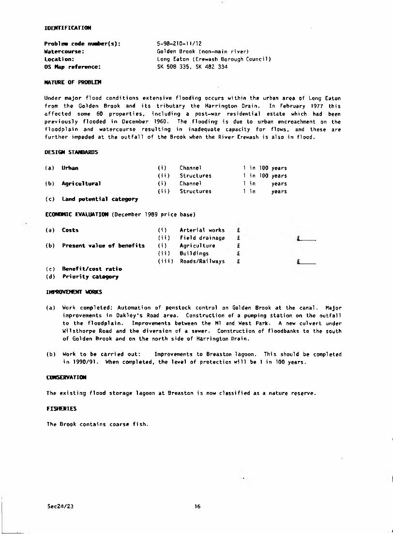
IDENTIFICATION
5-98-210-11/12
Golden Brook (non-main river)
Long Eaton (Erewash Borough Council)
SK 508 335, SK 482 334
NATURE OF PROBLEM
P rob lew code ntaber(s):
Watercourse:Location:
OS Hap reference:
Under major flood conditions extensive flooding occurs within the urban area of Long Eaton
from the Golden Brook and its tributary the Harrington Drain. In February 1977 this
affected some 60 properties, including a post-war residential estate which had been
previously flooded in December 1960. The flooding is due to urban encroachment on the
floodplain and watercourse resulting in inadequate capacity for flows, and these are
further impeded at the outfall of the Brook when the River Erewash is also in flood.
DESIQI STANDARDS
(i) Channel
(i i) Structures
(i) Channel
(i i) Structures
(a) Urban
(b) Agri cultural
(c) Land potential category
ECONOMIC EVALUATION (December 1989 price base)
(a) Costs
(b) Present value of benefits
(i) Arterial works
(i i) Field drainage
(i) Agriculture
(i i) Bui 1di ngs
(i i i) Roads/Railways
(c) Benefit/cost ratio(d) Priority category
1 in 100 years
1 in 100 years
1 in
1 i n
years
years
IHPROVOCNT WORKS
(a) Work completed: Automation of penstock control on Golden Brook at the canal. Major
improvements in Oakley's Road area. Construction of a pumping station on the outfall
to the floodplain. Improvements between the Ml and West Park. A new culvert under
Wilsthorpe Road and the diversion of a sewer. Construction of floodbanks to the south
of Golden Brook and on the north side of Harrington Drain.
(b) Work to be carried out: Improvements to Breaston lagoon. This should be completed
in 1990/91. When completed, the level of protection will be 1 in 100 years.
CONSERVATION
The existing flood storage lagoon at Breaston is now classified as a nature reserve.
FISHERIES
The Brook contains coarse fish.
Sec24/23 16
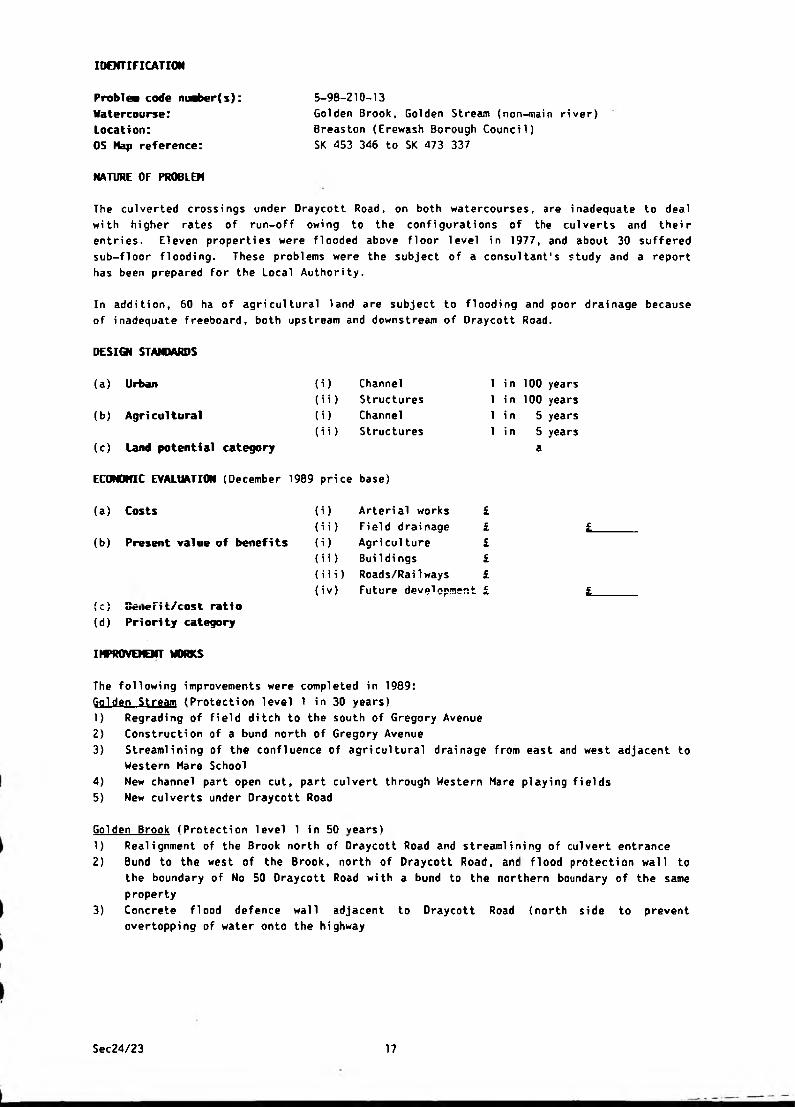
IDENTIFICATION
5-98-210-13
Golden Brook, Golden Stream (non-main river)
Breaston (Erewash Borough Council)
SK 453 346 to SK 473 337
NATURE OF PROBLEM
Problea code nuaber(s): Watercourse:Location:OS Hap reference:
The culverted crossings under Draycott Road, on both watercourses, are inadequate to deal
with higher rates of run-off owing to the configurations of the culverts and their
entries. Eleven properties were flooded above floor level in 1977, and about 30 suffered
sub-floor flooding. These problems were the subject of a consultant's study and a report
has been prepared for the Local Authority.
In addition, 60 ha of agricultural land are subject to flooding and poor drainage because
of inadequate freeboard, both upstream and downstream of Oraycott Road.
DESIGN STANDARDS
(a) Urban (i) Channel 1 in 100 years
(i i) Structures 1 i n 100 years
(b) Agricultural (i) Channel 1 in 5 years
(i i) Structures 1 i n 5 years
(c) Land potential category a
ECONOMIC EVALUATION (December 1989 price base)
(a) Costs (i) Arterial works £
(i i) Field drainage £ £(b) Present value of benefits (i) Agriculture £
(ii) Buildings £
(i i i) Roads/RaiIways £
(iv) Future development £ t-(c) SeiieFi t/cost ratio
(d) Priority category
IMPROVEMENT WORKS
The following improvements were completed in 1989:
Golden Stream (Protection level 1 in 30 years)
1) Regrading of field ditch to the south of Gregory Avenue
2) Construction of a bund north of Gregory Avenue
3) Streamlining of the confluence of agricultural drainage from east and west adjacent to
Western Mare School
4) New channel part open cut, part culvert through Western Mare playing fields
5) New culverts under Draycott Road
Golden Brook (Protection level 1 in 50 vears)
1) Realignment of the Brook north of Draycott Road and streamlining of culvert entrance
2) Bund to the west of the Brook, north of Draycott Road, and flood protection wall to
the boundary of No 50 Oraycott Road with a bund to the northern boundary of the same
property
3) Concrete f1ood defence wal1 adjacent to Oraycott Road (north side to prevent
overtopping of water onto the highway
Sec24/23 17

4) Streamlining the outfall from Draycott Road culvert and widening and regrading
downstream (adjacent to the "Crescent'1)
5) Reconstruction of accommodation bridge over the brook at the end of Marlborough Road.
FISHERIES
The Brook contains coarse fish.
Sec24/23 18
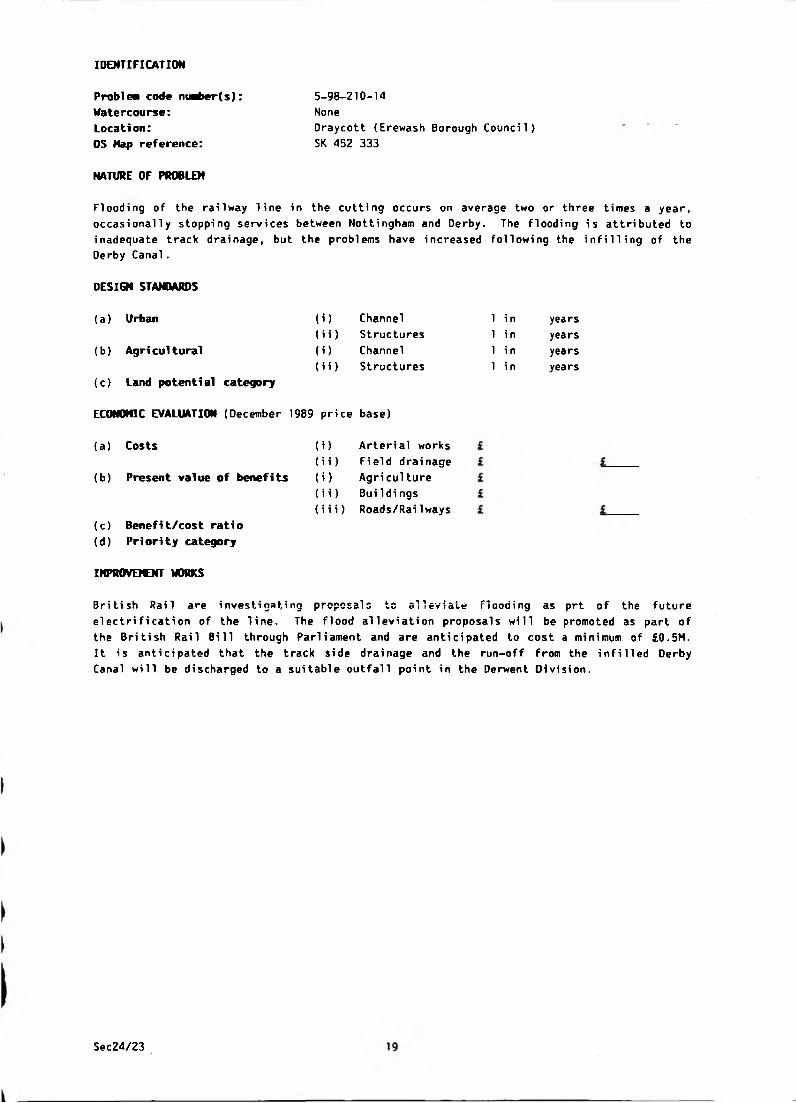
IDENTIFICATION
5-98-210-14
None
Draycott (Erewash Borough Council)
SK 452 333
NATURE OF PROBLEM
Problem code ntMber(s): Watercourse:Location:
OS Map reference:
Flooding of the railway line in the cutting occurs on average two or three times a year,
occasionally stopping services between Nottingham and Derby. The flooding is attributed to
inadequate track drainage, but the problems have increased following the infilling of the
Derby Canal.
DESIGN STANDARDS
(i)
(ii)
(i)
(ii)
(a) Urban
(b) Agri cultural
(c) Land potential category
ECONOMIC EVALUATION (December 1989 price base)
(a) Costs
(b) Present value of benefits
Channel
Structures
Channel
Structures
(i)
(ii)
(i)
(ii)
Arterial works
Field drainage
Agri culture
Buildi ngs
(i i i) Roads/Rai1ways
(c) Benefit/cost ratio(d) Priority category
1 i n
1 in
1 i n
1 i n
years
years
years
years
IMPROVEMENT WORKS
British Rail are investigating proposal; to alleviate flooding as prt of the future
electrification of the line. The flood alleviation proposals will be promoted as part of
the British Rail Bill through Parliament and are anticipated to cost a minimum of £0.5M.
It is anticipated that the track side drainage and the run-off from the infilled Derby
Canal will be discharged to a suitable outfall point in the Derwent Division.
Sec24/23
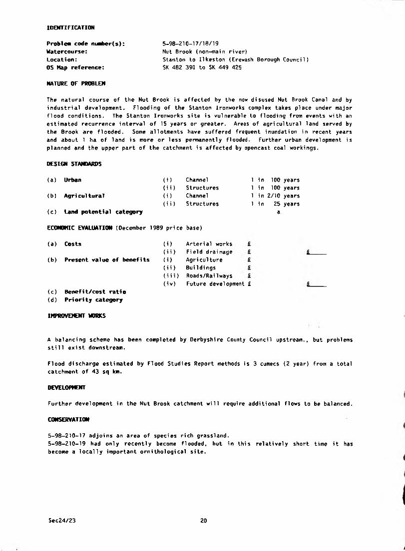
IDENTIFICATION
Problea code niMber(s): Watercourse:
Location:
OS Map reference:
NATURE OF PROBLEM
5-98-210-17/18/19
Nut Brook {non-main river)
Stanton to Ilkeston (Erewash Borough Council)
SK 482 390 to SK 449 425
The natural course of the Nut Brook is affected by the now disused Nut Brook Canal and by
industrial development. Flooding of the Stanton Ironworks complex takes place under major
flood conditions. The Stanton Ironworks site is vulnerable to flooding from events with an
estimated recurrence interval of 15 years or greater. Areas of agricultural land served by
the Brook are f 1 ooded. Some al1otments have suffered frequent i nundati on i n recent years
and about 1 ha of land is more or less permanently flooded. Further urban development is
planned and the upper part of the catchment is affected by opencast coal workings.
DESIGN STANDARDS
{a) Urban
(b) Agricultural
(c) Land potential category
(i) Channel
(ii) Structures
(i) Channel
(ii) Structures
1 in 100 years
1 in 100 years
1 in 2/10 years
1 in 25 years
a
ECONOMIC EVALUATION (December 1989 price base)
(a) Costs
(b) Present value of benefits
(c) Benefi t/cost rati o
(d) Priority category
i)
ii)
i)
ii)
iii)iv)
Arterial works
Field drainage
Agri culture
Bui 1 dings
Roads/Rai1 ways
Future development £
IMPROVEMENT WORKS
A balancing scheme has been completed by Derbyshire County Council upstream., but problems
still exist downstream.
Flood discharge estimated by Flood Studies Report methods is 3 cumecs (2 year) from a total
catchment of 43 sq km.
DEVELOPMENT
Further development in the Nut Brook catchment will require additional flows to be balanced.
CONSERVATION
5-98-210-17 adjoins an area of species rich grassland.
5-98-210-19 had only recently become flooded, but in this relatively short time it has
become a locally important ornithological site.
Sec24/23 20
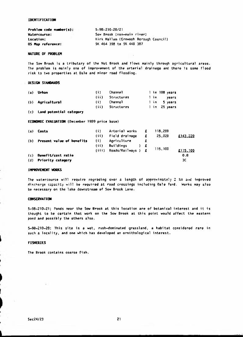
IDENTIFICATION
Problea code nuaber(s) Watercourse:Location:
OS Hap reference:
NATURE OF PROBLEM
5-98-210-20/21
Sow Brook (non-main river)
Kirk Hallam (Erewash Borough Council)
SK 464 398 to SK 440 387
The Sow Brook is a tributary of the Nut Brook and flows mainly through agricultural areas.
The problem is mainly one of improvement of the arterial drainage and there is some flood
risk to two properties at Dale and minor road flooding.
DESIGN STANDARDS
(a) Urban (1) Channel 1 in 100 years
(ii) Structures 1 in years
(b) Agri cultural (i) Channel 1 i n 5 years
(ii) Structures 1 i n 25 years
(c) Land potential category
ECONOMIC EVALUATION (December 1989 price base)
(a) Costs
(b) Present value of benefits
(i)
(ii)
(i)
(ii)(i i i)
Arterial works £
Field drainage £
Agriculture £
Buildings ) £
Roads/Railways ) £
118,20025,020
115,100
£143,220
£115.100
0.8
3C(c) Benefit/cost ratio
(d) Priority category
IMPROVEMENT WORKS
The watercourse will require regrading over a length of approximately 2 km and improved
discharge capacity win be required at road crossings including Dale Ford. Works may also
be necessary on the lake downstream of Sow Brook Lane.
CONSERVATION
5-98-210-21; Ponds near the Sow Brook at this location are of botanical interest and it is
thought to be certain that work on the Sow Brook at this point would affect the eastern
pond and possibly the others also.
5-98-210-20; This site is a wet, rush-dominated grassland, a habitat considered rare
such a locality, and one which has developed an ornithological interest.
FISHERIES
in
The Brook contains coarse fish.
Sec24/23 21
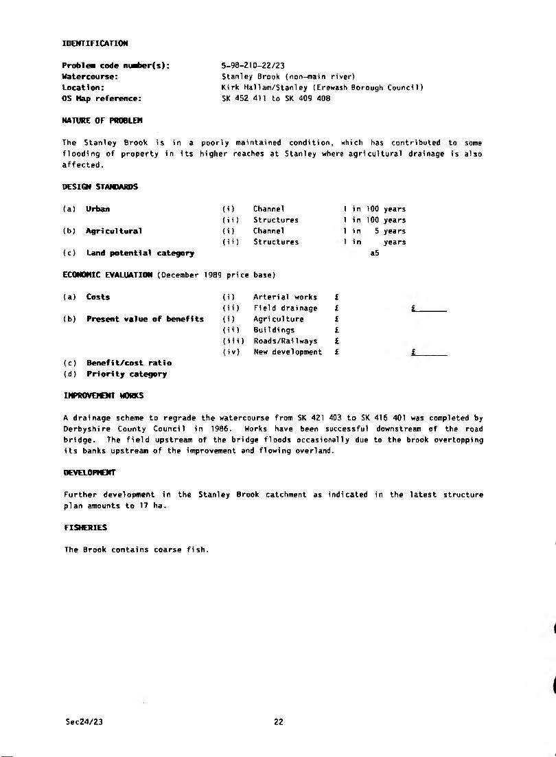
IDENTIFICATION
Problea code m*t>er(s):
Watercourse:Location:
OS Hap reference:
5-98-210-22/23
Stanley Brook (non-main river)
Kirk Hallam/Stanley (Erewash Borough Council)
SK 452 411 to SK 409 408
NATURE OF PROBLEM
The Stanley Brook is in a poorly maintained condition, which has contributed to some
flooding of property in its higher reaches at Stanley where agricultural drainage is al
affected.
so
DESIGN STAMMRDS
(a) Urban (O Channel 1 i n 100 years
(ii) Structures 1 i n 100 years
(b) Agricultural (i) Channel 1 i n 5 years
(ii) Structures i n years
(c) Land potential category a5
ECONOMIC EVALUATION (December 1989 pri ce base)
(a) Costs (i) Arterial works £
(ii) Field drainage £
(b) Present value of benefits (i) Agri cul ture £
(ii ) Buildings £
(i i i) Roads/RaiIways £
(iv) New development £
(c) Benefit/cost ratio
(d) Priority category
IMPROVEICNT WORKS
A drainage scheme to regrade the watercourse from SK 42 1 403 to SK 416 401 was completed by
Derbyshire County Council in 1986. Works have been successful downstream of the road
bridge. The field upstream of the bridge floods occasionally due to the brook overtopping
its banks upstream of the improvement and flowing overland.
DEVELOPMENT
Further development in the Stanley Brook catchment as indicated in the latest structure
plan amounts to 17 ha.
FISHERIES
The Brook contains coarse fish.
Sec24/23 22
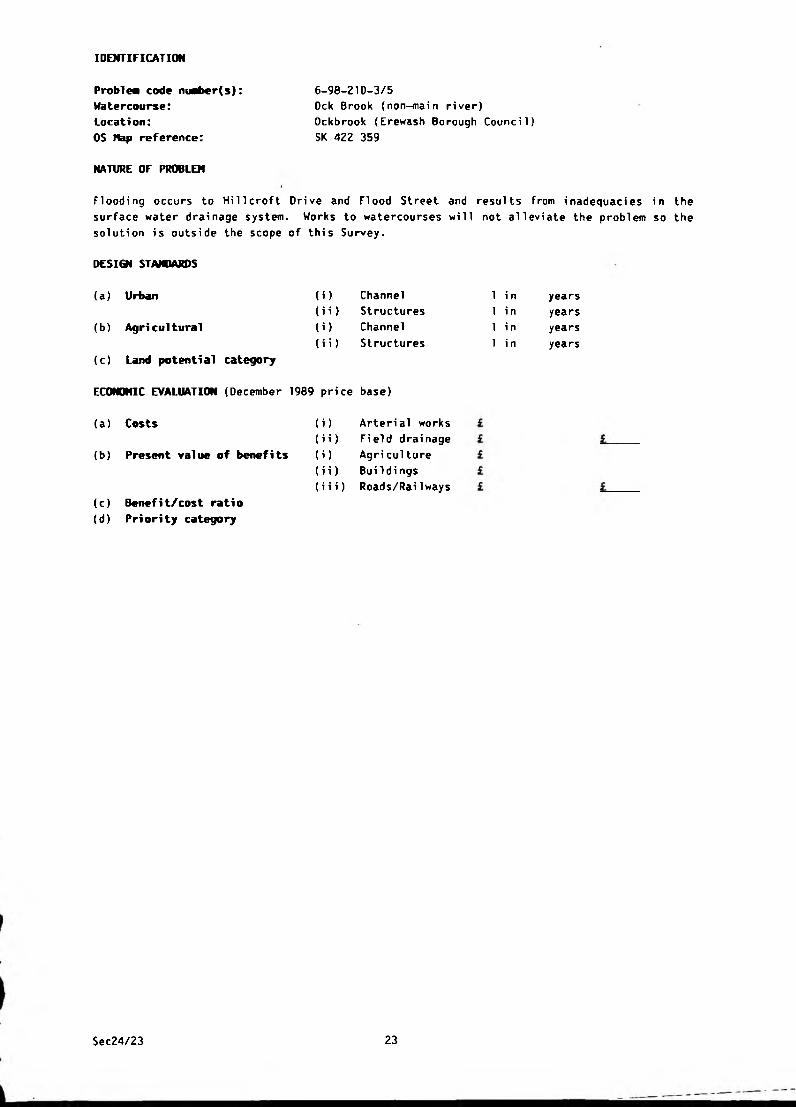
IDENTIFICATION
Problea code nuaber(s):
Watercourse:Location:OS Nap reference:
NATURE OF PROBLEM
6-98-210-3/5
Ock Brook (non-main river)
Ockbrook (Erewash Borough Council)
SK 422 359
Flooding occurs to Hi 11 croft Drive and Flood Street and results from inadequacies in the
surface water drainage system. Works to watercourses will not alleviate the problem so the
solution is outside the scope of this Survey.
DESIGN STAIOARDS
(a) Urban
(b) Agri cultural
(c) Land potential category
ECONOMIC EVALUATION (December 1989 price base)
(i) Channel
(i i) Structures
(i) Channel
(i i) Structures
1 i n
1 i n
1 i n
1 i n
years
years
years
years
(a) Costs
(b) Present value of benefits
(c) Benefit/cost ratio(d) Pri ori ty category
i) Arteri al works
i i) Fi eld drai nage
i) Agri culture
ii) BuiIdi ngs
i i i) Roads/RaiIways
Sec24/23 23

IDENTIFICATION
Problem code nuaber(s): Watercourse:Location:
OS Map reference:
NATURE OF PROBLEM
6-98-210-4
Ock Brook (non-main river)
Ockbrook {Erewash Borough Council)
SK 424 356
Flooding has occurred to 3 houses in Collier Lane and 3 houses in Cole Lane when the
culvert under Cole Lane becomes wholly or partially blocked by debris. Flooding last
occurred in February 1977.
DESIGN STANDARDS
(a) Urban
(b ) Agri cultural
(c) Land potential category
ECONOMIC EVALUATION (December 1989 price base)
(i)
(ii)
(i)
(ii)
Channel
Structures
Channel
Structures
1 in 100 years
1 in 100 years
1 i n years
1 in years
(a ) Costs
(b) Present value of benefits
(c) Benefit/cost ratio
(d) Priority category
(i) Arterial works
(i i) Fi eld drai nage
(i) Agri culture
(ii) Buildings
(i i i) Roads/Railways
118,200
2,500
£118.200
£2_. 500
0
3C
IM’ROVEICNT WORKS
The proposed solution requires the replacement of the culvert with a bridge, and tree
clearance and regrading of the Brook upstream and downstream of Cole Lane.
Sec24/23 24

IDENTIFICATION
6-98-210-7
None
Ockbrook (Erewash Borough Council)
SK 420 353
NATURE OF PROBLEM
Problem code ni^ier(s):
Watercourse:Location:
OS Map reference:
Flooding occurs to the Borrowash By-pass at the junction of Victoria Avenue and the A52
road. Flooding, which last occurred in February 1977, results from inadequate farm and
highway ditches. Works to watercourses will not alleviate the problem and the solution is,
therefore, outside the scope of the Survey.
DESIGN STANDARDS
(a) Urban
(b) Agricultural
(c) Land potential category
ECONOMIC EVALUATION (December 1989 price base)
(i)
(ii)
(i)
(ii)
Channel
Structures
Channel
Structures
(a) Costs
(b) Present value of benefits
(c) Benefit/cost ratio(d) Priority category
) Arterial works
i) Field drainage
) Agri culture
i) Buildi ngs
(i i i) Roads/RaiIways
1 in
1 in
1 in
1 in
years
years
years
years
Sec24/23 25

IDENTIFICATION
6-98-210-8.
Un-named tributary of Ock Brook (non-main river)
Ockbrook {Erewash Borough Council)
SK 423 366
NATURE OF PROBLEM
P rob lea code niaber(s): Watercourse:Location:
OS Hap reference:
Flooding occurs to Moor Lane and Dale Road, the last occasion being February 1977. The
flooding results from the inadequacy of the highway surface water drainage system and a
solution to the problem is, therefore, outside the scope of this Survey.
DESIGN STANDARDS
(i) Channel
{i i) Structures
Channel
(a) Urban
(b) Agricultural
(c) Land potential category
ECONOMIC EVALUATION (December 1989 price base)
O )(i i) Structures
(a) Costs
(b) Present value of benefits
(c) Benefit/cost ratio(d) Priority category
1 in
1 in
1 i n
1 in
i) Arterial works £
i i) Field drai nage £
i) Agri culture £
i i) Bui 1di ngs £
i i i) Roads/RaiIways £
years
years
years
years
Sec24/23 26
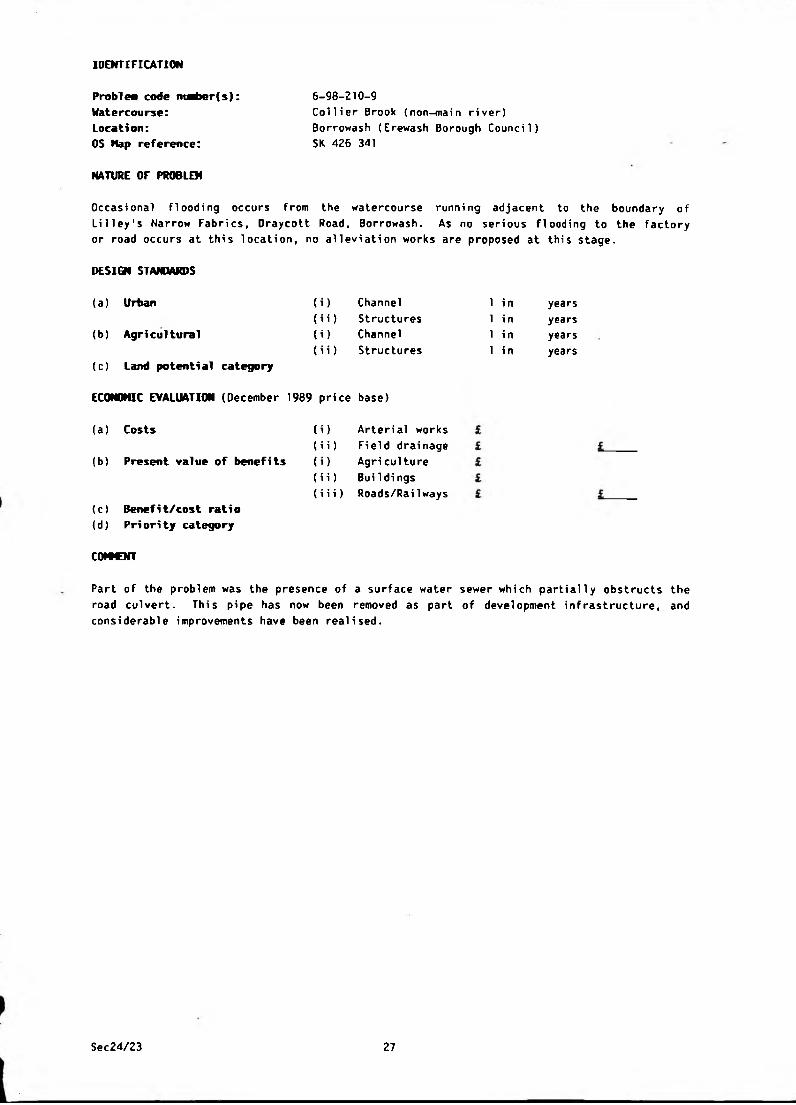
IDENTIFICATION
Problem code nt^>er(s): 6-98-210-9Watercourse: Collier Brook (non-main river)
Location: Borrowash (Erewash Borough Council)
05 Nap reference: SK 426 341
NATURE OF PROBLEM
Occasional flooding occurs from the watercourse running adjacent to the boundary of
Li 1 ley's Narrow Fabrics, Draycott Road, Borrowash. As no serious flooding to the factory
or road occurs at this location, no alleviation works are proposed at this stage.
DESIGN STANDARDS
(i)
(ii)
(i)
(ii)
(a) Urban
(b) Agri cultural
(c) Land potential category
ECONOMIC EVALUATION (December 1989 price base)
(a) Costs
(b) Present value of benefits
Channel
Structures
Channel
Structures
) Arterial works
i) Field drainage
) Agriculture
i) Buildings
i i) Roads/Rai Iways
(c) Benefit/cost ratio(d) Pri ori ty category
1 i n
1 i n
1 i n
1 i n
years
years
years
years
COWCNT
Part of the problem was the presence of a surface water sewer which partially obstructs the
road culvert. This pipe has now been removed as part of development infrastructure, and
considerable improvements have been realised.
Sec24/23 27

IDENTIFICATION
Problea code nuaber(s):
Watercourse:Location:OS Nap reference:
NATURE OF PROBLEM
6-98-210-11
Un-named (non-main river)
Oraycott (Erewash Borough Council)
SK 443 334
FIooding occurred to property on Wi1ne Road and the boi1er room at Draycott School in
October 1965, July and August 1973 and February 1977. Minor flooding has also occurred to
agricultural land.
DESIGN STAMMRDS
(a) Urban
(b) Agri cultural
(c) Land potenti al category
ECONOMIC EVALUATION (December 1989 price base)
(i)
(ii)
(i)
(ii)
Channel
Structures
Channel
Structures
1 i n
1 i n
1 i n
1 i n
years
years
years
years
(a) Costs (i) Arterial works £
(ii) Field drainage £ i(b) Present value of benefits ( O Agri culture £
(ii) Buildi ngs £
(iii) Roads/RaiIways £ i(c) Benefit/cost ratio(d) Priority category
IMPROVEMENT WORKS
Flooding on Wilne Road largely results from the surcharging of the foul sewerage system
and, as such, the solution is outside the scope of this Survey.
The flooding to the boiler room at Draycott School is partially attributable to groundwater
percolation and, although improvements to the watercourse will have a slight effect on this
problem, it will not solve it. The solution is also, therefore, outside the scope of this
Survey.
The culvert inlet upstream of the School has been improved and the Borough Council are
considering increasing the ditch size upstream to provide greater flood storage.
Sec24/23 28

IDENTIFICATION
6-98-210-12
Rivers Derwent/Trent (main river)
Shardlow (Erewash Borough Council)
SK 452 315
NATURE OF PROBLEM
Problea code niaber(s): Watercourse:Location:
OS Kap reference:
Agricultural land and Wilne Lane, both within the floodplains of the Rivers Derwent and
Trent, are flooded from time to time. Inundation of this area during times of high flows
in the rivers is essential to protect urban areas downstream, and no proposals can be
recommended for the improvement of this problem.
DESIGN STANDARDS
(i)
(ii)
(i)
(ii)
(a) Urban
(b) Agricultural
(c) Land potenti al category
ECONOMIC EVALUATION (December 1989 price base)
(a) Costs
(b) Present value of benefits
Channel
Structures
Channel
Structures
(c) Benefit/cost ratio(d) P H ori ty category
IMPROVEMENT WORKS
1 i n
1 in
1 in
1 in
(i) Arterial works £
(ii) Field drainage £
(i) Agriculture £
(ii) Buildings £
(i i i) Roads/Railways £
years
years
years
years
Improvements to Wilne Drain and the Great Wilne defences wore
completed in 1981.
tuv jM*r*uiow
Sec24/23 29
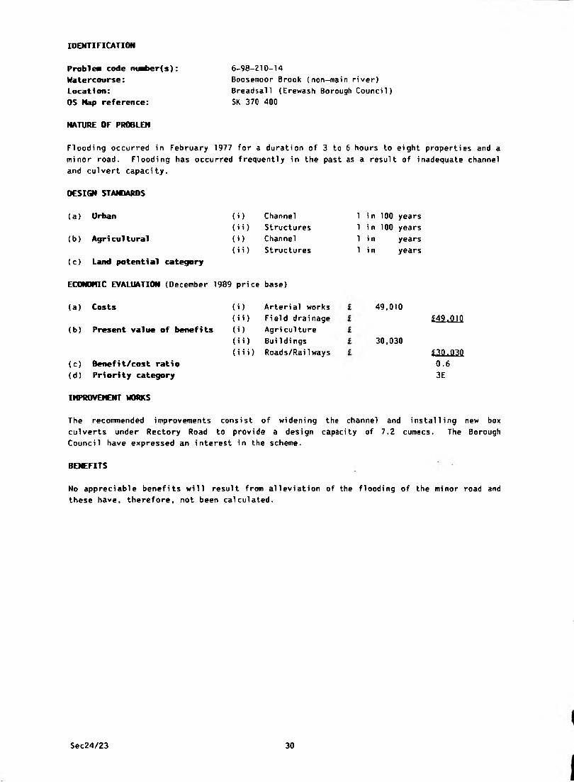
6-98-210-14
Boosemoor Brook (non-main river)
Breadsall (Erewash Borough Council)
SK 370 400
NATURE OF PROBLEM
IDENTIFICATION
Problen code ni^>er(s):
Watercourse:Location:
OS Map reference:
Flooding occurred in February 1977 for a duration of 3 to 6 hours to eight properties and a
minor road. Flooding has occurred frequently in the past as a result of inadequate channel
and culvert capacity.
DESIGN STAIOARDS
(a) Urban
(b) Agri cultural
(c) Land potential category
ECONOMIC EVALUATION (December 1989 price base)
(i) Channel
(ii) Structures
(i) Channel
(i i) Structures
(a ) Costs
(b) Present value of benefits
(c) Benefit/cost ratio(d) Priority category
(i) Arterial works
(i i) Field drai nage
(i) Agri culture
(i i) Buildings
(iii) Roads/Rai1 ways
1 in 100 years
1 in 100 years
1 i n years
1 i n years
49,010
30,030
£49.010
£30.030
0.63E
IMPROVEMENT WORKS
The recommended improvements consist of widening the channel and installing new box
culverts under Rectory Road to provi de a design capacity of 7.2 cumecs. The Borough
Council have expressed an interest in the scheme.
BENEFITS
No appreciable benefits will result from alleviation of the flooding of the minor road and
these have, therefore, not been calculated.
Sec24/23 30
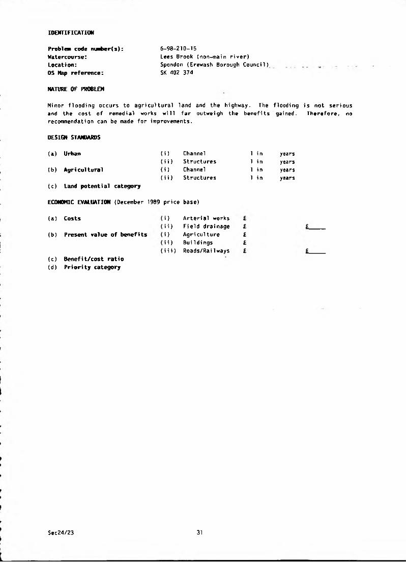
6-98-210-15
Lees Brook (non-main river)
Spondon (Erewash Borough Council)
SK 402 374
NATURE OF PROBLEM
IDENTIFICATION
Problea code niartier(s): Watercourse:Location:
OS Map reference:
Minor flooding occurs to agricultural land and the highway. The flooding is not serious
and the cost of remedial works will far outweigh the benefits gained. Therefore, no
recommendation can be made for improvements.
DESIGN STANDARDS
(a) Urban
(b) Agri cultural
(c) Land potential category
ECONOMIC EVALUATION (December 1989 price base)
(i)
(ii)
(i)
(ii)
Channel
Structures
Channel
Structures
(a) Costs
(b) Present value of benefits
(c) Benefit/cost ratio
(d) Pri ori ty category
) Arterial works
i) Field drainage
) Agri cul ture
i) Buildings
(i i i) Roads/Rai1 ways
1 i n
1 in
1 in
1 in
years
years
years
years
Sec24/23 31

IDENTIFICATION
Problea code nuaber(s):
Watercourse:
Location:
OS Nap reference:
6-98-210-17
Dam Brook (non-main river)
Breadsall (Erewash Borough Council)
SK 370 388
NATURE OF PROBLEM
Five houses, a shop and a telephone exchange (subsequently converted to a house) on
Brookside Road and Rectory Lane were flooded in 1965 and 1977 for durations of 3 to 6
hours. Minor roads have also been flooded.
DESIGN STANDARDS
(a ) Urban Channel 1 in 100 years
{i i) Structures 1 in 100 years
(b ) Agri cultural <i> Channel 1 in years
(ii) Structures 1 in years
(c) Land potential category
ECONOMIC EVALUATION (December 1989 price base)
(a) Costs (i) Arterial works £ 236,400
(ii) Field drainage £ £236.400(b) Present value of benefits (i) Agri culture £
(ii) Buildi ngs £ 17,510
(iii) Roads/Railways £ £17.510
(c) Benefit/cost ratio 0.1
(d) Priority category 3C
IMPROVQCNT WORKS
The recommended solution will provide a design capacity of 6 4 cumecs and requires:
i) The construction of a new box culvert at the junction of Rectory Lane/Brookside
Road/Croft Lane.
ii) The replacement of several access bridges to property on the south side of Brookside
Road.
iii) Regrading, lining and the construction of low flood walls to the section upstream of
the new culvert.
iv) Deepening and widening of the channel downstream of the new culvert.
BENEFITS
It has been estimated that the 100 years flood will affect twelve houses, a shop and a
minor road. The benefit from alleviation of flooding to the road is small and has not,
therefore, been assessed.
Sec24/23 32
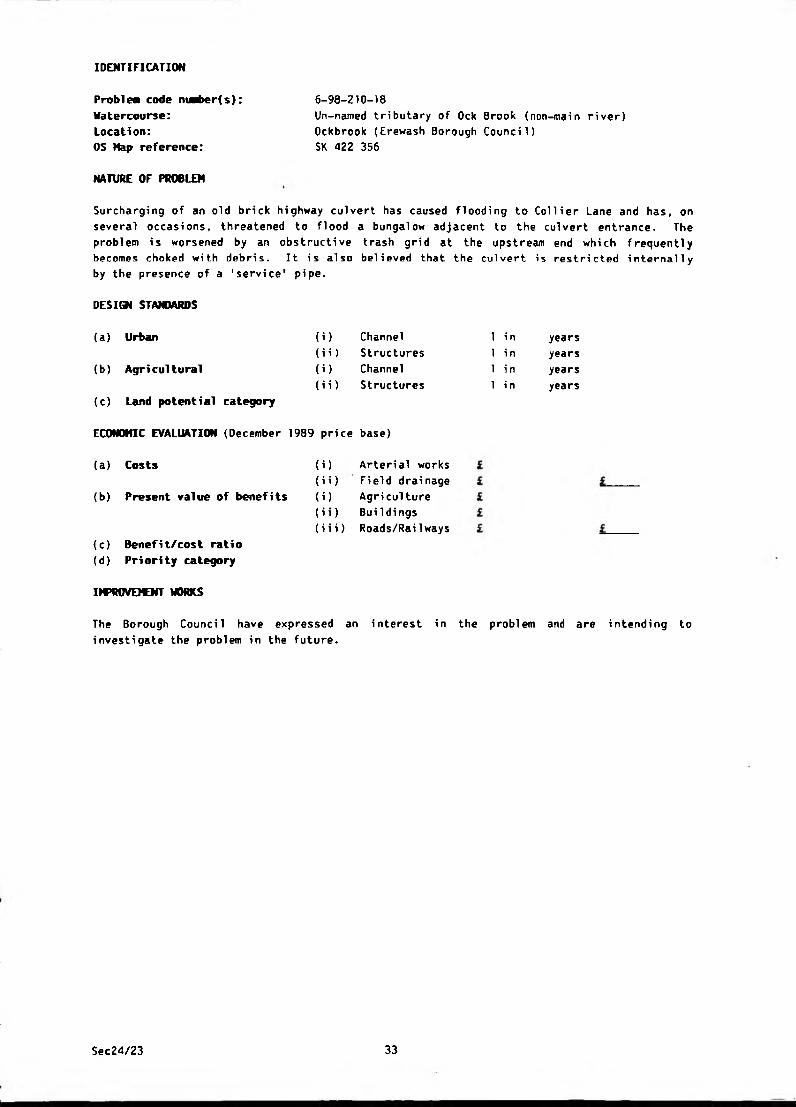
IDENTIFICATION
Problea code nuaber(s): Watercourse:Location:
OS Hap reference:
NATURE OF PROBLEM
6-98-210-18
Un-named tributary of Ock Brook (non-main river)
Ockbrook (Erewash Borough Council)
SK 422 356
Surcharging of an old brick highway culvert has caused flooding to Collier Lane and has, on
several occasions, threatened to flood a bungalow adjacent to the culvert entrance. The
problem is worsened by an obstructive trash grid at the upstream end which frequently
becomes choked with debris. It is also believed that the culvert is restricted internally
by the presence of a 'service' pipe.
DESIGN STANDARDS
(a) Urban
(b) Agri cultural
(c) Land potential category
ECONOMIC EVALUATION (December 1989 price base)
(i)
(ii)
(i)
(ii)
Channel
Structures
Channel
Structures
1 i n
1 in
1 i n
1 in
years
years
years
years
(a) Costs
(b) Present value of benefits
(c) Benefi t/cost rati o
(d) Priority category
IMPROVEMENT WORKS
(i) Arterial works
(i i) Field drai nage
(i) Agriculture
(i i) BuiIdings
(iii) Roads/Railways
The Borough Council have expressed an interest in the problem and are intending to
investigate the problem in the future.
Sec24/23 33
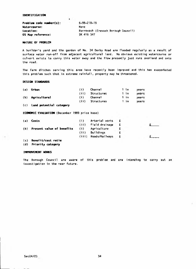
IDENTIFICATION
Problea code niaber(s): 6-98-210-19
Watercourse: None
Location: Borrowash (Erewash Borough Council)
OS Hap reference: SK 416 347
NATURE OF PROBLEM
A builder's yard and the garden of No. 34 Derby Road are flooded regularly as a result of
surface water run-off from adjacent agricultural land. No obvious existing watercourse or
culvert exists to carry this water away and the flow presently just runs overland and onto
the road.
The farm ditches serving this area have recently been improved and this has exacerbated
this problem such that in extreme rainfall, property may be threatened.
(i)
(ii)
(i)
(ii)
DESIGN STANDARDS
(a) Urban
(b) Agri cultural
(c) Land potential category
ECONOMIC EVALUATION (December 1989 price base)
(a) Costs
(b) Present value of benefits
Channel
Structures
Channel
Structures
1 i n
1 in
1 i n
1 i n
years
years
years
years
Arterial works
Field drainage
Agri culture
BuiIdings
i i) Roads/RaiIways
(c) Benefit/cost ratio(d) Priority category
IMPROVEMENT WORKS
The Borough Council are aware of this problem and are intending to carry out an
investigation in the near future.
Sec24/23 34
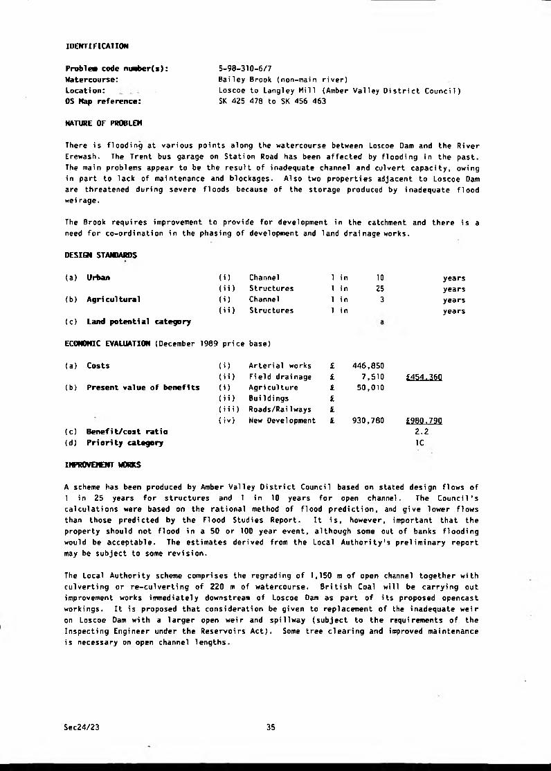
IDENTIFICATION
5-98-310-6/7
Bailey Brook (non-main river)
Loscoe to Langley Mill (Amber Valley District Council)
SK 425 478 to SK 456 463
NATURE OF PROBLEM
Problea code nnber(s): Watercourse:Location:OS Map reference:
There is flooding at various points along the watercourse between Loscoe Dam and the River
Erewash. The Trent bus garage on Station Road has been affected by flooding in the past.
The main problems appear to be the result of inadequate channel and culvert capacity, owing
in part to lack of maintenance and blockages. Also two properties adjacent to Loscoe Dam
are threatened during severe floods because of the storage produced by inadequate flood
wei rage.
The Brook requires improvement to provide for development in the catchment and there is a
need for co-ordination in the phasing of development and land drainage works.
DESIGN STANDARDS
(a) Urban (i) Channel
(i i) Structures
(b) Agricultural (i) Channel
(i i) Structures
(c) Land potential category
ECONOMIC EVALUATION (December 1989 price base)
1 in
1 i n
1 i n
1 i n
1025
3
years
years
years
years
(a) Costs
(b) Present value of benefits
(c) Benefit/cost ratio
(d) Priority category
{i) Arteri al works £
(ii) Field drainage £
(i) Agri culture £
(ii) Buildings £
(iii) Roads/RaiIways £
(iv) New Development £
446,850
7,51050,010
930,780
£454^360
£980.790
2.2 1C
imiOVEICNT WORKS
A scheme has been produced by Amber Valley District Council based on stated design flows of
1 in 25 years for structures and 1 in 10 years for open channel. The Council's
calculations were based on the rational method of flood prediction, and give lower flows
than those predicted by the Flood Studies Report. It is, however, important that the
property should not flood in a 50 or 100 year event, although some out of banks flooding
would be acceptable. The estimates derived from the Local Authority's preliminary report
may be subject to some revision.
The Local Authority scheme comprises the regrading of 1,150 m of open channel together with
culverting or re-culverting of 220 m of watercourse. British Coal will be carrying out
improvement works immediately downstream of Loscoe Dam as part of its proposed opencast
workings. It is proposed that consideration be given to replacement of the inadequate weir
on Loscoe Dam wi th a larger open wei r and spi 11way (subject to the requi remen ts of the
Inspecting Engineer under the Reservoirs Act). Some tree clearing and improved maintenance
is necessary on open channel lengths.
Sec24/23 35
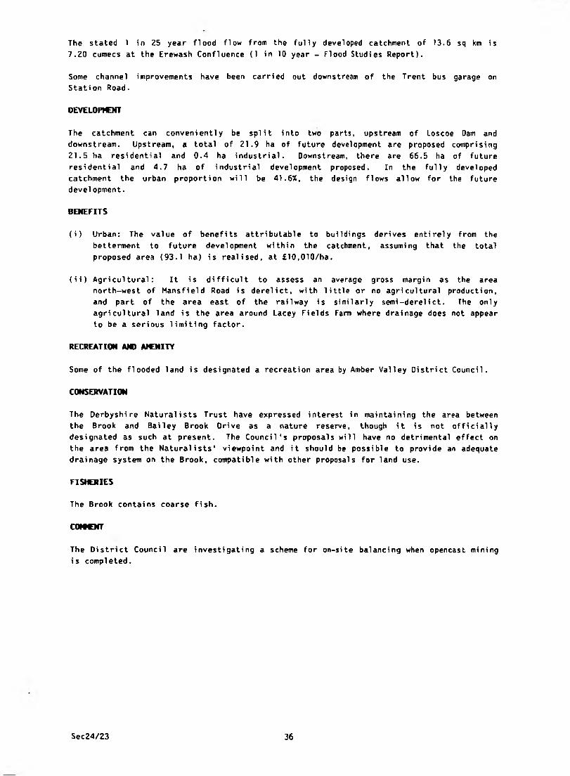
The stated 1 in 25 year flood flow from the fully developed catchment of 13.6 sq km is
7.20 cumecs at the Erewash Confluence (1 in 10 year - Flood Studies Report).
Some channel improvements have been carried out downstream of the Trent bus garage on
Station Road.
DEVELOPMENT
The catchment can convenientl y be spl i t i nto two parts, upstream of Loscoe Dam and
downstream. Upstream, a total of 21.9 ha of future development are proposed comprising
21.5 ha residential and 0.4 ha industrial. Downstream, there are 66.5 ha of future
residential and 4.7 ha of industrial development proposed. In the fully developed
catchment the urban proportion wi 11 be 41.6%, the design flows al 1 ow for the future
development.
BENEFITS
(i) Urban: The value of benefits attributable to buildings derives entirely from the
betterment to future development wi thin the catchment, assumi ng that the total
proposed area (93.1 ha) is realised, at £10,010/ha.
(ii) Agricultural: It is difficult to assess an average gross margin as the area
north-west of Mansfield Road is derelict, with little or no agricultural production,
and part of the area east of the rai lway is si mi lari y semi-derel i ct. The only
agricultural land is the area around Lacey Fields Farm where drainage does not appear
to be a serious limiting factor.
RECREATION AMI AMENITY
Some of the flooded land is designated a recreation area by Amber Valley District Council.
CONSERVATION
The Derbyshire Naturalists Trust have expressed interest in maintaining the area between
the Brook and Bailey Brook Drive as a nature reserve, though it is not officially
designated as such at present. The Council*s proposals will have no detrimental effect on
the area from the Naturalists' viewpoint and it should be possible to provide an adequate
drainage system on the Brook, compatible with other proposals for land use.
FISHERIES
The Brook contains coarse fish.
COMCNT
The District Council are investigating a scheme for on-site balancing when opencast mining
is completed.
Sec24/23 36
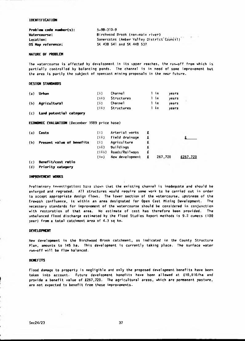
IDENTIFICATION
Problea code ni^er(s): 5-98-310-9
Watercourse: Birchwood Brook (non-main river)
Location: Somercotes (Amber Valley District'Council)
OS Map reference: SK 438 541 and SK 448 537
NATURE OF PROBLEM
The watercourse is affected by development in its upper reaches, the run-off from which is
parti ally control 1ed by balanci ng ponds. The channel is in need of some i mprovement but
the area is partly the subject of opencast mining proposals in the near future.
DESIGN STAMMRDS
(a) Urban (i) Channel 1 in years
(i i) Structures 1 in years
(b) Agricultural (i) Channel 1 in years
(ii) Structures 1 in years
(c) Land potential category
ECONOMIC EVALUATION (December 1989 price base)
(a) Costs (i) Arterial works £
(ii) Field drainage £
(b) Present value of benefits (i) Agri cul ture £
(ii) Buildi ngs £
(iii) Roads/Rai1ways £
(iv) New development £
(c) Benefit/cost ratio(d) Pri ori ty category
IMPROVEMENT WORKS
Preliminary investigations have shown that the existing channel is inadequate and should be
enlarged and regraded. All structures would require some work to be carried out in order
to accept appropriate design flows. The lower section of the watercourse, upstream of the
Erewash confluence, is within an area designated for Open Cast Mining Development. The
necessary standards for improvement of the watercourse should be considered in conjunction
with restoration of that area. No estimate of cost has therefore been provided. The
unbalanced flood discharge estimated by the Flood Studies Report methods is 9.2 cumecs (100
year) from a total catchment area of 4.3 sq km.
DEVELOPVOfT
New development in the Birchwood Brook catchment, as indicated in the County Structure
Plan, amounts to 145 ha. This development is currently taking place. The surface water
run-off will be flow balanced.
BENEFITS
Flood damage to property is negligible and only the proposed development benefits have been
taken into account. Future development benefits have been allowed at £10,010/ha and
provide a benefit value of £267,720. The agricultural areas, which are permanent pasture,
are not expected to benefit from these improvements.
Sec24/23 37
IDENTIFICATION
Problea code nuMber(s): Watercourse:Location:
OS Kap reference:
NATURE OF PROBLEM
6-98-310-1
Windley Brook {non-main river)
Hindley (Amber Valley District Council)
SK 311 450
An inadequate channel section and obstructive culverts cause flooding to Windley Hall,
Windley Cottage, the cheese factory and the associated grounds, garages etc.
DESIGN STANDARDS
(a) Urban
(b) Agri cultural
(c) Land potential category
ECONOMIC EVALUATION (December 1989 price base)
(i)
(ii)
<i)
(ii)
Channel
Structures
Channel
Structures
1 in 100 years
1 in 100 years
1 in years
1 in years
(a) Costs
(b) Present value of benefits
(c) Benefi t/cost rati o(d ) Pri ori ty category
(i) Arterial works
(i i) Field drainage
(i) Agri cultore
(ii) Buildings
{iii) Roads/Railways
66,310
17,510
£66,310
£ 1 7 .5 100.3
3D
IMPROVEMENT WORKS
The proposed scheme consists essentially of the provision of a floodbank together with an
improved channel section and new culverts at the accesses to the Windley Hall complex.
These works will provide for a design capacity of 11,3 cumecs.
BENEFITS
The principal benefits of the scheme are flood protection to the Windley Hall buildings and
its garden.
CONSERVATION
Windley Hall is a listed building.
NOTE
Surface water problems were also reported in Windley Village on Flower Lilies Drive and the
steeply inclined B5024 Windley-Turnditch Road. These problems however, fall outside the
scope of this Survey.
Sec24/23 38
IDENTIFICATION
Problem code niaber(s): Watercourse:Location:
OS Hap reference:
6-98-310-2
Buckland Hollow Brook (non-main river)
Pentrich (Amber Valley District" CounciT)
SK 376 518
NATURE OF PROBLEM
A private road off the B6013 and adjacent land and pasture land at Lower Hartshay are
subject to flooding caused by the backing up of the minor watercourse when the River Amber
is in flood. It is anticipated that flooding from the Brook would be alleviated
considerably if improvements were carried out on the River Amber.
DESIGN STANDARDS
(a) Urban (i) Channel 1 in years
(b) Agri cultural
(ii) Structures
(i) Channel
(ii) Structures
1 i n
1 i n
1 in
years
years
years
(c) Land potential category
ECONOMIC EVALUATION (December 1989 price base)
(a) Costs
(b) Present value of benefits
(i) Arterial works
(i i) Field drai nage
(i) Agriculture
£££££
L
(i i) BuiIdings
(iii) Roads/Railways L(c) Benefi t/cost rati o
(d). Priority category
Sec24/23 39
6-98-310-3
Flagshaw Brook (non-main river)
Kirk Langley (Amber Valley District Council)
SK 281 388
NATURE OF PROBLEM
IDENTIFICATION
Problea code maber(s): Watercourse:Location:OS Map reference:
The FI agshaw Brook runs through the front garden of Li lac Cottage, then underneath the
adjacent cottage and finally a piped culvert under Church Lane before flowing to the
Mackworth Brook as open channel.
The gardens and garages of the two cottages are subject to infrequent flooding together
with a section of Church Lane.
As no serious flooding occurs to property or land, flood alleviation works have not been
considered at this stage.
DESI0I STANDARDS
(a) Urban
(b) Agri cultural
(c) Land potential category
ECONOMIC EVALUATION (December 1989 price base)
( i )(ii)
(i>
(ii)
Channel
Structures
Channel
Structures
1 in
1 i n
1 i n
1 i n
years
years
years
years
(a) Costs (i) Arterial works £
(ii) Field drainage £ i(b) Present value of benefits (i) Agri cul ture £
(ii) Buildi ngs £
(iii) Roads/Railways £ i(c) Benefit/cost ratio
(d) Priority category
Sec24/23 40
IDENTIFICATION
P n b l n code niMber(s):
Watercourse:Location:OS Kap reference:
NATURE OF PROBLEM
6-98-310-5
Franker Brook (non-main river)
Turnditch (Amber Valley Di stri ct Co’unci 1)
SK 307 468
In times of flood, Franker Brook and surface water from Cowers Lane surcharge the Brook
culvert under the B5023 and flood the gardens of The Hawthorns. Since no serious flooding
to property occurs, no alleviation works are proposed.
DESIGN STAM1ARDS
(a) Urban
(b) Agricultural
(c) Land potential category
( i ) (ii)
(i)
(ii)
Channel
Structures
Channel
Structures
1 in
1 in
1 in
1 in
years
years
years
years
ECONOHIC EVALUATION (December 1989 price base)
(a) Costs
(b) Present value of benefits
(c) Benefit/cost ratio
(d) Priority category
)
i)
)
i)
(iii)
Arterial works £
Field drainage £
Agri culture £
Buildings £
Roads/RaiIways £
Sec24/23 41
IDENTIFICATION
Problea code maber(s):
Watercourse:Location:OS Map reference:
6-98-310-6/19
Coppice Brook tributaries (non-main river)
Bel per/Ripley (Amber Valley District Council)
SK 393 500 to SK 344 471
NATURE OF PROBLEM
Flooding occurs to three houses at Bullsmoor, eight houses and a School at Farm Close/Alton
Road and two farms. The railway line in Belper also floods as does land in the floodplain
of the Coppice Brook and its tributaries. Flooding occurred in December 1965, Summer 1973
and February 1977.
DESIGN STANDARDS
(a) Urban (i) Channel
(ii) Structures
(b ) Agri cultural (i ) Channel
(ii) Structures
(c) Land potential category
ECONOMIC EVALUATION (December 1989 price base)
(a) Costs (i > Arteri al works £
(ii) Field drainage £
(b) Present value of benefits (i) Agri culture £
(ii) BuiIdings £
(iii) Roads/RaiIways £
(c) Benefi t/cost rati o(d) Priority category
IMPROVEMENT WORKS
1 in 10 years
1 in 50 years
1 i n years
1 i n years
Bui 1smoor
Flood alleviation works consisting of replacement box culverting and watercourse
improvements were completed in 1983.
Farm Close/Alton Road
A new length of box culvert has been provided behind the Belper High School and the County
Council have improved the road culvert below Kilburn Road. These works were completed in
1983.
Coppice Brook (Generally)
A 30,000 m balancing reservoir (1 in 25 years standard) has been constructed near Belper
High School. This was completed in 1984 and a further balancing reservoir and other
channel improvement works are planned for the future. These future works will allow
further development to take place within this catchment area.
cottonThe Consulting Engineers Report dated 1978, commissioned by the District Council,
identified £1.135m (1978 price base) of engineering works to alleviate flooding. The
Council has an ongoing programme of improvement works to phase expenditure.
Sec24/23 42

IDENTIFICATION
P rob lew code nuaber(s):
Watercourse:
Location:OS Hap reference:
NATURE OF PROBLEM
6-98-310-7
River Ecclesbourne (non-main river)
Turnditch (Amber Valley District Council)
SK 294 478
One property, South Vi ew, si tuated near the confluence of the River Ecclesbourne and
Sherbourne Brook, suffers regularly from flooding (five times in the last 20 years).
(i)
(ii)
(i)
(ii)
DESIGN STANDARDS
(a) Urban
(b) Agri cultural
(c) Land potential category
ECONOMIC EVALUATION (December 1989 price base)
(a) Costs
(b) Present value of benefits
Channel
Structures
Channel
Structures
i) Arterial works
i) Field drainage
) Agri culture
i) Buildings
i i) Roads/Rai1ways
(c) Benefit/cost ratio(d) Priority category
1 in years
1 in 100 years
1 in years
1 in years
31,710
22,520
£31.710
£22.520
0.7
3E
IMPTOVEJOrr WORKS
It is suggested that a floodbank is constructed around South View combined with a road ramp
and the filling/shaping of a disused ford to provide a 1 in 100 years standard.
NOTE
Flooding of agricultural land adjacent to the River Ecclesbourne occurs but investigations
have shown that existing freeboard is approximately 1.8 m under normal flow conditions. It
is considered that the reduction in frequency of flooding effected by further channel
improvement would only yield marginal increases in gross margins. The benefits and costs
of such a scheme have, therefore, not been evaluated.
FISHERIES
The Ecclesbourne is a good trout fishery and consultation will be necessary.
Sec24/23 43

6-98-310-9/26/27
River Amber (main river)
South Wingfield (Amber Valley District Council)
SK 387 566 to SK 347 515
NATURE OF PROBLEM
IDENTIFICATION
Problea code nuaber(s):
Watercourse:Location:
OS Hap reference:
530 ha of the River Amber washland (two thirds of which is pasture and the remainder
industrial, housing, wastelands or woods) suffer from flooding and inadequate arterial
drainage. Flooding has occurred in 1965, 1973 and 1977. A church, 2 houses and a factory
have been flooded.
(i)
(ii)
(i)
(ii)
DESIGN STANDARDS
(a) Urban
(b) Agricultural
(c) Land potential category
ECONOMIC EVALUATION (December 1989 price base
(a) Costs
(b) Present value of benefits
Channel
Structures
Channel
Structures
(i) Arterial works
(i i ) Fi eld drainage
(i) Agri culture
(i i) Bui 1 dings
(iii) Roads/Railways
(c) Benefit/cost ratio(d) Priority category
1 in
1 i n
1 i n
1 i n
years
years
years
years
150,130
147,250
£147.250
IMPROVEMENT WORKS
The NRA is not intending to implement any comprehensive flood alleviation works on the
River Amber in the foreseeable future due to the lack of benefit. Certain limited
alleviation works may be carried out in the long term provided that a favourable
benefit/cost ratio can be achieved.
BENEFITS
The owner of a large proportion of the benefit area is opposed to an improvement scheme.
FISHERIES
This site is an existing coarse fishery.
Sec24/23 44

IDENTIFICATION
Problea code nuaber(s): Watercourse:Location:
OS Map reference:
6-98-310-10
Gypsy Brook (non-main river)
Horsley Woodhouse (Amber Valley District Council) SK 395 445
NATURE OF PROBLEM
The road flooding problem, reported in the vicinity of the Gypsy Brook culvert on Wood
Lane, is the result of heavy silting of the old stone culverts and inadequate surface water
drainage at the local low spot. Minor road flooding last occurred in July 1982 but the
road was still passable.
Such remedial measures involving maintenance and surface water drainage works fall outside
the scope of this Survey.
DESIGN STAMMRDS
(a) Urban (i) Channel 1 in years
(b) Agri cultural(i i) Structures
(i) Channel
(ii) Structures
1 in
1 in
1 in
years
years
years
(c) Land potential category
ECONOMIC EVALUATION (December 1989 price base)
(a) Costs (i) Arterial works
(i i) Field drainage
(i) Agri culture
£££££
(b) Present value of benefits
(i i) BuiIdings
(i i i) Roads/Railways L(c) Benefit/cost ratio(d) Pri ori ty category
Sec24/23 45
IDENTIFICATION
Problea code nuaber(s):
Watercourse:Location:OS Hap reference:
6-90-310-11
Park Brook (non-main river)
Horsley (Amber Valley District Council)
SK 384 438
NATURE OF PROBLEM
The Park Brook passes under Smalley Mill Road through a culvert which surcharges and floods
the road under storm conditions. As no serious flooding to land or property occurs no
alleviation works are proposed at this stage.
DESIGN STAMMRDS
(a) Urban (i) Channel 1 in years
(b) Agri cultural
(i i) Structures
(i) Channel
(i i) Structures
1 in
1 in
1 i n
years
years
years
(c) Land potential category
ECONOMIC EVALUATION (December 1989 price base)
(b) Present value of benefits
(a ) Costs ) Arterial works
i) Field drainage
) Agriculture
£££££
L
i) BuiIdi ngs
i i) Roads/Railways £.
(c) Benefit/cost ratio(d) Priority category
Sec24/23 46
6-98-310-12
Park Brook (non-main river)
Smalley (Amber Valley District Council)
SK 397 434
NATURE OF PROBLEM
IDENTIFICATION
Problea code nuaber(s):
Watercourse:Location:OS Map reference:
The Park Brook flows towards the Smalley Mill district then, more steeply, through private
gardens from the rear and under Wood Lane through twin 0.6 m diameter pipes. The piped
culvert is of insufficient capacity during flood conditions when water spills onto Wood
Lane and re-enters the Brook approximately 70 m further along the road. Two properties
were flooded in 1973 by stormwater running off the high ground at the rear, down towards
Wood Lane.
A floodbank was erected privately in the field behind the affected properties immediately
after the flood event in 1973, and improvement works to the upstream section of the Brook
were carried out.
No flooding to property has been reported since 1973, but Wood Lane is still affected
during storm conditions. As no serious flooding now occurs, alleviation works are not
proposed at this stage.
DESIGN STANDARDS
(a) Urban
(b) Agricultural
(c) Land potential category
ECONOMIC EVALUATION (December 1989 price base)
(i)
(ii)
(i)
(ii)
Channel
Structures
Channel
Structures
1 i n
1 i n
1 i n
1 i n
years
years
years
years
(a) Costs (i) Arterial works £
(ii) Field drainage £ i(b) Present value of benefits (i) Agri culture £
(ii) Bui 1 dings £
(iii) Roads/RaiIways £ i(c) Benefit/cost ratio
(d) Priority category
Sec24/23 47

IDENTIFICATION
Problea code nmber(s):
Watercourse:Location:OS Hap reference:
NATURE OF PROBLEM
6-98-310-13
Shipley Brook (non-main river)
Blackbrook (Amber Valley District Council)
SK 330 477
Two semi-detached houses and the A517 road flooded for up to two hours in 1977 and again in
1978 as a result of inadequate culverts under the A517. The road and gardens have been
flooded on numerous occasions since 1978.
(i)
(ii)
<i>
<H )
DESIGN STANDARDS
(a) Urban
(b) Agricultural
(c) Land potential category
ECONOMIC EVALUATION (December 1989 price base)
(a ) Costs
(b) Present value of benefits
Channel
Structures
Channel
Structures
i)ii)
i)
ii)
Arterial works
Field drainage
Agri culture
BuiIdings
(c) Benefit/cost ratio
(d) Pri ori ty category
IMPROVEMENT WORKS
1 in years
1 in 100 years
1 in years
1 in years
iii) Roads/Railways ) £
10,090
5,000
£10,090
£5..QQQ0.5
3E
The solution proposed is the provision of a new culvert to provide for a design capacity of
8.5 cumecs.
Sec24/23 48

IDENTIFICATION
Problea code maber(s):
Watercourse:Location:OS Hap reference:
NATURE OF PROBLEM
6-98-310-15
Un-named tributary of the Markeaton Brook (non-main river)
Quarndon (Amber Valley District Council)
SK 332 399
Two semi-detached houses were flooded in 1977 due to the inadequate capacity of culverts
upstream and downstream of the property. Several other properties are at risk from slight
inundation from major flood events.
DESIGN STANDARDS
(a) Urban (i) Channel 1 in years
(ii) Structures 1 in 100 years
(b) Agricultural (i) Channel 1 i n years
(ii) Structures 1 i n years
(c) Land potential category
ECONOMIC EVALUATION (December 1989 price base)
(a) Costs (i) Arterial works £ 74,960
(ii) Field drainage £ £Z4.960
(b) Present value of benefits (i) Agri culture £
(ii) BuiIdings £ 1,250
(iii) Roads/Rai1ways £ £ 1.250
(c) Benefit/cost ratio 0
(d) Priority category 3D
IMPROVEIOfT WORKS
The works envisaged consist of the provision of culverts under Kedleston Read, Clturcn
the Barn Brook access and Brook Close access. Preliminary channel clearance is also
necessary from upstream of Brook Close to the Kedleston Road culvert.
BENEFITS
The principle benefit is flood alleviation to six properties.
Sec24/23 49

IDENTIFICATION
Problea code nt^>er(s): 6-98-310-16
Watercourse: None
Location: Weston Underwood (Amber Valley District Council)
OS Map reference: SK 290 433
NATURE OF PROBLEM
Due to inadequate highway drainage, surface water from high ground floods Bullhurst Lane.
Works to watercourses will not alleviate the flooding and so the problem falls outside the
scope of this Survey.
DESIGN STANDARDS
(a) Urban (i) Channel 1 in years
(i i) Structures 1 i n years
(b) Agricultural (i) Channel 1 i n years
(ii) Structures 1 in years
(c) Land potential category
ECONOMIC EVALUATION (December 1989 price base)
(a) Costs (i) Arterial works £
(ii) Field drainage £ £_____
(b) Present value of benefits (i) Agriculture £
ii) Buildings £
iii) Roads/Railways £
(c) Benefit/cost ratio(d) Priority category
Sec24/23 50

IDENTIFICATION
6-98-310-17
Mercaston Brook (non-main river) ,
Mercaston (Amber Valley Oistrict Council)
SK 290 419
NATURE OF PROBLEM
Problem code niHber(s):
Watercourse:Location:
OS Hap reference:
Under normal flow conditions the Mercaston Brook has limited freeboard which results in the
poor land drainage of 45 ha of agricultural land. In flood conditions the channel is
inadequate and causes the agricultural land to be inundated. Minor flooding also occurs to
an unclassified road to Mugginton.
DESIGN STANDARDS
(a) Urban (i) Channel
(ii) Structures
(b) Agricultural (i) Channel
(ii) Structures
(c) Land potential category
ECONOMIC EVALUATION (December 1989 price base)
(a) Costs
(b) Present value of benefits
(c) Benefit/cost ratio(d) Priority category
1 i n 1 i n 1 i n 1 i n
(i) Arterial works £
(i i) Field drainage £
(i) Agri culture £
(ii) Buildings £
(i i i) Roads/Railways £
years
years
2 years
years
a
155,680
25,020
113,910
£180.700
£113,910
0.63C
IMPROVEUNT WORKS
The works comprise essentially of an agricultural improvement scheme over 1.9 km of
Mercaston Brook between Mercaston Hatchery and Kedleston Park. The works are designed to
provide a channel with a minimum capacity to convey a 2 year flood event and to give 1.5 m
of freeboard. This will allow the development of agricultural potential.
Three schemes were originally considered:-
i) A comprehensive land drainage and road flood alleviation improvement to 5.1 km of
Mercaston and Black Brook;
ii) a shorter pure land drainage scheme of 1.9 km of Mercaston Brook between Mercaston
Hatchery and Kedleston Park (see above);
iii) a road flood alleviation scheme for the Brailsford to Turnditch road (see 6-98-710-59).
The comprehensive land drai nage scheme over 5.1 km of the Mercaston Brook was not
considered viable as the Mercaston Hatchery (Trent Fish Culture Company Limited) rely upon
Mercaston Brook for abstraction purposes connected with the valuable trout rearing
i ndustry. Any works to the watercourse upstream of the abstraction poi nt would be
detrimental to fish rearing both during the construction period and for some time
afterwards until the natural river regime was re-established. The compensation works
envisaged are expected to be costly and may require separate cost evaluations for possible
water supply alternatives.
Sec24/23 51

Flooding originally reported on the minor road to Mugginton which would have been
alleviated by this comprehensive scheme has not been made the subject of a separate
investigation because no serious flooding to roads or property occurs.
FISHERIES
This Brook is an important fishery particularly for coarse fish and consultation is
necessary.
Sec24/23 52

IDENTIFICATION
6-98-310-20
Downmeadow Brook (non-main river)
Nether Heage (Amber Valley District Council)
SK 365 506
NATURE OF PROBLEM
Problew code nuaber(s): Watercourse:Location:
OS Hap reference:
The watercourse passes under the Nether Heage - Heage Road at the site of a former mill.
The existi ng culvert carrying the flow was original1y a relief channel, the main channel
has been subsequently filled in. The capacity of this relief channel is insufficient and
causes regular inundation of two cottages nearby.
DESIGN STANDARDS
(i)
(ii)
(i)
(ii)
(a) Urban
(b) Agricultural
(c) Land potential category
ECONOMIC EVALUATION (December 1989 price base)
(a) Costs
(b) Present value of benefits
Channel
Structures
Channel
Structures
(i)
(ii)
(i)
(ii)
Arterial works
Field drainage
Agri culture
Bui 1d ings
(iii) Roads/RaiIways
(c) Benefit/cost ratio
(d) Priority category
1 in 100 years
1 in 100 years
1 in years
1 in years
34,590
30,030
£34.590
£30 J.30
0.9
3E
IMPROVEMENT WORKS
The improvement works comprise the prnyisicr. of a new culvert, an improved channel section,
floodbanks and a new farm access bridge, to cater for a design discharge of 10.1 cumecs.
BENEFITS
The principal benefit is urban flood alleviation to five properties.
Sec24/23 53

IDENTIFICATION
Problea code ntaber(s):
Watercourse:Location:
OS Nap reference:
NATURE OF PROBLEM
6-98-310-21
None
Blackbrook (Amber Valley District Council)
SK 329 478
Flooding of a minor road (Holyseat Lane) occurs due to the inadequacy of highway drainage.
The solution is, therefore, outside the scope of this Survey.
(i)(H)
(i)
(ii)
DESIGN STAMMRDS
(a) Urban
(b) Agri cultural
(c) Land potential category
ECONOMIC EVALUATION (December 1989 price base)
(a) Costs
(b) Present value of benefits
Channel
Structures
Channel
Structures
) Arterial works
i) Field drainage
) Agri culture
i) Buildings
i i) Roads/Railways
(c) Benefit/cost ratio(d) Priority category
1 in
1 i n
1 i n
1 in
years
years
years
years
Sec24/23 54
IDENTIFICATION
6-98-310-22
Franker Brook (non-main river)
Shottle (Amber Valley District Council)
SK 307 498
NATURE OF PROBLEM
Problea code nuawr(s):
Watercourse:Location:OS Hap reference:
Surface water collects at the lowest point of Shottle Lodge Lane due to inadequate surface
water drainage. No alleviation works have been evaluated since surface water problems fall
outside the scope of this Survey.
DESIGN STANDARDS
(i) Channel
(i i) Structures
(i) Channel
(a) Urban
(b) Agricultural
(c) Land potential category
ECONOMIC EVALUATION (December 1989 price base)
(i i) Structures
(a) Costs
(b) Present value of benefits
(c) Benefit/cost ratio(d) Pri ori ty category
(i) Arterial works
(ii) Field drainage
(i) Agriculture
(i i) BuiIdi ngs
(iii) Roads/Railways
1 in
1 in
1 in
1 in
years
years
years
years
Sec24/23 55
IDENTIFICATION
6-98-310-23
None
Alderwasley (Amber Valley District Council)
SK 323 514
NATURE OF PROBLEM
Problea code nudber(s): Watercourse:Location:
OS Nap reference:
Surface water runs down Sandyford Lane from high ground and floods the road junction and
the corner of an adjacent field. The problem is due to inadequacies in the highway
drainage system and the solution is, therefore, outside the scope of this Survey.
DESIGN STANDARDS
(i)
(ii)
(i)
(ii)
(a) Urban
(b) Agri cultural
(c) Land potential category
ECONOMIC EVALUATION (December 1989 price base)
(a ) Costs
(b) Present value of benefits
Channel
Structures
Channel
Structures
(c) Benefi t/cost rati o
(d) Priority category
1 i n
1 i n
1 i n
1 i n
) Arterial works £
i) Field drainage £
) Agriculture £
i) Bui 1di ngs £
i i) Roads/Rai1 ways £
years
years
years
years
Sec24/23 56
IDENTIFICATION
Problm code nuaber(s): Watercourse:Location:
OS Nap reference:
6-98-310-25
Downmeadow Brook (non-main river)
Heage (Amber Valley District Council)
SK 370 503
NATURE OF PROBLEM
Up to ten cottages in the "Bowling Alley" and the Black Boy Inn are liable to flooding due
to the surcharging of the existing culvert.
(i)
(ii)
(i)
(ii)
DESIGN STAMMRDS
(a) Urban
(b) Agricultural
(c) Land potential category
ECONOMIC EVALUATION (December 1989 price base)
(a) Costs
(b) Present value of benefits
Channel
Structures
Channel
Structures
(i) Arterial works
(i i) Field drai nage
(i) Agri culture
(i i) BuiIdings
(i i i) Roads/Rai1 ways
(c) Benefit/cost ratio(d) Priority category
1 in years
1 in 100 years
1 in years
1 in years
IMPROVEMENT WORKS
The suggested scheme consists essentially of the replacement of an undersized culvert by a
165 m reinforced concrete box culvert designed to provide a discharge of 3 cumecs.
The District Council have designed a flood alleviation scheme to improve the situation.
The scheme consists of a new length of box culvert, which, when combined with a new
downstream flow control will provide both increased flow capacity and flood balancing
storage within the culvert.
DEVELOPMENT
New housing development is taking place immediately to the north of '‘Bowling Alley". This
could exacerbate the problem.
BENEFITS
The principal benefit of the scheme is urban flood alleviation to ten properties and a
public house.
Sec24/23 57
IDENTIFICATION
6-98-310-28
None
Denby (Amber Valley District Council)
SK 395 463
NATURE OF PROBLEM
Problea code nuaber(s): Watercourse:Location:
OS Map reference:
Several properties on south side of Church Street, Denby have been flooded. The site had a
history of flooding prior to the construction of the houses.
FIooding occurred in Denby in July 1982 when 4 other semi-detached houses were flooded.
Also affected were gardens and open land to the north of the Village.
High water levels on the nearby Bottle Brook caused flooding to gardens in Oakland Close
and Denby Lane near Bottle Brook Houses, and was probably exacerbated by increased run-off
from recent reinstatement works, carried out by British Coal on the opencast site lying
north of the Village.
DESIGN STAMMRDS
(a) Urban (i) Channel 1 in years
(i i) Structures 1 i n years
(b) Agricultural (i) Channel 1 in years
(ii) Structures 1 in years
(c) Land potential category
ECONOMIC EVALUATION (December 1989 price base)
(a ) Costs (i) Arterial works £
(ii) Field drainage £ ibenefits (i) Agri culture £
(ii) BuiIdings £
(i ii ) Roads/RaiIways £ i(c) Benefit/cost ratio(d) Priority category
IMPROVEICNT WORKS
British Coal have carried out various land drainage improvement works in the area. Amber
Valley District Council have also undertaken a Drainage Improvement Scheme in the Village.
This work has included the regrading, re-alignment and general improvement of approximately
300 m of the major brook course through the Village. The work was completed in 1984 and no
problems have been experienced since then.
Sec24/23 58
IDENTIFICATION
Problem code maber(s):
Watercourse:
Location:
OS Map reference:
NATURE OF PROBLEN
6-98-310-29
Hartshay Brook {non-main river)
Hammersmith (Amber Valley District Council)
SK 395 518
Asher Lane and the access to Eggerton Mill flooded in July and August 1973. No internal
floodi ng to property or floodi ng to agri cultural 1 and occurs at thi s 1ocati on and no
alleviation works are considered necessary.
DESIGN STANDARDS
(a) Urban
(b) Agricultural
(c) Land potential category
ECONOMIC EVALUATION (December 1989 price base)
(i) Channel
(i i) Structures
(i) Channel
(ii) Structures
1 in
1 i n
1 i n
1 i n
years
years
years
years
(a) Costs
(b) Present value of benefits
(c) Benefit/cost ratio
(d) Priority category
{i) Arterial works
(i i) Field drainage
(i) Agriculture
(ii) Buildings
(iii) Roads/RaiIways
Sec24/23 59
IDENTIFICATION
Problem code nwber(s)
Watercourse:
Location:
OS Hap reference:
6-98-310-30
River Derwent (main river)
Belper (Amber Valley District Council)
SK 347 484
NATURE OF PROBLEM
Two cottages in Wyver Lane close to the edge of the River Derwent floodplain are inundated
regularly. Eight other properties are at risk during severe flood events. Surface water
problems and high ground water levels add to the general risk of flooding. Host serious
flooding has occurred in 1958 and 1965. The worst event is estimated as the 1 in 30 years
return period.
DESIGN STANDARDS
(i)
(ii)
(i)
(ii)
(a) Urban
(b ) Agri cultural
(c) Land potential category
ECONOMIC EVALUATION (December 1989 price base)
(a ) Costs
(b) Present value of benefits
Channel
Structures
Channel
Structures
(c) Benefit/cost ratio
(d) Priority category
1 in years
1 in 100 years
1 in years
1 in years
(i) Arterial works f
(i i) Field drai nage £
(i) Agri culture £
(i i) Bui 1di ngs £
(iii) Roads/Railways £
11,530
20,020
£11.530
£2Q,Q?Q
1.7
2E
IMPROVEJCNT WORKS
The proposed works consist of the improvement of an existing flood defence wall, the
provision of a new access to the allotment and the raising and improvement of existing
field accesses to ensure the proposed flood defence level. These proposed works will
provide a design standard of 1 in 100 years.
No provision has been made in the estimate for the improvement of surface water drainage
and no solution to the possible groundwater problems has been evaluated.
BENEFITS
The principal benefit is the alleviation of flooding to ten properties on Wyver Lane.
FISHERIES
This is a good trout fishery site and consultation is required before any works are
commenced.
C OmE N T
The sluices serving East Mill just downstream of the cottages cause the high water table
which results in poor land drainage.
Sec24/23 60
IDENTIFICATION
6-98-310-31
Oakerthorpe Brook (non-mairi "ri ver)
Alfreton (Amber Valley District Council)
SK 409 549
NATURE OF PROBLEM
Pro blew code n«ber(s):
Watercourse:
Location:
OS Map reference:
Flooding of the A615 road and adjacent gardens in Amber Grove and Derwent Grove occurred in
1978 and 1980. The main problem is that the existing culverts beneath the A61 road are
inadequate. The situation is further worsened by an obstructive grid at the upstream inlet
which frequently becomes obstructed with debris and garden rubbish. The brookcourse also
requires regular cleaning and dredging both upstream and downstream of the culverts in
order to operate efficiently.
DESIGN STAMMRDS
(a) Urban (i) Channel 1 i n years
(ii) Structures 1 i n years
(b) Agricultural m Channel 1 in years
(11) Structures 1 in years
(c) Land potential category
ECONOMIC EVALUATION (December 1989 price base)
(a) Costs (i) Arterial works £
(ii) Field drainage £
(b) Present value of benefits (i) Agri culture £
(ii) Buildings £
(iii) Roads/Railways £
(c) Benefit/cost ratio
(d) Priority category
Sec24/23 61

IDENTIFICATION
6-98-310-32
Un-named (non-main river)
Duffield (Amber Valley District Council)
SK 336 429
NATURE OF PROBLEM
Problea code mari>er(s):
Watercourse:
Location:
OS Nap reference:
Low lying houses are subject to flooding exacerbated by an inadequate culvert,
placed in the stream is causing a further obstruction.
DESIGN STANDARDS
(a) Urban
(b ) Agri cultural
(c) Land potential category
ECONOMIC EVALUATION (December 1989 price base)
(i)
(ii)
(i)
(ii)
Channel
Structures
Channel
Structures
(a) Costs
(b) Present value of benefits
(c) Benefit/cost ratio
(d) Priority category
) Arterial works
i) Field drainage
) Agriculture
i) Buildings
i i) Roads/Railways
1 in
1 i n
1 i n
1 i n
years
years
years
years
A grid
Sec24/23 62

IDENTIFICATION
Probl m i code nuaber(s): 6-98-310-33
Watercourse: River Derwent (main river)
Location: Whatstandwel1 (Amber Valley'District Council)
OS Nap reference: SK 331 550
NATURE OF PROBLEM
The Whatstandwel 1 caravan site is immediately adjacent to the River Derwent and is at risk
from the normal inundation of the Derwent Washlands.
It is estimated that out of the 116 caravans on site, 67 caravans and 2 wooden chalets
would have water above floor level and water would pass underneath 6 more from a flood of
the 1965 magnitude (1 in 50 years). An adjacent factory is also subject to flooding.
DESIGN STANDARDS
(a) Urban (i) Channel 1 in years
(i i) Structures 1 i n years
(b) Agricultural (i) Channel 1 in years
(i i) Structures 1 i n years
(c) Land potential category
ECONOMIC EVALUATION (December 1989 price base)
(a) Costs (i) Arterial works £
(ii) Field drainage £ £_____
(b) Present value of benefits (i) Agriculture £
(ii) Buildings £
(i i i) Roads/RaiIways £ £_____
(c) Benefit/cost ratio
(d) Priority category
COffCNTS
The majority of the caravans remain on site all year, approximately 5 or 6 are permanently
occupied and there are berths for several tourers and a large field available for camping
in the summer months. A flood warning system is in operation.
Evaulation of costs and benefits for solutions to this type of problem fall outside the
scope of this Survey.
FISHERIES
This is a good trout and coarse fishery site and consultation is essential.
Sec24/23 63

IDENTIFICATION
6-98-310-34
Oakerthorpe Brook (non-main river)
Oakerthorpe/AIfreton (Amber Valley District Council)
SK 406 548 to SK 383 551
NATURE OF PROBLEM
Problea code niaber(s):
Watercourse:
Location:
OS Map reference:
The catchment area of the Oakerthorpe Brook was origi nal ly identified as part of the
Al freton/Mansfield Growth Zone and considerable development was planned within the area.
Although the total anticipated development has not been carried out. a significant amount
has, nevertheless, actually taken place within the area. In order to accommodate the
original planned increase in run-off due to the growth zone, this Brook and other
watercourses within the zone were to be improved. In accordance wi th thi s i ntention, the
Local Authority commissioned a report by Consulting Engineers which subsequently identified
a number of improvements that are required to the channel and associated structures. As
yet, none of these identified improvements have been carried out.
The unimproved Brook does not at present appear to be a source of serious flooding
problems. However, no extreme rainfall or flooding conditions have been experienced since
1978 and the Brook has not been 'tested' since the latest developments have been completed.
DESIGN STANDARDS
(i) Channel
(ii) Structures
(i) Channel
(i i) Structures
(a) Urban
(b ) Agri cultural
(c) Land potential category
ECONOMIC EVALUATION (December 1989 price base)
(a) Costs
(b) Present value of benefits
1 i n
1 i n
1 i n
1 in
years
years
years
years
(i) Arteri al works
(i i) Fi eld drai nage
(i) Agri culture
(i i) BuiIdi ngs
(iii) Roads/Railways
(c) Benefit/cost ratio
(d) Priority category
CONSERVATION
Oakerthorpe Brook forms part of Oakerthorpe Nature Reserve which is managed by the
Derbyshire Naturalists Trust. It is a well used teaching site and the brook supports
breeding Kingfishers.
Sec24/23 64

IDENTIFICATION
6-98-310-35/36
None
Crich (Amber Valley District Council)
SK 350 542
NATURE OF PROBLEM
Problea code nu^ber(s):
Watercourse:
Location:
OS Hap reference:
Flooding has occurred on several occasions to properties adjacent to Crich Market Place.
The cause of this appears to be a combination of run-off from an adjacent playing field,
spring drainage and the contribution of a number of old uncharted surface water culverts in
the area.
DESIGN STANDARDS
(a) Urban
(b) Agricultural
(c) Land potential category
ECONOMIC EVALUATION (December 1989 price base)
(i) Channel
(i i) Structures
(i) Channel
(ii) Structures
(a) Costs
(b) Present value of benefits
(c) Benefit/cost ratio
(d) Priority category
(1) Arterial works
(ii) Field drainage
(i) Agri culture
(ii) Buildings
(iii) Roads/RaiIways
1 in
1 in
1 i n
1 in
years
years
years
years
IMPROVEMENT WORKS
The District Council have investigated the problem and no economically viable solution is
obvious. No improvement works are proposed at this stage.
Sec24/23 65
IDENTIFICATION
P r o b l n code ntaber(s): 6-98-310-37
Watercourse: Un-named tributary of Bottle Brook (non-main river)
Location: Denby (Amber Valley District Council)
OS Hap reference: SK 381 467
NATURE OF PROBLEM
Local flooding occurs just upstream of the confluence of this small tributary and the
Bottle Brook. As a result, Denby Community Centre has been inundated on several occasions,
most recently in March 1983 and October 1985. The watercourse is also erodi ng the
underside of the foundations of the Community Centre.
DESIGN STANDARDS
(a) Urban (i> Channel 1 i n years
(ii) Structures 1 i n years
(b) Agricultural (i) Channel 1 i n years
(ii) Structures 1 i n years
(c) Land potential category
ECONOMIC EVALUATION (December 1989 price base)
(a ) Costs (i) Arterial works £
(ii) Field drainage £ i(b) Present value of benefits (i) Agri culture £
(ii) Bui 1di ngs £
(iii) Roads/RaiIways £ i(c) Benefit/cost ratio
(d) Priority category
IHPROVEIOfT WORKS
This site is a natural low spot which lies within the floodplain of the Bottle Brook. The
site is also subject to mining subsidence and has sunk considerably over recent years.
Protection of the building itself from major flooding would be difficult to achieve and
uneconomi c .
Some minor flood protection could be achieved by the construction of 45 m of concrete
floodwall and bank protection together with some low earth banking. The concrete bank
protection could be constructed to act as underpinning to support the building foundations
and prevent future collapse. The estimated cost of these minor works is £16,500.
Sec24/23 66
IDENTIFICATION
Problea code maber(s):
Watercourse:
Location:
OS Hap reference:
6-90-310-38
Un-named (non-main river)
Heage (Amber Valley District Council)
SK 376 505
NATURE OF PROBLEM
Flooding has occurred to No. 38 Ripley Road, Heage due to surcharging of an inaequate
culvert. The small watercourse running through the property has been culverted in part
using both 200 mm diameter pipes and 300 mm diameter pipes successively. These then lead
to a larger road culvert which discharges into what is believed to be a very steep 260 mm
diameter culvert downstream.
The source of the flooding is the 200 mm diameter upstream culvert which is barely capable
of carrying the estimated 1 in 1 year flood flow.
DESIGN STANDARDS
(a) Urban
(b) Agricultural
(c) Land potential category
ECONOMIC EVALUATION (December 1989 price base)
(i)
(ii)
O )
(ii)
Channel
Structures
Channel
Structures
1 in
1 i n
1 i n
1 in
years
years
years
years
(a) Costs (i) Arterial works £
(H ) Field drainage £
(b) Present value of benefits (i) Agri culture £
(ii) Buildi ngs £
(Hi) Roads/Rai Iways £
(c) Benefit/cost ratio
(d) Priority category
IMPROVOCNT WORKS
The proposed solution would be replacement of the 200 mm culvert with larger pipes.
300 mm dia pipe would provide 1 in 5 year min capacity.
350 mm dia pipe would provide 1 in 50 year min capacity.
375 mm dia pipe would provide 1 in 100 year min capacity.
Sec24/23 67
IDENTIFICATION
Problea code nuaber(s):
Watercourse:
Location:
OS Hap reference:
NATURE OF PROBLEM
6-98-410-3
None
Spondon (Derby City Council)
SK 400 365
Flooding occurs to Locko Road in Spondon and results from surcharged culverts. Since no
serious flooding to property, land or roads occurs at this location, no improvement works
are proposed at this stage.
DESIGN STAMMRDS
(a ) Urban
(b) Agricultural
(c) Land potential category
(i) Channel
(ii) Structures
(i) Channel
(i i) Structures
ECONOMIC EVALUATION (December 1989 price base)
(a) Costs
(b) Present value of benefits
(c) Benefit/cost ratio
(d ) Priori ty category
COfflENT
i) Arterial works
i i) Field drai nage
i) Agriculture
i i) Buildings
i i i) Roads/Railways
1 i n
1 in
1 i n
1 i n
years
years
years
years
The Spondon Central Re-drainage Scheme is being carried out and should resolve the problem.
Sec24/23 68
IDENTIFICATION
Proble* code nu^ier(s):
Watercourse:
Location:
OS^Hap reference:
NATURE OF PROBLEM
6-98—410-4
None
Sinfin (Derby City Council)
SK 353 323
A section of the road and two properties on Thackery Street flood from surcharging foul and
surface water drains during storm conditions. This problem falls outside the scope of this
Survey and no alleviation works are proposed.
DESIGN STANDARDS
(a) Urban
(b) Agricultural
(c) Land potential category
(i)
(ii)
(i)
(ii)
Channel
Structures
Channel
Structures
ECONOMIC EVALUATION (December 1989 price base)
(a) Costs
(b) Present value of benefits
(c) Benefit/cost ratio
(d) Priority category
IHPROVEtCNT WORKS
(i) Arterial works
(ii) Field drainage
(i) Agri culture
(i i) Buildi ngs
(i i i) Roads/RaiIways
1 in
1 i n
1 in
1 in
years
years
years
years
Some temporary alleviation works have been carried out to the sewerage system.
Sec24/23 69

IDENTIFICATION
Problew code nu^>er(s):
Watercourse:
Location:
OS Nap reference:
NATURE OF PROBLEM
6-98-410-5
None
Sinfin (Derby City Council)
SK 337 324
A section of Marston Close floods from surchargi ng foul and surface water drains during
storm conditions. This type of problem falls outside the scope of this Survey and no
alleviation works are proposed.
DESIGN STAM1ARDS
(a) Urban (i) Channel
(i i) Structures
(b) Agricultural (i) Channel
(i i) Structures
(c) Land potential category
ECONOMIC EVALUATION (December 1989 price base)
(a) Costs
(b) Present value of benefits
1 i n
1 i n
1 i n
1 i n
i) Arterial works £
ii) Field drainage £
i) Agri culture £
ii) Buildings £
iii) Roads/Railways £
years
years
years
years
(c) Benefit/cost ratio
(d) Priority category
COIMENT
The City Council are carrying out a long term study of this problem. A successful solution
will probably depend on proposed improvement works to the Hell Brook being carried out.
Sec24/23 70
IDENTIFICATION
6-98-410-6
None
Osmaston (Derby City Council)
SK 371 344
NATURE OF PROBLEM
Problem code nt^>er(s):
Watercourse:
Location:
OS Nap reference:
Flooding occurs to London Road at the junction with Ascot Drive as a result of the
inadequate highway drainage system. The solution is, therefore, outside the scope of this
Survey.
DESIGN STAIOARDS
(a) Urban
(b) Agricultural
(c) Land potential category
ECONOMIC EVALUATION (December 1989 price base)
(i)
(ii)
(i)
(ii)
Channel
Structures
Channel
Structures
(a) Costs
(b) Present value of benefits
(c) Benefit/cost ratio
(d) Pri ori ty category
(i) Arterial works
(ii) Field drainage
(i) Agriculture
(ii) Buildings
(iii) Roads/Railways
1 in
1 i n
1 i n
1 i n
years
years
years
years
Sec24/23 71
IDENTIFICATION
Problea code nuaber(s):
Watercourse:
Location:
OS Hap reference:
NATURE OF PROBLEM
6-90-410-8
River Derwent (main river)
Parley Abbey (Derby City Council)
SK 357 384
Flooding occurs to a minor road (Haslams Lane) in the floodplain of the River Derwent
This inundation is essential for the protection of areas downstream and improvement work
cannot be recommended.
DESIGN STAfOARDS
(i) Channel
(i i) Structures
( i ) Channel
(ii) Structures
(a ) Urban
(b ) Agricultural
(c) Land potential category
ECONOMIC EVALUATION (December 1989 price base)
(a ) Costs
(b) Present value of benefits
i) Arteri al works
i i) Fi eld drai nage
i) Agriculture
i i) Bui 1di ngs
i i i) Roads/Railways
(c) Benefit/cost ratio
(d) Priority category
FISHERIES
1 i n
1 i n
1 i n
1 in
years
years
years
years
This is a good trout and coarse fishery site and consultation is essential.
5ec24/23 72
IDENTIFICATION
6-98-410-9
Mackworth/Markeaton Brooks (non-main river)
Markeaton (Derby City Council)
SK 332 381 and SK 332 379
NATURE OF PROBLEM
Probl ea code nwber(s):
Watercourse:Location:
OS Map reference:
Annual road flooding occurs for short durations in two places on Markeaton Lane due to the
surcharging of Markeaton and Mackworth Brooks/culverts. Since no serious traffic
disruption or land flooding occurs at this location, no alleviation works are proposed at
this stage.
DESIGN STAM1ARDS
(i) Channel
(i i) Structures
(i) Channel
(a) Urban
(b) Agri cultural
(c) Land potential category
ECONOMIC EVALUATION (December 1989 price base)
(i i) Structures
(a) Costs
(b) Present value of benefits
(c) Benefit/cost ratio
(d) Priority category
(i) Arterial works
(i i) Fi eld drai nage
(i) Agri cul ture
(i i) Bui 1dings
<iii) Roads/Railways
1 i n
1 i n
years
years
years
years
Sec24/23 73
IDENTIFICATION
Problea code nu^>er(s):
Watercourse:
Location:
OS Hap reference:
6-98-410-10/11
None
Derby (Derby City Council)
SK 346 366
NATURE OF PROBLEM
Road re-surfacing on Bridge Street and Brook Street has raised the road levels higher than
nearby shops. As a result surface water collects at the entrance to the premises at these
newly created 'low spots'. This is a surface water drainage problem and falls outside the
scope of this Survey.
DESIGN STANDARDS
(a) Urban (i) Channel 1 in years
(b) Agricultural
(i i) Structures
(i) Channel
(ii) Structures
1 in years
1 in years
1 in years
(c) Land potential category
ECONOMIC EVALUATION (December 1989 price base)
(a ) Costs (i) Arterial works
(ii) Field drainage
(i) Agriculture
£££££
(b) Present value of benefits
(i i) Buildings
(i i i) Roads/Railways
(c) Benefit/cost ratio
(d ) P H ori ty category
Sec24/23 74

IDENTIFICATION
Problem code n«ber(s)
Watercourse:Location:
OS Kap reference:
6-98-410-12
Sinfin Moor Main Drain/Cuttle Brook (main river)
Sinfin Moor (Derby City Council)
SK 350 327 to SK 369 302
NATURE OF PROBLEM
The main drains and culverts in this area are regularly maintained by the Internal Drainage
Board. MAFF are of the opinion that little agricultural benefit will accrue as a result of
land drainage works to the arterial watercourse. Furthermore, arterial drainage is thought
to be adequate for field drainage purposes.
No further works are therefo
DESIGN STAM1ARDS
(a) Urban
(b) Agricultural
(c) Land potential category
ECONOMIC EVALUATION (Oecembe
(a) Costs
(b) Present value of benefi
(c) Benefit/cost ratio
(d) Priority category
uEVELuPrtfiT
re proposed at this stage.
(i) Channel
(ii) Structures
(i) Channel
(1i) Structures
1 in
1 in
1 i n
1 i n
years
years
years
years
r 1989 price base)
(i) Arterial works £
(ii) Field drainage £
ts (i) Agriculture £
(i i) Buildings £
(iii) Roads/Rai1 ways £
There is an existing planning embargo upon developments on the outskirts of Derby which
discharge to the drains in the Sinfin Moor Area. The embargo has been imposed to protect
the Internal Drainage Board area from the effects of increased flows which will result from
development. Although there are no significant problems in the Board's area at the moment,
large scale development would cause an unacceptable deterioration in the general land
drainage situation.
There are no practical works which can be undertaken to allow the removal of the
development embargo. However, development is allowed if surface water balancing facilities
are provided which limit the run-off from the site to that which would have occurred from
the undeveloped land. Some land within this area has been developed and surface water
balancing has been provided.
BENEFITS
Much of the area is already producing 5 tonnes of corn per hectare. Any increase on this
would be as a result of management rather than drainage.
Sec24/23 75
IDENTIFICATION
Problem code nuaber(s):
Watercourse:
Location:
OS Hap reference:
6-98-410-13
River Derwent (main river)
Allestree (Derby City Council)
SK 360 400
NATURE OF PROBLEM
Flooding occurs to agricultural land in the floodplain.
DESIGN STANDARDS
(a) Urban
(b) Agricultural
(c) Land potential category
ECONOMIC EVALUATION (December 1989 price base)
(i)
(ii)
( U
(ii)
Channel
Structures
Channel
Structures
(a ) Costs
(b) Present value of benefits
(c) Benefit/cost ratio
(d) Priority category
(i) Arteri al works
(i i) Field drainage
(i) Agri culture
(ii) Buildings
(i i i) Roads/Railways
1 i n
1 i n
1 i n
1 i n
IMPROVEMENT WORKS
Flooding still occurs to agricultural land adjacent to the road
floodplain. This flooding is essential to the protection of
improvement works can be recommended.
FISHERIES
Thi s is a good coarse f i shery si te and consul tat ion wi 11
improvement work is commenced.
years
years
years
years
L
L
within the River Derwent
areas downstream and no
be necessary before any
Sec24/23 76
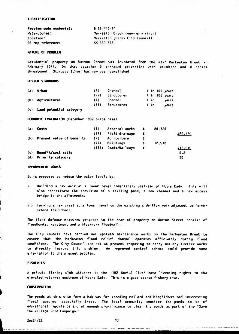
IDENTIFICATION
6-98-410-14
Markeaton Brook {non-main river)
Markeaton (Derby City Council)
SK 339 372
NATURE OF PROBLEM
Problea code niner(s):
Watercourse:
Location:
OS Map reference:
Residential property on Watson Street was inundated from the main Markeaton Brook in
February 1977. On that occasion 6 terraced properties were inundated and 4 others
threatened. Sturgess School has now been demolished.
DESIGN STANDARDS
( O(ii)
(i)
(ii)
(a) Urban
(b) Agricultural
(c) Land potential category
ECONOMIC EVALUATION (December 1989 price base)
(a) Costs
(b) Present value of benefits
Channel
Structures
Channel
Structures
(c) Benefi t/cost rati o
(d) P H ori ty category
1 in 100 years
1 in 100 years
1 i n years
1 in years
i) Arterial works £
ii) Field drainage £
i) Agri culture £
ii) Buildings £
i i i) Roads/RaiIways £
80,720
12,510
£8(1.720
£12.510
0. 23D
IHPROVEICNT WORKS
It is proposed to reduce the water levels by:
i) Building a new weir at a lower level immediately upstream of Moore Eady. This will
also necessitate the provision of a stilling pond, a new channel and a new access
bridge to the allotments;
ii) forming a new crest at a lower level on the existing side flow weir adjacent to former
school the School.
The flood defence measures proposed to the rear of property on Watson Street consist of
floodbanks, revetment and a blockwork floodwall.
The City Counci 1 have carried out upsteam maintenance works on the Markeaton Brook to
ensure that the Markeaton flood relief channel operates efficiently during flood
conditions. The City Council are not at present proposing to carry out any further works
to directly improve this problem. An improved control scheme could provide some
alleviation to the present problem.
FISHERIES
A private fishing club attached to the '102 Social Club' have licensing rights to the
elevated waterway upstream of Moore Eady. This is a good coarse fishery site.
CONSERVATION
The ponds at this site form a habitat for breeding Mallard and Kingfishers and interesting
floral species, especially trees. The local community consider the ponds to be of
educational importance and of enough significance to clear the ponds as part of the "Save
the Village Pond Campaign."
Sec24/23 77

6-98-510-1/7
Peakshole Water (non-main river)
Castleton (High Peak District Council)
SK 148 827 to SK 154 833
NATURE OF PROBLEM
IDENTIFICATION
Problea code nuaber(s):
Watercourse:
Location:
OS Map reference:
Flooding has occurred on six occasions since 1947 for durations of up to 24 hours,
has affected a large number of residential properties, two shops, a farm and a road.
Thi s
(i)( H )(i)
(ii)
DESIGN STANDARDS
(a) Urban
(b) Agricultural
(c) Land potential category
ECONOMIC EVALUATION (December 1989 price base)
(a ) Costs
(b) Present value of benefits
Channel
Structures
Channel
Structures
m
(ii)
(i)
(ii)
Arterial works
Field drainage
Agri culture
Bui 1di ngs
(iii) Roads/Railways
(c ) Benefit/cost rati o
(d ) Pri ori ty category
1 in 100 years
1 in 100 years
1 in years
1 in years
106,670
115,100
i J M
£H5.1QQ 1 . 12C
IMPROVEMENT WORKS
The proposed improvement scheme requires the removal of large quantities of bed
material/sediment from the watercourse between Peak Cavern and Spital Bridge. The work
includes stone pitching revetment/pointing to existing channel walls, the removal of a weir
and general improvements to the channel between Tricket Bridge and Spital Bridge.
BENEFITS
The alleviation of road flooding will provide only minor benefits and no assessment has
been made. It has been estimated that 27 houses, two shops, one farm and a minor road will
be affected by the 1 in 100 year flood.
Sec24/23 78
IDENTIFICATION
Probl ea code nuriier(s):
Watercourse:
Location:
05 Nap reference:
NATURE OF PROBLEM
6-98-510-3
River Derwent (main river)
Bamford (High Peak District Council)
SK 203 830
Part of the Bamford Recreation Ground is within the floodplain of the River Derwent and
floods on infrequent occasions. The inundation of the floodplain is essential for the
protection of areas downstream and no improvement works can, therefore, be recommended.
DESIGN STAM1ARDS
(i) Channel
(i i) Structures
(i) Channel
(i i) Structures
(a ) Urban
(b ) Agri cultural
(c) Land potential category
ECONOMIC EVALUATION (December 1989 price base)
(a ) Costs
(b) Present value of benefits
) Arterial works
i) Field drainage
) Agriculture
i) Buildings
i i) Roads/Rai1ways
(c) Benefit/cost ratio
(d) Priority category
FISHERIES
1 in
1 i n
1 i n
1 i n
years
years
years
years
This is a good trout fishery site and consultation is required before any works are
Sec24/23 79
IDENTIFICATION
Problea code ntflber(s):
Watercourse:
Location:
OS Hap reference:
NATURE OF PROBLEM
6-98-510-4
Tributaries of the River Dove (non-main river)
Dove Head/Brand Side (High Peak District Council)
SK 038 683
Flooding of a minor road occurs where streams are culverted under the road. The flooding
is as a result of inadequate culvert capacity.
DESIGN STANDARDS
(a) Urban (i) Channel 1 in years
(ii) Structures 1 in years
(b) Agri cultural (i) Channel 1 in years
(ii) Structures 1 in 50 years
(c) Land potential category
ECONOMIC EVALUATION (December 1989 price base)
(a ) Costs
(b) Present value of benefits
(i) Arterial works £ 22,490
(i i) Field drai nage £
(i) Agri cul ture £
(i i) Bui 1di ngs £
(i i i) Roads/RaiIways £ 4,630
(c) Benefit/cost ratio
(d) Priority category
£22,490
£4«63Q0.23E
IHPROVEWNT WORKS
The works proposed involve the provision of a new culvert to provide a capacity of 2.3
cumecs, together with headworks and tail works. Stone pitching revetment is necessary to
the Dove Head Springs tributary where it runs immediately adjacent to the road, but these
protection works are the responsibility of the Highway Authority as the erosion is
affecting the stability of the road. The cost of this revetment is not included within the
scheme cost.
CONSERVATION
This site has an interesting mixture of calcifuge and calcicole plant species in a short
distance and diversity of species is high. Much of the interest could be retained if the
improvement is carried out carefully.
Sec24/23 80
IDENTIFICATION
6-98-510-5
River Wye (non-main river)
Ashwood Dale, Buxton (High Peak^District,Counci 1 )=
SK 082 725
NATURE OF PROBLEM
Problew code nuaber(s):
Watercourse:
Location:
OS Hap reference:
The River Wye flows through a large culvert at the side of the A 6 . The Devonshire Arms
public house is built directly over this culvert and is consequently at risk from flooding
from high river levels, surface water run-off and culvert blockages. This property
suffered from minor flooding in 1972 but, as serious flooding has never occurred, flood
alleviation measures have not been investigated.
DESIGN STANDARDS
(a) Urban
(b) Agricultural
(c) Land potential category
O )
(i i)
( i )(ii)
Channel
Structures
Channel
Structures
1 in
1 i n
1 i n
1 i n
years
years
years
years
ECONOMIC EVALUATION (December 1989 price base)
(a) Costs (i) Arterial works £
(i i) Field drainage £
<b) Present value of benefits 0 ) Agri culture £
(i i) BuiIdings £
(Hi) Roads/Railways £
(c) Benefit/cost ratio
(d) Priority category
FISHERIES
This is a trout and grayling fishery and consultation is required before works are
commenced.
Sec24/23 81
6-98-510-9
None
Bamford (High Peak District Council)
SK 209 836
NATURE OF PROBLEM
IDENTIFICATION
Problew code maber(s):
Watercourse:
Location:
OS Map reference:
The flooding to Leeside Road originates from springs rising in the steep foreslopes of
Bamford Edge. The water discharges naturally to the road and the highway drainage system
i s i nadequate to cope wi th the run-off. The soluti on is, therefore, outsi de the scope of
this Survey as works to watercourses will not alleviate the problem.
DESIOI STANDARDS
(a ) Urban
{b ) Agri cultural
<c) Land potential category
ECONOMIC EVALUATION (December 1989 price base)
(i)
(ii)
< i)
(ii)
Channel
Structures
Channel
Structures
(a ) Costs
(b) Present value of benefits
(c) Benefi t/cost rati o
(d) Priority category
(i) Arterial works
(ii) Field drainage
(i) Agri culture
(i i ) Buildings
(iii) Roads/RaiIways
I i n
1 i n
1 i n
1 i n
years
years
years
years
Sec24/23 82

IDENTIFICATION
Problem code nutfber(s):
Watercourse:
Location:
OS Kap reference:
6-98-510-11
Grinds Brook and Lady Booth Brook (non-main river)
Edale (High Peak District^Council^ _
SK 125 854 and SK 142 862
NATURE OF PROBLEM
Flooding occurs to Edale Recreation ground, farm outbuildings and a road at Nether Booth.
DESIGN STANDARDS
(i)
(ii)
0)
( i i )
(a) Urban
(b) Agricultural
(c) Land potential category
ECONOMIC EVALUATION (December 1989 price base)
(a) Costs
(b) Present value of benefits
Channel
Structures
Channel
Structures
1 in 1 i n
1 i n 1 i n
yearsyearsyearsyears
(i) Arterial works
(ii) Field drainage
(i) Agri culture
(ii) Buildings
(i i i) Roads/RaiIways
(c) Benefit/cost ratio
(d) Priority category
IMPROVEMENT WORKS
Investigations have shown that no serious flooding of the
outbuildings has occurred and no remedial works are necessary.
Booth results from the blockage of a trash grid upstream of the road culvert and can be
alleviated by the instigation of a programme of planned maintenance.
recreation ground and
The flooding at Nether
Sec24/23 83
6-98-510-12
Un-named tributary of River Wye (non-main river)
Buxton (High Peak District Council)
SK 063 723
NATURE OF PROBLEM
IDENTIFICATION
Pruble* code maber(s):
Watercourse:
Location:
OS Hap reference:
Slight flooding occurs at the junction of Ashbourne Road {A515) and Harper Hill Road where
the watercourse is culverted. As no serious flooding to property, land or roads occurs, no
alleviation works have been considered.
DESIGN STANDARDS
(a) Urban
(b ) Agri cultural
(c) Land potential category
ECONOMIC EVALUATION (December 1989 price base)
(i) Channel
(i i) Structures
(i) Channel
(i i) Structures
(a ) Costs
(b) Present value of benefits
(c) Benefit/cost ratio
(d ) Pri ori ty category
) Arterial works
i) Field drainage
) Agriculture
i) Buildings
i i) Roads/Railways
1 i n
1 i n
1 i n
1 i n
years
years
years
years
Sec24/23 84
IDENTIFICATION
6-90-610-1
Westwood Brook (non-main river)
Morton (North-East Derbyshire District Council)
SK 417 601
NATURE OF PROBLEM
Problem code mwber(s):
Watercourse:
Location:
OS Map reference:
The abandoned Stonebroom Sewage Works suffers from flooding but as no other serious
flooding to property or land occurs at this location no improvement works are proposed.
DESIGN STANDARDS
(i) Channel
(ii) Structures
(i) Channel
(ii) Structures
(a) Urban
(b) Agricultural
(c) Land potential category
ECONOMIC EVALUATION (December 1909 price base)
(a) Costs
(b) Present value of benefits
i) Arterial works
i i) Fi eld drai nage
i) Agriculture
i i) Buildings
iii) Roads/Railways
(c) Benefit/cost ratio
(d) Priority category
1 i n
1 i n
1 in
1 i n
years
years
years
years
IHPROVEICNT WORKS
Some minor improvement works involving the removal of rubbish, cutting of undergrowth and
hand regrading has been carried out on a 450 n long stretch of the Morton Brook immediately
upstream of its confluence with the Westwood Brook. This work has provided some minor
alleviation to the problem. As there is no serious problem of flooding to property or
land, no further improvement works are proposed.
Sec24/23 85
6-98-610-5
Press Brook (non-main river)
Press, Old Tupton (North-East Derbyshire District Council)
SK 378 644
NATURE OF PROBLEM
IDENTIFICATION
Pruble* code marf>er(s):
Watercourse:
Location:
OS Nap reference:
Minor flooding occurred from the Press Brook at Brookfields Caravan Park, Old Tupton in
June 1982.
The only damage sustained was to a low-lying caravan used as an office. This has now been
replaced by a permanent brick building elsewhere on the site with a higher floor level.
The problem may have been caused by lack of maintenance to the brookcourse or the presence
of obstructive summer bank growth. As there is no serious flooding to either dwellings or
agricultural land, flood alleviation works are considered inappropriate.
DESIGN STANDARDS
(i) Channel
(i i) Structures
(i) Channel
(a) Urban
(b ) Agri cultural
(c) Land potential category
ECONOMIC EVALUATION (December 1989 price base)
(i i) Structures
(a ) Costs
(b) Present value of benefits
(c) Benefit/cost ratio
(d ) P H ori ty category
) Arterial works
i) Field drainage
) Agriculture
i) BuiIdi ngs
ii) Roads/Railways
1 in
1 in
1 in
1 in
years
years
years
years
Sec24/23 86
6-98-610-6
Press Brook (non-main river)
Press (North-Eastr Derbyshire District Council)
SK 37] 644
NATURE OF PROBLEM
IDENTIFICATION
Problea code m«ber(s):
Watercourse:
Location:
OS Hap reference:
In June 1982, 2 low-lying cottages on Press Lane opposite Corner Farm were very close to
being flooded. The problem appears to have been caused by lack of maintenance to the road
culvert and upstream watercourse, combined with the ponding of carriageway surface water in
the natural depression directly in front of the cottages.
DESIGN STANDARDS
(a) Urban
(b) Agricultural
(c) Land potential category
(i) Channel
(i i) Structures
(i) Channel
(i i) Structures
1 in
1 i n
1 in
1 i n
years
years
years
years
ECONOMIC EVALUATION (December 1989 price base)
(a) Costs
(b) Present value of benefits
(c) Benefit/cost ratio
(d) Pri ori ty category
IMPROVEMENT WORKS
(i) Arterial works £
(ii) Field drainage £
(i) Agri culture £
(i i) BuiIdings £
(iii) Roads/Railways £
In order to remove the accumulated floodwater, 2 holes were made in the solid stone
roadside wall opposite the cottages. This allowed water to escape to the Brook below and
has coped with similar problems since. As it is considered that the main problem is due to
inadequate highway drainage, the problem falls outside the scope of this survey.
Sec24/23 87
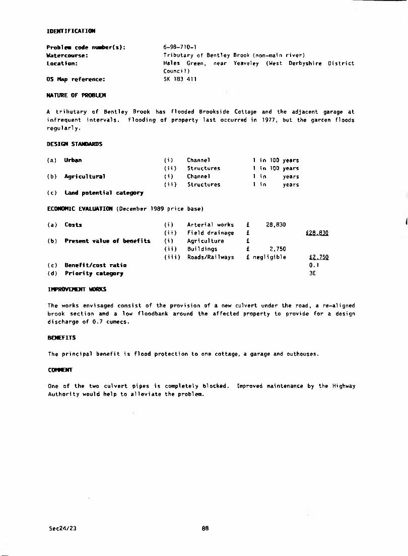
6-98-710-1
Tributary of Bentley Brook {non-main river)
Hales Green, near Yeaveley (West Derbyshi re District
Counci 1)
SK 183 411
NATURE OF PROBLEM
IDENTIFICATION
Problem code nunber(s):
Watercourse:
Location:
OS Hap reference:
A tributary of Bentley Brook has flooded Brookside Cottage and the adjacent garage at
infrequent intervals. Flooding of property last occurred in 1977, but the garden floods
regul arl y .
DESIGN STANDARDS
(i) Channel
(ii) Structures
(i) Channel
(ii) Structures
(a) Urban
(b ) Agri cultural
( c) Land potenti al category
ECONOMIC EVALUATION (December 1989 price base)
(a) Costs
(b) Present value of benefits
(i) Arterial works
(i i) Fi eld drai nage
(i) Agriculture
(i i) BuiIdings
(i i i) Roads/RaiIways
(c) Benefit/cost ratio
(d ) Pri ori ty category
1 in 100 years
1 in 100 years
1 in years
1 i n years
28,830£££££ negligible
2,750
£29.830
£2.7500.1
3E
IMPROVDCNT WORKS
The works envisaged consist of the provision of a new culvert under the road, a re-aligned
brook section and a low floodbank around the affected property to provide for a design
discharge of 0.7 cumecs.
BENEFITS
The principal benefit is flood protection to one cottage, a garage and outhouses.
COMMENT
One of the two culvert pipes is completely blocked. Improved maintenance by the Highway
Authority would help to alleviate the problem.
Sec24/23 88
IDENTIFICATION
Problea code nuaber(s):
Watercourse:
Locati on:
OS Nap reference:
NATURE OF PROBLEM
6-98-710-4
River Dove (main river)
Sudbury (Derbyshire Dales District Council)
SK 165 312
Extensive washland flooding occurs from the River Dove. The Sudbury to Draycott Road
crosses the floodplain and is also inundated from time to time, the last occasion being
February 1977.
DESIGN STANDARDS
(a) Urban
(b) Agricultural
(c) Land potential category
(i) Channel
(i i) Structures
(i) Channel
(i i) Structures
1 i n
1 i n
1 i n
1 i n
years
years
years
years
EC0N0NIC EVALUATION (December 1989 price base)
(a) Costs
(b) Present value of benefits
(c) Benefit/cost ratio
(d) Priority category
(i) Arterial works
(i i) Fi eld drai nage
(i) Agri culture
(ii) Buildings
(iii) Roads/Rai 1 ways
IMPROVEMENT WORKS
Inundation of the River Dove floodplain is essential at times of high flow to provide
storage for flood water which would otherwise create problems for urban areas downstream.
Restriction of this storage area is not possible at this stage.
FISHERIES
This is a good trout and coarse fishery site and consultation is essential.
Sec24/23 89
IDENTIFICATION
Problea code niaber(s):
Watercourse:
Location:
OS Hap reference:
NATURE OF PROBLEM
6-90-7 JO-5/84
Un-named tributary of Cubley Brook (non-main river)
Boylestone (Derbyshire Dales District Council)
SK 100 362
The watercourse is in very poor condition with many natural obstructions. The road
culverts are inadequate and Audishaw Lane is often submerged. Nearby domestic properties
were inundated in August 1957. Several farms are subject to flooding at Boylestone.
DESIGN STANDARDS
(a) Urban
(b ) Agri cultural
(c ) Land potential category
ECONOMIC EVALUATION (December 1989 price base)
( O
(ii)
( O
(ii)
Channel
Structures
Channel
Structures
1 in years
1 in 100 years
1 in years
1 in years
(a ) Costs
(b) Present value of benefits
(c ) Benefi t/cost rati o
(d) Priority category
(i) Arterial works
(i i) Field drai nage
(i) Agri culture
(i i) BuiIdings
(i i i) Roads/RaiIways
72,070
5,000
n u m .
£5,QQQ0.1
3D
IMPROVEMENT WORKS
The works envisaged are floodbanks around the affected property together with the provision
of new culverts under Audishaw Lane.
Some minor improvements to the Brook have been carried out.
BENEFITS
The principal benefits are flood alleviation to domestic properties and the alleviation of
access traffic disruption.
Sec24/23 90
IDENTIFICATION
Problea code mriwr(s): 6-98-710-6
Watercourse: None
Location: Boylestone (Derbyshire Dales District Council)
OS Nap reference: SK 188 363
NATURE OF PROBLEM
Inadequate surface water drainage causes flooding problems near to Claremont Farm,
Boylestone. Works to watercourses will not alleviate the flooding and so the problem falls
outside the scope of this Survey.
DESIOi STANDARDS
(a) Urban (i) Channel 1 i n years
(ii) Structures 1 i li years
(b) Agricultural (i) Channel 1 i n years
(i i) Structures 1 i n years
(c) Land potential category
ECONOMIC EVALUATION (December 1989 price base)
(a) Costs (i) Arterial works £
(ii) Field drainage £ £(b) Present value of benefits (i) Agri culture £
(ii) BuiIdi ngs £
(iii) Roads/RaiIways £ £(c) Benefit/cost ratio
(d) Priority category
Sec24/23 91

6-98-710-10
River Wye (main river)
Ashford in the Water (Derbyshire Dales District Council)
SK 195 697
NATURE OF PROBLEM
IDENTIFICATION
Problea code nuaber(s):
Watercourse:
Location:
OS Map reference:
Part of this problem concerns the flooding of cellars and basements of houses on the north
side of Church Street and results from inadequate surface water drainage or groundwater
percolation and is, therefore, outside the scope of this Survey. Flooding also occurs from
the River Wye, to gardens at the rear of Wye House and Cherry Close, but as no serious
flooding to property occurs at this location, no improvement works are proposed at this
stage.
DESIGN STANDARDS
(i) Channel
(i i) Structures
Channel( U(i i) Structures
(a ) Urban
(b ) Agri cul tural
(c) Land potential category
ECONOMIC EVALUATION (December 1989 price base)
(a) Costs
(b) Present value of benefits
) Arteri al works
i) Field drainage
) Agri cul ture
i) Buildings
ii) Roads/Railways
(c) Benefit/cost ratio
(d) Priority category
1 i n
1 in
1 in
1 in
years
years
years
years
FISHERIES
This is a trout and grayling fishery and consultation is required before works are
commenced.
Sec24/23 92
IDENTIFICATION
Problea code nuaber(s):
Watercourse:
Location:
OS Hap reference:
6-98-710-11
Tributary of River Wye (non-main river)
Tideswell (Derbyshire Dales District Council)
SK 152 756
NATURE OF PROBLEM
Flooding in Tideswell occurs at regular intervals and often for durations of up to several
days. The main cause of this is the inadequate surface water culvert running roughly
North-South through the town beneath Manchester Street, Queen Street and Buxton Road. This
is believed to consist mainly of an old 24" diameter pipe with some small sections of open
channel. It is likely that this pipe has a number of restrictions at various points along
its length.
Surcharging of the culvert occurs at its inlet at the top of Manchester Street and also at
manholes on Fountain Square and Queen Street. Serious road flooding also occurs in
numerous places and Derbyshire County Counci 1 have to divert water u sing sandbags to
prevent flooding to properties. A high degree of highway maintenance is al so requi red i n
the area to keep the frequency of road flooding to a minimum.
DESICM STAMARDS
(b) Agri cultural
(a) Urban (i) Channel
(ii) Structures
(i) Channel
(ii) Structures
1 in
1 in
1 in
1 in
years
years
years
years
(c) Land potential category
ECONOMIC EVALUATION (December 1989 price base)
(b) Present value of benefits
(a) Costs (i) Arterial works
i i c i u w i a i n a y e r(i) Agri cul ture
(i i) BuiIdings
(iii) Roads/Railways
£
£££ £
(c) Benefi t/cost rati o
(d) Pri ori ty category
IMPROVDOfT WORKS
The cost of alleviating this problem will obviously be very high and no future improvements
are planned at the present time.
Sec24/23 93
IDENTIFICATION
Problem code nuaber(s):
Watercourse:
Location:
OS Nap reference:
6-98-710-12
Hannage Brook (non-main river)
Wirksworth (Derbyshire Dales District Council)
SK 288 533
NATURE OF PROBLEM
There are three possible causes of flooding at this location:
i) The channel capacity upstream of the Water Lane culvert is restricted and overflow
occurs into Brooklands Avenue near to the footbridge;
ii) A 0.9 m weir and trash grid obstructs the Water Lane culvert;
iii) The existing culvert consists of part 1.2 m reinforced concrete culvert, part an old
stone arch. The route of the culvert is tortuous, passing under the weaving factory
yard and under a railway embankment. The capacity of the culvert is inadequate to
cater for flood flows.
From a combination of the above events, the lower floors of the weaving factory have been
inundated on several occasions. The owners have carried out several flood alleviation
measures, but the factory is still at risk from inundation by Hannage Brook.
DESIGN STAMMRDS
(a) Urban
(b ) Agri cultural
(c) Land potential category
ECONOMIC EVALUATION (December 1989 price base)
(1)(ii)
(i)
(ii)
Channel
Structures
Channel
Structures
1 in 100 years
1 in 100 years
1 in years
1 in years
(a) Costs (i ) Arterial works £ 207,570
(i i) Field drainage £ £Z0Z.52G
(b) Present value of benefits (i ) Agriculture £
(i i) Buildi ngs £ 42,540
(iii) Roads/Railways £ £42.540
(c) Benefit/cost ratio 0.2
(d) Priority category 3C
IMPROVEMENT WORKS
The works envisaged consist of the regrading and resectioning of the brookcourse adjacent
to Brooklands Avenue, the removal of the obstructive weir and trash grid, and the provision
of a new flood relief channel.
BENEFITS
The data for the benefit evaluation was supplied by the factory manager and was based on
estimates of damage to stock, machinery and business losses due to disruption.
Sec24/23 94
IDENTIFICATION
6-98-710-13
Dale 8rook (non-main river)
Stoney Middleton (Derbyshire Dales District Counci 1) -
SK 231 754
NATURE OF PROBLEM
Problea code nurf>er(s):
Watercourse:
Location:
OS Nap reference:
Flooding occurs when Dale Brook surcharges and discharges floodwater onto the A623 road and
eventually inundates six properties in The Nook. The most recent flooding was in November
1985, and occurs once every 2 to 3 years.
DESIGN STAfOAROS
(a) Urban (i) Channel 1 in years
(ii) Structures 1 in 50 years
(b) Agri cultural (i) Channel 1 i n years
(ii) Structures 1 i n years
(c) Land potential category
ECONOMIC EVALUATION (December 1989 price base)
(a) Costs (i> Arterial works £ 54,770
(ii) Field drainage £ £54.770
(b) Present value of benefits (i) Agriculture £
(ii) Buildi ngs £ 30,030
(iii) Roads/Rai1ways £ 2,500 £32_.530(c) Benefit/cost ratio 0.6
(d) Priority category 3D
IMPROVEMENT WORKS
Channel/Culvert improvements would be impracticable in these circumstances and so it is
proposed to: • - -
a) intercept the floodwater on the road and divert the flow back into the watercourse
(£13,620) and
b) alleviate local flooding in The Nook by the improvement of a short section of the
channel (£29,510).
The interception works consist of localised road shaping and the provision of a number of
road gullies which discharge floodwater off the A623 road directly to the watercourse. A
short length of channel improvement upstream of the Boot Factory weir is also necessary.
The local flooding in The Nook is to be alleviated by the removal of various obstructive
structures/weirs and the provision of new culverts to the 50 year standard (5 cumecs).
BENEFITS
The principal benefit of the scheme is urban flood alleviation to eight houses.
Sec24/23 95
IDENTIFICATION
6-98-710-14
Tributary of River Derwent (non-main river)
Froggatt (Derbyshire Dales District Council)
SK 247 761
NATURE OF PROBLEM
Problea code niaber(s):
Watercourse:
Location:
OS Hap reference:
In times of severe storms (1973 and 1977) surface water is not directed into defined
watercourses but flows over steeply sloping ground and into Chequers Inn. The water also
accumulates on the B6054 road from the adjoining fore-slopes of Froggatt Edge and flows
around the property from the road. The Inn is also affected by flows from springs which
continuously discharge through the garage of the property. Works to watercourses will not
alleviate this problem and the solution is, therefore, outside the scope of this Survey.
DESIGN STANDARDS
(a ) Urban
(b ) Agri cultural
(c) Land potential category
ECONOMIC EVALUATION (December 1989 price base)
(i) Channel 1 in years
(i i) Structures 1 i n years
(i) Channel 1 in years
(i i) Structures 1 i n years
(a) Costs
(b) Present value of benefits
(c) Benefit/cost ratio
(d ) P H ori ty category
) Arterial works
i) Field drainage
) Agri culture
i) Buildings
(i i i) Roads/RaiIways
Sec24/23 96
Probln code m*ber(s): 6-98-710-15
Watercourse: Tributary of River Derwent (non-main river)
Location: Froggatt (Derbyshire Dales District Council)
OS Nap reference: SK 245 762
NATURE OF PROBLEM
Flooding occurred to property and a minor road in July/August 1973 and January 1977.
DESIGN STANDARDS
(a) Urban (i) Channel 1 in
(ii) Structures 1 in
(b) Agricultural (i) Channel 1 in
(ii) Structures 1 in
(c) Land potential category
ECONOMIC EVALUATION (December 1989 price base)
(a) Costs (i) Arterial works £
(i i) Fi eld drai nage £
(b) Present value of benefits (i) Agriculture £
(i i) BuiIdings £
(i i i) Roads/Railways £
(c) Benefit/cost ratio
(d) Priority category
IMPROVEMENT WORKS
i) The watercourse runs alongside the road in a series of stone culverts, the blockage of
which has caused the flooding. Works have recently been carried out to prevent the
blockage of these culverts and no further work is recommended.
ii) A separate problem in the same area involves high groundwater levels and surface water
run-off from high ground immediately above Stoke View and Stonecroft. Works to
watercourses will not alleviate this problem and the solution is, therefore, outside
the scope of this Survey.
IDENTIFICATION
years
years
years
years
Sec24/23 97
IDENTIFICATION
6-98-710-16River Derwent (main river)
Froggatt (Derbyshire Dales District Council)
SK 244 761
NATURE OF PROBLEM
Problem code msber(s):
Watercourse:
Location:
OS Hap reference:
Flooding occurs to Stokes Lane and to agricultural land in the floodplain of the River
Derwent. Poor land drainage outfall conditions contribute to standing water remaining for
long periods on the floodplain. Alleviation of this problem requires comprehensive
investigation of the whole of the River Derwent floodplain to ensure that improvements in
one area do not reduce standards in others. This investigation is outside the scope of the
Survey and, therefore, no works can be recommended at this stage.
DESIGN STANDARDS
(a) Urban (i) Channel
(i i) Structures
(b) Agricultural (i) Channel
(ii) Structures
(c) Land potential category
ECONOMIC EVALUATION (December 1989 price base)
1 i n
1 i n
1 i n
1 i n
years
years
years
years
(a ) Costs (i) Arterial works £
(ii) Field drainage £
(b) Present value of benefits (i) Agri culture £
(ii) Bui 1di ngs £
(iii) Roads/Railways £
(c) Benefit/cost ratio
(d ) Pri ori ty category
FISHERIES
This is a good trout fishery site and consultation is required before any works are
commenced.
Sec24/23 98

IDENTIFICATION
6-98-710-18/41
Un-named tributary of Henmore Brook (non-main river)
Clifton (Derbyshire Dales District Council)
SK 167 449 to SK 168 446
NATURE OF PROBLEM
Problea code nuaber(s):
Watercourse:
Location:
OS Map reference:
The problem watercourse extends from the upstream culvert under the A515 Clifton By-pass to
the By-pass access adjacent to the Vicarage and Primary School. Eight properties along
this stretch of watercourse have a history of flooding due to restricted channels and
culverts. New residential development immediately adjacent to the watercourse is also at
risk. The culvert under the By-pass on the upstream side has been designed to throttle
flood flows and utilise the flood storage created by the By-pass embankment. This storage
is insufficient for severe flood events.
DESIGN STAMARDS
(a) Urban (i) Channel 1 in 100 years
(ii) Structures 1 in 100 years
(b) Agri cultural <i) Channel 1 i n years
<H) Structures 1 i n years
(c) Land potential category
ECONOMIC EVALUATION (December 1989 price base)
(a) Costs (i) Arterial works £ 106,670
(ii) Field drainage £
(b) Present value of benefits (i) Agri culture £
(ii) Buildings £ 40,030
(iii) Roads/Railways £ negli gi ble
(c) Benefit/cost ratio
(d) Priority category
£106.670
£40.030
0.4
3C
IHPROVDOfT WORKS
The works recommended involve:-
i) an increase in the flood storage upstream of the existing throttle by means of
embankment;
ii) the regrading and improvement of the watercourse between the upstream and downstream
culverts including the provision of new access culverts for recent residential
development adjacent to the watercourse;
iii) the removal of a trash grid and obstructive pipes in the existing downstream culverts.
These improvements will provide for a design discharge capacity of 9.8 cumecs.
BENEFITS
The principal benefit is flood protection to an estimated ten properties and the grounds of
Cli fton Hal 1.
Sec24/23 99
IDENTIFICATION
Problem code n«ber(s):
Watercourse:
Location:
OS Hap reference:
6-98-710-19
Shirley Brook (non-main river)
Shirley (Derbyshire Dales District Council)
SK 214 408
NATURE OF PROBLEM
A short section of Mill Lane and adjacent fields suffer from minor flooding. As there is
no serious f 1 oodi ng to ei ther buiIdi ngs or agri cultural land, alleviati on works are
considered inappropriate.
DESIGN STANDARDS
(a) Urban
(b ) Agri cuT tural
(i) Channel
(i i) Structures
(i) Channel
(i i) Structures
1 i n
1 i n
1 i n
1 in
years
years
years
years
(c) Land potential category
ECONOMIC EVALUATION (December 1989 price base)
(a ) Costs ) Arterial works
i) Field drai nage
) Agri culture
£££££
L(b) Present value of benefits
i) Buildings
i i) Roads/Railways
(c) Benefi t/cost rati o
(d) Priority category
CONSERVATION
The brook side immediately south of the road supports two species of considerable interest,
both scarce in Derbyshire (water whorl grass and Catabrosa aquatica). Any work on the bank
would remove these two species.
Sec24/23 100

IDENTIFICATION
6-98-710-20
Un-named tributary of Hilton Brook (non-main river)
Lower Thurvaston (Derbyshire Dales District Council)
SK 228 367
NATURE OF PROBLEM
Problea code nuri>er(s):
Watercourse:
Locati on:
OS Hap reference:
Two properties flood and another property suffers inundation of garden and garage.
Derbyshire County Council has recently installed new culverts under Longford Lane and
Thurvaston Road.
DESIGN STANDARDS
(a) Urban (i) Channel 1 i n 50 years
(ii) Structures 1 i n 50 years(b) Agricultural (i) Channel 1 i n years
(ii) Structures 1 i n years
(c) Land potential category
ECONOMIC EVALUATION (December 1989 price base)
(a) Costs
(b) Present value of benefits
(c) Benefi t/cost rati o
(d) Priority category
(i) Arterial works
(ii) Field drainage
(i) Agri culture
(ii) Buildings
(i i i) Roads/RaiIways
£ 23,060
£ £23.060
££ 17,510
£ i17,51Q0.8 3E
IHPROVEJCNT WORKS
The works consist of resectioning the main channel between the two culverts on Longford
Lane and Thurvaston Lane, preliminary channel clearance to both tributaries upstream of the
confluence and a new farm access bridge downstream of Longford Lane, to provide for a
design capacity of 5.5 cumecs.
BENEFITS
The principal benefit consists of flood protection to three domestic properties.
Sec24/23 101
IDENTIFICATION
Problem code maber(s)
Watercourse:
Location:
OS Hap reference:
NATURE OF PROBLEM
6-98-710-21
Marston Brook (non-main river)
Waldley (Derbyshire Dales District Council)
SK 127 370
Flooding of the road at Waldley occurs due to inadequate capacity of roadside ditches
Works to the watercourse will not alleviate the flooding and so the problem falls outsid
the scope of this Survey.
DESIGN STANDARDS
(a) Urban
(b) Agricultural
(c) Land potenti al category
( i )( H )
(i>
(ii)
Channel
Structures
Channel
Structures
1 i n
1 i n
1 i n
1 in
years
years
years
years
ECONOMIC EVALUATION (December 1989 price base)
(a ) Costs
(b) Present value of benefits
(c) Benefit/cost ratio
(d ) Pri ori ty category
) Arterial works £
i) Field drainage £
) Agriculture £
i) Buildings £
i i) Roads/Railways £
Sec24/23 102
Baslow (Derbyshire Dales District Council)
SK 279 721
NATURE OF PROBLEM
IDENTIFICATION
6-98-710-22
None
Problea code nvMber(s):
Watercourse:
Location:
OS Map reference:
flooding of the A619 Baslow to Chesterfield Road results from inadequate surface water
drainage from a campsite access road, car park and adjacent rising ground. Works to
watercourses will not alleviate the flooding and, therefore, the solution is outside the
scope of this Survey.
DESIGN STAJOARDS
( i ) Channel
(i i) Structures
(i) Channel
(a) Urban
(b) Agricultural
(c) Land potential category
ECONOMIC EVALUATION (December 1989 price base)
(i i) Structures
(a) Costs
(b) Present value of benefits
(c) Benefit/cost ratio
(d) Priority category
1 i n
1 i n
1 i n
1 i n
(i) Arterial works £
(ii) Field drainage £
(i) Agriculture £
(ii) Buildings £
(i i i) Roads/RaiIways £
years
years
years
years
Sec24/23 103
IDENTIFICATION
Oarley Dale (Derbyshire Dales District Council)
SK 279 623
NATURE OF PROBLEM
6-98-710-24
None
Probl m code nw b e r ( s ) :
Watercourse:
Locati on:
OS Map reference:
Flooding of the A6 near St. Elphins School, Darley Dale, Matlock results from inadequate
surface water drainage from large paved areas within the school grounds. Works to
watercourses will not alleviate the flooding and, therefore, the solution is outside the
scope of this Survey.
DESIGN STANDARDS
(a) Urban (i> Channel 1 i n years
(ii) Structures 1 i n years
<b) Agri cultural (i) Channel 1 in years
(ii) Structures 1 i n years
(c) Land potential category
ECONOMIC EVALUATION (December 1989 price base)
(a) Costs (i) Arterial works £
(ii) Field drainage £
(b) Present value of benefits (i) Agri culture £
(ii) Buildings £
(iii) Roads/Railways £
(c) Benefit/cost ratio
(d) Priority category
Sec24/23 104

IDENTIFICATION
Problem code nuaber(s):
Watercourse:Location:
OS Kap reference:
6-98-710-25
Un-named tributary of River Derwent (non-main river)
Grangemill (Derbyshire Dales District Council)
SK 244 577
NATURE OF PROBLEM
The watercourse is culverted downstream of a disused mi 11/converted house. The open channel
sections, farm access culverts and the road culvert downstream are all of insufficient
capacity and flooding of the road, farm outbuildings, farmyard and public house car park
occurs.
DESIW STAM1ARDS
(a) Urban
(b) Agricultural
(c) Land potential category
(i) Channel
(i i) Structures
(i) Channel
(ii) Structures
1 i n
1 i n
1 i n
1 i n
years
years
years
years
ECONOMIC EVALUATION (December 1989 price base)
(a) Costs
(b) Present value of benefits
(c) Benefit/cost ratio
(d) Priority category
(i) Arterial works £
(ii) Field drainage £
(i > Agriculture £
(ii) Buildings £
(iii) Roads/Rai1 ways £
IMPROVEMENT WORKS
Impounding works on the watercourse have been constructed by the owner and included in
these works is the utilisation of the original 1.2 m stone arch mill outfall. This appears
to adequately divert flood flows away from the existing flood area and no further works
have been considered. No flooding has been reported for several years.
Sec24/23 105

IDENTIFICATION
Darley Dale {Derbyshire Dales District Council)
SK 271 625
NATURE OF PROBLEM
6-98-710-26
None
Problea code maber(s):
Watercourse:
Location:
OS Hap reference:
Flooding of Four Lane Ends road junction and extensive areas of agricultural land in
floodplai n occurs. Thi s floodi ng whi ch occurs during high f1ows in the River Derwent
essential to protect urban areas downstream and improvement works cannot be recommended.
DESIOI STAMSARDS
(a) Urban (i) Channel 1 in years
(ii) Structures 1 in years
<b) Agricultural (i) Channel 1 i n years
< i i) Structures 1 i n years
(c) Land potential category
ECONOMIC EVALUATION (December 1989 price base)
(a) Costs (i) Arterial works £
(i i) Field drainage £ £
(b) Present value of benefits (i) Agri cul ture £
(ii) Buildings £
(Hi) Roads/Railways £ £
(c) Benefit/cost ratio
(d) Priority category
Sec24/23 106

6-98-710-27
River Derwent (main river)
Darley Dale (Derbyshire Dales District Council)
SK 270 620
NATURE OF PROBLEM
IDENTIFICATION
P rob lea code ntaber(s):
Watercourse:
Location:
OS Nap reference:
Flooding occurred in 1965 to houses on Main Street, two road haulage firms and farm
outbuildings. This is also associated with extensive flooding to the River Derwent
floodplain.
DESIGN STANDARDS
(a) Urban
(b) Agri cultural
(c) Land potential category
(i) Channel
(i i) Structures
(i) Channel
{i i) Structures
ECONOMIC EVALUATION (December 1989 price base)
(a) Costs
(b) Present value of benefits
(c) Benefit/cost ratio
(d) Priority category
(i) Arterial works
(i i) Fi eld drai nage
(i) Agri cul ture
(i i) Buildings
(iii) Roads/Rai1 ways
1 in 100 years
1 in 100 years
1 in years
1 in years
IMPROVOCNT WORKS
The STWA completed a flood alleviation scheme at Dgrlsy Bridge which will provide
protection for properties, but will not reduce inundation of the floodplain as this is
essential for flood protection downstream. The scheme involved the provision of
floodbanks, the diversion of a small tributary of the River Derwent and the construction of
flood walls and two road ramps. There has been no further inundation of properties since
completion of the scheme.
FISHERIES
This is a good trout and coarse fishery site and consultation is essential.
Sec24/23 107

Darley Dale (Derbyshire Dales District Council)
SK 269 626
NATURE OF PROBLEM
IDENTIFICATION
6-90-710-29
None
Problem code ntai>er(s):
Watercourse:
Location:
OS Map reference:
Flooding occurs to Church Road at Churchtown and is within the floodplain of the Riv
Derwent. Inundation of the floodplain during times of high flow in the River Derwent
essential to protect urban areas downstream, and remedial works cannot be recommended.
DESIGN STANDATOS
( i )(ii)
(i)
(ii)
(a) Urban
(b ) Agri cultural
(c) Land potential category
ECONOMIC EVALUATION (December 1909 price base)
(a ) Costs
(b) Present value of benefits
Channel
Structures
Channel
Structures
Arterial works
Field drainage
Agri culture
Bui 1 dings
iii) Roads/Rai1 ways
(c) Benefit/cost ratio
(d) Priority category
1 i n
1 i n
1 i n
1 i n
years
years
years
years
Sec24/23 108
IDENTIFICATION
Problea code mflber(s):
Watercourse:
Location:
OS Hap reference:
Biggin (Derbyshire Dales District Council)
SK 152 595
6-98-710-30
None
NATURE OF PROBLEM
flooding in isolated low locations results from inadequate capacity of farm and highway
ditches. Serious flooding has been prevented by recent drainage works carried out by
Derbyshi re County Counci 1. Works to watercourses wi 11 not al1eviate the f 1 oodi ng and,
therefore, the solution is outside the scope of this Survey.
DESIGN STANDARDS
(a) Urban (i) Channel 1 in years
(b) Agri cultural
(ii) Structures
(i) Channel
(i i) Structures
1 in years
1 in years
1 in years
(c) Land potential category
ECONOMIC EVALUATION (December 1989 price base)
(b) Present value of benefits
(a ) Costs (i) Arterial works
(ii) Field drainage
(i) Agriculture
£££££
L
(i i) BuiIdi ngs
(iii) Roads/Railways
(c) Benefit/cost ratio
(d) Priority category
Sec24/23 109
IDENTIFICATION
Problea code nuaber(s):
Watercourse:
Location:
OS Nap reference:
Baslow {Derbyshire Dales District Council)
SK 258 727
6-98-710-31
None
NATURE OF PROBLEM
Surface water run-off from Baslow Edge floods the steeply inclined Bar Road. The incidence
of flooding has been reduced by the provision of improved surface water drainage.
DESIGN STANDARDS
(a) Urban
(b) Agricultural
{c) Land potential category
ECONOMIC EVALUATION (December 1989 price base)
(i) Channel
(i i) Structures
(i) Channel
(i i) Structures
1 in
1 in
1 i n
1 i n
years
years
years
years
(a) Costs (i) Arterial works £
(ii) Field drainage £
(b) Present value of benefits (i) Agri cul ture £
(ii) BuiIdings £
(iii) Roads/RaiIways £
(c) Benefit/cost ratio
(d) Priority category
IHPROVEICNT WORKS
Works were undertaken by Derbyshire Dales District Council in 1988 which diverted flow from
Bar Road, via a large silt trap, into its former route through an existing stone culvert
across meadowland.
This appears to have alleviated the problems to a large degree.
Sec24/23 110

IDENTIFICATION
Proble* code mart>er(s):
Watercourse:
Location:
OS Hap reference:
6-98-710-32
Tributary of River Derwent (non-main river)
Curbar (Derbyshire Dales District Council)
SK 248 752
NATURE OF PROBLEM
Surface water run-off from high ground immediately above Stokeview and Stonecroft causes
flooding problems. However, works to watercourses will not alleviate the flooding and so
the problem falls outside the scope of this Survey.
DESIGN STANDARDS
(a) Urban (i) Channel
(ii) Structures
(b) Agricultural (i) Channel
(ii) Structures
(c) Land potential category
ECONOHIC EVALUATION (December 1989 price base)
(a) Costs (i) Arterial works £
(ii) Field drainage £
(b) Present value of benefits (i) Agri culture £
(ii) Buildings £
(iii) Roads/Railways £
(c) Benefit/cost ratio
1 in
1 i n
1 in
1 in
years
years
years
years
(d) Priority category
Sec24/23 111
IDENTIFICATION
Problem code mari>er(s):
Watercourse:
Location:
OS Hap reference:
NATURE OF PROBLEM
6-98-710-33
Dale Brook (non-main river)
Middleton Dale (Derbyshire Dales District Council)
SK 209 762
Middleton Dale is a steeply inclined valley with high rocky cliffs and quarries on both
sides of the A623 road. The flooding of the road is due to flash run-off from the
surrounding cliffs which flows naturally down the road surface. Works to the Dale Brook,
which flows parallel to the road, will not alleviate the flooding and the solution is,
therefore, outside the scope of this Survey.
DESIGN STAMMRDS
(i) Channel
(i i) Structures
Channel(i)(i i) Structures
(a) Urban
(b) Agricultural
(c) Land potential category
ECONOMIC EVALUATION (December 1989 price base)
(a) Costs
(b) Present value of benefits
1 i n
1 i n
1 i n
1 i n
years
years
years
years
) Arterial works
i) Field drainage
) Agri cul ture
i) Buildings
i i) Roads/Railways
(c) Benefit/cost ratio
(d ) Pri ori ty category
CONSERVATION
Middleton Dale has been notified to the Planning Authorities by the Derbyshire Naturalists
Trust as a site of the utmost biological importance, principally for its botanical interest.
Sec24/23 112
IDENTIFICATION
6-98-710-34
Dale Brook (non-main river)
Hathersage (Derbyshire Dales District Council)
SK 241 817
NATURE OF PROBLEM
Problea code nu^>er(s):
Watercourse:
Location:
OS Hap reference:
Flooding of a Class 'B* road results from inadequate road ditches. Work to watercourses
will not alleviate the flooding and, therefore, the solution is outside the scope of this
Survey.
DESIGN STANDARDS
(a) Urban (i) Channel 1 in years
( i i ) Structures 1 i n years
(b) Agricultural (i) Channel 1 i n years
( i i ) Structures 1 i n years
(c) Land potential category
ECONOMIC EVALUATION (December 1989 price base)
(a) Costs (i) Arterial works £
( i i ) Field drainage £
(b) Present value of benefits (i) Agri cul ture £
( i i ) BuiIdings £
( i i i ) Roads/Rai Iways £
(c) Benefit/cost ratio
(d) Priority category
Sec24/23 113
6-98-710-36/45
Hollow and Jumber Brooks {non-main river)
Eyam (Derbyshire Dales District Council)
SK 220 764 and SK 216 766
NATURE OF PROBLEM
IDENTIFICATION
Problem code nuaber(s):
Watercourse:
Location:
OS Nap reference:
In recent years, property at Town End around The Square has flooded from Hollow Brook.
FI oodi ng al so occurs near to the juncti on of Hawkhi 11 Road and Church Street from a
combination of surface water and Jumber Brook.
(i)
(ii)
(i)
(ii)
DESIGN STANDARDS
(a) Urban
(b) Agricultural
(c) Land potential category
ECONOMIC EVALUATION (December 1989 price base)
(a ) Costs
(b) Present value of benefits
Channel
Structures
Channel
Structures
i) Arteri al works
i i) Fi eld drainage
i) Agri cul ture
i i) Buildings
iii) Roads/Railways
(c) Benefit/cost ratio
(d ) Pri ori ty category
1 i n
1 in
1 in
1 in
years
years
years
years
IMPROVEMENT WORKS
Some improvement works have already been carried out at Town End by Derbyshire Dales
District Council Highways Department. Any further works will only be considered if major
problems occur in this area at some time in the future.
Sec24/23 114

IDENTIFICATION
Problea code nuaber(s):
Watercourse:
Location:
OS Nap reference:
NATURE OF PROBLEM
Tideswell (Derbyshire Dales District Council)
SK 141 760
6-98-710-37
None
Flooding of the road occurs as a result of inadequacies in the highway drainage system.
The solution to this problem is, therefore, outside the scope of this Survey.
(i)
(ii)
U >
<H>
DESIGN STANDARDS
(a) Urban
(b) Agricultural
(c) Land potential category
ECONOMIC EVALUATION (December 1989 price base)
(a) Costs
(b) Present value of benefits
Channel
Structures
Channel
Structures
1 in
1 i n
1 i n
1 i n
years
years
years
years
i) Arterial works
i i) Fi eld drai nage
i) Agriculture
i i) Buildings
iii) Roads/Rai Iways
(c) Benefit/cost ratio
(d) Priority category
IMPWVEJCNT WORKS
Some minor works have been carried out by Derbyshire County Council which have considerably
alleviated this problem.
Sec24/23 115
IDENTIFICATION
Problea code nuaber(s):
Watercourse:Location:
OS Hap reference:
6-98-710-38
Tributary of River Wye (non-main river)
Tideswell (Derbyshsire Dales District Council) SK 154 744
NATURE OF PROBLEM
Flooding occurs to the B6049 road at Tideswell Oale as a result of flash run-off from the
surrounding hills. The watercourse runs parallel and adjacent to the road in a series of
open channel/culverted sections but works to the watercourse will not alleviate the problem
completely. No works can be recommended at this stage.
DESIGN ST A W A R D S
(a) Urban (i) Channel 1 in years
(b ) Agri cultural
{i i) Structures
(i) Channel
(ii) Structures
years
years
years
(c) Land potential category
ECONOMIC EVALUATION (December 1989 price base)
(a ) Costs ) Arterial works
i) Field drainage
) Agri culture
£££££
L(b) Present value of benefits
i) Buildings
i i) Roads/RaiIways £
(c) Benefit/cost ratio
(d) Priority category
Sec24/23 116
IDENTIFICATION
6-98-710-40
Tributary of River Derwent {non-main river)
Calver (Derbyshire Dales District Council)
SK 243 745
NATURE OF PROBLEM
Problem code number(s):
Watercourse:
Location:
OS Nap reference:
Minor flooding occurs to a road and garden from an underground stream which discharges into
a water trough on Main Street, Calver. The flow passes through two watercourses which are
partially culverted and, in the case of both watercourses, the natural flow is impeded by
various obstructions. As the flooding is minor and any improvement works would be in
gardens where the water forms a feature, no works can be recommended.
DESIGN STAMMRDS
(i)
(ii)
(i)
(ii)
(a) Urban
(b) Agri cultural
(c) Land potential category
ECONOMIC EVALUATION (December 1989 price base)
(a) Costs
(b) Present value of benefits
Channel
Structures
Channel
Structures
) Arterial works
i) Field drainage
) Agriculture
i) Buildings
i i) Roads/RaiIways
(c) Benefit/cost ratio
(d) Pri ori ty category
1 i n
1 i n
1 i n
1 i n
years
years
years
years
Sec24/23 117

IDENTIFICATION
P r o b l m code nuaber(s)
Watercourse:
Location:
OS Hap reference:
6-98-710-43
River Wye (main river)
Bakewell to Rowsley (Derbyshire Dales District Council)
SK 221 685 to SK 259 655
NATURE OF PROBLEM
250 ha of the River Wye washland are subject to flooding and inadequate arterial drainage.
DESIGN STANDARDS
(a) Urban (i) Channel 1 i n years
(ii) Structures 1 i n years
(b) Agri cultural (i) Channel 1 i n years
(ii) Structures 1 i n years
(c) Land potential category a
ECONOMIC EVALUATION (December 1989 price base)
(a) Costs (i) Arterial works £
(ii) Field drainage £ 75,060 £75.060(b) Present value of benefits (i) Agri culture £ 75,010
(ii) Buildings £
(iii) Roads/Railways £ £75.010
(c) Benefit/cost ratio 1.0
(d) Priority category 3F
BENEFIT
It has been estimated by MAFF that only minimal benefit could be achieved as a result of an
improvement in the freeboard to the arterial watercourse. Field drainage costs alone,
necessary to achieve this benefit, are greater than the value of agricultural enhancement.
No works are therefore proposed.
FISHERIES
This is a good trout fishery site and consultation is required before any works are
commenced.
C O M O f T
There is a general reluctance by the landowners to accept any works on the river because of
the risk of damage to fishing sites.
Sec24/23 118
IDENTIFICATION
Problea code n
Watercourse: Location:
OS Hap reference:
r(s): 6-98-710-46
Bar Brook (non-main river)
Baslow (Derbyshire Dales District Council)
SK 260 722
NATURE OF PROBLEM
Surface water drainage problems exist adjacent to the public conveniences/council car park.
DESIGN STANDARDS
(i) Channel
{i i) Structures
(i) Channel
(i i) Structures
(a) Urban
(b) Agricultural
(c) Land potential category
ECONOMIC EVALUATION (December 1989 price base)
(a ) Costs
(b) Present value of benefits
1 in
1 in
1 in
1 in
years
years
years
years
) Arterial works
i) Field drainage
) Agri culture
i) BuiIdings
i i) Roads/Rai1 ways
(c) Benefit/cost ratio
(d) Priority category
IMPROVEMENT WORKS
Works to the watercourse will not alleviate this problem. Therefore, the solution is
outside the scope of this Survey.
Sec24/23 119

IDENTIFICATION
Problem code maber(s):
Watercourse:
Location:
OS Hap reference:
NATURE OF PROBLEM
6-98-710-47/54
Underground streams and un-named tributary of River
Derwent (non-main river)
Nether Padley (Derbyshire Dales District Council)
SK 247 779
Numerous underground watercourses and soughs traverse St. Helens Close, flooding gardens
and garages. The flooding cannot be alleviated by works to the watercourse and the problem
is therefore outside the scope of this Survey.
DESIGN STANDARDS
(i> Channel
(i i) Structures
( i ) Channel
(a) Urban
(b) Agricultural
(c) Land potential category
ECONOHIC EVALUATION (December 1989 price base)
(i i) Structures
(a ) Costs
(b) Present value of benefits
(c) Benefit/cost ratio
(d ) Pri ori ty category
1 in
1 in
1 in
1 in
) Arterial works £
i) Field drainage £
) Agri culture £
i) Buildings £
i i) Roads/RaiIways £
years
years
years
years
Sec24/23 120
IDENTIFICATION
Problew code nuaber(s):
Watercourse:
Location:
05 Nap reference:
Curbar (Derbyshire Dales District Council)
SK 252 746 and SK 255 746
6-98-710-48
None
NATURE OF PROBLEM
Bar Road and Hillside Cottages at the junction of The Hillock and Bar Road, are at risk
from flooding from surcharged surface water sewers. Two other cottages on Bar Road are at
risk from road drainage and also from a brook/well which forms an ornamental feature to the
rear of the property. The solution to these problems is outside the scope of the Survey as
works to watercourses will not solve the problem.
DESIGN STANDARDS
(a) Urban 0 ) Channel 1 i n years
(ii) Structures 1 i n years
(b) Agri cultural (i) Channel ] i n years
(ii) Structures 1 i n years
(c) Land potential category
ECONOMIC EVALUATION (December 1989 price base)
(a) Costs (i) Arterial works £
(ii) Field drainage £
(b) Present value of benefits (i) Agri culture £
(ii) Buildi ngs £
(iii) Roads/Railways £
(c) Benefit/cost ratio
(d) Priority category
Sec24/Z3 121
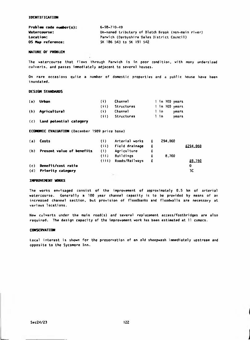
IDENTIFICATION
Problem code number(s):
Watercourse:
Location:
OS Nap reference:
NATURE OF PROBLEM
6-98-710-49
Un-named tributary of Bietch Brook (non-main river)
Parwich (Derbyshire Dales District Council)
SK 186 543 to SK 191 542
The watercourse that flows through Parwich is in poor condition, with many undersized
culverts, and passes immediately adjacent to several houses.
On rare occasi ons qui te a number of domesti c properti es and a publi c house have been
i nundated.
(i) Channel
(i i) Structures
(i) Channel
(i i) Structures
DESIGN STANDARDS
(a) Urban
(b) Agricultural
(c) Land potential category
ECONOMIC EVALUATION (December 1989 price base)
(a ) Costs
(b) Present value of benefits
(c) Benefit/cost ratio
(d) Priority category
1 in 100 years
1 in 100 years
1 in years
1 in years
(i) Arterial works £
(i i) Fi eld drainage £
(i) Agri culture £
(i i) BuiIdi ngs £
(iii) Roads/Railways £
294,060
8,760
£294.060
£8.760
0
3C
INPROVEKNT WORKS
The works envisaged consist of the improvement of approximately 0.5 km of arterial
watercourse. Generally a 100 year channel capacity is to be provided by means of an
increased channel section, but provision of floodbanks and floodwalls are necessary at
various locations.
New culverts under the main road(s) and several replacement access/footbridges are also
required. The design capacity of the improvement work has been estimated at 11 cumecs.
CONSERVATION
Local interest is shown for the preservation of an old sheepwash immediately upstream and
opposite to the Sycamore Inn.
Sec24/23 122

IDENTIFICATION
Problea code nuaber(s):
Watercourse:Location:
OS Nap reference:
6-98-710-51
Brailsford Brook (non-main river)
Longford (Derbyshire Dales District Council)
SK 220 375
NATURE OF PROBLEM
The weir at Longford retains a high water level in the Mill Pond inmediately below the
confluence of the Brailsford Brook and Shirley Brook. In times of flood the Mill Pond
overtops its banks and regularly inundates two cottages. The weir height was reduced by
0.45 m in 1971 by Derbyshire County Council and some dredging works were also carried out.
DESIGN STANDARDS
(a) Urban
(b) Agri cultural
(c) Land potential category
(i) Channel
(i i) Structures
(i) Channel
(ii) Structures
1 in 100 years
1 in 100 years
1 in years
1 in years
ECONOMIC EVALUATION (December 1989 price base)
(a) Costs
(b) Present value of benefits
(c) Benefit/cost ratio
(d) Priority category
(i) Arterial works £ 40,360
(ii) Field drainage £
(i) Agri culture £
(i i) Bui 1 dings £ 35,030
(iii) Roads/RaiIways £
£40,360
£35.030
0.9
3E
IMPROVEMENT WORKS
The only satisfactory solution would be to remove the weir at Longford Mill and regrade the
mill pond up to the confluence of Brailsford and Shirley Brooks. Channel resectioning and
a farm access bridge will be necessary downstream of Longford Bridge. These works will
provide for a design capacity of 21.4 cumecs.
BENEFITS
Agricultural benefits may be available but have not been included in this evaluation.
FISHERIES
The Scheme would necessitate the loss of private fishing facilities at Longford.
Sec24/23 123

IDENTIFICATION
Problem code maber(s): 6-98-710-52/53
Watercourse: Spinneyford Brook (non-main river)
Location: Bradley (Derbyshire Dales District Council)
OS Nap reference: SK 246 451
NATURE OF PROBLEM
The lowest section of Brunswood Lane and the footpath to Houghpark Farm are subject to
flooding. As no serious flooding occurs to buildings or agricultural land at this location
alleviation works are considered inappropriate.
DESIGN STAMMRDS
(a) Urban (i) Channel 1 in years
(ii) Structures 1 in years
(b) Agricultural (i) Channel 1 i n years
(ii) Structures 1 i n years
(c) Land potential category
ECONOMIC EVALUATION (December 1989 price base)
(a) Costs (i) Arterial works £
(ii) Field drainage £ i(b) Present value of benefits (i) Agri culture £
(ii) Buildings £
(iii) Roads/Railways £ i(c) Benefit/cost ratio
(d ) Pri ori ty category
Sec24/23 124

IDENTIFICATION
6-98-710-57
Brocksford Brook (non-main river)
Doveridge (Derbyshire Dales District Council)
SK 135 334
NATURE OF PROBLEM
Problea code maber(s):
Watercourse:
Location:
OS Map reference:
Flooding occurs to Brocksford Hall School playing fields which are partially situated in
the floodplain of the River Dove. As the storage in the floodplain is essential for the
protection of areas downstream, and the benefits from the relief of flooding to playing
fields is very low, flood alleviation works cannot be recommended at this stage.
DESIGN STAJUARDS
(i)(a) Urban
(b) Agri cul tural
(c) Land potential category
ECONOMIC EVALUATION (December 1989 price base)
Channel
(i i) Structures
(i) Channel
(i i) Structures
(a) Costs
(b) Present value of benefits
(c) Benefit/cost ratio
(d) Priority category
(i) Arterial works
(ii) Field drainage
(i) Agri culture
(i i) BuiIdings
(i i i) Roads/Rai1 ways
1 i n
1 i n
1 i n
1 i n
years
years
years
years
Sec24/23 125

IDENTIFICATION
Pro b l n code nuriwr(s):
Watercourse:
Location:
6-98-710-58
Bradbourne/Bentley Brooks (part main river)
Ashbourne to Bradbourne (Derbyshire Dales District
Counci 1)
SK 160 463 to SK 194 529OS Nap reference:
NATURE OF PROBLEM
185 ha of agricultural land, mainly grassland, suffer from inadequate arterial drainage.
DESIGN STANDARDS
(a) Urban
(b ) Agri cul tural
(c) Land potential category
ECONOMIC EVALUATION (December 1989 price base)
(i) Channel 1 in years
(ii) Structures 1 in years
(i) Channel 1 in 2 years
(ii) Structures 1 in 25
a
years
(a ) Costs
(b) Present value of benefits
(c) Benefi t/cost rati o
(d) Priority category
(i) Arterial works £ 836,040
(ii) Field drainage £ 12,510
(i) Agriculture £ 277,830
(i i) Buildi ngs £
(iii) Roads/Railways £
£848.550
£277.830
0.3
3B
IMPROVQOfT WORKS
The scheme required to develop the possible land drainage benefits, consists of river
regrading to achieve a minimum freeboard of 1,5 m. It would be necessary to underpin five
road bridges and to replace a number of farm access bridges and footbridges.
B E K F I T S
There is little prospect of any changes in farm management, and gross margin increases are
expected to be minimal.
CONSERVATION
The land adjoining the north bank of the Brook is a sedge marsh. This type of marsh is now
scarce in Derbyshire.
FISHERIES
There is fishery interest at this site and consultation is necessary before any improvement
work is commenced.
Sec24/23 126
IDENTIFICATION
Problea code ntaber(s):
Watercourse:
Location:
OS Nap reference:
Great Longstone (Derbyshire Dales District Council)
SK 201 719, SK 199 718 and SK 199 715
6-98-710-62
None
NATURE OF PROBLEM
Floodi ng on Church Lane near St. Giles Church i s due to i nadequate farm/highway di tches.
Flooding near Grange Cottage is due to inadequate farm ditches, and flooding of property
bel ow the garage on Mai n Street i s from a natural spri ng source i n the garage yard.
Improvements to watercourses will not alleviate these problems and no works are therefore
proposed. The solution of these problems is outside the scope of this Survey.
DESIGN STANDARDS
(a) Urban (i) Channel 1 in years
(b) Agri cultural
(i i) Structures
(i) Channel
(ii) Structures
in
i n
i n
years
years
years
(c) Land potential category
ECONOMIC EVALUATION (December 1989 price base)
(b) Present value of benefits
(a) Costs ) Arterial works
i) Field drainage
) Agri cul ture
£££££
L
i) BuiIdi ngs
i i) Roads/RaiIways L(c) Benefit/cost ratio
(d ) Pri ori ty category
Sec24/23 127

IDENTIFICATION
Problem code nt^ier(s): 6-98-710-63
Watercourse: River Derwent (main river)
Location: Calver (Derbyshire Dales District Council)
OS Kap reference: SK 248 742
NATURE OF PROBLEM
The Calver caravan site is immediately adjacent to the River Derwent and as such is at risk
from the normal inundation of the Derwent Washlands. It is estimated that out of a total
of 38 caravans on site, 18 would have been flooded to a depth of 0.45 m and 4 would have
floodwater passing underneath them from a flood of the 1965 magnitude (1 in 75 years).
DESIGN STAMMRDS
(a) Urban (i) Channel 1 i n years
(ii) Structures 1 i n years
(b) Agricultural (i) Channel 1 in years
(ii) Structures 1 in years
(c) Land potential category
ECONOMIC EVALUATION (December 1989 price base)
(a) Costs (i) Arterial works £
(ii) Field drainage £ i(b ) Present val ue of benef i ts (i) Agri culture £
(ii) Buildi ngs £
(iii) Roads/RaiIways £ I(c) Benefit/cost ratio
(d) Priority category
COtWENT
Whilst all the caravans remain on site for the whole year, none are occupied in
A flood warning system is in operati on Evaluation of costs and benefits for
this type of problem fall outside the scope of this Survey.
FISHERIES
Thi s is a good trout fi shery si te and consul tat ion is requi red before any works are
commenced.
Sec24/23 128
IDENTIFICATION
Problea code nuriier(s): 6-98-710-65
Watercourse: River Derwent (main river)
Location: Grindleford (Derbyshire Dales District Council)
OS Hap reference: SK 245 778
NATURE OF PROBLEM
Upstream of Grindleford Bridge, two bungalows and a service station, and downstream a post
office, 3 houses and the cellars of five houses are subject to very occasional inundation
from the River Derwent. Flooding occurred most recently in 1965.
DESIGN STAMIARDS
( i )(ii)
(i)
(ii)
(a) Urban
(b) Agricultural
(c) Land potential category
ECONOMIC EVALUATION (December 1989 price base)
(a) Costs
(b) Present value of benefits
Channel
Structures
Channel
Structures
i)
ii)
i)
ii)
Arterial works
Field drainage
Agri culture
Buildi ngs
iii) Roads/Railways
(c) Benefit/cost ratio
(d) Priority category
1 in years
1 in 100 years
1 in years
1 in years
167,210
5,750
£167.210
0
3C
IMPROVEMENT WORKS
Essentially the solution consists of a raised footpath, with a ramped access to the playing
fields on the west side of the river, to prevent floodwaters getting onto the road and into
the Post Office and nearby buildings. It will also be necessary to provide a low floodwall
to protect two semi-detached houses and cellars to five other properties adjacent to the
A6011. Two bungalows and a petrol filling station suffer from occasional inundation on the
East bank upstream of Grindleford Bridge and sheet pile revetments are proposed to
alleviate flooding.
FISHERIES
This is a good trout fishery site and consultation is required before any works are
commenced.
Sec24/23 129
IDENTIFICATION
Problea code niaber(s):
Watercourse:
Location:
OS Nap reference:
6-98-710-66
River Wye (main river)
Bakewell (Derbyshire Dales District Council)
SK 222 680
NATURE OF PROBLEM
The River Wye overtops its banks and occasionally floods gardens of property on Wye Bank
and Wye Bank Grove.
The f1ooding has also occasional1y reached foundation level of 10 of these properties in
Wye Bank and Wye Bank Grove. The water table is high in thi s particular location.
DESIGN STAMMRDS
(a) Urban (i) Channel 1 in years
(ii) Structures 1 in 100 years
(b ) Agri cultural (*) Channel 1 in years
(ii) Structures 1 i n years
(c) Land potential category
ECONOHIC EVALUATION (December 1989 price base)
(a ) Costs 0 ) Arterial works £ 49,010
(ii) Field drainage £ £49.010(b) Present value of benefits (i) Agri cul ture £
(ii) BuiIdi ngs £ 10,010
(iii) Roads/Railways £ £1Q.Q1Q(c) Benefit/cost ratio 0.2
(d) Priority category 3E
IHPROVEICNT WORKS
The improvement works consist of the provision of floodbanks to the rear of property on Wye
Bank Grove, and a raised footpath on the South side of the recreation ground adjacent to
property on Wye Bank. These remedial works will provide for a design standard of 1 in 100
years.
RECREATION, AMENITY AM) FISHERIES
The preservation of the natural habitat of the watercourse is important in this instance
due to the valuable trout fishing rights exercised along this reach of the River Wye. It
is not envisaged that the proposed works will be in any way detrimental to the natural
habitat of the River Wye.
Sec24/23 130
IDENTIFICATION
Problea code nuaber(s):
Watercourse:
Location:
OS Hap reference:
NATURE OF PROBLEM
Bakewell (Derbyshire Dales District Council)
SK 219 691
6-98-710-67
None
Occasional surface water flooding has been reported on the A619 Baslow Road. This is a
surface water problem and is outside the scope of this Survey.
( i )(ii)
(i)
(ii)
Channel
Structures
Channel
Structures
DESIGN STANDARDS
(a) Urban
(b) Agri cultural
(c) Land potential category
ECONOMIC EVALUATION (December 1989 price base)
(a) Costs (i) Arterial works
(ii) Field drainage
(b) Present value of benefits (i) Agriculture
(ii) Buildings
(iii) Roads/Railways
(c) Benefit/cost ratio
(d) Priority category
1 i n
1 i n
1 in
1 i n
years
years
years
years
Sec24/23 131
IDENTIFICATION
Problea code nu^>er(s):
Watercourse:
Location:
OS Hap reference:
NATURE OF PROBLEM
6-98-710-68
Mill Channel (non-main river)
Bakewell (Derbyshire Dales District Council)
SK 216 688
No serious flooding to property or roads occurs at this location and hence no alleviation
works have been considered or benefits evaluated.
(i)
(ii)
(i)
(ii)
DESIGN STANDARDS
(a ) Urban
(b) Agricultural
(c) Land potential category
ECONOMIC EVALUATION (December 1989 price base)
(a ) Costs
(b) Present value of benefits
Channel
Structures
Channel
Structures
(c) Benefit/cost ratio
(d) Priority category
1 in
1 i n
1 in
1 i n
) Arterial works £
i) Field drainage £
) Agri culture £
i) Buildings £
i i) Roads/RaiIways £
years
years
years
years
Sec24/23 132
IDENTIFICATION
Problea code nuaber(s):
Watercourse:
Location:
OS Hap reference:
6-98-710-69
Un-named tributary of Sutton Brook (non-main river)
Yeaveley (Derbyshire Dales District Council)
SK 188 403
NATURE OF PROBLEM
An old rectangular stone culvert passes under the road at Yeaveley and is joined to two
smal1er pipes in the access drive between two cottages. These cottages are flooded when
the culvert surcharges. The culvert is situated at a local low spot and surface water
run-off is likely to be a contributary factor.
DESIGN STANDARDS
(a) Urban
(b) Agri cultural
(c) Land potential category
ECONOMIC EVALUATION (December 1989 price base)
(i) Channel
(i i) Structures
(i) Channel
(i i) Structures
1 in
1 in
1 in
1 in
years
years
years
years
(a) Costs (i) Arterial works £
(ii) Field drainage £ i(b) Present value of benefits (i) Agri culture £
(ii) Bui 1di ngs £
(iii) Roads/RaiIways £ i(c) Benefit/cost ratio
(d) Priority category
IMPROVEMENT WORKS
The suggested scheme consists essentially of the provision of a new 600 mm culvert to pass
under the road and outfall downstream of the cottages, assuming that the new culvert can be
installed without diverting the foul sewer which runs alongside.
The 2 small culvert pipes immediately downstream of the road culvert have been replaced by
a single 400 mm diameter culvert which appears to have provided some alleviation. No
flooding has occurred si nee 1977 but the culvert i s thought to be inadequate for more
extreme flood events.
Some minor flooding still occurs due to poor highway surface water drainage.
Sec24/23 133
IDENTIFICATION
6-98-710-70
Tributary of River Dove (non-main river)
Mapleton (Derbyshire Dales District Council)
SK 166 476
NATURE OF PROBLEM
Problea code m^>er{s):
Watercourse:
Location:
OS Hap reference:
4 houses flood directly from the watercourse. 2 terraced cottages, 1 bungalow and a
detached house are also at risk, but suffer more frequently from the inadequacy of the
surface water drainage system, which results from poor outfall facilities into the
watercourse. Flooding of agricultural land and roads also occurs.
DESIGN STANDARDS
(a ) Urban
(b ) Agri cultural
(c) Land potential category
ECONOMIC EVALUATION (December 1989 price base)
(i)
(ii)
( i ) (i i)
Channel
Structures
Channel
Structures
(a ) Costs
(b) Present value of benefits
(c) Benefit/cost ratio
(d) Priority category
) Arteri al works
i) Field drainage
) Agri culture
i) Bui 1di ngs
(iii) Roads/Railways
1 in 50 years
1 in 50 years
1 in years
1 in years
23,060
27,520
£23.060
£27.520
1.2
2E
IMPROVEMENT MORKS
Property flood protection to a 1 in 50 years standard (0.9 cumecs) can be achieved by
diverting the watercourse into a new channel through a culvert under the road. Road and
farm ditches should be improved in conjunction. The scheme will improve the surface water
drainage system by improvement of the outfall conditions. Agricultural land and roads
flood as a result of normal floodplain inundation and any alleviation works will require
comprehensive investigation of the whole of the catchment.
Sec24/23 134
IDENTIFICATION
Problem code nuaber(s):
Watercourse:
Location:
OS Nap reference:
NATURE OF PROBLEM
Un-named tributary of the River Ecd esbourne (non-main river)
Millers Green, Wirksworth (Derbyshire Dales District
Counci 1)
SK 282 529
6-98-710-71
The MPI cavity wall insulation factory is on the site of the former Speedwell Mill. The
reception area of the factory and the car park are frequently inundated by overflow/high
water levels in the watercourse.
DESIGN STANDARDS
(a) Urban (i) Channel 1
(ii) Structures 1
(b) Agricultural (i) Channel 1
(ii) Structures 1
(c) Land potential category
ECONOMIC EVALUATION (December 1989 price base)
(a) Costs (i) Arterial works £
(ii) Field drainage £
(b) Present value of benefits (i) Agri culture £
(ii) Buildings £
(iii) Roads/Rai Iways £
(c) Benefit/cost ratio
(d) Priority category
years
years
years
years
20,180
7,510
ttQjqp
£7.510
0.4
3E
IHPROVDOfT WORKS
The flood alleviation works envisaged consist of the provision of floodbanks, 175 m of
pioneer channel clearance, a penstock and flap valve to an existing outfall and the fluming
of a highway bridge.
BENEFITS
The principal benefits consit of flood alleviation to the factory. No damage to stock or
machinery is expected in severe flooding events.
C09MENT
No measures are proposed to alleviate possible existing groundwater problems.
FISHERIES
This stretch is a feeder to a trout fishery and consultation is required.
Sec24/23 135
IDENTIFICATION
OS Hap reference:
Problem code maber(s):
Watercourse:
Location:
6-98-710-72
Hannage Brook (non-main river)
Millers Green, Wirksworth (Derbyshsire Dales District
Counci 1)
SK 284 527
NATURE OF PROBLEM
Flooding to the B5023 Wirksworth-Duffiel d Road occurs at frequent intervals. The flooding
occurs at a local low spot and is due to blocked surface water drains. The ovoid stone
culvert under the road has its capacity reduced by a sewer crossing. However, local
observations of flooding over a considerable length of time would indicate that this is not
a cause of the road flooding. No serious traffic delays occur. The solution and economic
assessment of surface water flooding problems fall outside the scope of this Survey.
DESIQf STANDARDS
(a) Urban (i) Channel 1 in years
(b ) Agri cultural
(i i) Structures
(i) Channel
(ii) Structures
i n
i n
l n
years
years
years
(c) Land potential category
ECONOMIC EVALUATION (December 1989 price base)
(a ) Costs
(b) Present value of benefits
) Arterial works
i) Field drai nage
) Agri culture
£££££
i) Buildings
ii) Roads/RaiIways i(c) Benefit/cost ratio
(d ) Priori ty category
IMPROVEMENT WORKS
Derbyshire County Council have carried out some minor works but it is not yet known whether
these have been totally successful in alleviating the problem.
Sec24/23 136
IDENTIFICATION
Problem code nuber(s):
Watercourse:
Location:
OS Hap reference:
NATURE OF PROBLEM
6-98-710-80
Un-named (non-main river)
Parley Dale (Derbyshire Dales District Council)
SK 263 649
Northwood Club, properties on the north side of Northwood Lane and Matlock Transport lorry
park are subject to flooding due to an inadequate watercourse and culvert.
<i)
(ii)
( i )(ii)
DESIGN STANDARDS
(a) Urban
(b) Agri cultural
(c) Land potential category
ECONOHIC EVALUATION (December 1989 price base)
(a) Costs
(b) Present value of benefits
Channel
Structures
Channel
Structures
i) Arterial works
i i) Field drainage
i) Agriculture
i i) BuiIdings
i i i) Roads/RaiIways
(c) Benefit/cost ratio
(d) Priority category
1 i n
1 in
1 in
1 in
years
years
years
years
Sec24/23 137

IDENTIFICATION
Problea code ntaber(s): 6-98-710-81
Watercourse: River Wye (main river)
Location: Near Bakewell (Derbyshire Dales District Council)
OS Nap reference: SK 220 670
NATURE OF PROBLEM
Land drainage outfalls are submerged in the Haddon Estates area and riverside land is
deteriorating.
DESIGN STAM1ARDS
(a ) Urban (i) Channel 1 i n years
(i i) Structures 1 in years
(b) Agricultural (i) Channel 1 in years
(i i) Structures 1 i n years
(c) Land potential category
ECONOMIC EVALUATION (December 1989 price base)
(a) Costs (i) Arterial works £
(ii) Field drainage £ £_____
(b) Present value of benefits (i) Agriculture £
(i i) BuiIdi ngs £
(iii) Roads/Rai lways £ £_____
(c) Benefit/cost ratio
(d ) Pri ori ty category
IMPROVEMENT WORKS
The landowners do not wish to consider dredging because of the importance of the river for
fi shi ng.
Sec24/23 138
IDENTIFICATION
Proble* code number(s): Watercourse:
Location:
OS Map reference:
6-98-710-82
River Lathkill (non-main river)
Lathkill Lodge (Derbyshire Dales District Council)
SK 240 650
NATURE OF PROBLEM
Flooding occurs at Lathkill Lodge near the confluence of the Rivers Wye and Lathkill.
flow in the river is regulated at a nearby weir by Fishery Wardens which could be
source of the problem.
DESIGN STANDARDS
(a) Urban (i) Channel 1 i n years
(ii) Structures 1 i n years
(b) Agricultural (i> Channel 1 i n years
(ii) Structures 1 i n years
(c) Land potential category
ECONOMIC EVALUATION (December 1989 price base)
(a) Costs (i) Arterial works £
(ii) Field drainage £ £
(b) Present value of benefits (i) Agri culture £
<ii) BuiIdings £
(iii) Roads/Railways £ £__(c) Benefit/cost ratio
(d) Priority category
The
the
Sec24/23 139
IDENTIFICATION
Problea code nuaber(s)
Watercourse:
Location:
OS Hap reference:
6-98-710-83
Cubley Brook (non-main river)
Cubley (Derbyshire Dales District
SK 164 375
NATURE OF PROBLEM
Cubley Hill Farmhouse is subject to flooding from Cubley Brook.
DESI0I STAM1ARDS
(a) Urban
(b ) Agri cultural
(c) Land potential category
(i)
(ii)
(i)
(ii)
Channel
Structures
Channel
Structures
ECONOMIC EVALUATION (December 1989 price base)
(a ) Costs
(b) Present value of benefits
(c) Benefit/cost ratio
(d) Priority category
i)
)
i)
(Hi)
Arterial works
Field drainage
Agri culture
Buildings
Roads/Railways
1 in
1 in
1 in
1 in
Sec24/23 140
Counci 1)
years
years
years
years
IDENTIFICATION
Problem code nuaber(s):
Watercourse:
Location:
05 Hap reference:
NATURE OF PROBLEM
6-98-710-86
Un-named (non-main river)
A6, Bakewell Road, Matlock
Counci 1)
SK 286 612
(Derbyshire Dales District
Occasional flooding occurs to a new property on the west side of Bakewell Road opposite
Stanton Moor Vi ew. The source of the problem is a 1 ength of old, rough and inadequate
stone culvert beneath both the A6 road and private land beyond. The problem is made worse
by frequent blockages in the culvert as a result of debris being thrown in further upstream.
DESIGN STAfOARDS
(a) Urban
(b) Agri cultural
(c) Land potential category
ECONOHIC EVALUATION (December 1989 price base)
(i) Channel
(i i) Structures
(i) Channel
(i i) Structures
1 in
1 i n
1 in
1 i n
years
years
years
years
(a) Costs
(b) Present value of benefits
(c) Benefit/cost ratio
(d) Priority category
IMPROVEMENT WORKS
(i) Arterial works
(ii) Field drainage
(i) Agri culture
(i i) Buildi ngs
(iii) Roads/Railways
The highway culvert under the A6 has been replaced by Derbyshire County Council. There is
the possibility of works downstream of the A6, or balancing above, which is now being
considered in connection with possible new development above the A6.
Sec24/23 141
IDENTIFICATION
Problea code nuaber(s): 6-98-710-87
Watercourse: Bradbourne Brook (non-main river)
Location: Fenney Bentley (Derbyshire Dales District Council)
OS Nap reference: SK 175 499
NATURE OF PROBLEM
Two cottages at Fenney Bentley are subject to flooding from the Bradbourne Brook as they
are situated in the floodplain.
DESIGN STAMMRDS
(a) Urban (i) Channel 1 in years
(i i) Structures 1 i n years
(b ) Agricultural (i) Channel 1 in years
(i i) Structures 1 i n years
(c) Land potential category
ECONOMIC EVALUATION (December 1989 price base)
(a) Costs (i) Arterial works £
(ii) field drainage £ i_____
(b) Present value of benefits (i) Agriculture £
(i i) Bui 1di ngs £
(iii) Roads/Railways £ £_____
(c) Benefit/cost rati o
(d) Priority category
Sec24/23 142

IDENTIFICATION
Problem code m«ber(s):
Watercourse:
Location:
OS Nap reference:
6-98-710-90
Un-named tributary of Henmore Brook (non-main river)
Clifton (Derbyshire Dales District Council)
SK 173 458
NATURE OF PROBLEM
The existing culverts beneath Nestles Factory yard, the factory itself and the railway are
inadequate and cause flooding to both the site and the adjacent A515 road. The culvert
beneath the road has been replaced in recent years but regularly becomes silted up near the
entrance thereby worsening the problem.
If further development is allowed to take place on the old airfield site upstream of this
problem, then the flooding situation will become worse.
DESIGN STANDAJttS
(b) Agricultural
(a) Urban (i) Channel
(i i) Structures
(i) Channel
(i i) Structures
i n
i n
in
in
years
years
years
years
(c) Land potential category
ECONOHIC EVALUATION (December 1989 price base)
(a) Costs i) Arterial works
i i) Field drainage
i) Agri culture
£££££
L(b) Present value of benefits
i i) BuiIdi ngs
iii) Roads/Railways L(c) Benefit/cost ratio
(d) Priority category
Sec24/23 143
IDENTIFICATION
Problew code nunber(s):
Watercourse:
Location:
OS Hap reference:
6-98-710-93
Un—named (non-main river)
Bakewell (Derbyshire Dales District Concil)
SK 223 686
NATURE OF PROBLEM
An old stone sough crosses meadowland above certain properties in Coombs Road, it then
fol1ows a route through the grounds of these properties. The route has been traced and
found to be in reasonable order. The crossing under Coombs Road appears to have been
disturbed at some time in the past and is causing a build up in the sough above Coombs
Road. This results in the emergence of water in the low laying field area to the rear of
the properties in question. On occasions this has reached such a level as to flood garden
areas and outflow onto the public highway in Coombs Road.
DESIGN STANDARDS
(a) Urban
(b) Agricultural
(i) Channel
(i i) Structures
(i) Channel
(i i) Structures
in
in
in
i n
years
years
years
years
(c) Land potential category
ECONOMIC EVALUATION (December 1989 price base)
(a) Costs
(b) Present value of benefits
) Arterial works
i) Field drainage
) Agriculture
£££££
i
i) Buildings
i i) Roads/RaiIways L(c) Benefit/cost ratio
(d) Priority category
IMPROVEMENT WORKS
Sec24/23 144
IDENTIFICATION
Matlock (Derbyshire Oales District Council)
SK 308 613
NATURE OF PROBLEM
6-98-710-94
None
Problen code nuaber(s):
Watercourse:Location:
OS Hap reference:
Discharge from Sand Lane and the catchment above often causes direct flow onto the publ
highway in Gritstone Road. This is a surface water problem and falls outside the scope
this survey.
DESIGN STANDARDS
(i)
(ii)
(i)
(ii)
(a) Urban
(b) Agricultural
(c) Land potential category
ECONOMIC EVALUATION (December 1989 price base)
(a) Costs
(b) Present value of benefits
Channel
Structures
Channel
Structures
) Arteri al works
i) Field drainage
) Agri culture
i) Bui 1di ngs
iii) Roads/Railways
(c) Benefit/cost ratio
(d) Priority category
1 in
1 in
1 in
1 in
years
years
years
years
IHPROVEICNT WORKS
Sec24/23 145

IDENTIFICATION
Ashford in the water {Derbyshire Dales District Council)
SK 195 700
NATURE OF PROBLEM
6-90-710-95
None
Problem code maber(s):
Watercourse:
Location:
OS Map reference:
The cultivation of meadowland which slopes towards Pennyunk Lane caused significant
flooding in the village of Ashford in the Water in 1903. Substantial soil erosion occured
with large amounts of silt being transported in suspension into the village centre. The
problem arises from the cultivation of meadowland and can only be improved by a change in
fanning methods aimed at reducing the risk of reoccurrence.
DESIGN STAMMRDS
(a) Urban (i ) Channel 1 i n years
(ii) Structures 1 i n years
(b) Agri cultural <i> Channel 1 i n years
(ii) Structures 1 i n years
(c) Land potential category
ECONOMIC EVALUATION (December 1909 price base)
(a) Costs (i) Arteri al works £
(ii) Field drainage £ t(b) Present value of benefits (i) Agri culture £
(ii) Buildi ngs £
(iii) Roads/RaiIways £ i
(c) Benefit/cost ratio
(d ) Pri ori ty category
IMPROVEKNT WORKS
Sec24/23 146
IDENTIFICATION
Problea code niari>er(s}:
Watercourse:
Location:
OS Map reference:
NATURE OF PROBLEM
6-98-810-1/16
Roadside Ditches (non-main river)
Bent Lane, Church Broughton (South Derbyshire District
Council)
SK 212 333
Two properties have been inundated from roadside ditches, which surcharge in times of heavy
rain due to changed farming methods and undersized culverts connecting the ditches
together. A solution would be to provide adequate culverts under the roads and carry out
routine maintenance to the roadside ditches.
Works to arterial watercourses wi 11 not al 1 eviate the f 1 ooding and so the problem falls
outside the scope of this Survey.
(i)
(ii)
(i)
(ii)
DESIGN STANDARDS
(a) Urban
(b) Agricultural
(c) Land potential category
ECONOMIC EVALUATION (December 1989 price base)
(a) Costs
(b) Present value of benefits
Channel
Structures
Channel
Structures
(i) Arterial works
(ii) Field drainage
(i) Agriculture
(i i) BuiIdings
(iii) Roads/Railways
(c) Benefit/cost ratio
(d) Priority category
1 in
1 i n
1 i n
1 in
years
years
years
years
IHPROVEICNT WORKS
The Highway Authority have replaced an inadequate culvert beneath the road with a larger
pipe. This has alleviated the problem of property inundation. The garden of No. 1 and the
adjacent field still flood.
Sec24/23 147
IDENTIFICATION
6-98-810-2
River Derwent (main river)
Ambaston (South Derbyshire District Council)
SK 428 326
NATURE OF PROBLEM
Problem code maber(s):
Watercourse:
Location:
OS Map reference:
Ambaston Village lies wholly within the washlands of the River Derwent. Three groups of
farm buildings, eight domestic properties and a sewage pumping station have been flooded on
rare occasions when the extensive River Derwent floodplain has been inundated. The most
serious flooding occurred in 1960 and 1965.
DESIGN STANDARDS
(i) Channel
(i i) Structures
(i) Channel
(ii) Structures
(a) Urban
(b ) Agri cul tural
(c) Land potential category
ECONOHIC EVALUATION (December 1989 price base)
(a ) Costs
(b) Present value of benefits
(i) Arterial works
(ii) Field drainage
(i) Agri culture
(i i) Buildings
(iii) Roads/Rai lways
(c) Benefit/cost ratio
(d) Priority category
1 in years
1 in 100 years
1 i n
1 i n
years
years
IHPROVEWNT WORKS
A flood alleviation scheme consisting mainly of an earth ring bank around the village has
been provided by Hoveringham Gravels. This bank, which also acts as a screen for quarrying
activities, is built high enough to provide protection from at least the 1 in 100 year
flood level. It must be noted, however, that during a prolonged flood event a risk of
minor flooding still exists within the defence due to floodwater percolating through the
porous gravels underlying the bank.
In recent flood events a temporary pump has been used to reduce the build up of water
within the defence due to rainfall and possible percolation.
FISHERIES
This is a good trout fishery site and consultation is required before any works are
commenced.
Sec24/23 148
IDENTIFICATION
Problem code nuaber(s):
Watercourse:
Location:
OS Nap reference:
NATURE OF PROBLEM
6-90-810-3
River Dove {main river)
Scropton (South Derbyshire District Council)
SK 190 301 and SK 195 300
Flooding has occurred, for durations of between 1 and 3 days, in December 1960, April 1971
and January/February 1977. This has affected Brook House and Mill Green, Scropton-Sudbury
Road, Church Broughton Road, Scropton-Hatton/Tutbury Road and extensive areas of land adjacent to the river.
DESIGN STAIOARDS
(i) Channel
{i i) Structures
< i) Channel
(ii) Structures
(a) Urban
(b) Agri cultural
(c) Land potential category
ECONOMIC EVALUATION (December 1909 price base)
(a ) Costs
(b) Present value of benefits
) Arterial works
i) Field drainage
) Agriculture
i) Buildings
i i) Roads/Railways
(c) Benefit/cost ratio
(d) Priority category
1 i n
1 i n
1 i n
1 i n
years
years
years
years
IMPROVEMENT WORKS
Existing flood defences at Brook House have been raised and property at Mill Grser. has natl
flood defences constructed around it. The agricultural land adjacent to the river and the
Scropton Village roads are within the normal floodplain of the River Dove. The storage in
the floodplain is essential for the protection of areas downstream and flood alleviation
works for this area cannot be reconmended at this stage.
FISHERIES
This is a good trout fishery site and consultation is required before any works are
commenced.
Sec24/23 149

IDENTIFICATION
Problem code nu^er(s):
Watercourse:
Locati on:
OS Map reference:
6-98-810-4/8/11/12/15/23
Twyford Brook/Doles Brook/Hell Brook (non-main river)
Findern (South Derbyshire District Council)
SK 326 285 to SK 304 314 and SK 319 334
NATURE OF PROBLEM
The existing watercourse does not provide sufficient freeboard between field level and
water level to allow proper drainage. Development in the upper reaches of the Doles Brook
and Hel 1 Brook has i ncreased the magnitude and frequency of flood flows causing more
frequent inundation of the farm 1 and. Eleven properties in Findern have been surrounded by
flood water under extreme flood conditions.
DESIQI STAIDARDS
(a) Urban (i) Channel 1 in years
(ii) Structures 1 in years
(b ) Agricultural (i) Channel 1 in years
(ii) Structures 1 in years
(c) Land potential category
ECONOMIC EVALUATION (December 1989 price base)
(a ) Costs (i) Arterial works £ 1,016,000
(ii) Field drainage £ £1.016.000
(b) Present value of benefits (i) Agri culture £
(ii) Buildings £
(iii) Roads/Railways £
(iv) Development £ £
(c) Benefit/cost ratio
(d ) Pri ori ty category 3A
IMPROVEMENT WORKS
A preliminary design for an Improvement Scheme on the Hell Brook was produced by STWA.
This scheme would provide 1 in 10 year flood protection to a large area of agricultural
land. The scheme would also provide flood protection to 19 properties and enable
considerable improvements to be made to existing foul and surface water sewerage systems.
These improvements will be possible because of improved Brook capacity and drainage
freeboard. A lowering of water levels within the Hell 8rook would also enable the Doles
Brook to be improved for much of its length. The proposed extent of the scheme is from a
point just downstream of Rykneld Road to the confluence with the River Derwent.
BENEFITS
The principal benefits associated with the scheme will be improved drainage to farmland and
reduction in the frequency of flooding of farmland caused by run-off from the development.
The improved channel capacity will allow for the development of 83 ha of land within the
catchment area of the brooks without the provision of surface water storage facilities, a
requirement for all development in this area at the moment.
CONSERVATION
The SNPC has expressed an interest in
consultation over the site at 6-98-810-8.
the site at 6-98-810-23 and would welcome
Sec24/23 150

IDENTIFICATION
6-98-810-5/7
Tributary of the River Trent (non-main river)
Willington (South Derbyshire District Council)
SK 294 285
NATURE OF PROBLEM
Problem code nuaber(s):
Watercourse:
Location:
OS Hap reference:
9 houses, a shop, a public house and a church (now converted into a shop) flooded in 1977.
This has been estimated as the 1 in 25 years event.
The flooding of Willington has four possible causes:
i) The surcharging of inadequate channel sections, obstructive and undersized culverts;
ii) discharge from a British Waterways sluice to regulate canal water levels;
iii) the proximity of the River Trent giving high groundwater levels in the gravel
sub-strata;
iv) backing up from the River Trent when tributary outfalls are restricted.
(i)
(ii)
0 )
(ii)
DESIGN STANDARDS
(a) Urban
(b) Agricultural
(c) Land potential category
ECONOMIC EVALUATION (December 1989 price base)
(a) Costs
(b) Present value of benefits
Channel
Structures
Channel
Structures
(i)
(ii)
(i)
Arterial works
Field drainage
Agri culture
(ii) Buildings
(iii) Roads/Rai Iways
(c) Benefit/cost ratio
(d) Priority category
1 i n years
1 in 100 years
1 in years
1 i n years
IMPROVEMENT WORKS
Due to change of ownership of several houses which have been subject to inundation, the new
riparian owners have reconstructed their access ways over this brook, and several have
constructed their own floodbanks and floodwalls. The South Derbyshire District Council has
been able to undertake heavy maintenance works and has also regraded and deepened the
brook. These measures will alleviate flooding, but cannot remove it due to the inability
to lower the River Trent flood levels, into which this brook discharges.
South Derbyshi re Di stri ct Counci 1 are currently exami ning the catchment wi th a view to
undertaking works during 1990/91 because the upstream catchment includes the Toyota
development site.
FISHERIES
There is fishery interest at this site and consultation is necessary before any improvement
work is commenced.
Sec24/23 151

IDENTIFICATION
6-98-810-6
River Trent (main river)
Barrow-on-Trent (South Derbyshire District Council)
SK 353 284 to SK 358 284
NATURE OF PROBLEM
Problea code m*d>er(s):
Watercourse:
Location:
OS Map reference:
Barrow-on-Trent lies on the banks of the River Trent. Properties along Church Lane border
these extensive washlands and suffer occasional inundation in major floods. Church Lane
itself is impassable for several days when the Trent is in flood causing difficult access
problems.
DESIGN STANDARDS
(a) Urban (i) Channel
(i i) Structures
(b) Agricultural (i) Channel
(i i) Structures
(c) Land potential category
ECONOMIC EVALUATION (December 1989 price base)
(a ) Costs
(b) Present value of benefits
(c) Benefit/cost ratio
(d) Priority category
1 in years
1 in 100 years
1 in years
1 in years
i) Arteri al works £
i i) Field drai nage £
i) Agri culture £
i i) Buildings £
iii) Roads/Railways £
51,890
7,510
£51.890
£7,51 Q0.13D
IMPROVEMENT WORKS
Works would include the construction of a low blockwork floodwall around The Crow Trees and
Trent Side Cottages combined with a road ramp adjacent to the River Trent. Eve Cottages
would also be protected by a reinforced wall with removable floodboards at the access point
for Church Lane.
BENEFITS
The principal benefits consist of flood relief to four domestic properties.
COVWENT
Access to all the properties on Church Lane is possible via Chapel Lane during flood
conditions. Alternative provision of access was not therefore considered necessary.
FISHERIES
Thi s is a good coarse f i shery si te and consul tat ion wi 11 be necessary before any
improvement work is commenced.
Sec24/23 152
IDENTIFICATION
6-98-810-9
River Trent (main river)
Swarkestone (South Derbyshire District Council),
SK 370 286
NATURE OF PROBLEM
Problem code nt^>er(s):
Watercourse:Location:
OS Map reference:
The Village of Swarkestone lies directly on the banks of the River Trent and as such is at
risk from major floods,
the 1947 flood.
DESIGN STAIOARDS
Two properties were inundated and several others put at risk by
(i)
(ii)
(i)
(ii)
(a) Urban
(b) Agricultural
(c) Land potential category
ECONOMIC EVALUATION (December 1989 price base)
(a) Costs
(b) Present value of benefits
Channel
Structures
Channel
Structures
i) Arterial works
i i) Field drai nage
i) Agri culture
i i) BuiIdi ngs
iii) Roads/RaiIways
(c) Benefit/cost ratio
(d) Priority category
1 i n years
1 in 100 years
1 in years
1 i n years
23,060
6,260
£23.060
£6.260
0.3
3E
IHPR0VEKNT WORKS
The works envisaged consist of the provision of floodbanks designed to the 100 year
standard to protect the Village of Swarkstone.
BENEFITS
The principal benefits are flood alleviation to five properties in Swarkestone and the
alleviation of access traffic disruption.
FISNERIES
This is a good coarse fishery site and consultation will be necessary before any
improvement work is commenced.
Sec24/23 153
IDENTIFICATION
Problew code nu*ber(s):
Watercourse:
Location:
OS Hap reference:
Shardlow (South Derbyshire District Council)
SK 430 300
6-98-810-10
None
NATURE OF PROBLEM
The drainage of land between Aston-on-Trent and Shardlow is in the low lying area
immediately between the River Derwent and the River Trent. Local flooding can also occur
behind the floodbanks protecting Shardlow from the Derwent and Trent respectively.
Minor local flooding of land and roads is due to inadequate farm/highway ditches. Works to
arterial watercourses will not alleviate the flooding and so the problem falls outside the
scope of this Survey.
Maintenance/improvement works to farm/highway ditches will give some measure of alleviation
to the flooding, but due to the low lying nature of the land and the proximity of the
Rivers Derwent and Trent, the effectiveness of a scheme will be.limited because the main
river outfall conditions cannot be significantly improved.
DESIGN STANDARDS
(b ) Agri cultural
(a) Urban (i) Channel
(i1) Structures
(i) Channel
(i i) Structures
in years
in years
in years
in years
(c) Land potential category
ECONOMIC EVALUATION (December 1989 price base)
(a) Costs (i) Arterial works
(i i) Fi eld drai nage
(i) Agri culture
£££££
L(b) Present value of benefits
(ii) Buildings
(iii) Roads/Railways L(c) Benefit/cost ratio
(d ) Pri ori ty category
Sec24/23 154
IDENTIFICATION
Etwall (South Derbyshire District Council) SK 274 332
NATURE OF PROBLEM
6-98-810-14
None
Problea code nuaber(s):
Watercourse:
Location:
OS Nap reference:
Surface water collects at a local low spot underneath the railway bridge near Bearwardcote,
Etwall. Works to the watercourse will not alleviate the flooding so the problem falls
outside the scope of this Survey.
DESIGN STANDARDS
(a) Urban
(b) Agricultural
(c) Land potential category
(i)
(")
(i)
(ii)
Channel
Structures
Channel
Structures
1 in
1 in
1 in
1 in
years
years
years
years
ECONOMIC EVALUATION (December 1989 price base)
(a) Costs
(b) Present value of benefits
(c) Benefit/cost ratio
(d) Priority category
(i) Arterial works £
(i i) Fi eld drainage £
(i) Agri culture £
{il) Buildings £
(i i i) Roads/Rai1 ways £
Sec24/23 155
IDENTIFICATION
Problem code nuaber(s):
Watercourse:
Location:
OS Hap reference:
Sutton-on-the-Hi 11 (South Derbyshire Oistrict Council)
SK 235 355
6-98-810-17
None
NATURE OF PROBLEM
Flooding occured to Yew Tree Farm in 1975 and Hay 1979, from surface water running along
Back Lane due to the inadequate road drainage system. The District Council has carried out
improvement works to the road drainage on Back Lane and no further flooding has occurred to
date. Infrequent surface water flooding occurs at the Sutton Lane Ends road junction but
this problem falls outside the scope of this Survey.
DESIGN STANDARDS
(a) Urban
(b) Agricoltural
(i) Channel
(i i) Structures
(i) Channel
(i i) Structures
1 i n years
1 i n years
1 i n years
1 i n years
(c) Land potential category
ECONOHIC EVALUATION (December 1989 price base)
(a ) Costs
(b) Present value of benefits
) Arterial works
i) Fi eld drai nage
) Agri culture
£££££
L
i) Buildings
ii) Roads/Railways L(c) Benefit/cost rati o
(d ) P H ori ty category
Sec24/23 156
IDENTIFICATION
Problea code maber(s):
Watercourse:
Location:
OS Map reference:
NATURE OF PROBLEM
6-98-810-18/19
River Dove and Egginton Brook (main river)
Egginton (South Derbyshire District Council)
SK 273 277
Agricultural washland, private gardens of two properties and Church Road are subject to
peri odi c floodi ng. However, this flooding represents normal i nundati on of the Dove
washland and flood alleviation works are not anticipated.
DESIGN STANDARDS
(i)
(ii)
(i)
(ii)
(a) Urban
(b) Agri cul tural
(c) Land potential category
ECONOMIC EVALUATION (December 1989 price base)
(a) Costs
(b) Present value of benefits
Channel
Structures
Channel
Structures
1 i n
1 in
1 in
1 i n
years
years
years
years
) Arterial works
i) Field drai nage
) Agriculture
i) Buildings
i i) Roads/Railways
(c) Benefi t/cost rati o
(d) Priority category
CONSERVATION
Adjoining gravel pits are of importance for birds. These pits have been notified as
Biological Sites on the register of important sites.
FISHERIES
This is a good trout fishery and consultation is required before any works are commenced.
Sec24/23 157
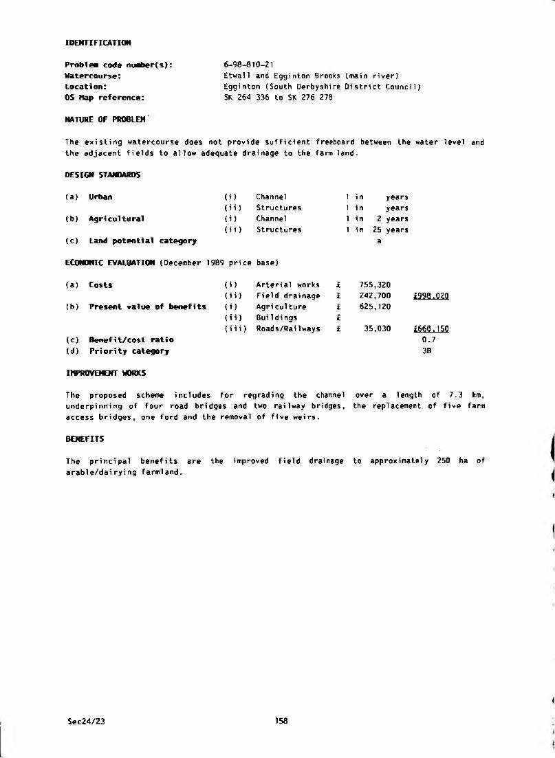
IDENTIFICATION
Problea code maber(s):
Watercourse:Location:
OS Nap reference:
NATURE OF PROBLEM
6-98-810-21
Etwall and Egginton Brooks (main river)
Egginton (South Derbyshire District Council)
SK 264 336 to SK 276 278
The existing watercourse does not provide sufficient freeboard between the water level and
the adjacent fields to allow adequate drainage to the farm land.
DESIGN STAMMRDS
(a) Urban (i) Channel 1 in years
(ii) Structures 1 i n years
(b) Agricultural (i) Channel 1 in 2 years
(ii) Structures 1 in 25 years
(c) Land potential category a
ECONOMIC EVALUATION (December 1989 price base)
(a) Costs (i) Arterial works £ 755,320
(ii) Field drainage £ 242,700 £998.020
(b) Present value of benefits (i) Agri culture £ 625,120
(ii) Bui 1di ngs £
(iii) Roads/Railways £ 35,030 4660.150(c) Benefit/cost ratio 0.7
(d) Priority category 38
IMPROVEMENT WORKS
The proposed scheme includes for regrading the channel over a length of 7.3 km,
underpinning of four road bridges and two railway bridges, the replacement of five farm
access bridges, one ford and the removal of five weirs.
BENEFITS
The principal benefits are the improved field drainage to approximatel
arable/dai ryi ng farmland.
y 250 ha of
Sec24/23 158
IDENTIFICATION
Problea code nuber(s):
Watercourse:
Location:
OS Map reference:
NATURE OF PROBLEM
6-98-810-24
Thulston Brook (non-main river)
Thulston Brook (South Derbyshire District Council)
SK 410 320
A house has been flooded in Thulston and others are now built on the same site. Flows from
the large scale development that has taken place upstream at Alvaston are balanced to limit
flows downstream.
DESIGN ST AWARDS
(a) Urban
(b) Agricultural
(c) Land potential category
ECONOMIC EVALUATION (December 1989 price base)
( U
(ii)
(i)
(ii)
Channel
Structures
Channel
Structures
(a) Costs
(b) Present value of benefits
(c) Benefit/cost ratio
(d) Pri ori ty category
)
i))
i)
(iii)
1 in
1 in
1 i n
1 i n
Arterial works £
Field drainage £
Agri culture £
Buildings £
Roads/Railways £
years
years
years
years
Sec24/23 159
IDENTIFICATION
P r o b i n code ni«ber(s):
Watercourse:
Location:
OS Nap reference:
6-98-810-26
Un-named (non-main river)
Scropton (South Derbyshire District Council)
SK 194 311 to SK 193 301
NATURE OF PROBLEM
The road known as Water Lane which links Scropton to the A50 road regularly suffers from
flooding. Several properties bordering the road are also at risk from flooding. The main
drain serving this catchment area runs in a southerly direction along the side of the lane
and eventually discharges via a flapped outfall into the River Dove at Scropton.
When flooding occurs on the River Dove, high river levels close the flap valve which
subsequently causes the Brook to back up and flood the road. The properties bordering the
road have been seriously threatened by floodwater on several occasions and any further
development or increase in paved areas upstream will certainly worsen the existing
si tuati on.
DESIGN STAMMRDS
(a ) Urban (i) Channel 1 i n years
(b ) Agri cultural
(i i) Structures
(i) Channel
(i i ) Structures
1 in
1 in
1 in
years
years
years
(c) Land potential category
ECONOMIC EVALUATION (December 1989 price base)
(b) Present value of benefits
(a ) Costs i) Arterial works
ii) Field drainage
i) Agriculture
£££
£
£
£.
ii) Buildings
iii) Roads/Railways £(c ) Benefi t/cost rati o
(d ) Pri ori ty category
Sec24/23 160

IDENTIFICATION
6-98-810-27
Shardlow Parish Dyke (non-main river)
Shardlow (South Derbyshire District Council)
SK 4312 3040 to SK 4475 3055
NATURE OF PROBLEM
Problea code nuaber(s):
Watercourse:
Location:
OS Hap reference:
A number of flooding problems exist on this watercourse, which is the main watercourse
serving the village. The problems are mainly caused by inadequate culverts and .channel
sections combined with a general lack of maintenance. The situation has been made worse
over recent years by increased development upstream of the main problem areas around The
Wharf.
As a result of increasing local concern, a considerable amount of discussion and
consultation has taken place between the Parish Council, District Council and the former
STWA. The outcome has been that a continuous length of the watercourse between
SK 4338 3018 and SK 4418 3045 has been accepted and adopted by STW as a public sewer.
Pending the result of further enquiries into riparian ownership, a further length upstream
may also ultimately be adopted as public sewer.
DESIGN STAMMRDS
(a) Urban
(b) Agri cultural
(c) Land potential category
ECONOMIC EVALUATION (December 1989 price base)
(i)
(ii)
(i)
(ii)
Channel
Structures
Channel
Structures
1 i n
1 i n
1 i n
1 i n
years
years
years
years
(a) Costs
(b) Present value of kcnsfi
(c) Benefit/cost ratio
(d) Priority category
(i) Arterial works £
(ii) Field drainage £
{i) Agri cul ture £
(ii) Buildings £
(iii) Roads/RaiIways £
IMPROVEMENT WORKS
South Derbyshire District Council have recently undertaken a drainage investigation of this
watercourse and have produced a report identifying what improvements require to be carried
out in order to alleviate the problem. No work is currently planned for implementation in
the immediate future, but it is envisaged that certain works will be carried out at some
stage to financial availability.
Sec24/23 161
6-98-810-28
Thulston Brook (non-main river)
Boulton to Shardlow (Derby City Council and South
Derbyshire District Council)
SK 390 320 to SK 442 377
NATURE OF PROBLEM
IDENTIFICATION
Problea code nuaber(s):
Watercourse:
Location:
OS Hap reference:
Thulston Village is subject to occasional flooding from the Thulston Brook, the last
notable event being in 1977. On this occasion, flooding was caused by a combination of
i ntense local rai nfal1 and the backwater effect of the hi gh floodwater 1evel at the
Derwent/Thulston Brook confluence.
In addition to Thulston Village, flooding also affects agricultural land bordering the
Brook and improvement works are required to alleviate the existing problems.
DESIGN STAMMRDS
(i)
(ii)
(i)
(ii)
(a) Urban
(b) Agricultural
(c) Land potential category
ECONOHIC EVALUATION (December 1989 price base)
(a ) Costs
(b) Present value of benefits
Channel
Structures
Channel
Structures
(i) Arterial works
(i i) Field drai nage
(i) Agri culture
(i i) BuiIdings
(i i i) Roads/RaiIways
(c) Benefit/cost ratio
(d) Priority category
1 i n
1 in
1 in
1 in
years
years
years
years
DEVELOPMENT
The policy of the NRA is that no further development draining to this watercourse should be
allowed in the future, unless either improvement or balancing works are undertaken.
CONSERVATION
The Brook and adjacent fields support a rich and varied flora and fauna.
Sec24/23 162
IDENTIFICATION
6-98-810-27
$hardlowTParish-Dyke=(non-main river)
Shardlow (South Derbyshire District Council)
SK 4312 3040 to SK 4475 3055
NATURE OF PROBLEM
P rob lea code nvber(s):
Watercourse:Location: ’ '
OS Map reference:
A number of flooding problems exist on this watercourse, which is the main watercourse
serving the village. The problems are mainly caused by inadequate culverts and .channel
sections combined with a general lack of maintenance. The situation has been made worse
over recent years by increased development upstream of the main problem areas around The
Wharf.
As a result of increasing local concern, a considerable amount of discussion and
consultation has taken place between the Parish Council, District Council and the former
STWA. The outcome has been that a continuous length of the watercourse between
SK 4338 3018 and SK 4418 3045 has been accepted and adopted by STW as a public sewer.
Pending the result of further enquiries into riparian ownership, a further length upstream
may also ultimately be adopted as public sewer.
DESIGN STANDARDS
(a) Urban
(b) Agricultural
(c) Land potential category
ECONOMIC EVALUATION (December 1989 price base)
(t) Channel
(ii) Structures
(i) Channel
(i i) Structures
(a) Costs
(b) Present value of benefits
(c) Benefit/cost ratio
(d) Pri ori ty category
(i) Arterial works
(ii) Field drainage
(i) Agri culture
(ii) Buildings
(iii) Roads/Railways
1 i n
1 i n
1 in
1 i n
years
years
years
years
IHPROVEICNT WORKS
South Derbyshire District Council have recently undertaken a drainage investigation of this
watercourse and have produced a report identifying what improvements require to be carried
out in order to alleviate the problem. No work is currently planned for implementation in
the immediate future, but it is envisaged that certain works will be carried out at some
stage to financial availability.
Sec24/23 161
6-98-810-28
Thulston Brook (non-main river)
Boulton to Shardlow (Derby City Council and South
Derbyshire District Council)
SK 390 320 to SK 442 377
NATURE OF PROBLEM
IDENTIFICATION
Problem code mari>er(s):
Watercourse:
Location:
OS Map reference:
Thulston Village is subject to occasional flooding from the Thulston Brook, the last
notable event being in 1977. On this occasion, flooding was caused by a combination of
intense local rainfall and the backwater effect of the high floodwater level at the
Derwent/Thulston Brook confluence.
In addition to Thulston Village, flooding also affects agricultural land bordering the
Brook and improvement works are required to alleviate the existing problems.
DESIGN STANDARDS
(i)
(ii)
(i)
(ii)
(a ) Urban
(b) Agricultural
(c) Land potential category
ECONOMIC EVALUATION (December 1989 price base)
(a) Costs
(b) Present value of benefits
Channel
Structures
Channel
Structures
(i) Arterial works
(i i) Field drainage
(i) Agriculture
(i i) Buildings
(iii) Roads/Railways
(c) Benefit/cost ratio
(d) Priority category
1 in
1 in
1 in
1 i n
years
years
years
years
DEVELOPMENT
The policy of the NRA is that no further development draining to this watercourse should be
allowed in the future, unless either improvement or balancing works are undertaken.
CONSERVATION
The Brook and adjacent fields support a rich and varied flora and fauna.
Sec24/23 162
IDENTIFICATION
Problea code maber(s):
Watercourse:
. Location: -------
OS Map reference:
NATURE OF PROBLEM
7-98-810-1 ^None _ _ . - _ - '
Burton Road, Newton Solney (South Derbyshi re Di stri ct
Counci1)
SK 280 255
Road flooding is caused by surface water ponding as the road gullies are not able to
discharge excess water.
(i) Channel
(i i) Structures
(t) Channel
(ii) Structures
DESIGN STAMMRDS
(a ) Urban
(b ) Agri cultural
(c) Land potential category
ECONOMIC EVALUATION (December 1989 price base)
(a) Costs
(b) Present value of benefits
1 i n
1 i n
1 i n
1 i n
years
years
years
years
) Arterial works
i) Field drainage
) Agri culture
i) Buildings
i i) Roads/RaiIways
(c) Benefit/cost ratio
(d ) Pri ori ty category
INPROVElOfT WORKS
This is a Highway Authority problem and is outside the scope of this Survey.
Sec24/23 163
IDENTIFICATION
P rob lea code nt^>er(s):
Watercourse:
Location:
OS Map reference:
Smisby (South Derbyshire District Council)
SK 350 191
7-98-810-2
None
NATURE OF PROBLEM
Surface water flows down the road flooding a public house.
DESIGN STANDARDS
(i)
(ii)
(i)
(ii)
(a) Urban
(b ) Agri cultural
(c) Land potential category
ECONOMIC EVALUATION (December 1989 price base)
(a ) Costs
(b) Present value of benefits
Channel
Structures
Channel
Structures
1 in
1 i n
1 i n
1 i n
i) Arterial works
i i) Field drainage
i) Agri culture
i i) Buildings
iii) Roads/Rai1 ways
(c) Benefit/cost ratio
(d) Priority category
years
years
years
years
IMPROVEMENT WORKS
This is a Highway Authority problem and is outside the scope of this Survey.
Sec24/23 164
IDENTIFICATION
Problem code maber(s)
Watercourse:
Location:
OS Hap reference:
NATURE OF PROBLEM
7-98-810-3 - .. - - - -- - - -
Hooborough Brook (non-main river)
Overseal (South Derbyshire Oistrict Council)
SK 294 127 to SK 300 161
65 ha of agricultural land suffer from inadequate arterial drainage and localised flooding.
DESIGN STANDARDS
(a) Urban (i) Channel 1 in years
(i i) Structures 1 in years
(b) Agricultural (i) Channel 1 in 3 years
(ii) Structures 1 i n years
(c) Land potential category a
ECONOMIC EVALUATION (December 1989 price base)
(a) Costs (i) Arterial works £ 273,880
(i i) Fi el d drai nage £ 20,020
(b) Present value of benefits (i) Agriculture £ 119,470
(ii) BuiIdi ngs £
(iii) Roads/Railways £
£293.900
£m ,4Z00.4
3C
(c) Benefit/cost ratio
(d) Priority category
IMPROVEMENT WORKS
General regrading works are required to provide a channel capacity of 3.1 cumecs and to
allow satisfactory freeboard for field drainage under average flow conditions. No major
work on structures is required. South Derbyshire District Council have no immediate plans
to undertake improvement works.
BENEFITS
With improved drainage some slight improvement in stocking rates may be possible resulting
in an increase in gross margin. No further increase in arable cropping is envisaged.
CONSERVATION
The area on either side of the road bridge (B5004) has developed into a good example of a
marsh habitat supporting willow warbler and chiff chaff. In a locality where mining and
other industrial activities have destroyed much of the natural vegetation, this is of
important conservation value.
Sec24/23 165
IDENTIFICATION
Problea code niari»er(s):
Watercourse:
Location:
OS Nap reference:
7-98-810-7
Ramsley Brook (non-main river)
Melbourne (South Derbyshire District Council)
SK 393 272
NATURE OF PROBLEM
15 ha of land used for horticulture and 42 ha of semi-waste land (old railway sidings etc)
suffer from inadequate arterial drainage.
DESIGN STANDARDS
(a ) Urban
(b ) Agri cul tural
(c) Land potential category
ECONOMIC EVALUATION (December 1989 price base)
(i)
(ii)
(i)
(”)
Channel
Structures
Channel
Structures
(a ) Costs
(b) Present value of benefits
(c) Benefit/cost ratio
(d) Priority category
) Arterial works
i) Field drainage
) Agri culture
i) BuiIdings
(iii) Roads/RaiIways
years
years
1 in 3 years
1 i n years
i niL
£ nil
IMPROVEMENT WORKS
The watercourse needs only limited maintenance works to bring it up to the required
standard. These are the responsibility of the riparian owners.
BETCFITS
No increase in gross margin is likely following drainage improvements; in fact there may be
a reduction as water from this area is extracted for irrigating 15 ha in the benefit area
and a further 50 ha beyond. If drainage alters the flow of water it may reduce the amount
of water available for irrigation.
It seems unlikely that the 42 ha of waste land has any horticultural potential. Its poor
quality is not due to any deficiency of drainage.
Sec24/23 166
6-99-110-1/12/13
River Tean and Cecilly Brook (non-main river)
lower=Tean-;to CHeadfe _(Staffordshi re"“Moorlands Di stri ct
Counci 1)
S3 997 429 to SK 020 382, SK 008 443 to SK 006 414,
SK 016 443 to SK 014 437
NATURE OF PROBLEM
IDENTIFICATION
Problea code niMber(s):
Watercourse:
^.Location:, = ^
OS Hap reference:
Flooding occurred in February 1946, July 1957 and the winter of 1974 on the floodplains of
the upper reaches of the River Tean and the Ceci11y Brook. Thi rteen properties were
affected near The White Hart Public House in Upper Tean and on Mill Lane in Lower Tean. In
addition, drainage is adversely affected on 112 ha of agricultural land.
DESIGN ST AWARDS
(a) Urban
(b) Agri cultural
(c) Land potential category
ECONOHIC EVALUATION (December 1
(a) Costs
(b) Present value of benefits
(c) Benefit/cost ratio
(d) Priority category
IMPROVEttMT WORKS
(i) Channel 1 i n 10 years
(ii) Structures 1 in 100 years
(i) Channel 1 i n 10 years
(ii) Structures 1 i n 25 years
a
pri ce base)
(i) Arterial works £
(ii) Field drainage £ £
(i) Agricul ture £
(ii) Bui 1d ings £
(iii) Roads/Railways £ i
The NRA, Severn-Trent Region has submitted proposals to the Ministry of Agriculture,
Fisheries & Food for maining the following lengths of watercourse:
R Tean - SK 062 360 to SK 001 424, 11 km.
Cecilly Brook - SK 006 414 to SK 010 442, 3.5 km
Upon confirmation of these watercourses as main river, the NRA has programmed improvement
works for 1992/93 subject to a satisfactory benefit cost assessment.
DEVELOPMENT
Objections are being raised to development in the River Tean catchment because of the
detrimental effect of additional surface water on land drainage. In the past, these
objections have been overlooked if developers have agreed to provide surface water
retention basins which will limit the discharge to the river. Future development could,
however, be advised against by STWA to avoid an unacceptable proliferation of retention
basins.
FISHERIES
This is a good coarse fishery site and consultation will be necessary before any
improvement is commenced.
Sec24/23 167

IDENTIFICATION
Problem code nuaber(s):
Watercourse:
Location:
OS Hap reference:
6-99-110-3
River Churnet headwaters (non-main river)
Meerbrook (Staffordshire Moorlands District Council)
SJ 986 626 to SJ 992 609
NATURE OF PROBLEM
Flooding upstream of Tittesworth Reservoir occurs for durations of 2 to 3 hours and affects
the drainage of 26 ha of agricultural land.
DESIGN STAMMRDS
(a) Urban (i) Channel 1 in years
(ii) Structures 1 in years
(b) Agricultural ( O Channel 1 in 2 years
(ii) Structures 1 in 50 years
(c) Land potential category a
ECONOHIC EVALUATION (December 1989 price base)
(a) Costs (i) Arterial works £ 236,400
(ii) Field drainage £ 15,010 £251.410
(b) Present value of benefits (i) Agri culture £ 130,580
(ii) Bui 1di ngs £
(iii) Roads/RaiIways £ £130.580
(c) Benefit/cost ratio 0.5
(d) Priority category 3C
IMPROVEMENT WORKS
A regrading scheme of 2.2 km of the river is proposed to improve the drainage of
agricultural land by providing 1.5 m of freeboard in the river at normal water levels. A
roadbridge, a farm access bridge and 3 footbridges are to be replaced as part of the scheme.
FISHERIES
This is a good trout and coarse fishery site and consultation is essential.
Sec24/23 168
IDENTIFICATION
Problem code nuaber(s):
Watercourse:
Location:
OS Nap reference:
6-99-110-4/5/15/17
^^Oiitches^draining- to' Horton' Brook {non-main river)
Endon (Staffordshire Moorlands District Council)
SJ 933 540
NATURE OF PROBLEM
Flooding has occurred to a cottage on Dams Lane at Gratton. The flooding results from
inadequate farm and highway ditches and work to watercourses will not alleviate this
problem. The solution, therefore, is outside the scope of this Survey.
DESIGN STAWARDS
(a) Urban (i) Channel 1 in years
(b) Agricultural
(ii) Structures
(i) Channel
(i i) Structures
1 in
1 i n
1 i n
years
years
years
(c) Land potential category
ECONOMIC EVALUATION (December 1989 price base)
(b) Present value of benefits
(a ) Costs ) Arterial works
i) Field drainage
) Agri culture
£££££
i) Buildings
i i) Roads/Railways L(c) Benefit/cost ratio
(d) Priority category
Sec24/23 169
IDENTIFICATION
Problem code number(s):
Watercourse:
Location:
OS Hap reference:
NATURE OF PROBLEM
6-99-110-6
Dingle Brook and canal
Rudyard (Staffordshire
SJ 955 579
feeder (non-wain river)
Moorlands District Council)
Flooding for a duration of 1-2 days occurred in February 1977 to a Garage, cellars to 2
houses and 4 ha of land. The flooding originates from Rudyard Reservoir overflow and canal
feeder which are British Waterways Board installations. The solution to this problem is,
therefore, outside the scope of this Survey.
DESIGN STANDARDS
(a) Urban (i) Channel 1 in years
(ii) Structures 1 i n years
(b) Agri cultural (i) Channel 1 in years
(ii) Structures 1 in years
(c) Land potential category
ECONOMIC EVALUATION (December 1989 price base)
(a) Costs (i) Arterial works £
(ii) Field drainage £
(b) Present value of benefits (i) Agri culture £
(ii) Bui 1 dings £
(iii) Roads/RaiIways £
(c) Benefit/cost ratio
(d ) Pri ori ty category
IHPROVEVCNT WORKS
British Waterways Board have carried out some improvement works to their reservoir overflow
arrangements and also cleared and improved their canal feeder channel. The problem has
still not been fully alleviated because storm run-off draining to the affected land cannot
get away due to inadequate drains beneath the artificially raised highway.
Sec24/23 170
IDENTIFICATION
Prtjblew code nu^er(s):
Watercourse:■ ' ~ ' “
Location:
OS Hap reference:
NATURE OF PROBLEM
nooding of Horton Brook affects the drainage of 80 ha of agricultural land.
DESIGN STANDARDS
(a) Urban (i) Channel 1 i n
(i i) Structures 1 i n
(b) Agricultural (i) Channel 1 i n
{i i) Structures 1 i n
(c) Land potential category
ECONOMIC EVALUATION (December 1989 price base)
(a) Costs (i) Arterial works £ 317,120
(ii) Field drainage £ 50,040(b) Present value of benefits (i) Agri culture £ 400,080
(ii) BuiIdi ngs £
{iii) Roads/Railways £
(c) Benefit/cost ratio 1.1
(d) Priority category 1C
IMPROVEMENT WORKS
A general regrading scheme along 3.8 km of the Horton Brook is recommended to improve the
land drainage of the area. Underpinning is required to two road bridges, and a number of
farm access bridges need replacing.
BENEFITS
The benefits are attributable to improved output from agricultural land alone. .
CONSERVATION
Downstream of the benefit area at SJ 952 576 are wet meadows of nature conservation
i nterest.
FISHERIES
This is a good coarse fishery site and consultation will be necessary before any
improvement work is commenced.
years
years
2 years
25 years
a
6—99—VI0-7 _ _ ^ „ - - - - - - - -
Horton Brook (non-main river)
Endon (Staffordshire Moorlands District Council)
SJ 936 576 to SJ 934 541
Sec24/23 171
IDENTIFICATION
Problem code number(s):
Watercourse:
Location:
OS Hap reference:
6-99-110-8/16
Tributary of River Churnet (non-main river)
Rudyard, Leek (Staffordshire Moorlands District Council)
SK 956 587
NATURE OF PROBLEM
Flooding occurred in February 1977 to a barn and a small area of land on each side of Green
Lane.
DESIGN STANDARDS
(a) Urban (i) Channel 1 i n years
(ii) Structures 1 i n years
(b) Agricultural (i) Channel 1 i n 25 years
(ii) Structures 1 i n 25 years
(c) Land potential category
ECONOHIC EVALUATION (December 1989 price base)
(a) Costs (i) Arterial works £ 7,210
(i i) Field drainage £ £7,210(b) Present value of benefits (i) Agri cul ture £
(ii) Buildi ngs £ 5,000
(iii) Roads/Railways £ £5.000
(c) Benefit/cost ratio 0.7
(d) Priority category 3F
IMPROVEMENT WORKS
The recommended remedial works comprise channel clearance upstream of the Green Lane
culvert. In addition, it wi 11 be necessary to replace the ford, which provides access to
the fields, with a bridge and flood embankment.
BENEFITS
The benefits from alleviation of flooding to agricultural land and the road are negligible
and have not been included.
Sec24/23 172

IDENTIFICATION
Proble* code niober(s): 6-99-110-11
Watercourse: Tri butary ofRiver Jean (non-mai n river)^ -- - --
Location:^"'"- ~ Upper Tean {Staffordshire Moorlands District Council)
OS Nap reference: SK 016 395
NATURE OF PROBLEM
Road flooding at this location has been reported, but investigations have shown no evidence
of any arterial drainage problem.
DESIGN STANDARDS
(a) Urban
{b) Agricultural
(c) Land potential category
(i) Channel
{i i) Structures
{i) Channel
(ii) Structures
1 i n
1 in
1 i n
1 in
years
years
years
years
ECONOMIC EVALUATION (December 1969 price base)
(a) Costs
(b) Present value of benefits
(c) Benefit/cost ratio
(d) Priority category
(i) Arterial works £
(i i) Fi eld drainage £
(i) Agri culture £
(ii) Buildings £
(iii) Roads/Railways £
Sec24/23 173
6-99-110-18
River Churnet (main river)
Alton (Staffordshire Moorlands Oistrict Council)
SK 072 427
NATURE OF PROBLEM
IDENTIFICATION
Problem code ntaber(s):
Watercourse:
Location:
OS Map reference:
In 1967 and 1969 flooding occurred to two houses, the gardens to two other houses and to
the sewage works.
(i)
(ii)
m
(ii)
DESIGN STAMMRDS
(a) Urban
(b) Agricultural
(c) Land potential category
ECONOMIC EVALUATION (December 1989 price base)
(a ) Costs
(b) Present value of benefits
Channel
Structures
Channel
Structures
(i) Arterial works
(i i) Field drainage
(i ) Agri culture
(i i) BuiIdings
(iii) Roads/Railways
(c) Benefit/cost ratio
(d) Priority category
1 in
1 in
1 i n
1 i n
years
years
years
years
17,300
6,010
£17.300
£6,0100.3
3E
IMPROVEMENT WORKS
The recommended works require an effective hydraulic seal to be constructed across the
disused mill race, to alleviate the flooding which occurs to the two houses behind the
mill. The cost of protecting the sewage works and house gardens is High in relation to the
benefits achieved and cannot, therefore, be recommended.
DEVELOPMENT
Development at Alton Towers may exacerbate these problems.
FISHERIES
Thi s is a good trout f i shery si te and consul tat ion i s requi red before any works are
commenced.
Sec24/23 174
IDENTIFICATION
6-99-110-19
Cotton_Brook^(non-main. r,iver)« - - ■ — ~
Oakamoor (Staffordshire Moorlands District Council)
SK 055 450
NATURE OF PROBLEM
Proble* code m^>er(s):
Watercourse:Locati o n : ^“" ' ”
OS )top reference:
In July 1974, flooding occurred to a public house, roads and terraced cottages around the
square in Oakamoor. The flooding lasted for approximately 4 hours.
DESIGN STANDARDS
(a ) Urban
(b) Agricultural
(c) Land potential category
ECONOMIC EVALUATION (December 1989 price base)
(i)(M)
(i)
(ii)
Channel
Structures
Channel
Structures
(a) Costs
(b) Present value of benefits
(c) Benefit/cost ratio
(d) Priority category
) Arterial works
i) Field drainage
) Agri culture
i) BuiIdi ngs
(iii) Roads/Railways
1 in 100 years
1 in 100 years
1 in years
1 in years
175,860
62,550
£175.860
S63.55Q0.4
3C
IMPROVEMENT WORKS
The recommended works consist of 200 m of channel clearance involving regrading, removal of
weirs and vegetation and the provision of a concrete lined channel. In addition, it will
be necessary to replace two existing footbridges. Floodbanks will be required adjacent to
the Brook channel and the River Churnet immediately upstream of the weir.
BENEFITS
The benefit from alleviation of road flooding is negligible and has not been included.
Sec24/23 175
IDENTIFICATION
Problea code nuaber(s)
Watercourse:
Location:
OS Hap reference:
6-99-110-20
River Churnet (main river)
Oakamoor (Staffordshire Moorlands District Council)
SK 053 446
NATURE OF PROBLEM
Flooding occurred to 8 terraced cottages at the Island, Oakamoor in 1948 and 1964.
DESIGN STAMMRDS
(i) Channel
(i i) Structures
Channel
Structures( i )(ii)
(a ) Urban
(b ) Agri cultural
(c) Land potential category
ECONOHIC EVALUATION (December 1989 price base)
(a ) Costs
(b) Present value of benefits
1 in 100 years
1 in 100 years
1 in years
1 in years
i) Arterial works
i i) Fi eld drainage
i) Agri culture
i i) Bui 1dings
i i i) Roads/RaiIways
54,780
15,010
£54,780
£15.010
0.3
3D
(c) Benefit/cost ratio
(d) Priority category
IMPROVEMENT WORKS
The recommended flood alleviation works consist of a reinforced concrete wall adjacent to
the River Churnet and a floodbank to tie the end of this wall into higher land at Mill Lane.
FISHERIES
This is a good trout and coarse fishery site and consultation is essential.
Sec24/23 176
IDENTIFICATION
Problem code mari>er(s):
Watercourse:^,Location:
OS Nap reference:
NATURE OF PROBLEM
6-99-110-21 — ^ ^ " ̂ ^-River Manifold (non-main river)
Brund, Near Sheen (Staffordshi re Moorlands District
Counci 1)
SK 098 613
The flooding problem reported represents the normal inundation of the River Manifold
floodplain. As no serious flooding to property, land or roads occurs, no alleviation works
have been considered or benefits evaluated.
(i)
(ii)
(i)
(ii)
Channel
Structures
Channel
Structures
DESIGN STANDARDS
(a) Urban
(b) Agricultural
(c) Land potential category
ECONOMIC EVALUATION (December 1989 price base)
(a) Costs (i) Arterial works
(i i) Fi eld drainage
(b) Present value of benefits (i) Agriculture
(i i) Buildings
(iii) Roads/Railways
(c) Benefit/cost ratio
(d) Priori ty category
1 in
1 in
1 i n
1 i n
years
years
years
years
Sec24/23 177

IDENTIFICATION
Problea code nuaber(s):
Watercourse:
Locati on:
OS Nap reference:
6-99-110-22
River Manifold (non-main river)
Hulme End {Staffordshire Moorlands District Council)
SK 106 593
NATURE OF PROBLEM
The flooding reported represents the normal inundation of the River Manifold floodplain.
As no serious flooding occurs to land or roads at this location, no alleviation works have
been considered at this stage.
Surface water sewerage problems exist at the Light Railway Inn and also near the
Office in Hulme End Village, but these problems fall outside the scope of this Survey.
DESIGN STANDARDS
Post
{a) Urban
(b ) Agri cultural
(c) Land potential category
(i)
(ii)
(i)
{ii)
Channel
Structures
Channel
Structures
ECONOMIC EVALUATION (December 1989 price base)
(a ) Costs
(b) Present value of benefits
(c) Benefit/cost rati o
(d ) Priori ty category
1 in
1 in
1 in
1 in
) Arterial works £
i) Field drainage £
) Agri cul ture £
(i i) Bui 1di ngs £
(iii) Roads/Railways £
years
years
years
years
Sec24/23 178
IDENTIFICATION
Problea code nuaber(s)
Watercourse:Location:
OS Kap reference:
6-99-n_0-23^ __ _ _ . .
Un-named tributary of River Hamps (non-main river)
Onecote (Staffordshire Moorlands District Council)
SK 051 554
NATURE OF PROBLEM
The problem is considered to be attributable to the brookcourse surcharging and flooding
the adjacent road, prior to its discharge to the River Hamps on the downstream side of the
B5053 road bridge. The solution considered would be basic channel maintenance consisting
of the removal of weeds, debris, etc from the farm access bridge to the River Hamps
outfall. As simple maintenance works would alleviate the flooding problem, no costs have
been established or benefits evaluated.
DESIGN STAJOARDS
(a) Urban (i) Channel 1 in years
(b) Agri cultural
(ii) Structures
(i) Channel
(i i) Structures
1 in
1 in
1 in
years
years
years
(c) Land potential category
ECONOMIC EVALUATION (December 1989 price base)
(a) Costs
(b) Present value of benefits
(i) Arterial works
(i i) Fi eld drai nage
(i) Agriculture
£££££
L
(i i) Buildi ngs
(iii) Roads/Railways i
(c) Benefit/cost ratio
(d) Priority category
Sec24/23 179

6-99-110-24
River Manifold {non-main river)
West Side Mill, Hulme End (Staffordshire Moorlands
District Counci 1)
SK 101 588
NATURE OF PROBLEM
IDENTIFICATION
Problem code niaber(s):
Watercourse:
Location:
OS Kap reference:
The infrequent road f1ooding reported results from abnormal inundation
Manifold floodplain and no alleviation works have therefore been considered.
of the River
DESIGN STAMMRDS
(a) Urban
(b ) Agricultural
(c) Land potential category
(i)
(ii)
<i>
(ii)
Channel
Structures
Channel
Structures
ECONOMIC EVALUATION (December 1989 price base)
(a ) Costs
(b) Present value of benefits
(c) Benefit/cost ratio
(d ) Pri ori ty category
) Arterial works
i) Field drainage
) Agri cul ture
i) Buildings
i i) Roads/RaiIways
1 in
1 in
1 in
1 i n
years
years
years
years
Sec24/23 180
IDENTIFICATION
Problem code maber(s): 6-99-110-25
W a t e r c o u r s e ^ _ _=... _-—,Tributary^of-River Dove=(:non-main river)^-̂ - =
Location: Hoi 1insclough (Staffordshire Moorlands District Council)
OS Nap reference: SK 071 666
NATURE OF PROBLEM
Flooding occurs to a minor road, but as this is not serious the benefits do not justify an
improvement scheme. A solution has, therefore, not been evaluated.
DESIGN STAMMRDS
(a) Urban
(b) Agricultural
(c) Land potential category
m
(ii)
(i)
(ii)
Channel
Structures
Channel
Structures
1 in
1 in
1 in
1 in
years
years
years
years
ECONOHIC EVALUATION (December 1989 price base)
(a) Costs
(b) Present value of benefits
(c) Benefit/cost ratio
(d) Priority category
) Arterial works £
i) Field drainage £
) Agri culture £
i) Buildings £
i i) Roads/Railways £
Sec24/23 181
IDENTIFICATION
Problea code nuaber(s):
Watercourse:
Location:
OS Hap reference:
Milldale (Staffordshire Moorlands District Council)
SK 139 547
6-99-110-26
None
NATURE OF PROBLEM
In 1964 and 1977 a shop, 2 houses and a woodyard were flooded by run-off from the highway
during a flood with an estimated frequency of 1 in 1 0 0 years.
(i)
( H )(i)
<ii>
DESIGN ST A W A R D S
(a) Urban
(b) Agricultural
(c) Land potential category
ECONOMIC EVALUATION (December 1989 price base)
(a) Costs
(b) Present value of benefits
Channel
Structures
Channel
Structures
Arterial works
Field drainage
Agri cul ture
Buildi ngs
ii) Roads/Rai1ways
( c) Benefi t/cost rati o
(d) Priority category
1 i n
1 i n
1 i n
1 in
years
years
years
years
IHPROVEICNT WORKS
These roadside properties flood due to the inadequacies in the highway surface water
drainage system. Works to watercourses will not alleviate the flooding and the solution
is, therefore, outside the scope of this Survey.
C O M C N T
Owing to the location, a surface water drainage system to prevent the road acting as a
watercourse is believed to be impractical and very expensive. Householders protect their
properties by sandbags or specially made 'stop boards'.
Sec24/23 182
IDENTIFICATION
Problem code nu^>er(s):
Watercourse:Location: __ _
OS Map reference:
NATURE OF PROBLEM
6-99-110-30
Leek Brook (non-main river)
Leekbrook-(Staffordshire~Moorlands=Drstrfct” Cbunci 1)
SJ 985 539
Occasional flooding occurs to two detached houses and a domestic garage.
DESIGN STAMARDS
(a) Urban (i) Channel 1 in 25 years
(ii) Structures 1 in years
(b) Agricultural (i) Channel 1 in years
(ii) Structures 1 in years
(c) Land potential category
ECONOHIC EVALUATION (December 1989 price base)
(a) Costs (i) Arterial works £ 23,060
(ii) Field drainage £ £23.060
(b) Present value of benefits (i) Agri culture £
(ii ) BuiIdings £ 35,030
(iii) Roads/Railways £ £35.030
(c) Benefit/cost ratio 1.5
(d) Priority category 2E
IMPROVEMENT WORKS
The recommended remedial works consist of clearance of the Leek Brook channel, both
upstream and downstream of the A520 Cheddleton Road, and the construction of floodbanks on
both sides of the Leek Brook adjacent to the affected properties. In addition, the A520
road culvert and the Basfcrd Lane culvert will require clearing out^
FISHERIES
There is fishery interest at this site and consultation is necessary before any improvement
work is commenced.
COMCNT
Some works to the channel have been carried out as a condition of development of upstream
i ndustrial estates, but floodi ng has si nee occurred to the same properties. The basi c
problem appears to be industrial debris thrown into the Brook and heavy river siltation
which leads to culvert blockage and flooding. Staffordshire Moorlands District Council
carry out some maintenance to the Brook on occasions but no works are programmed.
Sec24/23 183
IDENTIFICATION
Problea code nuaber(s):
Watercourse:
Location:
OS Nap reference:
6-99-110-31
River Churnet (main river)
Leek (Staffordshire Moorlands District Council)
SJ 980 572 to SJ 974 571
NATURE OF PROBLEM
The major problem on this reach of the river is the flooding of 3 houses and the road at
Abbey Green and also a public house, 7 residential properties, industrial premises and the
Macclesfield Road in Leek.
DESIGN STANDARDS
(i) Channel
(i i) Structures
(i) Channel
(i i) Structures
(a) Urban
(b ) Agri cultural
(c) Land potential category
ECONOMIC EVALUATION (December 1989 price base)
(a ) Costs
(b) Present value of benefits
(i) Arteri al works
(ii) Field drainage
(i) Agri culture
(i i) Buildi ngs
{i i i) Roads/RaiIways
(c) Benefit/cost ratio
(d ) Pri ori ty category
1 in years
1 in 1 0 0 years
in
in
years
years
IMPROVEMENT WORKS
The National Rivers Authority have an improvement scheme planned for 1991.
FISHERIES
This is a good coarse fishery site and consultation will be necessary before any
improvement work is commenced.
Sec24/23 184
IDENTIFICATION
Problem code nuaber(s):
Watercourse^ _ _____
Locati on:
OS Map reference:
NATURE OF PROBLEM
6-99-110-32
BalUBrook^non-roain-river)-̂ " - —
Leek (Staffordshire Moorlands District Council)
SJ 987 568
Flooding occurs to 6 terraced houses, a builders yard and the Ball Haye Road. Flooding
probably occurred in 1977 following a 1 in 50 year event, but there has been no reported
flooding since. The flooding results from surface water sewers, and works to the
watercourses will not alleviate the problem. The solution is, therefore, outside the scope
of this Survey.
DESIGN STANDARDS
(i)(ii)
m
(ii)
(a) Urban
(b) Agricultural
(c) Land potential category
ECONOMIC EVALUATION (December 1989 price base)
(a) Costs
(b) Present value of benefits
(c) Benefit/cost ratio
(d) Pri ori ty category
Channel
Structures
Channel
Structures
1 in
1 i n
1 in
1 i n
years
years
years
years
(i) Arterial works £
(ii) Field drainage £ £
(i) Agri culture £(ii) Buildi ngs £(iii) Roads/RaiIways £ £
Sec24/23 185
IDENTIFICATION
Problea code nuaber(s):
Watercourse:
Location:
OS Hap reference:
6-99-110-33
Ball Brook {non-main river)
Leek {Staffordshire Moorlands District Council)
SJ 992 567
NATURE OF PROBLEM
Flooding occurs to Bodes garage and workshops and the Buxton Road in Leek. The flooding
probably occurred in 1977 following a 1 in 50 year event, but no flooding has been reported
since. The flooding results from the inadequacy of surface water sewers and works to the
watercourse will not alleviate the problem. The solution is, therefore, outside the scope
of this Survey.
DESIGN STANDARDS
(a) Urban (i) Channel 1 in years
{b ) Agri cultural
{i i) Structures
(i) Channel
(i i) Structures
1 i n
1 in
1 in
years
years
years
(c) Land potential category
ECONOHIC EVALUATION {December 1989 price base)
(b) Present value of benefits
(a ) Costs ) Arterial works
i) Field drainage
) Agri culture
£££££
L
i) Bui 1di ngs
i i) Roads/RaiIways
(c) Benefit/cost ratio
(d ) Pri ori ty category
Sec24/23 186
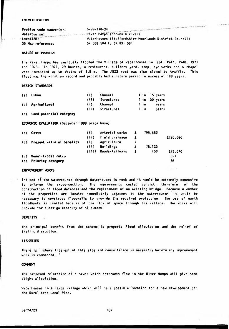
IDENTIFICATION
Problem code ma6er(s): 6-99-110-34 ^ ̂ .
Watercourse: - = -River Hamps (non-main river)
Location: Waterhouses (Staffordshire Moorlands District Council)
OS Map reference: SK 080 504 to SK 091 501
NATURE OF PROBLEM
The River Hamps has seriously flooded the Village of Waterhouses in 1934, 1947, 1948, 1971
and 1973. In 1971, 29 houses, a restaurant, builders yard, shop, dye works and a chapel
were inundated up to depths of 1.5 m. The A523 road was also closed to traffic. This
flood was the worst on record and probably had a return period in excess of 1 0 0 years.
DESIGN STANDARDS
(i) Channel
(i i) Structures
(i) Channel
(i i) Structures
(a) Urban
(b) Agricultural
{c) Land potential category
ECONOMIC EVALUATION (December 1989 price base)
(a) Costs
(b) Present value of benefits
(c) Benefit/cost ratio
(d) Priority category
IMPROVEMENT WORKS
1 in 15 years
1 in 1 0 0 years
1 in years
1 i n years
(i) Arterial works £
(i i) Field drainage £
(i) Agri culture £
(i i) Bui 1di ngs £
(iii) Roads/Railways £
795,680
78,320
750
£795.680
M0.1
3B
The bed of the watercourse through Waterhouses is rock and it would be extremely expensive
to enlarge the cross-section. The improvements costed consist, therefore, of the
construction of flood defences and the replacement of an existing bridge. Because a number
of the properties are located immediately adjacent to the watercourse, it would be
necessary to construct floodwalls to provide the required protection. The use of earth
floodbanks is limited because of the lack of space through the village. The works will
provide for a design capacity of 51 cumecs.
BENEFITS
The principal benefit from the scheme is property f1ood al1eviation and the relief of
traffic disruption.
FISHERIES
There is fishery interest at this site and consultation is necessary before any improvement
work is commenced. f
C0I9CNT
The proposed relocation of a sewer which obstructs flow in the River Hamps will give some
slight alleviation.
Waterhouses in a large village which will be a possible location for a new development ;in
the Rural Area Local Plan.
Sec24/23 187
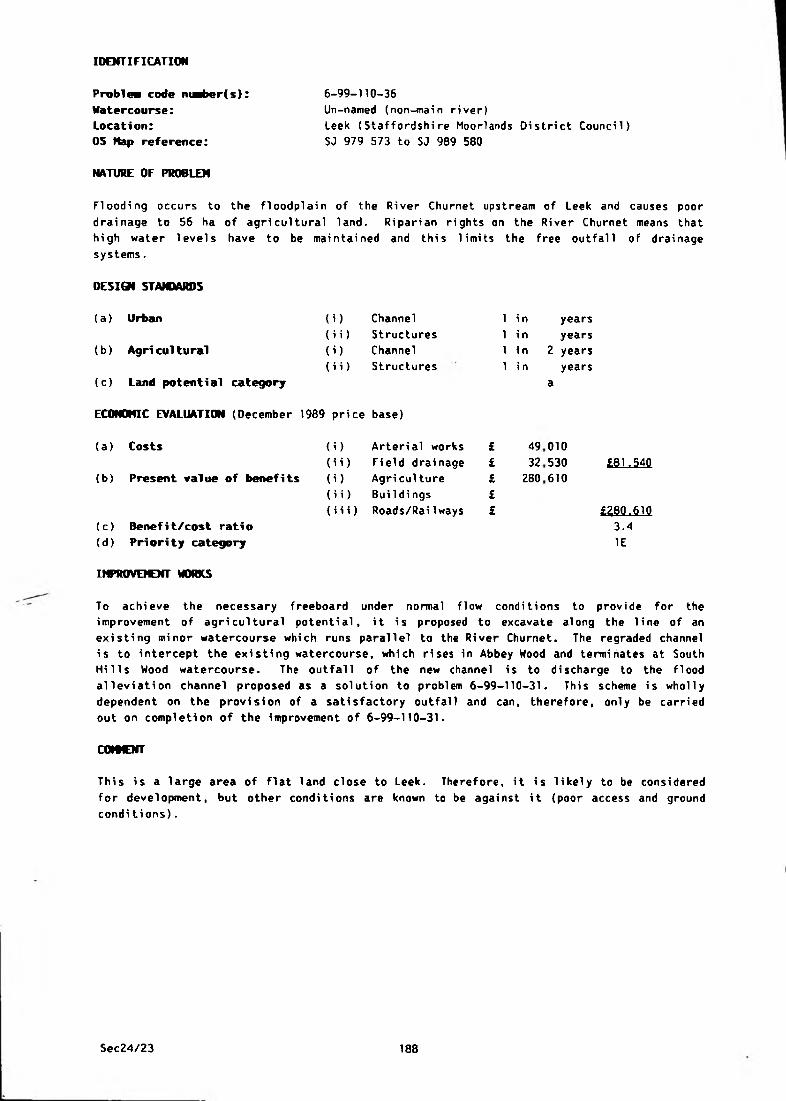
IDENTIFICATION
6-99-110-36
Un-named (non-main river)
Leek (Staffordshire Moorlands District Council)
SJ 979 573 to SJ 989 580
NATURE OF PROBLEM
Problea code maber(s):
Watercourse:
Location:
OS Nap reference:
Flooding occurs to the floodplain of the River Churnet upstream of Leek and causes poor
drainage to 56 ha of agricultural land. Riparian rights on the River Churnet means that
high water levels have to be maintained and this limits the free outfall of drainage
systems.
DESIGN STANDARDS
(a) Urban (i) Channel 1 i n years
(ii) Structures 1 i n years
(b) Agricultural (i) Channel 1 i n 2 years
(ii) Structures 1 i n years
(c) Land potential category a
ECONOHIC EVALUATION (December 1989 price base)
(a) Costs (i) Arterial works £ 49 0 1 0
(ii) Field drainage £ 32 530 £81.540
(b) Present value of benefits (i) Agri culture £ 280 610
(ii) Bui 1di ngs £
(iii) Roads/RaiIways £ «80.610(c) Benefit/cost ratio 3.4
(d) Priority category IE
IHPROVEKNT WORKS
To achieve the necessary freeboard under normal flow conditions to provide for the
improvement of agricultural potential, it is proposed to excavate along the line of an
existing minor watercourse which runs parallel to the River Churnet. The regraded channel
is to intercept the existing watercourse, which rises in Abbey Hood and terminates at South
Hills Wood watercourse. The outfall of the new channel is to discharge to the flood
alleviation channel proposed as a solution to problem 6-99-110-31. This scheme is wholly
dependent on the provision of a satisfactory outfall and can, therefore, only be carried
out on completion of the improvement of 6-99-110-31.
COtWENT
This is a large area of flat land close to Leek. Therefore, it is likely to be considered
for development, but other conditions are known to be against it (poor access and ground
conditions).
Sec24/23 188
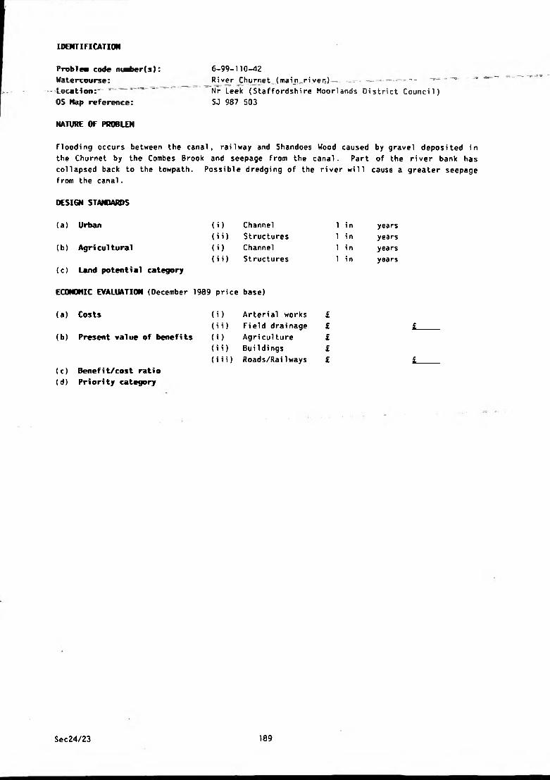
IDENTIFICATION
Problea code m^>er(s): 6-99-110-42
Watercourse: Rive r _C h ur net(maijiriver.) _ ̂ - - - - - ^ _ '
-Location:^ ^ Nr Leek {Staffordshire Moorlands District Council)
OS Hap reference: SJ 987 503
NATURE OF PROBLEM
Flooding occurs between the canal, railway and Shandoes Wood caused by gravel deposited in
the Churnet by the Combes Brook and seepage from the canal. Part of the river bank has
collapsed back to the towpath. Possible dredging of the river will cause a greater seepage
from the canal.
DESIGN STANDARDS
{a) Urban (i) Channel 1 i n years
(ii) Structures 1 in years
(b) Agri cultural (i) Channel 1 in years
(ii) Structures 1 i n years
<c) Land potential category
ECONOMIC EVALUATION (December 1989 price base)
(a) Costs (i) Arterial works £
(ii) Field drainage £ £(b) Present value of benefits (i) Agri culture £
(ii) BuiIdi ngs £
(iii) Roads/Railways £ £(c) Benefit/cost ratio
(d) Priority category
Sec24/23 189

IDENTIFICATION
Problem code nu^»er(s):
Watercourse:
Location:
OS Nap reference:
NATURE OF PROBLEM
6-99-110-43
River Churnet (main river)
Cheddleton (Staffordshire Moorlands District Council)
SJ 981 523 to SJ 995 499
The closure of Brittains Paper Mill at Cheddleton, and consequent cessation of extensive
borehole pumping, has resulted in a rise in the water table, waterlogging of land, collapse
of the river banks and overflowing of boreholes. Downstream of Oakmeadow Ford Lock the
land between the railway and river/canal is waterlogged.
DESIGN STANDARDS
(i)
(ii)
U )
(ii)
(a) Urban
(b) Agricultural
(c) Land potential category
ECONOMIC EVALUATION (December 1989 price base)
(a ) Costs
(b) Present value of benefits
Channel
Structures
Channel
Structures
1 in
1 in
1 in
1 in
years
years
years
years
) Arterial works
i) Field drainage
) Agri culture
i) Buildings
i i) Roads/Railways
(c) Benefit/cost ratio
(d) Priority category
IMPROVEMENT WORKS
A possible solution is to construct culverts to carry excess water from boreholes to the
river and carry out remedial works to the river banks.
Sec24/23 190
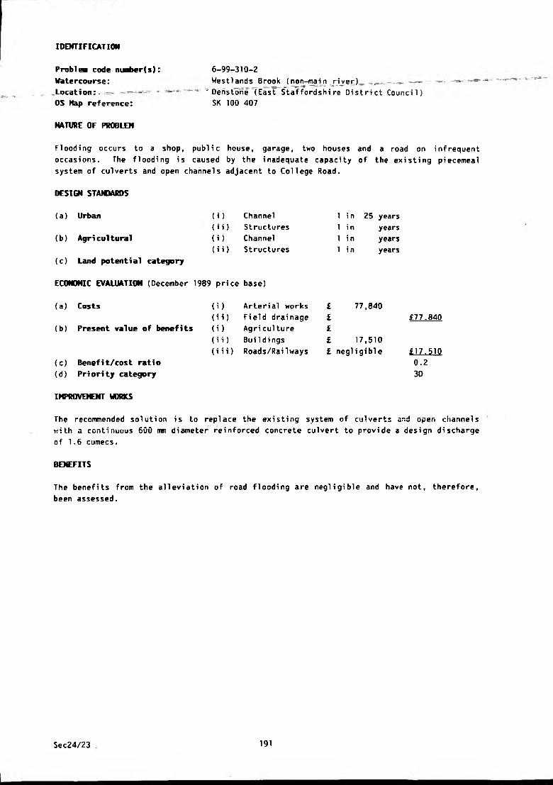
IDENTIFICATION
Problem code niafcer(s): 6-99-310-2
Hate rcourse: We s 11 an d s B ro o k (no n-main riv e r) — .. _ _ • — - - — -
Location: = - " Denstone (East Staffordshire District Council)
OS Kap reference: SK 100 407
NATURE OF PROBLEM
Flooding occurs to a shop, public house, garage, two houses and a road on infrequent
occasions. The flooding is caused by the inadequate capacity of the existing piecemeal
system of culverts and open channels adjacent to College Road.
DESIGN STAWARDS
(a) Urban (i) Channel
(t i) Structures
(b) Agricultural (i) Channel
(i i) Structures
(c) Land potential category
ECONOMIC EVALUATION (December 1989 price base)
(a) Costs (i) Arterial works
(i i) Field drai nage
(b) Present value of benefits (i) Agriculture
(i i) Bui 1 dings
{i i i) Roads/Railways
(c) Benefit/cost ratio
(d) Priority category
IMPROVEMENT WORKS
The recommended solution is to replace the existing system of culverts and open channels
with a continuous 600 mm diameter reinforced concrete culvert to provide a design discharge
of 1 . 6 cumecs.
BENEFITS
The benefits from the alleviation of road flooding are negligible and have not, therefore,
been assessed.
1 in 25 years
1 in years
1 in years
1 in years
£ 77,840
£ £77.840
££ 17,510
£ negligible £17.510
0.2
30
Sec24/23 191
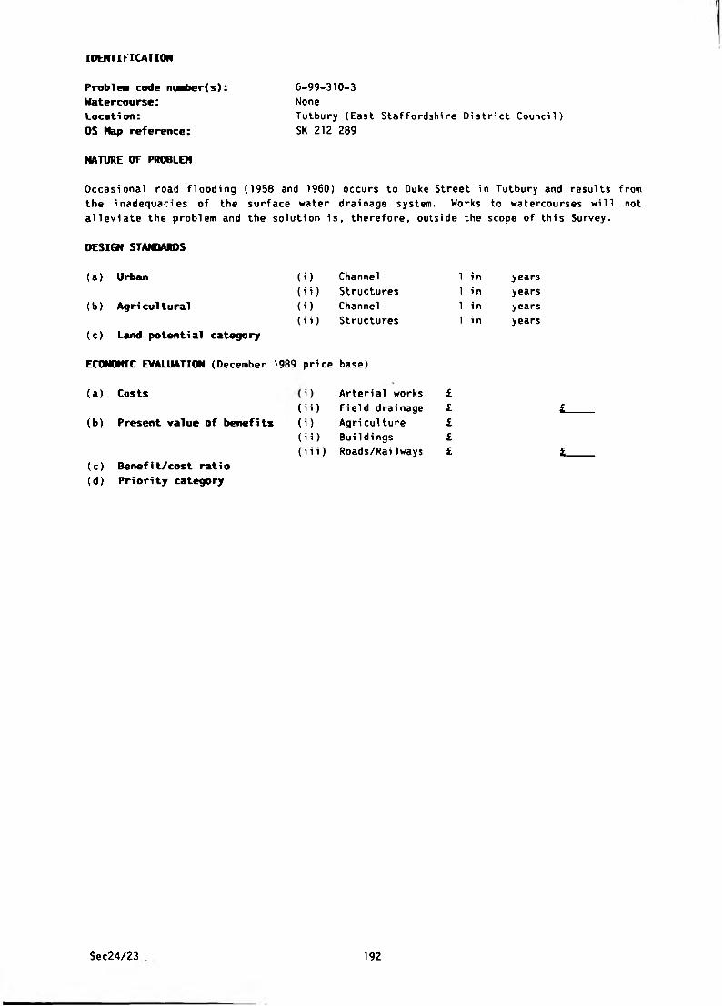
IDENTIFICATION
Problea code nuber(s):
Watercourse:
Location:
OS Hap reference:
Tutbury (East Staffordshire District Council)
SK 212 209
6-99-310-3
None
NATURE OF PROBLEM
Occasional road flooding (1958 and 1960) occurs to Duke Street in Tutbury and results from
the inadequacies of the surface water drainage system. Works to watercourses will not
alleviate the problem and the solution is, therefore, outside the scope of this Survey.
DESIGN STANDARDS
(a) Urban (i) Channel 1 in years
(b) Agricultural
(i i) Structures
(i) Channel
(i i) Structures
1 in
1 in
1 i n
years
years
years
(c) Land potential category
ECONOMIC EVALUATION (December 1989 price base)
(b) Present value of benefits
(a ) Costs
(i i) Fi eld drai nage
(i) Agriculture
(iii) Roads/Railways
(i i) Buildings
) Arterial works £££££
L
L(c) Benefi t/cost rati o
(d) Priority category
Sec24/23 192
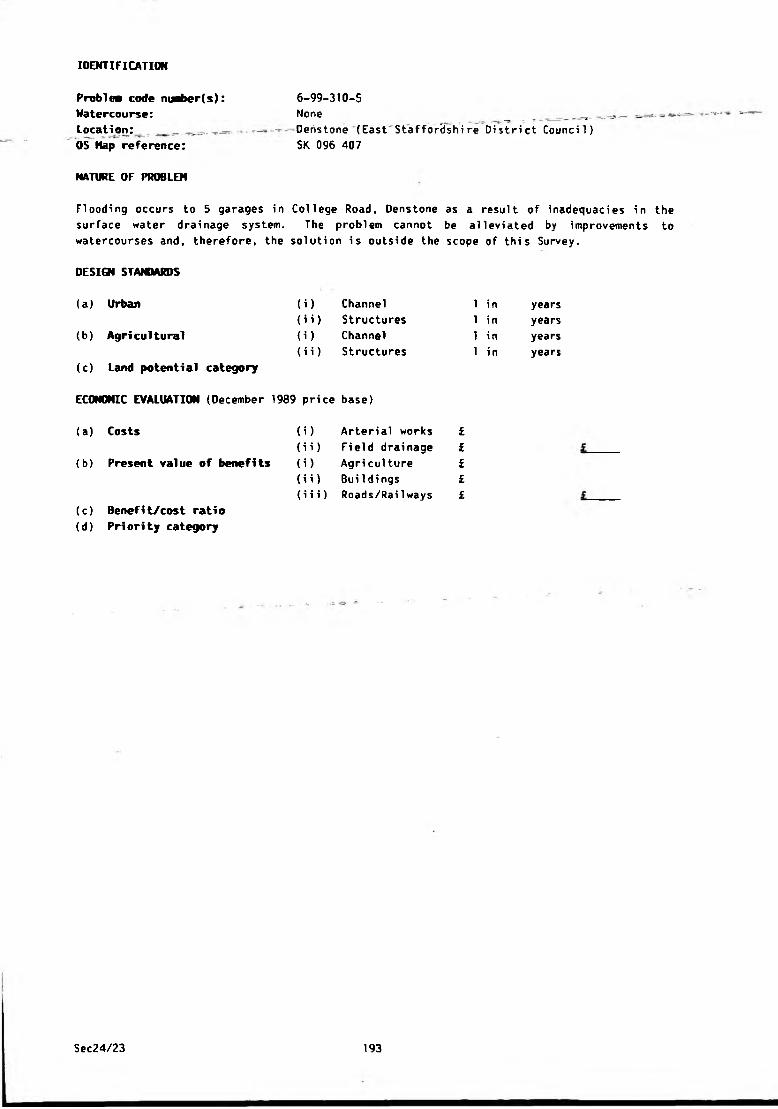
IDENTIFICATION
Problea code n«l>er(s):
Watercourse:Location: . ̂
OS Hap reference:
NATURE OF PROBLEM
6-99-310-5
None __ ^
Deristone (East Staffordshire District Council)
SK 096 407
Flooding occurs to 5 garages in College Road, Denstone as a result of inadequacies in the
surface water drainage system. The problem cannot be alleviated by improvements to
watercourses and, therefore, the solution is outside the scope of this Survey.
DESIGN STANDARDS
(a) Urban
(b) Agricultural
(c) Land potential category
(i) Channel
(ii) Structures
(i) Channel
(ii) Structures
ECONOMIC EVALUATION (December 1989 price base)
(a) Costs
(b) Present value of benefits
(c) Benefi t/cost ratio
(d) Priority category
1 in
1 in
1 in
1 in
(i) Arterial works £
(ii) Field drainage £
(i) Agriculture £
(ii) Buildings £
(iii) Roads/Railways £
years
years
years
years
Sec24/23 193

IDENTIFICATION
Problea code m^ber(s)
Watercourse:
Location:
OS Hap reference:
NATURE OF PROBLEM
6-99-310-7/9
River Tean (non-main river)
Beamhurst to Lower Tean (East Staffordshire District
Counci 1)
SK 065 359 to SK 019 381
Inadequate arterial drainage causes flooding and poor drainage of 210 ha of agricultural
land,
(i)
(ii)
(i)
(ii)
DESIGN STANDARDS
(a ) Urban
(b) Agricultural
(c) Land potential category
ECONOMIC EVALUATION (December 1989 price base)
(a ) Costs
(b) Present value of benefits
Channel
Structures
Channel
Structures
(i) Arterial works
(i i) Field drainage
(i) Agri culture
(ii) Buildings
(i i i) Roads/Rai Iways
(c) Benefit/cost ratio
(d) Priority category
1 i n
1 i n
1 in
1 in
years
years
2 years
years
a
677,480
120,1001,503,060
£797,580
£1.503.060
1.92B
IMPR0VOCNT WORKS
The recommended solution is to regrade the watercourse over a length of 6 . 8 km. The
improvements will provide 1.5 m of freeboard within the channel under normal flow
conditions.
BENEFITS
This is a grassland area devoted mainly to dairying and it is not anticipated that this
pattern will change. The estimated increase in gross margin of £270/ha per annum will
result from improved grassland and higher stocking rates.
FISHERIES
There is fishery interest at this site and consultation is necessary before any improvement
work is commenced.
Sec24/23 194
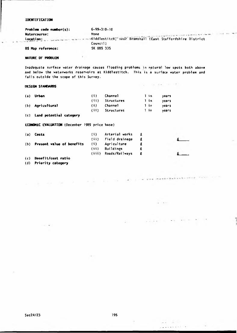
IDENTIFICATION
Problea code nuaber(s):
Watercourse:
Location: = ̂ ,
OS Nap reference:
NATURE OF PROBLEM
6-99-310-10
None . ^
-Kiddlesti tch7"near~ Bramshall (East Staffordshire District
Counci 1)
SK 085 335
Inadequate surface water drainage causes flooding problems in natural low spots both above
and below the waterworks reservoirs at Kiddlestitch. This is a surface water problem and
falls outside the scope of this Survey.
DESIGN STANDARDS
(a) Urban
(b) Agricultural
(c) Land potential category
(i) Channel
{i i) Structures
{i) Channel
< i i) Structures
ECONOMIC EVALUATION (December 1989 price base)
(a) Costs
(b) Present value of benefits
(c) Benefit/cost ratio
(d) Priority category
1 in
1 in
1 in
1 in
i) Arterial works £
ii) Field drainage £
i) Agri culture £
i i) BuiIdi ngs £
iii) Roads/Railways £
years
years
years
years
Sec24/23 195
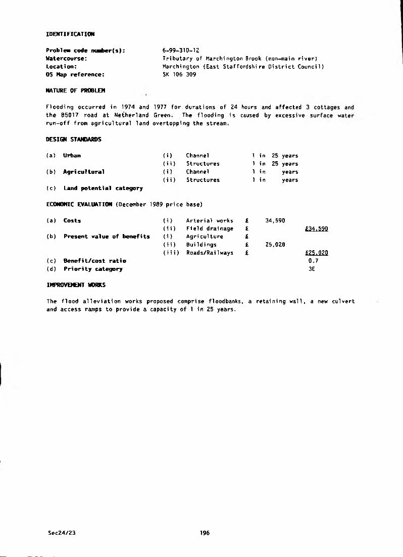
IDENTIFICATION
Problei code nuriwr(s):
Watercourse:
Location:
6-99-310-12
Tributary of Marchington Brook (non-main river)
Marchington (East Staffordshire District Council)
OS Hap reference: SK 106 309
NATURE OF PROBLEM
Flooding occurred in 1974 and 1977 for durations of 24 hours and affected
the B5017 road at Netherland Green. rhe flooding is caused by excessive
run-off from agricultural land overtopping the stream.
DESIGN STANDARDS
(a ) Urban (i) Channel 1 in 25 years
(ii) Structures 1 in 25 years
(b ) Agri cultural (i) Channel 1 in years
(ii) Structures 1 in years
(c) Land potential category
ECONONIC EVALUATION (December 1989 price base)
(a ) Costs (i) Arterial works £ 34,590
(ii) Field drainage £
(b) Present value of benefits (i) Agri culture £
(ii) Buildi ngs £ 25,020
(iii) Roads/RaiIways £
(c) Benefit/cost rati o
(d) Priority category
£34,590
£25.020
0.7
3E
IHPROVEICNT WORKS
The flood alleviation works proposed comprise floodbanks, a retaining wall, a new culvert
and access ramps to provide a capacity of 1 in 25 years.
Sec24/23 196

IDENTIFICATION
Problem code ntaber(s):
Watercourse:
Location: , - , = - ̂- - -
OS flap reference:
NATURE OF PROBLEM
6-99-310-14
March i ng ton Brook (non^main-river)-— - =--~- =
MarchTngton (East Staffordshire District Council)
SK 131 302
The watercourse at this location is poorly maintained and floods the road, preventing
satisfactory surface water drainage.
(i)
<ii)
(i)
(ii)
DESIGN STANDARDS
(a) Urban
(b) Agri cultural
(c) Land potential category
ECONOMIC EVALUATION (December 1989 price base)
(a) Costs
(b) Present value of benefits
Channel
Structures
Channel
Structures
(i) Arterial works
(ii) Field drainage
(i) Agriculture
(i i) BuiIdings
(iii) Roads/Railways
(c) Benefit/cost ratio
(d) Priority category
1 in 25 years
1 in 25 years
1 in years
1 in years
IMPROVEMENT WORKS
Channel clearance and removal of silt from under the road bridge will provide the major
improvement, and a small floodbank at a localised low spot will prevent further flooding.
The watercourse downstream of the bridge has been improved by the landowner. The work has
consisted of widening and regrading the channel. Although the bridge invert and upstream
watercourse are in need of maintenance and cleaning, no recent flooding problems have been
experienced at this location.
FISHERIES
There is fishery interest at this site and consultation is necessary before any improvement
work is commenced.
Sec24/23 197
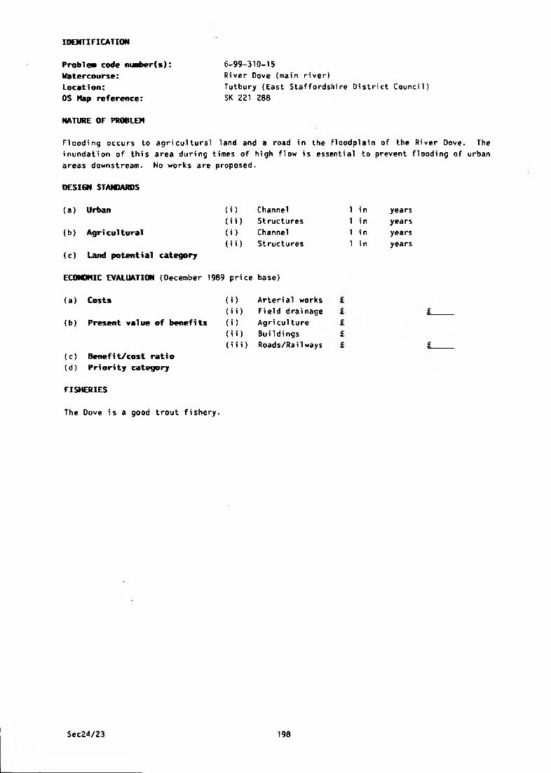
6-99-310-15
River Dove {main river)
Tutbury (East Staffordshire District Council)
SK 221 280
NATURE OF PROBLEM
IDENTIFICATION
Problem code ntaber(s):
Watercourse:
Location:
OS Map reference:
Flooding occurs to agricultural land and a road in the floodplain of the River Dove. The
inundation of this area during times of high flow is essential to prevent flooding of urban
areas downstream. No works are proposed.
DESIGN STAM1ARDS
(i) Channel
(i i) Structures
(i) Channel
(i i) Structures
(a) Urban
(b) Agricultural
(c) Land potential category
ECONOHIC EVALUATION (December 1989 price base)
(a) Costs
(b) Present value of benefits
(i) Arterial works
(i i) Field drai nage
(i) Agri culture
(i i) Buildings
(iii) Roads/Railways
(c) Benefit/cost ratio
(d) Priority category
1 in
1 i n
1 i n
1 i n
years
years
years
years
FISHERIES
The Dove is a good trout fishery.
Sec24/23 198

IDENTIFICATION
Rol 1 eston (East .Staffordshire Di strict Council)'
SK 240 111
NATURE OF PROBLEM
6-99-310-16None
Probl ea code nuaber(s):
Watercourse:
Location:
OS Hap reference: "
Surface water from fields near Beacon Hill surcharges culverts at the junction of
Craythorne Road and Beacon Road, and caused flooding in 1956, 1960, 1977 and 1979 for
durations of 4 to 6 hours. The excess water flows down Beacon Road and floods properties
and Chapel Lane, School Lane and Station Road. Works to watercourses will not alleviate
the problem and the solution is, therefore, outside the scope of this Survey.
DESIGN STANDARDS
(i)
(ii)
H )
(ii)
(a) Urban
(b) Agricultural
(c) Land potential category
ECONOMIC EVALUATION (December 1989 price base)
(a) Costs
(b) Present value of benefits
Channel
Structures
Channel
Structures
(i) Arterial works
(i i) Field drainage
(i) Agri culture
(ii) Buildings
(iii) Roads/RaiIways
(c) Benefit/cost ratio
(d) Priority category
IMPROVEMENT WORKS
1 in
1 in
1 in
1 in
years
years
years
years
Some remedial works have been carried out by Staffordshire County Council which has
slightly improved the situation.
Sec24/23 199

IDENTIFICATION
Problea code ntaber(s):
Watercourse:
Location:
OS Nap reference:
Anslow (East Staffordshire District Council)
SK 210 251
6-99-310-17
None
NATURE OF PROBLEM
The inadequacy of the surface water drainage system causes flooding to minor roads. Works
to the watercourses will not alleviate the flooding and the solution is, therefore, outside
the scope of this Survey.
DESIGN STANDARDS
(a) Urban (i) Channel 1 in years
(b ) Agri cultural
(ii) Structures
(i) Channel
(ii) Structures
1 in years
1 in years
1 in years
(c) Land potential category
ECONOMIC EVALUATION (December 1989 price base)
(a) Costs
(b) Present value of benefits
) Arterial works
i) Field drainage
) Agriculture
£I£i£
L
i) Buildings
i i) Roads/Railways L(c) Benefit/cost ratio
(d ) Pri ori ty category
Sec24/23 200
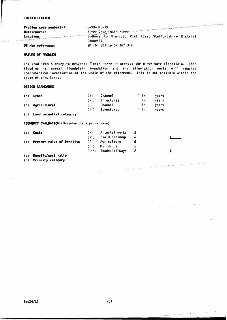
IDENTIFICATION
6-99-310-19 _ .. ..River poyjj_(maifn river)r_-
Sudbury to Oraycott Road (East Staffordshire District
Counci 1)
SK 161 301 to SK 167 319
NATURE OF PROBLEM
Problea code nu^>er(s):
Watercourse:
Locati on: _ . . —
OS Map reference;
The road from Sudbury to Draycott floods where it crosses the River Oove floodplain. This
f1 coding i s normal floodplai n inundation and any allevi ation works will requi re
comprehensive investiation of the whole of the catchment. This is not possible within the
scope of this Survey.
DESIGN STANDARDS
(a) Urban
(b) Agri cultural
(c) Land potential category
ECONOMIC EVALUATION (December 1989 price base)
(i) Channel
(i i) Structures
(i) Channel
(i i) Structures
1 i n
1 i n
1 i n
1 in
years
years
years
years
(a) Costs (i) Arterial works £
(ii) Field drainage £
(b) Present value of benefits (i) Agriculture £
(i i) BuiIdings £
{i i i) Roads/Rai1 ways £
<c) Benefit/cost ratio
<d) Priority category
Sec24/23 201
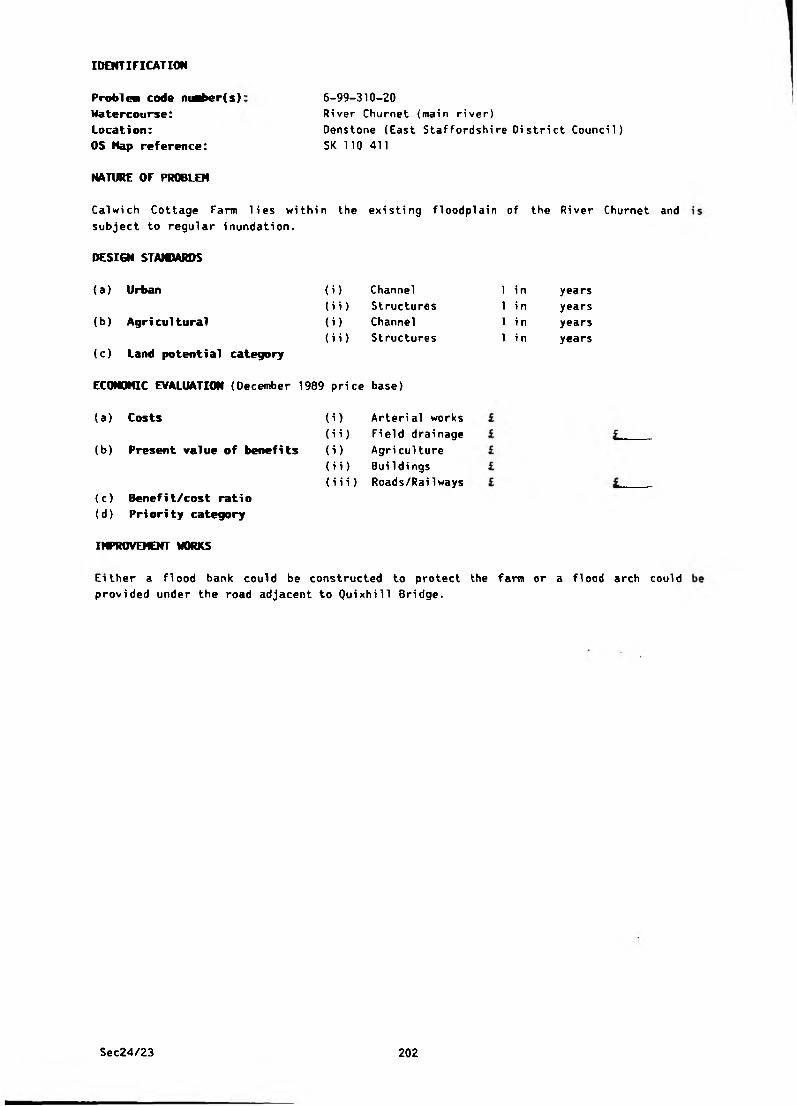
IDENTIFICATION
Problea code maber(s):
Watercourse:
Location:
OS Hap reference:
NATURE OF PROBLEM
6-99-310-20
River Churnet (main river)
Denstone (East Staffordshire District Council)
SK 110 411
Calwich Cottage Farm lies within the existing floodplain of the River Churnet and
subject to regular inundation.
(U(ii)
0 )( H )
DESIGN STANDARDS
(a) Urban
(b ) Agri cultural
(c) Land potential category
ECONOMIC EVALUATION (December 1909 price base)
(a) Costs
(b) Present value of benefits
Channel
Structures
Channel
Structures
i) Arterial works
i i) Field drainage
i) Agri culture
ii) Buildings
iii) Roads/Railways
(c) Benefi t/cost rati o
(d ) Priori ty category
IMPROVEMENT WORKS
1 i n
1 in
1 in
1 i n
years
years
years
years
Either a flood bank could be constructed to protect the farm or a flood arch could
provided under the road adjacent to Quixhill Bridge.
Sec24/23 202
IDENTIFICATION
Problem code niaber(s): 6-99-310-30 _ „ ■ -
Watercourse: _ __ _ -- --Ri ver Oove (ma i n river)
Location: Dove Cliff (East Staffordshire Oistrict Council)
OS Nap reference: SK 256 276
NATURE OF PROBLEM
A collapsed weir has been identified on the River Dove.
DESIGN STANDARDS
(a) Urban (i) Channel 1 i n years
(i i) Structures 1 in years
(b) Agri cultural <i) Channel 1 i n years<H) Structures 1 i n years
(c) Land potential category
ECONOMIC EVALUATION (December 1989 price base)
(a) Costs (i) Arterial works £
(ii) Field drainage £ £(b) Present value of benefits (i) Agri cul ture £
(ii) Buildi ngs £
(iii) Roads/Railways £ £
(c) Benefit/cost ratio
(d) Pri ori ty category
IMPROVEMENT WORKS
Lowering the crest level or total removal of the weir could result in land drainage
benefits to some 40 ha of washland. Existing surface water outfall problems in Rolleston
may also be improved by weir removal. However, there are also fishing interests involved.
No works are currently proposed.
Sec24/23 203

IDENTIFICATION
Problea code maber(s):
Watercourse:
Location:
OS Hap reference:
6-99-310-31
Croxden/Nothi11/Alders Brooks (non-main river)
Croxden (East Staffordshire District Council)
SK 066 395 to SK 100 372
NATURE OF PROBLEM
80 ha of agricultural land suffer from inadequate arterial drainage.
DESICM STANDARDS
(a) Urban (i) Channel 1 i n years
(ii) Structures 1 i n years
(b) Agri cultural (i) Channel 1 in 2 years
(ii) Structures 1 i n 1 0 0 years
( O Land potential category a
ECONOMIC EVALUATION (December 1989 price base)
(a) Costs
(b) Present value of benefits
i) Arterial works £ 504,510
ii) Field drainage £ 22,520
i) Agri culture £ 608,450
ii) Buildi ngs £
iii) Roads/Railways £
£527.030
£608.450
1.2 2B
(c) Benefit/cost ratio
(d) Priority category
IMPROVEMENT WORKS
A general regrading scheme is envisaged along 5.1 km of Croxden Brook from its confluence
with the River Dove to Croxden Village.
The scheme is designed to give satisfactory freeboard under normal flow conditions to allow
the agricultural improvement of 80 ha of land.
The works include regrading the watercourse, the underpinning of two road bridges at
SK 096 373 and SK 076 389 and the replacement of several farm access bridges.
BENEFITS
No change in the existing land use is anticipated, but the existing pattern of drainage
will be intensified to provide an increase in gross margins.
FISKRIES
There is fishery interest at this site and consultation is necessary before any improvement
work is commenced.
Sec24/23 204
IDENTIFICATION
Problea code m^>er(s): 6-99-310-32
Watercourse: Mill Fleam (non-main river) _ _ ________ . ___ -
Location:. Lower Ell as tone” (East Staffordshire District Council)
OS Nap reference: SK 118 427
NATURE OF PROBLEM
The Mi 11 FI earn whi ch used to feed the old mi 11 at Lower El 1 as tone is in a very poor
condition. It is extremely badly silted up along most of its length which causes it to
overtop its artifically raised banks in numerous places. This has led to flooding and poor
drainage of large areas of agricultural land. Flooding of the yard and outbuildings has
also occurred at Dove Farm adjacent to the mill pond.
A further problem is that the flow control apparatus at the mill pond has fallen into
disrepair and become unusable. This can no longer be used to provide relief in wet weather
and the level is now controlled by the fixed overflow weir.
DESIGN STANDARDS
(a) Urban
(b) Agri cultural
(c) Land potential category
ECONOMIC EVALUATION (December 1989 price base)
(i)
(ii)
(i)
(ii)
Channel
Structures
Channel
Structures
1 i n
1 i n
1 i n
1 in
years
years
years
years
(a) Costs
(b) Present value of benefits
(c) Benefit/cost ratio
(d) Priority category
i) Arterial works £
i i) Fi eld drainage £
i) Agri culture £
i i) BuiIdings £
i i i) Roads/Railways £
IMPROVEICNT WORKS
The Fleam is now solely used to supply water to the mill pond for fishing purposes. The
easiest solution to the problem would be to lower the overflow weir and restrict the amount
of water entering the Fleam from the River Dove. Since the pond is also fed by the Tit
Brook, an alternative would be to seal off the Fleam and abandon it altogether.
CONSERVATION
Largely as a result of silting, parts of the old Mill Fleam have developed considerable
nature conservation interest.
Sec24/23 205
IDENTIFICATION
Proble* code m^>er(s):
Watercourse:
Location:
OS Nap reference:
6-99-310-34
Un-named (non-main river)
Wallash (East Staffordshire Oistrict Council)
SK 154 453
NATURE OF PROBLEM
The inadequacy of both the culverts beneath the B5032 road and a further culvert just
downstream has, on several occasions, led to flooding occurring upstream of the road. The
degree of flooding has been dependent on storm frequency, but it is known that properties
have been flooded on at least 2 occasions during the past 26 years.
In order to prevent an i ncreased ri sk of floodi ng to these properti es, no further
development or increase in impermeable area should be allowed within the catchment area
upstream of the road culverts. Prior to further development, and to alleviate the existing
problem, a new road culvert would be requi red together wi th some downstream watercourse
improvements.
DESIGN STAMMRDS
(b) Agricultural
(a) Urban (i) Channel
(i i) Structures
(i) Channel
(i i) Structures
in
in
in
i n
years
years
years
years
(c) Land potential category
ECONOMIC EVALUATION (December 1989 price base)
(a ) Costs
(b) Present value of benefits
) Arteri al works
i) Fi eld drai nage
) Agri culture
£££££
i) Buildings
i i) Roads/Rai1 ways
(c ) Benefit/cost ratio
(d) Priority category
Sec24/23 206
IDENTIFICATION
Problem code nuaber(s): 6-99-310-35
Watercourse: Marchj^gton Brook^(non-main river) - ^ -,Location: — = - Marchington (East Staffordshire District Council)
OS Hap reference: SK 142 314 to SK 131 301
NATURE OF PROBLEM
Flooding affects roads, gardens, fields and property. Floodwaters from the brook also
travel overland and inundate a minor brookcourse at SK 144 310 causing flooding of two
properties.
DESIGN STAIOARDS
(a ) Urban
(b) Agricultural
(c) Land potential category
ECONOMIC EVALUATION (December 1969 price base)
{i) Channel
(ii) Structures
(i) Channel
(i i) Structures
1 in
1 i n
1 in
1 in
years
years
years
years
(a) Costs (i) Arterial works £
(ii) Field drainage £ i(b) Present value of benefits (i) Agri culture £
(ii) Bui 1 dings £
{iii) Roads/RaiIways £ £(c) Benefit/cost ratio
(d) Pri ority category
IMPROVEMENT WORKS
A survey has been carried out and a Flood Studies report to calculate flows and' assess
improvement options will be prepared in the near future. The County Council have agreed to
contribute towards the cost of the works which relate to highway culverts.
Sec24/23 207
APPENDIX A2
SCHEDULE OF MAIN RIVER


SCHEDULE Of MAIN RIVERS IN THE UPPER SEVERN AREA - JANUARY 1990
WATERCOURSE LOCATION FROM NGR TO NGR LENGTH (KM) CATCHMENTNO
ACRE BROOK R Severn confluence to upstream face of outfall structure
SJ 316 160 SJ 315 159 0.28 1
AOFORTON BROOK Wigmore Main Drain confluence to a point upstream of Green Lane Bridge, Adi'orton
SO 420 706 SO 415 704 0.48 2
ALLCOCKS BROOK Wigmore Main Drain confluence to All cocks Bridge
SO 420 706 SO 425 693 1.45 2
BACK BROOK R Roden confluence to Stang's Plantation SJ 514 286 SJ 484 291 3.70 1
BAILEY BROOK R Tern confluence to Hoarstone Lane Bridge SJ 629 315 SJ 610 337 4.67 1
BELE BROOK R Severn confluence to Wern Bridge SJ 283 158 SJ 253 137 4.14 1
BLACK BROOK Smestow Brook confluence to the A454 road bridge
SO 839 959 SO 836 967 1 . 0 0 2
BROMLEY BROOK R Perry confluence to Bagley-Shade Oak road bridge
SJ 399 252 SJ 410 274 3.70 I
BUCKLEY FARM BROOK R Severn confluence to upstream face of Buckley Farm outfall
SJ 363 166 SJ 364 167 0 . 2 0 1
RIVER CAMLAD R Severn confluence to Snead Bridge SJ 209 006 SO 320 918 29.23 1
RIVER CERIST R Severn confluence to Van road bridge (B4518) so 025 915 SN 915 874 9.50 1
RIVER CLYWEDOG R Severn confluence to Clywedog Dam SN 954 848 SN 913 869 5.31 1
COMMISSION DRAIN R Tern confluence to Kynnersley road bridge SJ 615 149 SJ 650 176 5.25 1
RIVER CORVE R Teme confluence to Beam Bridge so 506 750 SO 532 882 22.85 2
CRIGGION BROOK R Severn confluence to upstream face of outfall structure
SJ 314 161 SJ 313 161 0.04 1
CRUCKTON BROOK Rea Brook confluence to upstream of confluence with right bank tributary
SJ 432 098 SJ 428 1 0 2 0.70 1
DUNKETT BROOK R Severn confluence to upstream face of Dunkett outfal1
SJ 356 170 SJ 357 174 0.40 1
RIVER EIRTH R Tanat confluence to 250m upstream of B4391 bridge at Llangynog
SJ 055 260 SJ 051 263 0.56 1
ELMBRIDGE BROOK R Salwarpe confluence to road bridge near Cooksey Green
so 885 629 SO 894 696 8.69 2
RIVER GARNO R Severn confluence to Wig Bridge so 027 917 SO 017 926 1.50 1
GUILSFIELD BROOK Bele Brook confluence to Lower Varchoel Farm SJ 253 137 SJ 236 126 2.30 1
GWYFER BROOK R Severn confluence to upstream face of outfall structure
SJ 292 166 SJ 291 166 0.07 1
HADLEY BROOK R Salwarpe confluence to the B4192 road bridge so 869 620 SO 869 713 14.64 2
HEN AFON R Vyrnwy confluence to outfall structure S3 155 127 SJ 153 1 2 0 0.26 1
HOO BROOK R Stour confluence to A448 so 829 746 SO 847 755 2.25 2
HURLEY BROOK Commission Drain confluence to overflow structure on Northern Interceptor sewer
SJ 641 159 SJ 653 151 1.17 1
KYRE BROOK R Tame confluence to confluence with a minor watercourse downstream of Splash Bridge
so 599 685 SO 602 672 1 . 8 8 2
LAUGHERN BROOK R Teme confluence to the Worcester - Martley road bridge near Kenswick Manor
so 834 526 SO 796 580 12.71 2
LONCO BROOK R Meese confluence to Whitleyford Bridge SJ 737 217 SJ 746 238 4.83 1
RIVER HEESE R Tern confluence to Aqualate Mere SJ 638 208 SJ 765 208 22.60 1
RIVER MORDA R Vyrnwy confluence to Newbridge road bridge SJ 293 207 SJ 304 254 14.80 1
RIVER ONNY R Teme confluence to confluence of Quinny Brook SO 485 766 SO 436 843 12.34 2
OSWESTRY BROOK R Morda confluence to the major surface water outfalls at Oswestry
SJ 316 238 (SJ(SJ
302300
290)284)
7.40 1
SEC24/35

SCHEDULE OF MAIN RIVERS IN THE UPPER SEVERN AREA (CONTINUED)
WATERCOURSE LOCATION FROM NGR TO NGR LENGTH (KM) CATCHMENTNO
PENTRE BROOK R Vyrnwy confluence to downstream face of road culvert at Pentre
SJ 166 137 SJ 151 135 1.74 1
RIVER PERRY R Severn confluence to Hill yards Plantation SJ 440 166 SJ 315 334 30.09 1
POTFORD BROOK R Tern confluence to the downstream face of A442 culvert
SJ 638 208 SJ 634 223 2.30 1
REA BROOK R Severn confluence to Marton Pool SJ 496 123 SJ 298 028 37.65 1
RIVER REA R Teme confluence to the A4117 road bridge at Cleobury Mortimer
SO 636 6 8 6 SO 680 763 18.02
RIVER RED STRINE R Strine confluence to Humber Brook confluence SJ 644 174 SJ 685 165 5.31 1
RIVER RODEN R Tern confluence to Blackhurstford Bridge SJ 593 124 SJ 462 334 43.44 1
RIVER SALWARPE R Severn confleunce to Upton Warren Bridge SO 841 601 SO 933 674 23.01RIVER SEVERN R Teme confluence to R Clywedog confluence SO 850 521 SN 954 848 218.00 1 ♦ 2
SLEAP BROOK R Roden confluence to bridge on minor road from Brandwood to Noneley
SJ 505 281 SJ 471 271 4.30 1
SMESTOW BROOK R Stour confluence to the upstream face of the canal culvert
SO 863 855 SJ 898 006 25.27
SOULTON BROOK R Roden confluence to Creamery Bridge SJ 545 294 SJ 541 337 5.15 1
RIVER STOUR R Severn confluence to the downstream end of Overend Tunnel, Cradley
SO 812 708 SO 949 851 41.79
STRINE BROOK Soul ton Brook confluence to road bridge at Steel Heath
SJ 550 308 SJ 554 363 6.35 1
RIVER STRINE R Tern confluence to downstream face of canal culvert
SJ 629 176 SJ 752 2 0 0 15.00 1
RIVER TANAT R Vyrnwy confluence to 300m downstream of Llangynog bridge
SJ 243 207 SJ 055 260 26.00 1
RIVER TEME R Severn confluence to sewage works outfall at Knighton
so 8 S0 521 SO 301 724 107.07
RIVER TERN R Severn confluence to Walkmill Bridge, Market Drayton
SJ 553 091 SJ 672 335 45.21 1
TETCHILL AND NEWNES BROOK
R Perry confluence to upstream face of culvert at Dudleston Heath
SJ 380 296 SJ 365 363 10.70 1
RIVER TRANNON R Cerist confluence to the B4S69 road bridge at Trefeglwys
SO 0 1 2 910 SN 969 903 5.52 1
RIVER VYRNWY R Severn confluence to downstream end of the Vyrnwy dam spillway
SJ 328 159 SJ 019 192 66.06 1
WALL BROOK R Strine confluence to syphon at junction of Kynnersley Drive and Shropshire Union Canal
SJ 675 181 SJ 687 165 2.14 1
WEIR BROOK R Severn confluence to upstream face of outfall structure
SJ 345 169 SJ 344 169 0.05 1
WEIR BROOK (new cut) R Severn confluence to upstream face of outfall structure
SJ 345 171 SJ 344 171 0.04 1
WERN-OOU BROOK R Vyrnwy confluence to the Melverley IDB outfall on the B4398
SJ 283 2 0 2 SJ 2 82 206 0.56 1
WIGMORE MAIN ORAIN R Teme confluence to the head of the drain SO 431 717 SO 415 696 3.22RIVER WORFE R Severn confluence to Broad Bridge, Stapleford SO 725 952 SO 762 982 15.14 1
WORTHEN BROOK Rea brook confluence to the Ford at Worthen SJ 334 042 SJ 327 045 0.80 1
TOTAL 960.83
SEC24/35
SCHEDULE OF MAIN RIVERS III THE L O O SEVERN AREA - JANUARY 1990
WATERCOURSE LOCATION FROM NGR TO NGR LENGTH (KM) CATCHMENTNO
RIVER ALNE R Arrow confluence to Botley Mill Farm Bridge SP 093 573 SP 144 684 22.69 3RIVER ARROW R Avon confluence to Coventry Highway Bridge,
Reddi tchSP 083 507 SO 055 680 25.00 3
RIVER AVON R Severn confluence to road bridge at Wei ford SO 8 8 8 331 SP 645 808 180.94 3BADSEY BROOK R Avon confluence to A44 road bridge,
Wi ckhamfordSP 050 454 SP 065 413 6.27 3
BIRDINGBURY BROOK R Learn confluence to upstream face of culvert on Birdingbury-Offchurch Road
SP 418 685 SP 427 677 1.40 3
BOW BROOK R Avon confluence to Shell Ford, Himbleton SP 919 426 SO 951 596 25.90 3BRETFORTON BROOK Badsey Brook confluence to Stoneford Barn SP 066 443 SP 097 426 4.32 3RIVER CAM Gloucester and Sharpness Canal to Lower Cam SO 739 051 SO 752 0 0 2 7.15 2
CAPEHALL BROOK Wicksters Brook confluence to upstream face of MS Motorway culvert
so 756 048 SO 762 038 1.45 2
CAREYS BROOK R Severn confluence to upstream face of A4021 road bridge
so 849 506 SO 834 507 2.50 2
CARRANT BROOK R Avon confluence to Aston on Carrant road bridge
so 895 334 (SO(SO
940940
349)348)
8 . 1 0 3
RIVER CHELT R Severn confluence to railway bridge, Cheltenham
so 848 262 so 936 232 14.81 2
CLAYCOTON BROOK R Avon confluence to unnamed tributary flowing from Elkington
SP 564 778 SP 607 754 8 . 2 0 3
CLIFTON BROOK R Avon confluence to Clifton road bridge SP 515 775 SP 521 759 0.90 3COLLIERS BROOK R Leadon confluence to upstream face of the
A417 road bridgeso 776 235 so 799 260 4.00 2
DEAN BROOK R Swilgate confluence to the A435 road bridge SO 911 283 so 955 286 4.83 2
OEERHURST PARISH ORAIN
R Severn confluence to the drain head SO 846 264 so 878 271 3.22 2
RIVER DENE R Avon confluence to Wellesbourne Mill SP 258 563 SP 284 544 4.83 3OIMORE BROOK R Severn confluence to upstream face of the A38
road bridgeso 794 150 so 807 131 2.94 2
OOVERTE BROOK R Little Avon confluence to upstream face of the B4S09 road bridge at Berkeley
ST 677 992 ST 684 990 0.84 2
ELL BROOK R Leadon confluence to upstream face of Ell Bridge, Newent
so 774 245 so 721 264 6.80 2
RIVER FROME R Severn confluence to bridge on Frampton Mansell - Trillis road
so 751 106 so 929 030 34.59 2
GLYNCH BROOK R Leadon confluence to upstream face of Berry Bri dge, Staunton
so 771 275 so 783 294 4.00 2
HASFIELD DRAIN R Severn confluence to upstream face of B4213 road culvert
so 844 270 so 842 281 1.58 2
HATHERLEY BROOK R Severn confluence to upstream face of Arle Bridge
so 826 2 1 0 so 914 218 11.53 2
HORSBERE BROOK R Severn confluence to upstream face of Brockworth road bridge
so 828 209 so 892 169 9.84 2
RIVER ISBOURNE R Avon confluence to Wormington Bridge SP 031 431 SP 037 364 9.07 3RIVER ITCHEN R Leam confluence to R Stowe confluence SP 406 690 SP 406 620 12.55 3RIVER LEADON R Severn confluence to England's Bridge near
BosburySO 817 199 so 692 440 39.00 2
RIVER LEAM R Avon confluence to road bridge on Grandborough-Woolscott road
SP 301 657 SP 495 672 39.09 3
LEIGH BROOK R Chelt confluence to Knight's Bridge SO 853 259 so 893 268 5.40 2
SEC24/35
SCHEDULE OF M I N RIVERS IN THE LOWER SEVERN AREA - (CONTINUED)
WATERCOURSE LOCATION FROM NGR TO NGR LENGTH (KM) CATCHMENTNO
LEIGH PARISH ORAIN R Chelt confluence to approx 300m downstream of footbridge on Coombe Hill Canal (disused)
SO 851 261 SO 877 270 3.38 2
RIVER LITTLE AVON R Severn confluence to upstream face of railway bridge
SO 661 006 ST 728 902 20.04 2
LITTLETON BROOK Bretforton Brook confluence to tributary upstream of North Littleton
SP 073 443 SP 084 478 4.34 3
LONGOON BROOK R Severn confluence to confluence with Berry Meadow Brook
so 8 6 8 362 SO 810 335 9.87 2
MARCHFONT BROOK R Avon confluence to Clifford Chambers - Long Marston road bridge
SP 159 521 SP 169 513 1.61 3
HILL AVON R Severn confluence to downstream face of Abbey Mill sluice
so 879 317 SO 892 330 1.80 2
MILLHOLME BROOK R Learn confluence to downstream side of bridge on road running SW from Grandborough
SP 460 681 SP 483 659 4.02 3
MYTHE BROOK R Severn confluence to upstream face of Bow Bridge
so 8 8 6 342 SO 879 364 2.69 2
NOLEHAM BROOK R Avon confluence to access bridge at Pitchell Farm, south of Broad Marston
SP 117 514 SP 145 454 9.81 3
NORMANS BROOK Hatherley Brook confluence to railway bridge at Churchdown
so 874 2 2 2 SO 895 204 3.38 2
PIDOLE BROOK R Avon confluence to the A442 at Grafton FIyford
so 954 465 SO 964 555 14.48 3
RED BROOK R Leadon confluence to upstream face of road bridge at Taynton
so 776 2 2 2 SO 751 231 4.12 2
RIVER SEVERN Avonmouth (East bank) and Beachley Point (West Bank) to R Teme confluence
(ST(ST
513550
798)903)
so 850 521 130.00 1 + 2
SHELL BROOK Shell Ford to Brandon Brook confluence so 951 596 so 006 602 6.40 3RIVER SHERBOURNE R Sowe confluence to Whitley Bridge SP 346 757 SP 349 771 2.74 3SHORN BROOK Gloucester and Sharpness Canal to minor road at
Hardwickeso 791 128 so 794 125 0.40 2
SHOTTERY BROOK R Avon confluence to upstream face of culvert under the Stratford-on-Avon canal
SP 184 535 SP 187 560 3.00 3
RIVER SOWE R Avon confluence to Longford Bridge (A444) SP 324 724 SP 349 832 24.94 3STOCK GREEN BROOK Shell Brook confluence to downstream face of
road culvert in Stock Greenso 956 599 so 981 587 3.15 3
RIVER STOUR R Avon confluence to Mitford Bridge SP 183 534 SP 263 371 36.42 3RIVER STOWE R Itchen confluence to Daventry road bridge,
SouthamR Frome confluence to Wall Bridge culvert. Stroud
SP 406 620 SP 423 619 2.48 3
STROUD WATER so 831 047 SO 848 051 1.77 2
RIVER SWIFT R Avon confluence to Lutterworth water reclamation works outfall
SP 505 768 SP 541 835 11.50 3
RIVER SWILGATE Mill Avon confluence to Stoke Orchard Bridge SO 887 323 so 914 281 7.00 2
TIBBERTON BROOK Red Brook confluence to upstream face of Wynford Bridge
so 756 231 so 752 226 0 . 6 8 2
TIRLE BROOK R Swilgate confluence to Aston Cross Bridge so 897 325 so 942 336 5.95 2
WHADDON BROOK Gloucester and Sharpness Canal to downstream end of culvert, Lower Tuffley
so 815 157 so 824 146 1.40 2
WHITSUN BROOK Piddle Brook confluence to Bishampton - Abberton road bridge
so 962 510 so 991 522 4.40 3
SCHEDULE OF MAIN RIVERS IN THE LOWER SEVERN AREA - (CONTINUED)
WATERCOURSE LOCATION FROM NGR TO NGR LENGTH (KM) CATCHMENTNO
WICKSTERS BROOK R Cam confluence to upstream face of MS Motorway culvert
SO 742 049 SO 766 049 2.85 2
WITHY BROOK R Sowe confluence to 84029 SP 385 802 SP 410 827 4.00 3WOTTON BROOK Horsbere Brook confluence to Cole Bridge,
G1oucesterSO 833 210 SO 847 191 2.57 2
TOTAL 834.93
SEC24/35
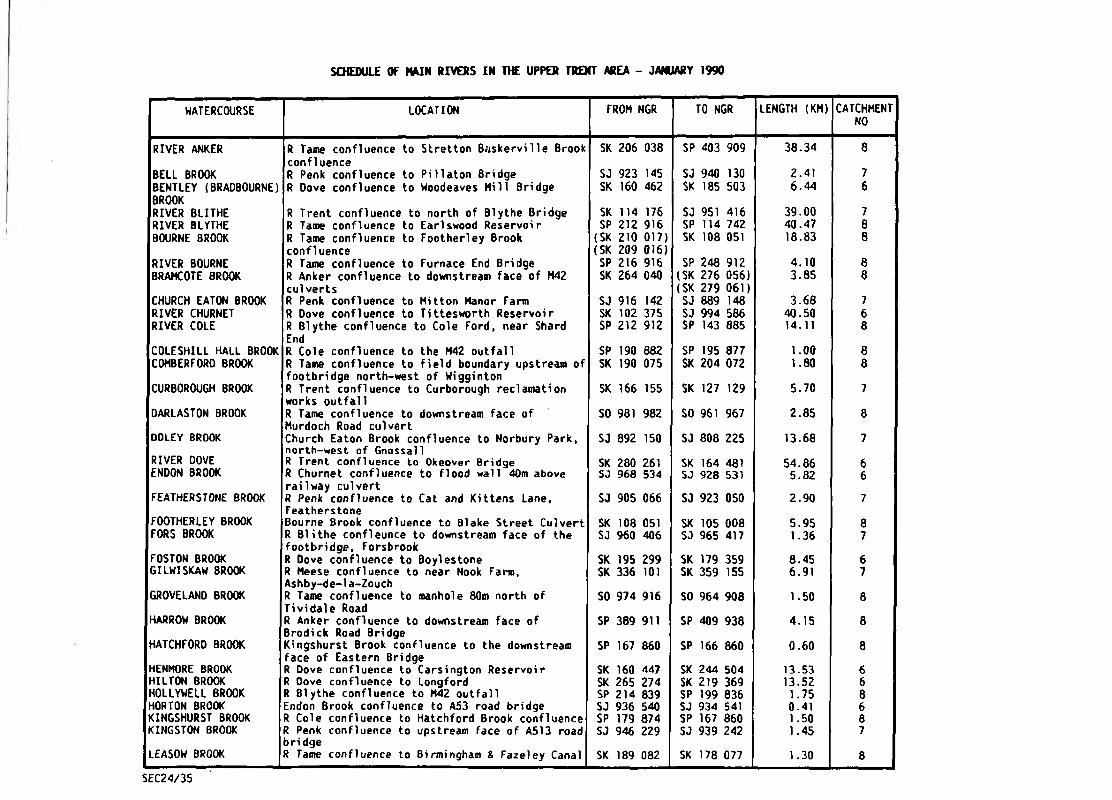
SCHEDULE OF MAIN RIVERS IN THE UPPER TRENT AREA - JANUARY 1990
WATERCOURSE LOCATION FROM NGR TO NGR LENGTH (KM) CATCHMENTNO
RIVER ANKER R Tame confluence to Stretton Baskerville Brook confluence
SK 206 038 SP 403 909 38.34 8
BELL BROOK R Penk confluence to PUlaton Bridge SJ 923 145 SJ 940 130 2.41 7BENTLEY (BRADBOURNE) BROOK
R Oove confluence to Woodeaves Hill Bridge SK 160 462 SK 185 503 6.44 6
RIVER BLITHE R Trent confluence to north of Blythe Bridge SK 114 176 SJ 951 416 39.00 7RIVER BLYTHE R Tame confluence to Earlswood Reservoir SP 2 1 2 916 SP 114 742 40.47 8
BOURNE BROOK R Tame confluence to Footherley Brook confluence
{SK(SK
2 1 0
209017)016)
SK 108 051 18.83 8
RIVER BOURNE R Tame confluence to Furnace End Bridge SP 216 916 SP 248 912 4,10 8
BRAMCOTE BROOK R Anker confluence to downstream face of M42 culverts
SK 264 040 <SK(SK
276279
056)061)
3.85 8
CHURCH EATON BROOK R Penk confluence to Mitton Manor Farm SJ 916 142 SJ 889 148 3.68 7RIVER CHURNET R Dove confluence to Tittesworth Reservoir SK 1 0 2 375 SJ 994 586 40.50 6
RIVER COLE R Blythe confluence to Cole Ford, near Shard EndR Cole confluence to the M42 outfall
SP 2 1 2 912 SP 143 885 14.11 8
COLESHILL HALL BROOK SP 190 882 SP 195 877 1 . 0 0 8
COHBERFORD BROOK R Tame confluence to field boundary upstream of footbridge north-west of Wigginton
SK 190 075 SK 204 072 1.80 8
CURBOROUGH BROOK R Trent confluence to Curborough reclamation works outfall
SK 166 155 SK 127 129 5.70 7
DARLASTON BROOK R Tame confluence to downstream face of Murdoch Road culvert
SO 981 982 SO 961 967 2.85 8
DOLEY BROOK Church Eaton Brook confluence to Norbury Park, north-west of Gnossall
SJ 892 150 SJ 808 225 13.68 7
RIVER DOVE R Trent confluence to Okeover Bridge SK 280 261 SK 164 481 54.86 6ENDON BROOK R Churnet confluence to flood wall 40m above
railway culvertSJ 968 534 SJ 928 531 5.82 6
FEATHERSTONE BROOK R Penk confluence to Cat and Kittens Lane, Featherstone
SJ 905 066 SJ 923 050 2.90 7
FOOTHERLEY BROOK Bourne Brook confluence to Blake Street Culvert SK 108 051 SK 105 008 5.95 8
FORS BROOK R Blithe confleunce to downstream face of the footbridge, Forsbrook
SJ 960 406 SJ 965 417 1.36 7
FOSTON BROOK R Dove confluence to Boylestone SK 195 299 SK 179 359 8.45 6
GILWISKAW BROOK R Meese confluence to near Nook Farm, Ashby-de-1a-Zouch
SK 336 1 0 1 SK 359 155 6.91 7
GROVELAND BROOK R Tame confluence to manhole 80m north of Tividale Road
SO 974 916 SO 964 908 1.50 8
HARROW BROOK R Anker confluence to downstream face of Brodick Road Bridge
SP 389 911 SP 409 938 4.15 8
HATCHFORO BROOK Kingshurst Brook confluence to the downstream face of Eastern Bridge
SP 167 860 SP 166 860 0.60 8
HENMORE BROOK R Dove confluence to Carsington Reservoir SK 160 447 SK 244 504 13.53 6
HILTON BROOK R Oove confluence to Longford SK 265 274 SK 219 369 13.52 6
HOLLYWELL BROOK R Blythe confluence to M42 outfall SP 214 839 SP 199 836 1.75 8
HORTON BROOK Endon Brook confluence to A53 road bridge SJ 936 540 SJ 934 541 0.41 6
KINGSHURST BROOK R Cole confluence to Hatchford Brook confluence SP 179 874 SP 167 860 1.50 8
KINGSTON BROOK R Penk confluence to upstream face of A513 road bri dge
SJ 946 229 SJ 939 242 1.45 7
LEASOW BROOK R Tame confluence to Birmingham & Fazeley Canal SK 189 082 SK 178 077 1.30 8
SEC24/35

SCHEDULE OF MAIN RIVERS IN THE UPPER TRENT AREA - (CONTINUED)
WATERCOURSE LOCATION FROM NGR TO NGR LENGTH (KM) CATCHMENTNO
LONGNOR BROOK Wheaton Aston Brook confluence t.o Station Road, Wheaton Aston
SJ 869 141 SJ 855 124 2.05 7
LOW BROOK Kingshurst Brook confluence to downstream face of railway culvert
SP 172 864 SP 179 846 2 . 0 0 8
MARE BROOK R Tame confluence to upstream face of A38(T) road culvert
SK 174 115 SK 141 096 4.80 8
MARSTON BROOK Wheaton Aston 8 rook confluence to Birchmoor Lane
SJ 845 141 SJ 827 143 1.98 7
RIVER MEASE R Trent confluence to Gilwiskaw Brook confluence
SK 196 147 SK 336 1 0 1 25.57 7
MEECE BROOK R Sow confluence to Swinchurch Brook confluence
SJ 874 282 SJ 823 363 16.94 7
MOAT BROOK R Penk confluence to 200m above Wood Road, Codsall
SJ 890 037 SJ 859 037 4.30 7
MOTTY MEADOWS BROOK Wheaton Aston Brook confluence to Wrestlers Wood
SJ 845 141 SJ 825 133 1.60 7
NUNEATON FLOOD RELIEF CHANNEL
R Anker confluence to inlet from the R Anker SP 365 927 SP 379 917 1.80 8
OTHERTON BROOK R Penk confluence to railway bridge near Lyne HillR Sow confluence to Pendeford Mill Lane bridge
SJ 922 144 SJ 923 129 1.61 7
RIVER PENK SJ 946 229 SJ 891 036 26.87 7PICKNALL BROOK R Dove confluence to confluence 260m downstream
of Loxley LaneSJ 116 319 SK 066 326 6.31 6
RAVENSHAW BROOK R Blythe confluence to M42 outfall SP 178 792 SP 173 789 0.80 8 ,RISING BROOK R Penk confluence to A449 culvert SJ 936 2 1 2 SJ 920 214 2.60 7ROLLESTON BROOK Tutbury Mill Fleam confluence to 200m upstream
of Bushton BridgeSK 242 282 SK 206 262 4.41 6
SAREDON BROOK R Penk confluence to Golly Brook confluence SJ 903 075 SJ 972 087 8.35 7SCOTCH BROOK R Trent confluence to downstream face of canal
culvertSJ 902 334 SJ 902 337 0.26 7
SENCE BROOK R Sence confluence to confluence of R Tweed and Stapleton Brook
SP 326 999 SP 409 989 12.47 8
RIVER SENCE R Anker confluence to B591 at Heather SP 315 991 SK 394 109 20.33 8
SHADOW BROOK R Blythe confluence to M42 outfall? SP 216 825 SP 192 809 3.00 8
SKETCHLEY BROOK Harrow Brook'confluence to downstream face of Brookfield Road Bridge !
SP 392 916 SP 421 928 3.50 8
RIVER SOW R Trent confluence to Pershal1 SJ 995 226 SJ 818 297 28.83 7SWAN BROOK Tipton Brook,confluence to downstream face of
manhole adjacent Birmingham New Roadso 963 927 SO 947 918 3.00 8
RIVER TAME R Trent confluence to Ashes Road, Oldbury and downstream face of James Bridge, Willenhall
SK 192 149 (SO(SO
985976
875)987)
87.72 8
TATENHILL BROOK R Trent confluence to SK 220 203 SK 227 209 SK 2 2 0 203 1 . 0 0 7RIVER TEAN R Dove confluence to footbridge near Noah's Ark
Farm(SK(SK
1 0 2
106355)344)
SK 062 360 7.80 6
TIPTON BROOK R Tame confluence to Swan Brook confluence SO 979 935 SO 963 927 1.90 8
RIVER TRENT R Dove confluence to footbridge at Stoke-on-T rent
SK 280 261 SJ 901 513 87.00 5 + 7
TUTBURY MILL FLEAM R Dove confluence to sluice at Dove confluence SK 249 284 SK 204 294 6.40 6
WHEATON ASTON BROOK Church Eaton Brook confluence to Motty Meadows Brook confluence
SJ 889 148 SJ 845 141 4.30 7
SEC24/35
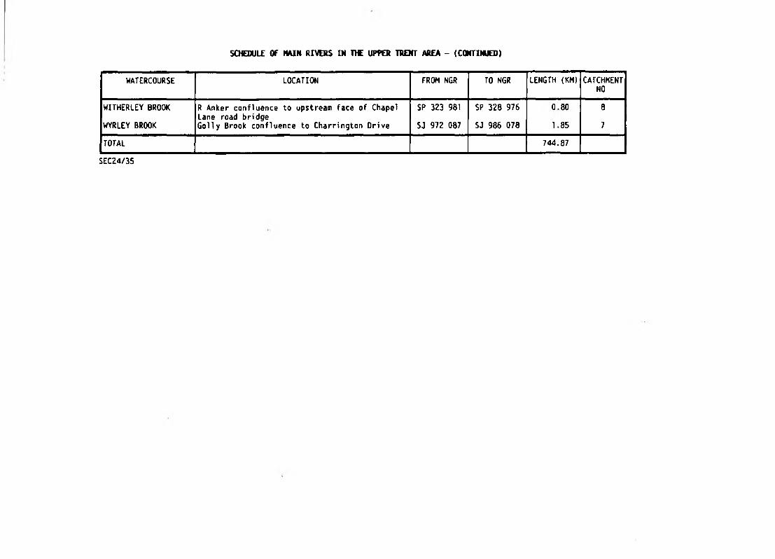
SCHEDULE OF M I N RIVERS IN H E UPPER TRENT AREA - (CONTINUES)
WATERCOURSE LOCATION FROM NGR TO NGR LENGTH (KM) CATCHMENTNO
WITHERLEY BROOK R Anker confluence to upstream face of Chapel Lane road bridge
SP 323 981 SP 328 976 0 80 8
WYRLEY BROOK Golly Brook confluence to Charrington Drive SJ 972 087 SJ 986 078 1 85 7
TOTAL 744.87
SEC24/35

SCHEDULE OF MAIN RIVERS IN THE LOWER TRENT AREA (CONTINUED)
WATERCOURSE LOCATION FROM NGR TO NGR LENGTH (KM) CATCHMENTNO
RATCLIFFE-ON-SOAR POWER STATION DRAIN
R Soar confluence to upstream face of railway culvert
SK 491 298 SK 497 296 0.70 4
RATCLIFFE-ON-SOAR VILLAGE DRAIN
R Soar confluence to upstream face of railway culvert
SK 493 289 SK 497 285 1.29 4
REPTON BROOK R Trent confluence to Lawn Bridge SK 317 285 SK 313 252 4.50 7ROTHLEY BROOK R Soar confluence to the A50 SK 592 132 SK 542 070 11.26 4RIVER RYTON R Idle confluence to Bracebridge, Worksop SK 658 921 SK 585 790 28.96 5SAUNDBY BECK R Trent confluence to Laneham IDD boundary SK 807 881 SK 790 879 1.74 5RIVER SENCE R Soar confluence to Great Glen SP 552 985 SP 656 981 19-31 4SILEBY BROOK R Soar confluence to Sileby Village SK 591 148 SK 602 150 1 . 0 0 4SNOW SEWER R Trent confluence to Snow Sewer pumping
stationSK 813 994 SK 731 986 9.01 5
RIVER SOAR R Trent confluence to footbridge upstream of Sharnford
SK 494 309 SP 463 909 75.73 4
SODBRIDGE DRAIN Middle Beck confluence to upstream face of railway culvert
SK 805 508 SK 816 528 2.53 5
SOUTH LEVEL ENGINE DRAIN
Keadby pumping station to Bull Hassocks pumping station
SE 835 113 SE 731 017 17.25 5
SOUTH LEVEL ENGINE SOAK DRAIN
South Idle Drain to north of Aucklands Farm SE 735 040 SE 738 034 2 . 0 0 5
SOUTH SOAK DRAIN Keadby pumping station to Thorne SE 835 113 SE 681 132 16.57 5RIVER TORNE R Trent confluence to the A60 at Styrrup Carr SE 836 113 SE 588 906 39.42 5RIVER TORNE SOAK DRAIN (CANDY FARM)
Ring Drain confluence to Blaxton Banks SE 704 037 SE 673 028 3.94 5
RIVER TORNE SOAK DRAIN (TUNNEL PITS)
Southern side of Syphon under R Torne into Tunnel Pits pumping station to Wroot Connon
SE 735 040 SE 717 040 2 . 2 0 5
RIVER TRENT R Humber confluence to R Dove confluence SE 863 235 SK 280 261 193.00 5 + 7TUNNEL PITS SUCTION DRAIN
Tunnel Pits pumping station to North Idle Drain at East Ring Drain
SE 735 040 SE 736 044 0.55 5
TWYFORD BROOK Queniborough Brook confluence to the Dairy Farm SK 643 131 SK 736 094 15.89 4WATERTON DRAIN Woodhouse Sewer confluence to Diggin Oyke
confluenceSE 662 066 SE 662 064 0 . 2 1 5
WENSLEY BROOK R Derwent confluence to upstream face of Oldfield Lane Bridge
SK 270 621 SK 269 619 0.13 6
WHETSTONE BROOK R Soar confluence to Bottom End Bridge, Countesthorpe
SP 548 974 SP 558 969 1.34 4
WILNE DRAIN R Derwent outfall to 230m north-east of Beech cottage
SK 452 314 SK 440 307 1.59 6
WOODCARR SUCTION DRAIN
Woodcarr pumping station to junction with Woodcarr Small Drain
SE 753 088 SE 754 088 0.06 5
WOODHOUSE SEWER Hatfield Waste Drain to Green Lane, Waterton Carr
SE 685 082 SE 660 066 3.22 5
RIVER WREAKE R Soar confluence to Stapleford Park SK 596 127 SK 815 187 40.42 4RIVER WYE R Derwent confluence to the A6 upstream of
Ashford-i n-the-WaterSK 260 655 SK 179 698 17.29 6
TOTAL 1,032.40
SEC24/35

SCHEDULE OF MAIN RIVERS IN THE LOWER TRENT AREA - JANUARY 1990
WATERCOURSE LOCATION FROM NGR TO NGR LENGTH (KM) CATCHMENTNO
ALFRETON BROOK R Amber confluence to Fordbridge Lane SK 387 564 SK 440 577 6.84 6
RIVER AHBER R Derwent confluence to Ogston Reservoir SK 347 515 SK 380 598 16.03 6
BAR BROOK R Derwent confluence to tributary confluence 60m upstream of Derwent Valley Aqueduct, near Baslow
SK 256 712 SK 262 725 1,77 6
BARROW DRAIN Main Drain confluence to SK 350 302 SK 368 303 SK 350 302 1.80 6
BENTLEY BROOK R Oerwent confluence to stilling pond south of Lumsdale
SK 300 598 SK 312 605 1.78 6
RIVER BIAM Downstream confluence with R Soar to upstream confluence with R Soar
SK 579 028 SK 577 024 0.48 4
BLACK BROOK R Soar confluence to Grace Dieu Brook SK 521 2 2 0 SK 487 209 5.15 4BOTTESFORO BECK R Trent confluence to Emanuel Bridge SE 837 061 SE 925 084 9.98 5BOTTLE BROOK R Derwent confluence to Smithy Houses (North) &
Bottlebrook Houses (South)SK 359 407 (SK
(SK386389
471)460)
9.00 6
BROUGHTON ASTLEY R Soar confluence to surface water outlet from SP 520 963 SP 528 923 5.00 4BROOK Harborough DC housing developmentBURTON BROOK R Sence confluence to Burton Overy SP 654 974 SP 675 980 2.41 4CANDY FARM SUCTION Candy Farm pumping station to Hatfield Chase SE 698 031 SE 698 037 0.60 5DRAIN IDB BoundaryCASTLE DONINGTON R Trent confluence to outfall of surface water SK 455 300 (SK 449 284) 3.33 7BROOK sewer (SK 448 277)CHAODESDEN BROOK R Derwent confluence to Lees Brook confluence SK 375 358 SK 384 372 1.83 6
COSBY BROOK R Soar confluence to Cambridge Road, Cosby SP 536 970 SP 547 952 3.22 4CUTTLE BROOK R Trent confluence to Sinfin Moor SK 377 281 SK 370 302 2.41 6
RIVER DERWENT R Trent confluence to outfall from Ladybower Reservoi r
SK 459 308 SK 199 853 88.78 6
RIVER DEVON R Trent confluence to Knipton reservoir SK 790 533 SK 818 309 32.94 5DIGGIN DYKE Waterton Drain confluence to balancing area SE 662 064 SE 657 050 2.03 5DOVER BECK R Trent confluence to Lowdham Mill (downstream
limit of control structures)SK 695 451 <SK
(SK6 6 6
6 6 6
474)473)
5.20 5
RIVER EAU R Trent confluence to Dunstall Beck SE 837 033 SK 891 940 16.41 5RIVER ECCLESBOURNE R Derwent confluence to weir upstream of
Windley BridgeSK 350 432 SK 319 447 5.28 6
EGGINTON BROOK R Trent confluence to Radbourne Brook, Etwall SK 285 269 SK 264 336 9.36 6
EMINSONS DYKE R Eau confluence to Messingham Catchwater Drain confluence
SE 879 026 SE 884 027 0.50 5
RIVER EREWASH R Trent confluence to downstream face of B6018 road bridge, Kirkby-in-Ashfield
SK 514 330 SK 485 548 39.66 5
FAIRHAM BROOK R Trent confluence to surface water outfall from new development on left bank
SK 560 366 SK 556 328 4.60 5
FOSSE DYKE R Trent confluence to Torksey road bridge SK 834 781 SK 838 781 0.32 5GRASSTHORPE BECK R Trent confluence to downstream end of control
structure at Grassthorpe MillSK 816 673 SK 792 676 3.12 5
GREAT CATCHWATER Ravensfleet pumping station to the A159 at SK 800 960 SK 839 934 6.40 5DRAIN WhartonRIVER GREET R Trent confluence to outfall at Lower
Kirklington Road, SouthwellSK 743 515 SK 705 547 6.80 5
GREYTHORNE OYKE R Trent confluence to upstream of Wilford Road SK 575 375 SK 572 368 0.81 5HALLOUGHTON DUMBLE Harlock Dyke confluence to Southwell SK 737 523 SK 726 526 1.37 5DRAIN reclamation works
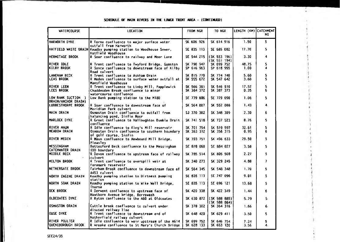
SCHEDULE OF MAIN RIVERS IN THE LOWER TRENT AREA - (CONTINUED)
WATERCOURSE LOCATION FROM NGR TO NGR LENGTH (KM) CATCHMENTNO
HARWORTH DYKE R Torne confluence to major surface water outfall from Harworth
SK 606 926 SK 614 916 1.50 5
HATFIELD WASTE DRAIN Keadby pumping station to Woodhouse Sewer, Hatfield Woodhouse
SE 835 m SE 685 082 17.70 5
HERMITAGE BROOK R Soar confluence to railway and Moor Lane SE 544 215 (SK(SK
553551
196)194)
3.30 4
RIVER IDLE R Trent confluence to Twyford Bridge, Gamston SK 790 947 SK 699 752 48.75 5KILBY BROOK R Sence confluence to downstream face of Kilby
Road culvertSP 616 963 SP 618 955 1 . 0 0 4
LANEHAM BECK R Trent confluence to Askham Drain SK 815 770 SK 774 740 5.60 5LEAS BROOK R Meden confluence to surface water outfall at
Mansfield WoodhouseSK 555 672 SK 547 642 3.60 5
RIVER LEEN R Trent confluence to Linby Mill, Papptewick SK 566 381 SK 546 510 17.52 5LEES BROOK Chaddesden Brook confluence to minor
watercourse confluenceSK 384 372 SK 387 373 0.35 6
LOW BANK SUCTION ) DRAIN/ANCHOR DRAIN)
Low Bank pumping station to the M180 SE 739 086 SE 729 090 1.06 5
LUBBESTHORPE BROOK R Soar confluence to downstream face of Meridian Park culvert
SK 564 007 SK 552 008 1.43 4
MAIN DRAIN Osmaston Drain confluence to outfall from balancing pond, Sinfin Moor
SJ 370 302 SK 348 309 2.30 6
HARLOCK DYKE R Greet confluence to Halloughton Dumble Drain confluence
SK 741 518 SK 737 523 0.76 5
RIVER MAUN R Idle confluence to King's Mill reservoir SK 701 754 SK 519 597 32.61 5MEADOW DRAIN Osmaston Drain confluence to southern boundary
of golf course, SinfinSK 363 312 SK 356 315 0.95 6
RIVER MEDEN R Maun confluence to Newbound Mill Bridge, PIeasley
SK 703 751 SK 496 633 29.50 5
MESSINGHAM CATCHWATER DRAIN
Bottesford Beck confluence to the Messingham IDD boundary
SE 878 060 SE 884 027 3.50 5
MIDDLE BECK R Devon confluence to upstream face of railway culvert
SK 785 514 SK 805 508 2.27 5
MILTON BROOK R Trent confluence to overspill weir at Foremark reservoir
SK 340 273 SK 329 245 4.80 7
NETHERGATE BROOK Fairham Brook confluence to downstream face of A453 culvert
SK 564 345 SK 548 348 1.70 5
NORTH ENGINE DRAIN Keadby pumping station to Dirtness pumping station
SE 035 113 SE 747 096 9.01 5
NORTH SOAK DRAIN Keadby pumping station to Wike Well Bridge, Thorne
SE 835 113 SE 696 1 2 1 13.68 5
OCK BROOK R Derwent confluence to upstream face of Hawthorn Avenue bridge, Barrowash
SK 420 338 SK 422 349 1.44 6
OLDCOATES DYKE R Ryton confluence to the A60 at Oldcoates SK 630 872 (SK(SK
588588
885)884)
5.79 5
OSHASTON DRAIN Cuttle brook confluence to culvert under disused railway line
SK 370 302 SK 364 316 1 . 6 6 6
OUSE DYKE R Trent confluence to downstream end of Netherfield railway culvert
SK 648 420 SK 629 411 3.50 5
RIVER POULTER R Idle confluence to weir upstream of the A614 SK 699 752 SK 646 754 7.24 5QUENIBOROUGH BROOK R Wreake confluence to St Mary's Church Bridge SK 628 133 SK 653 1 2 0 3.56 4
SEC24/35
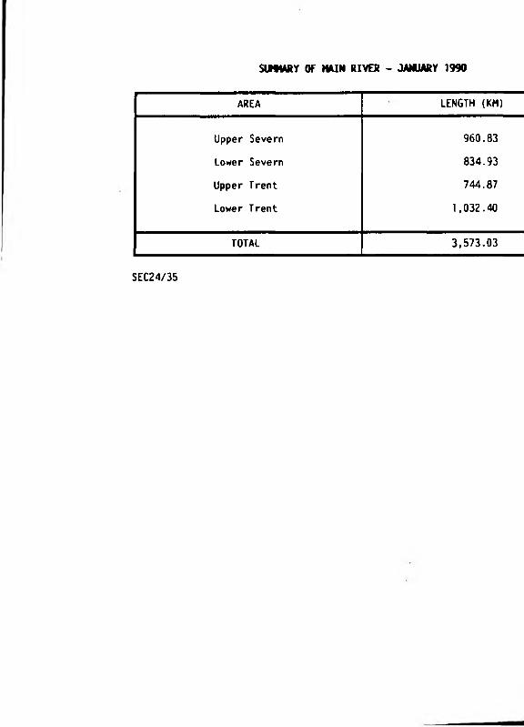
SIMMRY OF MAIN RIVES - JANUARY 1990
AREA LENGTH (KM)
Upper Severn 960.83
Lower Severn 834.93
Upper Trent 744.87
Lower Trent 1,032.40
TOTAL 3,573.03
SEC24/35

APPENDIX A3
SSSINNRI MR
V I I
CTR
CONSERVATION SITES
- Site of Special Scientific Interest- National Nature Reserve- Local Naturs Rsssrv©- County Trust Reserve

CONSERVATION SITES IN THE RIVER DERWENT CATCHMENT AND DERBYSHIRE AT APRIL 1990
SITE NAME STATUSNATIONAL
GRID REFERENCE
j
DESCRIPTION
Abney & Bretton Cloughs SSSI SK 2 1 0 790 Damp gritstone valley important for ferns.il
Attenborough Gravel Pits SSSI/CTR SK 522 341 Valuable wildfowl refuge. V!|
Bage Mine SSSI SK 292 549 Geological interest.V
Baileycroft Quarry SSSI SK 283 545 Good geological site. V
Ball Eye Hill SSSI SK 286 574 Community of lead tolerant plants.
Bath Pasture SSSI SK 063 459 Large floristically rich unimproved acid grassland. *1
Bradwell Dale & Bagshaw Cavern SSSI SK 170 800 Important geological site.
Breadsall Railway Cutting SSSI/LNR SK 395 394 A wide range of ecosystems. 'l
Bretton Clough SSSI SK 205 786 Gritstone valley and complex landslipped area.
Brownend Quarry SSSI SK 090 503 Important geological site. I
Caldon Dales SSSI SK 093 489 Unimproved traditionally managed calcareous and neutral grassland.
Caldon Low SSSI SK 077 492 Geologi cal i nterest.
Calton Hill SSSI SK 119 715 Good example of igneous intrusion. \\
Carvers Rocks SSSI/CTR SK 330 227 Geological interest. 'j
Castleton SSSI SK 129 830 Noted for cave systems. \1
Cawdor Quarry SSSI SK 284 605 Good geological exposures. ii
Chrome & Parkhouse Hills SSSI SK 075 671 Good geological and fossi1iferoos site. -J,i
Clough Mood SSSI SK 255 618 Ha inly oak and ash with characteristic ground flora including some unconunon species.
Colehill Quarries SSSI SK 287 552 A nationally important geological site. ',iCombes Valley SSSI/CTR SK 055 525 RSPB reserve and also of entomological interest.
Coombs Dale SSSI SK 224 744 Limestone dale with outstanding flora and some very rare species. ;|
Crabtree Wood SSSI SK 490 785 A base-rich flush.
Cressbrook Dale SSSI/NNR SK 173 738 Botanically outstanding with exceptionally rare species. iiCromford Canal SSSI/LNR/CTR SK 299 569 Supports a variety of plant and animal communities.
11
Cunning Dale SSSI SK 082 728 Uncommon limestone grassland.
Cresswell Crags SSSI SK 535 742 Series of caves and exposures of exceptional palaeo-bioloyical & botanical interest.¥
Dimminsdale SSSI SK 377 Z\8 Ancient semi-natural woodland and unimproved acid grassland. !i
Dove Valley and Biggin Dale SSSI SK 157 506 Area of exceptional geological, physiographical, botanical and ornithological interest.ir
Duchy Quarry SSSI SK 093 767 A nationally important geological site.
Eastern Moors SSSI SK 270 770 Broad tract of moorland. 'j
Edale SSSI SK 1 0 0 854 Geologi cal succession. 1
Eldon Hole, Eldon Hill SSSI SK 117 809 Famous pot-hole eroded in carboniferous limestone. \
SEC24/10
SITE NAME STATUSNATIONAL
GRID REFERENCEDESCRIPTION
Foxhole Cave SSSI SK too 663 Extensive cave system containing many fossils.
Gang Mine SSSI SK 287 558 Area of hummocky spoil heaps with metallophyte plants.
Ginny Springs SSSI SK 520 788 Small flush with some plant species rare in the region.
Green Lane Pits SSSI SK 166 626 Geologi cal i nterest.
Hal lam Moors SSSI SK 259 835 Characteristic Millstone Grit escarpment.
Hamps and Manifold Valleys SSSI SK 100 540 Ecton Hill shows unique mineralisation and is noted for its copper mi nes.
Hilton Gravel Pits SSSI/CTR SK 249 315 An important complex of open water, carr and marshland habitats.
Hipley Hi 11 SSSI SK 211 546 Mineralised limestone area with rocky outcrops and natural caves.
Hollinhill & Mark land Grips SSSI SK 510 750 Deep valleys with vertical cliff-like sides supporting rich flora.
Hull and Moss SSSI SK 250 462 Wetland Heath
Ibley and Middleton Woods SSSI SK 265 562 Semi-natural ash woodland.
Jumble Coppice SSSI SK 268 72! Geological interest.
Kinder & Bleaklow SSSI SK 091 942 Important upland vegetation.
Lathkill Dale SSSI/NNR SK 187 658 Deep limestone valley.
Lee Farm Meadow SSSI SK 131 785 Species rich hay meadow.
Leek Moors SSSI/LNR/CTR SK 020 650 Moorland noted for fauna and flora.
Long Dale and Gratton Dale SSSI/NNR SK 202 596 Area of considerable phytogeographical importance.
Longstone Moor SSSI SK 195 735 Large moorland area.
Masson Hill SSSI SK 290 588 Site with cave complex and species rich grasslands.
Hatlock Moods SSSI SK 296 593 Ash-Elm woodland with interesting ground flora.Monks Dale SSSI SK 135 745 Outstanding limestone dale with extremely rich flora.Morley Brick Pits SSSI SK 389 418 Acidic water pits colonised by rare flora and fauna.
Moss Carr SSSI SK 073 659 Well developed willow carr, orchids and ornithological interest.
Ogston Reservoir SSSI SK 376 602 Most important wildfowl refuge in district.
Old River Dove SSSI SK 238 285 Lowland wetland habitat.
Parwich Moor SSSI SK 175 579 Small area of heather moor of pedological interest.
Peak Forest Junction-Great SSSI SK 112 727 Geological site.
Rocksdale Quarry
Poole's Cavern & Grin Low Wood SSSI SK 050 724 Cave system and mixed woodland.
Ridgeway Quarry SSSI SK 360 517 Excellent example of sedimentary structures.
Rowlee Bridge SSSI SK 147 892 Geologi cal interest.
Rue Hill SSSI SK 082 481 Limestone habitat.
Shining Cliff Woods SSSI SK 335 530 Good example of oak-birch wood.
Stanton Pastures and Cuckoocliff SSSI SK 1 2 2 473 Rich flora includes orchids of both calcicote and acidophilous varieties.
Valley
Staunton Harold Reservoir SSSI SK 377 237 Important site for wintering wildfowl.
Stoney Middleton Dale SSSI SK 210 760 Geological and biological interest.
Swineholes Wood & Black Heath SSSI/CTR SK 048 504 Woodland and moorland areas notable as breeding sites for birds.
Taddington Wood SSSI SK 165 708 Ash wood with typical ground flora.
Ticknall Quarries SSSI SK 358 832 Geological, ornithological and entomological interest.
SEC24/10
SITE NAME STATUSNATIONAL
GRID REFERENCEDESCRIPTION
Topley Pike and Deepdale SSSI SK 099 717 Phytogeographical importance.
Upper Lathkill SSSI SK 143 677 Geological site with extensive cave system. ,,
Wye Dale SSSI SK 099 724 Important for geology, flora and fauna.
Wyns Tor SSSI SK 241 603 Fine example of a tor in dolomitised carboniferous limestone.
Yarncliff Wood SSSI SK 255 795 Remnant oak-birch woodland.
II
il
(Iitl
<■
SEC24/10

APPENDIX A4
CODING SYSTEM

CODING SYSTEM
X X X X X X X X
CATCHMENT COUNTY DISTRICT NUMBER
eg 6 98 510 23
Derwent Derbyshire High Peak - ’■ ^"Problem No.
CATCHMENT Code
UPPER SEVERN 1
LOWER SEVERN 2
AVON 3SOAR 4
LOWER TRENT 5
DERWENT 6
UPPER TRENT 7
TAME 8
County/District Councils County Code District Code
AVON COUNTY COUNCIL
Bri stol 82 310
Northavon 82 410
SHROPSHIRE COUNTY COUNCIL
Bridgnorth 83 1 1 0
North Shropshire 83 2 1 0
Oswestry 83 310
South Shropshire 83 410
Shrewsbury and Atcham 83 510
Telford Development Corporation 83 610
Wrekin 83 710
CLWYD COUNTY COUNCIL
Glyndwr 84 1 1 0
Wrexham Maelor 84 2 1 0
GWYNEDD COUNTY COUNCIL
Mei rionnydd 85 1 1 0
POWYS COUNTY COUNCIL
Mid Wales Development Corporation 8 6 1 1 0
Montgomery 8 6 2 1 0
Radnor 8 6 310
SEC24/6

HEREFORD AND WORCESTER COUNTY COUNCIL
leomi nster 87 n oBromsgrove 87 2 1 0
Malvern Hills 87 310Reddi tch 87 410Redditch Development Corporation 87 510South Herefordshire 87 610Worcester 87 710Wychavon 87 810Wyre Forest 87 910
GLOUCESTERSHIRE COUNTY COUNCIL
Cheltenham 8 8 n oForest of Dean 8 8 2 1 0
Gloucester 8 8 310Stroud 8 8 410T ewkesbury 8 8 510Cotswold 8 8 610
OXFORDSHIRE COUNTY COUNCIL
Cherwel 1 89 1 1 0
NORTHAMPTONSHIRE COUNTY COUNCIL
Daventry 90 n o
WARWICKSHIRE COUNTY COUNCIL
Nuneaton & Bedworth 91 1 1 0
Rugby 91 2 1 0
Stratford-upon-Avon 91 310Warwi ck 91 410
North Warwickshire 91 510
WEST MIDLAIOS
Coventry 92 1 1 0
Bi rmi ngham 92 2 1 0
Dudley 92 310
Sandwel1 92 410
Soli hul1 92 510
Walsail 92 610
Wolverhampton 92 710
LEICESTERSHIRE COUNTY COUNCIL
Bl aby 93 1 1 0
Hinckley and Bosworth 93 2 1 0
Charnwood 93 310
Harborough 93 410
Lei cester 93 510
Mel ton 93 610
North West Leicestershire 93 710
Oadby and Wigston 93 810
Rutland 93 910
SEC24/6
NOTTINQttMSHIRE COUNTY COUNCIL
Ashfield 94 110
Bassetlaw 94 Z10
Broxtowe ' 94 310
Gedli ng 94 410
Mansfield 94 510
Newark and Sherwood ___ . = 9 4 ^ ^ " ^ 610No 1 1 i ngham __ - - - - _ "" " - T- 9 4 7 1 0
Rushcliffe 94 010
LINCOLNSHIRE COUNTY COUNCIL
North Kesteven 95 n o
South Kesteven 95 2 1 0
West Lindsey 95 310
HUMBERSIDE COUNTY COUNCIL
Boothferry 96 1 1 0
Glanford 96 2 1 0
Scunthorpe 96 310
SOUTH YORKSHIRE
Doncaster 97 1 1 0
Rotherham 97 2 1 0
Sheffi eld 97 310
DERBYSHIRE COUNTY COUNCIL
Bolsover 98 1 1 0
Erewash 98 2 1 0
Amber Valley 98 310
Derby 98 410
High Peak 98 510
North East Derbyshire 98 610
Derbyshi re Dales 98 710
South Derbyshire 98 810
Chesterfield 98 910
STAFFORDSHIRE COUNTY COUNCIL
Staffordshire Moorlands 99 1 1 0
Cannock Chase 99 2 1 0
East Staffordshire 99 310
Li chfield 99 410
Newcastle under Lyme 99 510
South Staffordshire 99 610
Stafford 99 710
Stoke on Trent 99 810
Tamworth 99 910
SEC24/6
APPENDIX A5
SOURCES OF FINANCE


1 Levy on County Councils, Metropolitan District Councils and Internal Drainage Boards
The_ Author ityis^flood, defence -and landed ran nage revenue i ncome derives in the main
from contributions from County Councils, Metropolitan District Councils and Internal
Drainage Boards collected by a regional levy. The total amount required to be
collected is apportioned between the Councils on the basis of relevant population
(for Community Charge purposes) after taking into account the amounts to be raised
from Internal Drainage'Boards. The amount paid by Councils for flood defence levies
is reimbursed in full by the Department of the Environment the following year through
the revenue support grant for local authori ties. Internal Drai nage Boards1
contri butions to the Nati onal Rivers Authori ty expendi ture are assessed on the basi s
of the benefit which the Boards derive as a result of the Authority's operations.
2 Loans
The Authority's flood defence capital expenditure is self-financed and loans will be
sought in exceptional circumstances only, to deal with unforeseen emergencies.
3 General and Special Orainage Charges
General drainage charges are a means by which revenue, to meet land drainage
expenditure, can be raised on agricultural land which lies outside Internal Drainage
Districts. The Land Drainage Act (as amended by the Water Act 1989) prescribes a
procedure designed to secure that the amount of the charge shall be as near as
practicable equivalent to what would be paid in respect of the chargeable land if the
land were rated.
Special drainage charges can be levied on specified areas outside Internal Orainage
Districts where it appears to the Authority that drainage works on any watercourses
in that area should be carried out in the interests of agriculture.
Because of the limits which are statutorily imposed, General and Special charges
would provide only a small addition to current income. The Authority has, therefore,
decided that, in view of the high adminstrative costs, such charges would not be
justified at present.
4 Grant Aid to the National Rivers Authority
(a) Section 90 of the Land Drainage Act 1976 (as amended by the Water Act 1989)
enables grants to be paid by the Ministry of Agriculture, Fisheries and Food
in respect of approved land drainage schemes for the improvement of existing
works or the construction of new works- In the Severn-Trent Region grant is
currently paid at 15* of qualifying expenditure. A supplement of 20% may also
be payable for tidal defence schemes.
(b) Grants are available under Section 92 of the Land Drainage Act 1976 (as
amended by the Water Act 1989) for providing apparatus for carrying out
engineering operations for the installation of flood warning systems.
5 Grant Aid to Local Authorities and Internal Drainage Boards
By virtue of Section 91, Land Drainage Act 1976 (as amended by the Water Act 1989)
grants are payable by the Ministry of Agriculture, Fisheries and Food to Internal
Orainage Boards and County, Metropolitan and District Councils in respect of
expendi ture i ncurred on drai nage schemes carried out under Sections 17, 22, 98, 99
SEC24/7

and 100 of the Land Drainage Act 1976 {as amended by the Water Act 1989). Such
grants are available in respect of expenditure on approved land drainage schemes for
the improvement of existing works and for the construction of new works, and, in the
case of Internal Drainage Boards, on works (other than routine maintenance) on the
rebuilding or repair of any bridge maintained by a Board.
The Authori ty must be consul ted, as requi red by Section 98(8) of the Land Drai nage
Act 1976 (as amended by the Water Act 1989), before such schemes are submitted to the
Mi ni stry.
Grant aid is currently payable up to a maximum of 26% of the cost of the scheme for
Internal Drainage Boards and Local Authorities. A supplement of 20% may also be
payable for tidal defence schemes.
6 European Regional Development Fund
Certain areas within the region, principally the West Midlands, have been designated
as intermediate areas and schemes which are designed to serve those areas by the
provi si on of i nfrastructure for i ndustry/commerce may be eli gible for grant aid from
the European Regional Development Fund.
SEC24/7

APPENDIX A6
CONSERVATION


1 CONSERVATION DUTIES UNDER THE WATER ACT 1989
The following excerpts from the^ Water_-^.Act1989 ’def i ne the NRA's statutory
conservation,dutiesas"relating to flood defence/land drainage operations.
0 . {1 ) It shal 1 be the duty of each of the fol lowing, that is to say, the
Secretary of State, the Minister, the Director and every relevant body, in
formulating or consideri ng any proposal s relati ng to the functions of any
relevant body or, as the case may be, that body:-
a) so far as may be consistent with the purposes of any enactment relating to
the functions of that body and, in the case of the Secretary of State and
the Di rector, wi th thei r duti es under secti on 7 above, so to exerci se any
power conferred on him or it with respect to the proposals as to further
the conservation and enhancement of natural beauty and the conservation of
flora, fauna and geological and physiographical features of special
i nterest;
b) to have regard to the desirability of protecting and conserving buildings,
sites and objects of archaeological, architectural or historic interest; and
c) to take into account any effect which the proposals would have on the
beauty or amenity of any rural or urban area or on any such flora, fauna,
features, buildings, sites or objects.
(2) Subject to subsection (!) above, it shall be the duty of each of the following,
that is to say, the Secretary of State, the Minister, the Director and every
relevant body, in formulating or considering any proposals relating to the
functions of a relevant body or, as the case may be, that body:-
a) to have regard to the desirability of preserving for the public any freedom
of access to areas of woodland, mountains, moor, heath, down, cliff or
foreshore and other places of natural beauty;
b) to have regard to the desirability of maintaining the availability to the
public of any facility for visiting or inspecting any building, site or
object of archaeological, architectural or historic interest; and
c) to take into account any effect which the proposals would have on any such
freedom of access or on the availability of any such facility.
9. (1) Where the Nature Conservancy Council are of the opinion that any area of
land:-
a) is of special interest by reason of its flora, fauna or geological or
physiographical features; and
b) may at any time be affected by schemes, works, operations or activities of
a relevant body or by an authorisation given by the Authority,
the Council shall notify the fact that the land is of special interest for
that reason to every relevant body whose works, operations or activities
may affect the land or, as the case may be, to the Authority.
(2) Where a National Park authority or the Broads Authority is of the opinion that
any area of land in a National Park or in the Broads:-
a) is land in relation to which the matters for the purposes of which section
8 above has effect are of particular importance; and
SEC24/7

b) may at any time be affected by schemes, works, operations or activities of
a relevant body or by an authorisation given by the Authority, the National
Park authority or Broads Authority shall notify the fact that land is such
land, and the reasons why those matters are of particular importance in
relation to the land, to every relevant body whose works, operations or
activities may affect the land or, as the case may be, to the Authority.
(3) Where a rel evant body has recei ved a noti fi cation under subsection {1) or (2)
above with respect to any land, that body shall consult the notifying body
before carrying out, or (in the case of the Authority) carrying out or
authorising, any works, operations or activities which appear to that relevant
body to be likely:-
a) to destroy or damage any of the flora, fauna, or geological or
physiographical features by reason of which the land is of special
interest; or
b) significantly to prejudice anything the importance of which is one of the
reasons why the matters mentioned in subsection (2 ) above are of particular
importance in relation to that land.
(4) Subsection (3) above shall not apply in relation to anything done in an
emergency where particulars of what is done and of the emergency are notified to
the Nature Conservancy Council, the National Park authority in question or, as
the case may be, the Broads Authority as soon as practicable after that thing is
done.
SEC24/7

1 The Nature Conservancy Council was established by the Nature Conservancy
Counci 1 Act 1973 for the purposes of nature conservation and fostering the
understanding thereof. The major functions prescribed by the Act are:-
i) the establishment, maintenance and management of nature reserves in Great Bri tain;
ii) the provision of advice to Ministers on the development and
implementation of policies for or affecting nature conservation in Great
Bri tai n;
iii) the provision of advice and dissemination of knowledge about nature
conservati on;
iv) the commissioning or support of relevant research.
2 The NCC also inherited a number of powers and duties formerly exercised by the
Nature Conservancy among which are:-
i) a duty to notify land of special interest (SSSIs) to local planning
authorities (Section 23 of the National Park and Access to the
Countryside Act 1949 now superseded by Section 28 of the Wildlife and
Countryside Act 1981 - see below);
ii) power to enter into agreements to conserve SSSIs (Section 15 of the
Countryside Act 1968);
iii) powers of entry for survey in connection with acquisition of land
(Section 108 of the 1949 Act).
3 The Town and Country Planning General Development Order 1977 obliges local
planning authorities to consult the NCC before granting planning permission
for development in an SSSI.
4 The Wildlife and Countryside Act 1981 placed a number of additional duties on
the NCC, some of which replace similar duties in earlier legislation,
including:
i) duty to notify internal drainage boards and the NRA of land of special
interest and to advise those bodies when consulted on their proposals
affecting such sites. (Section 48);
ii) duty to notify land of special interest (SSSIs) not only to local
planning authorities but also to every owner or occupier and to the
Secretary of State, specifying the nature of the scientific interest and
any operations likely, to damage the interest (Section 28);
iii) duty to offer a management agreement where the NCC has objected to a farm
capital grant and it is subsequently refused by agriculture ministers on
nature conservation grounds (Section 32).
RELEVANT FUNCTIONS OF THE NATURE CONSERVANCY COUNCIL = -

3 RELEVANT FUNCTIONS OF COUNTRYSIDE COWIISSION
1 Under Sect i on 2 of the Countrysi de Act 1968, the Country si de Cortini ssion has
the statutory duty of keepi ng under review all matters rel ati ng to the
provision and improvement of facilities for the enjoyment of the countryside,
the conservation and enhancement of the natural beauty and amenity of the
count rysi de, and the need to secure publ ic access to the countryside for the
purposes of open-air recreation. It is required to consult with such local
pianning authorities and other bodies as appear to the Commission to have an
interest in those matters, and to encourage, assist, concert or promote the
implementation of any proposals with respect to those matters made by any
person or body, being proposals which the Commission consider to be suitable.
The Commission is also required to advise any Minister having functions under
the Countryside Act 1968, or any other Minister or any public body, on such
matters relating to the countryside as he or they may refer to the Commission,
or as the Commission may think fit.
2 Under Section 9 of the Local Government Act, 1974, the Commission, in
accordance with arrangements approved by the Secretary of State and the
Treasury, may give financial assistance by way of grant or loan, to any person
in respect of expenditure incurred by him in doing anything which, in the
opinion of the Commission, is conducive to the attainment of any of the
purposes of the Countryside Act 1968 or the National Parks and Access to the
Countryside Act 1949.
SEC24/7


NRANational Rivers Authority Severn-Trent Region