flora and fauna survey guidelines - lake macquarie · flora and fauna survey guidelines page 1 –...
TRANSCRIPT

Flora and Fauna
Survey Guidelines
Version 4.2
December 2012

Flora and Fauna Survey Guidelines
Version 4.2
Pubic exhibition 24 September 2012 to 24 December 2012
Adopted by Council 8 April 2013
Decision published Newcastle Herald on 20 April 2013
Acknowledgements Cover photography courtesy of John Young, Owl Expert
Robbie Economos Environmental Planner Sustainability Department Lake Macquarie City Council
December 2012

Flora and Fauna Survey Guidelines
Page 1 – F2004/10000 Version 4.2
DOCUMENT HISTORY
This 2012 version 4.2 of the City of Lake Macquarie Flora and Fauna Survey Guidelines is a revision of earlier versions.
Version 1 (1997) was prepared by:
Michael Murray Forest Fauna Surveys Pty Ltd Fauna
Kylie Maryott-Brown EcoPro Pty Ltd Flora
Glenn Hoye Fly By Night Bat Surveys P/L Bats
Dr Michael Mahony University of Newcastle Amphibians
Martin Fallding of Land and Environment Planning provided helpful advice and literature on the planning requirements for flora and fauna surveys.
Version 2.0 (2001) updated and incorporated amendments to planning legislation and new threatened species listings. The following authors contributed to this version:
Michael Murray Forest Fauna Surveys Pty Ltd Fauna
Stephen Bell Eastcoast Flora Survey Flora
Michael Todd formerly University of Newcastle Collated / provided flora and fauna records and advice on bird species
Robbie Economos-Shaw, Rebecca Moroney, Sue Effenberger of Lake Macquarie City Council, provided significant input and review.
Version 3.0 (2004) was prepared to incorporate amendments to planning legislation and new threatened species listings. It was not finalised. The following authors contributed to this version:
Michael Murray Forest Fauna Surveys Pty Ltd Fauna
Stephen Bell Eastcoast Flora Survey Flora
Colin Driscoll EcoBiological Survey and Assessment Flora and Fauna
Robbie Economos-Shaw Lake Macquarie City Council Planning component and critically review
Version 4.2 (2012) was prepared to incorporate amendments to planning legislation, new methodologies, new threatened species listings, and to accompany a new draft DCP for Lake Macquarie City. Contributions from the following authors are acknowledged:
Robbie Economos-Shaw Lake Macquarie City Council Author and editing
Brian Wilson Ecotone Ecological Consultants Terrestrial Flora and Fauna
Amy Rowles Ecotone Ecological Consultants Terrestrial Flora and Fauna
Stefan Rose Ecotone Ecological Consultants Terrestrial Flora and BioBanking
Jemma Sargent JSA Environmental Aquatic Flora and Fauna
Martin Fallding & Sarah Warner Lake Macquarie City Council Review of the document
Emma Graham & Belinda Hodges Lake Macquarie City Council Review of the document (aquatic)
Mandy MacDonald Lake Macquarie City Council Mapping
Susan Hooper Lake Macquarie City Council Desktop publishing and proofreading

Flora and Fauna Survey Guidelines
Page 2 – F2004/10000 Version 4.2
TABLE OF CONTENTS
1 Introduction ................................................................................................................................................... 8
1.1 Background to the Lake Macquarie Flora and Fauna Survey Guidelines................................................ 8
1.2 Legislative Context and Purpose of the Flora and Fauna Survey Guidelines.......................................... 9
1.3 When is a Flora and Fauna or Biodiversity Survey Required by Lake Macquarie City Council............. 12
1.4 Application of the Guidelines for Flora and Fauna Surveys ................................................................... 12
1.5 Procedure for Flora and Fauna (Biodiversity) Surveys and Assessments............................................. 15
2 Legislative And Planning Context In Detail.............................................................................................. 16
2.1 Federal Legislation ................................................................................................................................. 16
2.2 New South Wales Legislation ................................................................................................................. 17
2.2.1 National Parks And Wildlife Act 1974 ................................................................................................. 17
2.2.2 Threatened Species Conservation Act 1995 ...................................................................................... 17
2.2.3 Biobanking and Biocertification........................................................................................................... 18
2.2.4 Fisheries Management Act 1994 ........................................................................................................ 18
2.2.5 Water Management Act 2000 ............................................................................................................. 19
2.2.6 Native Vegetation Act 2003 ................................................................................................................ 20
2.2.7 Environmental Planning and Assessment Act 1979........................................................................... 20
3 Lake Macquarie Requirements and Issues for Flora and Fauna (Biodiversity) Surveys and Assessments............................................................................................................................................... 29
3.1 Council Guidelines and Management Plans........................................................................................... 29
3.2 Research................................................................................................................................................. 29
3.3 Development Context ............................................................................................................................. 30
3.4 Corridors ................................................................................................................................................. 30
3.5 Buffers..................................................................................................................................................... 33
3.6 Condition................................................................................................................................................. 33
3.7 Vegetation Community Classification ..................................................................................................... 33
3.8 Significant Species, Vegetation Communities and Habitat .................................................................... 34
3.9 Personnel Undertaking Surveys ............................................................................................................. 35
3.9.1 Experience and Qualifications ............................................................................................................ 35
3.9.2 Certification and Acknowledgement ................................................................................................... 36
3.9.3 Licensing............................................................................................................................................. 36
3.10 Reporting Form and Contents ................................................................................................................ 36
3.10.1 Outline of Proposed Development.................................................................................................. 36
3.10.2 Survey Methodology ....................................................................................................................... 36
3.10.3 Survey Results................................................................................................................................ 37
3.10.4 Mapping and Data Requirements ................................................................................................... 37
3.11 Revision of Surveys and Studies............................................................................................................ 39
3.12 Site Management During Construction / Development and Ameliorative Measures ............................. 39

Flora and Fauna Survey Guidelines
Page 3 – F2004/10000 Version 4.2
4 Terrestrial Surveys ..................................................................................................................................... 40
4.1 Survey Design ........................................................................................................................................ 40
4.2 Seasonal and Local Climatic Conditions ................................................................................................ 40
4.3 Knowledge of Local Species Distribution ............................................................................................... 40
4.4 Terrestrial Survey Methodology.............................................................................................................. 41
4.4.1 Habitat Description ............................................................................................................................. 41
4.4.2 Flora Surveys...................................................................................................................................... 42
4.4.3 GPS Units ........................................................................................................................................... 47
4.4.4 Areas of Special Interest..................................................................................................................... 48
4.4.5 Fauna Survey Methods....................................................................................................................... 49
5 Aquatic Surveys.......................................................................................................................................... 68
5.1 Aquatic Flora and Fauna Survey ............................................................................................................ 69
5.1.1 Aquatic Flora....................................................................................................................................... 70
5.1.2 Aquatic Fauna..................................................................................................................................... 70
5.1.3 Seasonal and Local Climatic Conditions ............................................................................................ 70
5.1.4 Condition of Habitats .......................................................................................................................... 71
5.1.5 Knowledge of Local Species Distribution ........................................................................................... 71
5.2 Aquatic Flora and Fauna Survey Methodology ...................................................................................... 72
5.2.1 General Aquatic Survey Techniques .................................................................................................. 72
5.2.2 Aquatic Flora Surveys......................................................................................................................... 75
5.2.3 Aquatic Fauna Surveys....................................................................................................................... 77
5.2.4 Significant Aquatic Flora and Fauna................................................................................................... 81
6 Adapting Surveys for Different Sites and Impacts.................................................................................. 82
6.1 Tree Removal ......................................................................................................................................... 82
6.2 Small Sites and Minor Development ...................................................................................................... 82
6.3 Altered and Disturbed Habitats............................................................................................................... 83
6.4 Surveys for Biodiversity Offset Sites ...................................................................................................... 84
6.5 Biobanking and Biocertification............................................................................................................... 85
6.6 Threatened Species Development or Species Impact Statements........................................................ 85
7 References................................................................................................................................................... 87
8 Appendices.................................................................................................................................................. 94
8.1 Appendix – Example of Council’s Development Application Assessment Checklist.............................. 94
8.2 Appendix - Example of a Table Demonstrating Compliance with these Flora and Fauna Survey Guidelines ............................................................................................................................................... 97
8.3 Appendix – Species Having Conservation Signficance........................................................................ 100
8.4 Appendix – Guidleines For Vegetation Management Plans - Version 1 .............................................. 109
8.5 Appendix - Site Management and Rehabilitation Plans and Ameliorative Measures .......................... 119
8.6 Appendix – Survey Times for Threatened Species Recorded in City of Lake Macquarie Terrestrial Fauna.................................................................................................................................................... 120

Flora and Fauna Survey Guidelines
Page 4 – F2004/10000 Version 4.2
8.7 Appendix - Specific Surveys and Targeted Survey Techniques for Selected Threatened Species..... 128
8.8 Appendix – Suitabile Times for Clearing and Disturbance to Avoid Loss of Threatened Species – Key Life Cycle Periods for Threatened Fauna............................................................................................. 139
8.9 Appendix - Small Site and Minor Development Checklist .................................................................... 141
8.10 Appendix - Threatened Species Recorded in City of Lake Macquarie with Associated Vegetation Communities ......................................................................................................................................... 145
LIST OF FIGURES
Figure 1 - City of Lake Macquarie LGA .................................................................................................................. 11
Figure 2 - Flowchart Indicating when a Flora And Fauna (Biodiversity) Survey is Required, and Level of Assessment Required ............................................................................................................................ 14
Figure 3 - Flow Chart for Integration of Flora And Fauna (Biodiversity) Survey and Assessment into the process................................................................................................................................................................ 24
Figure 4 - Native Vegetation and Corridors Map.................................................................................................... 32
LIST OF TABLES
Table 1 - Abundance Rating of Vegetation Species Within Survey Plots .............................................................. 46
Table 2 - Recommended Minimum Survey Effort for Flora and Fauna Surveys.................................................... 49
Table 3 - Recommended Minimum Survey Effort for Fauna Group....................................................................... 52
Table 4 - Recommended Minimum Survey Effort for Flora and Fauna Surveys.................................................... 73

Flora and Fauna Survey Guidelines
Page 5 – F2004/10000 Version 4.2
ABBREVIATIONS AND TERMS
AABR Australian Association of Bush Regenerators
ACEC Animal Care and Ethics Committee
AKF Australian Koala Foundation
API Air Photo Interpretation
APZ Bushfire Asset Protection Zone
AUSRIVAS Australian Rivers Assessment System
BBAM Biobanking Assessment Methodology
BOM Bureau of Meteorology
CKPoM Comprehensive Koala Plan of Management
DA Development Application
dbh Diameter at breast height (1.4 metres above ground level)
DCP Development Control Plan
DEC Department of Environment and Conservation now OEH
DECC Department of Environment and Climate Change now OEH
DEWHA Federal Department of Environment, Water, Heritage and the Arts (now DSEWPaC)
DGRs Director General’s Requirements
DoPI NSW Department of Planning and Infrastructure [formerly Department of Planning (DoP)]
DPI NSW Department of Primary Industries (includes, Fisheries, Agriculture, Forests and Mineral Resources
DSEWPaC Federal Department of Sustainability, Environment, Water, Population and Community
EA Environmental Assessment
EEC Endangered Ecological Community
EIS Environmental Impact Statement
Endemic Naturally occurring only in a specific area
EP&A NSW Environmental Planning and Assessment Act 1979
EPBC Federal Environment Protection and Biodiversity Conservation Act 1999
ESD Ecologically Sustainable Development
FM NSW Fisheries Management Act 1994
FMA NSW Fisheries Management Amendment Act 1994
FMGR NSW Fisheries Management (General) Regulation 2010
GIS Geographical Information System
GPS Global Positioning System
HCRCMA Hunter Central Rivers Catchment Management Authority
Indigenous Naturally occurring
JANIS Nationally agreed forest reserve criteria as per JANIS (1997)
LEP Local Environmental Plan
LES Local Environmental Study
LGA Local Government Area
LHCCREMS Lower Hunter Central Coast Regional Environmental Management Strategy
LHRCP Lower Hunter Regional Conservation Plan 2009

Flora and Fauna Survey Guidelines
Page 6 – F2004/10000 Version 4.2
LHRS Lower Hunter Regional Strategy
LMCC Lake Macquarie City Council
LMLEP Lake Macquarie Local Environmental Plan
MGA Map Grid of Australia
NPW NSW National Parks and Wildlife Act 1974
NPWS NSW National Parks and Wildlife Service
NV NSW Native Vegetation Act 2003
OEH NSW Office of Environment and Heritage
PAS Priority Action Statement
PVP Property Vegetation Plan
Ramsar Wetlands listed under the Ramsar convention for international importance
REF Review of Environmental Factors
ROTAP Rare or Threatened Australian Plant
SCA State Conservation Area
SCUBA Self contained underwater breathing apparatus
Sec Section
SEPP State Environmental Planning Policy
SIS Species Impact Statement
SoE State of Environment Report
SoEE Statement of Environmental Effects
Test of Significance The seven-part test, seven-point test, Section 5A Assessment - Section 5A of the EPA Act 1979
Threatened Species Includes both endangered and vulnerable
TSC NSW Threatened Species Conservation Act 1995
v Version
VMP Vegetation Management Plan
WM Water Management Act 2000

Flora and Fauna Survey Guidelines
Page 7 – F2004/10000 Version 4.2
TECHNICAL SIGNS AND SYMBOLS
% Per cent
≥ Greater than or equal to
+ Plus
< Less than
> Greater than
µS Micro Siemens (conductivity)
a Annum
cm Centimetre
DC Direct Current
GIS Geographical Information System
GPS Global Positioning System
ha Hectare
hr Hour
km Kilometre
km2 Square kilometre
L Litre
m Metre
min Minute
mm Millimetre
NTU Nephelometric Turbidity Units o
Degrees oC Degrees Celsius
ppm Parts per million
V Volt
yr Year

Flora and Fauna Survey Guidelines
Page 8 – F2004/10000 Version 4.2
1 INTRODUCTION
The City of Lake Macquarie covers an area of 752.5 km2, of which the Lake accounts for 14.7% of this area
(LMCC 2011). The Local Government Area (LGA) of Lake Macquarie supports a significant area of remnant native vegetation, approximately 38,025 ha, or 59.1% of land surface area (LMCC 2011).
Lake Macquarie is one of the fastest growing cities in New South Wales. The estimated 2010 population is 200,849 with an average annual growth rate of 0.9% per annum (ABS 2011). The projected increase in urbanisation will impact upon remnant vegetation communities and habitats within the City.
From 1992 to 2004, urban development was one of the most significant contributors to habitat loss in the City (LMCC 2003; West 1999). The major reasons for clearing of native vegetation since 2004 has been attributed to rural, mining, industry, roads and tracks, and infrastructure, as well as urban landuses (LMCC 2010a; LMCC 2011). The average rate of clearing of native vegetation (bushland to cleared) from 2004 to 2010 has been 57 ha/yr (LMCC 2011).
The clearing of native vegetation significantly impacts on the habitat of many protected and threatened species. Several threatened species occur within a restricted number of LGAs, including the City of Lake Macquarie. Figure 1 shows the boundary of the City of Lake Macquarie LGA.
1.1 BACKGROUND TO THE LAKE MACQUARIE FLORA AND FAUNA SURVEY GUIDELINES
In 1997, Flora and Fauna Survey Guidelines (Forest Fauna Surveys et al 1997) were adopted by Council and comments accepted on them for a six month “trial” period after their implementation. These were the first comprehensive flora and fauna survey guidelines released in New South Wales by local government. These guidelines indicated the minimum standard required for flora and fauna assessments accompanying applications and rezoning studies
Version 2.0 of the Lake Macquarie City Council Flora and Fauna Survey Guidelines was produced in July 2001 and included: New environmental legislation, additions to the threatened species schedules, and additional threatened flora and fauna species recorded (between December 1997 and June 2002), as well as comments received on the 1997 (Version 1) Flora and Fauna Survey Guidelines.
Version 3.0 was commissioned to update new amendments to environmental legislation and additions to threatened species schedules. This draft document was updated to be consistent with other relevant guidelines outlined below, but the document was never finalised.
• Lower Hunter Central Coast Flora and Fauna Survey Guidelines [Murray, Bell and Hoye for Lower Hunter Central Coast Regional Environmental Management Strategy (LHCCREMS) 2002]
• Threatened Species Survey and Assessment Guidelines for Developments and Activities (NSW NPWS and SMEC draft March 2003)
• Vegetation Mapping Guidelines for Reserves and Conservation (Wilson et al 1997)
• Guidelines for Assessment of Aquatic Ecology in EIA (Smith 1998)
• Biodiversity Planning Guide for NSW Local Government (Fallding et al 2001)
Version 4.0 (this document) has been prepared to incorporate:
• Improved knowledge and records of individual species
• Changes and improvements in survey methods
• Legislative changes including changes to the Threatened Species Conservation (TSC) Act 1995 (introduction of priority action statements (PAS), the seven-part test, biobanking and biocertification, and additions to the schedules), as well as the introduction of the Native Vegetation (NV) Act 2003
• Council policy changes (eg Biodiversity Planning Policy and Guidelines for rezoning proposals) and development of a standard plan of management guidelines

Flora and Fauna Survey Guidelines
Page 9 – F2004/10000 Version 4.2
• Technological developments leading to electronic planning (or ‘e-planning’)
• Availability of web-based information including PASs, species profiles and habitat requirements, scientific papers and the NSW Wildlife Atlas records
• Changes in survey techniques eg Tetratheca juncea
• Increased emphasis on aquatic environments require specific guidelines for estuarine and freshwater aquatic environments
• Changes in State Government guidelines and requirements including offsetting.
1.2 LEGISLATIVE CONTEXT AND PURPOSE OF THE FLORA AND FAUNA SURVEY GUIDELINES
These Guidelines provide detailed requirements to support:
• Implementation of the relevant legislation
• The achievement of the aims and objectives in Council’s Strategic Landuse Plan (eg Lifestyle 2030 or its successors), Lake Macquarie Local Environmental Plan (LMLEP) and Development Control Plan (DCP) (refer to http://www.lakemac.com.au/ for copies of these documents)
• Implementation of other Council policies on biodiversity such as the Biodiversity Planning Policy, and Guidelines for Rezoning Proposals (http://www.lakemac.com.au/)
• The assessment of biodiversity offsets
They are Council Policy and form part of Council’s DCP. They aim to ensure adequate survey and assessment of development proposals, rezoning applications, activities and other projects.
Council is required to consider the impacts of development applications, projects, activities, and rezoning proposals on biodiversity under the Environmental Planning and Assessment (EP&A) Act 1979.
All development activities that impact upon native vegetation and / or fauna habitat require assessment of the effect on aquatic habitat, native vegetation communities, protected and threatened flora and fauna species, threatened and vulnerable ecological communities, endangered populations or their habitat.
Council also provides comments on applications made to the State Government for determination. These Guidelines provide additional technical guidance on what information is required to adequately assess the biodiversity impacts of a development proposal under the EP&A Act 1979.
These Guidelines provide guidance on:
• How the impact on biodiversity is to be assessed
• How flora, fauna, and aquatic surveys are to be conducted
• The minimum level of survey effort required for adequate assessment
Being part of a DCP means that these Guidelines are a matter for consideration in the assessment of a Development Application (DA) under Sec 79C of the EP&A 1979.
Council will assess whether these Guidelines have been satisfied when considering a DA, rezoning proposal, or activity, and in commenting on proposals when Council is not the consent authority. Additional survey work may be required depending on the timing and results of the survey and any other information relevant to the subject site or proposed development.
The Lake Macquarie Flora and Fauna Survey Guidelines have attempted to find a compromise between obtaining adequate information to assess landuse or development proposals and minimum survey requirements that are within practical limits. They have been made as complementary and consistent as possible with guidelines produced by the relevant State and Federal government departments.
The Lake Macquarie Guidelines can be applied for initial biodiversity assessment or used in conjunction with other guidelines. However, there are circumstances when the guidelines used will depend on the development and its impact. For example, should a development proposal:

Flora and Fauna Survey Guidelines
Page 10 – F2004/10000 Version 4.2
• Require a Species Impact Statement (SIS) then the State Government guidelines (NSW Office of Environment and Heritage (OEH)) will prevail for the preparation of that SIS
• Use the legislative processes of biobanking and biocertification then the relevant specific methodologies must be followed
• Require offsets to the satisfaction of the State Government (OEH) then application of the biobanking assessment methodology (BBAM) is likely to be required to estimate offset requirements and formulate an offset package
More detail on the legislative and planning context is provided in the following section (Section 2.0).

Flora and Fauna Survey Guidelines
Page 11 – F2004/10000 Version 4.2
Figure 1 - City of Lake Macquarie LGA

Flora and Fauna Survey Guidelines
Page 12 – F2004/10000 Version 4.2
"Will the proposed development affect native vegetation or fauna habitat?"
1.3 WHEN IS A FLORA AND FAUNA OR BIODIVERSITY SURVEY REQUIRED BY LAKE MACQUARIE CITY COUNCIL
The trigger that initiates the preparation of a flora and fauna assessment and survey is:
Figure 2 is a flowchart of how the guidelines apply. A flora and fauna assessment will be required if development is proposed on land that contains:
• Native vegetation that is indigenous to the State including trees, shrubs, understorey plants and native grass
• Fauna habitat which includes areas of native and introduced vegetation, caves, culverts, hollow bearing trees (including dead stags), dead timber, trees with nests and roosts, bush rock, wetlands, streams, lakes, ponds or dams
• Aquatic habitat either marine, estuarine or freshwater
• Littoral, riparian or wetland vegetation associated with waterways, water bodies, or wetlands
• Native vegetation corridors identified:
o on the current version of the Native Vegetation and Corridors Map held at Council (refer to Section 3.7 and Figure 4),
o during the ecological assessment of the site, or
o conceptually identified in Council’s strategic planning document (Lifestyle 2030 - Urban Systems Map (LMCC 2012)).
OR, the land is within 40 m of:
• Wetland vegetation communities, or
• A wetland covered by State Environmental Planning Policy (SEPP) No 14 - Coastal Wetland, or
• Riparian or littoral habitat, or
• Waterbody or waterway, or
• A rainforest.
If native vegetation and / or fauna habitat (including aquatic habitat) is absent and will not be affected, directly or indirectly (refer to Figure 2 for further explanation) by the development proposal, then there is no requirement for further biodiversity assessment or a seven-part test (Sec 5A, EP&A 1979). However, a statement to this effect is required in the Statement of Environmental Effects (SoEE), or Review of Environmental Factors (REF), Environmental Impact Statement (EIS) or Environmental Assessment (EA), or Local Environmental Study (LES).
1.4 APPLICATION OF THE GUIDELINES FOR FLORA AND FAUNA SURVEYS
• It is important to conduct flora and fauna assessments and / or prepare Species Impact Statements (SIS) as early as possible in the planning stage of development. This is because:
o Many species are best surveyed at certain times of the year and some species cannot be surveyed outside these optimum periods
o Preliminary surveys may identify that further work is required (including targeted survey)
o The flora and fauna attributes of the site may significantly affect the development design, layout, and footprint

Flora and Fauna Survey Guidelines
Page 13 – F2004/10000 Version 4.2
o Ameliorative measures and / or offsets may need to be factored into project planning, the development design, and cost
• The level of field survey and degree of detail required in a flora and fauna assessment will depend on the scale and impact of the development and the environmental sensitivity of the site
• The test of significance (seven-part test – Sec 5A, EP&A Act 1979) is used to make an assessment of a development under Sec 79C, EP&A Act 1979 and to assess whether there is likely to be a significant affect on threatened species, populations, or ecological communities (Sec 78A (8), EP&A Act 1979)
• For a variety of reasons, additional flora and fauna survey and assessment may be required to adequately assess the impact of the development proposal
• A flora and fauna survey and assessment may be required to cover land beyond the subject site in order to:
o Establish the extent of habitat, an endangered ecological community, endangered population, or a threatened species population within an area
o Determine the contribution the site makes to a vegetation or fauna habitat corridor and the function of that corridor
o Assess the impacts of road widening, bushfire Asset Protection Zones (APZs), or service lines to the site
o Assess indirect and/or cumulative impacts
o Establish upstream and / or downstream data, or control sites for aquatic surveys

Flora and Fauna Survey Guidelines
Page 14 – F2004/10000 Version 4.2
Figure 2 - Flowchart indicating when a flora and fauna (biodiversity) survey is required, and level of assessment required
# Affect includes indirect impacts such as
changes to hydrology, drainage, and water
quality particularly where the development
proposal is within 40 m of:
1 Wetland vegetation communities, or
2 Wetland covered by SEPP No14 - Coastal
Wetland, or
3 Riparian or littoral habitat, or
4 Water body or waterway, or
5 Rainforest.
* Fauna habitat includes sandy beaches,
mudflats, trees with splits, hollows, rests or
root trees, fallen timber, creek lines, rock
outcrops, water bodies and dams.
* Aquatic habitat includes areas below high
tide mark (estuarine and marine intertidal
areas) and standing or flowing brackish or
freshwater (dams, waterways waterbodies,
creeks streams, swamps etc).
YES
Refer Section 6.3, Table 6:
Altered and Disturbed Habitat
� Conduct survey appropriate to habitats present on site, and
� Justify type of survey based on habitat / impacts of proposed development.
Threatened species / habitat found?
Targeted surveys required in accordance
with Sections 4.0 & Section 5.0
Flowchart
continues
as per Fig 3
NO
YES
Full Flora / Fauna (Biodiversity) Survey
Assessment required
Refer Section 4.0:
Terrestrial Surveys, & Section 5.0 Aquatic
Surveys Habitat
NO
Flora & Fauna Report included in
Statement of Environmental
Effects (SoEE).
Revise development to address
issues identified in the Flora &
Fauna Assessment ie
development proposal designed to
avoid, ameliorate, mitigate &
minimise impacts.
Is the site highly
disturbed or
modified?
Other
impact
Does the land (Study area) contain:
� Rainforest, or � Costal dunes or headlands with native
vegetation, or � Dams, ponds, � wetland vegetation, swamps or � Water courses, or � Native vegetation corridor, � Riparian vegetation, or � Marine or estuarine waters?
YES
YES YES
NO
Go to Section 6.1:
Tree Removal
Refer Section 6.2:
Small Site – Minor
Development & Appendix 9.
Flora & Fauna (Biodiversity)
Survey and / or arborist
report depending on
circumstances
NO Will the proposed development affect native vegetation or
fauna habitat* (indirectly or directly)?#
No Flora & Fauna (Biodiversity)
Survey Assessment
Is the development minor development?
That is, will the development affect habitat
trees, but less than 1,000 m2 of native
vegetation?
Will the
development
proposal affect#
terrestrial or aquatic
habitat?
Terrestrial Go to Section 5.0: Aquatic Survey
Other
impact Aquatic
Will it affect# less than five or
five to ten isolated trees that
are not:
-habitat trees,
-in a corridor
-threatened species or EEC?
YES

Flora and Fauna Survey Guidelines
Page 15 – F2004/10000
Version 4.2
1.5 PROCEDURE FOR FLORA AND FAUNA (BIODIVERSITY) SURVEYS AND ASSESSMENTS
Step 1 - Determine Requirements for Survey and Assessment
Determine whether native vegetation or fauna habitat will be affected directly or indirectly as per Section 1.3 and Figure 2.
Step 2 - Desktop Assessment
Desktop database and literature search – OEH Wildlife Atlas, National Herbarium, Atlas of Living Australia, SPRAT (Species Profiles and Threats Database), NSW Department of Primary Industry (DPI), Fisheries Database, or Australian Museum, and other published sources for threatened species known, or considered likely to occur within the locality (5 km radius of the subject site).
Rank the likelihood of threatened and regionally significant species occurring on-site considering the habitat present as high, medium, low probability of occurrence, or no habitat.
Where native vegetation and fauna habitat is present, but it is considered unlikely that threatened species are using the area, or will be affected by the proposal, the test of significance (Sec 5A, EPA Act 1979) should still be undertaken. Justification for perceived absence of threatened species must be documented.
Step 3 - Flora and Fauna Survey (as required)
Conduct flora and fauna surveys targeting protected and threatened species, particularly those that have habitat represented on site. Refer to Section 4, Terrestrial Survey; and Section 5, Aquatic Survey. Adjust Step 2 depending on the results of the site survey.
Step 4 - Constraints Mapping and Development Design
Feedback the results of the flora and fauna assessment into the location, siting design of the development proposal in order to avoid the impact on native vegetation, protected and threatened species.
Step 5 - Impact Assessment
Apply the test of significance for each threatened species recorded on site, or considered likely to occur. Each subclause of the test must be considered for each species, ecological community, and / or population, and a conclusion drawn as to whether there is likely to be a significant effect on threatened species, populations, ecological communities, or their habitats. The report should document those species that could potentially occur on site, and if these species are excluded from the significance test, provide justification.
Step 6 – Development Location, Redesign and / or Amelioration
Make recommendations with regard to avoiding, minimising, ameliorating, or managing, the impacts of the development proposal, change in landuse, activity, or other project.

Flora and Fauna Survey Guidelines
Page 16 – F2004/10000
Version 4.2
2 LEGISLATIVE AND PLANNING CONTEXT IN DETAIL
Development proposals must comply with the relevant requirements of any State or Commonwealth legislation or planning policy. The main statutes and policies relevant to flora and fauna (biodiversity) surveys and assessments are summarised below, however, there may be other relevant requirements, and current legislation and policies should always be checked.
Refer to, for NSW legislation: http://www.legislation.nsw.gov.au/
Refer to, for Australian legislation: http://www.austlii.edu.au/au/legis/cth/consol_act/
2.1 FEDERAL LEGISLATION
Environment Protection and Biodiversity Conservation Act 1999
This Act requires the Commonwealth Environment Minister's approval for an “action” that will have, or is likely to have, a detrimental / adverse impact on a matter of national environmental significance, or on Commonwealth land, unless the action is exempt.
Matters of national environmental significance currently relevant to the City of Lake Macquarie include: nationally threatened species, endangered ecological communities, and migratory species. No World Heritage properties occur within the City. Whilst no Ramsar Wetlands occur within the City, several catchments in the City drain north into Hexham Swamp, which is part of a listed Ramsar Wetland. Those creek systems include Blue Gum Creek, Minmi Creek, and Ironbark Creek. Any indirect impacts on the Ramsar Wetlands through these creek systems must be addressed.
Approval under the Environment Protection and Biodiversity Conservation (EPBC) Act 1999 is required in addition to obtaining development consent under the EP&A Act 1979 for a component of a DA, which may impact on matters of national environmental significance. The onus of obtaining this approval, if required, is on the applicant.
For more information and up-to-date information, including fact sheets, listed species, ecological communities, matters of national environmental significance, how to do a “Referral”, and guidelines on assessing significant impact, refer the Commonwealth Government’s website: http://www.environment.gov.au/epbc
The Environment Defenders Office has fact sheets on the EPBC Act 1999: http://www.edo.org.au/edonsw/site/factsh/fs03_1.php
Every rezoning, DA, and activity requiring a flora and fauna (biodiversity) survey or assessment is to address any relevant matters of national environmental significance to enable Council to make a complete environmental assessment of the application or activity.
• Species, ecological communities, populations, and threatening processes listed under the EPBC Act 1999 that have been recorded, or are likely to occur in Lake Macquarie City, are listed at: http://www.lakemac.com.au/page.aspx?pid=109&vid=10&fid=2505&ftype=True
This web page also lists relevant recovery plans and threat abatement plans that relate to biodiversity in Lake Macquarie City.
Migratory species, cetaceans, and marine species, listed under the EPBC Act 1999 that have been recorded, or are likely to occur in Lake Macquarie City, are listed at: http://www.lakemac.com.au/page.aspx?pid=109&vid=10&fid=2506&ftype=True
Note: These lists are subject to change with every new listing and recording of additional listed species within Lake Macquarie City. These lists may not be the most up-to-date source of information. It is important to access the Federal Government’s website that contains lists of threatened and migratory species, and the Protected Matters Search Tool, to determine their predicted locations: http://www.environment.gov.au/epbc/protect/species-communities.html

Flora and Fauna Survey Guidelines
Page 17 – F2004/10000
Version 4.2
2.2 NEW SOUTH WALES LEGISLATION
2.2.1 NATIONAL PARKS AND WILDLIFE ACT 1974
Protected species are those referred to in the National Parks and Wildlife (NPW) Act 1974. They include all native fauna (species not listed in Schedule 11, and not listed under the TSC Act 1995) and some native plant species (those listed in Schedule 13). Protected species contribute to the biodiversity of the City and are an integral part of the ecological processes that support threatened species eg provide food and habitat. Refer to NSW legislation website: http://www.legislation.nsw.gov.au “in force” NPW Act 1974, Schedule 11 and Schedule 13 for lists or: http://www.legislation.nsw.gov.au/maintop/view/inforce/act+80+1974+cd+0+N
A list of native and protected species is required in assessments as they provide information as to the type/s of vegetation communities and fauna habitats present within an area. Native and protected species are a relevant consideration for development assessment under Sec 79C (1) of the EP&A Act 1979. Some of these species may also be of regional or local significance.
Land held as part of the National Parks Estate is managed under the NPW Act 1974. Any development proposal, activity or rezoning adjacent to National Park Estate, or that may impact on such lands, will be referred to the relevant State Government Department, currently OEH for comment. There are guidelines for developments adjoining National Park Estate at:
www.environment.nsw.gov.au/resources/protectedareas/080290devadjoindecc.pdf
2.2.2 THREATENED SPECIES CONSERVATION ACT 1995
The objects of the TSC Act 1995 seek to conserve biological diversity, promote Ecologically Sustainable Development (ESD), protect critical habitat, manage threatening processes, ensure proper assessment of impacts, and encourage conservation of threatened species populations, and ecological communities. The NSW Scientific Committee lists endangered species, critically endangered species, vulnerable species, endangered ecological communities, vulnerable ecological communities, endangered populations, critical habitat, and key threatening processes in Schedules of the TSC Act 1995.
Recovery plans, threat abatement plans, and PAS, for threatened species, endangered ecological communities, and endangered populations, are prepared under the TSC Act 1995 and Critical Habitat can be declared. Recovery and Threat Abatement Plans and PASs are considerations in the assessment of a DA, project or proposed activity and will be considered in the preparation of a Local Environmental Study (LES), Local Environment Plan (LEP), or rezoning.
The TCS Act 1995 covers invertebrates, mammals, plants, birds, amphibians, marine mammals, and reptile species, even though some of these are purely aquatic. Both the TCS Act 1995 and the Fisheries Management (FM) Act 1994 list dragonflies.
The NSW Government’s website provides a database search tool and species profiles for species, ecological communities, and populations, listed in the Schedules of the TSC Act 1995. It also contains threat abatement plans, recovery plans, and PAS:
http://www.environment.nsw.gov.au/threatenedspecies/index.htm
http://www.threatenedspecies.environment.nsw.gov.au/tsprofile/home_species.aspx
Species, ecological communities, populations, and threatening processes, listed under the TSC Act 1995 that have been recorded, or are likely to occur in Lake Macquarie City, are listed at: http://www.lakemac.com.au/downloads/Threatened%20Species%20in%20Lake%20Macquarie%20City%20-%20November%202011.pdf This web page also lists relevant recovery plans and threat abatement plans.
Note: This list is subject to change with every new listing and recording of additional listed species within Lake Macquarie City. This list may not be the most up-to-date source of information. It is important to access the State Governments website that contains lists of threatened species and the Wildlife Atlas that contains locations:
http://www.threatenedspecies.environment.nsw.gov.au/tsprofile/home_species.aspx
http://wildlifeatlas.nationalparks.nsw.gov.au/wildlifeatlas/watlas.jsp

Flora and Fauna Survey Guidelines
Page 18 – F2004/10000
Version 4.2
If a development proposal or activity is likely to have a significant impact on threatened species, ecological communities, populations, or their habitat, a SIS will be required. The TSC Act 1995 provides for the form, content, and procedure, for the preparation of a SIS. It also provides for the licensing or certification of some procedures that may affect threatened species populations and ecological communities.
Director General’s Requirements (DGRs) must be obtained prior to the preparation of a SIS. These DGRs are obtained from the Director General of the NSW Government Department responsible for the administration of the TSC Act 1995 (currently the OEH). The OEH should be contacted in respect of the preparation of a SIS and activities and procedures that do not require development consent, but could affect protected and threatened species, populations, ecological communities, or their habitats, as a licence may be required.
Threatened species, ecological communities, and populations, require targeted survey and assessment for the purposes of the EP&A Act 1979 [Sec 5A and Sec 79C (1)]. Emphasis is to be placed on avoiding impacts on these species, communities, populations, and their habitats.
2.2.3 BIOBANKING AND BIOCERTIFICATION
The TSC Act 1995 also provides for the biocertification of environmental planning instruments such as LEPs and biobanking. Biobanking is a Biodiversity Banking and Offsets Scheme that has been introduced by the NSW Government. Landowners who commit to enhance and protect biodiversity values on their land may generate an income by selling ‘biodiversity credits’ to offset the impacts on biodiversity values elsewhere as a result of development.
Further details about these processes and methodologies can be obtained from the State Government’s websites: http://www.environment.nsw.gov.au/biobanking and http://www.environment.nsw.gov.au/biocertification
Biobanking and biocertification are legislative processes with standard well-documented methodologies and manuals. Biocertification applies to LEPs and has a similar methodology to biobanking.
The biobanking methodology is used by the State Government (OEH) to assess the biodiversity values of a development or biobank site. Biodiversity value is measured in the form of credits through the Biobanking Assessment Methodology (BBAM) – refer to: http://www.environment.nsw.gov.au/biobanking/assessmethodology.htm
These methodologies need to be applied by an accredited flora and fauna consultant. They include standard requirements for on-site survey and the presentation of flora and fauna data.
Where a development proposal follows the legislative process of biobanking or biocertification, the requirements of the State Government’s Biobanking / Biocertification Assessment Methodology will have to be applied, and may prevail over these Guidelines depending on the circumstances.
2.2.4 FISHERIES MANAGEMENT ACT 1994
The Fisheries Management Amendment Act 1994 (FMA Act 1994) covers the management of fisheries, protection, and conservation of fish and marine vegetation. Protected species of fish have been declared in Clause 5 of the Fisheries Management (General) Regulation (FMGR) 2010.
Permits are required for catching and releasing fish. Permits are required for aquaculture, to cut, remove, or destroy marine vegetation (including mangroves and seagrass) on public water, land or foreshore, set a net; construct or alter a dam, floodgate, causeway, or weir; or create an obstruction across a bay, inlet, river, creek; or across or around a flat. The requirement for a permit constitutes integrated development under the EP&A Act 1979. Refer to: http://www.legislation.nsw.gov.au/viewtop/inforce
A list of native and protected species is required in assessments for development proposals that may impact on the aquatic environment as they provide information as to the type/s of aquatic vegetation and fauna habitats present within an area. Native and protected species are a relevant consideration for development assessment under Sec 79C (1) of the EP&A Act 1979. Some of these species may be of regional or local significance.

Flora and Fauna Survey Guidelines
Page 19 – F2004/10000
Version 4.2
There are currently no aquatic reserves, marine, or intertidal, protected areas in Lake Macquarie City.
For threatened species, the Fisheries Management (FM) Act 1994 operates in a similar way to the TSC Act 1995. The FM Act 1994 enables the listing of threatened species of fish and marine vegetation, endangered populations and ecological communities, and key threatening processes, as well as the declaration of critical habitat. It allows the development of recovery plans and threat abatement plans, and the consideration of impacts on threatened species, populations, or ecological communities, as an integral part of the environmental planning and assessment process (NSW DPI Fisheries 1999).
In addition to the TSC Act 1995, the FM Act 1994, lists dragonflies.
A reference to critical habitat, threatening processes, threatened species, populations, or ecological communities, under the EP&A Act 1979, includes listings under both the TSC Act 1995 and the FM Act1994.
Threatened species, vulnerable and endangered ecological communities, and endangered populations, require targeted survey and assessment for the purposes of Sec 5A and Sec 79C(1) of the EP&A Act 1979. Emphasis is placed on avoiding impacts on these species, communities, populations, and their habitats.
The same process of preparing a SIS and obtaining concurrence applies to developments that may significantly affect threatened fish or marine vegetation except that the concurrence authority is NSW DPI Fisheries.
Species, ecological communities, populations, and threatening processes, listed under the FM Act 1994 that have been recorded or are likely to occur in Lake Macquarie City are listed at: http://www.lakemac.com.au/downloads/Threatened%20Species%20in%20Lake%20Macquarie%20City%20-%20November%202011.pdf
This web page also lists relevant recovery plans and threat abatement plans. Note: This list is subject to change with every new listing and recording of additional listed species within Lake Macquarie City. This list may not be the most up-to-date source of information. It is important to access the State Government’s website.
The NSW Government’s website provides lists of species, ecological communities, and populations that are included as protected, threatened or endangered in the FM Act 1994, as well as recovery plans, PASs and species profiles: http://www.dpi.nsw.gov.au/fisheries/species-protection
There are State Government guidelines for aquatic habitat management and fish conservation, fish friendly waterway crossings, and fish passage at: http://www.dpi.nsw.gov.au/environment/landuse-planning/aquatic-habitat
2.2.5 WATER MANAGEMENT ACT 2000
The Water Management Act 2000 (WM Act 2000) allows the preparation of Water Management Plans, requires a water access licence in order to take water, and allows for trading of licences. Works and water use approvals are required before water can be used in order to prevent land degradation arising from inappropriate water use (EDO 2012).
Approvals from the government department administering the WM Act (currently the Office of Water) are required to conduct a “controlled activity” on waterfront land. Waterfront land is land that is 40 m either side of the bed of any river, lake or estuary including the bed itself (WM Act 2000 Dictionary). A controlled activity is the erection of a building, the carrying out of work, removal of material or vegetation, deposition of material, carrying out any other activity that affects the quantity of flow of a water source (WM Act 2000 Dictionary).
The requirement for a water use approval, water management work approval, or activity approval under the WM Act 2000, constitutes integrated development under the EP&A Act 1979. Refer to: http://www.legislation.nsw.gov.au/viewtop/inforce
Riparian areas often contain critical resources for fauna and require thorough flora and fauna survey. It is common practice to require buffers to riparian areas consisting of native vegetation. Emphasis is placed on avoiding impacts on riparian areas, aquatic habitats and the buffers to them. Council may require buffers in excess of those specified by the State Government for biodiversity, native vegetation corridor, or water cycle

Flora and Fauna Survey Guidelines
Page 20 – F2004/10000
Version 4.2
management reasons. Council may also require aquatic surveys (refer to Section 5.0) where developments propose to encroach on recommended buffers.
2.2.6 NATIVE VEGETATION ACT 2003
Development consent or approval of a Property Vegetation Plan (PVP) from the Hunter Central Rivers Catchment Management Authority (HCRCMA) may be required for proposals involving the clearing of native vegetation in special uses, open space, rural and environmental zones.
Approval under the NV Act 2003 is required in addition to obtaining development consent under the EP&A Act 1979 for the clearing of native vegetation.
The HCRCMA should be consulted with regard to the applicability of the NV Act 2003 to the proposed development. Council may also consult with the HCRCMA, if it is likely that approval under the NV Act 2003 is required, in an attempt to provide consistency in the assessment and determination process.
2.2.7 ENVIRONMENTAL PLANNING AND ASSESSMENT ACT 1979
Proposed landuse changes or rezonings, projects, activities and DAs must address the requirements of the EP&A Act 1979 with respect to the direct and indirect impacts of the proposed development on flora and fauna.
The EP&A Act 1979 provides the legislative framework for:
1. The preparation and processing of environmental planning instruments (LEPs, State Environmental Planning Policy (SEPPs) and Regional Plans), and DCPs (Part III)
2. The lodgement and processing of DAs (Part IV)
3. The approval process for activities that do not require development consent (Part V)
4. State significant development, State significant infrastructure, and critical State significant infrastructure.
2.2.7.1 REZONING APPLICATIONS
A LES is usually required to accompany a draft LEP (or rezoning) that may ultimately result in a change in permissible landuses. Studies for rezoning applications include assessment of ecological attributes.
Where a LES is required for a rezoning proposal, the flora and fauna (biodiversity) survey and assessment should be incorporated into that document with biodiversity recommendations integrated with assessment of other issues affecting the site such as bushfire and hydrology, access, service provision etc.
A flora and fauna (biodiversity) survey and assessment for a rezoning proposal must be undertaken to serve the following purposes:
• Provide information for consultation with the Director General of State Government Department administering the TSC Act 1995 (OEH) or FM Act 1994 (DPI). Consultation is required prior to a LEP being made if critical habitat or threatened species, populations or ecological communities, or their habitats, will or maybe adversely affected by the draft LEP (Sec 34A of the EP&A Act 1979)
• Provide assessment and make recommendations to cater for threatened and protected species early in the development process
• Identify the areas of low or least biodiversity value that could be developed and those areas that should not be developed based on the biodiversity values of the land
• Address requirements under SEPP Nos 14, 19, 26 and 44 outlined in more detail below
• Provide an assessment of the likely impact of development in accordance with the proposed landuse zones - this includes general application of the test of significance (Sec 5A, EP&A Act 1979), as

Flora and Fauna Survey Guidelines
Page 21 – F2004/10000
Version 4.2
Council has to be confident that the land can be developed and used for the purpose for which it is being rezoned
• Collect the on-site data necessary to assess a number of landuse options in accordance with Council’s Biodiversity Planning Policy and Guidelines for Rezoning Proposals: http://www.lakemac.com.au/page.aspx?pid=109&fid=1851&ftype=File&vid=1&dlp=True
• Provide data that allows assessment of a variety of development footprints and assessment of offset requirements
• To ensure that the land proposed to be rezoned is capable of the development for which it is being rezoned
To increase objectivity, Council commissions flora and fauna (biodiversity)surveys and assessments for the majority of rezoning proposals on a cost recovery basis.
Further consultation with the relevant State Government departments (currently OEH and DPI) may occur as part of the required consultation for a draft LEP. Additional flora and fauna survey or expertise may be required as a draft LEP is formulated / processed, or to satisfy State Government requirements.
Where a rezoning proposal follows the legislative process of biobanking or biocertification, the requirements of the State Government’s Biobanking/Biocertification Assessment Methodology will have to be applied and may prevail over these Guidelines depending on the circumstances.
2.2.7.2 DEVELOPMENT APPLICATIONS (PART IV)
Statement of Environmental Effects
A SoEE must accompany all DAs. This document is required to accurately assess the environmental impacts of the development proposal in accordance with the legislative requirements outlined below. Flora and fauna (biodiversity) surveys and assessments should be integrated with the SoEE and all impacts on flora and fauna associated with the development assessed, including the impacts of:
• Fire hazard reduction requirements
• Asset protection zones
• Provision of services
• Stormwater management
• Provision of access
The flora and fauna (biodiversity) assessment and SoEE should contain clear recommendations with respect to avoiding eliminating, reducing, and managing the environmental impact of the development proposal. The flora and fauna assessment and recommendations are to be integrated and consistent with other matters such as bush fire protection, landscaping and soil and water management.
Figure 2 is a flowchart that includes the integration of flora and fauna survey and assessment with the processing of development applications.
Test of Significance
The test of significance (Sec 5A, EP&A Act 1979) must be applied to each threatened species, population, or ecological community, to determine wether a SIS is required. The State Government (OEH and NSW Fisheries) have produced guidelines for the Assessment of Significance.
Refer to: http://www.environment.nsw.gov.au/threatenedspecies/tsaguide.htm
http://www.dpi.nsw.gov.au/fisheries/species-protection/info-sheet

Flora and Fauna Survey Guidelines
Page 22 – F2004/10000
Version 4.2
The relevant State Government departments (currently, OEH and DPI) may be consulted as to whether a SIS should be required for the development, however, it is the determining authority’s decision. The concurrence of the relevant Director General is required for any development:
a On land that is part of critical habitat, or
b that is likely to significantly affect threatened species, populations, or ecological communities, or their habitats.
Refer to: http://www.legislation.nsw.gov.au/maintop/scanact/inforce/NONE/0
Where there is some doubt as to whether there is likely to be a significant impact on threatened species, endangered ecological communities, or population, a precautionary approach will be adopted.
If it is concluded by Council that the proposal is likely to have a significant effect on threatened species populations, or ecological communities, or their habitat, a SIS will be required.
Species Impact Statements
A DA must be accompanied by a SIS (prepared in accordance with the requirements of the TSC Act 1995 or FM Act 1994) if the application is in respect of development on land that is, or is part of critical habitat, or is likely to significantly affect threatened species, populations, or ecological communities, or their habitats (Sec 78A(8)(b), EP&A Act 1979).
Application must be made to the Director General of the State Government department responsible for administration of the TSC Act 1995 and / or the FM Act 1994 to obtain DGRs for the preparation of a SIS. Concurrence from the relevant Director General is required for any proposal that is likely to significantly affect threatened species, populations, or ecological communities, or their habitats.
Biobanking
Biobanking is a voluntary alternative to the “test of significance” and SIS. A biobanking statement can be obtained unless the development concerned requires approval under the NV Act 2003.
A biobanking statement obtained through the State Government Department responsible for administering the TSC Act 1995 (currently, OEH) is to be submitted with a DA. To obtain a biobanking statement, a development must be assessed through the BBAM. This assessment will determine the number of biodiversity credits that are required to be purchased to meet the “maintain or improve” test.
Biobanking only applies to biodiversity loss that cannot be mitigated and there are circumstances where biobanking cannot be used. Refer to BBAM and Assessment Tool (credit calculator): http://www.environment.nsw.gov.au/biobanking/calculator.htm
Matters for Consideration Section 79C
Sec 79C of the EP&A Act 1979 specifies the matters that must be considered in determining a development and project application. Refer to: http://www.legislation.nsw.gov.au/maintop/view/inforce/
For flora and fauna surveys and assessments the relevant considerations include, but are not limited to, the following:
• Relevant SEPPs including No 14 – Coastal Wetlands, No 19 – Urban Bushland, No 26 – Littoral Rainforest, No 44 – Koala Habitat Protection, SEPP 71 Coastal Protection
• The current Lake Macquarie Local Environment Plan (LMLEP) or any relevant publicly exhibited draft LEP, in particular the aims and objectives of the zone as they relate directly and indirectly to biodiversity
• Any planning agreement or draft planning agreement relating to biodiversity
• The suitability of the site for development – this includes the ecological attributes on the site

Flora and Fauna Survey Guidelines
Page 23 – F2004/10000
Version 4.2
• The public interest which includes the principles of ESD
• The current DCP for Lake Macquarie City that relates to the site, in particular the sections of the DCP that relate to biodiversity
• The likely impacts of the development on the maintenance of biodiversity such as:
o Protection and management of critical habitats, ecological communities, threatened species, populations, or their habitats (including any PAS, Recovery Plans or Threat Abatement Plans).
o Protection and management of protected species
o Wildlife corridors and remnant vegetation
o Weeds, feral animal activity, vermin and disease
o Vegetation stabilising soil and the water cycle
o Disturbance to native fauna populations and habitats
o The amount and location of vegetation disturbance and clearance
Other documents that are often used in assessment of development applications include:
• Policy statements or plans from Federal or State Governments
• Relevant planning studies and strategies or species specific studies
• Relevant assessment guidelines (including those in force under the TSC Act 1994 or FM Act 1994), PAS, Recovery Plan, Threat Abatement Plan, management plan, planning guideline, or advisory document
• Credible relevant research findings/papers
Note:
Submissions from the public may raise biodiversity issues with respect to a development or rezoning proposal. These submissions may require the applicant to conduct further investigations.
A checklist is used to ensure these issues are adequately addressed. Appendix 8.1 contains a copy of Council’s Development Application Assessment Checklist. This checklist can also be used for rezoning applications, Part V activities and in commenting on State significant development or infrastructure.

Flora and Fauna Survey Guidelines
Page 24 – F2004/10000
Version 4.2
Figure 3 - Flow chart for integration of flora and fauna (biodiversity) survey and assessment into the DA process
Assessed by Council Officers - additional information may be requested and / or modifications to DA discussed
Flora & Fauna Assessment & test of significance is advertised with application
Development may need to be revised and more flora & fauna information may be requested
SIS required and OEH concurrence required
Continue application processing and Sec 79C Assessment
Flora & Fauna Assessment & the Seven Point Test (Sec 5A) is reviewed by Council to decide on the significance of the impact on threatened species, populations, and ecological communities
SIS is referred to OEH - additional information may be requested
Council intend to approve DA with conditions
Submissions on the DA are referred to OEH
SIS is advertised with the DA
Liaison with OEH
Assessed by Council Officers - additional information may be requested - modifications to applications may be discussed
OEH assess the DA - the concurrence of the Director General of OEH will be either issued or refused
Not significant
Significant
OEH notified of Council decision
DA refused
DA approved with conditions
DA refused
Concurrence refused
Concurrence approved
DA refused
DA approved with conditions
Will the proposed development affect native vegetation and / or fauna habitat? (Liaise with Council if uncertain)
Flora & fauna issues addressed in “Statement of Environmental Effects”
Development revised to incorporate flora & fauna information and reduce impacts
DA submitted to Council with no SIS and no indications that concurrence required
A flora & fauna survey / assessment is required to
• Assess the value of the site for protected and threatened flora & fauna
• Address issues outlined under Chapters 3, 4 & 5 of these Guidelines.
• The impact on Threatened Species needs to be assessed by applying the Seven Point Test (Sec 5A EP & Act)
DA submitted to Council with SIS and indicating OEH concurrence required
Referral to OEH within 2 days of DA advertised
DEVELOPER PREPARES PROPOSAL
Check need for Commonwealth approval under Environment Protection and Biodiversity Conservation Act 1999 and / or the Native Vegetation Act 2003
Flora and Fauna Survey Guidelines
Page 25 – F2004/10000
Version 4.2
2.2.7.3 ACTIVITIES (OR PART V MATTERS)
These are works largely undertaken by or on the behalf of public authorities that are not exempt development but do not require development consent. These works or activities are assessed in a REF by either the proponent or a determining authority under Part V of the EP&A Act 1979. A wide range of activities may be covered by this part of the Act, examples include infrastructure projects.
The following issues of relevance to biodiversity are to be considered when assessing the likely impact of an activity on the environment (refer to Sec 228, EP&A Regulations 2000). These are to be addressed in flora and fauna (biodiversity) survey and assessments for activities.
Any guidelines in force under the regulations and where no guidelines are in force:
• Any environmental impact on the ecosystems of the locality
• Any reduction in scientific or other environmental quality or value of a locality; any effect on a locality, place, or building having scientific or other special value for present or future generations
• Any impact on protected fauna (within the meaning of the NPW Act 1974)
• Any endangering of any species of animal, plant or other form of life, whether living on land, in water, or in air
• Any long-term impacts on the environment
• Any degradation of the quality of the environment
• Any risk to the safety of the environment
• Any reduction in the range of beneficial uses of the environment
• Any pollution of the environment
• Any environmental problems with the disposal of waste
• Any increase in demand on resources
• Any cumulative environmental effect with other existing or likely future activities
• Any impact on coastal processes and coastal hazards, including those under projected climate change conditions
An EIS must be prepared if an activity is likely to significantly affect the environment (Sec 112, EP&A Act 1979).
If there is likely to be a significant affect on threatened species populations or ecological communities or their habitats, a SIS must be prepared and the concurrence of the Director General of the State Government Department responsible for the TSC Act 1995 and / or FM Act 1994 (currently OEH or DPI) must be obtained. The test of significance (or Sec 5A, EP&A Act 1979) is applied to activities in the same way as it is to DAs, to determine whether there is likely to be a significant effect.
Flora and fauna surveys and assessments for activities should be integrated with the review of environmental factors and all impacts on flora and fauna associated with the activity assessed. The documents should contain clear recommendations with respect to avoiding, eliminating, managing, or reducing the environmental impact of the activity. This is so that conditions may be placed on an activity that will detrimentally affect the environment or the activity, may be modified to eliminate or reduce the impacts of the activity.

Flora and Fauna Survey Guidelines
Page 26 – F2004/10000
Version 4.2
2.2.7.4 STATE ENVIRONMENTAL PLANNING POLICIES AND PLANS
State Environmental Planning Policy No 14 – Coastal Wetlands
If the proposed development is in the proximity of a wetland, the flora and fauna assessment is to assess the impact of the development on the wetland (including aquatic or estuarine habitats) and recommend measures to minimise impacts of the proposed development. If the proposed development is likely to result in the destruction or removal of any native plants, draining, filling or levee construction in a wetland designated under SEPP No 14, then the development is Designated Development as defined under the EP&A Act 1979 and the EP&A Regulations 2000. Designated Development requires specific notification and advertising procedures as well as an EIS and concurrence of the relevant Director General [currently Director General Department of Planning and Infrastructure (DoPI)].
Maps showing the approximate locations of wetlands defined as SEPP No 14 Wetlands within Lake Macquarie LGA can be accessed at Council and DoPI Offices.
If development is within, adjacent to, or near a SEPP No 14 Wetland, the boundary of the wetland in relation to the proposed development will have to be clearly defined on-site by an ecologist working in conjunction with a registered surveyor. The definition of the wetland boundary will have to be agreed to by Council’s ecologist and in some instances DoPI. The boundary should then be marked on an accurately scaled plan and be able to be clearly identified in relation to the property boundary and development proposal so that the impacts of development can be adequately assessed.
State Environmental Planning Policy No 19 – Urban Bushland
Where the proposed development adjoins land zoned Public Open Space that supports native vegetation, the flora and fauna assessment should address the effects of the proposed development on the native vegetation in the adjoining open space. Recommendations should be made with respect to mitigating the impact of the proposed development on the native vegetation within the open space land, particularly if any land should be excluded from the proposal to mitigate the effects of the proposed development.
Rezoning applications and development applications that are located on land zoned, or adjacent to open space which supports native vegetation, will need to address the aims and objectives of SEPP No 19. The need to protect and preserve the bushland must be assessed, alternatives to disturbing bushland must be explored, and any disturbance must be as minimal as possible.
In some circumstances, Council may require that a Management Plan be prepared for the bushland.
Development that removes bushland on land zoned Open Space is to follow the same notification and public exhibition requirements as Designated Development.
State Environmental Planning Policy No 26 – Littoral Rainforest
Where development is proposed within the catchment of a SEPP No 26 Littoral Rainforest, the flora and fauna assessment is to address the effects of the proposed development on the rainforest and the 100 m buffer to the rainforest.
Development within a SEPP No 26 Littoral Rainforest area is Designated Development requiring specific notification and advertising procedures as well as an EIS and concurrence of the relevant Director General, currently Director General DoPI.
A DA is required for clearing and disturbance within a 100 m buffer to the designated littoral rainforest area. Council must be satisfied that there is no other location where the development can be carried out.
The City of Lake Macquarie had one Littoral Rainforest gazetted under SEPP No 26 at Green Point at the time these Guidelines were finalised.
State Environmental Planning Policy No 44 – Koala Habitat Protection
Development, where the land holding is more than 1 ha, rezoning applications must be accompanied with the information required to determine whether “potential” and / or “core” Koala habitat exists. The proportion

Flora and Fauna Survey Guidelines
Page 27 – F2004/10000
Version 4.2
of Koala food trees in relation to the total number of trees in the vegetation community, and the presence of a population of koalas on the site, will need to be established using guidelines within the policy.
No Comprehensive Koala Plan of Management as defined under SEPP No 44 presently exists for Koala in the City of Lake Macquarie. Should “core” Koala habitat exist on a development site, an individual Koala Plan of Management must be prepared and approved by Council and the Director General, DoPI, before development consent can be issued for a DA.
For rezoning land, a LES will be required if core koala habitat is found on the subject site.
Given koala sightings have occurred in the City in areas where “potential Koala habitat” has been assessed and determined not to exist, Council resolved on 12 March 2001 that, “Council commence action to enable a Koala Plan of Management to be adopted by Council and the Plan includes requirements for applicants seeking to develop land containing identified Koala habitat or applicants seeking to rezone land containing Koala habitat.” However, no funds have been allocated for this purpose, therefore the preparation of such a Plan may have to be undertaken by the proponent.
State Environmental Planning Policy No 71 – Coastal Protection
SEPP No 71 applies within the Coastal Zone and may apply to a development proposal (both rezoning and development applications) depending on proximity to high water mark, a coastal lake, Ramsar wetland, National Park Estate and SEPP No 14 Wetlands, and other declared lands. Subdivisions may require a Master Plan.
This policy has a number of additional matters for consideration which should be addressed as part of a flora and fauna (biodiversity) survey and assessment. These include measures to conserve animals, plants, fish and marine vegetation and their habitats, cumulative impacts as well as impacts of / on coastal processes, increased public access, wildlife corridors, and water quality.
Referral of the application to the DoPI is required for Significant Coastal Development ie development below 100 m mean high water mark, further information relating to determination can be found at: http://www.lpma.nsw.gov.au/crown_lands/water_boundary_determinations
The Director General may specify additional matters that must be taken into consideration by Council. These may then have to be addressed by the flora and fauna (biodiversity) survey and assessment. In certain circumstances, the Minister may become the consent authority.
Lower Hunter Regional Conservation Plan
The Lower Huner Regional Conservation Plan (LHRCP) (DECCW 2009a) is a partner document to the
Lower Hunter Regional Strategy (LHRS) (DoP 2006) and provides a regional context for biodiversity
planning in Lake Macquarie. The Plan is intended, in part, to compensate for the biodiversity impacts of the
LHRS.
The LHRCP contains a regional analysis of the biodiversity values of the Lower Hunter. This Plan highlights
the significance of biodiversity in the Lake Macquarie LGA, including the use of JANIS conservation targets
to assess conservation status of vegetation communities in the Lower Hunter, identification of significant
Lake Macquarie habitats and conceptual native vegetation corridors.
The plan identifies an approach to climate change including:
• Protect and consolidate existing areas of habitat
• Provide habitat connectivity, especially across environmental gradients and between existing protected areas
• Conserve areas “off park” to improve habitat connectivity

Flora and Fauna Survey Guidelines
Page 28 – F2004/10000
Version 4.2
The Plan also identifies regional investment priorities, high priority conservation areas, and other priority
conservation areas, and includes a range of mechanisms to achieve this including offsetting.
The priorities for biodiversity planning in the LHRCP are:
• First, to avoid the biodiversity losses
• Second, to mitigate the adverse impacts
• As a last resort, compensate for, or offset, unavoidable losses (DECCW 2009, p37).
This Plan will be considered by Council in assessing the merits of biodiversity losses and gains associated
with rezoning, development, activities and other proposals. It has been taken into account by Council in the
preparation of it’s strategic planning documents such as Lifestyle 2030 (LMCC 2012).

Flora and Fauna Survey Guidelines
Page 29 – F2004/10000
Version 4.2
3 LAKE MACQUARIE REQUIREMENTS AND ISSUES FOR FLORA AND FAUNA (BIODIVERSITY) SURVEYS AND ASSESSMENTS
3.1 COUNCIL GUIDELINES AND MANAGEMENT PLANS
Biodiversity Planning Policy and Guidelines for Rezoning Proposals:
http://www.lakemac.com.au/page.aspx?pid=109&fid=1851&ftype=File&vid=1&dlp=True
This Policy and Guidelines contains sound specific issue guidelines that can be used for DAs as well as rezoning applications. Guidance is provided on areas of biodiversity value that should be avoided by development, long term security, management, and ownership of conservation land.
Under this policy, proposals to remove existing conservation zonings must include sufficient scientific investigation and survey to ensure a high degree of certainty of information (95%) as to the presence of all mammal, bird, amphibian, reptile and fish species present. Normally, this will require scientifically robust monitoring in all seasons over a minimum period of two to three years.
Draft Biodiversity Offsets Policy
This policy has been referred to the State Government to determine appropriate offset criteria and calculations: http://www.lakemac.com.au/
Guidelines for Vegetation Management Plans
Vegetation Management Plans are often required to be prepared and implemented, to manage and rehabilitate native vegetation, before, during, and after, development occurs.
Council has developed guidelines for the preparation of vegetation management plans. Appendix 8.4 contains Version 1 of these guidelines, however; they may be updated from time to time.
Other Council Documents, Species Specific Guidelines and Management Plans
Council will continue to produce a range of documents for use in strategic planning and assessment of proposals. Such documents provide up to date locally relevant information for survey effort and methods, and to assess the impacts of the proposal. The review of development and planning proposals should use relevant documents. Some of the documents produced include:
Local Eleebana Squirrel Glider Study (Murray 1996)
Squirrel Glider Review - Morisset Structure Plan (Fallding and Smith 2008)
Wyee Squirrel Glider Review (Economos and McDonald 2008)
Ecological Attributes Review for Wyee (Economos & McDonald 2008)
A Review of the Ecology and Biology of Tetratheca juncea (Driscoll 2009)
The Ecology of Grevillea parviflora subsp. parviflora – a Review (Driscoll unpublished)
3.2 RESEARCH
Research on flora and fauna species continually changes the knowledge base with respect to the species known to occur in the City, the requirements for assessment of these species and their requirements for conservation and viability.
Relevant credible research findings will be used where possible to determine the requirements for survey efforts and methods, and to assess the impacts of the proposal.
Council sponsors research projects through the Lake Macquarie Environmental Research Grants Scheme in order to improve the knowledge base for management of biodiversity in the City.

Flora and Fauna Survey Guidelines
Page 30 – F2004/10000
Version 4.2
3.3 DEVELOPMENT CONTEXT
The type of development and the relevant legislation (refer to Section 2) will determine how the flora and fauna (biodiversity) survey and assessment is undertaken and presented.
Assessment for rezoning proposals should focus on the highest and best use of the land. This involves identifying, which parts of a site have conservation value and should be zoned environmental protection, and which parts of the site have less biodiversity value and could be developed. This assessment influences the location and area of disturbance associated with development in a general sense through the landuse zone.
Dividing the site into units and ranking these units high medium, or low conservation value according to landscape context, condition, connectivity, vegetation community, quality and habitat value for each significant species, assists the determination of future landuse. However, a well documented, transparent and repeatable method, must be used to do this.
Flora and fauna (biodiversity) surveys and assessments for DAs, activities, and infrastructure should focus on the impact of a specific disturbance footprint. These studies will be more focussed on addressing the relevant sections of the EP&A Act 1979 outlined in Section 2.
Flora and fauna (biodiversity) surveys and assessment for offset sites have to identify biodiversity values through an examination of landscape context, condition, connectivity, vegetation community, quality and habitat for significant species, and match these to the losses that may be occurring on another site. Refer to Section 6.4 for more detail on assessments for offset sites.
3.4 CORRIDORS
Corridors are strips of native vegetation continuous between adjacent bushland fragments. By linking bushland fragments, their combined ecological viability increases. Once joined, fragments function more effectively for the:
• Movement of plant pollinators
• Dispersal of juvenile fauna
• Re-colonisation after fire
• Escape during fire
• Transfer of genetic diversity between species (which can be quite irregular)
The maintenance of corridors is fundamental to the long term maintenance of the ecological resources of the City.
Council has prepared a detailed Native Vegetation and Corridors Map that can be used to identity corridors. Figure 4 is an indicative version of the map which can be found at:
http://www.lakemac.com.au/page.aspx?pid=109&fid=284&ftype=File&vid=1&dlp=True
This map is updated as suitable new remote sensing data becomes available. However, individual site assessment must be undertaken to identify any corridors that are not mapped, to further define existing corridors on a particular site and identify their function.
The LHRCP (DECCW 2009a) conceptually identifies corridors of state significance including corridors for squirrel gliders and corridors in western Lake Macquarie.
Corridor Assessment
A Corridor assessment is required to ensure corridors are adequately protected from potential development impacts. The assessment should include the following.
1. A map, to scale, that:

Flora and Fauna Survey Guidelines
Page 31 – F2004/10000
Version 4.2
• Identifies native vegetation that is connected to the corridor as well as outlying fragments and patches of vegetation that may also play a role in movement of wildlife,
• identifies the condition of the native vegetation within the corridor;
• identifies the patch size of native vegetation fragments and the distance between patches / fragments;
• distinguishes differing vegetation communities within the corridor vegetation identified on site;
• identifies the quality of habitat within the corridor eg areas that have no mid or understorey vegetation, areas of old growth that have trees with habitat hollows; and
• defines the proposed area of impact including areas expected to be affected by edge impacts.
Note: Corridors should be identified on the vegetation or habitat maps submitted with the development proposal.
Note: Edge impacts will vary dependent on the development type but generally are evident up to 20 m from disturbed areas (but may extend further).
2. A description of the flora and fauna known and expected to benefit from the use the corridor now and in the future. As a minimum, this should be based on:
• A survey of species that benefit from the corridor;
• an evaluation of connectivity to larger patches of remnant vegetation; and
• an evaluation of fauna species (including plant pollinators and seed dispersal agents) expected to move between these areas.
3. An assessment of the proposed impact to the corridor. Corridor widths should be determined with reference to core habitat areas and potential edge effects as well as the species likely to be using them both now and in the future. Effort should be made to retain:
• All vegetation communities represented in the corridor;
• core areas of habitat that are adequately buffered from edge impacts;
• key habitat features such as habitat hollows, drainage lines and key foraging areas. These features may require the corridor to be of variable width.
4. Impacts on native vegetation corridors should be avoided. Any proposed mitigation measures should aim to enhance corridor width and function. Mitigation measures can include, but are not limited to, proposed rehabilitation using native vegetation indigenous to the local area to establish a self sustaining ecosystem as close as possible to the natural state, glide poles and artificial wildlife crossing.
Note: To fully quantify the impacts of a development proposal on a native vegetation corridor, data collection and survey may be required over several years.
Corridor Widths
Generally, the wider and shorter the corridor, the better. However, even a narrow corridor is better than no
corridor at all. The wider and more diverse the vegetation within a corridor, the greater the range of species
that will use it. Duplication of corridors is also required to allow alternative routes for movement, especially
where a corridor or connections become fragmented or narrow.
Whilst corridor widths and configurations can be limited by existing constraints and landuses, Council will generally not support narrowing of a native vegetation corridor without a very high level of justification and impact assessment.
Riparian corridors are corridors of vegetation along the edge of a waterway, wetland, drainage line, or water body. This corridor performs numerous functions including maintaining microclimate, filtering run-off, and

Flora and Fauna Survey Guidelines
Page 32 – F2004/10000
Version 4.2
providing habitat for fauna. However, greater widths are often required to satisfy biodiversity requirements than water quality requirements.
Figure 4 - Native Vegetation and Corridors Map

Flora and Fauna Survey Guidelines
Page 33 – F2004/10000
Version 4.2
3.5 BUFFERS
Native vegetation buffers perform numerous functions including maintaining microclimate, hydrology, filtering run-off, and providing habitat for fauna. They provide a zone to absorb the impacts arising from adjacent development so that a core area is protected or maintained in a natural state. The core area contains an area of ecologically sensitivity or significance including significant species, ecological communities, roosting, nesting and breeding locations.
Buffers may also function to enhance native vegetation corridors.
Riparian buffers protect waterways, waterbodies, drainage lines and wetlands. They perform an important function in shading aquatic habitat, providing a food source and maintaining water temperatures. Many species use a combination of both aquatic and terrestrial habitats.
The State Government has requirements for riparian buffers widths under the WM Act 2000, however, wider buffers are often required to enhance and protect both terrestrial and aquatic biodiversity and to allow migration in response to, or to mitigate the impacts of sea level rise.
For maximum effectiveness, buffer areas are to be rehabilitated with native vegetation endemic to the local area to establish a self sustaining ecosystem as close as possible to the natural state.
The width of buffer shall consider the significance and purpose of the habitat, the topography of the site and land adjoining, the type of development and likely impacts it will have on the ecological attributes of the site, local and regional habitat links. Appendix 8.5 is a guide to buffer widths.
Where developments propose to encroach on recommended riparian buffer widths an aquatic survey will be required.
3.6 CONDITION
The condition of a vegetation community or fauna habitat will influence the occurrence and viability of individuals and populations. Impacts such as fire history, logging, grazing, weed infestation, fragmentation and patch size reduction, may modify the vegetation and habitat to the detriment of some species. For example, a frequent fire regime may reduce the density of ground litter essential for small terrestrial vertebrates. Small isolated patches of remnant vegetation are likely to support lower diversity of species than larger continuous stands.
Condition is important for future management of native vegetation, where this will be retained on a development site. Information about condition is important for the preparation of vegetation management plans or rehabilitation proposals.
Note: Section 3.10.4 requires a map of condition to be submitted with the flora and fauna (biodiversity) survey and assessment report.
3.7 VEGETATION COMMUNITY CLASSIFICATION
The methodologies of vegetation sampling, and the subsequent community classification, varies widely between botanists and environmental consultants, from subjective assessment based on dominant canopy structure, to numerical classification describing compositional dissimilarity (LHCCREMS 2003).
The vegetation community classification should follow the classification used for the Lake Macquarie Working Draft Composite Vegetation Community Map and the report (LMCC 2010b; Bell and Driscoll 2010):
http://www.lakemac.com.au/page.aspx?pid=126&vid=1
The majority of vegetation communities in Bell and Driscoll (2010) can be grouped up to the native vegetation communities adopted for the Regional Vegetation Community Map prepared by the LHCCREMS (2003). Available at: http://www.hccrems.com.au/RESOURCES/HCCREMS-Publications.aspx
The LHCCREMS (2003) extant native vegetation community mapping was undertaken to define a uniform classification system within the Lower Hunter and Central Coast region, which includes the City of

Flora and Fauna Survey Guidelines
Page 34 – F2004/10000
Version 4.2
Lake Macquarie. This allows the significance of the vegetation community to be assessed in a regional context. The region being the Lower Hunter and Central Coast including the LGAs of Wyong, Gosford, Lake Macquarie, Newcastle, Port Stephens, Cessnock, and Maitland.
The Lake Macquarie Working Draft Composite Vegetation Community Map has varying degrees of accuracy. In areas that have not been surveyed in detail, the accuracy reflects LHCCREMS (2003), however other areas have been ground truthed. It is important to check and acknowledge the accuracy of the map for the area of interest. As an on-going project, Council is working to improve the accuracy of the working draft map and the web site will be updated as this occurs.
Other more recent vegetation community profiles and classifications currently being used include:
• Hunter, Central and Lower North Coast Classification and Mapping Project Volume 2 (Somerville 2009): http://www.hccrems.com.au/RESOURCES/HCCREMS-Publications.aspx and
• The biometric vegetation types used in the BBAM (DECC 2009a) http://www.environment.nsw.gov.au/projects/biometrictool.htm
The former vegetation classification system (Sommerville, 2009) has been used to develop a geodatabase and map the Greater Hunter Region (Sivertson Iet al 2011) and this has involved some minor modifications to vegetation community profiles in Sommerville (2009). It is anticipated that the LHCCREMS (2003) classification and the biometric vegetation types in the BBAM will eventually be replaced by the newer classification system and use of the Hunter Central and Lower North Coast / Greater Hunter Classification (Sommerville 2009; Sivertson et al 2011) will increase over time.
Where a vegetation community is classified using techniques outside of Bell and Driscoll (2010) and LHCCREMS (2003), an equivalent community, that is, the community of greatest compositional similarity to that described by Bell and Driscoll (2010) and LHCCREMS (2003), must be identified until successful coversion to a newer vegetation community classification system is completed.
Comparison of community classification becomes problematic when flora surveys do not collect quantitative or semi-quantitative data for numerical analysis. This is particularly problematic when surveys are undertaken using the random meander technique. Whilst the random meander is useful for targeted surveys such as locating threatened plant species, it should not be used to collect data for general vegetation classification.
Note: Regardless of the classification system used, endangered ecological communities must be accurately identified and boundaries mapped.
3.8 SIGNIFICANT SPECIES, VEGETATION COMMUNITIES, AND HABITAT
Significant flora and fauna species, vegetation communities and habitat, must be identified on the development site and possible adjoining land by field survey. Where such habitat includes riparian areas, wetlands or water bodies (dams, creeks etc) an aquatic survey is likely to be required. If estuarine or marine environments are involved, surveys of estuarine or marine habitats are likely to be required.
For the purposes of Council’s DCP and these Guidelines, significant flora and fauna species, significant vegetation communities, and significant habitat, are outlined below.
Significant Flora and Fauna Species
• Flora and fauna species of National significance covered by the EPBC Act 1999 (Threatened Species listed in the Schedules and / or Migratory Species listed under international agreements)
• Flora and fauna of State significance listed in the Schedules to the TSC Act 1995 and the FM Act 1994
• Flora and fauna of regional significance listed in Payne 1998a (refer to Appendix 8.3)
• Flora listed in Rare Or Threatened Australian Plants (ROTAP) (Briggs and Leigh 1996) (refer to Appendix 8.3)

Flora and Fauna Survey Guidelines
Page 35 – F2004/10000
Version 4.2
• Flora listed by Benson (1986) (refer to Appendix 8.3)
• New Flora Species (refer to Appendix 8.3)
• Flora and fauna identified by other reputable sources or by the on-site survey as being of significance in Lake Macquarie City
Significant Vegetation Communities
• Ecological communities of national significance covered by the EPBC Act 1999 (listed in the
Schedules)
• Vulnerable or endangered ecological communities or populations of State significance listed in the Schedules to the TSC Act 1995 and the FM Act 1994
• Areas defined by SEPP No 14 Coastal Wetlands and SEPP No 26 Littoral Rainforests
• Vegetation communities identified in Council’s 2009 State of Environment (SoE) Report:
http://www.lakemac.com.au/page.aspx?pid=126&vid=1
• Vegetation communities identified in the LHRCP (DECCW 2010)
http://www.environment.nsw.gov.au/newparks/hunterdraft.htm
• Native vegetation Corridors
Significant Habitat
• Vegetation communities identified in Council’s 2009 SoE Report
http://www.lakemac.com.au/page.aspx?pid=126&vid=1
• Vegetation identified in the LHRCP (DECCW 2010)
http://www.environment.nsw.gov.au/newparks/hunterdraft.htm
• Aquatic habitat
• Habitat for the significant species listed above including rock outcrops, hollow bearing trees, mudflats,
dead stags and intertidal areas
• Native Vegetation Corridors
Appendix 8.3 contains the criteria for identifying regionally significant flora and fauna and lists of regionally significant species.
3.9 PERSONNEL UNDERTAKING SURVEYS
3.9.1 EXPERIENCE AND QUALIFICATIONS
Flora and fauna surveys must be undertaken by experienced and competent experts in their respective field. A number of experts may be required to address the gambit of flora and fauna issues that may arise. For example, depending on the circumstances, different experts may be required to address aspects of botany eg orchids, and each of the fauna groups (birds, mammals, bats, amphibians and reptiles). An experienced and qualified herpetologist will be required to identify species such as the giant burrowing frog and green-thighed frog and their habitats.
In many cases, it will be necessary for a consultant to liaise with other flora and fauna consultants because of different fields of expertise, local knowledge, or previous experience on a site.
The professional experience and academic qualifications of all personnel involved in a study is required as an appendix to the relevant report. This assists in assessment of the adequacy of each report.

Flora and Fauna Survey Guidelines
Page 36 – F2004/10000
Version 4.2
3.9.2 CERTIFICATION AND ACKNOWLEDGEMENT
All consultants and sub-consultants who contributed to the surveying and reporting for a project must be acknowledged in the flora and fauna (biodiversity) survey and assessment report, and it should be certified by the principal author. This will help to ensure the integrity of reports presented to Council.
The certification should state that the results presented in the report are a true and accurate record of the species recorded, or considered likely to occur, on the site in the opinion of the consultants.
It should also state that the survey work was undertaken in accordance with these Guidelines and include a table such as outlined in Appendix 8.2 to demonstrate this.
3.9.3 LICENSING
The Animal Research Act 1995 requires all personnel undertaking animal research in NSW to hold an Animal Research Authority. Research or surveys performed by licence holders must be approved and supervised by a recognised Animal Care and Ethics Committee (ACEC), either with an accredited research establishment which has agreed to supervise the work, or an ACEC appointed by the Director General of NSW Agriculture.
Within NSW, all researchers are also required to hold the appropriate license from the NSW OEH. This also requires supervision from an ACEC.
Guidelines for the handling and experimentation of native fauna and fauna survey practices are discussed in the chapter on Animal Care Guidelines for Wildlife Surveys in the Australian Code of Practice for the Care and Use of Animals for Scientific Purposes. Copies of this Code are available from NSW Agriculture or on the web. A summary of this code is also included in the National Health and Medical Research Council publication prepared in September 1997. Reference should also be sought to Hand (1990) on the care and handling of Australian native animals.
Reports containing a fauna component must disclose the following information of all field workers associated with the survey:
• National Parks and Wildlife Service Scientific Investigation Licence,
• Animal Research Licence number (NSW Agriculture), and
• Animal Care and Ethics Committee Approval.
3.10 REPORTING FORM AND CONTENTS
Information presented in flora and fauna (biodiversity) survey and assessment reports should include the following details.
3.10.1 OUTLINE OF PROPOSED DEVELOPMENT
A detailed description of the proposed development, activity or change in landuse should be presented in the introduction to any report. This description must outline the type of proposed development, activity or change in landuse ie residential housing, industrial park; the location, proximity to surrounding development.
3.10.2 SURVEY METHODOLOGY
The survey methodology component of a report must provide specific details. The information provided should enable the survey to be replicated by an independent consultant and achieve similar results. Hence, this requires specific information on the time/s and date/s of the survey, locations of survey transects and plots. The latter must be accurately presented on a map. The locations of any significant attributes or species recorded should also be presented (refer to discussion above).

Flora and Fauna Survey Guidelines
Page 37 – F2004/10000
Version 4.2
The methodology must include details of all technical equipment used in a survey ie traps, spotlight, megaphone etc. For example, if aluminium folding traps are used for trapping mammals, the type, size, number, bait, location and duration of trapping for each survey site must be described. It is not adequate to indicate “..Elliott trapping (ground and tree-based) - 600 trap nights...”.
The above example lacks specific information on the size of traps employed, how many of each type were used at each site, the location and habitat types at each site, the duration of the trapping period, and baits utilised. This specific information is required to determine the adequacy of a survey to target specific fauna groups and species, particularly threatened species.
Where electrical equipment is utilised, the power rating ie spotlight, megaphone for playback calls etc should be indicated. The time and duration of each sampling period for each methodology should be indicated ie duration of Anabat echolocation call surveys. Spotlight searches should indicate whether undertaken on foot or from a moving vehicle, number of persons with spotlights etc.
The use of hair tubes is often employed to indirectly sample vertebrates. If used in surveys, the size/s, type, bait, and number of hair tubes should be described. Similarly, when pitfall traps are employed, the size, depth, number, and locations, of each line should be included in the methodology.
The report should include documentation of the weather conditions at the time of survey, and a discussion of any limitations associated with the survey. Ideally, the weather conditions at the site should be recorded, but nearby Bureau of Meterology (BOM) weather records may be acceptable.
Inclusion of a table demonstrating how the flora and fauna survey and assessment complies with the
requirements in these Guidelines is required. An example of such a table is presented in Appendix 8.2. If
there has been any departure from these Guidelines, the nature of this departure and the reasons for the departure are to be discussed.
3.10.3 SURVEY RESULTS
The results of database searches should be included in the report, ranking the likelihood of threatened and regionally significant species occurring on-site considering the habitat present as: Habitat present; or high, medium, low probability of occurrence; or no habitat present.
Survey results, including lists of species recorded and the method (for fauna) by which they were detected – the record may be presented as part of a species list for the whole site but needs to be able to be linked to a quadrat or trapping location within the study area with a grid reference.
A list of those species not recorded during the survey, or detected in the database search, but considered likely to occur based on suitable habitat. These species should be derived from relevant published and unpublished databases and reports in the local area.
A map of the locations of threatened and significant species, communities or populations, at the same scale as maps of the development proposal.
3.10.4 MAPPING AND DATA REQUIREMENTS
Apart from the location map, all maps / plans are to be at a scale that is directly comparable (able to be overlayed) so that the impact of the development proposal on different vegetation communities, species and habitats can be assessed. Maps can be combined as long as the information can be easily interpreted.
It must be possible to cross reference from the site marked on the map to the species list, habitat tree / hollows list, plot / quadrat and transect data, and any other data collected.
Apart from the location map, the preferable scale for mapping is 1:4,000 for large sites and less for smaller sites / proposals or where more detail is required. A surveyor is recommended to ensure the accuracy of any mapping work. Mapping accuracy should be at least +/-5 m and is preferably less than +/-1 m.
The full Map Grid of Australia (MGA) coordinates of the site, the survey plots and significant species recorded, should be included in the report. The coordinates should reference the middle of the site and the middle of the survey plots, unless stated otherwise.

Flora and Fauna Survey Guidelines
Page 38 – F2004/10000
Version 4.2
The recommended projection for both Global Positioning System (GPS) coordinates and Geographical Information System (GIS) formats is Map Grid of Australia (MGA) 1994 (MGA 94-GDA 94) Zone 56 in metres.
Council actively encourages the submission of all digital information, particularly vegetation
community boundaries, quadrat locations and species lists, records of all native fauna, records of all
significant flora species, and tree hollow / habitat tree locations. The submission of this information
is mandatory if the flora and fauna survey and assessment has been ccommisioned by Council.
Digital information should be supplied to Council as MapInfo TAB or Mid / Mif or ESRI Shape files.
Locality And Study Site
A map of the location of the study site in relation to the City of Lake Macquarie as well as any significant areas of remnant bushland, corridors and conservation reserves in proximity to the study site is required.
This should include a review of the landscape scale context of the development proposal, rezoning or other project and how it is related to biodiversity on adjacent land and beyond. This involves an examination of the relationship of patches of native vegetation and / or habitat over the landscape, and an assessment of the impact of the reduction in size, loss or gain of a particular patch of native vegetation or habitat.
Layout of the Proposal
A detailed map of the layout of the proposed development, activity or change in landuse illustrating the area impacted or footprint of the proposal in relation to the study site boundary, other landuses, and other identifiable on-site features such as fire trails, fences, large trees and topographic features as well as mapped biodiversity values.
The spatial size or area of native vegetation or fauna habitat to be affected both directly and indirectly by the proposal in hectares or square metres should be calculated.
Vegetation
A detailed description of vegetation communities and a map of vegetation communities (including any aquatic or marine vegetation) recorded on the site is required. The map is to accurately depict the boundary or location of significant vegetation communities and populations of significant or threatened flora.
A map showing the condition of vegetation communities should also be included.
Habitat
An accurate map of fauna habitat recorded on the site is required, including the location of significant or critical habitat features such as hollow bearing trees (species of tree, size and number of hollows), aquatic or marine habitat, rock outcrops etc and the location of fauna records.
Survey Plots, Quatrats or Transects
The location of flora transects and quadrats, fauna trap lines and sample sites must be indicated on a map of the study area.
A species list is required for each quadrat, transect and fauna sampling site.
Where Council is the client the quadrat data should be supplied to Council in excel spreadsheet format linked to a grid reference location for the quadrat. Provision of this data by other consultants would be welcomed. Should biobanking or biocertification be used, data will need to be provided to Council in the format compatible with the BBAM.
A GPS logger should be used to track transects surveyed. This should also be presented in the assessment report to demonstrate adequacy of survey effort.

Flora and Fauna Survey Guidelines
Page 39 – F2004/10000
Version 4.2
3.11 REVISION OF SURVEYS AND STUDIES
Flora and fauna (biodiversity) surveys and assessments, and any additional survey work undertaken in the assessment of threatened species, are valid for 12 months from the date of publication (or the date when field work was conducted if there is more than 12 months between survey and publication).
Subsequent surveys will be required to compliment existing work by focusing on poorly sampled areas, undertaking work in alternative seasons or climatic conditions and addressing any data gaps or limitations in previous reports.
Flora and fauna (biodiversity) surveys and assessments must also be revised to include up-to-date information on:
• New listings under the EPBC Act 1999
• The determinations (both preliminary and final) made by the Scientific Committees under the TSC Act 1995 and FM Act 1994
• Species records, habitat needs, and lifecycles.
3.12 SITE MANAGEMENT DURING CONSTRUCTION / DEVELOPMENT AND AMELIORATIVE MEASURES
A number of detailed plans may be required to manage the impacts of a development, govern how native vegetation might be rehabilitated, and how impacts might be minimised. Appendix 8.5 covers the types of plans that may be required and a range of ameliorative measures.
Where impacts on native vegetation and fauna habitat cannot be avoided, ameliorative and mitigating measures may include, but is not limited to:
• Maintenance and rehabilitation of buffer areas – refer to Appendix 8.5 for guidance on buffer widths
• Rehabilitation and securing native vegetation corridors, areas with significant species habitat, or vegetation communties
• Provision of compensatory habitat or alternative native vegetation corridors
• Suitable edge treatments – barriers, perimeter roads, pathways
• Retention of native vegetation on the site for as long as possible
• Staged clearing
• Clearing so as to avoid breeding times for significant species – refer to Appendix 8.8
• Provision and maintenance of nest boxes
• Use of indigenous native species in street planting and landscaping
• Provision of fauna crossings or fish passageways

Flora and Fauna Survey Guidelines
Page 40 – F2004/10000
Version 4.2
4 TERRESTRIAL SURVEYS
Surveys carried out to support local flora and fauna assessments are to utilise accepted and recognised methodologies. They must be capable of detecting cryptic and seasonal species as well as locally common species.
The components of biodiversity actually detected by a survey are influenced by many factors, including:
• Survey design
• Seasonal species and local weather conditions
• Condition of vegetation communities and associated habitats
• Knowledge of local species distribution and microhabitat requirements
• Other specialist knowledge and expertise
• Existing and historical landuse
These factors need to be addressed when initiating and designing flora and fauna surveys. Their effect on survey results should be documented in the flora and fauna survey report.
4.1 SURVEY DESIGN
The following general objectives should be determined prior to a more detailed survey design:
• Clearly define the site boundaries
• Assess the value of the site in a regional context
• Construct a list of threatened species that may occur
• Determine suitable survey times to encompass the potential threatened species, including those that are cryptic, occur or only active seasonally, migratory, or rare
Survey design principles relating to flora and fauna are outlined below in Section 4.5
4.2 SEASONAL AND LOCAL CLIMATIC CONDITIONS
Species that are active or present during specific periods of the year eg reptiles, amphibians, and orchids; and migratory fauna eg fruit eating rainforest pigeons; are usually not recorded when surveys are conducted outside optimal periods for their detection. In addition, local and regional weather conditions can influence the detectability of a species. Extended dry periods, or low temperatures, can influence the activity and hence the detectability of many species.
A number of surveys may need to be undertaken over several seasons if this is necessary in order to adequately assess a study area. If general surveys are undertaken outside optimal survey periods or weather conditions, additional species-specific surveys may need to be undertaken at optimal times.
Appendix 8.6 contains a list of optimal survey periods for threatened species known to occur in the LMCC area.
4.3 KNOWLEDGE OF LOCAL SPECIES DISTRIBUTION
Consultants working in the City of Lake Macquarie and region should become familiar with journals, and published and unpublished reports associated with the local area. For example, the Hunter Bird Observers

Flora and Fauna Survey Guidelines
Page 41 – F2004/10000
Version 4.2
Club publishes annual reports of all bird species within the Hunter Region which includes the City of Lake Macquarie. The OEH ROTAP Atlas and the National Herbarium hold a number of records of threatened flora within the City of Lake Macquarie. Fauna records, both protected and threatened include the OEH Wildlife Atlas and Australian Museum database. Additional reference material including EISs and SISs, also provide local information on occurrence and distribution of protected and threatened species.
These sources are not comprehensive, do not necessarily provide reliable locations, and may contain inaccuracies in species identifications. All sources used should be clearly referenced.
4.4 TERRESTRIAL SURVEY METHODOLOGY
Surveys should incorporate suitable methodologies that result in the detection of locally common species, as well as cryptic and seasonal species. It may therefore be necessary to undertake a number of surveys over several seasons to adequately assess a study area (See Appendix 8.6).
The minimum level of work considered necessary for flora and fauna surveys in areas which support remnant and introduced vegetation is indicated in Table 2. This is divided into areas of differing size which is commonly encountered for DAs and rezoning applications.
An initial site assessment is necessary to establish communities / vegetation types and the available habitat that is present. All vegetation types should be included in the general survey, with specific habitats investigated for targeted surveys.
The following details should be reported:
• All survey techniques used should be accurately documented - details such as GPS location, specific methods used, time, date of survey, weather conditions (wind, rain, moon, temperature), number of trap nights, bait used, number of observers, name of observers
• Location of field survey techniques as well as the location of any threatened species recorded during the field survey should be illustrated on a map
• The area of each habitat type / vegetation community within the study area, and the area of each habitat to be disturbed by the proposal
• A report should include the qualifications of all ecologists involved
4.4.1 HABITAT DESCRIPTION
For each survey site, a description of the habitat should be recorded and presented in the report with the following information included:
• Date
• Name of observer/s
• Location (easting and northing, map grid used and accuracy)
• Major and minor vegetation types eg forest, heath, wetland, pasture
• Topography eg hill slope, crest, ridgeline etc and aspect
• Soil type eg clay, sand, loam, skeletal
• Canopy, understorey, shrub layer and ground cover vegetation eg dominant species, mature trees, percentage cover, height of each strata layer, introduced species
• Ground litter eg logs, leaf litter, rocks, rock outcrops, caves or rock crevices, standing or flowing water
• Presence of habitat trees including a list of hollow bearing trees and hollow details (hollow sizes categorised into small medium, large, and fissures), roost trees and trees with nests, a map illustrating the location of all habitat trees

Flora and Fauna Survey Guidelines
Page 42 – F2004/10000
Version 4.2
• Level of disturbance and history (where possible)
• Size of survey site
4.4.2 FLORA SURVEYS
The following flora survey guidelines have been considered in the development of the recommendations within these Guidelines:
• City of Lake Macquarie Flora and Fauna Survey Guidelines, Version 2, 2001
• Threatened Biodiversity Survey Guidelines - Working Draft [Department of Environment and Conservation (DEC) - DEC 2004]
• Biobanking Assessment Methodology and Credit Calculator Operational Manual [Department of Environment and Climate Change (DECC) - DECC 2009a]
• EPBC Act 1999 Referral Guidelines for the Vulnerable Black-eyed Susan, Tetratheca juncea [Department of Sustainability, Environment, Water, Population and Communities (DSEWPC) - DSEWPC 2011a]
The combination of walking transects and plot-based surveys are considered to provide the most amount of information for a given input, and provide a means to sample vegetation boundaries, floristic diversity, and the possible presence of threatened species.
The following is required for a flora survey and assessment
1. A species list for the site as well as for each quadrat. The species list for the site is a combination of those species identified from the quadrats, transects, random meander, and opportunistic identifications. All plant species within each plot should be identified to species level. The location of each quadrat should be clearly marked and recorded with a GPS in case further assessment or verification is required at a later date.
2. A description of the vegetation communities that occur on the site.
3. A map indicating the distribution of the communities on the site with area of coverage of each community.
4. A description of the condition of the vegetation and preferably a map of condition.
5. Connectivity distance between patches of native vegetation on-site and off-site, patch size, and potential barriers to movement between patches.
6. A description of the adjoining vegetation.
A number of steps are involved in any vegetation survey and these steps are outlined below. However, some steps may be undertaken simultaneously.
Mapping of Vegetation Communities
Prior to undertaking detailed ground surveys, mapping of basic environmental units and vegetation community boundaries should be undertaken. One approach is aerial photographic interpretation. Other sources for preliminary mapping include cadastral, topographic, soil landscape, and geological maps. Cadastral and topographic maps often provide accurate property boundaries and topographic features, and can form reasonable base maps that are accurate to scale. It is important to illustrate the relationship of a proposed activity to the vegetation communities and habitat types in a study area. Additional information should include topographic features, habitats, locations of significant communities and species, and any critical elements ie habitat trees etc of the study area.
Flora and Fauna Survey Guidelines
Page 43 – F2004/10000
Version 4.2
Aerial photographic interpretation will enable coarse grained vegetation community mapping identification of disturbed areas and the initial locations of walking transects and plot-based surveys to be identified.
Transects and plots must be located to reflect the full range of environmental variation on the site. This means identification of relatively homogenous units in terms of their environmental characteristics including vegetation structure, vegetation floristic composition, topography, soils type, geology, slope, aspect disturbance history, successional stage, connectivity to other bushland areas, and distance from water sources. The boundaries and definitions of environmental units may be modified on the basis of information gathered in the field (NPWS 1998).
It is important to note that Air Photo Interpretation (API) only provides information on the spatial distribution of patches based on gross differences visible on aerial photographs. It does not describe the structural or floristic details observed during field surveys, or how these communities may be related (Wilson et al 1997). API can be a useful tool, but should never be relied upon without being supported by adequate ground truthing consisting at a minimum of sampling representative vegetation types. This will allow for later interpolation or extrapolation of vegetation types using API when mapping vegetation communities.
Quadrat sampling within each of the vegetation communities is required. A field survey of vegetation community boundaries should be undertaken, and the area of each vegetation community to be disturbed and / or retained should be calculated and presented in the report.
Walking Transects
Walking transects should be undertaken throughout the area requiring a vegetation survey to:
• Record information that might influence vegetation communities such as slope, aspect. topographic position and elevation
• Obtain an understanding of the vegetation communities in the area
• Ascertain the heterogeneity of the study area and vegetation communities
• Identify community boundaries
• Record all plant species
• Identify locations for plot-based surveys
• Find the potential distribution of threatened plants
The number of transects required for any one study area will vary depending upon the size, topographic diversity, and variety of vegetation communities mapped from the aerial photographs.
A guide to the minimum number of 100 m transects required within each vegetation type for the site is given in Table 2. The walking transects do not need to be straight; however they need to be located to sample the variability of environmental units on the site. For larger sites, replicate transects should also be placed perpendicular to each other or in different directions to ensure topographic variability is sampled adequately.
In addition to walking transects, a general ‘random meander’ throughout as much of the site as practicable should be undertaken to further assess and map vegetation types, record opportunistic flora species not otherwise recorded, and generally fill in the gaps between transects and quadrats. The random meander can also be used to search for threatened species. As a guide, DEC (2004) recommends a minimum of 30 minutes of random meander time per quadrat sampled for each vegetation zone.
Quadrat (or Plot-Based) Surveys
A quadrat (or plot-based) survey enables a quantitative examination of vegetation community, species distribution and abundance to be undertaken. Quadrats are more likely to detect inconspicuous or threatened species as a smaller area is sampled in a concentrated search. This survey technique also provides a basis for any subsequent monitoring required. The recommended size is 400 m² (20 m x 20 m in compliance with surveys from the National Herbarium and OEH).

Flora and Fauna Survey Guidelines
Page 44 – F2004/10000
Version 4.2
In some cases, a 20 m x 20 m (square) quadrat may not be an appropriate shape due to biogeographic or physical site constraints. For example, a narrow riparian community along a stream or a remnant strip of vegetation by a road may be less than 20 m wide. In such cases, the shape of the quadrat may be varied to suit the situation provided the total area remains at 400 m
2. In most cases, a 40 m x 10 m quadrat will
suffice for linear or narrow communities.
The 400 m² (20 m x 20 m) quadrat is also a component of the standard biobanking plot undertaken as part of the BBAM, as described below. If the BBAM is used as part of the field survey methodology, there is no requirement to use separate standard quadrats as well (except that identification of species within the quadrat is recommended as normally required).
Table 2 specifies the number of quadrats required by LMCC depending on the size of the site and the number of vegetation communities. The number of quadrats differs from those required for biobanking (see BBAM and Credit Calculator Operational Manual, DECC 2009a, for details).
Definitions of complex and simple floristic structure are as follows:
• Complex Floristic Structure: Four or more distinct structural layers eg canopy, tall and low understorey, and ground layer
• Simple Floristic Structure: Up to three distinct structural layers eg canopy, shrub and ground layer
Quadrat locations should be determined to representatively sample each vegetation type. This can be done by either pre-determining random locations from a map or aerial photograph and proceeding to those locations in the field based on grid coordinates, or pacing a pre-determined distance into the vegetation community and repeating the process for each plot. The method used to select quadrat locations should avoid or minimise assessor bias.
This may prove impractical where a major obstacle or barrier is encountered at the pre-determined location such as a deep gully, cliff, major watercourse, large weedy clearing, fence or other human-made structure. Such obstacles could either make quadrat placement difficult or impossible, or could confound the results due to a grossly atypical vegetation type. In such cases, simply move the quadrat the minimum distance in a random direction to avoid the obstacle.
In some cases it may be necessary to refine the vegetation communities and sampling strategy to account for the unexpected variation in vegetation type at the random location rather than shifting the quadrat. Minor areas of disturbance such as foot tracks or minor cleared, weedy patches, should not be avoided since they are representative of the overall condition of the vegetation.
If the community is very complex in structure ie canopy, tall and low understorey, ground layer vegetation, or floristic composition, then additional replicates are required. Replicates are necessary to sample variations in microclimatic conditions within a community influenced by topographic position, elevation and aspect. Replicates may also be necessary to sample species composition of areas with different management histories such as high or low fire frequencies, logging, grazing etc.
Where a vegetation community is fragmented and occupies several patches, replicate sampling will depend on several factors:
1. The total area of the vegetation community.
2. The distance between intra and inter patches on the site and adjacent areas of vegetation.
3. The size of the patches and the presence of potential barriers to movement between patches.
At each site where a quadrat is placed, a variety of physical, structural and floristic information should be recorded. Each of these different aspects is discussed below. The information is to be recorded and included in the report in such a way that it is obvious where the data was collected on the site. For example, the plant species lists need to be labelled and cross referenced to the map of the quadrat location/s.
Pro-formas should be used or developed to record all relevant information from each plot or walking transect.

Flora and Fauna Survey Guidelines
Page 45 – F2004/10000
Version 4.2
Biobanking Methodology
If biobanking is proposed for the site, application of the basic biobanking field methodology, supplemented by standard flora field assessment methodology such as walking transects, random meanders, vegetation mapping and targeted surveys as described in other sections, will enable the most comprehensive assessment of the flora values of the site, while also allowing credits to be calculated where offsets are required due to a development proposal.
Biobanking methodology uses a combination of quadrats and transects. Plots are established in each vegetation zone. A vegetation zone is defined as a relatively homogenous area of the same vegetation type (according to the biobanking vegetation types database) and condition (broad condition state as described in the Biobanking Operational Manual).
‘Plot’ includes a combination of:
• A 400 m² (usually 20 m x 20 m) quadrat for flora species composition and richness
• A 20 m x 50 m quadrat for tree hollow and fallen logs assessment
• A 50 m transect to determine percent cover of overstorey, mid-storey, grasses, shrubs, ground layer and exotic species - note that these transects are separate and distinct from the ‘walking transects’ described above, and are used to record specific information for the BBAM
The standard layout of the 20 m x 50 m plot and the data to be collected is given in Appendix 2 of the Biobanking Operational Manual (DECC 2009a).
Further details are provided in the Biobanking Assessment Methodology and Credit Calculator Operational Manual (DECC 2009)
The following tools may be found on the biobanking website: http://www.environment.nsw.gov.au/biobanking
• The Biobanking Credit Calculator (used in the assessment of development sites and biobank sites to calculate the number and type of credits required at a development site or created at a biobank site)
• The operational manual (detailed guidelines on methodology and how to use the calculator)
• Vegetation types database
• Vegetation benchmarks database (for determining the condition of the vegetation)
• Threatened species profile database (contains information for all listed threatened species, populations and communities)
• Field data sheets
Please note that if biobanking methodology is used to collect the quadrat and transect data, sampling must also adhere to the recommendations required under these LMCC guidelines, and a full flora assessment as prescribed in this section must be undertaken. The only exception to this is if the complete biobanking process is applied involving the generation of a development certificate and the purchase and extinguishment of biobanking credits.
Physical Attributes
Each plot location needs to be described. The general location and grid reference of each plot should be recorded with a GPS. In addition, physical attributes that are likely to influence occurrence and condition of vegetation types should also be recorded. These should include:
• Topographic position
• Elevation

Flora and Fauna Survey Guidelines
Page 46 – F2004/10000
Version 4.2
• Slope
• Aspect
• Soil type in general terms eg clay, sand, loam, alluvial; colour eg dark brown, grey, yellow etc; and depth eg skeletal, moderate, deep
• Soil moisture and drainage
• Leaf litter cover
• Signs of fire eg charring on tree trunks; including estimate of intensity and timing
• Signs of past or on-going physical disturbances eg clearing, logging, grazing, erosion, rubbish dumping, feral animals
• Level of weed infestation including major weed species
• Any comments or other relevant features of note
Structural Components
The primary structural layers should be identified at each plot. The height of these layers and the relative cover abundance of each strata should be recorded. A number of layers can be identified in a vegetation unit, however, no single vegetation community will contain all layers. These layers include a tree / canopy layer, sub-canopy layer, emergents, tall shrub / small tree layer, shrub layer, and ground cover. Vegetation cover can be described in a number of ways, however it is recommended that foliage (or canopy) cover be recorded for each layer. Foliage cover is the percentage of the plot occupied by a vertical projection of the foliage and branches. Estimates of foliage cover should be given to the nearest 5% or 10%. In addition, the three most dominant species in each layer should be recorded in order of dominance (ie species that are the most numerous &/or occupy most space within the plot).
Cover Abundance
A modified form of the Braun-Blanquet system of cover - abundance classes is used to visually estimate the crown coverage (for woody plants) or projected foliage cover (for understorey and ground layer plants) of each species in each separate vegetation stratum. This cover-abundance rating is shown in Table 1 below. Visual estimates of cover should use the visual calibration chart developed by Walker and Hopkins (1990). A copy of the visual calibration chart is found in Appendix 5 of Wilson et al (1997).
Table 1 - Abundance rating of vegetation species within survey plots
Rating Cover-abundance
1 < 5% cover, few individuals or sparse occurrence
2 < 5% cover, many individuals
3 5 - 25% cover
4 25 - 50% cover
5 50 - 75% cover
6 75 – 100% cover
Floristic Data
All species that can be distinguished in a plot should be recorded and identified as far as practicable to a species or subspecies level. A voucher specimen of any species unable to be identified in the field should be collected and kept in a plastic bag in a cool area. Species descriptions and other information should be sourced from Flora of New South Wales (Harden 1990, 1992, 1993, 2002; Harden and Muarry 2000) or more recent botanical literature, particularly Atlas of Living Australia http://www.ala.org.au/, PlantNET: http://plantnet.rbgsyd.nsw.gov.au/floraonline.htm, or the Australian Journal of Botany and Telopea (Wilson et al 1997). The most up-to-date nomenclature should be used.

Flora and Fauna Survey Guidelines
Page 47 – F2004/10000
Version 4.2
These specimens can also be sent to the National Herbarium for identification. A voucher specimen should be collected of any threatened or ROTAP plants recorded and these specimens sent to the National Herbarium of NSW (Royal Botanical Gardens) for confirmation. Guidelines on how to collect specimens are available from the Herbarium. The Herbarium’s confirmation of the species should be documented in the flora and fauna (biodiversity) survey and assessment report.
Targeted Surveys
Targeted surveys investigating suitable habitat, should be conducted for any threatened species may occur in the area. If flowering is required to detect a species, the survey must be conducted during the appropriate time of the year. Appendix 8.6 indicates suitable times for surveys depending on species targeted.
If the threatened species is detected within the site, then all potentially suitable habitat areas should be searched intensively using a systematic grid pattern of closely-spaced parallel transects. The spacing between transects will depend on the density of the shrub and ground layers, and ease of detectability of the target species. Normally, a spacing of 5-10 m between transects is adequate to ensure that the entire potential habitat area is covered visually.
Locations of individuals of the threatened plant should be recorded with a GPS. For dense aggregations of plants, the boundaries around each cluster should be marked by a GPS and the numbers of individuals counted or estimated within the boundary (polygon).
In most cases, a specimen of the threatened plant should be forwarded to the National Herbarium for confirmation of species.
The boundaries of any vulnerable or threatened ecological communities should be recorded with a GPS and incorporated into the vegetation mapping.
The boundaries of significant vegetation communities [including endangered ecological communities (EECs)] should be defined using a recognised technique. Where the boundary is not well defined (or there differences in expert opinion on the boundary location), transects perpendicular to the boundary with standard quadrats should be used to identify diagnostic species. Statistical analysis of the quadrats may be required to determine the boundary. Where there is dispute about the boundary, a conservative approach is required.
Significant Flora
If significant species, populations, or ecological communities are identified in the study area, specific information should be collected. This information should include location (GPS coordinates of each specimen), and / or extent (polygon delineating the outer extent of the population), population size ie number of specimens particularly within each polygon if point data is not provided; age, structure, reproductive state, threats, observer’s name and date. Any significant or threatened plant species must be accurately mapped on a scale map of the site to indicate the location in relation to proposed development or zoning.
4.4.3 GPS UNITS
The use of a hand held GPS unit is a commonly used technique in locating positions. An accuracy of <5 m is required (and preferably <1 m) to accurately plot significant species locations, habitat trees, quadrats and vegetation boundaries.
Spatial accuracy becomes more important closer to, and within, the development footprint.

Flora and Fauna Survey Guidelines
Page 48 – F2004/10000
Version 4.2
4.4.4 AREAS OF SPECIAL INTEREST
Areas of special interest such as rock outcrops, water bodies, and wetlands, should be targeted with a plot-based survey. This is because they are likely to support flora and possibly fauna species that are not found elsewhere on the site.
Full estuarine / marine or aquatic flora and fauna surveys will be required where estuarine / marine or aquatic habitat is affected directly or indirectly by proposed development (refer to section 5.0).

Flora and Fauna Survey Guidelines
Page 49 – F2004/10000
Version 4.2
Table 2 - Recommended minimum survey effort for flora and fauna surveys
Area of Land (hectares) Survey Type Minimum Survey Effort
Cleared Site/Area Flora Survey A flora species inventory (list) of the site
Limited habitat present 50% native ground cover and less than 25% native canopy cover (or canopy trees >50 m apart, or >90% ground cover cleared)
Fauna Survey Diurnal inspection for aquatic habitat (if present conduct amphibian survey and refer to Section 5 for aquatic surveys
Diurnal bird + reptile search No searches if totally cleared and no reptile habitat
Mapping of all habitat trees No survey if no habitat trees
Anabat + stagwatch habitat trees No stag watch survey if no habitat trees no anabat if no trees or native understorey and potential microbat roost sites (natural and man-made) are absent
Highly Disturbed Site/Area
Flora Survey A flora species inventory for the site
Habitat present Fauna Survey 2 nights spotlight search
Pond or steam present Specific searches for Crinia tinnula on 2 nights + 1 diurnal search
Refer to Section 5 for aquatic surveys
Reptile diurnal search Site <5 ha – 1 morning >5 ha - minimum of 2 mornings
Diurnal bird census Site <5 ha – 1 morning >5 ha - minimum of 2 mornings
Mapping of all habitat trees Each habitat tree mapped with species, number and size of hollow recorded
Anabat + stagwatch habitat trees 2 all-night recordings + 2 nights stagwatch - if very good bat roosts are present, it is recommended that detector time is doubled to 4 all-night recordings or 4 hrs of unattended detector on 2 separate evenings, including the first 2hrs after dusk and targeting potential roost sites
>50% Undisturbed (Remnant Vegetation and Habitat Present on site or in part of the site)
Flora Survey
Simple Floristic Structure
1-2 walking transects + 1 quadrat / community +
1 replicate quadrat per community ≥5 ha
Flora Survey
Complex Floristic Structure
3 walking transects + 2 quadrats per community +
1 quadrat per community ≥5 ha
<50 ha
Fauna Survey
1 survey site per vegetation community +
1 replicate site per community ≥5 ha in area
Flora Survey
Simple Floristic Structure
4–6 walking transects + 1 quadrat per community +
1 replicate quadrat per community ≥5 ha
Complex Floristic Structure
6 walking transects + 2 quadrats per community +
1 replicate quadrat per community ≥ 10 ha
>50 ha
Fauna Survey
1 survey site per vegetation community +
1 replicate site per communite ≥5 ha in area
4.4.5 FAUNA SURVEY METHODS
The recommended strategy for undertaking “one-off” inventory surveys should incorporate both plot-based and targeted methodologies. The basis of plot-based surveys is to sample the study area, describe the vegetation communities and fauna habitats, and derive an inventory of fauna species recorded on site.

Flora and Fauna Survey Guidelines
Page 50 – F2004/10000
Version 4.2
Whilst the plot-based survey will not document all of the species within the study area, it enables collection of specific habitat data and has the following advantages:
• It allows for quantitative analysis of species distribution and abundance at the time of the survey;
• identifies species / environment relationships and predictions based on habitat data;
• rare species are less likely to be overlooked due to concentrated search effort; and
• enables subsequent monitoring and / or more detailed work (York et al 1991).
Methodologies for target species (particularly threatened) are also required to provide specific information on distribution, abundance, and habitat requirements, in relation to the entire study area. A certain, minimum intensity of survey will be required for each targeted species, and must be justified in the survey design. The following fauna survey guidelines have been considered in the development of the Lake Macquarie Guidelines:
• City of Lake Macquarie and Fauna Survey Guidelines: Version 2, 2001
• Survey Guidelines for Australia’s Threatened Frogs: Guidelines for detecting frogs listed as threatened under the EPBC Act 1999; Department of Environment, Water, Heritage and the Arts (DEWHA), 2010
• Survey Guidelines for Australia’s Threatened Bats: Guidelines for detecting bats listed as threatened under the EPBC Act 1999; DEWHA, 2010
• Survey Guidelines for Australia’s Threatened Mammals: Guidelines for detecting bats listed as threatened under the EPBC Act 1999; DEWHA, 2010
• Survey Guidelines for Australia’s Threatened Reptiles: Guidelines for detecting reptiles listed as threatened under the EPBC Act 1999; DEWHA, 2010
• Survey Guidelines for Australia’s Threatened Birds: Guidelines for detecting birds listed as threatened under the EPBC Act 1999; DEWHA, 2010
• Threatened Species Survey and Assessment Guidelines: Introduction, OEH (last updated February 2011: www.environment.nsw.ogv.au)
• Threatened Species Survey and Assessment Guidelines: Field Survey Methods for Fauna – Amphibians. DECC, 2009
• Threatened Biodiversity Survey Guidelines Working Draft (DEC 2004),
• Recommendations of the Australasian Bat Society Inc for Reporting Standards for Insectivorous Bat Surveys Using Bat Detectors, 2006.
Some of the recommended survey requirements as prescribed by the above sources to detect the rarer and more cryptic species are very extensive. As indicated earlier, these Guidelines have attempted to find a compromise between assessment requirements and practicality of conducting surveys.
The size of the study area and diversity of vegetation communities and fauna habitats will influence the number of fauna survey sites required.
Various strategies have been proposed for fauna surveys, including transects and “point stations” (York et al 1991). The length of any transect must be variable to account for varying sizes and shapes of each study area, particularly when the site is small ie less than 10 ha. The adoption of “point stations” or “survey sites” is probably more applicable for many flora and fauna surveys relating to smaller residential developments. Where point stations are adopted as the preferred sampling technique, these should be clearly marked on a map of the site. The boundaries of each vegetation community, and location of survey

Flora and Fauna Survey Guidelines
Page 51 – F2004/10000
Version 4.2
sites, should be illustrated on a map of the study area (as indicated in Section 3.10.4 – Mapping Requirements).
Additional survey sites, which may or may not be directly impacted by a proposed activity such as an adjoining gully zoned public open space (SEPP No 19), should also be sampled, as it may support species that frequent both sites ie powerful owl).
The survey information should be provided to enable replication of surveys (or for on-going monitoring), and facilitate recording of changes to community or species structure over time. If doubtful results are obtained from a survey, the information must be presented to enable re-sampling of those sites(by an independent worker if necessary).
One-off surveys have limitations. A low number of survey hours or inadequate weather conditions may not allow detection of cryptic species. Seasonal species may not be detected.
Fauna surveys may be systematic or targeted and all opportunistic sightings should be recorded. Specific survey methodologies for fauna groups are presented below. Appendix 8.7 contains recommended survey techniques for particular threatened species.
Details of specific survey techniques are described below. It is not always possible to conduct these surveys as recommended; however, an explanation of any deviation is to be included in the report. Survey limitations are to be detailed in the survey report and taken into account when drawing conclusions from the study. This includes weather variables such as rainfall, temperature, wind speed, moon phase, and cloud cover at the time of the survey, and the time and duration of the survey should be recorded (DEC 2004).
If it is not possible to sample for threatened species eg bats, frogs; previously recorded in the general area during appropriate seasons and weather conditions, it must be assumed that these species occur in the study site, if suitable habitat exists (DEC 2004).
Care must be taken to minimise the impact on both target and non-target animals. Animal care and ethics requirements are available from the Animal Welfare Unit, NSW Department of Primary Industry; www.animalethics.org.au/policies-and-guidelines/wildlife-research/wildlife-surveys . Some reference is made to animal care and ethics within the discussion of fauna methods below, however it does not include all the requirements. Therefore, consultants should refer to the above guidelines and familiarise themselves with all the animal care and ethics requirements.
Following in Table 3, is a summary on the minimum survey effort required for each fauna group, including
birds, mammals, reptiles and amphibians.

Flora and Fauna Survey Guidelines
Page 52 – F2004/10000
Version 4.2
Table 3 - Recommended minimum survey effort for fauna group
Fauna Group Survey Technique
Survey Period (refer to species
specific information for
targeted surveys)
Minimum Survey <100 h
Birds
Formal census Summer & winter 1 ha sample plot per site for 20 mins
Wetland census Summer & winter 1 hr dawn or dusk for each wetland Diurnal birds
Water source Summer & winter 20 min census dawn or dusk for each watercourse
Quiet listening on a ridge near suitable habitat
Late February to mid August depending on species
Refer to Appendix 8.7
Formal census (call playback)
Best undertaken outside breeding season (October to January depending on species) or if no response to two consecutive nights of quiet listening during breeding season.
One point census/km2 repeated minimum of 3 visits on
non-consecutive nights
Note: Alternative methods to playback particularly during breeding season (refer Appendix 8.7 and 8.6)
Pellet / roost / nest tree searches
Best in breeding season as pellets decompose
Searches of potential roost / nest trees.
Nocturnal birds
Stagwatch potential roost / nest trees
Best undertaken in breeding season
Observing potential roost hollows for 30 mins - prior to sunset and 60 mins following sunset 3-4 nights and / or mornings, or more if owls are recorded in order to identify nest/roost sites
Mammals
All Mammals (terrestrial, arboreal and aquatic)
Spotlighting Any time of year 2 x 30 min searches on 2 separate nights at walking rate of 1 km/hr per site
Faecal pellet counts & predator scats
Any time of year Opportunistic – during all site activities
Stagwatch potential roost trees / foraging areas
Any time of year Observing potential roost hollows / foraging areas for 30 mins - prior to sunset and 60 mins following sunset
Optional Remote Camera Any time of year 2 per site for 14 consecutive nights
Terrestrial mammals
Small mammal traps Any time of year 100 trap nights over 4 consecutive nights per vegetation community
Cage / B Elliott traps Any time of year 12 trap nights over 4 consecutive nights per vegetation community
Call playback (if potential habitat for the koala or yellow-bellied glider is present)
2 locations on separate nights per site or may be done in conjunction with nocturnal bird census
Optional Hair tubes Any time of year 10 small hair tubes and10 large hair tubes per site for 5-10 consecutive nights
Optional Sand plots Any time of year 6 plots per site for 4 consecutive nights
Optional Pitfall trapping Any time of year 4 consecutive nights per site
B Elliott traps Any time of year Trapping grid of 1 ha sampling per vegetation type, with 10 traps opened for 3 consecutive nights - trapping grid sample each suitable vegetation community Arboreal
mammals
Stagwatching Any time of year Observing hollow for 30 mins prior to sunset until 60 mins after sunset for 3-4 nights and / or mornings
Koala quadrats (if potential habitat is present)
Any time of year
Follow relevant guidelines in Appendix 6 of the Port Stephens Comprehensive Koala Plan of Management 2001and Australian Koala Foundation (AKF) guidelines (refer to Appendix 8.7).
cont over …

Flora and Fauna Survey Guidelines
Page 53 – F2004/10000
Version 4.2
Fauna Group Survey Technique
Survey Period (refer to species
specific information for
targeted surveys)
Minimum Survey <100 h
Optional Hair tubes Anytime of year 10 large + 10 small hair tubes in trees per site for 5-10 consecutive nights
Harp traps October – May
2 harp trap nights per site, over two consecutive nights; 4 harp trap nights over 2 consecutive nights in target habitat (if high quality roosting habitat is present for a threatened species that is known to be captured by harp traps)
Echolocation call
Anytime of year (in suitable conditions). October – May preferred as reduced activity in winter.
2 separate nights continuous recording from dusk per site (minimum 4 hrs); 4 separate nights continuous recording from dusk per site (minimum 4 hours) unattended detectors or 3 separate nights for 1-2 hrs after dusk if detectors are attended in target habitat (if high quality roosting habitat is present for a threatened species that is known to be identified by echolocation call)
Microchiropteran bats
Microchiropteran bats (cont)
Stagwatching and diurnal roost search
October – May
Potential threatened species roost sites that may be impacted by proposal should be targeted and investigated – for stag watching, observe roost entrance from 30 min prior to sunset until 60 min after sunset – cameras may also be used for this purpose if they are able to be positioned in a suitable location
Tree hollow roosting fauna
Optional # –
Installing and monitoring nest-boxes
All Year
Nest-boxes may be installed and monitored at a site, allowing for the detection of more cryptic species, such as the eastern pygmy possum. Nest-boxes would need to be in place for months. A minimum of 5 nest boxes per hectare is recommended.
Optional – not recommended
unless considered necessary
Triplining October – March Duration of 2 hours from dusk for 2 nights
Optional – not recommended
unless considered necessary
Mistnetting October – March Duration of 2 hours from dusk for 2 nights
Reptiles
Diurnal searches Habitat searches September – April 1 ha search for 30 mins on 2 separate days, vegetation community or habitat type.
Nocturnal searches
Spotlight searches September – April 2 x 30 min searches on 2 separate nights at walking rate of 1 km/hr per site (may be done in conjunction with spotlighting for mammals)
Specific habitats (targeted surveys)
Diurnal + nocturnal searches
September – April 1 ha diurnal search for 30 mins on 2 separate days + 30 min spotlight search on 2 nights
Optional Pitfall trapping and / or funnel trapping
September – April 6 traps for minimum 4 consecutive nights per site
cont over …

Flora and Fauna Survey Guidelines
Page 54 – F2004/10000
Version 4.2
Fauna Group Survey Technique
Survey Period (refer to species
specific information for
targeted surveys)
Minimum Survey <100 h
Amphibians
Spotlight searches September - March
2 x 30 mins on 2 separate nights per vegetation community where suitable habitat occurs (may be done in conjunction with spotlighting for other taxa if weather conditions suitable for both)
Playback of recorded calls / call recording
September - March Once on each of 2 separate nights (preferably within the first 2 hrs after dusk) per site, where suitable habitat is present.
Nocturnal searches+
Specific habitat searches September - March 2 hrs per 200 m of water body edge
Diurnal searches+
Opportunistic search September - March Opportunistic searches should take place if frogs are heard calling during the day, until identified
Optional Tadpole and egg mass surveys
Anytime of year (refer to species specific information)
1 trap for each water body and / or 1 dip net survey per water body
Optional Systematic diurnal searches
September - March 1 ha search for 1 person per hr per site (may be done in conjunction with systematic reptile survey if in suitable habitat)
Optional Pitfall trapping September - March 6 traps for minimum 4 consecutive nights per site
# Optional only if there are other acceptable methods of detection used
+ Note: Wallum froglet should be surveyed May to November when adequate water present
Note: The above survey effort for each fauna group incorporates / or has considered the recommended survey effort for fauna from the range of guidelines listed above
An explanation must be provided in the report if surveys are unable to be conducted in accordance with the recommended requirements
The number of fauna survey sites selected for a study area should closely reflect the number required by Tables 2 and 3 and the number of fauna habitats on the site. Prior to undertaking detailed surveys, fauna survey sites should be determined from a vegetation community map, aerial photograph (see discussion on vegetation sampling), and field site assessment.
Birds
Diurnal Birds Formal Census
Surveys should be undertaken over at least two seasons (summer and winter) to account for seasonal species. York et al (1991) indicates that many winter populations are usually a subset of summer populations, with summer breeding season counts being the best option. However, many nomadic species such as Regent Honeyeater and Swift Parrot often irrupt during the winter months to coastal areas such as the City of Lake Macquarie. Conducting bird census in summer will overlook many winter species, which either irrupt or are regular migrants.
Peak activity for diurnal birds is early morning and late afternoon, therefore, surveys should take place during these times. As different habitats may be used at different times during the day, surveying the same site at different times may be beneficial. The detectability of birds will be significantly compromised when:
• Wind velocity exceeds about 10 km/hr (grass, leaves, or twigs constantly moving), especially for species that are usually detected by soft or high frequency calls;
• rainfall intensity is above a drizzle;
• conditions are misty or foggy, especially for species that are usually detected by sight; or

Flora and Fauna Survey Guidelines
Page 55 – F2004/10000
Version 4.2
• temperatures are either well below or above the seasonal average.
Bird surveys should be avoided during these unfavourable weather conditions. Surveys should also avoid disturbing nesting during breeding seasons (DEWHA 2010a).
Diurnal bird survey sites should include all habitat types / vegetation communities. A common and accepted method for sampling birds involves a 20 min search in a 1 h plot. However, longer surveys are likely to detect greater species richness, therefore DECC (2004) recommend using a species–time curve to judge a suitable length of survey. Sample plot counts are conducted only during periods of relatively high bird activity (ie early morning or late afternoon) and reasonable detectability. All bird species and individuals seen or heard are recorded, being scored as on-site if detected within plot, or off-site if recorded in adjacent vegetation types, or flying overhead (NPWS 1997).
Further details on other sampling methods: Random, systematic and temporal; area searches; transect surveys; point surveys; transect-point surveys; broadcast surveys; trapping; shipboard surveys (seabirds); aerial surveys; resource or habitat targeted searches; flushing and remote detection; are available in, ‘Survey Guidelines for Australia’s Threatened Birds’ (DEWHA 2010a).
Diurnal Birds Opportunistic Observations
Opportunistic sightings of birds not recorded during systematic surveys should be recorded whilst undertaking other duties in the study area.
Nocturnal Birds
Nocturnal birds are often detected only when they vocalise for territory proclamation or social contact (NPWS 1997). Two techniques are utilised to record the occurrence of nocturnal birds - formal census and opportunistic recordings. Procedures for surveys for owls from an owl expert (John Young) are provided in Appendix 8.7. Whilst John Young does not advocate broadcast of playback recordings, it is a useful survey technique to rapidly assess presence of nocturnal birds and is described below.
Where habitat is present for large forest owls, targeted surveys should be conducted during the preferred breeding season, which will vary depending on the species of owl. Suitable roost and nest site should be stagwatched. If owls are detected, additional survey will be required to identify roost and nest locations.
Critical times for the detection of nest and roost trees (breeding season) include:
Sooty Owls April to August
Barking Owl June to September
Powerful Owl March to August
Masked Owl February to July (J Young Pers. Comm. 2 April 2012)
Playback calls should not be used during the breeding season unless quiet listening after dusk and before dawn (refer to Appendix 8.7) for two consecutive nights has yielded no records.
The dates and timing of the records and surveys for forest owls are critical and should be documented. For example, calls close to dusk and dawn during the breeding season would indicate close proximity to breeding and roosting sites (J Young Pers. Comm. 2 April 2012).
Formal Census
The recommended methodology follows that described by York et al (1991); Kavanagh and Peake (1993); National Parks and Wildlife Service (NPWS) and State Forests of NSW (1994), and Debus (1995).
Where Owls are detected within the periods specified below, or potential roost / nest trees are present within the study area, Council will require accurate coordinates, identification, and inspection, of
potential roost and nest locations.

Flora and Fauna Survey Guidelines
Page 56 – F2004/10000
Version 4.2
Where fauna surveys are undertaken on land >50 ha in area, nocturnal bird formal census plots should be separated by a minimum distance of 1 km. This minimises the potential for re-sampling of the same birds.
Following dusk, or when arriving at a new survey plot, a quiet listening period of 15 mins is undertaken. This is followed by broadcast of recorded calls of threatened species likely to occur. Such species should include the Large Forest Owls, Masked Owl, Sooty Owl, Powerful Owl and Barking Owl. Other nocturnal bird species include Bush Stone-curlew, Australasian Bittern and Black Bittern in areas of suitable habitat. Broadcast each species call for 5 min, followed by 1-2 min of stationary spotlighting. Following the final broadcast, conduct a quiet listening period of 5 min for audible response and then a foot spotlight search of the area for a further 10 min. Specific details are described in Kavanagh and Peake (1993); NPWS and State Forests (1994) and Debus (1995).
Good quality digital recordings of nocturnal birds can be obtained from David Stewart, Nature Sound, Mullumbimby. State Forests of NSW also retail CD recordings of nocturnal birds and animals.
Recommended minimum power rating of broadcasting equipment is 8-10 watts so that calls can be audible for a distance of 600-1,000 m. A loud hailer or suitable speaker connected to an i-pod or portable CD player is sufficient. No census should be undertaken on very windy or rainy periods (York et al 1991; Kavanagh and Peake 1993). Consideration should also be given to minimising undertaking playback calls in proximity to residential areas, or during owl nesting periods.
Opportunistic Observations
Calls of nocturnal birds are often heard whilst undertaking other nocturnal activities such as spotlight searches. Consultants should be aware of the range of vocalisations of all nocturnal species occurring in the City of Lake Macquarie. Broadcasting of nocturnal bird calls can also elicit vocalism from arboreal mammals. These should be identified and noted in the report (NPWS 1998).
Terrestrial and Arboreal Mammals
Mammal surveys are to be carried out in all habitat types present, including targeted searches for threatened species that may occur. Caves, rock outcrops, hollow-bearing trees, and known feed trees of threatened species, are of particular interest (DSEWPC 2011b).
Habitat trees should be marked in the field and a GPS location recorded and presented on a map.
A thorough species inventory requires a combination of methods. Surveys for terrestrial and arboreal mammals include a number of techniques:
• Diurnal searches
• Stagwatching
• Spotlighting
• Call detection and playback
• Elliott traps (aluminium traps)
• Cage traps
• Dry pitfall trapping
• Hair tubes
• Nest boxes
• Remote cameras
• Koala habitat assessment
• Sand plots
• Predator scats
• Anecdotal evidence

Flora and Fauna Survey Guidelines
Page 57 – F2004/10000
Version 4.2
Diurnal Searches
Mammals active during the day may be detected during diurnal searches.
Stagwatching
Stagwatching involves direct counts of nocturnal animals emerging from a roost site at dusk. This technique is best done with more than one observer if possible, each placed on different sides of the stag (NPWS 1998). Stagwatching (trees, burrows, dens, nests etc) should be conducted 30 min before dusk until 60 min after sunset (DEC 2004). Spotlights should only be used if movement is observed and binoculars will aid in identifications. This technique can provide an observer with the minimum number of individuals in a roost and confirm occupancy. However, it must not be assumed that a potential roost site is unused, if no observations are made. It may be that the observer looked away at a crucial moment, or an occupant delayed their exit, or the hollow is used periodically / seasonally.
Spotlighting
As a guide, spotlighting should be conducted with lights that use a minimum of 30 watts for open forest and woodland. Brighter lights of 50 watt minimum should be used for tall and closed forests (DECC 2004). Spotlighting should be conducted on foot as this has the added advantage of the observer/s being able to hear fauna activity that would be drowned out by the sound of a vehicle. Spotlighting success is reduced by high wind and rain, therefore should not be conducted in these conditions. A full moon may also impact on the activity of some species and should be considered in the interpretation of results.
Spotlight searches should target flowering trees as these provide a source of blossom and nectar for Petaurus gliders. The smaller Petaurus Gliders are often difficult to detect by spotlight as their eyes do not reflect brightly, and often remain stationary when in the spotlight beam (Menkhorst et al 1988). Larger gliders such as Yellow-bellied Glider and Greater Glider, and possums such as common Brushtail Possum and Common Ringtail Possum, are more easily detected by spotlight. Vocalisations by the Sugar Glider, Yellow-G glider, will also indicate their presence.
Call Detection and Playback
Many nocturnal mammals have a distinctive call that can be identified during evening surveys.
Two threatened species, the Koala and Yellow-bellied Glider, are known to respond to recorded calls being played through a loudhailer or speaker. DECC (2004) suggests the following playback procedure:
• Initial listening period of 10–15 min
• Spotlight search of 10 min
• Broadcast pre-recorded calls intermittently for 5 min
• Listen for a response for 10 min
• Inspect the immediate vicinity with a spotlight to see if non-vocalising fauna have been attracted to the call (10 min)
Elliott Traps (Aluminium Traps)
Two sizes of these traps are commonly used:
• ‘’A’’ Elliott traps (8 x 9 x 33 cm), useful for catching small mammals such as Sminthopsis, Antechinus, Pseudomys, Rattus, Mus and Melomys species
• ‘’B’’ Elliott traps (15 x 16 x 45 cm), suitable for trapping medium sized ground dwelling mammals such as bandicoots, phascogale and quolls, as well as arboreal mammals, including the possums and gliders
Flora and Fauna Survey Guidelines
Page 58 – F2004/10000
Version 4.2
The standard rolled oat and peanut butter bait used in Elliot Traps can be modified to target different species or groups of species by adding seeds, honey, fish, or meat, depending on the diet of the target species.
Arboreal trapping techniques Petaurus (P. breviceps, P. norfolcensis have been described by York et al (1991), Meggs et al (1991) and Quin (1993, 1995). Undertake trapping for Petaurus gliders with larger Elliott type B traps mounted on platforms. Smaller Elliott A traps are more likely to injure the larger squirrel glider (particularly the tail), and should not be used. The squirrel glider is widespread within the city, from small bushland remnants <10 ha in size to large tracts of forest. Mount traps on the main trunk at a height of 2-4 m and inclined at an angle of about 10
O above horizontal to facilitate drainage in
the event of rain. Position the trap on the south-western side of the trunk to shade the trap from the morning sun. Cover each trap with a plastic bag to maintain dry internal conditions in the event of rain, and filled with a handful of dry bedding to keep the gliders warm. Bait each trap with a mixture of peanut butter, rolled oats and honey, and the trunk of the tree adjacent to the trap sprayed with a 50:50 mixture of water and honey to act as an attractant.
Trapping for small terrestrial mammals also provides valuable information on prey availability at a site. Sites, which support populations of introduced rodents such as Rattus and Mus species, can be significant as they provide foraging requirements for larger predators such as the threatened masked owl (Kavanagh and Murray, 1996).
The NSW DPI website: www.animalethics.org.au/policies-and-guidelines/wildlife-research/wildlife-surveys has guidelines addressing animal care and welfare during Elliott trap surveys. Methodology should be designed to adhere to these guidelines, including the following examples: Checking the traps early in the morning; closing during the day and re-opening in the late afternoon, a small amount of nesting material should be placed in the traps for shelter and covering the traps with plastic, but ensure adequate drainage to provide protection from rain. Care should be taken when handling marsupials with advanced pouch young, as females are prone to ejecting young when under stress. Trapping of species which are known to leave their young in nests should be avoided at the relevant time of the year (if this information is known) because young may die in the event their mother cannot return to suckle them (DEC 2004; DSEWPC 2011b).
Dry Pitfall Trapping
Pitfall traps are used to capture small ground-dwelling animals (frogs, reptiles, and mammals) and have been successful in capturing small arboreal mammals (such as the eastern pygmy possum) that spend some time on the ground. These traps consist of a series of holes lined with buckets or PVC pipe of depths ranging from 40-60 mm deep, with a drift fence running along the line of holes. More details on pitfall design may be found in the Survey Guidelines for Australia’s Threatened Mammals, including important animal ethics guidelines to be considered before using this technique (DSEWPC 2011b).
Pitfall trapping is a useful method in the arid and semi-arid zone, but in most cases is very labour intensive for little result in the LMCC area. This technique has been used to detect the eastern pygmy-possum; however, the use of nest boxes may be more effective for targeting this species if time permits.
Hair Tubes
Hair tubes are devices fitted with double sided tape to collect hairs of individuals that are investigating the bait. Hair tubes range in size and shape and can be positioned on the ground or on a tree trunk (at a height greater than 1.5 m). Hair tubes can be used to target the spotted-tailed quoll, brush-tailed phascogale, and yellow-bellied glider, which can be positively identified from a decent hair (Lobert et al 2001). The eastern pygmy-possum can be detected by a hair sample; however, identification is unreliable as hairs can be confused with the feathertail glider (Lobert et al 2001). Although it is difficult to distinguish the hair of P. breviceps and P. norfolcensis (Brunner and Coman, 1974), it indicates that a glider is using an area and other survey techniques can then be used to determine which species are present. Hair tubes also successfully detect a range of more common species. Bait hair tubes with the standard peanut butter, oats,
Where squirrel gliders are detected, Council is likely to require the identification of den trees.
Flora and Fauna Survey Guidelines
Page 59 – F2004/10000
Version 4.2
and oil that can then be modified to target particular species or groups. Add honey to attract Pygmy-possums and gliders. Add meat such as cat food, chicken, or tuna, to attract quolls and omnivorous species. Alternating baits and the position of tubes (ground or tree) provides the opportunity to detect a range of species. Conduct hair tube sampling for a minimum of 10 consecutive nights and rebait mid-way through the survey.
Tape should not be positioned on the bottom of the hair tube opening (adjacent to the ground or adjacent to the tree trunk) as small skinks and frogs can become stuck to the tape (DSEWPaC 2011b).
Tapes containing hairs should be forwarded to a qualified and experienced person for analysis.
Hair sampling provides a passive method that causes minimal disturbance to the animals detected. This method can sample an area for a longer period and is less labour intensive than trapping. However, hair sampling does not gather information on age, structure, breeding, abundance etc that can be gained through live trapping.
Nest Boxes
Several species of arboreal marsupial are detected more readily in nest boxes than by other survey techniques eg Feathertail Glider (Acrobates pygmaeus), Eastern Pygmy Possum (Cercartetus nanus) and Brush-tailed Phascogale (Phascogale tapoatafa), (Beyer and Goldingay 2006). Nest boxes are also readily used by squirrel gliders (Beyer and Goldingay, 2006; A Rowles pers obs.). For example, Ecotone Ecological Consultants have found squirrel gliders to use nest boxes at Macquarie Hills during nest – box monitoring from 2004 until 2009, and at Warnervale Business Park during nest-box monitoring from 2000 until 2005. This method may be used to detect the presence of these species, however, it is very time consuming and expensive to install. There is also the lag time waiting for occupation. Nest boxes are not as affective in areas where there are plenty of hollows (DSEWPC 2011b).
Remote Cameras
There are two types of camera traps: Infrared beam or heat and motion detectors. Camera trapping is the most effective method of detecting species at low or moderate densities. Remote cameras are less time consuming and less invasive, however, sometimes identification can be difficult and there is some concern that camera traps may affect animal behaviour by attracting or repelling, which is an issue for a behavioural study, not presence / absence. See the Survey Guidelines for Australia’s Threatened Mammals (DSEWPaC 2011b) for more details on the use of remote cameras. Remote cameras should be used in conjunction with other methods (DSEWPC 2011b).
Koala Habitat Assessment
SEPP No 44 policy does not specify satisfactory methodologies to determine potential koala habitat (based on greater than 15%, Schedule 2, Tree Species), or core koala habitat (based on presence of breeding females). However, a Comprehensive Koala Plan of Management (CKPoM) for the Port Stephens LGA details survey methodologies (Port Stephens Council, 2002). Guidelines for Koala Habitat Assessment are detailed in Appendix 6 of the Port Stephens CKPoM (2001), and the Spot Assessment Technique for determining the significance of habitat (Phillips and Callaghan 1995) is presented in Appendix 8.7 of this document.
https://www.savethekoala.com/sites/default/files/docs/projects/Port%20Stephens%20CKPoM.pdf
Sand Plots
Soil plots / sand trays / predator pads can be used to identify species using an area. An area of sand or soil is raked smooth each day for a minimum of three consecutive nights. Any prints may be identified in the field or a plaster cast or photo taken (with a scale bar) for later identification (DSEWPC 2011b).
Flora and Fauna Survey Guidelines
Page 60 – F2004/10000
Version 4.2
Predator Scats / Owl Pellets
Predator scats and owl pellets should be collected and sent to a qualified person for analysis. Bone and hair samples within the scats can lead to the identification of a species that has not been recorded by another survey technique. Scats should be collected opportunistically during all other site activities. A separate survey is not required unless targeted searches are required for particular species eg owl roost site.
Signs of Activity
Identification of scats can indicate the presence of a species. Likewise, tracks, scratches, diggings, nests, signs of foraging eg scars on tree trunk from Yellow-bellied Glider chewing through the bark to eat sap, chewed she-oak cones may indicate the presence of Glossy-black Cockatoo; are also useful.
Anecdotal Evidence
Anecdotal evidence from locals may also be useful, however, the source of the record should be clearly identified and used with caution, as a person’s experience to correctly identify wildlife will differ.
Aquatic Mammals
Both the platypus and water rat are known to occur in the LMCC area. Spotlighting and watching techniques, as described above for terrestrial mammals, can be used in suitable habitat to detect these species.
Bat Survey
Both flying-foxes and many insectivorous bats appear to be highly seasonal in their behaviour. While seasonal movements and migrations are known to be undertaken by flying-foxes and some microchiropteran bats, for many other species it has not been investigated. Longer term monitoring has indicated seasonal fluctuations in the presence and activity of the various bat species. Law et al 1998 discuss general prescriptions for the survey of bats. Bats are also regularly change roost sites. Therefore, bat surveys are more thorough if repeated in different seasons to account for these movements and fluctuations (DEWHA 2010b)
Survey techniques for bats include harp trapping, echolocation call survey, spotlighting and examination of potential diurnal roosts. In many areas, surveys that rely solely on one methodology such as harp trapping or recording of echolocation calls will not adequately survey for the range of species likely to occur. Table 8.7.2 in Appendix 8.7 identifies the suitability of particular survey techniques for the detection of microchiropteran bat species. The rarer and more cryptic species may require a large survey effort, in order to be detected (DEWHA 2010b).
Invasive bat surveys should not be conducted if they will disrupt breeding individuals ie when female bats may be heavily pregnant or have young attached, trapping and roost inspections should be avoided (DEWHA 2010b).
Consider two work health and safety issues before carrying out bat field surveys (DEWHA 2010b):
1. Caves and mines: Suitable experience and in some cases confined spaces training may be required to investigate these potential / known roost sites. There is a possibility of contracting Histoplasmosis where there is an accumulation of guano, therefore the wearing of a face mask is recommended.
2. Lyssavirus: It is recommended that anyone handling bats be vaccinated against lyssavirus (rabies vaccine) as both microbats and flying-foxes are known to carry the disease. More information may be found at the following website: http://health.nsw.gov.au/factsheets/infectious/rabiesbatinfection.html

Flora and Fauna Survey Guidelines
Page 61 – F2004/10000
Version 4.2
Microchiropteran Bats
Most microbat species use a wide range of habitats for foraging, with suitable roost sites being a limiting factor.
A detailed bat survey should be conducted if at least one of the following applies:
• there are known threatened species records for the study area; or
• the site contains suitable roost sites ie rock outcrops with caves and / or crevices, disused mines, tunnels, culverts, bridges, buildings, tree hollows; or
• a water source is present; or
• a specific habitat used by a threatened bat species is present on the site eg large-footed myotis forages over water; golden-tipped bat has mainly been recorded in rainforest, with preferred roost site being the nests of yellow-throated scrubwrens and brown gerygones (Churchill 2008).
A bat survey should be carried out during suitable survey conditions. Bat activity is reduced over winter and surveys are considered inadequate if temperatures drop below 10
oC (Williams 2001). Reduced Bat activity
occurs during windy weather (Williams 2001) and the effectiveness of detectors is compromised during windy weather. Therefore, surveys conducted during periods of high wind are considered inadequate. If a survey is conducted during unfavourable conditions, this should be stated in the report with an explanation.
A table indicating the species and method of detection should be included in the flora and fauna (biodiversity) survey and assessment.
Harp Traps
Capture of microchiropteran bats in harp traps has been useful for identification of slower flying bat species that commonly fly below the canopy (Tidemann and Woodside 1978). These species include the Long-eared Bats (Nyctophilus sp.), Golden-tipped Bat (Kerivoula papuensis), Large-footed Myotis (Myotis adversus) and Eastern Horseshoe Bat (Rhinolophus megaphyllus). Echolocation call survey does not effectively detect species that have weak echolocation. Others have calls that are readily confused with those of other bat species, limiting the accuracy of echolocation call survey for these species.
Harp trapping is currently the only effective means of surveying many of these species simultaneously at a range of sites. Place traps in bat “flyways” by locating the trap across tracks, trails, creeks, or in natural openings in the forest to maximise the likelihood of captures.
Check harp traps two hours after dusk, then one hour before dawn so that bats may be released immediately. More regular checking during the evening is required if a harp trap is capturing many individuals. If a harp trap is placed at a roost site entrance it must be attended at all times (DEC 2004).
Bats should not be released during the day due to the high risk of predation by birds. If it is necessary to retain bats, keep them in a cloth bag in a cool dark, well ventilated environment during the day to be released at dusk (DEC 2004).
Echolocation Call Surveys
Echolocation call survey is particularly effective for recording those bat species that have strong calls. These species generally feed at or above the forest canopy and are not readily captured in harp traps, including the Yellow-bellied Sheathtail Bat (Saccolaimus flaviventris), Eastern Freetail Bat (Mormopterus norfolkensis), Eastern Bent-wing Bat (Miniopterus schreibersii oceanensis), and Greater Broad-nosed Bat (Scoteanax rueppellii). While these species can be captured sporadically in harp traps or at suitable sites using mist nets or trip lines (see below), echolocation call survey is currently the only effective means of surveying for these species at a range of sites.
Bat detectors can be placed at set points or can be hand held during walking or slow driving transects. Both methods have advantages and disadvantages. A combination of detectors placed at set points and hand

Flora and Fauna Survey Guidelines
Page 62 – F2004/10000
Version 4.2
held transects is probably the best compromise. Detector sites should encompass the range of habitats and vegetation communities present within the study area.
Bat activity peaks shortly after sunset, with a smaller peak close to dawn (Williams 2001). Although this period at dusk is the most valuable, ideally, stationary detectors should be set to survey the entire night. However, it is understood that this is not always possible due to the threat of vandalism or predicted poor weather. Reasons for not sampling throughout the night should be clearly stated in the report. Calls recorded early in the evening or just before dawn may indicate that the bat is roosting nearby. Avoid locating detectors in areas with high insect noise levels.
Ultrasonic bat calls may be highly variable, with differences occurring due to animal behaviour, ie search phase calls / attack phase calls, the amount of clutter that the bats are navigating through, as well as geographical variations. Analysis of calls should be carried out or verified by an experienced person.
The Australasian Bat Society has recommendations for ultrasonic bat call survey standards (Australasian Bat Society 2006). A summary is located in Appendix 8.7 and the entire document may be found at http://ausbats.org.au/
Mist-Netting and Trip Lines
Two methods that can be useful for the capture of species not normally captured in harp traps are
mist-netting and trip lines (Helman and Churchill 1986). Trip lines and mist netting over dams in warm
weather can assist in capturing high flying species such as freetail bats (Mormopterus sp.) when they come
down to drink.
Both methods are labour intensive, require constant supervision, and are only suitable at relatively limited
sites and in suitable weather periods. Mist-netting and trip lines if used incorrectly may be harmful to bats
and may cause more stress to individuals than other methods, hence should only be used if deemed
necessary. In most cases, a combination of call detectors and harp traps would be a more efficient survey
method for the habitats present in Lake Macquarie. These techniques should only be carried out or
supervised by an ecologist experienced with bat surveys. Mist nets should not be used at the entrance of
roost sites.
Diurnal Roost Searches and Stagwatching
Inspection of potential diurnal roosts should also be undertaken in the study area. A torch can be used to
conduct a visual examination of potential roost sites including caves, rock crevices, tunnels, drains, bridges,
fairy martin nests, buildings and accessible tree hollows. Cameras on extendable / flexible poles may also
be used to investigate potential roosts. Stagwatching, as for arboreal mammals, is a technique that may be
used to investigate whether bats are using a potential roost that is inaccessible to an observer.
Where there is a risk of disturbing the bats, particularly in the breeding season, the use of call detectors and
watching for bats exiting at dusk at the roost entrance is preferred. It is, however, important not to obstruct
the exit by standing directly in front of the roost entrance (DEWHA 2010b). If trapping at a roost entrance is
required, this should be carried out or supervised by an ecologist experienced in bat surveys and should be
done with great care.
Radio-Tracking
Radio-tracking may be required if threatened bats are present and roost sites need to be identified. For the welfare of the bats, an experienced bat ecologist should only carry out this technique.
If a high frequency of microbat activity is detected, additional targeted work will be required to identify diurnal roost and maternity sites.
Flora and Fauna Survey Guidelines
Page 63 – F2004/10000
Version 4.2
Megachiropteran Bats (Flying Foxes)
These large bats are nomadic and are usually only present in an area when favoured tree species are in blossom or fruit (Eby 1991). While eucalypts are favoured for blossom, rainforest trees may be utilised for blossom or fruit depending on their availability and suitability (Parry-Jones and Augee 1991). Moreton Bay Figs (Ficus macrophylla), cultivated fruits, and some other garden trees are commonly utilised by Grey-headed Flying-foxes in urban situations.
Flying-foxes are usually detected through spotlighting of individuals while feeding on blossom or fruit or hearing their distinctive audible call. As flying foxes move large distances, in response to available foraging resources, an assessment of food availability is recommended rather than a presence / absence survey only (DEWHA 2010b). Diurnal field survey will easily identify the presence of a currently used flying-fox camp. These bats are very vocal and create a distinctive odour. Three species of flying-fox have distributions that include the LMCC area - the Black Flying-fox, Little Red Flying-fox and the threatened Grey-headed Flying-fox. These species are identifiable from the ground, therefore mist-netting is not required for a presence / absence survey. Grey-headed Flying-fox camps occur in the Martinsville and Mandalong Valleys, Blackalls Park. Another camp has been recorded in Belmont Wetlands.
Vegetation communities within the core range of Grey-headed Flying Foxes have been mapped. Eby and
Law (2008) have ranked the significance of each community as feeding habitat. This document also lists the
food plants that occur in each vegetation type. If the vegetation community on the site differs from that
mapped, use the list of food plants for the community that is actually present (DEWHA 2010b).
Reptiles
Most reptile species are best surveyed in late spring and early summer, and should not be surveyed between May and September, when many reptiles become inactive due to the cold daytime temperatures. Cool temperatures make it difficult to locate individuals as they hibernate in secluded locations (York et al 1991). Cool or very high temperatures, strong winds and rain or overcast skies, all reduce the numbers and diversity of active reptiles and should be avoided (DSEWPC 2011c; DEC 2004)
Several survey techniques are appropriate for the detection of reptiles, including:
• Plot-based surveys using dry pitfall traps and / or funnel traps
• Diurnal opportunistic and systematic surveys
• Nocturnal spotlight searches
• Remote camera
A combination of techniques is needed to detect a wide diversity of species. Techniques used should be those suitable to detect and target the potential threatened species.
Pitfall and Funnel Trapping
Dry pitfall trapping as described above for mammals, is a successful technique for sampling small active species difficult to capture by hand collecting, and those species difficult to identify. However, there are also limitations on the establishment and use of pitfall traps, particularly in rocky habitats and steep terrain (York et al 1991). The use of wet pitfall traps is unacceptable in the Draft Guidelines for the Use of Pitfall Traps (NSW Agriculture, 1995) and should not be used.
Funnel traps are 75 cm long by 18 cm wide, constructed from plastic netting (shade cloth) over a wire frame, with a funnel at one end and a zipper opening to remove captures (Denny 2005). Funnel traps, usually positioned along drift fences, have been successfully used to capture reptiles and appear to target a different group of reptiles that are less likely to be captured in pitfall buckets / tubes (Sass 2009; Denny 2005). This highlights the need to use a variety of techniques.

Flora and Fauna Survey Guidelines
Page 64 – F2004/10000
Version 4.2
Diurnal Opportunistic and Systematic Searches
Diurnal surveys include hand searching (looking for reptiles amongst shelter eg under rocks (particularly exfoliating rock), in rock crevices and caves, under bark and timber, in leaf litter, burrows, or accessible tree hollows and dumped domestic refuse), as well as visual searches (inspecting suitable micro habitat for active / basking reptiles using binoculars). These surveys may be done systematically with a recommended plot size of 0.5 ha (100 m x 50 m) actively searched for one person hour in potential reptile habitat. The extent of physical disturbance to reptile habitat must be kept to a minimum, as some species may abandon the area following destructive systematic searches (if rocks and bark are completely removed). It may take several years to re-establish suitable habitat following disturbance. Opportunistic sightings, particularly in early morning when diurnal reptiles (skinks, dragons, goannas and snakes) emerge from burrows and bask in direct sunlight, is a useful adjunct to systematic search (York et al 1991).
Diurnal surveys are usually best undertaken from 10.00 am to 4.00 pm under suitable weather conditions (DSEWPC 2011c)
Nocturnal Searches
Several reptile species are active at night, including geckos and nocturnal snakes. Several species of diurnal snakes are also active at night, particularly following warm to hot days. Nocturnal spotlight searches should also incorporate terrestrial searches for active reptiles, rather than concentrating solely on arboreal mammals and nocturnal birds. Suitable locations include rock outcrops, tree trunks, roads and tracks particularly after rainfall on warm nights.
Nocturnal surveys should be undertaken during the first five hours after dusk (DSEWPC 2011c)
Remote Camera
Remote cameras may be used, in the same way as described for mammals, to detect reptile species, such as the heath monitor.
Amphibians
The majority of amphibians are inactive during the colder months of the year, and as a consequence, difficult
to locate during this period. It is recommended that surveys for frogs be undertaken between
mid-September to February. The process of producing a development application requires many months.
Forward planning is required to incorporate surveys, particularly for amphibians, early in the
preparation of development applications.
Temporal replication may be necessary to detect populations that fluctuate in abundance, occurrence, or detectability with time, especially when these fluctuations are unpredictable (DEWHA 2010c).
Activity patterns of frogs are highly dependent on local environmental factors such as humidity, rainfall and temperature (DEWHA 2010c), and should only be conducted during suitable conditions ie a warm night during or after rainfall. It is recommended the use of reference sites nearby where the target species is known to occur, to determine if the species is likely to be active at the target survey site (DEWHA 2010c; DECC 2009b). If environmental conditions were not adequate during the survey, this should be stated in the report with an explanation.
Frogs occupy a variety of habitats, including rock outcrops and headwaters of catchments, ephemeral and permanent streams, soaks and swamps, underground burrows and arboreal habitats. Specific searches for each group are required, and especially for target species.
A variety of techniques can be used to survey frogs and it is best that a combination of techniques described below be used. More details on these techniques may be found below and in the, ‘Survey Guidelines for Australia’s Tthreatened Frogs’ (DEWAH 2010c).

Flora and Fauna Survey Guidelines
Page 65 – F2004/10000
Version 4.2
Specific Habitat Searches
Surveys should target specific amphibian habitats such as ephemeral soaks and creek lines, streams, swamps and rocky habitats. Many frogs are dependent upon areas of fresh water for breeding which can include ephemeral ponds distant from a large water body. Searches for frogs may consist of diurnal and nocturnal searches. Diurnal searches are generally not effective for detecting Australian frogs, with nocturnal searches being much more effective (DECC 2009b). Therefore, unless frogs are calling during the day and require identification, nocturnal searches are preferred.
Diurnal Searches
Searches should concentrate on suitable habitat such as creek beds, dense low vegetation and ground litter. Two techniques can be applied - systematic and opportunistic searches. Systematic searches involve intensive searches within appropriate habitat ie reedbeds, water soaks, groundlitter along creekbeds etc for one person hour per site, searching for basking or sheltering individuals. Any appropriate cover (ground boulders, logs, tufts of vegetation) should be turned over or searched for resting individuals.
Nocturnal Searches
Nocturnal surveys involve searches in appropriate habitat (along a stream and adjacent areas, including under logs and rocks, in shrubs and trees, under bark, in litter and emergent vegetation), listening for the characteristic call of male frogs, and spotlight / head torch searches (DECC 2010b). Performing surveys at the correct time of year and under optimum conditions should ensure that individuals will be located if present (State Forests and NPWS 1994). Many of the more common frog species enter breeding phases in late spring and early summer, and their activity peaks accordingly (NPWS 1997). Other species, such as the green-thighed frog (Litoria brevipalmata) appear to breed only after very specific rainfall events, and call rarely outside this period. For most species, calling activity decreases throughout the night, so surveys are best undertaken when the target species is most likely to be active (DECC 2009b).
Where creeks (either permanent or ephemeral) occur on a site, or will be impacted by a proposed activity ie siltation downstream, nocturnal searches are to be conducted along each creek. Time, temperature, identity and number of frogs and other fauna are to be recorded during the census (NPWS 1997).
Nocturnal frog searches should also be conducted along roads and tracks, especially during or immediately following rainfall. Many individuals can be found crossing or sitting on roads and tracks, and can be collected by hand for identification.
For frogs that inhabit permanent water bodies with emergent sedges and rushes, surveys should be conducted in identified habitats for a minimum of two separate nights. Any areas from which target frog species have previously been recorded must be searched in appropriate periods of the year.
A technique that allows location and identification of species involves positioning at least two people around a calling frog, the intersection of direction heard by each individual should indicate the location of the frog, which can then be captured and identified (DEC 2004; DECC 2009b). Care must be taken to minimise disturbance to microhabitat during searches.
Conducting surveys during sub-optimal conditions ie extended periods of dry weather or out of season, may not result in recording the presence of particular species. Calling activity may be reduced or cease completely, but some individuals may be induced to call by the use of playback of pre-recorded calls.

Flora and Fauna Survey Guidelines
Page 66 – F2004/10000
Version 4.2
Playback of pre-recorded Frog Calls
Good quality (digital) sound tapes of the advertisement calls of all species in the region are available (Stewart 1995). Playing the male advertisement call at suitable volume is known to elicit response from males in an area. This is a useful method in areas where the habitat is appropriate for a species but there is no record of the species presence. This method should not be used as a replacement for surveys during appropriate weather conditions ie warm rainy nights in spring and summer.
The major limitation of playback is that it is only a one-way test; it can confirm a species is present, but it cannot be used to say a species is not present. For example, playback can be used at sites where a species is known to occur, yet not elicit any response. Playback is often necessary to detect rare species, and may be used as an adjunct method to confirm their presence.
Care should be taken when identifying by sound. A number of common and widely distributed species have calls very similar to threatened species. Furthermore, many species make a range of calls depending on behaviour, and temperature. Identification by sound can be useful for many studies with respect to inventory surveys as it provides proof that a species is present. It can be used to estimate abundance, and aids in constructing community composition.
Overuse of call playback during the breeding season should be avoided as it can interfere with breeding patterns (DEC 2004).
Call Recording
The recording of frog species for later identification or confirmation is often undertaken. Ideally, calls should be taped to provide sound of an individual calling over a period of time (at least 5 min) and of a chorus if possible. It is useful to state on the recording; the date, time, location, air temperature, and any other field comments. The quality of the recording is influenced by the equipment. A good quality recording device with an external microphone is recommended.
Torches and headlamps should be turned off for a few minutes prior to a recording session, as lights can suppress calling activity (DEWHA 2010c).
Automated call recording, allows surveys to be conducted over a longer time, without an observer being present on site. It is worth noting that a large chorus of a common species may drown out isolated calls of a rarer species on a recording (DEWHA 2010c; DECC 2009b).
Pitfall Trapping
Pitfall trapping, as described for mammals, may capture some of the ground dwelling frog species, whilst sampling the other taxa.
Tadpole and Egg Mass Surveys
Tadpole surveys may be conducted during the day and in all weather conditions throughout the breeding season of a species (DECC 2009b). These surveys may be carried out with a dip net or light trap (bait traps). Tadpoles can be difficult to identify to species and requires experience (DEWHA 2010c; DECC 2009b). A clear digital photo of the tadpole in water may be sent to an expert for analysis (see DECC 2009b for more details).
Egg mass surveys may be used for species with conspicuous eggs (DEWHA 2010c).
Hygiene Protocol
The Hygiene protocol for the control of disease in frogs (www.environment.nsw.gov.au/resources/nature/hyprfrog.pdf) must be followed when working with frogs or conducting fieldwork in wetlands or other freshwater environments. This protocol aims to prevent the spread of pathogens, such as chytrid fungus. It covers on-site hygiene issues, including the cleaning and disinfection of footwear, equipment, and vehicles; and the handling of frogs in the field (DECC 2009b).

Flora and Fauna Survey Guidelines
Page 67 – F2004/10000
Version 4.2
There is some concern that synthetic gloves may be harming tadpoles, therefore it is recommended that if gloves must be used, avoid latex and nitrile and wash all gloves in clean water before handling tadpoles (DECC 2009b)
Significant Fauna
Records of the location, population size or extent, age structure, reproductive state, threats, observer's name and date are required for any significant species identified in the study area. The location must be accurately mapped on a scale map of the site to indicate the location in relation to proposed development or zoning.

Flora and Fauna Survey Guidelines
Page 68 – F2004/10000
Version 4.2
5 AQUATIC SURVEYS
Surveys carried out to support local aquatic flora and fauna (biodiversity) surveys and assessments are to utilise accepted and recognised methodologies. They must be capable of identifying habitat and water quality values and detecting cryptic, seasonally occurring and locally common species.
The components of biodiversity actually detected by an aquatic survey are influenced by many factors, including:
• Survey design
• Seasonal species
• Local climatic and tidal conditions
• Condition of communities and associated habitats
• Knowledge of local species distribution and microhabitat requirements
• Other specialist knowledge and expertise
• Existing and historical landuse
These factors need to be addressed when initiating and designing aquatic surveys. Their effect on survey results should be documented in the aquatic flora and fauna (biodiversity) survey and assessment report.
Survey Design
The intensity of survey work depends on, the objective of the investigation, the nature of the disturbance from the proposed development, and how the components of the aquatic ecosystem may respond. The description of the existing aquatic environment provides the foundation for the assessment of the impact of a proposed project. Thus, it should be comprehensive (identifying diversity, pest and indicator species), but highly focused on those aspects of the local aquatic environment likely to be affected by the development proposal (Smith 1998).
Traditionally, most aquatic flora and fauna investigations for planning and development proposals have directed the sampling methodology towards a description of water quality values, flora communities and fauna habitats, and the production of a ‘one off’ species inventory. The most significant constraint to this style of survey is time and spatial replication.
With regard to timing, the results merely document the presence of species recorded during the survey period. Surveys need to be replicated over a number of seasons to account for seasonal or vagrant species, or undertaken at appropriate times for sampling of target species. Survey timing should take into account species that:
• Are cryptic and difficult to survey (such as dragonflies);
• occur seasonally, have specific breeding times, or are active during particular periods of the year (such as macroinvertebrates and fish larvae into seagrass beds);
• are migratory, being present at certain times of the year, or sporadically present when suitable resources are available (such as sea turtles); or are
• rare, or occur in low abundance such as the seagrass Posidonia australis an Endangered Population of Lake Macquarie.
An estimate of abundance and diversity of aquatic flora and fauna needs to be placed into a context consistent with the geographic scale and timing of the proposed development. Thus, sampling upstream and downstream (depending on the circumstances) of the area that might be affected by the project is required.

Flora and Fauna Survey Guidelines
Page 69 – F2004/10000
Version 4.2
At least two control sites should be sampled to provide an appropriate spatial context of the potential impacts of the proposed development. Keough and Mapstone (1995) present a good summary of the need for multiple controls (Smith 1989). The control sites are to be surveyed using the same methods as the study sites and will provide baseline conditions of the aquatic ecosystems as baselines and provide a local and regional context to the survey results. Survey design principles relating to aquatic flora and fauna are outlined in the sections below.
The aquatic habitats present determine the scope and survey effort required to fulfil reporting requirements (outlined in Section 3 above). Within an estuary like Lake Macquarie, for example, there may be seagrasses, mud or sand banks, deep holes, mangroves, saltmarshes or rocky substrata (natural and artificial). Within a river, wetland or creek, habitat inventories should include the presence of aquatic macrophytes, deep holes, snags and billabongs / anabranches (Smith 1998).
The survey information should be provided to enable replication of surveys (or for on-going monitoring), and facilitate recording of changes to community or species structure over time. If doubtful results are obtained from a survey, the information must be presented to enable re-sampling of those sites (by an independent worker if necessary).
5.1 AQUATIC FLORA AND FAUNA SURVEY
The recommended strategy for undertaking “one-off” aquatic flora and fauna inventory surveys should incorporate both site based and targeted methodologies within the study area. The basis of site-based surveys is to sample the study area (including sites outside the development footprint), describe the water quality, aquatic vegetation communities and fauna habitats, and derive an inventory of aquatic flora and fauna species recorded within the study area ie control, upstream and downstream sites. Whilst the site-based survey will not document all of the species within the study area, it enables collection of specific habitat data and has the following advantages:
• it allows for quantitative analysis of species distribution and abundance at the time of the survey;
• it identifies species / environment relationships and predictions based on habitat data;
• rare species are less likely to be overlooked due to concentrated search effort; and
• it enables subsequent monitoring and / or more detailed work (York et al 1991).
Methodologies for target species (particularly threatened) are also required to provide specific information on distribution, abundance and habitat requirements in relation to the entire study area. A certain, minimum intensity of survey will be required for each targeted species, and must be justified in the survey design.
Profiles for threatened species, and endangered populations and ecological communities as well as protected species are provided on the DPI Fishing and Aquaculture website: http://www.dpi.nsw.gov.au/fisheries/species-protection/
The proposed development, size of the study area and the condition and variability of aquatic fauna habitats present will influence the number of fauna survey sites. Additionally, searches of the DPI Fisheries Threatened Species database HCRCMA will identify threatened fish species and their habitats for targeted surveys.
The most appropriate approach in surveying aquatic flora and fauna is to divide the study area into survey sites. For freshwater systems, the study sites will be reaches, and estuarine and marine systems the survey sites will be locations or bank lengths that:
• Encompass 100 m topographic sections that characterise the entire study area,
• extend to the outer edge of vegetation beds; and
• include habitat variability characteristic of the entire study area.

Flora and Fauna Survey Guidelines
Page 70 – F2004/10000
Version 4.2
5.1.1 AQUATIC FLORA
The application of sampling transects and quadrats within the survey sites require consideration of the following factors:
• Transects should run from the bank to the furthest edge of the flora bed,
• a standard number of randomly placed transects should be placed at each survey site; and
• though the length of the transects may vary, the number of sampling units should be standardised across the transects and sites ie while a seagrass bed may extend 20 m at one site and 60 m at another, the number of quadrats sampled at each site should remain the same.
Where several transects are established for replication within a survey site, they must be established to ensure sampling variation between transects is minimised, and the precision is maximised (Caughley and Sinclair, 1994). By comparison, sampling of vegetation by quadrats is likely to sample a patch of high density or low density of plants, whereas transects are more likely to cut through areas of both (Caughley and Sinclair 1994). Therefore, in order to maximise precision of sampling, quadrats should be established along transects. The sampling of aquatic vegetation within the quadrats can be undertaken qualitatively (% cover/density) or quantitatively (biomass).
Another qualitative method frequently used in aquatic surveys to quantify vegetation or habitat size and / or percentage cover is a line-intercept procedure. Typically, transects are placed within the study site and the type of cover is recorded at pre-determined points or intervals along the transect eg Morris and Therivel 1995).
5.1.2 AQUATIC FAUNA
The approach to aquatic fauna and habitat survey methods is based on the same replication used for aquatic flora within the study area (control, upstream and downstream) and site location techniques, including the use of standardised transect, quadrat and line intercept techniques.
These methods are suitable for the survey of most intertidal, benthic and pelagic estuarine and marine fauna with the use of benthic cores being incorporated into the transect and quadrat methods.
Freshwater macroinvertebrates are surveyed using the NSW Australian River Assessment System (AUSRIVAS) protocols and freshwater turtles using traps. Alternatively for small scale developments in non-sensitive catchments or for highly urbanised catchments with impervious surfaces covering greater than 50%
of their surface area, the Waterwatch Australia national technical manual (non lethal method) may be used.
Refer to the following website under publications:
http://www.waterwatch.org.au/index.html
Freshwater, estuarine and marine fish are surveyed using a variety of passive observation and active net
and trapping methods based on the Department of Sustainability, Environment, Water, Population and
Communities (2011b) Survey Guidelines for Australia’s Threatened Fish - guidelines for detecting fish listed
as threatened under the Environment Protection and Biodiversity Conservation Act 1999. Available from:
http://www.environment.gov.au
5.1.3 SEASONAL AND LOCAL CLIMATIC CONDITIONS
Species that are active or present during specific periods of the year (such as macroinvertebrates and macrophytes) and migratory fauna (such as sea turtles) are usually not recorded when surveys are conducted outside optimal periods for their detection. Tidal inundation and flow will have the greatest impact on the suitable timing of marine and estuarine survey adequacy particularly within intertidal zones and surveys should be undertaken during low tide. In addition, local and regional climatic conditions can influence the detectability of a species. Extended dry periods causing low flow conditions in creeks and wetlands or low temperatures can influence the activity, and hence the detectability of many species.

Flora and Fauna Survey Guidelines
Page 71 – F2004/10000
Version 4.2
When surveys are undertaken outside optimal survey periods, reports usually include predictive lists to account for those species of flora and fauna not recorded. However, the content of these lists is dependent upon the number of species records in databases and published material. In addition, the accuracy of predictive lists is dependent on expertise and local knowledge held by the consultants preparing the species inventory.
A number of surveys may need to be undertaken over various tidal periods and several seasons to adequately assess a study area. If surveys are undertaken outside optimal survey periods, additional species-specific surveys may need to be undertaken at optimal times, such as spring and autumn surveys for macroinvertebrates.
5.1.4 CONDITION OF HABITATS
In the case of freshwater systems, the condition of the water quality, benthic substrate, depth and available fauna habitat (including, riparian vegetation) will influence the occurrence and viability of individuals and populations. Impacts such as clearing, bank destabilisation, erosion and instream structures may modify the water quality and habitat to the detriment of some species. For example, clearing of riparian vegetation may reduce the condition of the instream water quality and habitat to support macroinvertebrate species and waterways with riparian clearing are likely to support a lower diversity of species than sites with a wider riparian buffer and better water quality.
The condition of marine and estuarine systems is linked to water quality, depth, benthic substrate, and available fauna habitat. Impacts such as stormwater discharge, bank destabilisation, and scouring around structures such as jetties may modify the water quality and habitat value reducing suitability to some species. For example, introduction of a jetty may require clearing of seagrass and saltmarsh beds, cause shading of communities and increased scouring during tidal flow. These impacts have potential to reduce the habitat quality to support a diversity of marine and estuarine species.
The disturbance of aquatic habitats for urban activities such as residential estates, bridges, weirs, jetties, and linear infrastructure has fragmented and isolated many wetlands, creeks, and lake shore environments. In combination with other compounding impacts, these reduce the viability of the populations of some species, particularly in invertebrates and fish.
Aquatic Habitat Descriptions
For each reach / site selected for targeted aquatic surveys, a description of the habitat should be recorded using AUSRIVAS Physical Assessment Protocol field data sheets for freshwater habitats:
http://ausrivas.ewater.com.au/
For marine habitats, data sheets need to identify (at a minimum) the habitat features below:
• Location (GPS coordinates);
• surrounding topography and landuse;
• water characteristics including flow, level, depth, stream width and condition;
• insitu water quality parameters including alkalinity; and
• habitat benthic substrate composition.
5.1.5 KNOWLEDGE OF LOCAL SPECIES DISTRIBUTION
Consultants working in the City of Lake Macquarie and region should become familiar with journals, and published and unpublished reports associated with the local area. The DPI Fisheries and EPBC Database Search Tool, the Australian Museum and NSW Botanic Gardens hold a number of records of commonly occurring, protected and threatened aquatic flora and fauna within the Lake Macquarie region. Additional reference material including environmental impact statements and assessments and species impact

Flora and Fauna Survey Guidelines
Page 72 – F2004/10000
Version 4.2
statements also provide local information on occurrence and distribution of protected and threatened species.
These sources are not comprehensive, do not necessarily provide reliable locations, and contain inaccuracies in species identifications. All sources used should be clearly referenced.
5.2 AQUATIC FLORA AND FAUNA SURVEY METHODOLOGY
Surveys should incorporate suitable methodologies that result in the detection of locally common species, as well as cryptic and seasonal species. It may therefore be necessary to undertake a number of surveys over several seasons to adequately assess a study area.
Table 4 indicates the minimum level of work considered necessary for freshwater, estuarine, and marine flora and fauna surveys in areas that support creeks, wetlands, saltmarsh, mangroves, seagrass, or macroalgae communities. This is divided into areas of differing disturbance levels that are commonly encountered for development applications and rezoning applications.
5.2.1 GENERAL AQUATIC SURVEY TECHNIQUES
The Lake Macquarie LGA supports a wide variety of aquatic communities ranging from freshwater habitats including rivers, creeks and wetlands; to the estuarine Lake Macquarie and rivers and coastal shore environments. All of these habitats have potential to be impacted by proposed development and may require survey of the aquatic flora and fauna communities within them depending on their proximity to the development. This section outlines general habitat survey techniques and specific methods to target freshwater, estuarine and marine flora and fauna (Table 4).

Flora and Fauna Survey Guidelines
Page 73 – F2004/10000
Version 4.2
Table 4 - Recommended minimum survey effort for flora and fauna surveys
Habitat type / condition Survey Type Minimum Survey Effort
Cleared Site Flora Survey Habitat Assessment
(limited aquatic habitat) Fauna Survey Habitat Assessment
Highly Disturbed Flora Survey Habitat Assessment
(aquatic habitat present) Fauna Survey Habitat Assessment
Water Quality Insitu and Chemical Water Quality Sampling
> 50% Undisturbed (Riparian, Marine or Estuarine Flora and Fauna Habitat Present)
Flora Survey
Indirect Impact
Habitat Assessment
Water Quality
Flora Survey
Direct Impact
Habitat Assessment
Water Quality
Riparian Transects
Macrophyte Transects
Freshwater
Fauna Survey
Indirect and Direct Impact
Habitat Assessment
Water Quality
AUSRIVAS Macroinvertebrate Survey
Fish Survey
Turtle Survey
Flora Survey
Indirect Impact
Habitat Assessment
Water Quality
Flora Survey
Direct Impact
Habitat Assessment
Water Quality
Seagrass Transects
Marine or Estuarine
Fauna Survey
Indirect and Direct Impact
Habitat Assessment (including sea turtles)
Fish Survey based on habitat present
Habitat Assessment
Freshwater habitat assessments will be undertaken at each site to determine the suitability of the site to support listed species. The assessments will be based on AUSRIVAS protocols and the NSW Field Data Sheets. The habitat assessments will identify habitat variables such as:
• Location (GPS coordinates),
• surrounding topography and landuse,
• water characteristics including flow, level, depth, stream width and condition,

Flora and Fauna Survey Guidelines
Page 74 – F2004/10000
Version 4.2
• habitat benthic substrate composition,
• riparian vegetation composition and integrity, as well as
• general habitat availability.
There are four estuarine and marine habitats present within the lake Macquarie LGA; mangroves, seagrass, intertidal (including rockwalls) and pelagic that will support a variety of aquatic flora including macroalgae, benthic and epibenthic invertebrates, fish and turtles. Estuarine and marine habitat assessments will identify habitat variables such as:
• Location (GPS coordinates),
• tidal inundation,
• surrounding topography and landuse,
• water characteristics including flow, depth, benthic substrate composition,
• foreshore vegetation integrity, and
• general habitat availability.
Water Quality
Changes to the physical properties of water and sediments can have profound effects on plants and animals. Chemical and physical attributes affect water quality and include, for example, light penetration, temperature and salinity. Poor water quality occurs when levels of these attributes are outside their normal range. Water quality guidelines prepared by the Australian and New Zealand Environment and Conservation Council (ANZECC 2000) provide a framework for assessing and monitoring the effects of changes in water quality. A variety of methods exist for analysing the physical and chemical parameters within the water body. The method used often depends on the parameters being measured and the number of samples required.
Water Quality Measurements
At each survey site, the water quality measurements and sampling must be taken prior to any other activity. This ensures that the results are not compromised through disturbance to the benthic substrate. During the water quality measurements, care must be taken not to disturb any potential habitats.
Water quality samples are to be recorded and collected using the DECCW Approved Water Sampling Methods compliant with the Australian Water Quality Standards:
• AS/NZS5667.1-1998 - Guidance on the Design of Sample Programs, Sampling Techniques and the Preservation and Handling of Samples
• AS/NZS5667.6-1998 - Water Quality – Sampling – Guidance on Sampling of Rivers and Streams
Insitu
The insitu water quality readings are to be undertaken using an electronic multi-parameter water quality meter to measure physicochemical parameters in the water column including; salinity (ppm), conductivity (µS/cm), temperature (
oC), dissolved oxygen (% saturation) and turbidity (NTU). There are a number of
water quality models available on the market but the most useful are those that have a logging capability. A logger with this capability is able to store electronically insitu measurements manually and it can be set up to record measurements automatically every 2, 5, 10 or 20 min intervals.
Measurements are recorded insitu by lowering the logger by a cable down through the water column to pre-determined depths where measurements are recorded from the surface using the logger feature. These and similar instruments may also be used by temporarily leaving the instruments within the water column, fixed to appropriately marked temporary buoyage or stands fixed to the benthic substrate. In all instances, the environment is not disturbed by deployment and no residual material remains at the conclusion of monitoring.

Flora and Fauna Survey Guidelines
Page 75 – F2004/10000
Version 4.2
Chemical
Physical and chemical water samples can be taken for alkalinity, total phosphorus, total Kjeldahl nitrogen, nitrates, and nitrites and any other chemical or metal parameters considered suitable.
When developing a water quality field program sampling is to be undertaken for relevant parameters including those that are potentially present in the study area or could be discharged during construction or operation of the proposed development. When developing a sampling design, an assessment of potential sources of contamination and their associated chemicals may be required. Table 5 provides detail of some chemical parameters that can be analysed and a description of their sources. Typically, the physical and chemical water samples taken are alkalinity, total phosphorus, total Kjeldahl nitrogen, nitrates and nitrites and chemical or metal parameters. Chemical parameters and their potential sources
Table 5 - Chemical parameters and their potential sources
Parameter Potential Source
Biological (Faecal coliforms, e.coli) Sewerage discharge, rural run-off,
BTEX Industry
Pesticides (organochlorine, organo phosphates) Agricultural run-off, commercial landuse run-off
Polynuclear aromatic hydrocarbons (PAH) concentrations Sewerage discharge
Total petroleum hydrocarbon (TPH) Natural, sewerage discharge
Nutrients Rural landuse run-off, sewage discharge, natural degradation
Metals Mining, sewerage discharge, marina anti-fouling agents, stormwater run-off, industrial discharges, natural sources
Algae (chlorophyll a, cyano bacteria) Build up of nutrients, high temperatures
Depending on the site access such as location from shore; bank stability, water depth and benthic substrate; the water quality samples can be taken by hand or sampling pole. If water quality from various depths is required, a discrete water sampler can be utilised.
All water samples are to be collected in a clean laboratory supplied with polyethylene bottles and transported to the laboratory within the specified holding times for analysis with the chain of custody documents.
Documentation of the time of day that the water quality recordings and samples are taken is required so diurnal effects can be factored into the interpretation of the water quality data. The effects of tidal influence in estuarine and marine sites will also have an effect on water quality data. Recording and sampling for water quality should be undertaken at peak high and low tides where possible.
5.2.2 AQUATIC FLORA SURVEYS
A variety of large scale methods can be used to survey and map aquatic flora communities (including freshwater macrophytes and estuarine and marine coastal saltmarsh, seagrass, macroalgae and mangroves). These methods include aerial surveys and mapping GPS points at least +/-5 m and preferably less than +/-1 m.
Surveys using aerial photographs and ground truthing using standard transects with quadrat based surveys, are required. There are three methods suggested for use in the plot based assessments including cover estimates, density and abundance, or line intercept surveys. Quantitative biomass sampling is not usually recommended due to the destructive nature of the sampling on protected marine vegetation species. The three qualitative methods of estimating aquatic flora density should be used in surveys.
Transects are typically run from the bank to the extent of the vegetation bed or a standardised 25 m from shore transect can be used. The number of transects will vary depending on habitat quality and availability.

Flora and Fauna Survey Guidelines
Page 76 – F2004/10000
Version 4.2
Quadrat (or plot-based) Surveys
A quadrat (or plot-based) survey enables a qualitative examination of aquatic flora species distribution and abundance to be undertaken. Quadrats are more likely to detect inconspicuous or threatened species as a smaller area is sampled in a concentrated search. This survey technique also provides a basis for any subsequent monitoring required. The recommended quadrat size is:
• 1 m x 1 m for macrophytes, saltmarsh or seagrass communities depending on community density;
• 25 cm x 25 cm if the beds are a variable mix of species, or the meadow is patchy, or if patches are smaller than twice the length of the quadrat or <2 m (Taedkaew 2007);
• 20 m x 20 m for mangroves (in compliance with survey data from the National Herbarium and Office of Environment and Heritage).
A minimum of three quadrats should be placed along each transect in a study site. The subsequent number of replicates undertaken will be dependent upon the size of the community and the homogeneity of the vegetation unit.
Cover Estimates
Percent cover refers to the area of substrate covered by vegetation within a quadrat and can be assessed visually or using photographs or video camera. Vertical photographs allow cover estimation in the laboratory. A reference ruler must be included to estimate the area of the frames filmed or the camera can be placed at a focal length where the quadrat fits the photo frame.
Density and Abundance
One method of estimating density and abundance is the Braun-Blanquett method. This involves identifying all species represented in that area, and then assigning each a code based on its contribution to the total area (Table 6). Each region of vegetation is attributed with the following information; species, density and cover. The results are mapped using ArcView GIS to show presence / absence, density and abundance at the site.
Table 6 - Braun-Blanquett coverage / density matrix
1 2 3 Coverage/Density
Single individual plants Moderate individuals Continuous mat
A Patchy 1A 2A 3A
B Fairly continuous 1B 2B 3B
C Established beds 1C 2C 3C
Line Intercept
The line-intercept method is especially efficient at determining relative estimates of plant density. Data is tabulated based on plants occurring on a straight line cutting across the community at the study site. Because an area is not being sampled, only relative estimates of density can be calculated. This is advantageous when true estimates of absolute density either cannot be made, or are difficult to interpret because of the problem of distinguishing among individual plants. Its advantages are emphasized for identifying community structure of a site (Cummings and Smith 2000).
Flora and Fauna Survey Guidelines
Page 77 – F2004/10000
Version 4.2
5.2.3 AQUATIC FAUNA SURVEYS
Aquatic fauna surveys target fish, macroinvertebrates and turtles. The methods used to target the specific species vary between fresh and estuarine and marine systems, and will be dependent on habitat present for threatened species, tidal conditions, depth, and access.
Freshwater, Estuarine and Marine Fish
The fish are to be sampled at each survey site using a mixture of passive and active sampling techniques depending on water conductivity, depth, access, security, and habitat. The survey methods must follow the Survey Guidelines for Australia’s threatened fish (DSEWPAC 2011).
Passive Sampling Techniques
Fyke nets and bait traps
Single and dual wing fyke nets can be deployed at survey sites. Used in both open water and against vegetation and woody debris, fyke nets are known to capture a diverse range of species. Fyke nets should be set with the cod-end on one bank with the wing attached to the opposite bank, or staked in the water channel. The nets should be set in series so that they funnel fish moving both upstream and downstream. The cod-end of each fyke should always be suspended out of the water to avoid the mortality of captured air breathing vertebrates. Use of non-prescribed fishing gear, such as fyke nets, requires specific approval within the DPI Fisheries permit. A description of the proposed activity and risks associated with the use of the gear must be included in the REF.
Bait traps are a quick and easy method of sampling fish amongst woody debris, dense vegetation, steep banks and deep waters. These are typically baited using dry dog food.
The time the nets / traps are set and removed from the water can be used to calculate the netting hour (sampling effort). The sampling effort will be calculated as:
1 net x 12 hrs sampling time = 12 net/hours
Active Sampling Techniques
Seine net
Ten metre seine nets can be used as an ‘active’ method of sampling small mid-water and benthic fish species (where safe). Each seine trawl can be standardised to 10 m transects.
Gill nets
A series of mesh nets made of nylon monofilament can be used where other conventional methods are not viable. The nets can consist of four mesh sizes (19 mm, 40 mm, 63 mm, and 80 mm stretched mesh size) with a 25 m length of hung net for each mesh size. The nets have a drop of 2 m and are weighted at the base. Gill nets must be manned at all times with all fish immediately removed from the net upon capture.
Freshwater Fish
Backpack Electrofishing
All electrofishing must be undertaken in compliance with the Australian Electrofishing Code of Practice (CCFE 1997) using a backpack or boat electrofishing unit. Backpack electrofishing is to be undertaken by a two-person operating crew in shallow, wadable pools to a maximum depth of operator hip height. Batteries provide electricity, which is transferred into the water as a pulsed DC waveform via a back-pack unit with portable electrodes. The purpose of electrofishing is to apply a suitable electrical field to a given body of freshwater in order to attract and induce a temporary state of narcosis in fish within the immediate area. Immobilised fish will be dip netted from the water by the assistant and placed in a bucket of water for

Flora and Fauna Survey Guidelines
Page 78 – F2004/10000
Version 4.2
recovery. The most effective output for fish capture is within a voltage range adjustable from 100 V to 600 V DC. Use only the minimum power necessary to attract and stun the fish effectively.
If threatened species are observed that are not being targeted, appropriate measures are to be undertaken to avoid disturbances and stress to the fish. Halt electrofishing within 50 m of any animals standing in, or about to enter the water. The upmost possible care should be taken to avoid shocking platypus, birds, and other aquatic animals.
Fish Management and Care
To minimise the stress caused to fish species captured during passive and active sampling techniques, all fish caught should be immediately collected using a small ‘enviro’ dip net and placed in aerated holding tanks. The fish are to be identified to species, enumerated, weighed and measured, and immediately returned to the areas where they were captured. All noxious species should be euthanased in clove oil water and removed from the site.
Freshwater Macroinvertebrates
The NSW AUSRIVAS methodology requires that sampling be undertaken during spring and autumn and sampling undertaken outside these times will fall outside these protocols. The NSW AUSRIVAS sampling methods are standardised and the sampling methodologies used when collecting and processing (live-picking) macroinvertebrate samples should be undertaken in accordance with the NSW AUSRIVAS Sampling and Processing Manual (Turak and Waddell 2004). The NSW method involves the sampling of the riffle and edge habitats, and surveyors must be accredited.
Riffle Sampling
The riffle habitat is defined as an area of broken water with a rapid current that has some cobble or boulder substratum. If the substrate within the riffle does not fit this description, then the available habitat would be described as marginal or unsuitable. Sampling of marginal habitat may occur, depending on the objectives of the study.
The substrate is disturbed by “kicking” or shuffling the streambed, with the kick net resting on the substrate immediately downstream allowing all disturbed matter to flow directly into the net. The sampler then continues this process of disturbing the streambed while moving backwards directly upstream. Turning over large rocks and rubbing them may be required to remove organisms.
Sampling of the riffle should continue until a 10 m section has been collected. The aim of this technique is to obtain macroinvertebrates from a range of microhabitats within the riffle. This includes a range of substrates, flow velocities and depths, as well as shading / non-shading etc.
If the net becomes full of debris (such as organic matter), which is inhibiting the nets efficiency, rinsing of the net into a bucket may be required before further sampling can continue.
Live-picked samples are washed and concentrated into the bottom of the net, then translocated into a 20 L bucket that is half-filled with water. Alternatively, if the sample is to be sub-sampled later, then the contents of the net are to be translocated into a suitable sample jar filled with 70% alcohol for preservation.
Edge Sampling
An edge habitat generally has little to no flow and is comprised of a variety of substrates including bare edges, macrophyte beds, grasses, overhanging trees or branches, snags and logs, amongst others.
The edge sample is collected using the “sweep” method, which consists of a 10 m sweep of the edge habitats, using the sweep net in an upstream direction. This sampling should occur in an upstream direction. The “sweep method” should be reasonably short, fast and vigorous, to minimise the loss of invertebrates. All habitats present at the collection site should be represented within the 10 m sweep, hence the sweep is not a continuous sweep, but a representation of the reach.
Flora and Fauna Survey Guidelines
Page 79 – F2004/10000
Version 4.2
When sampling around vegetation, agitating the net can help to dislodge the invertebrates from the substrate. Sweep the net just above the substrate surface along stream edges and logs. Leaf packs should be agitated enough to dislodge the animals without collecting large amounts of leaves.
Samples (much the same as for the riffle sample) should be washed and concentrated into the bottom of the net. Live-picked samples are washed and concentrated into the bottom of the net to be translocated into a 20 L bucket that is half-filled with water. If the sample is to be sub-sampled later, then the contents of the net are to be translocated into a suitable sample jar filled with 70% alcohol for preservation.
Live Sorting Procedures
The objective of live sorting is to collect as many different taxa as possible using forceps, pipettes, or spoons, and then place them into a sample jar filled with 70% alcohol.
The edge and riffle habitats sampled are to be sorted separately during live picks. Labels containing site information such as site code / name, habitat, date, and collector, will be placed in each sampling jar.
Whether the samples are sorted on-site or off-site needs to be recorded on the field data sheet. It should be noted that the sorting of samples off-site might affect the sorting ability, as some animals may die whilst others will be eaten. Samples to be sorted later should be transferred to a container or plastic bag with a small amount of water to keep them moist, and stored in a cool place. Furthermore, if the sample is not sorted on-site, then the location of sorting and time after sorting, should be recorded in the comments section of the field data sheet. In either case, an inadequate light source is necessary as lighting will affect the sorting ability.
Sorting Technique
All the collected material should be examined using the following methodology:
• For the first 5 mins, the active, abundant taxa, should be collected whilst not being biased toward the larger and colourful ones;
• for the next 20 mins, effort should be concentrated to obtaining new taxa;
• if by 25 mins, no new taxa have been found, then the focus should shift to collecting more animals;
• if new taxa have been collected between 30 and 40 mins, continue for an extra 10 mins;
• if new taxa have been collected between 40 and 50 mins, continue for an extra 10 mins; and
• sorting time should occur for a maximum of 60 minutes.
Freshwater Turtles
Sampling for freshwater turtles can be undertaken at specific sites, however, there is no species of freshwater turtle listed (under relevant legislation), considered likely to occur in the Lake Macquarie LGA.
Sampling for freshwater turtles is undertaken using turtle traps or crab pots. The traps are set with an air space to prevent drowning of turtles or by-catch such as platypus, water rats, or water birds. The air space can be maintained by use of a float eg an empty drink container, or by tying the trap to an overhanging tree or log. Opera-house style traps can be tied to a stake on the bank. Note that it is illegal to use opera-house style traps in some NSW waterways - check with NSW Fisheries before deployment.
Traps should be checked at least at dawn and dusk. They should be checked more frequently if turtle numbers are high, and during summer.

Flora and Fauna Survey Guidelines
Page 80 – F2004/10000
Version 4.2
Estuarine and Marine Intertidal Invertebrates
Invertebrate communities found in estuaries and the intertidal zone can be surveyed using a variety of methods as outlined below. These methods include benthic hand coring, ponar grab, still photography and videography, and benthic sled. Transects are used that typically run from the bank to the extent of the vegetation bed or a standardised 25 m from shore transect can be used. The number of transects varies depending on habitat quality and availability, but typically five replicate quadrats / transect are used.
Benthic Invertebrates
A hand corer can be used to collect benthic infauna from soft sediment samples in intertidal or shallow shore or lake environments. It is usually used in open marine waters in conditions that prevent the use of other sampling techniques. It can require divers that increase the health and safety risk and associated cost. Samples are collected by physically pushing the corer down into the substrate.
The ponar grab is efficient at collecting benthic infauna samples from soft sediment. The size of the grab that will be used tends to be determined by the water depth at a survey site. A small 4 kg 316 stainless steel ponar sediment grab is used in depths of water between 1-10 m and a larger 39 kg 316 stainless steel ponar sediment grab will be deployed in depths of water greater than 10-15 m. The grab is deployed and retrieved from the survey vessel deck by hand or winch. Ponar grabs typically capture seabed sediments to 20 cm depth depending on substrate composition.
Samples from either methods are then sieved through a 1.0 mm mesh with the remaining material in the sieve, including infauna species, fixed in a solution of 10% buffered formaldehyde in seawater. This survey method, while destructive for the micro-and macroscopic invertebrate organisms collected in the sediment, provides nil effective impacts to the habitat or communities from which the sample is collected. This type of survey is usually undertaken as part of dredge spoil ground assessment or the appraisal of wastewater discharges or other anthropogenic disturbance.
Additional Estuarine and Marine Survey Methods
Additional methods can be used for fish, sea turtles, or other surveys. There are a number of marine turtles occurring in Lake Macquarie. Assessment of the potential impacts of a development should use habitat assessments, however, some of the following methods may be considered suitable.
Still Photography
Digital still photographs can provide either a qualitative or a quantitative description of the epibenthos. Digital cameras enclosed in underwater housing can be used by divers or mounted on a frame and deployed from the survey vessel (bounce camera) to provide a description of the marine environment.
Still photography can quantitatively assess epibenthic flora and fauna communities by recording the number of individuals or percentage cover within a quadrat. This information can then be analysed to determine ecological condition or delineate impact as indexed by percentage habitat cover, substrate condition, and the relative abundance or diversity of habitat communities. Photographs should be taken of specific species requiring further identification. This method can be undertaken by self contained underwater breathing apparatus (SCUBA) or by attaching a camera to a frame with quadrat and lowered over the side of the boat.
Videography
Videography data is used for habitat mapping, identification of impacts to keystone species, and condition assessment of key habitats ie seagrass.

Flora and Fauna Survey Guidelines
Page 81 – F2004/10000
Version 4.2
Video line transect
Epi-benthic communities can be surveyed using percentage cover video line intersect transects. At each sampling site, divers measure out 4 x 20 m long line transects along the seabed using a measuring tape. Divers then swim along the length of the tape recording the intersect distance in centimetres of all benthic organisms beneath the tape. Distance totals for each group are then calculated and converted to percentage cover estimates. Divers also record transects using digital video for confirmation of identification purposes and permanent record.
Video benthic sled
For a semi quantitative analysis of benthic communities, a benthic sled can be used. A benthic sled normally consists of a metal frame with two runners either side that is lowered to the seabed using a winch and then towed by the survey vessel along the seabed. A video camera attached to the sled at an angle of approximately 45
o records the benthos. Video can then be reviewed and data collected and analysed.
Line intercept
Fish counts can also be undertaken in a similar fashion by laying a 50 m tape along the depth contour (<10 m) from the boat position with two transects each side of the boat. SCUBA divers swim along the tape recording large fish in a 5 m wide strip. When this count is completed, the divers return along the tape recording small fish in a 1 m wide strip. Digital video photography of each transect is also taken to allow for more detailed post-survey assessment.
Baited fish video survey
Fish counts can be undertaken by recording fish species from a video camera positioned above a fish attracting bait. Food items are placed in a cage on the seabed and a video camera is installed pointing at the baited station. The video camera records individual fish that are attracted to the food station. After a specified period, the video camera is retrieved and counts of individuals and species are calculated. This is a non-destructive, nil-disturbance method.
5.2.4 SIGNIFICANT AQUATIC FLORA AND FAUNA
A number of significant aquatic species occur in Lake Macquarie City. In the estuary, these include marine turtles, cetaceans and Posidonia australis (endangered population).
Freshwater species of significance include the platypus and the giant dragonfly.
In addition, many terrestrial species depend on aquatic habitats or the interface between aquatic and terrestrial eg, amphibians, osprey, bitterns and the little tern.
There is the potential for a number of significant aquatic species to occur within the City and aquatic surveys must consider the likelihood of the listed species occurring.

Flora and Fauna Survey Guidelines
Page 82 – F2004/10000
Version 4.2
6 ADAPTING SURVEYS FOR DIFFERENT SITES AND IMPACTS
6.1 TREE REMOVAL
A proposal that removes less than five trees, does not require a flora and fauna assessment providing the proposed tree removal does not impact on:
• a native vegetation corridor, or
• involve the removal of tree hollows, nest or roost trees, or
• threatened species, populations, endangered ecological community or threatened species habitat, or
• native vegetation located within 40 m of a wetland, or wetland vegetation community, waterbody, waterway, littoral or riparian habitat, or rainforest.
Refer to the Tree Preservation and Native Vegetation Management Guidelines.
Note: An arborist report may be required.
A proposal that removes five to ten trees, may require an arborist report rather than a flora and fauna assessment providing the proposed tree removal does not impact on:
• A native vegetation corridor, or
• involve the removal of tree hollows, nest or roost trees, or
• threatened species, populations, endangered ecological community or threatened species habitat, or
• native vegetation located within 40 m of a wetland, or wetland vegetation community, waterbody, waterway, littoral or riparian habitat or rainforest.
Refer to the Tree Preservation and Native Vegetation Management Guidelines.
6.2 SMALL SITES AND MINOR DEVELOPMENT
Small sites and minor development include sites with the following characteristics.
1 The area of native vegetation affected either directly or indirectly by the proposal is less than 1,000 m2;
and
2 The site does not contain:
a Rainforest, or
b coastal dunes or headlands with native vegetation, or
c wetland vegetation or swamp, or
d dams, ponds or watercourse (aquatic habitat), or
e a native vegetation corridor, or
f riparian vegetation.
If the site is located 40 m from a wetland (SEPP No 14 or wetland vegetation community), rainforest, or waterbody, then, impacts on these need to be assessed eg changes in hydrology, drainage and water quality. A full flora and fauna (biodiversity) survey and assessment (including an aquatic assessment) as outlined in Sections 3, 4 and 5 of this document, may be required depending on the impacts.
The minimum survey effort for flora and fauna on a small site or for minor development will depend on the type of development, the environmental attributes of the site, its location, and proximity to other vegetated areas, and the direct and indirect impacts of the proposal.

Flora and Fauna Survey Guidelines
Page 83 – F2004/10000
Version 4.2
Survey effort for small sites and minor development will include at least:
• Description of the native vegetation on the site including a species list; and
• Description of fauna habitat on the site; and
• Indication of the fauna likely to use the site; and
• Investigation of any fauna habitat on the site eg stagwatching hollow bearing trees; and
• Plan of the area showing important features in relation to the proposed development eg the location of trees to be removed / retained in relation to the proposal, threatened or significant flora species or vegetation communities, elements of fauna habitat including habitat trees to be retained /removed; and
• Indication of threatened species likely to occur on the site
Note: Effort should be made to avoid significant trees, habitat, or species.
A simple test of significance will also be required to be completed.
Appendix 8.9 contains a checklist for small sites and minor development.
Note: Should threatened species or their habitats be affected by the proposed development, a higher level of assessment in accordance with Sections 3, 4 and 5 of these Guidelines may be required.
6.3 ALTERED AND DISTURBED HABITATS
Survey effort can be adjusted to suit the native vegetation and fauna habitat existing on a site. For example, vegetation communities such as open grassland, or disturbed areas such as cleared sites, may not support habitat attributes for many protected and threatened species.
If the subject site is less than 50% native ground cover, and less than 25% native canopy cover (or canopy trees >50 m apart, or >90% ground cover cleared), transect or quadrat flora census would not be required. However, documentation of general weeds and remaining native species rather than a full botanical survey is required. The disturbed area is required to be defined on the vegetation community / habitat map. Caution is necessary as weeds such as lantana can often mask the presence of a wide variety of native species and any habitat trees will still require survey.
Fauna sampling is to target the habitat that will be affected, either directly or indirectly by the development proposal. Should a site be isolated by large cleared areas and consist of introduced pasture with a dam, the fauna assessment should target the aquatic habitat.
Habitat attributes such as dead stags in open grassland or cleared areas, may provide microhabitats for many cavity dependent fauna such as bats, arboreal mammals, reptiles and amphibians, or mobile species such as birds. The survey design must incorporate appropriate sampling methodologies in these habitats, even if they are considered marginal.
Suggested survey effort for fauna for disturbed sites, is summarised in Table 7.

Flora and Fauna Survey Guidelines
Page 84 – F2004/10000
Version 4.2
Table 7 - Recommended fauna survey effort for highly disturbed or totally cleared sites
Disturbed Site Cleared Site
Two nights spotlighting No spotlighting if totally cleared
Pond or stream present - two separate searches on rainy nights in summer for amphibians
Pond or stream present - two separate searches on rainy nights in summer for amphibians
If the site is potential habitat for threatened frog species eg Crinia tinnula, then a further diurnal census (middle of the day with calm to light wind).
If the site is potential habitat for threatened frog species eg Crinia tinnula, then a further census in the middle of the day with warm to hot temperatures, but an absence of wind.
Reptile searches and bird surveys over one or two (depending on site size) mornings
No searches if totally cleared and no reptile habitat
Anabat detector/s for microchiropteran bats No survey if totally cleared
Mapping of any mature trees with hollows plus stagwatch and spotlight search for arboreal mammals using hollows
No searches if totally cleared
Identification of any habitat trees (live or dead) or other habitat such as fallen timber, rock outcrops etc
No survey if totally cleared and no other habitat features present
Source: Adapted from Robert Payne of Ecological Surveys and Management
Notes:
Should threatened species or their habitats be affected by the proposed development, a higher level of assessment may be required.
The level of survey required will depend on the likely impacts of the proposed development and the site characteristics. Depending on the circumstances, some surveys may not be required. If in doubt about the level of survey required, Council’s ecologist should be contacted to confirm the required level of survey. Any departure from the Guidelines should be justified in the flora and fauna survey and assessment report.
6.4 SURVEYS FOR BIODIVERSITY OFFSET SITES
In order to adequately consider offsets, Council must compare the biodiversity values of the offset site to those of the site to be impacted by the development proposal.
Assessment of offset sites will include:
• An assessment of the strategic biodiversity value of the site including position in landscape in relation to other native vegetation, and areas of secure tenure such as National Park Estate
• An assessment of relevant strategic documents such as the Lower Hunter Regional Conservation Plan
• An assessment of connectivity
• Vegetation community mapping
• Surveys targeting relevant protected and threatened flora species
• Mapping of hollow bearing trees (location, size and number of hollows)
• Habitat mapping
• Mapping of condition of native vegetation and habitats
• Mapping and assessment of aquatic habitat
Generally, offset sites should be surveyed to a level similar to the development site and would be in accordance with the provisions of Sections 3, 4 and 5 of these Guidelines. Although trapping for fauna is preferred, it may not be considered mandatory in some circumstances, given that several sites may be surveyed in order to provide appropriate offsets. In the absence of trapping, enough habitat information must be collected so that the fauna species likely to use the site can be inferred from the habitat assessment and existing records.

Flora and Fauna Survey Guidelines
Page 85 – F2004/10000
Version 4.2
6.5 BIOBANKING AND BIOCERTIFICATION
Biobanking and biocertification have methodologies developed by the State Government and embedded in legislation with operational manuals. The Biobanking Assessment Methodology, Biobanking Credit Calculator and Operational Manual, are available from the State Government’s website.
This methodology requires on-site survey to be conducted via the operational manual and using the biobanking tool.
http://www.environment.nsw.gov.au/biobanking/assessmethodology.htm
http://www.environment.nsw.gov.au/biobanking/tools.htm
This methodology must be used if biobanking is being considered an option to:
• Establish a biobank site to offset development
• Purchase biodiversity credits to offset development
• Generate biodiversity credits from a site
• Use the biobanking tools to calculate offsets and develop an offsets package to be negotiated with the State Government and Council
The Biocertification Assessment Methodology and associated tools will have to be used if biocertification of a LEP is being considered.
6.6 THREATENED SPECIES DEVELOPMENT OR SPECIES IMPACT STATEMENTS
Under the TSC Act 1995 and the FM Act 1994, SISs are required if it is concluded by Council (after consideration of the seven-part test), that a significant effect on threatened species, populations or ecological communities, is likely to occur as a result of a development proposal.
The purpose of a SIS is to:
• Allow the applicant or proponent to identify threatened species issues and provide appropriate amelioration for adverse impacts resulting from the proposal;
• Assist consent and determining authorities in the assessment of a development application under Part 4, or request for Part 5 approval under the EP&A Act 1979;
• Assist the Chief Executive of the OEH in deciding whether or not concurrence should be granted for the purposes of Parts 4 or 5 of the EP&A Act 1979;
• Assist the Chief Executive of the OEH or the Minister for the Environment, when consulted for the purposes of Parts 4 or 5 of the EP&A Act 1979; and
• Assist the Chief Executive of the OEH in the assessment of Section 91 Licence applications lodged under the TSC Act 1995.
While the general matters to be addressed in the SIS are presented in the TSC Act 1995, it is necessary to request the specific DGRs from the Department responsible for administration of the TSC Act 1995 or FM Act 1994. These DGRs apply to the preparation of an SIS for a specific development proposal at a specific site.
The DGRs typically require the preparation of a comprehensive report bringing together desktop review of local records of threatened species, documentation of the habitat requirements of those species and an assessment of the likelihood that they could occur within the study area. Such species are considered ‘subject species’ and the methodology and results of targeted surveys for each of those species within the study area will be required for the SIS. Previous surveys (within the previous five years) can be used if they have been carried out in accordance with current best practice.

Flora and Fauna Survey Guidelines
Page 86 – F2004/10000
Version 4.2
Survey and Assessment Procedures should be consistent with those procedures and assessment approaches contained within the OEH publications:
Threatened Biodiversity Survey and Assessment: Guidelines for Developments and Activities (DEC November 2004) Note that Section 6.1 Assessment of Significance has now been amended by DECC (2007).
The test of significance (seven-part test) is repeated for the project after all proposed amelioration measures are taken into account.
The SIS must be signed by the author and by the proponent. The proponent must declare that they understand the SIS and that they must accept that the recommendations within the SIS are likely to be made conditions of consent or concurrence for the proposal (if approved by Council).
Should the consent authority resolve to approve a development or activity that requires a SIS, concurrence from the Director General responsible for administration of the TSC Act 1995 or FM Act 1994 (as relevant) is required. The consent authority may reject the proposal for a range of reasons.

Flora and Fauna Survey Guidelines
Page 87 – F2004/10000
Version 4.2
7 REFERENCES
Australasian Bat Society (2006) Recommendations of the Australasian Bat Society Inc for reporting standards for insectivorous bat surveys using bat detectors. The Australasian Bat Society Newsletter 27: 6-9 http://ausbats.org.au/
ABS (2011) Australian Bureau of Statistics 3218.0 Regional Population Growth, Australia Table 1 Estimated Residential Population for Local Government Areas in NSW released 11.30 am 31 March 2011 http://www.abs.gov.au/AUSSTATS/[email protected]/DetailsPage/3218.02009-10
ANZECC (2000) Australian and New Zealand Guidelines for Fresh and Marine Water Quality. Australian and New Zealand Environmental Conservation Council 2000.
Baxter N. and McDonald K. (1984) Flora of the Redhead-Dudley-Jewells Area in B. Gilligan (ed) Awabakal Natural Reserve reference handbook, NSW Department of Education, Awabakal Field Studies, Dudley.
Bell S.A.J. (1998a) Lake Macquarie SRA, Pulbah Island NR, and Tingira Heights NR: Vegetation Survey – A Fire Management Document. Volumes 1 & 2. Eastcoast Flora Survey - Unpublished Report to NSW National Parks and Wildlife Service (Hunter & Central Coast Districts). April 1998.
Bell S.A.J. (1998b) Glenrock SRA and Awabakal NR: Vegetation Survey – A Fire Management Document. Volumes 1 & 2. Eastcoast Flora Survey - Unpublished Report to NSW National Parks and Wildlife Service (Hunter District). August 1998.
Bell S.A.J. (in prep.) The Threatened Angophora inopina within Wyong and Lake Macquarie Shires: Distribution, Conservation & Management - Final Report. Eastcoast Flora Survey - Unpublished report to Wyong Shire Council.
Bell S. and Garofalow F. (1999) The Threatened Angophora inopina within Wyong and Lake Macquarie Shires: Distribution, Conservation & Management - Interim Report. Unpublished report to Wyong Shire Council. November 1999.
Bell S. and Driscoll C. (2010) Vegetation Mapping of Lake Macquarie LGA, Stages 1 & 2 Report to Lake Macquarie City Council. http://www.lakemac.com.au/page.aspx?pid=126&vid=1
Benson D. H. (1986) The Vegetation Mapping of the Gosford-Lake Macquarie 1:100,000 Map Sheet Cunninghamia 1(4) 467-489.
Beyer G. and Goldingay R. (2006) The value of nest boxes in the research and management of Australian hollow-using arboreal marsupials. Wildlife Research 33(3): 161-174.
Briggs J. D. and Leith J. H. (1988) Rare or Threatened Australian Plants, Revised Edition, Special Publication No 14 Australian National Parks and Wildlife Service, Canberra.
Briggs J.D. and Leigh J.H. (1996) Rare or Threatened Australian Plants: 1995 Revised Edition. CSIRO: Australia.
Caughley, C.J. and Sinclair A.R.E. (1994) Wildlife Ecology and Management. Blackwell Science, Cambridge.
CCFC (1997) Cooperative Centre for Freshwater Ecology Australian Code of Electrofishing Practice; Publication 1.
Cummings J. and Smith D. (2000) The line-intercept method: A tool for introductory plant ecology laboratories. Pages 234-246, in Tested studies for laboratory teaching, Volume 22 (S. J. Karcher, Editor). Proceedings of the 22nd Workshop/Conference of the Association for Biology Laboratory.
Debus, S.J.S. (1995) Surveys of Large Forest Owls in Northern New South Wales: methodology, calling behaviour and owl responses. Corella, 19(2), 38-50.
Debus, S.J.S. and Rose, A.B. (1994) The Masked Owl Tyto novaehollandiae in New South Wales. Australian Birds Supplement 28, 40-64.
Denny M. (2005) Reptile Funnel Traps – A Road Test. Newsletter of the Ecological Consultants Association of NSW. 11/12:6-8.

Flora and Fauna Survey Guidelines
Page 88 – F2004/10000
Version 4.2
DEC (2004) Threatened Biodiversity Survey and Assessment: Guidelines for Developments and Activities Working Draft. Department of Environment and Conservation NSW.
DECC (2007) Threatened Species Assessment Guidelines – The assessment of significance http://www.environment.nsw.gov.au/threatenedspecies/tsaguide.htm
DECC (2009a) Biobanking Assessment Methodology and Credit Calculator Operational Manual, Department of Environment and Climate Change March 2009 http://www.environment.nsw.gov.au/biobanking/calculator.htm
DECC (2009b) Threatened species survey and assessment guidelines: field survey methods for fauna: Amphibians, Department of Environment and Climate Change.
DECCW (2009c) Lower Hunter Regional Conservation Plan December 2009.
DECCW (2009) Draft National Recovery Plan for the Grey-headed Flying-fox Pteropus poliocephalus. Prepared by Dr Peggy Eby, Department of Environment, Climate Change and Water NSW, Sydney.
DECCW (2010) Regional Coastal Planning - Lower Hunter Mapping Methodology for Biodiversity Conservation Lands, Department of Environment Climate Change and Water NSW, 15 May 2010.
DEWHA (2010a) Survey guidelines for Australia’s threatened birds: Guidelines for detecting birds listed as threatened under the Environment Protection and Biodiversity Conservation Act 1999. Department of Environment, Water, Heritage and the Arts.
DEWHA (2010b) Survey guidelines for Australia’s threatened bats: Guidelines for detecting bats listed as threatened under the Environment Protection and Biodiversity Conservation Act 1999. Department of Environment, Water, Heritage and the Arts.
DEWHA (2010c) Survey guidelines for Australia’s threatened frogs: Guidelines for detecting frogs listed as threatened under the Environment Protection and Biodiversity Conservation Act 1999. Department of Environment, Water, Heritage and the Arts.
DoP (2006) Lower Hunter Regional Strategy NSW Department of Planning October 2006.
DSEWPC (2011a) Environment Protection and Biodiversity Conservation Act 1999 referral guidelines for the vulnerable black-eyed susan, Tetratheca juncea. Department of Sustainability, Environment, Water, Population and Communities. http://www.environment.gov.au/epbc/publications/pubs/black-eyed-susan-referral-guidelines.doc
DSEWPAC (2011b) Survey guidelines for Australia’s threatened fish. Guidelines for detecting fish listed as threatened under the Environment Protection and Biodiversity Conservation Act 1999.
DSEWPC (2011b) Survey guidelines for Australia’s threatened mammals: Guidelines for detecting mammals listed as threatened under the Environment Protection and Biodiversity Conservation Act 1999. Department of Sustainability, Environment, Water, Population and Conservation.
DSEWPC (2011c) Survey guidelines for Australia’s threatened reptiles: guidelines for detecting reptiles listed as threatened under the Environment Protection and Biodiversity Conservation Act 1999. Department of Sustainability, Environment, Water, Population and Conservation.
Driscoll C. (2009) A review of the Ecology and Biology of Tetratheca juncea prepared for Lake Macquarie Council.
Driscoll C. Pers. Comm. (2012) Meeting between Martin Fallding (LMCC), Robbie Economos (LMCC) and Colin Driscoll, 22 March 2012 and Tetratheca juncea Planning and Management Workshop 3 April 2012, Lake Macquarie Council.
Driscoll C. and Lewer S Pers. Comm. (2009) Communications between Colin Driscoll and Steve Lewer (OEH) and Sarah Warner (LMCC).
Duarte C. M. (1989) Temporal biomass variability and production/biomass relationships of seagrass communities. Mar. Ecol. Prog. Ser. 51: 269-276.
Eby P. (1991) Seasonal movements of Grey-headed flying-foxes, Pteropus poliocephalus (Chiroptera: Pteropodidae), from two maternity camps in northern New South Wales. Australian Wildlife Research 18, 547-559.

Flora and Fauna Survey Guidelines
Page 89 – F2004/10000
Version 4.2
Eby P. and Law B. (2008) Ranking the feeding habitats of Grey-headed flying foxes for conservation management. A report for The Department of Environment and Climate Change (NSW) & The Department of Environment, Water, Heritage and the Arts. http://www.environment.nsw.gov.au
Economos R. and McDonald A. (2008) Wyee Squirrel Glider Review for Wyee prepared for Lake Macquarie Council.
Economos R. and McDonald A. (2008) Ecological Attributes Review for Wyee prepared for Lake Macquarie Council.
EDO (2012) Environment Defenders Office Fact Sheet No 5.4 Water Management updated 5 February 2012 http://www.edo.org.au/edonsw/site/factsh/fs05_4.php accessed 16 February 2012.
Fallding M., Kelly A. H. H., Bateson P., Donovan I. (2001) Biodiversity Planning Guide for NSW Local Government, National Parks and Wildlife Service.
Fallding M., and Smith A. (2008) Squirrel Glider Review - Morisset Structure Plan prepared for Lake Macquarie Council.
Fly By Night Bat Surveys (1996) The exclusion and subsequent re-establishment of a colony of Fishing Bats Myotis adversus at Stockton creek Bridge near Morisset, New South Wales. Report to Lake Macquarie City Council. November 1996.
Forest Fauna Surveys (1996) Species Impact Statement, SRA Land, Glendale. Report to Lake Macquarie City Council by Forest Fauna Surveys, in association with EcoPro P/L and Fly By Night Bat Surveys P/L.
Forest Fauna Surveys et al (1997) Flora and Fauna Survey Guidelines: Report to Lake Macquarie City Council. Prepared by Forest Fauna Surveys, EcoPro P/L, and Fly By Night Bat Surveys P/L.
Forest Fauna Surveys Pty Ltd (1999) Characterisation of Habitats and Distribution of Large Forest Owls in the City of Lake Macquarie. Report to Lake Macquarie City Council.
Hand S.J. (1990) Care and handling of Australian Native Animals: Emergency Care and Captive Management, Surrey Beatty and Sons and Royal Zoological Society of NSW.
Harden G.J. (ed.) (1990) Flora of New South Wales, Volume 1. New South Wales University Press.
Harden G.J. (ed.) (1992) Flora of New South Wales, Volume 3. New South Wales University Press.
Harden G.J. (ed.) (1993) Flora of New South Wales, Volume 4. New South Wales University Press.
Harden G.J. and Williams J.B. (1992) Asclepiadaceae. Pp. 525 – 537 IN Flora of New South Wales: Volume 3. Ed. by G.J.Harden, NSW University Press: Kensington.
Harden, G.J. (ed) (2002) Flora of New South Wales. Volume 2. Revised Edition. Royal Botanic Gardens and New South Wales University, Sydney.
Harden, G.J. & Murray, L.J. (eds) (2000) Supplement to Flora of New South Wales. Volume 1. Royal Botanic Gardens and New South Wales University, Sydney.
Helman P. and Churchill S. (1986) Bat capture techniques and their use in surveys. Macroderma 2(2):32-53.
Hill K.D. (1997) New species in Angophora and Eucalyptus (Myrtaceae) from New South Wales, Telopea 7(2): 97-175.
Jacobs S.W.L. (1993) Zannichelliaceae. Pp. 29 – 31 IN Flora of New South Wales: Volume 4. Ed. by G.J.Harden, NSW University Press: Kensington.
JANIS (1997) Proposed nationally agreed criteria for the establishment of a comprehensive, adequate, and representative reserve system (CAR) for forests in Australia, a report by the joint ANZECC / MCFFA National Forest Policy Statement Implementation Subcommittee.
Jones A. (2011) A genetic investigation: multi-locus genotyping of Tetratheca juncea using microsatellite markers, Honours Thesis, Biological Sciences, University of Newcastle.
Kavanagh R.P. and Peake P. (1993) Survey procedures for nocturnal forest birds: an evaluation of the variability in census results due to temporal factors, weather and technique. In Australian Raptor Studies (Ed P. Olsen) pp. 86-100. Australian Raptor Association. RAOU Melbourne.

Flora and Fauna Survey Guidelines
Page 90 – F2004/10000
Version 4.2
Kavanagh R.P. and Murray M. (1996) Home range, habitat and behaviour of the Masked Owl (Tyto novaehollandiae) near Newcastle, New South Wales. Emu. 96, 250-257.
LMCC Fauna Database (2000) Fauna database compiled by Michael Todd, Department of Biological Sciences, University of Newcastle, as one of the components of the Lake Macquarie Biodiversity Project. This is a joint project between Lake Macquarie City Council and the Lake Macquarie Catchment Management Committee. The Lake Macquarie Biodiversity Project has been supported by the One Billion Trees or Save the Bush Program, a Federal Government initiative administered by the Australian Nature Conservation Agency, Total Catchment Management Enhancement Funds administered by the NSW Government.
LMCC (2003) State of the Environment Report 2003 Lake Macquarie City Council December 2003.
LMCC (2010a) City of Lake Macquarie Annual Report 2009-2010 Lake Macquarie City Council December 2010 http://www.lakemac.com.au/page.aspx?pid=126&vid=1
LMCC (2010b) Lake Macquarie City Council Lake Macquarie Working Draft Composite Vegetation Community Map prepared by Bell S., Driscoll C. and Lake Macquarie Council.
http://www.lakemac.com.au/page.aspx?pid=126&vid=1
LMCC (2011) City of Lake Macquarie Annual Report 2010-2011 Lake Macquarie City Council December 2011 http://www.lakemac.com.au/page.aspx?pid=126&vid=1
LMCC 2012 draft Lifestyle 2030 Lake Macquarie City Council 2012 on exhibition http://www.lakemac.com.au/
Lemckert F. (2006) Pers. Comm. email from F. Lemckert Senior Research Scientist with NSW Forest to Sarah Warner LMCC 24 May 2006.
Lobert B., Lumsden L., Brunner H., and Triggs B. (2001). An assessment of the accuracy and reliability of hair identification of south-east Australian mammals. Wildlife Research 28(6): 637-641.
LHCCREMS (2000) Vegetation Survey, Classification, and Mapping - Lower Hunter and Central Coast Region. Lower Hunter and Central Coast Regional Environmental Management Strategy.
LHCCRBCS (2003) Digital Aerial Photo Interpretation & Updated Extant Vegetation Community Map. Lower Hunter and Central Coast Regional Environmental Management Strategy.
Matthes S. and Nash, S. (1993) Conservation Research Statement and Species Recovery Plan for Cynanchum elegans. NSW National Parks and Wildlife Service - Report to Australian Nature Conservation Agency, Endangered Species Program, Project No. 311. NSW National Parks and Wildlife Service.
Meggs R.A., Lindenmayer D.B., Linga, T. and Morris B.J. (1991) An improved design to trap brackets used for trapping small mammals in trees, Wildlife Research 18, 589 – 91.
Menkhorst P.W., Weavers B.W., and Alexander J.S.A. (1988) Distribution, habitat and conservation status of the Squirrel Glider, Petaurus norfolcensis (Petauridae: Marsupialia) in Victoria. Australian Wildlife Research 15, 59-71.
Morris P. and Therivel (1995) Methods of Environmental Impact Assessment. UCL Press.
Murray M. (1996) Eleebana Local Squirrel Glider Study. Report to Lake Macquarie City Council by SWC Consultancy.
Murray M., Bell S., and Hoye G. (2002) Lower Hunter Central Coast Flora and Fauna Survey Guidelines (for Lower Hunter Central Coast Regional Environmental Management Strategy -LHCCREMS
NPWS (1997) NSW Comprehensive Regional Assessments - Vertebrate Fauna Surveys (1996-97 Summer Survey Season Field Survey Methods) Amended January 1997. Prepared by NSW National Parks and Wildlife Service.
NPWS (2001) Threatened Species Information. Grey-headed Flying Fox (Pteropus poliocephalus) Temminck, 1825. May 2001.

Flora and Fauna Survey Guidelines
Page 91 – F2004/10000
Version 4.2
NPWS and State Forests of NSW (1994) Guidelines for the Preparation of Fauna Impact Statements for Forestry Operations within State Forests. “1. Fauna Survey”. Prepared by NSW National Parks and Wildlife Service and State Forests of NSW. Version 1, July 1994.
NPWS and SMEC (draft 2003) Referred to as Threatened Species Survey and Assessment: Guidelines for Developments and Activities, prepared by NSW National Parks and Wildlife Service and SMEC Australia.
NSW Agriculture (1995) Draft Guidelines for the Use of Pitfall Traps. Draft report prepared by the Wildlife Advisory Group, Animal Research Review Panel, NSW Agriculture.
NSW Fisheries (2008) Threatened Species Assessment Guidelines, The assessment of significance http://www.dpi.nsw.gov.au/fisheries/species-protection/info-sheet February 2008.
Parry-Jones K. and Augee, M.L. (1991) Food selection by grey-headed flying-foxes (Pteropus poliocephalus) occupying a summer colony site near Gosford, New South Wales. Wildlife Research. 18(1), 111-124.
Payne, R.J. (1991) New findings of the rare tree Syzygium paniculatum in the Wyong area, New South Wales. Cunninghamia 2(3): 495-498.
Payne R.J. (1993) Prediction of the habitat for Tetratheca juncea in the Munmorah area, near Wyong, New South Wales. Cunninghamia 3(1): 147-154.
Payne R.J. (1996) State Environmental Planning Policy No. 44 Koala Habitat Protection: Koala survey for lands east of the Sydney – Newcastle Freeway. Shire of Wyong. Unpublished report prepared for Wyong Shire Council.
Payne R.J. (1998) Lake Macquarie Tetratheca juncea Conservation Management Plan - Interim Report. Ecological Surveys & Management - Report to NPWS, BHP Pty Ltd, and Lake Macquarie City Council. September 1998.
Payne (1998a) Lower Hunter and Central Coast Regional biodiversity Strategy Stage 1, prepared by R.
Payne for NSW Department of Urban Affairs and Planning draft February 1998.
Payne R.J. (2000) Lake Macquarie Tetratheca juncea Conservation Management Plan. Prepared by Ecological Surveys & Management for NPWS, BHP Pty Ltd, and Lake Macquarie City Council. November 2000.
Payne, Stevenson, and Wellington (2002) A Standardised Method for Counting Black –Eyed Susan Populations Technical Note May 2002.
Phillips S. and Callaghan J. (1995) The Spot Assessment Technique for Determining the Significance of Habitat Utilisation by Koalas, Australian Koala Foundation August 1995.
Phillips S., Callaghan, J. and Thompson, V. (2000) The tree species preferences of Koalas (Phascolarctos cinereus) inhabiting forest and woodland communities on Quaternary deposits in the Port Stephens area, New South Wales. Wildlife Research 27(1), 1-10.
Port Stephens Council (2002) Port Stephens Council Comprehensive Koala Plan of Management (CKPoM). Prepared by Port Stephens Council and Australian Koala Foundation, June 2002. https://www.savethekoala.com/sites/default/files/docs/projects/Port%20Stephens%20CKPoM.pdf
PlantNET http://plantnet.rbgsyd.nsw.gov.au/floraonline.htm
Quin, D.G. (1993) Sociology of the Squirrel Glider and the Sugar Glider. PhD Thesis, Department of Ecosystem Management, University of New England.
Quin, D.G. (1995) Population ecology of the Squirrel Glider (Petaurus norfolcensis) and the Sugar Glider (P. breviceps) (Marsupialia: Petauridae) at Limeburners Creek, on the central north coast of New South Wales. Wildlife Research 22, 471-505.
Sass S. (2009) The Effectiveness of Funnel Traps to Conduct Reptile Surveys in the Chenopod Shrublands of Western New South Wales. Consulting Ecology 22:18-20.
RBGS (1994) Correspondence from the Royal Botanical Gardens, National Herbarium Sydney, to Mr T.
Tame, September 1994.

Flora and Fauna Survey Guidelines
Page 92 – F2004/10000
Version 4.2
RPS (2011) Ecological Constraints and Opportunities Assessment Speers Point Quarry, prepared by RPA for Lake Macquarie City Council February 2011
Sivertsen D., Roff, A., Somerville, M. and Denholm, B. (2011) Hunter Native Vegetation Mapping. Geodatabase Guide, prepared for the Office of Environment and Heritage, Department of Premier and Cabinet, Sydney, Australia, Hunter Central Coast Regional Environmental Management Strategy (HCCREMS) and Hunter and Central Rivers Catchment Management Authority (HCRCMA).
Somerville (2009) Hunter Central and Lower North Coast Vegetation Classification and Mapping Project Volumes 2 Vegetation Community Profiles, Hunter Central Coast Regional Environmental Management Strategy 2009. http://www.hccrems.com.au/RESOURCES/HCCREMS-Publications.aspx
Smith M. (2003) Aquatic Ecology in Environmental Impact Assessments, NSW Department of Planning.
Smith M.L. (1998) Guidelines for Assessment of Aquatic Ecology in EIA. Prepared for Department of Urban Affairs and Planning by The Ecology Lab P/L, Balgowlah.
Stewart D.A. (1998) Australian Frog Calls, Subtropical East. Nature Sound, Mullumbimby, NSW.
SWC Consultancy (1995) Ecological Assessment of Proposed Awaba Nature Reserve. Lake Macquarie City Council Environmental Research Grant.
SWC (1998) Lake Macquarie Wetlands Management Study prepared by Shortland Wetland Centre Consultancy for Powercoal, December 1998.
SWC (1996b) Flora and Fauna Assessment for the Proposed Sewage Rinsing Main between Windale and
Belmont, prepared by SWC, December 1996. Appendix F in Environmental Impact Statement for Windale to
Belmont Rising Main Crossing of Jewells Swamp, prepared by Patterson Britton & Partners Pty Ltd for
Hunter Sewerage Project, April 1997, Report No HSP 9712.
Tadkaew and Nichanan (2007) Monitoring of seagrasses in Lake Illawarra, NSW, MEnvSc Thesis, School of Earth and Environmental Sciences, University of Wollongong.
Thiebaud I. and Williams RJ. (2007) Distribution of macrophytes in the Hawkesbury Nepean River from Warragamba Dam to Wisemans Ferry. NSW Department of Primary Industries.
Tidemann C.R. and Woodside,D.P. (1978) A collapsible bat trap and comparison of results obtained with the trap and with mist-nets. Australian Wildlife Research 5, 355-362.
Timms B.V. (1975) Frogs of the Cooranbong Area. Hunter Natural History 7, 51-53.
Travis Morgan (1992) Jewells Wetland Environmental Study, Tavers Morgan Pty Ltd in association with Patterson Consultants Pty Ltd, August 1992
Turak E., Waddell N. G., Johnstone. (2004) NSW AUSRIVAS Sampling and processing Manual, Department of Environment and Conservation.
ausrivas.canberra.edu.au/Bioassessment/Macroinvertebrates/Man/Sampling/NSW/NSW_Ausrivas_protocol_Version2_2004.pdf
Walker J. and Hopkins M.S. (1990) Vegetation. In Australian Soil and Land Survey Field Handbook. (Ed. McDonald, R.C., Isbell, R.F., Speight, J.G., Walker, J. and Hopkins, M.S.) pp. 58-86. Second Edition, Inkata Press, Melbourne.
WMA (2000) NSW Government Water Management Act 2000 Dictionary http://www.legislation.nsw.gov.au/maintop/view/inforce/act+92+2000+cd+0+N accessed 16 February 2012
West G. (1997) Quantifying habitat fragmentation in the Lake Macquarie Catchment using Landsat thematic mapper data. Proceedings of second Higher Degree Student Conference, Department of Biological Sciences, University of Newcastle.
West G. (1999) Lake Macquarie Biodiversity Project, Landsat Imagery component. Landsat mapping undertaken by Greg West of the Department of Biological Sciences, University of Newcastle for Lake Macquarie Council and the Lake Macquarie Catchment Management Committee. (supported by the One

Flora and Fauna Survey Guidelines
Page 93 – F2004/10000
Version 4.2
Billion Trees/Save the Bush Program a Federal Government Initiative administered by the Australian Nature Conservation Agency as well as Total Catchment Management Funds administered by the NSW Government).
Williams A (2001) The Ecology of Insectivorous Bats in the Simpson Desert, South-western Queensland. Honours Thesis, Sydney University.
Wilson D.G., Gott, M. and Schofield, M.J. (1997) Vegetation Mapping Guidelines for Reserve and Conservation Planning. NSW Biodiversity Survey Program, NSW National Parks & Wildlife Service.
Winning G. (1990) Lake Macquarie Natural Areas Study – A Conservation Study of the Remnant Natural Areas in Lake Macquarie City. Report prepared for Lake Macquarie City Council. The Wetlands Centre Ltd. Lake Macquarie Research Grant Project No. 90-1.
York A.; Binns, D. and Shields, J. (1991) Flora and Fauna Assessment in NSW State Forests - Survey Guidelines. Report by Forest Ecology and Silviculture Section, Wood Technology and Forest Research Division, Forestry Commission of NSW.
Young J. (1999) Northlakes Forest Owl Project - A survey on resident Masked Owls in the vicinity of a proposed residential subdivision at Northlakes. Report to Lake Macquarie City Council.

Flora and Fauna Survey Guidelines
Page 94 – F2004/10000
Version 4.2
8 APPENDICES
8.1 APPENDIX – EXAMPLE OF COUNCIL’S DEVELOPMENT APPLICATION ASSESSMENT CHECKLIST
FLORA FAUNA CHECKLIST
2020/2030 Strategy & LEP
2020/2030 Strategy Consistent with Green Systems Map / Urban Structure Map.
Zone objectives Does the DA comply with zone objectives related to flora and fauna?
Tree /Vegetation Clause Does the DA comply with objectives of the Tree or Vegetation Preservation Clause?
SEPPS
SEPP No 19 – Urban Bushland
Is land zoned or adjoining 6(1) land?
Aims objectives of SEPP No 19 achieved?
SEPP No 44 – Koala Habitat Protection
Are schedule 2 species on site and greater than 15%?
Core Koala Habitat?
Assessment adequate?
SEPP No 26 – Littoral Rainforest
Aims and objectives of SEPP No 26 achieved? For example, Green Point / Swansea Headland.
SEPP No 14 Does the development occur within or impact flows of SEPP No 14?
SEPP No 71 Coastal Protection
Does the development consider specified matters within Clause 8 of SEPP No 71
Is the land in a sensitive zone and to be subdivided, has a master plan been prepared? (Clause 18C)
REPS
LHRCP Consistent with strategy recommendations.
ACTS
NV Act 1993
Does the application involve the clearing of native vegetation (with the exception of single dwelling applications) on land zoned Rural Infrastructure, Open Space, Conservation, Environmental Protection, Environmental Living Natural Resources, or Investigations Zones?
Has the applicant consulted the Hunter-Central CMA?
FM Act 1994
Threatened Fish / Fish Habitat.
Obstruct fish passage [Clause 219(1)].
Dredge and Rec permit (Clause 201).
EPBC Act 1999 Is the EPBC Act triggered?
Is referral required ? If required, has it been sent?
TSC ACT
ECOLOGICAL VALUES
Impacts to native flora and fauna avoided or minimised.
Native flora and fauna assessments are conducted with sufficient detail.
Flora and Fauna Assessment Guideline
Will proposed development affect native vegetation or fauna habitat? Figure 2
Minor (Sec 6.2), Disturbed (Sec 6.3) or full assessment (Sec 3, 4 and 5)?
Method, survey dates, weather, qualifications included (see Section 3.0)?
Vegetation Map (3.0).
Fauna Habitat Map (3.0) including hollow bearing trees, aquatic or marine habitat, rock outcrops and fauna records.
Specialised and Time Sensitive Surveys
Squirrel glider - arboreal B Elliott traps 6-10 traps per ha/veg community for three consecutive nights. Surveyed outside winter and preferably August-September or February-March.
If detected, or if records occur within vegetation continuous with the site, then surveys to address DECCs TS guideline to:
Quantify quality and type of habitat ie vegetation type, habitat hollow density, den trees
Quantify the expected distribution of the local population
Quantify the impact of the development in relation to habitat loss and loss of connectivity

Flora and Fauna Survey Guidelines
Page 95 – F2004/10000
Version 4.2
Threatened arboreal owls - nocturnal surveys completed when calling between late February to mid May. If detected or if records occur within vegetation continuous with the site, then surveys to identify and map any potential roost or nest tree on or within 100 m of the site.
Threatened arboreal and cave dwelling bats - inclusion of nocturnal surveys and identification of potential habitat.
Hollow dwelling - greater broad nosed bat (Scoteanax rueppellii), Large-footed Myotis (Myotis macropus), East Coast Freetail Bat (Mormopterus norfolkensis); Yellow-bellied Sheath Tailed Bat (Saccolaimus flaviventris), Eastern Falsistrelle (Falsistrellus tasmaniensis).
Cave dwelling – Large-footed Myotis (myotis macropus), Little Bent-wing (Miniopterus australis) Eastern Bent-wing (Miniopterus schreibersii oceanensis), Eastern falsistrelle (Falsistrellus tasmaniensis), Large-eared Pied Bat (Chalinolobus dwyeri); Eastern Cave Bat (Vespadelus troughtoni).
Clearing of Habitat Trees
Depending on hollow type trees, should be felled preferably September - October, March or April.
Bats breed between October to early March and are in torpor over winter.
Squirrel Gliders with young in the nest can be present any time of the year. Lots of pouch young present in August.
Masked and Powerful Owls tend to breed over winter. Barking Owl into early spring.
Prior to removal of any habitat trees, an inspection or dusk stag watch of hollow-bearing trees - the potential seasonal use by some hollow-reliant fauna may not have been detected during previous surveys. An experienced animal handler to be present during clearing operations.
Wallum froglet - survey when breeding sites are known to hold water and between May and September. If surveys cannot be undertaken over this time, then surveys should only occur after at least 20 mm of rain has fallen and the breeding site is known to be 30% flooded.
Green and golden bell frog - September–mid January.
Green-thighed frog - survey from spring to autumn for a minimum of three nights, preferably on warm nights within two days of rainfall.
Tetratheca juncea - survey during peak flowering period from mid September to mid October. If detected, surveys to:
Quantify extent of population and proportion impacted ie 75% should be retained in core with 20 m buffer
Thoroughly search within 500 m of the population to address stepping stone conservation
Identify whether the population is a large population or of conservation significance
Determine if the population sets viable seed
Diuris praecox - survey when in flower from mid July through to beginning of September.
Cryptostylis hunteriana - (does not occur in permanently wet places) survey from mid December through all of January?
Rutidosis heterogama - survey when in flower from September to October (occurs in dry Sclerophyll forest)?
Caladenia tessellata - survey from mid September and to mid October
Microtis angusii - expected east side of lake known from Chain Valley Bay. Survey from late September to October.
Grevillea parviflora subsp.parviflora - survey from July to February.
Other species - eg Sp M. biconvexa, S. paniculatum, Cynanchum elegans etc.
Endangered Ecological Community
Surveys to determine the EECs type, location, size and condition across the site. If detected, impact assessment to address DECCs TS guideline.
Significant Habitat protected and enhanced.
Significant habitat on Open Space, Conservation, Environmental Natural Resources and investigations Zones is avoided, impact minimised.
Awaba Conservation Area conserved.
Significant Habitat protected from external influences.

Flora and Fauna Survey Guidelines
Page 96 – F2004/10000
Version 4.2
ECOLOGICAL CORRIDORS
Ecological corridors identified.
Minimal viable habitat areas on land with corridors and zoned Open Space, Conservation, Environmental Protection, Natural Resources and / Investigation is maintained.
Corridors in Awaba Conservation Area are conserved and managed.
Corridors in Martinsville Valley are conserved / rehabilitated.
The widths of ecological corridors within the site are maintained to enhance their identified function.
TREE PRESERVATION AND MANAGEMENT
Development maintains or enhances the quality of riparian and littoral vegetation; corridors, habitat and significant species / communities.
BUSHFIRE RISK
Bushfire risk is managed to preserve ecological values. APZs on slopes
greater than 1 in 5 (20% or 11.3°); ridgelines or environmental / conservation zones are not allowed.
WATER BODIES, WATERWAYS, AND WETLANDS
Changes to water regime avoided; watercourse and associated vegetation preserved and protected.
Land adjoining a water body is managed to protect ecological processes.
Water bodies are adequately buffered from development.
Rehabilitation proposed for degraded water bodies.
SLOPING LAND AND SOILS
Development minimises environmental impacts by reducing the need for cut / fill earthworks.
The maximum for either cut or fill is 1 m (2 m combined).
Construction techniques are suitable for the slope.
Development of slopes greater than 1 in 5 (20% or 11.3 °) to be pole or pier construction. No disturbance on slopes >4 to 1 (>25% or 14
o)
RECOMMENDATIONS MADE BY THE ECOLOGIST

Flora and Fauna Survey Guidelines
Page 97 – F2004/10000
Version 4.2
8.2 APPENDIX - EXAMPLE OF A TABLE DEMONSTRATING COMPLIANCE WITH THESE FLORA AND FAUNA SURVEY GUIDELINES
Table 8.2.1: Lake Macquarie Flora Survey Guideline Minimum Requirements and the Level of Survey Undertaken
Area of Land with
Remnant Vegetation
Activity Minimum Survey Effort Effort Undertaken and Comments
11–50 ha
Flora Survey
Complex Floristic Structure
3 walking transects + 2 quadrats per community, plus 1 quadrat per community >5 ha
Coastal Foothills Spotted Gum – Ironbark Forest (32.67 ha), 8 quadrats and 6 walking transects
Coastal Narrabeen Moist Forest (4.14 ha), 1 quadrat and 1 walking transect (most areas were inaccessible)
Coastal Wet Gully Forest (3.98 ha) – 1 quadrat and 2 walking transects
Disturbed Land (38.6 ha) – 2 quadrats and 4 walking transects
Table 8.2.2: Lake Macquarie Fauna Survey Guideline Minimum Requirements and the Level of Survey Undertaken
Fauna Group Survey
Technique Survey Period
Survey Effort per Vegetation Type
Effort Undertaken and Comments
Birds
Diurnal birds Formal census Summer & winter
1 ha plot for 20 minutes
Forest habitats - A total of 12, 30 min surveys were undertaken across 3 days totalling 6 person hrs of survey
Disturbed Land – Sampled opportunistically
Nocturnal birds Formal census Summer & winter
One point census per m
2
Forest habitats - Spotlighting transects were undertaken on two nights, totalling 7 person hrs of survey - 4 call playback sessions were also undertaken over 2 nights (once at each of 4 sites)
Disturbed Land – Sampled opportunistically
Mammals
Small terrestrial Small mammal traps
Should avoid trapping in mid winter to avoid trap deaths. August –October is breeding season for Antechinus – lactating females and dependent young
100 trap nights over 3-4 consecutive nights per vegetation community
Forest habitats - 400 Elliott A trap nights
Disturbed Land – No suitable habitat for trapping
Medium terrestrial Cage / B Elliott traps
Any time of year
20 trap nights over 3 - 4 consecutive nights per vegetation community
Forest habitats - 80 Elliott B trap nights
Disturbed Land – No suitable habitat for trapping
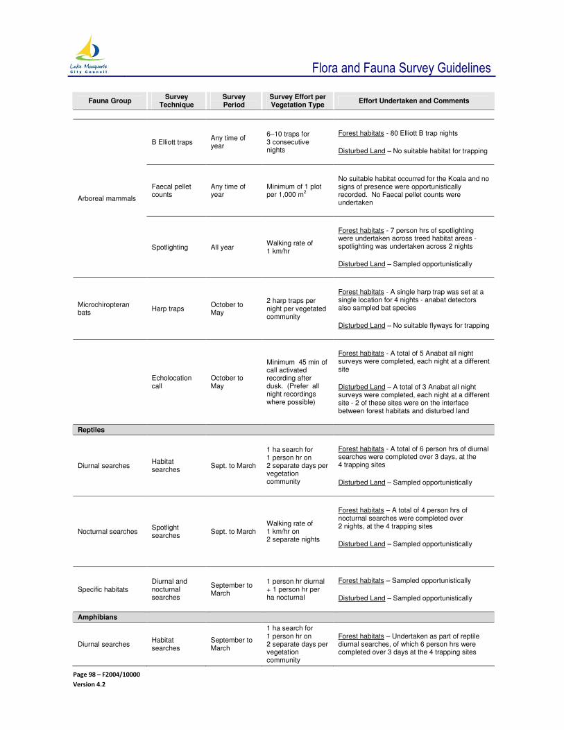
Flora and Fauna Survey Guidelines
Page 98 – F2004/10000
Version 4.2
Fauna Group Survey
Technique Survey Period
Survey Effort per Vegetation Type
Effort Undertaken and Comments
B Elliott traps Any time of year
6–10 traps for 3 consecutive nights
Forest habitats - 80 Elliott B trap nights
Disturbed Land – No suitable habitat for trapping
Faecal pellet counts
Any time of year
Minimum of 1 plot per 1,000 m
2
No suitable habitat occurred for the Koala and no signs of presence were opportunistically recorded. No Faecal pellet counts were undertaken
Arboreal mammals
Spotlighting All year Walking rate of 1 km/hr
Forest habitats - 7 person hrs of spotlighting were undertaken across treed habitat areas - spotlighting was undertaken across 2 nights
Disturbed Land – Sampled opportunistically
Microchiropteran bats
Harp traps October to May
2 harp traps per night per vegetated community
Forest habitats - A single harp trap was set at a single location for 4 nights - anabat detectors also sampled bat species
Disturbed Land – No suitable flyways for trapping
Echolocation call
October to May
Minimum 45 min of call activated recording after dusk. (Prefer all night recordings where possible)
Forest habitats - A total of 5 Anabat all night surveys were completed, each night at a different site
Disturbed Land – A total of 3 Anabat all night surveys were completed, each night at a different site - 2 of these sites were on the interface between forest habitats and disturbed land
Reptiles
Diurnal searches Habitat searches
Sept. to March
1 ha search for 1 person hr on 2 separate days per vegetation community
Forest habitats - A total of 6 person hrs of diurnal searches were completed over 3 days, at the 4 trapping sites
Disturbed Land – Sampled opportunistically
Nocturnal searches Spotlight searches
Sept. to March Walking rate of 1 km/hr on 2 separate nights
Forest habitats – A total of 4 person hrs of nocturnal searches were completed over 2 nights, at the 4 trapping sites
Disturbed Land – Sampled opportunistically
Specific habitats Diurnal and nocturnal searches
September to March
1 person hr diurnal + 1 person hr per ha nocturnal
Forest habitats – Sampled opportunistically
Disturbed Land – Sampled opportunistically
Amphibians
Diurnal searches Habitat searches
September to March
1 ha search for 1 person hr on 2 separate days per vegetation community
Forest habitats – Undertaken as part of reptile diurnal searches, of which 6 person hrs were completed over 3 days at the 4 trapping sites

Flora and Fauna Survey Guidelines
Page 99 – F2004/10000
Version 4.2
Fauna Group Survey
Technique Survey Period
Survey Effort per Vegetation Type
Effort Undertaken and Comments
Disturbed Land – Sampled opportunistically
Nocturnal searches Spotlight searches
September to March
30 minutes on 2 separate nights
Forest habitats - Undertaken as part of reptile nocturnal searches, of which 4 person hrs were completed over 2 days at the 4 trapping sites
Disturbed Land – Sampled opportunistically
Playback of recorded calls
September to March
Once on each of 2 separate nights
Forest habitats – Not undertaken. At the few small dams the entire waters margin was searched and call playback was unnecessary.
Disturbed Land – Not undertaken.
Specific habitat searches
September to March
2 hrs / 200 m of water body edge
The entire margin of each water body was searched on 2 separate nights.
Source: Modified from RPS (2011)

Flora and Fauna Survey Guidelines
Page 100 – F2004/10000
Version 4.2
8.3 APPENDIX – SPECIES HAVING CONSERVATION SIGNIFICANCE
8.3.1 CRITERIA FOR REGIONALLY SIGNIFICANT SPECIES
Fauna
Close to the limit of its geographical range
** Significant reductions in population size or area occupied
** Listed in an international treaty (with the exception of the cattle egret)
** Endemism (significant proportion of distribution - >90% centred within the region)
** Disjunct population
** Severe threatening processes acting on the population
* Intolerant of disturbance
* Susceptible to habitat fragmentation
** Rare taxa (localised within restricted geographic areas or habitats or sparsely scattered over a wide
area; restricted to rare habitats; reported less than 10 times in the last 10 years)
* Habitat and / or populations limited in extent or poorly represented in the region
* Occur in low abundance
* Require extensive area of habitat
* Insufficiently known
* Habitat poorly conserved in the region
* Species seasonally concentrated for nesting / roosting or maternity sites
Note: More than one * must apply
Flora
** Endemic taxa - with known distribution restricted to this Region
** Uncommon taxa - <50 known populations (discrete)
** Close to the limit of its geographical range
* Significant reductions in population size or area occupied
** Inadequately conserved
** Disjunct population
* Listed on ROTAP
* Geographical distribution is limited <0.5% of Region
Communities / Ecosystems
* Support a large number of flora / fauna species
* Critical habitat for a species of regionally significant flora fauna / fauna group
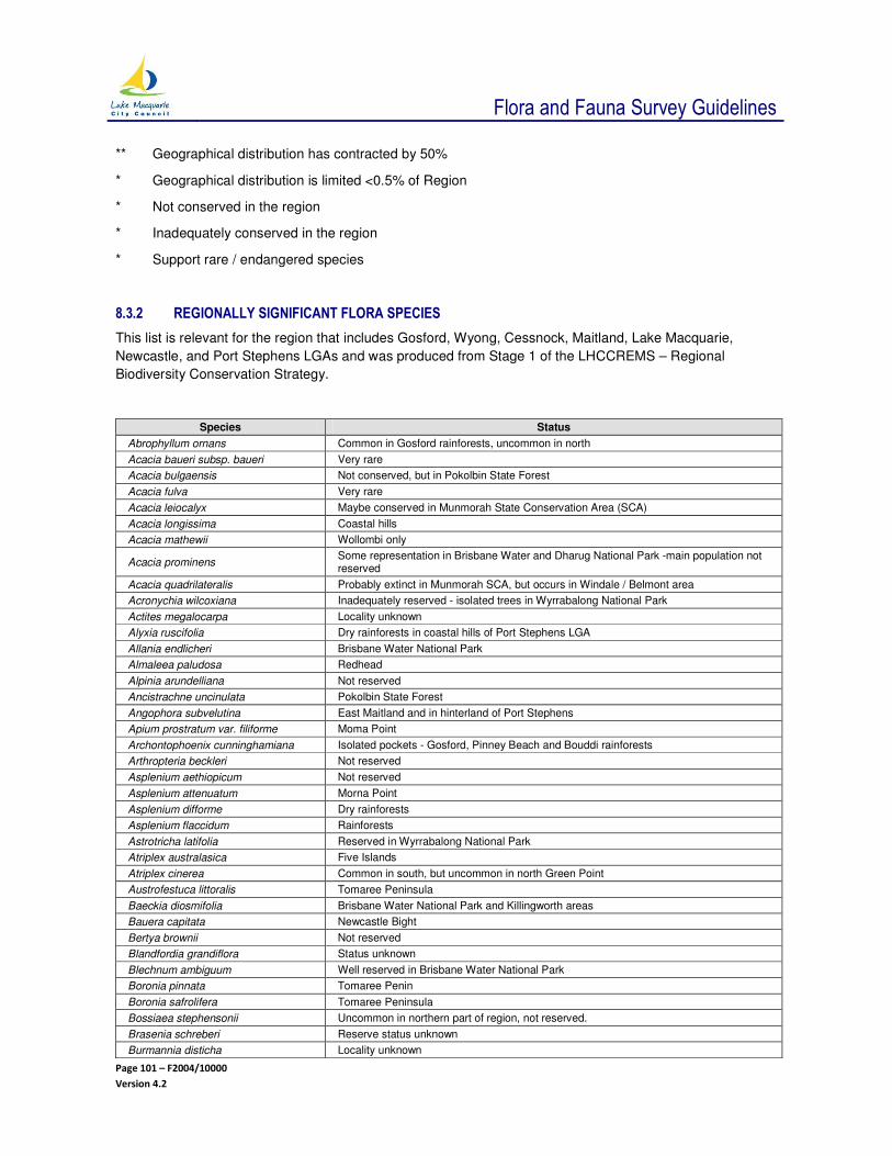
Flora and Fauna Survey Guidelines
Page 101 – F2004/10000
Version 4.2
** Geographical distribution has contracted by 50%
* Geographical distribution is limited <0.5% of Region
* Not conserved in the region
* Inadequately conserved in the region
* Support rare / endangered species
8.3.2 REGIONALLY SIGNIFICANT FLORA SPECIES
This list is relevant for the region that includes Gosford, Wyong, Cessnock, Maitland, Lake Macquarie,
Newcastle, and Port Stephens LGAs and was produced from Stage 1 of the LHCCREMS – Regional
Biodiversity Conservation Strategy.
Species Status
Abrophyllum ornans Common in Gosford rainforests, uncommon in north
Acacia baueri subsp. baueri Very rare
Acacia bulgaensis Not conserved, but in Pokolbin State Forest
Acacia fulva Very rare
Acacia leiocalyx Maybe conserved in Munmorah State Conservation Area (SCA)
Acacia longissima Coastal hills
Acacia mathewii Wollombi only
Acacia prominens Some representation in Brisbane Water and Dharug National Park -main population not reserved
Acacia quadrilateralis Probably extinct in Munmorah SCA, but occurs in Windale / Belmont area
Acronychia wilcoxiana Inadequately reserved - isolated trees in Wyrrabalong National Park
Actites megalocarpa Locality unknown
Alyxia ruscifolia Dry rainforests in coastal hills of Port Stephens LGA
Allania endlicheri Brisbane Water National Park
Almaleea paludosa Redhead
Alpinia arundelliana Not reserved
Ancistrachne uncinulata Pokolbin State Forest
Angophora subvelutina East Maitland and in hinterland of Port Stephens
Apium prostratum var. filiforme Moma Point
Archontophoenix cunninghamiana Isolated pockets - Gosford, Pinney Beach and Bouddi rainforests
Arthropteria beckleri Not reserved
Asplenium aethiopicum Not reserved
Asplenium attenuatum Morna Point
Asplenium difforme Dry rainforests
Asplenium flaccidum Rainforests
Astrotricha latifolia Reserved in Wyrrabalong National Park
Atriplex australasica Five Islands
Atriplex cinerea Common in south, but uncommon in north Green Point
Austrofestuca littoralis Tomaree Peninsula
Baeckia diosmifolia Brisbane Water National Park and Killingworth areas
Bauera capitata Newcastle Bight
Bertya brownii Not reserved
Blandfordia grandiflora Status unknown
Blechnum ambiguum Well reserved in Brisbane Water National Park
Boronia pinnata Tomaree Penin
Boronia safrolifera Tomaree Peninsula
Bossiaea stephensonii Uncommon in northern part of region, not reserved.
Brasenia schreberi Reserve status unknown
Burmannia disticha Locality unknown

Flora and Fauna Survey Guidelines
Page 102 – F2004/10000
Version 4.2
Species Status
Caldcluvia paniculosa Not reserved
Callistemon shiressii Not reserved
Callistemon pachyphylla Anna Bay
Callistemon pinifolius Rare - Pearl Beach, Patonga
Callitris macleayana Southern limit
Carpobrotus glaucescens Glen Rock Lagoon
Casuarina capitata?
Cinnamomum virens Rainforests
Cissus terculiifolia Not reserved
Codonocarpus attenuatus Rainforests
Comesperma defoliatum Redhead
Clematis microphylla var. leptophylla Dry rainforests
Clerodendrum floribundum Tomago Sandbeds
Conospermum ericifolium Tomaree Peninsula
Crinum pedunculatum Very rare - McMasters Beach and Gosford lagoons
Cryptocarya rigida Found in Bouddi Additions
Cupaniopsis foveolata Rare
Daphnandra sp. ‘A’ Not reserved - Watagan Mountains
Darwinia glaucophylla Brisbane Water National Park
Darwinia procera Brisbane Water National Park
Decaspermum paniculatum Not reserved - probably unable to be reserved
Dianella prunina Pokolbin State Forest
Dillwynia floribunda var. floribunda Common in south, but uncommon in north Anna Bay
Dillwynia tenuifolia Yengo National Park
Dodonaea megazyga Watagan Mountains
Doryanthes excelsa Gan Gan Hill and Toronto
Dracophyllum secundum Watagan Mountains
Dysoxylum fraseranum Not reserved - Jilliby Valley
Dysoxylum rufum Southern limit - Jilliby
Enydra fluctuans Glen Rock Lagoon
Elaepcarpus kirtonii Very rare
Elaeocarpus obovatus Isolated trees in Wyrrabalong National Park
Embelia australiana Not reserved - probably unable to be reserved
Endiandra discolor Small population in Bouddi National Park, but generally inadequately reserved
Eucalyptus analiculata Not reserved Coastal hinterland - Port Stephens
Eucalyptus deanei Northern limit
Eucalyptus fergusonii subsp. dorsiventralis
Not reserved.Pokolbin and Yengo State Forest
Eucalyptus fergusonii subsp. fergusonii
Not reserved - Watagan State Forest
Eucalyptus fracta Broken Back Range
Eucalyptus grandis Southern limit - Port Stephens
Eucalyptus hyostomatica Not reserved - Morisset Forestry District
Eucalyptus luehmanniana Brisbane Water National Park
Eucalyptus michaeliana Not reserved
Eucalyptus microcorys Southern limit
Eucalyptus multicaulis Brisbane Water National Park
Eucalyptus oblonga Northern limit
Eucalyptus paniculata ssp. matutina Newcastle to Port Stephens only
Eucalyptus placita Southern limit - Newcastle
Eucalyptus prominula Not reserved - Pokolbin and Olney State Forest
Eucalyptus robusta x E. tereticornis Not reserved - Nords Wharf
Eucalyptus signata Southern limit - Munmorah
Eucalyptus squamosa Localised - Wollemi and Mulbring
Euroschinus falcate Included in Wyrrabalong National Park - adequately reserved
Evolvulus alsinoides var.decumbens Pokolbin State Forest

Flora and Fauna Survey Guidelines
Page 103 – F2004/10000
Version 4.2
Species Status
Ficus fraseri Included in Wyrrabalong National Park - total population in area reserved
Ficus watkinsiana Tomaree Peninsula
Flagellaria indica Rainforests
Goodenia bellidifolia subsp. bellidifolia Killingworth and Redhead
Goodenia stelligera Newcastle Bight
Gonocarpus chinensis subsp. verrucosa
Not reserved, occurs at the Hawkesbury River
Gompholobium inconspicuum Pokolbin State Forest
Gompholobium pinnatum Popran National Park, Tomaree and Morna Point
Helicia glabriflora Rainforests
Hybanthus stellarioides Gan Gan Hill
Hybanthus veronii subsp. veronii Watagan Mountains
Hymenophyllum australe Not reserved
Keraudrenia hillii Very rare
Lepidosperma quadrangulatum Not reserved, although possible inclusion in Cockle Bay Nature Reserve
Leptospermum emarginatum Rare
Leptospermum liversidgei Southern limit - Tomaree - Anna Bay
Leptospermum squarrosum Rare - Jewells Swamp
Leucopogon amplexicaulis Conserved in Brisbane Water National Park
Leucopogon esquamatus Tomaree Peninsula - probably extinct in Brisbane Water National Park
Leucopogon margarodes Probably now extinct in Brisbane Water National Park
Leucopogon pleiospermus Probably now extinct in Brisbane Water National Park
Lindsaea dimorpha Brisbane Water National Park
Lobelia gibbosa Belmont and Croudace Bay
Lomandra micrantha subsp. tuberculata
Lomandra montana
Lomatia myricoides Rainforests - Gosford and the Watagans
Macarthuria neocambria Reserved in Munmorah SCA
Maclura cochinchinensis Not reserved
Macroglena caudata Not reserved
Maundia triglochinoides Ettymalong Creek and Wyong, not reserved
Melaleuca deanei Very rare - Brisbane Water National Park
Melaleuca decora Very rare
Micrantheum ericoides Tomago Peninsula
Mirabelia speciosa subsp. speciosa Very rare - Pinney Beach
Mollugo verticullata Tomago
Muehlenbeckia gracillima Locality unknown
Neolitsea australiensis Probably extinct in the region
Notelaea longifolia forma intermedia Green Point Headland
Olearia nernstii Small population in Wambina Road Nature Reserve
Olearia viscidula Very rare
Ottelia ovalifolia. Wetlands - uncommon
Ozothamnus argophyllus Rare
Persicaria elatior Very uncommon
Persicaria praetermissa Seaham Swamp, but more common further north
Persoonia laurina subsp. laurina Watagan and Redhead
Petrophile pedunculata Glenrock SCA and Redhead
Pisonia umbellifera Myall Lakes only
Parsonsia velutina Not reserved
Phebalium dentatum
Phebalium lamprophyllum Broken Back Range
Platycerium superbum Rainforests
Pomaderris aspera Blackbutt Reserve
Prostanthera incisa (Askania) Not reserved
Prostanthera sp. Somersby (junosis) Not reserved

Flora and Fauna Survey Guidelines
Page 104 – F2004/10000
Version 4.2
Species Status
Pultenaea myrtoides
Pultenaea rosmarinifolia Heaton State Forest, Brisbane Water National Park and Munmorah SCA
Restio pallens Tomaree Peninsula
Rhodomyrtus psidioides Inadequately reserved - small population in Wyrrabalong National Park
Rhodosphaera rhodanthema Blackbutt Reserve
Ripogonum fawcettianum Small population in Bouddi National Park - inadequately reserved
Ripogonum discolor Rainforests
Rulingia hermanniifolia Very rare - Bouddi National Park
Rupicola apiculata Tomago sandbeds
Sarcopteryx stipata Green Point headland
Sesuvium portulacastrum Moma Point, Saratoga and Chittaway Point
Sicyos australis Rainforests
Sloanea woollsii Southern limit - Port Stephens
Sprengelia incarnata Common in south - uncommon in north - Redhead
Sellaria radicans Common in south, uncommon in north - Green Point
Stylidium lineare Tomaree Peninsula
Styphelia laeta var. latifolia Conserved in Brisbane Water National Park
Symplocos stawellii Rainforests - Gosford and Green Point
Syzygium francisii Wambina Road Nature Reserve
Syzygium paniculatum Wyrrabalong NP, Fletchers Glen and Ourimbah Creek Valley - inadequately reserved
Tetrasigma nitens Not reserved
Trigloochin microtuberosum Very rare
Typhonium brownii Very rare
Typhonium eliosurum Not reserved
Velleia spathulata Catherine Hill Bay
Vittaria elongata Wambina Road Nature Reserve
Wilsonia backhousei Wamberal Lagoon Nature Reserve
Melaleuca biconvexa Not reserved
Woollsia pungens Common in south - uncommon in north - Anna Bay - Tomaree Peninsula
Xanthorrhoea fulva
Zieria latifolia Tomago Sandbeds
Source: Payne 1998 (Payne (1998a) Lower Hunter and Central Coast Regional biodiversity Strategy Stage 1, prepared by R Payne for
NSW Department of Urban Affairs and Planning - draft February 1998.
8.3.3 RARE OR THREATENED AUSTRALIAN PLANT SPECIES (ROTAP)
Species occurring in Lake Macquarie City listed as ROTAP species (Briggs and Leigh 1996) but are not
listed as threatened species in the legislation. These include:
Callistemon shiressii
Eucalyptus fergusonii subsp. fergusonii
Gonocarpus salsoloides
Typhonium elisoursum
Macrozamia pauli-guilielmi subsp flexuosa
8.3.4 VEGETATION OF GOSFORD-LAKE MACQUARIE
As part of the mapping of vegetation in the Gosford-Lake Macquarie Area, Benson (1986) compiled a list of
species with particular conservation significance. These species are described below.

Flora and Fauna Survey Guidelines
Page 105 – F2004/10000
Version 4.2
• Galeola cassythoides – a climbing orchid which feeds on dead or decaying organic matter, (saprophyte) which occurs scattered throughout the area. This was previously listed as rare (Leigh et al1981) but was not included in the Briggs and Leigh (1988 or 1996) (Winning 1990).
• Hakea bakerana – is considered to be a regionally significant species which is threatened by urban development. Benson (1986) lists this species to be uncommon.
• Acacia quadrilateralis – this species is considered rare by Benson (1986) but not by Briggs and Leigh (1988). It has been noted in the Redhead area by Baxter and McDonald (1984) (Winning 1990) and possibly in the Jewells area (Travers Morgan 1992).
• Xanthorrhoea resinosa ssp fluva, a grass tree that may occur in the Redhead district (Winning 1990).
• Alpina caerulea – the native ginger lily, which grows in rainforest and wet eucalypt forests. It is at its southern limit in Lake Macquarie (Winning 1990). Benson (1986) reports it to occur at Martinsville.
• Botrychium australe – a fern that is considered to be uncommon and is reported to occur at Martinsville (Benson 1986).
• Eucalyptus robusta – is considered a significant species flowering prolifically in winter. As one of the few flowering eucalypts in this area, it provides food for many species including a number of endangered species of birds (Regent Honeyeater and the Swift Parrot), the Koala and the Squirrel Glider. This species is considered to be inadequately conserved (Payne Pers. Comm.) and has been disproportionately subject to human disturbance (Travers Morgan 1992).
8.3.5 NEW OR SPECIAL SPECIES
The following species occur in Lake Macquarie and are considered significant for the reasons outlined below.
• Grevillea humilis – a new species of grevillea was discovered in 1999 at Northlakes (north of
Edgeworth)
• Xanthorrhoea resinifera - an unusual form of species that has not been recorded by the National
Herbarium of NSW occurs near Catherine Hill Bay Village. The specimens are much higher, up to 4
m, than ever recorded before and the age of this population would be measured in hundreds of years.
It is also the most northerly occurrence of this species (RBGS 1994).
• Bulbostylis densa - was located in the Jewells Swamp area and was considered by SWC (1996b) to
be locally important as it has a limited distribution within NSW and is close to its southern limit in
Lake Macquarie.
8.3.6 REGIONALLY SIGNIFICANT FAUNA SPECIES
This list is relevant for the region that includes Gosford, Wyong, Cessnock, Maitland, Lake Macquarie,
Newcastle, and Port Stephens LGAs and was produced from Stage 1 of the LHCCREMS – Regional
Biodiversity Conservation Strategy.

Flora and Fauna Survey Guidelines
Page 106 – F2004/10000
Version 4.2
Common Name Scientific Name
Birds
Little Bitten Ixobrychus minutus
Swamp Harrier Circus approximans
Peregrine Falcon Falco peregrinus
Painted Button Quail Turnix varius
Emerald Dove Chalcophaps indica
Brush Bronzewing Phaps elegans
Topknot Pigeon Lopholaimus antarcticus
Yellow-tailed Black Cockatoo Calyptorhynchus funereus
Gang Gang Cockatoo Callocephalon fimbriatum
Barn Owl Tyto alba
Noisy Pitta Pitta versicolor
Red-browed Treecreeper Climacteris erythrops
Brown Treecreeper Climacteris picumnus victoriae
Southern Emu-wren Stipiturus malachurus
Chestnut-rumped Heathwren Hylacola pyrrhopygia
Mangrove Gerygone Gerygone levigaster
Tawny-crowned Honeyeater Glyciphila melanops
Scarlet Robin Petroica boodang
Logrunner Orthonyx temminckii
Grey-crowned Babbler Pomatostomus temporalis
Spotted Quail-thrush Cinclosoma punctatum
Green Catbird Ailuroedus crassirostris
Regent Bowerbird Sericulus chrysocephalus
Chestnut-breasted Mannikin Lonchura castaneothorax
Bassian Thrush Zoothera lunulata
Russet-tailed Thrush Zoothera heinei
White-bellied Sea Eagle Haliaeetus leucogaster
Caspian Tern Sterna caspia
Pacific Golden Plover Pluvialis fulva
Peaceful Dove Geopelia placida
Crested Shriketit Falcunculus frontatus
Lewin’s Rail Lewinia pectoralis
Ruddy Turnstone Arenaria interpres
Sharp-tailed Sandpiper Calidris acuminata
Red Knot Calidris canutus
Curlew Sandpiper Calidris ferruginea
Red-necked Stint Calidris ruficollis
Latham’s Snipe Gallinago hardwickii
Bar-tailed Godwit Limosa lapponica
Eastern Curlew Numenius madagascariensis
Whimbrel Numenius phaeopus
Grey-tailed Tattler Tringa brevipes
Common Sandpiper Actitis hypoleucos
Greenshank Tringa nebularia
Marsh Sandpiper Tringa stagnatilis
Mammals
Feathertail Glider Acrobates pygmaeus
Eastern Pygmy Possum Cercartetus nanus
Dusky Antechinus Antechinus swainsonii
Yellow-footed Antechinus Antechinus flavipes
Water Rat Hydromys chrysogaster
Eastern Grey Kangaroo Macropus giganteus
Common Wallaroo Macropus robustus

Flora and Fauna Survey Guidelines
Page 107 – F2004/10000
Version 4.2
Common Name Scientific Name
Red-necked Wallaby Macropus rufogriseus
New Holland Mouse Pseudomys novaehollandiae
Fawn-footed Melomys Melomys cervinipes
Sugar Glider Petaurus breviceps
Common Dunnart Sminthopsis murina
Platypus Ornithorhynchus anatinus
Short-beaked Echidna Tachyglossus aculeatus
Eastern Horseshoe Bat Rhinolophus megaphyllus
Southern Forest Bat Vespadelus regulus
Eastern Forest Bat Vespadelus pumillus
Scotorepens sp.
Inland Broad-nosed Bat Scotorepens balstoni
Reptiles
Robust Velvet Gecko Oedura robusta
Stone Gecko Diplodactylus vittatus
Thick-tailed Gecko Underwoodisaurus millii
Burton’s Legless Lizard Lialis burtonis
Common Scaly-foot Pygopus lepidopodus
Basalt Snake-lizard Delma plebeia
Heath Goanna Varanus rosenbergi
Sand Goanna Varanus flavirufus
Southern Angle-headed Dragon Hypsilurus spinipes
Eastern Bearded Dragon Pogona barbata
Jacky Lizard Amphibolurus muricatus
Barred-sided Tree Skink Eulamprus tenuis
Southern Rainbow Skink Carlia tetradactyla
Cunningham’s Skink Egernia cunninghami
Land Mullet Bellatorias major
Northern She-oak Skink Cyclodomorphus michaeli
Tree Skink Egernia striolata
Southern Lerista Lerista bougainvillii
Boulenger’s Morethia Morethia boulengeri
Tree-toed Earless Skink Hemiergis decresiensis
Pink-tongued Skink Cyclodomorphus gerrardii
Rainbow Litter Skink Carlia Burnetti
Swanson’s Legless Skink Anomalopus swansoni
Bandy Bandy Vermicella annulata
Black-headed Snake Parasuta dwyeri (ssp.) robertsoni
Blue-bellied Black Snake Pseudechis guttatus
Broad-headed Snake Hoplocephalus bungaroides
Death Adder Acanthophis antarcticus
Eastern Brown Snake Pseudonaja textilis
Eastern Tiger Snake Notechis scutatus
Golden-crowned Snake Cacophis squamulosus
Krefft’s Dwarf Crowned Snake Cacophis krefftii
Pale Headed Snake Hoplocephalus bitorquatus
Red-naped Snake Furina diadema
Small-eyed Snake Rhinoplocephalus nigrescens
Stephen’s Banded Snake Hoplocephalus stephensii
Yellow-faced Whip Snake Demansia psammophis
Blind Snake Ramphotyphlops wiedii
Brown Tree Snake Boiga irregularis
Diamond Python Morelia spilota
Hunter River Tortoise Emydura (cf) signata
Amphibians

Flora and Fauna Survey Guidelines
Page 108 – F2004/10000
Version 4.2
Common Name Scientific Name
Barred River Frog Mixophyes fasciolatus
Bibron’s Toadlet Pseudophryne bibronii
Blue Mountains Tree Frog Litoria citropa
Eastern Banjo Frog Limnodynastes dumerilii grayi
Dainty Green Tree Frog Litoria gracilenta
Fletchers Frog Lechriodus fletcheri
Giant Burrowing Frog Heleioporus australiacus
Giant Barred River Frog Mixophyes iteratus
Green and Golden Bell Frog Litoria aurea
Green-thighed Frog Litoria brevipalmata
Green Tree Frog Litoria caerulea
Haswell’s Swamp Frog Paracrinia haswelli
Jervis Bay Tree Frog Litoria jervisiensis
Lesueur’s River Frog Litoria lesueurii
Littlejohn’s Tree Frog Litoria littlejohni
Spotted Marsh Frog Limnodynastes tasmaniensis
Ornate Burrowing Frog Limnodynastes ornatus
Red-crowned Toadlet Pseudophryne australis
Red-eyed Green Tree Frog Litoria chloris
Red-backed Toadlet Pseudophryne coriacea
Stuttering Frog Mixophyes balbus
Tinkling Toadlet Crinia tinnula
Tusked Frog Adelotus brevis
Verreaux’s Tree Frog Litoria verreauxii

Flora and Fauna Survey Guidelines
Page 109 – F2004/10000
Version 4.2
8.4 APPENDIX – GUIDELINES FOR VEGETATION MANAGEMENT PLANS - VERSION 1
Version 1 (9 September 2009)
Background
This document provides guidelines for the preparation of management plans for land with native vegetation
within the Lake Macquarie LGA. These are normally described as vegetation management plans (VMP) and
may provide for the protection and / or rehabilitation of native vegetation or guide activities directly affecting
native vegetation.
These guidelines apply in circumstances such as the following:
1 Preparation of a management plan is a requirement of development approval.
2 Land is to be rehabilitated and / or dedicated to Council as a requirement of a legal agreement eg associated with rezoning of land or a development proposal.
3 Land of conservation value is to be protected as an offset for development elsewhere.
4 Restoration is required under a court order or Council direction following unauthorised clearing or works.
5 Bush regeneration works are carried out by a contractor on Council owned or managed land.
6 Bushfire asset protection works or activities are required.
These guidelines outline the minimum standards that Lake Macquarie City Council will require for
documentation of vegetation management plans. Management plans must identify relevant management
issues, be site specific, and be concise and practical documents.
The guidelines apply to all situations where it is a Council requirement that a written statement or
specification is prepared to describe the objectives, actions and processes that will be used to manage
native vegetation on land. The land may be in private or public ownership, and the final plan may have a
range of descriptions including vegetation management plan, land management plan, rehabilitation plan,
rehabilitation and maintenance plan, environmental management plan, bushland management plan, wetland
management plan, or a similar name.
Note that ‘plan of management’ has a specific legislative meaning under the Local Government Act 1993 and
the Crown Lands Act 1989, and that a plan of management may include guidelines for vegetation
management or may reference these guidelines.
In some cases, the vegetation management plan may form part of a more comprehensive environmental
management plan. In all cases, the preparation of a plan must be considered in conjunction with any other
relevant plans that apply to the land or adjacent land. Such relevant plans may include a soil and water
management plan, a weed and pest management plan, bushfire management plan, or a landscaping plan.
Preparing a Management Plan
The management of land to protect its natural values requires proper consideration of the best ways in which
the existing distribution, abundance and diversity of native species and communities can be retained, and
the extent to which pre-existing natural ecosystems can be regenerated or restored.
A vegetation management plan must be prepared by a person qualified in natural vegetation management,
ecology or bush regeneration, with a sound knowledge of site management impacts and processes. Where
native vegetation must be rehabilitated or reconstructed, it is preferable to involve a qualified bush
regenerator in the preparation and implementation of the plan.

Flora and Fauna Survey Guidelines
Page 110 – F2004/10000
Version 4.2
Plans should be as brief as possible, and include only relevant material. A plan should generally include no
more than 25 pages of text.
In most cases, a management plan will be prepared by a consultant. The consultant must be properly
briefed and made aware of the Council’s requirements before they are engaged.
Properly preparing and managing contracts is essential to achieving good on-ground vegetation management outcomes. The preparation of a management plan and the undertaking of works can be combined or undertaken separately. However, where possible, they should be done in conjunction with one another. The scope of bush regeneration contracts and issues to be taken into consideration are outlined in Bush Regeneration: A Practical Guide to Contract Management (Davies and Dixon 2003).
When engaging a contractor, preparing a project brief or contract, consider the following matters:
1 Are the persons suitably qualified, and do they have appropriate experience relevant to the local area?
2 What are the requirements for project management eg meetings and consultation?
3 Are the project deliverables and time frames clearly understood?
4 Is there a requirement for neighbour or community consultation to be undertaken?
5 Have issues relating to public liability, workers compensation, and other insurance been considered?
6 Has all relevant information been provided to the contractor?
Plan format and Structure
The purpose of a management plan is to outline desired outcomes and to specify works and actions to be
carried out to achieve these outcomes. It must clearly state quantifiable objectives that are to be achieved
and should be suitable for both the landowner, approval authorities, and the persons who are required to
undertake implementation actions.
The structure and format of the plan must be suitable for the purpose. It will usually include maps, photos
and supporting text, and relevant background information. The required structure for management plans is
shown in Table 8.4.1 together with an explanation of information to be included in each section. The plan
structure may be varied where appropriate. It is essential that documentation clearly communicates
important functions to enable effective on-ground management actions.
The Lake Macquarie City Council vegetation management plan template is included in Appendix 8.4.1.
Table 8.4.1: Required management plan structure
Section Explanation
1 Introduction
Name of plan and location The plan must be clearly described and dated and must show the land to which it applies, including; a plan, street address, and property identifier (Lot and DP).
Land ownership Provide details of current and future ownership arrangements.
Administrative context
The reason for the plan should be included and the persons or organisations for which it has been prepared.
Some plans may be the result of a legal agreement or be required to meet legal requirements eg plans for Crown Land or plans of management for Council land. Where listed, threatened species or endangered ecological communities occur, there are responsibilities under relevant State and Commonwealth legislation.
Definitions Clear definitions are essential for the proper interpretation of the plan. For example, it may be important to specify the meaning of the terms “rehabilitation”, “bush regeneration”, and “bushland”. See Appendix 8.4.1.
2 Background Information
Planning and landscape context Current and proposed landuse and the landscape context of the land to which the plan applies.
Existing native vegetation and weeds Location and characteristics of existing plant communities and weeds should be identified

Flora and Fauna Survey Guidelines
Page 111 – F2004/10000
Version 4.2
Section Explanation
on the site and on immediately adjacent land.
Natural values A summary of ecological information, biodiversity values and previous studies and data should be included. Baseline ecological data may need to be compiled before a plan is prepared.
Other site values There may be important community values and issues that need to be identified such as Aboriginal cultural sites, heritage values, public access, walking tracks, utilities, view corridors, lookouts, or public health and safety issues.
Relationship with other plans, approvals or legislation
Identification of other approvals that may be required to carry out the management actions or works eg under the Water Management Act 2000 or EPBC Act, or TSC Act or Fisheries Management Act.
3 Management Issues
The plan must specify key management issues to be addressed eg threatened species, feral animals, weeds, fire management, habitat management, hydrology and earthworks, acid sulphate soils.
4 Objectives and Strategy
Management objectives Clear objectives should underpin a management plan. Objectives are quantitative statements of what can be achieved, and must be able to be monitored. The objectives should reflect the management issues.
Management strategies and priorities
Strategies are statements outlining how the objectives will be carried into effect. Strategies should be linked to the management guidelines in the plan and should reflect the priorities for the site.
Strategies and priorities should be based on proper analysis of the site values and ecological process, as reflected in the plan objectives.
5 Management Guidelines
Issue guidelines
The management issues may be addressed by identifying generic principles and / or specific guidelines and actions. Guidelines for issues should be clearly listed in order of priority and be linked to relevant maps eg vegetation condition. Examples of issue guidelines are outlined in a later section.
Area specific guidelines The plan area should be divided into management areas, units or zones, where different priorities apply or alternative approaches are required. These areas must be shown clearly on a map.
Monitoring guidelines Guidelines for monitoring should be specified including location and frequency of photo points, systematic flora and fauna monitoring requirements, and persons who need to review implementation.
6 Implementation
For each work and task (action), the plan must:
• Describe the proposed work. For example, weed control methods for each species, maintenance tasks etc. The location of where the task is to be undertaken should be shown on a map.
• Identify those responsible for completing the required works, and the required minimum qualifications for persons undertaking the work, task or action.
• Include a schedule of works to identify project milestones and completion dates eg details of planting program, and best times of the year to plant.
• Outline the budget for the works.
• Outline risks and contingency measures eg unexpected bush fire.
• Processes for regular monitoring and review including performance evaluation. This should include performance standards, provision for replacing plant losses, addressing deficiencies, weather events etc. Monitoring parameters could include weed density, response of natives to weed removal, species richness, survival rate of plantings etc.
• The minimum time period for which a plan is to be implemented is three years. Many sites will require active vegetation management to be undertaken over a 5–10 years period, or in perpetuity.
Monitoring of the site is essential for successful vegetation management and habitat restoration. Monitoring should include both surveys and photos. A rehabilitation or restoration site should be monitored for approximately 5-10 years. If restoration is not progressing adequately, appropriate action must be taken.
7 References
The plan must identify sources of information and relevant references justifying the proposed actions.
8 Maps
Vegetation map Should show vegetation communities, and may identify key management issues eg areas of weeds or disturbance.
Management units or zones It is necessary to define management areas where different actions and requirements may apply. Normally, there will be a distinction between areas requiring vegetation

Flora and Fauna Survey Guidelines
Page 112 – F2004/10000
Version 4.2
Section Explanation
rehabilitation and those requiring maintenance. This map should be at an appropriate scale which will normally be between 1:500 and 1:2,000.
Monitoring locations Location of monitoring sites eg vegetation quadrats, must be identified.
Other maps
Depending on the management issues and site, other maps may be required. These may include maps showing:
• Vegetation condition
• Key features eg land ownership, vegetation requiring protection, work or stockpile areas, contours and slopes, waterways
• Weed locations and distribution, and disturbance eg National Trust disturbance codes
• Bushfire map including hazard reduction and asset protection requirements
• Soil and water management
• Erosion and sediment control
• Site layout and / or location plan
• Location of buildings, services and infrastructure (water pipes, drains, roads, fences etc)
• Areas of contamination or mine subsidence risk
9 Appendices
Management plans should include or append relevant supporting information. This should include:
• Description of who prepared the plan, their qualifications, and details of any peer review
• Detailed outline of biodiversity values, including a table listing native and introduced plant species
• Description of key biodiversity values to enable these to be identified in the field
The following sections provide further details on what is expected in relation to key sections of a management plan.
Management Issues
Examples of key management issues are outlined in Table 8.4.2.
Table 8.4.2: Example of specific management issues
Issue Examples of Management Issues Examples of Relevant Works or
Actions Comments and References
Bushfires
Fire frequency for specific vegetation types, maintenance of trails, species selection for rehabilitation, impacts of fire on threatened species
Thinning of native ground vegetation, weed management following fires, clearing along power lines
Rural Fire Service, 2006, Planning for Bush Fire Protection
Weeds Presence of noxious and environmental weeds, weed control techniques
Methods of weed control eg manual, chemical, mechanical, biological and fire, monitoring of weed distribution
Hunter Regional Weeds Strategy
Tracks and trails
Excessive number of tracks, trail erosion, impact on weeds and feral animals
Consider closure of unnecessary tracks, methods of rehabilitating closed tracks, maintaining fire trails
Sourcing plants
Availability of local provenance seeds Seed collection and propagation guidelines, identification of acceptable source plants
Feral animals Impact of feral animals on native vegetation eg rabbits or goats
Feral animal control requirements, fencing
Objectives and Strategy
Goals of ecological restoration (which can include both assisted natural regeneration and reconstruction through revegetation) is ultimately the self perpetuation of a plant community, in this case one which approximates the available understanding of the pre 1788 structure. (NSW Department of Infrastructure, Planning and Natural Resources 2003).

Flora and Fauna Survey Guidelines
Page 113 – F2004/10000
Version 4.2
In determining objectives, the following should be taken into account:
• The intent is to carry out restoration to the highest extent practicable, recognising that there are significant constraints to be faced in practice
• The principle of minimum intervention should be adopted ie the intervention should only be that necessary to deal with the degree of damage on the site, and to achieve restoration goals
• As a general rule, an accent on efforts involving minimal intervention over a significant period is warranted before revegetation is considered
Key approaches which should underpin a management plan are outlined below in order of priority:
1 Retain and protect remnant vegetation on site eg control access, prevent rubbish dumping, prevent weed invasion.
2 Regenerate native vegetation. Where there is site resilience and native vegetation remains but is degraded, regeneration should be the main goal eg remove and suppress weeds, remove rubbish, restabilise degraded areas.
3 Revegetate. Where natural processes or assisted regeneration techniques are not appropriate, or where there is no potential, then revegetation is an option eg actively resurface and replant areas.
These actions start from minimal intervention building up to high levels of intervention. Minimal interventions are more efficient and cost effective.
The plan must include clearly stated objectives which are quantitative statements of what the plan is trying to achieve. Sample management plan objectives are included in Appendix 8.4.1.
Management Guidelines
The plan should include guidelines for the key management issues that need to be considered in achieving the plan objectives. In addition, there will be guidelines that apply to specific management areas within a site which need to be identified and where specific approaches and actions need to be identified.
Guidelines should direct tasks that can be implemented. They should be as specific and quantitative as possible.
Guidelines for identified management issues must be included, and could include:
• Measures for controlling access and encroachments
• Vegetation species composition, planting layout and densities eg a table showing number and species type of tubestock
• Seed / plant sources
• Details of planting priorities, rehabilitation methods and staging eg frequency of water, pesticide and fertiliser applications
• Maintenance requirements eg “maintenance should extend for a minimum of two years after completion of works or until such time as a minimum 80% survival rate for all plantings and a maximum 5% weed cover for the treated riparian corridor is achieved” – from DWE 2008
• Habitat augmentation eg type and location of nest boxes to be installed
• Threatened species and endangered ecological communities
• Flora and fauna monitoring program
• Fire management
• Neighbour relations and community education
• Weed removal and management eg whether mechanical or hand methods will be used, weed disposal location, managing spread of pathogens such as Phytophthora etc

Flora and Fauna Survey Guidelines
Page 114 – F2004/10000
Version 4.2
• Feral animal management
• Donor topsoil areas
• Use of machinery eg where machinery is not to be used
Guidelines that could be necessary to specific areas or landscape types occurring in Lake Macquarie City are outlined in Table 8.4.3.
Table 8.4.3: Guidelines for specific areas or landscape types
Landscape Type Examples of Management
Issues Examples of Relevant Works or
Actions Comments and References
Wetlands Retaining water levels, and a natural hydrological regime, managing buffers
Restoring or enhancing plant communities, water levels, surface water flow, groundwater flow, soil composition, acid sulphate soil remediation, improving water quality
DUAP 1999
Riparian corridors Reducing erosion of banks and channels, protecting water quality, maintaining riparian habitat and corridors
Removing stock or other disturbance from river banks, fencing of riparian vegetation
DWE 2008
Lake foreshores Foreshore erosion or inappropriate track location, impacts of vegetation on views
Rerouting of tracks, rehabilitation of areas, limiting access, signage
Remnant bushland Protection of listed threatened species, reducing stormwater impact adjacent properties, weed invasion as a result of site disturbance
Field survey of listed species, stormwater management devices, weed control, neighbour consultation
Coastal and dunes Erosion, walking tracks, vehicle access, protection of Aboriginal middens
Fencing of eroded areas, weed removal
Disturbed areas Rehabilitation and restriction of access
Restricting access, fencing, establishment of planting program, seed collection and propagation for planting
Buffers Maintaining managed vegetation buffers around high value vegetation
Maintaining adequate bushfire asset protection zones on adjacent land, preventing weed invasion
Listed endangered ecological communities or other high value areas
Protection of listed vegetation communities
Weed monitoring and removal, bush fire management
Roadsides Mowing frequency, spread of weed seeds, disturbance by machinery during road maintenance
Staff training, washing of machinery
Implementation
Management tasks should be identified to address each management issue and associated objective. Information provided for each task should be prescriptive enough for a bush regenerator to implement. Tasks should be identified in order of priority and timing. Plans must include a schedule of works, an example of which is included in Appendix 8.4.2.
The ability to successfully implement the management plan is essential. It must be clearly written, be realistic, and provide a suitable foundation for land owners and contractors. The plan should allow adequate time for vegetation management to achieve the plan objectives with a minimum period of three years. It

Flora and Fauna Survey Guidelines
Page 115 – F2004/10000
Version 4.2
should also allow for the occurrence of unexpected events such as bushfires or seasonal conditions eg frosts or drought.
Where the management plan is a requirement of a development consent or a legal agreement such as a planning agreement, it is a legally binding document and should be written to reflect this.
An essential element of implementation is a program of monitoring. This should include quantitative measurement and annual reporting eg vegetation quadrats, weed distributions, regular photos etc. The format for bush regeneration monitoring information to be provided for Lake Macquarie City Council projects is included at Appendix 8.4.3.
Plan Administration
Where a plan is a requirement of development approval, or a legal agreement, it is legally enforceable. During the preparation and implementation of a plan, it will usually be necessary to consult with a number of specialist Council staff regarding particular issues as outlined in the checklist in Table 8.4.4. It may also be necessary to consult with neighbouring land owners or relevant government agencies, and to take into account other plans eg property vegetation plans prepared under the NV Act 2003.
Table 8.4.4: Council consultation checklist
Subject Who should be consulted?
Plan content and approval Person responsible for commissioning the plan
Weeds Noxious Weeds Officer
Bushfire hazard reduction
Council land Community Planning Department
Biodiversity and threatened species Environmental Planner
Waterways and riparian vegetation
On-going consultation with specialist Council officers may be required during the implementation of the plan.
References
Davies P & Dixon P 2003: Bush Regeneration - A Practical Guide to Contract Management, Environment Protection Authority (NSW).
Department of Urban Affairs and Planning, 1991: Guidelines for preparing management plans for urban bushland.
Department of Urban Affairs and Planning, 1999: Guidelines – Wetland Restoration Plans.
Department of Infrastructure, Planning and Natural Resources, 2004: Guidelines for the Preparation of Environmental Management Plans
Department of Lands: Brief for preparing plans of management: http://www.lands.nsw.gov.au/crown_land/trusts/trust_handbook/appendicies (accessed 17 October 2008)
Fallding M, Kelly A H H, Bateson P & Donovan I, 2001: Biodiversity Planning Guide for NSW Local Government, NSW National Parks and Wildlife Service (Section 10.5): http://www.environment.gov.au/biodiversity/toolbox/templates/pubs/dpg-man-plan-example.pdf
Hornsby Shire Council, 2008: Guidelines for the preparation of vegetation management and restoration plans, 2008
NSW Department of Infrastructure, Planning and Natural Resources, 2003: Bringing Back the Bush in Western Sydney: Best Practice Guidelines for Bush Regeneration on the Cumberland Plain
NSW Department of Water and Energy, 2008: Guidelines for Controlled Activities, Water Management Act 2000 – Vegetation Management Plans

Flora and Fauna Survey Guidelines
Page 116 – F2004/10000
Version 4.2
Relevant Links
Australian Association of Bush Regenerators http://www.aabr.org.au/
Ecological Consultants Association of NSW http://www.ecansw.org.au/
Appendix - 8.4.1: Lake Macquarie City Council Vegetation Management Plan Template
The vegetation management plan template is not complete at this stage. The format will follow the required structure of a management plan as outlined in Table 8.4.1. It will also link with the Lake Macquarie bush regeneration monitoring framework included in Appendix 8.4.3.
Sample Management Plan Definitions
• Bush regeneration is defined by the Australian Association of Bush Regenerators (AABR) as the practice of restoring bushland by focussing on reinstating and reinforcing the systems’ ongoing natural regeneration processes.
• Ecological restoration aims to restore pre-existing indigenous ecosystems and ecological processes, maintaining and developing the capacity of a natural system to self-perpetuate. (Perkins 1999, cited in NSW Department of Infrastructure, Planning and Natural Resources 2003.
• Resilience refers to the ability of an ecosystem to regenerate naturally and to withstand, or recover from, disturbances such as weed invasion, clearing, or fire.
Sample Management Plan Objectives
The management plan objectives must take into account site conditions. Some examples of the types of objectives that could be included in a management plan are outlined below:
Project Management
• To formulate and implement vegetation management actions
• To clearly identify objectives, methods and reporting lines
• To inform all relevant participants of their responsibilities
• To engage and supervise bush regenerators to implement the plan
Vegetation Protection
• To protect vegetation during construction and operational phases
Rehabilitation and Maintenance
• To restore and enhance areas in post construction phase
• To maximise survival opportunities for areas of retained vegetation in newly rehabilitated areas
• To reduce weeds to less than 10% cover within Year 1 and to less than 5% by Year 3
• To achieve 90% survival rate of all tubestock planted
• To achieve a species diversity target that is 75% compatible with each naturally existing vegetation strata
• “To provide for a stable watercourse and riparian corridor which emulates the native vegetation communities in the area”, from NSW Department of Water and Energy 2008

Flora and Fauna Survey Guidelines
Page 117 – F2004/10000
Version 4.2
• “To achieve weed free resilient self-maintaining native ecosystem on the environmental corridors”, from LMCC 2008 – VPA for North Cooranbong
Monitoring and Compliance –
• To ensure compliance with the works schedule, including reporting requirements
Appendix - 8.4.2: Example of a Works Schedule
The following is an example of a works schedule that should be included in the implementation section of a management plan.
Management
area Action Timing of actions (years and/or months) Responsibility
1 2 3 4 5 6 7 8 9 10 11 12
Area 1
Construct
exclusion fencing
Owner
Select & order
seed supply
Bush regenerator
Undertake flora &
fauna survey
Ecological consultant
Area 2
Primary weeding of x species
Secondary
weeding
Follow up
weeding
Monitor & review
Contractor with bush regeneration
experience
Area 3 Remove weeds
Scarify soil
Tubestock
planting
Maintenance
Replacement
plantings
Monitor, review &
report
Contractor with bush regeneration
experience
Area 4 Plant native trees
at completion of
building works
Landscaping contractor

Flora and Fauna Survey Guidelines
Page 118 – F2004/10000
Version 4.2
Appendix - 8.4.3 Lake Macquarie City Council Bush Regeneration Monitoring Framework
Lake Macquarie City Council has developed a standard digital framework for project management and
reporting of bush regeneration works. This is a spatially based framework in MapInfo and Excel for recording
the progress of bush regeneration projects over time, and for organising images and quadrat data.
(Include further summary information of key elements with printouts of data presentation.)

Flora and Fauna Survey Guidelines
Page 119 – F2004/10000
Version 4.2
8.5 APPENDIX - SITE MANAGEMENT AND REHABILITATION PLANS AND AMELIORATIVE MEASURES
Rehabilitation Plan
Native vegetation and / or fauna habitat rehabilitation and management plans may be required as part of a development proposal in order to rehabilitate and enhance native vegetation and fauna habitat that are required to be conserved in order to mitigate and ameliorate the impacts of a development.
Construction Management Plan
This type of plan may be required to demonstrate how activities and works will be managed during construction in order to prevent impacts on native vegetation or fauna habitat within the development site.
Other plans such as Erosion and Sediment Control Plans, Stormwater Management Plans etc are important in minimising adverse impacts on native vegetation and fauna habitat. It is important that they be formulated to maintain biodiversity values on site or on adjoining land.
Buffers
As a guide, minimum vegetation buffer width requirements will vary as follows:
• 20 m to significant vegetation, habitat or species up-slope of urban development
• 50 m for significant vegetation down-slope of development eg where significant vegetation / threatened species habitat / floodplain endangered ecological communities, SEPP No 14 Wetlands occur down-slope of development
• 150 m to any known threatened species nest or roost trees.
Note 1: Where the boundaries of significant vegetation communities (including EECs) are not well defined, a larger buffer will be required to accommodate the transitional vegetation community.
Note 2: Where there are thresholds for counting plants to be retained, any threatened plant species within 20 m of urban development is counted as being lost, as it is highly likely to be adversely affected indirectly by urban development over the medium to long term.
Fauna Crossings
Provision of fauna crossings, both underpasses and overpasses, are desirable where linear disturbances fragment native vegetation.
Artificial Illumination
Restrictions on artificial illumination may be required to minimise impacts of developments on microbats.

Flora and Fauna Survey Guidelines
Page 120 – F2004/10000
Version 4.2
8.6 APPENDIX – SURVEY TIMES FOR THREATENED SPECIES RECORDED IN CITY OF LAKE MACQUARIE TERRESTRIAL FAUNA
8.6.1 TERRESTRIAL FAUNA
Status Species
TSC EPBC J F M A M J J A S O N D Notes
INSECTS
Giant Dragonfly Petalura gigantea E
AMPHIBIANS These times are recommended for detecting active / calling frogs. Tadpoles may be present at other times of the year.
Giant Barred Frog Mixophyes iterates E E
Giant Burrowing Frog Heleioporus australiacus V V
Green & Golden Bell Frog Litoria aurea E V
Green-thighed Frog Litoria brevipalmata V
Littlejohn's Tree Frog/Heath Frog Litoria littlejohni V V
Red-crowned Toadlet Pseudophryne australis V
Stuttering Frog Mixophyes balbus E V
Wallum (Tinkling) Froglet Crinia tinnula V
Wallum Froglet and Red-crowned Toadlet may call any time of year after rain. Survey when breeding sites are known to hold water and between May and September. If surveys cannot be undertaken over this time, then surveys should only occur after at least 20 mm of rain has fallen and the breeding site is known to be 30% flooded.
REPTILES
Broad-headed Snake Hoplocephalus bungaroides E V Under rocks in winter; active in summer (spotlighting)
Heath Monitor or Rosenberg’s Goanna
Varanus rosenbergi V Diurnal search
Pale-headed Snake Hoplocephalus bitorquatus V Spotlighting
Stephen's Banded Snake Hoplocephalus stephensii V Spotlighting
BIRDS
Optimal time for survey Species may be detected Avoid survey at this time due to
breeding
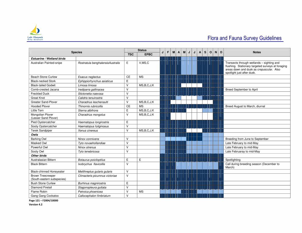
Flora and Fauna Survey Guidelines
Page 121 – F2004/10000
Version 4.2
Status Species
TSC EPBC J F M A M J J A S O N D Notes
Estuarine / Wetland birds
Australian Painted-snipe Rostratula benghalensisAustralis E V,MS,C Transects through wetlands – sighting and flushing. Stationary targeted surveys at foraging areas dawn and dusk as crepuscular. Also spotlight just after dusk.
Beach Stone Curlew Esacus neglectus CE MS
Black-necked Stork Ephippiorhynchus asiaticus E
Black-tailed Godwit Limosa limosa V MS,B,C,J,K
Comb-crested Jacana Irediparra gallinacea V Breed September to April
Freckled Duck Stictonetta naevosa V
Great Knot Calidris tenuirostris V
Greater Sand-Plover Charadrius leschenaulti V MS,B,C,J,K
Hooded Plover Thinornis rubricollis CE MS Breed August to March, diurnal
Little Tern Sterna albifrons E MS,B,C,J,K
Mongolian Plover (Lesser Sand Plover)
Charadrius mongolus V MS,B,C,J,K
Pied Oystercatcher Haematopus longirostris E
Sooty Oystercatcher Haematopus fuliginosus V
Terek Sandpiper Xenus cinereus V MS,B,C,J,K
Owls
Barking Owl Ninox connivens V Breeding from June to September
Masked Owl Tyto novaehollandiae V Late February to mid-May
Powerful Owl Ninox strenua V Late February to mid-May
Sooty Owl Tyto tenebricosa V Late Februaray to mid-May
Other birds
Australasian Bittern Botaurus poiciloptilus E E Spotlighting
Black Bittern Ixobrychus flavicollis V Call during breeding season (December to March)
Black-chinned Honeyeater Melithreptus gularis gularis V
Brown Treecreeper (South-eastern subspecies)
Climacteris picumnus victoriae V
Bush Stone Curlew Burhinus magnirostris E
Diamond Firetail Stagonopleura guttata V
Flame Robin Petroica phoenicea V MS
Gang Gang Cockatoo Callocephalon fimbriatum V
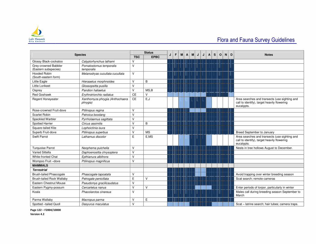
Flora and Fauna Survey Guidelines
Page 122 – F2004/10000
Version 4.2
Status Species
TSC EPBC J F M A M J J A S O N D Notes
Glossy Black-cockatoo Calyptorhynchus lathami V
Grey-crowned Babbler (Eastern subspecies)
Pomatostomus temporalis temporalis
V
Hooded Robin (South-eastern form)
Melanodryas cucullata cucullata V
Little Eagle Hieraaetus morphnoides V B
Little Lorikeet Glossopsitta pusilla V
Osprey Pandion haliaetus V MS,B
Red Goshawk Erythrotriorchis radiatus CE V
Regent Honeyeater Xanthomyza phrygia (Anthochaera phrygia)
CE E,J Area searches and transects (use sighting and call to identify), target heavily flowering eucalypts.
Rose-crowned Fruit-dove Ptilinopus regina V
Scarlet Robin Petroica boodang V
Speckled Warbler Pyrrholaemus sagittata V
Spotted Harrier Circus assimilis V B
Square-tailed Kite Lophoictinia isura V
Superb Fruit-dove Ptilinopus superbus V MS Breed September to January
Swift Parrot Lathamus discolor E E,MS Area searches and transects (use sighting and call to identify), target heavily flowering eucalypts.
Turquoise Parrot Neophema pulchella V Nests in tree hollows August to December.
Varied Sittella Daphoenositta chrysoptera V
White-fronted Chat Epthianura albifrons V
Wompoo Fruit –dove Ptilinopus magnificus V
MAMMALS
Terrestrial
Brush-tailed Phascogale Phascogale tapoatafa V Avoid trapping over winter breeding season
Brush-tailed Rock Wallaby Petrogale penicillata E V Scat search; remote cameras
Eastern Chestnut Mouse Pseudomys gracilicaudatus V
Eastern Pygmy-possum Cercartetus nanus V V Enter periods of torpor, particularly in winter
Koala Phacolarctos cinereus V Males call during breeding season September to March
Parma Wallaby Macropus parma V E
Spotted –tailed Quoll Dasyurus maculatus V Scat – latrine search; hair tubes; camera traps.

Flora and Fauna Survey Guidelines
Page 123 – F2004/10000
Version 4.2
Status Species
TSC EPBC J F M A M J J A S O N D Notes
Cage traps only if require more information - not between early September and mid-November when females may have large pouch young or den young. Optimal survey time May to August when breeding.
Squirrel Glider Petaurus norfolcensis V Avoid trapping over winter. Prefer August to September or February to March
Yellow-bellied Glider Petaurus australis V
Bats Avoid trapping during lactating late October to January (to late March for Myotis)
Eastern Bent-wing Bat Miniopterus schreibersii oceanensis
V No maternity roosts known in LGA, pregnant bats - leave the area December to late February
East Coast Freetail Bat Mormopterus norfolkensis V Roost in tree hollows and roofs of buildings
Eastern Cave Bat Vespadelus troughtoni V Predominantly cave roosting
Eastern False Pipistrelle Falsistrellus tasmaniensis V Predominantly roost old growth tree hollows
Golden-tipped Bat Kerivoula papuensis V Roost in hanging bird nests along rainforest creeks
Greater Broad-nosed Bat Scoteanax rueppellii V Predominantly roost old growth tree hollows
Grey-headed Flying-fox Pteropus poliocephalus V Most births occur October to December, avoid disturbance of maternity camps
Large-eared Pied Bat Chalinolobus dwyeri V Predominantly cave roosting
Large-footed Myotis (Fishing Bat, Southern Myotis)
Myotis macropus
V Two birthing periods – late October and February. Avoid disturbing roost sites October to March inclusive
Little Bent-wing Bat Miniopterus australis V No maternity roosts known in LGA, pregnant bats - leave the area December to late February
Yellow-bellied Sheath-tailed Bat Saccolaimus flaviventris V Often roost in the hollows of large dead stags

Flora and Fauna Survey Guidelines
Page 124 – F2004/10000
Version 4.2
8.6.2 TERRESTRIAL FLORA - FLOWERING TIMES FOR THREATENED FLORA SPECIES AND AN INDICATION OF WHICH SPECIES REQUIRE TARGETED SURVEYS DURING THEIR FLOWERING PERIOD.
Flowering times of many species vary significantly from year to year depending on weather conditions and some species (particularly orchids) may not flower at all in unfavourable seasons. The recommended flowering times should be used as a guide only. If it is crucial to determine presence/absence of a particular cryptic flora species at a site, local flowering at a known nearby reference population should be confirmed before conducting surveys regardless of the stated recommended range of suitable survey times.
Flowering times
Species Status J F M A M J J A S O N D
Targeted Surveys during
flowering season
Y – essential
D - desirable
N – not required
Notes
Scientific Name Common Name(s) TSC EPBC
Acacia bynoeana Bynoe’s Wattle E V Y
Angophora inopina Charmhaven Apple, Scrub Apple
V V N
Caladenia tessellata Thick lip Spider Orchid, Tessellated Spider Orchid, Daddy Long Legs
E V Y
Callistemon linearifolius Netted Bottlebrush V - N
Chamaesyce psammogeton Sand Spurge, Coastal Spurge E - N
Cryptostylis hunteriana Leafless Tongue Orchid V V Y Mainly flowers mid-summer
Cynanchum elegans White Flowered Wax Plant E E D Peak flowering in November
Dendrobium melaleucaphilum Spider Orchid E - Y
Diuris praecox Newcastle Doubletail, Rough Doubletail
V V Y More likely to flower early (July) in Lake Macquarie
Eucalyptus camfieldii Camfield’s Stringybark, Heart-leaved Stringybark
V V N Flowering irregular and can occur throughout the year, although mainly late spring to early summer.
Eucalyptus parramattensis Parramatta Red Gum E2 - N
Main or peak flowering Sporadic or minor flowering

Flora and Fauna Survey Guidelines
Page 125 – F2004/10000
Version 4.2
Flowering times
Species Status J F M A M J J A S O N D
Targeted Surveys during
flowering season
Y – essential
D - desirable
N – not required
Notes
Scientific Name Common Name(s) TSC EPBC
subsp. parramattensis in Wyong and Lake Macquarie LGAs
Eucalyptus parramattensis subsp. decans
Drooping Red Gum, Earp’s Gum, Earp’s Dirty Gum
V V N
Genoplesium baueri Bauer’s Midge Orchid V - Y
Grevillea parviflora subsp. parviflora
Small-flower Grevillea V V D Sporadic flowering in January to February
Maundia triglochinoides Maundia V - N
Melaleuca biconvexa Biconvex Paperbark V V N Flowers over just 3 to 4 weeks
Microtis angusii Angus’s Onion Orchid E E Y Sporadic flowering July to August and November
Prostanthera densa Villous Mintbush V V D Regenerates from rootstock after fire and flowers within the first year or two. Flowers sparingly throughout the year with a peak in spring.
Pultenaea maritima Coastal Headland Pea V - D
Rhizanthella slateri Eastern Underground Orchid V E Y Difficult or impossible to detect even, when flowering.
Rutidosis heterogama Heath Wrinklewort V V D Can flower sporadically throughout the year. Not essential to be flowering when surveys are conducted (for experienced surveyors), but it is easier to detect.
Syzygium paniculatum Magenta Lilly Pilly, Brush Cherry
E V N
Tetratheca juncea Black-eyed Susan V V Y Can be detected August and November to January. Full extent of population can only be detected during peak flowering mid-September

Flora and Fauna Survey Guidelines
Page 126 – F2004/10000
Version 4.2
Flowering times
Species Status J F M A M J J A S O N D
Targeted Surveys during
flowering season
Y – essential
D - desirable
N – not required
Notes
Scientific Name Common Name(s) TSC EPBC
to mid-October.
Tetratheca glandulosa Glandular Pink-bell V V Y
Thesium australe Austral Toadflax V V N
Zannichellia palustris Horned Pondweed E - N NSW populations behave as annuals, dying back completely every summer.
ROTAP Only
Callistemon shiressii (3RC-) White Bottlebrush N
Eucalyptus fergusonii subsp. fergusonii (3KC-)
Ferguson’s Ironbark N
Gonocarpus salsoloides (3RCa)
N
Typhonium eliosurum (3RC-) D
Macrozamia flexuosa (2K) N Not a flowering plant

Flora and Fauna Survey Guidelines
Page 127 – F2004/10000
Version 4.2
8.6.3 AQUATIC FLORA AND FAUNA
Species Name Common Name Fisheries
Management Act 1994
EPBC J F M A M J J A S O N D Notes
FISH
Carcharodon carcharias
Great White Shark V V,B The DPI Shark mesh program once ran all year, but now runs from 1 September to 30 April; however 57% of great white sharks caught during that time are caught in September and October.
Epinephelus daemelii
Black (Rock) Cod V
Pristis zijsron Green Swordfish Ex V
Carcharias Taurus
Grey Nurse Shark CE CE The DPI Shark mesh program once ran all year, but now runs from 1 September to 30 April, however 1/3 of grey nurse sharks caught during that time are caught in September while another 1/3 are caught in December.
Thunnus maccoyii
Southern Bluefin Tuna (oceanic continental shelf waters offshore of LGA)
E DPI – not seen within 3 nautical miles of coast for at least 5 yrs
INSECT
Archaeophya adamsi
Adams Emerald Dragonfly
E For Larval Stage.
REPTILES
Caretta caretta Loggerhead Turtle E E,MS,B
Chelonia mydas Green Turtle V V,MS,B SPRAT
Suitable survey period

Flora and Fauna Survey Guideline
Page 128 – F2004/10000
Version 4.2
8.7 APPENDIX - SPECIFIC SURVEYS AND TARGETED SURVEY TECHNIQUES FOR SELECTED THREATENED SPECIES
8.7.1 GUIDELINES FOR TETRATHECA JUNCEA
Survey
The location and number of plant clumps on the site is to be documented and accurately mapped as this is used to estimate the size of the population on site and assess development options. Plant clumps are defined by using the Technical Note prepared by Payne, Stevenson and Wellington (2002). However, this counting method has been shown to under predict the real number of individual plants or non-genetically related gamets for a group of plants at Awaba Bay (Jones 2011). Further research is being conducted in order to determine a more accurate counting technique. Until this research is available, the Payne, Stevenson and Wellington (2002) method will continue to be used.
All plant clumps within 500 m of the development site also require assessment and mapping. This is required to assess:
• the spatial arrangement of the plant clumps,
• likelihood of pollinator movement, and
• whether the loss of certain plant clumps would jeopardise long-term viability of plant clumps over a wider area.
The accepted method of assessment for Tetratheca juncea is to conduct one survey during the peak flowering period that has now been confirmed to be mid September to mid-October (C Driscoll pers. comm. 2012).
Any survey conducted outside this period will be unable to locate and map all the plant clumps occurring on a site. Habitat suitability can be mapped and assessed, however, this is considered inadequate for the purposes of determining the disturbance footprint for a development unless all the habitat is avoided.
Survey procedure should be conducted in accordance with the Australian Government referral guidelines for the vulnerable Black-eyed Susan, Tetratethca juncea (http://www.environment.gov.au/epbc/publications/pubs/black-eyed-susan-referral-guidelines.doc, DSEWPaC 2011a), and the SPRAT profile for Black-eyed Susan (www.environment.gov.au/cgi-bin/sprat/public/sprat.pl) without the determination of peak flowering period.
Tetratheca juncea Assessment
The Lake MacquarieTetratheca juncea Conservation Management Plan indicates that to adequately conserve a population on a site, approximately 75% of plant clumps must be conserved, with a native vegetation corridor linking the plant clumps to be conserved to other native vegetation. Plants within a 20 m buffer are not counted as being conserved.
Should substantially more than 25% of plant clumps be lost, this is considered to have a significant impact and a SIS likely to be required.
Other matters that need to be considered are:
• The spatial relationship and connectivity of plant clumps within 500 m of the development site
• Number of individuals affected
• The patch size of the native vegetation that the plant clumps occur within
• Whether the plant clumps occur at the edge of suitable habitat ie near a barrier that is unlikely to be able to be regularly crossed by native bees

Flora and Fauna Survey Guideline
Page 129 – F2004/10000
Version 4.2
Research on T. juncea is on-going. It is likely that the T. juncea Conservation Management Plan (adopted by Council on 12 June 2001) will be updated. Council will use a combination of the Conservation Management Plan, the latest research and the approach adopted by the Australian Government (DSEWPaC 2011a) in undertaking assessments and making decisions about this species until the Conservation Management Plan is reviewed.

Flora and Fauna Survey Guideline
Page 130 – F2004/10000
Version 4.2
8.7.2 SURVEY RECOMMENDATIONS FOR GREVILLEA PARVIFLORA SUBSP PARVIFLORA
To date there is no standard methodology for surveying Grevillea parviflora subsp parviflora. The following recommendations have been made by C Driscoll and S Lewer (Pers. Comm. 2009) until formal recommendations are published.
Grevillea parviflora is known to send out a number of plant stems from a single roost stock. The counting methodology as applied to T. juncea may be used, however, it is recommended that a stem distance of at least 2 m be applied to calculate plant clumps.
The point and / or extremity of each G. parviflora bush should be accurately plotted (1 m accuracy) over the plants distribution ie plant clumps less than one m
2 should be represented by a point; anything greater
should be represented by a polygon.
8.7.3 FOREST OWL SURVEYS
Procedure for Surveys from Owl Expert, John Young (revised June 2012)
Masked, Powerful and Sooty Owls, chiefly breed during the months of late April to mid July. The most effective results for identifying these three species is from late February through to mid May. For Barking Owls, the breeding season is from June to September. This is the time for the most effective results in detecting the Barking Owl.
With the on-set of breeding season, pairs are usually found within close proximity to the nest site, especially during the first half hour after dark and last half hour before dawn. Surveys undertaken at other times are unlikely to locate the owls and their nest / roost sites, even when they are present.
The recommended approach to identifying the presence of these species of owls is as follows.
Step One It is important to know the species that maybe inhabiting the site. This is usually determined through experience and a preliminary search for suitable sites like dense gullies for roosting Powerful Owls, or large patches of hollow bearing trees for Masked Owls (as Masked Owls mostly roost in hollows). The preliminary search identifies the location of the habitat that will be targeted in the first dusk session on site.
Locate position on highest vantage point possible in order to hear and survey a large area ie tree, elevated ridge. Attempting to locate these birds by their call from the bed of a gully is extremely difficult as sound does not travel as far, and noise deflects off tree trunks. It makes it difficult to accurately determine the direction of an owl's call.
Step Two Take up vantage position no later than 20 mins before dusk and for at least one half hour into total darkness. Between late February and mid May is the most important time of the year for Masked, Powerful and Sooty Owls as these species will be close to their breeding territories. For Barking Owls, the most important time is from June to August. The first calls of the evening, especially just on dusk, will usually indicate a breeding territory because the owls have had no time to move. If a call is recorded, it is a good idea to repeat this method a further 1-2 evenings for cross reference. The researcher should take care to remain quiet during this period, as excessive noise can affect the success of surveys for these birds.
Step Three Playback should not be done by megaphone in the Lake Macquarie-Newcastle area. This tool is mainly used in vast areas of state forest to cover long distances, and even then should only be used once if an owl responds. Continually playing calls once a bird is located is counterproductive and detrimental to the owls and their breeding. Due to the smaller parcel sizes in Lake Macquarie / Newcastle, a smaller and less noisy speaker should be used. Most Masked, Powerful and Sooty Owl pairs are spaced at least 2 km apart (J Young Pers. Obs.). Playback call should not be used if a breeding pair is known, within say 800 m of the site to be audited. Playback call is only going to:
• Draw a bird from a known site,
• stress the birds unnecessarily, and
• give the misleading results about the bird’s home base.
Flora and Fauna Survey Guideline
Page 131 – F2004/10000
Version 4.2
Calls should only be played once to find out if owls are there – not repeatedly. By an hour after dark, most owls will have already moved right away from their breeding sites (so playing calls more than 1 hr after dark is of little use). If no call is detected during the period specified in Step 2, refer to the playback method of Kavanagh and Peake (1993), NPWS and State Forests (1994), and Debus (1995). In some instances, a pair of owls will not respond to broadcast of pre-recorded calls. All four species of threatened owls are more than capable of approaching quietly and not indicating their presence. Sometimes owls will approach and not call at all (particularly if they are not breeding), so if nothing is heard in one or two nights, this does not mean owls are absent. These birds are incredibly secretive at times and can elude even the most obsessive observer. An observer can be right under a Masked Owls nest for hours at night over nine (9) days with no sign and not one call emitted in that time (J Young Pers. Obs.).
Step Four One of the most successful techniques for identifying the presence of large forest owls is to squeak by mouth, like a distressed bird or rat. This will frequently lure the owls out into the open as they rapidly approach seeking the invisible meal. If you cannot squeak by mouth, then a piece of polystyrene rubbed on glass will give a similar effect.
Step Five At day break or, up to two hours just before dawn, is generally the best time of all for sitting quietly in the owl’s territory. As it is getting light, all four species will often farewell the night by calling as they go to their day time roosts. This frequently gives away a home site, or in the case of the powerful owl, the day time roost location.
Sampling Effort
Debus (1995) notes that repeated sampling over time may be required to determine the presence of threatened large forest owls. The recommended number of visits to determine the presence or absence of threatened large forest owls, with 90% confidence is seven for Powerful Owl, eight for Sooty Owl, and nine for Masked Owl (Debus 1995).
8.7.4 KOALA HABITAT ASSESSMENT
Koala Habitat Assessment should include the following steps as the minimum acceptable standard:
1 Preliminary Assessment
2 Vegetation Mapping
3 Koala Habitat Identification and Activity Levels
1 Preliminary Assessment
A survey of the site is required to determine the presence / absence of Schedule 2 tree species (including supplementary species listed below in Table 5.7.1). This will determine if the site supports Preferred or Supplementary Koala Habitat. If the site contains greater than 15% Schedule 2 tree species, it will be necessary to proceed to Stage 2 – Vegetation Mapping.
2 Vegetation Mapping
The vegetation of the site should be mapped based on guidelines outlined in Section 3.2.2 of this report.
3 Koala Habitat Identification and Activity Levels.
The ‘Spot Assessment Technique’ has been adopted by the AKF as a means of determining the significance of a given area of koala habitat. The validation of this technique is based on high quality habitat on medium to high fertility soils, and is indicated as under evaluation on low fertility soils (Phillips and Callaghan, 1995 reproduced below). Significant areas of the City of Lake Macquarie would occur on medium to low fertility soils.

Flora and Fauna Survey Guideline
Page 132 – F2004/10000
Version 4.2
The methodology of the Spot Assessment Technique is presented in Appendix 6 of the Port Stephens Comprehensive Plan of Management (Port Stephens Council 2002). The basis of this technique is to sample a minimum of 20 trees within a circle radiating from a central point. Searches for Koala scats (or faecal pellets) are conducted at the base of each tree within the circle. The time allocated to each tree within the circle is a maximum of two to three person minutes.
If using the faecal pellet Spot Assessment Technique, the minimum density of spot assessment plots should be one plot per 1,000 m
2 of land that contains native trees within the areas where building envelopes and
associated works could potentially be located (Phillips and Callaghan 1995).
Table 8.7.1 Koala feed and browse trees which may occur in City of Lake Macquarie
Reference
Tree Species SEPP No 44
(Schedule 2)
Port Stephens
Council (2001) Other
Swamp Mahogany (Eucalyptus robusta) + + Payne (1996)
Forest Red Gum (E. tereticornis) + +
Drooping Red Gum (E. parramattensis) + Phillips et al (2000)
Large-fruited Grey Gum (E. punctata) + +
Scribbly Gum (E. haemastoma or E. signata) + +
Brown Stringybark (E. capitellata) +
Northern Grey Ironbark (E. paniculata) + Payne (1996)
Narrow-leaved Ironbark (E. crebra) +
Tallowood (E. microcorys) +
Sydney Blue Gum (E. saligna) + Payne (1996)
Flooded Gum (E. grandis) +
Sydney Peppermint (E. piperita) +
Red Mahogany (E. resinifera) +
White Mahogany (E. acmenoides) +
Broad-leaved White Mahogany (E. umbra) +
Spotted Gum (E. maculata) +
Blackbutt (E. pilularis) +
Red Bloodwood (Corymbia gummifera) +
Smooth-barked Apple (Angophora costata) +
Broad-leaved Paperbark (Melaleuca quinquenervia) +
Swamp Oak (Casuarina glauca) +
Table 8.7.1 is modified from Port Stephens Council and AKF (2001)
The Spot Assessment Technique for determining the significance of habitat utilisation by koalas by:
S Phillips and J Callaghan
Australian Koala Foundation
GPO Box 9899
BRISBANE QLD 4001
Ph: 07 3229 7233 Fax: 07 3221 0337
August 1995
Background
Long term studies of free ranging koala populations have established that koalas in a socially stable breeding population arrange themselves in a matrix of overlapping home range areas. These home range areas will vary in size depending upon the quality of the habitat (usually – but not always - measurable in terms of the density of primary browse trees) and the sex of the animal (males tend to have larger home

Flora and Fauna Survey Guideline
Page 133 – F2004/10000
Version 4.2
range areas than females). In a socially stable population of koalas, long term fidelity to the home range area is generally maintained.
An additional feature of the ranging patterns of koalas in a socially stable population is the repeated use of a small number of trees (home range trees), some of which may also be utilised by other animals in the population. Such trees are not only important in maintaining social cohesion, but are also likely to have significant nutritional value.
The areas surrounding such home range trees, and the areas where home ranges overlap, are regularly utilised and visited repeatedly throughout the year; these areas can be referred to as “areas of major activity”. As a consequence of such frequent visitation, such areas can also be characterised by a higher rate of faecal pellet deposition.
The “Spot Assessment Technique” is an abbreviated form of the methodology currently employed by the AKF for the purposes of the Koala Habitat Atlas and is based on the smallest unit of assessment considered to provide a reliable means of determining the significance of a given area of habitat from a koala’s perspective. The methodology has been validated by radio-tracking studies of free ranging koalas and the results from an ever increasing number of plot based samples from forest communities occurring on medium to high fertility soils, including quaternary sands along the eastern fall and coastal lowlands of the Great Dividing Range. It’s application in low fertility sites is still being evaluated.
Note: Those attributes of the biophysical environment which combine to influence Koalas, are complex and often poorly understood. Without the further modifications and sampling protocols required to provide necessary measures of statistical sensitivity, the “Spot Assessment Technique” as described below is not intended to provide a tool to comprehensively assess, determine and rate Koala habitat and tree preferences over an entire planning area.
Recommended Applications
Application of the Spot Assessment Technique is recommended for the purposes of LESs, fauna surveys, pre-logging surveys, Fauna Impact Statements, EISs, SEPP No 44 assessments (NSW only) and other landuse planning studies and or activities.
For the purposes of preliminary surveys, plot assessments should be evenly distributed throughout the area to be assessed and be representative of major forest types and soil types. Notwithstanding further provisions detailed below, the minimum recommended density of spot assessments is 1/ha in areas known or considered likely to be supporting koalas.
The “Spot Assessment Technique”
The Spot Assessment Technique involves assessment of koala activity within a circle of minimum radius 10 m from any one point around the basal circumference of a tree of any species known or otherwise considered likely to have been utilised by a koala. In order of decreasing priority, criteria for the selection of sites for spot assessment are as follows:
1 A tree of any species beneath which one or more Koala faecal pellets have been observed;
2 a tree in which a koala has been sighted; and
3 any other tree known or considered likely to be an important tree for koalas in a particular area.
Note: For statistical purposes, a minimum of 20 trees must be contained within the circle. If this cannot be achieved, the minimum radius must be extended accordingly to include at least the minimum number of trees. All trees in the circle, regardless of species, should be assessed [for the purposes of the assessment, a tree is defined as a live woody stem of any plant species (excepting palms, cycads, tree ferns and grass trees) which has a diameter at breast height (dbh) of 100 mm or greater].

Flora and Fauna Survey Guideline
Page 134 – F2004/10000
Version 4.2
Undertaking Assessments in the Field
1 Locate and mark with flagging tape a tree which meets one or all of the criteria specified above;
2 mark with flagging tape, all trees captured by a circle of minimum radius 10 m from any one point around the basal circumference of the tree identified in Step 1, ensuring that a minimum of 20 trees have been captured in the circle;
3 undertake a systematic faecal pellet search beneath each of the flagged trees as follows:
A precursory inspection of the undisturbed ground surface within a catchment of 100 cm from the base of trees with a dbh of 400 mm or less, 120 cm for larger trees; followed by a more thorough inspection involving disturbance of the leaf litter arid ground cover within the search area.
A maximum of between two to three person minutes should be devoted to the faecal pellet search around each tree. For the purposes of the assessment, the search can be concluded once the maximum search time has expired, or a single koala faecal pellet has been detected, whichever happens first.
The above process should be repeated until each tree in the prescribed circle has been assessed. For more detailed reporting purposes, information relating to the specific location of the spot assessment ie MGA co-ordinates or latitude / longitute), the criteria used to select the site (as specified above), the species of trees assessed and the number of koala faecal pellets observed and or counted within the prescribed search area of each tree, should be recorded for later reference. Faecal pellets should be returned to the base of each respective tree and should not be removed from the site unless some verification ie that they are in fact koala faecal pellets, is necessary.
Calculating the Activity Level
The activity level for each spot assessment is expressed as the percentage equivalent of the quotient derived by dividing the number of trees which had one or more koala faecal pellets recorded beneath them, by the total number of trees assessed in the circle
The Significance of Activity Levels
As a general rule, spot assessments which return activity levels of approximately 30% or greater are likely to be within areas containing home range trees and / or areas of major activity currently being utilised by koalas with well defined home range areas. Such animals are likely to be members of a socially stable breeding aggregation. In contrast, but with some exceptions (see below), spot assessments which return activity levels below 30% are generally indicative of areas of either unsuitable habitat, little used parts on an individual koala’s home range area, or areas of otherwise suitable habitat which are not presently supporting socially stable koala populations.
Low activity levels recorded in what would otherwise be considered critical /significant koala habitat may also be a result of historical factors such as past landuse, bushfire, disease or predation and should not necessarily detract from the importance of the habitat for longer term koala conservation. Application of the “Koala Habitat Atlas” methodology over a regional area in conjunction with historical research would be required to effectively resolve such issues and gain an appreciation of the likely influence of such factors.
Use of the Spot Assessment Technique to Delineate Areas of Significant Habitat
Where the results of a spot assessment return an activity level of less than 25% and the activity level is derived from scattered trees with low faecal pellet counts (generally less than five and usually one‘s and two’s), and the faecal pellets appear old and / or decayed, the current level of use by koalas is unlikely to be significant.
Flora and Fauna Survey Guideline
Page 135 – F2004/10000
Version 4.2
Recommended Response 1
No specific action required. However, any further evidence of Koalas (sightings, faecal pellets) located outside of the area of assessment should be regarded as being potentially indicative of utilisation by a socially stable breeding aggregation of Koalas - the Spot Assessment Technique should be reapplied.
Where the results of a spot assessment return an activity level of less than 30% but is otherwise high (greater than 25%) and derived from a discretely located small cluster of trees, some of which have high faecal pellet counts (generally greater than five, sometimes several hundred, and the faecal pellets are clearly of varying ages) - the clustered group of trees potentially contains an important browse tree or possibly a home range tree, and could be adjacent to an area of major activity.
Recommended Response 2
Identify the tree or trees with a protective buffer at least equivalent in size to the area of the spot assessment. However, any further evidence of koalas (sightings, faecal pellets) located outside of the buffer area should be regarded as potentially indicative of utilisation by a socially stable breeding aggregation of koalas and the Spot Assessment Technique should be reapplied
Where the results of a spot assessment return an activity level of 30% or greater, the area is likely to be within an area of major koala activity.
Recommended Response 3
Further assessment should be undertaken as follows:
a An additional four trees must be selected for spot assessments at a distance of no more than 50 m from the tree at the centre of the initial spot assessment The additional trees must be located at each of the four cardinal compass points and selected in accordance with the criteria specified earlier. If a tree cannot be found which satisfies the criteria, then an alternative tree should be selected, regardless of whether or not faecal pellets are present. The Spot Assessment Technique should be applied around each of the four trees selected.
b For each subsequent spot assessment returning an activity level of 30% or greater, a further three trees should be selected and assessed on an identical basis to that described above. This process should continue until the full extent of the area of major activity has been determined.
Significant Habitat Zones
A “Significant Habitat Zone” of 0.25 ha (being a square 50 m x 50 m or a circle of radius 25 m), centred upon the area of the spot assessment, should be applied to every spot assessment which has an activity level of 30% or greater.
Further assessments of “Significant Habitat Zones” should be dependant upon the nature and extent of any proposed activity which has the potential to adversely affect the area, particularly where disturbance to the understorey and / or the removal of home range trees and / or secondary browse trees (where known) is likely to be involved. Further advice on the types of assessment required and various ameliorative measures which might be suitable can be provided by the AKF.
Note: Further information and advice regarding application and use of the Spot Assessment Technique can be supplied if required. The authors would also be grateful for any feedback regarding its use for any of the purposes indicated in this report.

Flora and Fauna Survey Guideline
Page 136 – F2004/10000
Version 4.2
8.7.5 MICROCHIROPTERA
Table 8.7.2 Optimal Survey Techniques for Bat Species
Common Name Scientific Name
Harp
tra
p
Ec
ho
loca
tio
n c
all
re
co
rdin
g
Mis
t n
et
Tri
p lin
e
Sp
otl
igh
tin
g
Au
dio
ca
ll
Ro
os
t se
arc
h
(ro
ck
s,
ove
rhan
gs
,
ca
ve
s,
min
es
)
Targ
et
wate
r-b
od
ies
Grey-headed Flying Fox Pteropus poliocephalus + + +
Little Red Flying Fox Pteropus scapulatus + +
Eastern Horseshoe Bat Rhinolophus megaphyllus + + +
Yellow-bellied Sheathtail-bat Saccolaimus flaviventris + + +
East Coast Freetail Bat Mormopterus norfolkensis + + +
Eastern Freetail Bat Mormopterus ridei (mormopterus sp 2 adams et al 1988)
+ + +
White-striped Freetail-bat Nyctinomus australis + +
Golden-tipped Bat Kerivoula papuensis +
Little Bent-wing Bat Miniopterus australis + + + + +
Eastern Bent-wing Bat Miniopterus schreibersii
Oceansis
+ + + + +
Lesser Long-eared Bat Nyctophilus geoffreyi + +
Gould’s Long-eared Bat Nyctophilus gouldii + +
Large-eared Pied Bat Chalinolobus dwyeri + + + +
Gould’s Wattled Bat Chalinolobus gouldii + + + +
Chocolate Wattled Bat Chalinolobus morio + + +
Eastern Falsistrelle Falsistrellus tasmaniensis rare + +
Large-footed Myotis Myotis adversus + + + +
Greater Broad-nosed Bat Scotoneax rueppellii rare + + +
Eastern Broad-nosed Bat Scotorepens orion + + +
Large Forest Bat Vespadelus darlingtoni + + + +
Eastern Forest Bat Vespadelus pumilis + + + +
Southern Forest Bat Vespadelus regulus + + + +
Little Forest Bat Vespadelus vulturnus + + + +
Eastern Cave Bat Vespadelus troughtoni + + +
Note: Species in bold text are listed as ‘Threatened’ on the NSW Threatened Species Conservation Act 1995.
Source: Modified and updated from LMCC Guidelines 1997; NPWS and SMEC (draft 2003); NSW DEC (draft 2004).
Recommended Guidelines for Ultrasonic Bat Call Survey and Analysis
The Australasian Bat Society makes the following recommendations for impact statements, fauna assessments, survey reports, and research publications where bat detector recordings and call analysis have been used to identify bats (Australasian Bat Society 2006)
Essential
The following must be included in the final report:
1 A description of the reference library used in the identification process.
2 Details of the number of detector hours undertaken during the survey.
3 A sample ‘time versus frequency’ graph of each species identified during the survey. These graphs must be of bats recorded and identified during the survey.
4 For species with similar call characteristics, a written description of the characteristics used to distinguish these species must be included in the methods.

Flora and Fauna Survey Guideline
Page 137 – F2004/10000
Version 4.2
Highly Desirable
Inclusion of the following is strongly recommended:
1 An indication of the proportion of calls identified ie the total number of calls processed and the percentage of these that were identified.
2 All the call files from a survey are deposited ultimately with the client or agency.
Large-Eared Pied Bat (Chalinolobus dwyeri)
The use of bat call detector is the recommended method for recording this species. It has an easily identifiable call when recorded. However, often only a small number of calls are recorded, highlighting the need for a reasonable recording time. Roost searches are also useful, as well as harp trapping near potential roosts is also a secondary option. If detected, a survey to locate roost sites should be conducted. (DEWHA 2010b)
8.7.6 REPTILES
Broad-Headed Snake
Usually detected by searching suitable sheltering sites (under rocks or in crevices) on westerly-facing
sandstone cliffs by day during winter. Searching with torches is preferable to lifting and disturbing rock
(DSEWPC 2011c).
Heath Monitor (Varanus rosenbergi)
The heath monitor has been captured in cage traps (A Rowles Pers. Obs.).
8.7.7 AMPHIBIANS
Giant Burrowing Frog (Heleioporus australiacus)
Optimum conditions for surveying for the Giant Burrowing Frog is within one week of heavy rainfall from September to March. While most activity occurs following periods of thunderstorm activity in summer, specimens have been found active at temperatures ranging between 10° and 23°C and at all hours of the night. Most activity on the surface takes place well after sunset, with high levels of activity between 10:00pm and 1:00am. The Giant Burrowing Frog calls between February and April (DECC 2009b; DEWHA 2010c).
Green and Golden Bell Frog (Litoria aurea)
Warm, still, weather from October to February following heavy rainfall creates optimum conditions for peak activity of the green and golden bell frog. This species is active at night and during the day. A combination of call detection (distinctive call), call playback and spotlight surveys (carried out on three to four separate occasions, with the length of survey dependant on the size of the habitat area), may be used to detect this species. Surveyors should be aware this species is known to actively avoid torchlight and at such times will readily dive or swim off to another location. Tadpoles are distinctive and may be collected by dip netting or trapping (DECC 2009b; DEWHA 2010c).
Littlejohn’s Tree Frog (Litoria littlejohni)
A still (windless) evening in autumn and winter or summer following heavy rainfall (within three days) create
optimum conditions for detecting this species. The Littlejohn’s Tree Frog calls from February to August.
Breeding mainly occurs in autumn, but is known at other times. Spotlighting and call detection are the most
suitable methods. Surveys should cover a range of stream structure and be conducted for a minimum of two

Flora and Fauna Survey Guideline
Page 138 – F2004/10000
Version 4.2
to four nights. Tadpoles are distinctive and may be collected in late winter, spring and summer by dip
netting, where both a diurnal and nocturnal survey are recommended (DEWHA 2010c; DECC 2009b).
Stuttering Frog (Mixophyes balbus) and Giant Barred Frog (Mixophyes iterates)
The Stuttering Frog and Giant Barred Frog are best surveyed one week after heavy rainfall when the substrate and leaf litter are wet, between September to March and air temperature is above 18°C. These species may be detected using nocturnal call playback and spotlighting transects along streams and creeks in riparian rainforest and wet sclerophyll forest. Road transects may also detect the Stuttering Frog, however are not effective for the Giant Barred Frog. Nocturnal surveys should be conducted on a minimum of two nights under ideal conditions, on at least four separate occasions. Tadpoles are distinctive and may be collected by dip netting throughout the year. (DECC 2009b; DEWHA 2010c).
Wallum Froglet (Crinia tinnula)
The Wallum Froglet is best surveyed by a combination of call surveys and nocturnal searches around swamps, dams, and flooded roadside ditches that are holding water between May to November. However, males call at any time of the year, especially after heavy rain, and can sometimes be heard during the day after rain. Surveys should be repeated on a minimum of two separate nights. Tadpole surveys may also be conducted for this species (DECC 2009b). If surveys cannot be undertaken between May and November, surveys should only occur after at least 20 mm of rain has fallen and the breeding site is known to be 30% flooded (F Lemckert Pers. Comm. 2006).
Green-thighed Frog (Litoria brevipalmata)
The Green-thighed Frog is best surveyed by a combination of call surveys and nocturnal searches after
heavy rain between November and February. Surveys should be repeated on a minimum of two separate
nights. This species breeds after heavy summer rains and males only appear to call on a few nights a year,
making them a difficult species to detect. Tadpole surveys may also be conducted for this species
(DECC 2009b).
Red-Crowned Toadlet (Pseudophryne australis)
This species may call during the day or night (mainly late afternoon / early evening) throughout the year.
However, call detection between July and March is the most common method used to locate the
red-crowned toadlet. Areas of suitable habitat (any pools of water in drainage lines) should be inspected
after rain, with active searches following a period of listening for calls. Males are known to respond to call
playback or a loud shout. Tadpoles of this species may be surveyed all year (DECC 2009b).

Flora and Fauna Survey Guideline
Page 139 – F2004/10000
Version 4.2
8.8 APPENDIX – SUITABLE TIMES FOR CLEARING AND DISTURBANCE TO AVOID LOSS OF THREATENED SPECIES – KEY LIFE CYCLE PERIODS FOR THREATENED FAUNA
Threatened Species Preferred Breeding /
Shelter Habitat Important Periods in Life
Cycle Actions
Frogs
Wallum Froglet Crinia tinnula
Paperbark wetlands Winter breeding season following rainfall
Red-crowned Toadlet Pseudophryne australis
Soaks and ephemeral drainage line on upper sandstone escarpments
Winter breeding season following rainfall
Giant Burrowing Frog Heleioporous australiacus
Ephemeral drainage lines and swamps on sandstone plateaus
Mid summer to autumn breeding season following rainfall
Green-thighed Frog
Litoria brevipalmata
Ephemeral pools in creeklines and soaks in flood prone vegetation
Spring to mid summer breeding season following heavy rainfall
Giant Barred Frogs Mixophyes iterates / balbus
Riparian habitat along permanent rivers and streams in rainforest or moist forest
Mid spring to summer breeding season following rainfall
Green & Golden Bell Frog Litoria aurea
Permanent unshaded water bodies with fringing bullrushes and spikerushes and surrounding grassland, rocks and vegetation for shelter
Summer breeding season following rainfall
For all frog species:
Avoid changes to drainage regimes near known habitat
No vegetation removal to occur within riparian habitat, including ephemeral drainage lines, wetlands or swamps
Provide an adequate vegetated buffer around known or potential breeding habitat to provide foraging habitat and dispersal corridors
Reptiles
Broad-headed Snake
Exfoliating sandstone in autumn-spring - tree hollows in summer - confined to sandstone escarpments
Live young (4-12) born January to March
Stephens Banded Snake Loose bark, tree hollows and rock crevices in rainforest and eucalypt forest
Live young (up to 9) born December to March
Pale-headed Snake
Loose bark, tree hollows in riparian habitat in dry eucalypt forest / woodland
Live young (up to 17) born January to February
Heath Monitor
Rock crevices, hollow logs and burrows in sandstone escarpments, breed in termite mounds
Eggs (<14) laid in termite mounds February to March and these hatch September to October
Retain as much of the vegetated habitat as possible
Retain exfoliating rock, hollow bearing trees and fallen timber along ridge lines
In the case of the heath monitor, retain ground termite mounds.
Birds
Estuarine / wetland birds eg bitterns, bush stone-curlew)
Riparian vegetation on permanent rivers, creeks and wetlands
Breeding spring and summer Protect riparian vegetation with an adequate buffer zone and avoid changes to drainage regimes
Waders and seabirds
(eg Oystercatchers, Little Terns, Beach Stone Curlew)
Wetlands, mudflats and coastal saltmarshes
Many do not breed in Australia but need safe roosting areas at high tide and foraging areas at low tide
Protect breeding areas from human or feral animal disturbances by means of a fence and signage
Forest Owls
Large or connecting areas of forest with areas of large hollow bearing trees for nesting and depending on the species, a supply of arboreal and terrestrial mammals as a food source
Mainly breed in the autumn / winter period although the masked owl can breed any time of the year and the barking owl breeds winter / spring
Protect known nesting and roosting trees with a 100 m buffer zone
Avoid vegetation removal during the breeding season so as to retain the prey supply for feeding the chicks
Protect riparian vegetation with an adequate buffer zone for breeding of prey species
Forest / woodland birds
Forest / woodland with a well developed ground and shrub layer
Most species breed in spring early summer (late August to January)
Avoid vegetation removal during the nesting period
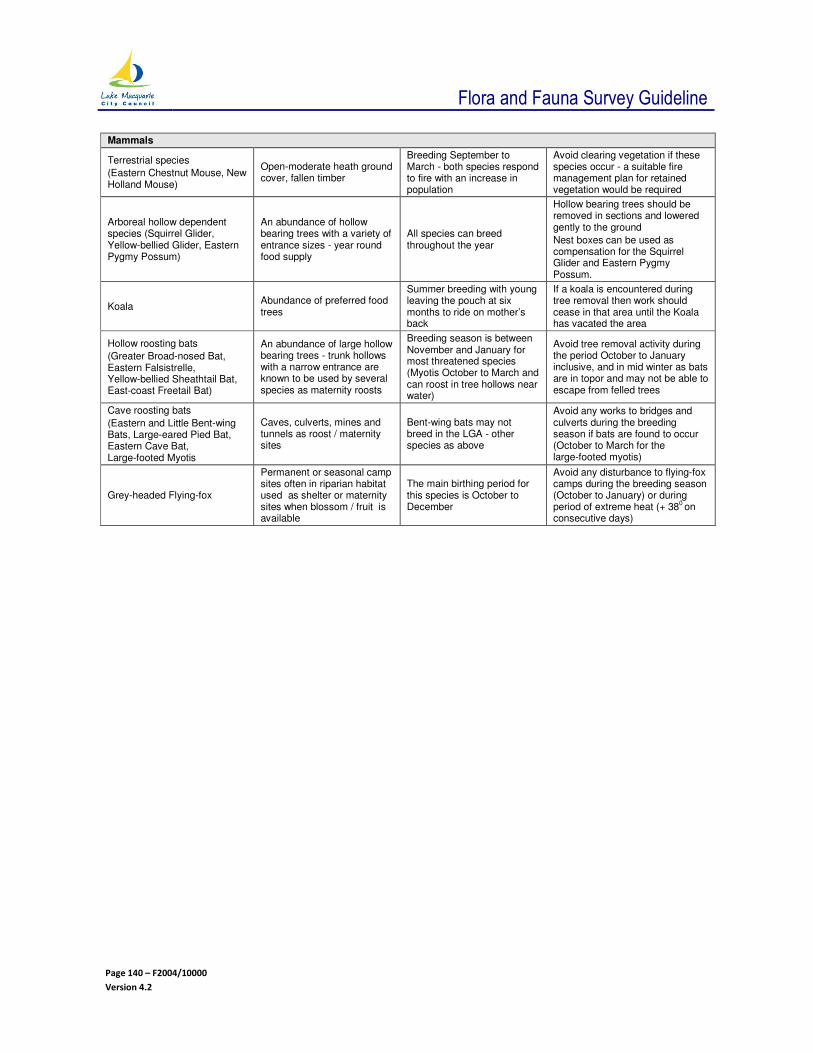
Flora and Fauna Survey Guideline
Page 140 – F2004/10000
Version 4.2
Mammals
Terrestrial species
(Eastern Chestnut Mouse, New Holland Mouse)
Open-moderate heath ground cover, fallen timber
Breeding September to March - both species respond to fire with an increase in population
Avoid clearing vegetation if these species occur - a suitable fire management plan for retained vegetation would be required
Arboreal hollow dependent species (Squirrel Glider, Yellow-bellied Glider, Eastern Pygmy Possum)
An abundance of hollow bearing trees with a variety of entrance sizes - year round food supply
All species can breed throughout the year
Hollow bearing trees should be removed in sections and lowered gently to the ground
Nest boxes can be used as compensation for the Squirrel Glider and Eastern Pygmy Possum.
Koala Abundance of preferred food trees
Summer breeding with young leaving the pouch at six months to ride on mother’s back
If a koala is encountered during tree removal then work should cease in that area until the Koala has vacated the area
Hollow roosting bats
(Greater Broad-nosed Bat, Eastern Falsistrelle, Yellow-bellied Sheathtail Bat, East-coast Freetail Bat)
An abundance of large hollow bearing trees - trunk hollows with a narrow entrance are known to be used by several species as maternity roosts
Breeding season is between November and January for most threatened species (Myotis October to March and can roost in tree hollows near water)
Avoid tree removal activity during the period October to January inclusive, and in mid winter as bats are in topor and may not be able to escape from felled trees
Cave roosting bats
(Eastern and Little Bent-wing Bats, Large-eared Pied Bat, Eastern Cave Bat, Large-footed Myotis
Caves, culverts, mines and tunnels as roost / maternity sites
Bent-wing bats may not breed in the LGA - other species as above
Avoid any works to bridges and culverts during the breeding season if bats are found to occur (October to March for the large-footed myotis)
Grey-headed Flying-fox
Permanent or seasonal camp sites often in riparian habitat used as shelter or maternity sites when blossom / fruit is available
The main birthing period for this species is October to December
Avoid any disturbance to flying-fox camps during the breeding season (October to January) or during period of extreme heat (+ 38
0 on
consecutive days)

Flora and Fauna Survey Guideline
Page 141 – F2004/10000
Version 4.2
8.9 APPENDIX - SMALL SITE AND MINOR DEVELOPMENT CHECKLIST
(Source: adapted from Wyong Shire Council Flora and Fauna Survey Guidelines)
Note: For aquatic surveys, this may be a checklist for jetties - may require some additions for aquatic assessment.
Minor Development Checklist
1 Property address
2 State the size of the study area (in square metres):
3 Attach a plan of the study area and proposed development in relation to the location of native vegetation and any known threatened species or communities or their habitats; protected; and significant species, if any. Characteristics of the study area should also be shown on the plan.
4 Does the study area contain any of the following?
Rainforest Yes / No
Coastal dunes or headlands with native vegetation Yes / No
Wetland vegetation or swamps Yes / No
Dams or ponds watercourse (aquatic habitat) Yes / No
A native vegetation corridor Yes / No
Riparian vegetation Yes / No
Marine or estuarine waters Yes / No
5 Is the area to be disturbed located within 40 m?
Of a wetland or wetland vegetation community Yes / No
Of a rainforest Yes / No
Of a riparian or littoral habitat Yes / No
Of a waterbody or waterway Yes / No
6 Describe native vegetation or fauna habitat within the study area (including species list).
7 List any fauna species likely to use the site.

Flora and Fauna Survey Guideline
Page 142 – F2004/10000
Version 4.2
8 List any threatened species, which you know, are likely to occur in the study area, and are affected by the proposal.
9 What steps are to be taken to minimise the impact of the development on the environment, threatened species and their habitats (circle steps taken):
Eg Design / location of development to avoid / minimise native vegetation and habitat removal / modification
Sediment and erosion controls
Tree / vegetation replacement plantings
Inspection of tree hollows by qualified person management of wildlife before removing tree
Other (list)
10 Section 5A Environmental Planning & Assessment Act 1979 (seven-part test):
(a) Will the lifecycle of any threatened species be disrupted? Yes / No
(b) Will the lifecycle of any endangered population be disrupted? Yes / No
(c) (i) Will the extent of any endangered ecological community be reduced? Yes / No
(ii) Will the an endangered ecological community be modified Yes / No
(d) (i) Will a habitat for a threatened species, population, or community be removed or modified? Yes / No
(ii) Will adjoining or nearby areas of habitat become isolated? Yes / No
(iii) If habitat is removed modified or fragmented, describe the significance of this habitat and the extent of removal or severity of modification?
(e) Will critical habitat be affected? Yes / No
(f) Is the proposal consistent with a recovery plan or threat abatement plan Yes / No
(g) Is the proposal likely to contribute to or exacerbate a key threatening process Yes / No
(h) In summary, will there be a significant effect on threatened species, populations, communities or their habitat (based on consideration of question 10(a) to (g))? Yes / No
11 I declare that to the best of my knowledge that the information I have supplied above is correct.
Completed by ______________________ Signature _________________________
Address _________________________ Date _________________________
_________________________

Flora and Fauna Survey Guideline
Page 143 – F2004/10000
Version 4.2
Explanatory Notes:
Minor Development Checklist
This checklist is only to be completed for development affecting a study area of less than 1,000 m2 and
where native vegetation or fauna habitat is present. The checklist is to be attached to the Statement of Environmental Effects. Explanatory notes are only provided for questions that are not self-explanatory.
Definitions
The study area is land that is directly or indirectly affected by the proposed development. It includes the subject site and any additional areas that are likely to be affected by the proposal. The study area should extend as far as is necessary to take all potential impacts into account (DECC 2009a).
Threatened species and endangered ecological communities and endangered populations are those listed under the Threatened Species Conservation Act 1995 (TSC Act 1979).
Habitat includes native vegetation, caves, dead stags, hollow-bearing trees, splits in trees, bush rock and rocky outcrops, wetlands, streams, lakes, ponds and dams.
Notes for Checklist
• Point 2: The study area may include the area that is proposed to be developed and other areas that are affected, for example, by bushfire hazard reduction eg underscrubbing; or sedimentation of downstream areas.
The study area may not include all of the property, if areas are protected from impacts of development.
If the study area is greater than 1,000 m2, the proposal is not minor development. Advice should be
sought from Council and the Flora and Fauna Survey Guidelines.
• Point 3: Show location of native vegetation and any threatened species or communities or their habitats, protected and significant species.
The plan must include a scale and direction of north. Other information to be shown, if applicable, includes the direction of drainage and the location of streets, watercourses, existing or proposed services, lot boundaries, and existing and proposed buildings / development.
• Points 4 and 5: Small site and minor development requires a minimal level of assessment because the impacts of these developments are likely to be minor. If the answer to any of these questions is, ‘yes’, then the development proposal has the potential to have higher impacts and therefore may require a higher level of assessment ie it may not be considered small site minor development. Contacting Council’s Development Assessment and Compliance Ecologist is recommended.
• Point 6: Native vegetation should be described by listing main species present. Vegetation should also be described in terms of structure ie rainforest, forest, woodland, heathland, scrubland, reedland, grassland.
Habitat, if present, should be described in terms of native vegetation, caves, dead stags, hollow-bearing trees, bush rock, and rocky outcrops, wetlands, streams, lakes, ponds, and dams. For example: “Scribbly Gum and Smooth-barked Apple, Woodland with Grassland understorey. There are three hollows.”
• Point 8: Species, ecological communities, populations, and threatening processes, listed under the TSC Act 1995 that have been recorded, or are likely to occur in Lake Macquarie City, are listed at:
http://www.lakemac.com.au/downloads/Threatened%20Species%20in%20Lake%20Macquarie%20City%20-%20November%202011.pdf
This web page also lists relevant recovery plans and threat abatement plans.
Note:

Flora and Fauna Survey Guideline
Page 144 – F2004/10000
Version 4.2
This list is subject to change with every new listing and recording of additional listed species within Lake Macquarie City. This list may not be the most up-to-date source of information. It is important to access the State Government’s website that contains lists of threatened species, and the Wildlife Atlas that contains locations:
http://www.threatenedspecies.environment.nsw.gov.au/tsprofile/home_species.aspx
http://wildlifeatlas.nationalparks.nsw.gov.au/wildlifeatlas/watlas.jsp
• Point 9: All reasonable steps must be taken to minimise the impact of the development on the environment, threatened species, or their habitats, for the development to be classified as minor development.
Replacement plantings should be limited to species that occur within the local area.
Tree hollows are to be inspected by a qualified person prior to felling. Management includes sectional dismantling, relocation of hollows, nest boxes. Wildlife should only be handled by qualified and licensed persons and released as close as possible to the capture site.
• Point 10: The seven-part test lists factors to be considered to find if the proposal is likely to have a significant effect on threatened species, populations, or ecological communities or their habitats.
• Point 10(a) the lifecycle is unlikely to be disrupted if no threatened species are likely to occur with the study area. If a threatened species is likely to occur and be affected then the any impacts such as the loss of breeding resources or food resources are likely to cause disruption of the life cycle.
• Point 10(b): Only two endangered populations have been listed in Lake Macquarie. These are very localised in the Lake Macquarie LGA (Posidonia australis in Lake Macquarie and Eucalyptus parramattensis sub species parramattensis in the Morisset area). Unless the proposal is in these areas, it is unlikely that the life cycle of any endangered populations will be disrupted.
• Point 10(d) (ii): Development of the study area may leave other areas of native vegetation isolated. This question requires careful consideration for minor development, particularly if trees within a native vegetation corridor are being removed.
• Point 10(d) (iii): Significant area of habitat is unlikely to be removed for minor development due to small study areas.
• Point 10(e): No critical habitat has been listed within the Local Government Area. It is unlikely that critical habitat will be affected.
• Point 10(f) and 10(g): Relevant key threatening processes, recovery plans and threat abatement plans in Lake Macquarie City, are listed at:
http://www.lakemac.com.au/downloads/Threatened%20Species%20in%20Lake%20Macquarie%20City%20-%20November%202011.pdf
Note: This list is subject to change with every new listing and recording of additional listed species within Lake Macquarie City. This list may not be the most up-to-date source of information. It is important to access the State Governments website that contains lists of threatened species and the Wildlife Atlas that contains locations:
http://www.threatenedspecies.environment.nsw.gov.au/tsprofile/home_species.aspx
http://wildlifeatlas.nationalparks.nsw.gov.au/wildlifeatlas/watlas.jsp
• Point 10(h): If no threatened species or their habitat occurs within the study area or area affected by the proposal, the answer is, ‘no’. If threatened species are present and affected, information about the species and an assessment of species distribution from the species profile and the Atlas of NSW Wildlife, (websites above) can be used to assess impact.

Flora and Fauna Survey Guideline
Page 145 – F2004/10000
Version 4.2
8.10 APPENDIX - THREATENED SPECIES RECORDED IN CITY OF LAKE MACQUARIE WITH ASSOCIATED VEGETATION COMMUNITIES
8.10.1 TERRESTRIAL FLORA
Vegetation Community
(Bell and Driscoll 2010)
Threatened species records sourced
from LMCC database
Veg
. C
om
mu
nit
y M
ap
Un
it
Acacia
bynoeana
Angophora
inopin
a
Calli
ste
mon lin
earifo
lius
Cham
aesyce p
sam
mogeto
n
Cory
bas d
ow
lingii
Cry
pto
sty
lis h
unte
riana
Cynanchum
ele
gans
Diu
ris p
raecox
Epacris p
urp
ura
scens v
ar.
purp
ura
scens
Eucaly
ptu
s c
am
field
ii
Eucaly
ptu
s ferg
usonii
Eucaly
ptu
s p
arr
am
attensis
subsp.
decadens
Eucaly
ptu
s p
arr
am
attensis
subsp.
parr
am
att
ensis
Gre
vill
ea p
arv
iflo
ra s
ubsp.
parv
iflo
ra
Maundia
triglo
chin
oid
es
Mela
leuca b
iconvexa
Pultenaea m
aritim
a
Rutidosis
hete
rogam
a
Syzygiu
m p
anic
ula
tum
Tetr
ath
eca juncea
Typhoniu
m e
liosuru
m
Zannic
helli
a p
alu
str
is
Coastal Wet Gully Forest 1 O O
Coastal Warm Temperate -
Subtropical Rainforest
1a O
Lake Macquarie Dry Rainforest 3e O O
Littoral Rainforest 4 O O O
Alluvial Tall Moist Forest 5 O O
Alluvial Bluegum-Paperbark Forest 5a O O O
Alluvial Bluegum-Apple Moist Forest 5b O
Alluvial Bluegum-Spotted Gum Moist
Forest
5e O
Coastal Narrabeen Moist Forest 6 O
Coastal Ranges Open Forest 9 O
Coastal Ranges Dry Blackbutt Forest 9b O
Coastal Sheltered Apple-Peppermint
Forest
11 O
Riparian Paperbark-Peppermint Forest 11a O O O O
Hunter Valley Moist Forest 12 O O O O O
Hunter Valley Moist Spotted Gum -
Fergusons Forest
12d O
Coastal Foothills Spotted Gum - 15 O O O O O O O

Flora and Fauna Survey Guideline
Page 146 – F2004/10000
Version 4.2
Vegetation Community
(Bell and Driscoll 2010)
Threatened species records sourced
from LMCC database
Veg
. C
om
mu
nit
y M
ap
Un
it
Acacia
bynoeana
Angophora
inopin
a
Calli
ste
mon lin
earifo
lius
Cham
aesyce p
sam
mogeto
n
Cory
bas d
ow
lingii
Cry
pto
sty
lis h
unte
riana
Cynanchum
ele
gans
Diu
ris p
raecox
Epacris p
urp
ura
scens v
ar.
purp
ura
scens
Eucaly
ptu
s c
am
field
ii
Eucaly
ptu
s ferg
usonii
Eucaly
ptu
s p
arr
am
att
ensis
subsp.
decadens
Eucaly
ptu
s p
arr
am
att
ensis
subsp.
parr
am
attensis
Gre
vill
ea p
arv
iflo
ra s
ubsp.
parv
iflo
ra
Maundia
triglo
chin
oid
es
Mela
leuca b
iconvexa
Pultenaea m
aritim
a
Rutidosis
hete
rogam
a
Syzygiu
m p
anic
ula
tum
Tetr
ath
eca juncea
Typhoniu
m e
liosuru
m
Zannic
helli
a p
alu
str
is
Ironbark Forest
Lake Macquarie Spotted Gum Forest 15h O O O
Sugarloaf Uplands Dry Spotted Gum -
Ironbark Forest
15l O

Flora and Fauna Survey Guideline
Page 147 – F2004/10000
Version 4.2
8.10.2 TERRESTRIAL BIRDS
Vegetation Community
(Bell and Driscoll 2010)
Threatened species records sourced from LMCC database
Veg
. C
om
mu
nit
y M
ap
Un
it
Austr
alia
n P
ain
ted S
nip
e #
Bark
ing O
wl
Bla
ck B
itte
rn
Bla
ck-c
hin
ned H
oneyeate
r
Bla
ck-n
ecked S
tork
Bla
ck-t
aile
d G
odw
it
Blu
e-b
illed D
uck
Bro
ad-b
illed S
andpip
er
Bro
wn T
reecre
eper
Bush S
tone-c
urlew
Dia
mond F
ireta
il
Com
b-c
reste
d J
acana
Fla
me R
obin
Fle
sh-f
oote
d S
hearw
ate
r
Fre
ckle
d D
uck
Gang-g
ang C
ockato
o
Glo
ssy B
lack-C
ockato
o
Gre
at
Knot
Gre
ate
r S
and P
lover
Gre
y-c
row
ned B
abble
r
Hooded R
obin
Lesser
Sand P
lover
Little E
agle
Little L
orikeet
Little T
ern
Masked O
wl
Coastal Wet Gully Forest 1 O O O
Coastal Warm Temperate - Subtropical Rainforest
1a O
Alluvial Bluegum-Paperbark Forest 5a O O
Coastal Narrabeen Moist Forest 6 O
Coastal Narrabeen Bluegum Ridge Forest
6a O
Coastal Ranges Open Forest 9 O O
Coastal Ranges Mesic Blackbutt Forest 9a O O
Coastal Ranges Dry Blackbutt Forest 9b O O
Coastal Ranges Dry Tallowwood - Blackbutt Forest
9h O
Coastal Sheltered Apple-Peppermint Forest
11 O
Hunter Valley Moist Forest 12 O O
Hunter Valley Moist Spotted Gum - Fergusons Forest
12d O
Coastal Foothills Spotted Gum - Ironbark Forest
15 O O O O O
Coastal Foothills Spotted Gum - Ironbark Forest (Kurri Kurri)
15d O
Lake Macquarie Spotted Gum Forest 15h O

Flora and Fauna Survey Guideline
Page 148 – F2004/10000
Version 4.2
Vegetation Community
(Bell and Driscoll 2010)
Threatened species records sourced from LMCC database
Veg
. C
om
mu
nit
y M
ap
Un
it
Austr
alia
n P
ain
ted S
nip
e #
Bark
ing O
wl
Bla
ck B
itte
rn
Bla
ck-c
hin
ned H
oneyeate
r
Bla
ck-n
ecked S
tork
Bla
ck-t
aile
d G
odw
it
Blu
e-b
illed D
uck
Bro
ad-b
illed S
andpip
er
Bro
wn T
reecre
eper
Bush S
tone-c
urlew
Dia
mond F
ireta
il
Com
b-c
reste
d J
acana
Fla
me R
obin
Fle
sh-f
oote
d S
hearw
ate
r
Fre
ckle
d D
uck
Gang-g
ang C
ockato
o
Glo
ssy B
lack-C
ockato
o
Gre
at
Knot
Gre
ate
r S
and P
lover
Gre
y-c
row
ned B
abble
r
Hooded R
obin
Lesser
Sand P
lover
Little E
agle
Little L
orikeet
Little T
ern
Masked O
wl
Sugarloaf Uplands Dry Spotted Gum - Ironbark Forest
15l O O
Hinterland Spotted Gum - Red Ironbark Forest
17o O O
Coastal Narrabeen Shrub Forest 22 O
Coastal Plains Smooth-barked Apple Woodland
30 O O O O O O O
Sugarloaf Uplands Bloodwood - Apple Forest
30b O O O O
Coastal Plains Stringybark - Apple Forest
30e O O
Freemans Peppermint-Apple-Bloodwood Forest
30f O O O
Sugarloaf Lowlands Bloodwood - Apple Forest
30h O
Coastal Plains Scribbly Gum Woodland 31 O O O O O
Scribbly Gum Open Woodland 31g O O
Coastal Sandstone Laterite Heath 31i O
Snappy Gum Ridgetop Heathy Forest 31j O O O
Coastal Sand Apple-Blackbutt Forest 33 O O
Coastal Sand Apple-Blackbutt Forest (redefined)
33a O
Coastal Sand Wallum Woodland-Heath 34 O
Coastal Sandplain Dry Heath 34c O
Swamp Mahogany - Paperbark Forest 37 O O O O

Flora and Fauna Survey Guideline
Page 149 – F2004/10000
Version 4.2
Vegetation Community
(Bell and Driscoll 2010)
Threatened species records sourced from LMCC database
Veg
. C
om
mu
nit
y M
ap
Un
it
Austr
alia
n P
ain
ted S
nip
e #
Bark
ing O
wl
Bla
ck B
itte
rn
Bla
ck-c
hin
ned H
oneyeate
r
Bla
ck-n
ecked S
tork
Bla
ck-t
aile
d G
odw
it
Blu
e-b
illed D
uck
Bro
ad-b
illed S
andpip
er
Bro
wn T
reecre
eper
Bush S
tone-c
urlew
Dia
mond F
ireta
il
Com
b-c
reste
d J
acana
Fla
me R
obin
Fle
sh-f
oote
d S
hearw
ate
r
Fre
ckle
d D
uck
Gang-g
ang C
ockato
o
Glo
ssy B
lack-C
ockato
o
Gre
at
Knot
Gre
ate
r S
and P
lover
Gre
y-c
row
ned B
abble
r
Hooded R
obin
Lesser
Sand P
lover
Little E
agle
Little L
orikeet
Little T
ern
Masked O
wl
Alluvial Floodplain Cabbage Gum Forest
37d O
Coastal Sand Swamp Forest 37e O
Foreshore Redgum-Rough-barked Apple Forest
38 O
Floodplain Redgum-Rough-barked Apple Forest
38a O O O O
Swamp Oak - Rushland Forest 40 O O O O O
Phragmites Rushland 40a O
Narrabeen Alluvial Sedge Woodland 42 O O O O O
Estuarine Paperbark Scrub Forest 43a O O
Mangrove - Estuarine Complex 47 O O O
Saltmarsh 47a O O O
Lake Macquarie Snappy Gum Forest 111 O O O
Kahibah Snappy Gum Forest 119 O O O
Cockle Creek Dune Forest 122 O
Cooranbong Blackbutt Tall Forest 123 O
Disturbed - Canopy only Xr O
Disturbed - Regrowth Xs O
Unclassified vegetation LM07 O
Cleared (no native vegetation mapped) C O
Lake Lake O

Flora and Fauna Survey Guideline
Page 150 – F2004/10000
Version 4.2
Vegetation Community
(Bell and Driscoll 2010)
Threatened species records sourced from LMCC database
Veg
. C
om
mu
nit
y M
ap
Un
it
Ospre
y
Pie
d O
yste
rcatc
her
Pow
erf
ul O
wl
Rose-c
row
ned F
ruit-D
ove
Regent H
oneyeate
r
Scarlet R
obin
Shy A
lbatr
oss
Spotted H
arr
ier
Spotted-t
aile
d Q
uoll
Squirre
l G
lider
Sw
ift P
arr
ot
Turq
uois
e P
arr
ot
Varied S
itte
lla
Wandering A
lbatr
oss
White-f
ronte
d C
hat
Wom
poo F
ruit D
ove
Sooty
Ow
l
Sooty
Oyste
rcatc
her
#
Sooty
Tern
#
South
ern
Gia
nt-
Petr
el
Speckle
d W
arb
ler
Square
-taile
d K
ite
Superb
Fru
it D
ove
Tere
k S
andpip
er
Coastal Wet Gully Forest 1 O O O O
Coastal Warm Temperate - Subtropical Rainforest
1a O
Lake Macquarie Dry Rainforest 3e O
Littoral Rainforest 4 O O
Alluvial Tall Moist Forest 5 O O O O
Coastal Narrabeen Moist Forest 6 O O O
Coastal Ranges Open Forest 9 O O O
Coastal Ranges Mesic Blackbutt Forest 9a O
Coastal Sheltered Apple-Peppermint Forest
11 O O
Hunter Valley Moist Forest 12 O
Hunter Valley Moist Spotted Gum - Fergusons Forest
12d O O
Coastal Foothills Spotted Gum - Ironbark Forest
15 O O O O O O
Coastal Foothills Spotted Gum - Ironbark Forest (Kurri Kurri)
15d O
Lake Macquarie Spotted Gum Forest 15h O O O
Sugarloaf Uplands Dry Spotted Gum - Ironbark Forest
15l O O
Hinterland Spotted Gum - Red Ironbark Forest
17o O O O O
Coastal Plains Smooth-barked Apple Woodland
30 O O O O O O O O O

Flora and Fauna Survey Guideline
Page 151 – F2004/10000
Version 4.2
Vegetation Community
(Bell and Driscoll 2010)
Threatened species records sourced from LMCC database
Veg
. C
om
mu
nit
y M
ap
Un
it
Ospre
y
Pie
d O
yste
rcatc
her
Pow
erf
ul O
wl
Rose-c
row
ned F
ruit-D
ove
Regent H
oneyeate
r
Scarlet R
obin
Shy A
lbatr
oss
Spott
ed H
arr
ier
Spott
ed-t
aile
d Q
uoll
Squirre
l G
lider
Sw
ift P
arr
ot
Turq
uois
e P
arr
ot
Varied S
itte
lla
Wandering A
lbatr
oss
White-f
ronte
d C
hat
Wom
poo F
ruit D
ove
Sooty
Ow
l
Sooty
Oyste
rcatc
her
#
Sooty
Tern
#
South
ern
Gia
nt-
Petr
el
Speckle
d W
arb
ler
Square
-taile
d K
ite
Superb
Fru
it D
ove
Tere
k S
andpip
er
Buttonderry Footslopes Forest 30a O
Sugarloaf Uplands Bloodwood - Apple Forest
30b O O O
Coastal Plains Stringybark - Apple Forest
30e O O O
Freemans Peppermint-Apple-Bloodwood Forest
30f O O O
Sugarloaf Lowlands Bloodwood - Apple Forest
30h O O
West Wallsend Stringybark Forest 30i O O O O
Coastal Plains Scribbly Gum Woodland 31 O O O O O O O
Snappy Gum Ridgetop Heathy Forest 31j O O O
Narrabeen Dune Forest 31k O
Coastal Sand Apple-Blackbutt Forest 33 O O
Coastal Sand Wallum Woodland-Heath 34 O O O
Swamp Mahogany - Paperbark Forest 37 O O O
Coastal Sand Swamp Forest 37e O O
Foreshore Redgum-Rough-barked Apple Forest
38 O O
Floodplain Redgum-Rough-barked Apple Forest
38a O O
Apple-Palm Gully Forest 39 O
Swamp Oak - Rushland Forest 40 O
Phragmites Rushland 40a O O
Narrabeen Alluvial Sedge Woodland 42 O O O
Wyong Paperbark Swamp Forest 43 O
Estuarine Paperbark Scrub Forest 43a O
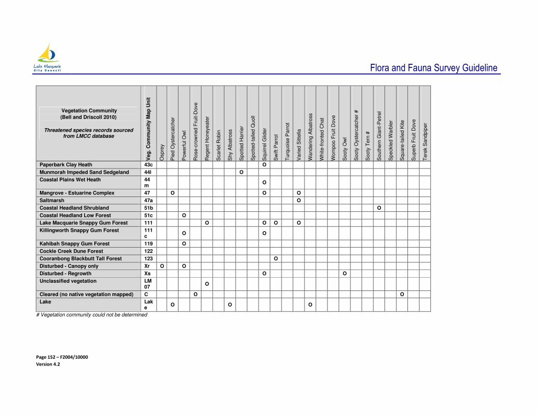
Flora and Fauna Survey Guideline
Page 152 – F2004/10000
Version 4.2
Vegetation Community
(Bell and Driscoll 2010)
Threatened species records sourced from LMCC database
Veg
. C
om
mu
nit
y M
ap
Un
it
Ospre
y
Pie
d O
yste
rcatc
her
Pow
erf
ul O
wl
Rose-c
row
ned F
ruit-D
ove
Regent H
oneyeate
r
Scarlet R
obin
Shy A
lbatr
oss
Spott
ed H
arr
ier
Spott
ed-t
aile
d Q
uoll
Squirre
l G
lider
Sw
ift P
arr
ot
Turq
uois
e P
arr
ot
Varied S
itte
lla
Wandering A
lbatr
oss
White-f
ronte
d C
hat
Wom
poo F
ruit D
ove
Sooty
Ow
l
Sooty
Oyste
rcatc
her
#
Sooty
Tern
#
South
ern
Gia
nt-
Petr
el
Speckle
d W
arb
ler
Square
-taile
d K
ite
Superb
Fru
it D
ove
Tere
k S
andpip
er
Paperbark Clay Heath 43c O
Munmorah Impeded Sand Sedgeland 44l O
Coastal Plains Wet Heath 44m
O
Mangrove - Estuarine Complex 47 O O O
Saltmarsh 47a O
Coastal Headland Shrubland 51b O
Coastal Headland Low Forest 51c O
Lake Macquarie Snappy Gum Forest 111 O O O O
Killingworth Snappy Gum Forest 111c
O O
Kahibah Snappy Gum Forest 119 O
Cockle Creek Dune Forest 122
Cooranbong Blackbutt Tall Forest 123 O
Disturbed - Canopy only Xr O O
Disturbed - Regrowth Xs O O
Unclassified vegetation LM07
O
Cleared (no native vegetation mapped) C O O
Lake Lake
O O O
# Vegetation community could not be determined

Flora and Fauna Survey Guideline
Page 153 – F2004/10000
Version 4.2
8.10.3 MAMMALS
Vegetation Community
(Bell and Driscoll 2010)
Threatened species records were sourced from LMCC
database. V
eg
. C
om
mu
nit
y M
ap
Un
it
Austr
alia
n F
ur-
se
al #
Bru
sh
-ta
iled R
ock-w
alla
by
Du
go
ng
Easte
rn C
ave B
at
Easte
rn F
als
e P
ipis
tre
llus
Easte
rn F
ree
tail-
bat
Easte
rn P
ygm
y-p
ossu
m
Go
lde
n-t
ipp
ed
Bat
Gre
y-h
ea
de
d F
lyin
g-f
ox
Koa
la
La
rge
-ea
red
Pie
d B
at
Little B
en
t-w
ing
-ba
t
Parm
a W
alla
by
Sou
the
rn M
yotis
Spo
tte
d-t
aile
d Q
uo
ll
Squ
irre
l G
lide
r
Yello
w-b
elli
ed
Sh
ea
thta
il B
at
Yello
w-b
elli
ed
Glid
er
Coastal Wet Gully Forest 1 O O O O O O
Coastal Warm Temperate - Subtropical Rainforest
1a O O
Alluvial Tall Moist Forest 5 O O O O O O
Coastal Narrabeen Moist Forest
6 O O O O
Coastal Ranges Open Forest 9 O O O
Coastal Ranges Mesic Blackbutt Forest
9a O
Coastal Ranges Dry Blackbutt Forest
9b O O O O O O
Coastal Ranges Dry Peppermint – Blackbutt Forest
9f O
Coastal Ranges Dry Tallowwood – Blackbutt Forest
9h O
Coastal Sheltered Apple-Peppermint Forest
11 O O O O
Riparian Paperbark-Peppermint Forest
11a
O
Hunter Valley Moist Forest 12 O O O O
Hunter Valley Moist Spotted Gum - Fergusons Forest
12d
O O O O O O
Coastal Foothills Spotted Gum - Ironbark Forest
15 O O O O O O O
Lake Macquarie Spotted Gum Forest
15h
O O O O
Sugarloaf Uplands Dry Spotted Gum - Ironbark Forest
15l
O O O
Hinterland Spotted Gum - Red Ironbark Forest
17o
O O O
Hunter Range Dry Escarpment Apple Forest
21a
O O
Coastal Narrabeen Shrub Forest
22 O
Coastal Plains Smooth-barked Apple Woodland
30 O O O O O O O O O
Sugarloaf Uplands Bloodwood - Apple Forest
30b
O O O O O O O
Coastal Plains Stringybark - Apple Forest
30e
O O O O O
Freemans Peppermint-Apple-Bloodwood Forest
30f
O O O O O
Sugarloaf Lowlands Bloodwood - Apple Forest
30h
O O
West Wallsend Stringybark Forest
30i
O O O O

Flora and Fauna Survey Guideline
Page 154 – F2004/10000
Version 4.2
Vegetation Community
(Bell and Driscoll 2010)
Threatened species records were sourced from LMCC
database.
Veg
. C
om
mu
nit
y M
ap
Un
it
Austr
alia
n F
ur-
se
al #
Bru
sh
-ta
iled R
ock-w
alla
by
Du
go
ng
Easte
rn C
ave B
at
Easte
rn F
als
e P
ipis
tre
llus
Easte
rn F
ree
tail-
bat
Easte
rn P
yg
my-p
ossu
m
Go
lde
n-t
ipp
ed
Bat
Gre
y-h
ea
de
d F
lyin
g-f
ox
Koa
la
La
rge
-eare
d P
ied B
at
Little B
en
t-w
ing
-ba
t
Parm
a W
alla
by
Sou
the
rn M
yotis
Spo
tte
d-t
aile
d Q
uo
ll
Squ
irre
l G
lide
r
Yello
w-b
elli
ed
Sh
ea
thta
il B
at
Yello
w-b
elli
ed
Glid
er
Coastal Plains Scribbly Gum Woodland
31 O O O O O O O O
Scribbly Gum Open Woodland
31g
O O O
Snappy Gum Ridgetop Heathy Forest
31j
O O O O O
Narrabeen Dune Forest 31k
O
Coastal Sand Apple-Blackbutt Forest
33 O
Coastal Sand Apple-Blackbutt Forest (redefined)
33a
O
Coastal Sand Wallum Woodland-Heath
34 O O
Swamp Mahogany - Paperbark Forest
37 O O O O O
Coastal Sand Swamp Forest 37e
O O O
Swamp Mahogany - Livistona Swamp Forest
37f
O
Foreshore Redgum-Rough-barked Apple Forest
38 O O O O
Floodplain Redgum-Rough-barked Apple Forest
38a
O O O O O O O
Apple-Palm Gully Forest 39 O
Narrabeen Alluvial Sedge Woodland
42 O O O O O O O O
Wyee Turpentine - Red Mahogany - Apple Riparian Forest
42c
O O
Estuarine Paperbark Scrub Forest
43a
O
Paperbark Clay Heath 43c
O
Coastal Plains Wet Heath 44m
O O
Mangrove - Estuarine Complex
47 O O O
Coastal Clay Heath 48 O
Coastal Headland Low Forest 51c
O
Lake Macquarie Snappy Gum Forest
111
O O O O O O
Killingworth Snappy Gum Forest
111c
O O O O O O
Kahibah Snappy Gum Forest 119
O O O
Cockle Creek Dune Forest 122
O
Disturbed – Canopy only Xr O O O
Disturbed – Regrowth X O O O

Flora and Fauna Survey Guideline
Page 155 – F2004/10000
Version 4.2
Vegetation Community
(Bell and Driscoll 2010)
Threatened species records were sourced from LMCC
database.
Veg
. C
om
mu
nit
y M
ap
Un
it
Austr
alia
n F
ur-
se
al #
Bru
sh
-ta
iled R
ock-w
alla
by
Du
go
ng
Easte
rn C
ave B
at
Easte
rn F
als
e P
ipis
tre
llus
Easte
rn F
ree
tail-
bat
Easte
rn P
yg
my-p
ossu
m
Go
lde
n-t
ipp
ed
Bat
Gre
y-h
ea
de
d F
lyin
g-f
ox
Koa
la
La
rge
-eare
d P
ied B
at
Little B
en
t-w
ing
-ba
t
Parm
a W
alla
by
Sou
the
rn M
yotis
Spo
tte
d-t
aile
d Q
uo
ll
Squ
irre
l G
lide
r
Yello
w-b
elli
ed
Sh
ea
thta
il B
at
Yello
w-b
elli
ed
Glid
er
s
Unclassified vegetation LM07
O O
Cleared (no vegetation mapped)
C O
Lake Lake
O
# Vegetation community could not be determined

Flora and Fauna Survey Guideline
Page 156 – F2004/10000
Version 4.2
8.10.4 REPTILES AND AMPHIBIANS
Vegetation Community
(Bell and Driscoll, 2010)
Threatened species records were sourced from LMCC database.
Veg
. C
om
mu
nity M
ap
Un
it
Gia
nt
Ba
rre
d F
rog
Gre
en
an
d G
old
en B
ell
Fro
g
Gre
en
-thig
he
d F
rog
Gre
en
Turt
le
Little
johns T
ree
Fro
g
Lo
gge
rhea
d T
urt
le
Re
d-c
row
ne
d T
oad
let
Ste
ph
ens' B
and
ed
Sn
ake
Stu
tte
ring
Fro
g
Wallu
m F
rog
let
Coastal Wet Gully Forest 1 O O
Coastal Warm Temperate - Subtropical Rainforest
1a O
Alluvial Tall Moist Forest 5 O O
Coastal Narrabeen Moist Forest 6 O
Coastal Ranges Open Forest 9 O O O O
Coastal Ranges Mesic Blackbutt Forest 9a O
Coastal Ranges Dry Peppermint - Blackbutt Forest
9f O
Coastal Sheltered Apple-Peppermint Forest
11 O
Coastal Foothills Spotted Gum - Ironbark Forest
15 O O
Coastal Narrabeen Shrub Forest 22 O O
Coastal Plains Smooth-barked Apple Woodland
30 O
Buttonderry Footslopes Forest 30a O
Coastal Plains Scribbly Gum Woodland 31 O O
Snappy Gum Ridgetop Heathy Forest 31j O
Coastal Sand Wallum Woodland-Heath 34 O
Heath 34a O
Swamp Mahogany - Paperbark Forest 37 O
Coastal Sand Swamp Forest 37e O
Narrabeen Alluvial Sedge Woodland 42 O O
Munmorah Grasstree Wet Heath 44a O
Munmorah Impeded Sand Sedgeland 44l O
Coastal Plains Wet Heath 44m O
Freshwater Typha Wetland 46a O
Mangrove - Estuarine Complex 47 O
Lake Macquarie Snappy Gum Forest 111 O
Kahibah Snappy Gum Forest 119 O
Disturbed - Regrowth Xs O
Cleared C O
Lake Lake O O
# Vegetation community could not be determined