for dakota county, n county zoning –2-21-06 iii section 680. hm, heavy manufacturing district50...
TRANSCRIPT
ZONING ORDINANCES
FOR DAKOTA COUNTY, NEBRASKA
Prepared for: Dakota County, Nebraska
By: Dakota County Joint Planning CommissionDakota County Board of Commissioners
With Assistance from: Siouxland Interstate Metropolitan Planning Council (SIMPCO)Sioux City, Iowa
February 21, 2006
Dakota County Zoning–2-21-06i
TABLEINTRODUCTION
Section 101. Title ..........................................................................................................1Section 102. Jurisdiction ..............................................................................................1Section 103. Purpose ....................................................................................................1Section 104. Interpretation and Scope.........................................................................1Section 105. Non-conforming Use ..............................................................................1
RULES, DEFINITIONSSection 201. Rules .......................................................................................................2Section 202. Definitions...............................................................................................2
DISTRICTS, BOUNDARIES, APPLICABILITY, SPECIAL PERMITSSection 301. Districts....................................................................................................19Section 302. District Maps...........................................................................................19Section 303. Interpretation of District Boundaries .....................................................19Section 304. Acquisition of Jurisdiction .....................................................................20Section 305. Applicability, General ............................................................................20Section 306. Applicability, Open Space......................................................................20Section 307. Interpretation, Priority of Contracts.......................................................20Section 308. General Interpretation.............................................................................20Section 309. Airport approach and Turning Districts ................................................20Section 310. Fences and Hedges, Corner Visibility ...................................................21
NONCONFORMING USES AND LOTSSection 401. Grandfather Rights..................................................................................21Section 402. Discontinuance of nonconforming use..................................................21Section 403. Structural alterations of nonconforming use.........................................21Section 404. Changes to a different nonconforming use ...........................................21Section 405. Amortization and discontinuance of certain uses .................................21Section 406. Non conforming structures.....................................................................22Section 407. Nonconforming lot..................................................................................22
APPEALS, ENFORCEMENT, PERMITS, FEESSection 501. Board of Adjustment...............................................................................22Section 502. Procedures ...............................................................................................23Section 503. Hearing ....................................................................................................23Section 504. Vote..........................................................................................................23Section 505. Jurisdiction ..............................................................................................23Section 506. Record......................................................................................................23Section 507. County Planning Commission, Special Powers....................................23Section 508. Amendments............................................................................................24Section 509. Enforcement ............................................................................................24Section 510. Administration.........................................................................................24Section 511. Application for Building Permit ............................................................24Section 512. Temporary Mobile Home Permit...........................................................25Section 513. Expiration of Building Permit ................................................................25Section 514. Non-transferability of building permits.................................................25Section 515. Zoning Change Forms ............................................................................25Section 516. Forms for Appeal to the Board of Zoning Adjustment ........................25
Dakota County Zoning–2-21-06ii
Section 517 Fees ..........................................................................................................25Section 518. Violations, Penalty ..................................................................................26Section 519. Severability..............................................................................................26
ZONING DISTRICTSSECTION 600. AG, AGRICULTURAL DISTRICT PURPOSE .............................26Section 600.1. Principal Permitted Uses ........................................................................26Section 600.2. Accessory Uses .......................................................................................27Section 600.3. Conditional Uses .....................................................................................27Section 600.4. Space Limits............................................................................................28Section 600.5. Special Conditional Uses........................................................................29Section 600.6. Performance Standards...........................................................................30
SECTION 610. AR, AGRICULTURAL-RESIDENTIAL DISTRICT ....................32Section 610.1. Principal Permitted Uses ........................................................................32Section 610.2. Accessory Uses .......................................................................................32Section 610.3. Conditional Uses .....................................................................................33Section 610.4. Space Limits............................................................................................34
SECTION 640. R-R, RESIDENTIAL-RECREATION DISTRICT PURPOSE ....35Section 640.1. Principally Permitted Uses .....................................................................35Section 640.2. Accessory Uses .......................................................................................35Section 640.3. Conditional Uses .....................................................................................35Section 640.4. Space Limits............................................................................................36Section 640.5 Recreational Vehicle Parks ....................................................................36Section 640.6 Recreation Facility Zone, Purpose.........................................................39
SECTION 650. B, BUSINESS DISTRICT PURPOSE ...............................................41Section 650.1. Principal Permitted Uses ........................................................................41Section 650.2. Permitted Accessory Uses ......................................................................42Section 650.3. Conditional Uses .....................................................................................42Section 650.4. Space Limits............................................................................................43
SECTION 660. HSB, HIGHWAY SERVICE BUSINESS DISTRICT PURPOSE ....44Section 660.1. Principal Permitted Uses ........................................................................44Section 660.2. Accessory Uses .......................................................................................45Section 660.3. Conditional Uses .....................................................................................45Section 660.4. Space Limits............................................................................................45Section 660.5. Other Applicable Provisions ..................................................................45
SECTION 670. LM, LIGHT MANUFACTURING DISTRICT PURPOSE ..........47Section 670.1. Principal Permitted Uses ........................................................................47Section 670.2. Specifically Excluded Uses....................................................................47Section 670.3. Permitted Accessory Uses ......................................................................47Section 670.4. Conditional Uses .....................................................................................48Section 670.5. Performance Standards...........................................................................48Section 670.6. Space Limits............................................................................................49
Dakota County Zoning–2-21-06iii
SECTION 680. HM, HEAVY MANUFACTURING DISTRICT .............................50Section 680.1. Principal Permitted Uses ........................................................................50Section 680.2. Specifically Excluded Uses....................................................................50Section 680.3. Permitted Accessory Uses ......................................................................51Section 680.4. Conditional Uses .....................................................................................51Section 680.5. Performance Standards...........................................................................51Section 680.6. Space Limits............................................................................................52
SECTION 700. SFH, SPECIAL FLOOD HAZARD DISTRICT PURPOSE.........53Section 700.1. Statutory Authorization ..........................................................................53Section 700.2. Findings of Fact ......................................................................................53Section 700.3. General Provisions..................................................................................54Section 700.4. Development Permits..............................................................................56Section 700.5. Application for Permit ............................................................................56Section 700.6. Establishment of Zoning Districts .........................................................57Section 700.7. Standards for Floodplain Development.................................................57
SECTION 700.8 FLOOD FRINGE OVERLAY DISTRICT(INCLUDING AO AND AH ZONES) .................................................58
Section 700.8.1. Principal Permitted Uses ........................................................................58Section 700.8.2. Standards for the Flood Fringe Overlay District...................................58
SECTION 700.9. FLOODWAY OVERLAY DISTRICT..............................................60Section 700.9.1. Principal Permitted Uses ........................................................................60Section 700.9.2. Standards for the Floodway Overlay District........................................61
SECTION 710. VARIANCE PROCEDURES..............................................................61Section 710.1. Conditions for Variances........................................................................62
SECTION 711. NONCONFORMING USE .................................................................62
SECTION 712. PENALTIES FOR VIOLATION .......................................................63
SECTION 713. AMENDMENTS ...................................................................................63
SECTION 800. SMH, SPECIAL MOBILE HOME DISTRICT, PURPOSE .........63Section 800.1. Principal Permitted Uses ........................................................................64Section 800.2. Restrictions and Standards .....................................................................64
SECTION 900 SUPPLEMENTAL REGULATIONS................................................64Section 900.1. Radio, Communications and Telecommunications Towers.................64Section 900.2. Wind Energy Installations......................................................................71Section 900.3. Sign Installations.....................................................................................77
Dakota County Zoning–2-21-061
DAKOTA COUNTY, NEBRASKA
ZONING REGULATIONS
RESOLUTION
INTRODUCTION
Section 101. Title. These regulations shall be known as the Dakota County Zoning Regulations.These regulations restrict the use of land, the use and location of buildings, height and bulk of buildingsand structures, and area of surrounding yards and courts. These regulations divide the county intodistricts for these purposes. These regulations adopt a map of the county showing boundaries of districtsand classification of such districts. These regulations define certain terms used herein. These regulationsestablish a Board of Adjustment. These regulations provide for changes and amendments to saidregulations and prescribe penalties for the violation of its provisions.
Section 102. Jurisdiction. The provision of these regulations shall apply to the unincorporatedterritory of Dakota County, Nebraska, except for areas where Cities or Villages are exercising theirextraterritorial jurisdiction.
Section 103. Purpose. These regulations have been made in accordance with a 1997comprehensive plan and recording approved and adopted zoning change requests from 1978 through2004. They are designed to lessen congestion on the streets and roads; to secure safety from fire, panicand other dangers; to promote health and general welfare; to provide adequate light and air; to preventovercrowding of land; and to avoid undue congestion of population. They are also designed to facilitatethe adequate provision of transportation, water, sewerage, schools, parks and other public facilities.These regulations have been made with reasonable consideration, among other things, to the characterof the district, and its peculiar suitability for encouraging the most appropriate use of land throughoutprescribed unincorporated portions of Dakota County, Nebraska.
Section 104. Interpretation and Scope. In the interpretation and application, theprovisions of these regulations shall be held to be the minimum requirement adopted for the promotionof the public health, safety, and welfare. Where these regulations impose a greater restriction upon land,buildings, or structures than is imposed or required by existing provisions of law, contract or deed, theprovisions of these regulations shall control.
Section 105. Non-conforming Use. The use of a building, structure, or land existing andlawful at the time of the enactment of these regulations, or at the time of an amendment to theseregulations, may, except as provided herein, be continued. Such use can continue although such usedoes not conform with the provisions of these regulations or amendment, and such use may be extendedthroughout the same building if no structural alteration of such building is proposed or made for thepurpose of such extension. If such nonconforming use is in fact discontinued for a period of twelvemonths, such right to nonconforming use shall be forfeited and any future use of the building andpremises shall conform to these regulations. The county board may provide in any zoning regulation forthe restoration, reconstruction, extension, or substitution of nonconforming uses upon such terms andconditions as may be set forth in the zoning regulations. The county board may, in any zoningregulation, provide for the termination of non-conforming uses, either by specifying the period orperiods in which non-conforming uses shall be required to cease, or by providing a formula whereby thecompulsory termination of a non-conforming use may be so fixed as to allow for the recovery oramortization of the investment in the non-conformance.
Dakota County Zoning–2-21-062
RULES, DEFINITIONS
Section 201. Rules. For the purpose of these regulations, the following rules shall apply:
1. Words and numbers used singularly shall include the plural and the plural shall include thesingular. Words used in the present tense shall include the future.
2. The word “persons” includes a corporation, members of a partnership or other business organization, a committee, board, trustee, receiver or other representative.
3. The word “shall” is mandatory.
4. The word “use,” “occupy,” or “occupied” as applied to any land or building shall be construed to include the works “intended,” “arranged,” or “designed” to be used or occupied.
Section 202. Definitions. For the purpose of these regulations, certain terms or words usedherein shall be interpreted or defined as follows, unless the context clearly indicates otherwise.
Where terms are not defined, they shall have their ordinary accepted meanings within the context whichthey are used. Webster’s Third New International Dictionary of the English Language, Unabridged, copyright 1986, shall be considered as providing ordinarily accepted meanings.
1. ABBUTTING: Shall mean to border on, being contiguous with, or have property or districtlines in common, including property separated by an alley.
2. ACCESSORY USE, STRUCTURE OR BUILDING: A subordinate building or use whichcustomarily is incidental to and detached from the main or principal buildings or use of thepremises. Customary accessory uses include, but are not limited to, tennis courts, swimmingpools, detached garages, air conditioners, garden houses, children's play houses, barbecueovens, fireplaces, patios and residential storage sheds.
3. AGRICULTURAL OPERATIONS: Farmsteads of forty (40) acres or more, which produce onethousand dollars ($1,000) or more of farm products each year.
4. AIRPORT (AIRFIELD): Any area which is used or is intended to be used for taking off andlanding of aircraft including helicopters, and any appurtenant areas which are used or areintended to be used for airport buildings or facilities, including open spaces, taxiways and tiedown areas.
5. ALLEY: A dedicated public right-of-way, other than a street, which provides only a secondarymeans of access to abutting property, the right-of-way of which is 20 feet or less in width.
6. ALTERATION: As applied to a building or structure, is a change or re-arrangement in thestructural parts of an existing building or structure. Enlargement, whether by extending a side,increasing the height, or moving from one location or position to another, shall be considered analteration.
7. AMERICANS WITH DISABILITY ACT (ADA): 1990 Federal law designed to providedisabled Americans with equal access to jobs, transportation, public facilities, and services.
8. AMUSEMENT, CENTER: An establishment offering five (5) or more amusement devices,including, but not limited to, coin-operated electronic games, shooting gallery, table games andsimilar recreational devices within an enclosed building.

Dakota County Zoning–2-21-063
9. ANIMAL HOSPITAL OR CLINIC: An establishment where animals are admitted forexamination, treatment, board or care, by a doctor of Veterinary Medicine. (This does notinclude open kennels.)
10. ANIMAL UNIT: Shall mean the equivalency of 1 slaughter and feeder cow, 0.5 horse; 0.7mature dairy cow; 2.5 swine weighing 55 lbs or more; 25 weaned pigs weighting less than 55lbs.; 10 sheep; 100 chickens; 50 turkeys or 5 ducks.
11. APARTMENT: (See Dwelling, Multiple).
12. ASSISTED LIVING FACILTIES: Shall mean Residences for elderly that provide rooms,meals, personal care, and supervision of self-administered medication. These facilities may alsoprovide other services such as recreational activities, financial services, and transportation.
13. AUTOMOBILE REPAIR, MAJOR: An establishment primarily engaged in the repair ormaintenance of motor vehicles, trailers and similar large mechanical equipment, including paint,body and fender, and major engine and engine par overhaul, provided it is conducted within acompletely enclosed building
14. AUTOMOBILE REPAIR, MINOR: An establishment primarily engaged in the repair ormaintenance of motor vehicles, trailers, and similar mechanical equipment, including brake,muffler, upholstery, tire repair and change, lubrication, tune ups and transmission work,provided it is conducted within a completely enclosed building.
15. AUTOMOBILE SELF-SERVICE STATION: A portion of property where flammable orcombustible liquids or gases used as fuel are stored and dispensed by the consumer from fixedequipment into the fuel tanks of motor vehicles. Such an establishment may offer for sale atretail other convenience items as a clearly secondary activity and may also include afreestanding car wash.
16. AUTOMOBILE SERVICE STATION: A portion of property where flammable or combustibleliquids or gases used as fuel are stored and dispensed from fixed equipment into the fuel tanksof motor vehicles. Accessory activities may include automobile repair and maintenance, carwash service, and food sales.
17. AUTOMOBILE WRECKING YARD: Shall mean the dismantling or wrecking of used motorvehicles or trailers, or the storage, sale, or dumping of dismantled or wrecked vehicles or theirparts. The presence on any lot or parcel of land of two (2) or more vehicles, which, for the aperiod exceeding thirty (30) days, have not been capable of operating under their own power,and from which parts have been or are to be removed for reuse or sale, shall constitute primafacie evidence of an automobile wrecking yard. (See Junk or Salvage yard).
18. BASEMENT: Shall mean a story of a building having part but not less than one-half (1/2) of itslowest story below grade. A basement is counted as a story for the purpose of heightregulations if subdivided and used for dwelling purposes
19. BED AND BREAKFAST HOME: Shall mean a single-family dwelling which providesovernight lodging for guests on a rental basis, in which the host or hostess resides and in whichpaying overnight guests may be served food. Also, if applicable, the premises must be licensedby the State of Nebraska.
20. BED AND BREAKFAST INN(EXPANDED SERVICES): Shall mean a single-familydwelling which provides lodging and meals for quests; and may provide facilities for groupmeetings, special occasion receptions or parties (either indoors or out-of-doors) and restaurantservices for the general public as approved with conditions by the Board of Adjustments.
Dakota County Zoning–2-21-064
21. BEDROOM: Shall mean a room within a dwelling unit, planned and intended for sleeping,separable from other rooms by a door.
22. BIKE/PEDESTRIAN PATHWAY: A public way designated for public use, which excludesmotorized vehicles.
23. BILLBOARD: Shall mean any structure or portion thereof, situated on private premises, onwhich lettered, figured or pictorial matter is displayed for advertising purposes, except the nameand occupation of the used or the premises, the nature of the business conducted on thepremises, or the products primarily sold or manufactured on the premises, and having an area ofon hundred (100) square feet or more. Any signboard carrying a message accepted in thisdefinition which also carries extraneous advertising of 100 square feet or more, shall beconsidered a billboard. This definition shall not include any board, sign, or surface used todisplay official notices issued by a court of public duty, or bulletin boards used to displayannouncements of meetings to be held on the premises on which such bulletin boards arelocated, nor shall it include a real estate sign advertising the sale or rent or the property uponwhich it stands when such sign does not exceed 50 square feet.
24. BLOCK: Shall mean a parcel of land platted into lots and bounded by public streets or bywaterways, rights-of-way, unplatted land, Village or County boundaries, or adjoining propertylines.
25. BOARD OF ADJUSTMENTS: Shall meant the board which has been created by the CountyBoard of Commissioners and which has the authority to hear and determine appeals,interpretations of, exceptions and variances to these regulations.
26. BOARDING HOUSE: A building, other than a hotel or motel, where for compensation and bypre-arrangement for definite periods, meals, or lodging and meals, are provided for three ormore persons. Individual cooking facilities are not provided.
27. BUILDING: Any structure designed or intended for the enclosure, shelter or protection ofpersons, animals, or property but shall not include temporary buildings as defined in “Structure, Temporary.” Trailers, with or without wheels, shall not be considered buildings.
28. BUILDING CODE, CODE, OR UNIFORM BUILDING CODE: Shall mean the currentUniform Building Code (U.B.C.) adopted by Dakota County, Nebraska.
29. BUILDING HEIGHT: The vertical dimension measured from the average elevation of thefinished lot grade at the front of the building to the highest point of the ceiling of the top story inthe case of a flat roof; to the deck line of a mansard roof; and to the average height between theplate and ridge of a gable, hip or gambrel roof.
30. BUILDING INSPECTOR: The official appointed by the County Commissioners and chargedwith the responsibility of performing building inspections.
31. BUSINESS USE: Shall mean all uses of land, buildings, or structures other than agricultural,residential, public, semi-public, or industrial uses.
32. CAMPGROUND: Any parcel, tract, or plot of ground which provides space for transientoccupancy and is used or intended to be used for the placement of tents, parking of one or morecamping trailers, or other recreational vehicles. Under no circumstances shall any one camperoccupy a campground for a period exceeding 15 consecutive days. The term campground doesnot include sales lots on which unoccupied camping trailers, whether new or used, are parkedfor the purpose of storage, inspection, or sale.
Dakota County Zoning–2-21-065
33. CAMPING UNIT: Any vehicle, tent, trailer, or other movable shelter used for campingpurposes.
34. CANOPY: A roofed structure constructed of fabric or other materials supported by the buildingor by support extended to the ground directly under the canopy, so as to extend outward fromthe building providing a protective shield for doors, windows, and other openings.
35. CARPORT: A roofed structure open on at least two (2) sides and used for the storage of privateor pleasure type vehicles.
36. CEMETARY: Shall mean a tract of land used or intended to be used for the burial of the dead,including columbarium’s, and mausoleums when in conjunction with and located within theboundaries of the cemetery.
37. CERTIFICATE OF OCCUPANCY: A permit issued by Building Inspector indicating that theuse of the building or land in question is in conformity with this resolution or that there has beena legal variance therefrom as provided by this resolution. Said certificate may be merged withthe building permit.
38. CHILD CARE CENTER: Shall mean an establishment other than a public or parochial school,which provides day care, play groups, nursery schools or education for 13 or more childrenunder age 13, at any one time, from families other than that of the provider. In addition to theseregulations, Child Care Centers shall meet all the requirements of the State of Nebraska.
39. CHURCH: Shall mean a permanently located building commonly used for religious worshipfully enclosed with walls, including windows and doors, and having a roof and conforming toapplicable legal requirements.
40. CLINIC, MEDICAL OR DENTAL: Shall mean a building in which a group of physicians,dentists, or allied professional assistants are associated for the purpose or carrying out theirprofession. The clinic may include a medical or dental laboratory. It may not include in-patientcare or operating rooms for major surgery.
41. COLLEGE: Shall mean an education institution offering advanced instruction in any academicfield, beyond the secondary level, not including trade schools or business colleges.
42. COMMERCE: Shall mean the purchase, sale or other transaction involving the handling ordisposition (other than that included in the term INDUSTRY, as defined herein) of any article,substance or commodity for profit or a livelihood, including in addition, operation of touristcourts, motels, public garages, office buildings, offices of doctors and other professionals,outdoor advertising signs and structures, public stables, recreational and amusement enterprisesconducted for profit, shops for the sale of personal services, places where commodities orservices are sold or are offered for sale, either by direct handling or by agreements to furnishthem, but not including dumps and junk yards.
43. COMMON SANITARY SYSTEM: Shall mean an approved sanitary sewage system in publicownership which provides for collection and treatment of domestic effluent in a central sewagetreatment plant which meets the minimum requirements of the Nebraska Department ofEnvironmental Control for primary and secondary sewage treatment and which does not includeindividual septic tanks or portable sewer treatment facilities.
44. COMMON WATER SYSTEM: Shall mean a water system in public ownership, whichprovides for the supply, storage and distribution of potable water on an uninterrupted basis.

Dakota County Zoning–2-21-066
45. COMMUNITY CENTER: Shall mean a place, structure, or other facility used for andproviding religious, fraternal, social, and/or recreational programs generally open to the publicand designed to accommodate and serve various segments of the community.
46. COMPREHENSIVE PLAN: The plan or series of plans for the future development of theCounty recommended by the County Planning Commission and adopted by the County Boardmeeting the purposes and requirements set forth in Nebraska State Statutes Section 23-174.05,as the same may, from time to time, be amended.
47. CONDITIONAL USE: A use which is not allowed in the district as a matter of right, but whichis permitted upon findings of the County Planning Commission that under the particularcircumstances present, such use is in harmony with the Principal Permitted Uses of the District.Allowable conditional uses are specifically listed under the district regulations.
48. CONDITIONAL USE PERMIT: Shall mean a permit issued by the Planning Commission thatauthorizes the recipient to make conditional use of the property in accordance with therequirements of this ordinance as well as additional requirements imposed by the commission.
49. CONDOMINIUM: Shall be as defined in the Nebraska State Statutes, Chapter 76, Article 8,Section 76-801 through 76-894, with revisions, the Condominium Law. A condominium shallbe a building containing four (4) or more dwelling units, which dwelling units are separated bya party wall, an which dwelling units are designed and intended to be separately owned in fee.
50. CONSERVATION AREA: Shall mean environmentally sensitive and valuable lands protectedfrom any activity that would significantly alter their ecological integrity, balance or character,except in overriding public interest, including but not limited to wetlands, floodways, floodplains, drainage ways, rivers or streams, and areas of significant biological productivity oruniqueness.
51. CONTIGUOUS: Shall mean the same as “abut”.
52. CONVENIENCE STORE: Shall mean a one-story, retail store containing less than 2,000square feet of gross floor area that is designed and stocked to sell primarily food, beverages, andother household supplies to customers who purchase only a relatively few items. It is dependenton, and is designed to attract and accommodate large volumes of stop-and-go traffic.
53. DANCE HALL: Shall mean an establishment intended primarily for dancing and entertainmentwithin an enclosed building, using either live or electronically produced music, either open tothe public or operated as a private club open only to members.
54. DAY CARE, ADULT DAY CARE: Shall mean the keeping for part-time care and/orinstruction, whether or not for compensation, of six (6) or less individuals at any one timewithin a dwelling, not including members of the family residing on the premises.
55. DEVELOPER: Shall mean any person, corporation, partnership, or entity that is responsible forany undertaking that requires a building or zoning permit, conditional use permit or sign permit.
56. DEVELOPMENT: Any man-made change to improved or unimproved real estate, includingbut not limited to, buildings or other structures, mining, dredging, filling, grading, paving,excavation or drilling operations.
57. DEVELOPMENT REVIEW: Shall mean the review, by the county of subdivision plats, siteplans, rezoning requests or permit review.
58. DISTRICT: A section or sections of the zoning area for which these regulations governing theuse of land, the height of buildings, the size of yards, and the intensity of use are uniform.
Dakota County Zoning–2-21-067
59. DRIVEWAY: Shall mean any vehicular access to an off-street parking or loading facility.
60. DWELLING: Any building or portion thereof which is designed and used exclusively forresidential purposes, excluding mobile homes and cabin trailers.
61. DWELLING, FARM: A single-family dwelling located on a farmstead.
62. DWELLING, MOBILE HOME: For purposes of this zoning resolution, a mobile home is adetached residential dwelling unit designed for transportation after fabrication, on streets orhighways on its own wheels, or on flatbed or other trailers, and arriving at the site where it is tobe occupied as a dwelling complete and ready for occupancy except for minor and incidentalunpacking and assembly operations, location on jacks or other temporary or permanentfoundations, connections to utilities and the like.
63. DWELLING, MODULAR: Any prefabricated structure, used for dwelling purposes, moved onto a site in an essentially complete constructed condition, in one or more parts, and whencompleted is a single family unit on a permanent foundation, attached to the foundation withpermanent connections and is to be considered a conventional type single-family dwelling. Tobe a modular home it shall meet or be equivalent to the construction criteria as defined by theNebraska State Department of Health under the authority granted by Section 71-1555 through71-15667 Revised Statutes of Nebraska 1943, in addition to any amendments thereto, those thatdo not meet the above criteria shall be considered a mobile home.
64. DWELLING, MULTIPLE: A building having accommodations for, and occupied exclusivelyby, more than two families, independently, excluding mobile homes and cabin trailers.
65. DWELLING, SINGLE-FAMILY: A building having accommodations for, and occupiedexclusively by, one family, excluding mobile homes and cabin trailers but includingmodular/manufactured homes which meet all the standards set forth in Revised Statutes ofNebraska 23-114.
66. DWELLING, TWO-FAMILY: A building having accommodations for, and occupiedexclusively by, two families, independently, excluding mobile homes and cabin trailers.
67. DWELLING, TOWNHOUSE OR TOWNHOME: Shall mean one (1) single-family residentialunit which may be joined together with at least one (1) additional single-familytownhouse/townhome residence by a common wall or walls, and/or roof, and/or foundation;provided, however, that in any even, the term townhouse/townhome shall not meancondominium.
68. EASEMENT: A grant by the property owner to the public, a corporation, or any persons for theuse of a tract of land for a specific purpose or purposes.
69. EXCEPTION: An exception is a use that would not be appropriate generally or withoutrestriction throughout the zoning district, but which, if controlled as to number, area, location orrelation to the neighborhood, would promote the public health, safety, welfare, morals, order,comfort, convenience, appearance, prosperity, or general welfare. Such exceptions should bebased upon circumstances unique to the specific situation in question. Such uses may bepermitted in such zoning districts as exceptions, if specific provision for such exceptions ismade in this regulation.
70. EXTRATERRITORIAL JURISDICTION: Shall mean the area beyond corporate limits, inwhich a city or village has been granted the powers by the state to exercise zoning and buildingregulations and is exercising such powers.
Dakota County Zoning–2-21-068
71. FAMILY: Shall mean one (1) or more persons related by blood, marriage, or adoption, livingtogether as a single dwelling unit; or a group of not more than four (4) unrelated persons livingtogether as a single dwelling unit; plus in either case, usual domestic servants. A family shallunder no circumstances be construed as the occupants of a boarding house, fraternity or sororityhouse, club, lodging house, hotel or motel.
72. FARM OPERATION: See AGRICULTURAL OPERATIONS.
73. FARMSTEAD: An area of twenty (20) acres or more on which is located at least one (1)dwelling unit and on which farm products of a value of one thousand dollars ($1,000) or moreare normally produced each year
74. FEEDLOT: The confined feeding of food, fur or pleasure animals in buildings, lots, pens, poolsor ponds, which normally are not used for the raising of crops or for the grazing of animals.The area of the confined feeding operation shall include the pens, corrals, sheds, buildings, feedstorage areas, waste disposal ponds and related facilities. Such facilities shall be constructedand operated in conformance with applicable county, state, and federal regulations. Further,such operations shall provide an operation and maintenance plan including a site plan and othersuch information as required by the county. For the purpose of these regulations, the termfeedlot shall include the confined feeding of one-hundred-fifty (150) or more feeder or fatcattle, one hundred (100) or more beef cows, one-hundred (100) or more dairy cattle, five-hundred (500) or more swine, two-thousand (2,000) or more sheep, three-thousand (3,000) ormore turkeys, or ten-thousand (10,000) or more chickens, ducks or geese.
75. FLOOD HAZARD AREA: The land within the county subject to a one-percent or greaterchance of flooding in any given year.
76. FLOOD, ONE HUNDRED (100) YEAR: The condition of flooding having a one- percentchance of annual occurrence.
77. FLOODPLAIN: Shall mean that area of land adjoining a watercourse or other body of waterwhich has been or may be hereafter covered by floodwater, and which has been designated bythe Nebraska Natural Resources Commission, Nebraska Department of Water Resources, or thefederal Emergency Management Agency.
78. FLOODPROOFING: Any combination of structural and non-structural additions, changes, oradjustments to structures, including utility and sanitary facilities, which would preclude theentry of floodwater. Structural components shall have the capability of resisting hydrostatic andhydrodynamic loads and the effect of buoyancy.
79. FLOOD, REGULATORY ELEVATION: The water surface elevation of the 100-year flood.
80. FLOODWAY-COMMISSION: A floodway whose limits have been designated and establishedby order of the Nebraska Natural Resources Commission.
81. FLOODWAY-SELECTED: A floodway within the limits of a Commission Floodway which isrecognized by the Nebraska Natural Resources Commission as being subjected to a high degreeof flood hazard.
82. FLOOR AREA: (a) For computing off-street parking requirements, shall mean the gross floorarea of the building measured from the exterior faces of the exterior walls or from the centerlineof walls separating two buildings and shall include one-half (1/2) the basement floor area andthe area of each other floor of the structure. (b) For determining floor area ratios, shall mean thesum of the following areas:
Dakota County Zoning–2-21-069
a. The gross horizontal areas of the buildings measured from the exterior faces ofexterior walls or the centerline of walls separating two buildings which shallinclude floor area utilized for stairwells or elevator shafts and floor space used formechanical equipment (except on roof, open areas, or enclosed).
b. Interior balconies and mezzanines.c. Penthouses.d. One-half (1/2) the basement floor area.e. Enclosed porches.f. Floor area devoted to accessory uses.g. Interior malls.h. Attic space having a minimum height of seven (7) feet.
83. FLOOR AREA RATIO: The maximum percentage of allowable floor area of a building orcomplex (including principal and accessory buildings) computed by dividing the floor area ofsaid complex or buildings by the area of the building site.
84. FRONTAGE: The length of the property abutting a street measured along the dividing linebetween the property and the street.
85. FUNERAL HOME/FUNERAL CHAPEL: Shall mean a building used for the preparation ofthe deceased for burial and the display of deceased, and rituals connected therewith beforeburial and cremation.
86. GARAGE, PRIVATE: An attached or detached accessory building for the storage of privatepassenger vehicles or recreational equipment with a capacity of not more than three (3) singlestalls per dwelling unit and where no repair facilities are maintained.
87. GROUND COVERAGE: The area of a zoning lot occupied by all buildings expressed as apercentage of the gross area of the zoning lot.
88. GOLF COURSE: Shall mean a lot or portion of a lot used for the playing of golf, includingpitch and putt courses, but shall not include driving ranges, miniature golf courses or othersimilar commercial enterprises.
89. GROUP HOME: Shall mean a home which is operated under the auspices of an organizationwhich is responsible for providing social services, administration, direction, and control for thehome, which is designed to provide twenty-four (24) hour care for children and youth in aresidential setting, as per Chapter 71 Article 19 of the Code of Nebraska.
90. HABITABLE SPACE: Shall mean space in a structure for living, sleeping, eating or cooking.Bathrooms, toiler compartments, closets, halls, storage or utility space, and similar areas are notconsidered habitable space.
91. HANDICAPPED IDENTIFICATION DEVICE: Shall mean an identification device bearingthe international symbol of accessibility issued by the Department of Transportation, andincluding a handicapped registration plate issued to, or for a handicapped person, under Chapter18, Articles 1736 through 1742, of the Code of Nebraska.
92. HANDICAPPED PARKING SIGN: Shall mean a sign which bears the international symbol ofaccessibility that meets the requirements of Chapter 18, Articles 1736 through 1742, of theCode of Nebraska.
93. HANDICAPPED PARKING SPACE: Shall mean a parking space designated for use by onlymotor vehicles displaying a handicapped identification device that meets the requirements ofChapter 18, Articles 1736 through 1742, of the Code of Nebraska.
Dakota County Zoning–2-21-0610
94. HANDICAPPED PERSON: Shall mean a person who, according to Chapter 18, Article 1738and its subsections, of the Code of Nebraska, because of a disability or impairment, meets eitherof the following:
a. Unable to reasonably walk in excess of 200 feet, unassisted,b. Cannot walk without causing serious detriment or injury to the person’s health.
95. HEALTH HAZARD: Shall mean a classification of chemical for which there is statisticallysignificant evidence based on at least one (1) study conducted in accordance with establishedscientific principals that acute or chronic health effects may occur in exposed persons. The termhealth hazard includes chemicals that are carcinogens, toxic or highly toxic agents, reproductivetoxins, irritants, corrosives, sensitizers, hepatotoxins, nephrotoxins, neurotoxins, agents that acton the hematopoietic system, and agents that damage the lungs, skin, eyes mucous membranes.
96. HIGHWAY, INTER-REGIONAL: Shall mean a U.S. designated highway with a 100 footright-of-way, or more, on which partial control of access, geometric design, and traffic controlmeasures are used to expedite the safe movement of through vehicular traffic.
97. HIGHWAY, REGIONAL: Shall mean a state designated highway with a 100 foot right-of-way, or more, on which partial control of access, geometric design, and traffic control measuresare used to expedite the safe movement of through vehicular traffic.
98. HIGHWAY SUPERINTENDENT: The term Highway Superintendent shall refer to theemployee designated by the County Commissioners to supervise the county road system.
99. HISTORIC DISTRICT: Shall mean an area containing buildings are places in which historicevents occurred or that have special public value because of notable architectural or otherfeatures relating to the cultural or artistic heritage of the community, of such significance as towarrant conservation and preservation.
100. HISTORIC STRUCTURE: Shall mean any structure that is, (a) Listed individually in theNational register of Historic Places or preliminarily determined by the Secretary of the Interioras meeting the requirements for individual listing on the National Register; (b) Certified orpreliminarily determined by the Secretary of the Interior as contributing to the historicalsignificance of a registered historic district preliminarily determined by the Secretary of theInterior to qualify as a registered historic district; (c) Individually listed on a state inventory ofhistoric places in states with historic preservation programs which have been approved by theSecretary of the Interior; or (d) Individually listed on the local inventory of historic places incommunities with historic preservation programs that have been certified either: (I) By anapproved state program as determined by the Secretary of the Interior, or (ii) Directly by theSecretary of the Interior in states without approved programs.
101. HOME OCCUPATION: A business, occupation or profession carried on within a residentialdwelling by the resident thereof, and which shall have the following characteristics:
a. There shall be no external evidence of the occupation with the exception of oneunlighted nameplate of not more than one square foot in area attached flat against thebuilding. Advertising displays and advertising devices displayed through a window ofthe building shall not be permitted.
b. There shall be no emission of smoke, dust, odor, fumes, glare, noise, vibration, andelectrical or electronic disturbance detectable at the zoning lot line.
c. The activity shall employ only members of the immediate family of the resident of thedwelling.
d. There shall not be a stock of goods on the premises in excess of thirty (30) cubic feet involume, none of which shall be of a flammable nature.
Dakota County Zoning–2-21-0611
e. There shall be no signs, radio, television, newspaper, handbill or similar types ofadvertising linking the address of the premises with the home occupation.
f. Said home occupation shall not involve continual visits by the general public exceptthat music lessons may be given to one (1) pupil at a time; dance and art lessons may begiven to four (4) pupils at a time; a dressmaker may have two (2) customers at a time; abeauty operator may have two (2) customers at a time; and a professional person mayhave one (1) client or patient at a time.
g. The above listed characteristics of a home occupation shall not be construed to restrictthe sale of garden produce grown on the premises, provided this exception shall notextend to allow the operation of a commercial greenhouse or nursery, or the existenceof stands or booths for the display of produce grown on the premises.
h. Said occupation may include the caring for not more than eight (8) children at one timefor hire.
i. Rooms or board for hire, but not for more than two (2) persons.
Any business, occupation or profession, the operation of which does not meet the aforesaidcharacteristics, shall not be interpreted to be a home operation despite the fact that it mayattempt to operate in a residential building.
102. HOSPICE: Shall mean an alternative way of caring for terminally ill individuals that stressespalliative care as opposed to curative or restorative care. Hospice care is not limited to medicalaspects, but addresses all physical, psychological and spiritual needs of the patient, and theemotional needs of the patient’s family. The emphasis of the hospice program is on keeping the hospice patient at home with his or her family and friends as much as possible
103. HOSPITAL: Shall mean any building , or portion thereof, used for the accommodation andmedical care of sick, injured, or infirm persons; and including sanitariums, alcoholicsanitariums, institutions for the cure of chronic drug addicts and mental patients.
104. HOUSEHOLD PETS: Shall mean dogs, cats, rabbits, birds, or family use only(noncommercial) with cages, pens, etc. and shall not include pigeons or dangerous animals asdefined by the municipal code.
105. HOTEL: A building, portion of building, or buildings used as transient housing which may ormay not serve meals. The use of buildings in this manner includes motel, inn, automobile court,motor inn, tourist court, or similar designation.
106. INDUSTRIAL PARK: Shall mean a planned coordinated development of a tract of land withtwo (2) or more separate industrial buildings. The development is planned, designed,constructed, and managed on an integrated and coordinated basis with an enforceable masterplan and/or covenants, conditions, and restrictions with special attention to onsite vehicularcirculation, parking, utility needs, building design and orientation, and open spaces.
107. INDUSTRY: Shall mean the manufacture, fabrication, processing, reduction or destruction ofany article, substance or commodity, or any other treatment thereof in such a manner as tochange the form, character, or appearance thereof, and including storage yards, buildings,elevators or in structures, warehouses, wholesale storage and other similar types of enterprises.
108. INSTITUTION: A building occupied by a non-profit corporation or a non-profit establishmentfor public use.
109. JUNK OR SALVAGE YARD: A place where waste, discarded or salvaged metals, buildingmaterials, paper, textiles, used plumbing fixtures, and other used materials are bought, sold,exchanged, stored, baled or cleaned, and places or yards for the storage of salvaged metal,materials and equipment; but not including pawn shops and establishments for the sale,
Dakota County Zoning–2-21-0612
purchase or storage of used cars or trucks in operable condition, and used furniture andhousehold equipment in usable condition and not including the processing of used, discarded orsalvaged materials as part of manufacturing operations.
110. KENNEL: Any place, area, building, or structure where dogs are boarded, housed, cared for,fed, bred, or trained by other than the owner.
111. LANDFILL OR SANITARY LANDFILL: Shall mean a disposal site employing a method ofdisposing solid wastes in a manner that minimizes environmental hazards in accordance withstate and federal requirements.
112. LANDSCAPING: Shall mean the changing, rearranging, or adding to a piece of land toproduce an aesthetic effect appropriate for the use to which the land is put. This may includethe reshaping of land, adding vegetation, sculptures, decorative lighting, structures, anddecorative surfacing or other enhancement for esthetical, ecological, and environmental reasons.
113. LIVESTOCK WASTE: Shall mean animal and poultry excreta and associated feed losses,bedding, spillage or overflow from watering systems, wash and flushing waters, sprinklingwaters from livestock cooling, precipitation polluted by falling on or flowing onto a livestockoperation, and other material polluted by livestock or their direct products.
114. LOT: For purpose of these regulations, a lot is a parcel of land of at least sufficient size to meetminimum zoning and subdivision requirements for use, coverage, and area and to provide suchyards and other open spaces as are herein required. Such lot shall have frontage on an improvedpublic street. A lot may consist of a single lot of record; a portion of a lot of record; acombination of complete lots of record and portions of lots of record, or of portions of lots ofrecords; or a parcel of land described by metes and bounds. In no case shall any residual lot orparcel be created which does not meet these requirements.
115. LOT AREA: Shall mean the total area within the lot lines of a designated lot either in squarefeet or acres.
116. LOT, CORNER: A lot situated at the intersection of two streets, or founded on two or moreadjacent sides by street right-of-way lines or in the case of curved right-of-way lines, theextension of tangents at the side lot lines, does not exceed one hundred thirty-five (1.35)degrees.
117. LOT, DEPTH: The mean horizontal distance between the front and rear lot lines.
118. LOT, DOUBLE FRONTAGE: A lot, other than a corner lot, fronting on two (2) intersectingstreets.
119. LOT FRONTAGE: The front of a lot shall be construed to be the portion nearest the street. Forthe purposes of determining yard requirements on corner lots and through lots, all sides of a lotadjacent to streets shall be considered frontage, and yards shall be provided as indicated under"yards" in this article.
120. LOT LINE: Shall be the property line bounding a lot or separating one (1) lot from another.
121. LOT OF RECORD: A lot which is part of a subdivision recorded in the office of the Registerof Deeds, or a lot or parcel described by metes and bounds, the description of which has been sorecorded.
122. LOT WIDTH: The mean horizontal distance between the side lot lines.
Dakota County Zoning–2-21-0613
123. LOT, ZONING: A parcel or tract of land used, developed, or built upon as a unit under singleownership or control. Said parcel or tract may consist of one or more lots of record, one ormore portions of a lot or lots of record, or any combination thereof.
124. MANUFACTURED HOME: A factory-built structure which is to be used as a place for humanhabitation, which is not constructed or equipped with a permanent hitch or other deviceallowing it to be moved other than to a permanent site. Such home shall bear a label certifyingthat it was built in compliance with standards set by the U.S. Department of Housing and UrbanDevelopment, and was constructed after June 15, 1976.
125. MANUFACTURING: Shall mean uses primarily engaged in the mechanical or chemicaltransformation of materials or substances into new products. These uses are usually describedas plants, factories or mills and characteristically use power driven machines and materialshandling equipment. Also included is the blending of materials such as lubricating oils,plastics, resins or liquors.
126. MOBILE H0ME: See Dwelling, Mobile Home.
127. MOBILE HOME PARK: Any area of land upon which two (2) or more mobile homes areparked, connected to utilities and used by one (1) or more persons for living or sleepingpurposes. A mobile home parked in this area can either be placed on a permanent foundation orsupported only by its wheels, jacks, blocks, or skirtings or a combination of these devices. Amobile home park includes any premises set apart for supplying to the public parking space,either free of charge or for revenue purposes for two (2) or more mobile homes, connected toutilities and used by one (1) or more persons; for living or sleeping purposes and shall includeany building, structure, tent, vehicle or enclosure used or intended for use as a part of theequipment of such mobile home park; and shall include any building, structure, tent, vehicle, orenclosure used or intended for use or intended wholly or in part for the accommodation ofautomobile transients.
128. MODULAR HOME: A structure which is to be used as a place for human habitation whichconsists entirely of, or the major portions of its construction consist of a unit or units notfabricated on the final site for use. Such structure is movable or portable until placed on apermanent foundation and connected to utilities. Modular homes shall display a seal issued bythe Nebraska Department of Health.
129. NON-CONFORMING BUILDING: A building or structure or portion thereof, lawfullyexisting at the time these regulations or an Amendment thereto become effective, which doesnot meet the bulk, height, yard, parking, loading or other requirements of these regulations orany Amendment thereto.
130. NON-CONFORMING LOT OF RECORD: A lot which was platted and duly recorded with theCounty Clerk prior to the adoption of these regulations and which does not meet the arearequirements of the district it is in.
131. NON-CONFORMING USE: A use which lawfully occupies a building or land at the time theseregulations or an Amendment thereto become effective but does not meet the requirements ofthese regulations or any Amendment thereto.
132. NURSING OR CONVALESECENT HOME: Shall mean a building or structure havingaccommodations and where care is provided for invalid, infirm, aged, convalescent orphysically disabled persons, not including insane and other mental cases, inebriate or contagiouscases.
Dakota County Zoning–2-21-0614
133. OCCUPANCY: Shall mean the purposes that a building, or part thereof, is used or intended tobe used.
134. OCCUPANT: Shall mean the person or entity lawfully in custody or control of any premises orparcel, or portion, thereof, whether pursuant to contract, lease, license, or other legallycognizable interest therein.
135. OPEN SPACE: Shall mean an area that is intended to provide light and air, and is designed foreither environmental, scenic, or recreational purposes including but not limited to lawns,decorative or natural plantings, walkways, active and passive recreation areas, playgrounds,fountains, swimming pools, ponds, wooded areas, and water courses. Right-of-ways,driveways, parking lots, or other surfaces designed or intended for vehicular use shall not beincluded as open space.
136. OWNER: Shall mean any person, agent, individual, firm, association, partnership, corporation,or any other legal entity in whom is vested the title to real estate or an undivided interesttherein, except that, where there is both a legal owner and an equitable owner as to the same realestate, then owner means both the equitable owner and the legal owner; where there is a lifeestate with vested remaindermen, then owner means both the life tenant and the vestremainderman. The term shall not include any option holder, lessee, mortgagee, or assignee forsecurity purposes.
137. PARK: Shall mean any public or private land available for recreational, educational, cultural,or aesthetic use.
138. PARKING SPACE, AUTOMOBILE: Shall mean a space within a building or private/publicparking lot, exclusive or driveways, ramps, columns, office and work areas, for the parking ofan automobile.
139. PERMANENT FOUNDATION: The masonry or concrete substructure of a structure whichdirectly supports the structure around its entire perimeter and at points within its perimeterwhere needed.
140. PERMITTED USE: Shall mean any building, structure or land lawfully occupied by a use atthe time of the passage of this Ordinance, or amendment thereto, which does not conform afterthe passage of the Ordinance, or amendment thereto, with the use regulations of the district inwhich it is situated, is authorized to be occupied or maintained.
141. PERSON: Shall mean a natural person, heirs, executors, administrators or assigns, and alsoincludes a firm, partnership or corporation, its or their successors or assigns, or the agent of anyof the aforesaid.
142. PRIVATE CLUB: A non-profit association of persons who are bona fide members payingannual dues, which owns, hires or leases a building or premises, or portion thereof, the use ofsuch building or premises being restricted to members and their guests. The affairs andmanagement of such private clubs are conducted by a board of directors, executive committee,or similar body chosen by the members at their annual meeting. It shall be permissible to servefood and meals on such premises providing adequate dining room space and kitchen facilitiesare available. The sale of alcoholic beverages to members and their guests shall be allowedprovided it is secondary and incidental to the promotion of some other common objective by theorganization.
143. PUBLIC SERVICES: Are uses operated by a unit of government to serve public needs, such aspolice (with or without jail), fire services ambulance, judicial court, or government offices, butnot including public utility stations or maintenance facilities.
Dakota County Zoning–2-21-0615
144. PUBLIC SEWER SYSTEM: See Common Sanitary System.
145. PUBLIC WATER SYSTEM: See Common Water System.
146. QUORUM: A majority of the authorized members of a board or commission.
147. RECREATION, INDOOR: An establishment providing completely enclosed recreationactivities. Accessory uses may include the preparation and serving of food and/or sale ofequipment related to the enclosed uses. Included in this definition shall be bowling, roller-skating or ice-skating, billiards, pool, motion picture theaters, and related amusements.
148. RECREATION, OUTDOOR: An area free of buildings except restrooms, dressing rooms,equipment storage, maintenance buildings, open-air pavilions, and similar structures, usedprimarily for recreational activities.
149. RECREATIONAL CAMPS: An area where activities such as angling, boating, horsebackriding, meditation, or similar activities are offered. Areas where activities such as educationalclasses, shooting or skeet ranges, or similar activities are offered shall not be construed toconstitute such camps.
150. RECREATIONAL VEHICLE: A vehicular unit, other than a mobile home, whose gross floorarea is less than 320 square feet, which is designed as a temporary dwelling for travel,recreational and vacation use, and which is either self-propelled, mounted on or pulled byanother vehicle. Examples include, but are not limited to, a travel trailer, camping trailer, truckcamper, motor home, fifth-wheel trailer or van.
151. RECREATIONAL VEHICHLE PARK: Any property where one or more lots are rented orleased to users of recreational vehicles and which are occupied for temporary purposes. Theterm Private Outdoor Recreational Area does not include sales lots on which unoccupiedcamping trailers, whether new or used, are parked for the purpose of storage, inspection, or sale.
152. RECYCLING CENTER: Shall mean any location whose primary use is where waste or scrapmaterials are stored, bought, sold, accumulated, exchanged, packaged, disassembled or handled,including but not limited to, scrap metal, paper, rags, tires, bottles and other such materials.
153. RESTAURANT: An establishment, which provides food for on-premises consumption.
154. SCHOOL, DAY, PRE-, OR NURSERY: Shall mean a school or center for children underschool age, whether licensed as a day care center or not, shall be approved by the NebraskaState Fire Marshall as being in safety conformance with the national Fire ProtectionAssociation, Pamphlet 101 and shall be approved by the Nebraska Department of Health andWelfare as meeting their health and welfare standards.
155. SCHOOL, ELEMENTARY, JUNIOR HIGH, OR HIGH: Shall mean public or non-profitinstitutions conducting regular academic instruction at kindergarten, elementary, and/orsecondary levels. Such institutions shall offer general academic instruction equivalent to thestandards prescribed by the State Board of Education.
156. SCHOOL, PRIVATE: Shall mean an institution conducting regular academic instruction atkindergarten, elementary, and/or secondary levels operated by a non-governmental organizationin conformance with Section 79-1701 through 79-1707 of Revised Nebraska State Statutes.
157. SELF-STORAGE UNIT: Shall mean a building, or group of buildings, that contains varyingsizes of individual, compartmentalized and controlled-access cubicles, stalls, bays, or lockersfor the dead storage of a customers goods and wares.
Dakota County Zoning–2-21-0616
158. SETBACK: Shall mean the minimum horizontal distance between the property line and thebuilding line.
a. Front Yard: Determined from the front façade of the building, excluding steps and eaveoverhang;
b. Rear Yard: Determined from the rear façade of the building, excluding steps and eaveoverhang;
c. Side Yard: Determined from the side façade of the building, excluding steps and eaveoverhang.
159. SIGN: Shall mean and include any outdoor sign, display, declaration, device, figure, drawing,illustration, message, placard, poster, billboard, insignia, or other things which are designed,intended, or used for direction, information, or to advertise, to inform, or to promote anybusiness, product activity, service, or any interest, except the following:
a. A nameplate or sign designating location, direction, information, or identification,providing the area or face of such sign does not exceed ten (10) square feet.
b. Sign less that twenty-five (25) square feet in surface area advertising activitiesconducted on the premise, products grown, made, or produced on the premise
c. Signs less than fifty (50) square feet in area and less than twenty-five (25) feet in heightof a public or quasi-public nature or other official notices that are authorized by theState of Nebraska, Dakota County, or a Federal Government Agency, directional,informational, or other official signs or notices authorized by law.
160. STREET: A right-of-way dedicated to the public use, which provides vehicular and pedestrianaccess to adjacent properties.
161. STREET LINE: A dividing line between a lot, tract, or parcel of land and the continuous street.The right-of-way line of a street.
162. STREET NETWORK:
a. EXPRESSWAY: A street, which provides fast and efficient movement of largevolumes of traffic between areas and does not provide a land service function.
b. ARTERIAL: A street which provides for through traffic movement between andaround areas with direct access to abutting property, subject to necessary control ofentrances, exists and curb use.
c. COLLECTOR: A street which provides for traffic movement between arterials andlocal streets, with direct access to abutting property.
d. LOCAL: A street which provides direct access to abutting land, and local trafficmovement whether in business, industrial or residential land.
163. STRUCTURE: A building constructed or erected, the use of which requires permanent locationon the ground or attachment to something having a permanent location on the ground, but notincluding fences, driveways, and surfacing or public items such as utility poles, street lights, andstreet signs.
164. STRUCTURAL ALTERATIONS: Any change in the supporting members of a building, suchas bearing walls or partitions, columns, beams, or girders, or any complete rebuilding of theroof or the exterior walls. For the purpose of this regulation, the following shall not beconsidered as structural alterations:
a. Attachment of a new front where structural supports are not changed.b. Addition of fire escapes where structural supports are not changed.
Dakota County Zoning–2-21-0617
c. New windows where lintels and support walls are not materially changed.d. Repair or replacement of non-structural members.
165. SUBDIVISION: Shall mean the division of land, lot, tract, or parcel into two (2) or more lots,parcels, plats, sites, or other divisions of land for the purpose of sale, lease, offer, ordevelopment, whether immediate or future. The term shall also include the division ofresidential, commercial, industrial, agricultural, or other land whether by deed, metes, andbounds descriptions lease, map, plat, or other instrument.
166. SURFACE WATERS: Shall mean all waters within the jurisdiction of this sate, including allstreams, lakes, ponds, impounding reservoirs, marshes, wetlands, watercourses, waterways,springs, canal systems, drainage systems, and all other bodies or accumulations of water, naturalor artificial, public or private, situated wholly or partly within or bordering upon the state.
167. TEMPORARY USE: Shall mean a use intended for limited duration to be located in a zoningdistrict not permitting such use.
168. USE: The purpose or purposes for which land or a building is designed, arranged, or intended,or to which said land or building is occupied, maintained or leased.
169. USE, ACCESSORY: A use customarily incidental to a principal permitted use of building andlocated on the same zoning lot with such principal use or building.
170. UTILITIES: Shall mean the local service distribution circuit or lines and related appurtenancesserved from a substation, town border station, reservoir, or terminal facility which is servedfrom a main supply line, main transmission line, or main feeder line as may be applicable toelectric, communications, gas, fuel, petroleum, fertilizer, or other chemical utilities.
171. WAREHOUSE, WHOLESALE OR STORAGE: A building or premises in which goods,merchandise or equipment are stored for eventual distribution.
172. WASTEWATER LAGOON: Shall mean a shallow body of water in which organic wastes aredecomposed by bacteria in the presence of free oxygen.
173. WATERS OF THE STATE: Shall mean all waters within the jurisdiction of this state,including all streams, lakes, ponds, impounding reservoirs, marshes, wetlands, watercourses,waterways, wells, springs, irrigation systems, drainage systems, and all other bodies oraccumulations of water; surface or underground, material or artificial, public or private, situatedwholly within or bordering upon the state.
174. WETLAND: Shall mean an area that is inundated or saturated by surface water or ground waterat a frequency and duration sufficient to support, and that, under normal circumstances, doesupport, a prevalence of vegetation typically adapted for life in saturated soil conditions,commonly known as hydrophytic vegetation.
175. VARIANCE: A variance is a relaxation of the terms of the Zoning Resolution where suchvariance will not be contrary to the public interest and where, owing to conditions peculiar tothe property and not the result of the actions of the applicant, a literal enforcement of theResolution would result in unnecessary and undue hardship. As used in these regulations, avariance is authorized only for height, area, and size of a structure or size of yards and openspaces; establishment or expansion of a use otherwise prohibited shall not be allowed byvariance, nor shall a variance be granted because of the presence of non-conformities in thezoning district or uses in an adjoining zoning district or because of conditions created by thelandowner.
Dakota County Zoning–2-21-0618
176. YARD, FRONT: An open space extending the full width of the zoning lot, between the mainbuilding and the front lot line, unoccupied and unobstructed by buildings or structures in excessof thirty (30) inches in height, except as provided herein, the depth of which shall be measuredas the least distance between the front lot line and the front of such main building.
177. YARD, SIDE: An open space extending from the front yard to the rear yard, between the mainbuilding and the side lot line, unoccupied and unobstructed by buildings or structures in excessof thirty (30) inches in height, except as provided herein, the depth of which shall be measuredas the least distance between the side lot line and the side of such main building.
178. ZONE: The word Zone shall refer to a zoning district and may be synonymous with the wordDistrict.
179. ZONING ADMINISTRATOR: The individual appointed by the County Commissioners andcharged with the responsibility of enforcing these regulations.
180. ZONING LOT: See Lot, Zoning.
Dakota County Zoning–2-21-0619
DISTRICTS, BOUNDARIES, APPLICABILITY, SPECIAL PERMITS
Section 301. Districts. In order to accomplish the purposes of these regulations, the followingdistricts are described herein for application to land within the county, at the present or in the future.Said districts are identified by name or by designated symbol:
AG AgriculturalAR Agricultural-ResidentialR-10 Residential, 10,000 Square FootR-5 Residential, 5,000 Square Foot Multi-FamilyR-R Residential-RecreationB BusinessHSB Highway Service BusinessLM Light ManufacturingHM Heavy ManufacturingRC Recreation Facility
Special districts to be used in addition to one of the above:
SFH Special Flood HazardSMH Special Mobile Home
Section 302. District Maps. The boundaries of the districts are shown on the maps which areattached hereto and made a part of these regulations or by description as an amendment thereto, whichmaps are designated Zoning District Maps. That part of the maps designating the different districts andtheir boundaries and that part of the legend designating the letter symbol for each district are a part ofthese regulations and have the same force and effect as if the district maps and that part of the legendreferred to above were all fully set forth herein. Other notations and references are for information only.The Dakota County zoning map adopted by the Dakota County commissioners datedsupersedes any or all previous zoning maps. Floodway boundaries and information must be obtainedfrom the Dakota County Federal Emergency Management Agency (FEMA) flood map dated April 15,1982 control panel number 310429 including an revisions.
Section 303. Interpretation of District Boundaries.
1. A district name or symbol shown on the district maps indicates that the regulations pertaining tothe district designated by that name or letter symbol extend throughout the whole area in theunincorporated portions of the county bounded by the district boundary lines within which suchname or letter symbol is shown or indicated, except as otherwise provided by this section.
2. Where uncertainty exists with respect to the boundaries of the various districts as shown on themaps accompanying and made a part of these regulations, the following shall apply:
a. In cases where a boundary line is given a position within a street, road or stream, itshall be deemed to be in the center of the street, road or stream, and if the actuallocation of such street, road or stream varies slightly from the location as shown onthe district map, then the actual location shall control.
b. In cases where a boundary line is shown as being located a specific distance from astreet, road line or other physical feature, this distance shall control.
c. In cases where a boundary line is shown adjoining or coincident with a railroad, itshall be deemed to be in the center of the railroad right-of-way and distancesmeasured from the center of the designated mainline track.
Dakota County Zoning–2-21-0620
d. In subdivided property, unless otherwise indicated, the district boundary line on theZoning District Maps shall be determined by the use of the scale contained on suchmaps and such measurement shall be construed to fall upon the nearest multiple often feet.
e. In a situation where the land is located within the unincorporated jurisdiction andthe extraterritorial jurisdiction of an incorporated jurisdiction, the proposed locationof the structure will control which jurisdiction’s zoning regulations’ will apply if the structure is to exist exclusively within the unincorporated, then the countyzoning regulations will apply.
f. In a situation where the land is located within the extraterritorial incorporatedjurisdiction and the unincorporated jurisdiction, the proposed location of thestructure will control which jurisdiction’s zoning regulations’ will apply if the structure is to exist exclusively within the incorporated, then the village/city zoningregulations will apply.
Section 304. Acquisition of Jurisdiction. All territory which may hereafter become a partof the unincorporated area of Dakota County by the un-incorporation of any municipality or shall fallwithin such county jurisdiction through failure of any municipality to exercise its zoning jurisdictionbeyond its corporate limits, or for any other reason may fall within the zoning jurisdiction of DakotaCounty, shall automatically be classified under the classification AR, Agriculture-Residential, until suchtime as it shall become classified otherwise by resolution enacted in accordance with the statutes.
Section 305. Applicability, General. No building, structure or land shall hereafter be usedor occupied and no building or structure or part thereof shall hereafter be erected, constructed,reconstructed, moved or structurally altered unless in conformity with all of the regulations hereinspecified for the district in which it is located.
Section 306. Applicability, Open Space. No open space surrounding any building shall beencroached upon or reduced in any manner except in conformity with the yard, lot area and buildinglocation regulations herein designated for zoning district in which such building or open space islocated, except to provide for the extension, establishment or widening of a public street, road orhighway, or other public facility. No yard, off-street parking space, off-street loading space, or otheropen space surrounding any building for the purpose of complying with the provisions of theseregulations, except as otherwise provided herein, shall be considered as the required open space onanother platted lot unless both lots are in the occupancy, and provided no land so considered haspreviously been considered as part of a required building site or zoning lot in the application for abuilding permit for an existing building or as required by these regulations for any existing building.
Section 307. Interpretation, Priority of Contracts. It is not the intention of theseregulations to defeat the purposes of any contract, deed restriction or protective covenant when suchinstrument is not inconsistent with these regulations or contains stricter requirements. In the event theseregulations conflict with other resolutions, rules or regulations adopted pursuant to law, or state orfederal law, then the more strict provisions shall apply.
Section 308. General Interpretation. Any use that is not specifically permitted in a districtas a principle use, an accessory use, a conditional use, or an exception, is hereby specifically prohibited.
Section 309. Airport Approach and Turning Districts. Notwithstanding heightrestrictions or the lack thereof in these regulations, no building, structure, vegetation or other use of landshall be constructed or permitted to grow to a height exceeding the limits indicated on any present orfuture zoning district map which sets forth maximum heights allowed within an aircraft approach andturning district. Zoning regulations of the Federal Aviation Administration (FAA) and Nebraska
Dakota County Zoning–2-21-0621
Department of Aeronautics’ must be met. If there is a conflict between airport zoning and otherwise; the most stringent limitation or requirement is to control.
Section 310. Fences and Hedges, Corner Visibility. There shall be provided in anyand all zoning districts, an unobstructed view across the triangle formed by points measured twenty (20)feet distant along the property line from the intersection of two roads or highways or streets orcombination thereof. Within said triangle there shall be no sight obscuring or partly obscuring wall,fence or foliage higher than thirty (30) inches above grade or in the case of trees, foliage lower than fivefeet. Vertical measurement shall be made at the top of the curb on the street adjacent to the nearest sideof the triangle or if no curb exists, from the edge of the nearest roadway.
NONCONFORMING USES AND LOTS
Section 401. Grandfather rights. The use of a building, structure, or land existing andlawful at the time of the enactment of these regulations or at the time of an amendment of theseregulations, may, except as herein provided, be continued, although such use does not conform with theprovisions of these regulations or amendment, and such use may be extended throughout the samebuilding if no structural alteration of such building is proposed or made for the purpose of suchextension
Section 402. Discontinuance of nonconforming use. If such nonconforming use is infact discontinued for a period of twelve months, such rights to the nonconforming use shall be forfeitedand any future use of the building and premises shall conform to the provisions of these regulations oramendment thereto.
Section 403. Structural alterations of nonconforming use. No structural alterationsshall be made to any such nonconforming structure or building which will increase its degree ofnonconformity except as may be ordered or required by law or resolution. This shall not be construed toprohibit maintenance and repair work necessary to keep a structure in sound condition.
Section 404. Changes to a different nonconforming use. If no structural alterationsare made, a nonconforming use of a building may be changed to a different use of the same degree ofnonconformity. However, when the use of a building has been changed to a more nearly conforminguse, such building shall not again be used for a less restrictive use or a use with a greater degree ofnonconformity. The principal permitted uses listed under a specific district shall be interpreted to havethe same degree of nonconformity in applying this provision. The Board of Zoning Adjustment willdetermine the degree of nonconformity in changing uses under this provision.
Section 405. Amortization and discontinuance of certain uses. There are found tobe certain uses of land, buildings and structures which have an adverse effect on the implementation ofthe comprehensive plan and which can reasonably be discontinued after a reasonable time irrespectiveof aforesaid rules as to non-conforming uses. The following uses shall be removed or made conformingwithin the specified amortization period. Said amortization period shall commence upon the effectivedate of these regulations:
1. Fences, walls and foliage which constitute a hazard by virtue of impairing sight distances at anintersection shall be made conforming within one calendar year.
2. Outdoor advertising signs and billboards shall conform within one calendar year.
Dakota County Zoning–2-21-0622
3. All provisions in business and industrial districts of these regulations setting forth specificationsfor the operation of a business or industry involving fencing or shielding shall be complied withwithin one calendar year.
4. Non-conforming open storage operations, such as truck parking, automobile wrecking, salvagematerial storage and similar uses not involving substantial structures or buildings designedspecifically for such use shall be made conforming within two calendar years.
Section 406. Nonconforming structures. Any nonconforming structure or building whichhas been damaged by fire, flood, explosion, wind, earthquake, war, riot or other calamity or act of Godto an extent more than fifty (50) percent of the fair market value exclusive of land and foundations, atthe time of such damage or destruction, shall not be reconstructed unless the building or structure andthe use conform with these regulations. If less than fifty (50) percent is damaged above the foundations,it may be restored, reconstructed or used as before, provided that such restoration is commenced withinsix (6) calendar months. If construction is not commenced within six (6) calendar months, the use ofsaid land or structure shall thereafter conform with the provisions of these regulations. Fair marketvalue shall be determined by reference to current statutory provisions pertaining to real estateassessment and the records of the county assessor.
Section 407. Nonconforming lot. In any district in which single family dwellings or farmdwellings are permitted, a single family dwelling and customary accessory buildings may be erected onany single lot of record at the effective date of adoption or amendment of this regulationnotwithstanding limitations imposed by other provisions of this regulation.
This provision shall apply even though such lot fails to meet the requirements for minimum site area.
The district requirements for side yards and setback shall still apply.
APPEALS, ENFORCEMENT, PERMITS, FEES
Section 501. Board of Adjustment. A Board of Zoning Adjustment is hereby created andshall be known as the County Board of Zoning Adjustment. The County Board of Zoning Adjustmentshall consist of five (5) members and shall be appointed by the County Commissioners. One memberonly of the County Planning Commission shall be appointed to the County Board of Zoning Adjustmentand loss of membership on the County Planning Commission shall also result in immediate loss ofmembership on the Board of Zoning Adjustment. The other four members will be selected fromcitizens of the County; however, no County Commissioners' members may also serve on the Board ofAdjustment. Discuss separation of Commissioners, Planning Commission, Board of ZoningAdjustment.
The members appointed shall serve for terms of three (3) years and be removable for cause by theCounty Commissioners upon written charges and after public hearing. Vacancies shall be filled byappointment for the unexpired term.
The County Board of Zoning Adjustment shall annually elect one (l) of its members as Chairperson,another as Vice-Chairperson, who shall act as Chairperson in the Chairperson's absence, and appoint asecretary who may be an officer or an employee of the County. Each shall serve until his/ her successorhas been selected.
The County Board of Zoning Adjustment shall adopt rules in accordance with the provisions of theseregulations. Meetings of the Board shall be held at the call of the Chairperson and at such other times asthe Board may determine. The Board shall keep minutes of its proceedings, showing evidencepresented, findings of fact by the Board, decisions of the Board and the vote upon each question.
Dakota County Zoning–2-21-0623
Records of all official actions shall be kept in the office of the County Clerk and shall be open to publicinspection during reasonable business hours. All meetings of the Board shall be open to the public.
Section 502. Procedures. Appeals to the Board of Zoning Adjustment may be taken by anyperson aggrieved by an official decision of the County Building Inspector. Said Building Inspector maybring appeals in his own name for the purpose of clarifying the intent of these regulations. Appealsshall be taken within a reasonable time by filing with the County Building Inspector a notice of appealspecifying the grounds thereof. The County Building Inspector shall forthwith transmit to the Board ofZoning Adjustment all papers constituting the record upon which the action being appealed is taken.
Section 503. Hearing. Upon receipt of the appeal by the Board of Zoning Adjustment, theBoard shall set a reasonable time for hearing and shall give notice to the parties of interest.
Section 504. Vote. If any proposition put to a vote shall fail to receive the concurring vote offour-fifths of all of the members of the Board, said proposition shall be deemed to have receiveddisapproval.
Section 505. Jurisdiction. The Board of Adjustment shall be limited to the following actions:
1. Powers relative to errors: To hear appeals where it is alleged there is an error in any order,decision, or determination made by the Zoning Administrator.
2. Map Interpretation: To decide the proper interpretation of the zoning district map in the eventthere is dispute or ambiguity.
3. Variances: To hear and decide on petitions for variances and to vary the strict application ofarea, yard or parking requirements to the extent necessary to permit the owners a reasonable useof land in those instances where there are peculiar, exceptional and unusual circumstances inconnection with a specific parcel of land, which circumstances are not general to the zoningdistrict or the locality concerned. Deviation from other provisions of these regulations shall besubject of amendment to these regulations. As a general rule, problems created by the presentor recent owners of the subject property should not be subject to variance relief. Statutorystandards for granting a variance shall apply.
Section 506. Record. In exercising the above mentioned jurisdiction, the Board may, inconformity with the provisions of these regulations, reverse or affirm, wholly or partially, or maymodify the order, retirement, decision, or determination appealed from and may make such decision asought to be made. In considering all appeals under these regulations the Board shall, before making anyfindings in a specific case, first determine that the proposed change will not constitute a change in thezoning district map and will not impair adequate supply of light and air to adjacent property, or increasethe congestion in public or impair established property values within the surrounding area, or in anyother respect impair the public health, safety, comfort, morals and welfare of Dakota County. Everychange ordered by the Board shall be accompanied by a written finding of fact specifying the reason forgranting or denying the variance. The Board may hold public hearings as it deems prudent, or as mayby required by law.
Section 507. County Planning Commission, Special Powers. Upon appeal, theCounty Planning Commission is hereby authorized to approve or deny the following:
1. Conditional use permits, special permits and exceptions as are specifically authorized by theseregulations.
Dakota County Zoning–2-21-0624
2. To permit the extension of a district where the boundary line of a district divides an urban typebuilding lot in single ownership as shown on record.
3. To permit the reconstruction of a nonconforming building which has been destroyed, orpartially destroyed, by fire or act of God where the Board shall find a compelling publicnecessity requiring the continuance of the non-conforming use buildings which themselves areundamaged. This provision shall not apply to any use which is a nonconformity due to itslocation in a floodway, flood plain or flood hazard area.
The County Planning Commission may hold public hearings as it deems prudent or as may be requiredby state law in exercising the powers granted in this section. The approval or denial of a permitauthorized under this section shall be accompanied by a written finding of fact stating why said actionwas taken.
Section 508. Amendments. The County Commissioners may, from time to time, on their ownmotion or on petition, amend, supplement, change, modify or repeal by resolution the boundaries ofdistricts or regulations herein established. Any such amendment shall follow statutory procedures aspertain to county zoning.
Section 509. Enforcement. An administrative official, who shall be known as the BuildingInspector and who shall be designated by the County Commissioners, shall administer and enforcethese regulations. He may be provided with assistance of such other persons as the County Board maydirect.
If the Building Inspector shall find that any of the provisions of these regulations are being violated, heshall notify in writing the person responsible for such violations, indicating the nature of the violationand ordering the action necessary to correct it. He shall order discontinuance of illegal use of land,buildings, or structures; removal of illegal buildings, structures or illegal additions, alterations, orstructural changes; discontinuance of any illegal work being done; or shall take any other actionauthorized by these regulations to insure compliance with, or to prevent violation of its provisions.. Heshall assist the County Attorney in documenting violations and in providing additional informationwhich may be required before legal action can be taken.
Section 510. Administration. No building or other structure shall be erected, moved, addedto, or structurally altered in an excess of one thousand ($1,000) dollars without a permit therefore issuedby the Building Inspector. No building or zoning compliance permit shall be issued by the BuildingInspector except in conformity with the provisions of these regulations.
Section 511. Application for Building Permit. The construction and alteration of farmbuildings will not require a zoning compliance permit and will not be subject to building codes adoptedby the County Commissioners. The following are classified as farm buildings: buildings utilized foragricultural purposes on a farmstead of twenty (20) acres or more which produces one thousand($1,000) dollars or more of farm products each year; dwelling units or other structures intended forhuman occupation shall be considered non-farm buildings for the purpose of these regulations.
All applications for building permits shall be accompanied by plans to scale, showing the actualdimensions and shape of the lot to be built upon; the sizes and locations on the lot of buildings alreadyexisting, if any; and the location, dimensions, and use of the proposed building or alteration.
The application shall include such other information as lawfully may be required by the BuildingInspector, including existing or proposed uses of the building and land; the number of families or rentalunits the building is designed to accommodate; conditions existing on the lot; and such other matters asmay be necessary to determine conformance with, and provide for the enforcement of, these regulations.
Dakota County Zoning–2-21-0625
One copy of the plans shall be returned to the applicant by the Building Inspector. This copy shallindicate that it was approved or disapproved and signed by the Building Inspector. If a building permitis disapproved, the Building Inspector shall state the reasons for such refusal in writing. The originaland one copy of the plans, similarly marked, shall be retained by the Building Inspector. The issuanceof a building permit shall in no case be construed as waiving any provisions of these regulations.
Section 512. Temporary Mobile Home Permit. A single building permit may be issuedfor both the temporary placement of a mobile home on a building site and the construction of apermanent residential unit on the same site.
The mobile home may remain on the site thirty (30) days after the residential unit is completed, or fortwo years, whichever time period is shorter. A single, one-year extension may be authorized by theCounty Planning Commission provided substantial progress has been made on construction of thedwelling unit. The permit fee shall include charges for inspection of placement of the mobile home andbuilding inspection during the construction of the permanent dwelling unit. Mobile homes placed in thismanner are subject to additional restrictions 2 and 3 under Section 800.2 of this regulation.
Temporary mobile home permits are subject to the provision of Section 515 regarding the cancellationof building permits. If the temporary mobile home permit is cancelled the owner has thirty (30) days toremove the mobile home from the construction site.
This permit does not provide for the placement of a mobile home other than for temporary livingquarters while a permanent dwelling is being constructed. A mobile home located on a building sitewith the use of this permit does not have grandfather rights under the provisions of this regulation.
Section 513. Expiration of Building Permit. If the work for which a permit has beenissued has not begun within ninety (90) days from the date of issuance thereof, said permit shall expire;it shall be cancelled by the Building Inspector and written notice thereof shall be given to the applicant.
If the work described in any building permit has not been substantially completed within two (2) yearsof the date of the issuance thereof, said permit shall expire and be cancelled by the Building Inspector,and written notice thereof shall be given to the persons affected, together with notice that further workas described in the cancelled permit shall not proceed unless and until a new building permit has beenobtained.
Section 514. Non-transferability of building permits. Building permits may not betransferred from one party to another. When property for which a permit has been issued changesownership, a new permit is required before construction can continue. The cost of the new permit maybe adjusted to reflect building inspections already performed.
Section 515. Zoning Change Forms. The county zoning administrator shall make formsavailable for individuals wishing to petition the County Commissioners for zoning changes. Saidpetitions shall only be valid after all fees have been paid and the form is completed and signed.
Section 516. Forms for Appeal to the Board of Zoning Adjustment. TheBuilding Inspector shall make forms available for individuals wishing to make an appeal or requestother action of the Board of Zoning Adjustment. Said appeal or actions will be considered to beformally submitted after all fees have been paid and the form is completed and signed.
Section 517. Fees. Fees shall be charged for services rendered by Dakota County and such feesshall be paid to the County Treasurer and placed in the general fund. Fees for building permits, zoning
Dakota County Zoning–2-21-0626
compliance permits, appeals and requested zoning changes will be set by the County Board ofCommissioners and may be changed as they deem necessary. Fee schedules will be posted in the officeof the County Building Inspector.
Section 518. Violations, Penalty. If any person, firm or corporation, or agent thereof, shallviolate any provision of these regulations, such person, firm or corporation, or agent thereof, shall bepunished upon conviction as provided by the statutes of the State of Nebraska.
Section 519. Severability. If any section, subsection, sentence, clause or phrase of theseregulations is, for any reason, held to be unconstitutional such shall not affect the validity of theremaining portion or portions of these regulations. The County Commissioners declares that it wouldhave passed these regulations, and each section, subsection, sentence, clause or phrase thereof,irrespective of the fact that any one or more parts hereof be declared unconstitutional.
ZONING DISTRICTS
Section 600. AG, AGRICULTURAL DISTRICT
Purpose
The AG, Agricultural District is intended to provide for the use and conservation of agricultural land, toprotect the value of such land, and to protect it from indiscriminate residential and urban developmentand other incompatible and conflicting land uses: to conserve and protect the value of open space,wooded areas, streams, mineral deposits and other natural resources and to protect them fromincompatible land uses and to provide for their timely utilization; to provide for the location and governthe establishment and operation of land uses which are compatible with agriculture and are of suchnature that their location away from residential, commercial and industrial areas is most desirable; toprovide for the location and govern the establishment of residential uses which are accessory to andnecessary for the conduct of agriculture and to provide for the location and govern the establishment anduse of limited non-agricultural residential uses. Such non-agricultural residential uses shall not be solocated as to be detrimental to or in conflict with other uses, which are named as permitted orconditional uses in this district and are appropriate to other property in the area. The nature of the AGDistrict and the uses allowed out right or by conditional uses precludes the provision of services,amenities and protection from land uses which are afforded to residential uses by the regulations ofother districts, and it is not intended that the AG District regulations afford such services, amenities andprotection to residential uses located therein.
Section 600.1. PRINCIPAL PERMITTED USES
The following uses are permitted as principal uses in the AG, Agricultural District:
1. Any form of agriculture including the raising of crops and horticultural uses.
a. All use of farm chemicals, including application of pesticides and herbicides, shall begoverned by State Agencies and applicants using restricted-use pesticides shall berequired to be certified as required by law.
2. New single family dwellings on lots of five (5) acres or more. Existing habitable dwellings onlots of no less than five (5) acres.
3. Farm dwellings and normal farm buildings.

Dakota County Zoning–2-21-0627
4. Airports and heliports including crop dusting strips.
5. Public parks and recreation areas, playgrounds, swimming pools, community centers, andconservation areas.
6. Facilities necessary for the provision of transportation, communication, water, sewerage,electrical energy, and natural gas pipelines and their necessary appurtenances.
Provided, however, no residence or Livestock Feeding Operation (LFO) is permitted within 200 yardsof any public hunting area in the AG District. Also, no residence, LFO, or water well is permittedwithin 1,000 feet of any existing public supply well.
Section 600.2. ACCESSORY USES
The following uses are permitted as accessory uses to the principle permitted uses in the AG,Agricultural District:
1. Facilities common to farm activities, including private swimming pools.
2. Single family residences including mobile homes for relatives of consanguinity and marriageprovided that only one such dwelling is allowed per five (5) acres. Mobile homes placed in thismanner are subject to the provisions of Section 800.2 of this regulation, are to be consideredtemporary only, and must be removed upon the death or departure of the relative.
3. Home occupations.
4. Roadside stands for the sale of products grown on the premises.
5. Signs identifying the property or the activity engaged in on the property, but not includingbillboards.
6. Mobile homes to be used as temporary residences for families waiting to move into a permanentdwelling on the same parcel of property, while the permanent dwelling is under construction orreconstruction. The mobile home and permanent dwelling may not be occupied at the sametime. Mobile homes placed in this manner are subject to additional restrictions 2 and 3 ofSection 800.2 of this regulation.
Accessory Uses 2 and 6 require the use of an annual consanguinity permit.
Section 600.3. CONDITIONAL USES
The following uses are permitted in the AG, Agricultural District after a finding by the County PlanningCommission that their mode of conduct and location will not hinder the enjoyment and use of nearbyproperties and will not disrupt the appropriate use of land and resources of the County:
1. Livestock Feeding Operations (LFOs), subject to the license requirements, waste disposalrequirements and recommendations of the State of Nebraska and the Land Use specifications inthe Dakota County Comprehensive Plan. LFOs must comply with the standards established inSection 600.6 of these regulations.
2. Quarters for transient labor.
3. Cemeteries, crematories, mausoleums.
4. Commercial mines, quarries, and sand and gravel pits.
Dakota County Zoning–2-21-0628
5. Automotive racetracks, driving tracks and motorcycle racetracks.
6. Manufacturing plants for the processing of crops, but not including meat packing, slaughtering,meat by-products manufacturing, rendering, or hide storage.
7. Riding academies, dude ranches and other farm and ranch type recreational enterprises,including hunting preserves, sporting clays courses, trap shooting ranges and other huntingenterprises.
8. Recreational camps owned or operated by government, private individuals, or by charitable orreligious organizations.
9. Agricultural service establishments primarily engaged in performing agricultural, animalhusbandry or horticultural services on a fee or contract basis. These services include cornshelling, hay bailing, thrashing, milling, processing, plant nurseries, landscaping, crop dusting,grain cleaning, land leveling, harvesting, plowing, farm equipment service and repair, veterinaryservices (animal hospitals or clinics), and commercial auctions. Other services include bulkstorage of petroleum products, fertilizer and insecticide for distribution or direct sales toagricultural consumers, boarding and training of horses, and wood chip factories.
10. Radio, television, and transmission towers and commercial signs.
11. Bike or pedestrian pathways.
12. Bed and Breakfast inns and homes.
13. Campgrounds pursuant Section 640.5
14. Schools, including private, elementary, junior high, high, day, nursery and pre schools.
15. Community facilities and institutions including monasteries, convents and other religiousinstitutions, hospitals, sanitariums, group homes, assisted living facilities and nursing orconvalescent homes.
16. Recycling Centers.
Section 600.4. SPACE LIMITS
The following space limitations shall apply to structures and buildings associated with each principalpermitted use and each accessory use, except fences and signs:
1. Minimum lot requirements: The minimum lot size for a principal permitted use is five (5)acres. Each lot must have legal access to an existing full service County gravel road, as definedin the authorized Dakota County 1989 Road and Bridge Inventory. Driveways or access pointsto gravel or hard surfaced roads will be allowed at no more than ten (10) driveways or accesspoints in a mile with driveways or access point being at least four hundred (400) feet apart.Building permits will not be issued for lots with driveways or access points to State or Federalroads until proper permits have been issued by the applicable regulating agency (NebraskaDepartment of Roads). Copies of permits must be filed with the County Zoning Administrator.
2. Minimum setback and front yard: Ninety (90) feet measured from the center line of each andevery road or fifty (50) feet from the property line, whichever is greater.
3. Minimum setback and yard space, other yards: Ninety (90) feet measured from the center lineof each and every road or fifty (50) feet from the property line, whichever is greater.

Dakota County Zoning–2-21-0629
4. All uses established in this zoning district shall provide parking and loading space off the publicright-of-way in sufficient quantity to accommodate the normal activities of such uses.
5. Distance from livestock feeding operation: Residential structures must follow the setbackstandards established in Section 600.6 of these regulations unless the structure is part of thefarming operation of which the LFO is a part.
6. Minimum lot and setback requirements for conditional uses: The minimum requirement forconditional uses will be established by the County Planning Commission during their review ofthe application. The minimum lot required shall be five (5) or more acres.
7. Exceptions: A lot smaller than five (5) acres may be separate from the adjoining farmingoperation of five (5) acres or more and used for a residential lot under one of the followingconditions:
a. If the parcel is an existing farm site not needed for the farming operation. For thepurpose of these regulations an existing farm site is one which has been used in afarming operation for six (6) or more years and includes a farm dwelling.
b. If the parcel is not easily accessible to the adjoining farm in the same ownership due tonatural features. These features are specifically limited to bluffs, rivers and streams.
c. If the parcel is separated from the farming operation by a County, State or Federal road.
d. If the parcel is a former school site and has not been reconverted to agricultural uses.
The above exceptions are for lot area only. All other provisions of the AG, Agricultural District apply.Only one exception in accordance with this section may be permitted on a single agricultural operationof five (5) acres or more. Exceptions require formal review and action by the County PlanningCommission. The County Planning Commission will consider the best use of the land, the use ofsurrounding land, long term effects on county development, the impact on the school district and thespecific criteria allowing the exception when making this determination.
Section 600.5. SPECIAL CONDITIONAL USES
Sanitary landfills and/or solid waste recycling plants are permitted as a special conditional use in theAG, Agricultural District after a finding by the County Commissioners that their location will notunduly hinder the enjoyment and use of nearby properties and will not disrupt the appropriate use ofland and resources in the County. In making their determination the Board may consider pertinentinformation regarding the proposed site and the impact the facility will have on the county as a whole.As a minimum, the County Board shall consider the following:
1. The need for a sanitary landfill or solid waste recycling plant.
2. Uses of surrounding property including current and/or proposed uses.
3. The cost of public improvements necessitated by the site.
4. Long-term effects on county development.
5. Adverse effects on ground water.
6. Drainage problems.
7. Any specific conditions deemed necessary for approval.
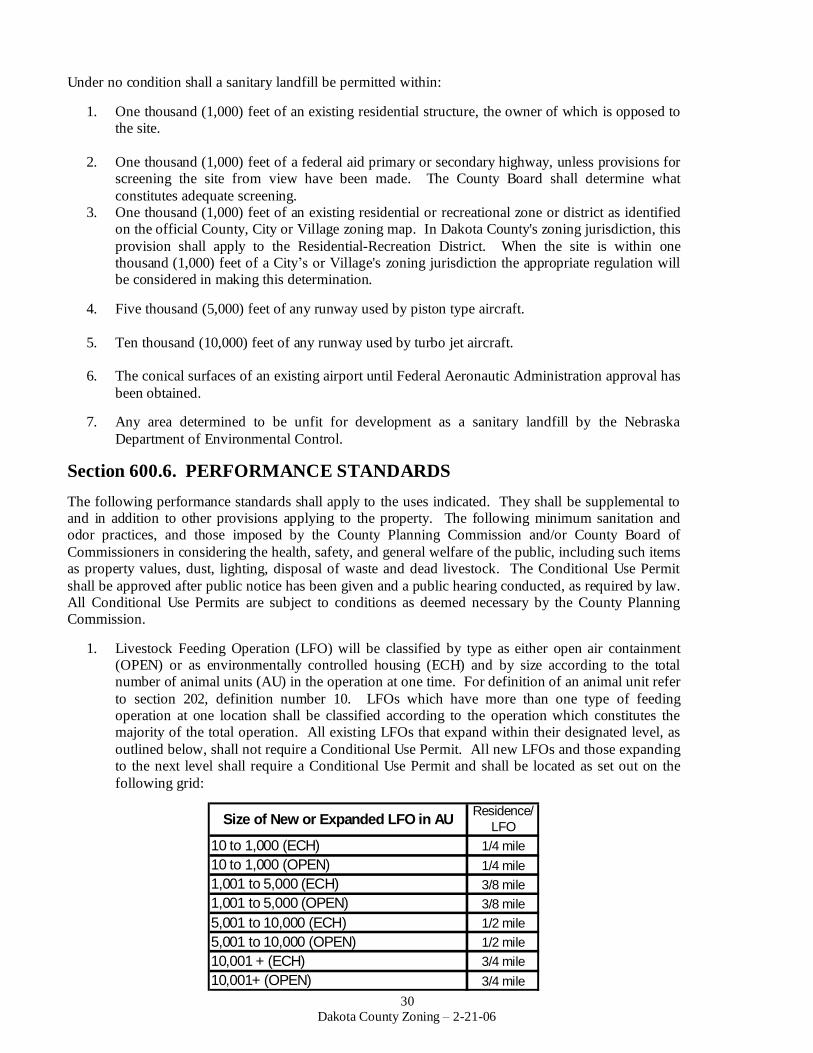
Dakota County Zoning–2-21-0630
Under no condition shall a sanitary landfill be permitted within:
1. One thousand (1,000) feet of an existing residential structure, the owner of which is opposed tothe site.
2. One thousand (1,000) feet of a federal aid primary or secondary highway, unless provisions forscreening the site from view have been made. The County Board shall determine whatconstitutes adequate screening.
3. One thousand (1,000) feet of an existing residential or recreational zone or district as identifiedon the official County, City or Village zoning map. In Dakota County's zoning jurisdiction, thisprovision shall apply to the Residential-Recreation District. When the site is within onethousand (1,000) feet of a City’s or Village's zoning jurisdiction the appropriate regulation willbe considered in making this determination.
4. Five thousand (5,000) feet of any runway used by piston type aircraft.
5. Ten thousand (10,000) feet of any runway used by turbo jet aircraft.
6. The conical surfaces of an existing airport until Federal Aeronautic Administration approval hasbeen obtained.
7. Any area determined to be unfit for development as a sanitary landfill by the NebraskaDepartment of Environmental Control.
Section 600.6. PERFORMANCE STANDARDS
The following performance standards shall apply to the uses indicated. They shall be supplemental toand in addition to other provisions applying to the property. The following minimum sanitation andodor practices, and those imposed by the County Planning Commission and/or County Board ofCommissioners in considering the health, safety, and general welfare of the public, including such itemsas property values, dust, lighting, disposal of waste and dead livestock. The Conditional Use Permitshall be approved after public notice has been given and a public hearing conducted, as required by law.All Conditional Use Permits are subject to conditions as deemed necessary by the County PlanningCommission.
1. Livestock Feeding Operation (LFO) will be classified by type as either open air containment(OPEN) or as environmentally controlled housing (ECH) and by size according to the totalnumber of animal units (AU) in the operation at one time. For definition of an animal unit referto section 202, definition number 10. LFOs which have more than one type of feedingoperation at one location shall be classified according to the operation which constitutes themajority of the total operation. All existing LFOs that expand within their designated level, asoutlined below, shall not require a Conditional Use Permit. All new LFOs and those expandingto the next level shall require a Conditional Use Permit and shall be located as set out on thefollowing grid:
10 to 1,000 (ECH) 1/4 mile10 to 1,000 (OPEN) 1/4 mile1,001 to 5,000 (ECH) 3/8 mile1,001 to 5,000 (OPEN) 3/8 mile5,001 to 10,000 (ECH) 1/2 mile5,001 to 10,000 (OPEN) 1/2 mile10,001 + (ECH) 3/4 mile10,001+ (OPEN) 3/4 mile
Size of New or Expanded LFO in AUResidence/
LFO
Dakota County Zoning–2-21-0631
a. The distance requirements may be decreased or waived by a waiver signed by all ofthe property owners of non-farm residences or other residences not on the owner’s property within the distances specified. The property owners shall sign a waiver on aform provided by the County Zoning Administrator which consent shall beacknowledged before a Notary Public and filed in the office of the Dakota CountyClerk. The waiver, when filed, shall be evidence of the property owner’s consent to the decrease and/or waiver of the required setback distances as described in theseregulations. Provided, however, waivers involving LFOs of 5,001 AU or more mustalso be approved by the County Planning Commission.
b. LFOs having up to 1,000 AUs shall locate 2,640 feet from a platted residential areaand LFOs having more than 1,000 AUs shall locate at least one (1) mile from aplatted residential area.
2. Conditional Use Permits shall be approved by the County Planning Commission and CountyBoard of Commissioners based upon a proposed site plan and conditions or requirementspending approval of application for a proposed operation and waste disposal plan form theNebraska Department of Environmental Quality (DEQ) or any other applicable State Agency.The applicant shall file a copy of his/her Operation and Maintenance Plan and ManureManagement Plan as filed with the DEQ with the County Zoning Administrator, and shall alsofile a copy of all approved DEQ plans and permits with the County Zoning Administratorwithin thirty (30) days after they are issued by the DEQ.
3. LFOs shall maintain drainage so as to avoid excessive concentrations of contaminated waterand such drainage shall be so arranged that contaminated water does not drain into watercourses in a manner which reaches neighboring properties at a concentration noticeable tonormal senses.
4. All dead animals shall be removed within three (3) days or within a reasonable amount of time.
5. In no event shall any manure storage unit or system by constructed in a Flood Plain, asdelineated on the Federal Emergency Management Agency’s Flood Plain map as adopted by Dakota County or where the bottom of the unit or system is either in contact or below theexisting water table where the unit or system is to be constructed. Application of manure indesignated Floodways and flooded areas of standing water shall be prohibited.
6. LFOs shall not be permitted within one thousand (1,000) feet of a federal aid primary orsecondary highway, unless provisions for screening the site from view have been made. TheCounty Planning Commission or County Board of Commissioners shall determine whatconstitutes adequate screening.
7. Parking and loading spaces sufficient to meet all reasonable demands for such space shall beprovided off the public right-of-way.
Dakota County Zoning–2-21-0632
Section 610. AR, AGRICULTURAL-RESIDENTIAL DISTRICT
Purpose
The AR, Agricultural-Residential District is designed to provide an environment in which agriculturecan operate compatibly with a greater density of population than normally found in farming areas.These regulations are intended to encourage the continued use of land that is suitable for agriculture, butlimit the land uses that may be a detriment to the efficient pursuit of agricultural production.
Section 610.1. PRINCIPAL PERMITTED USES
The following uses are permitted as the principal permitted use of any parcel of property in the AR,Agricultural-Residential District:
1. Agriculture, including the raising of crops and horticultural uses but excluding stock yards, feedyards and LFOs.
a. All use of farm chemicals, including application of pesticides and herbicides, shall begoverned by State Agencies and applicants using restricted-use pesticides shall berequired to be certified as required by law.
2. Ranch and farm dwellings and normal farm and ranch buildings.
3. Single family dwellings.
4. Public parks and recreation areas, playgrounds, swimming pools, community centers, andconservation areas.
5. Facilities necessary for the provision of transportation, communication, water, sewerage,electrical energy, and natural gas pipelines and their necessary appurtenances.
6. Feeding and raising of farm animals, including livestock, not to exceed a concentration of two(2) animal units per acre. Farm animals and livestock shall be located no closer than fivehundred (500) feet from the lot line when adjoining property is used for residential, motel, hotel,or cabin resort purposes.
Section 610.2. ACCESSORY USES
The following uses are permitted as accessory uses to the principle permitted uses in the AR,Agricultural-Residential District:
1. Facilities common to farm and ranch activities.
2. Living quarters for persons regularly employed on the premises, but not including labor campsor dwellings for transient labor.
3. Private garages, private swimming pools and other recreational facilities in conjunction with aresidence.
4. Home occupations.
5. Signs not over twelve (12) square feet in area identifying the occupants of the activity engagedin on the premises and provided there is not over two (2) square feet of extraneous advertisingmatter on any such sign.

Dakota County Zoning–2-21-0633
Section 610.3. CONDITIONAL USES
The following uses are permitted in the AR, Agricultural Residential District after a finding by theCounty Planning Commission that their mode of conduct and location will not hinder the enjoymentand use of nearby properties and will not disrupt the appropriate use of land and resources of theCounty:
1. Riding academies, dude ranches and other farm and ranch type recreational enterprises, golfcourses, country clubs, including hunting preserves, sporting clays courses, trap shooting rangesand other hunting enterprises, but not including automotive race tracks, golf driving ranges,outdoor theaters and similar commercial recreation enterprises.
2. Single family residences including mobile homes for relatives of consanguinity and marriageprovided that only one such dwelling is allowed per five (5) acres. Mobile homes placed in thismanner are subject to the provisions of Section 800.2 of this regulation, are to be consideredtemporary only, and must be removed upon the death or departure of the relative. Thisconditional use also requires filing an annual consanguinity permit with the County.
3. Mobile homes to be used as temporary residences for families waiting to move into a permanentdwelling on the same parcel of property, while the permanent dwelling is under construction orreconstruction. The mobile home and permanent dwelling may not be occupied at the sametime. Mobile homes placed in this manner are subject to additional restrictions 2 and 3 ofSection 800.2 of this regulation. This conditional use also requires filing an annualconsanguinity permit with the County.
4. Recreational camps owned or operated by government, private individuals, or by charitable orreligious organizations.
5. Agricultural service establishments primarily engaged in performing agricultural, animalhusbandry or horticultural services on a fee or contract basis. These services include cornshelling, hay bailing, thrashing, milling, processing, plant nurseries, landscaping, crop dusting,grain cleaning, land leveling, harvesting, plowing, farm equipment service and repair, veterinaryservices (animal hospitals or clinics), and commercial auctions. Other services include bulkstorage of petroleum products, fertilizer and insecticide for distribution or direct sales toagricultural consumers, boarding and training of horses, and wood chip factories.
6. Churches, schools, colleges and similar facilities.
7. Recycling centers
8. Public and private campgrounds pursuant Section 640.5.
9. Bike and pedestrian pathways.
10. Cemeteries, crematories, mausoleums, provided structures shall be located at least 500 feet fromall property lines.
11. Radio, television, and transmission towers.
12. Kennels.

Dakota County Zoning–2-21-0634
Section 610.4. SPACE LIMITS
The following space limitations shall apply to structures and buildings associated with each principlepermitted use and each accessory use, except fences and signs:
1. Minimum site area for a dwelling: Five (5) acres for each dwelling unit if lots have legal accessto an existing full service County gravel road, as defined in the authorized Dakota County 1989Road and Bridge inventory.
2. Minimum setback and front yard: Ninety (90) feet measured from the center line of each andevery road or fifty (50) feet from the property line, whichever is greater.
3. Minimum setback and yard space, other yards: Ninety (90) feet measured from the center lineof each and every road or fifty (50) feet from the property line, whichever is greater.
4. Distance from livestock feeding operation: Residential structures must follow the setbackstandards established in Section 600.6 of these regulations unless the structure is part of thefarming operation of which the LFO is a part.
5. Minimum lot and setback requirement for conditional uses: The minimum lot requirement forconditional uses will be established by the County Planning Commission during applicationreview. The minimum lot required shall be five (5) or more acres.
6. Kennels containing more than three dogs over six months of age shall be placed no closer thantwo hundred (200) feet from the lot line when adjoining property is used for residential, motel,hotel or cabin resort purposes.
7. All uses established in this zoning district shall provide parking and loading space off the publicright-of-way in sufficient quantity to accommodate the normal activities of such uses.
Dakota County Zoning–2-21-0635
Section 640. R-R, RESIDENTIAL-RECREATION DISTRICT
Purpose
The R-R, Residential-Recreation District is designed to promote and protect the most desirable types ofdevelopment bordering the Missouri River and other natural resources. This district is designed toprotect water quality and natural or cultural resources while allowing residential development, limitedagricultural uses, and recreational activities.
Section 640.1. PRINCIPALY PERMITTED USES
The following uses are permitted as the principal; permitted use of any parcel of property in the RC,Recreation Facility District:
1. Any principal permitted use enumerated in the AR, Agricultural-Residential District whenestablished in accordance with all of the requirements set forth for that zone includingperformance standards, except that residential facilities shall be established in accordance withthe provisions of this District.
Section 640.2. ACCESSORY USES
The following uses are permitted as accessory uses to the principal permitted uses in the R-R,Residential-Recreation District:
1. Private garages and parking areas serving a permitted principal use.
2. Private swimming pools.
3. Storage structures serving a permitted principal use.
4. Signs indicating the recreation area not exceeding sixty (60) square feet.
Section 640.3. CONDITIONAL USES
The following uses are permitted in the R-R, Residential-Recreation District after a finding by theCounty Planning Commission that their mode of conduct and location will not hinder the enjoyment anduse of nearby properties and will not discount the appropriate use of land and resources of the County:
1. Public and quasi-public uses of an educational, recreational or religious type including publicand parochial elementary schools, junior high schools, high schools, and colleges, churches,nursery schools, private non-profit schools and colleges, parsonages and other religiousinstitutions, public parks and public playgrounds.
2. Marinas, including docks, launching facilities, boat storage sheds, boat and marina repairfacilities, convenience goods stores, and restaurants.
3. Motels, hotels, or cabin resorts including restaurants and other facilities normally appurtenantthereto.
4. Public and private charitable institutions.
Dakota County Zoning–2-21-0636
5. Public uses of an administrative, public service or cultural type including city, county, state orfederal administrative centers and courts, libraries, museums, art galleries, police and firestations and other public buildings, structures and facilities.
6. Riding academies, dude ranches and other farm and ranch type recreational enterprises, golfcourses, country clubs, including hunting preserves, sporting clays courses, trap shooting rangesand other hunting enterprises, but not including automotive race tracks, golf driving ranges,outdoor theaters and similar commercial recreation enterprises.
7. Facilities necessary for the provision of transportation, communication, water, sewerage,electrical energy, and natural gas pipelines and their necessary appurtenances.
8. Home occupations.
9. Recreational vehicle parks pursuant to Section 640.5
Section 640.4. SPACE LIMITS
The following space limitations shall apply to structures and buildings comprising each principalpermitted use and each accessory use, except fences and signs:
1. Minimum site area for a dwelling is ten thousand (10,000) square feet. All applicable on-sitewater and waste disposals regulations of the State of Nebraska shall be met.
Section 640.5. RECREATIONAL VEHICLE PARKS
The following guidelines shall apply to all recreational vehicle parks both public and privately owned.The County Planning Commission may require other conditions be met to ensure that the enjoyment anduse of nearby properties is not disturbed or hindered and that the environment and aesthetics of the areais not threatened. The Commission must also make sure that the adverse impacts between a recreationalvehicle park and surrounding land uses are minimized.
Privately owned and operated recreational vehicle parks, shall submit a plan of operation or parkguidelines to the Commission for review. The plan of operation or guidelines shall be given to all parkoccupants and posted in a highly visible public area for all park occupants to view.
No person shall construct or expand any recreational vehicle park unless they hold a valid permit issuedby the County Planning Commission in the name of such person for the specific purposed construction,alteration or extension. All applicable permits or documentation of meeting the guidelines mentioned inthis section must be presented to the County Planning Commission before park operation or occupationwill be allowed.
No person shall operate any recreational vehicle park unless they hold a valid license issued annually bythe County Planning Commission in the name of such person for the specific recreational vehicle park.
Every person holding a license shall give notice in writing to the County Planning Commission withintwenty-four (24) hours of having sold transferred, given away, or otherwise disposed of interest in orcontrol of any recreational vehicle park. Such notice shall include the name and address of the personsucceeding in ownership or control of such recreational vehicle park. Upon receiving written notice oftransfer, the license shall be transferred if the recreational vehicle park complies with all applicableprovisions of this ordinance.
Dakota County Zoning–2-21-0637
Definitions
1. Recreational Vehicle: A motor home, travel trailer, truck camper, or camping trailer with orwithout motive power designed for human habitation for recreational or emergency occupancy.This shall not include mobile or modular homes. Vehicles shall not exceed forty-five (45) feetin length and shall not exceed one hundred two (102) inches in width.
2. Recreational Vehicle Park: Any property where one or more lots are rented or leased to usersof recreational vehicles and which are occupied for temporary purposes.
3. Camping Party: A person or group of persons occupying any site within a park.
4. Public: Refers to a recreational vehicle park owned and operated by a government bodylocated in the county.
5. Private: Refers to a recreational vehicle park owned and operated by an individual or group.
Site Plan Requirements
1. A site plan of the proposed park, prepared at a scale of not less than 1" = 100', shall besubmitted with an application for a conditional use permit for review and consideration by theCounty Planning Commission.
2. All drainage and public utility facilities shall be shown and proposed methods of storm waterremoval; waste removal; and water distribution shall be stated on the plan.
3. All points of ingress and egress must clearly be shown.
4. All provisions of the Dakota County Zoning Ordinances not in conflict shall apply.
Occupancy
Occupancy of each site is limited to one (1) recreational vehicle, two (2) automobiles or truck, and one(1) miscellaneous recreational vehicle including but not limited to boats and all-terrain vehicles,accommodating one camping party. Recreational vehicle parks shall be allowed to operate from Aprilthrough October in a calendar year, being closed for the remainder of the year. Private recreationalvehicle parks may establish their own times of operation, but they must fall between the months of Aprilthrough October each year. Recreational vehicle parks must close and all vehicles must be removedfrom the grounds by October 31 of each year and shall open no earlier than April 1 of each year. Nopermanent or year around occupancy is allowed in recreational vehicle parks.
Tent camping shall be allowed in recreational vehicle parks. No more than two (2) tents shall be allowedon each lot. Tent camping shall be allowed under the same date guidelines stated above for recreationalvehicles.
Portable storage sheds are permitted in recreational vehicle parks. All sheds shall be constructed ofwood products, painted and have asphalt shingled roofs. Sheds shall not exceed one hundred twenty(120) total square feet. Sheds must be portable and removed under the same guidelines for removal asrecreational vehicles.
Design Standards
1. Park size: Minimum shall be five (5) acres, maximum shall be twenty (20) acres.
2. Minimum lot size: Fifty (50) feet in width by one hundred (100) feet in length.
Dakota County Zoning–2-21-0638
3. Minimum setbacks:a. Interior road: Ten (10) feet.
b. Public street, road, or highway: Fifty (50) feet from right of way.
c. The distance from any residential area shall be five hundred (500) feet. This setbackshall be an open space and is not to be used for any recreational activities. Inaddition, a five (5) foot strip of land adjacent to any residential area shall be plantedwith trees of a species, which will form a screen and act as a noise barrier:
d. Recreational vehicle parks shall be located at least one thousand (1,000) feet fromone another to maintain the aesthetics of the area.
Parking
One visitor parking space shall be provided for every five (5) recreational vehicle sites or fractionthereof. No vehicle parking shall be allowed on any interior roads.
Facilities
1. Recreation: A recreation area of at least five thousand (5,000) square feet shall be allowed in arecreational vehicle camp. Recreation equipment such as a playground, picnic tables, and aservice building including toilets, showers, and laundry can be located within the recreationarea.
2. Sanitation: A minimum of one (1) toilet and one (1) lavatory for each sex shall be provided forthe exclusive use of the park occupants. An additional toilet and lavatory for each sex shall beprovided for each fifteen (15) sites or fraction thereof.
3. A minimum of one (1) shower for each sex is required.
4. Trailer sanitation stations designed to receive the discharge of sewage holding tanks for self-contained vehicles shall be installed in an accessible location in every recreational vehicle parkin which individual sites are not provided with drain or sewage inlets that meet State ofNebraska regulations.
5. Trash containers shall be located within three hundred (300) feet of every recreational vehiclesite and enclosed on three (3) sides with a solid wood or masonry fence six feet in height. Parkowners must make the Commission aware of the arrangements made for trash pick up andremoval from the area to help ensure the aesthetic beauty of the given area. Park owners areresponsible for trash disposal.
Commercial activities: All proposed commercial activities for a recreational vehicle park shall besubmitted to the County Planning Commission for approval. Laundry and vending machine servicesshall be allowed for park occupant and visitor use only. All other commercial activities must beapproved by the Commission.
Recreational Vehicle Site Design Standards
Separation: Recreational vehicle parking pads shall be located to maintain a ten (10) foot separationbetween recreational vehicles.
Landscaping: At least twenty-five percent (25%) of each site shall be landscaped and shall include anon-deciduous tree of at least fifteen (15) gallon size and be indigenous to the area. The trees and otherlandscaping materials must be maintained by park owners.
Dakota County Zoning–2-21-0639
Parking: Each site shall include a parking space for one (1) automobile.
Access: Each site shall have direct access to a main driveway.
Water supply: Any public or private supply of water for domestic purposes shall conform to NebraskaDepartment of Health standards for water quality. Private wells shall be located and designed inaccordance with local and State requirements. Permits or documentation shall be presented to theCommission by park owners/operators.
Sewage disposal: All premises used for human occupancy shall be provided with an approved andadequate method of sanitary sewage disposal which shall be maintained in accordance with acceptablepractices and applicable regulations. The requirements of this paragraph shall be administered andenforced in conjunction with other applicable County and State regulations. All sanitary sewer facilitiesand waste disposal practices shall be subject to the applicable state, county, and city standards, criteria,rules, and regulations. All private and on-site sewage and other sanitary waste disposal systemsincluding septic tanks and soil absorption systems shall be subject to the following:
1. Systems shall conform to applicable standards, criteria, rules, and regulations of the State andCounty with respect to size, construction, use and maintenance.
2. The location and installation of septic tanks and soil absorption systems shall be such that, withreasonable maintain, they will function in a sanitary manner and will not create a nuisance,endanger the quality of any domestic water supply, or pollute or contaminate any public water.Consideration shall be given to the size and shape of the lot, slope of natural and finished grade,soil permeability, high ground water elevation, geology, proximity to existing or future watersupplies, accessibility for maintenance, and possible expansion of the system in determining asuitable: location.
The County Planning Commission shall be provided with the necessary permits and paperwork from theappropriate agencies to show that the above conditions have been met. Park owners are responsible forsewage disposal and removal.
Vegetation: Clear cutting and intensive vegetation clearing shall be prohibited.
Fire: Fire pits or fire rings must be provided in accordance with State and County fire coderegulations. Documentation shall be provided to the Commission that State and/or County codes wouldnot be violated and that surrounding areas are not put into immediate or undue stress from fires.
Speed limits: Reasonable speed limits shall be posted by park owners.
Section 640.6. RC, RECREATION FACILITY ZONE, Purpose.
The RC, Recreation Facility Zone, is designed to promote and protect the most desirable type ofdevelopment bordering reservoirs and other recreational facilities.
PRINCIPAL PERMITTED USES
Section 640.6.1. The following uses are permitted as the principal use of any parcel of property in theRC, Recreation Facility Zone:
1. Any principal permitted use enumerated in the AR, Agricultural-Residential Zone whenestablished in accordance with all of the requirements set forth for that zone includingperformance standards, except that residential facilities may be established in accordance withthe provisions of this zone.
Dakota County Zoning–2-21-0640
ACCESSORY USES
Section 640.6.2. The following uses are permitted as accessory to the principal permitted uses in theRC, Recreation Facility Zone:
1. Any principal permitted use enumerated in the AR, Agricultural-Residential Zone.CONDITIONAL USES
Section 640.6.3. The following uses are permitted in the RC, Recreation Facility Zone after a findingby the County Planning Commission their mode of operation and location will not hinder the enjoymentof nearby properties and will not disrupt the appropriate use of land and resources of the county:
2. Marinas, including docks, launching facilities, boat storage sheds, boat and marine motor repairfacilities, convenience goods store, restaurant.
3. Motels, hotels or cabin resorts including restaurants and other facilities normally appurtenantthereto.
4. Recreational facilities, including riding academies, dude ranches, golf courses, miniature golf,golf driving ranges and similar recreational enterprises; but not including automotive race tracksor driving tracks, outdoor theaters, drive-in eating places and similar enterprises.
SPACE LIMITS Amended October 9, 1979 (Amendment underlined)
Section 640.6.4. The following space limitations shall apply to structures and buildings associated witheach principal permitted use, each conditional use and each accessory use allowed in this zone exceptfences and signs meeting the requirements of the R-IO. Residential, 10,000 Square Foot Zone:
1. Minimum site area for a dwelling which is utilizing both a public water supply and a publicsewer system: ten thousand (10,000) square feet.
2. Minimum lot width for a dwelling which is utilizing both a public water supply and a publicsewer system: seventy (70) feet.
3. Residential lots not served with both public water and sewer systems shall meet the followingarea and width requirements:
a. Every lot served with a public water supply but not served with a public sewersystem shall have a lot area of not less than one (1) acre and a minimum width ofone hundred forty (140) feet.
b. Every lot served with a public sewer system but not served with a public watersystem shall have an area of not less than one (1) acre and a minimum width of onehundred forty (140) feet.
c. Every lot not served with either a public water system or a public sewer systemshall have an area of not less than two (2) acres and a minimum lot width of twohundred (200) feet.
4. Minimum site area for marinas, motels, commercial recreation enterprises and other commercialactivities: twenty thousand (20,000) square feet.
5. Minimum lot width for marinas, motels, commercial recreation enterprises and othercommercial activities: one hundred forty (140) feet.
Dakota County Zoning–2-21-0641
6. Minimum front yard: When land is not platted into urban type lots or when a platted lot adjoinsa state highway or primary county road: ninety (90) feet measured from the center line of eachand every such road or highway.
When land has been platted into urban type lots: thirty (30) feet from the lot line adjoining thefronting street and twenty (20) feet from any lot line adjoining a side street when such streetsare not a state highway or primary county road.
7. Minimum yard space, other yards: One (1) feet removed from, the property line for each foot ofheight of the structure, but in no event: less than ten (10) feet.
Platters of water-front property are urged to record building lines on the waterfront side of eachproperty as may be appropriate to the location.
8. For motels, hotels, cabin resorts and other similar facilities, the lot area per dwelling or sleepingunit shall be two thousand (2,000) square feet. When such dwelling units or sleeping units areconstructed in a line parallel to the waterfront, then the minimum site for each unit shall beseventy (70) feet in width measured parallel to the waterfront.
9. Feed lots, corrals and winter quarters for animals shall follow the performance standards setforth for the AR, Agricultural-Residential Zone.
10. All uses established in this zoning district shall provide parking and loading space off the publicright-of-way in sufficient quantity to accommodate the normal activities of such uses.
Section 650. B, BUSINESS DISTRICT
Purpose.
The B, Business District is designed to provide for the broad range of businesses and commercial usesneeded in the county.
Section 650.1. PRINCIPAL PERMITTED USES
The following uses are permitted as the principal use of any parcel of property in the B, BusinessDistrict:
1. Business services such as banks, insurance agencies, real estate offices, other offices, postalstations, printing, credit services, security brokers, dealers and exchanges, title abstracting,savings and loans, finances services and investment services.
2. Automotive, motorcycle, boat and marine sales, rental and service.
3. Personal services such as barber shops, beauty salons, reducing salons and photographicstudios.
4. Food services, such as eating and drinking establishments.
5. Recreational enterprises such as bowling alleys, dance halls, skating rinks, theaters, drive-intheaters, assembly halls, miniature golf courses, golf courses, golf driving ranges and billboardsand advertising signs.
6. Equipment sales and service such as radio and television shops, business machines, musicalinstrument shops, sewing machines, plumbing and heating and electrical fixtures.
Dakota County Zoning–2-21-0642
7. Farm equipment, implement sale or repair, and service.
8. Hotels, motels, lodging houses, hospitals, or clinic for human or animals, funeral homes ormortuaries.
9. Cocktail lounges and taverns.
10. Garden and lawn centers.
11. Cleaning establishments such as laundromats, dry cleaning and laundries using nonflammablesolvents.
12. Gasoline service stations.
13. Medical and dental clinics.
14. Public buildings, assembly halls, auditoriums and civic centers.
15. Retail stores such as food markets, delicatessens, bakeries, candy stores, fruit and vegetablestores; department stores, and drug stores; books and stationary shops, newspaper distributionfacilities; hobby, floor, camera, sporting goods stores, dry goods, household appliance stores,home furnishing stores, and hardware stores; jewelry and variety stores; retail mail order stores,confectioneries, and retail dairy stores; radio, electronics and music stores; retail liquor,antiques, cigar and tobacco stores; and retail paint stores.
16. Self-storage and mini-storage units.
17. Facilities necessary for the provision of transportation, communication, water, sewage,electrical energy, and natural gas pipelines and their necessary appurtenances.
18. Other business establishments similar to, or included within, the general classifications listedabove.
Section 650.2. PERMITTED ACCESSORY USES
The following uses are permitted as accessory to the principal permitted uses in the B, Business District:
1. Uses, buildings and structures normally appurtenant to the enumerated principal permitted uses.
Section 650.3. CONDITIONAL USES
The following uses are permitted in the B, Business District after a finding by the County PlanningCommission that their mode of conduct and location will not hinder the enjoyment and use of nearbyproperties and will not discount the appropriate use of land and resources of the County:
1. Farm store or feed store including storage of liquid or solid fertilizer.
2. Radio, television and communications towers and transmitters.
3. Residences in conjunction with the principal use.
Dakota County Zoning–2-21-0643
Section 650.4. SPACE LIMITS
The following space limitations shall apply to all structures and buildings associated with each principalpermitted, accessory, and conditional use allowed in this district, except fences and signs:
1. Minimum site area: The minimum lot size shall be ten thousand (10,000) square feet.
2. Minimum site area for business: Twenty Thousand (20,000) square feet, provided that morethan one enterprise may be located on one site.
3. Minimum front yard: When land is not platted into urban type lots or when a platted lot adjoinsa state highway or primary county road: ninety (90) feet measured from the center line of eachand every such road or highway or fifty (50) feet from the property line, whichever is greater.
4. When land has been platted into urban type lots: thirty (30) feet from the lot line adjoining thefronting street and twenty (20) feet from any lot line adjoining a side street when such streetsare not a state highway or primary county road.
5. Minimum yard space, other yards: No minimum side yard is required unless abutting a zonerequiring a side yard, then the minimum side yard shall be ten (10) feet. A minimum side yardof twenty (20) feet is required for any street side yards.
6. All uses established in this zoning district shall provide parking and loading space off the publicright-of-way in sufficient quantity to accommodate the normal activities of such uses.
Dakota County Zoning–2-21-0644
Section 660. HSB, HIGHWAY SERVICE BUSINESS DISTRICT
Purpose
The HSB, Highway Service Business District is designed to provide for the effective use of landsituated in relationship to major highways and highway interchanges so efficient grouping of activitiescan develop to serve the traveling public.
Section 660.1. PRINCIPAL PERMITTED USES
The following uses are permitted as the principal use of any parcel of property in the HSB, HighwayService Business District:
1. Motels and motor hotels designed for accommodation of the traveling public, and includingswimming pools, children's play yards, golf putting greens and similar uses when they are a partof said motel or motor hotel developments.
2. Restaurants and eating places, provided however, that no such establishment shall be operatedas a restaurant or eating place in which more than half of the gross receipts are derived from thesale of liquor, mixed drinks, beer or other intoxicating beverages. Taverns, bars, cocktaillounges, and similar establishments which require licensing for the dispensing of alcoholicbeverages shall be prohibited except as a part of and located in the same building as a restaurantor eating place specified above. A tavern, bar or cocktail lounge need not be located in thesame building as a restaurant in the overall design of a motel or motor hotel when such tavern,bar or cocktail lounge is less than ten (10) percent of the floor area of said motel or motor hoteland is not located on the front or highway side of such motel or motor hotel complex.
3. Automobile service stations which do not conduct major automobile repairs, body and fenderwork, or automobile painting and at which all used and waste materials are kept within a solidenclosure so that the contents are not visible from a street, highway, interstate highway or otherproperties. Gasoline pumps and other facilities shall be considered as structures and shall not belocated within a required yard space.
4. Self-operated vending devices, provided such devices shall be placed for operation and storedbehind the building line specified herein for conventional structures.
5. Drive-in configurations of any business otherwise permitted in this district, provided, that anysuch establishment shall provide adequate off-street space for the maneuvering and storage ofpatrons' vehicles, and further provided that there be a sturdy, close woven or solid fence suitablefor the retaining of any discarded paper or other material on all sides of the parking area exceptthe front, and provided no music or loud speaker system shall be installed or operated that canbe heard at neighboring residential, motel or motor hotel properties, and providing all lightingshall be directed and shielded so as to light only the property of such establishment.
6. Light retail establishments such as apparel, drug, variety, florist, gift, grocery, jewelry, smallappliance, bakery, dairy.
7. Light service establishments such as tailor, dressmaker, barber, beauty shop, self-servicelaundry and dry cleaning.
8. Commercial recreation facilities such as billiards, putt-putt golf, children’s play areas, swimming pools and amusement parks.
Dakota County Zoning–2-21-0645
9. Facilities necessary for the provision of transportation, communication, water, sewage,electrical energy, and natural gas pipelines and their necessary appurtenances.
10. Other business establishments similar to, or included within, the general classifications listedabove.
11. Signs and Billboards.
Section 660.2. ACCESSORY USES
The following uses are permitted as accessory to the principal permitted uses in the HSB, HighwayService Business District:
1. Uses normally appurtenant to the principal permitted uses enumerated in this district.
Section 660.3. CONDITIONAL USES
The following uses are permitted in the HSB, Highway Service Business District after a finding by theCounty Planning Commission that their mode of conduct and location will not hinder the enjoyment anduse of nearby properties and will not discount the appropriate use of land and resources of the County:
1. Residences in conjunction with a principal use.
2. Radio, television and communications towers and transmitters.
Section 660.4. SPACE LIMITS
The following space limitations shall apply to structures and buildings associated with each principalpermitted use and each accessory use allowed in this district except fences and signs:
1. Minimum site area: The minimum lot size shall be ten thousand (10,000) square feet.
2. Minimum site area for business: Twenty Thousand (20,000) square feet, provided that morethan one enterprise may be located on one site.
3. Minimum front yard: When land is not platted into urban type lots or when a platted lot adjoinsa state highway or primary county road: ninety (90) feet measured from the center line of eachand every such road or highway. When land has been platted into urban type lots: thirty (30)feet from the lot line adjoining the fronting street and twenty (20) feet from any lot lineadjoining a side street when such streets are not a state highway or primary county road.
4. Minimum yard space, other yards: One (1) foot removed from the property line for each foot ofheight of the structure, but in no event less than ten (10) feet.
5. All uses established in this zoning district shall provide parking and loading space off the publicright-of-way in sufficient quantity to accommodate the normal activities of such uses.
Section 660.5. OTHER APPLICABLE PROVISIONS
When a property owner or his/her developer intends to develop a property already zoned or requiring re-zoning to the HSB, Highway Service Business District, they shall file, together with the building permitapplication or re-zoning application, a detailed Site Development Plan and such other drawings,calculations, sketches or diagrams that provide reasonable and adequate information on the location,
Dakota County Zoning–2-21-0646
size and use of the buildings; and the location, size, arrangement and capacity of highway frontageroads, parking, loading and unloading areas. Vehicular access to existing streets and highways shall beclearly indicated. Vehicular and pedestrian traffic generated to and from the proposed developmentshall not create undue hazards to the normal traffic movement on the existing streets and highways.These plans and documents shall become a part of the application and shall form the basis for theissuance of a building permit and/or approval of the re-zoning. Plan changes that change the vehicularaccess drives, parking layout, building size or location, frontage roads, loading and unloading areas shallrequire a re-submission and shall make the existing re-zoning or building permit invalid.
Dakota County Zoning–2-21-0647
Section 670. LM, LIGHT MANUFACTURING DISTRICT
Purpose
The LM, Light Manufacturing District is designed to provide for a wide range of commercial andindustrial uses, all of which shall be able to meet comparatively rigid specifications as to nuisance freeperformance. The district specifically excludes residences on the theory that the mixture of residentialuse and public services and facilities for residences, with those of industry is contrary to the purposes ofthese regulations irrespective of whether the industry is encroaching on a living area or a living area isencroaching on an industrial area.
Section 670.1. PRINCIPAL PERMITTED USES
The following uses are permitted as the principal use of any parcel of property in the LM, LightManufacturing District:
1. Any use allowed in the B, Business District, all dwellings and other types of livingaccommodations shall be prohibited save that one quarter for a watchman or caretaker shall bepermitted as an accessory use for any permitted use occupying more than twenty thousand(20,000) square feet of lot area.
2. Any business, commercial or industrial use which can meet the performance standards set forthfor this district but not specifically excluded or specifically mentioned as belonging in anotherless restrictive district.
3. Agriculture, including the raising of field crops, horticulture and animal husbandry. LivestockFeeding Operation’s (LFO’s), poultry farms, farms and kennels shall be allowed when suchactivities shall meet the performance standards set forth for this district. LFO’s shall also meet the requirements established for them in Section 600.5.
Section 670.2. SPECIFICALLY EXCLUDED USES
The following uses are hereby declared incompatible with the purpose of the LM, Light ManufacturingDistrict and are hereby expressly excluded:
1. Dwellings except caretaker and watchmen's quarters as set forth herein.
2. Public, parochial and private schools and colleges, except trade schools.
3. Hospitals, clinics, nursing or convalescent homes, group homes, and other institutions for thehousing or care of human beings.
4. Motels, hotels and mobile home parks.
5. Any use not enumerated as permitted in this zone but which is specifically provided for inanother district or districts.
Section 670.3. PERMITTED ACCESSORY USES
Any accessory use normally appurtenant to a use permitted in this district shall be allowed providedsuch use shall conform with all performance standards set forth for this district.
Dakota County Zoning–2-21-0648
Section 670.4. CONDITIONAL USES
The following uses are permitted in the LM, Light Manufacturing District after a finding by the CountyPlanning Commission that their mode of conduct and location will not hinder the enjoyment of nearbyproperties and will not disrupt the appropriate use of land and resources of the County:
1. Recreational uses which are temporary in nature and do not involve any appreciable amount offixed construction and which will not interfere with the efficient functioning of the district forits primary purpose of providing for manufacturing and heavy commercial establishments.
Section 670.5. PERFORMANCE STANDARDS
The following performance standards shall be met by each and every use established in this district:
1. Physical Appearance: All operation shall be carried on within an enclosed building except thatnew materials or equipment in operable condition may be stored in open. Normal daily wastesof an inorganic nature may be stored in containers not in a building when such containers arenot readily visible from the street. The provisions of this paragraph shall not be construed toprohibit the display of merchandise or vehicles for sale or the storage of vehicles, boats, farmmachinery, trailers, mobile homes or similar equipment when in operable condition.
2. Fire Hazard: No operation shall involve the use of highly flammable gases, acid, liquids,grinding processes or other inherent fire hazards. This provision shall not be construed toprohibit the use of normal heating fuels, motor fuels and welding gases when handled inaccordance with other resolutions of Dakota County or the Laws of the State of Nebraska.
3. Noise: No operation shall be carried on which involves noise in excess of the normal trafficnoise of the adjacent street at the time of the daily peak hour of traffic volume. Noise shall bemeasured at the property line and when the level of such noise cannot be determined byobservation with the natural senses, a suitable instrument may be used and measurement mayinclude breakdowns into a reasonable number of frequency ranges. All noises shall be muffledso as not to be objectionable due to intermittence, beat frequency, or shrillness. All noise orsound levels shall be within the levels prescribed under the Nebraska Environmental Standardsadministered by the Nebraska Department of Environmental Quality.
4. Sewage and Liquid Wastes: No operation shall be carried on which involves the discharge intoa sewer, watercourse or the ground of liquid wastes of any radioactive nature, or liquid wastesof a chemical nature which are detrimental to normal sewage plant operation or corrosive anddamaging to sewer pipes and installations. The final approval and the permit issued by theNebraska Department of Environmental Quality indicating that the proposed use meets theNebraska Environmental Standards will be required before construction will be allowed.
5. Air Contaminants: The final approval and permit issued by the Nebraska Department ofEnvironmental Quality indicating the proposed use meets the Nebraska EnvironmentalStandards will be required before construction will be allowed.
a. Air contaminants and smoke shall be less dark than designated Number One on theRingleman Chart as published by the United States Bureau of Mines, except thatsmoke of a density designated as Number One shall be permitted for one four (4)minute period in each one-half hour. Light colored contaminants of such an opacityas to obscure an observers view to a degree equal to or greater than the aforesaidshall not be permitted.
b. Particulate matter or dust as measured at the point of emission by any generallyaccepted method shall not be emitted in excess of two tenths grains per cubic foot
Dakota County Zoning–2-21-0649
as corrected to a temperature of five hundred (500) degrees Fahrenheit except for aperiod of four (4) minutes in any one-half hour, at which time it may equal but notexceed six-tenths grains per cubic foot as corrected to a temperature of five hundred(500) degrees Fahrenheit.
c. Due to the fact that the possibilities of air contamination cannot reasonably becomprehensively covered in this section there shall be applied the general rule thatthere shall not be discharged from any sources whatsoever such quantities of aircontaminants or other material in such quantity as to cause injury, detriment,nuisance or annoyance to any considerable number of persons or to the public ingeneral or to endanger the comfort, repose, health or safety of any suchconsiderable number of persons or to the public in general or to cause or have anatural tendency to cause injury or damage to business, vegetation or property.
6. Odor: The emission of odors that are generally agreed to be obnoxious to any considerablenumbers of persons shall be prohibited. Observations of odor shall be made at the property lineof the establishment causing the odor. As a guide to classification of odor, it shall be deemedthat strong odors of putrefaction and fermentation tend to be obnoxious and that such odors asassociated with baking or the roasting of nuts and coffee shall not normally be consideredobnoxious within the meaning of these regulations.
7. Gases: The gases sulfur dioxide and hydrogen sulfide shall not exceed five (5) parts permillion, and carbon monoxide shall not exceed five (5) parts per million. All measurementsshall be taken at the zoning lot line.
8. Vibration: All machines, including punch presses and stamping machines, shall be mounted asto minimize vibration and in no case shall such vibration exceed a displacement of three-thousandths of an inch measured at the zoning lot line. The use of steam or broad hammersshall not be permitted in this district.
9. Glare and Heat: All glares, such as welding arcs and open furnaces, shall be shielded so thatthey shall not be visible from the zoning lot line. No heat from furnaces or processingequipment shall be sensed at the zoning lot line to the extent of raising the temperature of air ormaterials more than five (5) degrees Fahrenheit.
Section 670.6. SPACE LIMITS
The following space limitations shall apply to structures and buildings associated with each principalpermitted use and each accessory use allowed in this district, except fences and signs:
1. The space limits for this district shall be the same as those set forth herein for the B, BusinessDistrict.
Dakota County Zoning–2-21-0650
Section 680. HM, HEAVY MANUFACTURING DISTRICT
Purpose
The HM, Heavy Manufacturing District is intended to provide for the widest range of industrialoperations permitted in the County. It is the district for location of those industries which have notreached a technical stage in processing which renders them free of nuisance factors or where economicsprecludes construction and operation in a nuisance free manner.
Section 680.1. PRINCIPAL PERMITTED USES
The following uses are permitted as the principal use of any parcel of property in the HM, HeavyManufacturing District:
1. Any use permitted in the LM, Light Manufacturing District and any use which can meet theperformance standards for this district, except as herein modified.
2. The following uses shall be allowed only in this district:
a. Trucking terminals containing in excess of four (4) loading or transfer bays.
b. The storage above ground of liquid petroleum products or chemicals of aflammable or noxious nature when more than one hundred fifty thousand (150,000)gallons are stored on one zoning lot of less than an acre in size or when more thantwenty five thousand (25,000) gallons are stored in one tank.
c. The storage of flammable or noxious gases above or below ground in excess of fivemillion (5,000,000) cubic feet on any one zoning lot of less than one acre or twomillion (2,000,000) cubic feet in any one tank.
d. Meat packing, slaughtering, eviscerating and skinning.
e. Poultry killing, plucking and dressing when such operations are of such size as toemploy in excess of three (3) persons.
f. Rendering of by-products of slaughtering and killing of animals or poultry.
g. Yards for the sale, transfer and temporary holding of livestock.
h. Junk yards, auto parts salvage and auto wrecking yards when such operations areobscured from any street or from any adjacent property in another district by asturdy, sight obscuring fence in good repair, and under the condition that anyburning operations be carried on in an enclosed structure provided with such super-heating devices designed to assist complete combustion as may be approved by theBuilding Inspector.
Section 680.2. SPECIFICALLY EXCLUDED USES
The following uses are hereby declared incompatible with the purpose of the HM, Heavy ManufacturingDistrict and are hereby expressly excluded:
1. Any use which cannot meet the performance standards set forth herein.
Dakota County Zoning–2-21-0651
2. Dwellings, except caretaker and watchmen's quarters as set forth in the provisions of the LM,Light Manufacturing District.
3. Schools and colleges, except trade schools.
4. Hospitals, clinics, rest homes and other institutions for the housing or care of human beings,except that medical facilities accessory to any industrial operation shall be permitted.
5. Motels, hotels and mobile home parks.
Section 680.3. PERMITTED ACCESSORY USES
Any accessory use normally appurtenant to a use permitted in this district shall be allowed providedsuch use shall conform to all performance standards set forth for this district.
Section 680.4. CONDITIONAL USES
The following uses are permitted in the HM, Heavy Manufacturing District after a finding by theCounty Planning Commission that their mode of conduct and location will not hinder the enjoyment ofnearby properties and will not disrupt the appropriate use of land and resources of the County:
1. Recreational uses which are temporary in nature and do not involve any appreciable amount offixed construction and which will not interfere with the efficient functioning of the district forits primary purpose of providing for manufacturing and heavy commercial establishments.
Section 680.5. PERFORMANCE STANDARDS
The following performance standards shall be met by each and every use established in this district:
1. Appearance: Junk, salvage, auto wrecking and similar operations shall be shielded from viewfrom streets and from adjacent properties in another district by means of a sturdy, sight-obscuring fence in good repair.
2. Fire Hazard: All flammable substances involved in any activity established in this district shallbe handled in conformance with the standards of the National Board of Fire Underwriters andany additional regulations of Dakota County or the State of Nebraska.
3. Noise: All noises and noise causing activities shall be muffled so that they will not create adisturbance greater than normal peak hour traffic noise on a major street when observed fromany area district. Major street noise for comparison purposes shall be measured on the primaryState highway nearest the industry. All noise or sound levels shall be within the levelsprescribed under the Nebraska Environmental Standards administered by the NebraskaDepartment of Environmental Quality.
4. Sewage and Liquid Wastes: No operation shall be carried on which involves the discharge intoa sewer, watercourse or the ground of liquid wastes of any radioactive nature, or liquid waste ofa chemical nature which are detrimental to normal sewage plant operation or corrosive anddamaging to sewer pipes and installations. The final approval and the permit issued by theNebraska Department of Environmental Quality indicating that the proposed use meets theNebraska Environmental Standards will be required before construction will be allowed.
5. Air Contaminants:
Dakota County Zoning–2-21-0652
a. Air contaminants and smoke shall be less dark than designated number 2 on theRingleman Chart as published by the United States Bureau of Mines, except thatsmoke of a density designated as number 2 shall be permitted for one four (4)minute period in each one-half (1/2) hour. Light colored contaminants of suchopacity as to obscure an observer's view to a degree equal to or greater than theaforesaid shall not be permitted.
b. Particulate matter or dust measured at the point of emission by any generallyaccepted method shall not be emitted in excess of two-tenths grains per cubic footas corrected to a temperature of five hundred (500) degrees Fahrenheit.
c. Due to the fact that the possibilities of air contaminants cannot be comprehensivelycovered in this section there shall be applied the general rule that there shall not bedischarged from any source whatsoever such quantities of air contaminants or othermaterial in such quantity as to cause injury, detriment, nuisance or annoyance toany considerable number of persons or to the public in general or to endanger thecomfort, repose, health or safety of any such considerable number of persons or thegeneral public or to cause or have a natural tendency to cause injury or damage tobusiness, vegetation or property.
6. Odor: Odor-causing operations shall be controlled so as to reduce escape of odors to theminimum practical within the limits of technology and economics.
7. Gases: All noxious gases shall be controlled to the extent that they will not be injurious to lifeor property. The gases sulfur dioxide and hydrogen sulfide shall not exceed five (5) parts permillion, carbon monoxide shall not exceed twenty-five (25) parts per million, and nitrous fumesshall not exceed five (5) parts per million. All measurements shall be made at the zoning lotline.
8. Vibration: All machines including punch presses and stamping machines shall be mounted soas to minimize vibration. Vibration shall not be so excessive that it interferes with industrialoperations on nearby zoning lots.
Section 680.6. SPACE LIMITS
The following space limitations shall apply to structures and buildings associated with each principalpermitted use and each accessory use allowed in this district, except fences and signs:
1. The space limits for this district shall be the same as those set forth herein for the B,Business District.
Dakota County Zoning–2-21-0653
Section 700. SFH, SPECIAL FLOOD HAZARD DISTRICT
Purpose
The SFH, Special Flood Hazard District is created to be appended to or overlaid on another primaryzoning district for the purpose of meeting the needs of the watercourses and drain ways and theconveyance of flood waters in the County and to minimize the extent of floods and reduce the heightand violence thereof; to promote the health safety and the general welfare of the County; and to securesafety from floods.
It is the purpose of this regulation to promote the public health, safety, and general welfare and tominimize those losses described in Section 700.2 by applying the provisions of this regulation to:
1. Restrict or prohibit uses which are dangerous to health, safety, or property in times offlooding or cause undue increases in flood heights or velocities.
2. Require that uses vulnerable to floods, including public facilities which serve such uses,be provided with flood protection at the time of initial construction.
3. Protect individuals from buying lands which are unsuited for intended purposes becauseof flood hazard.
4. Assure that eligibility is maintained for property owners in the County to purchase floodinsurance in the National Flood Insurance Program.
Section 700.1. STATUTORY AUTHORIZATION
The Legislature of the State of Nebraska has delegated the responsibility to local governmental units toadopt zoning regulations designed to protect the public health, safety and general welfare. TheLegislature, in Sections 31-1001 to 31-1022, R.R.S. 1943, has further assigned the responsibility toadopt, administer, and enforce floodplain management regulations to the county, city or village withzoning jurisdiction over the flood-prone area. Therefore, the Dakota County Board of CountyCommissioners of Dakota County, Nebraska resolves as follows:
Section 700.2. FINDINGS OF FACT
1. Flood Losses Resulting from Periodic Inundation: The flood hazard areas of DakotaCounty, Nebraska, are subject to inundation which results in loss of life and property,health and safety hazards, disruption of commerce and governmental services,extraordinary public expenditures for flood protection and relief, and impairment of thetax base, all of which adversely affect the public health, safety and general welfare.
2. General Causes of the Flood Losses: These flood losses are caused by: (1) Thecumulative effect of obstructions in floodplains causing increases in flood heights andvelocities, (2) The occupancy of flood hazard areas by uses vulnerable to floods orhazardous to others, which are inadequately elevated or otherwise unprotected fromflood damages.
3. Methods Used to Analyze Flood Hazards: This regulation uses a reasonable methodof analyzing flood hazards which consists of a series of interrelated steps:
Dakota County Zoning–2-21-0654
a. Selection of a regulatory flood which is based upon engineering calculationswhich permit a consideration of such flood factors as its expected frequencyof occurrence, the area inundated, and the depth of inundation. Theregulatory flood is selected for this regulation. It is representative of largefloods which are reasonably characteristic of what can be expected to occuron the particular streams subject to this regulation. It is in the general orderof a flood which could be expected to have a one percent (1%) chance ofoccurrence in any one year, as delineated on the Federal InsuranceAdministration's Flood Insurance Study, and illustrative materials dated () as amended, and any future revisions thereto.
b. Calculation of water surface profiles based on a hydraulic engineeringanalysis of the capacity of the stream channel and overbank areas to conveythe regulatory flood.
c. Computation of the floodway required to convey this flood withoutincreasing flood heights more than one (1) foot at any point.
d. Delineation of floodway encroachment lines within which no obstruction ispermitted which would cause any water surface increase along the floodwayprofile.
e. Delineation of floodway fringe, i.e., that area outside the floodwayencroachment lines, but which still is subject to inundation by the regulatoryflood.
The Dakota County Board of Commissioners hereby designated to current Flood HazardBoundary Map/Flood Insurance Rate Map dated April 15, 1982, and any revisions thereto, asthe official map to be used in determining those areas of special flood hazard.
Section 700.3. GENERAL PROVISIONS
1. Lands to Which Regulation Applies: This regulation shall apply to all lands within thejurisdiction of Dakota County, Nebraska identified on the Flood Insurance Rate Map(FIRM) dated April 15, 1982, and any revisions thereto, as numbered and unnumbered AZones (including AE, AO and AH Zones) and within the Zoning Districts FW and FFestablished in Section (700.6). In all areas covered by this regulation no developmentshall be permitted except upon the issuance of a floodplain permit to develop, granted bythe Dakota County Zoning Administrator or in his/her absence the Dakota County Boardof County Commissioners under such safeguards and restrictions as the Administrator orBoard of County Commissioners may reasonably impose for the promotion andmaintenance of the general welfare, health of the inhabitants of the community andwhere specifically noted in Sections 700.7, 700.8, 700.9.
2. The Enforcement Officer: The Zoning Administrator or in his/her absence the DakotaCounty Board of County Commissioners is designated as the Enforcement Officer underthis regulation.
3. Rules for Interpretation of District Boundaries: The boundaries of the floodway andflood fringe overlay districts shall be determined by scaling distances on the officialzoning map or on the Flood Insurance Rate Map or Floodway Map. Where
Dakota County Zoning–2-21-0655
interpretation is needed to the exact location of the boundaries of the districts as shownon the official zoning map, as for example where there appears to be a conflict between amapped boundary and actual field conditions, the Enforcement Officer shall make thenecessary interpretation. In such cases where the interpretation is contested, the Board ofZoning Adjustment will resolve the dispute. The regulatory flood elevation for the pointin question shall be the governing factor in locating the district boundary on the land.The person contesting the location of the district boundary shall be given a reasonableopportunity to present his case to the Board of Zoning Adjustment and to submit his/herown technical evidence, if he/she so desires.
4. Compliance: No development located within known flood hazard areas of the Countyshall be located, extended, converted or structurally altered without full compliance withthe terms of this regulation and other applicable regulations.
5. Abrogation and Greater Restrictions: It is not intended by this section to repeal,abrogate or impair any existent easements, covenants, or deed restrictions. However,where this section imposes greater restrictions, the provision of this section shall prevail.All other ordinances inconsistent with this regulation are hereby repealed to the extent ofthe inconsistency only.
6. Interpretation: In their interpretation and application, the provisions of this sectionshall be held to be minimum requirements and shall be liberally construed in favor of thegoverning body and shall not be deemed a limitation or repeal of any other powersgranted by Nebraska state statutes.
7. Warning and Disclaimer of Liability: The degree of flood protection required by thisregulation is considered reasonable for regulatory purposes and is based on engineeringand scientific methods of study. Larger floods may occur on rare occasions or the floodheight may be increased by man-made or natural causes, such as ice jams and bridgeopenings restricted by debris. This section does not imply that areas outside floodwayand flood fringe district boundaries or land uses permitted within such districts will befree from flooding or flood damage. This section shall not create liability on the part ofDakota County or any officer or employee thereof for any flood damages that may resultfrom reliance on this regulation or any administrative decision lawfully madethereunder.
8. Severability: If any section, clause, provision or portion of this section is adjudgedunconstitutional or invalid by a court of competent jurisdiction, the remainder of thissection shall not be affected thereby.
9. Appeal: Where a request for a permit to develop or a variance is denied by the ZoningAdministrator or in his/her absence the Dakota County Board of County Commissionersthe applicant may apply for such permit or variance directly to the Board of ZoningAdjustment. Applications for such appeals are to be kept on file with the office of theDakota County Zoning Administrator. The Board of Zoning Adjustment may grant ofdeny such appeals by appropriate resolution adopted within thirty (30) days after the dateof such applications to the Board of Zoning Adjustment.
Dakota County Zoning–2-21-0656
Section 700.4. DEVELOPMENT PERMITS
1. Permit Required: No person, firm or corporation shall initiate any floodplaindevelopment or substantial improvement or cause the same to be done without firstobtaining a separate permit for development.
2. Administration: The Dakota County Zoning Administrator or in his/her absence theDakota County Board of County Commissioners is hereby appointed to administer andimplement the provisions of this section. The duties of the Dakota County ZoningAdministrator or in his/her absence the Dakota County Board of County Commissionersshall include, but not be limited to:
a. Review all development permit applications to assure that sites are reasonably safefrom flooding and that the permit requirements of this regulation have beensatisfied.
b. Review applications for proposed development to assure that all necessary permitshave been obtained from those Federal, state or local governmental agencies fromwhich prior approval is required.
c. Notify adjacent communities and the Nebraska Natural Resources Commissionprior to any alteration or relocation of a watercourse, and submit evidence of suchnotification to the Federal Emergency Management Agency.
d. Assure that maintenance is provided within the altered or relocated portion of saidwatercourse so that the flood carrying capacity is not diminished.
e. Verify, record and maintain record of the actual elevation (in relation to mean sealevel) of the lowest floor (including basement) of all new or substantially improvedstructures in special flood hazard areas.
f. Verify, record and maintain record of the actual elevation (in relation to mean sealevel) to which new or substantially improved structures have been flood proofed.
g. When flood proofing is utilized for a particular structure the Dakota County ZoningAdministrator or in his/her absence the Dakota County Board of CountyCommissioners shall be presented certification from a registered professionalengineer or architect.
Section 700.5. APPLICATION FOR PERMIT
1. To obtain a floodplain development permit, the applicant shall first file an application in writingon a form furnished for that purpose. All fees shall be paid prior to processing the application.Every such application shall:
a. Identify and describe the development to be covered by the floodplain developmentpermit.
b. Describe the land on which the proposed development is to be done by lot, block,tract and house and street address, or similar description that will readily identifyand definitely locate the proposed building or development.
c. Indicate the use or occupancy for which the proposed development is intended.
Dakota County Zoning–2-21-0657
d. Be accompanied by plans and specifications for proposed construction.
e. Be signed by the permittee or his/her authorized agent who may be required tosubmit evidence to indicate such authority.
f. Give such other information as reasonably may be required by the County ZoningAdministrator or in his/her absence the County Board of County Commissioners.
g. When flood-proofing is utilized and/or when elevation one (1) foot aboveregulatory flood level is achieved by piling for a particular structure, the ZoningAdministrator or in his/her absence the County Board of Commissioners shall bepresented with a construction and elevation certification from a registeredprofessional engineer or architect.
Section 700.6. ESTABLISHMENT OF ZONING DISTRICTS
Along watercourses where a floodway has been established, the mapped floodplain areas are herebydivided into the two following districts: A floodway overlay district (FW) and a flood fringe overlaydistrict (FF) as identified in the Flood Insurance Study and accompanying map(s). Within these districtsall uses not meeting the standards of this regulation and those standards of the underlying zoning districtshall be prohibited. These zones shall be consistent with the numbered and unnumbered A Zones asidentified on the official FIRM and identified in the Flood Insurance Study.
Section 700.7. STANDARDS FOR FLOODPLAIN DEVELOPMENT
1. No permit for development shall be granted for new construction, substantial improvements andother development(s) including the placement of manufactured homes within all numbered andunnumbered A zones (including AE, AO, and AH zones) unless the conditions of this Sectionare satisfied.
2. All areas identified as unnumbered A zones on the FIRM are subject to inundation of theregulatory flood; however, the water surface elevation was not provided. The unnumbered Azones shall be subject to all development provisions of this section (700.8). If Flood InsuranceStudy data is not available, the County shall utilize any regulatory flood elevation or floodwaydata currently available from Federal, State or other sources. The applicant may be requested tosupply engineering evidence of predicted flood heights and steps to be taken to meet compliance.
3. Until a floodway has been designated, no development or substantial improvement may bepermitted within special flood hazard areas unless the applicant has demonstrated that theproposed development or substantial improvement, when combined with all other existing andreasonably anticipated developments or substantial improvements, will not increase the watersurface elevation of the regulatory flood more than one (1) foot at any location as shown on theFlood Plain Study incorporated by reference and described in Section 700.2.
4. New construction, subdivision proposals, substantial improvements, prefabricated buildings,placement of manufactured homes and other developments shall require:
a. Design or anchorage to prevent flotation, collapse or lateral movement of thestructure resulting from hydrodynamic and hydrostatic loads, including the effectsof buoyancy.
b. New or replacement water supply systems and/or sanitary sewage systems bedesigned to minimize or eliminate infiltration of flood waters into the systems and
Dakota County Zoning–2-21-0658
discharges from the systems into flood waters, and on-site waste disposal systemsbe located so as to avoid impairment or contamination.
c. Construction with materials resistant to flood damage, utilizing methods andpractices that minimize flood damages, and with electrical, heating, ventilation,plumbing, and air conditioning equipment and other service facilities that aredesigned and/or located so as to prevent water from entering or accumulatingwithin the components during conditions of flooding.
d. All utility and sanitary facilities be elevated or flood proofed up to the regulatoryflood protection elevation.
5. The storage or processing of materials that are in time of flooding buoyant, flammable,explosive, or could be injurious to human, animal or plant life is prohibited.
6. Storage of other material or equipment may be allowed if not subject to major damage by floodsand firmly anchored to prevent flotation or if readily removable from the area within the timeavailable after flood warning.
7. Subdivision proposals and other proposed new development, including manufactured homeparks or subdivisions, be required to assure that (a) all such proposals are consistent with theneed to minimize flood damage, (b) all public utilities and facilities, such as sewer, gas,electrical, and water systems are located, elevated and constructed to minimize or eliminateflood damage, (c) electrical, heating, ventilation, plumbing, air conditioning equipment and otherservice facilities shall be designed and/or located so as to prevent water from entering oraccumulating within the components during conditions of flooding; ( d) adequate drainage isprovided so as to reduce exposure to flood hazards, and (e) proposals for development (includingproposals for manufactured home parks and subdivision) of five (5) acres or fifty (50) lots,whichever is lesser, include within such proposals the regulatory flood elevation.
Section 700.8. FLOOD FRINGE OVERLAY DISTRICT –(Including AOand AH Zones)
Section 700.8.1 PRINCIPAL PERMITTED USES
Any use permitted in Section 700.9 shall be permitted in the Flood Fringe Overlay District. No useshall be permitted in the district unless the standards of Section 700.7 are met.
Section 700.8.2 STANDARDS FOR THE FLOOD FRINGE OVERLAYDISTRICT
1. Require new construction or substantial improvements of residential structures to have thelowest floor, including basement, elevated to or above one (1) foot above the regulatory floodelevation.
2. Require new construction or substantial improvements of non-residential structures to have thelowest floor, including basement, elevated to or above one (1) foot above the regulatory floodelevation or, together with attendant utility and sanitary facilities, to be flood proofed so thatbelow that level the structure is watertight with walls substantially impermeable to the passage ofwater and with structural components having the capability of resisting hydrostatic andhydrodynamic loads and effects of buoyancy. A registered professional engineer or architectshall certify that the standards of this subsection are satisfied. Such certification shall be

Dakota County Zoning–2-21-0659
provided to the County Zoning Administrator or in his/her absence the County Board of CountyCommissioners as set forth in Section 700.4, 2(g).
3. Require for all new construction and substantial improvements with fully enclosed areas belowthe lowest floor that are usable solely for parking of vehicles, building access or storage in anarea other than a basement and which are subject to flooding shall be designed to automaticallyequalize hydrostatic flood forces on exterior walls by allowing for the entry and exit offloodwaters. Designs for meeting this requirement must either be certified by a registeredprofessional engineer or architect or meet or exceed the following minimum criteria: Aminimum of two openings having a total net area of not less than one square inch for everysquare foot of enclosed area subject to flooding shall be provided. The bottom of all openingsshall be not higher than one (1) foot above grade. Openings may be equipped with screens,louvers, valves, or other coverings or devices provided that they permit the automatic entry andexit of floodwaters.
4. Within AH zones adequate drainage paths around structures on slopes shall be required in orderto guide floodwaters around and away from proposed structures.
5. For new manufactured home parks, or expansions of the same, and for new manufactured homesnot in a manufactured home park, for and for existing manufactured homes (inside and outside ofmanufactured home parks or subdivisions) where the repair, reconstruction or improvements ofstreets, utilities, and pads equals or exceeds fifty percent (50%) of the value of the streets,utilities, and pads before the repair, reconstruction or improvement has commenced, it isrequired that:
a. All manufactured homes shall be anchored to resist floatation, collapse, or lateralmovement. Manufactured homes must be anchored in accordance with localbuilding codes or FEMA guidelines. In the event that over-the-top frame ties toground anchors are used, the following specific requirements (or their equivalent)shall be met:
1. Over-the-top ties be provided at each of the four corners of the manufacturedhome, with two additional ties per side at intermediate locations andmanufactured homes less than 50 feet long requiring one additional tie perside;
2. Frame ties be provided at each comer of the home with five additional tiesper side at intermediate points and manufactured homes less than 50 feet longrequiring four additional ties per side;
3. All components of the anchoring system be capable of carrying a force of4,800 pounds; and
4. Any additions to the manufactured home be similarly anchored;
5. Adequate surface drainage is provided;
6. Stands or lots are elevated on compacted fill or piers so that the lowest floorof the structure will be at elevated to or above one (1) foot above theregulatory flood elevation;
7. In the instance of elevation on piers, lots are large enough to permit steps,pier foundations are placed on stable soil not more than ten (10) feet apart,and steel reinforcement is provided for piers more than six (6) feet high.
Dakota County Zoning–2-21-0660
6. Recreational vehicles placed on sites within the special flood hazard areas on the County’sofficial map shall either (i) be on the site for fewer than 180 consecutive days, (ii) be fullylicensed and ready for highway use, or (iii) meet the permit requirements and the elevation andanchoring requirements for "manufactured homes" of this section. A recreational vehicle isready for highway use if it is on its wheels or jacking system, is attached to the site only byquick-disconnect type utilities and security devices, and has no permanently attached additions.
7. Located within the areas of special flood hazard established in Section 700.3 (1) are areasdesignated as AO Zones. These areas have special flood hazards associated with regulatoryflood depths of 1 to 3 feet where a clearly defined channel does not exist and where the path offlooding is unpredictable and indeterminate; therefore, the following provisions apply within AOZones:
a. All new construction and substantial improvements of residential structures shallhave the lowest floor (including basement) elevated above the highest adjacentgrade at least as high as one (1) foot above the depth number specified in feet on theCounty’sFIRM (at least two feet if no depth number is specified).
b. All new construction and substantial improvements of non-residential structuresshall:
1. Have the lowest floor elevated above the highest adjacent grade at least ashigh as one (1) foot above the depth number specified in feet on the County'sFIRM (at least two feet if no depth number is specified), or
2. Together with attendant utility and sanitary facilities be completely floodproofed to or above that level so that any space below that level is watertightwith walls substantially impermeable to the passage of water and withstructural components having the capability of resisting hydrostatic andhydrodynamic loads and effects of buoyancy. Such certification shall beprovided to the official as set forth in Section 700.4 2(g).
c. Adequate drainage paths around structures on slopes shall be required in order toguide floodwaters around and away from proposed structures.
SECTION 700.9. FLOODWAY OVERLAY DISTRICT
700.9.1 PRINCIPAL PERMITTED USES
Only uses having a low flood-damage potential and not obstructing flood flows shall be permittedwithin the Floodway District to the extent that they are not prohibited by any other section or regulationprovided they do not require structures, fill or storage of materials or equipment. No use shall increasethe flood levels of the regulatory flood elevations and all shall be certified by a registered engineer orarchitect. These are also subject to the standards of sections 700.7 and 700.8.
1. Agricultural uses such as general farming, pasture, nurseries, and forestry.
2. Residential uses such as lawns, gardens, parking, and play areas.
3. Non-residential areas such as loading areas, parking and airport landing strips.
4. Public and private recreational uses such as golf courses, archery ranges, picnic grounds, parks,wildlife and nature preserves.
Dakota County Zoning–2-21-0661
700.9.2 STANDARDS FOR THE FLOODWAY OVERLAY DISTRICT
New structures for human habitation are prohibited. All encroachments, including fill, newconstruction, substantial improvements and other development must be prohibited unless certificationby a registered professional engineer or architect is provided demonstrating that the development shallnot result in any increase in water surface elevations along the floodway profile during occurrence of theregulatory flood discharge. These uses are subject to the standards of Section 700.7 and 700.8. In ZoneA unnumbered, obtain, review and reasonably utilize any flood elevation and floodway data availablethrough Federal, State or other sources or Section 700.7 7(d) of this regulation, in meeting the standardsof this section.
SECTION 710. VARIANCE PROCEDURES
1. The Board of Zoning Adjustment as established by Dakota County shall hear and decide appealsand requests for variances from the requirements of the Special Flood Hazard District.
2. The Board of Zoning Adjustment shall hear and decide appeals when it is alleged that there is anerror in any requirement, decision, or determination made by the County Zoning Administratorin the enforcement or administration of this regulation.
3. Any person aggrieved by the decision of the Zoning Board of Adjustment or any taxpayer mayappeal such decision to the District Court as provided in Nebraska Revised Statutes Section 23-168, R.R.S. 1943.
4. In passing upon such applications, the Zoning Board of Adjustment shall consider all technicalevaluation, all relevant factors, standards specified in other sections of this regulation, and:
a. The danger that materials may be swept onto other lands to the injury of others;
b. The danger to life and property due to flooding or erosion damage;
c. The susceptibility of the proposed facility and its contents to flood damage and theeffect of such damage on the individual owner;
d. The importance of the services provided by the proposed facility to the community;
e. The necessity to the facility of a waterfront location, where applicable;
f. The availability of alternative locations, not subject to flooding or erosion damage,for the proposed use;
g. The compatibility of the proposed use with existing and anticipated development;
h. The relationship of the proposed use to the comprehensive plan and floodplainmanagement program for that area;
i. The safety of access to the property in times of flood for ordinary and emergencyvehicles;
j. The expected heights, velocity, duration, rate of rise and sediment transport of thefloodwaters and the effects of wave action, if applicable, expected at the site; and,
Dakota County Zoning–2-21-0662
k. The costs of providing governmental services during and after flood conditionsincluding maintenance and repair of public utilities and facilities such as sewer,gas, electrical, and water systems, and streets and bridges.
5. No variance shall be authorized by the Zoning Board of Adjustment unless the Board finds thecondition or situation of the property concerned or the intended use of the property is not sogeneral or reoccurring in nature as to make reasonably practical the formation of a generalregulation to be adopted as an amendment to the zoning regulations.
710.1 CONDITIONS FOR VARIANCES
1. A variance may be issued for new construction and substantial improvements to be erected on alot of one-half acre or less in size contiguous to and surrounded by lots with existing structuresconstructed below the regulatory flood level, providing items (2-7 below) have been fullyconsidered. As the lot size increases beyond the one-half acre, the technical justificationrequired for issuing the variance increases.
2. Variances may be issued for the repair or rehabilitation of historic structures upon adetermination that the proposed repair or rehabilitation will not preclude the structure'scontinued designation as a historic structure and the variance is the minimum necessary topreserve the historic character and design of the structure.
3. Variances shall not be issued within any designated floodway if any increase in flood levelsalong the floodway profile during the regulatory flood discharge would result.
4. Variances shall only be issued upon a determination that the variance is the minimum necessary,considering the flood hazard, to afford relief.
5. Variances shall only be issued upon (i) a showing of good and sufficient cause, (ii) adetermination that failure to grant the variance would result in exceptional hardship to theapplicant, and (iii) a determination that the granting of a variance will not result in increasedflood heights, additional threats to public safety, extraordinary public expense, create nuisances,cause fraud on or victimization of the public, or conflict with existing local laws or regulations.
6. The applicant shall be given a written notice over the signature of a community official that (1)the issuance of a variance to construct a structure below the regulatory flood level will result inincreased premiums rates for flood insurance up to amounts as high as $25.00 for $100.00 ofinsurance coverage and (2) such construction below the regulatory flood level increases risks tolife and property. Such notification shall be maintained with the record of all variance actions asrequired by this regulation.
Section 711. NONCONFORMING USE
1. A structure or the use of a structure or premises which was lawful before the passage oramendment of the regulation, but which is not in conformity with the provisions of thisregulation may be continued subject to the following conditions:
a. No such use or substantial improvement of that use shall be expanded, changed,enlarged, or altered in a way which increases its nonconformity.
b. If such use is discontinued for twelve (12) consecutive months, any future use ofthe building premises shall conform to this regulation.
Dakota County Zoning–2-21-0663
c. Uses or adjuncts thereof that are or become nuisances shall not be entitled tocontinue as nonconforming uses.
2. If any nonconforming use or structure is destroyed by any means, including flood, it shall not bereconstructed if the cost is more than 50 percent of the market value of the structure before thedamage occurred except that if it is reconstructed in conformity with the provisions of thisregulation. This limitation does not include the cost of any alteration to comply with existingstate or local health, sanitary, building, or safety codes or regulations or the cost of any alterationof a structure listed on the National Register of Historic Places or a State Inventory of HistoricPlaces, provided that the alteration shall not preclude its continued designation.
Section 712. PENALTIES FOR VIOLATION
Violation of the provisions of this regulation or failure to comply with any of its requirements (includingviolations of conditions and safeguards established in connection with grants of variances or specialexceptions) shall constitute a misdemeanor. Any person who violates this regulation or fails to complywith any of its requirements shall upon conviction thereof be fined not more than $250.00, and inaddition, shall pay all costs and expenses involved in the case. Each day such violation continues shallbe considered a separate offense.
Nothing herein contained shall prevent the Dakota County Board of County Commissioners or otherappropriate authority from taking such other lawful action is as necessary to prevent or remedy anyviolation.
Section 713. AMENDMENTS
The regulations, restrictions, and boundaries set forth in this section (700) may from time to time beamended, supplemented, changed, or appealed to reflect any and all changes in the National FloodDisaster ProtectionAct of 1973, provided, however, that no such action may be taken until after a public hearing in relationthereto, at which parties in interest and citizens shall have an opportunity to be heard. Notice of the timeand place of such hearing shall be published in a newspaper of general circulation in Dakota County. Atleast ten (10) days shall elapse between the date of this publication and the public hearing. A copy ofsuch amendments will be provided to the Federal Emergency Management Agency. These regulationsare in compliance with the National Flood Insurance Program Regulations as published in Title 44 ofthe Code of Federal Regulations and the 1983 Nebraska Flood Plain Management Act.
No Changes to this regulation shall be approved until the Dakota County Planning Commission has firstconsidered proposed changes, held a public hearing and made its recommendation officially known tothe Dakota County Board of County Commissioners.
Section 800. SMH, SPECIAL MOBILE HOME DISTRICT
Purpose
The SMH, Special Mobile Home District is designed to be appended to other districts in theseregulations to allow for the placement of mobile homes in areas where they are compatible with otheruses and to provide standards for their safety. This district is created to be appended to any districtwhich includes single family dwellings as a permitted use. The district, to which this district isappended, is the parent district.
Dakota County Zoning–2-21-0664
Section 800.1. PRINCIPAL PERMITTED USES
Mobile homes placed in accordance with the provisions of Section 800.2 are hereby added to the list ofprincipal permitted uses of the parent district and are subject to the same provisions of the parent districtas single family dwellings.
Section 800.2. RESTRICTIONS AND STANDARDS
With regards to accessory uses, conditional uses, space limitations and performance standards, theprovisions of the parent district shall apply. The restrictions and standards of the SMH, Special MobileHome District will apply in addition to, and in case of conflict supersede those of, the parent district.
The following are the additional restrictions of the Special Mobile Home District:
1. The mobile home shall be placed on a permanent foundation of concrete block or pouredreinforced concrete or other comparable foundation. The permanent foundation shall beadequate for the placement and tie-down of the mobile home, thereby securing the super-structure against uplift, sliding, rotation, or overturning.
2. Anchors and tie-downs shall be placed at least at each corner of the mobile home or trailer unitand at intervals not to exceed ten (10) feet and shall be able to resist the design wind pressuresand in any event shall be able to sustain a minimum tensile strength of two thousand eighthundred (2,800) pounds.
3. The mobile home shall be served by water and sewer facilities comparable to the water andsewer facilities required for conventional single-family dwelling units.
Section 900. SUPPLEMENTAL REGULATIONS
The district regulations hereinafter set forth in this section qualify or supplemental, as the case may be,the district regulations appearing elsewhere in their Regulations.
Section 900.1. RADIO, COMMUNICATIONS ANDTELECOMMUNICATIONS TOWERS
The district regulations hereinafter set forth in this section qualify or supplemental, as the case may be,the district regulations appearing elsewhere in their Regulations. Based on the Communications Act of1934, as amended by the Telecommunications Act of 1996 (the Act) grants the FederalCommunications Commission (FCC) exclusive jurisdiction over certain aspects of telecommunicationsservices. This section is intended to regulate towers, telecommunications facilities, satellite dishes, andantennas in the County in conformance with the Act without prohibiting or tending to prohibit anyperson from providing wireless telecommunications services. Telecommunications facilities, towers,and antennas in the County, to protect residential areas and land uses from potential adverse impact ofinstallation of towers and antennas through careful design, sitting, and camouflaging, to promote andencourage shared use / collection of towers and other antenna support structures rather than theconstruction of additional single use towers, to avoid potential damage to property caused by towers,telecommunications facilities, and antennas by ensuring such structures are soundly and carefullydesigned, constructed, modified, maintained, repaired, and removed when no longer used or aredetermined to be structurally unsound and to ensure that towers and antennas are compatible withsurrounding land uses.
Dakota County Zoning–2-21-0665
Definitions
All terms in this Section which are not specifically defined herein shall be constructed in accordancewith the Communications Act of 1934, the Telecommunications Act of 1996 and the Rules andRegulations of the Federal Communications Commission (FCC). As used in this Section, the followingterms shall have the following meanings:
1. Antenna: A device, designed and intended for transmitting or receiving television, radio, ormicrowave signals, direct satellite service (including direct-to-home service), and/or videoprogramming services via multi-point distribution services.
2. Antenna Support Structure: Any building or structure other than a tower which can be used forlocation of telecommunications facilities.
3. Application: A process by which the owner of a tract of land within the zoning jurisdiction ofthe County submits a request to develop, construct, modify, or operate a tower upon such tractof land. The term application includes all written documentation, verbal statements, andrepresentations, in whatever, formal forum, made by an applicant to the County concerning suchrequest.
4. Conforming Commercial Earth Station: A satellite dish which is two meters or less in thediameter and is located in an area where commercial or industrial uses are generally permittedunder this regulation.
5. Engineer: Any engineer qualified and licensed by any state or territory of the UnitedStates of America.
6. Owner: Any person with a fee simple title or a leasehold exceeding ten (10) years in duration toany tract of land within the zoning jurisdiction of the County who desires to develop, construct,modify or operate a tower upon such tract of land.
7. Person: Any person, firm, partnership, association, corporation, company, or other legal entity,private or public, whether for profit or non-profit.
8. Satellite Dish Antenna: An antenna consisting of a radiation element intended for transmittingor receiving television, radio, microwave, or radiation signals and supported by structure with orwithout a reflective component to the radiating dish, usually circular in shape.
9. Stealth: Any telecommunications facility, tower, or antenna which is designed to enhancecompatibility with adjacent land uses, including, but not limited to, architecturally screenedroof-mounted antennas, antennas integrated into architectural elements and towers designed tolook other than a tower, such as light poles, power poles and trees.
10. Telecommunication Facilities: Any cables, wires, lines, waive guides, antennas, or any otherequipment or facilities associated with the transmission or reception of communications which aperson seeks to locate or has installed upon or near a tower or antenna support structure.However, telecommunications facilities shall not include:
a. Any Conforming Commercial Earth Station antenna two (2) meters or less indiameter which is located on real estate zoned AG, AR, RF, Recreational Facility orRecreational Facility–10,000.
b. Any earth station antenna or satellite dish antenna of one (1) meter or less indiameter, regardless of zoning applicable to the location of the antenna.
11. Tower: A self-supporting lattice, guyed, or monopole structure that supportsTelecommunications Facilities. The term tower shall not include non-commercial amateur
Dakota County Zoning–2-21-0666
radio operators’ equipment as licensed by the FCC or structure supporting an earth station antenna serving residential premises or dwelling units exclusively.
12. Tower Owner: Any person with an ownership interest of any nature in a proposed or existingtower following the issuance of a Conditional Use Permit.
Location of Towers and Construction Standards
1. Towers shall be permitted conditional uses of land in only those zoning districts wherespecifically listed or authorized in this regulation
2. No person shall develop, construct, modify or operate a tower upon any tract of land within thezoning jurisdiction of the County prior to approval of its application for a Conditional UsePermit by the County Board and issuance of the permit by the County. Applicants shall submittheir application for a Conditional Use Permit to the Zoning Administrator.
3. All towers, telecommunications facilities, and antennas on which construction has commencedwithin the zoning jurisdiction of the County after the effective date of this regulation shallconform to the Building Codes and all other construction standards set forth by the County,federal, and state law and applicable American National Standards Institute (ANSI), FederalAviation Administration (FAA), Federal Communications Commission (FCC), EnergyInformation Administration (EIA) and Telecommunications Industry Association (TIA) and anyother . Upon completion of construction of a tower prior to the commencement of use, andengineer’s certification that the tower is structurally sound and in conformance with all of the aforementioned applicable regulatory standards shall be filed with the Zoning Administrator.
Application to develop a tower
Prior to the commencement of development or construction of a tower, an application shall be submittedto the Zoning Administrator for the Conditional Use Permit and shall include the following:
1. Name, address, and telephone number of the owner and if applicable, the lessee of the tract ofland upon which the tower is to be located. Applicants shall include the owner of the tract ofland and all persons having an ownership interest in the proposed tower. The application shallbe executed by all applicants.
2. The legal description and addresses of the tract of land on which the tower is located.
3. The application shall identify proposed vehicle and equipment storage areas.
4. The application shall include a map showing contours, proposed excavation and gradingcontours, and proposed final grad contours.
5. The names, addresses, and telephone numbers of all owners of other towers or useable antennasupport structures within one (1) mile radius of the proposed tower, including publicly andprivately owned towers and structures.
6. An affidavit attesting to the fact that the applicant has made diligent but unsuccessful efforts toobtain permission to install or collocate the applicants telecommunications facilities on a toweror useable antenna support or written technical evidence from an engineer that the applicantstelecommunications facilities cannot be installed or collocated on another tower or useableantenna support structure and reason why to be approved by the County Board.
Dakota County Zoning–2-21-0667
7. Written technical evidence from an engineer that the proposed tower will meet establishedBuilding Codes, and all other applicable construction standards set forth by the County Boardand federal and state and ANSI standards.
8. Color photo simulations showing the proposed location of the tower with a photo-realisticrepresentation of the proposed tower as it would appear viewed for the nearest residentially usedand / or zoned property and nearest roadway, street or highway.
9. Descriptions and diagrams of the proposed tower, telecommunications facilities and / orantenna, manufacturers literature, appurtenances such as buildings, driveways, parking areas,and fences or other security enclosures with significant detail to allow persons reviewing theapplication to understand the kind an nature of the proposed facility. Towers shall be designedto carry the antennas of at least three providers.
10. A copy of any lease between the applicant and the owner of the land where the tower isconstructed must be delivered to the Dakota County Road Department Superintendent prior toconstructing the tower. The land owner shall have the ability to enter into leases with othertelecommunications carriers for co-location. A binding agreement of the landowner to leasespace to other telecommunications providers shall be a fair market cost. The landowner shall beresponsible for the removal of the tower structure or facility in the event the lessee fails toremove it upon abandonment.
11. Excavating and Grading requirements of land and soil must be completed according to:
a. The faces of cut and fill slopes shall be prepared and maintained to control soilerosion. Where necessary, vegetative plantings, check dams, cribbing, riprap orother devices or methods shall be employed to control erosion and provide safety.
b. All drainage provisions shall be designed to carry surface waters to the nearestnatural water course approved by the County Planning and Zoning Committee.
c. Setbacks:1. Cut and fill slopes shall be set back from site boundaries in accordance with
this section. Setback dimensions shall be horizontal distances measuredperpendicular to the site boundary.
2. The setback from a site boundary line for the top of a cut section or the toe ofa fill section which does not involve a professionally designed retaining wallstructure shall be determined as: B = H (1 –S/4), where B is the setbackrequired, H is the height of the cut or fill section and S is the horizontalelement of the slope ration (e.g. S = 4 for a 4:1 slope). For a slope steeperthan 3:1, the setback shall not be less than 5 feet.
3. The setback for a retaining wall structure designed by a registeredprofessional engineer, architect, or landscape architect shall be sufficient tocontain any of the structure of the retaining wall and to assure the adjoiningproperty owner will not be deprived of rights to build.
4. The setback may be reduced to zero if a recorded easement of the adjoiningproperty for construction and maintenance of the cut of fill section equal inwidth to the reduction of the setback required by the provisions of subsectionb. or c. above is secured.
5. The minimum setback may be increased as a result of a determination by theCounty Planning and Zoning Committee that it is necessary to support a loadon adjacent properties or that special site conditions warrant increasedsetbacks.
6. Where a cut or fill slope is to be located near the site boundary, specialprecautions shall be incorporated in the work as the city engineering divisiondeems necessary to protect the adjoining property from damage. Theseprecautions may include but are not limited to:
Dakota County Zoning–2-21-0668
i. Additional setbacks.ii. Provisions for retaining walls or drainage channels.iii. Mechanical or chemical treatment of the fill slope to minimize
erosion.iv. Other provisions for the control of surface waters.
d. The County Planning and Zoning Committee may require or approve alternatesetbacks, investigation, and recommendations by a registered professional engineerexperienced in soil mechanics or an engineering geologist to demonstrate that theintent of this section has been satisfied.
e. No grading shall allow earthen materials to be deposited upon, or to roll, flow, orwash upon or over the premises of another without the explicit written consent ofthe owner of such premises so affected, or upon or over any public street, walk,place, or way; not so close to the top of a bank of a channel as to create thepossibility of bank failure and sliding.
f. No cut or fill materials shall be transported to or from a site in such a manner as topermit it to be deposited upon any public street or road. In the event cut or fillmaterials are deposited or tracked upon the public streets, the land owner shallclean it up by the end of each working day, or the County may clean it up andassess the costs of the cleanup to the land owner. Costs for damage to the Countyroads or bridges used for access to the site which requires additional maintenance orrepair for the normal County maintenance or repair as a result of additional trafficgenerated, shall be the responsibility of the owner of the property from which thesoil is being removed. The determination of the costs and the method of repairand maintenance shall be prescribed by the Dakota County Road DepartmentSuperintendent. The property owner may appeal the Superintendent’s decision to the Dakota County Board of Commissioners within thirty (30) days after receivingthe Superintendent’s decision.
g. Fill material shall be obtained from approved sources which shall be free ofvegetative matter and deleterious materials such as broken concrete, asphalt andlarge rocks unless prior approval is obtained from the County planning and zoningcommittee.
h. Minimum standards of excavations and fills:1. In general, excavations and fills should have a finished slope of three
horizontal to one vertical; however, steeper excavations and fills may bemade subject to the following design certifications:
2. An excavation or fill steeper than a 3:1 slope that is less than 20 feet inheight must be based upon a design prepared and certified by anarchitect, landscape architect, or professional engineer, registered in thestate of Iowa.
3. An excavation or fill steeper than a 3:1 slope that is more than 20 feet inheight must be based upon a design prepared and certified by a registeredprofessional engineer experienced in soil mechanics with substantiationby a soils investigative report.
4. The face of the cut or fill shall be stabilized by a vegetative land cover,retaining wall, or other means provided in the approved design.
5. The top of the cut or fill or any terrace created shall be shaped in such amanner that no surface water is allowed to flow over the edge. The topsurface shall be stabilized be vegetation or other non-erodible surface.
i. Within one (1) year after completion of the excavation or grading on any portion of thesite, the topography and soils shall be stabilized and the land shall be graded, seeded,and sodded so as to prevent erosion and siltation, and to protect the health, safety, andgeneral welfare of the public.
j. Timber, logs, trees, tree stumps, brush, vegetable matter, masonry and rubbish of anydescription shall be removed and disposed of so as to leave the disturbed area with aneat and finished appearance. Solid rock, shale or similar materials shall be removed
Dakota County Zoning–2-21-0669
to a depth of 15 inches below sub grade for paved areas and 2 feet below finish gradefor lawn areas except where it is impractical because of rock out-cropping.
k. Ground cover shall be established within 30 days after a phase of grading work iscompleted or by April 1 of the next year if completion is after October 1 in order toprevent erosion of finished grading. Such ground cover must be maintained in such amanner as to assure the long-term stability of the grading.
l. Appropriate measures shall be implemented to prevent fugitive dust frombecoming a nuisance to surrounding occupied properties.
Setbacks and Separation or Buffer Requirements
1. All towers up to fifty (50) feet in height shall be setback on all sides a distance equal to theunderlying setback requirement in the applicable zoning district. Towers in excess of (50) fiftyfeet on height shall be set back (1) one additional foot of tower height in excess to fifty (50)feet. The height of the tower shall be measured from the grade at the foot of the base pad to thetop of any telecommunications facilities or antennas attached thereto. Setback requirementsshall be measured from the base of the tower to the property line of the tract of land on which itis located.
2. Towers exceeding one hundred (100) feet in height may not be located in any residentiallyzoned district and must be separated from all residentially zoned districts and occupiedstructures other than those utilized by the tower, by a minimum of two hundred (200) feet orone hundred (100) percent (100%) of the height of the proposed tower, whichever is greater.
3. Towers of one hundred (100) feet or less in height may be located in residentially zoneddistricts provided said tower is separated from any residential structure, school, church, and oroccupied structures other than those utilized by the tower owner, by a minimum of (100%) ofthe height of the tower.
4. Towers must meet the flowing minimum separation requirements from other towers:a. Monopole tower structures shall be separated from all other towers, whether
monopole, self supporting lattice, or guyed by a minimum of seven hundred fifty(750) feet.
b. Self-supporting lattice or guyed towers shall be separated from all other self-supporting lattice or guyed towers by a minimum of one thousand five hundred(1500) feet.
Structural Standards for towers adopted
The Structural Standards for Steel Antenna Towers and Antenna Supporting Structures, 1991Edition (ANSI/EIA/TIA 222-E-1991) is hereby adopted, together with any amendments thereto asmay be made from time to time, except such portions as are hereinafter deleted, modified, oramended by regulation and set forth in this Article of the Zoning Regulation.
Illumination and Security Fences
1. Towers shall not be artificially lighted except as required by the Federal AviationAdministration (FAA) and Federal Communications Commission (FCC). In cases where thereare residential uses / zoned properties within a distance of 300% of the height of the tower, anytower subject to this Section shall be equipped with dual mode lighting. In no case shall saidtower be allowed to operate a strobe lighting system after sunset and before dawn.
2. All self-supporting lattice or guyed towers shall be enclosed within a security fence or otherstructure designed to preclude unauthorized access. Monopole towers shall be designed and
Dakota County Zoning–2-21-0670
constructed in a manner which will preclude to extent practical, unauthorized climbing of saidstructure.
Exterior Finish
Towers not requiring FAA painting or marking shall have an exterior finish which enhancescomputability with adjacent land uses, subject to review and approval by the Planning and ZoningCommittee and County Board as part of the application approval process. All towers that must beapproved as conditional use shall be stealth design unless stealth features are impractical or the cost ofsuch features represents an undue burden on the applicant.
Maintenance, Repair or Modification of Existing Towers
All towers constructed or under construction on the date of approval of this regulation may continue inexistence as a non-conforming structure and may be maintained or repaired without complying with anyof the requirements of this Section. Nonconforming structures or uses may not be enlarged or thedegree of nonconformance increased without complying with this Section, including applying for andobtaining a Conditional Use Permit. Any modification or reconstruction of a tower constructed or underconstruction on the date of approval of this regulation shall be required to comply with the requirementsof this Section including applying for and obtaining a Conditional Use Permit. Said application shalldescribe and specify all items which do not comply with this Section and may request, subject to finalreview and approval of the County Board, and exemption from compliance as a condition of theConditional Use permit.
Inspections
Telecommunications towers shall be inspected by a qualified tower inspector once every 36 months bythe owner, operator, or his representative to assess the structural condition of the tower and supportequipment. An inspection report shall be delivered to the Dakota County Road DepartmentSuperintendent within 30 days of the inspection. Said report shall certify that the tower and supportequipment continues to meet or exceed the current published Federal Communications Commission,Federal Aviation Association, Energy Information Association and Telecommunications IndustryAssociation structural standards and is in sound and safe operating condition.
Maintenance
The towers antenna support structures, telecommunications facilities and antennas shall at all times bekept and maintained in good condition, order and repair so that the same does not constitute a nuisanceto or a danger to the life or property of any person or the public.
Abandonment
1. The tower owner shall be required to notify the Zoning Administrator of any periods of nonuseor abandonment of the tower facility.
2. If any tower shall cease to be used for a period of one (1) year, the Zoning Administrator shallnotify the tower owner that the site will be subject to determination by the ZoningAdministrator that the site had been abandoned. Upon issuance of written notice to show causeby the Zoning Administrator, the tower owner shall have thirty (30) days to show by apreponderance of evidence that the tower has been in use or under repair during the period ofapparent abandonment. In the event the tower owner fails to show that the tower shall have (75)days, thereafter to dismantled and remove the tower. In the event the tower is not dismantle andremoved, the tower shall be declared a public nuisance by the Zoning Administrator, or his / herdesignee nuisance pursuant to authority of the Nebraska State Statues and County of Dakota
Dakota County Zoning–2-21-0671
codes, and charge the costs thereof against the real estate on which the tower is located or theowner of record of the said real estate.
Satellite Dish Antennas, Regulation
1. Upon adoption of this regulation, installation of satellite dish antennas shall be permitted withinthe zoning jurisdiction of Dakota County only upon compliance with the following criteria.
2. In residentially zoned districts, satellite dish antennas may not exceed a diameter of (10) feet.
3. Single family residences may not have more than one (1) satellite dish antenna over three (3)feet in diameter.
4. Multiple family residences with ten (10) or less dwelling units may have no more than one (1)satellite dish antenna over three (3) feet in diameter. Multiple family residences with more thanten (10) dwelling units may have no more than two (2) satellite dish antennas over three (3) feetin diameter.
5. In residential zoning districts, satellite dish antennas shall not be installed in the required frontyard setback or side yard set back area.
6. All satellite dish antennas installed within the zoning jurisdiction of Dakota County, uponadoption of this regulation, shall be of a neutral color such as black, gray, brown, or such coloras will blend with the surrounding dominant color in order to camouflage the antenna.
Section 900.2. WIND ENERGY INSTALLATIONS
This section is intended to regulate wind energy conversion systems, including such devices as windcharger, windmill, or wind turbines in the County in conformance with the American Wind EnergyAssociation (AWEA) and United States Department of Energy standards and requirements. Windenergy systems regulations in the County are adopted to protect residential areas and land uses frompotential adverse impact of installation of wind energy systems through careful design, sitting, andcamouflaging and to avoid potential damage to property caused by wind energy systems by ensuringsuch structures are soundly and carefully designed, constructed, modified, maintained, repaired, andremoved when no longer used or are determined to be structurally unsound and to ensure that windenergy systems are compatible with surrounding land uses.
Definitions
All terms in this Section which are not specifically defined herein shall be constructed in accordancewith the American Wind Energy Association (AWEA) and United States Department of Energy rules,regulations and standards. As used in this Section, the following terms shall have the followingmeanings:
1. Wind charger: Device for holding a charge of electricity.
2. Wind energy: Kinetic energy present in wind motion that can be converted to mechanicalenergy for driving pumps, mills, and electric power generators.
3. Wind energy conversion system: An apparatus for converting the energy available in the windto mechanical energy that can be used to power machinery (grain mills, water pumps) and tooperate an electrical generator.
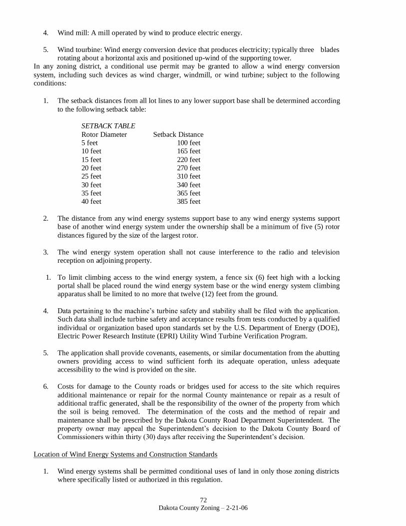
Dakota County Zoning–2-21-0672
4. Wind mill: A mill operated by wind to produce electric energy.
5. Wind tourbine: Wind energy conversion device that produces electricity; typically three bladesrotating about a horizontal axis and positioned up-wind of the supporting tower.
In any zoning district, a conditional use permit may be granted to allow a wind energy conversionsystem, including such devices as wind charger, windmill, or wind turbine; subject to the followingconditions:
1. The setback distances from all lot lines to any lower support base shall be determined accordingto the following setback table:
SETBACK TABLERotor Diameter Setback Distance5 feet 100 feet10 feet 165 feet15 feet 220 feet20 feet 270 feet25 feet 310 feet30 feet 340 feet35 feet 365 feet40 feet 385 feet
2. The distance from any wind energy systems support base to any wind energy systems supportbase of another wind energy system under the ownership shall be a minimum of five (5) rotordistances figured by the size of the largest rotor.
3. The wind energy system operation shall not cause interference to the radio and televisionreception on adjoining property.
1. To limit climbing access to the wind energy system, a fence six (6) feet high with a lockingportal shall be placed round the wind energy system base or the wind energy system climbingapparatus shall be limited to no more that twelve (12) feet from the ground.
4. Data pertaining to the machine’s turbine safety and stability shall be filed with the application. Such data shall include turbine safety and acceptance results from tests conducted by a qualifiedindividual or organization based upon standards set by the U.S. Department of Energy (DOE),Electric Power Research Institute (EPRI) Utility Wind Turbine Verification Program.
5. The application shall provide covenants, easements, or similar documentation from the abuttingowners providing access to wind sufficient forth its adequate operation, unless adequateaccessibility to the wind is provided on the site.
6. Costs for damage to the County roads or bridges used for access to the site which requiresadditional maintenance or repair for the normal County maintenance or repair as a result ofadditional traffic generated, shall be the responsibility of the owner of the property from whichthe soil is being removed. The determination of the costs and the method of repair andmaintenance shall be prescribed by the Dakota County Road Department Superintendent. Theproperty owner may appeal the Superintendent’s decision to the Dakota County Board ofCommissioners within thirty (30) days after receiving the Superintendent’s decision.
Location of Wind Energy Systems and Construction Standards
1. Wind energy systems shall be permitted conditional uses of land in only those zoning districtswhere specifically listed or authorized in this regulation.

Dakota County Zoning–2-21-0673
2. No person shall develop, construct, modify, or operate a wind energy system upon any tract ofland within the zoning jurisdiction of the County prior to approval of its application for aConditional Use Permit by the County Board and issuance of the permit by the County.Applicants shall submit their application for a Conditional Use Permit to the ZoningAdministrator.
3. All wind energy systems on which construction has commenced within the zoning jurisdictionof the County after the effective date of this regulation shall conform to the Building Codes andall other construction standards set forth by the County, federal, and state law and applicableAmerican National Standards Institute (ANSI), Federal Aviation Administration (FAA), UnitedState Department of Energy, Energy Information Administration (EIA) and American WindEnergy Association (AWEA) and any other. Upon completion of construction of a wind energysystem prior to the commencement of use, and engineer’s certification that the tower isstructurally sound and in conformance with all of the aforementioned applicable regulatorystandards shall be filed with the Zoning Administrator.
Application to develop a wind energy system
Prior to the commencement of development or construction of a wind energy/turbine, and applicationshall be submitted to the Zoning Administrator for the Conditional Use Permit and shall include thefollowing:
1. Name, address, and telephone number of the owner and if applicable, the lessee of the tract ofland upon which the tower is to be located. Applicants shall include the owner of the tract ofland and all persons having an ownership interest in the proposed tower. The application shallbe executed by all applicants.
2. The legal description and addresses of the tract of land on which the wind energy system islocated.
3. The application shall identify proposed vehicle and equipment storage areas.
4. The application shall include a map showing contours, proposed excavation and gradingcontours, and proposed final grad contours.
5. The names, addresses, and telephone numbers of all owners of other wind energy systemswithin one (1) mile radius of the proposed wind energy system, including publicly and privatelyowned wind energy systems and structures.
6. Written technical evidence from an engineer that the proposed wind energy systems will meetestablished Building Codes, and all other applicable construction standards set forth by theCounty Board and federal and state and AWEA standards.
7. Color photo simulations showing the proposed location of the wind energy system with a photo-realistic representation of the proposed wind energy system as it would appear viewed for thenearest residentially used and / or zoned property and nearest roadway, street, or highway.
8. Descriptions and diagrams of the proposed wind energy system, manufacturers literature,appurtenances such as buildings, driveways, parking areas, and fences or other securityenclosures with significant detail to allow persons reviewing the application to understand thekind an nature of the proposed facility.
9. A copy of any lease between the applicant and the owner of the land where the wind energysystem is constructed must be delivered to the Dakota County Road Department Superintendentprior to constructing the wind energy system. The landowner shall be responsible for the
Dakota County Zoning–2-21-0674
removal of the wind energy system or facility in the event the lessee fails to remove it uponabandonment.
10. Excavating and Grading requirements of land and soil must be completed according to:
a. The faces of cut and fill slopes shall be prepared and maintained to control soilerosion. Where necessary, vegetative plantings, check dams, cribbing, riprap, orother devices or methods shall be employed to control erosion and provide safety.
b. All drainage provisions shall be designed to carry surface waters to the nearestnatural water course approved by the County Planning and Zoning Committee.
c. Setbacks:1. Cut and fill slopes shall be set back from site boundaries in accordance with
this section. Setback dimensions shall be horizontal distances measuredperpendicular to the site boundary.
2. The setback from a site boundary line for the top of a cut section or the toe ofa fill section which does not involve a professionally designed retaining wallstructure shall be determined as: B = H (1 –S/4), where B is the setbackrequired, H is the height of the cut or fill section and S is the horizontalelement of the slope ration (e.g. S = 4 for a 4:1 slope). For a slope steeperthan 3:1, the setback shall not be less than 5 feet.
3. The setback for a retaining wall structure designed by a registeredprofessional engineer, architect, or landscape architect shall be sufficient tocontain any of the structure of the retaining wall and to assure the adjoiningproperty owner will not be deprived of rights to build.
4. The setback may be reduced to zero if a recorded easement of the adjoiningproperty for construction and maintenance of the cut of fill section equal inwidth to the reduction of the setback required by the provisions of subsectionb. or c. above is secured.
5. The minimum setback may be increased as a result of a determination by theCounty Planning and Zoning Committee that it is necessary to support a loadon adjacent properties or that special site conditions warrant increasedsetbacks.
6. Where a cut or fill slope is to be located near the site boundary, specialprecautions shall be incorporated in the work as the city engineering divisiondeems necessary to protect the adjoining property from damage. Theseprecautions may include but are not limited to:
i. Additional setbacks.ii. Provisions for retaining walls or drainage channels.iii. Mechanical or chemical treatment of the fill slope to minimize erosion.iv. Other provisions for the control of surface waters.
d. The County Planning and Zoning Committee may require or approve alternatesetbacks, investigation, and recommendations by a registered professional engineerexperienced in soil mechanics or an engineering geologist to demonstrate that theintent of this section has been satisfied.
e. No grading shall allow earthen materials to be deposited upon, or to roll, flow, orwash upon or over the premises of another without the explicit written consent ofthe owner of such premises so affected, or upon or over any public street, walk,place or way; not so close to the top of a bank of a channel as to create thepossibility of bank failure and sliding.
f. No cut or fill materials shall be transported to or from a site in such a manner as topermit it to be deposited upon any public street or road. In the event cut or fillmaterials is deposited or tracked upon the public streets, the land owner shall cleanit up by the end of each working day, or the County may clean it up and assess thecosts of the cleanup to the land owner. Costs for damage to the County roads orbridges used for access to the site which requires additional maintenance or repair

Dakota County Zoning–2-21-0675
for the normal County maintenance or repair as a result of additional trafficgenerated, shall be the responsibility of the owner of the property from which thesoil is being removed. The determination of the costs and the method of repair andmaintenance shall be prescribed by the Dakota County Road DepartmentSuperintendent. The property owner may appeal the Superintendent’s decision to the Dakota County Board of Commissioners within thirty (30) days after receivingthe Superintendent’s decision.
g. Fill material shall be obtained from approved sources which shall be free ofvegetative matter and deleterious materials such as broken concrete, asphalt andlarge rocks unless prior approval is obtained from the County planning and zoningcommittee.
h. Minimum standards of excavations and fills:1. In general, excavations and fills should have a finished slope of three
horizontal to one vertical; however, steeper excavations and fills may bemade subject to the following design certifications:
2. An excavation or fill steeper than a 3:1 slope that is less than 20 feet in heightmust be based upon a design prepared and certified by an architect, landscapearchitect, or professional engineer, registered in the state of Iowa.
3. An excavation or fill steeper than a 3:1 slope that is more than 20 feet inheight must be based upon a design prepared and certified by a registeredprofessional engineer experienced in soil mechanics with substantiation by asoils investigative report.
4. The face of the cut or fill shall be stabilized by a vegetative land cover,retaining wall or other means provided in the approved design.
5. The top of the cut or fill or any terrace created shall be shaped in such amanner that no surface water is allowed to flow over the edge. The topsurface shall be stabilized be vegetation or other non-erodible surface.
i. Within one (1) year after completion of the excavation or grading on any portion ofthe site, the topography and soils shall be stabilized and the land shall be graded,seeded, and sodded so as to prevent erosion and siltation, and to protect the health,safety, and general welfare of the public.
j. Timber, logs, trees, tree stumps, brush, vegetable matter, masonry and rubbish ofany description shall be removed and disposed of so as to leave the disturbed areawith a neat and finished appearance. Solid rock, shale or similar materials shall beremoved to a depth of 15 inches below sub grade for paved areas and 2 feet belowfinish grade for lawn areas except where it is impractical because of rock out-cropping.
k. Ground cover shall be established within 30 days after a phase of grading work iscompleted or by April 1 of the next year if completion is after October 1 in order toprevent erosion of finished grading. Such ground cover must be maintained in sucha manner as to assure the long-term stability of the grading.
l. Appropriate measures shall be implemented to prevent fugitive dust from becominga nuisance to surrounding occupied properties.
Structural Standards for wind energy systems and structures
The structural standards for wind energy systems and structures shall follow the American Wind EnergyAssociation (AWEA) and United States Department of Energy standards and requirements.
Illumination and Security Fences
1. Wind energy systems shall not be artificially lighted except as required by the Federal AviationAdministration (FAA) and Federal Communications Commission (FCC). In cases where thereare residential uses / zoned properties within a distance of 300% of the height of the windenergy system, any wind energy system subject to this Section shall be equipped with dual
Dakota County Zoning–2-21-0676
mode lighting. In no case shall said wind energy system be allowed to operate a strobe lightingsystem after sunset and before dawn.
2. All self-supporting lattice or guyed wind energy systems shall be enclosed within a securityfence or other structure designed to preclude unauthorized access. Wind energy systems shallbe designed and constructed in a manner which will preclude to extent practical, unauthorizedclimbing of said structure.
Exterior Finish
Wind energy systems not requiring AWEA painting or marking shall have an exterior finish whichenhances computability with adjacent land uses, subject to review and approval by the Planning andZoning Committee and County Board as part of the application approval process. All wind energysystems and structures that must be approved as conditional use shall be stealth design unless stealthfeatures are impractical or the cost of such features represents an undue burden on the applicant.
Maintenance, Repair or Modification of Existing Wind Energy Systems and Structures
All wind energy systems constructed or under construction on the date of approval of this regulationmay continue in existence as a non-conforming structure and may be maintained or repaired withoutcomplying with any of the requirements of this Section. Nonconforming structures or uses may not beenlarged or the degree of nonconformance increased without complying with this Section, includingapplying for and obtaining a Conditional Use Permit. Any modification or reconstruction of a windenergy system or structure constructed or under construction on the date of approval of this regulationshall be required to comply with the requirements of this Section including applying for and obtaining aConditional Use Permit. Said application shall describe and specify all items which do not comply withthis Section and may request, subject to final review and approval of the County Board, and exemptionfrom compliance as a condition of the Conditional Use permit.
Inspections
Wind energy systems shall be inspected by a qualified wind energy system inspector once every 36months by the owner, operator, or his representative to assess the structural condition of the wind energysystem or structure. An inspection report shall be delivered to the Dakota County Road DepartmentSuperintendent within 30 days of the inspection. Said report shall certify that the wind energy system orstructure and support equipment continues to meet or exceed the current published American WindEnergy Association (AWEA) and United States Department of Energy standards and requirements andis in sound and in safe operating condition.
Maintenance
The wind energy system support structures shall at all times be kept and maintained in good condition,order and repair so that the same does not constitute a nuisance to or a danger to the life or property ofany person or the public.
Abandonment
1. The wind energy system owner shall be required to notify the Zoning Administrator of anyperiods of nonuse or abandonment of the wind energy system facility.
2. If any wind energy system shall cease to be used for a period of one (1) year, the ZoningAdministrator shall notify the wind energy system owner that the site will be subject todetermination by the Zoning Administrator that the site had been abandoned. Upon issuance ofwritten notice to show cause by the Zoning Administrator, the wind energy system or structurebeen in use or under repair during the period of apparent abandonment. In the event the tower
Dakota County Zoning–2-21-0677
owner fails to show that the wind energy system or structure shall have (75) days, thereafter todismantled and remove the structure. In the event the wind energy system or structure is notdismantle and removed, the structure shall be declared a public nuisance by the ZoningAdministrator, or his / her designee nuisance pursuant to authority of the Nebraska State Statuesand County of Dakota codes, and charge the costs thereof against the real estate on which thewind energy system is located or the owner of record of the said real estate.
Section 900.3. SIGN INSTALLATIONS
It is the intent and purpose of these sign regulations to qualify, supplement or define the allowable usesof the several types of signs allowed in the district regulations appearing elsewhere in the Regulation.
Use Regulations
Any sign shall, by definition, be a structure. No land or building or structure shall be used for signpurposes except within the stipulated districts listed in Sign Use Regulations specified herein. All signslegally existing at the time of passage of these regulations may remain in use under the conditions oflegal nonconformance. Signs in legal nonconformance shall not be enlarged, moved, lighted, orreconstructed; however, the change of the advertising display shall not be restricted except as previouslystated. After the effective date of the Regulation, no sign shall be erected, enlarged, constructed orotherwise installed without first obtaining a sign permit, and a sign permit shall be legally issued onlywhen in compliance with this sign regulation. All signs shall be constructed in compliance with thebuilding codes and shall be constructed in such a manner and of such material that they shall be safe andsubstantial. Scale drawings of the sign and manner of supports shall be furnished to the ZoningAdministrator in application for a sign permit for all signs.
Classification of Signs
Functional Types:
1. Advertising Signs: A sign which directs the attention of the public to any goods, merchandise,property, business, service, entertainment or amusement conducted or produced which is boughtor sold, furnished, offered, or dealt in elsewhere than on the premises where such sign is locatedor to which it is affixed.
2. Bulletin Board Sign: A sign that indicates the name of an institution or organization on whosepremises it is located and which contains the name of the institution or organization, the nameor names of persons connected with it, and announcement or persons, events or activitiesoccurring at the institution. Such sign may also present a greeting or similar message.
3. Business Signs: A sign which directs attention to a business or profession conducted, or toproducts, services or entertainment sold or offered upon the premises where such sign islocated, or to which it is affixed.
4. Construction Signs: A temporary sign indicating the names of the architects, engineers,landscape architects, contractors and similar artisans involved in the design and construction ofa structure, complex or project only during the construction period and only on the premises onwhich the construction is taking place.
5. Identification Signs: A sign giving the name and address of a building, business, developmentor establishment. Such signs may be wholly or partly devoted to a readily recognized symbol.
6. Name Plate Signs: A sign giving the name and/or address or the owner or occupant of abuilding or premises on which it is located, and where applicable, a professional status.
Dakota County Zoning–2-21-0678
7. Real Estate Signs: A sign pertaining to the sale or lease of a lot or tract of land on which thesign is located, or to the sale or lease of one or more structures, or a portion thereof on whichthe sign is located.
Structural Types:
1. Awning, Canopy or Marquee Sign: A sign that is mounted or painted on, or attached to anawning, canopy or marquee. No such signs shall project above, below or beyond the awning,canopy or marquee.
2. Ground Sign: Any sign place upon, or supported by, the ground independently of the principalbuilding or structure on the property, where the bottom edge of the sign is less than six feet.
3. Pole Sign: Any sign placed upon, or supported by, the ground independently of the principalbuilding or structure on the property where the bottom edge of the sign is six feet or more abovethe ground level.
4. Projection Sign: Any sign that is wholly or partly dependent upon a building for support andwhich projects more than 12 inches from such building.
5. Wall Sign: A sign fastened to or painted on a wall of a building or structure in such a mannerthat the wall becomes merely the supporting structure or forms the background surface, andwhich does not project more than 12 inches from such building.
6. Roof Sign: A sign totally supported on the roof of a structure. Roof signs shall not projectmore than 12 inches beyond the face of the building.
General Standards
1. Gross Area of Sign: The entire area within a single continuous perimeter enclosing the extremelimits of the sign, exclusive of the base on which it is mounted or from which it is suspended. Ifmore than one side of a sign is utilized as a sign, then it shall also be computed and shall becounted as a portion of the gross area. On lots where more than one sign is located, the totalgross area of all the signs shall not exceed the maximum gross area permitted by this regulation.For computing the gross area of any wall sign which consists of letters mounted or painted on awall, the area shall be deemed to be the area of the smallest rectangular figure which canencompass all of the letters.
2. Sign Height: Sign height shall be measured from the ground elevation at the base of the sign tothe highest element of the sign.
3. Illuminated Signs: A sign designed to give forth artificial light or designed to reflect lightderived from any source.
a. Illuminated signs shall be designed as to reflect or direct light away from anyresidential dwelling district and any illuminated sign located on a lot adjacent to, infront of or across the street from any residential district, which sign is visible fromsuch residential district, shall not be illuminated between the hours of 11 p.m. and 7a.m.
b. Lighted signs in direct vision of a traffic signal shall not be in red, amber or greenillumination.
4. Flashing or Moving Signs: Any illuminated sign on which the artificial light is not constant inintensity and color at all times. For the purpose of this regulation, any revolving, rotating,
Dakota County Zoning–2-21-0679
moving, animated, signs with moving lights or signs which create the illusion of movementshall be considered as a flashing sign and shall not be permitted except where:
a. A sign giving public service information.
b. A sign whereon the current time, temperature, weather or news is indicated byintermittent lighting shall not be deemed as a flashing sign if the lighting changes arelimited to the numerals or configurations of letters indicating such information.
5. Accessway or Window: No sign shall block any required accessway or window.
6. Advertising Sign Spacing on Highways.
a. Advertising signs visible from a primary highway shall not be erected within the limitsof an incorporated city less than one hundred (100) feet, and outside the limits of anincorporated city less than three hundred (300) feet, of another such sign on the sameside of the highway.
b. Advertising signs visible from a freeway or interstate highway shall not be erectedwithin five hundred (500) feet of another such sign on the same side of the highway,and outside the limits of an incorporated city, no such sign shall be located adjacent toor within five hundred (500) feet of an interchange, intersection at grade or a safetyrest area, with such distance to be measured along the freeway or interstate highwayfrom the nearest point of the beginning or ending of pavement widening at the exitfrom or entrance to the main traveled way.
c. The minimum distances between two signs prescribed by subsections a. and b. shallnot apply where such signs are separated by a building, structure, roadway or otherobstruction which prevents a view of both signs at the same time by traffic proceedingon any one highway.
d. The minimum distance between two signs as prescribed by subsections a. and b. shallbe measured along the nearest edge of the pavement between points directly oppositethe signs along each side of the highway.
e. Nothing in this subsection shall be construed as preventing the erection of doublefaced, back-to-back or V-type signs with a maximum of two (2) signs per facing.
7. Signs on Trees or Utility Poles: No sign shall be attached to a tree or utility pole whether onpublic or private property.
8. Metal Signs: Signs constructed of metal and illuminated by any means requiring wiring orelectrically wired accessory fixtures attached to a metal sign shall maintain a free clearance tograde of nine feet. Accessory lighting fixtures attached to a non-metal frame sign also maintaina clearance of nine feet to grade.
a. No metal ground sign shall be located within eight feet vertically and four feethorizontally of electric wires or conductors in free air carrying more than 48 volts,whether or not such wires are insulated or otherwise protected.
9. Traffic Safety:
a. No sign shall be maintained at any location where by reason of its position, size,shape or color, it may obstruct, impair, obscure, interfere with the view of, or be

Dakota County Zoning–2-21-0680
confused with any traffic or railroad control sign, signal or device, or where it mayinterfere with, mislead, or confuse traffic.
b. Any sign located within three feet of a driveway or within a parking area shall haveits lowest elevation at least ten feet above the curb level; however, in no event shallany sign be placed so as to project over any public right-of-way.
c. Under no circumstances shall any sign be placed in the site triangle as defined bythis regulation.
d. Signs shall not be erected or maintained which are not effectively shielded so as toprevent beans or rays of light from being directed at any portion of the traveled wayof any street or highway and are of such brilliance as to cause glare or to impair thevision of, or otherwise interfere with, the driver of any motor vehicle.
10. Setbacks: No advertising sign shall project beyond the front, side or rear building setback linesfor the district set forth in this zoning regulation.
11. Lineal Street Frontage: In those districts where gross sign area is allocated based on linealstreet frontage and the tract or parcel is adjacent to more than one street, the lineal streetfrontage shall be computed as follows:
a. For those tracts or parcels located on major streets as designed in the CirculationPlan of the Comprehensive Plan, the lineal street frontage shall be the distance onthat property line abutting the major street.
b. For those tracts or parcels not located on a major street, the lineal street frontageshall be one-half of the sum of all the street frontages.
Exemptions.
1. The following signs shall be exempt from the requirements of this Article:
a. Flags or emblems of a governmental or of a political, civic, philanthropic,educational or religious organization displayed on private property.
b. Signs of a duly constituted governmental body, including traffic or similarregulatory signs, legal notices, warnings at railroad crossings and other instructionalor regulatory signs having to do with health, hazards, parking, swimming, dumping,etc.
c. Memorial signs and tablets displayed on private property.
d. Small signs, not exceeding three square feet in area, displayed on private propertyfor the convenience of the public, including signs to identify entrance and exitdrives, parking areas, one-way drives, restrooms, freight entrances and other similarsigns.
e. Score boards in athletic stadiums.
2. The following signs are exempt from the sign permit section of this Article, but shall complywith all of the other regulations imposed by this Article:
a. Name plate signs not exceeding two square feet in gross area accessory to a single-family or two-family dwelling.
Dakota County Zoning–2-21-0681
b. Bulletin board signs not exceeding 15 square feet in gross area accessory to achurch, school or public or non-profit institution.
District Regulations.
1. Agricultural Districts:
a. Functional Types Permitted:i. Bulletin board signs.ii. Business signs, pertaining only to the sale of agricultural products produced on
the premises and home occupations.iii. Construction signs.iv. Identification signs.v. Name plate signs.vi. Real estate signs.
b. Structural Types Permitted:i. Ground signs.ii. Wall signs.
c. Number of Signs Permitted: One sign per zoning lot.
d. Maximum Gross Area:i. Bulletin board and identification signs: 24 square feet.ii. Business signs - home occupations: two square feet; Agricultural - 20 square
feet.iii. Construction signs: 20 square feet.iv. Name plate signs: 2 square feet.v. Real estate signs: 12 square feet.vi. Mobile home parks: 24 square feet on one face and not more than 40 square
feet total.
e. Maximum Height: 15 feet.
f. Required Setbacks: None.
g. Illumination: Bulletin board and identification signs that do not exceed 12 squarefeet on one face for churches, hospitals, police stations, fire stations and othersimilar public facilities.
2. Residential Districts:
a. Functional Types Permitted:i. Business signs pertaining to a home occupation and subject to the sign
requirements of the home occupation section of this regulation.ii. Bulletin board signs.iii. Construction signs.iv. Identification signs.v. Name plate signs.vi. Real estate signs.
b. Structural Types Permitted:i. Ground signs.ii. Wall Signs.
Dakota County Zoning–2-21-0682
c. Number of Signs Permitted: One sign per zoning lot.
d. Maximum Gross Area:i. Business signs - Home occupation: 2 square feet.ii. Bulletin board and identification signs: 24 square feet.iii. Construction signs: 20 square feet.iv. Name plate signs: 2 square feet.v. Real estate signs: six square feet, provided that one sign not more than 100 feet
in area announcing the sale of lots and/or houses in a subdivision may belocated on said development. Said sign shall be removed at the end of threeyears or when 75 percent of the lots have been sold, whichever occurs sooner.
vi. Mobile home park: 24 square feet on one face and not more than 40 square feettotal.
e. Maximum Height: 15 feet.
f. Required Setback: No sign shall be placed closer to the front property line than ½the distance of the front yard.
g. Illumination: Bulletin boards and identification signs may be indirectly illuminatedwith incandescent or fluorescent lighting.
3. Business District:
a. Functional Types Permitted:i. Advertising signs.ii. Bulletin board signs.iii. Business signs.iv. Construction signs.v. Identification signs.vi. Name plate signs.vii. Real estate signs.
b. Structural Types Permitted:i. Awning, canopy or marquee signs.ii. Ground signs.iii. Pole signs.iv. Projecting signs.v. Roof signs.vi. Wall signs.
c. Number of Signs Permitted:i. Awning, canopy or marquee signs and wall signs: No limitations.ii. Ground signs and pole signs: Two per zoning lot.iii. Projecting signs: One per zoning lot.iv. Roof signs: One per zoning lot.
d. Maximum Gross Surface Area: Two square feet for each lineal foot of streetfrontage provided no single sign shall exceed a gross surface area of 400 squarefeet.
e. Maximum Height: 30 feet.
f. Required Setback: None except that advertising signs shall maintain the samesetback that is required for principal structures.
Dakota County Zoning–2-21-0683
g. Illumination: Illuminated signs shall be permitted.
4. All Other Industrial Districts:
a. Functional Types Permitted:i. Advertising signs.ii. Bulletin board signs.iii. Business signs.iv. Construction signs.v. Identification signs.vi. Name Plates.
b. Structural Types Permitted:i. Awning, canopy or marquee signs.ii. Ground signs.iii. Pole signs.iv. Projecting signs.v. Wall signs.vi. Roof signs.
c. Number of Signs Permitted: Two per zoning lot.
d. Maximum Gross Surface Area: Two square feet per lineal foot of street frontage,provided no single sign exceeds a gross area of 400 square feet.
e. Maximum Height:i. Roof and wall signs: 30 feet above the highest point of the structure on which
the sign is located.ii. All other signs: 30 feet.
f. Required Setback: None, except that advertising signs shall maintain the samesetback that is required for principal structures.
g. Illumination: Illuminated signs shall be permitted.
Public Utility Facilities Lot Size Requirements
Notwithstanding any other provision of these Regulations, none of the following public utility or publicservice uses shall be required to comply with the lot size requirements and bulk regulations of thezoning district in which they are located:
1. Electric and telephone substations and distribution systems.
2. Gas regulator stations.
3. Poles, wires, cables, conduits, vaults, laterals, pipes, mains, valves, or other similar equipmentfor the transmission of electricity, gas, or water.
4. Pumping stations.
5. Radio, television, and microwave transmitting or relay stations and towers, except as may berequired to meet setback requirements.
6. Transformer station.
Dakota County Zoning–2-21-0684
7. Water tower or standpipes.
Mobile Home Parks
1. A mobile home park may be established provided that the proposed mobile home park meets allof the requirements of Section 4.06 and the additional requirements below:
2. Certification of compliance with all Regulations and regulations regarding mobile home parklicensing, zoning, health, plumbing, electrical, building, fire prevention and all other applicableRegulations and regulations.