for work within the louisiana coastal zone work within the louisiana coastal zone what is the...
TRANSCRIPT
Page 1 of 12
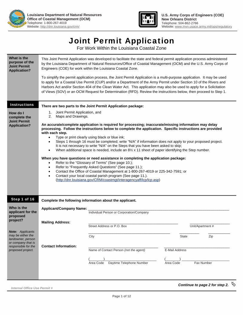
Joint Permit Application For Work Within the Louisiana Coastal Zone
What is the purpose of the Joint Permit Application?
How do I complete the Joint Permit Application?
Who is the applicant for the proposed project?
Note: Applicants may be either the landowner, person or company that is responsible for the proposed project.
This Joint Permit Application was developed to facilitate the state and federal permit application process administered by the Louisiana Department of Natural Resources/Office of Coastal Management (OCM) and the U.S. Army Corps of Engineers (COE) for work within the Louisiana Coastal Zone. To simplify the permit application process, the Joint Permit Application is a multi-purpose application. It may be used to apply for a Coastal Use Permit (CUP) and/or a Department of the Army Permit under Section 10 of the Rivers and Harbors Act and/or Section 404 of the Clean Water Act. This application may also be used to apply for a Solicitation of Views (SOV) or an OCM Request for Determination (RFD). Review the instructions below, then proceed to Step 1. There are two parts to the Joint Permit Application package:
1. Joint Permit Application, and 2. Maps and Drawings.
An accurate/complete application is required for processing; inaccurate/missing information may delay processing. Follow the instructions below to complete the application. Specific instructions are provided with each step.
• Type or print clearly using black or blue ink; • Steps 1 through 16 must be completed; write “N/A” if information does not apply to your proposed project.
It is not necessary to write “N/A” on the Steps that you have been asked to skip; • When additional space is needed, include an 8½ x 11 sheet of paper identifying the Step number.
When you have questions or need assistance in completing the application package:
• Refer to the “Glossary of Terms” (See page 10.); • Refer to “Frequently Asked Questions” (See page 11.); • Contact the Office of Coastal Management at 1-800-267-4019 or 225-342-7591; or • Contact your local coastal parish program (See page 11.).
(http://dnr.louisiana.gov/CRM/coastmgt/interagencyaff/lcp/lcp.asp)
Complete the following information about the applicant.
Applicant/Company Name: _______________________________________________________________________ Individual Person or Corporation/Company
Mailing Address: _____________________________________________ ____________________
Street Address or P.O. Box Unit/Apartment #
_________________________________________ __________ ___________ City State Zip
Contact Information: ___________________________________ _________________________________
Name of Contact Person (not the agent) E-Mail Address
(_______)__________________________ (_______) ________________________ Area Code Daytime Telephone Number Area Code Fax Number
Continue to page 2 for step 2.
Louisiana Department of Natural Resources Office of Coastal Management (OCM) Telephone: 1-800-267-4019 Website: http://dnr.louisiana.gov/crm/
U.S. Army Corps of Engineers (COE)New Orleans District Telephone: 504-862-2766
Website: www.mvn.usace.army.mil/ops/regulatory
Instructions
Step 1 of 16
Internal Office Use Permit #
Page 2 of 12
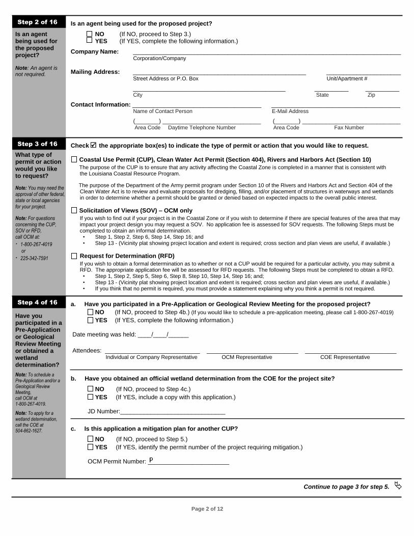
Is an agent being used for the proposed project? Note: An agent is not required.
What type of permit or action would you like to request?
Note: You may need the approval of other federal, state or local agencies for your project.
Note: For questions concerning the CUP, SOV or RFD, call OCM at:
· 1-800-267-4019
or
· 225-342-7591
Have you participated in a Pre-Application or Geological Review Meeting or obtained a wetland determination?
Note: To schedule a Pre-Application and/or a Geological Review Meeting, call OCM at 1-800-267-4019.
Note: To apply for a wetland determination, call the COE at 504-862-1627.
Is an agent being used for the proposed project?
NO (If NO, proceed to Step 3.) YES (If YES, complete the following information.)
Company Name: _______________________________________________________________________________ Corporation/Company
Mailing Address: ___________________________________________________ ______________________
Street Address or P.O. Box Unit/Apartment #
_____________________________________________ __________ __________ City State Zip
Contact Information: ______________________________________ ______________________________________ Name of Contact Person E-Mail Address
(_______) _____________________________ (_______) _____________________________ Area Code Daytime Telephone Number Area Code Fax Number
Check h the appropriate box(es) to indicate the type of permit or action that you would like to request. Coastal Use Permit (CUP), Clean Water Act Permit (Section 404), Rivers and Harbors Act (Section 10)
The purpose of the CUP is to ensure that any activity affecting the Coastal Zone is completed in a manner that is consistent with the Louisiana Coastal Resource Program. The purpose of the Department of the Army permit program under Section 10 of the Rivers and Harbors Act and Section 404 of the Clean Water Act is to review and evaluate proposals for dredging, filling, and/or placement of structures in waterways and wetlands in order to determine whether a permit should be granted or denied based on expected impacts to the overall public interest. Solicitation of Views (SOV) – OCM only
If you wish to find out if your project is in the Coastal Zone or if you wish to determine if there are special features of the area that may impact your project design you may request a SOV. No application fee is assessed for SOV requests. The following Steps must be completed to obtain an informal determination.
• Step 1, Step 2, Step 6, Step 14, Step 16; and • Step 13 - (Vicinity plat showing project location and extent is required; cross section and plan views are useful, if available.)
Request for Determination (RFD)
If you wish to obtain a formal determination as to whether or not a CUP would be required for a particular activity, you may submit a RFD. The appropriate application fee will be assessed for RFD requests. The following Steps must be completed to obtain a RFD.
• Step 1, Step 2, Step 5, Step 6, Step 8, Step 10, Step 14, Step 16; and; • Step 13 - (Vicinity plat showing project location and extent is required; cross section and plan views are useful, if available.) • If you think that no permit is required, you must provide a statement explaining why you think a permit is not required.
a. Have you participated in a Pre-Application or Geological Review Meeting for the proposed project?
NO (If NO, proceed to Step 4b.) (If you would like to schedule a pre-application meeting, please call 1-800-267-4019) YES (If YES, complete the following information.)
Date meeting was held: ____/____/______ Attendees: ____________________________ ___________________________ ___________________________
Individual or Company Representative OCM Representative COE Representative b. Have you obtained an official wetland determination from the COE for the project site?
NO (If NO, proceed to Step 4c.) YES (If YES, include a copy with this application.)
JD Number:_______________________________
c. Is this application a mitigation plan for another CUP?
NO (If NO, proceed to Step 5.) YES (If YES, identify the permit number of the project requiring mitigation.)
OCM Permit Number: ________________________
Continue to page 3 for step 5.
Step 2 of 16
Step 3 of 16
Step 4 of 16
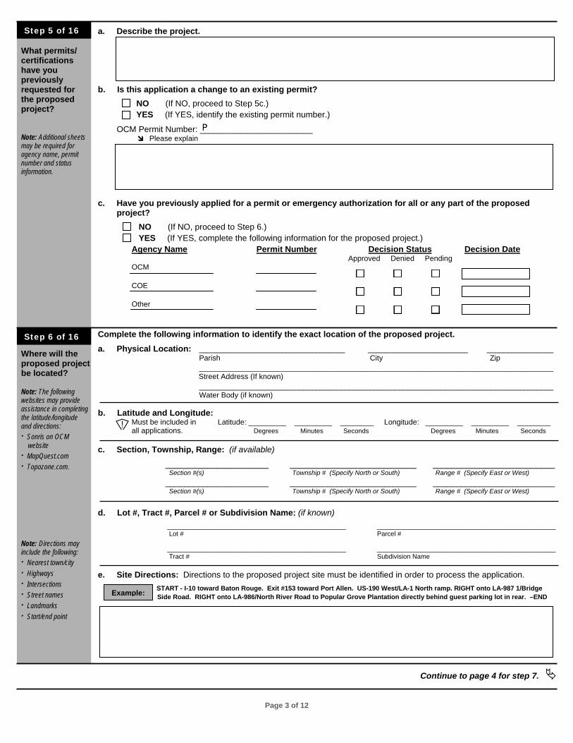
Page 3 of 12
What permits/ certifications have you previously requested for the proposed project?
Note: Additional sheets may be required for agency name, permit number and status information.
Where will the proposed project be located?
Note: The following websites may provide assistance in completing the latitude/longitude and directions: · Sonris on OCM website · MapQuest.com · Topozone.com. Note: Directions may include the following: · Nearest town/city · Highways · Intersections · Street names · Landmarks · Start/end point
a. Describe the project. b. Is this application a change to an existing permit?
NO (If NO, proceed to Step 5c.) YES (If YES, identify the existing permit number.)
OCM Permit Number: ________________________ d Please explain
c. Have you previously applied for a permit or emergency authorization for all or any part of the proposed project?
NO (If NO, proceed to Step 6.) YES (If YES, complete the following information for the proposed project.) Agency Name Permit Number Decision Status Decision Date
Approved Denied Pending OCM
COE
Other Complete the following information to identify the exact location of the proposed project. a. Physical Location: ___________________________________ ________________________ ________________ Parish City Zip _____________________________________________________________________________________
Street Address (If known) _____________________________________________________________________________________ Water Body (if known)
b. Latitude and Longitude: Must be included in Latitude: _________ _________ ________ Longitude: _________ _________ ________
all applications. Degrees Minutes Seconds Degrees Minutes Seconds
c. Section, Township, Range: (if available)
______________________ ___________________________ __________________________ Section #(s) Township # (Specify North or South) Range # (Specify East or West)
______________________ ___________________________ __________________________ Section #(s) Township # (Specify North or South) Range # (Specify East or West)
d. Lot #, Tract #, Parcel # or Subdivision Name: (if known) _________________________________________________ _________________________________________________
Lot # Parcel #
_________________________________________________ _________________________________________________ Tract # Subdivision Name
e. Site Directions: Directions to the proposed project site must be identified in order to process the application. START - I-10 toward Baton Rouge. Exit #153 toward Port Allen. US-190 West/LA-1 North ramp. RIGHT onto LA-987 1/Bridge Side Road. RIGHT onto LA-986/North River Road to Popular Grove Plantation directly behind guest parking lot in rear. –END
Continue to page 4 for step 7.
Step 5 of 16
Step 6 of 16
Example:
]
Page 4 of 12
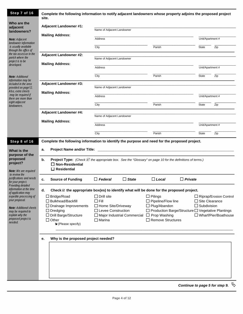
Who are the adjacent landowners? Note: Adjacent landowner information is usually available through the office of the tax assessor in the parish where the project is to be developed. Note: Additional information may be included in the area provided on page12. Also, extra sheets may be required if there are more than eight adjacent landowners. What is the purpose of the proposed project? Note: We are required to review the justifications and needs for your project. Providing detailed information at the time of application may expedite processing of your proposal. Note: Additional sheets may be required to explain why the proposed project is needed.
Complete the following information to notify adjacent landowners whose property adjoins the proposed project site. Adjacent Landowner #1: ________________________________________________________________________________ Name of Adjacent Landowner
Mailing Address: ________________________________________________________ _____________________ Address Unit/Apartment #
______________________________ ________________________ _______ ____________ City Parish State Zip
Adjacent Landowner #2: ________________________________________________________________________________ Name of Adjacent Landowner
Mailing Address: ________________________________________________________ _____________________ Address Unit/Apartment #
______________________________ ________________________ _______ ____________ City Parish State Zip
Adjacent Landowner #3: ________________________________________________________________________________ Name of Adjacent Landowner
Mailing Address: ________________________________________________________ _____________________ Address Unit/Apartment #
______________________________ ________________________ _______ ____________ City Parish State Zip
Adjacent Landowner #4: ________________________________________________________________________________ Name of Adjacent Landowner
Mailing Address: ________________________________________________________ _____________________ Address Unit/Apartment #
______________________________ ________________________ _______ ____________ City Parish State Zip
Complete the following information to identify the purpose and need for the proposed project.
a. Project Name and/or Title: _____________________________________________________________________________ b. Project Type: (Check e the appropriate box. See the “Glossary” on page 10 for the definitions of terms.)
Non-Residential Residential
c. Source of Funding Federal State Local Private d. Check e the appropriate box(es) to identify what will be done for the proposed project.
Bridge/Road Drill site Pilings Riprap/Erosion Control Bulkhead/Backfill Fill Pipeline/Flow line Site Clearance Drainage Improvements Home Site/Driveway Plug/Abandon Subdivision Dredging Levee Construction Production Barge/Structure Vegetative Plantings Drill Barge/Structure Major Industrial Commercial Prop Washing Wharf/Pier/Boathouse Other Marina Remove Structures d (Please specify)
_________________________________________________________________________________________
e. Why is the proposed project needed?
Continue to page 5 for step 9.
Step 7 of 16
Step 8 of 16
Page 5 of 12
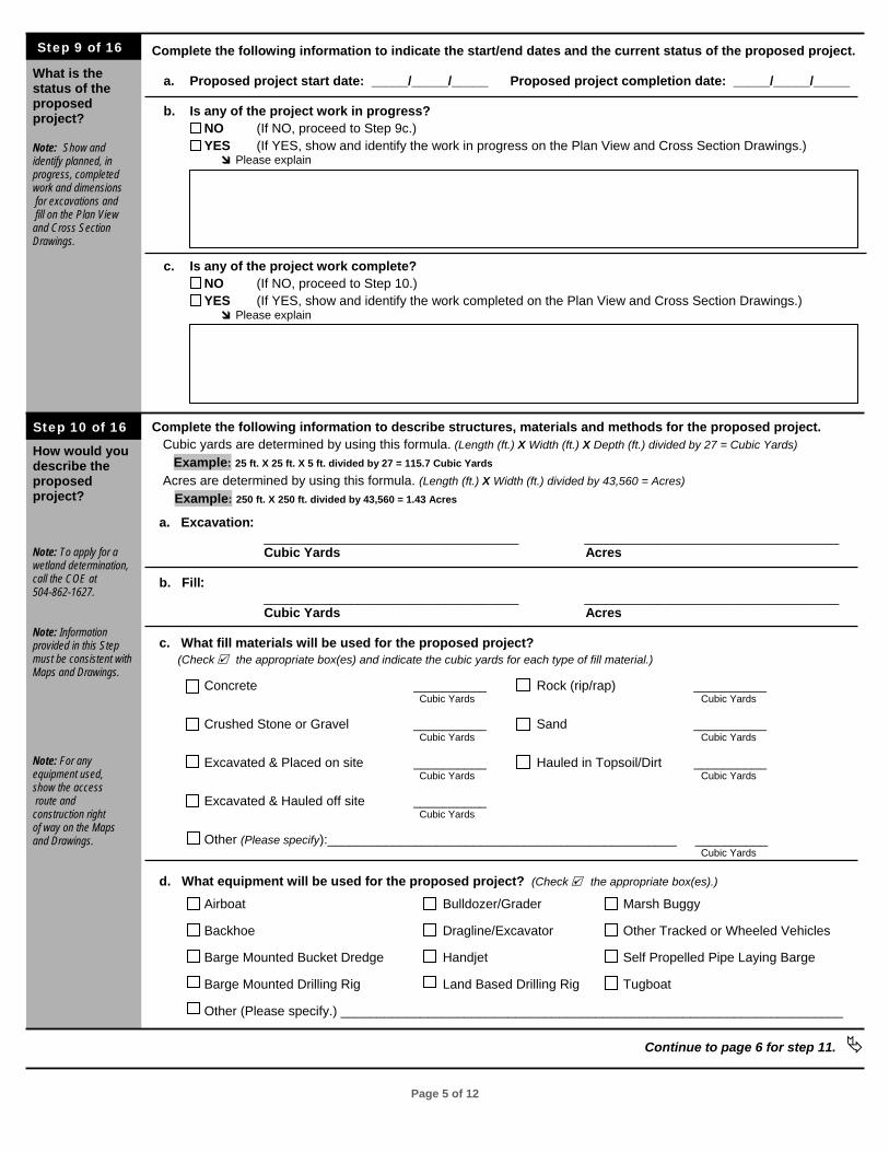
What is the status of the proposed project? Note: Show and identify planned, in progress, completed work and dimensions for excavations and fill on the Plan View and Cross Section Drawings.
How would you describe the proposed project? Note: To apply for a wetland determination, call the COE at 504-862-1627. Note: Information provided in this Step must be consistent with Maps and Drawings. Note: For any equipment used, show the access route and construction right of way on the Maps and Drawings.
Complete the following information to indicate the start/end dates and the current status of the proposed project.
a. Proposed project start date: _____/_____/_____ Proposed project completion date: _____/_____/_____
b. Is any of the project work in progress? NO (If NO, proceed to Step 9c.) YES (If YES, show and identify the work in progress on the Plan View and Cross Section Drawings.) d Please explain
c. Is any of the project work complete? NO (If NO, proceed to Step 10.) YES (If YES, show and identify the work completed on the Plan View and Cross Section Drawings.) d Please explain
Complete the following information to describe structures, materials and methods for the proposed project. Cubic yards are determined by using this formula. (Length (ft.) X Width (ft.) X Depth (ft.) divided by 27 = Cubic Yards) Example: 25 ft. X 25 ft. X 5 ft. divided by 27 = 115.7 Cubic Yards
Acres are determined by using this formula. (Length (ft.) X Width (ft.) divided by 43,560 = Acres) Example: 250 ft. X 250 ft. divided by 43,560 = 1.43 Acres
a. Excavation: ___________________________________ ___________________________________ Cubic Yards Acres
b. Fill: ___________________________________ ___________________________________ Cubic Yards Acres
c. What fill materials will be used for the proposed project? (Check e the appropriate box(es) and indicate the cubic yards for each type of fill material.)
Concrete __________ Rock (rip/rap) __________ Cubic Yards Cubic Yards
Crushed Stone or Gravel __________ Sand __________ Cubic Yards Cubic Yards
Excavated & Placed on site __________ Hauled in Topsoil/Dirt __________ Cubic Yards Cubic Yards
Excavated & Hauled off site __________ Cubic Yards
Other (Please specify):________________________________________________ __________ Cubic Yards
d. What equipment will be used for the proposed project? (Check e the appropriate box(es).)
Airboat Bulldozer/Grader Marsh Buggy Backhoe Dragline/Excavator Other Tracked or Wheeled Vehicles Barge Mounted Bucket Dredge Handjet Self Propelled Pipe Laying Barge Barge Mounted Drilling Rig Land Based Drilling Rig Tugboat Other (Please specify.) _____________________________________________________________________
Continue to page 6 for step 11.
Step 9 of 16
Step 10 of 16
Page 6 of 12
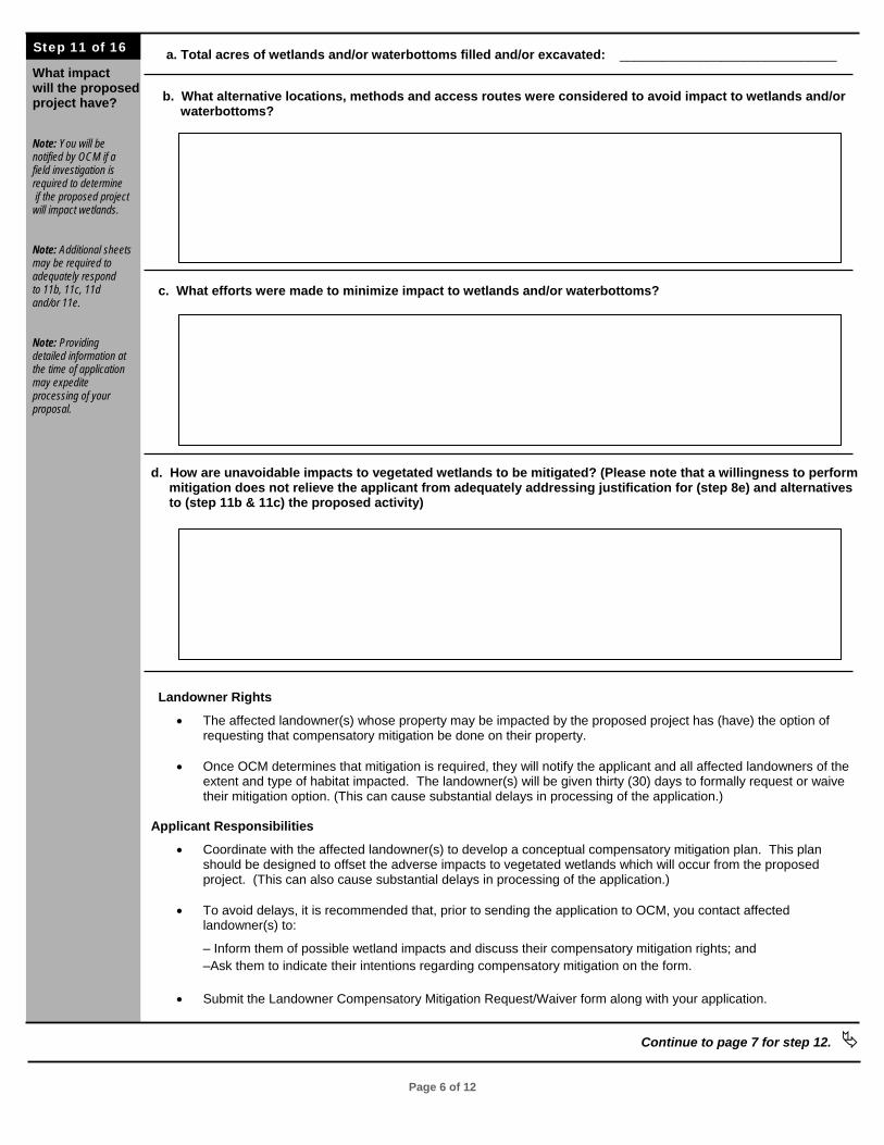
What impact will the proposed project have? Note: You will be notified by OCM if a field investigation is required to determine if the proposed project will impact wetlands. Note: Additional sheets may be required to adequately respond to 11b, 11c, 11d and/or 11e. Note: Providing detailed information at the time of application may expedite processing of your proposal.
a. Total acres of wetlands and/or waterbottoms filled and/or excavated: ______________________________ b. What alternative locations, methods and access routes were considered to avoid impact to wetlands and/or waterbottoms?
c. What efforts were made to minimize impact to wetlands and/or waterbottoms? d. How are unavoidable impacts to vegetated wetlands to be mitigated? (Please note that a willingness to perform mitigation does not relieve the applicant from adequately addressing justification for (step 8e) and alternatives to (step 11b & 11c) the proposed activity)
Landowner Rights
• The affected landowner(s) whose property may be impacted by the proposed project has (have) the option of requesting that compensatory mitigation be done on their property.
• Once OCM determines that mitigation is required, they will notify the applicant and all affected landowners of the extent and type of habitat impacted. The landowner(s) will be given thirty (30) days to formally request or waive their mitigation option. (This can cause substantial delays in processing of the application.)
Applicant Responsibilities
• Coordinate with the affected landowner(s) to develop a conceptual compensatory mitigation plan. This plan should be designed to offset the adverse impacts to vegetated wetlands which will occur from the proposed project. (This can also cause substantial delays in processing of the application.)
• To avoid delays, it is recommended that, prior to sending the application to OCM, you contact affected landowner(s) to:
– Inform them of possible wetland impacts and discuss their compensatory mitigation rights; and –Ask them to indicate their intentions regarding compensatory mitigation on the form.
• Submit the Landowner Compensatory Mitigation Request/Waiver form along with your application.
Continue to page 7 for step 12.
Step 11 of 16
Page 7 of 12
What are the requirements for notification of landowners and oyster lease holders of the proposed project site?
Note: OCM and COE both have mitigation requirements under different laws, rules and regulations; therefore, specific agency requirements may vary.
Note: If a property has multiple owners with undivided interest in the property, each person owning an interest is considered to be a landowner and must be notified.
Note: Additional sheets may be required if there are more than two landowners.
Note: Compensatory mitigation is not a monetary settlement to be used at the discretion of the landowner(s).
Note: A copy of the “Landowner Compensatory Mitigation Request/ Waiver” form is included with this application. To obtain additional copies, visit the OCM website or call: •1-800-267-4019 Or •225-342-7591
Note: See our FAQ for a list of regulations that may be applicable. Be aware that this list is for example proposes and does not purport to be complete or indicate applicability in any particular situation or project. It is the applicant’s responsibility to be fully aware of all regulatory requirements, to list those requirements and certify that thy will be in compliance.
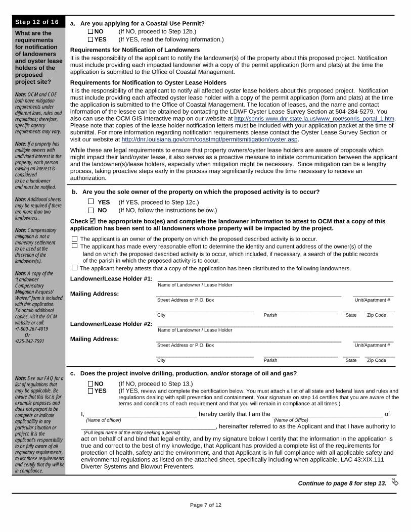
a. Are you applying for a Coastal Use Permit?
NO (If NO, proceed to Step 12b.) YES (If YES, read the following information.)
Requirements for Notification of Landowners It is the responsibility of the applicant to notify the landowner(s) of the property about this proposed project. Notification must include providing each impacted landowner with a copy of the permit application (form and plats) at the time the application is submitted to the Office of Coastal Management.
Requirements for Notification to Oyster Lease Holders It is the responsibility of the applicant to notify all affected oyster lease holders about this proposed project. Notification must include providing each affected oyster lease holder with a copy of the permit application (form and plats) at the time the application is submitted to the Office of Coastal Management. The location of leases, and the name and contact information of the lessee can be obtained by contacting the LDWF Oyster Lease Survey Section at 504-284-5279. You also can use the OCM GIS interactive map on our website at http://sonris-www.dnr.state.la.us/www_root/sonris_portal_1.htm. Please note that copies of the lease holder notification letters must be included with your application packet at the time of submittal. For more information regarding notification requirements please contact the Oyster Lease Survey Section or visit our website at http://dnr.louisiana.gov/crm/coastmgt/permitsmitigation/oyster.asp.
While these are legal requirements to ensure that property owners/oyster lease holders are aware of proposals which might impact their land/oyster lease, it also serves as a proactive measure to initiate communication between the applicant and the landowner(s)/lease holders, especially when mitigation might be necessary. Since mitigation can be a lengthy process, taking proactive steps early in the process may significantly reduce the time necessary to receive an authorization. b. Are you the sole owner of the property on which the proposed activity is to occur? YES (If YES, proceed to Step 12c.) NO (If NO, follow the instructions below.)
Check e the appropriate box(es) and complete the landowner information to attest to OCM that a copy of this application has been sent to all landowners whose property will be impacted by the project.
The applicant is an owner of the property on which the proposed described activity is to occur. The applicant has made every reasonable effort to determine the identity and current address of the owner(s) of the land on which the proposed described activity is to occur, which included, if necessary, a search of the public records of the parish in which the proposed activity is to occur. The applicant hereby attests that a copy of the application has been distributed to the following landowners.
Landowner/Lease Holder #1: ______________________________________________________________________ Name of Landowner / Lease Holder
Mailing Address: _______________________________________________________ ____________ Street Address or P.O. Box Unit/Apartment #
_____________________________ ______________________ _____ _________ City Parish State Zip Code
Landowner/Lease Holder #2: ______________________________________________________________________ Name of Landowner / Lease Holder
Mailing Address: _______________________________________________________ ____________ Street Address or P.O. Box Unit/Apartment #
_____________________________ ______________________ _____ _________ City Parish State Zip Code c. Does the project involve drilling, production, and/or storage of oil and gas?
NO (If NO, proceed to Step 13.) YES (If YES, review and complete the certification below. You must attach a list of all state and federal laws and rules and
regulations dealing with spill prevention and containment. Your signature on step 14 certifies that you are aware of the terms and conditions of each requirement and that you will remain in compliance at all times.)
I, _________________________________ hereby certify that I am the _________________________________ of (Name of officer) (Name of Office)
________________________________________, hereinafter referred to as the Applicant and that I have authority to (Full legal name of the entity seeking a permit) act on behalf of and bind that legal entity, and by my signature below I certify that the information in the application is true and correct to the best of my knowledge, that Applicant has provided a complete list of the requirements for protection of health, safety and the environment, and that Applicant is in full compliance with all applicable safety and environmental regulations as listed on the attached sheet, specifically including when applicable, LAC 43:XIX.111 Diverter Systems and Blowout Preventers.
Continue to page 8 for step 13.
Step 12 of 16
Page 8 of 12
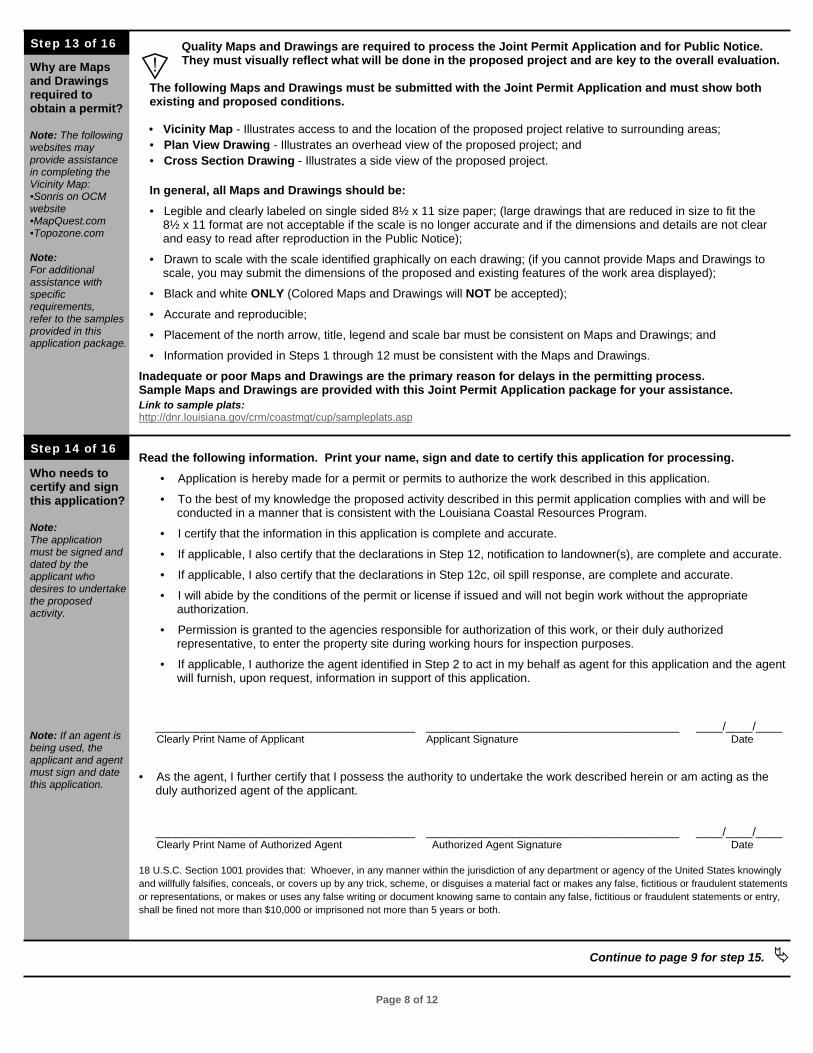
Why are Maps and Drawings required to obtain a permit? Note: The following websites may provide assistance in completing the Vicinity Map: •Sonris on OCM website •MapQuest.com •Topozone.com Note: For additional assistance with specific requirements, refer to the samples provided in this application package.
Who needs to certify and sign this application? Note: The application must be signed and dated by the applicant who desires to undertake the proposed activity. Note: If an agent is being used, the applicant and agent must sign and date this application.
Quality Maps and Drawings are required to process the Joint Permit Application and for Public Notice. They must visually reflect what will be done in the proposed project and are key to the overall evaluation.
The following Maps and Drawings must be submitted with the Joint Permit Application and must show both existing and proposed conditions.
• Vicinity Map - Illustrates access to and the location of the proposed project relative to surrounding areas; • Plan View Drawing - Illustrates an overhead view of the proposed project; and • Cross Section Drawing - Illustrates a side view of the proposed project. In general, all Maps and Drawings should be:
• Legible and clearly labeled on single sided 8½ x 11 size paper; (large drawings that are reduced in size to fit the 8½ x 11 format are not acceptable if the scale is no longer accurate and if the dimensions and details are not clear and easy to read after reproduction in the Public Notice);
• Drawn to scale with the scale identified graphically on each drawing; (if you cannot provide Maps and Drawings to scale, you may submit the dimensions of the proposed and existing features of the work area displayed);
• Black and white ONLY (Colored Maps and Drawings will NOT be accepted);
• Accurate and reproducible;
• Placement of the north arrow, title, legend and scale bar must be consistent on Maps and Drawings; and
• Information provided in Steps 1 through 12 must be consistent with the Maps and Drawings.
Inadequate or poor Maps and Drawings are the primary reason for delays in the permitting process. Sample Maps and Drawings are provided with this Joint Permit Application package for your assistance. Link to sample plats: http://dnr.louisiana.gov/crm/coastmgt/cup/sampleplats.asp Read the following information. Print your name, sign and date to certify this application for processing.
• Application is hereby made for a permit or permits to authorize the work described in this application.
• To the best of my knowledge the proposed activity described in this permit application complies with and will be conducted in a manner that is consistent with the Louisiana Coastal Resources Program.
• I certify that the information in this application is complete and accurate.
• If applicable, I also certify that the declarations in Step 12, notification to landowner(s), are complete and accurate.
• If applicable, I also certify that the declarations in Step 12c, oil spill response, are complete and accurate.
• I will abide by the conditions of the permit or license if issued and will not begin work without the appropriate authorization.
• Permission is granted to the agencies responsible for authorization of this work, or their duly authorized representative, to enter the property site during working hours for inspection purposes.
• If applicable, I authorize the agent identified in Step 2 to act in my behalf as agent for this application and the agent will furnish, upon request, information in support of this application.
_______________________________________ ______________________________________ ____/____/____ Clearly Print Name of Applicant Applicant Signature Date • As the agent, I further certify that I possess the authority to undertake the work described herein or am acting as the duly authorized agent of the applicant. _______________________________________ ______________________________________ ____/____/____ Clearly Print Name of Authorized Agent Authorized Agent Signature Date 18 U.S.C. Section 1001 provides that: Whoever, in any manner within the jurisdiction of any department or agency of the United States knowingly and willfully falsifies, conceals, or covers up by any trick, scheme, or disguises a material fact or makes any false, fictitious or fraudulent statements or representations, or makes or uses any false writing or document knowing same to contain any false, fictitious or fraudulent statements or entry, shall be fined not more than $10,000 or imprisoned not more than 5 years or both.
Continue to page 9 for step 15.
Step 14 of 16
Step 13 of 16
]
Page 9 of 12
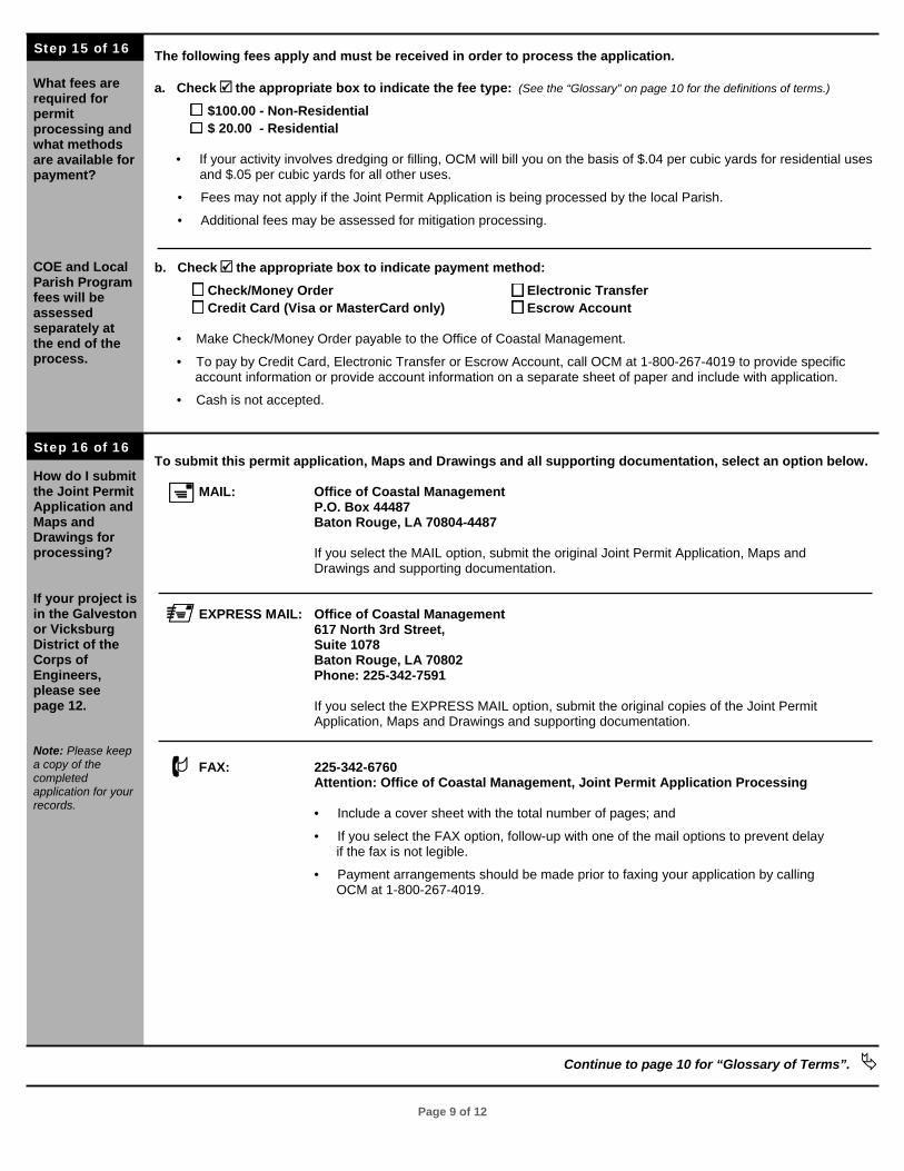
What fees are required for permit processing and what methods are available for payment? COE and Local Parish Program fees will be assessed separately at the end of the process.
How do I submit the Joint Permit Application and Maps and Drawings for processing? If your project is in the Galveston or Vicksburg District of the Corps of Engineers, please see page 12. Note: Please keep a copy of the completed application for your records.
The following fees apply and must be received in order to process the application. a. Check e the appropriate box to indicate the fee type: (See the “Glossary” on page 10 for the definitions of terms.)
$100.00 - Non-Residential $ 20.00 - Residential
• If your activity involves dredging or filling, OCM will bill you on the basis of $.04 per cubic yards for residential uses and $.05 per cubic yards for all other uses.
• Fees may not apply if the Joint Permit Application is being processed by the local Parish.
• Additional fees may be assessed for mitigation processing.
b. Check e the appropriate box to indicate payment method: Check/Money Order Electronic Transfer Credit Card (Visa or MasterCard only) Escrow Account • Make Check/Money Order payable to the Office of Coastal Management.
• To pay by Credit Card, Electronic Transfer or Escrow Account, call OCM at 1-800-267-4019 to provide specific account information or provide account information on a separate sheet of paper and include with application.
• Cash is not accepted. To submit this permit application, Maps and Drawings and all supporting documentation, select an option below. MAIL: Office of Coastal Management P.O. Box 44487 Baton Rouge, LA 70804-4487 If you select the MAIL option, submit the original Joint Permit Application, Maps and Drawings and supporting documentation. EXPRESS MAIL: Office of Coastal Management 617 North 3rd Street, Suite 1078 Baton Rouge, LA 70802 Phone: 225-342-7591 If you select the EXPRESS MAIL option, submit the original copies of the Joint Permit Application, Maps and Drawings and supporting documentation. FAX: 225-342-6760 Attention: Office of Coastal Management, Joint Permit Application Processing • Include a cover sheet with the total number of pages; and
• If you select the FAX option, follow-up with one of the mail options to prevent delay if the fax is not legible.
• Payment arrangements should be made prior to faxing your application by calling OCM at 1-800-267-4019.
Continue to page 10 for “Glossary of Terms”.
Step 16 of 16
Step 15 of 16

Page 10 of 12
Adjacent Landowner Property owners or lessees whose property is contiguous or shares a common border with that being developed. Affected Landowner The owner of the land on which a proposed activity will occur. If a property has multiple owners with undivided interest, each person owning an interest is considered to be an affected landowner. Coastal Use Permit A permit required by 214.30 of the SLCRMA. The term does not mean or refer to, and is in addition to, any other permit or approval required or established pursuant to any other constitutional provision or statute. Compensatory Mitigation As defined by OCM, replacement, substitution, enhancement, or protection of ecological values to offset anticipated losses of ecological values caused by a permitted activity. As defined by the COE, compensating for unavoidable adverse impacts to wetlands by restoring areas to wetlands, creating wetlands, or enhancement of wetlands. Most compensatory mitigation involves purchase of mitigation credits in a private mitigation bank. The amount of credits purchased is dependent on the amount of wetland values that would be lost because of the permitted project. Cross Section A side view of a project area illustrating elevations of features such as natural ground; buildings; bulkheads; piers; and depressions such as waterways, ditches, ponds, etc. Cross sections also show side views of proposed work such as dredging and filling. Discharge The placement or movement of fill or excavated material using methods including, but not limited to dragline or backhoe buckets, bulldozers, front loaders, dump trucks, hydraulic dredge pipes, wheel-washing or prop-washing, jetting, etc. Dredged Material (Spoil) Material that is excavated as part of a specific project. Ecological Value The ability of an area to support vegetation, fish and wildlife populations. Excavate To dig out, remove or move earthen material, or to form a cavity or hole including linear features. Methods include, but are not limited to, draglines, backhoes, bulldozers, front loaders, hydraulic dredges, wheel-washing or prop-washing, jetting, etc. Fastlands Lands surrounded by publicly-owned, maintained, or otherwise validly existing levees or natural formations as of January 1, 1979, or as may be lawfully constructed in the future, which levees or natural formations would normally prevent activities, not to include the pumping of water for drainage purposes, within the surrounded area from having direct and significant impacts on coastal waters. Fill Material Any material including, but not limited to, soil, rocks, sand, clay, construction debris, trees, wood chips, broken concrete and asphalt, etc., whose placement replaces any portion of a waterbottom or wetland with dry land or changes the elevation of wetlands or waterbottoms. This material may come from on-site or be imported from an off-site source.
Mean High Water The average position (elevation) of the high water mark. Mean Low Water The average position (elevation) of the low water mark. Mitigation All actions taken by a permittee to avoid, minimize, restore, and compensate for ecological values lost due to a permitted activity. Non-Residential Includes all actions that do not meet the requirements for the Residential category. Non-Vegetated Waterbottoms Waterbottoms that lack the presence of rooted vegetation. Non-Wet Areas Any area that has sufficiently dry conditions that indicate hydrophytic vegetation, hydric soils, and/or wetland hydrology are lacking. Off-site Not within or adjoining the area directly modified by the permitted activity and not directly related to implementation of the permitted activity. On-site Within or adjoining the area directly modified by the permitted activity or directly related to implementation of the permitted activity. Residential Any coastal use associated with the construction or modification of one single-family, duplex, or triplex residence or camp. It shall also include the construction or modification to any outbuilding, bulkhead, pier, or appurtenance on a lot on which there exists a single-family, duplex, or triplex residence or camp or on a water body which is immediately adjacent to such lot. Uses which do not fit this definition are non-residential. The Coastal Use Permit application fee for residential projects is $20. Unavoidable Net Loss of Ecological Values The net loss of ecological value that is anticipated to occur as the result of a permitted/authorized activity, despite all efforts, required by the guidelines, to avoid, minimize, and restore the permitted/authorized impacts. Vegetated Waterbottoms Waterbottoms that exhibit the presence of rooted vegetation. Wetlands For the purposes of §724 (as defined in R.S. 49:21.41), Open water areas or areas that are inundated or saturated by surface or groundwater at a frequency and duration sufficient to support, and under normal circumstances, do support a prevalence of vegetation typically adapted for life in saturated soil conditions.
Continue to page 10 for “Frequently Asked Questions”.
Glossary of Terms
The following information may provide a better understanding of terms that are used throughout this application. If the terms defined in this section do not help you, please contact OCM at one of the following, 1-800-267-4019 or 225-342-7591.
Page 11 of 12
What gives the Office of Coastal Management (OCM) the right to regulate private property? OCM does not regulate private property. OCM regulates activities that have a direct and significant impact on state public resources. OCM’s authority derives from Louisiana Revised Statute 49:214.21 et seq. Visit the legislative website for additional information at http://www.legis.state.la.us/lss/tsrssearch.htm. How does the Joint Permit Application process work? In general, an application is submitted which details the location and scope of the proposed work. OCM – Permits & Mitigation Division, which serves as a central collection point for the applications, distributes the applications to interested parties for their review and comment. OCM - Permits & Mitigation Division and the commenting agencies review the application for conformance with programmatic requirements and look for ways of minimizing impacts to coastal resources (e.g., vegetated wetlands, bird rookeries, endangered species, etc.). If necessary, negotiations are entered into to find locations, technologies or methods of implementing the project which will accommodate the needs of the permit applicant while conforming with the mandates of the various state and federal agencies. Once consensus is reached an appropriately conditioned permit is issued. Who receives a copy of my Joint Permit Application? The following agencies/offices receive a copy of your application: • OCM Permit Section; • Local Programs Section, (if necessary); • OCM Support Services Staff; • OCM Field Investigator; • The Army Corps of Engineers; and • State Land Office. How long does it take to obtain a permit? The following schedules are offered with the assumption that all of the information required by OCM is included in the application and the plats are adequate, clear and legible. For activities that are exempt from permit requirements, the determination is normally issued in under seven days. Projects that are determined to have no direct or significant impacts to coastal resources are issued in 4 to 10 days depending on location. Authorizations for activities that qualify for a General Permit are issued in 10 to 15 days. For those activities that require full public notice, a minimum of 45 days is required. During review of the permit application, for more complex activities, additional information may be requested. The more promptly the applicant can furnish this information the less time it will require to issue the authorization. The requirement for mitigation of wetland impacts is one of the factors that increases the time required for permit application review, as does coordination with other State agencies for activities affecting resources of concern to that agency How do I check the status of a submitted Joint Permit Application? Information regarding submitted permits may usually be obtained on the OCM website: http://sonris.com/direct.asp?server=sonris-www&path=/sonris/cmdPermit.jsp%3Fsid%3DPROD. How does OCM protect the information that I provide throughout this application? Information provided on the application is used to evaluate the activity that is proposed for permitting, and this information is generally available for inspection and copying by the public, pursuant to the Louisiana Public Records act. There are some limited exceptions to the public records laws to protect certain types of records or information from public inspection. Please contact our office, before you submit any records or information that you would prefer not be available for public inspection or copying. In any case, simply marking a document “CBI” or “confidential business information” will not guarantee that the records or information will be protected from public inspection and copying.
May I submit a Joint Permit Application to the Parish instead of OCM? Yes, if your project is located in a parish with an approved Local Coastal Program (Calcasieu, Cameron, Jefferson, Lafourche, Orleans, Plaquemines, St. Bernard, St. James, St. Tammany or Terrebonne) then you may submit your application to either the approved local program or the state office. If you submit the application to the state office, it will be input into the system and reviewed at that time. If you submit your application to the local parish office, then that office will forward the application to the state office to be input into the system and reviewed. Please allow additional time to receive a response if you choose the latter option. What other permits may be required? If your project involves dredging or filling of wetlands you may need a Water Quality Certification from the Department of Environmental Quality. Other approvals may be required but are not limited to the following: • State Land Office; • Department of Wildlife and Fisheries; • Department of Culture, Recreation and Tourism; • Department of Transportation and Development; and/or • Department of Health and Hospitals. These agencies will notify you of their requirements as part of the Joint Public Notice process. When I receive my permit from OCM, may I begin work? Following the determination from OCM, work may begin only after obtaining any necessary permit(s) from the COE, including any required mitigation, and any approvals or permits required any local authority or agency or by any state or federal agency, as may be required by law for said activity or the construction of the referenced project. How may I receive an extension for a permit? If you have not begun work on your project within two years of the date of permit issuance, the initiation period can be extended for an additional two years if you submit a request to OCM no less than sixty days and no more than one-hundred and eighty days before the initial two year period expires. The expiration date can be extended. Follow the same rules. There is an $80.00 extension fee. If I began my project without a permit, what will happen? OCM processing of any pending Joint Permit Application for the project will be suspended until the violation is resolved. You may be required to remove any structures installed and restore any impacted habitat. You may be subject to fines of up to $12,000and may be jailed up to six months. The penalties assessed by the Army Corps of Engineers may be significantly more expensive and more complicated. Did I break the law if I have already done some clearing? A representative from LDNR will perform a field investigation and project evaluation in order to determine the extent of any impacts and if you have violated any laws. Contact OCM at 1-800-267-4019 for assistance. What is Section 10 of the Rivers and Harbors Act? Section 10 of the Rivers and Harbors Act of 1899 prohibits the obstruction or alteration of navigable water of the United States without a permit from the U.S. Army Corps of Engineers. What is Section 404 of the Clean Water Act? Section 404 of the Clean Water Act prohibits the discharge of dredged or fill material into waters of the United States without a permit from the U.S. Army Corps of Engineers. How do I receive additional information on the Joint Permit Application process? For additional information regarding the Joint Application Process, contact OCM at 1-800-267-4019 or visit the website at: http://dnr.louisiana.gov/crm/. You may also contact the Army Corps of Engineers at 504-862-2766 or visit the website at: www.mvn.usace.army.mil/ops/regulatory.
Frequently Asked Questions
The following questions and answers may assist you during the application process. For an expanded version of frequently asked questions, visit our website at http://dnr.louisiana.gov/CRM/faq.asp
Continue to page 12 for “Contacts and Additional Landowner Information” .

Page 12 of 12
J
COE District Contact Information: U.S. Army Corps of Engineers Galveston District Attention: CESWG-PE-R P.O. Box 1229 Galveston, TX 77553-1229 Phone:409-766-3930 Fax:409-766-3931
U.S. Army Corps of Engineers Vicksburg District Attention: CEMVK-OD-F 4155 Clay Street Vicksburg, MS 39183-3435 Phone:601-631-5276 Fax:601-631-5459
If your project is in the Galveston or Vicksburg COE District, submit your application directly to them. See addresses listed below.
Additional Landowner Information (if necessary):
Adjacent Landowner #5: _____________________________________________________________________ Name of Adjacent Landowner
Mailing Address: ____________________________________________________________________ Street Address or P.O. Box Unit/Apartment #
___________________________ __________________ _______ ___________ City Parish State Zip
Adjacent Landowner #6: _____________________________________________________________________
Name of Adjacent Landowner
Mailing Address: ____________________________________________________________________ Street Address or P.O. Box Unit/Apartment #
___________________________ __________________ _______ ___________ City Parish State Zip
Adjacent Landowner #7: _____________________________________________________________________
Name of Adjacent Landowner
Mailing Address: ____________________________________________________________________ Street Address or P.O. Box Unit/Apartment #
___________________________ __________________ _______ ___________ City Parish State Zip
Adjacent Landowner #8: _____________________________________________________________________
Name of Adjacent Landowner
Mailing Address: ____________________________________________________________________ Street Address or P.O. Box Unit/Apartment #
___________________________ __________________ _______ ___________ City Parish State Zip
Contacts and Additional Landowner Information