forest classification & forest road & trail designations...
TRANSCRIPT

Forest Classification &
Forest Road & Trail Designations for
State Forest Lands in Lake County, Minnesota
Final Plan – 11/06/07
Minnesota Department of Natural Resources

Lake Co. Plan – Final Plan Page 2 of 31 06 Nov. 2007
Minnesota Department of Natural Resources
Lake County Road & Trail Designation Team
Steve Hennessy..........................................................................................................Trails & Waterways Div. Chel Anderson........................................................................................................... Ecological Services Div. Dave Olfelt.................................................................................................................................Fish & Wildlife Jim Rupert .................................................................................................................................Div. of Forestry Kathy Larson ...................................................................................................................Div. of Enforcement Tom Engel, G.I.S. Support........................................................................................Div. of Fish & Wildlife Craig Perrault, G.I.S. Support .....................................................Mgmt Information Systems, NE Region Brian McCann, Planner ............................................................................................Trails & Waterways Div.
© 2007, State of Minnesota, Department of Natural Resources
Equal opportunity to participate in and benefit from programs of the Minnesota
Department of Natural Resources is available to all individuals regardless of race,
color, creed, religion, national origin, sex, marital status, status with regard to public
assistance, age, sexual orientation, or disability. Discrimination inquiries should be
sent to MN DNR, 500 Lafayette Road, St. Paul, MN 55155-4031; or the Equal
Opportunity Office, Department of the Interior, Washington, DC 20240.

Lake Co. Plan – Final Plan Page 3 of 31 06 Nov. 2007
Table of Contents Executive Summary................................................................................... .....................................................4 Purpose.................................................................................................. ...........................................................4 Lands covered by this Plan.............................................................................................................................4 Final Motor Vehicle Use Classifications .....................................................................................................4 Closed Areas & Areas With Limitations on Off-Trail and Non-Designated Trail Use.......................5 Forest Route Inventory .................................................................................................................................5 Final Road & Trail Designations..................................................................................................................5
Background .........................................................................................................................................................7 Process .............................................................................................................................................................7
Description of Lands Covered by this Plan ...................................................................................................8 Final Motor Vehicle Use Classification...........................................................................................................8 Lands Covered by this Classification Review.............................................................................................9 Inside State Forest Boundaries .................................................................................................................9 Outside State Forest Boundaries ..............................................................................................................9
Classification Process...................................................................................................................................10 Final State Forest Land Classifications......................................................................................................10 Finland State Forest..................................................................................................................................10 Scattered Lands Outside State Forest Boundaries ...............................................................................11 Closed Areas & Areas With Limitations on Off-Trail and Non-Designated Trail Use .................11
Forest Route Inventory ...................................................................................................................................11 Development of Access Proposals ............................................................................................................12 Final Forest Road & Trail Designations ...................................................................................................12 Forest Roads..................................................................................................................................................12 System Forest Roads ................................................................................................................................13 Minimum Maintenance Forest Roads....................................................................................................13
Interagency Recognition of Forest Road Designations ..........................................................................13 Off-Highway Vehicle Trails ....................................................................................................................13 Non-Motorized Trails ..............................................................................................................................14 Snowmobile Trails ....................................................................................................................................14 Non-Designated Routes...........................................................................................................................14 Proactive Closures ....................................................................................................................................15
Maps...................................................................................................................................................................15 Plan Implementation & Monitoring..............................................................................................................15 Adoption of the Classification & Road/Trail Designation Plan...............................................................15 Road and Trail Development & Signing Projects .......................................................................................15 Plan Effective Date..........................................................................................................................................15 Monitoring and Management.........................................................................................................................15 Appendices ......................................................................................................................................................16

Lake Co. Plan – Final Plan Page 4 of 31 06 Nov. 2007
Executive Summary Purpose Minnesota Laws 2003, Chapter 128, Article 1, Section 167 (as amended) directs the Commissioner of the Department of Natural Resources (DNR) to review the recreational motor vehicle use classification of state forest lands. Following public review and comment, the Commissioner implements these motor vehicle use classifications and road / trail designations through the adoption and publication of written orders. By December 31, 2008, the DNR must review the motor vehicle use classification of all 58 State Forests, and associated lands located outside of state forests, all across Minnesota. This plan covers state forest lands located in Lake County, Minnesota. The Lake County Planning Unit covers 161,093 acres, including 99,562 acres inside the Finland State Forest, and 61,531 acres outside of state forest boundaries. About 23,501 acres of these so-called ‘scattered’ lands located outside of state forest are located within the federal Boundary Waters Canoe Area Wilderness (BWCAW). Lake County is 83% publicly-owned; with 58% federal forest land, 13% state forest land, and 12% county tax-forfeited forest lands. Over 30% of Lake County’s total 1,364,480 acres lies within the BWCAW. Given the mixed public forest land ownership in Lake County, the DNR has sought to coordinate its’ work with key stakeholders, including Lake County and the U.S. Forest Service. Tribal leaders have also been consulted. Recommended forest land classifications and motor route designations were developed in consultation with these groups, and with input from citizens who participated in a series of agency-sponsored open houses held in July 2006. This plan, and the commissioner’s Orders that implement it, address only for state-administered forest lands. Federal, county and tribal land management decisions will be made and communicated separately from the DNR process.
Lands Covered by this Plan There are four named State Forests located, entirerly or partially within Lake County. These include the Insula Lake and Lake Isabella State Forests, both of whiich are located entirely inside the BWCAW, a portion of the Bear Island State Forest, most of which is located in St. Louis County, and the Finland State Forest. This plan addresses only the state forest lands within the Finland State Forest (99,562 ac. – including 1,861 ac. in SW Cook Co.) and those ‘scattered’ state lands located outside its statutory boundaries (61,531 ac.). Of this, 23,501 acres located within the BWCAW are ‘closed’ to motorized use. Therefore, a total of approximately 137,592 acres are subject to reclassification and motor route designation as part of this exercise.
Table 1. Summary of Lake County State Forest Land Ownership. Source: Forest Access Route Unpublished Data, Jan. 2007. DNR DRS. Generated using ArcView extension.
State Forest Lands
Lake County
Statutory
Acres
DNR-Admin
Acres
DNR Acres
w/in
BWCAW
Inventoried
Route Miles
Finland State Forest 311,971 99,562 NA 165.7
Outside State Forest NA 61,531 23,501 52.6
Totals 311,971 161,093 23,501 218.3
In addition to State Forest lands, there are 4 State Parks (19,537 ac), 2 SNA’s (5,302 ac), 2 WMA’s (592 ac) and 1 State Wayside (92 ac). The Lake Co. Land Department also manages about 155,000 acres; 94,102 acres of this within the Finland State Forest. Forested lands (all owners) comprise over 95% of the total land area of Lake County.
Final Motor Vehicle Use Classifications According to state law, state forest lands must be classified as managed, limited or closed with respect to public motor vehicles use. All state forest lands located within and outside the Finland State Forest boundaries, except for those lands within the BWCAW, were previously classified as ‘managed. State forest lands within the BWCAW are ‘closed’ to all motorized vehicle use, and will remain so under this proposal.

Lake Co. Plan – Final Plan Page 5 of 31 06 Nov. 2007
This proposal changes to ‘limited’ the classification of all state forest lands located within the proclamation boundaries of the Superior National Forest (northern portion of the Finland), but retains as ‘managed’ those portions of the Finland that lie outside the Superior National Forest boundaries in southern Lake & SW Cook County. Scattered state forest lands, outside of state and federal forest boundaries, in the northern part of the county will be reclassified as ‘limited’. Scattered state forest lands, outside of State & Federal forest boundaries, in southern Lake County will remain ‘managed’. Lake County state forest land classifications are summarized in Table 2. (Approx acreages)
Table 2. Final State Forest Land Classification in Lake County Source: Forest Access Route Unpublished Data, Jan. 2007. DNR DRS. Generated using ArcView extension.
Final Forest
Classification
Inside State Forest
(acres)
Outside State Forest
(acres)
Totals
(acres)
Managed 17,816 18,802 36,618
Limited 81,746 19,228 100,974
Closed (in BWCAW) NA 23,501 23,501
Totals (acres) 99,562 61,531 161,093
‘Closed’ Areas and Areas with Limitations on Off-Trail and Non-Designated Trail Use Seven areas totaling 12,065 acres (state forest lands) were given special desingations under this plan. Three of the sites will be reclassified as ‘closed’; the remainder were designated as areas with limitations on off-trail and non-designated trail use pursuant to MS Chap. 84.926, Subd. 5 (eliminates hunter/trapper exceptions). All 7 sites share the following general characteristics: (See the Plan Appendix for maps).
• High-to-outstanding biodiversity significance rankings;
• Absence of inventoried forest roads or motorized trails, and/or existing non-motor activity; and
• Proximity to unique or sensitive wildlife habitat, hydrologic features, and/or traditional non-motorized recreation areas.
Forest Route Inventory The 2003-04’ forest route inventory showed a total of 218.3 miles of ‘routes’ on State Forest land within the DNR’s Lake County Planning Unit: 165.7 miles in the Finland State Forest; 52.6 miles located outside of state forest boundaries. No routes were inventoried within the federal BWCAW.
Final Road and Trail Designations The forest road and trail designations for State Forest lands proposed in this plan were developed by an interagency team using route inventory data, combined with local land manger’s knowledge of these routes, and public input gathered during the open house meetings in January 2006 and the public review meeting held June 12th in Finland. The Planning Team’s challenge was to propose a consistent, understandable and enforceable system across public land ownerships that complies with existing laws and policies, adequately protects natural resources, and provides for continued public recreational access. Proposed road and trail designations are summarized in Table 3 (below) and shown in the forest Road & trail Designation Map which accompanies this plan, and is incorporated by reference. See www.dnr.state.mn.us for a downloadable copy of the Lake County Planning Map.

Lake Co. Plan – Final Plan Page 6 of 31 06 Nov. 2007
Table 3. Final Forest Road and Trail Designation Mileage Summary for Lake County
Source: Forest Access Route Unpublished Data, 2007. DNR DRS. Generated using ArcView extension.
Route Designation Inside Finland State Forest
(miles)
Outside State Forest
(miles)
Route Totals (miles)
Inventoried Routes 169.8 48.5 218.3
System Forest Road 57.5 0.0 57.5
Min. Maintenance Forest Road 64.7 20.0 84.7
Non-designated Routes
Proactive Closures
In closed forests
In limited forests
In managed forests (Access Routes)
11.3
0.0
7.8
12.7
31.8
2.7
0.0
8.5
8.2
19.4
14.0
0.0
16.3
20.9
51.2
ATV Trail 5.0 0.0 5.0
ATV/OHM Trail 0.6 0.4 1.0
Hiking Trails 6.1 8.7 14.8
Hunter Walking Trails 4.1 0.0 4.1

Lake Co. Plan – Final Plan Page 7 of 31 06 Nov. 2007
BACKGROUND The Minnesota Department of Natural Resources (DNR) manages nearly 5 million acres of State Forest land. Minnesota's State Forests are managed to produce timber, protect watersheds, provide outdoor recreation, and to perpetuate rare and distinctive species of native flora and fauna. State Forests are managed in a ‘sustainable’ manner, in order to ensure that they remain healthy, vital, and productive for present and for future generations. State Forests provide a variety of dispersed, unstructured outdoor recreation opportunities, such as hunting, trapping, berry picking, and nature observation. For more structured activities, many State Forests contain recreation facilities with campgrounds, day-use areas, and trails designated for various motorized and non-motorized purposes. Minnesota statutes direct the Commissioner of Natural Resources to:
• Manage State Forests according to the principles of multiple use and sustained yield. (MS 89.002, Subd.1)
• Provide a system of forest roads and trails to access State Forest lands. (MS 89.002, Subd.3) Prior to the mid-1980’s recreational motor vehicle use was generally allowed in most State Forests. As the number of Off-Highway Vehicles (OHVs) increased, the DNR closed some forests to OHV use and began developing trails and other facilities for OHV use in others. In late 1996, the DNR began to reassess its OHV management programs. In 1999 the DNR revised the rules governing recreational use of State Forests. In 2000, the DNR classified State Forests as managed, limited, or closed with respect to recreational motor vehicle use. Minnesota Laws 2003, Chapter 128, Article 1, Section 167 (as amended) directs the DNR Commissioner to review the recreational motor vehicle use classification of all 58 State Forests, and scattered state forest lands. Following public review and comment, motor vehicle use classification decisions and road / trail designations are to be adopted and implemented through the publication of official notices and written orders.
Process In June 2006, an interdisciplinary team with members from the DNR Divisions of Ecological Services, Enforcement, Fish & Wildlife, Forestry, and Trails & Waterways began working on the following tasks:
1. Collaborate with the public and other forest management agencies to develop a plan for the management of public motor vehicle use on forest lands in the planning area.
2. Consider the criteria for classification of State Forest lands (MR Chap. 6100.1950) and recommend an appropriate motor vehicle use classification.
3. Evaluate all inventoried forest access routes and propose (un)designation of forest roads and trails for specific motorized and non-motorized uses.
4. Present the team’s recommendations for public review, discussion and comment.
Major steps in developing the road and trail designation proposals are: 1. Compile an inventory of forest access routes – roads, trails, and other routes showing evidence of ongoing
motorized use. Prepare maps showing all travel routes. 2. Host a series of public open houses to alert people to the road and trail designation process, to gain an
understanding of how they use these access routes, how they use state lands generally, and to solicit ideas regarding the future designation of selected routes.
3. Conduct interagency working sessions to make preliminary designation and use recommendations based on inventory data, staff knowledge, and public input from the open houses.
4. Identify routes potentially suitable for designation as motor/non-motor recreational trails. 5. Prepare designation plans and maps for internal agency and public review and comment. 6. Secure final approval for final plans, maps and Commissioner’s Orders implementing recommendations.
Given the mix of county, state, and federal land ownership in the planning area, the DNR team sought to coordinate its work with Lake County and the US Forest Service. Tribal interests were also consulted. The goal was to develop a consistent, understandable and enforceable approach to vehicular access across public and private forest land ownerships. The team worked within existing mandates and guidelines for the management of state forest lands, while respecting the management plans and policies for other forest land owners in Lake County.

Lake Co. Plan – Final Plan Page 8 of 31 06 Nov. 2007
DESCRIPTION OF LANDS COVERED BY THIS PLAN There are four named State Forests located, entirerly or partially within Lake County. These include the Insula Lake and Lake Isabella State Forests, both of whiich are located entirely inside the BWCAW, a portion of the Bear Island State Forest, most of which is located in St. Louis County, and the Finland State Forest. This plan addresses only the state forest lands within the Finland State Forest (99,562 ac. – including 1,861 ac. in SW Cook Co.) and those ‘scattered’ state lands located outside its statutory boundaries (61,531 ac.). Of this, 23,501 acres located within the BWCAW are ‘closed’ to motorized use. Therefore, a total of approximately 137,592 acres are subject to reclassification and motor route designation as part of this exercise.
Table 4. Summary of Lake County State Forest Land Ownership. Source: Forest Access Route Unpublished Data, Jan. 2007. DNR DRS. Generated using ArcView extension.
State Forest Lands
Lake County
Statutory
Acres
DNR-Admin
Acres
DNR Acres
w/in
BWCAW
Inventoried
Route Miles
Finland State Forest 311,971 99,562 NA 165.7
Outside State Forest NA 61,531 23,501 52.6
Totals 311,971 161,093 23,501 218.3
In addition to State Forest lands, there are 4 State Parks (19,537 ac), 2 SNA’s (5,302 ac), 2 WMA’s (592 ac) and 1 State Wayside (92 ac). The Lake Co. Land Department also manages about 155,000 acres; 94,102 acres of this within the Finland State Forest. Forested lands (all owners) comprise over 95% of the total land area of Lake County.
MOTOR VEHICLE USE CLASSIFICATION Minnesota Law requires the Commissioner of Natural Resources to complete a review the motor vehicle use classification of all 58 State Forests, and associated ‘scattered’ state forest lands located outside of state forest boundaries, by December 31, 2008. The process and criteria for forest classification are set forth in MR Chapter 6100.1950.
State Forest motor vehicle use classifications are characterized as follows: ‘Managed’ Forest Lands. All state forest roads and forest trails are open to recreational motor vehicle use unless posted closed. These forest lands are characterized by a low intensity of use by OHVs, a variety of motorized and non-motorized recreational opportunities, widely dispersed use, and little competition among visitors for recreational use of the land. Signing and enforcement restrict motor vehicle use in sensitive resource areas and on designated recreational trails. ATVs may be operated on non-designated routes and off-trail under hunting and trapping exceptions (MS Chap. 84.926). ORVs and HLVs may also be operated on non-designated routes under these same exceptions. When using unsigned routes, it is illegal to operate motor vehicles in a manner that causes erosion or rutting or injures, damages, or destroys trees or growing crops. The managed classification can only be applied to forest lands north of U.S. Highway 2. ‘Limited’ Forest Lands. Forest roads are ‘open’ to motor vehicle use unless posted closed. Forest trails are closed to motor vehicle use, except where designated and signed to permit specific motorized uses. These forest lands are characterized by moderate to high levels of recreational use. ATVs may be operated on non-designated routes and off-trail pursuant to statutory hunting and trapping exceptions. ORVs and HLVs may also be operated on non-designated routes under these same statutory exceptions. ‘Closed’ Forest Lands. Forest roads are open to motor vehicles licensed for highway use. No OHVs are permitted, except for operation on frozen public waters. Snowmobiles may operate on designated trails only. These lands are characterized by high-susceptibility to damage by motorized use or have a history that precludes motorized use.

Lake Co. Plan – Final Plan Page 9 of 31 06 Nov. 2007
Areas closed to motor vehicle use by statute or regulations (e.g., State Forest lands within the BWCAW) are automatically classified as ‘closed.’ The hunting and trapping exceptions do not apply in closed forests.
The following criteria are used to classify forest lands for motor vehicle use: (MR 6100.1950, Subp. 2)
A. resource sensitivity and management objectives;
B. resource impact by motorized and nonmotorized use, including erosion, rutting, and impacts on vegetation,
wildlife, air, water, or natural habitats;
C. motorized and nonmotorized recreational opportunity in area;
D. user needs, such as trails, parking, signs, and access;
E. the degree and trend of motor vehicle use in the area;
F. the degree and trend of nonmotor vehicle use in the area;
G. competing interests among different user groups; and
H. public safety and law enforcement concerns.
Lands Covered by this Classification Review This plan addresses only state forest lands located within the Finland State Forest (99,562 ac. – including 1,861 ac. in SW Cook Co.) and those ‘scattered’ state lands located outside its statutory boundaries (61,531 ac.). Of this, 23,501 acres located within the BWCAW are ‘closed’ to motorized use. Therefore, a total of approximately 137,592 acres are subject to reclassification and motor route designation as part of this exercise. This review does not cover DNR lands located within the federal BWCAW, which includes both the Insula Lake and Lake Isabella State Forests, and a portion of the Bear Island State Forest. The Bear Island State forest will be addressed, in its entirety, in a subsequent planning effort. NOTE: Variability in plan acreage calculations results from combining various state, federal & county data layers, each with their own stregnths and shortcomings, and data collection and reporting protocols (e.g., include or exclude surface water acres).
Inside State Forest Boundaries This plan addresses only the state forest lands within the Finland State Forest (99,562 ac. – including 1,861 ac. in SW Cook Co.) and those ‘scattered’ state lands located outside its statutory boundaries (61,531 ac.). Of this, 23,501 acres located within the BWCAW are ‘closed’ to motorized use. Therefore, a total of approximately 137,592 acres are subject to reclassification and motor route designation as part of this exercise. Minnesota Statutes Chapt. 84.777 also applies the State Forest classification and road/trail designation process to county-administered forest lands inside the boundaries of State Forests, unless the county board adopts a resolution that modifies restrictions on the use of off-highway vehicles on county-administered land within the forest. Thus, this classification review also technically covers the 94,102 acres of Lake County tax-forfeited forest located within state forest boundaries. The Lake County Board of Commissioners has not, as of this date, adopted a resolution modifying or endorsing restrictions on OHV use on county-administered forest lands within State Forests. The motor vehicle use classification and related State Forest rules do not apply on federal, tribal, or private lands within (or outside of) State Forest boundaries. The classification and rules also do not apply to the rights-of-way of public highways within State Forest boundaries, which are under the jurisdiction of state, county, or local public road authorities. Moreover, state forest classification and rules do not apply to other state lands administered by the DNR, such as State Parks, Wildlife Management Areas, Scientific & Natural Areas or State Trails.
Outside of State Forest Boundaries There are about 61,531 acres of state forest lands located outside the statutory boundaries of the Finland State Forest. Of this, 23,501 acres located within the BWCAW are ‘closed’ to motorized use and shall remain so. The remaining 38,030 acres of so-called ‘scattered lands’ are, however, included in this forest classification review.

Lake Co. Plan – Final Plan Page 10 of 31 06 Nov. 2007
This review does not apply to county-administered lands located outside of State Forest boundaries. Nor does it apply to federal, tribal, or private lands inside or outside of State Forest boundaries. Forest classification also does not apply to other state-owned lands such as those located inside State Parks, Wildlife Management Areas, Scientific & Natural Areas, or those lands included as part of State Trails.
Classification Process & Criteria The DNR’s Lake County Planning Team reviewed the forest classification criteria, collected pertinent data, and solicited input from Area Staff, cooperators and the public. Various classification proposals were discussed and debated among team members at the outset of this process. This set the stage for an intensive route-by-route evaluation which followed. USFS and Lake County Land Department Staff also participated in this evaluation process. Team recommendations are based upon criteria contained in MR 6100.1950, and an evaluation of existing conditions and current use levels. Team members sought to protect natural resources and further resource management objectives through their recommendations. They also sought to foster consistency with USFS and county access plans and travel management policies. Consistency of regulation across mixed public ownerships is desirable, because it fosters public understanding of vehicular use rules, and it facilitates effective field enforcement.
Final State Forest Land Classifications All state forest lands located within and outside the Finland State Forest boundaries, except for those lands within the BWCAW, are currently classified as ‘managed. State forest lands within the BWCAW are ‘closed’ to all motorized vehicle use, and will remain so under this plan. This plan changes to ‘limited’ the classification of all state forest lands located within the legal boundaries of the Superior National Forest (northern portion of the Finland), but retains as ‘managed’ those portions of the Finland that lie outside the Superior National Forest boundaries in southern Lake & SW Cook County. Scattered state forest lands, outside of state and federal forest boundaries, in the northern part of the county will be classified as ‘limited’. Scattered state forest lands, outside of State & Federal forest boundaries, in southern Lake County will remain ‘managed’.
Table 5. Final State Forest Land Classification in Lake County Source: Forest Access Route Unpublished Data, Jan. 2007. DNR DRS. Generated using ArcView extension. (Approx)
Proposed Forest
Classification
Inside State Forest
(acres)
Outside State Forest
(acres)
Totals
(acres)
Managed 17,816 18,802 36,618
Limited 81,746 19,228 100,974
Closed (mostly in BWCAW) NA 23,501 23,501
Totals (acres) 99,562 61,531 161,093
Finland State Forest – Inside Forest Boundaries The majority of current OHV and HLV use in the Finland State Forest is related to fall hunting and trapping activities. Use levels are generally light, with little summer use. Popular routes are most commonly of logging origin, with few user-developed trails or spurs. Most inventoried forest roads and trails do not show signs of rutting, overuse, erosion or significant vehicular damage. While OHV use in the Finland State Forest is not extensive, there are areas of concentrated use. Access to cities, towns and popular recreation facilities (e.g., Moosewalk/Mooserun & Red Dot ATV Trails) makes the forest a destination for some riders. Moreover, the scattered nature of state and federal forest lands within the forest make consistency critical in terms of OHV regulation and enforcement. Routes on USFS lands are ‘closed unless posted open’ to OHV use,

Lake Co. Plan – Final Plan Page 11 of 31 06 Nov. 2007
which approximates the state’s ‘limited’ classification. For this reason, the DNR Planning Team suggests a ‘limited’ classification for that portion of the Finland State Forest that lies within the Superior National Forest. Lake County forest lands, on the other hand, are ‘open’ to vehicle use unless posted closed, similar to the state’s ‘managed’ classification. Most of Lake County’s forest lands are located in southern Lake County, both inside and outside of the Finland State Forest. Adjacent State Lands are likewise proposed to be classified as ‘managed’. Hunting, trapping and local utilitarian (summer) motorized access is maintained, to some extent, under both the ‘limited’ and ‘managed’ classifications. Heavy recreational OHV use of non-designated routes is unlikely given the forest’s remote location and distance form major population centers. The state land prohibitions on rutting, erosion and vegetative damage which apply to all non-designated or forest access routes were deemed adequate to deter future abuse. Mixed public land ownership within the forest makes regulatory consistency a critical factor in fostering compliance. Every effort was made to ensure a consistent approach across ownerships.
Finland State Forest – Outside Forest Boundaries (‘Scattered’ Lands) There are about 61,531 acres of state forest lands located outside the statutory boundaries of the Finland State Forest. Of this, 23,501 acres located within the BWCAW are ‘closed’ to motorized use and shall remain so. The remaining 38,030 acres of so-called ‘scattered lands’ are included in this forest classification review. So-called ‘scattered’ lands in the northern part of the county will be classified as ‘limited’ consistent with USFS regulations, and ‘managed’ in the southern part of the county where the preponderance of Lake County forest lands are located. This is based on the need to foster consistency of management and enforcement of OHV regulations in areas of mixed public forest land ownership. Both the managed and limited forest classifications provide for continued vehicular access.
‘Closed’ Areas and Areas with Limitations on Off-Trail and Non-Designated Trail Use Seven areas totaling 12,065 acres (state forest lands) will receive special designations. Three of the sites will be reclassified as ‘closed’; the remainder will have limitations on off-trail and non-designated trail use pursuant to MS Chap. 84.926, Subd. 5 (eliminates hunter/trapper exceptions). All 7 sites share the following general characteristics:
• High-to-outstanding biodiversity significance rankings;
• Absence of inventoried forest roads or motorized trails, and/or existing non-motor activity; and
• Proximity to unique or sensitive wildlife habitat, hydrologic features, and/or traditional non-motorized recreation areas.
FOREST ROUTE INVENTORY In 2003-04’, DNR staff inventoried and mapped all existing forest access routes on state and county-administered forest lands showing evidence of ongoing motorized use. Field crews did this using ATVs equipped with global positioning system (GPS) units. Impassable routes were digitized from aerial photos. Also recorded were locations where the access routes were too narrow or unsafe for ATV travel, and where these routes ended. Inventory crews collected data such as tread width, apparent use, level of use, and surface condition. All forest route data was entered into a GIS database and was used to support the team’s analysis and decision making. The 2003-04’ DNR Forest Access Route Inventory showed a total of 218.3 miles of roads, trails and other routes on DNR-administered lands in Lake County. The routes were distributed as follows: 1. Finland State Forest = 165.7 miles of roads, trails and non-designated forest access routes, including 59.3 miles
of previously designated State Forest Roads; 2. ‘Scattered’ Lands Outside of State Forest = 52.6 miles of roads, trails and non-designated forest access routes.
US Forest Service and DNR GIS staff compiled all the highway, forest road, trail, and access route data into a ‘travel routes’ database. Given the multiple data sources, there was some duplication of information. Automated and manual checks were used to clean-up the database and remove duplicates. Still, there are inherent limitations on the completeness and accuracy of forest route inventory information. Public road authorities are continually adding,

Lake Co. Plan – Final Plan Page 12 of 31 06 Nov. 2007
rerouting, and sometimes abandoning public roadways. Public land ownership patterns also change over time as lands are acquired, sold, or exchanged. Likewise, regular natural resource management activities (e.g., fire-fighting, timber sales) can create or obliterate forest access routes. Little-used trails and other routes often re-vegetate and become impassable over time.
Development of Access Proposals The forest road and trail designations proposed in this plan were developed by an interagency team using the data described above, along with the local land manger’s knowledge of the routes, and public input gathered during the open houses held in January 2006. Interagency working sessions held during 2006 sought to ensure consistency and compatibility of access planning recommendations. The challenge is to provide for adequate public land access in an understandable, sustainable and enforceable manner. The interagency work groups used GIS tools to map and document their proposals. Every route on state and federal forest land maps has been coded as to its proposed use designation (e.g., forest road, motorized or non-motorized recreational trail). Reasons for each proposed designation have been recorded. For previously designated forest roads and recreational trails, the presumption was typically that the current designation would be maintained, unless there was a compelling reason to propose a change.
FINAL FOREST ROAD AND TRAIL DESIGNATIONS The miles of routes proposed to receive various administrative designations are summarized in Table 6. The routes are also shown on the maps that accompany and are part of this plan.
Forest Roads Forest roads are routes that are maintained by resource management agencies to provide access to public forest lands both for resource management and public use. They range from unimproved double-track with native soil surface to two-lane graveled roads with engineered stream crossing and drainage improvements. Forest roads are not considered ‘public roads’ by resource agencies which are not technically ‘road authorities.’ Each agency sets public use rules and determines the types of vehicles that will be allowed on the forest roads it manages.
Table 6. Forest Road and Trail Designation Mileage Summary for Lake County Source: Forest Access Route Unpublished Data, 2007. DNR DRS. Generated using ArcView extension.
Route Designation State Forest Lands (miles)
System Forest Road 57.5
Min. Maintenance Forest Road 84.7
Non-designated Routes Proactive Closures In closed forests In limited forests In managed forests (Access Routes)
14.0 0.0 16.3 20.9
51.2
ATV Trail* 5.0
ATV/OHM Trail* 1.0
ORV Trail* 0.0
Snowmobile Trail 0.0
Non-motorized Trails 18.9 * It is anticipated that additional OHV trails may be designated in future collaborative planning efforts involving the US Forest Service, DNR, Lake County and local grant-in-aid trail clubs.

Lake Co. Plan – Final Plan Page 13 of 31 06 Nov. 2007
Forest Roads (con’t) The DNR develops and maintains State Forest Roads to access State Forest lands. Various state statutes govern the development and use of State Forest Roads. Key concepts include:
1. “State forest road” means a road constructed, acquired, maintained, or administered by the commissioner for the purpose of carrying out forest resource management …” (MN Statutes 89.001, Subd.14)
2. “The commissioner shall provide a system of forest roads and trails which provides access to state forest land …” (MN Statutes 89.002, Subd. 3)
3. “… the commissioner is not a road authority under chapters 160 to 168, and chapters 160 to 168 do not apply to forest roads …” (MN Statutes 89.71, Subd.7)
4. “The commissioner may designate a state forest road as a minimum-maintenance forest road to be maintained at a level consistent with the intended use...” (MN Statutes 89.71, Subd. 5)
State Forest Roads are generally open to use by both Highway-Licensed Vehicles (HLVs) and Off-Highway Vehicles (OHVs = ATVs, OHMs, and ORVs). However, forest roads may be temporarily closed, at any time, to some or all vehicular use, pursuant to public safety and/or natural resource protection concerns. The DNR classifies State Forest Roads as either ‘System Roads’ or ‘Minimum Maintenance Roads’ based upon their condition, intended use and planned maintenance level. System Forest Roads (SFRs) are the major arterial roads that provide forest management access, recreational access, and links to state, county, or township public roads. Forest System Roads are used on a daily or weekly basis, and are generally maintained to allow year-round travel by standard highway licensed vehicles. This plan designates 57.5 miles of System State Forest Roads within the planning area. These roads will be managed by the DNR and will typically be open to HLVs and OHVs. These roads are located exclusively on DNR-administered lands. No forest road designations are proposed on other land ownerships. Minimum Maintenance Roads (MMRs) are forest management access roads used on an intermittent basis. Recreational users may use them, but they are not promoted or maintained for recreational use. While open to public use, MMRs are not maintained to a level where low-clearance highway vehicles can routinely travel on them. They are duly signed, and may be gated and/or closed during certain times of the year. Minimum maintenance roads are also more likely to be subjected to travel restrictions than are higher standard system forest roads. This proposal is to designate a total of 84.7 miles of MMRs in Lake County. These roads will be managed by the DNR and will typically be open to HLVs and OHVs, but may not be maintained to a level where low-clearance vehicles can routinely travel on them. These state-administered forest roads are located exclusively on DNR-administered land (both inside and outside of state forest boundaries).
Interagency Recognition of Forest Road Designations Given the mix of state and federal lands in Lake County, it is common for forest roads constructed and managed by one agency to cross lands administered by the other. The DNR and USFS have mutually agreed to recognize all forest roads officially designated by either agency. Therefore, USFS policies govern public use of National Forest System Roads that cross State Forest lands, and vice versa. In addition, the agencies have agreed that control, management, and public use of ‘non-designated routes’ will be governed by policies of the underlying land owner.
Off-highway Vehicle (OHV) Trails This proposal recommends the designation of 5.0 miles of ATV trail and 0.6 miles of shared ATV/OHM trail within the Finland State Forest. Another 0.4 miles of shared ATV/OHM trail is proposed on ‘scattered’ lands outside state forest elsewhere in Lake County (See the Lake County Planning maps.). All 6.0 miles of proposed designations occur along existing, inventoried routes which are currently legal to ride. No ORV trail designations are proposed. Given the substantial acreage of public forest lands in the area, and the desire of county, state, and federal agencies to collaboratively manage motor vehicle use in the county, the development of additional (new) OHV recreational trails is likely in the future. For example, the Forest Plan for the Superior National Forest calls for the designation of up to 90

Lake Co. Plan – Final Plan Page 14 of 31 06 Nov. 2007
miles of additional OHV trail on National Forest System land alone. New trail construction and designations are beyond the scope of the current exercise, but can and will be considered subsequent to its completion.
Non-Motorized Trails There are a total of 18.9 miles of proposed non-motorized recreational trail designations in this draft plan; 14.8 miles of hiking trail and 4.1 miles of hunter-walking trail. All are located on pre-existing routes, and many are already signed and in-use. The proposed non-motor trail designations in this plan are simply intended to formalize current use in order to avoid potential conflict between motorized and non-motorized recreationists following forest reclassification. Most of the non-motorized trails occur in areas of mixed federal and state land ownership. These designations are consistent with both DNR and US Forest Service management objectives, and with the DNR’s newly-designated motorized-limted areas They will result in relatively minor additions to the mileage of designated non-motorized trails on State Forest lands.
Snowmobile Trails This Forest Road and Trail Designation Plan does not substantially modify the existing snowmobile trail system in the planning area. Although existing snowmobile routes were considered in developing road and trail designations, no new snowmobile trails are proposed for designation in the Finland State Forest. North Shore State (Snowmobile) Trail. Approximately 66 miles of the North Shore State Trail (NSST) lie within Lake County. During the route designation exercise the planning team found no instances where use of the NSST impacted the designation of an inventoried route. Where inventoried routes do intersect with the NSST the trail is already open to ATV use; either as part of the Mooswalk ATV trail or where the NSST is on, or parallel to, a county administered road open to ATV use. The physical capacity of the NSST to accommodate summer-season ATV use has been analyzed and is reported in a feasibility study completed in March of 2006. The feasibility study concluded that “…ATV traffic cannot be sustained on all or portions of the North Shore State Trail in its present condition, except for the 6.4 mile segment already designated for ATV use.” (All-Terrain Vehicle Use on the North Shore State Trail: A Feasibility Study. MN DNR, 2006). Any future changes to the designated uses of the NSST would require an amendment to the NSST Master Plan and falls outside the scope of the this planning process. Such a change would be subject to a separate planning process including possible environmental review.
Non-designated Routes Some 37.2 miles of inventoried routes on state forest land will not be designated as either forest roads or recreational trails as part of this exercise. These routes will remain open to non-motorized recreation, but will not normally be signed or actively managed. Permitted motor uses of these routes depends upon the type of vehicle, and the motor vehicle use classification of the land they are located on: ‘Managed’ – Non-designated routes in a managed forest, called ‘forest access routes’, are ‘open’ to motor vehicle use year-round, subject to user discretion and state land operating prohibitions on rutting, erosion, and damage. These routes are also available for vehicle use while hunting or trapping as per MS 84.926. They may be subject to temporary closure, at any time and without notice, at the discretion of the Area Forest Supervisor. ‘Limited’ – Non-designated routes are closed to motor vehicle use, except pursuant to MS 84.926. Under this exception, licensed hunters and trappers using ATVs or HLVs may use these routes for these purposes during specified legal seasons. ATVs may travel off-trail for these same purposes, subject to state land operating prohibitions on rutting, erosion, and damage. ‘Closed’ – Non-designated routes are closed to all motor vehicle use year-round. MS 84.926 does not apply. The only motorized uses permitted in closed forests are highway licensed vehicles (HLVs) on signed Forest Roads and snowmobiles on signed, designated snowmobile trails.

Lake Co. Plan – Final Plan Page 15 of 31 06 Nov. 2007
Proactive Closures This plan includes 14.0 miles of proactive closures on State Forest lands, 11.3 miles of routes in the Finland State Forest, and 2.7 miles outside of statutory state forest boundaries. Closed routes will have signs, gates, or barricades to clearly indicate that motor vehicle use is no longer permitted. The hunting and trapping exceptions of MS 84.926 do not apply to closed routes. No vehicular travel is permitted on these routes.
Maps The proposed forest road and trail designations in the Lake County planning area are depicted on the following map, which is incorporated in this plan by reference: (available at www.dnr.state.mn.us )
1. Motor Vehicle Use Classification and Route Designation, Lake County (MN DNR, 2007)
Plan Implementation and Monitoring
Adoption of the Forest Classification & Road / Trail Designation Plan Final commissioner’s Orders implementing this Forest Classification & Road/Trail Designation Plan will be published in the State Register on Nov. 12, 2007. A statewide DNR news release and paid advertisements will also announce plan completion, as per MR 6100.1950. Copies of all draft materials may be viewed at the DNR’s Two Harbors Area Office located at 1568 Hiughway 2, Two Harbors, MN, or are available by request from Brian McCann, MN DNR Trails & Waterways, Box 52, 500 Lafayette Road, St. Paul, MN 55155-4052. Phone: 651/2559-5627 or Toll Free at 1-888-MINNDNR. Email: [email protected] . Final Plan, Maps, DNR’s Response to Comments, and the Commissioner’s Orders will be noticed in the State Register and posted at www.dnr.state.mn.us. Copies of all of these materials are also available upon request by contacting MN DNR at 1-888-MINNDNR..
Road & Trail Development and Signing Projects The DNR is committed to substantially completing the improvement and signing of roads and trails listed in the final plan by the plan effective date (as listed on the final Commissioner’s Orders). However, construction permits may be required before some of the more substantial improvement projects can begin. Temporary route closures may prove necessary during this transition period.
Plan Effective Date The effective date for the Lake County Plan (i.e., Finland State Forest and lands outside state forest boundaries) is September 1, 2008. The DNR will substantially complete plan implementation by this date.
Ongoing Monitoring and Management The DNR is committed to providing quality recreational experiences on environmentally sustainable trails. Department personnel will apply recently updated Forest Management Guidelines (2005) and Trail Planning, Design and Development Guidelines (2007) in planning, designing, constructing and maintaining forest roads and trails. The DNR is also committed to rigorously monitoring all designated roads and trails to ensure that they are well-maintained and that trail users are complying with rules and regulations. Safety training, education and field enforcement will also help to ensure compliance with road and trail-use designations.
Roads and trails may be temporarily closed as warranted by weather conditions (e.g., during Spring breakup, high-fire hazard periods, after extreme storm events) or while needed repairs are being undertaken. Permanent changes to the designated recreational trail system (i.e., changes in allowed uses, addition or deletion of routes) will be subject to additional public notice, public review and public comment.
FinalPlan.doc 06 Nov. 2007

Lake Co. Plan – Final Plan Page 16 of 31 06 Nov. 2007
APPENDIX A Minnesota Statutes & Rules Related to State Forest Classification
& Off-Highway Vehicle Operations
Laws of MN 2003, Chap. 128, Article 1, Sect. 167, as amended by M.L. 2005, 1st Special
Session, Chapter 1, Article 2, Sect. 152, and by ML 2007, Ch. 57, Sec. 155.
Subdivision 1. Forest classification status review. (a) By December 31, 2006, the commissioner of natural resources shall complete a review of the forest
classification status of all state forests classified as managed or limited, all forest lands under the authority of the
commissioner as defined in Minnesota Statutes, section 89.001, subdivision 13, and lands managed by the
commissioner under Minnesota Statutes, section 282.011. The review must be conducted on a forest-by-forest
and area-by-area basis in accordance with the process and criteria under Minnesota Rules, part 6100.1950. Except
as provided in paragraph (d), after each forest is reviewed, the commissioner must change the status of the lands
within each forest to limited or closed. The commissioner may classify portions of a limited forest as closed. The
commissioner must also provide a similar status for each of the other areas subject to review under this section
after each individual review is completed.
(b) If the commissioner determines on January 1, 2005, that the review required under this section cannot be
completed by December 31, 2006, the completion date for the review shall be extended to December 31, 2008.
By January 15, 2005, the commissioner shall report to the chairs of the legislative committees with jurisdiction
over natural resources policy and finance regarding the status of the process required by this section.
(c) Until December 31, 2010, the state forests and areas subject to review under this section are exempt from
Minnesota Statutes, section 84.777, unless an individual forest or area has been classified as limited or closed.
(d) Notwithstanding the restrictions in paragraph (a), and Minnesota Statutes, section 84.777, subdivision 1, all
forest lands under the authority of the commissioner as defined in Minnesota Statutes, section 89.001, subdivision
13, and lands managed by the commissioner under Minnesota Statutes, section 282.011, that are north of U.S.
Highway 2 shall maintain their present classification unless the commissioner reclassifies the lands under
Minnesota Rules, part 6100.1950. The commissioner shall provide for seasonal trail closures when conditions
warrant them. By December 31, 2008, the commissioner shall complete the review and designate trails on forest
lands north of Highway 2 as provided in this section. History: 2003 c 128 art 1 s 21(as amended)
Subdivision 2. Temporary Suspension of Environmental Review. The requirements for environmental review under Minnesota Statutes, section 116D.04, and rules of the environmental quality
board are temporarily suspended for each reclassification and trail designation made under subdivision 1 until the
commissioner has met all requirements under subdivision 1, or December 31, 2008, if the commissioner has failed to complete
those requirements as required by law.
Chapter 84.773, Minnesota Statutes 2006 84.773 RESTRICTIONS ON OPERATION. Subdivision 1. Restrictions. A person may not intentionally
operate an off-highway vehicle: (1) on a trail on public land that is designated or signed for nonmotorized use only;
(2) on restricted areas within public lands that are posted or where gates or other clearly visible structures are
placed to prevent unauthorized motorized vehicle access; (3) except as specifically authorized by law or rule
adopted by the commissioner, in unfrozen public waters, as defined in section 103G.005; in a state park; in a
scientific and natural area; or in a wildlife management area; or (4) in a calcareous fen, as identified by the
commissioner.
Subd. 2. Wetland disturbance. A person may not operate an off-highway vehicle in a manner to: (1) indicate a
willful, wanton, or reckless disregard for the safety of persons or property; (2) carelessly upset the natural and
ecological balance of a wetland or public waters wetland; or (3) impact a wetland or public waters wetland in

Lake Co. Plan – Final Plan Page 17 of 31 06 Nov. 2007
excess of the amounts authorized in section 103G.2241, subdivision 9, unless: (i) sequencing of the impact is
followed according to section 103G.222, subdivision 1, paragraph (b), and the impact is repaired under section
103G.2242, and rules adopted pursuant to that section; or (ii) the activity is exempt under section 103G.2241.
Subd. 3. Private land access. The commissioner may grant up to a ten-year permit to exempt a private landowner
or leaseholder from this section when the only reasonable access to a permit applicant's land is across state land. History: 2003 c 128 art 1 s 19; 2004 c 255 s 6
Chapter 84.777, Minnesota Statutes 2007
84.777 OFF-HIGHWAY VEHICLE USE OF STATE LANDS RESTRICTED. Subd. 1. Designated trails. (a) Except as otherwise allowed by law or rules adopted by the commissioner,
effective June 1, 2003, notwithstanding sections 84.787 to 84.805 and 84.92 to 84.929, the use of off-highway
vehicles is prohibited on state land administered by the commissioner of natural resources, and on county-
administered forest land within the boundaries of a state forest, except on roads and trails specifically designated
and posted by the commissioner for use by off-highway vehicles.
(b) Paragraph (a) does not apply to county-administered land within a state forest if the county board adopts a
resolution that modifies restrictions on the use of off-highway vehicles on county-administered land within the
forest.
Subd. 2. Off-highway vehicle seasons. (a) The commissioner shall prescribe seasons for off-highway vehicle use
on state forest lands. Except for designated forest roads, a person must not operate an off-highway vehicle on state
forest lands outside of the seasons prescribed under this paragraph. (b) The commissioner may designate and post
winter trails on state forest lands for use by off-highway vehicles. (c) For the purposes of this subdivision, "state
forest lands" means forest lands under the authority of the commissioner as defined in section 89.001, subdivision
13, and lands managed by the commissioner under section 282.011.
Subd. 3. Mapped trails. (a) Except as provided in sections 84.926 and 84.928, after completion of official
department off-highway vehicle maps for the area, a person must not operate an off-highway vehicle on state land
that is not mapped for the type of off-highway vehicle. This paragraph does not apply to state forest land north of
U.S. Highway 2 until after June 30, 2009.
(b) This subdivision does not apply to a forest access route in a managed forest north of U.S. Highway 2 that the
commissioner has not designated as a road or trail. Forest access routes will not be signed or maintained and will
not be included on published user maps of the forest. Off-highway vehicle operation on forest access routes is
subject to the prohibitions on causing erosion, rutting, damage to trees or crops, and construction of unauthorized
trails contained in Minnesota Rules. Damaged routes are subject to closure to off-highway vehicle use.
Subd. 4. Exemption from rulemaking. Determinations of the commissioner under this section may be by written
order published in the State Register and are exempt from the rulemaking provisions of chapter 14. Section 14.386
does not apply. History: 2003 c 128 art 1 s 21
[MS 84.8045] RESTRICTIONS ON OFF-ROAD VEHICLE TRAILS. Notwithstanding any provision of sections 84.797 to 84.805 or other law to the contrary, the commissioner shall
not permit land administered by the commissioner in Cass, Crow Wing, and Hubbard Counties to be used or
developed for trails primarily for off-road vehicles as defined in section 84.797, subdivision 7, except: (1) upon
approval by the legislature; or (2) in designated off-road vehicle use areas. History: Minnesota Session Laws 2007,
Ch. 57 Sec. 26.
Chapter 84.926, Minnesota Statutes 2007,
84.926 VEHICLE USE ON PUBLIC LANDS; EXCEPTIONS. Subdivision 1. Exception by permit. Notwithstanding sections 84.773, subdivision 1, and 84.777, on a case by
case basis, the commissioner may issue a permit authorizing a person to operate an off-highway vehicle on
individual public trails under the commissioner's jurisdiction during specified times and for specified purposes.

Lake Co. Plan – Final Plan Page 18 of 31 06 Nov. 2007
Subd. 2. All-terrain vehicles; managed or limited forests; off trail. Notwithstanding section 84.777, but subject
to the commissioner's authority under subdivision 5, on state forest lands classified as managed or limited, other
than the Richard J. Dorer Memorial Hardwood Forest, a person may use an all-terrain vehicle off forest trails or
forest roads when: (1) hunting big game or transporting or installing hunting stands during October, November, and
December, when in possession of a valid big game hunting license; (2) retrieving big game in September, when in
possession of a valid big game hunting license; (3) tending traps during an open trapping season for protected
furbearers, when in possession of a valid trapping license; or (4) trapping minnows, when in possession of a valid
minnow dealer, private fish hatchery, or aquatic farm license.
Subd. 3. All-terrain vehicles; closed forests; hunting. Notwithstanding section 84.777, the commissioner may
determine whether all-terrain vehicles are allowed on specific forest roads, on state forest lands classified as closed,
for the purpose of hunting big game during an open big game season. The determination shall be by written order as
published in the State Register and is exempt from chapter 14. Section 14.386 does not apply.
Subd. 4. Off-road and all-terrain vehicles; limited or managed forests; trails.
Notwithstanding section 84.777, but subject to the commissioner's authority under subdivision 5, on state forest
lands classified as limited or managed, other than the Richard J. Dorer Memorial Hardwood Forest, a person may
use vehicles registered under chapter 168 or section 84.798 or 84.922, including class 2 all-terrain vehicles, on
forest trails that are not designated for a specific use when: (1) hunting big game or transporting or installing
hunting stands during October, November, and December, when in possession of a valid big game hunting
license;(2) retrieving big game in September, when in possession of a valid big game hunting license;(3) tending
traps during an open trapping season for protected furbearers, when in possession of a valid trapping license; or(4)
trapping minnows, when in possession of a valid minnow dealer, private fish hatchery, or aquatic farm license.
Subd. 5. Limitations on off-trail and undesignated trail use. The commissioner may designate areas on state
forest lands that are not subject to the exceptions provided in subdivisions 2 and 4. Such designations are not
subject to the rulemaking provisions of chapter 14 and section 14.386 does not apply. Before designating such
areas, the commissioner shall hold a public meeting in the county where the largest portion of the forest lands are
located to provide information to and receive comment from the public regarding the proposed designation. Sixty
days before the public meeting, notice of the proposed designation shall be published in the legal newspapers that
serve the counties in which the lands are located, in a statewide Department of Natural Resources news release, and
in the State Register.
Subd. 6. Operation; class 2 vehicles. Except as provided in subdivision 4, operation of class 2 all-terrain vehicles
on lands administered by the commissioner is limited to forest roads, minimum maintenance roads, and trails
designated or signed for class 2 all-terrain vehicles.
Subd. 7. Snowmobiles; closed forests; off trail. Forests classified as closed forests are open to off-trail
snowmobile use unless prohibited, as determined by the commissioner by written order published in the State
Register. The determination is not subject to the rulemaking provisions of chapter 14 and section 14.386 does not
apply. History: 1984 c 647 s 5; 1986 c 444; 2003 c 128 art 1 s 31; 1Sp2005 c 1 art 2 s 45; 2006 c 281 art 2 s 6
Minnesota Rules, Part 6100.1950
6100.1950 MOTOR VEHICLES AND SNOWMOBILES; FOREST LANDS. Subpart 1. Classified forest lands. The operation of motor vehicles and snowmobiles on forest lands classified
by the commissioner for purposes of motor vehicle use according to subpart 2 and Minnesota Statutes, section
89.002, is regulated according to items A to C.
A. On forest lands classified as managed, a person may operate a motor vehicle only on forest roads and forest
trails that are not posted and designated closed and in areas that are posted and designated to allow motor vehicle
use, subject to the limitations and exceptions in this part.
B. On forest lands classified as limited, a person may operate a motor vehicle only on forest roads that are not
posted and designated closed and on forest trails or areas that are posted and designated to allow motor vehicle use,
subject to the limitations and exceptions in this part.

Lake Co. Plan – Final Plan Page 19 of 31 06 Nov. 2007
C. No person shall operate a motor vehicle or snowmobile on forest lands classified as closed, unless on frozen
public waters where operation is not otherwise prohibited. Motor vehicles that are licensed for use on public
highways may be operated on forest roads that are not posted or gated closed. Snowmobiles may operate on
designated trails.
Subp. 2. Criteria for classification. The following criteria shall be considered when classifying forest lands for
motor vehicle use:
A. resource sensitivity and management objectives;
B. resource impact by motorized and nonmotorized use, including erosion, rutting, and impacts on vegetation,
wildlife, air, water, or natural habitats;
C. motorized and nonmotorized recreational opportunity in area;
D. user needs, such as trails, parking, signs, and access;
E. the degree and trend of motor vehicle use in the area;
F. the degree and trend of nonmotor vehicle use in the area;
G. competing interests among different user groups; and
H. public safety and law enforcement concerns.
Subp. 3. Notice and public meeting. Before changing the classification of forest lands for motor vehicle use, the
commissioner shall provide notice and a public meeting according to items A to C.
A.) A public meeting shall be held in the county where the largest portion of the forest lands are located to
provide information to and receive comment from the public regarding the proposed classification change.
B.) Sixty days before the public meeting, notice of the proposed classification change shall be published in legal
newspapers that serve the counties in which the lands are located and in a statewide Department of Natural
Resources news release and in the State Register. The notice shall include a summary of the proposed action, a
request for public comment, and notice of the public meeting.
C.) Twenty-one days before the public meeting, notice of the meeting shall be announced in a statewide
Department of Natural Resources news release.
Subp. 4. Commissioner's decision. The commissioner shall make a decision about the proposed classification
change after considering the criteria listed in subpart 2 and any public comment received and explaining how the
nature and magnitude of the criteria and comments relate to the classification.
Subp. 5. Nonmotorized trails. No person shall operate a motor vehicle or snowmobile on forest lands on a
designated nonmotorized trail, including ski, foot, horse, bike, or accessible trail, unless the trail is also posted open
for a motorized use. STAT AUTH: MS 14.045; 14.388; 84.03; 85.052; 85.053; 85.20; 86A.05; 86A.06; 89.031; 89.19 to
89.21; 89.71 HIST: 24 SR 208; 25 SR 782; 27 SR 27
MS84-777.doc
Rev. 10 Oct. 07
Lake Co. Plan – Final Plan Page 20 of 31 06 Nov. 2007
APPENDIX B
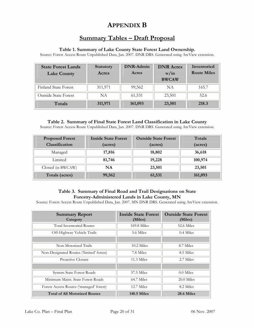
Summary Tables – Draft Proposal
Table 1. Summary of Lake County State Forest Land Ownership. Source: Forest Access Route Unpublished Data, Jan. 2007. DNR DRS. Generated using ArcView extension.
State Forest Lands
Lake County
Statutory
Acres
DNR-Admin
Acres
DNR Acres
w/in
BWCAW
Inventoried
Route Miles
Finland State Forest 311,971 99,562 NA 165.7
Outside State Forest NA 61,531 23,501 52.6
Totals 311,971 161,093 23,501 218.3
Table 2. Summary of Final State Forest Land Classification in Lake County
Source: Forest Access Route Unpublished Data, Jan. 2007. DNR DRS. Generated using ArcView extension.
Proposed Forest
Classification
Inside State Forest
(acres)
Outside State Forest
(acres)
Totals
(acres)
Managed 17,816 18,802 36,618
Limited 81,746 19,228 100,974
Closed (in BWCAW) NA 23,501 23,501
Totals (acres) 99,562 61,531 161,093
Table 3. Summary of Final Road and Trail Designations on State Forestry-Administered Lands in Lake County, MN
Source: Forest Access Route Unpublished Data, Jan. 2007. MN DNR DRS. Generated using ArcView extension.
Summary Report Category
Inside State Forest (Miles)
Outside State Forest (Miles)
Total Inventoried Routes 169.8 Miles 52.6 Miles
Off-Highway Vehicle Trails 5.6 Miles 0.4 Miles
Non-Motorized Trails 10.2 Miles 8.7 Miles
Non-Designated Routes (‘limited’ forest) 7.8 Miles 8.5 Miles
Proactive Closure 11.3 Miles 2.7 Miles
System State Forest Roads 57.5 Miles 0.0 Miles
Minimum Maint. State Forest Roads 64.7 Miles 20.0 Miles
Forest Access Routes (‘managed’ forest) 12.7 Miles 8.2 Miles
Total of All Motorized Routes 140.5 Miles 28.6 Miles

Lake Co. Plan – Final Plan Page 21 of 31 06 Nov. 2007
Table 4. Summary of Final Road & Trail Designations in the Finland State Forest. Source: Forest Access Route Unpublished Data, Jan. 2007. DNR DRS. Generated using ArcView extension.
Summary Report Final Plan
Category Miles of Road & Trail
Total Inventoried Routes 169.8 miles
Off-Highway Vehicle Trails 5.6 miles
Non-Motor Trails 10.2 miles
Non-Designated Routes (‘limited’ forest) 7.8 miles
Proactive Closure 11.3 miles
System State Forest Roads 57.5 miles
Minimum Maint. State Forest Roads 64.7 miles
Forest Access Routes (‘managed’ forest) 12.7 miles
Total of All Motorized Routes 140.5 miles
Table 5. Summary of Proposed Road & Trail Designations Outside State Forest Boundaries in Lake County, Minnesota.
Source: Forest Access Route Unpublished Data, Jan. 2007. DNR DRS. Generated using ArcView extension.
Summary Report Final Plan
Category Miles of Road & Trail
Total Inventoried Routes 48.5 miles
Off-Highway Vehicle Trails 0.4 miles
Non-Motor Trails 8.7 miles
Non-Designated Routes (‘limited’ forest) 8.5 miles
Proactive Closure 2.7 miles
System State Forest Roads 0.0 miles
Minimum Maint. State Forest Roads 20.0 miles
Forest Access Routes (‘managed’ forest) 8.2 miles
Total of All Motorized Routes 28.6 miles
SumTbles-Lake.doc 11/06/07
Lake Co. Plan – Final Plan Page 22 of 31 06 Nov. 2007
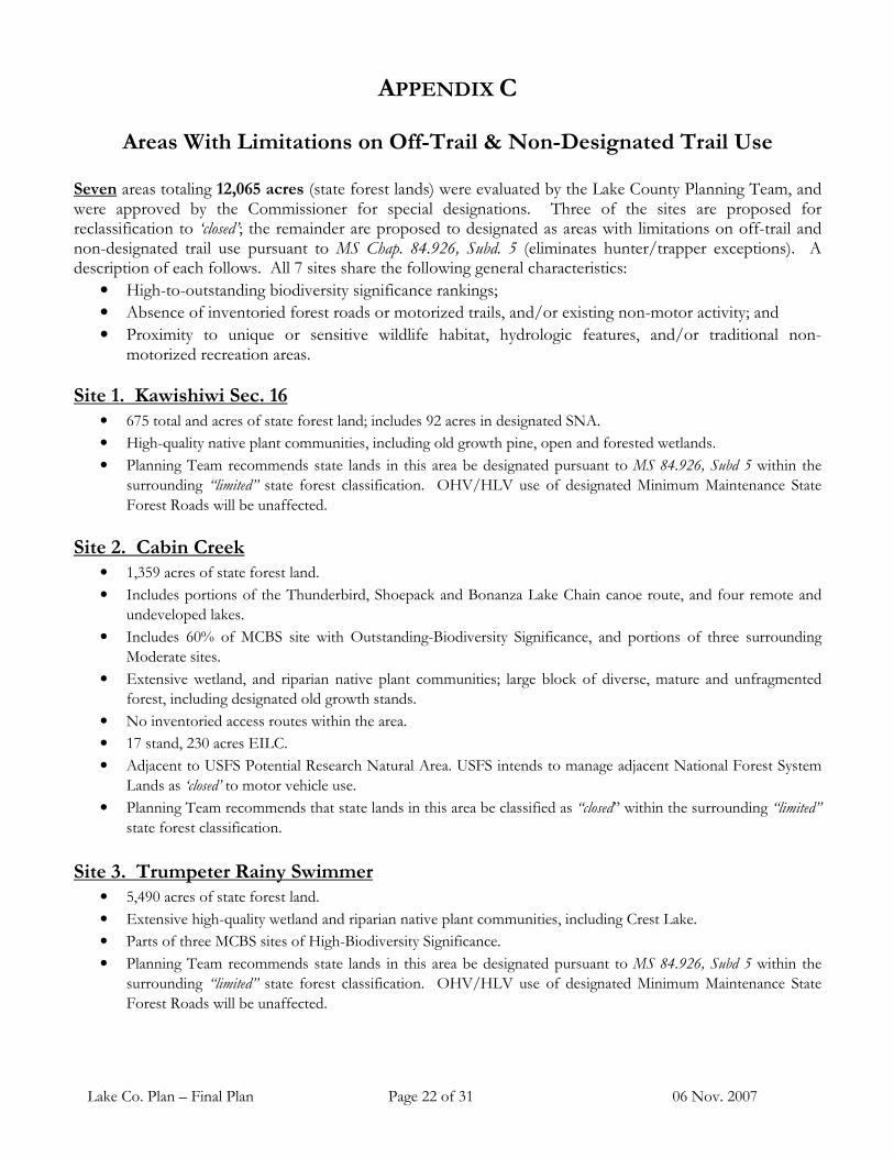
APPENDIX C
Areas With Limitations on Off-Trail & Non-Designated Trail Use Seven areas totaling 12,065 acres (state forest lands) were evaluated by the Lake County Planning Team, and were approved by the Commissioner for special designations. Three of the sites are proposed for reclassification to ‘closed’; the remainder are proposed to designated as areas with limitations on off-trail and non-designated trail use pursuant to MS Chap. 84.926, Subd. 5 (eliminates hunter/trapper exceptions). A description of each follows. All 7 sites share the following general characteristics:
• High-to-outstanding biodiversity significance rankings;
• Absence of inventoried forest roads or motorized trails, and/or existing non-motor activity; and
• Proximity to unique or sensitive wildlife habitat, hydrologic features, and/or traditional non-motorized recreation areas.
Site 1. Kawishiwi Sec. 16 • 675 total and acres of state forest land; includes 92 acres in designated SNA.
• High-quality native plant communities, including old growth pine, open and forested wetlands.
• Planning Team recommends state lands in this area be designated pursuant to MS 84.926, Subd 5 within the
surrounding “limited” state forest classification. OHV/HLV use of designated Minimum Maintenance State
Forest Roads will be unaffected.
Site 2. Cabin Creek • 1,359 acres of state forest land.
• Includes portions of the Thunderbird, Shoepack and Bonanza Lake Chain canoe route, and four remote and
undeveloped lakes.
• Includes 60% of MCBS site with Outstanding-Biodiversity Significance, and portions of three surrounding
Moderate sites.
• Extensive wetland, and riparian native plant communities; large block of diverse, mature and unfragmented
forest, including designated old growth stands.
• No inventoried access routes within the area.
• 17 stand, 230 acres EILC.
• Adjacent to USFS Potential Research Natural Area. USFS intends to manage adjacent National Forest System
Lands as ‘closed’ to motor vehicle use.
• Planning Team recommends that state lands in this area be classified as “closed” within the surrounding “limited”
state forest classification.
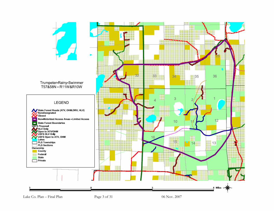
Site 3. Trumpeter Rainy Swimmer • 5,490 acres of state forest land.
• Extensive high-quality wetland and riparian native plant communities, including Crest Lake.
• Parts of three MCBS sites of High-Biodiversity Significance.
• Planning Team recommends state lands in this area be designated pursuant to MS 84.926, Subd 5 within the
surrounding “limited” state forest classification. OHV/HLV use of designated Minimum Maintenance State
Forest Roads will be unaffected.

Lake Co. Plan – Final Plan Page 23 of 31 06 Nov. 2007
Areas With Limitations on Off-Trail & Non-Designated Trail Use
(Pursuant to MS Chap. 84.926, Subd. 5)
Site 4. Beaver Ridge • 733 acres of state forest land.
• Portion of MCBS site with Outstanding-Biodiversity Significance.
• High quality native plant communities and rare plant populations.
• Large block of diverse, mature, unfragmented forest, including designated old growth stands.
• No inventoried access routes within the area. Non-motorized access via Superior Hiking Trail.
• Planning Team recommends that state lands in this area be classified as “closed” within the surrounding
“managed” state forest.
Site 5. Upper Baptism/Manitou
• 1,878 acres of state land.
• Portion of MCBS site with Outstanding-Biodiversity Significance.
• High quality native plant communities. Extensive wetlands and riparian native plant communities.
• Large block of diverse, mature and unfragmented forest, including a large cluster of designated old growth. 10
stands, 169 acres of EILC
• Includes about 2.5 miles of the East Branch of the Baptism River and about 1.5 miles of the South Branch of
Manitou Rivers.
• Planning Team recommends that state lands in this area be classified as ‘closed’ within the surrounding ‘managed’
forest.
Site 6. Spruce Road • Includes approximately 1,380 acres of state forest land.
• Mix of upland forest and wetland habitats.
• Good mix of forest types on state lands that will be managed to benefit game wildlife species
• Area is proposed as a “Remote Hunting Area” –an area that is relatively accessible, yet provides an opportunity to get off-road and hunt or trap on foot without competition from wheeled vehicles
• Planning Team recommends state lands in this area be designated pursuant to MS 84.926, Subd 5 within the surrounding “limited” state forest classification. OHV/HLV use of designated Minimum Maintenance State Forest Roads willl be unaffected.
Site 7. Greenstone Lake
• Section 16, includes approximately 550 acres of state forest land.
• Forest cover types are mainly aspen and birch.
• Existing network of haul roads and forest cover combine to make this a good hunter walking area.
• Access from the NW via gated USFS road and Lake County route, or from NE via USFS road.
• Possible lake access to Greenstone Lake.
• Planning Team recommends state lands in this area be designated pursuant to MS 84.926, Subd 5 within the surrounding “limited” state forest classification. OHV/HLV use of designated Minimum Maintenance State Forest Roads will be unaffected.
Lake-Subd5.Doc
03/05/07

Lake Co. Plan – Final Plan Page 24 of 31 06 Nov. 2007


Lake Co. Plan – Final Plan Page 2 of 31 06 Nov. 2007
Lake Co. Plan – Final Plan Page 3 of 31 06 Nov. 2007

Lake Co. Plan – Final Plan Page 4 of 31 06 Nov. 2007

Lake Co. Plan – Final Plan Page 5 of 31 06 Nov. 2007

Lake Co. Plan – Final Plan Page 6 of 31 06 Nov. 2007

Lake Co. Plan – Final Plan Page 7 of 31 06 Nov. 2007