forest health protection survey - ellington cms...2015/04/30 · forest health protection survey...
TRANSCRIPT
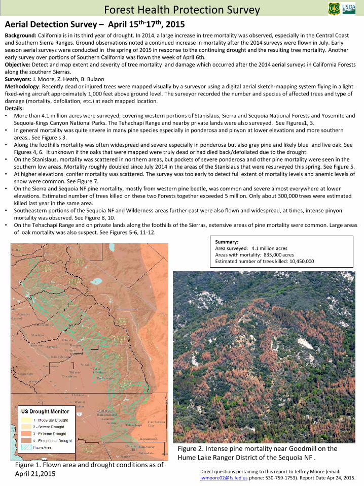
Aerial Detection Survey – April 15th-17th, 2015 Background: California is in its third year of drought. In 2014, a large increase in tree mortality was observed, especially in the Central Coast and Southern Sierra Ranges. Ground observations noted a continued increase in mortality after the 2014 surveys were flown in July. Early season aerial surveys were conducted in the spring of 2015 in response to the continuing drought and the resulting tree mortality. Another early survey over portions of Southern California was flown the week of April 6th. Objective: Detect and map extent and severity of tree mortality and damage which occurred after the 2014 aerial surveys in California Forests along the southern Sierras. Surveyors: J. Moore, Z. Heath, B. Bulaon Methodology: Recently dead or injured trees were mapped visually by a surveyor using a digital aerial sketch-mapping system flying in a light fixed-wing aircraft approximately 1,000 feet above ground level. The surveyor recorded the number and species of affected trees and type of damage (mortality, defoliation, etc.) at each mapped location. Details: • More than 4.1 million acres were surveyed; covering western portions of Stanislaus, Sierra and Sequoia National Forests and Yosemite and
Sequoia-Kings Canyon National Parks. The Tehachapi Range and nearby private lands were also surveyed. See Figures1, 3. • In general mortality was quite severe in many pine species especially in ponderosa and pinyon at lower elevations and more southern
areas.. See Figure s 3. • Along the foothills mortality was often widespread and severe especially in ponderosa but also gray pine and likely blue and live oak. See
Figures 4, 6. It unknown if the oaks that were mapped were truly dead or had died back/defoliated due to the drought. • On the Stanislaus, mortality was scattered in northern areas, but pockets of severe ponderosa and other pine mortality were seen in the
southern low areas. Mortality roughly doubled since July 2014 in the areas of the Stanislaus that were resurveyed this spring. See Figure 5. • At higher elevations conifer mortality was scattered. The survey was too early to detect full extent of mortality levels and anemic levels of
snow were common. See Figure 7. • On the Sierra and Sequoia NF pine mortality, mostly from western pine beetle, was common and severe almost everywhere at lower
elevations. Estimated number of trees killed on these two Forests together exceeded 5 million. Only about 300,000 trees were estimated killed last year in the same area.
• Southeastern portions of the Sequoia NF and Wilderness areas further east were also flown and widespread, at times, intense pinyon mortality was observed. See Figure 8, 10.
• On the Tehachapi Range and on private lands along the foothills of the Sierras, extensive areas of pine mortality were common. Large areas of oak mortality was also suspect. See Figures 5-6, 11-12.
Forest Health Protection Survey
Direct questions pertaining to this report to Jeffrey Moore (email: [email protected] phone: 530-759-1753). Report Date Apr 24, 2015.
Figure 1. Flown area and drought conditions as of April 21,2015
Summary: Area surveyed: 4.1 million acres Areas with mortality: 835,000 acres Estimated number of trees killed: 10,450,000
Figure 2. Intense pine mortality near Goodmill on the Hume Lake Ranger District of the Sequoia NF .

Figure 3. Overview of flown area and mapped tree mortality and damage .
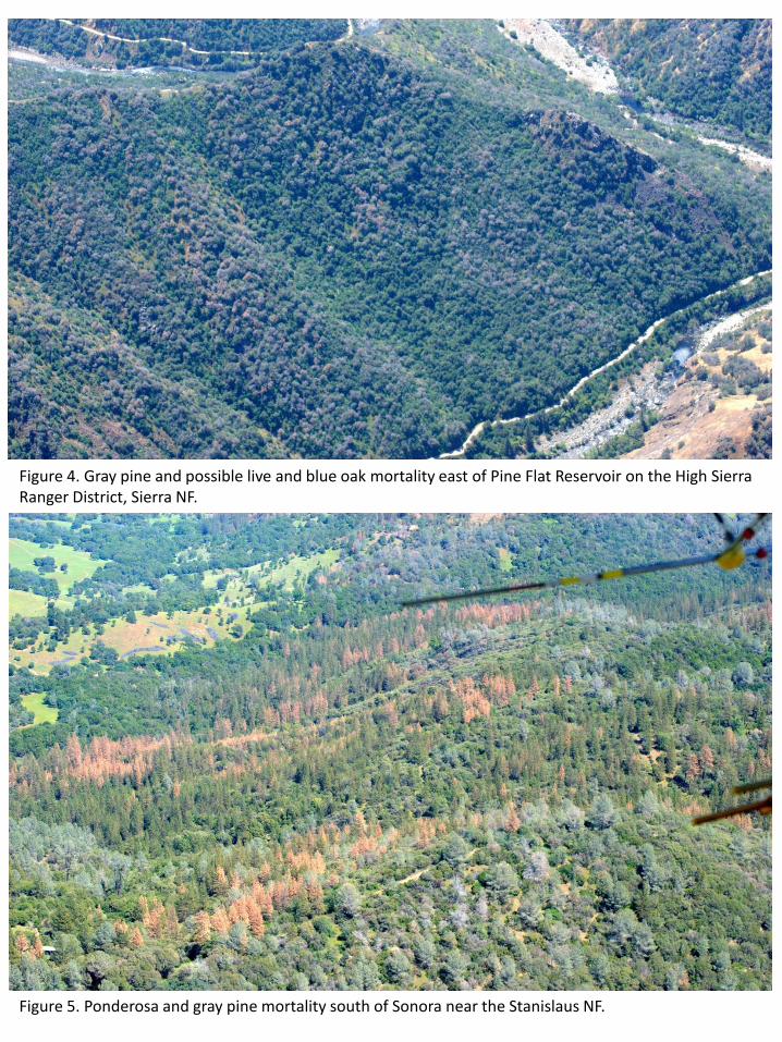
Figure 4. Gray pine and possible live and blue oak mortality east of Pine Flat Reservoir on the High Sierra Ranger District, Sierra NF.
Figure 5. Ponderosa and gray pine mortality south of Sonora near the Stanislaus NF.

Figure 7. Widely scattered fir and pine mortality was already noticeable even in high elevation areas such as this one southeast of Sherman Peak in the Domeland Wilderness of the Sequoia National Forest.
Figure 6. Possible live oak and blue oak mortality Near Dalton Mtn. south of Pine Flat Reservoir. Sites like this were common and extensive.

Figure 8. Jeffrey and pinyon pine mortality south of Pinyon Peak in the Scodie Mountains, Sequoia NF.
Figure 9. Scattered as well as intense pockets of Jeffrey pine mortality south of Inspiration Point in the Piute Mountains, Sequoia NF.

Figure 11. Increasingly intense pine mortality near Twin Lakes, Tehachapi Mountains.
Figure 10. Pinyon mortality and discoloration near Lamont Peak in the Owen Peak Wilderness.
Figure 12. Pine mortality north of Five Points, Tehachapi Mountains.