forest history alt lebanon channels state forest … · is now the channels state forest from the...
TRANSCRIPT

www.dof.virginia.gov
Virginia Department of Forestry
~ 4,836 Acres ~Washington and Russell
Counties
VI RGI NIA
State Forest
Forest HistoryThe Virginia Department of Forestry purchased what is now the Channels State Forest from The Nature Conservancy (TNC) in early 2008. The purchase was made possible through funding from the Virginia Land Conservation Fund. TNC had purchased the property a few years earlier for the purpose of protecting and conserving this unique and valuable resource. Within the boundary of the 4,836-acre property is a 721-acre parcel that has been dedicated in perpetuity as the Channels Natural Area Preserve under the provisions of the Natural Area Preserve Act of 1989 to be managed by the Department of Forestry in partnership with the Department of Conservation and Recreation.
At the crest of the mountain, within the Natural Area Preserve, are the Great Channels of Virginia, impressive formations of 400-million-year-old sandstone outcroppings. Geologists conclude that the Channels were likely formed while the high-elevation sandstone cap was under the influence of permafrost and ice wedging during the last ice age. These forces shattered and enlarged joints in the sandstone caprock.
Located on the southern slope of Clinch Mountain, elevations on the Channels State Forest range from 1,800 feet to more than 4,200 feet. Ecological communities and forest types change significantly with elevation. A diversity of forest types from cove
hardwoods to northern hardwoods are present. Continuing studies indicate the presence
of rare and imperiled plant species.
Forest ManagementLike all of Virginia’s state forests, the Channels is managed for multiple uses. One management goal is sustainable timber production. Management activities on the Channels State Forest demonstrate sound forestry and conservation practices. Wildlife habitat, recreation and watershed protection are all compatible with sound timber management strategies.
In the past, through several ownerships, the forest was subject to unregulated logging resulting in the diminished quality and productivity of the land. The Channels State Forest will be managed to continually restore and improve the forest, encourage natural biodiversity, protect water quality, provide wildlife habitat and provide recreational opportunities.
Channels State Forest
About Your State ForestsThe Virginia Department of Forestry (VDOF) manages more than 20 State Forests, totaling more than 69,000 acres. Virginia’s State Forests are managed for multiple uses: water quality, recreation, forest products, wildlife and scenic beauty. The primary management goals of individual State Forests may vary, usually depending on the wishes of the donor of the land.
The State Forests of Virginia are self-supporting and receive no taxpayer funds for operation. Operating funds are generated from the sale of forest products. In addition, up to 25 percent of the revenue received from the sale of forest products is returned to the counties in which the forests are located. You can support educational programs on your State Forests by donating a portion of your state tax refund to Virginia’s
State Forests Fund.
91
46019
ALT58
81
81
58
460
19
ALT58
19
42158
1191
8063
107
67
71
42
75
65
8091
80
67
71
Rt. 689
Location Map
ChannelsState Forest
Richlands
Abingdon
BristolDamascus
Lebanon
Hayters Gap
HonakerTrammel
Broadford
Chilhowie
Location
Channels
This institution is an equal opportunity provider.
Virginia Department of Forestry900 Natural Resources Drive, Suite 800Charlottesville, Virginia 22903Phone: (434) 977-6555
www.dof.virginia.govVDOF P00154; 05/2013
For More InformationFor more information about Virginia’s State Forests, please contact your local Virginia Department of Forestry office or visit:
www.dof.virginia.gov
State Forest Main Office:Located at Cumberland State Forest751 Oak Hill Road, Cumberland, VA 23040-2511Phone: (804) 492-4121
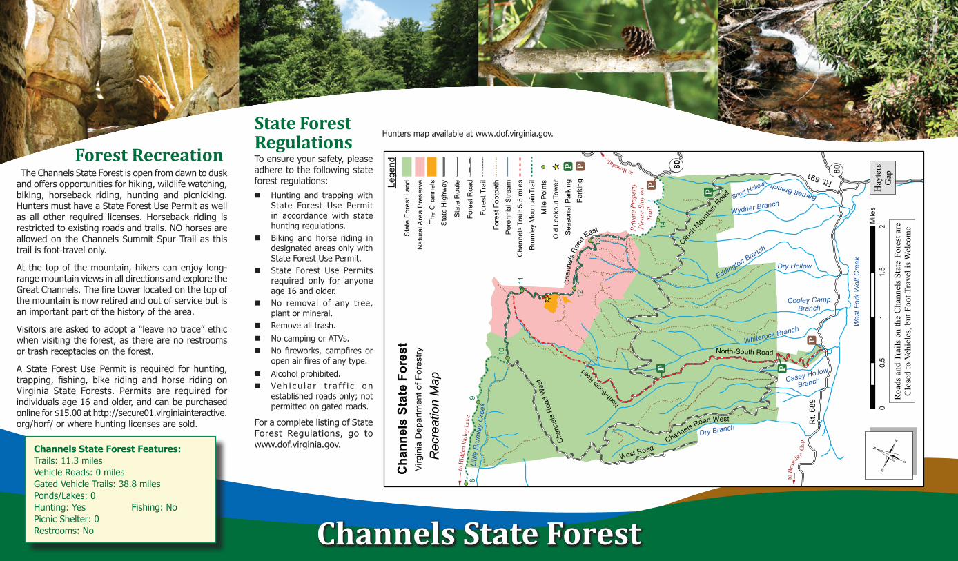
Forest RecreationThe Channels State Forest is open from dawn to dusk
and offers opportunities for hiking, wildlife watching, biking, horseback riding, hunting and picnicking. Hunters must have a State Forest Use Permit as well as all other required licenses. Horseback riding is restricted to existing roads and trails. NO horses are allowed on the Channels Summit Spur Trail as this trail is foot-travel only.
At the top of the mountain, hikers can enjoy long- range mountain views in all directions and explore the Great Channels. The fire tower located on the top of the mountain is now retired and out of service but is an important part of the history of the area.
Visitors are asked to adopt a “leave no trace” ethic when visiting the forest, as there are no restrooms or trash receptacles on the forest.
A State Forest Use Permit is required for hunting, trapping, fishing, bike riding and horse riding on Virginia State Forests. Permits are required for individuals age 16 and older, and can be purchased online for $15.00 at http://secure01.virginiainteractive.org/horf/ or where hunting licenses are sold.
Channels State Forest
Channels State Forest Features:Trails: 11.3 milesVehicle Roads: 0 milesGated Vehicle Trails: 38.8 milesPonds/Lakes: 0Hunting: Yes Fishing: NoPicnic Shelter: 0Restrooms: No
State Forest Regulations To ensure your safety, please adhere to the following state forest regulations:Hunting and trapping with
State Forest Use Permit in accordance with state hunting regulations.
Biking and horse riding in designated areas only with State Forest Use Permit.
State Forest Use Permits required only for anyone age 16 and older.
No removal of any tree, plant or mineral.
Remove all trash.No camping or ATVs.No fireworks, campfires or
open air fires of any type. Alcohol prohibited. Ve h i c u l a r t r a f f i c o n
established roads only; not permitted on gated roads.
For a complete listing of State Forest Regulations, go to www.dof.virginia.gov.
Hunters map available at www.dof.virginia.gov.
ââ
ââââââââââ
ââââââ
ââââââââââ
ââââ
ââ
ââââââââââââ
ââââââ
ââââ
ââââââââââââââââââ
ââ
ââââââââââââââââââ
ââââââ
ââââââââââââââââââ
ââ
ââââââââââââââ
ââââââââ
ââââââââââââââ
ââ
ââââ
ââ ââ ââ ââ ââ ââ ââ ââ
ââââ
ââ ââ ââââ
ââ ââ ââ ââ ââ
ââââ
ââââââââââââ
ââ
ââ
ââ
ââââ
ââââ
ââââ
ââââ
ââââ ââ
ââ ââ ââ ââ
ââââââââââ
ââââââââââ
ââââââ
ââââ
ââââââââââ
ââââââââââââââââââ
ââââ
ââââââââââââ
ââââ
ââ ââ ââ ââ ââ ââ ââ ââ ââ ââ ââ ââ ââ ââ ââ ââ ââ ââ ââ ââ ââ ââ ââ ââââ ââ
ââ ââ
ââ ââ ââ ââ ââââ ââ ââ
ââ ââââ ââ ââ ââ ââ ââ
ââââ ââ ââ
ââ ââââ ââ
ââââ
ââââââ ââ ââ ââ
ââ ââ
ââ ââ ââ ââ ââ ââ ââ ââ ââ ââ ââ ââ ââ ââ ââ ââ ââ ââ ââ ââ ââ ââ ââ ââ ââ ââ ââ ââ ââ ââ ââ ââ ââ ââââ ââ ââ ââ ââ ââ ââ ââ ââ ââ ââ ââ ââ ââ ââ ââ ââ ââ ââ ââ ââ ââ ââ ââ ââ ââ ââ ââ ââ ââ ââ ââ ââ
ââââââ ââ
ââ
ââââââââ
ââ ââ ââ ââ ââ
ââââââââââââââââââââââââââââ
ââââââââââââ
ââ ââ ââ ââ ââ ââ ââ ââââ ââ ââ ââ ââ
ââ ââââ ââ ââ ââââ ââ
ââ
ââ ââ ââ ââ
ââ ââ
ââ
ââââ
ââ ââââ ââ
ââââââââ
ââââââââââ
ââââââââââââââââââââââ
ââ ââ
ââââââââââââââââ
ââââââ
ââ
ââââââ
ââââ
ââ
ââââ
ââ
ââ
ââââââââââââââââââââââââââââââââââââââââââââââââ
ââ
ââââââ
ââââââââââââââ
ââââââ
ââââââââââââââââââââââââ
ââââââââââââââââââââ
ââ
ââââââââââââââââââââââââââââââ
ââ ââ ââââ ââ ââ ââ ââ ââ
ââ
ââ ââ ââ ââ ââââââââââââââââââââââââ
ââ ââ ââ ââ ââ ââ ââ ââ ââ ââ ââ ââ ââ
ââââ
ââ
ââââââââ
ââââââ
ââââ
ââââââ
ââââââââ
ââââââââââââââ
ââââ
ââ
ââââââââââââ
ââââ ââ ââ ââ
ââââââââ
ââ ââ
ââ ââââââââââââââââââ
ââ ââ
ââââââ
ââââââââââââââââââ
ââââââââââââââ
ââ
ââââââââââ
ââ
ââââââââ
ââââââ
ââââââââ
ââââââ
ââââââââââââââââââââââââââââââ
ââ
ââ
ââââââ
ââ ââ
ââââ ââ ââ
ââââ
ââ ââ ââ ââ ââ ââ ââ ââ
ââââââââââââââââââââââââââââââââââ
ââââââ
ââââ
ââââââââ
ââ ââ
ââââââââ
ââââââââââ
ââââââ
ââââââââââ
ââââââââââ
ââââââââââââââââââââââââââ
ââââââ
ââ
ââ ââââ
ââ ââ ââ ââ
ââââââââââââââââ
ââ ââ
ââââ
ââââââââââââââââââ
ââââââââââââââ
ââââââ
ââ
ââââââ
ââ
ââââââââ
ââââ
ââââââââ
ââââââââââââââââââââââââââââââââ
ââ
ââââââââââââââââââââââââââââââââââââââââââââââââââââââââââââââââââââ
ââââââ
ââââââââââââââââââââââ
ââ ââ ââ ââ ââââ ââ
ââ
ââ ââ ââ
ââââââ ââ
ââ
ââ ââ ââ ââ ââ ââ ââââ
ââââââââ
ââ
ââ
ââ
ââââââ
ââââââââââ
ââââââââââââââââ
ââââââââââââââââââââââââââ
ââââââââ
ââââââââââââ ââ ââ ââ
ââ
ââ ââ ââ
ââââââââââââââââââââââââââââââââââââââââ
ââââ
ââââââ
ââââââ
ââââââ
ââââ
ââââ
ââââââââ
ââââââââ
ââââââââââââ
ââââââââââ
ââââââââââââââââââââââââââââââ
ââââââ
ââââââ
_̂
Cha
nnel
s R
oad
Wes
t
Clinch
Mou
ntain
Road
North-South Road
West Road
North-S
outh
Road
¬ « 80¬ « 80
Rt. 691
Rt.
689
Barnett Branch
Short Hollow
Wydner Branch
Eddington Branch
Dry Hollow
Cooley CampBranch
Whiterock Branch
Casey Hollow
Branch
Dry Branch
Littl
e Br
umle
y C
reek
Channels Road West
Wes
t For
k W
olf C
reek
98
14
13
12
11
10
Cha
nnel
s St
ate
Fore
stVi
rgin
ia D
epar
tmen
t of F
ores
try
00.
51
1.5
2M
iles
©Rec
reat
ion
Map
Cha
nnel
sRo
ad
East
Roa
ds a
nd T
rails
on
the
Cha
nnel
s Sta
te F
ores
t are
Clo
sed
to V
ehic
les,
but
Foo
t Tra
vel i
s Wel
com
e
Hay
ters
Gap
toRosedale
toB
rumley
Gap
Lege
ndS
tate
For
est L
and
Nat
ural
Are
a P
rese
rve
The
Cha
nnel
s
Sta
te H
ighw
ay
Sta
te R
oute
Fore
st R
oad
Fore
st T
rail
ââââââââââââââââââââââ
Fore
st F
ootp
ath
Per
enni
al S
tream
Cha
nnel
s Tr
ail:
5.5
mile
s
Brum
ley
Mou
ntai
nTra
il
Mile
Poi
nts
_̂O
ld L
ooko
ut T
ower
! j
! j
Par
king
! j
Priv
ate
Prop
erty
Ple
ase
Stay
on
Trai
l
Sea
sona
l Par
king
! j
! j! j
! j
to H
idde
n Va
lley
Lake