forest regions of montana - us forest service · pdf fileforest regions of montana ... but it...
TRANSCRIPT
FOREST REGIONS OF MONTANA
STEPHEN F. ARNO
USDA Forest Service Research Paper INT-218 INTERMOUNTAIN FOREST AND RANGE EXPERIMENT STATION Forest Service U.S. Department of Agriculture Ogden, Utah 84401
This file was created by scanning the printed publication.Errors identified by the software have been corrected;
however, some errors may remain.

USDA Forest Service Research Paper INT-218
April 1979
FOREST REGIONS OF MONTANA STEPHEN F. ARNO
INTERMOUNTAIN FOREST AND RANGE EXPERIMENT STATION Forest Service
U. S. Department of Agriculture Ogden, Utah 84401

THE AUTHOR
STEPHEN F. ARNO i s a Plant Ecologist on the Forest Ecosystems r e sea rch work unit at Missoula. He earned a B. S. in forestry at Washington State University and a m a s t e r ' s degree and a Ph. D. in forestry and plant science at the University of Mon- tana before joining the Forest Service in 1970.
ACKNOWLEDGMENTS
Robert Pfister (USDA Forest Service Project Leader) gave encouragement and advice throughout this study. The following for- e s t e r s from USDA Forest Service, Northern Region, shared their information on the distributions of indicator plants: Robert Bigler, Herbert Holdorf (Soil Scientist), John Joy, Bernard Kovalchik, Tom Lawrence, Gary Learn, B. John Losensky, and James Schaeffer. Similar information was provided by Joseph Antos, J ames Habeck, and Pete Zager f rom the Botany Department of the University of Montana and by Tad Weaver, John Rumley, and Frank Forcella f rom Montana State University. In addition, I would like to thank the many people who provided review comments during the develop- ment of this manuscript.

Page
INTRODUCTION . . . . . . . . . . . . . . . . . . . . . . . . . . . . . . . . . . . . DELINEATING MONTANA FOREST REGIONS
. . . . . . . . . . . . . . . . FOREST REGION DESCRIPTIONS
Northwestern Montana Fores t Region . . . . . . . . . . . . West-Central Montana Fores t Region . . . . . . . . . . . .
. . . . . . . . . . . North-Central Montana Fores t Region Central Montana Fores t Region . . . . . . . . . . . . . . . Southwestern Montana Fores t Region . . . . . . . . . . . . South-Central Montana Fores t Region . . . . . . . . . . . . Southeastern Montana Fores t Region . . . . . . . . . . . . Northeastern Montana Fores t Region . . . . . . . . . . . .
. . . . . . . RESEARCH AND MANAGEMENT APPLICATIONS
PUBLICATIONS CITED . . . . . . . . . . . . . . . . . . . . . . APPENDIX A.. DISTRIBUTION OF KEY TREE AND
UNDERGROWTH SPECIES IN MONTANA . . . . APPENDIX B.. NUMBER OF SAMPLE PLOTS (PFISTER AND
OTHERS 1977) BY HABITAT TYPE. PHASE. AND FOREST REGION IN MONTANA . . . . . .
APPENDIX C.. NATIONAL FORESTS. INDIAN RESERVATIONS. AND NATIONAL PARKS WITHIN EACH FOREST REGION IN MONTANA . . . . . . . . . . . . . .

The author categorizes forest vegetation across Montana into eight geo- graphic subdivisions called "forest regions. " The regions correlate the in- fluence of climate and general topography to forest vegetation--including the distributions of tree and undergrowth species and forest habitat types. The vertical zonation of forest ser ies (based on the potential climax tree species) also differs from one region to the next. Regional boundaries were fitted to distributions of certain t ree and undergrowth species, habitat types, and nat- ural climatic barr iers such a s the Continential Divide and broad grassland valleys that separate forest environments.
(1) The northwestern Montana forest region has major representation by Pacific Coast species such a s Thujaplicata and Clintoniauniflora; its climate is strongly influenced by moist maritime airmasses. (2) The west-central region has a generally drier Pacific-influenced climate and only small amounts of Pacific Coast species; however, i t has major representation of intermountain plants like Larix occidentalis and Xerophyllum tenax.
(3) North-central Montana lies in the severe climate of the "chinook wind belt" along the east slope of the Continental Divide. It is distinguished by being too cold for Pinus ponderosa, but having extensive Populus tremuloides groves and Pinus flexilis woodlands. (4) The central Montana forest region has a less severe continental climate and it supports the east-side forin of Pinus ponderosa at lower elevations. However, both coastal and intermountain - species a re essentially absent from its mountain forests.
Both the ( 5 ) southwestern and (6) south-central forest regions have high base elevations and a re without Pinus ponderosa. The former region's for- ests a re generally dr ier than the latter 's and often have sparse undergrowth. (7) Southeastern Montana differs from previously mentioned regions in not having prominent mountains. It has extensive Great Plains Pinus ponderosa forests. (8) Northeastern Montana i s a Great Plains area having no forest, except for Populus deltoides groves along major streams.
The regions may be usefulas a biologically based stratification for for- est research and forest management studies.
INTRODUCTION
This r e p o r t de sc r ibes 'Montana's f o r e s t s by geographic subdiv is ions c a l l e d " fo re s t reg ions . I ' I t emphasizes pat t e r n s i n spec i e s composition ( t r e e s and undergrowth) and t h e r e l a t i o n s h i p of t h e s e p a t t e r n s t o c l imate and topography. The i n t e r p r e t a t i o n s a r e based on f i e l d experience and d a t a c o l l e c t e d dur ing a recent f o r e s t h a b i t a t type c l a s s i - f i c a t i o n ( P f i s t e r and o t h e r s 1977).
There a r e two primary reasons f o r d e l i n e a t i n g t h e f o r e s t reg ions of Montana. F i r s t , t h e reg ions s e rve a s a geographic r e f e r ence f o r desc r ib ing p a t t e r n s of f o r e s t vege ta t ion ac ros s t h e S t a t e . Second, d e l i n e a t i n g t h e reg ions con t r ibu t e s t o r eg iona l c l a s s i f i c a t i o n s t h a t a r e being developed from a na t iona l pe r spec t ive (Bailey 1976, 1978). The geographic subdiv is ions discussed i n t h i s paper a r e based on t h e d i s t r i b u t i o n of f o r e s t vege ta t ion i n r e l a t i o n t o c l ima te (as inf luenced by topography). Thus, t h e s e subdiv is ions a r e proposed f o r use on ly f o r i n t e r p r e t a t i o n s r e l a t e d t o f o r e s t vege t a t i on .
A f t e r reviewing d e f i n i t i o n s provided i n Kuchler (1973) and Bai ley (1976), t h e term " f o r e s t region" seemed most app rop r i a t e f o r u se he re . "Region" i s a genera l term t h a t does not n e c e s s a r i l y spec i fy a l eve l i n t h e land c l a s s i f i c a t i o n h ie rarchy , and t h e term " fo re s t region" has been appl ied i n Canada (Rowe 1972). ("Province" was a l s o considered, bu t i t has a more p r e c i s e h i e r a r c h i c a l d e f i n i t i o n r e l a t e d t o t h e dominant vege t a t i ve types i n an a r ea , o r t o physiography; t hus , some of Montana's f o r e s t reg ions occur within grass land provinces . j
Other r eg iona l d i v i s i o n s o f Montana have been developed from d i f f e r e n t t ypes of information t o meet d i f f e r e n t ob j ec t ives . Schmidt and Dufour (1975) emphasized geomor- phology i n des igna t ing s i x reg ions wi th in Montana. Those reg ions were used i n a s se s s ing r e sea rch n a t u r a l a r e a needs from t h e fol lowing viewpoints: f o r e s t vege t a t i on , g r a s s and shrubland vege t a t i on , geology, zoology, and aqua t i c s . Crowley (1972) depic ted seven major environmental reg ions wi th in Montana based on c h a r a c t e r i s t i c s of human environ- ments, inc luding landforms, c l imate , and e l eva t iona l zonat ions of vege t a t i on .
S t i l l o t h e r s (Kuchler 1964; Payne 1973; Ross and Hunter 1976) have provided maps of Montana's n a t u r a l vege t a t i ve types; but t h e maps a r e not focused on r eg iona l v a r i - a t i o n i n f o r e s t vege t a t i on . In c o n t r a s t t o t h e s e r e f e r ences , t h e Montana " fo re s t regions" proposed here d e l i n e a t e r a t h e r broad a r eas having s i m i l a r zonat ion i n f o r e s t vege t a t i on . These f o r e s t reg ions have genera l s i m i l a r i t i e s t o t h e f o r e s t d i s t r i c t s designated by t h e e a r l y Montana b o t a n i s t , Kirkwood (1922), f o r desc r ib ing f o r e s t d i s - t r i b u t i o n i n t h e Northern Rocky Mountains.
During t h e Montana f o r e s t h a b i t a t type s tudy ( P f i s t e r and o t h e r s 1977), 1,500 s t ands were sampled " sub jec t ive ly without b i a s t ' (Mueller-Dombois and Ellenburg 1974). The s tands r ep re sen t a spectrum o f mature f o r e s t communities and s i t e s i n each mountain range and fo re s t ed a r e a of t h e S t a t e . A s t h e h a b i t a t type c l a s s i f i c a t i o n was being de- veloped from t h e s e d a t a , i t became obvious t h a t d i s t r i b u t i o n s of many t r e e and under- growth spec i e s (and thus t h e d i s t r i b u t i o n s o f t h e h a b i t a t types) a r e s t r o n g l y c o r r e l a t e d

t o p a t t e r n s of geography and c l ima te w i th in Montana. I t became ev ident t h a t t h e S t a t e could be subdivided i n t o s eve ra l r e l a t i v e l y homogeneous f o r e s t reg ions based on t h e d a t a , f i e l d observa t ions , and information on p l a n t spec ies d i s t r i b u t i o n s (Herbarium c o l l e c t i o n s a t t h e Un ive r s i t y of Montana, Missoula; Montana S t a t e Un ive r s i t y , Bozeman; t h e USDA Fore s t Se rv i ce Fo re s t ry Sciences Laboratory, Missoula; personal in te rv iews with l o c a l f o r e s t e r s and b o t a n i s t s ( s e e acknowledgments) ; Booth and Wright 1966, Hitchcock and o t h e r s 1955-1969, L i t t l e 1971, 1976).
A map o f f o r e s t r eg ions ( c a l l e d "geographic s ~ b d i v i s i o n s ~ ~ ) was presen ted by P f i s t e r and o t h e r s (1977), and a b r i e f account o f each h a b i t a t t y p e ' s d i s t r i b u t i o n was given by r eg ion . However, t h e b a s i s f o r t h e s e reg ions was no t d i scussed ; a l s o , Montana's f o r e s t vege t a t i on and environments were no t descr ibed by r eg ion . These t o p i c s a r e addressed he re .
The Canadian Fores t Se rv i ce (Rowe 1959, 1972) mapped and descr ibed "Forest Regions o f Canada," which provides a precedent . Rowe (1972) explained t h a t t h e Cana- d i an r eg iona l de s igna t i ons a r e gene ra l i z ed , with t h e broad pe r spec t i ve o f Canada a s a whole, a l though t h e s tatement was made t h a t it would be p o s s i b l e t o de s igna t e such reg ions from a d e t a i l e d knowledge of s p e c i f i c a r e a s i f d e t a i l e d da t a e x i s t e d . The l a t t e r approach i s used he re with d e t a i l e d d a t a from t h e h a b i t a t t ype s tudy ( P f i s t e r and o t h e r s 1977) a s a b a s i s .
Kuchler (1973) d i scussed techniques f o r de s igna t i ng e c o l o g i c a l l y based " regions." He s t a t e d t h a t c l a s s i f i c a t i o n s o f n a t u r a l vege t a t i on t ypes and d e t a i l e d mapping of t h e i r d i s t r i b u t i o n s a r e fundamental f o r e s t a b l i s h i n g such r eg ions . ( I t appears t h a t t h e Montana f o r e s t h a b i t a t t ype c l a s s i f i c a t i o n along wi th t h e sample p l o t s and o t h e r d i s t r i - bu t iona l d a t a can provide t h i s b a s i c information.) Kuchler (1973)~ a l s o concluded t h a t vege t a t i on r eg ions should f i r s t be des igna ted wi th in a l im i t ed s tudy a r e a , such a s a S t a t e o r geographic r eg ion , and l a t e r expanded t o surrounding a r e a s .

Montana's f o r e s t s a r e both ex tens ive and d ive r se . Forest covers nea r ly one- fourth of Montana--about 2 3 mi l l i on ac re s according t o Green and Se t ze r (1974)--and s u b s t a n t i a l amounts of f o r e s t a r e found i n a l l but t h e no r theas t e rn po r t i ons of t h e S t a t e ( f i g . 1 ) . A t lower e l eva t ions t hese f o r e s t s range from luxur i an t s tands of Tsuga heterophylla, Thuja plicata, Pinus monticola, and o the r P a c i f i c Coast spec i e s i n northwestern Montana t o open Pinus ponderosa woodlands on t h e Great P l a in s of southeas te rn Montana. The h igh- e leva t ion f o r e s t s ac ros s t h e Montana Rockies a l s o show s u b s t a n t i a l v a r i a t i o n .
Di f fe rences i n c l imate a r e p r imar i l y r e spons ib l e f o r geographic v a r i a t i o n s i n t h e p o t e n t i a l climax f o r e s t vege ta t ion , expressed i n h a b i t a t types ( P f i s t e r and o t h e r s 1977). The c l i m a t i c d i f f e r e n c e s ac ros s Montana r e f l e c t t h e g r e a t e r importance of P a c i f i c mari- time airmasses west of t h e Continental Divide versus con t inen ta l c l i m a t i c condi t ions e a s t of t h e Divide. Locally, c l imate (and thus f o r e s t vege ta t ion) a l s o i s s t rong ly i n - f luenced by changes i n e l eva t ion , a spec t , and landform wi th in t h e Montana Rockies. S o i l s and underlying geology a l s o a f f e c t f o r e s t vege ta t ion , but except f o r c e r t a i n lime- s tone s u b s t r a t e s and extremely rocky s i t e s , t h e e f f e c t s do no t gene ra l ly obscure t h e ove r r id ing in f luence of c l imate and topography.
The f o r e s t reg ions ou t l i ned on f i g u r e 1 c o r r e l a t e t h e inf luence of c l imate and genera l topography t o f o r e s t vege ta t ion- - inc luding t h e d i s t r i b u t i o n s of t r e e and under- growth spec i e s and f o r e s t h a b i t a t types and t h e v e r t i c a l zonation of f o r e s t s e r i e s (discussed l a t e r ) . Because t r e e spec i e s s e rve a s i n d i c a t o r s of c l imate (Daubenmire and Daubenmire 1968; P f i s t e r and o t h e r s 1977), t h e i r geographic d i s t r i b u t i o n s serve a s a primary determinant of reg ional boundaries. (Appendixes A-1 through A-6 i l l u s t r a t e how t h e d i s t r i b u t i o n s of t r e e spec ies c o r r e l a t e with Montana's f o r e s t r eg ions . ) Dis t r ibu- t i o n s of undergrowth spec i e s t h a t have proved use fu l a s i n d i c a t o r p l a n t s i n major f o r e s t h a b i t a t type c l a s s i f i c a t i o n s i n t h e Northern Rockies ( R . and J . Daubenmire 1968; P f i s t e r and o t h e r s 1977; and Robert S t e e l e and o t h e r s 1 ) , a l s o were used ( f o r examples, s ee appendixes A-7 through A-10) .
I t became obvious t h a t many o f t h e t r e e , undergrowth p l a n t , and h a b i t a t type d i s - t r i b u t i o n s showed s i m i l a r p a t t e r n s , and r e l a t e t o known c l ima t i c d i f f e r ences (U.S. De- partment of Commerce 1971; USDA S o i l Conservation Serv ice 1968). Prel iminary reg ional boundaries were drawn t o f i t t h e s e vege t a t i ona l da t a . The boundaries then were ad jus ted s l i g h t l y t o c o r r e l a t e with n a t u r a l c l i m a t i c b a r r i e r s such a s t h e Continental Divide and broad grass land v a l l e y s t h a t s epa ra t e f o r e s t environments. Although these r eg iona l boundaries were f i t t e d t o vege t a t i on d a t a and t o topographic b a r r i e r s a s log2ca l ly a s p o s s i b l e , sometimes t h e general p a t t e r n s of f o r e s t vege t a t i on change gradual ly over r a t h e r broad a r e a s . I n t he se ca se s , where poss ib l e , major topographic f e a t u r e s were used f o r f i n a l placement of boundaries. Dashed l i n e s were used t o des igna te reg ional boundaries i n nonforested a r e a s .
The occurrence of t h e approximately 1,500 sample p l o t s by h a b i t a t type and f o r e s t reg ion i s summarized i n appendix B . P lan t composition a t t he se f o r e s t s i t e s provides b a s i c d a t a f o r r eg iona l boundaries . A t a broad l e v e l of gene ra l i za t i on from t h i s da t a
' ~ e v i e w d r a f t s of "Forest h a b i t a t types of c e n t r a l Idaho" (1975) and those of t he Nezperce National Fores t (1976). In te rmt . For. and Range Exp. S t n . , Ogden, IJtah.
- FOREST
ED
[7 N
ON
FO
RE
ST
I a
WE
AT
HE
RS
TA
TIO
NS
1
Fig
ure
1.
--M
onta
na
fore
st r
egio
ns
and
fore
sted
are
as
(fro
m H
utc
hin
son
and
K
emp
1952
, R
oss
and
Hun
ter
1976
, co
mp
osi
te
sa
tell
ite
p
ho
to o
f M
onta
na,
GE
Spa
ce S
yste
ms,
B
elt
svil
le,
Md.
,J C
ircl
ed n
wnb
ers
are
wea
ther
sta
tio
ns
lis
ted
in
ta
ble
4.

Tab le 1.--Extent (area covered) o f forest series (potential climax) i n each o f Montana's fores t regions
A! = major m = minor r = rare . = absent
Fores t r eg ion : North- : West- : North- : : South- : Soirth- : South- : North-
S e r i e s : wes te rn : c e n t r a l : c e n t r a l : Cent ra l : western : c e n t r a l : e a s t e r n : e a s t e r n
Tsuga and Thuja M Abies g r a n d i s M Picea m Pinus c o n t o r t a r Pinus ponderosa m Pinus f l e x i l i s Pseudotsuga il Abies l a s i o c a r p a M
t h e ex t en t ( a r ea covered) of each climax s e r i e s can be compared- - identif ied by t h e most shade- to leran t ( p o t e n t i a l climax) t r e e spec i e s capable of growing on a given s i t e . Table 1 shows which ser ies occur i n each of t h e f o r e s t r eg ions . For i n s t ance , t h e P a c i f i c Northwest c o a s t a l f o r e s t types (Thuja, Tsuga, and Abies grandis s e r i e s ) a r e of major importance only i n northwestern Montana. Low-elevation f o r e s t types (Pinus pon- derosa climax s e r i e s ) a s soc i a t ed with dry , in land c l imates a r e abundant only i n c e n t r a l and southeas te rn Montana, and a r e absent o r r a r e i n t h e no r th- cen t r a l , southwestern, and south- cent ra l f o r e s t r eg ions .
Deta i led i n t e r p r e t a t i o n s (from appendix B da ta ) a r e presented i n t a b l e 2, which shows t h e major h a b i t a t types i n each of Montana's f o r e s t r eg ions . Addit ional i n t e r - p r e t a t i o n s and adjustments were made i n developing t a b l e 2 from t h e sample p l o t d a t a (appendix B). Ce r t a in subs t r a t e- o r i en t ed h a b i t a t types (such a s PicealSenecio strep- tanthi foz ius and Abies Zasiocarpa/CZematis pseudoaZpina h . t . on l imestone s u b s t r a t e s ) were heav i ly sampled by P f i s t e r and o t h e r s (1977), and a r e n o t a s ex t ens ive a s appendix B impl ies . Also, c e r t a i n a r e a s nea r t h e border of a f o r e s t reg ion were heavi ly sampled; thereby more p l o t s were c o l l e c t e d from c e r t a i n h a b i t a t types than a r e i n d i c a t i v e of t h e reg ion i n genera l . For i n s t ance , s eve ra l Abies Zasiocarpa/CZintonia and Abies Zasio- carpa/XerophyZZwn h . t . p l o t s were taken i n unusual l oca t ions immediately e a s t o f t h e Continental Divide i n no r th- cen t r a l Montana.
The d i s t r i b u t i o n o f va r ious t r e e spec i e s and undergrowth p l a n t s s e rv ing a s h a b i t a t type o r c l i m a t i c i n d i c a t o r s i s presented i n t a b l e 3 by f o r e s t reg ion ac ros s Montana. This t a b l e i s based on t h e 1,500 h a b i t a t type p l o t s , and t h e f i e l d observa t ions and published information on p l a n t d i s t r i b u t i o n s c i t e d previous ly . The d i s t r i b u t i o n s of P a c i f i c Coast and intermountain spec i e s a r e u se fu l f o r d i f f e r e n t i a t i n g f o r e s t s o f nor thern Idaho, northwestern Montana, and wes t- cent ra l Montana, but t h e o t h e r f o r e s t reg ions a r e cha rac t e r i zed l a r g e l y by a lack of t h e s e spec i e s . (" Intermountain spec ies" a p p l i e s t o p l a n t s found most o f t e n between t h e c r e s t of t h e Cascade Mountains and t h e Cont inenta l Divide.)
Cer ta in widespread spec i e s ( l i k e Vacciniwn scopariwn, Juniperus conormnis, Arnica cordifo l i a , Aster conspicuus, and even Pyro Za secunda) general 1 y a r e accompanied by P a c i f i c Coast o r intermountain spec i e s west of t h e Continental Divide; f a r t h e r e a s t t h e c o a s t a l and intermountain competi tors drop o u t . This s i t u a t i o n i s documented by t h e changes i n h a b i t a t types depic ted i n t a b l e 2. For i n s t ance , Pseudotsuga/Junipems c o r n i s , Pseudotsuga/l?rnica cordifozia, and Abies Zasiocarpa/Amica cordifoZia appear only e a s t of t h e Divide.
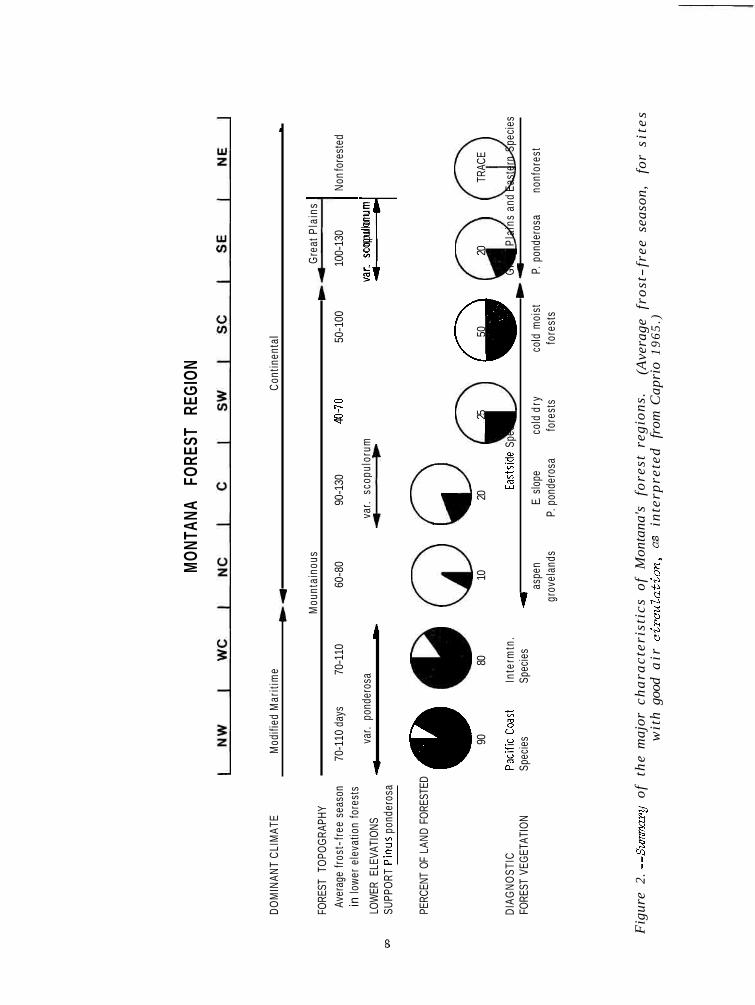
Figure 2 shows a summary of t h e c h a r a c t e r i s t i c s of each f o r e s t reg ion . The r e l a - t i o n s h i p o f f o r e s t reg ion and National Fores t boundaries i s shown i n appendix C.
Table 2.--Major habitat types ( P f i s t e r and others 1977) i n each o f J4mtana's fores t regions (See appendix B for more detai led information on a l l habitat t ypes )
Habitat type Forest region
Pinus flexilis/Festuca idahoensis P. ponderosa/Agropyron spicatum P. ponderosa/Festuca idahoensis P. ponderosa/Symphoricarpos albus P. ponderosa/Prunus virginiana
Pseudotsuga/Festuca idahoensis Pseudotsuga/Festuca scabrella Pseudotsuga/Vaccinium caespitosum
Pseudotsuga/Physocarpus malvaceus x Pseudotsuga/Vaccinium globulare x Pseudotsuga/Linnaea borealis
Pseudotsuga/Syn~phoricarpos albus x Pseudotsuga/Calamagrostis, Cal. phase Pseudotsuga/Cal., other phases x
Pseudotsuga/Spiraea betulifolia Pseudotsuga/Arctostaphylos uva-ursi Pseudotsuga/Juniperus communis Pseudotsuga/Arnica cordifolia
Picea/Clintonia uniflora Picea/Physocarpus malvaceus Picea/Galium triflorum Picea/Linnaea borealis
All Abies grandis h.t.s x Thuja plicata/Clintonia uniflora x Tsuga heterophylla/Clintonia uniflora x
Abies lasiocarpa/Clintonia uniflora x Abies lasiocarpa/Galium triflorum Abies lasiocarpa/Calamagrostis canadensis . Abies lasiocarpa/Linnaea borealis x
Abies lasiocarpa/Menziesia ferruginea x All Tsuga mertensiana h.t.s x Abies lasiocarpa/Xerophyllum tenax x
Abies lasiocarpa/Vaccinium globulare Abies lasiocarpa/Vaccinium scoparium Abies lasiocarpa/Arnica cordifolia Abies 1as.-Pinus albic./Vaccinium scop.
Abies lasiocarpa/Luzula hitchcockii Pinus albicaulis-Abies lasiocarpa Larix lyallii-Abies lasiocarpa Pinus contorta community types

Table 3.--Distribution of selected t rees and undergrowth indicator plants by forest region across Montana. ?iorthern Idaho data from Daubewnire and Daubenmire (1 9 6 8 )
x = common r = rare or scarce . = absent
Forest region : Northern :
Species : Idaho : NW : WC : NC : C : SW : SC : SE
Coastal species Adiantum pedatum Asarum caudatum
Tsuga heterophylla x x Tsuga mertsnsiana x x
Thuja plicata Pinus monticola Taxus brevifolia Abies grandis Clintonia unif lora
Intermountain species Larix occidentalis x x x Larix lyallii x x x x Pinus ponderosa x x x var . -ponderosal
Xerophyllum tenax x x x x r r r Menziesia ferruginea x x x x r r r Luzula hitchcockii x x x x r r r
Widespread species Widespread Rocky Mt. x x x x x x x trees2
Calamagrostis rubescens x x x x x x x Carex geyeri x x x x x x x
Physocarpus malvaceus x x x r x r x
Eastside species Pinus flexilis r x x x x Senecio streptanthefolius . r x x x Frasera speciosa r x x x Geranium richardsonii x x x x
Pinus ponderosa x r x var . scopulorum3
Juniperus horizontalis x x x x x Fraxinus pennsylvanica r
(Little 19531, having three-needle fascicles only. Pseudotsuga, Abies lasiocarpa, Picea, Pinus contorta, and Pinus albicaulis. (Booth 1950 and Little 19531, having many two-needle fascicles.
7
MON
TANA
FO
REST
RE
GION
DO
MIN
ANT
CLI
MAT
E M
odifi
ed M
ariti
me
Con
tinen
tal
*-
P
Mou
ntai
nous
G
reat
Pla
ins
FORE
ST T
OPO
GRA
PHY
Aver
age
fros
t -fr
ee s
easo
n 70
-110
day
s 70
-110
60
-80
90-1
30
40-7
0 50
-100
10
0-13
0 N
on fo
rest
ed
in lo
wer
ele
vatio
n fo
rest
s I
LOW
ER E
LEVA
TIO
NS
var.
pond
eros
a 4
b
- a
SUPP
ORT
Pin
us p
onde
rosa
var.
scop
ulor
um
-
var.
scop
ulor
um
+-i
PERC
ENT
OF L
AND
FOR
ESTE
D @
@ 0
@ @
0 0
90
80
10
20
25
50
20
TRAC
E
DIA
GN
OST
IC
Pac
ificc
oast
In
term
tn.
East
side
Spe
cies
G
reat
Pla
ins
and
East
ern
Spec
ies
FORE
ST V
EGET
ATIO
N Sp
ecie
s Sp
ecie
s rl as
pen
E. sl
ope
cold
dry
co
ld m
oist
P.
pon
dero
sa
nonf
ores
t gr
ovel
ands
P.
pon
dero
sa
fore
sts
fore
sts
Fig
ure
2. -
-Sum
nary
o
f th
e m
ajor
ch
ara
cte
rist
ics
of
Mon
tana
's
fore
st r
egio
ns.
(A
vera
ge
fro
st-
fre
e s
easo
n,
for
sit
es
w
ith
goo
d a
ir c
ircu
Za
tio
n, as
inte
rpre
ted
fr
om C
apri
o 1
96
5.)

Northwestern Montana Forest Region
The northwestern f o r e s t reg ion of Montana inc ludes t h e Kootenai, Flathead, and lower Clark Fork River (as f a r upstream a s F ish Creek and Ninemile Valley) dra inages . This reg ion i s bounded on t h e e a s t by t h e Continental Divide, on t h e no r th by B r i t i s h Columbia, and on t h e west and southwest by Idaho and t h e c r e s t o f t h e B i t t e r r o o t Moun- t a i n s . The southeas te rn border of t h e reg ion i s marked by t h e Rat t lesnake Creek and Blackfoot River divTdes.
Diagnostic forest vegetation
The northwest f o r e s t reg ion has an abundance ( i n a l l but t h e d r i e r va l l eys ) o f P a c i f i c Coast f o r e s t spec i e s t h a t a r e l e s s common o r absent elsewhere. Tree spec i e s l a r g e l y r e s t r i c t e d t o t h i s reg ion inc lude Tsuga heterophylla, T. mertensianu, Thuja plicata, Abies grandis, Tams brevi fol ia , and Pinus monticola. Undergrowth l a r g e l y r e s t r i c t e d t o t h i s reg ion inc ludes Clintonia uniflora, Aralia nudicaulis, Gymocarpiwn dryopteris (and o t h e r P a c i f i c Coast f e m s ) , Dispomm hookeri, Tiarella t r i f o l i a t a , Viola glabella, and Oplopam horridwn (nomenclature i s from Hitchcock and Cronquist 1976).
Forest dis tr ibut ion
AS i s t h e ca se i n o the r mountainous s ec t ions of Montana, t h e rugged t e r r a i n c r e a t e s an a r r a y o f h a b i t a t s and accompanying vegeta t ion , from semiarid grass lands i n t h e r a i n shadow o f l a r g e mountain masses t o moist mountain v a l l e y s , subalpine f o r e s t s , and a l p i n e tundra . The genera l ized d i s t r i b u t i o n of f o r e s t t r e e s and climax s e r i e s f o r an a r e a i n t h e Kootenai River dra inage i s depic ted i n f i g u r e 3. Major f o r e s t h a b i t a t t ypes f o r northwestern Montana a r e l i s t e d i n t a b l e 2.
About 90 percent of t h e land i n t h i s region i s p o t e n t i a l l y f o r e s t e d (Hutchison and Kemp 1952; Green and Se t ze r 1974). Throughout much of t h e reg ion , f o r e s t covers even t h e lowest e l e v a t i o n v a l l e y s (as low a s 1,800 f e e t ) ; i n t h e d r i e s t v a l l e y s southwest of Flathead Lake, grass land p r e v a i l s below about 3,500 f e e t e l eva t ion . Fores t extends over a l l but t h e h ighes t peaks (and r o c k i e s t s i t e s ) . The average e l eva t ion o f a l p i n e t r e e l i n e i s about 8,000 f e e t .

Figure 3.- -Distribution o f f o res t t r e e s i n an area o f the Kootenai drainage i n north- western Montana. Arrows show t h e r e l a t i v e e l eva t iona l range o f each species; s o l i d por t ion o f t he arrow i n d i c a t e s where spec ies i s po ten t ia l climax, dashed port ion shows where it i s se ra l . (Modified from P f i s t e r and o ther s 1977. )
Climatic i n f l u e n c e s
Northwestern Montana is s t rong ly inf luenced by moist maritime airmasses t h a t t y p i c a l l y funnel through t h i s a r e a on t h e i r way inland from t h e P a c i f i c Coast (U.S. Department of Commerce 1971; Daubenmire 1969). The airmasses provide abundant r a i n and snowfal l s and gene ra l ly humid, cloudy condi t ions except i n midsummer. The airmasses a l s o b r ing t h e r e l a t i v e l y mild win ter temperatures (even a t high e l eva t ions ) t h a t a r e necessary f o r t h e su rv iva l o f many of t h e coas t a l f o r e s t spec i e s .
The mi ldes t condi t ions a r e gene ra l ly a s soc i a t ed with t h e Kootenai dra inage i n t h e western p a r t o f t h e reg ion . In t h e Kootenai drainage, f o r e s t s most nea r ly resemble t hose of ad jacent nor thern Idaho, r ep re sen t ing a s t i l l mois te r and milder c o a s t a l c l i - mate. Pinus monticola i s abundant and is gene ra l ly t h e t a l l e s t and f a s t e s t growing t r e e i n nor thern Idaho. However, eastward through northwestern Montana, Larix occ i - d e n t a l i s assumes t h i s r o l e ( a t t a i n i n g he igh t s of 150 t o 170 f e e t on favorable s i t e s ) .
Far ther e a s t , i n t h e upper Flathead Valley, outbreaks of a r c t i c a i r occur more f r equen t ly i n t h e win ter (1J.S. Department of Commerce 1971). A s a r e s u l t , Tsuga he ter- ophylla and Thuja s u s t a i n f r o s t damage and become r e s t r i c t e d t o s p e c i a l s i t e s . These s i t e s e i t h e r have a c l imate t h a t i s moderated by t h e presence of a l a r g e lake (Flathead Lake and Lake McDonald) o r r ep re sen t she l t e r ed "cove" f o r e s t s i n rav ines above t h e v a l l e y bottom f r o s t zones. S t i l l , even i n t h e upper Flathead Valley, t r e e and under- growth f l o r a r e f l e c t a P a c i f i c in f luence extending a l l t h e way t o t h e Continental Divide i t s e l f .
Weather records f o r Libby and Trout Creek ( t a b l e 4 ) represent t h e mi lder , western p a r t o f t h i s reg ion; whereas t h e Polebridge s t a t i o n l i e s i n t h e co lde r , upper Flathead
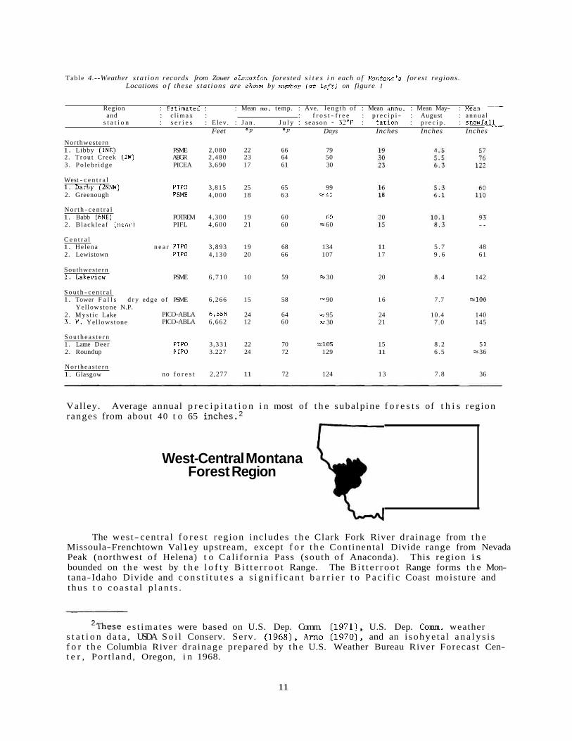
Tab le 4.--Weather s t a t i on records from Zower ezevation forested s i t e s i n each o f E'ontana's forest regions. Locations o f these s ta t ions are shotm by nwnber f a t Zeftl on figure I
Region : Fs t ima ted : : Mean ma. temp. : Ave. l e n g t h of : Mean annu. : Mean May- : ~ e a n and : c l imax : : f r o s t - f r e e : p r e c i p i - : August : annua l
s t a t i o n : s e r i e s : Elev. : J a n . J u l y : season - 32'F : t a t i o n : p r e c i p . : s n o w f a L Feet O F O F Days Inches Inches Inches
Northwestern 1. Libby (1NE) PSME 2,080 22 66 79 2. T rou t Creek (2W) ABGR 2,480 23 64 50 3 . Po l eb r idge PICEA 3,690 17 6 1 30
West - c e n t r a l 1. Darbv f2NNWl . . ,
2. Greenough PIP0 3,815 25 65 99 PSME 4,000 18 6 3 - -45
N o r t h - c e n t r a l 1. Babb (6NE) POTREM 4,300 19 60 60 2. B lack l ea f ( n e a r ) PIFL 4 ,600 21 60 = 60
C e n t r a l 1. Helena n e a r PIP0 3 ,893 19 68 134 11 5 . 7 48 2. Lewistown PIP0 4 ,130 20 66 107 17 9 . 6 61
Southwestern 1. Lakeview PSME 6 ,710 10 59 == 30 20 8 . 4 142
S o u t h - c e n t r a l 1. Tower F a l l s d r y edge o f PSME 6,266 15 5 8 - 90 16 7.7 E l 0 0
Yel lowstone N.P. 2. Mys t i c Lake PICO-ABLA 6,558 24 64 -- 95 24 10.4 140 3 . W. Yellowstone PICO-ABLA 6,662 12 60 -- 30 21 7 .0 145
S o u t h e a s t e r n 1 . Lame Deer PIP0 3 ,331 22 70 = lo5 15 8 . 2 5 1 2. Roundup PIP0 3.227 24 72 129 11 6 . 5 = 36
Nor theas t e rn 1. Glasgow no f o r e s t 2,277 11 72 124 13 7 .8 36
Val ley. Average annual p r e c i p i t a t i o n i n most of t h e subalp ine f o r e s t s of t h i s reg ion ranges from about 40 t o 65 i n c h e ~ . ~
West-Central Montana Forest Region
The wes t- cent ra l f o r e s t reg ion inc ludes t h e Clark Fork River dra inage from t h e Missoula-Frenchtown Val 1 ey upstream, except f o r t h e Continental Divide range from Nevada Peak (northwest of Helena) t o Ca l i fo rn i a Pass (south o f Anaconda). This reg ion i s bounded on t h e west by t h e l o f t y B i t t e r r o o t Range. The B i t t e r r o o t Range forms t h e Mon- tana-Idaho Divide and c o n s t i t u t e s a s i g n i f i c a n t b a r r i e r t o P a c i f i c Coast moisture and thus t o c o a s t a l p l a n t s .
' ~ h e s e e s t ima te s were based on U.S. Dep. Comm. (1971), U.S. Dep. Comrn. weather s t a t i o n d a t a , USDA S o i l Conserv. Serv. (1968), Arno (1970), and an i sohye ta l a n a l y s i s f o r t h e Columbia River dra inage prepared by t h e U.S. Weather Bureau River Forecast Cen- t e r , Por t land , Oregon, i n 1968.
11

Diagnostic fores t vegetation
Although it has a r e l a t i v e l y mild, Pac i f ic- inf luenced c l ima te , t h i s r e g i o n ' s f o r - e s t s a r e gene ra l l y d r i e r than t hose of e i t h e r northwestern Montana o r ad j acen t no r the rn Idaho. Thus, t h e reg ion has on ly small amounts o f P a c i f i c Coast f o r e s t spec i e s such a s Thuja pl icata , Pinus monticola, T m s brev i fo l ia , Clintonia uni f lora, Adenocaulon b i - color, Coptis spp. (of western North America), and Tiare l la t r i f o l i a t a . These spec i e s a r e r e s t r i c t e d t o moist canyon-bottom s i t e s o r seepage a r e a s and gene ra l l y reach t h e i r sou theas t e rn l i m i t s wi th in t h i s reg ion ( t a b l e 3 ) . Abies grandis i s l o c a l l y common, bu t i s much l e s s abundant t han it i s i n northwestern Montana. West-central Montana i s char- a c t e r i z e d by an abundance o f t h e intermountain f o r e s t spec ies - -Lar ix occidental is , Larix l y a l l i i , Pinus ponderosa v a r . ponderosa, Xerophyllwn tenax, Menziesia fermginea, and Luzula hi tchcocki i . These spec i e s become r a r e o r absent i n t h e remaining r eg ions t h a t l i e f a r t h e r e a s t ( t a b l e 3 ) .
Forest d i s t r ibu t ion
As f i g u r e 4 shows, t h e t y p i c a l a r r a y of f o r e s t s e r i e s he re i s not a s d i v e r s e a s t h a t i n northwestern Montana, because o f t h e s c a r c i t y of P a c i f i c Coast s p e c i e s . About
Figure 4.--Distribution of fores t t r e e s i n an area of west-central Montana. Arrows show the r e l a t i v e elevational range of each species; sol id portion of the arrow ind ica tes where a species i s the potential climax and dashed portion shows where it i s seral . (Modified from P f i s t e r and others 1977) .

80 percent o f t he land i n t h i s reg ion i s p o t e n t i a l l y fo re s t ed . Most of t h e nonfores t land i s grass land (Agropyron spieatwn, Festuea idahoensis, and F . scabrella a s s o c i a t i o n s o f Mueggler and Hand1 (In p r e s s ) ) t h a t occur i n t h e broader low-elevat ion v a l l e y s . Annual p r e c i p i t a t i o n on t h e s e nonfores t v a l l e y s i t e s i s l e s s than 15 inches and s o i l s a r e wel l- dra ined . However, t h i s grass land i s no t ex tens ive , and lower t imber l i ne gene ra l ly occurs wi th in 1,000 f e e t o f t h e v a l l e y base e l eva t ion ; t hus it i s found between about 3,200 and 5,500 f e e t . Fores t extends over a l l bu t t h e h ighes t peaks (and r o c k i e s t s i t e s ) . The average e l eva t ion of a l p i n e t r e e l i n e is about 8,800 f e e t . P r inc ipa l f o r e s t h a b i t a t types o f wes t- cent ra l Montana a r e shown i n t a b l e 2.
Climatic influences
The comparatively d ry , Pac i f ic- inf luenced c l imate of t h i s reg ion i s i l l u s t r a t e d by d a t a from t h e l o c a t i o n s of Darby and Greenough ( t a b l e 4 ) . Average annual p r e c i p i t a t i o n i n t h e subalp ine f o r e s t s i s gene ra l ly 35 t o 55 inches ( footnote 2 ) .
Sera1 Pinus ponderosa and Larix occidentalis form t h e l a r g e s t and most commercially important wes t - cen t r a l Montana f o r e s t t r e e s ; they o f t e n a t t a i n he igh t s of 130 t o 140 f e e t a t ma tu r i t y . The exception i s t h e sou theas t e rn p a r t of t h i s reg ion where v a l l e y base e l eva t ions a r e high and f o r e s t s a r e doninated by Pinus contorts. (However, t h e intermountain undergrowth spec i e s dominate.)
North-Central Montana Forest Region
The no r th- cen t r a l Montana f o r e s t region inc ludes a l l t h e fo re s t ed t e r r a i n along t h e e a s t s l ope of t h e Continental Divide from t h e dra inage of t h e North Fork of t h e Dearborn River no r th t o t h e Canadian border and e a s t t o Havre. Adjacent southern Alber ta has s i m i l a r f o r e s t environments.
Diagnostic forest vegetation
This a r e a suppor ts t h e most ex tens ive Populus tremuloides groves i n t h e S t a t e (Lynch 1955) a s well a s l a r g e pa tches of Pinus flercilis woodland along t h e lower s k i r t s of t h e mountains. Pinus ponderosa i s absen t , apparent ly because of t h e excess ive ly cold and windy winter condi t ions . A narrow band of Abies lasiocarpa ( s e r i e s ) f o r e s t a long t h e Rocky Mountain f r o n t suppor ts t h e easternmost occurrences of intermountain under- growth spec i e s , Menziesia ferruginea, Xerophyllwn tenax, Luzula hitchcockii, and even "cove s i t e s " with Clintonia unifZora ba re ly extending across t h e Divide from northwest- e rn Montana (appendixes A- 7, -8, and -10); however, t h e l imi t ed t r e e f l o r a and i t s s tun t ed growth a r e d e f i n i t e l y i n d i c a t i v e of t h e severe e a s t s i d e c l i m a t i c condi t ions .

ELEVATIONS a.l
(approx. 1 L U ru U 111
alpine t u n d r a .: I,l
LAS IOCARPA SERIES
6000 -
PSEUDOTSUGA SERIES 5000
Populus tremuloides grovelands 4000 -
Nor the rn Great P la ins grassland
Figure 5.--Distribution of forest trees i n an area of north-central Montana. Arrows show the re la t ive elevationul range of each species; solid portion of the arrow indicates where a species i s the potential climax and dashed portion shows where it i s seral.
Forest dis tr ibut ion
Only about 10 percent of the land i n t h i s region i s po ten t i a l ly fores ted, most of it occurring i n a 20 t o 30 mile band along the eas tern s k i r t s of the Continental Divide o r Front Range of the Rockies. Figure 5 i l l u s t r a t e s a charac te r i s t i c d i s t r ibu t ion of t r e e species i n t h i s region. A small area of s imilar fo res t (8 mi2), lacking only Lap& Zyal l i i , occurs on the Sweetgrass H i l l s (elev. 6,983 f e e t ) 90 miles eas t of the neares t Front Range stands (Thompson and Kuijt 1976).
Lower t imberline generally occurs between 4,500 and 5,000 f e e t and fo res t extends up t o a l l but the highest r idges and peaks. Alpine t r e e l i n e averages about 8,000 f e e t . Most of the nonforest land i s po ten t i a l ly grassland dominated by Agropyron, Festuca, Bouteloua, and Stipa (Kuchler 1964; Mueggler and Handl, In p ress ) .
Climatic influences
North-central Montana has a continental climate with severe chinook winds and dra- matic f luctuat ions of winter temperatures t h a t of ten in ju re fo res t t r e e s . On wind- exposed slopes, t r e e growth i s stunted by "red bel t" conditions. Branches, groups of t r e e s , o r even s izab le stands a r e rout inely k i l l e d by desiccation of fo l iage caused when warm, dry chinook winds occur while the ground i s frozen and l i t t l e water i s avai lable t o replace t r ansp i ra t ion losses . Pinus f l e x i l i s (a t low and middle elevations) and P. albicaulis ( a t high elevations) a r e l e a s t susceptible t o red b e l t damage.

Growing seasons a r e s h o r t and cool i n t h e lower e l eva t ion f o r e s t s i t e s ( t a b l e 4 and f i g u r e 2) . Except i n pro tec ted v a l l e y s , t r e e s seldom reach 70 f e e t i n he igh t . Average annual p r e c i p i t a t i o n i n t h e subalpine f o r e s t s i s gene ra l ly 30 t o 40 inches ( footnote 2 ) , a l though it i s much g r e a t e r i n a few a reas along t h e Continental Divide, p a r t i c u l a r l y i n G lac i e r National Park. The s e v e r i t y o f win ter temperature f l u c t u a t i o n s i s i l l u s t r a t e d by t h e world- record temperature drop of 100" F i n 24 hours (from +44" t o -56°F) a t Browning, nea r East Glac ier Park, i n January 1916 (McWhirter and McWhirter 1972).
Central Montana Forest Regioln
The c e n t r a l Montana f o r e s t reg ion inc ludes a l l t h e f o r e s t e d t e r r a i n from t h e Helena Valley e a s t t o Harlowton, Lewistown, and Fort Peck Reservoir , and no r th t o Havre. Spe- c i f i c a l l y , t h e western edge runs along t h e Continental Divide from t h e dra inage of t h e Middle Fork o f t h e Dearborn River south t o t h e Boulder River d iv ide . Fores t s contiguous wi th and west o f t h e d i v i d e a r e included from t h e Avon Valley south t o Deer Lodge (from Nevada Peak t o E l e c t r i c Peak along t h e Continental Divide). Eastward, t h e a r e a encom- passes t h e Elkhorn Mountains (except f o r t h e southwestern po r t i on of t h a t range t h a t d r a i n s i n t o t h e Boulder River) a s well a s t h e Big Be l t , L i t t l e Be l t , Cas t l e , Big Snowy, L i t t l e Snowy, J u d i t h , L i t t l e Rocky, Bearpaw, and Highwood Mountains. The range a l s o con ta in s r a t h e r ex t ens ive lowland Pinus ponderosa (var. scopulorwn, Booth 1950, L i t t l e 1953) f o r e s t s i n t h e Helena and Lewistown v i c i n i t i e s and i n t h e Missouri River Breaks.
Diagnostic forest vegetation
Most of c e n t r a l Montana has a low-elevat ion f o r e s t b e l t o f Pinus ponderosa (var . scopulorwn). In c o n t r a s t t o westside P. ponderosa (va r . ponderosa), t h e s e have many two-needle f a s c i c l e s and a s h o r t growth form. Addi t iona l ly , c e n t r a l Montana has moun- t a i n f o r e s t s made up of o t h e r climax s e r i e s ( t a b l e 1 ) . The o t h e r e a s t s i d e reg ion conta in ing P. ponderosa ( southeas te rn Montana) does not have a d d i t i o n a l f o r e s t s e r i e s .
Coastal and intermountain spec i e s a r e e s s e n t i a l l y absent , while e a s t s i d e spec i e s , inc luding Pinus fZexiZis and Juniperus horizontalis, a r e prominent ( t a b l e 3 ) . Great P l a in s grass land elements such a s BouteZoua graci l is and B. curtipendula, Yucca glauca, and Opuntia fragiZis, and 0. polyacantha a r e commonly found i n t h e d r i e s t Pinus ponder- osa and P. f l e x i l i s s t ands .
Forest dis tr ibut ion
Approximately 20 percent of t h e land i n t h i s reg ion i s p o t e n t i a l l y f o r e s t e d . Most of t h e nonfores t land i s p o t e n t i a l l y grass land dominated by Agropyron, Festuca, Boute- Zowz, and Stipa (Kuchler 1964; Mueggler and Handl, I n p r e s s ) . The f o r e s t s a r e a s soc i a t ed with prominent mountain ranges and t h e Missouri River Breaks. Forest extends from v a l l e y base l e v e l s o r from lower t imber l i nes on t h e p r i n c i p a l mountain ranges ( a t 4,000 t o 5,500 f e e t ) and covers a l l but t h e h ighes t peaks. Alpine t r e e l i n e averages about 8,500 f e e t . Figure 6 shows a c h a r a c t e r i s t i c d i s t r i b u t i o n of t r e e spec i e s on non- l imestone pa ren t m a t e r i a l s i n c e n t r a l Montana.

Figme 6.--Distribution of forest trees i n an area of central Montana. Arrows show the re la t ive elevational range of each species; solid portion of the arrow indicates where a species i s the potential climax and dashed portion shows where it i s seral.
Extensive a reas having limestone subs t r a t e s occur i n t h e mountain ranges of c e n t r a l Montana. The limestone-derived s o i l s d r a i n r ap id ly and a r e genera l ly dominated by d r i e r s i t e spec ies than t h e adjacent nonlimestone s i t e s ( f i g . 53, 54, i n P f i s t e r and o t h e r s 1977). For example, a t medium e levat ions t h e limestone s i t e s o f t e n support Pseudotsuga with a grass- forb undergrowth, while ad jacent g r a n i t i c s i t e s have Pinus contorta and Vacciniwn spp. (Goldin and Nimlos 1977; Weaver and Parry 1978).
Climatic influences
This region has a con t inen ta l c l imate , but has f o r e s t s extending t o lower eleva- t i o n s and l e s s severe winter condi t ions than no r th- cen t r a l Montana. The warmer J u l y temperatures and longer growing seasons ( f i g . 2) i n t h e lower f o r e s t zone a r e i nd ica t ed by weather s t a t i o n da t a i n t a b l e 4 . However, except on she l t e r ed s i t e s , t r e e s seldom a t t a i n 80 f e e t i n he igh t . Average annual p r e c i p i t a t i o n i n t h e subalpine f o r e s t s i s es t imated t o be 25 t o 35 inches ( footnote 2) .
In t h e h igher v a l l e y s and a t high e l eva t ions i n t h e mountains, extreme temperature changes accompanied by s t rong winds i n f l i c t red b e l t damage. For ins tance , i n mid- January 1971 such weather condi t ions (temperatures f l u c t u a t i n g between -30" and +58" F a t Great F a l l s , accompanied by s t rong winds) k i l l e d about 20,000 ac re s of Pinus contorta I
f o r e s t i n t h e L i t t l e Belt Mountains. b

Southwestern Montana Forest Region
Area included
The southwestern Montana f o r e s t reg ion inc ludes t h e J e f f e r s o n , Madison, and Boulder River d r a inages , e a s t of t h e Cont inenta l Divide, a s wel l a s t h e f o r e s t s on both s l opes o f t h e Cont inenta l Divide range i n t h e v i c i n i t y o f Butte ( s p e c i f i c a l l y from E l e c t r i c Peak, e a s t o f Deer Lodge, t o C a l i f o r n i a Pass , sou th of Anaconda).
A s i n c e n t r a l Montana, P a c i f i c Coast f o r e s t e lements a r e absent and intermountain elements a r e s c a r c e ( t a b l e 3 ) . Rather s h o r t , bu t s t o u t Pseudotsuga (o r Pinus f l e x i l i s ) occupy t h e warmest f o r e s t s i t e s , and Pinus contorta along wi th Vacciniwn scopariwn undergrowth dominate most h igh- e leva t ion f o r e s t s . Undergrowth is no t ab ly spa r se i n t h e denser f o r e s t s t ands , and i n Pseudotsuga f o r e s t s undergrowth o f t e n c o n s i s t s p r i m a r i l y o f s c a t t e r e d Festuca idahoensis and even Artemisia tr identata Figure 7 shows a char- a c t e r i s t i c d i s t r i b u t i o n of t r e e spec i e s i n southwestern Montana. P r i n c i p a l f o r e s t h a b i t a t t ypes a r e shown i n t a b l e 2 .
V) .- -
TORTA SERIES unce r ta in )
MENZIESI I SERIES
- 6000
grassland
Figure 7.--Distribution of forest t rees i n an area of southwestern Montana. Arrows show the r e la t i v e elevationai! range of each species; solid portion of the arrow indicates where a species i s the potential climax and dashed portion shows where it i s seral.

F o r e s t d i s t r i b u t i o n
Desp i te i t s mountainous t e r r a i n , on ly about one- four th o f t h i s reg ion i s f o r e s t e d . Most o f t h e non fo re s t l and i s semiar id s t eppe ( A r t e h s i a ) and g r a s s l a n d (Agropyron, Fe s tuca , and S t i p a ) , a long with small a r e a s of a l p i n e v e g e t a t i o n (Kuchler 1964; Mueggler and Handl, In p r e s s ) above 9,500 f e e t e l e v a t i o n . Lower t i m b e r l i n e g e n e r a l l y occurs somewhere between 5,700 and 7,000 f e e t i n e l e v a t i o n . However, some of t h e mountain ranges sou th o f D i l l o n a r e s o d r y t h a t l i t t l e f o r e s t i s suppor ted even a t 8,000 f e e t . Thus, t h e e n t i r e f o r e s t b e l t (between lower and upper t imbe r l i ne ) may span on ly 1,000 t o 1,500 f e e t of e l e v a t i o n , and may b e l o c a l l y ab sen t on exposed sou th- and wes t - f ac ing s l o p e s . S i m i l a r l y h igh , semiar id mountain ranges , p r o j e c t i n g above an Ar temis ia t r i d e n t u t a s t e p p e (Kuchler 1964), occur i n a d j a c e n t e a s t - c e n t r a l Idaho ( S t e e l e and o t h e r s ( f oo tno t e 1 ) ) .
C l ima t i c i n f l uences
A s i l l u s t r a t e d by weather r e co rds from Lakeview ( t a b l e 4 ) , t h i s i s a co ld , d r y f o r e s t r eg ion having high va l ley- base e l e v a t i o n s , and a c o n t i n e n t a l c l ima t e . Average annual p r e c i p i t a t i o n i n t h e suba lp ine f o r e s t r anges from about 22 t o 35 inches ( foo t- n o t e 2 ) . Th i s f o r e s t r eg ion e v i d e n t l y has growing seasons t o o s h o r t and co ld f o r P inus ponderosa ( f i g . 2 ) . The co ld , d r y cond i t i ons a r e a l s o evidenced by t h e l a ck of P s e u d o t s u g a / P h y s o c q u s h a b i t a t t y p e ( t a b l e s 2 and 3 ) . However, chinook winds and tem- p e r a t u r e f l u c t u a t i o n s a r e l e s s s eve re t han i n n o r t h - c e n t r a l and c e n t r a l Montana, and r e d b e l t damage i s l e s s common.
south-central Montana Forest Region
The sou th- cen t r a l Montana f o r e s t r eg ion i nc ludes t h e G a l l a t i n and upper Yellowstone River d r a inages (along wi th t h e Bridger and Crazy Mountains) a s wel l a s t h e Pryor Moun- t a i n s and t h e n o r t h end o f t h e Bighorn Range. The r eg ion encompasses t h e no r the rn p a r t o f an ex t ens ive , h igh- e l eva t i on f o r e s t e d upland surrounding Yellowstone Nat ional Park. This upland i s capped by l a r g e a l p i n e p l a t e a u s i n Montana and Wyoming.
D iagnos t i c f o r e s t vege t a t i on
Most of t h e f o r e s t i n sou th- cen t r a l Montana is dominated by Pseudotsuga, P inus contor tu , Picea, o r Abies l a s i o c q a . The abundance of PicealPhysocarpus, Picea/Galium t r i f lo rwn, Abies lasiocarpa/GaZiwn t r i f lo rwn, and Abies lasiocarpa/CaZwnagrostis cana- d e n s i s h a b i t a t t y p e s ( t a b l e 2) a t t e s t s t o t h e mois tness o f many of t h e f o r e s t s . Also, s c a t t e r e d popu l a t i ons o f Xerophyllwn and Menziesia (appendixes A-9 and -10) a r e found he r e , more t han 100 mi l e s e a s t o f t h e i r usua l d i s t r i b u t i o n a l l i m i t s n ea r t h e Cont inen ta l Divide. In c o n t r a s t t o southwest Montana, one seldom f i n d s ex t ens ive s t ands having a g r a s s l and undergrowth (except on l imes tone s u b s t r a t e s ) , nor does one f i n d ve ry s p a r s e undergrowth r e l a t e d t o d r y cond i t i ons .
I
F o r e s t d i s t r i b u t i o n
I Nearly h a l f o f t h e land i n sou th- cen t r a l Montana suppor t s f o r e s t , and most of t h e remaining a r e a i s p o t e n t i a l l y grassland--(Agropyron, Festuca, S t i p a ) accord ing t o

ELEVATIONS (approx )
Figure 8.--Distribution o f forest t r e e s i n an area of south-central Montana. Arrows show the r e l a t i v e elevational range o f each species; sol id portion o f the arrow indicates where a species i s the potential climax and dashed portion shows where it i s seral . (Modified from P f i s t e r and others 1977.1
Kuchler (1964)--occupying t h e d r i e r , lower e l eva t ion v a l l e y s . Lower t imber l i ne aver- ages about 5,500 f e e t and a l p i n e t r e e l i n e occurs near 9,500 f e e t . Figure 8 shows a c h a r a c t e r i s t i c d i s t r i b u t i o n of t r e e spec i e s i n an a r ea of sou th- cen t r a l Montana. Table 2 l i s t s p r i n c i p a l f o r e s t h a b i t a t types .
Limestone s u b s t r a t e s a r e abundant i n t h e Pryor Mountains and occur spo rad ica l ly elsewhere i n south- cent ra l Montana. These s i t e s , below about an 8,000- foot e l eva t ion , gene ra l ly have f o r e s t s dominated by Pinus f l e x i l i s and Pseudotsuga.
Climatic in f luences
South- cent ra l Montana has a con t inen ta l c l imate , and red b e l t i n j u r y is o f t e n severe a t lower t imber l i ne . The v a l l e y s have high base e l eva t ions and a r e too co ld ( shor t growing season, f i g u r e 2) f o r any s i g n i f i c a n t amounts o f Pinus ponderosa; how- ever , f o r e s t s a r e gene ra l ly mois te r than those of southwestern Montana. Weather records f o r t h r e e f o r e s t e d s i t e s i n t h i s reg ion a r e found i n t a b l e 4 . Average annual p r e c i p i t a - t i o n i n t h e subalp ine f o r e s t s i s gene ra l ly 30 t o 45 inches ( footnote 2 ) .

Southeastern Montana Forest Region
The sou thea s t e rn Montana f o r e s t reg ion i nc ludes t h e ex t ens ive pure Pinus ponderosa f o r e s t s on lowlands and h i l l y t e r r a i n (most ly 2,800 t o 4,400 f e c t e l e v a t i o n ) i n t h e no r the rn Great P l a i n s . I t covers t h e lower Yellowstone River d r a inage a s f a r upstream (west) a s Big Timber. The r eg ion ex tends up t h e Musselshel l Val ley t o Harlowton and i t s no r the rn boundary inc ludes t h e northernmost p i n e groves i n t h e v i c i n i t i e s of Round- up, Miles C i t y , and Baker.
Diagnostic forest vegetation
Although Pinus ponderosa i s t h e o n l y f o r e s t t r e e , it occurs i n r a t h e r d i v e r s e h a b i t a t t ypes ( t a b l e 2 ) . The d r i e s t o f t h e s e f o r e s t s i t e s have ve ry open s t ands of s h o r t t r e e s (35-60 f e e t ) , wi th g r a s s l and undergrowth ( e . g . , Andropogon gerardii and A. scoparius, Agropyron spicatwn, Bouteloua grac i l i s , Carex f i l i f o l i a ) . Conversely, moist no r th- fac ing s l o p e s have dense s t a n d s of P. ponderosa (70-95 f e e t t a l l ) , wi th a l u x u r i - a n t shrub and he rb undergrowth i nc lud ing many s p e c i e s c h a r a c t e r i s t i c o f t h e mountain f o r e s t s t o t h e west (e . g . , Shepherdia camdensis, Arctostaphylos uva-msi, Berberis repens, Linmea borealis, Arnica cordi fol ia , Dispomon trachycarpwn, PyroZa secunda, and Smilacina s t e l l a t a ) .
The presence o f Linnaea and some o t h e r undergrowth s p e c i e s s t r o n g l y sugges t s t h a t t h e more moist h a b i t a t s would suppor t Pseudotsuga; however, t h e n e a r e s t seed source f o r t h i s s p e c i e s i s a t l e a s t 70 mi l e s away i n t h e Bighorn Range. This conc lus ion i s r e i n - fo r ced by t h e f a c t t h a t Pinus ponderosa s t ands developing on t h e mo i s t e r s i t e s a r e more h e a v i l y s tocked t h a n i s c h a r a c t e r i s t i c o f P. ponderosa h a b i t a t t ypes elsewhere i n t h e S t a t e .
I n a d d i t i o n t o having a s h o r t e r growth form than i t s coun t e rpa r t west o f t h e Con- t i n e n t a l Divide, t h e P. ponderosa (var . scopulorwn, Booth 1950 and L i t t l e 1953) i n sou th- e a s t e r n Montana ha s a m a j o r i t y o f two-needle f a s c i c l e s . These may be man i f e s t a t i ons of s u b s t a n t i a l g e n e t i c d i f f e r e n c e s between t h e west s l o p e and Great P l a i n s P. ponderosa.
Two e a s t e r n deciduous - f o r e s t s p e c i e s (Fraxinus pennsy Zvanica and Prunus americana) occur a long s t reams and moist lower n o r t h s l opes i n sou thea s t e rn Montana, and two o t h e r such s p e c i e s (Ulmus americana and Quercus macrocarpa) reach t h e e a s t e r n edge of t h i s r eg ion ( L i t t l e 1971, 1976) . P f i s t e r and o t h e r s (1977) have d i scussed composi t ional s i m i l a r i t i e s between t h e P. ponderosa f o r e s t s o f sou thea s t e rn Montana and t hose of t h e Black H i l l s o f western South Dakota a s sampled by Th i l en iu s (1972).
Forest d i s t r ibu t ion
Approximately 20 pe r cen t o f sou thea s t e rn Montana suppo r t s f o r e s t . This i s a reg ion - without prominent mountains, o r mountain f o r e s t s ; t h u s , it d i f f e r s from a l l o t h e r f o r - e s t e d r eg ions . (Nor theas te rn Montana does no t have mountains, bu t a l s o i s without Great
L
P l a i n s Pinus ponderosa f o r e s t . )

Most o f t h e remainder o f t h e reg ion i s Great P l a in s grass land (BouteZoua-Stipa- Agropyron, according t o Kuchler 1964). Some of t h i s grass land has widely s c a t t e r e d p ines , and thus can be termed a "savanna."
Southeastern Montana has a con t inen ta l c l imate . Summers a r e longer , h o t t e r , and more humid than those i n t h e mountainous f o r e s t reg ions ( t a b l e 4 and f i g u r e 2 ) . Most of t h e annual p r e c i p i t a t i o n (ranging up t o about 18 inches i n moist f o r e s t a r ea s ) comes i n sp r ing and summer r a i n s . Winters a r e gene ra l ly d ry and co ld , but a r e not a s severe a s t hose i n t h e nor thern p a r t s of Montana e a s t o f t h e Continental Divide.
Northeastern Montana i-1, The no r theas t e rn p a r t o f Montana inc ludes t h e a r e a nor th of Miles C i ty and e a s t o f
t h e Missouri River Breaks. Po ten t i a l n a t u r a l vege ta t ion i s Great P la ins grass land (BouteZoua-Stipa-Agropyron and Agropyron-Stipa, according t o Kuchl e r 1964) except f o r s t ands o f PopuZus deZtoides l i n i n g t h e p r inc ipa l r i v e r s . This reg ion has no upland f o r e s t , except f o r a few widely s c a t t e r e d popula t ions of s tun ted Pinus ponderosa. (The most no tab le s tand i s a t t h e Pines Recreat ion Area south of Glasgow on Fort Peck Reser- v o i r . ) The extremely co ld con t inen ta l win ters , coupled with des i cca t ing winds, may be t h e f a c t o r s prevent ing Pinus ponderosa from growing here . Average annual p r e c i p i t a t i o n i s between 11 and 15 inches i n t h i s region (U.S. Dep. Comm. 1971). Table 4 p re sen t s c l i m a t i c d a t a from Glasgow.

RESEARCH AND MANAGEMENT APPLICATIONS
The f o r e s t reg ions presented here were developed t o descr ibe d i s t r i b u t i o n s of f o r e s t h a b i t a t types ( P f i s t e r and o t h e r s 1977) - - i . e . , f o r e s t s i t e s and vegeta t ion i n mature s t ands . The reg ions can a l s o be used i n descr ib ing d i s t r i b u t i o n s of ind iv idua l f o r e s t spec i e s o r s e r a 1 f o r e s t communities ( e . g . , Acer gzabrwn-SaZix brushf i e l d s ) . The Northern Region o f t h e USDA Fores t Se rv i ce r e c e n t l y adopted f o r e s t r eg ions a s "seed t r a n s f e r zones" t o he lp i n su re t h a t nu r se ry- ra i s ed seed l ings a r e s e n t t o a geographic a r e a s i m i l a r t o t h e one where t h e seeds were c o l l e c t e d .
These f o r e s t r eg ions may be u se fu l a s a b i o l o g i c a l l y based reg ional s t r a t i f i c a t i o n f o r f o r e s t r e sea rch and f o r e s t management s t u d i e s . For example, i t might be usefu l t o s t r a t i f y p roduc t iv i t y e s t ima te s ( s i t e index and y i e l d c a p a b i l i t y ) of i nd iv idua l h a b i t a t types by f o r e s t reg ion . S imi l a r ly , t h e s e f o r e s t reg ions l o g i c a l l y could be incorpora ted i n s t u d i e s o f gene t i c v a r i a t i o n i n t r e e spec i e s and i n t r e e improvement programs.
Responses of t r e e s and o t h e r vege t a t i on t o management a r e o f t e n s t r a t i f i e d by h a b i t a t t y p e , but it may be u se fu l t o analyze them by f o r e s t reg ion a s wel l . Forest reg ions o f f e r an add i t i ona l dimension f o r i n t e r p r e t i n g v a r i a t i o n i n f o r e s t vege t a t i on . Fores t managers may f i n d appendix C u se fu l f o r determining t h e l oca t ion of f o r e s t reg ion boundaries .
Arno, Stephen F. 1970. Ecology of a l p i n e l a r c h (Larix ZyaZZii P a r l , ) i n t h e P a c i f i c Northwest. Ph.D.
Diss., Univ. Mont., Missoula, 264 p. Bai ley, R. G .
1976. Ecoregions o f t h e United S t a t e s (map) , USDA For. Serv. , In te rmt . Reg. , Ogden, Utah.
Bai ley, R. G. 1978. Ecoregions o f t h e United S t a t e s (manual t o accompany map). USDA For. Se rv . ,
Intermt. Reg., Ogden, Utah, 77 p. Booth, W. E .
1950. F lora of Montana. Pa r t I , Conifers and Monocots. 232 p. Mont. S t a t e Univ., Bo z eman.
Booth, W. E . , and J. Wright. 1966. F lo ra of Montana. P a r t 11. Dicotyledons. 305 p. Mont. S t a t e Univ., Bozeman.
Caprio, J. M. 1965. Average l eng th of f r e e z e - f r e e season. Mont. Agric. Ext. S t n . , Bozeman. Folder
83 (map) . Crowley, J. M.
1972. Environmental reg ions of Montana. I n Montana Environmental Qual i ty Council, F i r s t Annu. Rep., Helena, Mont., p. 2-11.
Daubenmire, R. 1969. S t r u c t u r e and ecology of coni fe rous f o r e s t s o f t h e Northern Rocky Mountains.
Proc. 1968 Symp. (Coniferous Fo res t s of t h e Northern Rocky Mountains), Univ. Mont., Missoula, p . 25-41.
Daubenmire, R . , and J. B. Daubenmire. 1968. Fores t vege t a t i on of e a s t e r n Washington and nor thern Idaho. Wash. Agric. Exp.
S tn . , Pullman. Tech. Bull . 60, 104 p. Goldin, A . , and T. J. Nimlos.
1977. Vegetat ion p a t t e r n s on l imestone and a c i d parent m a t e r i a l s i n t h e Garnet Moun- t a i n s of western Montana. Northwest S c i . 51(3):149-160.
Green, A. W . , and T. Se t ze r . 1974. The Rocky Mountain t imber s i t u a t i o n , 1970. USDA For. Serv. Resour. Bul l .
INT-10, 78 p. Intermt. For. and Range Exp. S tn . , Ogden, Utah. Hitchcock, C. L . , and A. Cronquist .
1976. F lo ra of t h e P a c i f i c Northwest. 730 p. Univ. Wash. P re s s . , S e a t t l e . Hitchcock, C. L . , A. Cronquist, M. Ownbey, and J. Thompson.
1955-1969. Vascular p l a n t s o f t h e P a c i f i c Northwest (5 v o l s . ) . Univ. Wash. P re s s , S e a t t l e .
Hutchison, S. B . , and P. D . Kemp. 1952. Fores t resources o f Montana. USDA For. Se rv . , For. Res. Rep. 5, 76 p. North.
Rocky M t . For. and Range Exp. S tn . , Missoula, Mont. Kirkwood, J. E .
1922. Forest d i s t r i b u t i o n i n t h e Northern Rocky Mountains. Mont. S t a t e Univ., Bul l . 247 ( s e r . 2 ) , Missoula, 180 p.
Kuchler, A. W. 1964. P o t e n t i a l n a t u r a l vege t a t i on o f t h e conterminous United S t a t e s (map and manual)
Am. Geog. Soc. Spec. Publ. 36, 116 p.
Kuchler, A. W. 1973, Problems i n c l a s s i f y i n g and mapping vege t a t i on f o r e co log i ca l r e g i o n a l i z a t i o n .
Ecology 54:512-523. L i t t l e , E . L . , Jr.
1953. Check l i s t of n a t i v e and n a t u r a l i z e d t r e e s o f t h e U.S. USDA For. Serv . Agric . Handb. 41, 472 p.
L i t t l e , E . L . , Jr. 1971. A t l a s o f United S t a t e s t r e e s . Vol. 1. Coni fe rs and important hardwoods. USDA
For. Serv . Misc. Publ. 1146. L i t t l e , E . L. Jr.
1976. A t l a s o f United S t a t e s t r e e s . Vol. 3. Minor western hardwoods. USDA For. Serv. Misc. Publ. 1314.
Lynch, D. L. 1955. Ecology o f aspen groveland i n G lac i e r County, Montana. Ecol . Monogr.
25:321-344. McWhirter, N . , and R. McWhirter.
1972. Guinness book o f world r eco rds . 704 p. S t e r l i n g Publ . Co., N. Y . Mueggler, W . F. , and W . P. Handl.
[ I n p roce s s . ] Mountain g r a s s l and and shrubland h a b i t a t t ypes o f wes te rn Montana. USDA For. Serv . , Gen. Tech. Rep., In te rmt . For. and Range Exp. S t n . , Ogden, Utah, and North. Reg., Missoula, Mont.
Mueller-Dombois, D. , and H. E l lenburg . 1974. Aims and methods o f vege t a t i on ecology. 547 p. John Wiley and Sons, N . Y .
Payne, G. F. 1973. Vege ta t ive range land t ypes i n Montana. Mont. Agric . Exp. S t n . , Bul l . 671.
Bozeman, 1 5 p. and map. P f i s t e r , R. D . , B. Kovalchik, S. Arno, and R . Presby.
1977. Fo re s t h a b i t a t t y p e s o f Montana. USDA For. Serv. Gen. Tech. Rep. INT-34. 174 p. In te rmt . For. and Range Exp. S t n . , Ogden Utah.
Ross, R. L . , and H. E . Hunter. 1976. Climax vege t a t i on of Montana based on s o i l s and c l ima t e . USDA S o i l Cons.
Serv . , Bozeman . 64 p. and map. Rowe, J . S.
1959 and 1972 e d i t i o n s . Fores t r e g i o n s o f Canada. Canadian Fo re s t ry Serv. Publ . 1300. 172 p. Ottawa.
Schmidt, W. C . , and W . P. Dufour. 1975. Bui lding a n a t u r a l a r e a system f o r Montana. Western Wildlands 2(1) :20-29.
Mont. For. and Cons. Exp. S t n . , Univ. Mont., Missoula. T h i l e n i u s , J . F.
1972. C l a s s i f i c a t i o n o f dee r h a b i t a t i n t h e ponderosa p ine f o r e s t o f t h e Black H i l l s , South Dakota. USDA For. Serv. Res. Pap. RM-91, 23 p. Rocky M t . For. and Range Exp. S t n . , For t C o l l i n s , Colorado.
Thompson, L . S . , and J. Ku i j t . 1976. Montane and suba lp ine p l a n t s of t h e Sweetgrass H i l l s , Montana, and t h e i r
r e l a t i o n s h i p t o e a r l y p o s t g l a c i a l environments o f t h e Northern Great P l a i n s . Canadian F i e l d - N a t u r a l i s t 90(4):432-448.
USDA S o i l Conservat ion Serv ice . 1968. Average annual mountain p r e c i p i t a t i o n (map). S o i l Cons. Se rv . , Bozeman,
Montana. U . S. Department o f Commerce.
I 1971. Cl imates o f t h e S t a t e s : Montana. Climatography o f t h e United S t a t e s No. 60: 24. Environ. Data Serv . , S i l v e r Spr ings , MD.
Weaver, T., and D. A. Perry.
I 1978. Re l a t i onsh ip o f cover t y p e t o a l t i t u d e , a s p e c t , and s u b s t r a t e i n t h e Bridger Range, Montana. Northwest S c i . 52(3):212-219.
APPENDIX A Distribution of key tree and undergrowth species in Montana
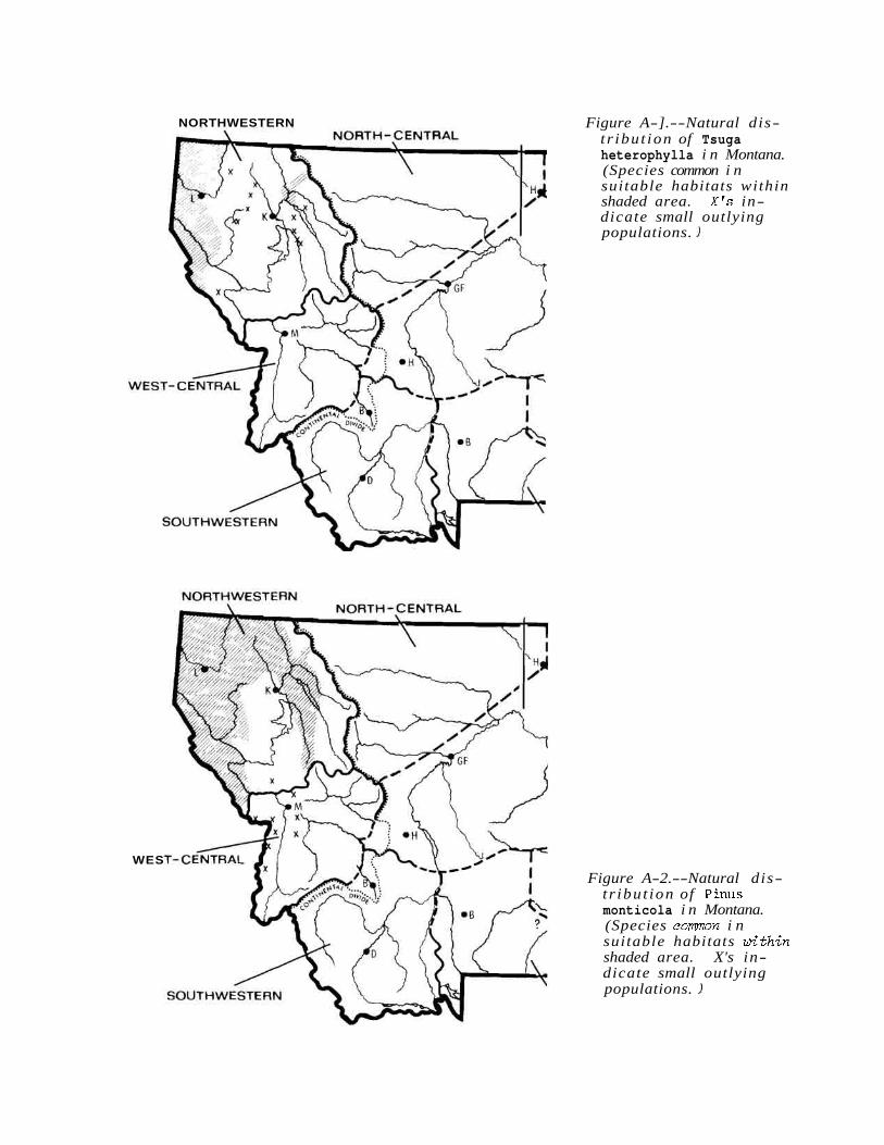
NORTHWESTERN Figure A-].--Natural dis- t r ibu t ion of Tsuga heterophylla i n Montana. (Species common i n suitable habitats within shaded area. X's in- dicate small outlying populations. )
WES
Figure A-2.--Natural dis- t r ibu t ion of Pinus monticola i n Montana. (Species common i n suitable habitats wlthin shaded area. X's in- dicate small outlying populations. )
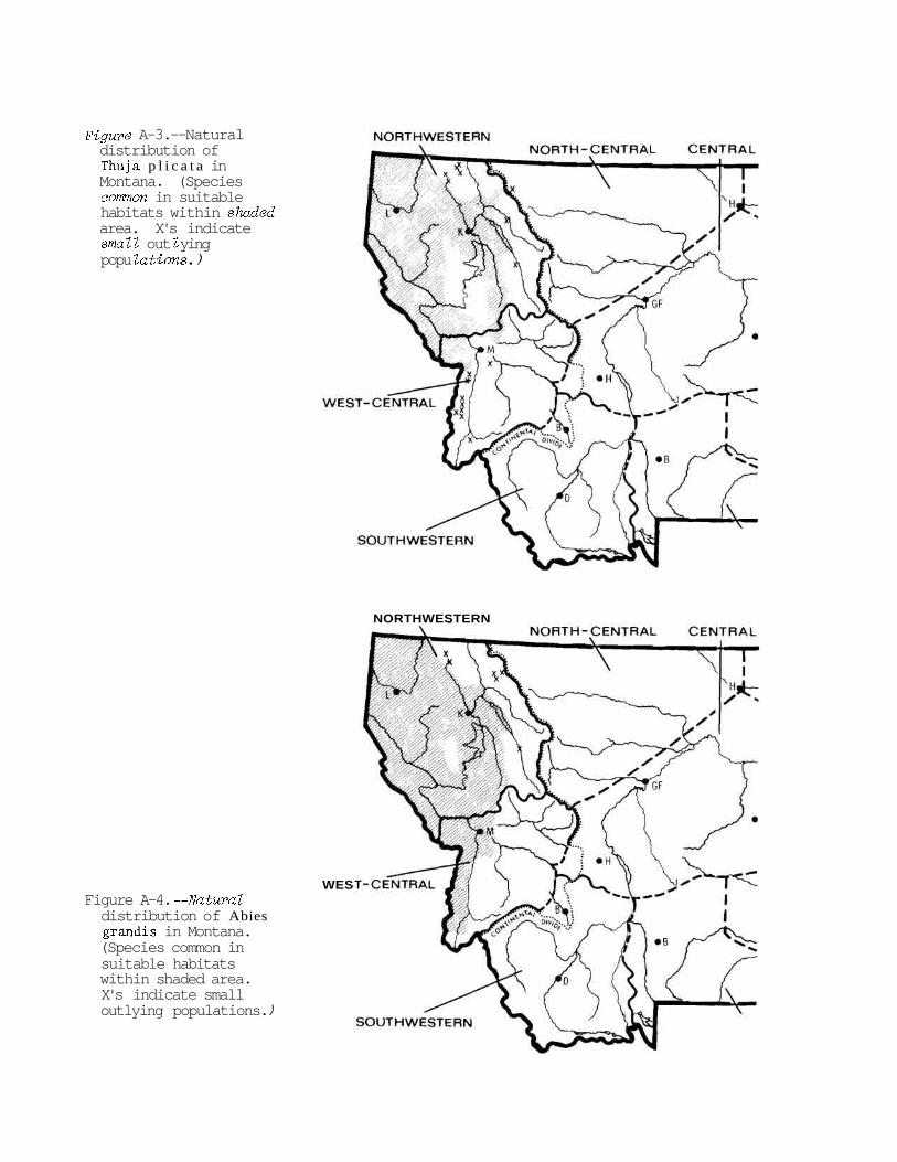
Figure A-3. --Natural distribution of Thuja p l i c a t a in Montana. (Species common in suitable habitats within shuded area. X's indicate sma Z l out l ying popu Zations . )
NORTHWESTERN
WES Figure A-4. --Natural distribution of Abies grandis in Montana. (Species common in suitable habitats within shaded area. X's indicate small outlying populations. )
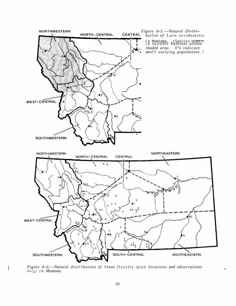
NORTHWESTERN - - - - - . - - . . Fiaure A-5. --Natural d i s t r i - NORTH-,CENTRAL CENTRAL
I
'H* /
WES
WES
" but ion o f Larix o c c i d e n t a l i s
I
\ \ I I i n ~ m t a & . . - (Species - . common . - . i n su i tab le habi ta ts wzthzn shaded area. X's ind ica te smal Z out ly ing populations. )
I Figure A-6.--Natural d i s t r i b u t i o n of Pinus f l e x i l i s ( p l o t locat ions and observations - onZy) i n Montana.
28

Figure A-7. --Natural d i s- t r ibu t ion of Cl in ton ia u n i f l o r a i n Montana. (Species comon i n suitable habitats within shaded area. X's in- dicate small outlying populations. )
WES
Figure A-8. --Natural d i s t r ibu t ion of Luzula h i t c h c o c k i i i n Montana. (Species comon i n suitable habitats wi thin shaded area. X's i n- dicate small outlying populations. l
NORTHWESTERN

NORTHWESTERN
NORTHWESTERN
WES
Figure A-9.--Natural d is- t r ibu t ion of Menziesia ferruginea i n Montana. (Species common i n sui table habitats wi thin shaded area. X's indicate small outlying populations. )
Figure A-1 0. --Natural dis- t r ibu t ion of Xerophyllum tenax i n Montana. (Species common i n sui table habi tats within shaded area. X's in.- dicate small outlying populations. )

APPENDIX B Number of sample p l o t s ( P f i s t e r and others 1977)
by hab i ta t type, phase, and fo res t region in Montana

Table B-1--Number o f s q l e plots (P f i s t e r and others 1977) by habitat type, phase, and forest region i n Montana. ( c . t . = cort~mmity t ype)
NW = Northwestern Montana WC = west-central Montana NC = north-central Montarxz
C = central Montana
SW = southwestern Montana SC = south-central Montana SE = southeastern Montana
Montana f o r e s t region S e r i e s / h a b i t a t type/phase : NW : WC : NC : C : SW : SC : SE : Tota l
Fores ted s c r e e
Pinus f l e x i l i s s e r i e s
/Agropyron spicatum h . t . 1 2 2 1 6 /Fes tuca idahoens is h . t .
-Festuca idahoens is phase . 1 2 2 2 7 -Festuca s c a b r e l l a phase . 1 3 4
/ Juniperus communis h; t . 1 - 1 - 1 - 4 - 7 - 4 8 5 7 2 4
Pinus ponderosa s e r i e s
/Andropogon spp . h. t . /Agropyron spicatum h . t . /Festuca idahoens is h . t .
-Festuca idahoens is phase -Festuca s c a b r e l l a phase
/Pursh ia t r i d e n t a t a h . t . -Agropyron spicatum phase -Festuca idahoens is phase
/Symphoricarpos a lbus h . t . -Symphoricarpos a l b u s
phase -Berber i s repens phase
/Prunus v i r g i n i a n a h . t . -Prunus v i r g i n i a n a phase -Shepherdia canadensis
phase
Pseudotsuga menzies i i s e r i e s
/Agropyron spicatum h . t . 1 4 5 1 2 13 /Festuca idahoens is h . t . 1 1 . 14 3 19 /Fes tuca s c a b r e l l a h . t . 5 2 6 13 /Vaccinium caespitosum h . t . 15 9 i 2 2 7 /Physocarpus malvaceus h . t .
-Physocarpus malvaceus phase 12 23 3 1 6 4 5
-Calamagrostis rubescens phase 1 7 8
(con. )

Table B-1. --(con.)
Montana forest region Series/habitat ty-pe/phase : NW : WC : NC : C : SW : SC : SE : Total
Pseudotsuga menziesii series
/Vaccinium globulare h.t. -Vaccinium globulare phase -Arctostaphylos uva-ursi
phase -Xerophyllum tenax phase
/Linnaea borealis h.t. -Symphoricarpos albus
phase -Calamagrostis rubescens
phase -Vaccinium globulare phase
/Symphoricarpos albus h.t. -Agropyron spicatum phase -Calamagrostis rubescens
phase -Symphoricarpos albus
phase /Calamagrostis rubescens h.t. -Agropyron spicatum phase -Arctostaphylos uva-ursi
phase -Calamagrostis rubescens
~hase -Pinus ponderosa phase
/Carex geyeri h.t. /Spiraea betulifolia h.t. /Arctostaphylos uva-ursi h.t.
/Juniperus communis h. t . /Arnica cordifolia h.t. /Symphoricarpos oreophilus
Picea series
/Equisetum arvense h.t. 3 2 2 1 1 /Clintonia uniflora h.t. -Vaccinium caespitosum
phase 8 -Clintonia uniflora phase 16
/Physocarpus malvaceus h.t. . ti
/Galium trif lorum h. t . i i i 9 /Vaccinium caespitosum h.t. 4 i /Senecio streptanthifolius h.t. -Pseudotsuga menziesii
phase 1 2 2 -Picea phase 5
/Linnaea borealis h.t. i 5 4 11 /Smilacina stellata h.t. - 1 - - 4 - 1 - 4 -
3 1 5 4 19 10 31
(con. )
Table B-1.--(con.)
Montana forest region Series/habitat type/phase : NW : WC : NC : C : SW : SC : SE : Total
Abies grandis series
/Xerophyllum tenax h.t. 5 1 6 /Clintonia uniflora h.t. -Clintonia uniflora phase 4 2 6 -Aralia nudicaulis phase 5 1 6 -Xerophyllum tenax phase 4 4
/Linnaea borealis h.t. -Linnaea borealis phase 3 2 5 -Xerophyllum tenax phase 3 - 3 6 -
2 4 3 0
Thuja plicata series
/Clintonia uniflora h.t. -Clintonia uniflora phase 13 2 15 -Aralia nudicaulis phase 8 1 9 -Menziesia ferruginea phase 6 1 7
/Oplopanax horridum h.t. - - 11 4 -
38 42
Tsuga heterophylla series
/Clintonia uniflora h.t. -Clintonia uniflora phase 27 2 7 -Aralia nudicaulis phase - 11
3 8
Abies lasiocarpa series (Lower subalpine h . t . s )
/Oplopanax horridum h.t. 4 4 /Clintonia uniflora h.t. -Clintonia uniflora phase 18 11 3 32 -Aralia nudicaulis phase 12 4 2 18 -Vaccinium caespitosum
phase 8 2 10 -Xerophyllum tenax phase 13 7 i 2 1 -Menziesia ferruginea
phase 12 8 2 2 2 /Galium triflorum h.t. 10 4 i 3 4 /Vaccinium caespitosum h.t. . 2 3 i 10 /Calamagrostis canadensis h.t. -Calamagrostis canadensis
phase 8 1 8 6 23 -Galium triflorum phase 2 1 2 5 -Vaccinium caespitosum
phase 3 1 1 2 7 /Linnaea borealis h.t. -Linnaea borealis phase 1 10 4 2 1 2 20 -Xerophyllum tenax phase 5 8 13 -Vaccinium scoparium phase 2 3 i 4 i i 17
/Menziesia ferruginea h.t. 19 37 5 2 1 64
(con. )

Table R-1.--(con.)
Montana forest region Serieslhabitat tvnelnhase : NW : WC : NC : C : S1.l " SC : SE : 'Total
Abies lasiocarpa series (Lower subalpine h.t.s)
Tsuga mertensiana/Menziesia h.t. 8 2 10
/Xerophyllum tenax h.t. -Vaccinium globulare phase 18 18 3 1 40 -Vaccinium scoparium phase 3 14 3 1 2 1
Tsuga mertensiana/Xerophyllum h.t. 9 9
/Vaccinium globulare h.t. i 5 3 11 2 1 /Vaccinium scoparium h.t. -Calamagrostis rubescens
phase 2 3 5 10 -Vaccinium scoparium phase 1 ;1 3 4 5 17 -Thalictrum occidentale
phase 1 5 4 10 /Alnus sinuata h.t. i i 2 2 6 /Calamagrostis rubescens h.t. . 1 i 2 4 8 /Clematis pseudoalpina h.t. . 1 7 1 6 15 /Arnica cordifolia h. t. 1 8 15 2 4 /Carex geyeri h.t. -Carex geyeri phase 2 1 3 -Pseudotsuga menziesii
phase 2 1 3 6
(Upper subalpine h. t. s )
/Ribes montigenum h.t. 3 3 6 Abies 1as.-Pinus albic./ Vaccinium scop. h.t. 4 3 9 15 13 4 4 /Luzula hitchcockii h.t. -Vaccinium scoparium phase 5 18 4 2 29 -Menziesia ferruginea
phase 14 9 1 24 Tsuga mertensiana/Luzula h.t.
-Vaccinium scoparium phase 2 2 -Menziesia ferruginea
phase 2 2
(Timberline h. t . s)
Pinus albicaulis-Abies lasiocarpa h . t. s 4 6 3 4 6 7 3 0
Larix lyallii-Abies lasiocarpa h.t.s 5 29 2 36
Pinus albicaulis h.t.s 1 - - - i - 4 - i - 9 - 168 221 43 63 94 93 682
-=->-
(con. ) 35

Table R-1. --(con.)
-. - Montana forest region Series/habitat type/phase : NW : WC : NC : C : SW : S C : S E : Total
Pinus contorta series
/Purshia tridentata h.t. 3 3 /Vaccinium caespitosum c.t. . 4 i i il 12 /Linnaea borealis c.t. 1 4 2 6 ;1 17 /Vaccinium scoparium c.t. 1 6 5 6 2 2 0 /Calamagrostis rubescens c.t. - - - 1 - 4 1 - 6 -
2 14 1 10 21 10 5 8
Unclassified stands 11 8 3 12 3 6 4 3
1 Total number of plots 399 459 66 217 188 178 24 1,531
This total includes 35 Pinus contorta community type plots also listed under Pseudotsugo, Picea, or Abies Zasiocarpa habitat types.

APPENDIX C National Fores ts , Indian Reservations, and
National Parks within each f o r e s t region i n Montana


National F o r e s t s ( f i g . C- l ) , Ind ian Reservat ions, and National Parks wi th in each f o r e s t reg ion . (N.F. = National Fores t ; R.D. = Ranger D i s t r i c t ) :
Forest region
Northwestern
West - c e n t r a l
North-central
Cent ra l
Southwest ern
Southeas te rn
Northeastern
Areas incZuded
Flathead N.F. Kootenai N.F. Lolo N . F . (Thompson F a l l s , P l a in s ,
Super ior , and W . and N . po r t i ons o f Ninemile R . D . ' s )
Flathead Indian Reservat ion G lac i e r National Park (W. s lope)
B i t t e r r o o t N.F. (Montana po r t i on ) Deerlodge N.F. (Phi l ipsburg R . D . , W .
p o r t i o n o f Deer Lodge R.D.) Helena N . F. (Blackfoot River dra inage
p o r t ion) Lolo N.F. (Missoula, See ley Lake, and
S.E. p o r t i o n o f Ninemile R.D.)
Lewis and Clark N.F. (Rocky Mountain Front p o r t ion)
Blackfeet Indian Reservat ion G lac i e r National Park ( E . s lope)
Helena N . F . (except Blackfoot R . d ra inage) Lewis and Clark N.F. (except Rocky M t .
Front and Crazy Mts.) For t Belknap (S. po r t i on ) and Rocky Boy
Indian Reservat ion Chas. M . Russel l Nat ional Wi ld l i f e Refuge
(W. po r t i on )
Beaverhead N.F. Deerlodge N.F. (except Ph i l i p sbu rg and W .
po r t i on o f Deer Lodge R.D.'s)
Cus te r N.F. (Red Lodge R.D.) G a l l a t i n N.F. Lewis and Clark N . F . (Crazy Mts. po r t i on ) Crow Indian Reservat ion (Pryor and Bighorn
Mts. po r t i on ) Yellowstone National Park (Montana po r t i on )
Cus te r N.F. (Montana p o r t i o n except Red Lodge R.D.)
Crow (except Pryor and Bighorn Mts .) and Northern Cheyenne Indian Reservat ion
Fort Belknap (N. po r t i on ) and For t Peck Indian Reservat ion
Chas. M . Russe l l National Wi ld l i f e Refuge (E. por t ion)
39 *LI.S. GO V E R N M E N T P R I N T I N G OFFICE: 1979-0-677-019/71
ARNO, STEPHEN F. 1979. Fo re s t regions of Montana. USDA For . Serv. Res. Pap.
INT-218, 39 p. Intermt. For . and Range Exp. Stn., Ogden, Utah 84401.
In this paper , Montanais divided into eight geographic subdivisions called "forest regions, "based on distributions of t r e e and undergrowth spec ies and the relationship of these pat terns t o cl imate and topography. The regions s e r v e a s a geographic re fe rence fo r describing pat terns of fores t vegetation a c r o s s the State. Data on the distributions of plant spec ies and habitat types and fores t zonation a r e presented fo r each region.
KEYWORDS: fores t ecology, fores t classification, plant geography, Northern Rocky Mountains
ARNO, STEPHEN F. 1979. Fores t regions of Montana. USDA For. Serv. Res. Pap.
INT-218, 39 p. Intermt. For . and Range Exp. Stn., Ogden, Utah 84401.
In this paper , Montana i s divided into eight geographic subdivisions called " forest regions, "based on distributions of t r e e and undergrowth spec ies and the relationship of these pat terns t o c l imate and topography. The regions s e rve a s a geographic re fe rence fo r describing pat terns of fores t vegetation a c r o s s the State. Data on the distributions of plant spec ies and habitat types and fores t zonation a r e presented for each region.
KEYWORDS: fores t ecology, fores t classification, plant geography, Northern Rocky Mountains