forest stewardship series 17: forest roads · forest stewardship series 17 forest roads claralynn...
TRANSCRIPT

Forest stewardship series 17
Forest RoadsClaralynn nunamaker, California Registered Professional Forester, Scotland, UK; John leBlanC, California Registered Professional Forester, Garden Valley, CA; Gary nakamura, UCCE Forestry Specialist, Department of Environmental Science, Policy, and Management, University of California, Berkeley; yana ValaChoViC, UCCE Forest Advisor, Humboldt and Del Norte Counties
Decisions regarding roads are among the most important that you as a forest land-owner can make. Although roads are essential for the management of your forest, poorly located or poorly functioning roads can significantly and adversely impact water quality and plant and wildlife habitat and can cause erosion both on and off of your property. These roads are also expensive to maintain and repair. This publication provides an overview of the following topics:
• environmental impacts of roads
• types of roads
• drainage
• construction and reconstruction
• maintenance
• social and legal issues
• funding sources for roadwork
enVironmental impaCts
sediment transportRoads are the major source of soil erosion and stream sedimentation on most forest land. While some sediment transport into water-courses is natural and necessary for good riparian function, roads commonly deposit more sediment into streams than they should. Your goal should be to minimize to the maximum extent possible erosion from your roads. Sediment transport happens in many ways:
• Compacted road surfaces increase the rate, and therefore the ero-sive potential, of runoff.
• Ditches concentrate storm runoff and can transport sediment to nearby stream channels.
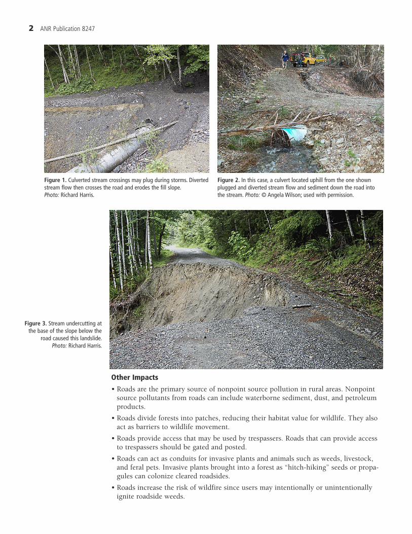
• Culverts can plug, causing fill washouts or gullies where the diverted stream flow runs down nearby roads and hillslopes (figs. 1 and 2).
• Landslides may be triggered by road construction on steep or unstable slopes (fig. 3). This can occur due to increasing the weight of soil on slopes through depositing road fills and pushing materials off the side of the road (side-casting), through under-mining by road cuts, or through interception of groundwater.
• Unstable road fills or landing side-cast material may fail, even many years after the road was constructed.
puBliCation 8247
uniVersity oF CaliFornia
Division of Agriculture and Natural Resources
http://anrcatalog.ucdavis.edu
objectiveUnderstand the planning, construc-tion, maintenance, and environmental impacts of forest roads.
Competencies• Evaluate the condition and suitability of existing
roads.
• Anticipate and plan for new roads.
• Know the types of roads and the uses they support.
• Understand the environmental impacts of roads on watersheds, streams, and other forest resources.
• Understand how to improve the condition, drain-age, and functioning of existing roads.
• Understand how to maintain roads to prevent their failure and to mitigate environmental impacts.
• Understand the legal issues associated with access and roads.
• Gain familiarity with the funding and implemen-tation of road improvements and maintenance.
related Forest stewardship series publications• Laws and Regulations Affecting Forests, Part I:
Timber Harvesting, ANR Publication 8249
• Forest Streams, ANR Publication 8239
• Forest Water Quality, ANR Publication 8241
� ANR Publication 8247
other impacts
• Roads are the primary source of nonpoint source pollution in rural areas. Nonpoint source pollutants from roads can include waterborne sediment, dust, and petroleum products.
• Roads divide forests into patches, reducing their habitat value for wildlife. They also act as barriers to wildlife movement.
• Roads provide access that may be used by trespassers. Roads that can provide access to trespassers should be gated and posted.
• Roads can act as conduits for invasive plants and animals such as weeds, livestock, and feral pets. Invasive plants brought into a forest as “hitch-hiking” seeds or propa-gules can colonize cleared roadsides.
• Roads increase the risk of wildfire since users may intentionally or unintentionally ignite roadside weeds.
Figure 3. Stream undercutting at the base of the slope below the
road caused this landslide. photo: Richard Harris.
Figure 1. Culverted stream crossings may plug during storms. Diverted stream flow then crosses the road and erodes the fill slope. photo: Richard Harris.
Figure 2. In this case, a culvert located uphill from the one shown plugged and diverted stream flow and sediment down the road into the stream. photo: © Angela Wilson; used with permission.

� ANR Publication 8247
As a general rule, landowners should try to keep the number, size, and extent of roads on their property to the minimum necessary to accommodate required uses.
types oF roadsThe type of road and its intended use determine many aspects of the road’s design, con-struction, and maintenance.
A permanent road is used year-round. Culverts in permanent roads should be sized to accommodate 100-year storm events plus associated sediment and debris. Road sur-faces in riparian zones or wet areas are usually rocked (fig. 4).
Seasonal roads are used for access only during the dry season. These roads are gener-ally not rocked in riparian or wet areas (fig. 5). If culverts are permanently placed, they should be sized to accommodate 100-year storm events plus sediment and debris. The use of seasonal roads in the winter should generally be limited to low-impact vehicles such as
ATVs, unless the ground is frozen.
Temporary roads are used only for a short time and for a designated purpose, such as tractor (or skid) trails used for skid-ding logs. Drainage structures large enough to handle the water flow should be built at watercourse crossings during the time of use. A temporary road should not be used in the winter unless the ground is frozen.
It is important to understand what kind of road you have and limit your use of it accordingly. For example, during the winter, avoid using a seasonal road that is near a watercourse or that is not rock-surfaced or paved, to avoid creating ruts and gullies that can transport sediment into a stream and are difficult to repair (fig. 6). If you want to use the road for year-round access, upgrade it to a permanent road.Figure 6. Driving on unsurfaced roads during rainy weather can create ruts and pot-
holes that are difficult to repair. photo: © Angela Wilson; used with permission.
Figure 4. This road has been surfaced with gravel to permit all-season use. Note armoring on stream crossing and dip in the road to prevent diversion of stream flow down the road if the culvert plugs. photo: Richard Harris.
Figure 5. Seasonal-use roads often develop a cover of grass and forbs. This is beneficial for preventing road surface erosion during the winter. photo: © J. Bawcom; used with permission.

� ANR Publication 8247
existing roadsExisting, or “legacy,” roads are roads that were on your property when you acquired it. Many legacy roads are significant sources of sediment, “bleeding” sediment into water-courses every year. Do not assume that a road does not need work simply because it has been on your property for many years.
Factors that influence the stability of a road and its erosive potential include where the road is placed, when and how it was constructed, how it has been maintained, and the type of soil in the area.
Over the years, ideas have changed about good road placement, construction, and maintenance. It was once commonplace, for example, to drain road surface water into inside ditches that were run downhill for long stretches before discharging through a culvert cross-drain. Today, a more successful strategy is to out-slope the road where pos-sible, continuously draining the road surface, and install cross-drains, such as water bars and rolling dips, where feasible. This minimizes reliance on culverts, which can plug with sediment or debris during a storm, leading to erosion and increased maintenance. (For more information and definition of terms, see the section “Drainage,” below.)
The location of a legacy road is very important. Some locations, such as extremely steep or very flat ground, have inherent drainage problems and need constant main-tenance. Likewise, certain soil types are particularly erosive, and even a well-designed road may need frequent maintenance.
Look for ways to improve your legacy roads to lower the maintenance required. If the road has severe, chronic problems, you might consider relocating key stretches. If you choose to abandon the road, try to ensure that problem areas will not continue to bleed sediment when the road is no longer used.
drainaGeIt is impossible to overemphasize the importance of road surface and stream-crossing drainage in main-taining stable roads and protecting water quality. The goal is to make the road as hydrologically invisible as possible by making use of the natural drainage pat-terns when designing the system by which water will be removed from the road surface. In general, this means getting the water off the road as quickly as possible. Make sure you adequately plan for both road surface drainage and hillslope drainage. Proper drain-age will mean less erosion and lower maintenance costs for you.
road surface drainageRoad surface drainage includes water that originates from the road surface or the cut slope above the road surface. There are two main techniques for drain-ing permanent or seasonal forest roads: they may be sloped towards the cut bank and drained by a ditch running at the base of the cut bank (in-sloped) or sloped towards the outside of the road (out-sloped) The ditches on in-sloped roads are drained under the road by cross-drain culverts, which are also called ditch relief culverts since they relieve the ditch of excessive flow. Out-sloped roads may simply drain
A
B
WRONG
RIGHT
Roll ing dips
Figure 7. A: A road surface that is not properly drained will con-centrate surface water runoff that will eventually erode the road bed. B: Out-sloping the road and installing rolling dips to drain runoff minimizes water concentration and erosion. source: Adapted from Weaver and Hagens 1994, p. 47.

� ANR Publication 8247
water diffusely over the slope below the road, or they may be drained by depressions in the road called rolling dips (fig. 7).
Out-sloped roads have a gentle slope (2–3%) from the inside to the outside edge of the road (fig. 8). This provides for immediate drainage off the road surface. Under appropriate conditions, out-sloped roads are entirely adequate and are the preferred design for low-volume forest roads. They are not suitable on excessively steep or unsta-ble terrain, in areas of high groundwater, or where the road is subject to black ice or otherwise treacherous driving conditions where out-sloping would move vehicles to the road’s edge on turns.
Most major county roads and highways are in-sloped roads. In-sloped roads gener-ally require a much higher level of maintenance than out-sloped roads. For example, the drainage ditches and cross-drain culverts must be kept clear of debris. Ditches are
prone to erosion in some soil types. Cut bank sloughing and road surface erosion can block ditches during storms, causing ditch water to overflow, run down the road, and cause erosion. Gullies may be created at the outlets of cross-drains (culverts). In some cases, in-sloped or even crowned roads with ditches on either side are necessary, but whenever possible, a landowner is well-advised to use out-sloping for road surface drainage (fig. 9).
Out-sloped roads commonly use rolling dips to function as cross-drains (fig. 10). Rolling dips are essentially gentle, gradual depressions in the road grade. They get their name from the grade of the road rolling down and back up again, forming the dip. They can be used as a type of ford to drain small streams or springs across the road (fig. 11). In the case of road surface
Out-sloped road
Ditch �lledRoad surface
Road �ll
Road cutOutslope 2-4%
Ditch openRoad surface
Road �ll
Cut slope
In-sloped road
Figure 8. Out-sloped and in-sloped road cross-sections. source: Adapted from Weaver and Hagens 1994, p. 47.
Figure 9. This ditch and road surface erosion was caused by inadequate spacing of ditch relief culverts. photo: Susie Kocher.
Figure 10. There is a gentle rolling dip in the middle of this picture of an out-sloped road. photo: Richard Harris.
Figure 11. This rolling dip has a gentle increase in grade going left to right and a reverse grade (where people are stand-ing) to direct water off the road at the dip. photo: Gary Nakamura.

� ANR Publication 8247
runoff, the water running down the road is caught in the dip and drained to the side. Rolling dips should be drivable by ordinary vehicles with low clearance.
Temporary and seasonal roads are commonly drained with water bars (fig. 12). These erosion control measures are also used on skid trails after completion of timber harvesting to prevent erosion. Water bars are a combination of a dip and a hump of soil, acting much like a speed bump with a ditch just before or after it. They are erosion con-trol measures, not intended for use on permanent roads or during wet weather.
The spacing of cross-drains and rolling dips is determined by the potential for soil erosion and the slope of the road (table 1). Either must be adequately sized to accom-modate runoff from the road surface and other sources, such as intercepted groundwater or springs.
Water bar spacing on temporary roads and skid trails is prescribed in the state Forest Practice Rules when associated with a timber harvest. For other temporary roads or trails, spacing is determined by the potential for soil erosion and the slope (table 2).
hillslope drainageHillslope drainage includes water from streams, gullies, or springs that cross the road. The three basic ways to carry water across roads are bridges, fords, and culverts. A num-ber of factors influence the type of structure you choose for a particular crossing. These include the size and flow regime of the source, the presence of fish, whether the crossing is permanent, the types of vehicles using the road, frequency of use, slope and stability of the channel, the cost of installation and maintenance, and legal requirements.
Figure 12. Water bars and straw mulch have been installed on this seasonal road prior to the onset of the rainy season. Water bars drain road surface runoff to prevent erosion. They will be removed when the road is put back in use. photo: © Angela Wilson; used with permission.
Table 1. Spacing recommendations for cross-drains and rolling dips on in-sloped and out-sloped roads
Road grade (%)Spacing at soil erosion potential (ft)
Low Moderate to high
0–3 400 250
4–6 300 160
7–9 250 130
10–12 200 115
12+ 160 100
source: Keller and Sherar 2003, p. 55.
Table 2. Spacing recommendations for water bars on temporary roads and trails
Grade (%)
Spacing at soil erosion potential (ft)
Low Moderate to high
0–5 250 130
6–10 200 100
11–15 150 65
16–20 115 50
21–30 100 40
30+ 50 30
source: Keller and Sherar 2003, p. 55.

� ANR Publication 8247
Bridges are a more expensive type of stream crossing than culverts or fords, though some portable bridges may be competitive in price with large culverts. Bridges are the best choice for large watercourses. Stream channels that are deeply incised with steep side slopes may require extensive preparatory work before a bridge can be installed. It is critical to adequately engineer bridges used for any vehicular traffic. Bridges may be temporary or permanent. Railroad flatcars are commonly used as bridge decks in both permanent and temporary road situations, as they can easily be hauled on lowboy trailers and moved from site to site.
Fords may be wet or dry. Wet fords cross running streams; they work well on small or medium-sized streams if the stream bottom is stable (rocks or coarse gravel) and traffic is light (fig. 13). Heavy traffic tends to disturb and pulverize the stream bot-
tom, causing turbidity and sedimentation. Dry fords are less problematic but should still have a stable stream bottom. If construction work is required to establish the ford (for example, paving with concrete), wait until water is not flowing to do such work (fig. 14). Fords, particularly unimproved ones, are vulnerable to erosion. Fords should be armored with rock or a layer of coarse gravel. Do not construct unimproved fords in which the stream channel is filled with a substantial amount of soil and left without a protective layer of rock or surfacing.
Culverts are corrugated metal or plastic pipes used at stream crossings. They must be properly sized (in diameter), based on the expected life of the culvert, local topogra-phy, local rainfall intensity, and other factors. Culvert sizing should be done by a qualified professional such as a registered professional
Figure 14. Concrete ford on bedrock outcrop in perennial stream. photo: © Angela Wilson; used with permission.
Figure 13. Wet ford stream crossing. These are sometimes
called “Arizona crossings.” photo: Richard Harris.

� ANR Publication 8247
forester or engineer. In general, all culverts should be sized to pass the anticipated 100-year storm runoff plus associated debris and sediment.
Culverts must be installed at the correct angle (which affects culvert length and therefore cost), allowing for fish passage if fish are present (fig. 15). Debris control structures (trash racks) at culvert inlets and energy dissipaters (such as rocks) at culvert outlets are two key components of good culvert design (fig. 16). Plastic may be easier to work with and cheaper initially but it can burn in a fire, collapsing the road fill above it and requiring expensive reinstallation.
Install failsafe culverts. All culverts fail eventually, so you should install the culvert so that when it does fail, it does not divert the stream channel and cause erosion on the road surface or the road fill. This usually involves creating a critical dip at the crossing. A critical dip is a high point on each approach that is sufficient to contain the stream flow if the culvert plugs or fails and to keep the stream in the natural channel rather than flowing down the road (fig. 17).
Figure 15. This box culvert will not permit fish passage because it is too high above the stream (excessive jump height for migrating fish) and the outlet velocity is too high (exceeds swimming ability of migrating fish). Any new culvert on a stream that supports fish must allow passage; many deficient culverts are being replaced. photo: Richard Harris.
Figure 16. Rock has been installed at the outlet of this newly installed cross drain to prevent slope erosion or gullying. photo: Richard Harris.
Figure 17. The proper instal-lation of culverts and a critical
dip at a stream crossing. If culvert B plugs, the stream will
overflow road at low point C, washing out the road there but
flowing back into the natural stream course rather than
down the road to point D and beyond. source: Weaver and
Hagens 1994, p. 62; used with permission.
AB C
D

� ANR Publication 8247
ConstruCtion and reConstruCtion
General principlesWhether laying out a new road or working on an existing one, keep these general prin-ciples in mind. Minimize• the total number of roads in your watershed; build only what is necessary to achieve
your goals• new road construction by using existing roads• watercourse crossings• cuts, fills, and the clearing of vegetation• road work near watercourses, unstable areas, and steep slopes• road width• road gradient• concentration of runoff on and from roads
Avoid earthmoving activities in the winter; do this work in the summer when stream flows are at their lowest level.
Washed-out stream CrossingsWashed-out stream crossings are one of the most common problems of older roads. A crossing structure, usually a culvert, is washed out when its capacity to pass stream flow is exceeded during a peak runoff event and the flow erodes the fill and road surface (fig. 18). The structure may be completely uprooted and transported downstream or tossed to the side of the road. As mentioned above, all culverts may eventually fail, but preventative measures can be taken to minimize the risk of road and stream damage. Those measures include adequately sizing the culvert and maintaining culverts free of blockages by debris and sediment (fig. 19).
maintenanCe
inspection and maintenance schedulesRoads and their drainage structures should be inspected at least once each year before the rainy season begins. Some structures are more likely to have problems than others.
Figure 18. This culvert plugged with debris during a storm. Although it is still in place, the swirling water and debris caused extensive erosion of the road and the adjacent old log landing. This type of failure is common on older “legacy” roads where crossings were not adequately designed to pass 100-year flows plus debris and sediment. In many cases, the culvert will be displaced and transported downstream. photo: Richard Harris.
Figure 19. This reconstructed stream crossing on an all-season road used for hauling timber illustrates many desired design features. The culvert is sized to accommodate 100-year storm flows plus debris and sediment. It is located at the base of the road fill at the elevation of the channel to prevent scour. The face of the crossing fill is armored with rock. The road has a critical dip to prevent diversion and is surfaced with gravel. photo: Richard Harris.
10 ANR Publication 8247
While you should inspect all your drainage structures, it helps to know where you will need to make an extra effort or where upgrades will be most effective. Consider keeping a journal to record your road maintenance activities. This can help you identify chronic problems.
What to do—and What not to do
Road Use
The first rule of maintaining a stable road surface is to minimize use during wet weather. For permanent roads, this means avoid wet weather grading and use by heavy vehicles such as log trucks. On seasonal roads, any intense vehicular activity should be limited to dry periods. Seasonal, unsurfaced roads can be badly damaged by even occa-sional use during wet periods when the roadbed is soft. These road surfaces can be dam-aged almost as easily by a pickup as by a log truck. If unauthorized winter use is likely, seasonal roads should be gated during wet weather.
If vehicular traffic on a seasonal road is intense in the dry period, employ dust control and watering to prevent air pollution and the development of a deep, unconsoli-dated road surface. Standing water or ruts on permanent or seasonal roads indicate that the road surface is deteriorating.
Grading
On any road, grade only when necessary and only when material is slightly damp. Excessive grading causes erosion and increases road surface rock wear. Grading when road surfaces are dry promotes erosion. On out-sloped roads, make sure the grading does not build up berms at the roadsides that block drainage.
Some counties require grading permits. Check with your county planning and public works departments to find out whether your county has a grading ordinance and the threshold of earth movement that requires a permit.
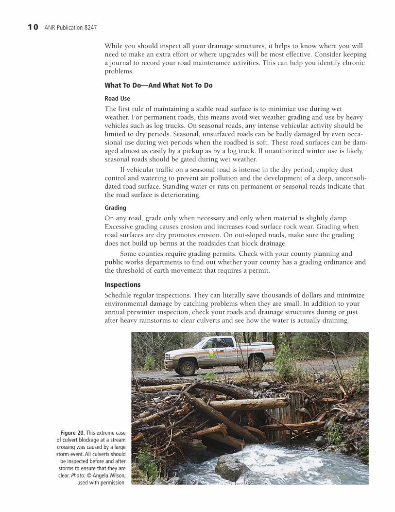
inspectionsSchedule regular inspections. They can literally save thousands of dollars and minimize environmental damage by catching problems when they are small. In addition to your annual prewinter inspection, check your roads and drainage structures during or just after heavy rainstorms to clear culverts and see how the water is actually draining.
Figure 20. This extreme case of culvert blockage at a stream crossing was caused by a large storm event. All culverts should
be inspected before and after storms to ensure that they are clear. photo: © Angela Wilson;
used with permission.

11 ANR Publication 8247
What to look for
•Culverts:Problemswithculvertsmustbecorrectedbeforecompletefailureoccurs(fig.20).Almostallculvertmaintenancecanbedonebyhandorwithashovelandachainsaw.Inspectinletsandlookdownthepipe.Cleardebrisandsedimentthatcanblocktheflowofwater.Inspectoutlets.Straightenculvertendsthathavebeenbent.Notelocationswherethereiserosionattheoutlet.Attheculvertoutlet,youmaywanttoinstallenergydissipaters,vegetation,orlargerockthatwillnoterodewiththeexpectedflow.
•Fords:Lookforsignsoferosionwhereadditionalrockmaybeneeded.Waituntillow-flowconditionstomaketherepairs.
•Bridges:Lookforbridgeabutmentsthatneedrepair.Removeorfloatdownstreamanydebrissuchaslogsorbranchesthatarelodgedinthebridgestructure.Haulsoilordebrisawayfromthebridge—donotdumpitintothewatercourse.
•Waterbars:Makesurewaterbarsareintactandworkingproperly.Checktoseethatwatercaughtbythewaterbarisabletofreelydrainoffthesideoftheroad.
•Rollingdips:Checktheoutsideedgeofthedip.Ifthereiserosionatthelipofthedip,plantoarmorthelipwithrockorbagsofcement.Makesuregradinghasnotcreatedanoutboardberm.
•Insideditches:Clearvegetationorrocksthatcanblocktheflowofwater.Oftenthiscanbedonewithashovel.Strictlylimitgradingofditches,asunnecessarygradingcauseserosion,underminesbanks,andexposesthebottomofthecutslopetoerosion.
•Cutslopesandfill:Lookforrilling,slumping,andcracksonthesurfaceoredgeoftheroad(fig.21).Itmaybenecessarytoplacealoadofrockatthetoeofacutbankslump,installadditionaldrainagestructures,orremoveunstablematerialswithanexcavator.
Figure 21. Cracks appearing in the road surface, especially at the edges of fills, are a sure sign of an impending failure or landslide. The horsetail growing in these cracks indicates that the source of the problem is groundwater seeping through the road bed. Photo: Richard Harris.

1� ANR Publication 8247
Winterize your roadsAll roads—permanent, seasonal, and temporary—should be inspected and prepared for the rainy period. Winterizing consists of maintenance and erosion control needed to drain the road surface, ensure free-flowing ditches and drains, and open all culverts to their maximum capacity. Follow the inspection guidelines above. Once your roads have been winterized, gate and close those not needed for winter access.
spoil disposalSpoil is soil and organic debris that is not used or needed as part of a road or landing. Spoil material is generated during road construction, reconstruction, and maintenance. Some spoil material can be spread out over the road, but too much will cause muddy conditions after the rains begin. Spoil material should never be side-cast near streams. Haul it to a stable site away from streams, and if possible stabilize it with mulch and vegetation.
soCial and leGal issues
access and easementsAn easement grants a legal right for another person to use specific land for a specific purpose. There are several types of easements. An easement is a property right, and ide-ally it will be deeded, or recorded in the deed, for the property.
If your property is located on a private road that passes through the property of another, you should have an easement that guarantees you the right to use the road in order to access your property. Several people can hold easements for the same road. Typically, everyone who shares the road contributes to road maintenance costs, but such an agreement is not part of the easement itself.
Some easements may not be recorded in the property deed. The most common type of unrecorded easement is a prescriptive easement. In California, if someone openly uses your road to access their property for 5 years with or without your permis-sion, they can often get a prescriptive easement that will give them permanent use of your road. Gating and posting the road can prevent such an easement and give you the opportunity to come to some other agreement about road use and maintenance.
Another type of unrecorded easement is an easement by necessity. This applies when one parcel is landlocked by another. Whether a landlocked parcel has an easement by necessity depends on the intentions of the parties involved. It is not automatic; if there is a dispute, consult a lawyer who specializes in easement law.
If a property owner does not have an easement but wishes to use the road of another landowner, an agreement can be made. Often such agreements are made when one landowner wants to haul forest products, such as logs, over the property of a neigh-bor. Typically an amount, such as $10 per thousand board feet of lumber to be hauled, is agreed upon between the parties involved.
road associations and road maintenance agreementsIn many areas, groups of landowners form road associations to pay for maintenance of a road they share. As a member, you usually pay either a yearly amount or a portion of the bill for repairs as they are made. Groups vary in size and scale of activity. Check with your neighbors or a realtor for information about your local road association.
You might enter into a written road maintenance agreement as part of a formal or informal road association. Make sure that the terms of noncompliance are clearly spelled out.

1� ANR Publication 8247
protecting yourselfYou can protect against prescriptive easements and trespass in a number of ways.
• Post signs that read “Posted” or “No Trespassing.”
• Post a sign or make a written agreement that grants permission for another to use the road in a limited, clearly defined way.
• Block entry to trespassers by putting up a locked gate, especially to restrict wet weath-er use.
• Visit your property to make sure signs are still up, gates are intact, and there are no obvious signs of trespass.
• Offer to rent the property to a trespasser.
• As a last resort, call the police, hire a lawyer, or both.
streambed alteration agreementsA landowner is required to contact the California Department of Fish and Game before performing any activity that would result in the diversion or obstruction of natural stream flow or the physical modification of the bed or banks of a stream or lake. A Streambed Alteration Agreement, required under the Fish and Game Code (§ 1600 et seq.), is often referred to as a “1603 permit.” This covers projects such as installing cul-verts, bridges, fords, or rip-rap, or skidding logs across temporary crossings.
FundinG sourCes For roadWorkWhile most roadwork must be paid for by the landowner or road association, cost-share programs can help with these costs. These programs will pay a portion of the costs, if the work is done in accordance with the goals of the program. For roadwork to qualify for most cost-share programs, you must demonstrate how the roadwork will reduce the amount of sediment that will be transported into watercourses.
Contact local offices of the California Department of Forestry and Fire Protection, California Department of Fish and Game, and the Natural Resources Conservation Service to find out about cost-share programs and application procedures. These agen-cies can also assist you with diagnosing and solving road management problems.
reFerenCesKeller, G., and J. Sherar. 2003. Low-volume roads engineering: Best management
practices field guide. USDA Forest Service Conservation Management Institute. See the US Department of Transportation National Transportation Library Web site, http://ntlsearch.bts.gov/tris/record/ntl/24650.html.
Weaver, W., and D. Hagens. 1994. Handbook for forest and ranch roads. Ukiah, CA: Mendocino Resource Conservation District.
enGlish–metriC ConVersions
EnglishConversion factor for
English to MetricConversion factor for
Metric to English Metric
inch (in) 2.54 0.394 centimeter (cm)
foot (ft) 0.3048 3.28 meter (m)
yard (yd) 0.914 1.09 meter (m)
mile (mi) 1.61 0.62 kilometer (km)
1� ANR Publication 8247
For Further inFormationTo order or obtain printed ANR publications and other products, visit the ANR Communication Services online catalog at http://anrcatalog.ucdavis.edu. You can also place orders by mail, phone, or FAX, or request a printed catalog of our products from:
University of California Agriculture and Natural Resources Communication Services 6701 San Pablo Avenue, 2nd Floor Oakland, California 94608-1239Telephone: (800) 994-8849 or (510) 642-2431FAX: (510) 643-5470
E-mail inquiries: [email protected]
An electronic version of this publication is available on the ANR Communication Services Web site at http://anrcatalog.ucdavis.edu.
Publication 8247
ISBN-13: 978-1-60107-467-6
© 2007 by the Regents of the University of California, Division of Agriculture and Natural Resources. All rights reserved.
The University of California prohibits discrimination or harassment of any person on the basis of race, color, national origin, religion, sex, gender identity, pregnancy (including childbirth, and medical conditions related to pregnancy or childbirth), physical or mental disability, medical con-dition (cancer-related or genetic characteristics), ancestry, marital status, age, sexual orientation, citizenship, or status as a covered veteran (covered veterans are special disabled veterans, recently separated veterans, Vietnam era veterans, or any other veterans who served on active duty during a war or in a campaign or expedition for which a campaign badge has been authorized) in any of its programs or activities. University policy is intended to be consistent with the provisions of appli-cable State and Federal laws.
Inquiries regarding the University’s nondiscrimination policies may be directed to the Affirmative Action/Staff Personnel Services Director, University of California, Agriculture and Natural Resources, 300 Lakeside Drive, 6th Floor, Oakland, CA 94612-3550 (510) 987-0096. For a free catalog of other publications, call (800) 994-8849. For help downloading this publication, call (530) 297-4445.
This publication has been anonymously peer reviewed for technical accuracy by University of California scientists and other qualified professionals. This review process was managed by the ANR Associate Editor for Natural Resources.
pr-12/07-SB/CM