forestation, aesthetic plantation and landscaping for karachi
TRANSCRIPT

Forestation, Aesthetic Plantation
and Landscaping For Karachi
FINAL REPORT


Forestation, Aesthetic Plantation & Landscaping Study-Karachi Comprehensive Plan
Tahir Traders-Landscape Consultants, Karachi i
TABLE OF CONTENTS Acknowledgement………………………………………………………………………………ix Executive Summary………………………………………………………………………….. xi Chapter I……………………………………………………………………………………1
1.0 Introduction………………………………………………………………………………1 1.1 Background ……………………………………………………………………………1 1.2 Historical context of Karachi……………………………………………….…………1 1.3 Geographical context of Karachi…………………………………………..…………2 1.4 Population and demographic analysis……………………………………..………2 1.5 Ecological footprint analysis……………………………………………..……………2 1.6 Environmental context of Karachi………………………………………..……………3 1.7 Past Master Planning and Landscaping …………………………….……………3 1.8 Opportunities and Challenges for Comprehensive Plan…………….……………4
Chapter II………………………………………………………………………………………5
2. Goals and Basis of Comprehensive Plan………………………………………………..5 2.1 Goals of Comprehensive Plan……………………………………………………………5 2.2 Forestation and Landscaping……………………………………………………….……6 2.3 Implementation of Goals……………………………………………………………….…6 2.4 Basis of Comprehensive Plan…………………………………………………………..6 2.4.1 Background Studies…………………………………………………………………....6
Chapter III………………………………………………………………………………………11
3. Assessment of Target Areas………………………….……………………………………11 3.1 Total vegetation Cover in Karachi……………………….………………………………11 3.2 CDGK’S Entry Points………………………………………………………………15 3.3 Karachi Northern Bye-Pass……………………………………………………..16 3.4 Link Roads …………………………………………………………………………16 3.5 Urban Roads and Arteries of Karachi ……………………………….……………17 3.6 Defense Housing Authority roads ………………………………………………………22 3.7 Soil Quality of target areas………………………………………………………………24 3.8 Water Quality and Suitability……………………………………………………………27 3.9 Rivers……….………………………………………………………………………………29 3.9.1 Malir River ………………………………………………………………………………29 3.9.2 Lyari River………………………………………………………………………………31 3.10 Coastal belt of Karachi outside mangrove areas ……………………………………32 3.11 Streets, roundabouts and greenbelts … ………………………………………………35 3.12 Farmlands…………………………………………………………………………………37 3.13 Establishment of Mini Forests…………………………………………………………38 3.13.1 Assessment of Mini Forests…………………………………………………………38 3.13.2 Concept of Mini Forests ………………………………………………………………38 3.13.3 Importance of Forests/ Mini Forests…………………………………………………39 3.13.4 Potential for Establishment of Mini Forests in Karachi……………………………39 3.14 Micro irrigation system …………….……………………………………………………40 3.14.1 Why Micro Irrigation Design is Important……………………………………………40 3.14.2 Advantages of Modified Hose fed Irrigation System………………………………40 3.14.3 Comparison between Hose fed and Drip Irrigation Systems………………………41 3.14.4 Modified Hose-Fed Fertigation System………………………………………………41

Forestation, Aesthetic Plantation & Landscaping Study-Karachi Comprehensive Plan
Tahir Traders-Landscape Consultants, Karachi ii
Chapter IV………………………………………………………………………………………43
4. Concept Designs of Target Areas ………………………………………………………43 4.1 General Guidelines for Designing of Roads/Avenues …………………………………43 4.1.1 Balanced Line System …………………………………………………………………43 4.1.2 Unbalanced Line System ………………………………………………………………43 4.1.3 Sporadic System ………………………………………………………………………43 4.1.4 The Park way System …………………………………………………………………43 4.2 Purpose and objectives of forestation along highways ………………………………44 4.3 General Plantation Pattern ………………………………………………………………44 4.4 Guidelines for Plantations along Highways………………………..……………………45 4.5 Concept designs and choice of species for highways and roads ……………………46 4.5.1 Super Highway (M-9)…………………………………………………………………46 4.5.2 National Highway (N-5)………………………………………………………………50 4.5.3 RCD Highway (N-25)……………………………………………………………………52 4.5.4 Establishment of Tree Groves ………………………………………………………53 4.5.5 Karachi Northern Bye- Pass ………………………………………………………53 4.5.6 Link Roads …………………………………………………………………………….55 4.6 Main Roads and arteries of city …………………………………………………………65 4.6.1 Objectives of Forestation of Urban Roads ……………………………………………65 4.6.2 Assessment of Urban roads ……………………………………………………………65 4.6.3 Present status of Urban Plantation……………………………………………………65 4.6.4 Proposed Planting Methodology………………………………………………………66 4.6.5 Guiding principles of Concept designs………………………………………………66 4.6.6 General guidelines for concept designs………………………………………………67 4.6.7 Classification of Urban Roads …………………………………………………………68 4.6.8 Concept Design of Major Roads and Arteries:………………………………………72 4.6.9 Concept designs of Corridors…………………………………………………………..89 4.6.10 Concept designs of Major Roads ……………………………….............…………103 4.6.11 Per Unit Cost of Urban roads………………………………………………………..113 4.6.12 Rivers ………………………………………………………………………………… 117 4.6.12.1 Malir River…………………………………………………………………………117 4.6.12.2 Lyari River …………………………………………………………………………122 4.6.13 Farmlands ……………………………………………………………………………128 4.6.13.1 Social Forestry in urban agriculture areas ……………………………………128 4.6.13.2 Social Forestry technologies for Urban Build Up Areas……………………135 4.6.13.3 Social Forestry Models and their technical features ………………137 4.6.13.4 Establishment of demonstration areas/plots ……………………………139 4.6.13.5 Awareness Campaign for Social Forestry ………………………………139 4.6.13.6 Incentives for social/participatory Forestry…………...……………………… 143 4.6.13.7 Capacity building of target groups ………………………………………………144 4.6.13.8 Training Module for Social Forestry/Participatory Forestry ……………………146 4.6.14 Mini forests ……………………………………………………………………………148 4.6.14.1 Objectives of Mini Forests ………………………………………………………148 4.6.14.2 Probable Locations of Mini Forests ………………………………………………148 4.6.14.3 Concept Designs of Mini Forests ………………………………………………149 4.6.14.4 Technique of Establishment of Mini Forest ……………………………………150 4.6.14.5 Proposed potential area for establishment of Mini Forests……………………153 4.6.15 Coastal belt outside mangrove area ………………………………………………154 4.6.15.1 Purpose and Objectives of Forestation and landscaping on coastal roads …154 4.6.15.2 Concept Designs …………………………………………………………………155 4.6.15.3 Proposals of water supply ………………………………………………………156

Forestation, Aesthetic Plantation & Landscaping Study-Karachi Comprehensive Plan
Tahir Traders-Landscape Consultants, Karachi iii
4.6.15.4 Proposals for Development of Recreation Areas ………………………………156 4.6.16 Streets, Roundabouts and Greenbelts …………………………………………157 4.6.16.1 Streets ……………………………………………………………………………158 4.6.16.2 Roundabouts ………………………………………………………………………159 4.6.16.3 Greenbelts…………………………………………………………………………172 4.6.17 Maintenance of trees…………………………………………………………………182 4.6.18 Establishment of Nursery …………………………………………………………183 4.6.19 Concept designs on Micro Irrigation Techniques ………………………………184 4.6.19.1 Objectives …………………………………………………………………………186 4.6.19.2 Micro Irrigation Systems Technology …………………………………………186 4.6.19.3 Irrigation Scheduling ……………………………………………………………186 4.6.19.4 Crop Water Requirements ……………………………………………………186 4.6.19.5 Irrigation Water Quality Criteria ………………………………………………188 4.6.19.6 Comparisons of various Micro Irrigation Systems and their Components .188 4.6.19.7 System Layout and Components of Drip Irrigation…………………………189 4.6.19.8 Low-Cost Modified Hose-fed Irrigation System ………………………190 4.6.19.9 System Layout and Components of Hose fed system …………………….…190 Chapter V …………………………………………………………………………………… 211
5. Physical and Financial Targets and Impact of Comprehensive Plan ……………211 5.1 Physical Targets ………………………………………………………………………211 5.2. Utilization of Container Plants and estimated achievement of targets …………212 5.3. Projected Targets of KSMP, 2020 …………………………………………………213 5.4. Micro Irrigation …………………………………………………………………………213 5.5 Overall Targets of Comprehensive Plan ……………………………………………214 5.6 Estimated Financial Financial allocation of Comprehensive Plan …………………215 5.7. Impact of Comprehensive Plan ………………………………………………………217 5.8. Agencies and groups influencing urban Tree management in Karachi……….220 5.9. Other potential organizations/Departments ……………………………………220 5.10. Non Government Organizations ……………………………………………………220 5.11. Phasing of Physical and Financial targets …………………………………………221
Chapter VI ……………………………………………………………………………………225
6. Approaches/strategies for execution of Plan …………………………………………225 6.1: Coordination……………………………………………………………………………225 6.2: Participation ……………………………………………………………………………225 6.3: Team work ………………………………………………………………………………225 6.4: Political will ……………………………………………………………………………225 6.5: Vision-driven planning …………………………………………………………………226 6.6: Community involvement ………………………………………………………………226 6.7: The Green Movement …………………………………………………………………226 6.8: Allocation of budget for Tree Plantation in Infrastructure Projects…………………226 6.9: Partnerships ……………………………………………………………………………226 6.10: Transparency …………………………………………………………………………227 6.11: Environmental stewardship …………………………………………………………227 6.12: Recommended Administrative set up for execution of Plan ……………………227 6.13: Legislationn for Trees and Parks……………………………. ……………………228 6.14: Alleniation of Comprehensive Plan with KSDP and Sindh Vision 2030. ………228 6.15: Allocation of Land for Forestation ……………………………. ……………………228 6.16: Public Private Partnership………….…………………………. ……………………228 6.17: Preservattions of Heritage Trees….…………………………. ……………………229 6.18: Tree Plantation on Pathways……….…………………………. ……………………229
Forestation, Aesthetic Plantation & Landscaping Study-Karachi Comprehensive Plan
Tahir Traders-Landscape Consultants, Karachi iv
Chapter VII …………………………………………………………………………………231
7. Monitoring and Evaluation Plan of Comprehensive Plan ……………………………231 7.1: Monitoring and Evaluation (M & E) System using Satellite Facility ………………231 7.2: Methodology for conducting Vegetative Cover Assessment ……………………233 7.3: Process Diagram ………………………………………………………………………233 7.4: Geodatabase Layers ……………………………………………………….…………235 7.5: Outcomes of M & E ………………………………………………………….…………235 7.6: Future Monitoring Strategy ……………………………………………….…………236 7.7: Future Field Survey Data……………………………………………………………237 7.8: Consultant Monitoring Tasks ………………………………………………………237 7.9: Facilities and staff required for M & E ……………………………………………238 7.10: Monitoring and Evaluation System using Third Party Facility …………………238
Chapter VIII …………………………………………………………………………………241
8. Recommendations on Public Private Partnership Methods…………………………241 8.1: Introduction………………………………………………………………………241 8.2: Concept of PPP………………………………………………………………………241 8.3: Process of PPP in Natural Resources…………………………………………………242 8.4: Avenues of PPP in Karachi ……………………………………………………………243 8.5: Identification of agencies for PPP……………………………………………………244 8.6: Responsibilities/Mechanisms for PPP ………………………………………………245 8.7: Essentials of PPP Models ………………………………………………………245 8.8: Mobilization of Private sector for PPP…………………………………………………247 8.9: Conclusions………………………………………………………………………247

Forestation, Aesthetic Plantation & Landscaping Study-Karachi Comprehensive Plan
Tahir Traders-Landscape Consultants, Karachi v
LIST OF TABLES Table 1: Town-wise area and vegetation cover in Karachi…….…………………………11
Table 2: Spatial details and potential length of Highways………………………………15
Table 3: Spatial details and potential length of KNBP……………………………………..16
Table 4: Spatial details and potential length of Link Roads……………………………17
Table 5: Spatial Details, Potential Length and Partial Potential Sides of Main Roads… 23
Table 6: Per Unit Cost estimates of Highways and Link Roads…………………………. 60
Table 7: Per Unit cost of Urban Roads…………………………………………………….113
Table 8: Cost Estimates of Roundabouts………………………………………………169
Table.9. Actual crop evapo-transpiration ETO (mm/day) for forest and fruit orchards in Karachi/ Hyderabad ……………………………………………………………………… 186
Table: 10. Crop Co-efficient (Kc) Values for some plants………………………………186
Table: 11. Principle Ions Present in Irrigation Water ……………………………………187
Table: 12 Water Classifications by Salinity ………………………………………………187
Table: 13. Plantation Targets …………………………………………………………209
Table: 14. Projected Targets of KSMP, 2020 ……………………………………………211
Table: 15. Micro-Irrigation Systems ………………………………………………………211
Table: 16. Estimated Financial Allocations of Comprehensive Plan …………………213
Table: 17. Site wise canopy coverage of Comprehensive Plan ………………………216
Table .18 Phasing of Physical Targets of Comprehensive Plan ………………………220
Table: 19. Financial Phasing of Comprehensive Plan …………………………………221
Table.20: Types of Satellite Imageries for Vegetative Cover Analysis …….…………235

Forestation, Aesthetic Plantation & Landscaping Study-Karachi Comprehensive Plan
Tahir Traders-Landscape Consultants, Karachi vi
LIST OF FIGURES Fig. 1: Showing overall vegetation cover of Karachi………………………………………..12 Fig. 2: Showing town wise vegetation cover………………………………………………12 Fig. 3: Showing CDGK Base Map……………………………………………………………13 Fig. 4: Showing Town wise vegetation cover of Karachi ………………………………….14 Fig. 5: Soil sampling Sites in CDGK…………………………………………………………26 Fig. 6: Water sampling Sites in CDGK………………………………………………………27 Fig. 7: Water Quality and Suitability in CDGK………………………………………………28 Fig. 8: Status of Roundabouts of Karachi………………………………………………….36 Fig. 9: Showing Urban agriculture and Urban Build up area………………………………38 Fig.10: Concept design and pattern of Plantation along Super Highway (M-9)………47 Fig.11: Concept design and pattern of Plantation along Nationl Highway (N-5)………51 Fig.12: Concept design and pattern of Plantation along RCD Highway (N-25) …………52 Fig.13: Concept design and pattern of Plantation along KNBP…………………………55 Fig.14: Concept design and pattern of Plantation along Link road (NHW-SHW)………56 Fig.15: Concept design and pattern of Plantation along Link Roads …………………57 Fig.16: Concept design and pattern of Plantation along Link road in City area………59 Fig.17: Concept design and pattern of Plantation along Sabzi Mandi road……………60 Fig.18: Concept Design and Pattern of Plantation along Urban roads…………………84 Fig.19: Concept Design and Pattern of Plantation along Urban roads ……………89 Fig20: Concept Design and Pattern of Plantation along Urban roads 103 Fig.21: Concept Design and Pattern of Plantation along Urban roads ……………109 Fig.22: Spatial Details of Malir River ……………………………………………………121 Fig.23: Spatial Details of Lyari River ……………………………………………………123 Fig.24: Concept design of Single Row Windbreak ………………………………………130 Fig.25: Concept design Two Row Windbreak ……………………………………………130 Fig.26: Concept design of Three Row Windbreak ……………………………………131 Fig.27: Concept design of Border Plantation …………………………………………131 Fig.28: Concept design of Block Plantation ………………………………………………132 Fig.29: Concept design of Scattered Tree Plantation ……………………………………133 Fig.30: Concept design of Drip Irrigation System. ………………………………………150 Fig.31: Concept design of Hose-fed Irrigation System and Pattern of Trees in Mini Forest………………………………………………………………………………………….151 Fig.32: Concept design of roundabout located at sea view ……………………………159 Fig.33: Concept design of roundabout located near Quaid-e-Azam Moslem ………160 Fig.34: Concept design of Shan roundabout Korangi Industrial Area …………161 Fig.35: Concept design of Vita roundabout Korangi Industrial Area …………162 Fig.36: Concept design of Bilal roundabout Korangi Industrial Area …………163 Fig.37: Concept design of Singer roundabout Korangi Industrial Area …………164 Fig.38: Concept design of Murtaza roundabout Korangi Industrial Area …………165 Fig.39: Standard concept design of roundabout having 50’ radius …………………166 Fig.40: Standard concept design of roundabout having 100’ radius …………………167 Fig.41: Standard concept design of roundabout having 150’ radius……………………168 Fig.42: Micro-Irrigation System Design………………………………………………191 Fig.43: Micro-Irrigation System Design……………………………………………………..192 Fig.44: Micro-Irrigation System Design……………………………………………………..193 Fig.45: Micro-Irrigation System Design……………………………………………………..194 Fig.46: Micro-Irrigation System Design……………………………………………………..195 Fig.47: Micro-Irrigation System Design……………………………………………………..196 Fig.48: Micro-Irrigation System Design……………………………………………………..197 Fig.49: Micro-Irrigation System Design……………………………………………………..198 Fig.50: Micro-Irrigation System Design……………………………………………………..199

Forestation, Aesthetic Plantation & Landscaping Study-Karachi Comprehensive Plan
Tahir Traders-Landscape Consultants, Karachi vii
Fig.51: Micro-Irrigation System Design……………………………………………………..200 Fig.52: Micro-Irrigation System Design……………………………………………………..201 Fig.53: Micro-Irrigation System Design……………………………………………………..202 Fig.54: Micro-Irrigation System Design……………………………………………………..203 Fig.55: Micro-Irrigation System Design……………………………………………………..204 Fig.56: Micro-Irrigation System Design……………………………………………………..205 Fig.57: Micro-Irrigation System Design……………………………………………………..206 Fig.58: Micro-Irrigation System Design……………………………………………………..207 Fig.59: Micro-Irrigation System Design……………………………………………………..208
LIST OF ANNEXURES
Annexure-I: Tree Plantation Policy for Highways and Motorways……………………..247
Annexure-II: Draft Trees & Parks Act for Karachi ………………………………………..251 Annexure-III: List of important species………….………………………………………..266
Annexure-IV: List of Trees Recommended For Comprehensive Plan…………………272
Annexure-V: List of Abbreviations used in Comprehensive Plan……………………281
Annexure-VI: List of Background Reports and Deliverables ……………………283
Annexure-VII: List of People consulted during the study………………………………284
Bibliography …………………………………………………………………………………286

Forestation, Aesthetic Plantation & Landscaping Study-Karachi Comprehensive Plan
Tahir Traders-Landscape Consultants, Karachi viii

Forestation, Aesthetic Plantation & Landscaping Study-Karachi Comprehensive Plan
Tahir Traders-Landscape Consultants, Karachi ix
Acknowledgement
Comprehensive Plan on Forestation, Aesthetic Plantation and Landscaping for Karachi is outcome of the vision of Syed Mustafa Kamal, Nazim City District Government Karachi to improve the green cover of the Megapolis for healthier environment for the citizens of Karachi. This Plan has been prepared in line with Karachi Strategic Development Plan 2020 against the backdrop of environmental degaradation, increasing pollution, existing inadequate vegetative cover and planting potential in green belts, along roads, rivers, highways, link roads, agricultural fields, blank lands, roundabouts and streets. This timely initiative is an effort to combat the increasing “Heat Islands” to make the Mega City environment human-friendly. I am grateful to Syed Ali Mumtaz Zaidi, Project Director, Karachi Mega City Sustainable Development Project, Mr. Roshan Ali Sheikh and Mr. Khaquan Murtaza, Project Coordinators of Local Suport Unit, their Officers and Staff for their continued support, cooperation and guidance during the study. Thanks are also due to all the Officers of CDGK particulary, Mr. Liaqat Ali Khan, Executive Director Horticulture and Parks, Managing Director, Mass Transit Authority, Executive District Officers of Works and Services, Executive Engineer Public Health Engineering, Karachi and Drainage Division, Thatta. The information provided by General Manager National Highway Authority and his Directores regarding their future expansion plans is also acknowledged. Special thanks are due to Mr. Saeed Ahmed Pirani, District Officer Forests and his team for their coordination, cooperation and support in conductiong several backgraound Studies and critical comments in finalizing the Comprehensive Plan. Accomplishment of the Study and Comprehensive Plan is the result of the professional vision, an efficient working of my Experts’ Team comprising of Dr. Lekhraj Kella, Dr. Inayatullah Rajpur, Muhammad Amin Khaskheli, Mehboob Ali Bhatti, Engineer Mohammad Aslam, A. F. Babar Sani, Misbah-u-ddin Jamili and Nadeem Mirbabar. Their valuable contribution and expertise in their respective fields is higly regarded. I also record my debt to Mr. Tahir Pervaiz for his overarching support and assistance in completion of this work. Finally, the untiring efforts and contribution of the support staff namely M/S Ghulam Sarwar Keerio, Abdul Hafiz Memon, Imran Ali and Manzoor Hussain Mirbahar is also appreciated in accomplishment of this plan Dr. G. R. Keerio Team Leader/International Forestation Expert Karachi dated, 30th October, 2008

Forestation, Aesthetic Plantation & Landscaping Study-Karachi Comprehensive Plan
Tahir Traders-Landscape Consultants, Karachi x

Forestation, Aesthetic Plantation & Landscaping Study-Karachi Comprehensive Plan
Tahir Traders-Landscape Consultants, Karachi xi
Executive Summary City District Government Karachi (CDGK) is committed to enhance beauty and improve the environment of the city through forestation, aesthetic plantation and landscaping. In this context a Comprehensive Plan in line with the Karachi Strategic development Plan 2020 (KSDP) is formulated after conducting several baseline studies and background investigations. The overarching goal of the plan is to beautify the city by extending tree cover, establishment of aesthetic plantations, application of modern landscaping techniques, encourage farm/social forestry in and around city to check green house effect, minimize threats to ecological integrity through carbon sequestration and improve bio-geochemical processes. The Comprehensive Plan on Forestation, Aesthetic Plantation and Landscaping for Karachi is a document that will, in one location, bring together planning, policies, procedures and field operations related to the broad array of urban tree plantation elements that exist or are planned within the city of Karachi. This comprehensive plan is comprised of eight (08) chapters. Chapter I describes Karachi with respect to historical, geographic, ecological, demographic and environmental contexts. Chapter II describes the goals and objectives and basis of Comprehensive Plan, Chapter III gives outcomes of assessment of all major areas including vegetative cover viz. entry-exist points, urban and rural roads, rivers, coastal belt, farmlands, with respect to potential sites and other areas available for forestation and landscaping and, Chapter IV provides technical details of concept designs of above target areas. Chapter V gives the details of physical targets, financial estimates and overall impact of Comprehensive Plan. Chapter VI suggests the guiding principles, strategies and policies for the execution of Plan and Chapter VII provides the Monitoring and Evaluation Mechanisms for the execution of the Plan. Chapter VIII provides the guidelines/recommendations on Public Private Partnership for tree plantation, recreation and landscaping for Karachi. Chapter-wise summary is given in following paragraphs. 1. Introduction On the world map Karachi is located at N 24*51’36” E 67*00’36”. It is bounded by Arabian sea in the south, Balochistan province in the west, Jamshoro district in the north and Thatta district in the east. Malir and Lyari Rivers pass through the city. Karachi is the Megapolis of Pakistan, ranking 12th largest city of the world and 6th in having highest population growth, revenue generating engine of the country, hub of industrial base, highly urbanized, extremely polluted environment, densely populated, un-planned and un-organized settlements and, depleting vegetative cover. Due to two sea ports and strategic location several federal organizations are headquartered in Karachi. There are also six military cantonments (Karachi, Clifton, Faisal, Malir, Korangi Creek and Manora) covering about 40% of total area of Karachi (Karachi Encyclopedia, 2008). Karachi is the nerve center of Pakistan’s economy and financial and commercial capital of Pakistan accounting for about 65% of total national revenue both federal and provincial (Pakistan and Gulf Economist, 2007). Karachi also produces 42% of value added manufacturing. Karachi is a rapidly expanding city having population of about 16 million (2006) and projected population of 27.550 million in 2020 (KSDP-2020). Karachi inhabits 30% of Sindh’s population and 62% of urban population and housing 9% of country’s total population. Migration of people especially workers from rural Sindh and other parts of Pakistan has taken place mainly due to industrial growth and variety of employment opportunities. A sizable portion of urban population of Karachi lives in informal settlements designated as Katchi Abadies which are un-serviced or under-serviced. As a result of population growth trend and associated problems un-planned settlements and

Forestation, Aesthetic Plantation & Landscaping Study-Karachi Comprehensive Plan
Tahir Traders-Landscape Consultants, Karachi xii
slum areas have remarkably increased creating social, environmental and economical inequalities within the city. Total land area of Karachi is 3,600 sq. km (KSDP-2020, 2007). Karachi is distinctly divided in two major areas i.e Urban agriculture area occupying 2300 sq. km (65% of total land area) and Urban build up area occupying 1300 sq. km (35% of total land area). Major land use of urban agriculture area is agricultural farming and of Karachi build up area are housing settlements, roads, parks, industrial sites, army and other federally and provincially controlled institutions, coastal mangroves etc. Karachi is the only City which was declared as City District in Sindh under Devolution Plan 2000, having 18 Town Administrations and 178 Union Council Administrations (KSDP- 2020). Ecology of Karachi is influenced by climate, soil, water, land use patterns and topographic features. Karachi is a coastal city, thus its climate is pre-dominantly influenced by the coastal climate characterized by extremely humid and moderate temperature, sporadic monsoon rains and high velocity oceanic winds. Soil of Karachi is principally calcareous with patches of saline and sodic characteristics mainly along the sea coast. Water for both the drinking and vegetation purposes has remained a scarce commodity since the time of influx of migrants. Water for agriculture and trees is mainly drawn from pockets of sweet water through deep tube wells, sludge water and treatment plants. The topography of Karachi is influenced by Khirthar range of mountains which are the watershed areas for the Malir and Lyari rivers. The area comprises of flat or rolling plains, with hills on the western and northern boundaries. There are three outfalls in Karachi i.e Korangi Creek (Malir river), Boat Basin and Lyari river which drain water (rain /sewage) to sea. Lyari river was full of mango gardens which were reputed to be the only second to Bombay mangoes in India. Malir river valley was also rich in agricultural productivity especially fruit orchards of different varieties used to be grown. Environmental health of Karachi is deteriorating with the passage of time. Factors affecting the urban environment of Karachi include industrial and residential un-treated effluents, vehicular pollution, contaminated water and occupational environment. The predominant factors responsible for degradation of environment of the city are the indiscriminate population growth, influx of migrants, un-planned settlements and small industrial units and increased number of un-authorized slums. Most of the industrial units discharge their untreated effluents containing heavy metals and their compounds directly into the water bodies which is ultimately released in the sea. The marine environment around Karachi is highly toxic and the fish and shrimps accumulate a high degree of lead and heavy metals. Untreated industrial and domestic wastes, in-adequate treatment plants and landfill sites and poorly organized collection of solid waste materials have deteriorated the over all environment of Karachi. Polluted air, contaminated water, poor living conditions in over crowded and under serviced settlements, vehicular pollution etc. have further deteriorated the health conditions of the citizens of Karachi. Above mentioned human activities and inequalities, transformation of natural landscape into buildings, metalled roads coupled with in-adequate vegetation cover in and around the city have caused urban areas hot in the form of heat waves of blistering heat in summer days. This phenomenon has emerged in the form of “Urban heat islands” resulting in increased temperature level compared to surrounding rural areas. This scenario has major effects on energy usage and costs for air conditioning and socio-economic conditions and quality of urban life.

Forestation, Aesthetic Plantation & Landscaping Study-Karachi Comprehensive Plan
Tahir Traders-Landscape Consultants, Karachi xiii
Trilogy of past, present and future and analysis of demographic and ecological contexts and associated environmental problems, have provided opportunities and posed serious challenges for CDGK to improve depleting vegetative cover and eco-environment of the mega city. Initiative of preparation of Comprehensive Plan on “Forestation, Aesthetic Plantation and Landscaping for Karachi” by CDGK in line with KSDP, 2020 is to meet the eco-environmental challenges through massive tree plantation within and around the city to mitigate the over all environment. This step of CDGK is a timely and in a right direction which will definitely improve the quality of life of citizens of Metropolitan city on the one hand and will increase its beauty and aesthetics on the other. 2. Goals and basis of Comprehensive Plan There are three aspects covered under the Comprehensive Plan for Karachi i.e Forestation, Aesthetic Plantation and Landscaping. The overarching goal of the plan is to beautify the city by extending tree cover, establishment of aesthetic plantations, application of modern landscaping techniques, encourage farm/social forestry in and around city to check green house effect, minimize threats to ecological integrity through carbon sequestration and improve bio-geochemical processes. The over all plan outputs will result in substantial and sustainable environmental benefits besides beautification of city. The plan will specifically facilitate tree planting on private and public properties, increase species diversity in Karachi through proven well adopted and relatively common species, encourage public participation, coordination and communication among stakeholders and communities, change attitude of organizations, residents and other people towards urban trees. In addition it will ensure through education and outreach efforts that all stakeholders appreciate the value of trees and greenery, maximize the potential benefits of trees and ensure that urban trees improve the quality of life of Karachi’s residents, develop strategies for the next generation of trees along streets, in yards and in parks and meet the active and passive recreation needs, aid in energy conservation and provide neighborhood beautification. This plan is an anthology of following background studies and reports prepared as a result of assessment of target areas conducted during “Forestation, Aesthetic Plantation and Landscaping Study for Karachi”. 1. Situation Analysis report of the Existing Tree Growth 2. Identification of Gaps in existing Tree Plantation Areas requiring new plantation
and rehabilitation 3. Identification of Appropriate/Potential Areas along/within Target Areas 4. Soil and Water Quality, Availability & Suitability report 5. Assessment & Concept Design of Micro-Irrigation Techniques 6. Assessment Concept Design of Landscaping Techniques for Roundabouts and
Green Belts 7. Assessment Concept Design of Landscaping Techniques for Highways, Roads,
Link roads & Bye-Passes 8. Assessment & Concept Design of various Aesthetic Plantation Techniques for
Major Roads & Arteries in Urban Areas 9. Assessment Concept Design of various Techniques for Establishment of Mini
Forests 10. Assessment and concept design of landscaping techniques of coastal belt
outside mangrove areas 11. Assessment Concept Design of various Social/Farm Forestry Concepts.

Forestation, Aesthetic Plantation & Landscaping Study-Karachi Comprehensive Plan
Tahir Traders-Landscape Consultants, Karachi xiv
12. Report on Designing a Monitoring & Evaluation System by using Satellite facilities
13. Report on Contract Packages, Pre-Qualification of Contractors, Tendering, Bid Evaluation and Contract Administration (ADB, CDGK, GoS)
14. Recommendations on Public Private Partnership Methods for Green Pockets of Out skirts of the city & Renovation/Aesthetic Plantation of Roundabouts within City
In addition, the Comprehensive Plan is in line with Karachi Strategic Development Plan, 2020 and all the projected areas up to 2020 have been taken into account for forestation purposes. The vegetative cover of Karachi city both in urban agriculture area and build up area including DHA and Cantonments as determined from baseline survey through Satellite Imageries of March, 2007 and application of GIS facility is 7%. Majority of this coverage pertains to the canopy cover of trees planted in farmlands, streets, roads and residential areas of Karachi. Prior to this study the quantum of vegetation coverage in the city was not known. Hence, this investigation not only gives the vegetation coverage of Karachi but also is a benchmark of future way forward and the interventions of Comprehensive Plan will follow this milestone/benchmark. The recommendations of KSDP, 2020 with respect to future developments in green infrastructure and environmental needs of population and projected development scenario both in urban agriculture and urban build up areas stretching over 2300 sq.km and 1300 sq. km, respectively has been taken into account while finalizing this plan. 3. Assessment of Target Areas
Assessment is an important and essential part of development and management planning which is carried out prior to preparation of plans. Assessment of all target areas to be covered under the Comprehensive Plan was carried out through a detailed baseline survey by using two techniques i.e satellite imageries and ground truthing by physical field visits. The areas assessed were highways (super highway, national highway and RCD highway), major roads and arteries in urban areas, link roads, Karachi Northern bye-pass, Malir and Lyari rivers, green belts, farmlands, coastal belt, roundabouts, streets and blank areas requiring forestation, aesthetic plantation and landscaping. Besides, soil and water quality and suitability, micro irrigation techniques and areas for mini forests were assessed. On the basis of assessment, “Potential Areas” were identified in all the target areas. CDGK’S Entry Points There are three major entry-exist points to Karachi i.e. Super Highway (M-9), National Highway (N-5) and RCD Highway (N-25). M-9 is Karachi’s major communication link to upcountry. It starts from Karachi and ends at Hyderabad where it merges with National Highway. The jurisdiction of City District Government Karachi extends from Sohrab Goth to Km 60 near Lucky Cement Factory. The road is a dual carriage way with total Right of Way (ROW) of 450 feet (136 m) on south bound and 220 feet (67 m) on north bound. N-5 is also main highway of the country connecting Karachi with rest of the country. CDGK controls and manages from Jinnah intersection to Steel Mills Gate and there after, it is managed by National Highway Authority. RCD highway connects Balochistan province with Karachi. It serves as an important landward communication link not only with the Balochistan province but also extends to Iran and Turkey.

Forestation, Aesthetic Plantation & Landscaping Study-Karachi Comprehensive Plan
Tahir Traders-Landscape Consultants, Karachi xv
Karachi Northern Bye-Pass Karachi Northern Bye-pass (KNB) is the only bye-pass in the jurisdiction of CDGK. This recently constructed road connects Superhighway at interchange near New Subzi Mandi with Karachi Port. The main objective of this road is to divert all heavy traffic leading to and fro Karachi Port and Balochistan province and reduce pressure on busy city roads. Total length of this wide double bye-pass road is 57 km. Physically it is divided in two portions i) from Super High Way interchange to RCD Highway Bridge and ii) from there onwards to Karachi Port. Its first portion passes through barren undeveloped hilly terrain. Presently, one side of road (north bound) has been constructed and other side is planned on south bound (NHA). Link Roads CDGK has network of 16 link roads connecting the suburbs with Karachi city and highways leading to up country. Link road connecting N-5 and M-9 is a main link for diverting heavy traffic from Pakistan Steel Mills, Muhammad Bin Qasim Port, heavy mechanical industries, large ware houses and Korangi Industrial Area to up country where as other link roads are farm to market roads for transporting farm produce to Karachi and facilitation to several villages in Malir, Gadap, Keamari and Bin Qasim towns. Urban Roads and Arteries of Karachi Classification of Urban Roads: Karachi is having a network of varying sizes of roads. There are 6 main arteries, two corridors and several main roads, under the jurisdiction of CDGK and Towns. Main arteries of Karachi are those roads which bring outside traffic in the city and connect down town with major populated areas. Six arteries of the urban Karachi are; Shahrah-e-Faisal, Shahrah-e- Pakistan, Main University road, Muhammad Ali Jinnah road, Sher Shah Suri road, and Main Clifton road. These roads are very busy roads and bear major pressure of the urban traffic. Following are the major roads and corridors of Karachi: Corridor 1 and 2, Shaheed-e-Millat road, Shahrah-e-Quaideen, Abul Hassan Isphani road, Allama Shabir Ahmed Usmani road, I. I. Chundrigar road, Dr. Ziauddin Ahmed road, Awane-e-Saddar road, Allama Dawoodpota road, Shahrah-e-Liaquat road, Abdullah Harron road, Tariq road, Kalid Bin Waleed road, Pir Sibgatullah Shah Rashdi, Dalmia road, Kashmir road, Manghopir road, Nishtar road, Allama Iqbal road, Main Korangi road, Main Clifton road, Khayaban-e-Saadi road, Mai Kolachi road, Khayaban-e-Ghalib road, Main Gulistan-e-Johar road, Darul-Uloom to University and Officers Colony to University roads, Safooran Goth to Main Gulistan Johar Road at Pehlwan Mor, Johar Mor to University Road via Johar and Kamran Chowrangies, Gulzar-e-Hijri Scheme 33 roads, Choudhry Fazul Ellahi road, Captain Haleem Siddqui road, Main North Nazimabad road, Nagin Chowrangi to Sakhi Hassan Chowrangi road, Sakhi Hassan Chorangi to Mehmood Azam Chowrangi (Five Star) road, Five Star Chowrangi to Allahwalla Chowrangi road, Allahwala chorangi to signal near Overhead bridge, Nazimabad over head bridge to Lasbela Bridge road, Allama Rashid Turabi road Other roads of North Nazimabad, Banaras Colony to Bara Board road, Golimar Chowrangi to Dak Khana road, S. M Farooq Road (Korangi 8000), Shahrah-e-Darul Uloom, Dawud Chowrangi to Korangi Crossing via Nasir Jump (10,000 road), Korangi Road (1100 road), Korangi 4000 road, Sher Shah Road, SITE Police station-Valika Mill road, Mirza Adam Khan Road, Chakiwara Road, Tannery Road, Nawab Dilawar Khanji Road, Manghopir road, and DHA roads.
Forestation, Aesthetic Plantation & Landscaping Study-Karachi Comprehensive Plan
Tahir Traders-Landscape Consultants, Karachi xvi
As per KSMP 2020, Karachi Mass Transit Programme office, Works and Services Group of Offices and Municipal services Group of offices are adopting different corridors as per requirement of their services. The 19 corridors designed by Municipal Services Group of Offices and Works and Services Group of Offices are the comprehensive ones. Karachi Mass Transit Programme Office has proposed 11 Bus Rapid Transit (BRT) and 6 Light Rail Transit corridors (LRT): All the major urban roads and arteries were surveyed physically by the experts to acquire complete information regarding biophysical conditions of these roads and to identify the gaps, and select potential sites for landscaping and establishing aesthetic plantations. Parameters assessed were length of the roads, availability of side and median strips and their width for planting, present status of plantations, type of species planted, gaps in existing plantation, potential of planting in such gaps and blank sites, topography of the area and type of soil along roads, irrigation water sources and quality of soil and water The main objective of forestation along city roads is to beautify through aesthetic plantation and landscaping so that overall tree cover is enhanced in the city for better and healthy environment. A selective pattern of planting trees, shrubs, edge plants, flower beds and green ground cover depending upon the width of side and central strips of roads is emphasized. Overall assessment of City Roads: Karachi is located in arid zone where tropical thorn plant species grow in natural conditions, but with the availability of water, several plant species growing in moist tropical regions were introduced which have acclimatized in this climate. Old trees found on roads and in houses of Karachi are Pipal, Bar, Coconut and Neem but subsequently, several tropical tree species such as Siris, Rain tree, Ashok, Amaltas and other Cassia species, Terminalia (Badam), Peltophorum, Gul Mohar, Coconut, Palm trees, Molseri, etc were introduced and are found on several roads of the city. Lignum tree was introduced in 1960’s and was planted almost on every new/blank road turning the city in Lignum City (Situation Analysis Report, 2008). Eucalyptus being fast growing trees was also planted on several roads without considering its silvicultural characteristics and suitability to urban environment. Recently, city roads are swarmed with Conocarpus tree which is being planted indiscriminately without looking to its compatibility with the site and surroundings and associated problems for human health. Trees were planted beneath power lines which are frequently cut and de-shaped to avoid power breakdown. Tall and brittle trees were planted on road sides which fell down during wind storms and cause inconvenience to the citizens. Flowering trees, lawns and seasonal flowers look beautiful on road side, but are not planted in the roads of Karachi. On roundabouts only hard landscape was preferred over soft landscape. Malir River
In vernacular language Malir means greenery and prosperity. Malir River has played an important role for a long time in producing agricultural and horticultural crops and supplying potable water for Karachi. The major tributaries feeding Malir River are Mol, Thadho, Khadeji, Langeji, Dhoro Naro and Sukkan Streams, but main course of river is formed by the confluence of Mole and Khadeji streams. Malir River joins the Mole stream through a wide gorge near Dumlotte and enters in its flood plains. It has a wide bed with narrow strip of flood plain along its banks. The dry bed of Malir River is important as the soil derived from native rocks supports good vegetation. The bed being gravelly is highly permeable and contains a rich number of aquifers.

Forestation, Aesthetic Plantation & Landscaping Study-Karachi Comprehensive Plan
Tahir Traders-Landscape Consultants, Karachi xvii
To protect the residential areas from flooding in rainy season, earthen embankments have been constructed with stone pitching on its both sides from Qaidabad to the Sea. Three reservoirs viz. Mole, Thadho and Malir have also been constructed over this river for recharge of ground and drinking purposes. Different sources have reported different area of Malir River. CDGK estimates its length as 17.5 km and catchments area as 2240 sq km and estimated area as 4070 ha.
Malir river is a seasonal river for carrying storm flow water but presently it is also used for transporting urban sewerage to Arabian sea. In monsoon season, tremendous amount of storm water flows in this river. As per record of Irrigation and Power department, 112,000 cusec water was discharged by this river in 1975 with 4.0 m depth of water. This river recharges the sub soil water of cultivable areas of Gadap, Malir and Bin Qasim towns which are the green belt of Karachi District and where several agricultural and horticultural crops are raised. The present land use of river bed is to drain rain storm water of its catchments area and sewerage / effluent of Landhi, Malir, Shah Faisal and Korangi towns of CDGK in to Arabian Sea. In dry season, agricultural crops are also cultivated in its bed on sewerage water. According to one estimate, nearly 9,540 m3 of sand and gravel is being excavated daily for use in construction industry. Presently there is no tree growth in this river except scattered mesquite shrubs along its bunds and in bed. Lyari River Lyari River originates from its catchments area in Khirthar hills and discharges in Arabian sea at Lyari town of Karachi. Its total length is more than 40 km of which, 20 km is within build up area of the city. In addition to storm water, Lyari River also carries urban sewage / effluent to sea. The length of the river from Sohrab Goth to Gul Bai is 14.22 km, average width is 0.139 km (460 feet) and its area is 1.98 sq km (495 acres). In order to reduce the traffic pressure from city roads, regulate the traffic both banks have been raised and 17.5 km long Expressway has been constructed on its both sides from Sohrab Goth to Gul Bai. One side of the expressway is operational and other side is under construction. The river has been trained by excavating its bed in the centre leaving a strip of land on its both sides, the width of which increases gradually from 30 m at Sohrab Goth to about 75 m at Gulbai on its each side. Presently, the river bed and expressway (banks) are without any vegetation. Soil of Lyari River is non-saline to non-sodic and very calcareous in nature. Its pH is alkaline ranging from 7.7 to 8.2, CaCO3 content is over 10%, total nitrogen content is low, P and K+ status is adequate, its texture is light and colour is yellow to yellowish brown (Soil Quality Report, 2008). On the basis of EC (dS m-1) and Cl-1, 2 water samples had little higher salinity but still useable for irrigation with proper choice of species (Water Quality Report, 2008). The river water was also contaminated with 0.01 ppb arsenic. The present land use of Lyari River bed is to drain rain storm water and urban sewerage/affluent into the sea. A 84 cm dia bulk water supply line for Lyari town is passing under its bed on south bound side from near Sindhi hotel to Bakra Piri at a depth of 1.5 m and located 2 m from the apron of expressway. In future, Lyari river will be used for the discharge of storm water only sewerage water will be discharged by constructing a conduit deep in its bed. There is no space for planting of trees along sides of the Expressway, but linear plantation can be established on its banks.

Forestation, Aesthetic Plantation & Landscaping Study-Karachi Comprehensive Plan
Tahir Traders-Landscape Consultants, Karachi xviii
Coastal belt of Karachi outside mangrove areas Total coastal line of Karachi is 135 km long (KSMP, 2020) between the boundaries of Balochistan and Thatta district. This coast is an important place for recreation for the people of Pakistan and Karachi having fine beaches, backwaters, mud flats, mangrove ecosystem and natural scenic beauty which attracts large section of population for recreation. Hawks bay, Paradise Point and Clifton beach are the important recreation points on this coast. Assessment carried out revealed that except Clifton Beach area, rest of the recreation points are devoid of tree cover along their roads and within. These potential areas could be developed and beautified through forestation, aesthetic plantation and landscaping. CDGK has developed a magnificent beach park namely Bagh-e- Ibne Qasim, at Clifton beach for the recreation of its citizens. Considering the importance and need of development of coastal belt out side mangrove area, CDGK has identified coastal belt as a priority area for development under Forestation, Aesthetic Plantation and Landscaping. Almost all along the coast, parallel roads are located and immediately after roads residential or other buildings start which becomes part of main city area. Hence, roads running parallel to coast have been assessed and made part of Comprehensive Plan. The objective is to beautify these roads for recreation and beautification. Mauripur road (from ICI Bridge – Sandspit, from Gul Bai - Hawks Bay Road near Paradise Point), coastal road from Manora to Paradise Point, Sea View road (from Kiamari Oil Terminal to Golf Club via Village Hotel), and a road from Ibrahim Hydri to Rari are 13, 23, 17 and 7 km in length respectively. Presently these roads are without any vegetation but are the potential sites for tree planting. From Ibne Qasim Park to Desalinization Plant through Village Hotel, the central strip is planted with trees and shrubs and its ground is covered with grass. From Desalinization Plant to Golf Club, a plantation of Conocorpus has been tried but is in poor condition due to inadequate maintenance and speedy sea winds. Assessment revealed that the soil quality is moderate and the main sources of water are: sewerage outfalls, Malir and Lyari river outfalls, and water sources established by sea front organizations. The reliable sources for tree plantation are the sludge water transported through tankers from treatment plants, rivers and sewerage outfalls. Presently the vegetation cover along the coastal roads is extremely sparse and in-adequate to cater the environmental needs and beautification of this area. There is scope and potentiality to develop this belt through massive tree plantation so that the adverse environmental impacts are mitigated and the area is beautified. Organizations located in the sea front and interested NGOs’ shall be taken on board and a mechanism evolved to include them as main stakeholders. Streets Karachi is the oldest coastal habitation of the country. From British rule and particularly after independence, several housing projects have been completed where well planned roads and streets were laid out. The prominent housing schemes are Parsi Colony, Clifton, PECHS, Sindhi Muslim Society, Mohammed Ali Society, Nazimabad, North Nazimabad, Bahadurabad. Garden, Gulshan-e-Iqbal, Federal B Area, Gulistan-e-Johar, Model Colony, Defense Housing authority, etc. where roads, streets, amenity places have properly been planned. Several new housing schemes are under process where wide roads and streets with a provision of roundabouts and green belts have been planned. GIS facility for assessing the vegetation cover of the streets was used and random assessment of some streets of major housing societies was also conducted

Forestation, Aesthetic Plantation & Landscaping Study-Karachi Comprehensive Plan
Tahir Traders-Landscape Consultants, Karachi xix
during the field visits. The GIS data reveals that most of the vegetation in Karachi is in streets of residential societies, where people have planted and nurtured trees, flowering plants, shrubs, climbers, ground cover and lawns within the compound walls and outside of their houses. Greenbelts The greenbelts are vegetated areas developed or preserved for different objectives. They are primarily maintained for environmental protection and beautification. The main objective of green belts in agricultural area is to produce agricultural products, provide recreation and mitigate smoke pollution of urban area, whereas, its objective in buildup area is to establish aesthetic plantations for landscaping, beautification and mitigation of sound and smoke pollution. Wide strips between dual carriage way roads are ideal places for growing green belts in Karachi. During the baseline survey it was seen that M.A. Jinnah Road from Sohrab Goth to Karimabad, University road from Sui Gas colony to Safoora chowk, Central road from Nazimabad to Surjani, National highway from Ghaghar Railway crossing to Quaidabad, Korangi Industrial Area roads, Mauripur road up to Hawksbay road, coastal road from village hotel to Golf club, SITE roads and all roads of scheme 33 are the main roads where green belts could be established. At present all the strips meant for green belt are blank. The width of above roads varies from 6-20 m. These are the potential sites where 3-5 rows of trees and shrubs could be raised as greenbelts. In the urban agriculture area located in Gadap, Malir and Bin Qasim town’s, greenbelts of trees in different configurations in agricultural farms, farm houses and recreation areas are proposed to be established. These areas have also been proposed in Social Forestry Component of this plan which will serve as greenbelts for Karachi and their impact will be both in the agricultural area and the build up area of the city. Roundabouts CDGK used to have several roundabouts on main roads but during recent renovation/improvement works for widening of roads, most of the roundabouts have either been abolished or reduced to traffic signals size and this process is continuing. During the survey, 75 roundabouts were identified which are still existing and have been categorized as Developed, Partially developed and Un-developed. They are categorized as small, medium and large on the basis of their spatial dimensions. 18 roundabouts are developed and landscaped with structures, aesthetic plants and lawn where as, 35 roundabouts are partially developed and landscaped with physical structures, flowering shrubs and lawns and there are 22 roundabouts which are un-developed and blank (Situation Analysis Report, 2008). Farmlands As per Karachi Strategic Development Master Plan, 2020, 65% area of CDGK falls under Urban agriculture which is mainly located in Gadap, Malir and Bin Qasim towns. Some area also falls in Keamari town but its main land use is not agriculture. The main land use of this large tract is primarily agriculture where farming of fruit orchards, vegetables, food and fodder crops are raised. Agro-forestry, poultry farms, dairy farms and recreational spots are also common in this area. Assessment was carried out through detailed field visits and collection of primary and secondary data for collecting detailed information such as farm sizes, type of agricultural

Forestation, Aesthetic Plantation & Landscaping Study-Karachi Comprehensive Plan
Tahir Traders-Landscape Consultants, Karachi xx
and orchard crops, source of irrigation, vegetation pattern on farmlands and wastelands, and general perceptions of farming community about social/farm forestry. In this regard, meetings with main stakeholders were held to record their point of view for future development activities and consultative workshop held at Malir Town revealed that there is a large potential for introducing site-specific social/farm forestry interventions in the existing farming systems. In order to increase tree cover in the outskirts and within the main city of Karachi, social forestry is the best tool/mechanism with which the target groups are encouraged to plant trees in various forms on their available lands. Social Forestry Program for Karachi has to be designed separately for the areas under urban agriculture and build up areas as the target groups to be benefited from this program are quite different. Main findings of assessment of farmlands (Situation Analysis Report, 2008) are as follows:
The existing vegetation in farmlands comprises of fruit crops of Chikoo, Ber, Pappaya, Coconut, Mango, Custard apple and Guava trees. Other trees include; Neem, Babul, Ber, Siris, various palm and Ficus spp., Gul Mohr, Conocorpus, Eucalyptus, Imli, Kandi, Capparis, and Mesquite.
The wastelands are almost blank with sparse obnoxious vegetation comprising of thin and bushy mesquite, Calotropis (Akk), Cactii, variety of grasses and other pastoral ground vegetation.
The source of irrigation for agriculture is lift water from 60-120 m deep tube wells. The average number of trees on farm and wastelands is 10 and two respectively. Ornamental trees and flowering plants are generally grown on farm houses,
whereas, Nim is preferred on poultry farms. Social forestry in built-up area is to be designed for the residents of societies, educational institutions, industrial areas, tree- loving individuals, corporations, cantonments and other land-owning agencies/individuals. The main objective will be to involve above target groups in massive tree plantation activities to increase the tree cover for better environment. Soil quality of target areas
Extensive soil assessment of the target areas was carried out and in and soil samples at three depths (15 cm, 30 cm and 45 cm) were collected from 422 sites. A total of 1,166 samples were tested in soil testing laboratories for physical and chemical parameters to assess the over all soil quality of Karachi (Soil Quality Report, 2008). It was concluded that majority of the soils were non-saline or slightly saline in nature except coastal area. Although, these soils are poor to medium in organic matter and nitrogen contents with adequate Phosphorus contents but have a great potential for planting plants and trees. Water Quality and Suitability
Several water samples were collected from existing water sources such as tube wells, open wells, rivers, treatment plants, nallas, ponds, check dams, hydrants, sewerage water, sludge water and hand pumps for testing. The parameters assessed were pH, EC, Na, Ca, Mg, SAR, CO3, SO4, CL, HCO3, RSC, Fe, Cr, and Ar. Overall water quality and suitability assessment revealed that out of 102 existing sources, 63.5% are of useable quality, 18.5% are marginal and the remaining 18% are hazardous. (Water Quality Report, 2008). The sources having marginal quality could also be used for tree plantation either by amending the water/mixing with other sources of water or by selecting species which can withstand marginal water. Thus, 82% water sources are fit for tree plantation. The plantations in agricultural areas, highways and link roads will

Forestation, Aesthetic Plantation & Landscaping Study-Karachi Comprehensive Plan
Tahir Traders-Landscape Consultants, Karachi xxi
mainly be done on tube well water whereas the main source of irrigation for urban area (roads and coastal area) will be the treated sewage/sludge water. 4. Concept Designs of Target Areas Assessment of target areas with respect to potential sites to be included in Comprehensive Plan for tree plantation, quality of soil, quality and availability of irrigation water and introduction of micro-irrigation systems provided basis for concept designing. Appropriate concept designs, their technical descriptions and patterns of tree plantations and choice of species, techniques of tree planting and guidelines for aftercare of plantation are proposed in the Plan for each target area. Afforestation Policy of NHA for Highways and Motorways has also been kept in mind while proposing the concept designs of the highways. Super Highway (M-9) The proposed design of linear plantation along the Super Highway will be Parkway Design that involves planting of multiple rows of trees at a uniform distance. A stretch of 30 km long stretching from Kathore stop to Sohrab Goth has been proposed for tree planting. National Highway Authority is planning to convert Super highway into a Motorway by adding one lane on its either side. This highway has a ROW of 134 m on south bound side and 67 m on north bound side with 3.5 m median. A barbed wire hedge will be erected at a distance of about 30 m from the toe of the road on both sides. Half of this strip along the road will be left for service lines and visibility and the remaining half could be planted with trees. After barbed wire hedge, service roads will be constructed and remaining area will be brought under tree plantation. Keeping in view the width of highway, median, service roads and shoulders, 23 m wide strips on north bound side and 75 m on south bound side will be available for planting trees at a distance of 5 m from plant to plant and 7 m from row to row. During water quality and suitability survey, seven water sources along Super highway were identified and found suitable for irrigation purposes. Presently, agricultural crops are being cultivated on tube wells at 5 sites. Hence, additional tube wells can be sunk in the vicinity of those tube wells for plantation purposes. All the seven sources have been verified by concerned authority. The plantations will be irrigated through drip irrigation system (Micro Irrigation report, 2008). National Highway (N-5) N-5 from Steel Mill gate to Ghaghar Railway crossing is being managed by NHA whereas, from Jinnah intersection to Steel Mill gate is managed by CDGK. Parkway design will also be applied on this highway. Keeping in view the habitations and their and other activities taking place from Jinnah intersection to Pakistan Steel Mill gate one row of trees on either side of the highway is proposed. Beyond that point to Ghaghar Railway crossing, three rows of trees on either side of the road are proposed. The distance between plant to plant and row to row will be 5 m and 7 m respectively in alternate fashion. The last row of trees shall be established along the exterior boundary of ROW to define and protect it. During water quality and suitability survey, 4 water sources i.e. one hydrant point and three tube wells along National highway were identified and found suitable for irrigation. Tube well water is being used for drinking and agricultural purposes; hence more tubewells can be sunk in the vicinity for plantation purposes. All the water sources have

Forestation, Aesthetic Plantation & Landscaping Study-Karachi Comprehensive Plan
Tahir Traders-Landscape Consultants, Karachi xxii
been verified by concerned authority. The plantations will be irrigated through drip irrigation system (Micro Irrigation report, 2008). RCD Highway (N-25) This highway will also be widened in the near future. The present ROW of this road from Karachi Northern Bye-Pass intersection to Hab River in a length of 4 km is 17 m on either side (NHA), hence, 2 rows of trees have been proposed on either side. Karachi Northern Bye- Pass The Karachi Northern Bye pass is divided in two sections, i.e. from Super highway to RCD intersection over 39 km and from RCD intersection to KPT over 18 km. The ROW of first section is 100 m. At present, only north bound side is constructed and carries two way traffic. A 300 m wide strip is reserved on each side of this bye-pass for commercial purposes with a provision of two service roads (KSDP, 2020). For demonstration purposes, CDGK has got prepared the concept design for one km buildup area for commercial purposes. As recommended under land use plan KSDP, 2020 the plantation along Karachi Northern Bye Pass is proposed as under:
1. 300 meter reservation shall be applicable on all lands (Government, CDGK, MDA, LDA or Private etc) along KNBP.
2. The entire 300 meter reservation would be bounded by two side roads (140 & 120 feet) separating special land use strip form Karachi Northern Bye.
3. These wide strips are reserved for high rise commercial and residential buildings such as petrol pumps, restaurants, hotels, departmental stores, parking, car showrooms, fire stations, utility center, police check posts, police check posts, roads and circulations.
4. For Government lands, the minimum area of plots facing NBP will not be less than 1.0 acre for commercial use.
5. For Private Lands the minimum area of plots facing NBP will not be less than 1000 sq.yds for commercial use.
6. The percentage of the proposed commercial plots will not be more than 50% of the remaining land after leaving the land for maintaining 140 and 120 feet (43 m and 37 m) wide roads. The rest would be utilized for amenity and internal roads.
7. Land uses such as truck stand, bus terminals, Sabzi mandi, anaj mandi, timber/steel market, godowns and such other whole sale markets etc shall be located behind 300m strip on Government allocated lands in addition to commercial plus residential, amenity land use.
8. The lay out plans containing 300m land would invariably be submitted to Master Plan Group of Offices, CDGK for approval in accordance with approved land use of CDGK.
The site conditions of Northern bye pass are similar to that of Super Highway therefore; parkway design system of plantation is suggested. SHW intersection to RCD intersection three lines of trees at a distance of 5 m from plant to plant and 7 m from row to row is proposed for planting on both sides of KNBP and service roads. RCD intersection to KPT single row of trees is proposed to be planted on one side of the road along RCD highway at a distance of 5 m from plant to plant. Flowering climbers having aesthetic value are proposed to be planted at a distance of 2 m along barbed wire hedge erected on both sides of the bye pass. Plantations will be irrigated from the identified water sources during the water quality and suitability survey through drip irrigation.

Forestation, Aesthetic Plantation & Landscaping Study-Karachi Comprehensive Plan
Tahir Traders-Landscape Consultants, Karachi xxiii
Link Roads Out of 16 link roads, only 4 roads are double road and remaining 12 roads are single road. Total length of these link roads is 472 km. There are plans that all these single roads will be widened and made double road as per necessity and availability of resources. Link Road Connecting N-9 with N-5 near Sassi Toll Plaza. The site factors of this link road are similar to that of Super Highway and Karachi Northern Bye-pass, hence three rows of large size trees with dense foliage are proposed to be planted along this link road alternatively at a distance of 5 m between plant to plant and 7 m from row to row in entire length except river beds, bridges, culverts, hill side and other unsuitable places. One row of trees on each side of single roads will be planted on either side leaving 3 m from the shoulder. On dual carriage link roads, a row of trees and shrubs will also be planted in median. Most of the link roads pass through agricultural belt where farmlands are irrigated through tube well water. Hence, some tubewells can be dug for irrigating the road side plantations. Concept designs of Urban Roads Before undertaking plantations along urban roads, following factors shall be considered:
Length and width of the road Width and length of median and side strips available for plantations Type of activities taking place on planting site Type of structures/buildings along the roads Location and height of power line poles and their network along the roads Location and area occupied by sewerage and storm water drainage nallas and
service lines. Quality of soil and sub-soil water level
The pattern of plantation has been designed according to the width of the strips available for plantations. Most of the roads have side strip width ranging between 3 to 9 meters. Roads having 9 m and above width in the median or side strips are most suitable for green belts as multiple rows of trees could be planted. Guiding principles of Concept designs: The urban roads have been classified in 4 categories according to their importance and treatment. However, their concept design and choice of species is based upon the width of side and median strips and their location. It has been attempted to propose flowering trees and shrubs having aesthetic value and well acclimatized to the environment of Karachi. To break the monotony and avoid mixture, it is suggested that single species shall be planted in a stretch not more than 2-3 km. It is also proposed that no tree shall be cut unless other trees and shrubs are planted and attain sufficient size before removal of existing trees. Mature large size trees such as Eucalyptus shall be pollarded and maintained at required height and size until other trees planted at those sites. On main roads and roundabouts, seasonal flowering plants shall be planted in formal and informal designs to beautify and create aesthetic sense for the citizens.

Forestation, Aesthetic Plantation & Landscaping Study-Karachi Comprehensive Plan
Tahir Traders-Landscape Consultants, Karachi xxiv
General guidelines for concept designs: The plantation of trees, shrubs and ground cover will be undertaken in following fashion:
1. In less than 3 m wide strip one row of small size tree with shrubs in between and with lawn grass and edge plants with flower bed in any geometric fashion are proposed.
2. In 3-6 m wide strips, one row of medium size trees in the outer side, followed by second row of small trees in alternate fashion with 1-2 rows of shrubs in front of the trees with flower beds and lawn grass and edge plants are proposed
3. In 6-9 m wide strips, larger trees in background medium/ small trees in 2nd row followed by 2 – 3 rows of shrubs, grass and edge plants in accordance with the space are proposed. In case of wide median, larger trees will be planted in centre followed by medium and small size tree and shrubs on sides.
4. In 9 m and above strips, larger trees in background and two and more rows of medium/ small trees in following rows followed by 2 – 3 rows of shrubs, grass and edge plants in accordance with the space are proposed. These spaces will be planted as greenbelts as their width is more than 9 m.
5. It is also proposed to introduce the flower beds in the median and side strips at appropriate locations and fashion. This pattern of planting will definitely enhance the aesthetic value of roads.
Following will be the criteria for selection of plant species for beautification and aesthetic planting on different roads and their arteries:
Fully acclimatized species having aesthetic value will be preferred for planting. On roads where there is a partial success preference will be given to the existing
well growing species having higher rate of survival. In case of large gaps, new planting will be preferred with ornamental species. Large size trees particularly Eucalyptus if has grown out of proportion to the area
available or to reduce the risk of falling/breaking down, shall be pollarded periodically and maintained up to required size until these trees are replaced with suitable trees.
On wider roads having broader side strips shady trees with spreading crowns shall be preferred.
In central strips where electric lines are passing overhead, trees shall be replaced with flower beds, flowering shrubs, lawn grass and ground covers.
Climbers are to be planted in combination of ornamental shrubs over barbed wire/steel grill hedges and /walls
To create an impact of plantation, planting of single species on each road on its both sides is preferred. In case of long roads, the plant species will be changed after 2 – 3 km without disturbing the pattern and symmetry.
Likewise, the color of flowers of trees and shrubs are also to be changed after 2 – 3 km so as to increase the aesthetic value of the roads and over all beauty of city during the flowering season of the particular species.
No large trees are planted in central island except where green belts are very wide
In median where tall street light poles are erected, trees such as Ulta Ashok are planted and maintained at a height of 3-5 m in symmetry of polls
Emphasis shall be given to the flowering trees/shrubs of aesthetic value for urban and shade trees for the rural areas. Spread of the tree shall also be considered.
Choice of species and pattern of planting has been given preference to the species with different colour of flowers and season of flowering so that during the flowering season the roads beauty is enhanced.

Forestation, Aesthetic Plantation & Landscaping Study-Karachi Comprehensive Plan
Tahir Traders-Landscape Consultants, Karachi xxv
Concept design of Shahrah-e-Faisal Shahrah- E- Faisal is a main artery of metropolis that connects Quaid-E-Azam International Airport with the downtown. Part of its side strips are managed and controlled by cantonments, but entire median is managed by the CDGK. The total length of this road is 14 km extending from Metropole Hotel in Sadar town to Jinnah intersection in Shah Faisal Town. The side strips on both sides of this road which were more than 6 m are being narrowed for widening of the road. The width of its median varies from 1-5 m. Although Shahrah-Faisal is planted all along its sides and in median except overhead bridges, gas stations and road cross sections but, it is unsystematic, unthought-of and without any planning. Trees have been planted under power line in median which are cut and de-shaped regularly. Likewise, tall and brittle trees like Eucalyptus are planted on sides which have been pollarded for safety purposes. Therefore to beautify and increase the aesthetic value of the road, the existing plantation has to be replaced with desired systematic planting. Considering the importance of this road, the pattern of forestation and landscaping is proposed with appropriate species keeping in view their flowering season, color, fragrance, size and crown coverage of species. Preference will be given to already successfully tried plant species. The road is divided in three sections and named as Gul Mohr, African Tulip and Amaltas Sections having these species as dominant trees planted in outer line, Ashok in the central line and a flowering shrub along the inner line. Concept Designs of Corridors CDGK has declared /notified two corridors by constructing overhead bridges and under passes to avoid signals for free flow of the traffic. The roads which have been made the part of these corridors were already busy roads and to bear the increased load traffic, these roads have further been widened by reducing median and side spaces. Construction of under passes and overhead bridges have also occupied the median and side area which otherwise have been used for aesthetic plantations. Despite all these factors, the corridors are to be planted for beautification and mitigating of vehicular smoke and sound pollution. Following planting design/pattern is proposed according to the space available on sides and in median: Among 19 corridors of Muncipal Group of Offices, few roads have been renovated. In these roads, the width of median and side strips has been reduced for widening of the roads. One of these roads is University road, where each side of dual carriage way is 17.5 and 16.75 m with 11 m wide median, 2-4 m wide foot paths and 12 m green belt on one side only have been provided from Mazar-e-Quaid to Safooran Goth (Techno-Consult International). The cross section of each road varies from place to place according to the availability of the space. Hence, plantation concept design will be according to the space available. Corridor No. 1 and Corridor II have been made signal free by constructing flyovers, underpasses and intersections. The plantation along these corridors has been proposed in the available spaces on side strips, medians underpasses and intersections.

Forestation, Aesthetic Plantation & Landscaping Study-Karachi Comprehensive Plan
Tahir Traders-Landscape Consultants, Karachi xxvi
Other Major Roads Concept designs showing the choice of species, spacing, tree-shrub-flower bed combination have also proposed in the comprehensive plan. General concept designs for various widths of side strips and medians of major roads have been proposed. RIVERS: Malir River Following land uses are proposed for the development of Malir river bed: Recreation: People of Karachi are confronted with a number of serious health and social issues such as air, water and sound pollution, depression, obesity and several other health problems. Recreation opportunities to address these alarming social and health trends are in-sufficient. It is proposed to develop facilities which are not damaged by flood water such as parks for general public and play grounds for school, college and university students and youth to play cricket, soccer, basket ball, lawn tennis, and traditional games on both banks of the river. Children amusement parks, walking and cycling trails shall also be developed in addition to open spaces for learning driving and other social activities. Fruit Orchards: Since the soil of Malir River bed is suitable for agriculture and subsoil water and sewerage water after treatment can be made available, fruit orchards of Guava, Coconut, Chikoo, Papaya, Custard Apple, Jaman, Date palm and Mango are proposed to be established over about 200 ha near flood protection bunds and away from river current. The fruit trees will ameliorate the environment, provide food to the citizens of Karachi and create employment to local people. It is recommended that fruit orchards be established under Public Private Partnership (PPP) under agreed terms and conditions. Palm Oil and Coconut Plantations: The climate of Karachi is most suitable for establishing Palm oil plantations which not only improve the environment and aesthetic value of the city but these plantations will produce edible oil, provide jobs and save foreign exchange. PPP option is the best for establishing Palm Plantations over about 200 ha between river bed and flood protection bunds. CDGK shall offer land and rest of the expenses and benefits shall be negotiated with the private entrepreneurs. Tree Plantations: CDGK gives high priority to environmental improvement through extensive planting of trees and shrubs in all possible open / blank spaces including river beds in its jurisdiction. It is proposed to plant blocks of trees of different species to increase vegetation cover for better environment, recreation and soil quality improvement. Linear Plantation along Malir Expressway: CDGK has planned to construct Malir Expressway for reducing the traffic pressure on existing roads. It is proposed that a 14 km two lane dual carriage Expressway will be constructed on its left bank with one side on the earthen bund and other side starting from the toe outside existing bund. Trees are proposed to be planted only on the outer side of the expressway.

Forestation, Aesthetic Plantation & Landscaping Study-Karachi Comprehensive Plan
Tahir Traders-Landscape Consultants, Karachi xxvii
Lyari River Objectives and concept designs: Since this river passes through the heart of the city and almost in zigzag or curve fashion, the plantation along the both sides of river bed will give a pleasant look while traveling along expressway and by air. Area on both banks of the Lyari River is suitable place for establishing linear plantations to improve environment. There are different designs or layout systems of planting, but only linear plantation design suits the narrow longitudinal strip of Lyari River where coconut and date palm plantations are proposed. The distance between trees and rows will be 5 m and 7 m respectively in alternate pattern/fashion. The trees will be planted 3 m away from the stream flow, bulk water supply line and edge of the apron. Mixed trees are avoided and one species is not recommended for more than two km to avoid monotony and secure from epidemics. Concept Designs of Streets, Roundabouts and Greenbelts There is no any particular concept design for raising plantations in streets and houses. Generally, residential houses are located in streets, where residents plant trees and shrubs inside and in the streets in front of their houses. The extent of planting depends upon the area of houses and open area available in them. It also depends upon the affordability, taste and will of the house owners to plant trees, shrubs, climbers, ground cover and grass in their houses. Residents, Housing societies, commercial building owners, shopkeepers and other stakeholders will be mobilized and motivated through social forestry program to plant small to medium size flowering trees having aesthetic value in the streets. Under the Plan, 22 roundabouts which at present are un-developed and blank are proposed to be developed through soft and hard landscape. Out of 22 roundabouts, 7 designs having soft and hard landscape have been proposed at Sea View, Korangi 8000 Road and near Quaid Mazar. For remaining 15 roundabouts, 5 concept designs for 15 m (50 ft) diameter, 5 of 30.5 m (100 ft) diameter and 5 of 45 m (150 ft) diameter are also proposed. These roundabouts have mainly soft landscape designs. The concept designs and their cost are as under: Generally, green belt strips along sides and in median of major roads of Karachi is 6-12 m wide. For establishing green belts, different concept designs are proposed which can be adjusted according to the width of each site. In side strips, tall trees are planted in back and medium/small trees and shrubs are planted in front in sequence. In median strips, taller trees are planted in centre and medium/small trees and shrubs are planted on both sides. In front of shrubs, ground cover and seasonal flowers are planted. However, leaving the area under trees, grass is planted in shrub, ground cover and facing area. In 9 m and above wide strips, 2-3 rows of trees, 1-2 rows of shrubs, ground cover with flower beds and grass is proposed. In 6-9 m wide strips, 1-2 rows of trees, 1-2 rows of shrubs, ground cover with flower beds and grass is proposed. In 6 m and less wide strips, one row of tree and 1-2 rows of shrubs, ground cover and grass is proposed. Farmlands
Farmlands located in Malir, Gadap, Bin Qasim and Keamari towns of Karachi are potential sites for increasing tree cover. Accordingly, the social forestry program will have different objectives, approaches and site-specific technologies. The objectives of this program are to i) meet the existing and future needs of the rural communities for fuel, food, fodder etc. by tailoring the latest technologies in the farm forestry systems ii) grow and manage more trees of ecological and economical values on farm lands and iii) improve environment of Karachi through massive tree plantation.

Forestation, Aesthetic Plantation & Landscaping Study-Karachi Comprehensive Plan
Tahir Traders-Landscape Consultants, Karachi xxviii
Following models of tree planting has been proposed in the urban agriculture area of Karachi through involvement of farming community, villagers and farm house owners:
Agro-forestry Wind breaks/Shelterbelts Wood lots/Block plantations Scattered trees within farmlands Trees in villages and in neighboring blank areas of villages Trees around tube wells and farm huts Trees on farm houses Other target area for social forestry
Objectives of social forestry in urban build up area are to i) increase vegetative cover in streets, roads, within and around residential areas ii) plant the indoor potted plants in and out side the houses for beatification and improvement of the surrounding atmosphere iii) plant the flowering plants or vegetables in pots for greening and beautification of roofs of houses and balconies of flats for improvement of surrounding environment iv) raise amenity plantation on the available spaces on roads, houses compounds, parks, school spaces and office compounds for providing over all greener look and reduce the environmental hazards and v) enhance aesthetic look and improve the environment for better human health and healthy social activities. Following models are proposed in Karachi build up areas:
Planting along the compound walls of houses: Indoor planting: Greening of Roofs by increasing Vegetation Cover Street plantation: Planting in neighborhood parks: Planting in Kitchen gardens: Planting in front and backyards Planting by corporate and commercial buildings Planting in commercial streets:
Concept of Mini Forests and proposed targets
Principally Mini Forests are tree woodlots or block plantations raised on a contiguous piece of land primarily for wood production and associated benefits in rural settings and in urban areas. Main purpose is micro climate improvement and over all improvement of environment through positive impacts of trees-in-blocks on city’s environmental problems such as abatement of noise and smoke, carbon sequestration combat desertification and halt land degradation. Under this back ground, the necessity of raising Mini Forest requires utmost attention. Total area to be covered in Mini Forests is 7,000 acres. Area proposed for establishment of Mini forests from areas allocated to different agencies under KSDP, 2020 is 2,000 acres whereas in other areas is 5,000 acres.

Forestation, Aesthetic Plantation & Landscaping Study-Karachi Comprehensive Plan
Tahir Traders-Landscape Consultants, Karachi xxix
Micro Irrigation Design Objectives of designing any micro-irrigation system suitable to the local environment and socio-economic conditions are to i) reduce water losses, ii) apply assured and uniform irrigation to each plant to meet peak water requirement iii) energy and water efficient to keep initial capital and operation cost as low as possible and iv) simple in operation and maintenance so can use these systems without extensive training.
When water for irrigation is in small quantity, more efficient use of water becomes necessary. The efficient utilization of irrigation water is possible by adopting water conservation technique such as micro-irrigation systems i.e. drip irrigation; modified hose fed irrigation system and mini-sprinkler irrigation system (Micro Irrigation Report, 2008). For highways, KNBP, link roads, coastal roads and side strips of urban roads drip irrigation (2,695 km) has been proposed, for mini forests and rivers (4,037 ha) modified hose fed system and for medians of urban roads and roundabouts (357 km and 22 No.) sprinkler system has been proposed. Designs, technical specifications, material and cost estimates for each system has been in report on Micro Irrigation. 5. Physical and financial Targets of Comprehensive Plan Comprehensive Plan envisages establishing linear plantations and block plantations in various target groups. It is estimated that that overall targets of the Plan will be as follows:
7,939 km linear plantations (equivalent canopy cover of 12,236 ac/ 4992 ha) along highways, roads, link roads, ring roads and other roads will be established during the Plan period.
Another 9,975 acres (4037 ha) block plantations will be raised mini forests, social
forestry, dry forestation and river bed plantations.
An area of 47,200 acres (19,102 ha) is estimated to be established by various target groups on their lands to whom 24 million saplings will be supplied under social forestry programme of the Plan.
In all, 69,411 acres (28,090 ha) plantation will be added to Karachi City by executing the Comprehensive Plan interventions. In addition, an area of 13,625 acres (5,514 ha) area proposed under KSDP, 2020 will be planted under the plan. This will increase the vegetation cover substantially apart from environmental, social and economic benefits. Impact of Comprehensive Plan The main thrust of plantation works will be both in urban built up and agricultural area where more than 20 million saplings will be planted in residential areas, private and public corporations and institutions, urban roads, highways, link roads, greenbelts and streets, education and health institutions, rivers, coastal belt, defense and other target areas. 24 million plants will be produced in departmental and farmer nurseries which will be planted on farmlands and supplied to public for planting in houses, offices, farm houses and on all suitable blank spaces. In case the recommendations of plan are executed in letter and spirit, the vegetative cover of the CDGK will increase by another more than 7% by the year 2030. On farmlands the number of tree will increase from present 10 trees per acre to 20 trees per acre whereas on wastelands the number of trees will increase to 5 against the present 2 trees per acre after Plan interventions.

Forestation, Aesthetic Plantation & Landscaping Study-Karachi Comprehensive Plan
Tahir Traders-Landscape Consultants, Karachi xxx
Cost estimates of Comprehensive Plan The financial horizon of the Plan is 10 years. Total estimated cost of the plan is Rs. 8.34 billion. Agencies and groups influencing urban tree management in Karachi: Following Departments / organizations /agencies having their own horticultural establishments and responsible for making their areas green are also considered in this Plan:
CDGK Towns and UCs Universities (Karachi, NED and Hamdard) Defense Housing Authority Six Army cantonments, Pakistan Navy, Pakistan Air Force (4 air bases) Karachi Port Trust Civil Aviation Authority SITE and Industrial Estates Port Qasim Authority Pakistan Steel Mills Export Processing Zone Pakistan Railways
Other potential organizations/Departments:
Karachi Water and Sewerage Board Board of Revenue Forest Department, Government of Sindh Communication and Works Department, Government of Sindh Public Works Department, Government of Pakistan Cooperative Housing Societies Colleges and Schools (Government and private) Hospitals
6. Approaches/strategies for execution of Plan For the successful execution of this Plan the commitment of CDGK is essential as it is an apex body with legal authority. This Plan has been prepared on the initiative of CDGK and in line with the Karachi Strategic Master Plan 2020. Thus, for execution of the Plan, CDGK is the lead agency. Some essential guidelines and administrative set up for the successful execution of Comprehensive Plan are given below: Coordination: The agencies to execute the Comprehensive Plan are CDGK and its departments, Town and UC administrations, Government of Sindh departments, provincial and federal land owning agencies/departments, large government and privately owned industrial units, military cantonments, industrial estates, multi-national companies, NGOs’, residential societies and associations and farming communities. Although they will be working independently but the coordination among them is essential. Participation: The envisaged impact of the Comprehensive Plan is linked with active participation of all the stakeholders to whom the targets of tree plantation has been

Forestation, Aesthetic Plantation & Landscaping Study-Karachi Comprehensive Plan
Tahir Traders-Landscape Consultants, Karachi xxxi
assigned. The plan’s strategy to achieve the targets revolves around the participatory approach. This approach binds the participating stakeholders to execute the Comprehensive Plan prescriptions and targets in a way that each one’s participation will result in successful execution of the overall Plan as per designed time frame. Team work: Crux of the participatory approach is the team work of participating forces in the projects. Through team work the required target could easily and efficiently be achieved as against the disintegrated or individual efforts. In the Comprehensive Plan the tree planting targets require team work among the stakeholders and even within the agencies/target groups responsible for executing the Plan.
Political will: The Comprehensive Plan of Forestation, Aesthetic Plantation and Landscaping for Karachi has to be cleared from CDGK Council so that it shall be binding document for the CDGK and all the stakeholders to achieve their targets included in the Plan. Once this Plan is cleared from the Council of CDGK, during its execution the provision of required financial resources and back up support will also require political will and due importance to achieve the targets and envisaged outputs/results. Vision-driven planning: The vision of the CDGK to initiate this Comprehensive Plan is a thoughtful approach for improving the City’s degrading environment for the benefit its of citizens. This approach has to be continued during its execution also. While executing the Comprehensive Plan prior planning each year has to be done so that the Plan is executed as per its time frame and phasing of the targets to be achieved. For this purpose the CDGK has to transmit its visionary planning to each stakeholder. Every participating stakeholder has to be taken on board to achieve the required results.
Community involvement: It is mandatory to involve the local communities in execution of Social/farm Forestry interventions proposed in the Comprehensive Plan. This will come under the umbrella of participatory approach to be adopted to organize, mobilize and motivate the communities and general public to extend their participation. In Karachi’s urban agriculture area the involvement of farming communities to adopt the interventions of the Plan for their own benefit is essential. Likewise in the Urban build up area the interventions of tree planting in residential societies, streets, neighborhood parks, roads within the residential and commercial areas and other areas, the involvement and motivation of respective communities is essentially required for the successful execution of forestation plan. The Green Movement: It is proposed to work on strategic way instead of regular way of working. Stakeholders specially the masses will have to be moved through organized way to execute the Comprehensive Plan effectively. It is recommended to initiate “The Green Movement” in Karachi and communicate message to people of Karachi to make their city green through tree plantation by adopting collective efforts. They may also be organized and mobilized to participate by themselves and get others participated in this movement so that the Green Environment may prevail upon the Brown Environment for the benefit the society. In this context CDGK and the Horticulture and Parks and Forest departments will have to accept this responsibility and make it successful.
Allocation of budget for Tree Plantation in Infrastructure Projects: It is proposed that in all infrastructure projects (roads, buildings etc.), a separate allocation of funds be provided in the PC-I of the project for tree plantation. The contractors shall raise tree seedlings in nurseries so that well grown tree saplings are planted as soon as the construction work of particular project commences.

Forestation, Aesthetic Plantation & Landscaping Study-Karachi Comprehensive Plan
Tahir Traders-Landscape Consultants, Karachi xxxii
Partnerships: Public Private Partnership (PPP) in infrastructure projects has been emphasized in Pakistan. A PPP Cell has also been established in Finance Department of Government of Sindh to assist various organizations in promotion of PPP. In Karachi the Adoption of Parks/Roads/Roundabout scheme was initiated in which private parties (mostly philanthropists) were allocated one of the above areas of their choice. This intervention was not promoted as there was no economic aspect in it but it was mostly social/voluntary obligations of adopting individuals/agencies. Comprehensive Plan provides to encourage PPP formally on the guidelines of IPDF of Government of Pakistan and PPP Cell of Government of Sindh. The areas for PPP have been identified in the Plan. Environmental stewardship: The ultimate outcome of the Comprehensive Plan is to improve the environment of City for the betterment of its citizens. All the stakeholders directly and indirectly involved in the Plan are to be made conscious of environment through education, training, outreach programs and strategies so that people understand the environment and their activities shall follow the “Environment First Approach”. Recommended Administrative set up for execution of Plan: In Karachi aesthetic plantations are to be established along all the urban major roads, arteries, coastal areas, roundabouts, streets, households and all other blank urban areas and roads. In urban agriculture areas, plantation works will be carried out along highways, link roads, by-pass, mini forests and rivers in the jurisdiction of CDGK. Social forestry/ Farm forestry programme will also be executed in its farmlands and other areas. Presently Executive Director Horticulture & Parks manages the parks and urban plantations including planting all along major roads, arteries, coastal belt, roundabouts, streets, and all blank urban areas and other roads whereas, Forest department of CDGK executes plantation programs along rural roads, in mini forests (Thado Dam) raises and supplies plant saplings to farmers, government/private departments and organizations, armed forces and to general public. It is proposed that both the wings shall work in their own jurisdiction of which they have the experience and specialization. Hence, all the urban and coastal forestation works will be executed by Directorate of Horticulture and Parks, whereas social forestry, highway plantations, mini forests and plantation works in Malir and Lyari rivers will be executed by the Forest department of CDGK. Due to execution of Comprehensive Plan, the scope of work will increase manifold which will require strengthening of the Directorate of Horticulture and Parks and forest department of CDGK. Presently, both are under staffed and not adequately equipped. It is proposed that one horticulturist assisted by skilled support staff in each town be posted and the office of the Director Horticulture and DO Forests be strengthened with necessary machinery, equipment, vehicles for the field and office. Legislation for Trees and Parks: It is essential to prepare Parks and Trees Act for Karachi, which at present is non existent. The draft Trees and Parks for Karachi has been prepared (Annexure-II). It is proposed that priority actions should be taken to get this Act approved from the competent authority. This Plan is also to be approved by the City Council of CDGK for its execution. Linkage of Comprehensive Plan with KSDP 2020 and Sindh Vision 2030: Comprehensive Plan has been prepared on the basis of Situation Analysis and recommendations for availability of areas within the jurisdiction of CDGK and areas under the control of Federal, Army, Industrial zones, Prominent Housing Authorities, Private land owners and Government Departments etc. The Plan is also in line with proposed areas of KSDP, 2020 such as areas proposed for Housing Authorities,

Forestation, Aesthetic Plantation & Landscaping Study-Karachi Comprehensive Plan
Tahir Traders-Landscape Consultants, Karachi xxxiii
Amenities, Graveyards, Special Purpose Zone, Education City, Industrial Zones, Cities Entry Points, Transport Infrastructure, Landfill sites and future water supply schemes. It is essential to link this plan with KSDP, 2020 and Sindh Vision, 2030. Allocation of Land for Forestation: Efforts were made during the plan preparation to identify the vacant areas for Mini Forests in the CDGK jurisdiction and other agencies. Revenue department of CDGK has identified only 65 acres for Mini Forest in the entire City District. It is proposed that this area be kept for the purpose i.e. raising of Mini Forests. It is also proposed that in each town such areas be reserved for tree plantation and in the Gadap, Bin Qasim, Malir and Kiamari Towns. Long term leases are also given only for tree plantation. CDGK may coordinate with other land owning agencies/departments for enhancing tree cover specially outskirts of Karachi for improvement of overall environment of the city. Preservation of Heritage Trees: During the assessment, it was observed that there are several old trees which were planted about a century ago in the older part of city. These trees are being cut while construction of buildings and widening the roads. It is recommended that all such trees shall be declared as “Heritage Trees” and preserved as ecological assets of the metropolis. Tree Plantation on Pathways: It has been observed that the concrete area in the city is increasing and the green area is consequently decreasing. Several trees planted on foot paths have been cut while cementing with out leaving the space for new planting. It is suggested that 3’x3’ area be left after every 20’ on all the foot paths for tree planting for the comfort of pedestrians. KSDP, 2020 suggests that Financial District of Saddar be declared as Pedestrian area. Accordingly, it is suggested that all along the streets of Saddar Financial District be thickly afforested for the comfort of pedestrian shoppers and shopkeepers. 7. Monitoring and Evaluation Plan of Comprehensive Plan M & E of Comprehensive Plan will be undertaken by adopting two techniques viz. M & E system using Satellite Facility and M & E system through third party. Keeping in view the objectives of the project, it is important that a comprehensive scheme of vegetative cover assessment and evaluation of various horticulture and improvement schemes should be regularly monitored and evaluated for the respective CDGK department to administer the long term plantation improvement program on sustainable and scientific basis. The localized interventions and regional changes should be monitored through an effective IT based reporting solution. M & E during the execution of Plan is also emphasized through third party. 8. Recommendations on Public Private Partnership Methods PPP is defined as establishment of partnership or mutual understanding between the public department, the private individual or community (group of like minded people) and NGOs’ for common commercial goal on agreed term and conditions. The binding force between the parties is basically a social responsibility than the commercial benefit. In the developed countries the concept of PPP is common in natural resources where the resources are managed through this partnership on the principles of conservation and sustainable development. During the baseline survey of Karachi, the potential of introducing the concept of PPP was also assessed. Exchange of views and discussions with the stakeholders revealed
Forestation, Aesthetic Plantation & Landscaping Study-Karachi Comprehensive Plan
Tahir Traders-Landscape Consultants, Karachi xxxiv
that there are individuals and agencies/companies interested in PPP especially on roundabouts, portions of roads and parks within the city and growing of fruit orchards in the potential blank areas under agreed social and economic responsibilities. Considering this initiative both from above mentioned agencies and CDGK certain PPP methods and related framework and policy issues are suggested. The ideal PPP would entail i) a formal arrangement between public and private sector entities with active community participation, or even an arrangement between the private sector and communities but within the officially defined framework ii) an arrangement that delivers profits for the private sector, revenues for public sector, and economic incentives or direct income for the local communities and iii) a partnership where sustainable management practices are implemented to ensure conservation benefits. Avenues of PPP in Karachi Urban forestation and landscaping: Within the build up area of Karachi there are potential sites such as City roundabouts, important roads, parks, and sites in commercial areas etc. which could be taken up under the PPP program. Certain sites could be identified and offered to private entities under a mutually agreed terms and conditions. Ecotourism in Mangroves of Karachi: Karachi has a sizeable area of Mangroves along its coast under the jurisdiction various agencies. There is tremendous scope of PPP in mangrove areas of Karachi. A framework could be established to introduce the concept of PPP in the field of eco-tourism between the Government agency and interested private sector.
Mangroves of Karachi are owned by different Government agencies such as Sindh Forest Department, Karachi Port Trust, Board of Revenue and Port Qasim Authority. These agencies could offer Mangrove areas for PPP to interested Private agencies under an agreed Management. People of Karachi lack recreational areas especially in mangroves areas due to inadequate facilities in mangrove areas. Recreational facilities in mangrove areas have been identified in this Plan.
Establishment of new beaches and rehabilitation of existing beaches along Karachi Coast: It is proposed that a new beach near Mubarak Village located in the north west of Karachi near Balochistan boundary is proposed for development on B.O.T (Built Operate and Transfer) basis for boating, surfing, recreation, small restaurants and huts for the visitors is proposed at this site. Existing beaches/recreational areas along the coast such as Hawks bay, Sands pit, Clifton sites should be offered for PPP. Ecotourism in Outskirts of Karachi: Gadap town of Karachi has various landscapes such as farmlands, recreation areas, farm houses, wastelands, river banks and dams where there exists potential for eco-tourism, recreation and sight seeing. For example Thadho Dam, Plantation established by Forest Department of CDGK near Thadho dam, Water Parks, Recreation Parks etc. which could be included in PPP Framework. Leasing for Recreation and social activities: Public sector shall lease out parks/recreation spots to private entrepreneurs for launching amusement activities for children and family functions. Leasing Malir and Lyari River Areas for Fruit Orchards: Potential areas for the establishment of orchards along Malir and Lyari Rivers could be leased out to private parties under agreed terms and conditions.

Forestation, Aesthetic Plantation & Landscaping Study-Karachi Comprehensive Plan
Tahir Traders-Landscape Consultants, Karachi xxxv
Identification of agencies for PPP Karachi being a coastal city and a major business center has several national and international entrepreneurs, who solely or with partnership have the potential to invest in recreation business. In order to attract them, the concept of PPP has to be introduced through incentive-based approaches in which the inputs and outputs could be shared both by the Public and Private sectors. CDGK and Government of Sindh could play a lead role in this respect. Consultants through search and during baseline have identified prospective categories with whom PPP could be established such as Multi-national Companies, Large Industrial Unit Owners, Investment Companies, Corporate bodies, Commercial Institutions, Non-Government Organizations, Organized and experienced communities and Agencies located on Sea-Front (DHA, Steel Mills, KPT & Port Qasim).

Forestation, Aesthetic Plantation & Landscaping Study-Karachi Comprehensive Plan
Tahir Traders-Landscape Consultants, Karachi xxxvi

Forestation, Aesthetic Plantation & Landscaping Study-Karachi Comprehensive Plan
Tahir Traders-Landscape Consultants, Karachi 1-287
Chapter I
1. Introduction 1.1 Background Karachi, the City of many superlatives viewed from world as well the country’s contexts is Mega polis of Pakistan, ranking 12th largest city of the world and 6th in having highest population growth, a revenue generating engine of the country, hub of industrial base, highly urbanized, extremely polluted environment, having 4,115 people per sq. km, un-planned and un-organized settlements and depleting vegetative cover. Due to two sea ports and strategic location, several federal organizations are headquartered in Karachi. There are also six military cantonments (Karachi, Clifton, Faisal, Malir, Korangi Creek and Manora) covering about 40% of total area of Karachi (Karachi Encyclopedia, 2008). Karachi is the nerve center of Pakistan’s economy and financial and commercial capital of Pakistan accounting for about 65% of total national revenue both federal and provincial (Pakistan and Gulf Economist, 2007). Karachi also produces 42% of value added manufacturing. Karachi is the only coastal city of Pakistan harboring two ports i.e. Karachi Port and Muhammad Bin Qasim Port and seat of several federal agencies, one Steel Mill and three industrial sites having more than 6,000 industrial units constituting about 60% of country’s industries. Karachi is the only City District of Sindh declared after Devolution Plan 2000, having 18 Town Administrations and 178 Union Council Administrations (KSMP- 2020, 2007). All the above factors have caused the problem of pollution and environmental degradation in view of meager vegetative cover. Vegetation particularly in urban landscape serves as its lungs by purifying the air, moderating the temperatures and reducing noise levels. The City District Government Karachi (CDGK) is committed to enhance beauty and improve the environment of the city through forestation, aesthetic plantation and landscaping. In this context a Comprehensive Plan in line with the Karachi Strategic Master Plan 2020 (KSMP) is formulated after conducting several baseline studies and background investigations. 1.2 Historical context of Karachi Karachi was known as “Kolachi” in Baloch tribes from Balochistan and Makran who established a small fishing community in the area. In 1795, the village came in the domain of the Baloch Talpur rulers (Karachi Encyclopedia, 2008). In 1837 AD, Karachi was surrounded by a mud fort and covered an area of 30-35 acres (12-14 ha). British East India Company conquered the town on February 3, 1839. The town was later annexed to the British Indian Empire when Sindh was conquered by Charles James Napier in 1843. Karachi was made the capital of Sindh in the 1940s. The British Government realized the importance of city as a military cantonment and as a port for exporting the produce of Indus River Basin, and rapidly developed its harbour for shipping. After British conquer, the island of Manora became strategically important from naval point of view. Thereafter, British embarked on a large scale modernization of the city in the 19th century with intention of establishing a major modern port which could serve a gateway to Punjab, the western part of British India and Afghanistan. The foundations of a city municipal government were laid down and infrastructure development was undertaken.

Forestation, Aesthetic Plantation & Landscaping Study-Karachi Comprehensive Plan
Tahir Traders-Landscape Consultants, Karachi 2-287
After independence of Pakistan in 1947, the city became the capital of Pakistan. Karachi was focus of refugees from India who transformed the city’s demographics. Karachi had become a bustling metropolis with beautiful classical buildings with European architect. In 1958, the capital of Pakistan was shifted to Rawalpindi and then to Islamabad in 1960. This marked the start of a long period of decline in the city, marked by inadequate development (Karachi Encyclopedia, 2008). 1.3 Geographical context of Karachi On the world map Karachi is located at N 24*51’36” E 67*00’36”. It is the southern most city of Sindh province of Pakistan located on the coast of Arabian Sea. Karachi is bounded by Arabian Sea in the south, Balochistan province in the west, Dadu district in the north and Thatta district in the east. Malir and Lyari Rivers pass through the city. Port of Karachi is a sheltered bay to the south-west of the city protected from storms by the Sandspit beach, the Manora Island and the Oyster Rocks. The Arabian Sea beach lines the southern coastline of Karachi. Dense mangroves and creeks of the Indus delta are found towards the south east side of the city. Towards the west and the north is Cape Monze, locally called as Raas Muari, an area marked with projecting sea cliffs and rocky sandstone promontories (Karachi Encyclopedia, 2008). 1.4 Population and demographic analysis Karachi is a fast expanding city having present population of about 18 million and projected population of 27.550 million in 2020 (KSMP-2020, 2007). Karachi inhabits 30% of Sindh’s population and 62% of urban population and housing 9% of country’s total population. The density of population per sq. km is 4115 people. Migration of people especially workers from rural Sindh and other parts of Pakistan has taken place mainly due to industrial growth and variety of employment opportunities. A sizable portion of urban population of Karachi lives in informal settlements designated as Katchi Abadies which grow in haphazard manner creating slums lacking civic amenities. 1.5 Ecological footprint analysis Ecology of Karachi is influenced by climate, soil, water, land use patterns and topographic features. Karachi is a coastal city, thus its climate is pre-dominantly influenced by the coastal climate characterized by extremely humid and moderate temperature (30-38 Celsius), sporadic monsoon rains (approximately 250 mm) and blowing oceanic winds. Summer temperatures range from 30 to 44 degrees Celsius from April to August and the winters are mild ranging from 17 to 30 degrees Celsius. Highest recorded temperature is 47.8 degrees Celsius (118 degrees F) and lowest is 0 degree C (32 degree F) (Karachi Encyclopedia, 20080. Soil of Karachi is basically calcareous with patches of saline and sodic characteristics mainly along the sea coast. Water for both the drinking and vegetation purposes has remained a scarce commodity since the time of influx of migrants. Main water sources of drinking are K. B. Feeder originating from Kotri Barrage near Hyderabad and Hub Dam located in Balochistan province. Water for irrigation purposes for agriculture and vegetation is mainly drawn from pockets of sweet water through deep tube wells and treatment plants. Recently, a water de-salination plant has been established on sea coast. Total land area of Karachi is 3,600 sq. km (KSMP-2020, 2007). Karachi is distinctly divided in two major areas i.e. urban agriculture area occupying 2300 sq. km (65% of total land area) and urban built up area occupying 1300 sq. km (35% of total land area). Major land uses of urban agriculture area are wastelands and agricultural farming and that of Karachi
Forestation, Aesthetic Plantation & Landscaping Study-Karachi Comprehensive Plan
Tahir Traders-Landscape Consultants, Karachi 3-287
built up area are housing settlements, roads, parks, industrial sites, army and other federally and provincially controlled institutions, coastal mangroves etc. The topography of Karachi is influenced by Khirthar range of mountains which are the watershed areas for the Malir and Lyari rivers. The area comprises of flat or rolling plains, with hills on the western and northern boundaries. Besides, there are several natural Nallas and hill torrents flowing from hilly areas to sea. The overall topography of the Karachi is rugged with alternating gentle slopes and plains. There are three outfalls in Karachi i.e. Korangi Creek (Malir River), Boat Basin and Lyari river which drain water (rain /sewage) to sea. All these are heavily encroached and narrowed. Two rivers pass through the city; the River Malir which flows from east towards the south and centre, and Lyari River which flows from north to the south west were reputed to be only second to Bombay in mangoes in India. Malir river valley was also rich in agricultural productivity especially fruit orchards. Apart from above, due to predominantly hilly tract the indigenous vegetation is scrub type. With the expansion of city and socio-economic development to cater expanding population and social and economic needs and increasing landscaping and aesthetic requirements for better environment, the original vegetation has been continuously replaced with exotic species in roads, parks, streets, around all types of commercial buildings, residential societies and various other sites. With the continued efforts of various agencies including private the over all vegetation cover of entire CDGK is 7% (Situation Analysis Report, 2008). 1.6 Environmental context of Karachi Environmental health of Karachi is deteriorating with the passage of time. Factors affecting the urban environment of Karachi include industrial and residential un-treated effluents, vehicular pollution, contaminated water and occupational environment. The predominant factors responsible for degradation of environment of the city are the indiscriminate population growth, influx of migrants, un-planned settlements and small industrial units and increased number of un-authorized slums and Katchi Abadies. Most of the industrial units discharge their untreated effluents containing heavy metals and their compounds directly into the water bodies which are ultimately released in into the sea. The marine environment around Karachi is highly toxic and the fish and shrimps accumulate a high degree of lead and heavy metals. Studies have revealed that vegetable samples taken from farms located along Lyari and Malir rivers have high levels of zinc and copper. Untreated industrial and domestic wastes, in-adequate treatment plants and landfill sites and poorly organized collection of solid waste materials have deteriorated the over all environment of Karachi. Polluted air, contaminated water, living conditions in over crowded and under serviced settlements, vehicular pollution etc. have deteriorated the health conditions of the citizens of Karachi. In addition, the biotic life and natural resources of Karachi have adversely been affected. Above mentioned human activities and inequalities, transformation of natural landscape into buildings, metalled roads coupled with in-adequate vegetation cover both within city and around have created heat waves of blistering heat in summer days. This phenomenon has emerged in the form of “Urban heat islands” resulting in increased temperature level compared to surrounding rural areas. This in turn has caused increased use of air conditioning which has created problems of load shedding and power theft. 1.7 Past Master Planning and Landscaping Except Islamabad, none of the cities of Pakistan have a Master Plan for Landscaping and Plantation. This Master Plan considered landscaping as an integral part of urban

Forestation, Aesthetic Plantation & Landscaping Study-Karachi Comprehensive Plan
Tahir Traders-Landscape Consultants, Karachi 4-287
development of the capital city. A comprehensive landscaping policy was evolved taking into account and co-relating the urban functions, the site factors and changes in the environment in the long term. Tradition of planting trees outside forest areas for special purposes is traced from time immemorial. The Mughal emperors developed gorgeous gardens, orchards, and laid the foundation of roadside plantations. Although these are important contributions to non-conventional forestry, yet the urban forestry in Pakistan did not become a regular feature of urban development until start of construction of the new capital of Pakistan. It was the first time in the country that Master Plan of Islamabad formally incorporated landscaping as an integral part of urban development. In Karachi and other major cities of Pakistan, tree plantation along roads, in parks, residential societies, cantonments, government and private buildings, educational institutions, green belts, roundabouts, streets, farmlands and in industrial areas/ sites has been carried out in the past and is still continuing as a regular feature through short term tree plantation schemes. The main purpose of plantation was to increase greenery but the aspect of proper landscaping is missing. There was no Master Plan to achieve the long term environmental objectives through the principles of landscaping. It is first time that a Comprehensive Plan on “Forestation, Aesthetic Plantation and Landscaping” for Karachi is being prepared through site-specific concept designs. In this context the initiative of CDGK is timely as the over all environment of the city is degrading. 1.8 Opportunities and Challenges for Comprehensive Plan Trilogy of past, present and future and analysis of demographic and ecological contexts and associated environmental problems discussed above, have provided opportunities and posed serious challenges for CDGK to improve depleting vegetative cover and eco-environment of the mega city. Initiative of preparation of Comprehensive Plan on “Forestation, Aesthetic Plantation and Landscaping for Karachi” by CDGK in line with KSMP, 2020 is to meet the eco-environmental challenges through massive tree plantation within and around the city to mitigate the over all environment.

Forestation, Aesthetic Plantation & Landscaping Study-Karachi Comprehensive Plan
Tahir Traders-Landscape Consultants, Karachi 5-287
Chapter II
2. Goals and Basis of Comprehensive Plan 2.1 Goals of Comprehensive Plan There are three aspects covered under the Comprehensive Plan for Karachi i.e. Forestation, Aesthetic Plantation and Landscaping. Briefly describing Forestation is an umbrella term for Afforestation and re-forestation; Aesthetic Plantation is the value that people place on seeing, hearing, touching, experiencing the nature and diversity of life forms and; Landscaping is that eye can comprehend in a single view including all the objects it contains. The Comprehensive Plan will be the outcome of the above and shall cover these aspects in achieving the goals and objectives of plan. The overarching goal of the plan is to beautify the city by extending tree cover, establishment of aesthetic plantations, application of modern landscaping techniques, encourage farm/social forestry in and around city to check green house effect, minimize threats to ecological integrity through carbon sequestration and improve bio-geochemical processes. The over all plan outputs will result in substantial and sustainable environmental benefits besides beautification of city. The plan will specifically achieve the following:
Facilitate tree planting on private and public properties to help the city in achieving an overall tree canopy cover of more than 10%.
Increase species diversity in Karachi through proven and well adopted species. Encourage public participation and input in forest management in Karachi. Change attitude of organizations, residents and other people towards urban trees. Encourage planting and rehabilitation of trees on government and private lands. Ensure through education and outreach efforts that all stakeholders appreciate the
value of trees and greenery. Improve coordination and communication among stakeholders and communities. Ensure that tree planting and maintenance are important elements of streetscapes. Maximize the potential benefits of trees and ensure that urban trees improve the
quality of life of Karachi’s residents. Develop strategies for the next generation of trees along streets, in yards and in
parks. Meet the active and passive recreation needs, aid in energy conservation and
provide neighborhood beautification. Achieving these goals will result in the following outcomes:
Improved condition of the urban forest in terms of increased canopy, health, and diversity.
Increased ecological service benefits such as storm water mitigation benefits. Clear policy framework to guide city actions. Consistent approach to urban forest management and public outreach among city
departments. Improved management and accountability within city Government. Equitable distribution of urban forest resources across the city. Engaged and informed community.

Forestation, Aesthetic Plantation & Landscaping Study-Karachi Comprehensive Plan
Tahir Traders-Landscape Consultants, Karachi 6-287
2.2 Forestation and Landscaping Forestation and Landscaping are considered as major interventions of Comprehensive Plan. The basic aim is to provide a sustainable living environment to every community for providing the functional needs, social life, cultural development, aesthetic satisfaction and economic development. The importance of landscaping is more in pristine/poor environment but has potential to support a large and diverse flora and fauna. A comprehensive planning has to be evolved taking into account and co-relating the functional and user aspects of the city, the environmental capabilities of the site and the changes in the environment as a result of long term development. Following objectives are set for the forestation and landscaping programme:
Improving micro climate through suitable landscaping and plantation. Improving the health of inhabitants by amelioration of the environment. Enriching the social life by providing places for social development. Providing the recreational functions. Serving the economic needs by controlling soil erosion. Meeting the aesthetic needs through improvement and enrichment of the
cityscape. Improving urban environments through maintaining air, water and soil quality,
carbon sequestration and reducing green house gas effects. In order to achieve the objectives a specialized landscaping discipline is to be evolved with the combination of architecture, horticulture and forestry. Following the guidelines of Comprehensive Plan, landscaping designs are prepared for every site and implemented by a team of foresters and horticulturists. The Comprehensive Plan will meet the green agenda, provide policy levers and answer questions and concerns of public. 2.3 Implementation of Goals This comprehensive plan and its recommended goals are not the end of the process but the beginning. On the basis of plan findings and recommendations the city needs to develop and specific management plans to attain goals that are most appropriate for the residents of Karachi. Such plans will have to be developed within the political and managerial structures of the city and should include items such as budget, staffing, timelines and specific objectives. 2.4 Basis of Comprehensive Plan Background Studies This plan is an anthology of following background studies and reports prepared as a result of assessment of target areas conducted during “Forestation, Aesthetic Plantation and Landscaping Study for Karachi” (Volume II-V of Comprehensive Plan, 2008). 1. Situation Analysis report of the Existing Tree Growth 2. Identification of Gaps in existing Tree Plantation Areas requiring new plantation
and rehabilitation 3. Identification of Appropriate/Potential Areas along/within Target Areas 4. Soil and Water Quality, Availability & Suitability report 5. Assessment & Concept Design of Micro-Irrigation Techniques

Forestation, Aesthetic Plantation & Landscaping Study-Karachi Comprehensive Plan
Tahir Traders-Landscape Consultants, Karachi 7-287
6. Assessment Concept Design of Landscaping Techniques for Roundabouts and Green Belts
7. Assessment Concept Design of Landscaping Techniques for Highways, Roads, Link roads & Bye-Passes
8. Assessment & Concept Design of various Aesthetic Plantation Techniques for Major Roads & Arteries in Urban Areas
9. Assessment Concept Design of various Techniques for Establishment of Mini Forests
10. Assessment and concept design of landscaping techniques of coastal belt outside mangrove areas
11. Assessment Concept Design of various Social/Farm Forestry Concepts. 12. Report on Designing a Monitoring & Evaluation System by using Satellite facilities 13. Report on Contract Packages, Pre-Qualification of Contractors, Tendering, Bid
Evaluation and Contract Administration (ADB, CDGK, GoS) 14. Recommendations on Public Private Partnership Methods for Green Pockets of
Out skirts of the city & Renovation/Aesthetic Plantation of Roundabouts within City Karachi Strategic Master Plan (2020) The Comprehensive Plan is in line with Karachi Strategic Master Plan (KSMP, 2007) 2020 and all the projected areas up to 2020 have been taken into account for forestation purposes. Details are as under:
1.776 million, house holds will be increased. 100,000 new housing units meeting requirement of 3.8 million house holds/unit.
Already notified but vacant housing schemes such as Shah Latif town, MDA
Project – 1, Taisar town, scheme 33, scheme 42, scheme 43, scheme 45, Halkani town, Hawksbay town, and scheme 25 - A have been identified for development.
Textile City on national Highway and SITE along Karachi Northern Bye-pass.
Decentralization of Financial District.
Establishment of Diplomatic Enclave at appropriate site.
Additional site for Karachi International Airport.
Special purpose Zone along Karachi Northern Bye-pass.
Education City in Deh Chuhar spreading over 9,000 acres (3642 ha).
Land for Media City.
Land for Law Enforcement Agencies – Infrastructure Requirements.
Space for 500-600 acres (202-243 ha) for new graveyards.
Area for landfill sites and garbage stations.
Reservation of land for Public Amenities 42,646 acres (1726 ha). Reservation of land for CDGK projects 2150 acres (870 ha).

Forestation, Aesthetic Plantation & Landscaping Study-Karachi Comprehensive Plan
Tahir Traders-Landscape Consultants, Karachi 8-287
Ring Roads (R1, R2, R3 and R4) as under:
Central Ring Road (R1) 32 km long connecting Lyari expressway, Jail road, Shaheed-e-Millat road, Korangi road, Kahyaban-e-Roomi, Mai Kolachi bye-pass and Mauripur road.
Inner Ring road (R2) 32.5 km from lyari expressway Gulbai, RCD highway,
Manghopir road, Nazimabad, Liaquatabad road, Sir Shah Sulemman road, Habib Ibrahim Rehmatullah road to Shahrahe-e-Faisal.
Northern Ring road (R3) 65 km connecting Shahrah-e-Faisal with RCD highway via
Malit cantonment and Karachi Northern Bye-pass.
Outer Ring Road (R4) from RCD highway, Hawksbay, Korangi, Landhi and Bin Qasim to existing Link road and Education City.
Urban Agriculture Area.
Agencies and groups influencing urban plantation management in Karachi Departments/organizations having own horticultural establishments and responsible for making their areas green are also considered in this Plan. Following is the list of these organizations/agencies:
CDGK Towns and UCs Universities (Karachi, NED and Hamdard) Defense Housing Authority Six Army cantonments, Pakistan Navy, Pakistan Air Force (4 air bases) Karachi Port Trust Civil Aviation Authority SITE and Industrial Estates Port Qasim Authority Pakistan Steel Mills Export Processing Zone
Other potential organizations/Departments are:
Karachi Water and Sewerage Board Board of Revenue Forest Department, Government of Sindh Communication and Works Department, Government of Sindh Public Works Department, Government of Pakistan Cooperative Housing Societies Colleges and Schools (Government and private) Hospitals Pakistan Railways
Non Government Organizations
Horticultural Society of Pakistan Ladies Horticultural Society of Pakistan Floral and Arts Society

Forestation, Aesthetic Plantation & Landscaping Study-Karachi Comprehensive Plan
Tahir Traders-Landscape Consultants, Karachi 9-287
Amateur Gardeners Club Greener Karachi Society Behbood Others
The demand of potential organizations, departments and NGOs’ for tree plantations has also been taken into account in this Comprehensive Plan.

Forestation, Aesthetic Plantation & Landscaping Study-Karachi Comprehensive Plan
Tahir Traders-Landscape Consultants, Karachi 10-287

Forestation, Aesthetic Plantation & Landscaping Study-Karachi Comprehensive Plan
Tahir Traders-Landscape Consultants, Karachi 11-287
Chapter III
3. Assessment of Target Areas
Assessment is an important and essential part of development and management planning. Prior to preparation of plans an in depth assessment is carried out. Accordingly, an assessment of all target areas to be covered under the Comprehensive Plan on “Forestation, Aesthetic Plantation and Landscaping for Karachi” was carried out through a detailed baseline survey by using two techniques i.e. satellite imageries and ground truthing by physical field visits. The areas assessed were highways (super highway, national highway and RCD highway), major roads and arteries in urban areas, link roads, Karachi Northern bye-pass, Malir and Lyari rivers, green belts, farmlands, coastal belt, roundabouts, streets and blank areas requiring forestation, aesthetic plantation and landscaping. Besides, soil and water quality and suitability, micro irrigation techniques and areas for mini forests were assessed. On the basis of assessment, the “Gap Analysis” was conducted to identify gaps in the existing plantation areas and, “Potential Areas” were identified in all the target areas assessed. Based upon all assessments concept designs are proposed in the Comprehensive Plan. Soil quality of the target areas and water quality and suitability of main sources was also assessed. The key results of assessment of all target areas are given below: 3.1 Total vegetation Cover in Karachi Total vegetation cover assessed through satellite imageries in all the 18 towns under the jurisdiction of CDGK, Cantonments and Defense Housing Authority within Karachi district is given in Table 1:
Table 1: Town-wise area and vegetation cover in Karachi
Sr. Towns UCS CDGK Area KSMP- 2020
(Ha)
Area - satellite imageries/GIS
(ha)
Vegetation Cover (ha)
Vegetation cover in %
1 Jamshed Town 13 2343.2 2294.0 334.2 14.57 2 Gulshan-e-Iqbal 13 5366.2 5300.1 755.9 14.26 3 Shah Faisal Town 7 1174.0 1168.0 143.5 12.28 4 North Nazimabad 10 1670.2 1711.0 312.3 18.25 5 New Karachi 13 2046.9 2101.0 282.6 13.49 6 Gulberg 8 1382.8 1418.0 245.9 17.34 7 Liaqatabad 11 1086.6 1128.0 186.5 16.53 8 Malir 7 1778.6 1721.0 235.4 13.67 9 Saddar 11 2414.8 2428.2 179.6 7.40 10 SITE 9 2543.9 2526.1 350.8 13.89 11 Landhi 12 3913.4 3957.1 554.8 14.02 12 Korangi 9 4146.9 4054.2 398.9 9.84 13 Baldia 8 2920.7 2794.0 337.3 12.07 14 Orangi 13 2348.4 2345.2 305.5 13.03 15 Bin Qasim 7 55832.1 52620.8 3761.4 7.15 16 Keamari 7 42985.4 43017.8 2243.1 5.21 17 Gadap 9 143989.5 219408.7 13111.4 5.98 18 Lyari 11 800.1 787.1 136.3 17.31 19 Cantonment - 12681.5 12519.4 1291.0 10.31 20 DHA - 3826.0 3758.8 184.9 4.92
Total 295251.3 367058.8 25351.4 * Excluding Khirthar National Park

Forestation, Aesthetic Plantation & Landscaping Study-Karachi Comprehensive Plan
Tahir Traders-Landscape Consultants, Karachi 12-287
Total vegetation cover in Karachi as estimated through satellite imageries is 62,643 acres (25351 ha) which works out to 7% of the total land area of 907,001 (367,058 ha) acres (Situation Analysis Report, 2008) (Fig. 1). Fig. 2 depicts the percent area under vegetation cove in each town as shown in table 1. Rest of the area measuring 844,357.67 acres 341,707 ha) is either blank or other land uses i.e. buildings, roads etc.
Fig. 1: Showing overall vegetation cover of Karachi
Vegetation Cover CDGK Land (ha)
,253517%
,34170793%
Fig.2: Showing town wise vegetation cover
0
2
4
6
8
10
12
14
16
18
20
Per
cen
tag
e
Jam
shed
Tow
n
Gulshan-
e-Iq
bal
Shah F
aisal
Town
North
Nazim
abad
New K
arach
i
Gulberg
Liaqa
tabad
Malir
Saddar
SITE
Landhi
Koran
gi
Baldia
Orangi
Bin Qas
im
Keam
ari
Gadap
Lyari
Canto
nmen
tDHA
Towns
Townwise Vegetation Cover
Vegetation Cover

Forestation, Aesthetic Plantation & Landscaping Study-Karachi Comprehensive Plan
Tahir Traders-Landscape Consultants, Karachi 13-287
Base map of Karachi showing town boundaries and other land uses is shown in Fig. 3 and screened out vegetation cover in all the towns, cantonments and DHA is shown in Fig.4. Fig. 3: Showing CDGK Base Map
Fig. 4: Showing Town wise vegetation cover of Karachi 3.2 CDGK’S ENTRY POINTS There are three major entry-exist points to Karachi i.e. Super Highway (M-9), National Highway (N-5) and RCD Highway (N-25). M-9 is Karachi’s major communication link to upcountry. It starts from Karachi and ends at Hyderabad where it merges with National Highway. Its total length is 162 km of which the part under the jurisdiction of City District Government Karachi extends from Sohrab Goth to Km 60 near Lucky Cement Factory. The road is a two carriage way with total Right of Way (ROW) of 450 feet (139 m) on southern bound and 220 feet (67 m) on northern bound including 4 m wide median strip

Forestation, Aesthetic Plantation & Landscaping Study-Karachi Comprehensive Plan
Tahir Traders-Landscape Consultants, Karachi 14-287
Fig. 4: Showing town wise vegetation cover in Karachi
D

Forestation, Aesthetic Plantation & Landscaping Study-Karachi Comprehensive Plan
Tahir Traders-Landscape Consultants, Karachi 15-287
3.2 CDGK’s Entry Points There are three major entry-exit points to Karachi i.e Super Highway (M-9), National Highway (N-5) and RCD Highway (N-25). M-9 is Karachi’s major communication link to upcountry. It starts from Karachi and ends at Hyderabad where it merges with National Highway. Its total length is 162 km of which the part under the jurisdiction of City District Government Karachi extends from Sohrab Goth to Km 60 near Lucky Cement Factory. The road is a two carriage way with total Right of Way (ROW) of 450 feet (139 m) on southern bound and 220 feet (67 m) on northern bound road including 4 m wide median strip (NHA, 2008). N-5 is main highway of the country connecting Karachi with rest of the country. The total length of this highway is 30 km starting from Jinnah intersection to Ghaghar Railway crossing at Thatta district boundary. CDGK controls and manages from Jinnah intersection to Steel Mills Gate and thereafter, it is managed by National Highway Authority. This highway connects Balochistan province with Karachi. It serves as an important landward communication link not only with the Balochistan province but also extends to Iran and Turkey. This double road falling within the jurisdiction of CDGK is only 22 km starting from Karachi Port to Hub River (boundary of Sindh and Balochistan provinces) having 17 m ROW on either side. Parallel to this road Northern Bye-pass has been constructed which has limited its original function/purpose but is now a city road. Presently, this road is either under commercial activity and occupied by habitations or its ROW has been narrowed by Northern Bye-Pass. Karachi Strategic Development Plan 2020 (2007) has identified these entry points to be developed through beautification and landscaping. In order to develop and beautify above entry points through landscaping and raising of aesthetic plantation a detailed survey was conducted to determine the existing tree growth, identify gaps and suggest appropriate areas/locations along these highways. The details with respect to existing tree type and condition, gaps and potential areas are given in back grounds reports of the Comprehensive Plan Table 2 shows the spatial details of highways and potential areas on both sides and median strip. Table 2: Spatial details and potential length of Highways
Potential Length in KM S.No Name of Road Location
Type of
Road
Length in KM Both
Sides Median Total
1 Super Highway
M-9
Lucky Cement
Factory to Sohrab Goth
Dual 30 60 30 90
2 National
Highway N-5
Ghagar crossing to Jinnah Terminal
Dual 25 50 25 75
3 RCD Highway
N-25 Hub River
to KPT Double 4 8 - 8
Total 59 118 55 173 Table 1 indicates that the potential area for tree plantation is 173 km along both side and median strips of highways.

Forestation, Aesthetic Plantation & Landscaping Study-Karachi Comprehensive Plan
Tahir Traders-Landscape Consultants, Karachi 16-287
3.3 KARACHI NORTHERN BYE-PASS Karachi Northern Bye-pass (KNB) is the only bye-pass in the jurisdiction of CDGK. This recently constructed road connects Superhighway at interchange near New Sabzi Mandi with Karachi Port. The main objective of this road is to divert all heavy traffic leading to and fro Karachi Port and Balochistan province and reduce pressure on busy city roads. Total length of this wide double bye-pass road is 57 km. Physically it is divided in two portions i) from Super High Way interchange to RCD Highway Bridge and ii) from there onwards to Karachi Port. The total ROW of first section is 300 meters (KSDP, 2020). Entire road passes through barren undeveloped hilly terrain. Presently, one side of road has been constructed and other side will be constructed on south bound (NHA). Table 3 shows the spatial details of KNB and potential areas for tree plantation on both sides. Table 3: Spatial details and potential length of KNBP
Potential Length in KM S.No
Name of Road
Location Type
of Road
Total Length in KM
Both Sides
Climber planting
Total
1 Karachi Northern Bye Pass
Super Highway
Interchange to KPT
Double 57 82 24 106
Total 57 82 24 106 3.4 LINK ROADS Within the jurisdiction of CDGK there is network of link roads connecting the suburbs with Karachi city and highways leading to up country. Link road connecting N-5 and M-9 is a main link for diverting heavy traffic from Pakistan Steel Mills, Muhammad Bin Qasim Port, heavy mechanical industries, large ware houses and Korangi Industrial Area to up country where as other link roads provide linkage for transporting farm produce to Karachi and facilitation to several villages in Malir and Gadap towns. In all there are 16 link roads 218 km long listed below:
Link Road Connecting National Highway with Super Highway Link road connecting Memon Goth (Gadap Town) with NHA- SHW Link Road Link road connecting Kathore with Super Highway Memon Goth to Super Highway via Damloti wells. Gadap to Super Highway at Baqai Medical University Gadap to Northern Bye Pass (Mokhi Road) Al-Asif to Northern Bye Pass road Dumba Goth on Super Highway to Jinnah Avenue at Model Colony Super Highway to Malir Cant Check post No. 6 Malir 15 (NHA) to Memon Goth Razakabad (NHA) to Memon Goth University Road to SHW via SUPARCO, Sachal goth and PCSIR Laboratories Safooran Chorangi to New Sabzi Mandi via Super Highway Sabzi Mandi to Sohrab Goth. Hawksbay intersection to Mubarak Goth. Intersection Hawksway-Mubark Goth road near Amri River to RCD Highway.
Out of 218 km only 24 km has been recently planted single row on both sides by the Forest Department of CDGK with Neem and Conocorpus and the rest 194 Km are blank.

Forestation, Aesthetic Plantation & Landscaping Study-Karachi Comprehensive Plan
Tahir Traders-Landscape Consultants, Karachi 17-287
Table 3 shows that along both sides an strip of 352 km and along median 24 km are potential areas of all link roads of Karachi. Table 4: Spatial details and potential length of Link Roads
Potential Length in KMS.No Name & Location of Road
Type of
Road
Total Length in KM
Both Sides
Median Total
1 Link Road Connecting National Highway with Super Highway
Single 17.5 30 - 30
2 Link road connecting Memon Goth (Gadap Town) with NHA- SHW Link Road
Single 10 - - -
3 Link road connecting Kathore with Super Highway
Single 2 4 - 4
4 Memon Goth to Super Highway via Damloti wells
Single11
- - -
5 Gadap to Super Highway at Baqai Medical University
Single 25 48 - 48
6 Gadap to Northern Bye Pass (Mokhi Road
Single 25 48 - 48
7 Al-Asif to Northern Bye Pass Single 6 10 - 10
8 Dumba Goth on Super Highway to Jinnah Avenue at Model Colony
Single 10 16 - 16
9 Super Highway to Malir Cant Check post No. 6
Single 3 - - -
10 Malir 15 (NHA) to Memon Goth Single 11 16 - 16 11 Razakabad (NHA) to Memon Goth Single 7 12 - 12
12 University Road to SHW via SUPARCO, Sachal goth and PCSIR Laboratories
Dual 7 14 7 21
13 Safooran Chorangi to New Sabzi Mandi via Super Highway
Dual 11.5 10 5 15
14 Sabzi Mandi to Sohrab Goth Dual 12 24 12 36 15 Hawks intersection to Mubarak goth Single 30 60 - 60
16 Intersection Hawksway-Mubark goth road near Amri river to RCD Highway
single 30 60 - 60
Total 218 352 24 376 3.5 URBAN ROADS AND ARTERIES OF KARACHI Karachi city has a network of main arteries, main roads and housing society roads under the jurisdiction of CDGK and Towns. Brief description of each road including their spatial measurements is as follows: Shahrah-e-Faisal is the gateway to downtown and mid town. It is named after His Majesty late King Faisal Bin Abdul Aziz of Saudi Arabia. It extends from Metropole Hotel in Sadar town to Jinnah Terminal. The total length of this road is 14 km. It is a dual carriage way road. This is a main artery of Karachi Metropolis that connects Quaid-E-Azam International Airport with the City’s Downtown. This road is also the tail end of N.H.W which is the main communication link of entire country. This road has three main sections i) Metropole hotel to Shahrah-e-Quaidin overhead interchange ii) Shahrah-e-Quaidin interchange to Karsaz interchange and, iii) Karsaz interchange to Jinnah gate.

Forestation, Aesthetic Plantation & Landscaping Study-Karachi Comprehensive Plan
Tahir Traders-Landscape Consultants, Karachi 18-287
Corridor 1 starts from Shahrah-e-Faisal at Karsaz interchange and ends at Gul Bai constituting four roads. Total length of this corridor is 15.5 km. It, on its way crosses 3 overhead and 3 under passes. Ibrahim Rehmatullah road starts from Shahrah-e-Faisal to National Stadium overhead (2.2 km), Sir Shah Suleman road starts from National Stadium overhead bridge to Liaquatabad No:10 (4.1 km), Hakim Ibn-e-Sina road starts from Liaquatabad No.10 (4.3 km) and S.I.T.E road starts from Siemens Chowrangi and ends at Gul Bai (4.8 km). Corridor 2 is 10.3 km includes two roads viz. Rashid Minhas Road (from COD overhead bridge to Sohrab Goth overhead bridge) and road from Sohrab Goth to Nagin Chowrangi. This is the main north-bound and is in the process of converting into signal free road. Muhammad Ali Jinnah road is named after Founder of Pakistan hence it is very important road of Karachi. Its total length is 6.5 km stretching from Tower to Jail Chowrangi. This road is passing through main commercial area and traverses the thickly populated of the city This road is divided in three sections viz. i) from Tower to Jamia Cloth Market ii) from Jamia Cloth Market to Mazar-e-Quaid and iii) from Mazar-e-Quaid to Jail Chowrangi. Shahrah-e-Pakistan is one of the main entry roads connecting Karachi with up country through Super Highway. It starts from Sohrab Goth overhead bridge and ends at Guru Mander stretching over 9 km length. It constitutes S.M. Taufique road, (from Teen hatti to Al-Karam square) and Jahangir road (from Guru Mander to Teen Hatti). It is a dual carriage four lane wide road with median strip measuring 30 feet and service roads over its length up to Teen Hatti (7 km). This road is being widened and renovated where drainage line is laid in the median from S. M. Taufique road to water pump. Hence all the existing trees on a side and in centre have been cut and stumps uprooted. Shaheed-e- Millat road is double track road with median and service roads starts at junction of M.A.Jinnnah road, Kashmir road and University road at Jail roundabout and ends at Shahrah -e-Faisal at Baloch overhead bridge. Total length of this road is 3.3 km. This is excellent piece of plantation in entire Karachi where almost all the tree species available in Karachi are available in healthy condition. Though there is sufficient aesthetic view but proper landscaping is lacking. Shahrah-e-Quaideen road starts from Shahrah-e-Faisal and terminates at Shahrah-e-Pakistan at Quaid-e- Azam tomb. Its length is 2.2 km. In the central strip drain is constructed over a length of 1 km starting from Shahrah-e-Faisal Main University road starts from Jail Chowrangi and ends at Safooran Chowk. It passes through Hassan Square, NIPA overhead, Safari Park, Abul Hassan Isphani Road junction and Universities. This is a dual carriageway road through out its length of 12.5 km. Abul Hassan Isphani road starts from main university road at Sui Gas colony junction and ends at al- Asif Square on Super Highway. This is a double track road with narrow median. The total length of the road is 2.5 km from University road up to Shabir Ahmed Usmani Road Junction. Allama Shabir Ahmed Usmani road starts from Abul Hassan Isphani road and ends at Yaseenabad overhead bridge measuring 3.2 km. It is double tract road. I. I. Chundrigar road starts from Tower and ends at Shaheen Complex. This raod is a Hub of commercial activities where International and National Banks, Multinational Companies, City Railway station are located on the road. This is 2.5 km long single road.

Forestation, Aesthetic Plantation & Landscaping Study-Karachi Comprehensive Plan
Tahir Traders-Landscape Consultants, Karachi 19-287
Dr. Ziauddin Ahmed road is 2.4 km road starts from M. A. Jinnah road at Light House and ends at New Clifton flyover. It is double road except a portion from Shaheen Complex to PIDC house where it turns into dual carriage road. Awane-e-Saddar road measures 1.3 km double road starts from Jinnah Fountain roundabout near Rex market and terminates at Dr. Ziauddin Ahmed road. A good patch of trees are planted along Bag-e-Jinnah Park and Governor House and Other site is almost treeless without canopy cover. Allama Dawoodpota road is 2.8 km dual carriage road starts from Cantonment railway station and joins M. A. Jinnah road through Saddar via Hotel Mehran- Shahrah-e-Faisal intersection. Shahrah-e-Liaquat road is double road takes off from Burns Road and ends at Empress Market at Saddar. Its total length is 1.4 km. Abdullah Harroon road is road is 2.5 km long. The road starts from old Clifton bridge and terminates at Rex/ Jinnah Fountain at Saddar. Tariq road starts from Shaheed-e-Millat road and terminates at Shahrah-e-Quaideen. It is one of main shopping center of the city where several business centers are located. It is two way road with narrow RC median. Kalid Bin Waleed road starts from Shahrah-e-Quaidin road and joins Shaheed-e-Millat road. This two way road is 2.8 km in length with central and side strips and intersects Allama Iqbal, Shaheed- e- Milat and Jamaldin Afghani roads, from Shahrah e Qaedeen to Alama IIqbal road in a length of 1.6 km. Pir Sibgatullah Shah Rashdi and Dalmia roads starts from Jail chowrangi and join Rashid Minhas Road at Millennium Mall while passing along new town police station, TV station, Liaquat National and Agha Khan Hospitals, Sports Complex, National Stadium, Baharia University. It is dual carriage road with median measuring 7 km. Kashmir road is dual road starts from Jail Chowrangi and ends at Shahd-e- Millat road stretching about 1.8 km. Manghopir road starts from Lyari River Bridge and terminates at Manghopir Mazar having length of 8 km. Nishtar road starts from Teen Hatti and joins Napier road having total length of 5.7 Km. It is a double road. Allama Iqbal road starts from Kashmir road and ends at Jheel Park. It is dual carriage way having total length of 2.5 km. Main Korangi road starts from Shahrah-e-Faisal (FTC interchange) to KPT interchange constructed at Hino Chowk. The entire road is dual carriage 4 km long with central strip measuring 8 feet wide and paved side strips. From FTC to Kala Pull, From Kala Pull to Kashmir Colony Bridge this road is under the jurisdiction of DHA whereas the rest is with CDGK. The central strip of road in the jurisdiction of DHA is well planted. Along the side strips there are several container plant nurseries. Rest of the road falling in CDGK jurisdiction is blank.

Forestation, Aesthetic Plantation & Landscaping Study-Karachi Comprehensive Plan
Tahir Traders-Landscape Consultants, Karachi 20-287
Main Clifton road starts from Clifton Bridge and terminates at Park Towers near Abdullah Shah Ghazi Mazar. Its total length is 3 km and is dual carriage way having narrow median strip. Khayaban-e-Saadi road starts from Boat basin and ends at Sea View via Bilawal Chowrangi. This road is 2.6 km long dual carriage having 5 m wide central strip paved with cement bricks. Mai Kolachi road starts from boat basin roundabout and ends at M.T. Khan road measuring 2 Km. It is double road with a RC central median leaving pits for trees. Khayaban-e-Ghalib road starts from Keamari and ends at Park Towers measuring 6.3 km. It is a dual carriage way road with central strip and side strips. Main Gulistan-e-Johar road starts from main University Road Intersection near Sui Gas Colony and ends at Chowrangi near Pehlwan goth River Nala Via Johar Chowrangi. Length of the entire road is about 3.5 km and is alternate road to the Jinnah International Airport and Shahrah-e-Faisal. It is dual carriage road with median and side strips. Darul-Uloom to University and Officers Colony to University roads are located parallel to main Gulistan-e-Johar Road and join the University Road and serve as link/street roads of the Gulistan-e-Johar residential area. The length of these roads is 2.5 and 3 km, respectively. Both of the roads are dual carriage with median in the center. Safooran Goth to Main Gulistan Johar Road at Pehlwan Mor starts from Safooran Goth and terminates at Gulistan-e-Johar at Pahlwan Mor. The length of this road is about 3 km. This dual carriage road has recently been widened and housing projects are under development along this road. Johar Mor to University Road via Johar and Kamran Chowrangies road connects Rashid Minhas road with University road. It starts from Johar Mor and ends at University road after crossing Johar Chowrangi dividing blocks 4 and 5 of Gulistan-e-Johar. It is a dual carriage way road with central and side strips of varying widths. It is also served with service roads on both the sides. From Johar Mor up to Johar Chowrangi the length of road is about 2.5 km. This dual carriage road has service roads on its both sides. Gulzar-e-Hijri Scheme 33 roads are located in Gulzar-e-Hijri residential area of Malir and Gulshan-e-Iqbal Towns. It is bounded by Super Highway in north and University road and Malir Cantonment in south. Several residential societies have been planned with extensive network of wide roads having wide median/green belts and side roads. The length of all the roads of scheme 33 residential areas is 90 Km. Some roads are also incomplete but are earmarked on the ground. This scheme is a potential area for future forestation, aesthetic plantation and landscaping. Choudhry Fazul Ellahi road is 4.6 km long stretching form Nagen Chowrangi to Surjani Chowrangi. On way it crosses Power House Chowrangi at distance 2.3 km and then joins Captain Haleem Siddiqui road. From Nagin Chorangi to Powerhouse Chowrangi there is central strip about 12 m wide. On other side 10 m has few Eucalyptus trees are existing which require replacement with new planting. From Power house Chowrangi to Surjani Chowrangi recently widened central strip over which high tension power line running is blank and require new planting. On one side Nala is located and other side 10 m wide strip is blank which also require new planting.

Forestation, Aesthetic Plantation & Landscaping Study-Karachi Comprehensive Plan
Tahir Traders-Landscape Consultants, Karachi 21-287
Captain Haleem Siddqui road road starts from Surjani Chowrangi and ends short of Northern bye-pass stretching over 6.6 km. This is a dual carriage way road with about 10 m wide central strip and side strips. Main North Nazimabad road is also called Shahrah-e-Sher Shah Suri road. This road starts from Nagin Chowrangi and terminates at Nazimabad overhead bridge. It is a dual carriage road having total length of 9.1 km. Nagin Chowrangi to Sakhi Hassan Chowrangi: This road starts from Nagin Chowrangi and terminates at Sakhi Hassan Chowrangi stretching over 1.4 km. In central wide strip of about 70 feet. Rain water Nala is running on both sides parallel to main road. Sakhi Hassan Chorangi to Mehmood Azam Chowrangi (Five Star): This road is 1.6 km long. Central wide strip is 50 feet wide. Five Star Chowrangi to Allahwalla Chowrangi: This road is 1.6 km long. There are scattered trees with grassy ground cover and shrubs in feet wide central strip. Allahwala chorangi to signal near Overhead bridge: This road is 1 km long. Same wide strip with same type of growth. On sides due to commercial activities, there is no scope of planting. Nazimabad over head bridge to Lasbela Bridge road Total length of this road is about 2.0 km stretching from Nazimabad overhead bridge to Lasbela Bridge. Allama Rashid Turabi road starts from Dr. Ziauddin hospital and ends at Shah Rah Shah Jahan. Its total length is 3.5 km. Other roads of North Nazimabad roads crossing main road in North Nazimabad area namely Babar, Jahangir, Hamayoon and Shahrah-e-Noorjahan roads stretching over about 20 km. Banaras Colony to Bara Board road starts from Banaras colony and ends at Bara board. It is double carriage road measuring 2.6 km with central strip of 1-1.5 m width. Golimar Chowrangi to Dak Khana road starts from Golimar Chowrangi and terminates at Dakk hana. It is double carriage way measuring 1.4 km with 1-1.5 m ft wide central strip. S. M Farooq Road (Korangi 5000) starts from Brooks Chowrangi and ends at Bilal Chowrangi stretching over 6.2 km. It is a dual carriage road with 12 m wide central strip and on one side sewage Nala is running parallel to road. Shahrah-e-Darul Uloom road starts from Bilal Chowrangi and terminates at Daud Chowrangi stretching over 7.5 km. The width of central strip is 12 m wide. Dawood Chowrangi to Korangi Crossing via Nasir Jump (10,000 road) starts from Daud Chowrangi and ends at Korangi crossing stretching over a length of 12 km. Initially it is a dual carriage way and then turns into single road with sides under commercial activities and no central strip. This section of road is under shops and other commercial activity unto about 3 km. Afterwards it converts into dual carriage way with narrow (about 1 m) central strip.

Forestation, Aesthetic Plantation & Landscaping Study-Karachi Comprehensive Plan
Tahir Traders-Landscape Consultants, Karachi 22-287
Korangi Road (1100 road) starts from Hino Chowk and ends at Ibrahim Hyderi. Its initial part is dual carriage and major portion is single road which is under construction. Korangi 4000 road starts from Malir River Bund near Mehran Town passing through Sharaf abad, bilal Colony, Bengali Para ending short of under Construction Bridge over Malir River. The single road measuring 6 km is blank from vegetation point of view. Korangi 5000) road joins with 1100 road near Ibrahim Hydari village. It is double carriage road with median strip. Sher Shah Road starts from Gani Chowrangi and ends at Bashirabad. It is a double carriage road with a central strip. Total length of the road is 2 km. The sides are occupied with commercial activity by roadside hotels/workshops. The central strip which is 1-1.5 m wide is only potential site. SITE Police station-Valika Mill road is double carriage road with central strip of 1-1.5 m wide. The length of the road is 2 km. Mirza Adam Khan Road is double carriage road with a central strip of 4-5 ft wide, running from Agra Taj Colony to Saeedabad Town. It runs parallel to Lyari Expressway. There are wider strips along the road fit for plantation except these spots under commercial activities like garrages, roadside hotels and shops. Chakiwara Road is single track road run from Saeedabad to Bheengpura. The entire road is congested with full commercial activities on its sides. The central strip in cemented where there is neither planting nor there is such potential. The length of the road is 1.5 km. Tannery Road starts from Gulistan Colony and ends at Gul Mohammad Lane. It is a double carriage road with central strip up to 1 m wide. The central strip is cemented rendering it unfit for planting. Entire road is occupied by commercial activity and is congested due to heavy traffic and settlements. There are also roads namely G. Allana road, Jamait Khana road, Fida Hussain Shaikha, Faquir Muhammad Durra Khan road, Sheedi village road and Siddique Wahab road having length of 20 km. Nawab Dilawar Khanji Road is double carriage way road with a central strip which is fitted with grill and electric poles in the center. The total length of this road is 1.8 Km. There are shops on both sides of the road. 3.6 DEFENSE HOUSING AUTHORITY ROADS Administratively, the Defense housing area of Karachi does not fall in the jurisdiction of CDGK. Hence its roads, plantations, parks and recreation places are managed by Defense Housing Authority (DHA). This area is mainly located along the coast and is subdivided in 8 phases. Since this housing scheme is well planned, its roads have also been systematically laid out with connecting link roads to the main roads such as Khayaban-e-Jami, Khyaban-e-Itehad, Khayaban Sadi (Sea View), Abdullah Shah Gazi Road, Khayaban e Shujat, Khyaban-e Faisal, Khyaban-e Tipu Sultan, Khyaban-e Khyber, Khayaban e Arfat, Khyaban-e Shajjar, Khyaban-e Bilal, Khyaban-e Badban, Khyaban-e Shamsher, Khyaban-e Shahbaz, Khyaban-e Hilal, Khyaban-e Khyaban-e Badar, Khyaban-e Baharia, Khyaban-e Badban, Khyaban-e Mujahid, Khayaban-e-Rahat, Khayaban-e-Hafiz, Zamzama Boulevard and Sunset Boulevard. Total length of above Khayabans is about 100 km. The main roads are interconnected through streets. The main leading roads and the link roads have central strip of 1-1.5 m wide and side strips mainly under foot paths.

Forestation, Aesthetic Plantation & Landscaping Study-Karachi Comprehensive Plan
Tahir Traders-Landscape Consultants, Karachi 23-287
Table 5 shows the spatial details of main roads and potential areas on both sides and median strip. Table 5: Spatial Details, Potential Length and Partial Potential Sides of Main Roads
New Potential Length in KM Partial Potential Sides
in KM S. No
Name & Location of
Road
Type of
Road
Total Length in KM Both
Sides Median Total
Both Sides
Median Total
1 Shahrah-e-Faisal Dual 14 24 12 36 - - - 2 Corridor-1 Dual 15.5 20 7 27.5 - 2.0 2.0 3 Corridor-2 Dual 10.3 8 2.2 10.9 - 1.3 1.3 4 M.A. Jinnah Road Dual 6.5 - - - 2 - 2 5 Shahrah-e-
Pakistan Dual 9 14 5 19 - - -
6 Shaheed-e-Millat Road
Dual 3.2 2.6 - 2.6 - 2.5 2.5
7 Shahrah-e-Quaideen
Dual 2.2 2 - 2.0 - 1 1
8 Main University Road
Dual 12.5 14 - 14 10 12.5 22.5
9 Abul Hassan Isphani Road
Dual 2.5 - - - - 2.5 2.5
10 Allama Shabir Ahmed Usmani Rd.
Dual 3.2 6.4 3.2 9.6 - - -
11 I.I. Chundrigar Road
Double 2.5 - - - - - -
12 Dr. Zia-u-Din Ahmed Road
Dual 2.4 - - - 2 - 2
13 Awan-e-Saddar Road
Double 1.3 1 - 1 1 - 1
14 Allama Daud Pota Road
Dual 2.8 3 0.5 3.5 - 1 1
15 Shahrah-e-Liaqat (Frere Road)
Dual 1.5 - - - 1 - 1
16 Abdullah Haroon Road
Dual 2.5 - - - 3 1.5 4.5
17 Tariq Road Dual 1.8 0.3 - 0.3 - 1.0 1.0 18 Khalid Bin Walid
Road Dual 2.8 5.6 2.8 8.4 - -
19 Pir Subgatullah Shah Rashdi and Dalmia Road
Dual 7 6 1 7 4 2 6
20 Kashmir Road Dual 1.8 3.6 1.8 5.4 - - - 21 Mangho Pir Road Dual 8 10 8 18 - - - 22 Nishtar Road Dual 5.7 - - - - - - 23 Allama Iqbal Road Dual 2.5 5 2.5 7.5 - - - 24 Main Korangi Road Dual 4 2 - 2 - - - 25 Main Clifton Road Dual 3 3 - 3 - 3 3 26 Khayaban-e-Saadi Dual 2.6 - - - - - - 27 Mai Kolachi Road Dual 2 5 - 5 - - - 28 Khayaban-e-Galib Dual 6.3 6 - 6 - 1 1 29 Main Gulistan-e-
Johar Road Dual 3.5 6 - 6 - 2 2
30 Darul Uloom to University Road
Dual 5.5 - - - - 5 5

Forestation, Aesthetic Plantation & Landscaping Study-Karachi Comprehensive Plan
Tahir Traders-Landscape Consultants, Karachi 24-287
31 Safoora Goth to Pehlwan Goth
Dual 3 6 3 9 - - -
32 Johar Mor via Kamran Chowrangi to University Road
Dual 4.5 9 2.5 11.5 - 2 2
33 Gulzar-e-Hijri, Scheme 33
Dual 90 180 90 270 - - -
34 Choudhry Fazal Ellahi
Dual 4.6 4.6 2.3 6.9 - 2.3 2.3
35 Captain Haleem Siddiqui
Dual 6.6 13.2 4.4 17.6 - - -
36 Main North Nazim Abad Road
Dual 5.6 6.4 5.6 12.0 - - -
37 Allama Rasheed Turabi Road
Dual 3.5 6.0 0.5 6.5 - - -
38 Other North Nazim Abad Roads
Dual 20 20 - 20 10 - 10
39 Banaras Colony to Bara Board
Dual 2.6 5 - 5 - 2.5 2.5
40 Golimar to Dak Khana
Dual 1.4 2.8 1.4 4.2 - - -
41 SM Farooq Road Dual 6.8 6.8 6.8 13.6 - - - 42 Shahrah-e-Darul
Uloom Dual 5.5 - 2.3 2.3 - - -
43 Dawood Chowrangi to Korangi Crossing
Dual 12 6 - 6 - 5 5
44 Korangi Road 4000 Single 6 12 - 12 - - - 45 Korangi Road 5000 Dual 5.5 11 5.5 16.5 - - - 46 Korangi Road
11000 Dual 7.7 15.0 7.5 22.5 - - -
47 Sher Shah Road Dual 2 - - - - 2 2 48 SITE Police Station
to Valika Dual 2 4 2 6 - - -
49 Mirza Adam Khan Road
Dual 5 5 5 10 - - -
50 Chakiwara Road Dual 1.5 - - - - - - 51 Tannery Road Dual 1.6 - - - - - - 52 Other Lyari Road Dual 20 5 - 5 - - - 53 Nawab Khanji Road Dual 1.8 1 - 1 - - - 54 Expressway Dual 4 - 0.5 0.5 - - - 55 Defense Roads Dual 100 8 - 8 - - -
Total 471.6 474.3 185.3 660.8 33 52.1 85.1 3.7 Soil quality of target areas
Extensive soil assessment of the target areas was carried out. In all 422 sites were sampled for three depths (15 cm, 30 cm and 45 cm) covering almost all target areas. A total of 1,166 soil samples were tested for both the physical and chemical parameters so as to assess the over all soil quality of Karachi (Soil Quality Report, 2008). Parameters determined were as under; Physical: Soil texture, Soil Color, Water Holding Capacity and bulk Density Chemical: EC, pH, Na, Ca, Mg, P, K, N, OM, CO3, HCO3, Cl, SO4, SAR and ESP. Some important conclusions drawn from this study are:
Majority of the soils in the study were non to slightly saline in nature.

Forestation, Aesthetic Plantation & Landscaping Study-Karachi Comprehensive Plan
Tahir Traders-Landscape Consultants, Karachi 25-287
The values of SAR and ESP shown by majority of the soils were lower than those considered for sodic soils.
There were some deeply salt-affected sites in the coastal area. Majority of soil samples were poor to medium in organic matter and nitrogen contents. The Phosphorus in majority of the samples was adequate enough. Potassium in most of the samples was in low to medium category. These soils were slightly to medium alkaline in reactions. The soils were brown in colour. However, various grades of brown colour appeared. Majority of the soil samples come in the category of heavy textured soils. The soils in the study area have potential for planting trees and vegetation.
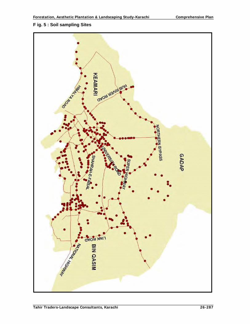
Forestation, Aesthetic Plantation & Landscaping Study-Karachi Comprehensive Plan
Tahir Traders-Landscape Consultants, Karachi 26-287
F ig. 5 : Soil sampling Sites
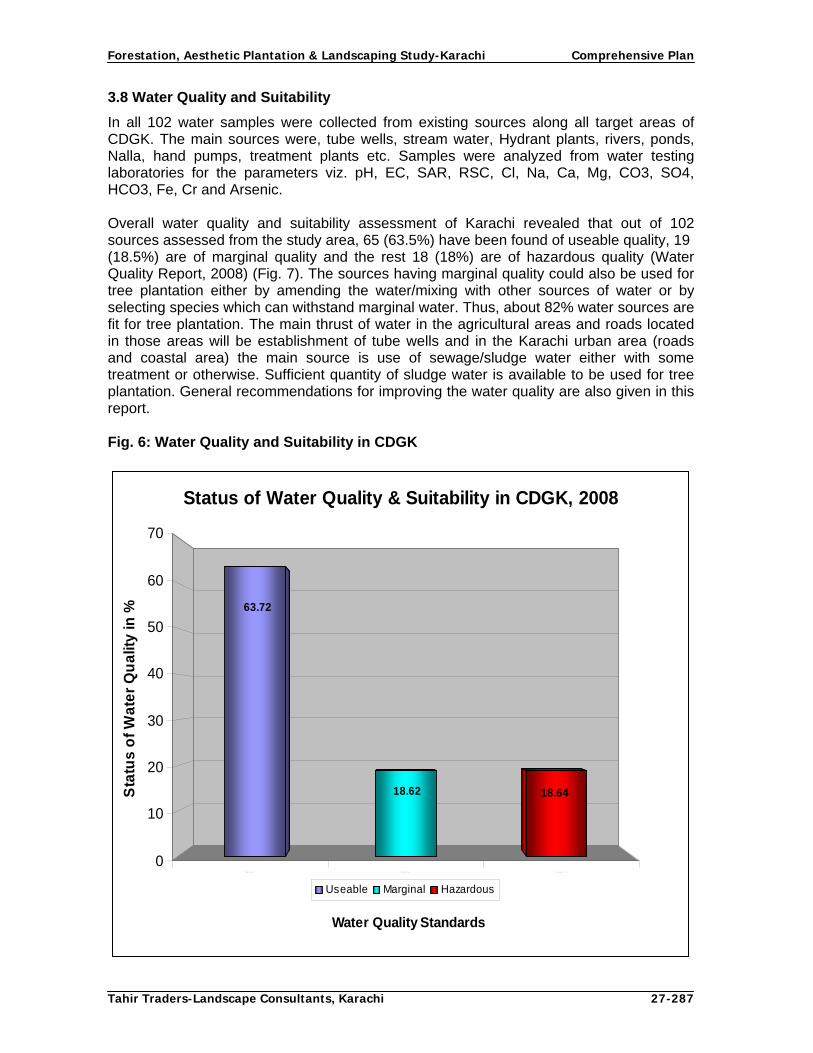
Forestation, Aesthetic Plantation & Landscaping Study-Karachi Comprehensive Plan
Tahir Traders-Landscape Consultants, Karachi 27-287
3.8 Water Quality and Suitability
In all 102 water samples were collected from existing sources along all target areas of CDGK. The main sources were, tube wells, stream water, Hydrant plants, rivers, ponds, Nalla, hand pumps, treatment plants etc. Samples were analyzed from water testing laboratories for the parameters viz. pH, EC, SAR, RSC, Cl, Na, Ca, Mg, CO3, SO4, HCO3, Fe, Cr and Arsenic. Overall water quality and suitability assessment of Karachi revealed that out of 102 sources assessed from the study area, 65 (63.5%) have been found of useable quality, 19 (18.5%) are of marginal quality and the rest 18 (18%) are of hazardous quality (Water Quality Report, 2008) (Fig. 7). The sources having marginal quality could also be used for tree plantation either by amending the water/mixing with other sources of water or by selecting species which can withstand marginal water. Thus, about 82% water sources are fit for tree plantation. The main thrust of water in the agricultural areas and roads located in those areas will be establishment of tube wells and in the Karachi urban area (roads and coastal area) the main source is use of sewage/sludge water either with some treatment or otherwise. Sufficient quantity of sludge water is available to be used for tree plantation. General recommendations for improving the water quality are also given in this report. Fig. 6: Water Quality and Suitability in CDGK
U se a b le M a rg in a l H a za rd o u s
63.72
18.6418.62
0
10
20
30
40
50
60
70
Sta
tus
of
Wa
ter
Qu
alit
y in
%
Status of Water Quality & Suitability in CDGK, 2008
Useable Marginal Hazardous
Water Quality Standards

Forestation, Aesthetic Plantation & Landscaping Study-Karachi Comprehensive Plan
Tahir Traders-Landscape Consultants, Karachi 28-287
Fig. 7: Water sampling Sites in CDGK

Forestation, Aesthetic Plantation & Landscaping Study-Karachi Comprehensive Plan
Tahir Traders-Landscape Consultants, Karachi 29-287
3.9 RIVERS
3.9.1 Malir River
In vernacular language Malir means greenery and prosperity. Malir River has played an important role for a long time in producing agricultural and horticultural crops and supplying potable water for Karachi. The major tributaries feeding Malir River are Mol, Thadho, Khadeji, Langeji, Dhoro Naro and Sukkan Streams, but main course of river is formed by the confluence of Mole and Khadeji streams near Ansari bridge at Super highway. Malir River joins the Mole stream through a wide gorge near Dumlotte and enters in its flood plains. It has a wide bed with narrow strip of flood plain along its banks. The dry bed of Malir River is important as the soil derived from native rocks supports good vegetation. The bed being gravelly is highly permeable and contains a rich number of aquifers.
To protect the residential areas from flooding in rainy season, earthen embankments have been constructed with stone pitching on its both sides from Qaidabad to the Sea. In city limits, three overhead bridges have been constructed over this river at Landhi, Shah Faisal and Korangi for easy communication. Three reservoirs viz. Mole, Thadho and Malir have also been constructed over this river for recharge of ground and drinking purposes. Since this study deals with the river banks only, it has been surveyed and studied from Landhi to Korangi near Jam Sadiq Bridge. To check erosion, spurs have been constructed in its bed leaving sufficient space between spurs for free flow of water in the centre. The river can further be tamed if its bed is excavated in the centre like Lyari river for establishing plantations on both sides away from river current.
Area
Different sources have reported different area of Malir River. The River Valley park report of CDGK estimates its length as 17.5 km and catchments area as 2240 sq km. Kazmi and Ghori, 1995 has reported its catchments area as 1415 sq km and estimated cultivated area as 4070 ha. GIS study has estimated its length, bed area and average bed width from Qaidabad over head bridge to its tail opposite to Hino Chorangi as 15.0 km, 14.0 sq km (3500 acres) 0.934 km respectively.
It is proposed that out of 1416 ha Malir river land, 202 ha will be for river bed, spurs and along bunds, 202 ha reserved for recreational purposes, 405 ha for fruit orchards and oil palm plantations and over remaining 607 ha tree plantations will be established. Water Malir river is a seasonal river for carrying storm flow water but presently is also used for transporting urban sewerage to Arabian sea. In monsoons, tremendous amount of flood waters flow in this rive. As per record of Irrigation and Power department, 112,000 cusec water was discharged by this river in the 1973 and 1976 with 4.0 m depth of water. This river recharges the sub soil water of cultivable areas of Gadap, Malir and Bin Qasim towns which are the green belt of Karachi District and where several agricultural and horticultural crops are raised. Due to dry years and excessive with-drawl of ground water, water table has dropped substantially and has created a shortage of irrigation water. As per an estimate, the people have to dig 50-230 m deep well for water to be used for Irrigation and drinking purpose. Another major cause for lowering ground water level is the unhampered excavation of hill sand and gravel which allows the percolation of surface water to the ground water aquifer. Network of deep gullies in many parts of the valley formed due to

Forestation, Aesthetic Plantation & Landscaping Study-Karachi Comprehensive Plan
Tahir Traders-Landscape Consultants, Karachi 30-287
removal of materials has been instrumental in acceleration of erosion process and degradation of natural environment.
Water Quality at Malir River Water quality assessment carried out during the baseline survey indicated that on the basis of EC (dS m-1) overall quality of water from three sources i.e river bed, dug well and hand pumps was marginal but some samples taken from river bed were hazardous (Water Quality Study Report, 2008). Soil Soil quality from Malir River at 0-15, 15-30 and 30-45 cm depths were found with no salinity problem. The concentration of Na+ remained dominant over Ca2++Mg2+, among soluble anions, Cl- remained dominant followed by SO4
2- and HCO3
-. About 60, 67 and 73% of samples taken from 0-15, 15-30 and 30-45cm depth were non-sodic respectively and in general were slightly to moderately alkaline in reaction. The colour of the soils was dark yellowish brown and majority (80%) of the samples was low in total nitrogen. Approximately 60% of the samples were low in organic matter content and their texture was mostly loam to sandy loam in character. The over all quality of soil was suitable for tree planting in Malir river (Soil Study Report, 2008).
Existing Land use of River Malir
A view of Polluted water of River Malir

Forestation, Aesthetic Plantation & Landscaping Study-Karachi Comprehensive Plan
Tahir Traders-Landscape Consultants, Karachi 31-287
Land Use The present land use of river bed is to drain rain storm water of its catchments area and sewerage / effluent of Landhi, Malir, Shah Faisal and Korangi towns of CDGK in to Arabian Sea. In dry season, agricultural crops are also cultivated in its bed on sewerage water. According to one estimate, nearly 9,540 m3 of sand and gravel is being excavated daily for use in construction industry. Presently there is no tree growth in this river except scattered mesquite shrubs along its bunds and in bed.
3.9.2 Lyari River Lyari river originates from its catchments area in Khirthar hills and discharges in Arabian sea at Lyari town of Karachi. Its total length is more than 40 km of which 20 km are within Karachi build up area of the city. Its two branches cross Karachi Northern bye-pass and join at crossing of Surjani, Gulshan-e-Maymar, New Karachi and Gulberg Towns. Lyari river passes through Nazimabad, Jamshed, SITE and Lyari towns carrying rain water and urban sewerage / effluent to sea. In order to regulate the traffic both banks have been raised and 17.5 km long Expressway has been constructed from Sohrab Goth to Gul Bai. One side of the expressway is operational and other side is under construction. The river has been trained by excavating its bed in the centre leaving a strip of land on its both sides which increases gradually from Sohrab Goth from 30-75 m at Gulbai on its each side. Presently, the river bed and expressway (banks) are without any vegetation. Area The length of the river of this section is 14.22 km, average width is 0.139 km (460 feet) and its area is 1.98 sq km (495 acres). Soil Majority (83 to 100%) of soil samples taken from Lyari River area were non-saline to non-sodic in nature, pH in most (83-100%) of the soil samples was medium alkaline (pH ranged from 7.7 to 8.2). The soils were very calcareous in nature. The CaCO3 content observed in the field remained over 10%. The structure observed in the field was massive. The soils were light in texture and their colour was yellow, yellowish brown and light
Existing Land use of River Malir

Forestation, Aesthetic Plantation & Landscaping Study-Karachi Comprehensive Plan
Tahir Traders-Landscape Consultants, Karachi 32-287
yellowish brown. About 33 and 50% of samples were low and marginal in organic matter content, respectively. Total nitrogen content in 50% of the samples was low and in 50% was medium. However, there was no problem in majority (83%) of the soil samples with P and K+ status in these soils (Soil Quality Report, 2008). Water Quality of Lyari affluent Three water samples each from head, middle and tail of the Lyari River were assessed. The colour of the water at head was red with bad smell that was probably due to the addition of industrial waste into the river. The colour at middle of the river was blackish and or dark brown. The river water was also contaminated with 0.01 ppb arsenic. On the basis of EC (dS m-1) and Cl-1 2 water samples had little higher salinity but still useable for irrigation with proper choice of species (Water Quality Report, 2008). These data suggests proper treatment of the water before its application for irrigation so as to improve its quality. Land Use The present land use of Lyari River bed is to drain out rain storm water and urban sewerage/affluent into the sea. . A bulk water supply line of 84 cm dia for Lyari town is passing under its south bound side bed from near Sindhi hotel to Gulbai at a depth of 1.5 m and located 2 m from the apron of expressway. This aspect of Lyari River will be kept in mind while proposing concept design fro plantation along this river. As regards the maximum flow of storm water in this river, no data was available with the concerned agencies. However, it was informed, that in the future, lyari river will be used for the discharge of storm water only sewerage water will be discharged by constructing a conduit deep in its bed. Lyari Expressway has been constructed on its banks and area on both sides of banks is not available for planting but both sides of main river flow are suitable for establishing linear plantations in a belt. 3.10 Coastal belt of Karachi outside Mangrove areas Arid climate of Karachi does not permit natural tree growth along its coast except xerophytes vegetation and mangrove forests which too have been cut and degraded due to climatic variations and social reasons. Low rainfall, coarse soils and high velocity salt/sand ridden winds do not favour planting trees along coastal roads, unless favourable conditions are created for aesthetic plantation. Coastal area of Karachi outside mangrove area falls between the seashore and the coast line. Almost all along the coast parallel roads are located and immediately after roads residential or other installations start which becomes part of main city area. Hence, roads running parallel to coast have been assessed and made part of Comprehensive Plan. The objective is to beautify these roads for better opportunities for recreation and beautification. All coastal roads were surveyed physically to acquire complete information regarding biophysical conditions of these roads and to identify the gaps and potential sites for landscaping and establishing aesthetic plantations. This information could not be retrieved from satellite imageries through GIS due to difficulty in identification of species, etc. Following parameters were assessed during the baseline survey:
Length of the roads

Forestation, Aesthetic Plantation & Landscaping Study-Karachi Comprehensive Plan
Tahir Traders-Landscape Consultants, Karachi 33-287
Availability of side and median strips and their width available for planting Present status of plantations along target roads Type of species planted Identification of Gaps in plantation Selection of potential sites for plantations Bio-physical environmental factors of the area and quality of soil along roads of
coastal belt Identification of irrigation water sources
Assessment Outcomes of Coastal Roads Mauripur Road There are two sections of this road one starts from ICI Bridge and ends at Sandspit and the other starts from Gul Bai and joins Hawks Bay Road near Paradise Point. Both roads cross each other at Mauripur colony. This road is double from ICI Bridge to Mauripur colony and single from Mauripur colony to Sandspit. This length of road is about 11 km where 1 row of trees can be planted on both sides in about 7 km length. Road from Gulbai to Hawks Bay Road near Paradise point have a length of 13 km. 5 km portion starting from Paradise road intersection is newly constructed with wide median has potential of planting in center and sides. Road from Manora Town to Paradise Point is single road and is 23 km long. On the left there is sand bar along the beach in a length of 13 km where tourist’s huts have been constructed whereas on the right side there are Mangroves. Mud flats on Mangrove side and blank patches are found on both sides up to Paradise Point. Entire road including Paradise point are devoid of tree growth except few scattered trees in front of KANUPP. The soil and water quality of above coastal roads is saline due to their location along the sea. Kiamari Oil Terminal to Golf Club via Village Hotel (Sea View Road) This coastal road is 17 km long and runs parallel to sea coast. This is the main beach area of Karachi up to Village Hotel. It is dual carriageway through out. The carriage ways are having side roads and central strips. The central strip varies in width from 1.5 -2.5 m and side strips varying from 2.5-3.0 m. The central strip from Kiamari Oil Terminal to Ibne Qasim Park and side strips are blank. Central strip is potential area for tree planting and ground cover whereas side strips on both sides are cemented but there is scope of tree planting in pits. From Ibne Qasim Park to Desalinization Plant through Village Hotel the central strip is planted with trees and shrubs and its ground is covered with grass. From Desalinization Plant to Golf Club plantation of Conocorpus has been tried but id in poor condition due inadequate maintenance and fast sea winds. Entire area is potential for tree plantation in the median and side strips of the road. Ibrahim Hydri to Rari Road This is an important coastal road which starts from village Ibrahim Hydri an ends at Rari village near Landhi industrial area. Its total length is 7 km. Initially it passes through thickly populated area and afterwards it runs parallel to sea coast. Karachi Fish Harbour Authority has planted Conocorpus trees on the 1 km long road leading to the harbour. Rest of the road is totally blank up to Rari village. Although the soil of the road is apparently saline but it can withstand the trees species such as Conocorpus as has been done by the Karachi Fish Harbour Authority.

Forestation, Aesthetic Plantation & Landscaping Study-Karachi Comprehensive Plan
Tahir Traders-Landscape Consultants, Karachi 34-287
Recreation Points Along the coastal belt there are recreation points such as Hawksbay, Paradise Point and Clifton beach. Assessment carried out revealed that except Clifton Beach Area rest of the recreation points are devoid of tree cover along their roads and within. These potential areas could be developed and beautified through forestation, aesthetic plantation and landscaping. Assessment of Soil Quality of Coastal Areas The soils of this area indicated salinity problem at all 3 depths, but 31, 38 and 46% samples collected from 0-15, 15-30 and 30-45 cm depth were salt-free. The EC (d Sm-1) ranged from 0.58 to 6.1, pH ranged from 7.2 to 8.2 and soils were slightly to medium alkaline in reaction. Among the soluble cations and anions Na+ and Cl- were dominant. The CO3
2- was absent, organic matter and nitrogen were low and Phosphorus and K+ were marginal in these soil samples. Coarse textured soil was dominant over sandy loam and silt loam. The colour ranged from brownish yellow to pale brownish yellow and water holding capacity was moderate (Soil Quality Report, 2008). Sources of Water and their assessment Assessment revealed that the main sources of water are the following:
Sea water Sewerage outfalls Malir and Lyari river outfalls Creeks Water sources established by sea front organizations
Sea water being too saline is not fit for irrigation. Other water sources i.e river and sewerage outfalls are marginal and creeks are hazardous as they contain industrial effluents. The reliable sources for tree plantation are the sludge water transported through tankers from treatment plants, rivers and sewerage outfalls. Main problems of coastal areas There are several problems confronting the coastal belt of Karachi. They include high wind velocity, polluted environment, soil quality and water quality and suitability. These problems collectively and individually have adverse impact on the coastal climate and natural resources especially vegetation. Overall assessment Study reveals that presently the vegetation cover along the coastal roads is extremely sparse and in-adequate to cater the environmental needs and beautification of this area. The soil quality is moderate as revealed from the soil quality assessment. Except sludge water other sources of water are not suitable for irrigation. There is scope and potentiality to develop this belt through massive tree plantation so that the adverse environmental impacts are mitigated and the area is beautified. Organizations located in the sea front and interested NGOs’ shall be taken on board and a mechanism evolved to include them as main stakeholders.

Forestation, Aesthetic Plantation & Landscaping Study-Karachi Comprehensive Plan
Tahir Traders-Landscape Consultants, Karachi 35-287
3.11 Streets, roundabouts and greenbelts Looking to the number of streets in the metropolis, neither it was possible to survey each and every street of the city, nor had any tool to determine the extent of vegetation. Hence, advance GIS software namely ERDAS 8.2 and ARC MAP 9.2 were used to calculate vegetative cover of the city (Situation analysis Report, 2008). Streets Karachi is the oldest coastal habitation of the country, where old congested part of the city is constructed without any planning. From British rule and particularly after independence, several housing projects have been completed where well planned roads and streets were laid out except Kachi-abadis. The prominent housing schemes are Parsi Colony, Clifton, PECHS, Sindhi Muslim Society, Mohammed Ali Society, Nazimabad, North Nazimabad, Bahadurabad. Garden, Gulshan-e-Iqbal, Federal B Area, Gulistan-e-Johar, Model Colony, Defense Housing authority, etc. where roads, streets, amenity places have properly been planned. Looking to the number of streets in the Metropolis, it was not possible to survey each and every street of the city. It was decided to use GIS facility for assessing the vegetation cover of the streets of the city. However, random assessment of some streets of major housing societies was conducted during the field visits. The GIS data collected during baseline survey (2008) reveals that most of the vegetation is in the streets of residential societies, where people have planted and nurtured trees, flowering plants, shrubs, climbers, ground cover and lawns within the compound walls and outside of their houses. In fact, streets are located in between major roads where most of the population resides. In commercial areas, people live in apartments and in residential areas mostly in houses. Due to increase in population and cost escalation of urban land, most of the old large size houses where there have been several trees have been demolished and converted in to high rise apartment buildings in recent years. The baseline survey revealed that at an average, 7% area of CDGK is under different types of vegetation. In buildup area, most of this vegetation is found in residential houses which are located in the streets. These flowering trees, shrubs, climbers, ground cover and lawns in and outside of their houses have been planted and nurtured by the residents themselves according to their taste and love for vegetation. Greenbelts The greenbelts are vegetated areas developed or preserved for different objectives. They are maintained for erosion control, preservation of watershed, recreation, environmental protection and several other purposes. In CDGK, green belts are developed or proposed in buildup area as well as in rural/agricultural areas. The main objective of green belts in agricultural area is to produce agricultural products, provide recreation and mitigate smoke pollution of urban area. Whereas, its objective in buildup area is establish aesthetic plantations for landscaping, beautification and mitigation of sound and smoke pollution. The greenbelt of rural area has been discussed in social forestry/agroforestry section and green belts in buildup area are discussed in this report. Wide strips between dual carriage way roads are ideal places for growing green belts in Karachi. During the baseline survey it revealed that M.A. Jinnah Road from Sohrab Goth

Forestation, Aesthetic Plantation & Landscaping Study-Karachi Comprehensive Plan
Tahir Traders-Landscape Consultants, Karachi 36-287
to Karimabad, University road from Sui Gas colony to Safoora chowk, Central road from Nazimabad to Surjani, National highway from Ghaghar Railway crossing to Quaidabad, Korangi Industrial Area roads, Mauripur road up to Hawksbay road, coastal road from village hotel to Golf club, SITE roads and all roads of scheme 33 are the main roads where green belts could be established. At present all the above belts are blank. The width of above roads varies from 6-13 m. These are the potential sites where 3-5 rows of trees and shrubs could be raised as greenbelts. In the urban agriculture area located in Gadap, Malir and Bin Qasim town’s greenbelts of trees in different configurations in agricultural farms, farm houses and recreation areas are proposed to be established. These areas have also been proposed in Social Forestry Component of this plan which will serve as greenbelts for Karachi and their impact will be both in the agricultural area and the build up area of the city. Roundabouts CDGK used to have several roundabouts on main roads. Due to recent renovation/improvement works for widening of roads most of the roundabouts have either abolished or reduced to size of traffic signals size and this process is continuing. During the survey 75 roundabouts are identified which are still existing and have been categorized as Developed (D), partially developed (PD) and Un-developed (UD). Above roundabouts are categorized as small, medium and large on the basis of their spatial dimensions. 18 roundabouts are Developed (D) and landscaped with structures, aesthetic plants and lawn where as, 35 roundabouts are Partially Developed (PD) landscaped with physical structures, flowering shrubs and lawns. There are 22 roundabouts which are completely Un-developed (UD) and blank (Situation Analysis Report, 2008). Town-wise names, locations and present position of roundabouts is given in Volume III of this Plan Fig. 8: shows that 24% roundabouts are developed, 47% are partially developed and 29% are un- developed.
Fig.8: Status of Roundabouts of Karachi
Status of Roundabouts of Karachi
29%
24%
47%
Developed Partially Developed Undeveloped
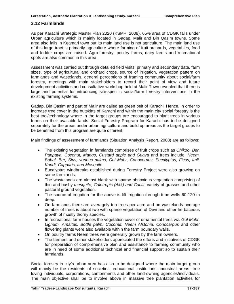
Forestation, Aesthetic Plantation & Landscaping Study-Karachi Comprehensive Plan
Tahir Traders-Landscape Consultants, Karachi 37-287
3.12 Farmlands As per Karachi Strategic Master Plan 2020 (KSMP, 2008), 65% area of CDGK falls under Urban agriculture which is mainly located in Gadap, Malir and Bin Qasim towns. Some area also falls in Keamari town but its main land use is not agriculture. The main land use of this large tract is primarily agriculture where farming of fruit orchards, vegetables, food and fodder crops are raised. Agro-forestry, poultry farms, dairy farms and recreational spots are also common in this area. Assessment was carried out through detailed field visits, primary and secondary data, farm sizes, type of agricultural and orchard crops, source of irrigation, vegetation pattern on farmlands and wastelands, general perceptions of framing community about social/farm forestry, meetings with main stakeholders to record their point of view and future development activities and consultative workshop held at Malir Town revealed that there is large and potential for introducing site-specific social/farm forestry interventions in the existing farming systems. Gadap, Bin Qasim and part of Malir are called as green belt of Karachi. Hence, in order to increase tree cover in the outskirts of Karachi and within the main city social forestry is the best tool/technology where in the target groups are encouraged to plant trees in various forms on their available lands. Social Forestry Program for Karachi has to be designed separately for the areas under urban agriculture and build up areas as the target groups to be benefited from this program are quite different. Main findings of assessment of farmlands (Situation Analysis Report, 2008) are as follows:
The existing vegetation in farmlands comprises of fruit crops such as Chikoo, Ber, Pappaya, Coconut, Mango, Custard apple and Guava and trees include; Neem, Babul, Ber, Siris, various palms, Gul Mohr, Conocorpus, Eucalyptus, Ficus, Imli, Kandi, Capparis, and Mesquite.
Eucalyptus windbreaks established during Forestry Project were also growing on some farmlands.
The wastelands are almost blank with sparse obnoxious vegetation comprising of thin and bushy mesquite, Calotropis (Akk) and Cactii, variety of grasses and other pastoral ground vegetation.
The source of irrigation for the above is lift irrigation through tube wells 60-120 m deep.
On farmlands there are averagely ten trees per acre and on wastelands average number of trees is about two with sparse vegetation of Devi and other herbaceous growth of mostly thorny species.
In recreational farm houses the vegetation cover of ornamental trees viz. Gul Mohr, Lignum, Amaltas, Bottle palm, Coconut, Neem Alstonia, Conocarpus and other flowering plants were also available within the farm boundary walls.
On poultry farms Neem trees were generally grown by the farm owners. The farmers and other stakeholders appreciated the efforts and initiatives of CDGK
for preparation of comprehensive plan and assistance to farming community who are in need of some additional technical and financial support so to sustain their farmlands.
Social forestry in city’s urban area has also to be designed where the main target group will mainly be the residents of societies, educational institutions, industrial areas, tree loving individuals, corporations, cantonments and other land-owning agencies/individuals. The main objective shall be to involve above in massive tree plantation activities for

Forestation, Aesthetic Plantation & Landscaping Study-Karachi Comprehensive Plan
Tahir Traders-Landscape Consultants, Karachi 38-287
increasing tree cover in the city for better environment of Karachi. Different forms of urban forestry will be introduced to these target groups. Fig.9: Showing Urban agriculture and Urban Build up area
Build up & Agriculture Area of Karachi in Square Kilometer1300,
36%
2300, 64%
Urban Agriculutre Urban Build up area
3.13 Establishment of Mini Forests 3.13.1 Assessment of Mini Forests
The assessment conducted through GIS reveals that the vegetation cover of CDGK is about 7%. This vegetation includes trees, shrubs and grasses grown by the residents in their houses and city administration in parks, roads and office buildings, agricultural and horticultural crops raised by farmers in Malir, Gadap and Bin Qasim towns, other land owning organizations and bushy growth having crown coverage found in waste lands and river beds. This vegetation cover is insufficient to mitigate the pollution created by several industries, more than 1.5 million vehicles and 18.0 million inhabitants. Besides, there are very few recreation places for the densely populated residents of this mega city. The present vegetation cover has to be increased for the development and betterment of the citizens which can be enhanced by establishing block plantations or Mini forests on all suitable blank open places in the jurisdiction of CDGK in addition to raising of linear plantations along highways, roads, rivers and farmlands. 3.13.2 Concept of Mini Forests A forest is plant community of predominantly trees and other woody vegetation growing more or less closely together, its related flora and fauna and the values attributed to it. Mini Forest is a community of plants of predominantly woody species artificially planted on smaller scale on a suitable site. According to definition adopted by Government of Pakistan, a mini forest is a tree dominated plant community with 0.5 density and area of 0.5 acre (0.2 ha).

Forestation, Aesthetic Plantation & Landscaping Study-Karachi Comprehensive Plan
Tahir Traders-Landscape Consultants, Karachi 39-287
Principally Mini Forests are tree woodlots or block plantations raised on a contiguous piece of land primarily for wood production and associated benefits in rural settings and in urban areas their main purpose is micro climate improvement and over all improvement of environment through positive impacts of trees-in- blocks on city’s environmental problems such abatement of noise and smoke and carbon sequestration. 3.13.3 Importance of Forests/ Mini Forests
Trees bring many benefits to our lives, but forests play a complex role in climatic and environmental stability. Forests modify the climate by influencing ground temperatures, evaporation, surface roughness, albido, cloud formation and precipitation. In recent years, attention is particularly been focused on their role in sequestering carbon dioxide from the atmosphere and their subsequent contribution in reducing green house effects or global warning. However, in highly arid climatic conditions, their role in reducing extreme temperatures and air humidity is important.
It is generally recognized that climatic stability is also dependent upon forests as they influence the climate by increasing evapo-transpiration, reducing climatic extremes, slowing horizontal movement of air, and through vertical exchange process. In hot and arid conditions, trees and forests protect the farms from desiccation. In industrial areas they control atmospheric pollution through their large internal surface area of the leaves which act as a filter and extract contaminants from the air. As a result of dry deposition of pollutants, trees contain 20 times as many dust particles and aerosols as open sites.
It is estimated that one ha of trees can remove about 32.5 tons of dust and gases every year from the surrounding environment. Recent studies in India suggest that Neem trees have the highest dust retention capacity and their growth near cement plants and stone crushing sites could minimize atmospheric pollution and health hazards. Forests and forest soils can store 20 to 100 times more carbon per ha than pastures and croplands. Forests are also the largest single above ground carbon sink and reservoir in existence. If these are destroyed or degraded, carbon stored in biomass is released in the atmosphere in the form of CO2, which contributes to increase in green house effect and global warming.
3.13.4 Potential for Establishment of Mini Forests in Karachi Mega city of Karachi is one of the most polluted cities of the world. Uncontrolled industrial pollution, high level of vehicular emissions, relentless growth of population and insufficient vegetation cover have created several problems and induced diseases for its habitants. City District Government Karachi has attached a great importance to the environmental improvement of this city and desires to plant several mini forests on blank spaces in addition to planting of trees along roads, rivers and in coastal areas.
Karachi is located in arid zone where temperature in summer exceeds 40o C and average rainfall is less than 200 mm. Hence, it is devoid of the needed tree cover and the city is suffering from extensive aridity, desertification and soil and environmental degradation. Tree planting will not only ameliorate general climate and improve living environment of the citizens but will also contribute to economic wellbeing of the people. If trees are planted to the desired level, the ecological balance will be restored and the widespread pollution caused by industrial effluents and motor vehicle emissions will be reduced to great extent. The increased tree cover will also reduce/control the land degradation and desertification which is increasing in the form of soil erosion, loss of soil fertility, reduced crop productivity, deforestation and loss of biodiversity. Due to over exploitation of subsoil

Forestation, Aesthetic Plantation & Landscaping Study-Karachi Comprehensive Plan
Tahir Traders-Landscape Consultants, Karachi 40-287
water and illegal removal of sand from river beds, under ground water reservoirs are shrinking. Increased deforestation has resulted in soil erosion, reduced water holding capacity of the soil and groundwater recharge, minimal carbon sequestration, aridity in climate, disappearance of wild animals and birds. Under this back ground, the necessity of raising Mini Forest requires utmost attention.
During the assessment potential areas for establishment of Mini Forests were identified. It was concluded that Mini Forest could be established by all the land-owning agencies/organization/departments such as Forest Department, Board of Revenue, Revenue Department of CDGK, Town administration, large industrial areas, educational institutions including universities, Cantonments, Civil Aviation Authority, DHA, Housing Societies, Cement Factories, Railway lines, Pakistan Steel Mill, Ports etc. In chapter V of Comprehensive Plan the targets for above agencies have been proposed.
3.14 Micro irrigation system Micro-Irrigation is a system of water distribution/application to crops, trees and other water requiring biotic life. The basic principle of designing a micro-irrigation system is to apply irrigation as per requirement of the plants with desired water quantity for optimum growth. Through this system the wastage of water is controlled through uniformity and efficiency of the system. The main micro-irrigation techniques/systems now a days being used world wide are drip irrigation, sprinkler irrigation system, pitcher irrigation, Hose fed irrigation, modified Hose fed irrigation and Modified Hose-fed fertigation.
3.14.1 Why Micro Irrigation Design is Important Micro-irrigation systems require high initial investment and are energy intensive compared to other irrigation systems. Objectives of designing any micro-irrigation system suitable to the local environment and socio-economic conditions are to:
Apply water to meet peak plants water requirement Maintain application and uniformity efficiencies at a desired level Energy and water efficient to keep initial capital and operation cost as low as
possible Simple in operation and maintenance so can use these systems without extensive
training.
3.14.2 Advantages of Modified Hose fed Irrigation System
Modified hose-fed concept is particularly adaptable in Pakistan since it makes a reasonable compromise between labour and resource inputs. This system provides optimum water management on all types of soils for mini-forests and fruit orchards.
In essence, the innovative adaptation of this form of irrigation involves the use of portable hoses to supply water directly to small basins around each tree or near to each plant. The hoses can be systematically moved within the orchard to complete irrigation every four days on sandy soils to further reduce the installation cost. The system could be redesigned for longer irrigation intervals where soil conditions permit.
In this system, the water will leave the pump, pass through a filter, a fertilizer injection device, flow meters and through pipelines that feed the hoses. The water will only make exit from the system at and into the basins provided at each plant and there will be no chance for losses except through poor distribution or over-irrigation of the basins. If the labourers systematically move the hoses, the overall efficiency of the system will be in the

Forestation, Aesthetic Plantation & Landscaping Study-Karachi Comprehensive Plan
Tahir Traders-Landscape Consultants, Karachi 41-287
neighborhood of 90 percent. However, the conveyance efficiency is around 100% due to complete elimination of transit losses.
3.14.3 Comparison between Hose fed and Drip Irrigation Systems
Hose fed is suitable for matured plants as well as newly planted plants because root systems has been developed on flood system while drip irrigation is not suitable for matured plants but it is only suitable for newly planted plants in which root system preliminary stages.
Cost of hose fed irrigation system is less as compared to drip irrigation system
Labour is required to operate the hose fed while in drip system labour is not required.
Hose fed irrigation is in four days interval while drip irrigation is required on daily basis.
According to my suggestion Hose fed irrigation system is more suitable than drip irrigation system for mini-forest
3.14.4 Modified Hose-Fed Fertigation System
As the hose-fed fertigation system requires some initial capital cost, so in this way the productivity of orchards and mini-forest can be increased along with improved quality of the marketable products. Simple innovative techniques were used for designing of fertigation systems where organic and chemical fertilizers are used in the fertigation tank and mix it with irrigation water in the required ratio and then irrigate the plants.

Forestation, Aesthetic Plantation & Landscaping Study-Karachi Comprehensive Plan
Tahir Traders-Landscape Consultants, Karachi 42-287

Forestation, Aesthetic Plantation & Landscaping Study-Karachi Comprehensive Plan
Tahir Traders-Landscape Consultants, Karachi 43-287
Chapter IV
4. Concept Designs of Target Areas Assessment of target areas with respect to potential sites to be included in Comprehensive Plan for tree plantation, soil and water quality, suitability of water sources and introduction of micro-irrigation systems provided basis for concept designing. This chapter gives the target area-wise appropriate concept designs, their technical descriptions and paper drawings, patterns of tree plantations, choice of species, techniques of tree planting and guidelines for aftercare of plantation proposed in the Plan. This chapter also includes the guidelines on capacity buildings of target groups, tree plantation campaigns, training module for social/Farm forestry and incentives for the target groups identified for each target area. 4.1 General Guidelines for Designing of Roads/Avenues A literature search was undertaken during the baseline survey to find out guiding principles for tree plantation designing highways and roads. Guidelines/principles came out from literature search has been considered necessary to include them in this report for future guidance of planners (A.S. Khan, 1963). Construction of highways is a full time job and once it getting going, it hardly creates difficulties as it is repaired and renovated through periodic maintenance. Where as, designing of avenues is one of the difficult aspects of roadside plantations and it entails with living things and compete with the nature. The designing of highway avenues is subjected to criticism from horticulturist, engineers and general public as each of them has different perception. Avenues improperly formed or designed may give a patchy appearance and a jagged skyline, but if designed properly, it will look homogenously aesthetic and fascinating for the passerby. Following are the techniques for designing the avenues: 4.1.1 Balanced Line System: This method consists of two rows of uniform type of trees. It is a simple and commonly used method best suited for straight roads with minimum narrow verges. There could be some places on a road where deviation or detour in line system is required when passing along a building of monumental value or a stream or water meadow. 4.1.2 Unbalanced Line System: This system is divided into two categories i.e. Continuous and Discontinuous unbalanced line systems. These systems are mainly used for preserving the available scenic beauty where shrubs and hedges are used so that outside scenic beauty is not hided. These are unsuitable for this part of country which is hot and dry, where shade is primarily needed on the road itself. 4.1.3 Sporadic System: This system has the characteristics of both discontinuous and continuous unbalanced and suitable for hot and arid areas. This system is ideally suited for broad and beautiful valleys where a continuous system of planting is likely to deprive the travelers of scenic beauty of the surrounding landscape. 4.1.4 The Park way System: This system involves planting of more than one row of trees in the uniform distance and is only possible where wide road side strips of land are available. Brief discussions on the roadside designs shows that the balanced line system of planting with certain modifications is best suited for link roads or roads with very narrow strips as continuous shade is a basic need of our arid season with hot summers. Wherever

Forestation, Aesthetic Plantation & Landscaping Study-Karachi Comprehensive Plan
Tahir Traders-Landscape Consultants, Karachi 44-287
possible, parkway system shall be applied as it provides broad green belt against desiccating winds and enable maximum use of the roadside lands. These are simple guidelines for designing planting layouts. No specific rules can be formulated for designing purpose as it will largely depend upon the nature of each site and imagination of the planner, who has often to blend the various systems of designs of plantations on one highway or link road. 4.2 Purpose and objectives of forestation along highways All the three highways, Karachi Northern bye pass and link roads are the entry-exist points and main source of communication of the city. Due to adverse climatic conditions and other harsh site problems, no serious efforts have been made in the past for planting trees along these highways and roads. National Highway Authority awarded a contract in mid 1990’s for planting of trees along Super highway and work was carried through the private organizations/firms. Since the work done was of below quality and species selection was wrong, it failed badly. Not a single tree survived on all the planted strips. Therefore, Karachi Strategic Master Plan 2020 (KSMP, 2007) has identified these roads particularly entry points for beautification through, aesthetic planting and landscaping. NHA, Ministry of Communications and Railways has formulated tree plantation policy for National highways and motorways. The main features of this policy are as under: Objectives and Benefits: Apart from aesthetic and landscape value tree plantation along highways are source of economy, safety and efficiency. Plantation provides following benefits:
Protect road users from weather condition and provide shade and comfortable traveling.
Protect metalloid road surface from sudden and extreme exposures to heat and cold to prolonged highway life and reduce maintenance cost.
Protect road surface from drifting sand and gravel and reduce soil erosion on slopes and berms.
Improve aesthetics and provide landscaped highways. Combat pollution caused by vehicular traffic. During national emergencies, help in concealment of troops deployment. Accentuate visibility of road curvature and relieve road users from boredom and
monotony enhancing road safety. 4.3 General Plantation Pattern Plantation to be undertaken on highways shall be under the general principle that it should in no way endanger or affect condition of the road pavement and that it will not hinder smooth flow of traffic or disturb overhead and underground utility lines. Plantation shall be carried out in a manner that in the first row shrubs would be planted and in the second and subsequent rows small trees and tall trees would be planted. Care shall be taken that trees do not fall on utility lines. Approach road to major towns shall be beautified through landscape treatment, using flowering trees and shrubs. Where ever feasible nurseries should be established along the roads. Spacing between rows and plants shall depend upon the choice of species. As a general guideline the distance should not be less than 10 feet (3 meters) from plant to plant and row to row. The last row of trees shall be established along the exterior boundary of ROW to define and protect it.

Forestation, Aesthetic Plantation & Landscaping Study-Karachi Comprehensive Plan
Tahir Traders-Landscape Consultants, Karachi 45-287
Institutional arrangements: In future all Afforestation projects of NHA shall be executed, maintained and managed preferably by the local forest department of respective provinces as deposit work. The forest department shall manage and maintain established plantations on behalf of NHA. The GM/Director responsible for particular road will also be responsible for tree plantation. For scientific and proper management of plantation by provincial forest departments as deposit work, NHA shall coordinate with provincial forest departments, to finalize mutually agreed terms and conditions including satisfactory monitoring and evaluation systems. Replacement of Felled trees Whenever the trees removed to facilitate any activity connected with road construction and improvement programs, as general rule, NHA shall arrange to plant at least twice the number in lieu of removed trees. Legal Cover NHA will propose amendments in National Highway Authority Act, 2001 to incorporate suitable sections to provide legal cover for establishment, maintenance and manage net of NHA plantations. 4.4 Guidelines for plantations along highways Desirability of Mixed or Pure Avenues Planting of species in mixture on highways is not looked upon favorably as their maintenance and replacement is expensive as uniformity can not be created by care and selection. It is thus better to avoid mixture of species and establish plantations of pure species for considerable stretch of length on road side. Out break of certain fungal or insect epidemic is a factor against the wholesale planting of pure. In order to overcome this problem, one species may be planted in two to three km to break the monotony of one species for a traveler. These buffer zones of different species will also prove effective in localizing the epidemic.
Planting On Curves Planting along curves require special care so that the visibility of motorists is not obstructed. A little carelessness can be a cause of accidents. Usual curves on our roads are S curves, L curves and U curves. Planting on S-curves, should be so adjusted that while taking right turn, and then subsequently taking left turn, the traffic coming from the opposite direction or going from the same direction should remain visible. In case of L and U curves, plant spacing should be increased on the inner side of the curve. At such sites, spacing of 60’ will be suitable. Planting on Crossings To avoid accidents, clear visibility is necessary at crossings for vehicles coming from all directions. The best thing would have been to provide tall lofty trees with thin crowns at considerable distances but for the shade of travelers, it would be desirable to plant trees with spreading crowns. Within a distance of 60 m of the crossing from all the directions, the spacing of trees should be increases from 60 to 80’. The corners of crossings should particularly be kept clear of trees.

Forestation, Aesthetic Plantation & Landscaping Study-Karachi Comprehensive Plan
Tahir Traders-Landscape Consultants, Karachi 46-287
Planting on Road Junctions Since on road junctions, the motorist coming from the side road is likely to slow down at main turning on the main road and similarly a motorist from the main road turning on the side road slows down, wider spacing should be provided on the junction side only up to distance of 40 m on either side. Planting on Bifurcations Quite often the main road bifurcates into two roads in a manner which is slightly different from a junction. At such bifurcations, the two convergent sides of the triangle formed by bifurcations should be planted at a distance of 40 feet apart up to distance of 40 m, while both the bifurcating roads will form slight curves in the outer direction which should also be thinly planted like the curves mentioned earlier. Planting near Habitations Planting near habitations should not be done in thick belts to avoid obstruction in visibility. Trees with very large and spreading crowns should be planted, so that they can be spaced far apart and provide enough shade and serve as amenity spots. Planting on Median strip The place left between the lanes of dual carriage way should be planted with small or low trees or shrubs. A few tall trees with clear boles may be introduced after suitable intervals. This will beautify the bi lanes and at the same time would reduce the dazzling effect of beams, injurious for traffic traveling in opposite directions to each other at night. Planting on Under Power and Transmission Lines Due care should be exercised for selection of species to be planted under low tension power lines and high tension transmission lines. As a result the tree entangles with power and transmission lines and cause breakdown. On account of this indiscriminate planting, the trees are pollarded by technical staff of Electricity department. Preferably shrubs or small sized tree species attaining 8 feet 10 height are best suited for planting near power transmission lines. 4.5 Concept designs and choice of species for highways and roads 4.5.1 Super Highway (M-9) The proposed design of linear plantation along the Super Highway will be Parkway Design that involves planting of multiple rows of trees at a uniform distance. National Highway Authority is planning to convert Super highway in to a Motorway by adding one lane on its either side. This highway has a ROW of 134 m on southern bound side and 67 m on northern bound side with a median 3.5 m. A barbed wire hedge will be erected at a distance of about 30 m from the toe of the road on both sides. Half of this strip along the road will be left for service lines and visibility and the remaining half could be planted with trees. After barbed wire hedge, service roads will be constructed and remaining area will be brought under tree plantation. Keeping in view the width of highway, median, service roads and shoulders, 23 m wide strips on north bound side and 75 m on south bound side will be left for planting trees at a distance of 6m from plant to plant and 5 m from row to row.

Forestation, Aesthetic Plantation & Landscaping Study-Karachi Comprehensive Plan
Tahir Traders-Landscape Consultants, Karachi 47-287
Choice of Species Due to arid climate, extensive traffic, and unpleasant surroundings along the Super highway, tree species with dense crown/foliage providing shade, breaking wind velocity, moderating local temperature, mitigating hazardous effects of smoke and providing aesthetic value are proposed for road side plantations. Trees such as Neem, Ficus, Siris, Arjun (Terminelia arjuna) Raintree and Peltophorum which sustain arid conditions are proposed for the plantation in a Park-Way System. In order to avoid monotony and mix plantation, each species shall be planted in a stretch of 2 to 3 km of distance. It is proposed that barbed wire fencing be erected to protect the plantation from astray animals and grazing. In median strip, small to medium size trees with flowering shrubs such as Lignum, Melia azedaracha, Melantonia and Plumeria (white) with different colour Bougainvillaea, Caesalpinia, & Nerium, Tecoma stans, Tecoma redican are recommended to be planted. Fig. 10: Concept design and pattern of Plantation along Super Highway (M-9)

Forestation, Aesthetic Plantation & Landscaping Study-Karachi Comprehensive Plan
Tahir Traders-Landscape Consultants, Karachi 48-287
Existing view of Side Strip of Super Highway
Concept Design of Side Strip of Super Highway
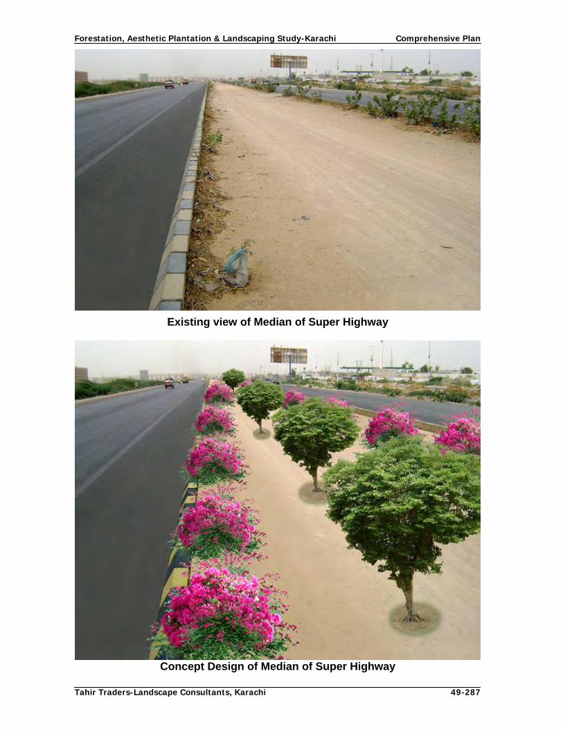
Forestation, Aesthetic Plantation & Landscaping Study-Karachi Comprehensive Plan
Tahir Traders-Landscape Consultants, Karachi 49-287
Existing view of Median of Super Highway
Concept Design of Median of Super Highway

Forestation, Aesthetic Plantation & Landscaping Study-Karachi Comprehensive Plan
Tahir Traders-Landscape Consultants, Karachi 50-287
Source of irrigation water During water quality and suitability survey, seven water sources along Super highway were identified and found suitable for irrigating plantations. Presently, agricultural crops are being cultivated on tube wells at 5 sites. Hence, additional tubewells can be sunk in the vicinity of those tubewells for plantation purposes. All the seven sources have been confirmed by concerned authority. During the water quality assessment the existing water sources along the Super Highway were determined through collecting water samples and their quality assessment. Following water sources were assessed.
1. Tube well owned Mr. Arshad Ali located on link road leading to Memon Goth 2. Tube well owned by Hajji Ramazan near Dumba village 3. Tube well owned by chowdry Ghulam Yasin near Kathore bridge 4. Tube well owned by Abdul Rehman Jokio at Kathore stop 5. Tube well owned by hajji Baqar on Super Highway near Lucky Cement Factory 6. Khadaji River near village Bachu Kholi along Super Highway 7. Hydrant Plant of KWB located near Saadi gardens
The water qualities of above sources indicate that they are of usable category. While executing the Comprehensive Plan tube wells could be sunk near these reliable sources. Proposed Irrigation system: The plantations will be irrigated through drip irrigation system (Micro Irrigation report, 2008). 4.5.2 National Highway (N-5) National Highway (NHW) is the main highway of the country connecting Karachi with rest of the country. It starts from Jinnah intersection and falls in the jurisdiction of CDGK up to Steel Mill Gate and onwards it is managed by National Highway Authority. Under this study, a total length of 30 km from Jinnah intersection to Ghaghar Railway crossing has been studied and improvement aspects have been briefly discussed and appropriate suggestions have been made. This section of National Highway is a dual carriage way with 1-4 m wide median strip. The ROW from Ghaghar crossing to Steel town is 63 m and afterwards it is reduced to17 m in built up area on either side. Concept Design Since the climate, width of roadside strip for plantation, and other site factors of National highway are similar to that of Super highway, Parkway design will also be applied on this highway. Keeping in view the habitations and other activities taking place along this highway from Jinnah intersection to Pakistan Steel Mill Colony two rows of trees on either side of the highway are proposed. Beyond that point to Ghaghar Railway crossing, three rows of trees on either side of the road are proposed. The distance between plant to plant and row to row will be 7m and 5m respectively in alternate fashion. The last row of trees shall be established along the exterior boundary of ROW to define and protect it.

Forestation, Aesthetic Plantation & Landscaping Study-Karachi Comprehensive Plan
Tahir Traders-Landscape Consultants, Karachi 51-287
Fig.11: Concept design and pattern of Plantation along National Highway (N-5)
Choice of Species In given circumstances, shady trees with dense foliage such as Neem, Siris, Ficus species, Rain tree, Shisham are preferred from Ghaghar Railway crossing to Steel Mill colony and from that point to Jinnah intersection, ornamental trees such as Neem, Ficus spp., Gul mohar, Amaltas, Erythrina, Peltophorum, lignum, Parkinsonia and Plumeria proposed along the sides. In median strip, small to medium size trees such as Lignum, Plumeria, Lagersrtoemia, Tabebvia rosea (chandni) with Nerium, Arjun (Terminelia arjuna,) Caesalpenia, Tecoma stans, Bougainvillaea flowering shrubs are recommended. Source of irrigation water During water quality and suitability survey, 4 water sources i.e. one hydrant point and three tube wells along National highway were identified and found suitable for irrigating plantations. Tube well water is being used for drinking and agricultural purposes, hence more tubewells can be sunk in the vicinity of these tubewells for plantation purposes. All the water sources have been confirmed by concerned authority. During the water quality assessment the existing water sources along the National Highway were determined through collecting water samples and their quality assessment. Following water sources were assessed.
1. Open wells near Sassi Toll Plaza along Pakland cement Factory road 2. Tube well owned by Karim Bux Kalmati near malook Hotel. 3. Tube well owned by Mr. Faiz Mohammad village Saleh Mohammad near Bin
Qasim

Forestation, Aesthetic Plantation & Landscaping Study-Karachi Comprehensive Plan
Tahir Traders-Landscape Consultants, Karachi 52-287
4. Hydrant Water Point near Jamia Milai College The water qualities of above sources indicate that they are of usable category. While executing the Comprehensive Plan tube wells could be sunk near these reliable sources. Proposed Irrigation system: The plantations will be irrigated through drip irrigation system (Micro Irrigation report, 2008). 4.5.3 RCD Highway (N-25) Concept Design The ROW of this road from Karachi Northern Bye-Pass intersection to Hab River in a length of 4 km is 17 m on either side (NHA), where 2-3 rows of trees could be planted. Design Parameters Since the site factors for establishing plantation along RCD Highway are almost similar to that of other two highways, same design parameters such as Length of the road, Width of the planting strip, Location of the road, Activities taking place along the road, Climatic conditions of the area, Topography, Soil characteristics and source of Irrigation water will be studied for designing the linear plantations. Fig.12: Concept design and pattern of Plantation along RCD Highway (N-25)
Choice of Species Since the distance is only 4 km, Azadrichta indica (Neem), Arjun (Terminelia arjuna) and suitable Ficus species are recommended for this highway. The last row of trees shall be established along the exterior boundary of ROW to define and protect it.

Forestation, Aesthetic Plantation & Landscaping Study-Karachi Comprehensive Plan
Tahir Traders-Landscape Consultants, Karachi 53-287
Irrigation water source The water for irrigating this plantation can be lifted either from Hub river or from nearby treatment plants. There are some orchards on link road connecting RCD highway with Hawksbay. If necessary, tube well can also be sunk in that area. 4.5.4 Establishment of Tree Groves Planting of groves along highways at an interval of 5-10 km is an important aspect of roadside plantations. These groves of varying sizes ranging from 0.3-1.5 ha are to be located at convenient distances depending upon the availability of land along highways and Karachi northern bye-pass. They will not only serve as resting places for the travelers but will provide all the benefits which are received from a mini forest or compact vegetation. Guidelines for Designing Groves The design of groves depends upon the size and shape of the plot, but it is necessary to leave sufficient space for a path and parking place for the vehicles while designing the groves. If area is bigger, the grove may be divided in sections for the privacy of the visitors. Preferably, paths shall be constructed in zigzag manner to provide aesthetics and privacy. Wooden table around the bole of trees, rest rooms, a few children amusements, a small lawn for enjoying sunlight in winter season and other facilities which require minimum maintenance shall be provided. Choice of Species Tree species planted in groves shall be evergreen, thorn-less, shady with dense foliage and suitable to the site. Flowering and fruiting trees can also be planted in the groves. Proposed species are Neem, Ficus spp., Jaman, Arjun (Terminelia arjuna), Siris, Rain tree, Amaltas, Peltophorm and Erythrina. 4.5.5 Karachi Northern Bye- Pass The Karachi Northern Bye pass is divided in two sections, i.e. From Super highway to RCD intersection over 39 km and from RCD intersection to KPT over 18 km. Presently, north bound side is constructed and the south bound side will be constructed in future. ROW of this section is 60 m on either side which includes median, shoulders, service roads and area for planting trees (NHA). After service roads, a strip of 300 m is reserved for commercial purposes and a service road on its both sides (Karachi Strategic Master plan 2020). So far out of total 39 km length of this section, CDGK has got prepared the concept design for one km buildup area for commercial purposes. Hence plantation will be raised as recommended under land use plan KSMP 2020 along Karachi Northern Bye Pass 300 meter reservation under
1. 300 meter reservation shall be applicable on all lands ( Government, CDGK, MDA, LDA or Private etc)
2. The entire 300 meter reservation would be bounded by two wide roads (140 & 120
feet) separating special land use strip with the Karachi Northern Bye Pass and the residential area.

Forestation, Aesthetic Plantation & Landscaping Study-Karachi Comprehensive Plan
Tahir Traders-Landscape Consultants, Karachi 54-287
3. High rise commercial, residential and civic use will be allowed including special land uses such as Petrol Pumps, Restaurant Hotels, Cash and Carry Shops, Parking, Car Showrooms, Fire Stations, Utility Center, Police Check Posts, Utility Center, Police Check Posts, Roads and Circulations.
4. For Government lands, the minimum area of plots facing NBP should not be less
than 1.0 acre for commercial use.
5. For Private Lands the minimum area of plots facing NBP should not be less than 1000 sq yards for commercial use.
6. The percentage of the proposed commercial plots should not be more than 50% of
the remaining land after leaving the land for maintaining 140 and 120 feet (43 m and 37 m) wide roads. The rest would be utilized for amenity and internal roads.
7. Land uses such as Truck stand, Bus Terminals, Sabzi Mandi, Anaj Mandi,
Timber/Steel market, Godowns and such other whole sale Markets etc shall be located behind 300m strip on Government allocated lands in addition to commercial plus residential, amenity land use.
8. The lay out plans containing 300m land would invariably be submitted to Master
Plan Group of Offices, CDGK for approval in accordance with approved land use of CDGK.
Concept Design The site conditions of Northern bye pass are similar to that of Super highway therefore; parkway design system of plantation is suggested. Section-I (SHW intersection to RCD intersection): Three lines of trees at a distance of 6 m from plant to plant and 5 m from row to row is proposed for planting on both sides of KNBP and service roads.
Section-II (RCD intersection to KPT): Single row of trees is proposed to be planted on one side of the road along RCD highway at a distance of 6 m from plant to plant. Flowering climbers having aesthetic value are proposed to be planted at a distance of 2 m along barbed wire hedge erected on both sides of the bye pass. Choice of Species Looking to the aridity of the area, trees with dense crown which sustain dust laden high velocity winds such as Neem, Ficus species, Siris, Rain tree, Eryrtrina, Conocarpus, and Peltophorum are proposed to be planted in alternate fashion along section-I of this road. In 2nd section, Gul mohar, Amaltas Arjun (Terminelia arjuna), Peltophorum, Neem, Dillenia and Conocarpus trees and climbers such as Rangoon creeper, Bougainvillaea, Bignonia and Venusta and Qusqollius are proposed to be planted along barbed wire hedge. To break the monotony, one species of trees shall not continue for more than 2-3 km. The last row of trees shall be established along the exterior boundary of ROW to define and protect it.

Forestation, Aesthetic Plantation & Landscaping Study-Karachi Comprehensive Plan
Tahir Traders-Landscape Consultants, Karachi 55-287
Fig. 13: Concept design and pattern of Plantation along KNBP
Irrigation Water Sources along KNBP During the water quality assessment the existing water sources along the KNBP were determined through collecting water samples and their quality assessment. Following water sources were assessed.
1. Hub rive canal crossing KNBP near Hamdard University 2. Two tubewells located at KNBP about 17 km from Super Highway near Imam Bux
Village 3. Tube well near Khahiroo Brohi village on Khor Dam link road. 4. Dam/Pond located at Mio near Hajji Gohar village
The water qualities of above sources indicate that they are of usable category. While executing the Comprehensive Plan tube wells could be sunk near these reliable sources. 4.5.6 Link Roads Out of 16 link roads, only 4 roads are double road and remaining 12 roads are single road. There are plans that all these roads will be widened and made double road as per necessity and availability of resources.

Forestation, Aesthetic Plantation & Landscaping Study-Karachi Comprehensive Plan
Tahir Traders-Landscape Consultants, Karachi 56-287
Concept Design for Link Road Connecting N-9 with N-5 near Sassi Toll Plaza The site factors of this link road are similar to that of Super highway and Karachi Northern bye pass, hence three rows of large size trees with dense foliage are proposed to be planted along this link road alternatively at a distance of 6 m between plant to plant and 5 m from row to row in entire length except river beds, bridges, culverts, hill side and other unsuitable places. Choice of Species Tree species such as Neem, Siris, Arjun (Terminelia arjuna),Rain tree, Peltophorum, Ficus species, Erythrina and Conocarpus shall be planted on this link road. Each species shall not be planted more than 3 km to break the monotony. Fig.14: Concept design and pattern of Plantation along Link road (NHW-SHW)
Concept Design of Farm-Market Link Roads Located in Malir, Gadap and Bin Qasim Towns These single lane link roads are mainly used as farm to market roads with narrow side strips. At places, farm boundaries are extended right up to the edge of these roads. Due to narrow side strips and roads being used for transporting agricultural produce through trucks and tractor trolleys, single row of trees on either side is proposed to be planted at a distance of 6m. These linear plantations will also serve as a wind breaks for the farmlands located along these link roads. Choice of Species Since these single roads with narrow sides strips are mainly used for plying of trucks and tractor trolleys, medium size trees are proposed to be planted at a distance of 20 feet from plant to plant along these link roads so that tree branches may not create problem for the

Forestation, Aesthetic Plantation & Landscaping Study-Karachi Comprehensive Plan
Tahir Traders-Landscape Consultants, Karachi 57-287
transport vehicle. Where ever, sufficient space is available, large size trees with dense foliage are preferred. Tree species such as Lignum, Bakain, Sukhchain, Arjun (Terminelia arjuna),Neem, Acacia auriculiformis shall be planted. Fig.15: Concept design and pattern of Plantation along Link Roads
Link Roads located in Gulshan-e-Iqbal Town There are two roads which connect university road and Safuran chorangi with Super highway through PCSIR laboratories and new Sabzi Mandi, respectively. These dual carriage way urban roads with varying size of median are located in Scheme 33. Part of these roads is under commercial activities and there is no space for raising plantations and part is still under construction.

Forestation, Aesthetic Plantation & Landscaping Study-Karachi Comprehensive Plan
Tahir Traders-Landscape Consultants, Karachi 58-287
Concept Designs of Link Roads

Forestation, Aesthetic Plantation & Landscaping Study-Karachi Comprehensive Plan
Tahir Traders-Landscape Consultants, Karachi 59-287
Fig.16: Concept design and pattern of Plantation along Link road in City area
Choice of Species Medium size trees with aesthetic value along sides and small to medium size trees on median strips are proposed to be planted on these roads. Neem, Arjun (Terminelia arjuna), Lignum and Parus peepal and shrubs are proposed.
Sabzi Mandi Road This 12 km dual carriage way starts from Al-Asif Apartments near Sohrab goth and terminates at new Sabzi Mandi along Super highway. This road is also devoid of any vegetation and is a potential site for planting single row of trees on one side and one row of trees with shrubs in median strip as other side strip is common with Super highway. Small to median size suitable trees and flowering shrubs having aesthetic appearance will be planted on this road. A separate planting design is also attached.

Forestation, Aesthetic Plantation & Landscaping Study-Karachi Comprehensive Plan
Tahir Traders-Landscape Consultants, Karachi 60-287
Fig.17: Concept design and pattern of Plantation along Sabzi Mandi road
Coastal Link roads: Hawksbay intersection to Mubarak village Road The length of this single road is 30 km and is devoid of any vegetation. This is a potential road for planting single tree on either side. Proposed species are Neem, Ficus, Siris and Babul for this road. The water for plantation will be lifted from check dams constructed along this road. Amri River intersection to RCD Highway The length of this single road is about 30 km and is devoid of any vegetation. This is a potential road for planting single tree on either side. Proposed species are Neem, Ficus, Siris and Babul for this road. The water for plantation will be obtained by sinking tubewells along this road near existing tubewells used for irrigating the orchards. Per Unit Cost estimates of Highways & Link Roads Per unit cost estimates for Highways and Link roads has been worked out on the basis of prevalent Government of Sindh/ CDGK/Market rates (Table-6 ). Table: 6 Per Unit Cost Estimates of Highways and Link roads
Cost Estimates for 1.0 km Super Highway Plantation 4 rows on South bound, 4 rows North bound, one row in median and 1 row of median
shrubs
Item of Work Unit Qty. Total
Quantity. Unit Cost Total Cost
Site Clearance (Rs) (Rs)
Bulldozer (hrs) 20 20 3,000 60,000
Manual (man days) 25 25 300 7,500
Tractors (hrs) for leveling 20 20 800 16,000

Forestation, Aesthetic Plantation & Landscaping Study-Karachi Comprehensive Plan
Tahir Traders-Landscape Consultants, Karachi 61-287
No of tree rows 9
No of saplings per km at 5 m spacing 200 1,800 250 450,000
E. work of pits at 5 m distance :3x3x3=27 cft 27 48,600 1 51,516
Sweet earth 70% 19 34,020 15 510,300
Farm Yard Manure 30% 8 14,580 15 218,700
Failure of plants 0 180 250 45,000
No of shrub rows 1
No of saplings per km at 5 m spacing 200 200 200 40,000
No of pits at 5 m distance :2x2x2=8 cft 8 1,600 1 1,696
Sweet earth 70% 6 1,120 15 16,800
Farm Yard Manure 30% 2 480 15 7,200
Failure of plants 0 20 200 4,000
Stacking 1,800 1,800 50 90,000
Sub-total 1,518,712
Miscellaneous Lump-
sum 81,288
Total 1,600,000
Cost Estimates for 1.0 km Karachi Northern Bye-Pass Plantation
4 rows on South bound, 4 rows North bound and 1 row tree+1 row of shrub in median)
Kilometers to be planted
Item of Work Unit Qty. T.Quantity Unit Cost Total Cost
Site Clearance (Rs) (Rs)
Bulldozer (hrs) 20 20 3,000 60,000
Manual (man days) 25 25 300 7,500
Tractors (hrs) for leveling 20 20 800 16,000
No of tree rows 9
No of saplings per km at 5 m spacing 200 1,800 250 450,000
E.Work of pits at 5 m distance :3x3x3=27 cft 27 48,600 1 51,516
Sweet earth 70% 19 34,020 15 510,300
Farm Yard Manure 30% 8 14,580 15 218,700
Failure of plants 0 180 250 45,000
No of saplings per km at 5 m spacing 200 200 200 40,000
E. Work of pits at 5 m distance :2x2x2=8 cft 8 1,600 1 1,696
Sweet earth 70% 6 1,120 15 16,800
Farm Yard Manure 30% 2 480 15 7,200
Failure of plants 0 20 200 4,000
Stacking 1,800 1,800 50 90,000
1,518,712
Misc. 81,288
1,600,000

Forestation, Aesthetic Plantation & Landscaping Study-Karachi Comprehensive Plan
Tahir Traders-Landscape Consultants, Karachi 62-287
Cost Estimates for 1.0 km Karachi Northern Bye-Pass Plantation
two rows of climbers and one row trees
No of Climbers at 2 m distance 330 7,920 100 792,000
E. Work of pits at 5 m distance :2x2x2=8 cft 8 63,360 1 67,162
Sweet earth 70% 6 44,352 15 665,280
Farm Yard Manure 30% 2 19,008 15 285,120
Failure of plants 0 792 150 118,800
No of tree rows 1
No of saplings per km at 5 m spacing 200 200 250 50,000
E.Work of pits at 5 m distance :3x3x3=27 cft 27 5,400 1 5,724
Sweet earth 70% 19 3,780 15 56,700
Farm Yard Manure 30% 8 1,620 15 24,300
Failure of plants 0 20 250 5,000
2,070,086
Misc. 29,914
2,100,000
Cost Estimates for 1.0 km National Highway Plantation
2 rows of trees on each side and one in median
Item of Work Unit Qty. Total
Quantity. Unit Cost Total Cost
Site Clearance (Rs) (Rs)
Bulldozer (hrs) 20 20 3,000 60,000
Manual (man days) 20 20 300 6,000
Leveling
Tractors (hrs) 20 20 800 16,000
No of tree rows 5
No of saplings per km at 5 m spacing 200 1,000 250 250,000
E.Work of pits at 5 m distance :3x3x3=27 cft 27 27,000 1 28,620
Sweet earth 70% 19 18,900 15 283,500
Farm Yard Manure 30% 8 8,100 15 121,500
Failure of plants 0 100 250 25,000
Stacking 600 600 50 30,000
Sub Total 820,620
Misc. 29,380
Total 850,000
Cost Estimates for 1.0 km National Highway Plantation
one row of trees on both sides and one row in median
Item of Work Unit Qty. T.Quantity. Unit Cost Total Cost
Site Clearance (Rs) (Rs)
Bulldozer (hrs) 15 15 3,000 45,000
Manual (man days) 20 20 300 6,000

Forestation, Aesthetic Plantation & Landscaping Study-Karachi Comprehensive Plan
Tahir Traders-Landscape Consultants, Karachi 63-287
Leveling
Tractors (hrs) 20 20 800 16,000
No of tree rows 3
No of saplings per km at 5 m spacing 200 600 250 150,000
E.Work of pits at 5 m distance :3x3x3=27 cft 27 16,200 1 17,172
Sweet earth 70% 19 11,340 15 170,100
Farm Yard Manure 30% 8 4,860 15 72,900
Failure of plants 0 60 250 15,000
Stacking 600 600 50 30,000
Sub Total 522,172
Misc. 27,828
Total 550,000
Cost Estimates for 1.0 km RCD Highway Plantation
(2 rows of trees on each side)
Item of Work Unit Qty. T.Quantity. Unit Cost Total Cost
Site Clearance (Rs) (Rs)
Bulldozer (hrs) 20 20 3,000 60,000
Manual (man days) 25 25 300 7,500
Tractors (hrs) for leveling 20 20 800 16,000
No. of plants at 5 m distance 200 800 250 200,000
E. Work of pits :3x3x3= 27x 528 27 21,600 1 22,896
Sweet earth 70% 1 15,120 15 226,800
Farm Yard Manure 30% of 27cft = 8 x 528 0 6,480 15 97,200
Failure of plants 15% of 528 = 80 0 80 250 20,000
Stacking 800 800 50 40,000
Sub-total 690,396
Miscellaneous L-sum 9,604
Total 700,000
Cost Estimates of 1.0 km Plantation along Link Roads (1 Row of tree on each side)
Item of Work Unit Qty. T.Quantity. Unit Cost Total Cost Site Clearance (Rs) (Rs) Bulldozer (hrs) 25 25 3000 75,000 Manual (man days) 25 25 300 7,500 Tractors (hrs) for leveling 30 30 800 24,000No. of plants at 5 m distance 200 400 250 100,000E. Work of pits :3x3x3= 27x 528 27 10800 1.06 11,448Sweet earth 70% 70% 7560 15 113,400Farm Yard Manure 30% of 27cft = 8 x 528 30% 3240 15 48,600Failure of plants 15% of 528 = 80 10% 40 250 10,000Stacking 400 400 50 20,000 Sub-total 409,948Miscellaneous L-sum 40,052 Total 450,000

Forestation, Aesthetic Plantation & Landscaping Study-Karachi Comprehensive Plan
Tahir Traders-Landscape Consultants, Karachi 64-287
Cost Estimates for 1.0 km Sabzi Mandi Link road Plantation (2 Row of trees + 1 rows of shrubs)
Item of Work Unit Qty. Total
Quantity. Unit Cost Total Cost Leveling (Rs) (Rs) Tractors (hrs) 30 30 800 24,000Site Clearance Manual (man days) 40 40 300 12,000No of saplings per km at 5 m spacing 200 400 250 100,000E.Work of pits at 5 m distance :3x3x3=27 cft 27 10,800 1.06 11,448Sweet earth 70% 7,560 15 113,400Farm Yard Manure 30% 0 3,240 15 48,600Failure of plants 0 40 250 10,000No of shrub rows 1 No of saplings per km at 5 m spacing 200 200 200 40,000E. Work of pits at 5 m distance :2x2x2=8 cft 8 1,600 1 1,696Sweet earth 70% 6 1,120 15 16,800Farm Yard Manure 30% 2 480 15 7,200Failure of plants 10% 0 20 200 4,000Stacking 400 400 50 20,000Stacking 405 352 50 17,600 Sub-total 402,744
Miscellaneous Lump-
sum 17,256 Total 420,000
Cost Estimates for 1.0 km Gulshan Link road Plantation (3 Row of trees + 1 rows of shrubs)
Item of Work Unit Qty. Total
Quantity. Unit Cost Total Cost Tractors (hrs) for leveling 30 30 800 24,000Site Clearance (Rs) (Rs) Manual (man days) 40 40 300 12,000No of saplings per km at 5 m spacing 200 600 250 150,000E.Work of pits at 5 m distance :3x3x3=27 cft 27 16,200 1.06 17,172
Sweet earth 70% 11,340 15 170,100Farm Yard Manure 30% 0 4,860 15 72,900Failure of plants 0 60 250 15,000No of shrub rows 1 No of saplings per km at 5 m spacing 200 200 200 40,000E. Work of pits at 5 m distance :2x2x2=8 cft 8 1,600 1 1,696Sweet earth 70% 6 1,120 15 16,800Farm Yard Manure 30% 2 480 15 7,200Failure of plants 10% 0 20 200 4,000
Stacking 400 400 50 20,000
Stacking 405 352 50 17,600 Sub-total 544,468Miscellaneous L-sum 55,532 Total 600,000

Forestation, Aesthetic Plantation & Landscaping Study-Karachi Comprehensive Plan
Tahir Traders-Landscape Consultants, Karachi 65-287
4.6 Main Roads and arteries of city 4.6.1 Objectives of Forestation of Urban Roads City District Government Karachi has attached a high priority to the improvement of its environment through massive tree plantation including urban roads and arteries for beautification, enhancement of aesthetic value and sustainable development under Karachi Mega City Sustainable Development Programme. If desired planting targets are achieved, the vegetative will ameliorate the local climate, reduce carbon dioxide and other greenhouse gases and provide recreation facilities and healthy environment for the development of mega city. 4.6.2 Assessment of Urban roads All the major urban roads arteries were surveyed physically to acquire complete information regarding biophysical conditions of these roads and to identify the gaps, and select potential sites for landscaping and establishing aesthetic plantations. Attempts were made to gather information through GIS from satellite imageries to save time and energies, but it was not possible to know the status of existing plantations, species planted and to identify the potential gaps for planting from the imageries. Hence, the entire assessment was relied upon physical verification through field visits by the experts. Following parameters were assessed during the baseline survey:
Length of the roads in the jurisdiction of CDGK Availability of side and median strips and their width for planting Present status of plantations along target roads and highways Type of species planted Identification of Gaps in plantation Potential of planting in such gaps and blank sites Topography of the area and type of soil along roads Identification of irrigation water sources Quality of soil and water
Above information during baseline survey has been reported in relevant deliverable reports of this study (refer Volume II). 4.6.3 Present status of Urban Plantation Karachi is located in arid zone where tropical thorn plant species grow in natural conditions, but with the availability of water, several plant species growing in moist tropical regions were introduced which have acclimatized in this climate. Old trees found on roads and in houses of Karachi are Pipal, Bar, Coconut and Neem but subsequently, several tropical tree species such as Siris, Rain tree, Ashok, Amaltas and other Cassia species, Terminalia (Badam), Peltophorum, Gul Mohar, Coconut, Palm trees, Molseri, etc were introduced and are found on several roads of the city. Lignum tree was introduced in 1960’s and was planted almost on every new/blank road turning the city in Lignum City (Situation Analysis Report, 2008). Eucalyptus being fast growing trees was also planted on several roads without considering its silvicultural characteristics and suitability to urban environment. Lately, city roads are swarmed with Conocarpus tree which is being planted indiscriminately without looking to its compatibility with the site and surroundings. Trees were planted beneath power lines which are frequently cut and de-shaped to avoid power

Forestation, Aesthetic Plantation & Landscaping Study-Karachi Comprehensive Plan
Tahir Traders-Landscape Consultants, Karachi 66-287
breakdown. Tall and brittle trees were planted on road sides which fell down during wind storms and cause inconvenience to the citizens. Flowering trees, lawns and seasonal flowers look beautiful on road side, but strangely they were not planted in the roads of Karachi. On roundabouts, construction of structures was preferred over colourful plants and seasonal flowers in befitting manner. It was observed during the baseline survey that in the entire city of Karachi growing of flower beds and small hedges were not being practiced. This aspect of beautification and aesthetics was completely missing from the plantation patterns along the roads and roundabouts. The climate of Karachi is equally suitable as of Hyderabad for growing flowering plants especially Roses and Motia etc. During the exposure visit of Islamabad it was seen that the flower beds of roses along the median, side strips and roundabouts beautified the avenues/roads. Hence, this aspect is being introduced in the concept design of plantation along Karachi’s main roads. 4.6.4 Proposed Planting Methodology Before undertaking any plantations along urban roads, following factors shall be considered:
Length and width of the road Width and length of median and side strips available for plantations Type of activities taking place on planting site Type of structures/buildings along the roads Location and height of power line poles and their network along the roads Location and area occupied by sewerage and storm water drainage nallas and
service lines. Quality of soil and sub-soil water level
In light of above factors, the pattern of plantation has been designed according to the width of the strips available for plantations.
1. Width of strip less than 3 m. 2. Width of strip from 3 to 6 m 3. Width of strip 6 to 9 m and 4. Width of strip 9 m and above
Roads having 9 m and above width in the median or side strips are most suitable for green belts as three rows of trees and more could be planted. 4.6.5 Guiding principles of Concept designs There are several roads in CDGk among which major roads and arteries were physically visited, their present vegetation assessed and new planting/restocking proposed separately according to their importance and biophysical conditions. The roads were classified in 4 categories according to their importance and similar treatment. However, their concept design and choice of species is based upon the width of side and median strips and their location. It has been attempted to propose flowering trees and shrubs having aesthetic value and well acclimatized to the environment of Karachi. To break the monotony and avoid mixture, it is suggested that single species shall be planted in a stretch not more than 2-3 km. It is also proposed that no tree shall be cut unless other trees and shrubs are planted and attain sufficient size before replacement of existing trees. Mature large size trees such as Eucalyptus shall be pollarded and maintained at

Forestation, Aesthetic Plantation & Landscaping Study-Karachi Comprehensive Plan
Tahir Traders-Landscape Consultants, Karachi 67-287
required height and size until other trees planted at those sites. On main roads and roundabouts, seasonal flowering plants shall be planted in formal and informal designs to beautify and create aesthetic sense for the citizens. 4.6.6 General guidelines for concept designs The plantation of trees, shrubs and ground cover will be undertaken in following fashion:
1. In less than 3 m wide strip one row of small size tree with shrubs in between and with lawn grass and edge plants with flower bed in any geometric fashion are proposed.
2. In 3-6 m wide strips, one row of medium size trees in the outer side, followed by
second row of small trees in alternate fashion with 1-2 rows of shrubs in front of the trees with flower beds and lawn grass and edge plants are proposed
3. In 6-9 m wide strips, larger trees in background medium/ small trees in 2nd row
followed by 2 – 3 rows of shrubs, grass and edge plants in accordance with the space are proposed. In case of wide median, larger trees will be planted in centre followed by medium and small size tree and shrubs on sides.
4. In 9 m and above strips, larger trees in background and two and more rows of
medium/ small trees in following rows followed by 2 – 3 rows of shrubs, grass and edge plants in accordance with the space are proposed. These spaces will be planted as greenbelts as their width is more than 9 m.
5. It is also proposed to introduce the flower beds in the median and side strips at
appropriate locations and fashion. This pattern of planting will definitely enhance the aesthetic value of roads.
Following will be the criteria for selection of plant species for beautification and aesthetic planting on different roads and their arteries:
Species which have fully acclimatized and have ornamental value will be preferred
for planting.
On roads where there is a partial success preference will be given to the existing well growing species having higher rate of survival.
In case of large gaps, new planting will be preferred with ornamental species. Large size trees particularly Eucalyptus if has grown out of proportion to the area
available or to reduce the risk of falling/breaking down, these shall be pollarded periodically and maintained up to required size until these trees are replaced with suitable trees.
On wider roads having broader side strips shady trees with spreading crowns will
be preferred. In central strips where electric lines are passing overhead, trees will be replaced
with flower beds, flowering shrubs, lawn grass and ground covers.

Forestation, Aesthetic Plantation & Landscaping Study-Karachi Comprehensive Plan
Tahir Traders-Landscape Consultants, Karachi 68-287
Climbers are to be planted in combination of ornamental shrubs over barbed wire/steel grill hedges and /walls
To create an impact of plantation, planting of single species on each road on its
both sides is preferred. In case of long roads, the plant species will be changed after 2 – 3 km without disturbing the pattern and symmetry.
Likewise, the color of flowers of trees and shrubs are also to be changed after 2 –
3 km so as to increase the aesthetic value of the roads and over all beauty of city during the flowering season of the particular species.
No large trees are planted in central island except where green belts are very wide In median where tall street light poles are erected, trees such as Ulta Ashok are
planted and maintained at a height of 3-5 m in symmetry of polls Emphasis shall be given to the flowering trees/shrubs of aesthetic value for urban
and shade trees for the rural areas. Spread of the tree shall also be considered.
Choice of species and pattern of planting has been given preference to the species with different colour of flowers and season of flowering so that during the flowering season the roads beauty is enhanced.
4.6.7 Classification of Urban Roads Karachi is having a network of varying sizes of roads. According to KSMP, 2020 (2007), 17.7% of Karachi is covered under the road network. As per the TORs of the assignment concept design is to be proposed for the major urban roads of the city categorized as under:
Main Arteries Corridors Main Roads in build up area Main roads in Industrial area Other Roads
Assessment revealed that there are 6 main arteries, 2 corridors and several major roads located in Karachi’s build up area, industrial area and other conspicuous areas. All these roads are very important and needs to be beautified through landscaping and selective pattern of planting trees, shrubs, edge plants, flower beds and green ground cover depending upon the width of side and central strips of roads. As per KSMP 2020, Karachi Mass Transit Programme office, Works and Services Group of Offices and Municipal services Group of offices are adopting different corridors as per requirement of their services. The 19 corridors designed by Municipal Services Group of offices and Works and Services Group of Offices are as under:

Forestation, Aesthetic Plantation & Landscaping Study-Karachi Comprehensive Plan
Tahir Traders-Landscape Consultants, Karachi 69-287
Works & Services and Municipal Services 19 Corridors
S.N NAME OF CORRIDORES NAME OF ROADS LOCATION M.A. Jinnah Road Tower to Gurumander
Roundabout Jahangir Road Gurumander R/A[1] to
Teen Hatti Bride S.M.Taufeeq Road Teen Hatti Bridge to
Karimabad Flyover
1. Sohrab Goth to Tower
Shahrah-e-Pakistan Metropole Hotel to Star Gate
Shahrah-e-Faisal Metropole Hotel to Star Gate
2. Shahrah-e-Faisal from Metropole unto Quaidabad
Shahrah-e-Faisal Star Gate to Quaidabad New M.A. Jinnah Road Mazare-e-Quaid to Jail
Roundabout 3. From Mazare-e-Quaid up to
Safoorah Goth University Road Jail Roundabout to
Safooran Goth Shaheed-e-Millat Road Jail Roundabout to
Baloch Colony 4. Jail Roundabout up to Hino
Roundabout Expressway Road Bloch Colony to Hino
Roundabout HIR Road/Karsaz Karsaz Bridge to
Stadium Bridge Sir Shah Suleman Road Stadium Bridge to
Liaqatabad no:10
5. Shahrah-e-Faisal, Karsaz Bridge up to Habib Bank.
Hakeem Ibne-e-Sina Road Liaqatabad no:10 up to HBL Roundabout
Rashid Minhas Road Drig Station to Surhab Goth Flyover
6. Drig Road Roundabout Bridge up to Nagan
Shah Waliullah Road Surhab Goth Flyover to Nagan Flyover
Business Recorder Road Gurumander R/A to Lasbella R/A
Nawab Siddique Ali Khan Road
Lasbella R/A to Matric Board Office
Sher Shah Soori Road Board Office R/A to Nagan Flyover
7. Gurumander up to Surjani
5000 Road Nagan Flyover to Surjani Town
Garden Road Kanda –wala Building to Pakistan Quarter
Mangopir Road Pakistan Quarters up to Mangopir Mazar
Shahrah-e-Orangi Banaris R/A to KNBP
8. Kanda-wala Building M.A. Jinnah Road up to Manghopir. (Including Shahrah-e-Orangi and Shahrah-e-Qazzafi)
Shahrah-e-Qazzafi Qasba More to KNBP Maripur Road ICI Bridge to Gul Bye 9. ICI Bridge up to Hawksbay
T-Junction Hawksbay Road Gul Bye to Hawksbay T-Junction
10. Site road to Hub river road, Mach Goth
RCD Highway/Hub River Road
Sher Shah Roundabout to Mach Goth
11. Maripur Road to Zoo (Mirza Adam Khan Road)
Mirza Adam Khan Road Maripur Road to Zoological Garden
12. Abul Hassan Isphani Road, University Road to Super Highway
Abul Hassan Isphani Road Safari Park to Al-Asif Square Highway
Allama Shabbir Usmani Road Bhayani Heights to Zia-ul-Haq Colony
13. Allama Shabir Usmani Road from Bhayani Heights to Hassan Square. Saiba Akhtar Road Zia-ul-Haq Colony to

Forestation, Aesthetic Plantation & Landscaping Study-Karachi Comprehensive Plan
Tahir Traders-Landscape Consultants, Karachi 70-287
Hassan Square Sibghatullah Shah Road New Town to National
Stadium Flyover 14. New Town Police Station
up to Rashid Minhas Road, Pir Sabghatullah Rashdi Road
Shaheed Sibghatullah Shah Pir Pagara Road
National Stadium Flyover to Askari Pump
15. Teen Hatti to Lee Market Nishtar Road Teen Hatti Bridge to Napier Road
16. Hino Roundabout to Quaidabad via 8000 Road.
8000 Road Jam Sadiq bridge to Quaidabad
17. Mehran Highway to Landhi via Cattle Colony
Mehran Highway Dawood R/A to Muzafar Colony
18. Qayumabad to Qaidabad Roundabout 12000 Road
12000 Road Qayumabad to Qaidabad Roundabout
I.I. Chundrigar Road Tower to Shaheen Complex
Dr. Ziauddin Road Shaheen Complex to Bara-Dari
Aiwan-e-Saddar Road Bara-Dari to Governor House R/A
19. Tower to Clifton Flyover via Awan-e-Saddar
Abdullah Haroon Road Governor House R/A to Clifton Bridge
Karachi Mass Transit Programme Office has proposed following 11 Bus Rapid Transit (BRT) and 6 Light Rail Transit corridors (LRT): Bus Rapid Transit BRT Mass Transit
S.N Corridor Kilometers Location Phase-I 1 Corridor-1 25 Surjani to Quaid-e-Azam and CBD and Railway
Station 2 Corridor-2 15.5 Safooran Goth to Mazar-e-Quaid/CBD via
University Road 3 Corridor-3 4 Orangi Town Extension Phase-II 1 Corridor-4 21.5 Nagan Chorangi to Landhi 2 Corridor-5 & 6 2.7 Rashidabad Extension/UP More Extension Phase-III 1 Corridor-7 4.7 Gulistan-e-Johar to University Road 2 Corridor-8 10.4 KDA to Metropole via Shahrah-e-Faisal 3 Corridor-9 2.3 Shahrah-e-Quaideen 4 Corridor-10 18 Korangi to Shahrah Faisal 5 Corridor-11 4.8 DHA Extension 6 Corridor-12 Tower to Baldia Town

Forestation, Aesthetic Plantation & Landscaping Study-Karachi Comprehensive Plan
Tahir Traders-Landscape Consultants, Karachi 71-287
Light Rail Transit LRT Overview
S.N Corridor Kilometers Route Description 1 Corridor-1 Tower to
Sohrab Goth 15.2 Alternative 1
Tower through M.A. Jinnah Road, Guru Mandir, Jahangir Road, Tin Hatti, S.M. Taufiq Road, Liaqatabad, Karimabad etc. Alternative 2 Tower along KCR Alignment, Crossing Chundrigar Road onto Shahrah-e-Kamal Ataturk, Frere Road, Zaibunissa Street following the alignment in Alternative -1 (above) beyond Garden Road Crossing on M.A. Jinnah road or joining M.A. Jinnah Road through Ziauddin Road via Pakistan Chowk.
2 Corridor-2 Cant Station to Orangi
12.2 Start from Karachi Cantt. Station, passed through Fatima Jinnah Road, Zaibunnisa Street, Agha Khan Road, Garden Road, Gandhi Road, Manghopir Road, Bara Board/Pak Colony, D.C. West office Manghopir Road-KCR flyover, SITE area, Banaras Chowk, Shahrah-e-Orangi-Orangi Town.
3 Corridor-3 North Karachi-Nagan Chowrangi-Sharah-e-Sher Shah Soori via Sakhi Hassan Haidri-Board Office—Banaras Chowk and along the KCR from Liaqatabad to Manghopir Road crossing Major Junctions Nagan Chowrangi-Rashid Minhas Road-Sakhi Hassan Branches-Water Pump-KDA Chowrangi, Board Office Junction on KCR portion Paposh (near Shaheen Hospital & & Bara Maidan (near Orangi R.S)
4 Corridor-4 Karachi Cantt to Landhi along Pakistan Railway Main Line
Major Junctions Chanesar Halt Kala Pul-Korangi Road over bridge, Drigh Colony Road (Gate), Malir Colony Road (Gate) Qaidabad flyover.
5 Corridor-5 Starts From Nagan Chowrangi
Major Junctions Nagan Chowrangi-Allama Shabbir Ahmed Usmani Road, NIPA Chowrangi-University Road, Shahrah-e-Faisal & P.R. Main Line Transit way will be elevated.
6 Corridor-6 Starts from Tower
Starts from Tower along KCR, Gullbai, National Motors along RCD Highway/Hub River Road to Baldia Town along the boundary of Mauripur Airbase. Major Junction Tower under Jinah Bridge, West Wharf Road-This was replaced by a flyover but is still in use as level crossing Gullbai-Hawksbay Road-Under passage also possible at this crossing RCD Highway-Here the Transit way is likely to be elevated for some distance but KCR will require a flyover.

Forestation, Aesthetic Plantation & Landscaping Study-Karachi Comprehensive Plan
Tahir Traders-Landscape Consultants, Karachi 72-287
Karachi Circular Railway Track Overview
S.N Track Kilometers Route Description 1 Karachi Circular
Railway Track KCR 49.5 The main stations are Landhi, Malir Halt, Model
Colony, Drig Road, NED University, NIPA, Gulshan, Nazimabad, Bara board, SITE Area, GCET, City Station and Cantt Station.
Among 19 corridors of Municipal group of Offices, few have been renovated. In these roads, the width of median and side strips has been reduced for widening of the roads. One of these roads is University road, where each side of dual carriage way is 17.5 and 16.75 m with 11 m wide median, 2-4 m wide foot paths and 12 m green belt on one side only have been provided from Mazar e Qaid to safooran Goth (Techno-Consult International). The cross section of each road varies from place to place according to the availability of the space. Hence, plantation concept design will be according to the space available given in paragraph 4.5.6 above. 4.6.8 Concept Design of Major Roads and Arteries: Main Arteries Main arteries of Karachi are those roads which bring outside traffic in the city and connect down town with major populated areas. These roads are very busy roads and bear major pressure of the urban traffic. The main objective of forestation along these roads is to beautify these roads through aesthetic plantation so that people traveling along these roads enjoy driving and feel better. Six arteries of the urban Karachi are; Shahrah-e-Faisal, Shahrah-e- Pakistan, Main University road, Muhammad Ali Jinnah road, Sher Shah Suri road, and Main Clifton road. Important features of the main arteries of Karachi, their spatial details, present pattern of tree planting and the recommended concept design/pattern of planting are as follows: 4.6.8.1 Shahrah-e-Faisal Shahrah- E- Faisal is a main artery of metropolis that connects Quaid-E-Azam International Airport with the downtown. Part of its side strips are managed and controlled by cantonments, but median is managed by the City government. Every VVIP, VIP, International and national business executives, diplomats, tourists and scores of the persons who arrive in the city through air or land, travel on this road. The total length of this road is 14 km extending from Metropole Hotel in Sadar town to Jinnah intersection in Shah Faisal Town. This dual carriage way is also the tail end of National Highway. The side strips on both sides of this road which were more than 6 m are being narrowed for widening of the road. The width of its median varies from 1-5m. Although Shahrah-Faisal is planted all along its sides and in median except overhead bridges, gas stations and road cross sections but, it is unsystematic, unthought-of and without any planning. Trees have been planted under power line in median which are cut and de-shaped regularly. Likewise, tall and brittle trees of Eucalyptus are planted on sides which have been pollarded for safety purposes. Therefore to beautify and increase the aesthetic value of the road, the existing plantation has to be replaced with desired systematic planting.

Forestation, Aesthetic Plantation & Landscaping Study-Karachi Comprehensive Plan
Tahir Traders-Landscape Consultants, Karachi 73-287
Concept Design Specific features of this road are as follows:
There is no uniformity in width of side strips and median of this urban road. At places the side strips are non-existent and too narrow. Areas located in front of Army buildings and main buildings are already planted and
beautified. Existing plantation raised by the Horticulture department is not based on any
concept design. At places the median strips are occupied by iron grill and un-systematically
planted. Considering the above specific features of the road and its importance, following pattern of forestation and landscaping are proposed with proper of species keeping in view their flowering season, color, fragrance, size and crown coverage of species. Preference will be given to already successfully tried species of plants. The design proposals are divided in three sections and named as Gul Mohr, African Tulip and Amaltas Sections as follows: Gul Mohr Section This section stretching from Metropole Hotel to Shahrah-E-Qaideen Intersection (3 km) has about 6m wide side strips and 2.5 m wide median where unsystematic plantation exists. The concept design of this road shall comprise of Tree-shrub-flower bed combination with ground cover This section of Shahrah-e-Faisal shall be converted into Gul Mohr section where on the outer edge of both sides of the side strips are proposed to be planted with Delonix regia (Gul Mohr) at a spacing of 5 m between tree to tree and alternated with Plumeria acutifolia shrub. Caesalpinia pulcherrima shrub shall be planted in the middle strips row at a distance of 1.5 m between plant to plant. Lantana yellow ground cover as an edge plant in the inner row shall be planted. In case the space allows a narrow rectangular shape flower bed be established. The median width is 2.5 m where a row of Plumeria rubra (White) and in between two Ixora coccina plants with lawn grass, edge plants and a rectangular bed of seasonal flowers shall be planted. The existing tree growth shall be systematically and selectively replaced keeping in view the growth and establishment of newly planted trees and shrubs and the condition of existing trees. Lignum trees having good crown and growth are proposed to be retained.

Forestation, Aesthetic Plantation & Landscaping Study-Karachi Comprehensive Plan
Tahir Traders-Landscape Consultants, Karachi 74-287
View of existing site
Concept Design of Gul Mohar Section

Forestation, Aesthetic Plantation & Landscaping Study-Karachi Comprehensive Plan
Tahir Traders-Landscape Consultants, Karachi 75-287
Existing view of median
Concept Design of Median

Forestation, Aesthetic Plantation & Landscaping Study-Karachi Comprehensive Plan
Tahir Traders-Landscape Consultants, Karachi 76-287
African Tulip section: This section starting from Shahrah-E-Qaideen to Karsaz interchange (4 km) has about 6 m wide side strips, 2.5 m wide median and about 0.5 km iron grill where scattered and unsystematic plantation dominated by newly planted Conocorpus species exists. The concept design of this road shall comprise of Tree-shrub-flower bed combination with ground cover This section of Shahrah-e-Faisal shall be converted into African Tulip section where on the outer edge of both sides of the side strips are proposed to be planted with African tulip at a spacing of 5 m between tree to tree and alternated with Plumeria acutifolia shrub. Tabernamontana coronaria (white single flower) shrub shall be planted in the middle strips row at a distance of 1.5 m between plant to plant. Lantana yellow ground cover as an edge plant in the inner row shall be planted. In case the space allows a narrow rectangular shape flower bed be established. The median width is 2.5 m where a row of Plumeria rubra (White) and in between two Ixora occinea (white) plants with lawn grass, edge plants and a rectangular bed of seasonal flowers shall be planted. After removing existing crooked and un-healthy shrubs of various species a single species of climber at close spacing shall be planted. The existing tree growth shall be systematically and selectively replaced keeping in view the growth and establishment of newly planted trees and shrubs and the condition of individual trees. However, properly growing and good looking Lignum trees especially along median shall also be retained.

Forestation, Aesthetic Plantation & Landscaping Study-Karachi Comprehensive Plan
Tahir Traders-Landscape Consultants, Karachi 77-287
Existing view of road
Concept Design of African Tulip Section

Forestation, Aesthetic Plantation & Landscaping Study-Karachi Comprehensive Plan
Tahir Traders-Landscape Consultants, Karachi 78-287
Existing view of Median
Concept Design of Median

Forestation, Aesthetic Plantation & Landscaping Study-Karachi Comprehensive Plan
Tahir Traders-Landscape Consultants, Karachi 79-287
Amaltas Section: This section from Karsaz interchange to Jinnah intersection (7 km) has about 6 m wide side strips, 2.5 m wide median and about 1 km iron grill where scattered and unsystematic plantation dominated by newly planted Conocorpus species exists. The concept design of this road shall comprise of Tree-shrub-flower bed combination with ground cover This section of Shahrah-e-Faisal shall be converted into Amaltas section where on the outer edge of both sides of the side strips are proposed to be planted with Amaltas at a spacing of 5 m between tree to tree and alternated with Plumeria acutifolia shrub. Tecoma radican shrub shall be planted in the middle strips row at a distance of 1.5 m between plant to plant. Lantana yellow ground cover as an edge plant in the inner row shall be planted. In case the space allows a narrow rectangular shape flower bed be established. The median width is 8 feet where a row of Plumeria rubra (Multi colour) and in between two Ixora coccina (pink) plants with lawn grass, edge plants and a rectangular bed of seasonal flowers shall be planted. After removing existing crooked and un-healthy shrubs of various species Bignonia venusta (Golden shower) Bougainvillee, Almanda and Quisqualis indica climbers will be planted at a distance of 2.5 m all along fencing on both sides alternately. The existing tree growth shall be systematically and selectively replaced keeping in view the growth and establishment of newly planted trees and shrubs and condition of existing trees. Successfully growing Lignum trees having impressive crown and growth shall be retained.

Forestation, Aesthetic Plantation & Landscaping Study-Karachi Comprehensive Plan
Tahir Traders-Landscape Consultants, Karachi 80-287
Exiting view of road
Concept Design of Amaltas Section

Forestation, Aesthetic Plantation & Landscaping Study-Karachi Comprehensive Plan
Tahir Traders-Landscape Consultants, Karachi 81-287
Concept Design of Median
Concept Designs of flower beds
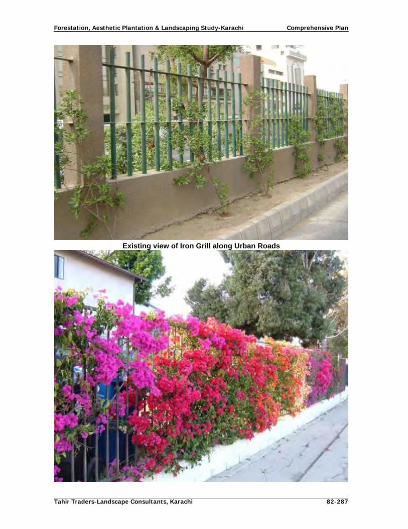
Forestation, Aesthetic Plantation & Landscaping Study-Karachi Comprehensive Plan
Tahir Traders-Landscape Consultants, Karachi 82-287
Existing view of Iron Grill along Urban Roads
Concept Design with Bougainvillea creeper

Forestation, Aesthetic Plantation & Landscaping Study-Karachi Comprehensive Plan
Tahir Traders-Landscape Consultants, Karachi 83-287
Concept Design with climber roses

Forestation, Aesthetic Plantation & Landscaping Study-Karachi Comprehensive Plan
Tahir Traders-Landscape Consultants, Karachi 84-287
Concept Design with climber roses
4.6.8.2. Concept Design of Shahrah-e-Pakistan The concept behind beautification of this important artery of Karachi is to make the road flowery through out the year on both sides and seasonal flowers in the median. Accordingly, a tree and shrub having red flowers through out the year (African tulip) and multi-colored shrub (Bougainvillea) has been proposed. In the median strip yellow flowered Amaltas and multi-colored shrubs are proposed. Along the both sides of this road there is narrow strip where one row of tree and a shrub shall be planted. It is proposed that on both side strips one row of African tulip trees and Bougainvillea shrub be planted in between the trees. The spacing between tree to tree shall be 5 m and between tree to shrub 3 m. A row of Cassia fistula at a distance 5 m, Plumeria obstusa small size tree and one row of Ixora orange shrub on either side of the trees with grass and flowering plants is proposed along the median. Fig.18: Concept Design and Pattern of Plantation along Urban roads
4.6.8.3 Concept Design of University Road

Forestation, Aesthetic Plantation & Landscaping Study-Karachi Comprehensive Plan
Tahir Traders-Landscape Consultants, Karachi 85-287
4.6.8.3 Concept Design of University Road The concept behind proposed design in each section of this main artery of Karachi is to create aesthetic and beautification through multi-colored trees, shrubs and ground cover. Section-wise proposed concept design is as under: Section-1: (Jail Chowrangi to Hassan Square) It is proposed that along both side strips of this section the outer edge row shall be planted with Peltophorum at a distance of 5 m with Lignum and Nerium olender pink single in front row at 10 feet distance. Along median Plumeria obtusifolia (white) in single row and Ixora orange shall be planted. The ground be landscaped and beautified by planting with lawn grass, edge plants and flowering beds in some geometric fashion. Section-2: (Hassan Square to NIPA Chowrangi) It is proposed that along both side strips of this section the outer edge row shall be planted with Peltophorum at a distance of 5 m with Cessalpinia pulcherrima in front of the trees in a single row at a distance of 3 m. Along median Plumeria obtusifolia (white) in single row and Ixia red shall be planted at 3 m distance. The ground shall be landscaped and beautified by planting with lawn grass, edge plants and flowering beds in some geometric fashion. Section-3: (NIPA to Safoorah Goth Chowrangi)
Side strips on both sides of this section of main university road are wide which are proposed to be planted as green belts of shady trees. Arjun (Terminelia arjuna),Azadirichta indica (Neem) at a distance of 6 m and a row of Jatropa panduraefolia at a distance of 3 m are proposed. Along median Guaiacum officinale (Lignum) at a distance of 5 m, with 2 plants of Tecoma radicans in between the trees, lawn grass, edge plants and flower bed is proposed. 4.6.8.4 Concept Design of M. A. Jinnah Road M. A. Jinnah road passes through commercial area where the space available for planting is the foot paths in front of shops. It is thus, proposed to plant shady trees for the comfort of shopkeepers and shoppers. All along side strips from Tower to Jamia Cloth Market Peltophorum, from Jamia Cloth Market to Mazar-e-Quaid Peltophorum and from Mazar-e-Quaid to Jail Chowrangi Delonix regia be planted in gaps at a distance of 5 m. Along median Lignum be restocked and in between trees, Plumeria rubra is proposed to be planted. It is further proposed that Plumeria obstusa and Ixora orange in front are proposed all around Mazar by changing the colour of Ixora shrubs. All the existing trees having good growth and shape shall be retained all along the M. A. Jinnah road. Only crooked, shabby looking, dried and un-wanted trees be re-placed. 4.6.8.5 Concept Design of Main North Nazimabad Road (Shahrah -e- Shershah Suri) Shershah Suri road is an important artery of northern part of Karachi. It has wide side strips and median strips. The concept of tree planting along this road is to beautify it

Forestation, Aesthetic Plantation & Landscaping Study-Karachi Comprehensive Plan
Tahir Traders-Landscape Consultants, Karachi 86-287
through multi-tree species on the side strips and greenbelts in the median. Section-wise proposed concept and choice of species has been proposed as under: Section-1 (Nagan Chorangi to Sakhi Hassan)
Along side strips Delonix regia at a distance of 5 m with Plumeria rubra (white) and along median Bauhinia galipinii at a distance of 5 m with two to three rows of Ixora orange, grass and edge plants on either side and flowering beds in geometric design are proposed to be planted. Section-2 (Sakhi Hassan to 5 Star chorangi) There is no space to raise plantation on the side strips of this road as the available space has either been converted in Nallas or road widened during renovation work leaving no space for tree plantation. The only space available is the central wide strips which are potential for greenbelts. Hence, the concept design has been proposed for the central strip only. Median: Three rows of Butea monosperma at a distance of 5 m between row to row
with two rows Ixora (red), with ground cover of lawn grass, edge plants and flower beds on both sides are proposed. At present the entire belt has been planted with lawn grass.
Section- 3 (5 star to Allawala Chorangi) Median: Three rows of Butea monosperma at a distance of 5 m between row to row
with two rows Ixora (yellow), with ground cover of lawn grass, edge plants and flower beds on both sides are proposed. At present the entire belt has been planted with lawn grass.
Section- 4 (Allahwla Chorangi to Overhead Bridge) Median: Three rows of Butea monosperma at a distance of 5 m between row to row
with two rows Ixora (pink), with ground cover of lawn grass, edge plants and flower beds on both sides are proposed. At present the entire belt has been planted with lawn grass.
Entire Shershah Suri road shall have a greenbelt having colorful trees and shrubs and ground cover. Existing trees and shrubs having good growth and shape shall have to be retained.

Forestation, Aesthetic Plantation & Landscaping Study-Karachi Comprehensive Plan
Tahir Traders-Landscape Consultants, Karachi 87-287
Existing view of Green Belt
Concept Desig Concept Design of Green Belt

Forestation, Aesthetic Plantation & Landscaping Study-Karachi Comprehensive Plan
Tahir Traders-Landscape Consultants, Karachi 88-287
Concept Design for Side Strip
Fig.19: Concept Design and Pattern of Plantation along Urban roads
4.6.8.6 Concept Design of Main Clifton Road (Khayaban-e-Iqbal) This is an important artery of Karachi connecting sea side and posh residential housing societies. Tree plantation efforts have been made in the past with variety of species. All the existing tree cover along sides and in the median shall be retained with gap filling with Sterculia guttata at a distance of 5 m with Ixora yellow on the sides and Cassia fistulas at

Forestation, Aesthetic Plantation & Landscaping Study-Karachi Comprehensive Plan
Tahir Traders-Landscape Consultants, Karachi 89-287
a distance of 5 m with Tabernaemontana coronaria (Single flower) shrub in between trees are proposed in median. There is a wide blank strip on this road between Clifton bridge and Teen Talwar, where a row of Delonix regia followed by a row of Guaiacum officinale trees and Ixora shrub, ground cover, flowering bed and lawn is proposed. 4.6.9 CONCEPT DESIGNS OF CORRIDORS CDGK has declared /notified two corridors by constructing overhead bridges and under passes to avoid signals for free flow of the traffic. The roads which have been made the part of these corridors were already busy roads and to bear the increased load traffic, these roads have further been widened by reducing median and side spaces. Construction of under passes and overhead bridges have also occupied the median and side area which otherwise have been used for aesthetic plantations. Despite all these factors, the corridors are to be planted for beautification and mitigating of vehicular smoke and sound pollution. Following planting design/pattern is proposed according to the space available on sides and in median: 4.6.9.1 Corridor No. 1 (Shahrah e- Faisal to Gul Bai overhead bridge) Section-1 (from Shahrah-e-Faisal to National Stadium) Following concept design is proposed for this corridor:
Along sides one row of Polyalthea longifolia (Ashok) trees at a distance of 5 m, Plumeria rubra shrub in between trees and Bougainvillea in front line with grass and flowers. In median, One row of Cassia fistula at a distance of 5 m and Nerium shrubs of same flower colour may be restocked in gaps. Seasonal flowers and lawn grass and seasonal flower beds may be added. Section -2 (Stadium to Liaquatabad No. 10)
Along sides a row of Cassia fistula trees and Caesalpinia shrubs in between trees with grass and flowers. In median Lignum may be restocked in gaps and in between Ixora shrub with orange flowers be planted with grass and flowers.
Section-3 (Liaquatabad No. 10 to Gulbai)
Along sides a row of Delonix regia trees and Cassia alata shrubs in between with grass and seasonal flowers. In median mix plantation may be replaced with dominating Guaiacum officiniale (Lignum) trees and in between Cassia glauca shrubs with grass and flowers.

Forestation, Aesthetic Plantation & Landscaping Study-Karachi Comprehensive Plan
Tahir Traders-Landscape Consultants, Karachi 90-287
Existing view of Side Strip
Concept Desig
Concept Design for Side Strip

Forestation, Aesthetic Plantation & Landscaping Study-Karachi Comprehensive Plan
Tahir Traders-Landscape Consultants, Karachi 91-287
Existing vie
Existing View of Median
Concept Des
Concept Design of Median

Forestation, Aesthetic Plantation & Landscaping Study-Karachi Comprehensive Plan
Tahir Traders-Landscape Consultants, Karachi 92-287
Existing view of Underpass
Concept Design of Underpass

Forestation, Aesthetic Plantation & Landscaping Study-Karachi Comprehensive Plan
Tahir Traders-Landscape Consultants, Karachi 93-287
Existing view of Hassan Square interchange
Concept Design of Hassan Square interchange

Forestation, Aesthetic Plantation & Landscaping Study-Karachi Comprehensive Plan
Tahir Traders-Landscape Consultants, Karachi 94-287
Corridor II 4.6.9.2 Corridor II This corridor comprises of two roads and is stretched over 10.3 km. Rashid Minhas Road starts from COD overhead bridge and ends at Sohrab Goth overhead bridge, where as other road starts at Sohrab Goth and terminates at Nagin Chowrangi. Presently, except 1.3 km central strip and 6 km scattered plantation with wide gaps on sides, the remaining 9 km in centre and 5 km on sides is blank
All along Corridor II remodeling work of side strips and central median strips has recently been started and is still continuing. Significant changes both in the structure of road and replacement of tree and shrub species have been made. All Eucalyptus trees, selected Lignum and Neem have been replaced. The proposed design and pattern of tree and shrubs are as follows:

Forestation, Aesthetic Plantation & Landscaping Study-Karachi Comprehensive Plan
Tahir Traders-Landscape Consultants, Karachi 95-287
Existing view of Gulshan Chowrangi
Concept Design of Gulshan Chowrangi

Forestation, Aesthetic Plantation & Landscaping Study-Karachi Comprehensive Plan
Tahir Traders-Landscape Consultants, Karachi 96-287
Existing view of Nala and Road Near Nagan Chowrangi
Concept Design for Nala and Road Near Nagan Chowrangi

Forestation, Aesthetic Plantation & Landscaping Study-Karachi Comprehensive Plan
Tahir Traders-Landscape Consultants, Karachi 97-287
Existing view of Corridor II near Power House
Concept Design of Corridor II near Power House

Forestation, Aesthetic Plantation & Landscaping Study-Karachi Comprehensive Plan
Tahir Traders-Landscape Consultants, Karachi 98-287
Existing view of Side Strip of Corridor II
Concept Design of Side Strip of Corridor II

Forestation, Aesthetic Plantation & Landscaping Study-Karachi Comprehensive Plan
Tahir Traders-Landscape Consultants, Karachi 99-287
Existing view of Corridor-II median near NIPA
Concept Design of Corridor-II median near NIPA

Forestation, Aesthetic Plantation & Landscaping Study-Karachi Comprehensive Plan
Tahir Traders-Landscape Consultants, Karachi 100-287
Existing view of Corridor-II median & Side Strip near NIPA
Concept Design of Corridor-II median & Side Strip near NIPA

Forestation, Aesthetic Plantation & Landscaping Study-Karachi Comprehensive Plan
Tahir Traders-Landscape Consultants, Karachi 101-287
Existing view of Corridor-II median
Concept Design of Corridor-II median

Forestation, Aesthetic Plantation & Landscaping Study-Karachi Comprehensive Plan
Tahir Traders-Landscape Consultants, Karachi 102-287
Existing view of Corridor-II median
Concept Design of Corridor-II median

Forestation, Aesthetic Plantation & Landscaping Study-Karachi Comprehensive Plan
Tahir Traders-Landscape Consultants, Karachi 103-287
Section -1 (COD Bridge to NIPA bridge) Sides: On both sides presently scattered Azadrichta indica (Neem) trees are planted over 3m wide strip up to Millennium Mall. It is proposed that gaps shall be filled with same tree species and in between trees, Bougainvillea be planted. Median: Lignum trees in Centre and Nerium shrub on both sides at a distance of 3 m are proposed with grass and flowers. Section -2: (NIPA to Sohrab goth) Sides: One row of Cassia fistula trees and in between Punica granatum shrubs
with grass and flowers according to available space is proposed. Median: One row of Lignum at a distance of 5 m, Caesalpinia pulcherrima and
bougainvillea white on its both sides with grass and flowers. Section – 3: (Sohrab goth to Nagan Chorangi) Sides: A row of Cassia fistula trees at a distance of 5 m, Lagerstroemia shrubs in
front of trees on either side with grass and edge plants. Median: A row of Plumeria rubra small size tree and Tecoma radicans shrubs on its
both sides with grass and flowering plants. Healthy and good looking existing vegetation shall be retained. Trees/shrubs of poor quality shall be replaced with suggested trees and shrubs. Fig.20: Concept Design and Pattern of Plantation along Urban roads 4.6.10 CONCEPT DESIGNS OF MAJOR ROADS 4.6.10.1 Shaheed-e- Millat Road This dual carriage way with service roads emerges at Jail roundabout and terminates at Shahrah -e-Faisal at Baloch over head bridge. Total length of above road is 3.3 km. In the median lignum trees mixed with conocarpus and other species have been planted. Major roads of the area such as Jamaluddin Afghani road, Tariq road, Siraj-u-ldula road, Hyder Ali road, Ameer Khusro road Tipu Sultan road, cross this road. All the crossings are at traffic signal points where monuments at Jail,Tariq road and Sirajuldula roads have been built. On sides, scattered mix trees of Eucalyptus, Lignum, Conocarpous up to Naheed super store have been planted. Afterwards a dense patch of several species are planted

Forestation, Aesthetic Plantation & Landscaping Study-Karachi Comprehensive Plan
Tahir Traders-Landscape Consultants, Karachi 104-287
up to Shah Faisal. This is excellent piece of plantation in entire Karachi where almost all the tree species available in Karachi are available in healthy condition. Though there is sufficient aesthetic view but proper landscaping is lacking. All along this urban road trees of different species have been planted both along the sides and in the median. There is little space left for introducing new concept design. In spite of this scenario following pattern and species along side strips and median is proposed. Sides: A row of Delonix regia and Guaiacum officinale trees on both sides on back
and Tabernamontania coronaria shrub row in front with grass and flowering plants.
Median: Lignum may be restocked in gaps and in between Jatropha curcus (Ratan
jot) in between the trees. All existing plantation shall be retained except un-wanted and dominated trees. 4.6.10.2 Pir Sibgatullah Shah Rashdi -Dalmia Road It is proposed to plant shady trees on both sides of this road and medium-sized trees with green foliage to enhance the beauty and tree cover of the road. Section-wise proposals are as follows: Section-I: Jail Chowrangi to National Stadium Sides: Azadirichta indica at the distance of the 6m with Fiddle wood, Cessalpenia
pulcherrimia in between the trees as a front row is proposed. Median: Plumeria rubra at a distance of 5 m with 2 Ixora orange plants in between
are proposed. Section-II: National Stadium to Millennium Mall Sides: Azadirichta indica at the distance of 5 m with 2 plants of Tabernamontana
coronaria (Single flower) Median: Plumeria obtusifolia at a distance of 5 m with 2 Lagerstroemia indica in
between the trees. The iron grill in this section shall be planted with colorful climbers on both sides of grill at a suitable spacing between two climbers. Existing shrub vegetation shall be retained unless technically required. 4.6.10.3 I. I . Chundrigar Road It is proposed to retain existing tree cover along both sides of this road. There is no space to plant as the narrowness of road, passing from commercial area and heavy vehicular traffic do not allow to induct trees. However, the multi-national companies, market places, banks etc. shall be encouraged to beautify their frontages with potted plants of large sizes. Another alternative is to plant trees along the walls of the railway (inside) with Polyalthea longifolia (Ashok tree) with Bougainvillea are planted to get at least some green effect on this road in front of railway area. The offices compound areas should be directed to plant Polyathea longifolia along their compound wall for beautification of the building and road.

Forestation, Aesthetic Plantation & Landscaping Study-Karachi Comprehensive Plan
Tahir Traders-Landscape Consultants, Karachi 105-287
4.6.10.4 Korangi Road It is proposed to plant one row of Casia nodusa at a distance of 5 m with front row of Tecoma stans shrub from FTC bridge to Kala pul. 4.6.10.5 Shahrah-e-Quaideen Over-aged Eucalyptus trees shall be replaced and on side strips one row of Delonix regia at a distance of 5 m with two rows of Lagerstromea and Tabernamontana shrubs are proposed up to society office. Along median, Lignum trees shall be restocked with Ixora shrub in between the trees. 4.6.10.6 Awane-e-Saddar Road Crataevairelegosa (Berna), to be restocked on both the sides. The flowering beds to be extended on both sides of the road and different ground covers with different shrubs as background of each bed. 4.6.10.7 Abdullah Harron Road The gaps in between the fully grown up trees be filled up with Albizzia lebbeck (Siris) along both sides and Guaiacum officinale to be restocked and in between the trees 2 plants of Ixora amabilis are proposed to be planted in the median.. In the triangle near Jinnah fountain the flowering bed should be filled with Ixora orange. A green strip which is lying vacant should be developed with trees, shrubs and flowers with some water fall effect.

Forestation, Aesthetic Plantation & Landscaping Study-Karachi Comprehensive Plan
Tahir Traders-Landscape Consultants, Karachi 106-287
Existing view of Business Street-Saddar
Concept Design of Business Street-Saddar

Forestation, Aesthetic Plantation & Landscaping Study-Karachi Comprehensive Plan
Tahir Traders-Landscape Consultants, Karachi 107-287
Existing view of Business Street Saddar
Concept Design of Business Street Saddar

Forestation, Aesthetic Plantation & Landscaping Study-Karachi Comprehensive Plan
Tahir Traders-Landscape Consultants, Karachi 108-287
4.6.10.8 Korangi, Landhi and SITE Industrial Area Roads The main objectives of industrial area roads are i) to increase tree cover to mitigate the polluted environment created by industries and ii) to beautify these roads by tree plantation along side strips and wide medians through greenbelts and roundabouts. Following are the proposed concept designs and plantation patterns for each road: 4.6.10.9 S. M Farooq Road The concept design shall be large tree, medium tree and shrub combination along side strips and for median strips greenbelts of multi-species at fairly close spacing combined with shrubs and ground cover. Following are the proposals: Sides: In outer row Roystromea regia at a distance of 5 m, Delonix regia in second
row with Tecoma radican shrubs in front are proposed. Where space allows the ground cover species shall be planted.
Median: Median is to be developed as greenbelt and Guaiacum officinale with
Plumeria rubra on both sides with Casealpinin pulcherrima be planted at 15 feet spacing and lawn grass, edge plants and flowering beds.
4.6.10.10 Shahrah-e-Darul Uloom Sides: In outer row Roystromea regia at a distance of 5 m, Delonix regia in second
row with Tecoma radican shrubs in front are proposed. Where space allows the ground cover species shall be planted.
Median: Median is to be developed as greenbelt and Guaiacum officinile with
Plumeria obstusa on both sides with Tabernamontana coronaria be planted at 5 m eet spacing and lawn grass, edge plants and flowering beds.
4.6.10.11 Dawud Chowrangi to Korangi Crossing via Nasir Jump (10,000 road) Sides: Azadrichta indica (Neem) at distance of 5 m with Cassia alata in between Median: Restocking with Lignum trees. 4.6.10.12 Korangi 5000 Road Sides: Albizia lebbek trees at 6 m with Nerium shrubs in between Median: Lignum trees with Bougainvillea shrubs.

Forestation, Aesthetic Plantation & Landscaping Study-Karachi Comprehensive Plan
Tahir Traders-Landscape Consultants, Karachi 109-287
Fig.21: Concept Design and Pattern of Plantation along Urban roads
4.6.10.13 Korangi 4000 road Sides: Albizia lebbeck trees at a distance of 6m on either sides are proposed to make tunnel road 4.6.10.14 SITE Police station-Valika Mill Since scattered plantation exists on sides and in median, side gaps shall be filled with Azadrichta indica and median with lignum trees. In between Lignum trees, Lagerstromea shrubs are proposed. 4.6.10.15 Other Roads Sides: Thespisia populnea at a distance of 5 m, single row with Bougainvillea pink
in front of the trees on both sides. Median: Lignum trees at a distance of 5 m with Nerium oleander red in between the
trees, grass/edge plants. Existing trees having good growth and form shall be retained. Gap filling in the blank areas shall be carried out where required. 4.6.10.16 Allama Shabir Ahmed Usmani Road : Sides: Cassia fistula (Amaltas) at a distance of 5 m, single row with Lagerstroemia
indica in front of the tree at a distance of 3 m. Median: Guaiacum officinale at a distance of 5 m with 2 plants of Cassia multijoba in
between the trees, grass and edge plants. 4.6.10.17 Main Gulistan-e-Johar Road Sides: Milletia piguienis at a distance of 5 m Median: Guaiacum officinale at a distance of 9 km with Callindra hyberida.

Forestation, Aesthetic Plantation & Landscaping Study-Karachi Comprehensive Plan
Tahir Traders-Landscape Consultants, Karachi 110-287
4.6.10.18 Darul-Islam to University and Officers Colony to University Roads Sides: Polyalthea longifolia at 5 m with Nerium shrubs. Median: Guaiacum officinale at a distance 5 m to be restocked with Bougainvillea
red. 4.6.10.19 Johar Mor to University Road via Johar and Kamran Chowrangies Sides: Dellenia pentagyna at a distance of 5 m on both sides. Median: Punica granatum at the distance of 5 m t with Bougainvillea white. 4.6.10.20 Safooran Goth to Main Gulistan Johar Road (at Pehlwan Mor) Sides: One row of Calophyllum inophyllum at distance of 5 m is proposed. Median: Bauhinia with Caeselpinia shrub in between trees 4.6.10.21 Choudhry Fazul Ellahi Road Sides: Azadirichta indica on both sides at a distance of 5 m Median: Guaiacum officianale at a distance of 5 m with 1 row of Cessalpenia
pulcherrima at a distance of 4 m on both sides of the tree. 4.6.10.22 Captain Haleem Siddiqui Road
Sides: Azadirichta indica on both sides at a distance of 5 m Median: Guaiacum officinale at a distance of 7 m with 1 row of Nerium oleander
white at a distance of 4.5 m on both sides of the tree. 4.6.10.23 Dr. Ziauddin Ahmed Road Sides: Delonix regia (Gul Mohar) at a distance of 5 m, with 2 plants of Lagerstomia
indica, in between trees on both sides. Median: Butea monosperma (Dhak), at a distance of 5 m with Ixora (Pink) in
between the trees. 4.6.10.24 Mai Kolachi Road Sides: Cocos nucifera at a distance of 8 m, in a single row in between Lignum and
Nerium oleander (Pink) a distance of 10 feet in the front. Median: Guaiacum officinale at a distance of 5 m with 2 plants of Bougainvillea
(white) in between the trees. 4.6.10.25 Tariq Road Sides: Polyalthea longifolia along the wall of the graveyard and at suitable spaces
available for plantation on both sides in front of shopping centers.
Median: Guaiacum officianale to be restocked and Lagerstroemia indica pink to be planted in between the trees.

Forestation, Aesthetic Plantation & Landscaping Study-Karachi Comprehensive Plan
Tahir Traders-Landscape Consultants, Karachi 111-287
4.6.10.26 Manghopir road Sides: Albizzia lebbeck at the distance of 5 m with Bougainvillea red in between. Median: Guaiacum officinale at the distance of 5 m with Bougainvillea in between. 4.6.10.27 Nishtar Road The gaps in between the trees should be filled with Samanea saman. Sides: Samanea saman (Rain Tree) at a distance of 6 m. Median: Guaiacum officinale at a distance of 5 m. (Instant trees should be planted
because of thickly populated area. 4.6.10.28 Allama Dawoodpota Road Sides: Cocos nucifera to be restocked on both sides with Cassia fistula and a row
of group plantation of Tabernamontana coronaria (Single flower) Chandni, and in between the groups Lagerstomia shrub.
4.6.10.29 Gulzar-e-Hijri Scheme 33 roads There are about 90 km roads in this scheme which are to be planted on sides and in median strips. It is proposed that any tree among Peltophorum, Delonix regia, Cassia fistula, Polyalthea longifolia and Milletia peguienis with shrubs such as Nerium, Caselpenia, Bougainvillea, Ixora, Hamellia shrubs are proposed on sides. To break the monotony, one species shall not be panted over more than 2-3 km. In median, trees such as Lignum, Callistemon, Plumeria, and Fiddlewood with any of the above shrubs are proposed. 4.6.10.30 Kashmir Road Sides: Polyalthea longifolia pendulata at the distance of 5 m. Median: Callistemon lancedatus at a distance of 5 m with Accalipha (red variegated). 4.6.10.31 Khayaban-e-Saadi Sides: Conocarpus trees planted in gaps Median: Guaiacum officinale to be restocked with Nerium shrubs (red) 4.6.10.32 Khayaban-e-Galib Sides: Thespisia populnea at a distance of 5 m with Tecoma stans Median: Plumeria obustusifolia at a distance of 5 m with Cassia multijoba. 4.6.10.33 Kalid Bin Waleed Road Median: Lignum trees may be restocked in the gaps.

Forestation, Aesthetic Plantation & Landscaping Study-Karachi Comprehensive Plan
Tahir Traders-Landscape Consultants, Karachi 112-287
4.6.10.34 Allama Iqbal Road Sides: Delonix regia at a distance of 5 m. Median: Guaiacum officinale at a distance 5 m with Nerium Oleander pink. 4.6.10.34 Khayaban-e-Saadi road Sides: Conocarpus trees planted in gaps Median: Guaiacum officinale to be restocked with Nerium shrubs (red) 4.6.10.35 Khayaban-e-Ghalib Road Sides: Thespisia populnea at a distance of 5 m with Tecoma stans Median: Plumeria obustusifolia at a distance of 5 m with Cassia multijoba. 4.6.10.37 Other Roads of North Nazimabad There several roads crossing main road in North Nazimabad area namely Babar, Jahangir, Hamayoon and Shahrah-e-Noorjahan roads stretching over about 20 km. Plantation has been carried out along all roads in the past. Of the total length an area of about 33% are planted with various species and the rest area is blank. Central lines of these roads are generally occupied by drainage nallas. 4.6.10.38 Road from Nazimabad Over Head Bridge to Lasbela Bridge There is no median in most of these roads. Hence side plantation shall be restocked with Lignum tress already planted over these roads 4.6.10.39 Allama Rashid Turabi Road Sides: Delonix regia at a distance of 5 m on both sides. 4.6.10.40 Sher Shah Road Sides: Thespisia (Parus �eople) is recommended in pits left in cemented foot paths Median: Lignum trees are planted in the gaps. 4.6.10.41 Shahrah-e-Liaquat Conocarpus trees are proposed to be planted in Chakiwara green strips /park only. 4.6.10.42 Nawab Dilawar Khanji Road It is a dual carriage way with a central strip which having grill and electric poles in the center. The total length of this road is 1.8 Km. There are shops on both sides of the road. No provision on this road for plantation except the Kharadar hospital where small patch can be established. Hence, Conocarpus planting is recommended in front of Johar park and hospital

Forestation, Aesthetic Plantation & Landscaping Study-Karachi Comprehensive Plan
Tahir Traders-Landscape Consultants, Karachi 113-287
4.6.10.43 Mirza Adam Khan Road Sides: Conocarpus trees are proposed to be planted on sides Median: Lignum trees are proposed in 1 km blank strip. Slopes of Lyari river embankment can be planted with Bougainville. 4.6.11 Per unit cost estimates of Urban roads Per unit cost estimates for Urban roads have been calculated on the basis of prevalent Government of Sindh/ CDGK/ Market rates ( Table-7) Table: 7 Per unit cost estimates of Urban roads
Cost Estimates for 1.0 km Plantation (2 rows of trees& 2 rows of shrubs each side)
Item of Work Unit Qty.
Total Quantity. Unit Cost
Total Cost
Site Clearance (Rs) (Rs)
Bulldozer (hrs) 30 30 3000 90,000
Manual (man days) 25 25 300 7,500
Leveling
Tractors (hrs) 30 30 800 24,000
No. of plants at 5 m distance 200 800 250 200,000
E. Work of pits :3x3x3= 27x 528 27 21600 1.06 22,896
Sweet earth 70% 70% 15120 15 226,800
Farm Yard Manure 30% of 27cft = 8 x 528 30% 6480 15 97,200
Failure of plants 15% of 528 = 80 10% 80 250 20,000
No. of shrub saplings at 5 m distance 200 800 200 160,000
E. work of pits for shrubs: 2 x 2 x2 8 3520 1.06 3,731
Sweet earth 70% of 8 cft = 5 x 440 pits 70% 2200 15 33,000
Farm Yard Manure 30% of 8 cft = 3 x 440 30% 1320 15 19,800
Failure of shrub saplings 10% 80 200 16,000
Stacking 800 800 50 40,000
Sub-total 960,927
Miscellaneous Lump-
sum 39,073
Total 1,000,000
Cost for 1.0 km Plantation (2 rows of trees each side)
Item of Work Unit Qty.
Total Quantity. Unit Cost
Total Cost
Site Clearance (Rs) (Rs)
Bulldozer (hrs) 20 20 3000 60,000
Manual (man days) 25 25 300 7,500
Leveling
Tractors (hrs) 20 20 800 16,000
No. of plants at 5 m distance 200 800 250 200,000
E. Work of pits :3x3x3= 27x 528 27 21600 1.06 22,896
Sweet earth 70% 70% 15120 15 226,800

Forestation, Aesthetic Plantation & Landscaping Study-Karachi Comprehensive Plan
Tahir Traders-Landscape Consultants, Karachi 114-287
Farm Yard Manure 30% of 27cft = 8 x 528 30% 6480 15 97,200
Failure of plants 15% of 528 = 80 10% 80 250 20,000
Sub-total 650,396
Miscellaneous Lump-
sum 49,604
Total 700,000
Cost Estimates of 1.0 km Plantation (1 Row of tree on each side)
Item of Work Unit Qty.
Total Quantity. Unit Cost
Total Cost
Site Clearance (Rs) (Rs)
Bulldozer (hrs) 25 25 3000 75,000
Manual (man days) 25 25 300 7,500
Leveling
Tractors (hrs) 30 30 800 24,000
No. of plants at 5 m distance 200 400 250 100,000
E. Work of pits :3x3x3= 27x 528 27 10800 1.06 11,448
Sweet earth 70% 70% 7560 15 113,400
Farm Yard Manure 30% of 27cft = 8 x 528 30% 3240 15 48,600
Failure of plants 15% of 528 = 80 10% 40 250 10,000
Stacking 400 400 50 20,000
Sub-total 409,948
Miscellaneous Lump-
sum 30,052
Total 440,000
Cost Estimates for 1.0 km Road side/Median Plantation (1 Row of trees + 2 rows of shrubs)
Item of Work Unit Qty.
Total Quantity. Unit Cost
Total Cost
Site Clearance (Rs) (Rs)
Tractors (hrs) 20 20 800 16,000
Manual (man days) 50 50 300 15,000
No. of Tree saplings at 5 m distance 200 200 250 50,000
E. Work of pits :3x3x3 27 5400 1.06 5,724
Sweet earth 70% 70% 3780 15 56,700
Farm Yard Manure 30% of 27cft = 8 x 528 30% 1620 15 24,300
Failure of plants 15% of 528 = 80 10% 20 250 5,000
No. of shrub saplings at 5 m distance 200 400 200 80,000
E. work of pits for shrubs: 2 x 2 x2 8 3200 1.06 3,392
Sweet earth 70% of 8 cft = 5 x 440 pits 70% 2240 15 33,600
Farm Yard Manure 30% of 8 cft = 3 x 440 30% 960 15 14,400
Failure of shrub saplings 10% 40 200 8,000
Stacking 200 200 50 10,000
Sub-total 322,116
Miscellaneous Lump-
sum 23,916
Total 346,032
Miscellaneous

Forestation, Aesthetic Plantation & Landscaping Study-Karachi Comprehensive Plan
Tahir Traders-Landscape Consultants, Karachi 115-287
Cost Estimates for the Establishment of 1.0 km Road (1 Row of trees)
Item of Work Unit Qty.
Total Quantity. Unit Cost
Total Cost
Site Clearance (Rs) (Rs)
Bulldozer (hrs) 5 5 3000 15,000
Manual (man days) 15 15 300 4,500
Leveling
Tractors (hrs) 10 10 800 8,000
No. of Tree saplings at 5 m distance 200 200 250 50,000
Digging of pits at 25’ distance: 3x3x3= 27x 132 27 5400 1.06 5,724
Sweet earth 70% 3780 15 56,700
Farm Yard Manure 30% of 27cft = 8 x 132 30% 1620 15 24,300
Failure of plants 15% of 132 = 20 10% 20
Stacking = 1 per plant 200 200 50 10,000
Sub-total 174,224
Miscellaneous Lump-
sum 19,080
Total 193,304
Cost for Planting Climbers on barbed wire/Iron Grills along Roads (1 Row)
Item of Work Unit Qty.
Total Quantity. Unit Cost
Total Cost
Site Clearance (Rs) (Rs)
Manual (man days) 25 25 300 7,500
No. of climber saplings: at 2m distance 500 500 0
Digging of pits for shrubs: 2 x 2 x2 = 8 x 500 8 cft 4000 1.06 4,240
Sweet earth 70% of 8 cft = 5.5 x 330 pits 70% 2800 15 42,000
Farm Yard Manure 30% of 8 cft = 2.5 x 330 30% 1200 15 18,000
Cost of sapling, transport and planting500+75=575 10% 50 100 5,000
Sub-total 76,740
Miscellaneous Lump-
sum 13,260
Total 90,000
Cost Estimates for 1.0 km Median Plantation (1 Row of shrubs)
Item of Work Unit Qty.
Total Quantity. Unit Cost
Total Cost
Site Clearance (Rs) (Rs)
Manual (man days) 25 25 300 7,500
No. of shrub saplings:3300/10=330
Digging of pits for shrubs: 2 x 2 x2 = 8 x 330 8 cft 2640 1.06 2,798
Sweet earth 70% of 8 cft = 5.5 x 330 pits 5.5 cft 1815 15 27,225
Farm Yard Manure 30% of 8 cft = 2.5 x 330 2.5 cft 825 15 12,375
Failure of shrub saplings 15% of 330 = 50 50
Cost of shrub saplings+transportation (1 yr) 330 +50 380 250 95,000
Stacking = 1 per plant 330 330 50 16,500
Sub-total 161,398
Miscellaneous Lump-
sum 15,328
Total 176,726

Forestation, Aesthetic Plantation & Landscaping Study-Karachi Comprehensive Plan
Tahir Traders-Landscape Consultants, Karachi 116-287
Cost Estimates for 1.0 km Median Plantation (2 rows of shrubs)
Item of Work Unit Qty.
Total Quantity. Unit Cost
Total Cost
Site Clearance (Rs) (Rs)
Manual (man days) 50 50 300 15,000
No. of shrub saplings:220 x 2 x 2 = 440
Digging of pits for shrubs: 2 x 2 x2 = 8 x 440 8 3520 1.06 3,731
Sweet earth 70% of 8 cft = 5 x 440 pits 2200 2200 15 33,000
Farm Yard Manure 30% of 8 cft = 2 x 440 1320 1320 15 19,800
Failure of shrub saplings 15% of 440 =66
Cost of shrub saplings+transportation (1 yr) 440+66 506 250 126,500
Stacking 440 440 50 22,000
Sub-total 220,031
Miscellaneous Lump-
sum 15,604
Total 235,635
Cost Estimates for 1.0 km Median Plantation (1 Row of trees + 1 rows of shrubs)
Item of Work Unit Qty.
Total Quantity. Unit Cost
Total Cost
Site Clearance (Rs) (Rs)
Manual (man days) 40 40 300 12,000
No. of Tree saplings:132 x 1= 132 132 132 0
Digging of pits at 25’ distance: 3x3x3= 27x 132 27 cft 3264 1.06 3,460
Sweet earth 70% of 27cft = 19 x 132 pits 19 2508 15 37,620
Farm Yard Manure 30% of 27cft = 8 x 132 8 1156 15 17,340
No. of shrub saplings:220
Digging of pits for shrubs: 2 x 2 x2 = 8 x 220 8 1760 2.3 4,048
Sweet earth 70% 1232 1232 15 18,480
Farm Yard Manure 30% 528 528 15 7,920
Failure of tree saplings 15% of 132=20
Failure of shrub saplings 15% of 220 = 33
Cost and transportation of tree saplings (2 yr) 132+20 152 200 30,400
Cost of shrub saplings+transportation (1 yr) 220+33 253 250 63,250
Stacking 405 352 50 17,600
Sub-total 212,118
Miscellaneous Lump-
sum 13,835
Total 225,953
Note
The rates per acre on establishment of Micro-irrigation method shall be added
Allowable cost escalation on market rates and GOS 2004 Schedule of Rates as on June 2008 may be added.

Forestation, Aesthetic Plantation & Landscaping Study-Karachi Comprehensive Plan
Tahir Traders-Landscape Consultants, Karachi 117-287
4.6.12 RIVERS 4.6.12.1 Malir River Objectives of Development The land is a very precious commodity particularly a big chunk located in the heart of the Metropolis Karachi. This land can not be used for any one purpose such as planting but there are several limitations also on its use being located in the bed of the river. Its two km width and steepness indicates that at some period of time, water has flown to that extent in this river and this can happen again in any rainy season in future. The record of Irrigation Department Thatta about the storm water flow is silent. The available data indicates that during heavy rains in the years 1975, 112,000 cusec (3360 m3) of water with average depth of 12 feet (3.7 m) passed through this river. Hence, no any permanent structure is advisable to be constructed in its bed but it can be utilized for the establishment of trees, play grounds and recreational purposes. Hence, following uses are proposed for Malir river bed land:
View of land use and Malir Bund along River

Forestation, Aesthetic Plantation & Landscaping Study-Karachi Comprehensive Plan
Tahir Traders-Landscape Consultants, Karachi 118-287
Recreation Karachites are confronted with a number of serious health and social issues such as air, water and sound pollution, depression, diabetes, obesity, unemployment, street crime and suicide to name a few. The trend towards a sedentary lifestyle particularly in youth is recognized as a major contributor towards many health and social issues. CDGK better understand the benefits of recreation facilities for combating these challenges and plans to develop more recreation opportunities to address these alarming social and health trends.
The present population of the metropolis is about 18.00 million and as per an estimate, it will reach 27.5 million by 2020 (KSMP 2020, 2007). The ratio of young population who need the recreation most and has sufficient time is significant. Participating in recreation activities helps develop our youth, improve their education and deters them from negative behaviors. Social bonds are also improved when families recreate together and when seniors and individuals with disabilities are actively engaged in recreation activities. Recreation and park facilities help promote social bonds by uniting families, encouraging cultural sensitivity, and supporting seniors and individuals with disabilities. The combined values that may be gained are almost endless and has a positive economic impact and value to the community. The aggregate impact of these health and social benefits makes parks and recreation one of the most cost-effective public services available to decision-makers Hence, it is proposed to develop structures which are not damaged by flood water such as parks for general public and play grounds for school, college and university students and youth to play cricket, soccer, basket ball, lawn tennis, and traditional games on both banks of the river. Children amusement parks, walking and cycling trails shall also be developed in addition to open spaces for learning driving and other social activities.
Fruit Orchards Since the soil of Malir River bed is suitable for agriculture and subsoil water and sewerage water after treatment can be made available, fruit orchards of Guava, Coconut, Chikoo, Papaya, Custard Apple, Jaman, Date palm and Mango are proposed to be established over about 200 ha near flood protection bunds and away from river current. The fruit trees will ameliorate the environment, provide food to the citizens of Karachi and create employment to local people. It is recommended that fruit orchards be established under Public Private Partnership (PPP) under agreed terms and conditions. Palm Oil Plantations The climate of Karachi is most suitable for establishing Palm oil plantations which not only improve the environment and aesthetic value of the city but these plantations will produce edible oil, provide jobs and save foreign exchange. PPP option is the best for establishing Oil Palm Plantations over about 200 ha between river bed and flood protection bunds. CDGK shall offer land and rest of the expenses and benefits shall be negotiated with the private entrepreneurs. Tree Plantations City District Government Karachi gives high priority to environmental improvement through extensive planting of trees and shrubs in all possible open / blank spaces including river beds in its jurisdiction. The increased vegetation will mitigate the pollution by sequestering

Forestation, Aesthetic Plantation & Landscaping Study-Karachi Comprehensive Plan
Tahir Traders-Landscape Consultants, Karachi 119-287
Carbon dioxide and other green house gases and by pumping oxygen in the atmosphere. Besides, trees provide recreation, wood and several products to the citizens of Karachi. Trees also increase the fertility of land, reduce erosion, moderate the temperatures and recharge ground water by increasing infiltration. Besides, these plantations will provide recreational and entertainment facilities to the citizens of Karachi. Construction of Malir Expressway City District Government has planned to construct Malir Expressway for reducing the traffic pressure on existing roads. It is proposed that a 14 km two lane dual carriage Expressway will be constructed on its left bank with one side on the earthen bund and other side starting from the toe outside existing bund. Trees are proposed to be planted only on the outer side of the expressway. Land use The available area for planting in Malir river bed is about 3500 acres (1416 ha). If a 45 m wide river bed in the centre is excavated all along its width, it will cover less than a 100 ha area in river bed. After leaving area under spurs, etc, about 245 ha area will be left which is proposed for establishing play grounds, parks and recreational facilities which are not damaged by the river flow in flood season. Concept Designs of Forestation There are different designs for forestation of the areas such as Block Planting, Linear planting, Grove planting, Scattered Tree Planting, etc., but the Block plantation will be the most suitable pattern for planting in Malir river bed. Tree plantations will be raised near river bed after leaving 55 m water current area and some additional area for increased flow of water. Immediately after plantation blocks, fruit orchards and oil palm plantations will be established up to river protection bund. The play grounds and recreation places will be scattered all along the river length alternating with plantation and orchards to facilitate the neighbouring public located along its length. The plantations will be raised in small blocks of 8-16 ha according to the area available at that site. A 4-6 m wide kacha road/path will be constructed around/all sides of each block for easy access. In case of flow irrigation, each block will be divided in equal size strips of 30-35 m and each strip will further be divided in square plots. It is proposed to install micro irrigation system preferably drip irrigation system for plantation in Malir river. Well grown 1.5-2 m tall plants will be planted in pits at a distance of 5 m from plant to plant and row to row. Planting Techniques There are several planting techniques such as through seeding, branch cutting, root shoot cutting, planting of saplings or well grown up plants with ball of earth. In river beds, planting of well established plants raised in big size earthen pots or in polythene bags will be most suitable method of planting. The planting shall be done immediately after rainy season so that plants establish their root system before the start of next rainy season. Since the soil of river bed is suitable for planting, fresh soil is not required for mixing or replacement. However, FYM shall be mixed with pit soil to increase fertility and retain soil moisture. Pits of size 1m*1m*1m shall be dug to accommodate the ball of earth or big size polythene bag. These plants shall carefully be transported so that they are not damaged in transit. After planting, soil of the pit is pressed with foot and immediately irrigated to remove air from the pit. If required, plants may be stacked to hold them straight against

Forestation, Aesthetic Plantation & Landscaping Study-Karachi Comprehensive Plan
Tahir Traders-Landscape Consultants, Karachi 120-287
wind. The space between plant to plant shall be wider (8-10 m) so as to have minimum obstruction while water flows in the river. Nurturing and protection The young plantation shall be irrigated at regular intervals and protected from grazing and other damages. To give it a proper form or shape to the tree, proper pruning of its branches is necessary without affecting its growth process. Choice of Species Choice of species depends upon the objective of planting. Under above given objectives, big shady forest trees with dense foliage are proposes for river bed planting. Trees such as Neem, Siris, Rain tree, Eucalyptus, Babul, Gul Mohar, Amaltas, Peltophorum, African tulip, Simal, Conocarpus etc. are proposed.

Forestation, Aesthetic Plantation & Landscaping Study-Karachi Comprehensive Plan
Tahir Traders-Landscape Consultants, Karachi 121-287
Fig. 22: Spatial Details of Malir River
Sp
ecification of M
alir River from
Quaid A
bad
Brid
ge to Koran
gi Op
posite to Hin
o Chow
rangiL
ength
= 15 km
, River B
ed Area=
14 Sq
Km
, Average B
ed w
idth
= 0.934 k
m

Forestation, Aesthetic Plantation & Landscaping Study-Karachi Comprehensive Plan
Tahir Traders-Landscape Consultants, Karachi 122-287
4.6.12.2 LYARI RIVER Objectives of Development Although urban lands in centre of the city are very precious, but the narrow strips measuring 30-90 m on both bank of Lyari River can only be used for raising plantations. Since this river passes through the heart of the city and in zigzag or curve fashion, the plantation along the both sides of river bed will give a pleasant look while traveling along expressway and by air. City District Government Karachi has attached priorities to the improvement of the environment through extensive increase in vegetation in all possible open / blank spaces including river beds in its jurisdiction. The increased vegetation will mitigate the pollution by sequestering CO2 and other green house gases and by pumping oxygen in the atmosphere. Trees also increase the fertility of land, reduce erosion and moderate the temperatures. Besides, trees provide recreation, produce wood and several products to the citizens of Karachi. Land use Lyari river is one of the seven outfalls carrying sewerage and storm water flows from its catchments and urban areas to sea. The length of the river from Sohrab goth to Gulbai is 14.2 km occupying an area of 1.9 sq km having average width of 0.0934 km (GIS report).. A bulk water supply line of 84 cm dia for Lyari town is passing under its south bound side bed from near Sindhi hotel to Gulbai at a depth of 1.5 m and located 6.2 m from the apron of expressway. As regards the maximum flow of storm water in this river, no data was available with the concerned agencies. However, it was informed, that in future; lyari river will be used for the discharge of storm water only as sewerage water will be discharged by constructing a conduit under its bed at the location of present stream flow. Lyari Expressway has been constructed on its banks. Concept Design for River Bed Plantation There are different designs or layout systems of planting, but only linear plantation design suits the narrow longitudinal strip of Lyari River. The distance between trees and rows will be 6 m and 5 m respectively in alternate pattern/fashion. The trees will be planted 3 m away from the stream flow, bulk water supply line and edge of the apron. Mixed trees are avoided and one species is not recommended for more than two km to avoid monotony and secure from epidemics. Concept Design of Lyari Express Embankments All along the express way in a length of 14.2 km, colorful climbers are to be planted at the base of the sloping embankments to beautify and cover stone pitched surface of the bunds up to berms of the road.

Forestation, Aesthetic Plantation & Landscaping Study-Karachi Comprehensive Plan
Tahir Traders-Landscape Consultants, Karachi 123-287
Fig. 23: Spatial Details of Lyari River
Lyari R
iver Section
from Soh
rab G
oth to G
ul B
ai L
ength
14.22 km
, Area 1.9 S
q K
m, A
verage wid
th 0.139 k
m

Forestation, Aesthetic Plantation & Landscaping Study-Karachi Comprehensive Plan
Tahir Traders-Landscape Consultants, Karachi 124-287
Choice of Species Rain tree, Siris, Ficus, Date palm, Coconut, Jaman, Neem, Babul, Eucalyptus are recommended to be planted as per above design and Bougainvillea climber of different colours on the stone pitching. Coconut, Date palm and Jaman are proposed to be planted under PPP option on agreed terms and conditions. Water availability and quality Sufficient quantity of sewerage water flowing in the river is suitable for irrigation purposes. The possibility of installation of treatment plants in lyari river was discussed with the experts who also thought it necessary for plantation purposes one million gallon treatment plant will require at least one acre land which at present is not available outside river embankments due to thickly populated area.
Lyari River Showing the location of Bulk water supply line

Forestation, Aesthetic Plantation & Landscaping Study-Karachi Comprehensive Plan
Tahir Traders-Landscape Consultants, Karachi 125-287
Existing view of Lyari River

Forestation, Aesthetic Plantation & Landscaping Study-Karachi Comprehensive Plan
Tahir Traders-Landscape Consultants, Karachi 126-287
Concept design
Concept design
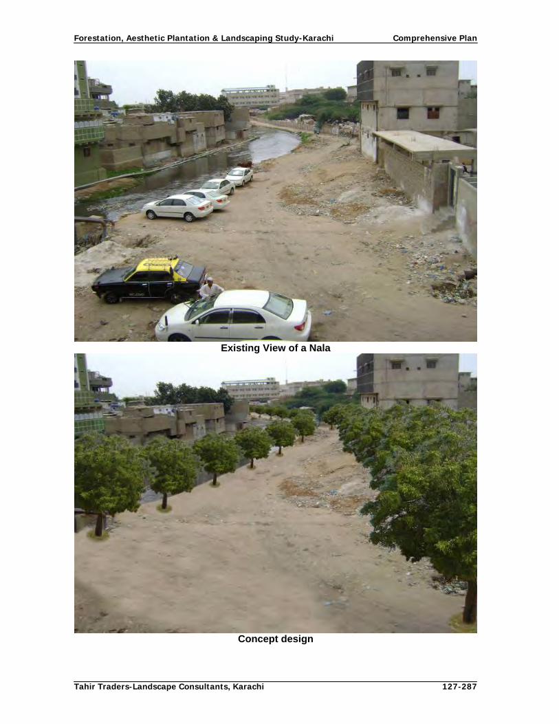
Forestation, Aesthetic Plantation & Landscaping Study-Karachi Comprehensive Plan
Tahir Traders-Landscape Consultants, Karachi 127-287
Existing View of a Nala
Concept design

Forestation, Aesthetic Plantation & Landscaping Study-Karachi Comprehensive Plan
Tahir Traders-Landscape Consultants, Karachi 128-287
4.6.13 Farmlands
4.6.13.1 Social Forestry in Urban Agriculture Areas Need and Justification for Social/Farm Forestry The total area of the agriculture belt is about 3,50,000 acres (141,643 m) located in four towns viz. Gadap, Malir, Bin Qasim and Kiamari. The main land use of the area is agriculture including orchards, road net work, villages, poultry farms, farm houses, graveyards, various institutions and offices, industrial areas (Bin Qasim town), Malir river and its two nallahs i.e., Thadho and Sucko, small hills, Khirthar National Park, commercial activities like petrol pumps, shops, ware houses, block plantations and scattered trees. The potential areas in Karachi district where social forestry activities could be adopted are the Gadap and Bin Qasim towns and part of Malir town. Gadap town is the biggest of all towns of Karachi and has comparatively more area under agriculture. This area is also called the green belt of karachi, where various types of agriculture crops, trees and fruit orchards are grown. Due to scanty rainfall, the requirement of irrigation is met by installation of deep sub merged tube wells at a level of 90-120 m. Due to continuous droughts, over 3 to 5 years the water table even gone down to 150 m. As compared to Bin Qasim town, the sub-soil water in Gadap and Malir towns is of better quality. There is immense potential of tree plantation in the forms of shelterbelts, windbreaks, block plantations and other forms of tree planting on the farmers’ lands. This will not only improve the economy of farmers directly from wood and fodder but also their vegetable fields and fruit orchards will be protected. Besides, the trees planted on farms will add fertility to soil and in general improve the ecology and biodiversity. Objectives
To meet the existing and future needs of the rural communities for fuel, food, fodder etc. by tailoring the latest technologies for enhancement in the farm forestry systems.
To grow and manage more trees of ecological and economical values on farm lands.
To improve environment of Karachi through massive tree plantation. Social Forestry Models/Technologies for urban agriculture areas
A. Agro-forestry Agro-forestry is land-based forest, agriculture and livestock-related production systems. It combines the production of trees, vegetables, cereals and fodder crops, to produce both subsistence and cash crops while maintaining the productivity of soil. Agro-forestry is the combination of trees, and agriculture crops or animals on the same land, either at the same time or in sequence. In short it can be said as intercropping of woody plants with food and forage crops. There are three popular technologies/types of agro-forestry in practice depending upon the need of the community, i) agro-silviculture system (intercropping of trees with agricultural crops), ii) silvo-pastoral (growing of trees with grasses) and iii) agro-silvo-pastoral (growing trees, agriculture crops with grasses for

Forestation, Aesthetic Plantation & Landscaping Study-Karachi Comprehensive Plan
Tahir Traders-Landscape Consultants, Karachi 129-287
animals). All the above mentioned technologies are suited in Karachi urban agriculture areas. B. Wind breaks/Shelterbelts Growing of trees and shrubs on farmlands in rows to reduce the effect of wind on the productivity, growth and soil quality is described as windbreaks. The primary function of raising windbreaks is to check/reduce the wind velocity in agricultural systems in the areas where the wind speed is high and detrimental to crops and soil. The wind velocity in agro- based areas in Karachi is very high especially from May to September being located near the coast. It ranges from 15 to 25 knots per hour. The damage of agricultural and fruit crops is significantly high due to fast winds as photosynthetic and cation and anion exchange processes are reduced which ultimately reduces the production. The erosion of fertile surface soil is also a serious problem which reduces the fertilely of soil on one hand and the production on the other. This phenomenon finally affects the per acre production of agriculture farms. To overcome the effect of wind action, trees lines are established in rows with close spacing, normally 1.5 – 3 m distance from tree to tree and 18 m from belt to belt. These distances vary from site to site depending upon the speed of wind, height of trees and area of farm. One, two and three rows are planted as per wind speed. The selection of tree species is very important. Generally, value added trees which cast minimum shade are planted in a manner that crops are protected fro wind and shade damage. The proposed tree species are Iple Iple, Eucalyptus, Acacia nilotica, Euginea jambolana, and Azadirichta indica. There are three methods of planting i.e. single alternate row, double alternate row and random mixture, depending upon the need and requirements of the farmers. As per plan, 500 km of windbreaks and 800 km of shelterbelts are proposed to be established during plan period.

Forestation, Aesthetic Plantation & Landscaping Study-Karachi Comprehensive Plan
Tahir Traders-Landscape Consultants, Karachi 130-287
Fig.24: Concept Design of Single Row Windbreak
Fig.25: Concept design Two Row Windbreak

Forestation, Aesthetic Plantation & Landscaping Study-Karachi Comprehensive Plan
Tahir Traders-Landscape Consultants, Karachi 131-287
Fig.26: Concept design of Three Row Windbreak
Trees along farm boundaries and water channels Under this system the trees are planted on farm boundaries, paths and on water channels. These trees serve as boundary marks, live fences, fire and wind breakers. In addition, they produce wood, fodder fruits and green manure. Generally, leguminous and fruit bearing trees species suit these areas. Fig.27: Concept design of Border Plantation

Forestation, Aesthetic Plantation & Landscaping Study-Karachi Comprehensive Plan
Tahir Traders-Landscape Consultants, Karachi 132-287
C. Wood lots/Block plantations Some times value able farmlands remain uncultivated mainly due to shortage of water and resources. The availability of water can easily be regulated for growing trees in the form of block plantations on such lands. Although lift irrigation is costly, but the benefits and financial returns arising out of sale of block plantation compensates this extra expenditure. Moreover, this system controls the surface erosion of soil and adds fertility to enrich it. Acacia nilotica is best leguminous specie for block plantation. The tree has multi values such as industrial wood, fuel wood, fodder, pods, seed and green manure qualities. Initially the land is leveled and ploughed, followed by irrigation and drilling of soaked seed on 6 feet line to line space. Some times seed broadcasting of babul seed before or after irrigation is also done. First irrigation is given after about a month. After on year, cleaning is done and after two years the spacing shall be further increased to 2 m providing the space for better growth and formation of quality timber. Under this plan, an area of 200 ha is proposed to be brought under block plantations on the farmlands and 1000 ha dry Afforestation on wastelands. Fig.28: Concept design of Block Plantation
D. Scattered trees within farmlands In this system various types of trees are planted along irrigation channels, bunds, and even within plots in scattered form. No regular spacing or any pattern is practiced. The trees are automatically irrigated with agricultural crops. The tree species selected are value added such as leguminous, shady and woody to cater the needs of the farmers and provide additional income from the sale of trees.

Forestation, Aesthetic Plantation & Landscaping Study-Karachi Comprehensive Plan
Tahir Traders-Landscape Consultants, Karachi 133-287
Fig.29: Concept design of Scattered Tree Plantation
E. Trees in villages and in neighboring blank areas of villages There are several scattered settlements in the form of small and big villages located in the target areas. The barren village landscape do not give pleasant look therefore, plantation of trees in spaces available in streets, house compounds, guest houses (Otaks), livestock pens etc. are suggested. There are several blank areas located in the outskirts of villages which could also be utilized for tree planting. The main objective of this system is to provide comfort to the villagers and their livestock, and increase tree cover for the betterment of environment of the area. The species suitable for this system of planting are Neem , Peepal, Siris, Jaman, Mango, Babul etc. F. Trees around tube wells and farm huts The tree plantation around the tube wells installed on the farms is also a viable system. The shady or fruit bearing trees are preferable. The farmers and working force on farms and travelers can take rest while working on farms. The trees like Neem, Peepal, Siris, and fruit trees like Mango, Lemon, Ber, are suitable trees for this system. G. Trees on farm houses There are several farm houses located in the urban agriculture areas and are the most potential sites for tree planting. These farms require ornamental trees or flowering plants/ trees to provide the beautification of and aesthetic look to the visitors. The water in farm houses is assured and these areas are protected from grazing animals. The flowering trees like Gul Moher, Cassia fistula, Oleander, Lignum and various fruit trees such as coconut, jaman, mango, etc having aesthetic values are recommended. Similarly the flowering shrubs, green grasses, perennial flowers and seasonal flowers etc could also be grown. There is wide range of such plants for farm house owners in this respect.

Forestation, Aesthetic Plantation & Landscaping Study-Karachi Comprehensive Plan
Tahir Traders-Landscape Consultants, Karachi 134-287
H. Other target area for social forestry There are many sites / places where social forestry practices can be adopted such as poultry farms, livestock farms, petrol pumps, outskirts hotels, individual shops, school and college compounds, medical and animal hospitals, any other government buildings having suitable areas which normally have sufficient land which could be utilized for purpose in rural areas. In these areas the ornamental and shed trees are suited. I. Identification of target groups The potential target groups for participatory/social forestry are; Individual agriculture farmers, Farmers community/co-operative groups, Heads of tribes of a village, Town Nazims, Union Council Nazims and members, elected representatives (MPA, MNA), Teachers and students, Government functionaries having buildings and areas, NGOS, Societies of Shop-owners, Mill-owners, Industrialists, semi government organizations like Steel Mills and Qasim Port etc. Motivation, awareness and extension service is essential for target groups so that they may include trees in their agricultural systems and on the areas available with them. Raising of planting stock for Social Forestry It is proposed to raise 24 million of saplings in 18 town nurseries, 5 departmental nurseries and one mother nursery. Among these saplings, 7 million saplings will be raised in 12” pots, 12 million saplings in 6”x12” polythene bags and 5 million in 4” x 8” polythene bags. Mother nursery Mother nursery will be established in the premises of Forest complex at Model colony Karachi wherein, ornamental plants of commercial value and big size plants of various species in earthen pots and polythene bags will be raised for planting in target areas and supply to general public, farmers and different agencies. 4.6.13.2 Social Forestry Technologies for Urban Buildup Areas Importance of Social Forestry in urban area The Karachi is the mega city of the country, situated along Arabian sea having two ports, four industrial estates, two cantonments, having H.Q of national companies, best educational institutions and 6,000 industrial units. It is called city of lights, due to social and economical activities. The people of Karachi are involved in multi-ferrous jobs, due to that variability and popularity, the movement of people on Karachi roads is round the clock. It is city which rarely sleeps, being the business hub of the country, the poor people from all over the country move to this city in search of job; therefore, population growth ratio is highest in country. The population growth and development of civic amenities have not taken place in required proportion. The pace of infrastructure development was so fast that the standard norms of proper planning and keeping up civic amenity standards were seen as secondary need of people. High rise buildings irrespective of suitable location were constructed without any environmental considerations. Excessive expansion of Kachi-abadi’s and slums has exerted tremendous pressure on city resources and made the life of people of Karachi miserable. The major issues like civic services, health, environment etc presently are in alarming state and causing serious social problems for the citizens.

Forestation, Aesthetic Plantation & Landscaping Study-Karachi Comprehensive Plan
Tahir Traders-Landscape Consultants, Karachi 135-287
Tree plantation is the area where the government is doing the best within its means and using all the necessary tools to meet the challenges and trying to provide comfort for the citizens by caring their essential needs. The centre of efforts is the areas common for all, like main roads, parks, medical care, education, water and sewerage etc through the responsible government machinery. However, there are also some areas which are owned and managed by the elected bodies of housing societies. These are the potential target areas where social forestry practices through participatory approach are very important. Concepts for urban areas, their objectives and technical features The concept of planting trees in city areas is not new. Initially the individual people use to plant trees for shade, fruit trees for multiple use and beautification of their individual houses and streets. However, with increase in urbanization the different needs also emerged for planting of trees. With the industrial advancement and further improvement in technology, the need arose to beautify the city’s urban areas to cater the need of beautification and improve the environment. Due to above reasons the need for managed and systemic plantation was felt in urban areas. This is now-a-days called as Urban Forestry. Overview of Past work and objectives of tree planting in Karachi The social forestry in urban areas is being done since long by establishing nurseries and selling of planting stock to the willing individuals and group of individuals for planting by themselves in available areas. Some multinationals or nationals also planted trees and shrubs for beautification in areas under their control. Some industries also planted trees within industrial compounds for shade, beatification and developing greenery in their domain. The school and college administrations with assistance and involvement of the students have planted trees within school compounds. The organizations like Pakistan Steel Mills, Port Qasim Authority, Karachi Port and their residential colonies have also planted trees in their jurisdictions. Some construction companies also developed greenery to beautify site to provide clean and green look to the client, few roundabouts build up by individual companies and small parks adopted by few societies/individuals. Tree planting activities have also been done by the government of Sindh, CDGK and other semi-government organizations. Social forestry activities have given impetus to the private nurseries in the city and are not new to the urban population, who is very conscious about the programme. Thus, the expansion of social forestry activities in city may lead to city’s greenery and beautification. As such the increase in tree cover in urban area would mitigate the environmental effect significantly. Need for Social Forestry in urban areas The basic objective for introducing social forestry in urban areas or city is to make the city aesthetically green and environmentally clean. The present state of greenery existing in city is in-sufficient. At present the vegetation cover is about 7% in Karachi including the peripheral areas. This state of vegetation cover is much beyond the standard limits and aesthetics. There are ample potential areas where the greenery could be enhanced but due to lack of basic data and participation of people the required greenery could not be achieved. The polluted environment is a serious issue which is causing serious health and social problems and can be mitigated with the participation of the people. The government functionaries cannot tackle single handedly as the issues are complex in nature, therefore to meet the objectives and goal of aesthetics and clean environment, the people of the city be motivated and taken on board to participate in social forestry activities

Forestation, Aesthetic Plantation & Landscaping Study-Karachi Comprehensive Plan
Tahir Traders-Landscape Consultants, Karachi 136-287
and implementation of its concept. The concerned departments are carrying out works on their own way and without considering the need of people who are ultimate beneficiaries. It is there fore essential to involve the people and ensure their participation. Objectives of social forestry
To increase vegetation cover in streets, roads, within and around residential areas. To beauty the streets and roads by planting the ornamental or shade trees To plant the indoor potted plants in and out side the houses for beatification and
improvement of the surrounding atmosphere. To plant the flowering plants or vegetables in pots for greening and beautification
of roofs of houses and balconies of flats for improvement of surrounding environment
To raise amenity plantation on the available spaces on roads, houses compounds, parks, school spaces and offices compounds to providing over all greener look and reduce the environmental hazards.
To enhance aesthetic look and mitigate the environment for better human health and healthy social conditions.
To impart training to communities and householders to increase their capacity for maintaining the plantations.
To mobilize communities to think of better environment of their city. To create awareness among the masses on the importance of trees and participate
in tree planting activities in the areas even outside their houses i.e neighborhood parks, roads, roundabouts etc.
4.6.13.3 Social Forestry Models and their technical features Planting along the compound walls of houses: The planting of trees along the compound walls of individual houses irrespective of size of plots or covered area. Most houses have space along compound walls in the shape of walkways. These are potential areas for beautification and improvement of the surroundings. People be motivated to plant trees, shrubs and flowering plants in their houses and outside compound walls in streets to increase tree cover in general and improve the environment in particular. The method of planting varies from shrubs to trees however, in general .5 m x .5 m pit be dug so that the plant may have enough space of loose soil to establish its root system. The new soil with 30%manure be mixed and filled in the pit leaving just 8 cm from surface for watering. Daily water be given to the plant. In case the space is bit large the green grass can be planted as ground cover or the seasonal or perennial flowers can be planted for beautifying the space. The beautification so done will give pleasant look to passer-byers; improve the atmosphere of surroundings for healthy living. The recommended species are Lignum, Coconut and various ornamental shrub species. The indoor planting: Indoor plants are primarily beautification of the available spaces with suitable live plants within the walls of the houses. They create better micro environment for the members of the house. Mostly, these plants are kept in pots and are adequately watered as and when required. Proper care is necessary to keep the plants live and give their attributed fragrance within the house. Some house holds are fond of maintaining their house with plants of their choice but still it is essential to improve their capacity to properly maintain them specially their light requirements. For this purpose it is necessary to include a training program for this aspect.

Forestation, Aesthetic Plantation & Landscaping Study-Karachi Comprehensive Plan
Tahir Traders-Landscape Consultants, Karachi 137-287
Greening of Roofs by increasing Vegetation Cover: Karachi is thickly populated city occupied by various types and sizes of settlements such as residential houses of various sizes, apartments of various stories, office buildings, commercial buildings and many other types of buildings. The roof of these buildings normally remain un utilized except some washing of clothes activates are carried out on roof for drying of clothes. The idea of “Green Roofs” planting techniques has been proposed to utilize the space by placing the pots and plants are planted there in. In this case the green leaved, flowery and certain vegetables like cabbage, tomato, onions, garlic, cauliflower, etc can easily be grown on the roofs of buildings. Keeping up such plants on roofs provide green atmosphere and purify the surrounding environment. The plants when placed on roofs provide barrier to the direct sun light to roof as such cooling effect is developed on roof and buildings, the electric bills are also reasonably lowered. The suitable plant species are the various vegetables and flowery and ornamental plants, planted in the earthen pots. Street plantation: Karachi has several well organized housing societies having roads, streets and houses. They are well organized and planned, therefore highly potential for social forestry activities through participation of residents. All the societies have single and double road net works, with median strips. The societies are further divided into streets having about 0.5-1 m area available between road and compound, in bigger bungalows it is some time wider also. In both cases small size plants could be planted at 5-7 m distance. The wider space can be planted green grass as ground cover, besides some seasonal or perennial plants can also be planted. It will beautify to pleasant look and improve the local atmosphere. The creepers can also be planted along compound walls with or with out flower. This will beautify the building and the street also. Beautification of commercial areas like petrol pumps, corporate offices, galleries in flats, any other suitable spaces where some trees can be planted of any size and, flowery or ornamental species. The selection of species and type of plants depends upon the space available and nature of the compounds etc. however, main aim should be to develop aesthetic look and beautification of area, therefore the flowery shrubs and creepers may be planted. Planting in neighborhood parks: Neighbor-hood parks and amenity areas are usually earmarked in every residential society. Most of them are partially developed and planted. They are potential sites for increasing tree plantation. These are common places which are used by the communities. Their beautification and aesthetic plantation will not only increase vegetative cover but also improve the health of the residents. Planting in Kitchen gardens: Kitchen gardening is the concept where trees are planted in the houses by utilizing water from kitchens. This concept is very common in developed countries where the irrigation is catered from the kitchen water used for cleaning of cooking and eating utensils. This concept can also be easily be introduced in Karachi and trees/shrubs, fruit trees and vegetables could be grown around houses by using water from kitchens. In Kitchen gardens also vegetables are grown which are sufficient to meet the requirement of house holders. Planting in front and backyards: In the residential areas having big houses there is sufficient space in front and in back of houses named front and back yards, respectively. Like kitchen gardens the back and front yards can also cater for the fruit and vegetable requirements of house holders. In front yards mostly fruit bearing trees and shrubs are grown where as in the back yards trees, vegetables, shade trees and other trees/shrubs are grown. Planting by corporate and commercial buildings: Within the build up area of Karachi there are several corporate and commercial buildings where there is sufficient space for tree planting. This space could be utilized for greenery and beautification. Although these

Forestation, Aesthetic Plantation & Landscaping Study-Karachi Comprehensive Plan
Tahir Traders-Landscape Consultants, Karachi 138-287
agencies are already aware of beautification of their areas but still there is scope of social forestry to involve them. Planting in commercial streets: There are several commercial streets and small roads within the build up area that require tree cover for shade, shelter and environmental improvement. At present these areas are almost blank or have few old trees but there is space to be utilized for trees and shrubs with the cooperation and participation of shopkeepers, workshop owners, etc. for their comfort and betterment. They are to be convinced and awarded through persuasion and incentive by offering a package of tree plantation. Target areas in urban area The main target areas identified in the build up areas of Karachi are the streets in the privately managed societies, roof space of buildings and flats, side strips of compounds of houses, commercial areas having space within and out side entrance corridors petrol pumps, government institutions like schools, hospitals compounds, play grounds, graveyards, nurseries, star hotels, airport and the vast areas with defense authorities. These are major target areas where social forestry activities could be initiated. Identification of target groups The elected members of housing societies: This group can easily be mobilized by providing the technical and material support along with some incentives so that they can carry out plantation in streets and along compound walls Nazim of union councils and town Nazim: These persons hold the public offices and have easy reach to every individual there they can mobilize the individuals and communities. Apart from that they have horticulture and park department therefore they can provide the technical and material assistance to public. Flat and house owner associations: They can be mobilized to have plantation in pots and placing on roofs and balconies in flats individual banglow owners Government institutions: Schools, colleges, hospitals, universities and play grounds having suitable spaces, can be taken up under participatory approach Semi- government authorities: Authorities like Steel mill, Port Qasim, and Shipping Corporations, Defense authorities are the main stakeholders. Private nursery owners: There is a network of private nurseries which can be expanded to increase their number and spaces so that individual or communities can get plants very easily. Horticulture and Park department: It is government department under CDGK having all resources and technical capabilities, they can provide the technical support to the people. 4.6.13.4 Establishment of demonstration areas/plots For popularizing the social and participatory forestry establishment of demonstration areas/plots for education and awareness of various models are an effective system. CDGK may adopt this both in urban agriculture and build up areas. For example few farms, streets, roads, parks be planted and maintained as models for replication to other areas by the people and stakeholders.

Forestation, Aesthetic Plantation & Landscaping Study-Karachi Comprehensive Plan
Tahir Traders-Landscape Consultants, Karachi 139-287
i) The agro-forestry systems and social forestry models implemented on farms be shown to various target groups for practical teaching and observations. ii) The pictures of such demonstration activities highlighted in print and electronic media Iii) In urban areas, the group visits and exposure visits be conducted on the impressive sites and beautified points and wide publicity be given to such visits. 4.6.13.5 Awareness Campaign for Social Forestry Awareness is an important tool for popularizing any activity where the stakeholders are many and the outcomes of particular activity are manifold and for every body. Awareness campaign for social and participatory forestry is very essential. Every individual can not be reached for awareness but strategies be evolved to reach as many people and stakeholders through them. There are several ways to reach the people collectively. Some of such activities are described below: Tree plantation campaigns Karachi is the mega city of Pakistan having polluted environment due to variety of factors such as uncontrolled industrial pollution, un-planned disposal of sewage water, less vegetation cover and high levels of vehicular and noise pollution. One of the major factors to improve environment of the expanding city is to increase tree cover with proper planning. Tree plantation campaigns are organized every year by the Government and other stakeholders and certain activities are planned in the country including Karachi. Following proposals are submitted for the Monsoon Tree Plantation, for Karachi prior and during the campaign: Prior to commencement of Monsoon Tree Plantation Campaign following meetings be organized: A general meeting be arranged under the chairmanship of City Nazim/Naib Nazim. The meeting be attended by all stakeholders, NGO’s, civic society persons, departments of CDGK, semi government organizations, corporations and multi-national companies etc. Last season’s achievement be discussed and Targets of planting of trees be assigned to each stakeholder. Multi-national companies shall be actively involved in tree plantation campaign. The department may identify the blank roads, roundabouts and areas and offer these companies to plant/beautify the above areas during the campaign. Separate meetings be called by all town Nazims on the pattern of main meeting. The targets be assigned to all UC Nazims. Forest Department of CDGK to be declared as Coordinating Body and the supply of plants be ensured and arranged in advance by forest department of CDGK either free of cost or on subsidized rates. Forest department of CDGK may announce a Focal Person and Focal Point during the campaign.
During the campaign period following activities are proposed:

Forestation, Aesthetic Plantation & Landscaping Study-Karachi Comprehensive Plan
Tahir Traders-Landscape Consultants, Karachi 140-287
Message from CDGK Nazim Message from Nazim CDGK be published in leading newspapers, telecasted in TV channels, broadcasted in Radio Stations. The message be repeated during the campaign period. Main Inauguration Ceremony Main inaugural ceremony be arranged at Mazar-e-Quaid or any other convenient place in the morning. This should not be planting ceremony only but a ceremony containing inauguration followed by at least one hour programme of speeches both from technical, citizens, elected representatives and NGOs, preferably from stakeholders from all walks of life. Diplomats of foreign countries, ministers, elected representatives, heads of departments, representatives of multi-national companies, Karachi Port Trust, heads of government and private industries, etc. be invited to attend the inaugural ceremony and plant trees. Subsequent ceremonies Subsequent ceremonies shall be held at : All town levels may hold ceremonies at conspicuous places within towns on the pattern of main ceremony. Main departments of CDGK may also hold ceremonies at conspicuous places on the pattern of main ceremony. During the campaign the government and private educational institutions i.e universities, colleges, schools be involved and directed to organize special tree planting ceremonies involving teachers and students in which they should plant trees in groups and arrange educative speeches on the subject so that students may understand the importance of trees. Other stakeholders be also facilitated to arrange ceremonies, plant trees in groups and highlight the importance of campaign. Awareness Campaign Following activities are proposed for effective awareness campaign:
Seminars: A seminar or workshop be arranged in C.G.D.K Hall by inviting the members of civil society, Corporations, Authorities such as Malir Development Authority, Lyari Development Authority and others and private Housing societies and other stakeholders. The speeches are delivered by experts. The city Nazim or Naib Nazim may chair the seminar. In this seminar organizations such as Greener Karachi, Pakistan Horticultural society, Floriculture society and Bonsi society be specially invited to deliver key note addresses. Gatherings for Tree Planting: Efforts be made to arrange gatherings of notables, civil society organizations, NGOs, even the students. The informative and knowledgeable speeches in massage conveying manners be organized. The some speakers shall be experts also. The venue shall be well decorated with banners .The proper material about the forestry and environment may also be put on display.

Forestation, Aesthetic Plantation & Landscaping Study-Karachi Comprehensive Plan
Tahir Traders-Landscape Consultants, Karachi 141-287
Distribution of saplings: Pickups be hired and shall be loaded with different species of trees and flowers plants of public interests. The vehicles be posted at prominent points on rotation. The saplings may be distributed to interested people or organization free of cost during the campaign period. The vehicles be decorated with banners and small speaker for publicity. The staff posted at vehicle must well-dressed in uniform and knowledgeable. Plant trees on Phone call: People may record their requests for supply of tree saplings on the Call Center of CDGK and the concerned department may supply required number and kind of saplings the next day. Greener Karachi Walk: A walk named as “Greener Karachi Walk” may be organized during the campaign which shall be attended by people from all walks of life including students so as to popularize the campaign between the masses. Brochures: The broachers be prepared having brief about the role of trees in agriculture, ecology, environment, aesthetic value and beautification of city and houses. The same be distributed among various target groups. Pamphlets: The two leaved pamphlets be got printed having pictures of various trees and slogans etc for conveying the massage of importance of trees. The same be distributed to stakeholders and general public. Booklets may also be get printed , in which details about the planting and post care of trees and various species of flowers so that one can read and acquire some knowledge . Stickers: The various stickers be printed for posting on vehicles bearing monogram or pictures or some suitable slogans. Calendars be printed bearing scenic pictures or some attractive scenes of trees and be distributed among various Government, Semi Government, Stakeholders and NGO’s. Diaries: The medium size diaries and writing pads be printed by pasting logical pictures, verses and slogans and same be distributed among the relevant target groups and NGO’s. Key chains: The key chains with monogram of Forest or any suitable word like “Plant Tree” be prepared and distributed among stakeholders and NGO’s. Pencils: The green color ball pens or pencils be prepared with monogram along with suitable slogans and distributed among stakeholders particularly students. Wall clock: The wall clock or table clock be prepared with green base. The slogan or any message bearing phrases be printed on it. The same be given to all Government or Semi Government organizations for office use and other relevant institution like Health and Schools, Colleges and Universities and NGO’s. Flags: The small flags with wooden stand bearing the monogram of forest department with one phrase or slogan be prepared and distributed in all relevant public dealing offices and NGO’s. T-Shirts: The green color T Shirt bearing the monogram of forest and slogan on back side be prepared and distributed among students in school, colleges and universities. Caps: The green color caps be arranged and distributed among the stakeholders.

Forestation, Aesthetic Plantation & Landscaping Study-Karachi Comprehensive Plan
Tahir Traders-Landscape Consultants, Karachi 142-287
Banners: During the campaign period, the banners be printed and installed in rural as well as in whole city at prominent places so that message is properly conveyed to masses.
A single page pamphlet bearing scenic pictures and slogans be arranged and distributed to masses by making some arrangements with distributors of news papers so that material is reached to every news paper reader. The same pamphlets can also be distributed at road crossings to every passing cars or vehicles by engaging the person on daily basis. Radio and T.V authorities be contacted for broadcasting the talks and relevant programmes. Some suitable advertisement be get printed in news papers for wide publicity, similarly the T.V media may be contacted for carrying out programmes about forestry and environment or showing clips during their programmes. Films: The forest and wild life movie be shown to public in seminars and workshops etc. Debate competition: - The debate competition programme be arranged among matriculation level students. The three prizes be arranged with cups, certificates and cash award of Rs. 10,000, Rs. 5,000 and Rs. 3,000 to first, second and third ranked students.
In the rural area, the MPA’s & MNA’s be invited as chief guest for ceremony, where the speeches be delivered and saplings be made available free of cost to farmers during campaign period.
Tree and Flower show: During the campaign a tree and flower show be organized at a prominent place in Karachi. The show shall include the value added trees, Bonsai trees, seasonal flower show and main tree products. Handsome prizes be kept to the best stalls. All the materials shall be published well ahead of the campaign by the Forest Department of CDGK. Necessary funds shall be also allocated to Forest Department of CDGK for organizing the campaign.
4.6.13.6 Incentives for social/participatory forestry Incentive approach An incentive approach has been advocated to create linkages between conservation and the economic interests of local people. The theory behind this approach is generation of income from tree resources can provide appositive incentive for sustainable use and can thus contribute to conservation. The incentives approach attempts to break the poverty-forest degradation cycle by opening new forest-based opportunities for income generation. The incentives approach answers two key questions:
Contributes to biodiversity conservation.
Contributes to the well being of communities living in and around forests
Trees in farming systems Trees contribute to farming systems and farmer welfare in three different ways:
Trees can help improve the productivity of farmlands by fixing nitrogen, providing green manure and reducing wind erosion and soil moisture loss.
Trees can contribute to livestock production by providing fodder.
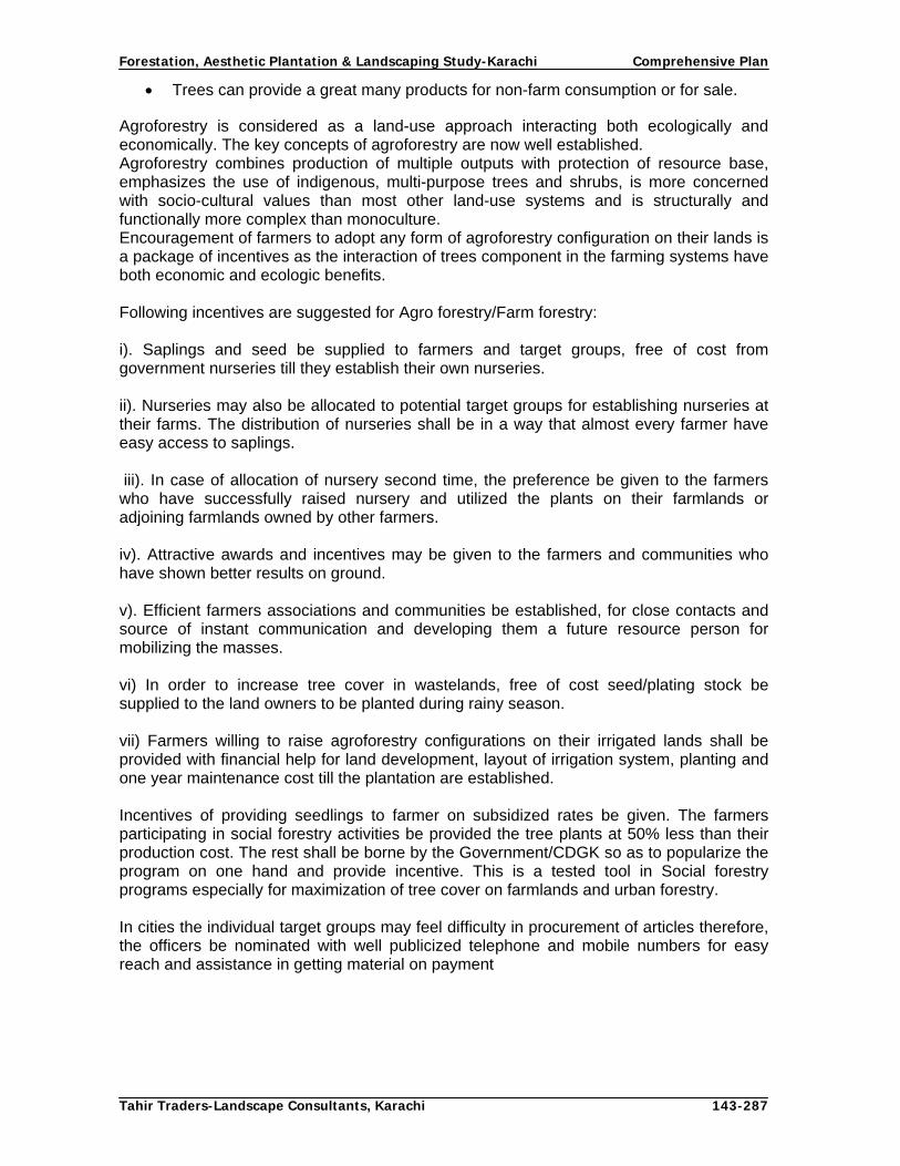
Forestation, Aesthetic Plantation & Landscaping Study-Karachi Comprehensive Plan
Tahir Traders-Landscape Consultants, Karachi 143-287
Trees can provide a great many products for non-farm consumption or for sale.
Agroforestry is considered as a land-use approach interacting both ecologically and economically. The key concepts of agroforestry are now well established. Agroforestry combines production of multiple outputs with protection of resource base, emphasizes the use of indigenous, multi-purpose trees and shrubs, is more concerned with socio-cultural values than most other land-use systems and is structurally and functionally more complex than monoculture. Encouragement of farmers to adopt any form of agroforestry configuration on their lands is a package of incentives as the interaction of trees component in the farming systems have both economic and ecologic benefits. Following incentives are suggested for Agro forestry/Farm forestry: i). Saplings and seed be supplied to farmers and target groups, free of cost from government nurseries till they establish their own nurseries. ii). Nurseries may also be allocated to potential target groups for establishing nurseries at their farms. The distribution of nurseries shall be in a way that almost every farmer have easy access to saplings. iii). In case of allocation of nursery second time, the preference be given to the farmers who have successfully raised nursery and utilized the plants on their farmlands or adjoining farmlands owned by other farmers. iv). Attractive awards and incentives may be given to the farmers and communities who have shown better results on ground. v). Efficient farmers associations and communities be established, for close contacts and source of instant communication and developing them a future resource person for mobilizing the masses. vi) In order to increase tree cover in wastelands, free of cost seed/plating stock be supplied to the land owners to be planted during rainy season. vii) Farmers willing to raise agroforestry configurations on their irrigated lands shall be provided with financial help for land development, layout of irrigation system, planting and one year maintenance cost till the plantation are established. Incentives of providing seedlings to farmer on subsidized rates be given. The farmers participating in social forestry activities be provided the tree plants at 50% less than their production cost. The rest shall be borne by the Government/CDGK so as to popularize the program on one hand and provide incentive. This is a tested tool in Social forestry programs especially for maximization of tree cover on farmlands and urban forestry. In cities the individual target groups may feel difficulty in procurement of articles therefore, the officers be nominated with well publicized telephone and mobile numbers for easy reach and assistance in getting material on payment

Forestation, Aesthetic Plantation & Landscaping Study-Karachi Comprehensive Plan
Tahir Traders-Landscape Consultants, Karachi 144-287
4.6.13.7 Capacity building of target groups Trainings Training to trainers and target groups is an effective tool for transfer of technology and capacity building. The suitable number of resource persons shall be selected for imparting training to develop the resource persons group. The persons who participate in training be provided with all material and compensations. The training topics shall be informative, supported by printed literature in vernacular language. The training be arranged in groups and a wide publicity be given so that every willing person both from city and rural have opportunity to participate. The trainings may also be arranged for the field staff of horticulture and park department at town and union council level, Forest Department of CDGK and other semi-government organizations as they are directly involved in social forestry activities. The NGO and any other related and interested persons be also encouraged for training. Following trainings are proposed during Comprehensive plan period: Farmers: 117 mm Local tracings for staff: 47 mm Overseas trading for staff: 10 mm Overseas exposure visits: 10 mm In addition, five No of demonstration plots each of shelter belts and wind breaks and five block plantations will be established. Workshops Holding of well organized workshops and seminars also play very important role in the awareness campaign. The resource persons and actively participating NGO may be made part of those workshops. It would be better to have a workshop after every three month and seminar after every year. The lectures by experts, speeches by target groups highlighting the achievements, department efforts by officers, achievements and finally open discussions are held. All the proceedings be recorded and sent to the participants reference material for future. Meetings The group of resource persons both from city and rural areas be invited in the meetings for discussion and future line of action. The actively participating NGOS may also be made part of meetings. The regular monthly meetings be held, the place or venue be different at different meetings and on rotation basis so that every one feel encouraged. These meetings will provide base of participation and developing understanding among groups. The minutes of meetings be recorded and circulated among all members/stakeholders. Exposure visits The exposure visits are the visits of sites where social or participatory works have been successfully carried out. Every meetings/workshops/seminars should follow exposure visit of area of work to analyze the progress and achievements and learn lessons. During such visits the media both print and electronic shall be part of it so that wide publicity is provided the visits and progress be known to the masses at large. The transport in use be decorated with banners, slogans, flags etc. so the persons passing route could also be motivated for expression in other gatherings.
Forestation, Aesthetic Plantation & Landscaping Study-Karachi Comprehensive Plan
Tahir Traders-Landscape Consultants, Karachi 145-287
Foreign Trainings and Exposure Visits Trainings and exposure visits of Executing Agency and its staff both at local and abroad is essential. These activities build the capacity of staff to execute the plans successfully and also learn new technologies which could be replicated. Lessons learnt from successful execution of urban forestry, community forestry, social/Farm forestry and Participatory forestry in countries and major cities of the world would also provide an additional knowledge to the city administrators and executing staff. Hence, trainings and exposure visits to neighboring countries where participatory forestry has been successfully practiced and, major cities where urban forestry has been experienced are proposed in this plan. Proposed target of foreign trainings per year Trainings to staff: 10 man months Exposure visits for Urban Forestry: 10 man months Total Target per annum: 20 man months The duration of each training and exposure visit shall range from 2-4 weeks. 4.6.13.8 Training Module for Social Forestry/Participatory Forestry Importance of Training Social forestry is a discipline of planting trees on lands other than state forests i.e., farmlands, wastelands, roads, open spaces, playgrounds and all such places where sufficient space is available for planting trees such as houses, offices, educational institutions, hospitals, cantonments, police lines, etc. Social forestry is for the people, by the people and of the people. It is a public oriented forestry which ends at providing goods and services for the benefit of rural communities’ particularly poor section of the society. It also encompasses community forestry, village forestry, rural development forestry, participatory forestry, farm forestry and self help forestry. The main objective of social forestry is to uplift the wellbeing of rural communities through forestry and related activities and to grow and manage more trees through people’s participation. Since social forestry deals with wide range of society, it is essential to enhance their capability to understand the discipline, adopt and execute on their lands and technical aspect of growing trees, their management and aftercare in befitting manner. The crux of the training is to transfer the technology to the target groups so that they may be able to practice it sustain ably. Objectives of Training
To bring together the interested communities on one platform to facilitate the interchange of ideas.
To transfer the technique of tree planting and establishment of nursery from skilled one to non-skilled.
To propagate the campaign of tree planting in a systematic and meticulous manner.

Forestation, Aesthetic Plantation & Landscaping Study-Karachi Comprehensive Plan
Tahir Traders-Landscape Consultants, Karachi 146-287
To create an awareness for tree planting in general public through mobilization and motivation.
To provide hands on expertise to people who are interested in tree planting. To enhance capability of target groups to practice forestry and transfer technology
to others.
Targets Groups of proposed Training
The selection of target groups is essential for the success of the training programme. In Karachi, there are two distinct areas i.e. urban agricultural areas and urban buildup area having different perspectives with reference to socio-economic conditions, biophysical environment and objectives of incorporating trees in their systems.
A. Urban Agriculture
Progressive farmers Tenants Community groups Farm house owners Owners of Recreational spots Rural Development Department Representatives of local councils Rural NGO’s Owners of gas stations and road side restaurants Representatives of Industrial units located in rural areas Village /community heads
B. Urban Buildup Area
Representatives of housing societies Residents of housing areas Local Council representatives Urban NGO’s Government and semi-government departments Senior citizens Educational institutions Environmental groups Representatives of industrial units, cantonments and national development
departments Duration of Training The duration of training shall be 5 days including field and exposure visits. Number of trainees in training A batch of 25 trainees is proposed. Curricula of Training Curricula of training revolve around following areas:

Forestation, Aesthetic Plantation & Landscaping Study-Karachi Comprehensive Plan
Tahir Traders-Landscape Consultants, Karachi 147-287
Importance of trees in context of environment, economic returns, and aesthetics. Importance of social forestry Techniques of raising of plant nurseries Techniques of planting in different environments Various of social forestry systems Basic knowledge of aftercare
Training Materials
Brochures Pamphlets Documentaries Exhibitions on forests and forest products
Qualifications of trainer /trainee Qualification of both the trainee and trainer are important in this module. The trainee shall be literate person to understand the technology and the trainer shall be expert in the subject, have experience of conducting trainings and be a subject specialist.
4.6.14 Mini forests 4. 6.14.1 Objectives of Mini Forests
Mitigate industrial and vehicular pollution and improve environment Increase and conserve wild life habitat. Enhance water holding capacity of soil and reduce run off losses. Enrich degraded soils through soil improving processes. Increase the potential of recreational spots Conserve the gene pool of plant species Improve the aesthetic and scenic values of rugged surroundings in the vicinity of
Karachi. Increase agricultural production by reducing desiccating winds Reduce deforestation caused by increasing agricultural practices and construction
of industrial and housing projects. Improve human health through environmental amelioration Produce the source of seed for nurseries. Provide recreational facilities to the residents of Karachi.
4.6.14.2 Probable Locations of Mini Forests During assessment it has been established that at present there no Mini forests both in urban agricultural area and in build up area. There are several potential blank sites where the concept of Mini Forests could be introduced and established. Following sites have been identified: Mini forests are proposed to be established on suitable vacant areas declared as protected forests, waste lands, farmlands, recreational places open spaces in industrial units, offices, educational institutes compounds, police lines, cantonments, along highway, bye-passes, link roads, coastal belt, railway lines, play grounds, etc. In addition, various picnic spots are emerging along highways, coastal belt and in Malir and Gadap towns, where need to establish mini-forest has multifold effect on recreation and

Forestation, Aesthetic Plantation & Landscaping Study-Karachi Comprehensive Plan
Tahir Traders-Landscape Consultants, Karachi 148-287
environment. The coastal belt particularly near sea-view has vast vacant tract along the road. Mini forests will protect the nearby habitations and visitors from sand laden hot winds in summer months. There is dire need of establishing mini forest in SITE and Korangi Industrial areas where there are several open spaces near and around industrial units suitable for this purpose to reduce the hazardous effect of industrial pollution generated by emission of hazardous smoke. Mini Forest and fruit tree orchards can be established in agricultural fields by providing some incentives to the farmers in Malir and Gadap towns of Karachi. There are various wasteland chunks in Gadap, Malir and Port Qasim towns along highways and roads where Mini forests can be established over degraded sites for ameliorating the environment. All the target groups identified above for Mini Forests be bound to reserve areas in their areas of jurisdiction for Mini Forests so as to mitigate the environmental problems. CDGK has to play a leading role for coordination and execution. Advantages of the Mini Forests 1. Apart from aesthetic values of trees and vegetation, the mini forests play an important
role in improving the environment and increasing the scenic value of the landscape. 2. Mini forests increase the value of unproductive land over which they are established. 3. Mini Forests in agricultural lands will improve the site quality by increasing the fertility
through fixation of atmospheric nitrogen. They act as shelter belts against desiccating winds thereby preserving the soil moisture and moderating the air temperature.
4. Mini forests will improve environment by sequestering atmospheric CO2 and by
absorbing dust particles and green house gases 5. These forests will provide habitat to wild animals and birds 6. Mini forests will provide affordable recreational facilities to burgeoning population of
mega city. 7. These forests will ultimately be the source of timber and fire wood will reduce the
pressure on state forest. 4.6.14. 3 Concept Designs of Mini Forests The design of Mini forests or block plantations depend upon the objective of establishing mini forest, type of soil, area or size of mini forest, availability of irrigation water, climate of the area, biotic factors interfering mini forests, etc. In case of CDGK, where land is a precious commodity, water is scarce and costly to transport, climate is very arid and wastelands or easily available lands are rugged. Following designs are proposed: 1. Mini forests through dry Afforestation method 2. Mini forests / block plantations in Agricultural lands 3. Mini forests in Urban areas
Forestation, Aesthetic Plantation & Landscaping Study-Karachi Comprehensive Plan
Tahir Traders-Landscape Consultants, Karachi 149-287
Single species Mixed species Arboretum
Mini Forests through Dry Afforestation Technique Out of 3600 sq km area of CDGK, more than 50% area is wasteland. Part of this land is rugged and few of its slopes can be planted with indigenous xerophytic tree species through dry Afforestation. Well grown saplings of Acacia Senegal, Prosopis spicigera, Prosopis glandulosa, Tecoma undulata, Zizyphus jujuba, Acacia sial, Azadrichta indica, etc. will be planted by digging semi elliptical pits on contours to hold run off water. The planting will be done in monsoon season and in case of dry /minimal rainfall years; few watering will be done in order to establish the plants. The objectives of dry afforestation are to combat desertification, control erosion, produce fodder and shade for cattle, enrichment of soil, and to improve environment. Mini Forest / Block Plantations in Agricultural Lands Mini Forests or block plantations of short and long rotation species having economic value such as Acacia nilotica, Sesbenia egyptica, Ipip Ipil, Eucalyptus camaldulensis, Azadrichta indica, etc. can be planted over agricultural lands on flood /trench or micro irrigation system. The objective of mini forest in agricultural lands will be the protection of crops from desiccating winds, enrichment of soil, shade for cattle and humans, moderating climate, in addition to aesthetic and pollution mitigation. Mini Forest in Urban Areas The objective of establishing Mini Forests in urban areas will be providing recreation for increasing population, contributing aesthetic value to surroundings and education for school and college students. In addition, these trees will mitigate the vehicular/industrial smoke and moderate temperature. In urban areas, three types of mini forests will be established. Some mini forests/block plantations will be planted with single species, and in others mixture of few species particularly flowering and having ornamental value will be planted. However, in educational institutions arboretums will be established in which maximum variety of tree and plant species will be planted 4.6.14.4 Technique of Establishment of Mini Forest A mini forest can be established over any suitable blank space measuring 0.5 acres and above. Hence, the design of layout of mini forest will depend upon the shape and size of individual site. However, a minimum area of 4 acres is treated as a suitable size for establishing a mini forest. The preferable design is either rectangular or square. After selection of site, following operations will be followed:
Development of Site The development of site includes clearance of site from existing undesirable vegetation if any, rough leveling and fine leveling with earth moving machinery such as tractors and bulldozers. Clearance of jungle or existing growth can be uprooted manually or through machinery. After removal, the growth shall be disposed of or its brush wood used for tree guards.

Forestation, Aesthetic Plantation & Landscaping Study-Karachi Comprehensive Plan
Tahir Traders-Landscape Consultants, Karachi 150-287
Fig.30: Concept design of Drip Irrigation System.

Forestation, Aesthetic Plantation & Landscaping Study-Karachi Comprehensive Plan
Tahir Traders-Landscape Consultants, Karachi 151-287
Fig.31: Concept design of Hose-fed Irrigation System and Pattern of Trees in Mini Forest
Forestation, Aesthetic Plantation & Landscaping Study-Karachi Comprehensive Plan
Tahir Traders-Landscape Consultants, Karachi 152-287
Layout of Irrigation System The area of 5 acre plot will be 43,560 * 5 = 217,800 sq ft. If the plot is of square shape each side will be of 465.7’. By leaving a 17.7’ wide path in the centre for movement and vehicle parking, the Mini forest will be divided in 4 equal size plots of about 1.15 acre. If this forest is irrigated through flood irrigation system, then each plot will further be subdivided in 4 sub plots of 112’ * 112’ each and water channels i.e., main and khals excavated for proper irrigation. To economize the irrigation water, planting can be done on trench system in initial years and afterwards by extending the trench around each tree for allowing sufficient watering. In case of micro irrigation system preferably drip irrigation, there is no need of sub division of plots and digging of water channels. Layout and method of Planting Initially, weeds will grow in this wide spacing, but as soon as canopy starts growing and covers the ground with its shade, this problem will be reduced. In case of drip irrigation, minimum weeds will come up as water is confined to planting place only. Most of the trees have wide crowns and 5 m spacing may be insufficient for those trees on maturity, but they may attend sufficient height due to competition of light. Planting methods Well established nursery plants will be planted at a spacing of 5 m from plant to plant and from row to row. Pits of size .5mx.5mx.5m shall be dug in normal soil conditions and nursery plant with ball of earth or in ploythene bag transported from nurseries will be planted in the pits. To improve the soil of the pit, fresh earth and farm yard manure will be mixed with pit soil prior to planting. Immediately after planting, the pit shall be filled with soil, properly pressed with foot while protecting and keeping the plant straight. The pit shall be properly irrigated to remove the air/vacuum from the pit. If plant needs some support, a stack shall be fixed and tide with plant loosely to protect it from wind and grow straight. If possible brush wood/thorn hedge shall be erected around plants to avoid grazing and trampling. Additional Facilities/attractions in Mini Forests A menu of recreational facilities that may be introduced in Mini Forest which includes play equipments, court games, picnic facilities and sitting areas. As a general rule the Mini Forest should be designed to meet the needs of specific user group or activity. 4.6.14.5 Proposed Potential areas for the establishment of Mini Forests 1. Area proposed for establishment of Mini forests
from areas allocated to different agencies under Karachi Strategic Master Plan 2020: 2,000 acres
2. Mini forests proposed over existing areas:
Protected Forest Areas 3,050 acres Wastelands (Revenue lands): 65 acres Town Administrations: 500 acres (Amenity plots, Guter Baghicha and vacant places) Large Industrial Areas 300 acres Educational Institutions including universities 40 acres

Forestation, Aesthetic Plantation & Landscaping Study-Karachi Comprehensive Plan
Tahir Traders-Landscape Consultants, Karachi 153-287
Cantonments 500 acres Civil Aviation Authority 100 acres DHA 50 acres New Housing Projects 50 acres Cement factories 200 acres Railway lines 20 acres Recreational spots 15 acres Jails 10 acres Steel Mill 100 acres Sub Total 5,000 acres ----------- Total 7000 acres = 2833 ha
4.6.15 Coastal belt outside mangrove area Total coastal line of Karachi is 90 km long (KSMP, 2020) between the boundaries of Balochistan and Thatta district. The Karachi coast is an important place for recreation and enjoyment for people of Pakistan and Karachi. As a matter of common rights established and protected under Beach Development Byelaws, general public have free excess to the beaches. The Karachi coastline having fine beaches, backwaters, mud flats, mangrove ecosystem and natural scenic beauty attracts large section of population for recreation. The Clifton beaches, Hawksbay, Sandspit and Paradise Point are visited by general public on weekends and holidays, where they enjoy walking and wading. The City District Government Karachi has developed a magnificent beach park, a high rise fountain and other amusement facilities at Clifton beach for the recreation of its citizens. There used to be dense mangrove forests along Karachi coast which have been destroyed due to pollution, reduced inundation water and greed of land for urbanization. Remnants of mangrove are still witnessed while driving along Mai Kolachi by-pass, Manora-Paradise point road, and Ibrahim Hydri-Rari road. Considering the importance and need of development of coastal belt out side mangrove area, CDGK has included coastal belt as a priority area for development under Forestation, Aesthetic Plantation and Landscaping Comprehensive Plan. 4.6.15.1 Purpose and Objectives of Forestation and landscaping on coastal roads
Since coastal belt is an important and most visited area for recreation. Therefore City District Government has attached a great importance to its beautification. If roads approaching coastal area are beautified through aesthetic plantations, it will further attract the people for recreation which benefits the people in improving their physical and mental health by reducing obesity and risk of chronic diseases such as heart diseases, diabetes, cancer, osteoporosis and depression. Recreation relieves stress and improves quality of life, self-esteem, personal and spiritual growth and life satisfaction.
Recreation also has several social benefits. It strengthens communities, reduces crime, encourages volunteerism, promotes stewardship, promotes social bonds, unites families, builds cultural diversity and harmony, supports individuals with disabilities, supports seniors, develops youth, enhances their education, deters negative behaviors, decreases drug and alcohol and prevents them from committing crime.

Forestation, Aesthetic Plantation & Landscaping Study-Karachi Comprehensive Plan
Tahir Traders-Landscape Consultants, Karachi 154-287
4.6.15.2 Concept Designs The concept design along the coastal roads shall be avenue planting of single or multiple rows with shrubs where ever required. The details are as under: Mauripur Road Section-I: Out of total length, two rows of trees are to be planted on either side of the road in about 7 km. Casuarina equisitifolia and Guaiacum officinale trees are to be planted are to be planted at a distance of 5 m from plant to plant and 3 m from row to row. Nerium shrubs are to be planted 10 feet apart at a distance of 5 feet from second row of trees. Section-II: This dual carriage road starts from Gulbai and joins Hawksbay road near Paradise point in a length of 13 km. There is no place for planting in initial 3 km on both sides or in median, but onwards, one row of Salvadora as wind breaker, then Conocarpus and Lignum are to be planted. The spacing from tree to tree will be 5 m and from row to row 2.5 m. Nerium shrubs are to be planted in front of tree lines. In wide median, Lignum trees in central row at a distance of 5 m, Nerium as second row and Bouganvillea as a front row on either side of the central row are to planted. The distance between row to row will be 2.5 m and shrub to shrub 10 feet respectively. All the plants will be planted in alternate fashion. Section III: The side strips of this 23 km double road are narrow, but in such high velocity wind areas, one row of trees hardly survives. Hence two rows of trees of Salvadora, Casuarina equisitifolia and Lignum at an spacing of 5 m from plant to plant and 2.5 m from row to row are proposed to be planted. Sea View Road (Keamari Oil Terminal to Golf Club via Village Hotel) This road is administered and managed both by Defense Housing Authority and City District Government Karachi. Part of this road is under construction but despite that, most of its median which is under the management of DHA, is planted with one row of Casuarina equisitifolia. It is proposed to plant 1-3 rows of trees of Conocarpus and Lignum at closer spacing with Nerium and Bougainvillea shrubs according to the varying widths of median and side strips. Planting Techniques The establishment of plantations along such avenues requires digging of sizeable pits to be filled with 70% sweet earth and 30% farm yard manure (FYM) to avoid salinity and to increase fertility and water holding capacity of pit soil. After filling the pits, these are thoroughly irrigated 2-3 days prior to planting and immediately after planting. Choice of Species Due to arid climate, high velocity desiccating winds and blasting of salt ridden sand in summer months, saline soils and limited irrigation water only those plant species are to be planted which can grow in harsh environment. Trees such as Casuarina equisitifolia, Salvadora, Lignum, Causrina, Bougainvillea, etc which sustain arid conditions are proposed for the plantation in coastal roads at shorter spacing.
Forestation, Aesthetic Plantation & Landscaping Study-Karachi Comprehensive Plan
Tahir Traders-Landscape Consultants, Karachi 155-287
Size of Plants and Planting Planting of bigger plants is better from many aspects on the road side particularly coastal areas where there is severe problem of sand blast on plant leaves. It is easier to grow bigger size plants in a nursery then to allow small size plant to grow at site by providing appropriate conditions of growth. Planting of bigger size plant produces quick results and save the plantations from damage and natural hazards. Bigger plants, when planted in the proper manner have great ability to establish themselves than smaller plants. This one time costly operation is quite cheaper to create a road side plantation over a period of time. Smaller plants would require excessive irrigation for 2-3 years to attain that size and availability of irrigation water alone has enough justification to plant bigger size plants. It is therefore proposed that nursery plants not less than 1.5 m in height excluding pot height and more than 2 years in age with well developed root and branching system are planted in 1mx1mx1m pits preferably in monsoon season. Aftercare To save the plants from desiccating high velocity winds and sand blast, regular irrigation, stacking of plants, fixing canvass cloth on windward side of plants and periodic washing of plants during high velocity wind period and mulching of pits are necessary. Other silvicultural operations such as cleaning, pruning, mulching, etc may be carried out whenever necessary, the details of which are given in the report on Highway and link roads plantations. 4.6.15.3 Proposals of water supply Water for irrigation is an important input for plantation. Its importance is more in scarce areas. It is proposed to establish a series of sea water de- salinization plants and Treatment Plants of sewerage water along the coast to meet the requirements of irrigation supply of plantations to be established along the sea coast. This water could be distributed through cost effective micro irrigation technique. 4.6.15.4 Proposals for Development of Recreation Areas Development and forestation of Recreation Areas Recreation is the main intervention in the coastal area of Karachi. Sandspit and Hawksbay are the main recreation spots which at present are under-developed. The vegetation cover is almost negligible. It is proposed to develop them through preparation of a development plan. Under this plan planting of trees in proper landscaping in the recreation plan of these areas should be included. Concerned agencies and CDGK may coordinate in this intervention. Planting in frontage of recreation Huts All along the coastal roads from Manora to Hawksbay there are several huts which are used by the people especially families who come for recreation during the weekends. It is proposed that the owners of huts may be organized, mobilized and properly guided to plant trees, shrubs and flowering plants in front of these huts and maintain them properly. In this way the over all vegetation cover could be increased for beautification and improvement of environment of coastal areas.

Forestation, Aesthetic Plantation & Landscaping Study-Karachi Comprehensive Plan
Tahir Traders-Landscape Consultants, Karachi 156-287
Mobilization of Week-end Visitors All along the coast of Karachi there are recreation facilities where people of Karachi and outside come for recreation on the week ends. There is immense scope to utilize this human resource for tree plantation through motivation, mobilization and awareness. Visitors can easily be guided to save water for trees and shrubs planted outside the huts, along roads and within recreation spots. The agencies governing and managing the recreation spots and facilities may construct water troughs where visitors may collect the surplus water they bring for their own use. This quantity of water could then be utilized for irrigating the trees/shrubs. In this way the water requirement could be met without much spending. Mobilization of coastal communities Coastal area in Rari and Ibrahim Hydri areas is occupied by coastal communities whose main occupation is fishing. These communities could also be mobilized to take part either in planting or maintenance of planted areas. Identification of Target Groups There are several major organizations located along the sea coast having sea front. They are listed as under:
1. CDGK 2. Town Administrations 3. Defense Housing Authority 4. Karachi Port Trust (KPT) 5. Port Qasim Authority 6. Pakistan Steel Mills 7. Export Processing Zone 8. Korangi and Landhi Industrial Estates 9. KANUPP 10. Pakistan Navy 11.Karachi Fish Harbour Authority
Some of the above organizations have own horticultural establishments. It is proposed to take them on board and CDGK may take initiative and leading role so that the sea front area available to above organizations could be beautified and made part of Comprehensive Plan. 4.6.16 Streets, Roundabouts and Greenbelts Forestation in urban areas also includes individual trees and canopy cover in parks, wooded areas, riparian buffers, nature centers, playgrounds, schools, local, state and federal land, private sanctuaries, country clubs, golf courses, universities and private residences. Karachi is one of the oldest coastal habitations of the country. Like other towns and cities, the older parts of the city and Kachi-abadis prop up without any planning and have congested, narrow and zigzag streets and single roads. There was no concept of medians, roundabouts and green belts at that time. From British rule and particularly after independence, several well planned housing projects have appeared where (traffic circles) roundabouts, straight / wide roads and streets with median and service roads have been

Forestation, Aesthetic Plantation & Landscaping Study-Karachi Comprehensive Plan
Tahir Traders-Landscape Consultants, Karachi 157-287
constructed. Some of the major housing schemes of Karachi are Parsi Colony, Clifton, PECHS, Sindhi Muslim Society, Mohammed Ali Society, Nazimabad, Bahadar abad. Garden, Gulshan e Iqbal, Federal B Area, Gulistan- e- Johar, Model Colony, Defense Housing Authority, etc. and several new housing schemes are under process where these wide roads and streets with a provision of roundabouts and green belts have been kept and planned. 4.6.16.1 Streets There is no any particular concept design for raising plantations in streets and houses. Generally, residential houses are located in streets, where these residents plant trees and shrubs inside and in the streets in front of their houses. The extent of planting depends upon the area of houses and open area available in those houses. Above all it depends upon the affordability, taste and will of the house owners to plant trees, shrubs, climbers, ground cover and grass in the house. In this water scarcity city, availability of water is also a limiting factor for planting. Housing societies also raise plantations in wider streets. It is proposed to plant small to medium size flowering trees having aesthetic value in streets. Choice of Species Generally, small to medium size fruit and flowering trees having aesthetic value are preferred in street planting. Flowering and colourful shrubs, fragrant plants and climbers, ground cover and grass for lawns are to be planted in houses and streets. Following trees, shrubs and climbers are proposed for street planting: Coconut, Date palm, Bauhania spp., Lignum, Gul Mohar, Amaltas, Arecuria, Ashok, Plumeria spp., Ixora spp., Acalypha spp., Beloperone, Bougainvillea, Caesalpinia, lagerstroemia, Mussaenda spp., Murriaya, Nerium, Roses and rose creepers, Jasmine spp., Raat ki rani, Goden shower, Jacomantii, Alhea spp. Lantana spp., etc. Benefits of trees in streets Benefits of trees are categorized as environmental, economic and psychological/social. The amount of tree cover and the quality of health of trees determine the amount of benefits the community receives. Many benefits that were considered qualitative and subjective are now being scientifically quantified. Environmental benefits: Producing oxygen and removing air pollutants, reducing air temperatures and consequently affecting air quality, planting trees in right location around buildings reduce heating and cooling energy costs. Economic benefits to community: Trees are valuable to property’s landscape, add to residential property values, in business areas having tree cover the shoppers spend more time and willing to pay more money, higher shopping frequency, higher office occupancy rates, reduced health care costs. Psychological/social benefits: Trees are valuable aesthetic components in urban landscapes and above values of trees go beyond their visual appeal. Benefits of Street trees
Energy savings Green house gas reduction Air quality improvements Storm water savings

Forestation, Aesthetic Plantation & Landscaping Study-Karachi Comprehensive Plan
Tahir Traders-Landscape Consultants, Karachi 158-287
Aesthetic and other benefits Property value increase
Street trees modify climate and conserve energy use in three principal ways: Shading: reduces the amount of radiant energy absorbed and stored by build surfaces. Transpiration: converts moisture to water vapor and thus cools by using solar energy that would otherwise result in heating of the air. Wind speed reduction: reduces the infiltration of outside air into interior spaces and conductive CO2 in two ways: i) trees directly capture (sequester) CO2 as woody and foliar biomass while tree grow ii) trees near buildings can reduce the demand for heating and air conditioning, thereby reducing emissions associated with electric power production. 4.6.16.2 Roundabouts The trend of developing roundabouts has recently grown in Pakistan. The roundabouts reduce injurious accidents, traffic congestion, fuel consumption, air pollution and maintenance cost, while quite often easing traffic and enhancing intersection beauty. Roundabouts differ from the old traffic circles that have been used earlier. The modern roundabout is generally smaller requiring reducing traveling speed. At roundabouts, the entering traffic yields the right-off-way to the circulating traffic which keeps traffic from locking up and allows free flow moment. The center island and splitter islands at each entry to the roundabout reflect entering traffic and reinforce the yielding process. Pedestrians usually find it easy to cross the streets at roundabout, because, using the splitter island as a refuge, they only need to cross one lane at a time. Under the Plan 22 roundabouts which at present are un-developed and blank are proposed. Out of 22 roundabouts, 7 designs having soft and hard landscape have been proposed at Sea View, Korangi 8000 Road and near Quaid Mazar. For remaining 15 roundabouts, 5 concept designs for 15 m (50 ft) diameter, 5 of 30.5 m (100 ft) diameter and 5 of 45 m (150 ft) diameter are proposed within the city. These roundabouts have mainly soft landscape designs. The concept designs and their cost are as under:

Forestation, Aesthetic Plantation & Landscaping Study-Karachi Comprehensive Plan
Tahir Traders-Landscape Consultants, Karachi 159-287
Fig: 32 Sea View Roundabout

Forestation, Aesthetic Plantation & Landscaping Study-Karachi Comprehensive Plan
Tahir Traders-Landscape Consultants, Karachi 160-287
Fig: 33 Quaid-e-Azam Roundabout
Fig: 34 Shan Roundabout Korangi Road 8000

Forestation, Aesthetic Plantation & Landscaping Study-Karachi Comprehensive Plan
Tahir Traders-Landscape Consultants, Karachi 161-287
Fig: 34 Shan Roundabout

Forestation, Aesthetic Plantation & Landscaping Study-Karachi Comprehensive Plan
Tahir Traders-Landscape Consultants, Karachi 162-287
Fig: 35 Vita Roundabout Korangi Road 8000

Forestation, Aesthetic Plantation & Landscaping Study-Karachi Comprehensive Plan
Tahir Traders-Landscape Consultants, Karachi 163-287
Fig: 36 Bilal Roundabout Korangi Road 8000

Forestation, Aesthetic Plantation & Landscaping Study-Karachi Comprehensive Plan
Tahir Traders-Landscape Consultants, Karachi 164-287
Fig: 37 Singer Roundabout Korangi Road 8000

Forestation, Aesthetic Plantation & Landscaping Study-Karachi Comprehensive Plan
Tahir Traders-Landscape Consultants, Karachi 165-287
Fig: 38 Murtaza Roundabout Korangi Road 8000

Forestation, Aesthetic Plantation & Landscaping Study-Karachi Comprehensive Plan
Tahir Traders-Landscape Consultants, Karachi 166-287
Fig.39: Standard concept design of roundabout having 50’ radius

Forestation, Aesthetic Plantation & Landscaping Study-Karachi Comprehensive Plan
Tahir Traders-Landscape Consultants, Karachi 167-287
Fig.40: Standard concept design of roundabout having 100’ radius

Forestation, Aesthetic Plantation & Landscaping Study-Karachi Comprehensive Plan
Tahir Traders-Landscape Consultants, Karachi 168-287
Fig.41: Standard concept design of roundabout having 150’ radius

Forestation, Aesthetic Plantation & Landscaping Study-Karachi Comprehensive Plan
Tahir Traders-Landscape Consultants, Karachi 169-287
Cost Estimates of RoundaboutS
Table: 8 Cost Estimates of Roundabouts Rs. initial ROM for Roundabout implementation
Area unit rate TOTAL 1 Sea View Roundabout (19,200 SQFT)
1.1 Soft Landscape 7680 SFT 115 883,2001.2 Hard Landscape 11520 SFT 160 1,843,2001.3 Sculpture Wooden frame 350 RFT 1250 437,500 Water elements 1 piece 300000 300,000 Mechanical (pump + filter) 1 piece 100000 100,0001.4 Lighting 4 piece 40000 160,000 TOTAL 3,723,900
2 Quaid e Azam Roundabout (63,000 SQFT)
2.1 Soft Landscape 45335 SFT 80 3,626,8002.2 Hard Landscape 17665 SFT 150 2,649,7502.3 Sculpture 5 piece 80000 400,0002.4 Lighting 12 piece 40000 480,0002.5 Water elements 4607 SFT 200 921,4002.6 Mechanical (pump + filter) 1 piece 100000 100,000 TOTAL 8,177,950
3 Shaun Roundabout (39,000 SQFT) 3.1 Soft Landscape 27300 SFT 80 2,184,0003.2 Hard Landscape 11700 SFT 150 1,755,0003.3 Lighting 6 piece 40000 240,0003.4 Water elements 2 piece 500000 1,000,000 TOTAL 5,179,000
4 Vita Roundabout (8,000 SQFT) 4.1 Soft Landscape 6800 SFT 100 680,0004.2 Lighting 4 piece 50000 200,0004.3 Floodlights external 8 piece 40000 320,000
Windmills 4 piece 180,000 720,000
Mechanical work (windmill, piping etc.) 1 LS 80000 80,000 TOTAL 2,000,000
5 Bilal Roundabout (55,000 SQFT) 5.1 Soft Landscape 42000 SFT 80 3,360,000
5.2 Hard Landscape 13000 SFT 150 PKR
1,950,0005.3 Sculpture RCC frame 600 SFT 300 180,000 Tempered glasswork 100 SFT 500 50,0005.4 Lighting 6 piece 40000 240,000 TOTAL 5,780,000
6 Singer Roundabout # 3 (55,000 SQFT) 6.1 Soft Landscape 35000 SFT 80 2,800,0006.2 Hard Landscape 20000 SFT 150 3,000,0006.3 Sculpture 600 SFT 750 450,000

Forestation, Aesthetic Plantation & Landscaping Study-Karachi Comprehensive Plan
Tahir Traders-Landscape Consultants, Karachi 170-287
6.4 Lighting 6 piece 40000 240,0006.5 Water elements 1 piece 450000 450,000 TOTAL 6,940,000
7 Murtaza Roundabout (55,000 SQFT) 7.1 Soft Landscape 20000 SFT 80 1,600,0007.2 Hard Landscape 35000 SFT 100 3,500,0007.3 Sculpture Steel pipes 150 RFT 1250 187,500 Wooden frame 100 RFT 1000 100,0007.4 Lighting 6 piece 40000 240,0007.5 Water elements 1 piece 450000 450,000 TOTAL 6,077,500 SUB TOTAL 37,878,350
Cost estimates of 50, 100 & 150 feet Roundabouts with Soft landscape 8. Cost Estimates for 50 feet Diameter Roundabouts
Roundabouts Number Area Unit Rate(Rs) Total (Rs) type of Work Soft Landscape 9 19,900 SFT 115 2,059,650 Hard landscape 6,920 SFT 150 934,200 Lighting 200,000 1,800,000 Water element 300,000 2,700,000 Total 7,493,850 9. Cost Estimates for 100 feet Diameter Roundabouts Soft Landscape 3 23,571 SFT 115 2,710,665 Hard landscape 8,950 SFT 150 1,342,500 Lighting 200,000 600,000 Water element 300,000 900,000 Total 5,553,165 10. Cost Estimates for 150 feet Diameter Roundabouts Soft Landscape 3 53,010 SFT 115 6,096,150 Hard landscape 23,500 SFT 150 3,525,000 Lighting 200,000 600,000 Water element 300,000 900,000 Total 11,121,150 SUB TOTAL 24,168,165 GRAND TOTAL 62,046,515

Forestation, Aesthetic Plantation & Landscaping Study-Karachi Comprehensive Plan
Tahir Traders-Landscape Consultants, Karachi 171-287
4.6.16. 3 Greenbelts Generally, green belt strips along sides and in median of major roads of Karachi are 6-12 m wide. For establishing green belts, three concept designs are proposed which can be adjusted according to the width of each site. In side strips, tall trees are planted in back and medium/small trees and shrubs are planted in front in sequence. In median strips, taller trees are planted in centre and medium/small trees and shrubs are planted on both sides. In front of shrubs, ground cover and seasonal flowers are planted. However, leaving the area under trees, grass is planted in shrub, ground cover and facing area. In 9 m and above wide strips, 2-3 rows of trees, 1-2 rows of shrubs, ground cover with flower beds and grass is proposed. In 6-9 m wide strips, 1-2 rows of trees, 1-2 rows of shrubs, ground cover with flower beds and grass is proposed. In 6 m and less wide strips, one row of tree and 1-2 rows of shrubs, ground cover and grass is proposed.
Forestation, Aesthetic Plantation & Landscaping Study-Karachi Comprehensive Plan
Tahir Traders-Landscape Consultants, Karachi 172-287
General Concept Designs
of
Green Belts
Medians
and
Side Strips
of
Urban Roads

Forestation, Aesthetic Plantation & Landscaping Study-Karachi Comprehensive Plan
Tahir Traders-Landscape Consultants, Karachi 173-287

Forestation, Aesthetic Plantation & Landscaping Study-Karachi Comprehensive Plan
Tahir Traders-Landscape Consultants, Karachi 174-287

Forestation, Aesthetic Plantation & Landscaping Study-Karachi Comprehensive Plan
Tahir Traders-Landscape Consultants, Karachi 175-287

Forestation, Aesthetic Plantation & Landscaping Study-Karachi Comprehensive Plan
Tahir Traders-Landscape Consultants, Karachi 176-287
CONCEPT DESIGNS OF GREEN BELTS 5’ TO 70’

Forestation, Aesthetic Plantation & Landscaping Study-Karachi Comprehensive Plan
Tahir Traders-Landscape Consultants, Karachi 177-287

Forestation, Aesthetic Plantation & Landscaping Study-Karachi Comprehensive Plan
Tahir Traders-Landscape Consultants, Karachi 178-287

Forestation, Aesthetic Plantation & Landscaping Study-Karachi Comprehensive Plan
Tahir Traders-Landscape Consultants, Karachi 179-287

Forestation, Aesthetic Plantation & Landscaping Study-Karachi Comprehensive Plan
Tahir Traders-Landscape Consultants, Karachi 180-287
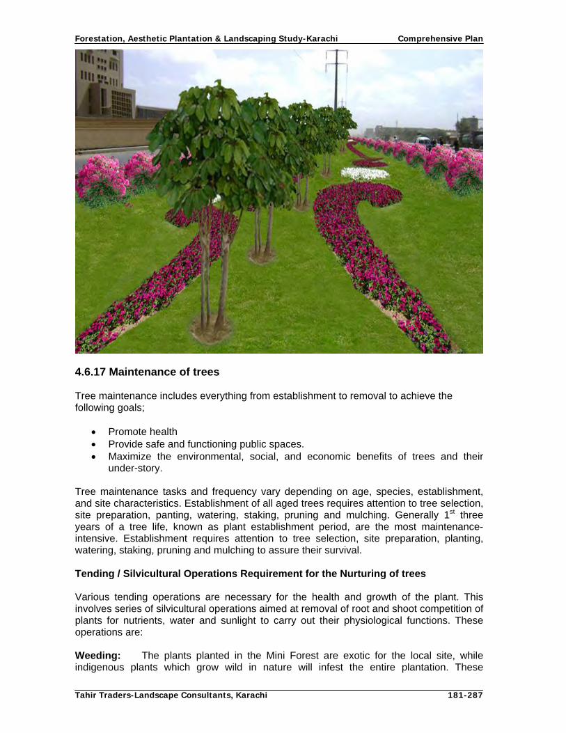
Forestation, Aesthetic Plantation & Landscaping Study-Karachi Comprehensive Plan
Tahir Traders-Landscape Consultants, Karachi 181-287
4.6.17 Maintenance of trees Tree maintenance includes everything from establishment to removal to achieve the following goals;
Promote health Provide safe and functioning public spaces. Maximize the environmental, social, and economic benefits of trees and their
under-story. Tree maintenance tasks and frequency vary depending on age, species, establishment, and site characteristics. Establishment of all aged trees requires attention to tree selection, site preparation, panting, watering, staking, pruning and mulching. Generally 1st three years of a tree life, known as plant establishment period, are the most maintenance-intensive. Establishment requires attention to tree selection, site preparation, planting, watering, staking, pruning and mulching to assure their survival. Tending / Silvicultural Operations Requirement for the Nurturing of trees Various tending operations are necessary for the health and growth of the plant. This involves series of silvicultural operations aimed at removal of root and shoot competition of plants for nutrients, water and sunlight to carry out their physiological functions. These operations are: Weeding: The plants planted in the Mini Forest are exotic for the local site, while indigenous plants which grow wild in nature will infest the entire plantation. These

Forestation, Aesthetic Plantation & Landscaping Study-Karachi Comprehensive Plan
Tahir Traders-Landscape Consultants, Karachi 182-287
unwanted plants which are called weeds will compete with exotic plants for water and nutrients resulting in severe retardation of growth. Hence, periodical removal of unwanted plants or weeds is necessary for reducing the competition and achieving required growth. If it is a flood irrigation system, then weeding after every 3 months in entire area is essential in first year. In case of pit irrigation, monthly weeding that will also serve as hoeing will facilitate the plant in early establishment. Hoeing: It is important to conserve soil moisture in hot, arid and high velocity wind areas. Hoeing should be done preferably after every watering or at least once a month to discontinue capillary action and provide aeration to root system. Sandy soils being loose do not require hoeing. Mulching: Mulching is a term used for artificial conservation of moisture. This can be done by putting the straw, dry cut weeds and leaves on the pit to reduce evaporation from the pits. The mulching of pits is more important in dry season for keeping a soil moisture under optimum level. Pruning: Pruning is a silvicultural operation to remove undesired branches for allowing optimum nutrients and water to remaining branches for attending required growth. Through proper pruning, trees with straight bole, beautiful crown and desire able height can be produced. Extreme care should be taken while pruning of branches to avoid deformity and wounds that harbor insects and pests. Pruning conserves soil moisture by reducing the surface evapo-transpiration from foliage and should be done through hand saws, pruning knives or sharp axe without peeling of the barks .In young plants, pruning should be done 1/3rd of plant height and shall be increased up to 2/3 height of the plant on maturity as general rule. Thinning: Thinning is an important operation in forestry. Dead, dying, moribund, crooked and weaker trees are removed for providing sufficient nutrients, soil moisture, and sunlight to remaining healthy trees. In the initial stage, planting is done at closer spacing to discourage weeds and subsequently, more space is created for desired plants to grow faster by removing unhealthy trees. In forest plantation 2-3 thinning are done and generally first thinning is mechanical in which every alternate tree is removed. But since in case of Mini forest the objective is not only production of wood and revenue earning and initial spacing is 15’, hence no thinning will be required until canopy of the trees is closed. If required necessary, then only weak and suppressed trees will be removed. Coppice growth of cut trees shall not be allowed and therefore either stumps are uprooted, or treated with crude oil to kill the buds. No lopping of any sort is allowed in mini forest as this practice harm the trees and retards the growth. Lopping de-shapes the crown of a tree as such it should be done to those trees which grow on inspection paths or irrigation channels 4.6.18 Establishment of Nursery: The success of any planting programme depends upon the quality of nursery stock to be planted at site. Therefore, sustained supply of healthy planting stock of desired size, age and species is pre requisite for initial success. Further growth depends upon protection, maintenance and nurturing of the plantation.

Forestation, Aesthetic Plantation & Landscaping Study-Karachi Comprehensive Plan
Tahir Traders-Landscape Consultants, Karachi 183-287
Following operations are required for the establishment of plant nursery: Collection of Seed
The quality of plants to be grown will depend upon the quality of the seed which has been sown in the nursery. Seed must be collected from the healthy tree when it is ripe. In case of flashy fruits, the seed should be de-pulped and dried. It should be cleaned before storage. Many seeds after collection may not be stored as they lose viability like Neem and various fruit trees. The cleaned seeds may be sown directly into polythene bags or seed beds for germination in soil medium having equal ratio sand of sand, silt, clay and FYM.
Preparation of Seed Beds
For better germination of seed and healthy growth of sapling, preparation of seed bed is essential. If it is a bedded nursery, existing growth is up rooted and removed and land is properly plowed preferably by cross plowing. If the size of plot is small, the soil shall be worked up with spade or belcha. In case of sandy or infertile soil, mixing of FYM is essential for increasing water holding capacity its fertility. After mixing of soil and leveling, 3’ to 4’ wide beds shall be prepared. Seed shall be sown in beds 1”-2” apart keeping in view the size of the seed. In case of tiny seeds like eucalyptus or Conocarpus, the seed shall be spread over sand or fine soil in pots or small beds and then irrigated through seepage or sprinklers and not direct irrigation.
Transplanting
After the seeds are germinated, seedlings attained the height of 2’ – 3’ ft, shall be transplanted in bigger ploythene bags either as a root shoot cuttings or entire plant for 2nd stage nursery. Trees that have better coppicing potential such as Simal, Sheesham, Siris, Neem, Kachnar, Amaltas, Cassia species, Gul-e-Nishtar, Ficus spp, Mulberry, etc. shall be planted through root shoot cutting in secondary nursery. Plant that grow through branch cuttings shall be planted in secondary nursery as a entire plants. The seedlings shall be allowed to grow in secondary nursery for 1-2 years keeping in view the root system and size of plants. 4.6.19 Concept designs on Micro Irrigation Techniques Introduction
When water for irrigation is in small quantity, more efficient use of water becomes necessary. The efficient utilization of irrigation water is possible by adopting water conservation technique such as micro-irrigation systems i.e. drip irrigation; modified hose fed irrigation system and mini-sprinkler irrigation system (Micro Irrigation Report, 2008). The type’s micro-irrigation irrigation systems selected depends on a number of considerations including the compatibility of the system with other agricultural operations economic factors, topographic limitations, soil properties shortage of water and agronomic influences. With drip irrigation system, water may be provided at the plants on low tension and high frequency basis, thereby creating a nearly optimal soil moisture environment Because of the high irrigation frequency, higher water use efficiencies are possible. Researcher indicates that the water use efficiency may be increased by 50 % or more with the use of drip, mini-sprinkler and modified hose fed irrigation systems as compared to surface irrigation system.

Forestation, Aesthetic Plantation & Landscaping Study-Karachi Comprehensive Plan
Tahir Traders-Landscape Consultants, Karachi 184-287
Proper design, operation and management of an irrigation system are the essential elements of an efficient utilization and management of irrigation water. Irrigation engineers often provide detailed designs taking into considerations, the following factors; peak crop water requirements, soil type, climatic conditions, topography, water availability and source, water quality, management practices and labour availability (Bralts and Segerlind), therefore, such techniques must be adopted which are more efficient and maximize the quantity and quality of fruit / forest plants, grasses, ground cover and ornamental plants.
Scope of Study
CDGK intends to prepare Comprehensive Plan for Forestation and Aesthetic Plantation to improve over all environment of the city through massive tree plantation and beautification. One of the components is to conduct Assessment and Concept Design of Various Micro-Irrigation Techniques. In order to study the adoption and suitability of water conservation techniques, visited different sites in CDGK area. Identified the plantations of main sites include highways (Super highway, National highway, RCD highway), Karachi Northern Bye-pass, Lyari Rivers and green belts of city main roads, Industrial areas etc. Topographic survey was conducted for different sites and took their measurements. The information regarding appropriate system design options, system analysis, cost and material estimates, cost comparisons of different options and irrigation scheduling of micro-irrigation systems for various sites of CDGK areas presented in this report. This information will be quite useful guideline for planners preparing the comprehensive plan for Forestation, Aesthetic plantation and landscaping for Karachi. Keeping in view the scarce water availability in Karachi city, various options of micro-irrigation system are proposed for Supper Highway, National Highway, RCD Highway, while modified hose fed irrigation system are proposed for mini-forest along the Highways and Lyari River. According to report the water quality of Lyari River is marginally fit after treatment for irrigation but suspended particles were abundant in it, so modified hose fed system is the most suitable as compare to drip system. The system was designed considering a number of factors viz. peak crop water requirement, soil type, climatic condition, land topography, scarce water availability, management practices and labour availability. Critical analysis of friction head losses has been done to ensure the minimum energy losses in pipe hydraulics flow. The system were designed on peak demand plants water requirements while the systems are simple in operation and maintenance so can use these systems without extensive training Micro-sprinkler irrigation systems are proposed for round about and green belts for grasses, ground covers, flower beds shrubs and ornamental plants. The green belts are of varying widths ranging from10 to 70 ft within Karachi city. For each type of system, the layout plan, pumping system, cost and material estimates are estimated for all types of green belt micro-sprinkler irrigation systems. Moreover, fertigation system is designed and linked with micro-irrigation system to provide the essential nutrients in dilute form to the root zone of plants. Peak actual crop water requirement for Karachi areas, forest and fruit plants varied from 2.4 to 6.4 mm/day. At initially development stage little water is required to fulfill their demand. The plants root system will be established within two years after plantation and ground water will also contributes for deeper roots system. In order to calculate Crop Water Requirements (Etc), the specific crop co-efficient (Kc) must be determined. The crop coefficient depends on plants leaves areas and its roughness, weather conditions and growth stages (young or mature) and plants canopy. Crop Co-efficient (Kc) Values for some plants varies from 0.25 to 110.

Forestation, Aesthetic Plantation & Landscaping Study-Karachi Comprehensive Plan
Tahir Traders-Landscape Consultants, Karachi 185-287
Problems
The main problems regarding environments of Karachi are summarized below.
� Karachi is an industrial city with thick populations and have polluted environment
with industrial smokes and chemical wastes.
� Management of city wastes water and how to us wastes water which is marginally
fit for irrigating the plants to improve environment.
4.6.19.1 Objectives
The overall objectives of this study are to evaluate the different design of micro-irrigation system for mini-forest, high way site plantation, along the lyari river plantation, city green belts and roundabouts. The specific objectives are as under: 1. To identify the types of micro-irrigation system suitable for mini-forest, highway
Plantation, lyari river plantation in the CDGK area. 2. To identify the type of sprinkler irrigation system suitable for green belts and
roundabouts.
4.6.19.2 Micro Irrigation Systems Technology
Importance of Micro-irrigation Systems
Micro-irrigation systems require high initial investment and are energy intensive compared to other irrigation systems. Objectives of designing of any micro-irrigation system suitable to the local environment and socio-economic conditions are to:
� Apply water to meet peak plants water requirement � Maintain application and uniformity efficiencies at a desired level � Energy and water efficient to keep initial capital and operation cost as low as
possible � Simple in operation and maintenance so can use these systems without extensive
training.
4.6.19.3 Irrigation Scheduling
Irrigation scheduling is one of the important factors for both water savings improved plants yield. The irrigation water is applied to the plants according to predetermined schedules based upon the monitoring of the soil water status and the crop water requirements. The type of soil and climatic conditions have a significant effect on the main practical aspects of irrigation, which are the determination of how much water should be applied and when it should be applied to the plants. 4.6.19.4 Crop Water Requirements
Peak actual water requirement for Karachi areas, forest and fruit plants varied from 2.4 to 6.4 mm/day. The minimum water requirement per day is 7 liter and maximum water requirement per day is 21 liter. However, the seasonal variation is significantly higher in summer and lower in winter as actual evapotranspiration varied between 2.4-6.4 mm/day. Thus the winter season irrigation frequency will be different than the summer season. The plants root system will be established within two years after plantation and ground water will also contributes for deeper roots system

Forestation, Aesthetic Plantation & Landscaping Study-Karachi Comprehensive Plan
Tahir Traders-Landscape Consultants, Karachi 186-287
Table.9. Actual crop evapo-transpiration ETO (mm/day) for forest and fruit orchards in Karachi/ Hyderabad
The amount of water which evaporates from wet soils and plant surfaces together with the plant transpiration is called evapotranspiration (ET). Its value is largely determined by climate factors, such as solar radiations, temperature, humidity and wind velocity, and by the environment. Out of the total evapotranspiration, evaporation accounts for about 10 percent and plant transpiration for the remaining 90 percent. Crop Water Requirements encompass the total amount of water used in evapotranspiration. It is expressed as a mean value in mm/day over a period of one month.
The evaporation from the pan is very near to the evapotranspiration of grass that is taken as an index of ETO for calculation purposes. In order to calculate Crop Water Requirements (Etc), the specific crop co-efficient (Kc) must be determined. The crop coefficient depends on plants leaves areas and its roughness, weather conditions and growth stages (young or mature) and plants canopy. The Kc values for some plants are as under.
Table : 10. Crop Co-efficient (Kc) Values for some plants
Growth Stages Sr. Plants Types
Young Mature 1 Ficus, Conocarpos, Nim 0.25 0.6
2 Citrus 0.3 0.65
3 Apple, Cherry 0.45 0.85
4 Almond, Apricot, Pear, Peach, Plum 0.4 0.75
5 Palm tree, Grape 0.7 0.7
6 Banana 0.5 1.1
Source: FAO Crop Water Requirements can be calculated by the following formula
Etc = ETo * Kc
In drip irrigation, water is applied to each plant separately in small, frequent, precise quantities through emitters. It is the most advanced irrigation techniques with the above 90 % application efficiency. The water is delivered continuously in drops at the same point and moves into the soil and wets the root zone vertically by gravity and laterally by capillary action. The planted area is only partially wetted. In light texture soil the average radius of water lateral spread is I ft while in medium and fine texture soils are 2.13 and 4.0 ft.
Water Quality for Irrigation
All irrigation waters contain soluble salts. The composition of salts in water varies according to the source and properties of constituent chemical compounds. Karachi is an industrial city; there is no proper management of industrial wastes. The city waste water contains huge amount of salts dissolved in it. These salts separate into Cations and Anions. The principle ions present in irrigation water and their characteristics are listed below.
Jan Feb Mar April May Jun July Aug. Sept. Oct. Nov. Dec.
2.4 3.0 4.5 5.7 6.4 5.8 5.0 4.4 4.4 4.2 3.3 2.4

Forestation, Aesthetic Plantation & Landscaping Study-Karachi Comprehensive Plan
Tahir Traders-Landscape Consultants, Karachi 187-287
Table:11. Principle Ions Present in Irrigation Water
Cations Chemical Symbol Equivalent Weight
Sodium Na+ 23
Potassium K+ 39.1
Calcium Ca++ 20
Magnesium Mg++ 12.2
Anions Chemical Symbol Equivalent Weight
Chloride Cl- 35.5
Sulphate SO4 - - 48
Carbonate CO3 - - 30
Bicarbonate HCO3 - 61
Nitrate NO3 - 62
4.6.19.5 Irrigation Water Quality Criteria The water quality criteria proposed by FAO as an initial guide, has proved most practical and useful in assessing water quality of on-farm water use. The water classification by salinity is presented below Table: 12. Water Classification by Salinity Type of water Ec Ds/m Ppm
Good quality water < 0.7 < 500 Slightly Saline 0.7 – 3.0 500 – 2000 Medium Saline 3.0 – 6.0 2000 – 4000 Highly Saline > 6.0 > 4000 Brine > 42 > 30,000
4.6.19.6 Comparisons of various Micro Irrigation Systems and their
Components
Why Drip Irrigation is Successful than other Conventional Systems
� Easy to install and maintain � Carries water and nutrients directly to the plants root zone � Ensure plants get the exact quantities of water and nutrients needed � Based on advanced technology � No need to level the field areas � No need of labours � Increases yield and improve the quality of products � Save water and energy � Minimize operation and maintenance costs

Forestation, Aesthetic Plantation & Landscaping Study-Karachi Comprehensive Plan
Tahir Traders-Landscape Consultants, Karachi 188-287
Disadvantages of Round Basin and Flood Irrigation Systems
� Needs to be leveled the fields prior to irrigation, however huge investment is involved
� uneven distribution of water and application efficiency between 30-40%R � In sandy soil flood or round basin furrow irrigation is not possible due to high
infiltration rate � Uneven distribution of nutrients and loss of fertilizers. � More evaporation and percolation. � High operation and maintenance costs. � Low yields and poor quality of the products. � leaching of nutrients decreases the soil fertility. � Flood irrigation causes the environmental pollution.
Comparison between Hose fed and Drip Irrigation Systems
� Hose fed is suitable for matured plants as well as newly planted plants because root systems has been developed on flood system while drip irrigation is not suitable for matured plants but it is only suitable for newly planted plants in which root system preliminary stages.
� Cost of hose-fed irrigation system is less as compared to drip irrigation system � Labour is required to operate the hose while in drip system labour is not required. � Hose fed irrigation is in four days interval while drip irrigation is required on
daily basis. � According to my suggestion Hose fed irrigation system is more suitable than drip
irrigation system for mini-forest 4.6.19.7 System Layout and Components of Drip Irrigation A complete drip irrigation system consists of Pumping Unit, Main Sub-Main pipelines, Hydrant, Manifolds and Lateral pipelines along with emitters. Pumping Unit
Its features and equipment depends on the system’s requirements. Usually, it consists of the prime mover (Electric or Diesel Engine), pump, a screen filter, water and fertigation storage tank, water meter, gate valve and other fittings and accessories. Main and Sub-Main Pipelines
The main and sub-main pipelines are U-PVC and three feet buried. The main pipeline starts from the pumping unit and then it divides in two or more than to sub-main pipelines. Its features depend on the system capacity. Hydrants The hydrants are fitted on the sub-main pipelines and equipped with one or two gate valves. They are capable of delivering a part of the piped water flow to the manifolds feeder lines in block type plantation or to lateral pipelines in road site plantation in lengthwise. The usually material used in hydrant are G.I pipe and fittings.

Forestation, Aesthetic Plantation & Landscaping Study-Karachi Comprehensive Plan
Tahir Traders-Landscape Consultants, Karachi 189-287
Manifold (feeder) Pipelines
The manifolds are usually made up of Low-density Polyethylene Pipes (LDPP) and they are attached to the hydrants through push fit hose nipple and tight with clamp. It is usually remains on the soil surface. Lateral Pipe lines
The dripper pipelines are fitted to the manifolds with small adopter connectors at fixed positions and laid along the plant rows. They are equipped with emitters at fixed plant spacing. The lateral pipelines are usually made up of Low-density Polyethylene Pipes (LDPP) of inner diameter 13mm and 16mm. Emitters (Drippers)
The emitters are pressure compensating type and have small sized opening or outlet, made up of high quality plastics. They are usually imported from UAE. In general, the system’s working pressure ranges from 2.0 to 3.0 bars in distribution piping net work. 4.6.19.8 Low-Cost Modified Hose-fed Irrigation System Modified hose-fed concept is particularly adaptable in Pakistan since it makes a reasonable compromise between labour and resource inputs. This system provides optimum water management on all types of soils for mini-forests and fruit orchards. In essence, the innovative adaptation of this form of irrigation involves the use of portable hoses to supply water directly to small basins around each tree or near to each plant. The hoses can be systematically moved within the mini-forest/orchard to complete irrigation every four days on sandy soils. To further reduce the installation cost the system could be redesigned for longer irrigation intervals where soil conditions permit. In this system, the water will leave the pump, pass through a filter, a fertilizer injection device, flow meters and through pipelines that feed the hose-basins. The water will only make exit from the system at and into the basins provided at each plant and there will be no chance for losses except through poor distribution or over-irrigation of the basins. If the labourers systematically move the hoses, the overall efficiency of the system will be in the neighborhood of 90 percent. However, the conveyance efficiency is around 100% due to complete elimination of transit losses.
4.6.19.9 System Layout and Components of Hose fed system
The layout of the system and the hydraulics of design and operation are almost the same as in other closed pipe low pressure system.
Pumping Unit
In this system the pumping unit design depends on total number of plants and their water requirements and irrigation interval. It consists of the prime mover and low pressure pump, fertigation storage tank, water meter, gate valve and other fittings and accessories.
Main and Sub-Main Pipelines
The system’s piping network is also similar to the other low pressure irrigation system. The main and sub-main pipelines are U-PVC pipe and buried three feet under the soil. The main pipeline will be connected to the pump and then further sub-divided into two or more than two sub-main. The size of the UPVC pipes depend on the discharge of the system.

Forestation, Aesthetic Plantation & Landscaping Study-Karachi Comprehensive Plan
Tahir Traders-Landscape Consultants, Karachi 190-287
Hydrants
Similar to the other micro-irrigation system, the hydrants assembly are also fitted on the sub-main pipelines and equipped with one or two gate valves. Two Pvc flexible hose pipe are connected to both gate valve and irrigate both field separately. They are capable of delivering a part of the piped water flow to the hose pipe. The usually material used in hydrant are G.I pipe and G.I fittings.
Hoses
The hoses are well-known and widely available garden hoses. They are elasticized soft small diameter 20 mm flexible Pvc pipe with plain ends. One end is coupled with hydrant and other end is fitted with 0.75’’gas valve to control the water when labour will move from one basin to the other. The maximum length of the hose pipe will be 100 ft and the maximum discharge 0.25 cft will flow through the hose pipe under 10 psi pressure head. The low-cost hose fed irrigation system is suitable for matured fruit orchards, ornamental plants and mini-forest
Modified Hose fed Fertigation System
As the hose-fed fertigation system requires some initial capital cost, so in this way the productivity of orchards and mini-forest can be increased along with improved quality of the marketable products. Simple innovative techniques were used for designing of fertigation systems where organic and chemical fertilizers are used in the fertigation tank and mix it with irrigation water in the required ratio and then irrigate the plants. Design Options for Micro-Irrigation Systems for various Target areas, their designs, technical specifications, material and cost estimates for each system are given in back ground report on Micro-Irrigation. Some of the designs are as under: Micro-Irrigation Targets
Micro Irrigation Systems Plantation Site
Drip Modified Hose Sprinkler Total
Super Highway 330 km 330 kmNational Highway 75 km 75 kmRCD Highway 16 km 16 kmKarachi Northern by-pass 351 km 351 kmLink Roads 402 km 402 kmCoastal Roads 355 km 297 kmUrban Roads (Side strips) 1166 km 1166 kmUrban Roads (Median) 357 km 357 kmMini Forest 7,000 ac(2833 ha) 7,000 acMalir River 2,500 ac (1012 ha) 2,500 acLyari River 475 ac (192 ha) 475 acRoundabouts 22 No 22 NoTotal 2,695 km 9, 975 ac (4037 ha) 357 km 22 No.
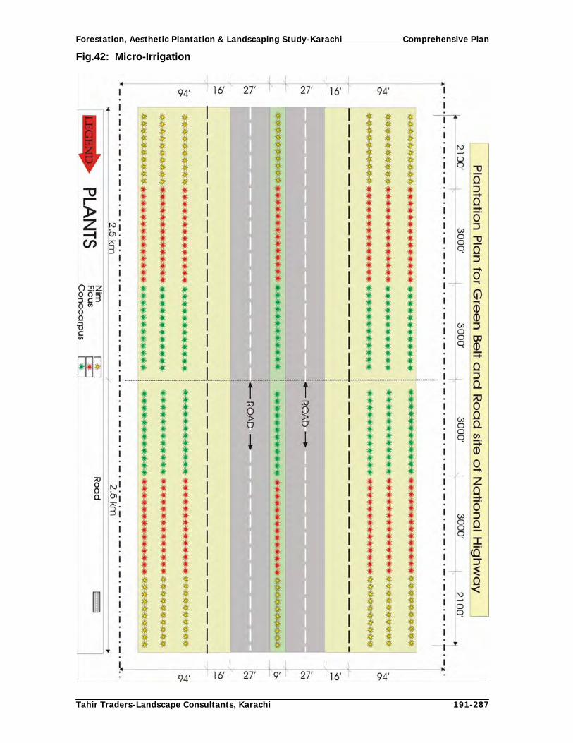
Forestation, Aesthetic Plantation & Landscaping Study-Karachi Comprehensive Plan
Tahir Traders-Landscape Consultants, Karachi 191-287
Fig.42: Micro-Irrigation
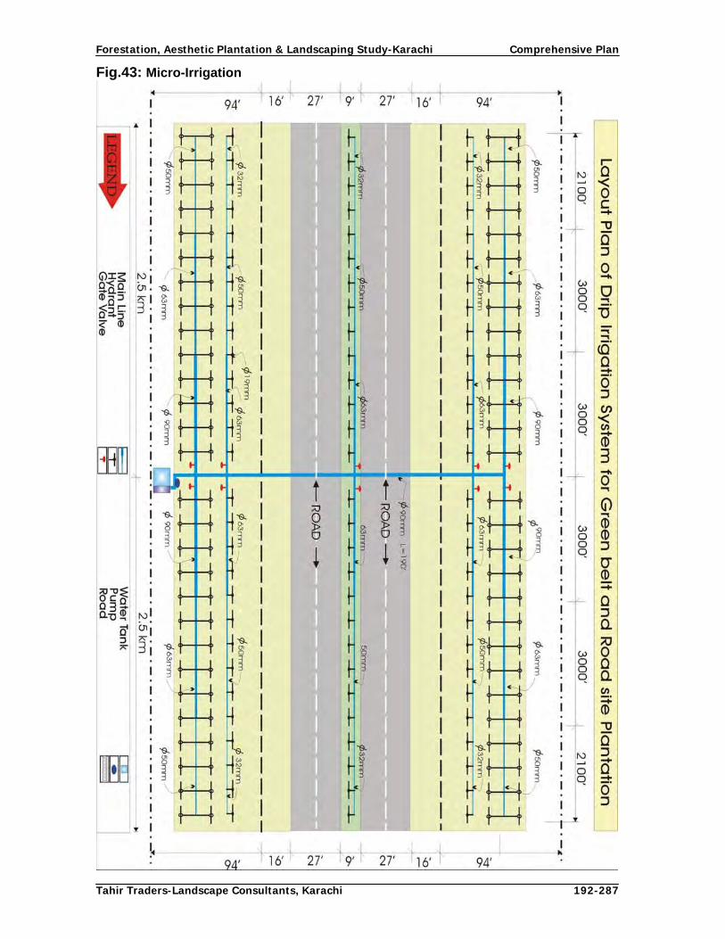
Forestation, Aesthetic Plantation & Landscaping Study-Karachi Comprehensive Plan
Tahir Traders-Landscape Consultants, Karachi 192-287
Fig.43: Micro-Irrigation

Forestation, Aesthetic Plantation & Landscaping Study-Karachi Comprehensive Plan
Tahir Traders-Landscape Consultants, Karachi 193-287
Fig.44: Micro-Irrigation

Forestation, Aesthetic Plantation & Landscaping Study-Karachi Comprehensive Plan
Tahir Traders-Landscape Consultants, Karachi 194-287
Fig.45: Micro-Irrigation

Forestation, Aesthetic Plantation & Landscaping Study-Karachi Comprehensive Plan
Tahir Traders-Landscape Consultants, Karachi 195-287
Fig.46: Micro-Irrigation

Forestation, Aesthetic Plantation & Landscaping Study-Karachi Comprehensive Plan
Tahir Traders-Landscape Consultants, Karachi 196-287
Fig.47: Micro-Irrigation

Forestation, Aesthetic Plantation & Landscaping Study-Karachi Comprehensive Plan
Tahir Traders-Landscape Consultants, Karachi 197-287
Fig.48: Micro-Irrigation

Forestation, Aesthetic Plantation & Landscaping Study-Karachi Comprehensive Plan
Tahir Traders-Landscape Consultants, Karachi 198-287
Fig.49: Micro-Irrigation

Forestation, Aesthetic Plantation & Landscaping Study-Karachi Comprehensive Plan
Tahir Traders-Landscape Consultants, Karachi 199-287
Fig.50: Micro-Irrigation

Forestation, Aesthetic Plantation & Landscaping Study-Karachi Comprehensive Plan
Tahir Traders-Landscape Consultants, Karachi 200-287
Fig.51: Micro-Irrigation

Forestation, Aesthetic Plantation & Landscaping Study-Karachi Comprehensive Plan
Tahir Traders-Landscape Consultants, Karachi 201-287
Fig.52: Micro-Irrigation

Forestation, Aesthetic Plantation & Landscaping Study-Karachi Comprehensive Plan
Tahir Traders-Landscape Consultants, Karachi 202-287
Fig.53: Micro-Irrigation
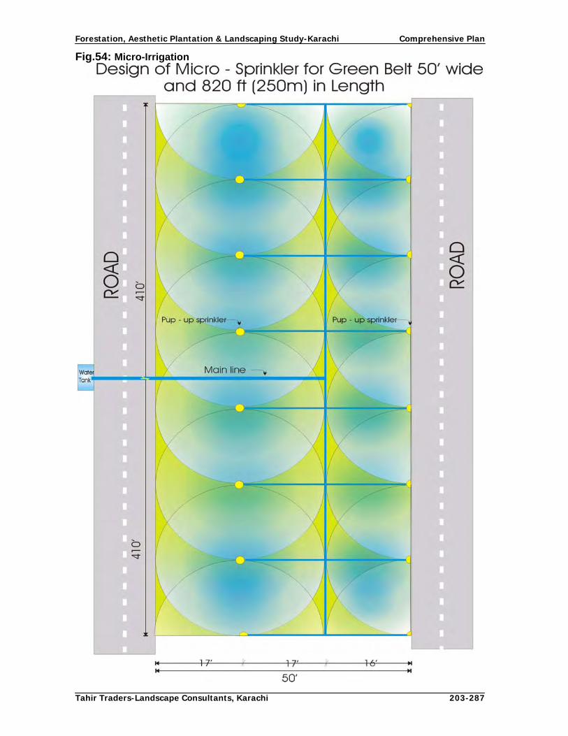
Forestation, Aesthetic Plantation & Landscaping Study-Karachi Comprehensive Plan
Tahir Traders-Landscape Consultants, Karachi 203-287
Fig.54: Micro-Irrigation

Forestation, Aesthetic Plantation & Landscaping Study-Karachi Comprehensive Plan
Tahir Traders-Landscape Consultants, Karachi 204-287
Fig.55: Micro-Irrigation

Forestation, Aesthetic Plantation & Landscaping Study-Karachi Comprehensive Plan
Tahir Traders-Landscape Consultants, Karachi 205-287
Fig.56: Micro-Irrigation

Forestation, Aesthetic Plantation & Landscaping Study-Karachi Comprehensive Plan
Tahir Traders-Landscape Consultants, Karachi 206-287
Fig.57: Micro-Irrigation

Forestation, Aesthetic Plantation & Landscaping Study-Karachi Comprehensive Plan
Tahir Traders-Landscape Consultants, Karachi 207-287
Fig.58: Micro-Irrigation

Forestation, Aesthetic Plantation & Landscaping Study-Karachi Comprehensive Plan
Tahir Traders-Landscape Consultants, Karachi 208-287
Fig.59: Micro-Irrigation

Forestation, Aesthetic Plantation & Landscaping Study-Karachi Comprehensive Plan
Tahir Traders-Landscape Consultants, Karachi 209-287
Chapter V
5. Physical and Financial Targets and Impact of Comprehensive Plan This chapter of Comprehensive Plan covers the physical targets of different target areas and financial resources required for executing those targets. It also includes estimates of associated costs (if any) required for preparation of P C-I and(if any) phasing of physical targets and financial resources during the plan period of 10 years. 5.1 Physical Targets The proposed targets of different target areas determined during the study are as under: Table : 13. Plantation Targets
Area to be Planted
Rows to be planted (km)
Plantation Sites
Km/Acre Sides Median Total
Super Highway 30 240 90 330
National Highway 25 50 25 75
RCD Highway 4 16 - 16
Karachi Northern by-pass
Section-I 35 280 35 315
Section-II 12 36 - 36
Link Roads 174 378 24 402
Coastal Roads 71 245 52 297
Urban Roads 357 1166 357 1523
Total (km) 708 2,411 583 2,994Mini Forest 7,000 ac(2832 ha)
Malir River 2,500 ac (1012 ha)
Lyari River 475 ac (192 ha)
Total (acres) 9,975 ac (4037 ha)
Social Forestry Targets Raising of Container Plants Number Potted Plants (6"x12" Polythene bags) 12,000,000
Potted Plants (12" pots) 7,000,000
Potted Plants (4"x8" Polythene bags) 5,000,000
Total 24,000,000
Linear Field Plantation Km
Shelter belts 800
Wind breaks 500
Total 1300

Forestation, Aesthetic Plantation & Landscaping Study-Karachi Comprehensive Plan
Tahir Traders-Landscape Consultants, Karachi 210-287
Block Field Plantation Acres
Block Plantations 500 ac (202 ha )
Dry forestation 2,500 ac (1,012 ha )
Total 3,000 ac (1,214 ha) Other Targets Number Establishment of Mother Nursery 1 Establishment of Town Nurseries 18 Construction of Green Houses 15 Engagement of Social Mobilizers 38 Seminars 10
Workshops 20
Trainings Man Months
Farmers 117 Staff (Local) 47
Staff (overseas) 10
Exposure Visits of Urban Forestry (overseas) 10
Establishment of Demonstration Plots Number Shelterbelts/windbreaks 5
Block Plantations 5
5.2. Utilization of Container Plants and estimated achievement of targets Container plants produced during the Comprehensive Plan period will be utilized for tree plantation in the following plantation sites.
Plantation Sites Saplings Planted Area planted acres Ha Shelterbelts 800 km 110,000 455 184 Windbreaks 500 km 70,000 303 123 Block plantations 200 ha 220,000 200 81 Rural house hold, mosques, graveyards, hotels, farm houses, play grounds, amusement parks, etc 1,600,000
3,200 1,295
Urban residential areas 3,000,000 6,000 2,428 Private and Public corporations and institutions 5,000,000 10,000 4,047 Federal/Provincial/Local Govt. Departments 2,000,000 4,000 1,619 Free distribution during planting campaigns 2,000,000 4,000 1,619 Urban roads and streets 3,000,000 6,000 2,428 Education and health institutions 2,000,000 4,000 1,619 Defense Forces 5,000,000 10,000 4,047
Sub Total 24,000,000 48,158 19,489 Equivalent area estimated to be planted by each target group has also been computed so as to arrive at planted area due to social forestry programme in CDGK. It reveals that an estimated area of 48,158 acres (19,489 ha) will be planted by executing the social forestry interventions proposed in the Plan.

Forestation, Aesthetic Plantation & Landscaping Study-Karachi Comprehensive Plan
Tahir Traders-Landscape Consultants, Karachi 211-287
5.3. Projected Targets of KSMP, 2020 (2007) Comprehensive Plan also takes into account the projected areas earmarked in the KSMP, 2020. Ring roads, roads and the areas requiring mini forests and other types of plantations are also included in the Plan. Details are given in Table 14. Table: 14. Projected Targets of KSMP, 2020
Plantations over proposed KSMP 2020 Km Acres Ring Roads 1040 km 2,364
Other Roads in proposed housing schemes 3,000 km 4,724
Plantations over 5% of allocated lands for public amenities
- 2,500
New Industrial zones 5 No. 200 km 300
Additional Site for Karachi International Airport (3500 acres)
175
Special purpose zone along KNBP (300 meter wide strips on both side of 38 km)
250 km 375
Education City (9000 ac) 500 km 750
Spaces for graveyards (500-600 acres) 50
Land-fill sites and garbage stations 50 km 75
Pedestrian improvement 1000 km 1,500
Sewerage treatment plants 200 km 300
Check dams for collection rain water harvesting 200
Establishment of veterinary hospitals and livestock stock farms
200
Proposed CDGK projects (2250 ac) 112
Total 13,625
It is estimated that 6,240 km and 3237 acres (1310 ha) will be planted in the areas shown in the KSMP, 2020. 5.4. Micro Irrigation Water management for irrigation to plantations raised under the Plan is an important aspect of Comprehensive Plan. During the assessment it revealed that the water is scarce and expensive input for tree plantation in Karachi. Accordingly, three micro irrigation techniques have been recommended for respective plantation sites as in Table 15. Table: 15. Micro-Irrigation Systems
Micro Irrigation Systems Plantation Sites
Drip Modified Hose Sprinkler Total
Super Highway 330 km 330 kmNational Highway 75 km 75 kmRCD Highway 16 km 16 kmKarachi Northern by-pass 351 km 351 kmLink Roads 402 km 402 kmCoastal Roads 355 km 355 km

Forestation, Aesthetic Plantation & Landscaping Study-Karachi Comprehensive Plan
Tahir Traders-Landscape Consultants, Karachi 212-287
Urban Roads (Side strips) 1166 km 1166 kmUrban Roads (Median) 357 km 357 kmMini Forest 7000 (1821 ha) 4,500 acMalir River 2,500 (1012 ha) 2,500 acLyari River 475 (192 ha) 475 acRoundabouts 22 No 22 NoTotal 2,695 km 9,475 (4037 ha) 357 km
Above table shows that 2,695 km long drip irrigation system will be established/ installed in various target areas ranging from 1-11 rows, 9,475 acres (4037 ha) plantation will be established and irrigated through modified Hose-fed system of micro irrigation and, sprinkler system of micro irrigation will be used for 357 km urban roads (median) and 22 roundabouts. 5.5 Overall Targets of Comprehensive Plan Comprehensive Plan envisages establishing linear plantations, block plantations and plantations by various target groups. It is estimated that that overall targets of the Plan will be as follows:
10,534 km linear plantations (equivalent canopy cover of 15,800 ac/ 6,395 ha) along present and projected highways, roads, link roads, ring roads and other roads will be established during the Plan period.
Another 10,475 acres (4239 ha) block plantations/ mini forests will be raised in
agricultural lands, arable lands, wastelands (dry forestation) and river beds.
An area of 47,200 acres (19,102 ha) is estimated to be established by various target groups to whom the saplings will be supplied under social forestry programme of the Plan.
In all, 73,475 acres (29,735 ha) plantation will be added to Karachi City by executing the Comprehensive Plan interventions. This will increase the vegetation cover substantially apart from environmental, social and economic benefits. Basis for estimating the Plan cost estimates The cost estimates have been worked out on the basis of market price and approved Schedule of Rates of Government of Sindh, 2004. A provision of 6.5% cost escalation and 5% physical contingencies has also been provided in the comprehensive plan but if the escalation in the cost of prices is substantial, these rates will be revised accordingly. The cost of the following items has been estimated as under: Micro Irrigation: Micro irrigation consultant has proposed drip irrigation for linear/ road side plantations, modified hose irrigation for block plantations in Rivers and mini forests and sprinkler irrigation for roundabouts and median strips with grass and ground cover. In case of linear plantations, pumping stations will be installed at each 5-10 km according to the number of tree rows/lines and gradient of the site. Water storage tanks will be constructed at these stations which will be filled through water tankers from nearest treatment plants or tube well installed for irrigation these plantations. Looking to the high cost of installation and

Forestation, Aesthetic Plantation & Landscaping Study-Karachi Comprehensive Plan
Tahir Traders-Landscape Consultants, Karachi 213-287
maintenance of micro irrigation system and installation of tube wells near such mini forests/block plantations, trench/flow irrigation system will be practiced at such sites. Water Tankers: Looking to the extensive plantations to be established on lift water, 143 water tankers of 3000 gallons capacity have been proposed in the project. Besides these tankers, existing facilities with CDGK and other agencies involved in these plantations will also be used. As per plan, each tanker will make 4 trips from the nearest water source/tube well. In urban /built up area, mainly treated sewerage water will be used for irrigation purposes, To save the cost, time and energy, the plantations will be irrigated from the nearest source of water. The cost of the water tankers and their operation/maintenance cost has been provided in the project. Tube wells: It is proposed to install 60 deep tube wells along super highway, national highway, RCD highway, Karachi Northern Bye-pass link roads, rivers, and in urban areas identified by the water and soil consultant. Besides, water will also be lifted from check dams and rivers on its availability. Hydrant points will be the last option for taking water for these plantations. The cost of installation, running and maintenance of the tube wells has been provided in the plan. 5.6 Estimated Financial Allocations of Comprehensive Plan Total estimated cost of the Comprehensive Plan over a period of 10 years is Rs. 8.3 billion, part of which will be shared by concerned agencies on whose lands proposed plantations will be raised. Break up of the above estimated cost of the Plan is given in Table 16. Table: 16. Estimated Financial Allocations of Comprehensive Plan
TARGET AREAS (NEW PLANTATIONS) AMOUNT (Rs.) Highways, Urban Roads and Other Areas
Super Highway 48,000,000 National Highway 13,750,000 RCD highway 2,800,000 Karachi Northern By-pass 81,200,000 Link Roads 83,490,000 Coastal Roads 31,890,000 Urban Roads 371,500,644 Ring Roads 91,000,000 Other roads 550,000,000 Mini Forest 245,000,000 Malir River 175,000,000 Lyari River 33,250,000 Roundabouts (22) 62,046,515Micro-Irrigation (Rivers, Roads & Mini Forests etc) 982,522,469 Tube wells Installation ( 60 ) 63,500,000Purchase of water tankers ( 183 ) 730,646,000
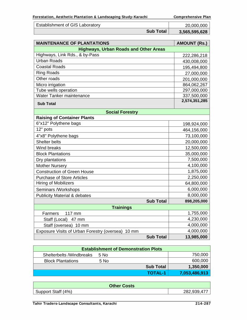
Forestation, Aesthetic Plantation & Landscaping Study-Karachi Comprehensive Plan
Tahir Traders-Landscape Consultants, Karachi 214-287
Establishment of GIS Laboratory 20,000,000 Sub Total 3,565,595,628
MAINTENANCE OF PLANTATIONS AMOUNT (Rs.)
Highways, Urban Roads and Other Areas Highways, Link Rds., & by-Pass 222,286,218 Urban Roads 430,008,000 Coastal Roads 195,494,800 Ring Roads 27,000,000 Other roads 201,000,000 Micro irrigation 864,062,267Tube wells operation 297,000,000Water Tanker maintenance 337,500,000
Sub Total 2,574,351,285
Social Forestry Raising of Container Plants 6"x12" Polythene bags 198,924,000 12" pots 464,156,000 4"x8" Polythene bags 73,100,000 Shelter belts 20,000,000 Wind breaks 12,500,000 Block Plantations 35,000,000 Dry plantations 7,500,000
Mother Nursery 4,100,000
Construction of Green House 1,875,000
Purchase of Store Articles 2,250,000 Hiring of Mobilizers 64,800,000
Seminars /Workshops 6,000,000
Publicity Material & debates 8,000,000 Sub Total 898,205,000
Trainings Farmers 117 mm 1,755,000
Staff (Local) 47 mm 4,230,000
Staff (oversea) 10 mm 4,000,000
Exposure Visits of Urban Forestry (oversea) 10 mm 4,000,000 Sub Total 13,985,000
Establishment of Demonstration Plots
Shelterbelts /Windbreaks 5 No 750,000
Block Plantations 5 No 600,000 Sub Total 1,350,000
TOTAL-1 7,053,486,913
Other Costs
Support Staff (4%) 282,939,477

Forestation, Aesthetic Plantation & Landscaping Study-Karachi Comprehensive Plan
Tahir Traders-Landscape Consultants, Karachi 215-287
Physical Contingencies (5%) 353,674,346
Logistics (2%) 141,469,738
Monitoring &Evaluation (0.5%) 35,367,435
Price Escalation (6.5%) 459,776,649 TOTAL-2 1,273,227,644
GRAND TOTAL 8,346,714,557 Rs. 8.35 billion
5.7. Impact of Comprehensive Plan During last 2-3 decades, the urban environment of Karachi has deteriorated to a significant extent. Automobile exhaust, industrial emissions, open burning of garbage and commercial/ domestic fuel consumption etc. has contaminated the air with increase in TSP, NOxi, Lead, So2, CO and other toxic materials. As per vehicles registration record, there were more than 1.5 million vehicles in Karachi in the year 2005, among which, 11.8% vehicles were registered just in that year. Rapid increase in vehicular traffic has produced high levels of pollution along busy city roads and their intersections where smoke level far exceeds than the limits set by WHO and National Environment Quality Standards of Pakistan. Open burning of garbage and solid waste of industries and hospitals at land fill sites and in and solid waste open areas also causes considerable and solid waste pollution. Malir and Lyari rivers which are meant for draining rain storm water have almost been converted in to large open sewers in which hazardous chemicals are discharged without any treatment. This sewerage system is one of the major causes of sever marine pollution mainly along the coastline. Besides, open sewerage channels running through urban settlements also create pollution and expose the residents to several diseases. In addition to vehicular exhaust, constant increase in industrial and municipal pollution, the expansion in built up area and densification the built environment has also been deteriorated by intense congestion, filthiness, unsanitary conditions, encroachments of footpaths, streets, roads and public amenity open spaces otherwise reserved for parks and recreation. Despite all these factors, vegetative cover which mitigates this pollution to great extent has not been increased. On the contrary, existing vegetation has decreased due to climatic variations and anthropological activities. The CDGK is well aware of the current situation and has initiated a comprehensive programmme for enhancing the vegetative cover through forestation and aesthetic plantations along highways, by-passes, link roads, major urban roads, arteries, roundabouts, streets, rivers, farmlands, wastelands and all its open spaces.

Forestation, Aesthetic Plantation & Landscaping Study-Karachi Comprehensive Plan
Tahir Traders-Landscape Consultants, Karachi 216-287
As per plan, plantations will be established over and along following areas: Table: 17. Site wise canopy coverage of Comprehensive Plan
S.No Location Km/acres Planted
Canopy cover in
acres Roads & Rivers
1 Super Highway 330 km 495 2 National Highway 75 km 1133 RCD Highway 16 km 244 Karachi Northern By-pass 351 km 5265 Link Roads 402 km 6036 Coastal Roads 297 km 4457 Urban Roads (tree rows) 1,166 km 8 Urban roads (shrub, creeper and lawn) 357 km
2,942
9 Ring Roads 1040 km 2,36410 Other roads 3000 km 472411 Sub Total 7,067 km 12,23612 Mini Forest (ac.) 7,000 ac 7,00013 Malir River (ac.) 2,500 ac 2,50014 Lyari River (17 km) plantation: 136 km 475 ac 475 Sub Total 9,975 ac 9,975
Total (acres) 22,211Total ha 8990
Social Forestry Raising of Container Plants in No
1 Departmental Nurseries 19,000,0002 Farmer Nurseries 5,000,000
Total 24,000,000Plantations to be raised from nursery plants
1. Shelterbelts 800 km 264,000 12002. Windbreaks 500 km 165,000 7503. Block plantations 200 ha 200,000 5004. Rural house hold, mosques, graveyards,
hotels, farm houses, play grounds, amusement parks, etc
1,600,000 32005. Urban residential areas 2,700,000 54006. Private and Public corporations and institutions 5,000,000 10,0007. Federal/Provincial/Local Govt 2,000,000 4,0008. Free distribution during planting
campaigns 2,000,000
4,000
9. Urban roads and streets 3,000,000 6,00010. Education and health institutions 2,000,000 4,00011. Defense Forces 5,000,000 10,000
Sub Total 49,050Plantations to be raised over proposed KSMP 2020 areas
Linear Plantations 2,200 km 3,300 ac Block Plantations 3,112 ac 3,112 ac 6,412 ac
Equivalent canopy cover in acres 77,673Equivalent canopy cover in ha 31,433

Forestation, Aesthetic Plantation & Landscaping Study-Karachi Comprehensive Plan
Tahir Traders-Landscape Consultants, Karachi 217-287
As shown in the table, linear plantations (along roads and in farmlands) will be raised over 10,534 km. It is estimated that after 10-15 years, the tree crown will spread to a minimum width of 20 feet and a single row of trees in a length of one km will cover an area of more than 1.5 acre. Collectively, these linear plantations will produce a vegetative cover over 15,801 acres (6,395 ha). Collectively, the linear plantations and block plantations will create a tree cover over 77,673 acres. The main thrust of plantation works will be confined in urban built up area where more than 20 million saplings will be supplied for planting in Rural house hold, mosques, graveyards, hotels, farm houses, play grounds, amusement parks, Urban residential areas, private and public corporations and institutions, urban roads and streets, education and health institutions and defense forces will also be distribution free of cost during planting campaigns. As per plan, 24 million plants will be produced in departmental and farmer nurseries which will be planted on farmlands and supplied to public for planting in houses, offices and on all suitable blank spaces. If these plants are planted at a spacing of 10 feet, it is estimated that 47,200 acres plantations will be raised in addition to 28,524 acre plantations to be raised as linear and block plantations. Since plants are living things and it is not possible that all planted sapling will survive. As per KSMP 2020, the total land area of CDGK is 729,566 acres but as per GIS imageries, the same area is 907,001.02 acres (367,058 ha). Among this area, 62,329 acres (25,224 ha) are under vegetative cover which forms about 7% of total land area. If the recommendation of this study titled “Forestation, Aesthetic Plantation and Landscaping for Karachi” is executed in letter and spirit of the plan, the vegetative cover of the CDGK will increase by another 8.5% by the year 2030. It is therefore estimated that 80% plantation (about 62, 138 acres), (25,147 ha) will survive and establish crown cover which will increase another 7 % vegetative cover of the CDGK in next 10 years. However, the overall vegetation cover in Karachi City by the year 2030 will further increase as the crown coverage of the vegetation will increase. On farmlands after Plan interventions the number of tree will increase from present 10 trees per acre to 20 trees per acre whereas on wastelands the number of trees will increase to 5 against the present 2 trees per acre. In fact farmlands have great potential for raising of extensive tree plantations, but due to dry cycle from 1998 to 2002, the water table fell to greater depth and substantial area of farmland was abandoned due to scarcity of water. The ever increasing cost of fossil fuel and excavation of hill-sand from riverbeds also exacerbated the situation. However, with the start of wet cycle, the water table has risen and area under urban agriculture is gradually increasing despite unaffordable power tariff and fuel cost. In such semi arid conditions where water is the most precious commodity, farmlands and wastelands are still a potential sites for increasing vegetative cover. Under this plan, a provision of dry afforestation over 2000 acres has also be kept but this has not been included in plantation area as it all depends upon climatic conditions of the region. The Forestation and Aesthetic Plantation Programme will have a positive impact on environment, agriculture, recreation facilities of general public and on marine environment. Although the impact of vegetation on environment and agricultural sector will be felt after a decade, but aesthetic impact of plantation along highways, link roads, urban roads, rivers, coastal roads and on roundabouts will immediately be visible and appreciable. The urban temperature will be moderated, people particularly youngsters will be attracted for recreation and other healthy activities in stead of negative activities, urban effluent will be utilized for establishing plantations, clean air and nice environment will be made available to all the dwellers of this metropolis, the value of agricultural lands will be appreciated and production will be increased by planting windbreaks and shelterbelts, plenty of fruit and

Forestation, Aesthetic Plantation & Landscaping Study-Karachi Comprehensive Plan
Tahir Traders-Landscape Consultants, Karachi 218-287
wood will be produced on unutilized areas and wastelands. Wildlife will be increases with the creation of their habitat and whole ecology of the tract will be improved. 5.8. Agencies and groups influencing urban Tree management in Karachi Departments/organizations having own horticultural establishments and responsible for making their areas green are also considered in this Plan. Following is the list of these organizations/agencies:
CDGK Towns and UCs Universities (Karachi, NED and Hamdard) Defense Housing Authority Six Army cantonments, Pakistan Navy, Pakistan Air Force (4 air bases) Karachi Port Trust Civil Aviation Authority SITE and Industrial Estates Port Qasim Authority Pakistan Steel Mills Export Processing Zone Pakistan Railways
5.9. Other potential organizations/Departments are:
Karachi Water and Sewerage Board Board of Revenue Forest Department, Government of Sindh Communication and Works Department, Government of Sindh Public Works Department, Government of Pakistan Cooperative Housing Societies Colleges and Schools (Government and private) Hospitals
5.10. Non Government Organizations
Horticultural Society of Pakistan Ladies Horticultural Society of Pakistan Floral and Arts Society Amateur Gardeners Club Greener Karachi Society Behbood Others
At present there is only one mini forest in Karachi which has been established over 80 acres by the forestry wing of CDGK at Thado Dam. It is proposed that at least 1% additional area over 9,000 acres (3642 ha) shall be established in 10 years in city jurisdictions. As per Karachi Strategic Master Plan 2020, CDGK has allocated 46,646 acres of land to several agencies for different purposes i.e. transport terminals/truck stands, cattle colony, commercial centers, hospital facilities, education city, institutional hub, air port, financial districts, government departments and agencies, markets, industries, grave yards, etc. If 5% area of this allocated land and some of the land portions lying vacant with several

Forestation, Aesthetic Plantation & Landscaping Study-Karachi Comprehensive Plan
Tahir Traders-Landscape Consultants, Karachi 219-287
agencies are earmarked for the establishment of mini forests ranging from 0.5 acre to any size, 1% additional area can be brought under tree growth. 5.11 Phasing of Physical and Financial targets Table 18 depicts the phasing of physical targets of the Comprehensive Plan and Table 19 shows phasing of financial resources of the Plan.

Forestation, Aesthetic Plantation & Landscaping Study-Karachi Comprehensive Plan
Tahir Traders-Landscape Consultants, Karachi 220-287
Table .18 Phasing of Physical Targets of Comprehensive Plan

Forestation, Aesthetic Plantation & Landscaping Study-Karachi Comprehensive Plan
Tahir Traders-Landscape Consultants, Karachi 221-287
Table: 19. Financial Phasing of Comprehensive Plan
Year-1 Year-2 Year-3 Year-4 Year-5 Year-6 Year-7 Year-8 Year-9 Year-10Item of Work Cost 5% 10% 15% 15% 15% 15% 15% 5% 5% 0%
Super Highway 48,000,000 2,400,000 4,800,000 7,200,000 7,200,000 7,200,000 7,200,000 7,200,000 2,400,000 2,400,000 0National Highway 13,750,000 687,500 1,375,000 2,062,500 2,062,500 2,062,500 2,062,500 2,062,500 687,500 687,500 0RCD highway 2,800,000 140,000 280,000 420,000 420,000 420,000 420,000 420,000 140,000 140,000 0Karachi Northern By-pass 81,200,000 4,060,000 8,120,000 12,180,000 12,180,000 12,180,000 12,180,000 12,180,000 4,060,000 4,060,000 0Link Roads 83,490,000 4,174,500 8,349,000 12,523,500 12,523,500 12,523,500 12,523,500 12,523,500 4,174,500 4,174,500 0Coastal Roads 31,890,000 1,594,500 3,189,000 4,783,500 4,783,500 4,783,500 4,783,500 4,783,500 1,594,500 1,594,500 0Urban Roads 371,500,644 18,575,032 37,150,064 55,725,097 55,725,097 55,725,097 55,725,097 55,725,097 18,575,032 18,575,032 0Ring Roads 91,000,000 0 0 0 0 13,650,000 18,200,000 22,750,000 22,750,000 13,650,000 0Other roads 550,000,000 0 0 0 0 82,500,000 110,000,000 137,500,000 137,500,000 82,500,000 0Mini Forest (ac.) 245,000,000 12,250,000 24,500,000 36,750,000 36,750,000 36,750,000 36,750,000 36,750,000 12,250,000 12,250,000 0Malir River (ac.) 175,000,000 8,750,000 17,500,000 26,250,000 26,250,000 26,250,000 26,250,000 26,250,000 8,750,000 8,750,000 0Lyari River (ac.) 33,250,000 1,662,500 3,325,000 4,987,500 4,987,500 4,987,500 4,987,500 4,987,500 1,662,500 1,662,500 0Rundabouts 62,046,515 3,102,326 6,204,652 9,306,977 9,306,977 9,306,977 9,306,977 9,306,977 3,102,326 3,102,326Micro Irrigation Installation 982,522,469 49,126,123 98,252,247 147,378,370 147,378,370 147,378,370 147,378,370 147,378,370 49,126,123 49,126,123 0Tubewell Installation 63,500,000 3,175,000 6,350,000 9,525,000 9,525,000 9,525,000 9,525,000 9,525,000 3,175,000 3,175,000 0Purchase of Water Tankers 730,646,000 6,258,000 25,032,000 62,580,000 112,644,000 156,450,000 181,482,000 186,200,000Est: of GIS Laboratory & Softwares 20,000,000 0 0 4,000,000 2,000,000 2,000,000 2,000,000 2,000,000 2,000,000 3,000,000 3,000,000MaintenanceHighways, L. Rds., & by-Pass 222,286,218 11,114,311 22,228,622 33,342,933 33,342,933 33,342,933 33,342,933 33,342,933 11,114,311 11,114,311 11,114,311Urban Roads 430,008,000 21,500,400 43,000,800 64,501,200 64,501,200 64,501,200 64,501,200 64,501,200 21,500,400 21,500,400 21,500,400Coastal Roads 195,494,800 9,774,740 19,549,480 29,324,220 29,324,220 29,324,220 29,324,220 29,324,220 9,774,740 9,774,740 9,774,740Ring Roads 27,000,000 0 0 0 0 3,600,000 4,680,000 5,760,000 5,760,000 3,600,000 3,600,000Other roads 201,000,000 0 0 0 0 21,000,000 36,000,000 45,000,000 45,000,000 27,000,000 27,000,000Mic.irrigation 864,062,267 7,022,157 21,154,449 42,293,755 63,620,981 84,486,905 105,355,353 126,223,800 133,432,789 140,236,038 140,236,038Maintenance of Water Tankers 337,500,000 22500000 40000000 52500000 45000000 37500000 30000000 30000000 20000000 7000000 12500000Tube wells operation 297,000,000 16,875,000 23,760,000 29,700,000 29,700,000 33,480,000 33,480,000 33,480,000 33,480,000 29,700,000 26,730,000
Sub Total 6,159,946,913 165,367,089 350,360,314 565,134,552 634,525,778 819,947,702 913,978,150 981,694,597 498,529,721 422,072,970 216,225,489 Social Forestry 10% 10% 10% 10% 10% 10% 10% 10% 10% 10%Raising of Container Plants6"x12" Polythene bags 198,924,000 19,892,400 19,892,400 19,892,400 19,892,400 19,892,400 19,892,400 19,892,400 19,892,400 19,892,400 19,892,40012" pots 464,156,000 46,415,600 46,415,600 46,415,600 46,415,600 46,415,600 46,415,600 46,415,600 46,415,600 46,415,600 46,415,6004"x8" Polythene bags 73,100,000 7,310,000 7,310,000 7,310,000 7,310,000 7,310,000 7,310,000 7,310,000 7,310,000 7,310,000 7,310,000Shelter belts 20,000,000 375,000 750,000 1,125,000 1,125,000 1,125,000 1,125,000 1,125,000 375,000 375,000 375,000Wind breaks 12,500,000 250,000 500,000 750,000 750,000 750,000 750,000 750,000 250,000 250,000 250,000Block Plantations 35,000,000 1,200,000 2,400,000 3,600,000 3,600,000 3,600,000 3,600,000 3,600,000 1,200,000 1,200,000 1,200,000Dry plantations 7,500,000 150,000 300,000 450,000 450,000 450,000 450,000 450,000 150,000 150,000 150,000Mother Nursery 4,100,000 4,100,000 0 0 0 0 0 0 0 0 0Construction of Green House 1,875,000 1,125,000 750,000 0 0 0 0 0 0 0 0Purchase of Store Articles 2,250,000 225,000 225,000 225,000 225,000 225,000 225,000 225,000 225,000 225,000 225,000Hiring of Mobilizers 64,800,000 6,480,000 6,480,000 6,480,000 6,480,000 6,480,000 6,480,000 6,480,000 6,480,000 6,480,000 6,480,000Seminars /Workshops 6,000,000 600,000 600,000 600,000 600,000 600,000 600,000 600,000 600,000 600,000 600,000Publicity Material & debates 8,000,000 800,000 800,000 800,000 800,000 800,000 800,000 800,000 800,000 800,000 800,000Trainings/Visits 13,985,000 1,398,500 1,398,500 1,398,500 1,398,500 1,398,500 1,398,500 1,398,500 1,398,500 1,398,500 1,398,500Demonstration Plots 1,350,000 135,000 135,000 135,000 135,000 135,000 135,000 135,000 135,000 135,000 135,000
Sub Total 913,540,000 90,456,500 87,956,500 89,181,500 89,181,500 89,181,500 89,181,500 89,181,500 85,231,500 85,231,500 85,231,500 Total-1 7,073,486,913 255,823,589 438,316,814 654,316,052 723,707,278 909,129,202 1,003,159,650 1,070,876,097 583,761,221 507,304,470 301,456,989
Support Staff (4%) 282,939,477 21,220,273 32,648,255 47,857,426 55,768,061 94,344,538 123,400,293 149,173,040 144,560,704 131,249,544 85,985,042Physical Contingencies (5%) 353,674,346 21,220,273 32,648,255 47,857,426 55,768,061 94,344,538 123,400,293 149,173,040 144,560,704 131,249,544 85,985,042Logistics (2%) 141,469,738 10,610,137 16,324,128 23,928,713 27,884,031 47,172,269 61,700,147 74,586,520 72,280,352 65,624,772 42,992,521Monitoring &Evaluation (0.5%) 35,367,435 2,122,027 3,264,826 4,785,743 5,576,806 9,434,454 12,340,029 14,917,304 14,456,070 13,124,954 8,598,504Price Escalation (6.5%) 459,776,649 13,793,178 21,221,366 31,107,327 36,249,240 61,323,950 80,210,191 96,962,476 93,964,458 85,312,203 55,890,277
Total-2 1,273,227,644 104,249,678 109,177,866 120,288,827 125,430,740 150,505,450 169,391,691 186,143,976 179,195,958 170,543,703 141,121,777
Grand Total 8,346,714,557 360,073,267 547,494,679 774,604,879 849,138,018 1,059,634,652 1,172,551,341 1,257,020,073 762,957,179 677,848,174 442,578,766
FINANCIAL PHASING OF FORESTATION & AESTHETIC PLANTATIONSHighways, Roads & Others

Forestation, Aesthetic Plantation & Landscaping Study-Karachi Comprehensive Plan
Tahir Traders-Landscape Consultants, Karachi 222-287

Forestation, Aesthetic Plantation & Landscaping Study-Karachi Comprehensive Plan
Tahir Traders-Landscape Consultants, Karachi 223-287
Chapter VI
6. Approaches/strategies for execution of Plan
This Plan has been prepared on the initiative of CDGK and in line with the Karachi Strategic Master Plan 2020. Thus, for successful execution of this Plan, the commitment of CDGK is essential being a lead agency. Some essential guidelines and administrative set up for the successful execution of Comprehensive Plan are given below: 6.1: Coordination The agencies to execute the Comprehensive Plan are CDGK and its departments, Town and UC administrations, departments of Sindh Government, provincial and federal land owning agencies/departments, large government and privately owned industrial units, military cantonments, industrial areas, multi-national companies, NGOs’, residential societies associations, farming communities etc. Although will be working independently but the coordination among them is essential. Hence, the coordination under the single agency i.e CDGK is necessary to execute the Comprehensive Plan successfully. 6.2: Participation The envisaged impact of the Comprehensive Plan is linked with active participation of all the stakeholders to whom the targets of tree plantation has been assigned. The plan’s strategy to achieve the targets revolves around the participatory approach. This approach binds the participating stakeholders to execute the Comprehensive Plan prescriptions and targets in a way that each one’s participation will result in successful execution of the overall Plan as per designed time frame. Participatory approach in the forestation projects has resulted in successful execution in neighboring countries viz. India, Nepal, Srilanka and Bangladesh. Under this approach communities and other stake holders have been organized and mobilized to participate in forestry project under agreed benefits. This approach is called as participatory forestry both on Government and Private lands. 6.3: Team work Crux of the participatory approach is the team work of participating forces in the projects. Through team work the required target could easily and efficiently be achieved as against the disintegrated or individual efforts. In the Comprehensive Plan the tree planting targets require team work among the stakeholders and even within the agencies/target groups responsible for executing the Plan. It is thus, essential to emphasize on team work system of working.
6.4: Political will
The Comprehensive Plan of Forestation, Aesthetic Plantation and Landscaping for Karachi has to be cleared from CDGK Council so that it shall be binding document for the CDGK and all the stakeholders to achieve their targets included in the Plan. Once this Plan is cleared from the Council of CDGK, during its execution the provision of required financial resources and back up support will also require political will and due importance to achieve the targets and envisaged outputs/results.

Forestation, Aesthetic Plantation & Landscaping Study-Karachi Comprehensive Plan
Tahir Traders-Landscape Consultants, Karachi 224-287
6.5: Vision-driven planning The vision of the CDGK to initiate this Comprehensive Plan is a thoughtful approach for improving the City’s degrading environment for the benefit its citizens. This approach has to be continued during its execution also. While executing the Comprehensive Plan prior planning each year has to be done so that the Plan is executed as per its time frame and phasing of the targets to be achieved. For this purpose the CDGK has to transmit its visionary planning to each stakeholder. Every participating stakeholder has to be taken on board to achieve the required results.
6.6: Community involvement Execution of Social/farm Forestry interventions proposed in the Comprehensive Plan is mandatory for the involvement of local communities. This will come under the umbrella of participatory approach to be adopted to organize, mobilize and motivate the communities and general public to extend their participation. In Karachi’s urban agriculture area where the main land use is agriculture, the involvement of farming communities to adopt the interventions of the Plan for their own benefit is essential. Likewise in the Urban build up area the interventions of tree planting in residential societies, streets, neighborhood parks, roads within the residential and commercial areas and other areas, the involvement and motivation of respective communities is essentially required for the successful execution of forestation plan. 6.7: The Green Movement It is proposed to work on strategic way instead of regular way of working. Stakeholders specially the masses will have to be moved through organized way to execute the Comprehensive Plan effectively. It is recommended to initiate “The Green Movement” in Karachi and communicate message to people of Karachi to make their city green through tree plantation by adopting collective efforts. They may also be organized and mobilized to participate by themselves and get others participated in this movement so that the Green Environment may prevail upon the Brown Environment for the benefit the society. In this context CDGK and the Parks and Forest departments will have to accept this responsibility and make it successful.
6.8: Allocation of budget for Tree Plantation in Infrastructure Projects It is proposed that in all infrastructure projects (roads, buildings etc.), a separate allocation of funds be provided in the PC-I of the project for tree plantation. The contractors be bound to raise tree seedlings in nurseries as soon as the construction work of particular project commences and plant those well grown tree saplings after completion of the construction work. 6.9: Partnerships Public Private Partnership (PPP) in infrastructure projects has been emphasized in Pakistan. A PPP Cell has also been established in Planning and Development Department of Government of Sindh to assist various organizations in promotion of PPP. Recently a PPP cell also been established within CDGK under the Enterprise and Investment Promotion Department. In Karachi the Adoption of Parks/Roads/Roundabout scheme was initiated in which private parties (mostly philanthropists) were allocated one of the above areas of their choice. This intervention was not promoted as there was no economic

Forestation, Aesthetic Plantation & Landscaping Study-Karachi Comprehensive Plan
Tahir Traders-Landscape Consultants, Karachi 225-287
aspect in it but it was mostly social/voluntary obligations of adopting individuals/agencies. This was mostly done by the philanthropists as their social and voluntary obligation. Comprehensive Plan provides to encourage PPP formally on the guidelines of IPDF of Government of Pakistan and PPP Cell of Government of Sindh. The areas for PPP has been identified in the Plan. 6.10: Transparency Transparent actions during execution of Comprehensive Plan are essential for its acceptability and implementation in letter and spirit. The executing agency has to adopt such policies/actions which encourage and build confidence of the stakeholders and communities to participate in execution of Comprehensive Plan. This could be achieved by adopting policies and guidelines given in the Plan.
6.11: Environmental stewardship The ultimate outcome of the Comprehensive Plan is to improve the environment of City for the betterment of its citizens. All the stakeholders directly and indirectly involved in the Plan are to be made conscious of environment through education, training, outreach programs and strategies so that people understand the environment and their activities shall follow the “Environment First Approach”. 6.12: Recommended Administrative set up for execution of Plan The subject study suggests planting in urban built up as well as in urban agriculture area. In urban build up area, aesthetic plantations are to be established along all the urban major roads, arteries, coastal areas, roundabouts, streets, households and all other blank urban areas and roads. In urban agriculture areas, plantation works will be carried out along highways, link roads, by-pass, mini forests and rivers in the jurisdiction of CDGK. In addition, Social forestry/ Farm forestry programme will also be executed in its farmlands and other areas. Presently Executive Director Horticulture & Parks manages the parks and urban plantations including planting all along major roads, arteries, coastal belt, roundabouts, streets, and all blank urban areas and other roads. Whereas, Forestry wing of CDGK executes plantation programes along non-urban / rural roads, in mini forests (Thado Dam) raises and supplies plant saplings to farmers, government/private departments and organizations, armed forces and to general public. They also execute the Farm forestry/social forestry programmes but the magnitude and workload of their operations is much less than horticulture and parks wing of CDGK. It is therefore proposed that both the wings shall work in their own jurisdiction of which they have the experience and specialization. Hence, all the urban and coastal forestation works will be executed by Directorate of Horticulture and Parks, whereas social forestry, highway plantations, mini forests and plantation works in Malir and Lyari rivers will be executed by the Forestry wing of CDGK. Under SLGO (2001), Social Forestry wing of Sindh Forest Department was devolved and limited staff was transferred to CDGK for its forestry works which is much less than its requirement. As per new setup, Forestry is one of the 6 wings of Agriculture group of offices and District Officer Forests executes his limited works with the assistance of two DDO’s and his field staff. In recent years, he has established plantation at Thado dam, planted few km plantation along link roads and raises and supplies lacs of saplings

Forestation, Aesthetic Plantation & Landscaping Study-Karachi Comprehensive Plan
Tahir Traders-Landscape Consultants, Karachi 226-287
annually to various target groups and plays a pivotal role in greening Karachi and outskirts. The work load and budget provided are less than the capacity of the department. Due to execution of Comprehensive Plan, the scope of work will increase manifold which will require strengthening of the forestry wing of CDGK. It is therefore proposed that a full fledge Plantation Department is created in CDGK to execute the Forestation and aesthetic plantation programme in urban agricultural areas of CDGK. The department will be headed by EDO Plantations/ who will be assisted by three Plantation Officers / D.O Forests, six Deputy Plantation Officers / D.D.O Forests and their support field staff to execute proposed plantation targets. Presently, the Parks and Horticulture Department of CDGK are under staffed. With the increase in quantum of work of comprehensive plan more trained and qualified staff will be required so as to strengthen the department. It is proposed that one horticulturist assisted by skilled support staff in each town be posted and the office of the Director Horticulture strengthened. In addition, necessary machinery, equipment, vehicles for the field and office is also recommended. 6.13. Legislation for Trees and Parks It is essential to prepare Parks and Trees Act for Karachi, which at present is non existent. The draft Trees and Parks for Karachi has been prepared (Annexure-II). It is proposed that priority actions should be taken to get this Act approved from the competent authority. This Plan is also to be approved by the City Council of CDGK for its execution. 6.14. Alienation of Comprehensive Plan with KSDP 2020 and Sindh Vision 2030. Comprehensive Plan has been prepared on the basis of Situation Analysis and recommendations for availability of areas within the jurisdiction of CDGK and areas under the control of Federal, Army, Industrial zones, Prominent Housing Authorities, Private land owners and Government Departments etc. The Plan is also in line with proposed areas of KSDP 2020 such as areas proposed for Housing Authorities, Amenities, Graveyards, Special Purpose Zone, Education City, Industrial Zones, Cities Entry Points, Transport Infrastructure, Landfill sides and future water supply schemes. The tree plantation component proposed for the above areas have been taken into account while proposing the Forestation Plan for City. 6.15. Allocation of Land for Forestation. Efforts were made during the plan preparation to identify the vacant areas for Mini Forests in the CDGK jurisdiction and other agencies. Revenue department of CDGK has identified only 65 acres for Mini Forest in the entire City District. It is proposed that this area be reserved for the purpose i.e. raising of Mini Forests. It is also proposed that in each town such areas be reserved for tree plantation and in the Gadap, Bin Qasim, Malir and Kiamari Towns. Long term leases be also given only for tree plantation. CDGK may coordinate with other land owning agencies/departments for enhancing tree cover specially outskirts of Karachi for improvement of overall environment of the city. 6.16. Public Private Partnership Various avenues for PPP have been identified in Comprehensive Plan and guidelines to initiate the process have also been outlined. Government of Pakistan and Government of Sindh have established Infrastructure Project Development Facility (IPDF) and Public Private Partnership Cell, respectively. It is proposed that CDGK may coordinate with the

Forestation, Aesthetic Plantation & Landscaping Study-Karachi Comprehensive Plan
Tahir Traders-Landscape Consultants, Karachi 227-287
above agencies for introducing PPP for tree plantation, recreation, environmental improvement, beautification and landscaping in Karachi. 6.17 Preservation of Heritage Trees During the assessment, it was observed that there are several old trees which were planted about a century ago in the older part of city. These trees are being cut while construction of buildings and widening the roads. It is recommended that all such trees shall be declared as “Heritage Trees” and preserved as an ecological assets of the metropolis. 6.18. Tree Plantation on Pathways It has been observed that the concrete area in the city is increasing and the green area is consequently decreasing. Several trees planted on footpath have been cut while cementing with out leaving the space for new planting. It is suggested that 3’x3’ area be left after every 20’ on all the foot paths for tree planting for the comfort of pedestrians. KSDP 2020 suggests that Financial District of Saddar be declared as Pedestrian area. Accordingly, it is suggested that all along the streets of Saddar Financial District be thickly afforested for the comfort of pedestrian shoppers and shopkeepers.

Forestation, Aesthetic Plantation & Landscaping Study-Karachi Comprehensive Plan
Tahir Traders-Landscape Consultants, Karachi 228-287

Forestation, Aesthetic Plantation & Landscaping Study-Karachi Comprehensive Plan
Tahir Traders-Landscape Consultants, Karachi 229-287
Chapter VII
7. Monitoring and Evaluation Plan of Comprehensive Plan
M & E of Comprehensive Plan will be undertaken by adopting two techniques viz. M & E system using Satellite Facility and M & E system through third party. Monitoring is usually done during the execution of the projects to identify the bottle necks hindering the progress and also suggests the corrective measures, whereas the evaluation is done after completion of the development projects so as to assess its success, sustainability and lessons learnt. This chapter describes both the techniques. 7.1: Monitoring and Evaluation (M & E) System using Satellite Facility Introduction Vegetation monitoring demands high temporal frequency information to follow the rapid vegetation change. Customarily, the standard resource datasets that have been used are the satellite images data such as NOAA AVHRR data, SPOT and Landsat satellite raster datasets to obtain regional coverage and synoptic overview of areas of interests. NOAA AVHRR and SPOT VEGETATION data have been widely utilized for global, continental and regional land use and land cover studies. The use of these multi spectral satellite images spatial and spectral models are extensively applied for assessment of regional and localized land use and vegetative cover. Landsat ETM+ with its multi spectral bands is generally processed to discern major land use classes; however, the spatial resolution of multi spectral bands has remained a major consideration in discerning the land use classes in the form of geographical and hydro-geological datasets. Among major problems when using these satellite datasets are their volume and noise, in addition to their low spatial resolution. Usually, the large ground area of each AVHRR or SPOT VEGETATION pixel is a mixture of several land cover types. Conventional classification approaches categorize each pixel into a discrete vegetation type and generally do not fully utilize the rich information content of the pixel data to describe gradients and mosaics in the landscape, and also variation in vegetation characteristics within a cover type is obscured (Defries et al., 2000). Efforts to address the problem of mixed pixels are of increasing importance as emphasis is being placed in providing global-scale monitoring.
The envisaged project monitoring and evaluation strategy is to detect change using high and low resolution satellite imageries over a period of time and its continuous monitoring and data updates using ancillary datasets in the form of field survey data. The difference in spectral reflectance between imagery dates determines whether change occurred or not in terms of spatial areas obtained using cumulative pixel count.
The term spectral reflectance refers to the amount of sunlight reflected from surface features to the satellite in space. The change detection process interprets these spectral reflectance differences and produces a map identifying a continuum of change classes. The classes range from little or no vegetation change to large increases or decreases in vegetation cover.
In case of high resolution digital globe satellite imagery, limited spectral depth is available along with high spatial resolution 3 No bands (red, green & blue). However, it is important to note that the feature discerning criterion in the case of high spatial resolution is limited

Forestation, Aesthetic Plantation & Landscaping Study-Karachi Comprehensive Plan
Tahir Traders-Landscape Consultants, Karachi 230-287
to the available pixel capture or spectral depth that can be idealized in the form of generated statistics based on the cumulative pixel count within the idealization domain of interest. The Consultant Group under its terms of references has developed an automated geospatial procedure / assessment technique that can readily provide the vegetative and tree cover sprawl in each administrative unit. There are 18 Towns administrative units in Karachi which are further sub divided into 178 Union Councils. The spatial analysis strategy incorporates classified high and low resolution satellite imageries with GPS field survey datasets projected as themes with information stored in the form of tabular data / geodatabase on GIS platform. The vegetative cover is essentially the cumulative count of the selected vegetative pixel class. This report presents the methodology which is primarily based on remote sensing technologies and its integration along with the field survey data in the form of geodatabase. The model allows spatial and temporal assessments using remote sensing technologies based change detection technique and results in populating the vegetative cover geodatabase. The model will allow the town and union council administrations to scientifically implement necessary measures and intervention for the maintenance and improvement of the existing tree and vegetative cover in the city.
Objectives of Monitoring & Evaluation
1) To develop a comprehensive city wide monitoring and evaluation model to assess the increment / or depletion of vegetative cover in each town on yearly basis/ or on specific time intervals
2) The monitoring system should be robust and sustainable for management and preservation of green belts and vegetative cover by towns and CDGK administrations
3) The Geodatabase should be modular in design to update the localized interventions and improvement schemes by incorporating GPS based field survey records and satellite imageries
4) Reporting mechanism should be developed that can reflect the percentage of vegetative cover change (increment/decrement) in each Town
5) The system should allow access of the vegetative cover and plantation schemes information and updates through internet and should get integrated with the CDGK spatial data cell geodatabase model
Importance of M & E
Change detection results answer different questions at a variety of scales. At a regional scale, users investigate ecosystem characteristics or function by examining the cause of change over time, the ratio of vegetation increase to decrease, and whether changes are temporary or permanent such as infrastructure developments as new road network or temporary changes caused due to fire.
Examining changes in vegetation using satellite imageries at sub-regional or local scales can help resource managers to evaluate the impacts of disturbances on natural ecological resources of interest. This information is useful to monitor and assess the effectiveness of existing policies, programs, management activities, regulations, and develop alternatives as needed.

Forestation, Aesthetic Plantation & Landscaping Study-Karachi Comprehensive Plan
Tahir Traders-Landscape Consultants, Karachi 231-287
Keeping in view the objectives of the project, it is important that a comprehensive scheme of vegetative cover assessment and evaluation of various horticulture and improvement schemes should be regularly monitored and evaluated for the respective CDGK department to administer the long term plantation improvement program on sustainable and scientific basis. The localized interventions and regional changes should be monitored through an effective IT based reporting solution.
7.2: Methodology for conducting Vegetative Cover Assessment
The Vegetation Assessment and Monitoring Model (VAMM) and the geodatabase developed under the consultancy program entails spatial vegetative cover information in each town generated using high and low resolution satellite imageries.
The entire scheme of data modeling is developed on GIS platform using ESRI Arc.Map and ERDAS Imagine software suites/applications. The baseline raster layers are latest archive 3 Band multi spectral high resolution 0.6m satellite imagery from Digital Globe and Landsat ETM+ and GPS point event themes obtained through field surveys. Additional vector layers in the form of Towns/Union Councils boundaries, land use etc also form an integral part of data model.
7.3: Process Diagram
The following diagram depicts the interaction of processes with the various internal and external data sources of the Vegetation Coverage Geodatabase, from a system overview perspective. As mentioned, the monitoring model allows incorporation of high and low resolution satellite images for land use classification requirement and generates statistics in the form of vegetative cover sprawl in each town. Each Town is clipped on the basis of Town boundary and the respective vegetative cover statistics is generated on the basis of vegetative class cumulative pixels area as shown as under.
Multi spectral Satellite Image(s)
Generate pixel based classes
Clip using vector Masking
Calculate Area of selected pixel class
VAMM process diagram

Forestation, Aesthetic Plantation & Landscaping Study-Karachi Comprehensive Plan
Tahir Traders-Landscape Consultants, Karachi 232-287
Generated Statistics of Vegetative Class pixel based area
The vegetative cover identified under land use classification can be further categorized into parks and general tree/vegetation in each town using raster – vector overlay between vegetative pixels and parks vector layers giving a viable analysis tool to assess the vegetative cover in each Town and provide a technical justification to propose future forestation and improvements schemes for beautification and aesthetics improvement programs such as coastal areas plantation and greenbelts along northern bypass and other major arterial/link roads and Malir and Lyari rivers.
Sample of high resolution satellite imagery used for classification
Sample high resolution satellite image showing vegetative cover classification The datasets generated are not just a snapshot in time. It is a constantly changing with time and is therefore important to maintain the VAMM sustainability with the resources and

Forestation, Aesthetic Plantation & Landscaping Study-Karachi Comprehensive Plan
Tahir Traders-Landscape Consultants, Karachi 233-287
updates with latest satellite imageries and data that provides the decision makers the confidence to plan and execute schemes in lines with the Master Plan 2020. 7.4: Geodatabase Layers The Consultant in coordination with the CDGK LSU project office utilized the available resources in the tabular form as under:
S.No Data Layers Topology
1 High Resolution Digital Globe Satellite Imagery Raster
2 Land sat ETM+ Satellite Imagery Raster
3 GPS Survey Points Vector
4 Town Boundaries Vector
5 Union Council Boundaries Vector
6 Street level road network Vector
7 2020 Master Plan land use Vector
8 Parks/Green Fields Vector
7.5: Outcomes of M & E Generated Geodatabase Data The GIS geodatabase model developed under this consultancy program entails development of analysis layers carried out for the 18 towns of the Karachi city including the survey and proposed interventions and improvements records in the form of spatial data layers such as contours. The generated layers are given as under: 1) Classified raster layers for 18 Towns 18 No raster layers 2) Tabular data for vegetative Cover area in 18 Towns 18 No Tabular mdb table 3) Vector Point Layer Survey Locations 4) Vector Point Layer Soil Samples 5) Vector Point Layer Water Samples 6) Vector Polygon Layer Layri River 7) Vector Polygon Layer Malir River
Monitoring and Data Update Strategy The process for updating information and monitoring is driven by the ever-changing land use sprawl and also due to the development schemes and improvement plans and policies. A robust and comprehensive analysis and monitoring approach is developed in the project to undertake planning and future interventions for the assessment of improvement / or depletion of vegetative cover at each administrative UC/Town level. The objective is to provide a sustainable long term solution plan that can effectively provide the necessary feedback and analysis platform for the town and city administrations and take actions accordingly.

Forestation, Aesthetic Plantation & Landscaping Study-Karachi Comprehensive Plan
Tahir Traders-Landscape Consultants, Karachi 234-287
As discussed the entire exercise is primarily based on remote sensing technologies and is therefore important to enable the system to upload new datasets with provision to identify the improvement or / depletion in terms of Vegetative Indices (VI) and statistics in each town and also in the preferred zones of interest such as coastal belt and greenbelts along highways, bypasses, link road, coastal and urban roads.
7.6: Future Monitoring Strategy A typical monitoring approach would enable the town administration and other stakeholder departments / functionaries to assess and extract vegetation cover in the 18 Towns of Karachi city. Based on the conceptual model in terms of cost and availability of satellite imageries for the time frame under consideration, it is proposed to acquire satellite imageries at regular intervals of 1 year/ or at suitable time interval to assess and monitor the vegetative sprawl in the 18 Towns. The change detection process begins with Landsat/other listed images of two different dates, runs through a series of image analysis steps as discussed in the methodology generating vegetative cover statistics in each town /city wide or in areas of interest with the creation of spatial raster and vector files. Conventionally multi spectral Landsat and SPOT satellite imageries are generally adopted for land use modeling wherein the spectral resolution of the satellite image pixel depicts
Multi-Temporal Imagery
Satellite Imagery Type I – Time A
Satellite Imagery Type I - Time > A
Classifications
Extract Features
Combine
Geo-referencing / Enhancement
Multi Temporal Satellite Imagery based monitoring strategy

Forestation, Aesthetic Plantation & Landscaping Study-Karachi Comprehensive Plan
Tahir Traders-Landscape Consultants, Karachi 235-287
the level of data capture vis-à-vis ground resolution. However, keeping in view the scope of services in this project, (0.6m) high resolution No 3 bands Digital Globe satellite imagery is used for analysis and assessment of vegetative cover at street level. The statistics generated in the form of geodatabase can ideally be assessed for the land use analysis at each town administrative levels. Table.20: Types of Satellite Imageries for Vegetative Cover Analysis
S.No Raster Data Cost
1 Multi spectral Landsat/Aster satellite imagery Low cost 2 Multi spectral SPOT 10m satellite imagery Low cost 3 Multi spectral SPOT 2.5 m satellite imagery Medium cost 4 High Resolution Digital Globe (0.6m) High Cost
The cost of above raster data depends upon there availability in the market, quality and reliability of the vender. It is proposed to consider these factors while procuring the raster data and necessary equipment required for establishment of the GIS facility in CDGK and town administration. 7.7: Future Field Survey Data Keeping in view the scope of services and the requirement to assess the vegetative cover and propose interventions in the form of plantations and aesthetics improvement program at major intersections in the city, GPS surveys are to be conducted and sampling points need to be reflected in the geodatabase as point layer(s) with information of each such location associated in the attribute tables and to be displayed as thematic color coded scheme surface to depict the spatial distribution of the parameters under study such as salinity and depth to groundwater table etc. It is proposed under this study to acquire a consultant/Firm on long a term basis with relevant project experience of remote sensing and forestation to continuously monitor and provide the necessary feedback on vegetative cover in all the areas of interest under CDGK. 7.8: Consultant Monitoring Tasks The consultant will be required to collect information such as soil and water quality samples along with GPS point locations and depict the same in the form of contour surface to identify and analyze the potential locations of interventions and suggest improvement and remedial measures. The generated statistics in terms vegetative cover area in each town will be required to compare with the previously generated datasets to asses on scientific basis the real ground situation in terms of vegetation cover status. It is proposed that the GIS based multilayer paradigm should be used to conveniently access the information and generate the reports. Furthermore, the spatial information that shall be collected through field surveys is to be added in the geodatabase as point event themes to support the management in assessing the improvement schemes at ground level.

Forestation, Aesthetic Plantation & Landscaping Study-Karachi Comprehensive Plan
Tahir Traders-Landscape Consultants, Karachi 236-287
The geodatabase is to be generated on the ArcGIS platform due to its modular structure and can be quite conveniently enhanced and integrated with other database management systems. 7.9: Facilities and staff required for M & E Based on the requirement to carry out surveys and provide a continuous stream of data update to effectively monitor and assess the various beautification and improvement schemes, it is recommended to establish a computer center facility with fulfilling the following hardware, software and manpower requirements: Equipment required for M & E Hardware I Magellan Explorist 600 GPS sets 03 II Xeon Server 01 III Desktop Computers 02 IV Furniture(Tables/Chairs) 05 V Air conditioner 02 VI UPS 02 VII Wireless Network Router 01 VIII DSL Connection 01 Software required for M & E Software I ESRI suites of application ArcMap 9.x 01 II ESRI Spatial Analyst extension 01 III ERDAS Imagine 8.x 01 Manpower required for M & E I Consultant/Firm 01 II System Administrator 01 III GIS /Remote Sensing Analyst/Developer 01 IV Computer Operators 02 V GPS Field Surveyors 03 It is proposed to establish a nucleus GIS laboratory in the office of the Executive Director Parks and Horticulture and modest GIS facilities at DO Forests Office and Town Administrations, for this purpose a single room space and necessary equipment should be provided under the development plan. Necessary cost estimates have been included in this Plan in Table:16- Financial Phasing of Comprehensive Plan, wherein support staff, logistics, monitoring and evaluation and physical contingencies have been provided. 7.10: Monitoring and Evaluation System using Third Party Facility Monitoring and Evaluation (M & E) Plan provides a brief overview of the purpose of M & E, roles and responsibilities, data collection and reporting mechanisms, and selected performance indicators and targets. The purpose of monitoring is to provide timely feed

Forestation, Aesthetic Plantation & Landscaping Study-Karachi Comprehensive Plan
Tahir Traders-Landscape Consultants, Karachi 237-287
back and analysis to the department and programme partners for making management decisions. This information is used to:
Facilitate problem-solving at the local level.
Identify trends requiring corrective action at the programme level.
Evaluate programme performance.
Document successful approaches and lessons learned.
Support strategic planning efforts.
Following types of M & E are proposed:
Implementation monitoring of ongoing works/contracts focuses on measuring progress against work plans (outputs) and quality of facilitation and community participation (processes).
Post-implementation monitoring of completed works/contracts focuses on the quality of completed works and sustainability.
Programme evaluation provides a more in-depth assessment of i) development outcomes and impacts and ii) the effectiveness and efficiency on implementation.
Each type of monitoring uses a select group of Performance indicators and associated targets to measure results. There are four types of indicators which form a “results chain”. They are as follows: Output: Immediate visible result. Process: Actions taken by beneficiaries and facilitators to achieve a desired outcome. Outcome: Medium-term result. Impact: The long-term result that comes from achieving outputs and outcomes. Programme activities are typically specified in work plans and include coordination, technical assistance, training, and other tasks undertaken by programme implementers. Programme inputs are typically specified in budgets and include programme staff, organizations, supplies, funds, and other resources allocated to the programme. M & E is a shared responsibility involving almost all stakeholders, facilitating partners, communities and the CDGK/Government. Programme evaluation is the responsibility of CDGK which is conducted by external consultants or third parties contracted by CDGK rather than concerned department.

Forestation, Aesthetic Plantation & Landscaping Study-Karachi Comprehensive Plan
Tahir Traders-Landscape Consultants, Karachi 238-287

Forestation, Aesthetic Plantation & Landscaping Study-Karachi Comprehensive Plan
Tahir Traders-Landscape Consultants, Karachi 239-287
Chapter-VIII
8. Recommendations on Public Private Partnership Methods 8.1: Introduction Scope of work envisages recommendations on Public Private Partnership (PPP) methods for plantation in green pockets of outskirts of the city as well as renovation / aesthetic plantation of roundabouts within the city and other areas having tremendous commercial value. Consultants have conducted in depth review on various aspects of PPP including guidelines of IPDF and have prepared recommendations on PPP methods applicable for Karachi. The term ‘Public Sector’ is used broadly to refer to the state-the authorities-government functionaries and departments, the officials representing the state in an official capacity. ‘Private Sector’ on the other hand represents the non-government, for profit entities, whether they be private individuals acting in the system, proprietorships, partnerships, or corporate entities. This report meant to be a “thought stimulator” and seeks to put the PPP concept, its scope and potential benefits that could be introduced in Karachi in the Comprehensive Plan on Forestation, Aesthetic Plantation and Landscaping for Karachi. Assessment during Baseline Survey During the baseline survey of Karachi, situation analysis of existing tree growth, gap analysis within the plated areas and identification of potential sites/locations to be included in the Comprehensive Plan, the potential of introducing the concept of PPP was also assessed. Exchange of views and discussions with the stakeholders particularly the business community revealed that there are individuals and agencies/companies interested in PPP especially on roundabouts, portions of roads and parks within the city and growing of fruit orchards in the potential blank areas under agreed social and economic responsibilities. Considering this initiative both from above mentioned agencies and CDGK certain PPP methods and related framework and policy issues are discussed in this report. 8.2: Concept of PPP PPP is a contract between a private sector “institution” and a private party in which the private party assumes substantial financial, technical and operational risks in the design, financing, building and operation of and infrastructure related project. PPP arrangements are basically contracts between a private sector entity and the government that call for the private partner to deliver a desired service and assume the associated risks. In turn for agreeing to provide the service, the private partner receives payment (in the form of a fee, tariff or other user charge) according to certain standards of service and other criteria as specified in the contract. Corporate Social Responsibility (CSR) is often used by private entities to reflect goodwill in order to enhance their image in front of consumers/general public. PPPs are prompted by a desire among companies to emphasize their socially and environmentally conscious outlook. The underlying rationale of forging partnerships i.e pooling land, manpower, and financial resources and sharing of benefits and profits between the two parties depending upon the allocation of their respective resources, but in a manner that does not undermine sustainability concerns. PPP are presumed to create an integration pattern that produces higher efficiency gains in absolute terms than a situation in which either the public or private

Forestation, Aesthetic Plantation & Landscaping Study-Karachi Comprehensive Plan
Tahir Traders-Landscape Consultants, Karachi 240-287
sector would have acted alone. Profit motive is not allowed to override sustainable resource management under the framework of PPP. The ideal PPP would entail i) a formal arrangement between public and private sector entities with active community participation, or even an arrangement between the private sector and communities but within the officially defined framework ii) an arrangement that delivers profits for the private sector, revenues for public sector, and economic incentives or direct income for the local communities and iii) a partnership where sustainable management practices are implemented to ensure conservation benefits. PPP is defined as establishment of partnership or mutual understanding between the public department, the private individual or community (group of like minded people) and NGOs’ for common commercial goal on agreed term and conditions. The binding force between the parties is basically a social responsibility than the commercial benefit. In the developed countries the concept of PPP is common in natural resources where the resources are managed through this partnership on the principles of conservation and sustainable development. The benefits from these resources are shared between the partners in agreed sharing system. In this way the resources are conserved on the one hand and part of the benefits are ploughed back for development and livelihood of partner community. This concept is being used as a tool for conservation and development of natural resources. Multi-national agencies and industrialists earn carbon credits by adapting this concept through tree planting and add carbon credits to the over all atmosphere there by pouring their share in environmental amelioration. Like many developed as well as developing countries the Federal Government has for the purpose of coordinating and promoting PPP, setup an independent PPP unit-Infrastructure Project Development Facility (IPDF) which has been incorporated as a company under section 42 of the Companies Ordinance, 1984 through the Ministry of Finance. IPDF was launched in November 2006, which provides expertise and hands on support on behalf of the Federal Government to implementing institutions at all tiers of the government for infrastructure projects under the PPP modality and for serving as the secretariat to the Task Force constituted by the Federal Government in 2006. 8.3: Process of PPP in Natural Resources Literature search conducted during the study revealed that a National Consultative Workshop was organized on PPPs for Sustainable Forest Management in Pakistan. This workshop was a follow up of provincial consultative workshops conducted under the auspices of Ministry of Environment, Government of Pakistan. Summary of discourse of workshops is reproduced as under:
Almost all participants supported the idea of PPP in forestry. Clear rules, regulations and pre-conditions for a meaningful, productive partnership
that may prove beneficial to all stakeholders, as well as to the environment be formulated.
Majority of the views suggested jump-starting the PPP process from areas which already had some form of private sector involvement.
There was a general sense that while company-community partnerships could be mutually beneficial, a strong governance and legislative framework is required to ensure a favorable outcome.

Forestation, Aesthetic Plantation & Landscaping Study-Karachi Comprehensive Plan
Tahir Traders-Landscape Consultants, Karachi 241-287
Both, the public sector and the civil society warned against the potential of overexploitation of sources by private entities if the arrangement is not situated within a robust framework.
In Karachi by incorporating the concept of PPP in the comprehensive plan and preparation of recommendations for PPP methods is a commitment of CDGK to enhance partnership with the private sector in landscaping of the city. 8.4: Avenues of PPP in Karachi In Karachi there are potential areas and interventions which could be exploited for PPPs. Some of the avenues and sites where PPP could be introduced are as follows: Urban forestation and landscaping: Within the build up area of Karachi there are potential sites such as City roundabouts, important roads, parks, and sites in commercial areas etc. which could be taken up under the PPP program. Certain sites could be identified and offered to private entities under a mutually agreed terms and conditions. Ecotourism in Mangroves of Karachi: Karachi has a sizeable area of Mangroves along its coast under the jurisdiction various agencies. There is tremendous scope of PPP in mangrove areas of Karachi. A framework could be established to introduce the concept of PPP in the field of eco-tourism between the Government agency and interested private sector. Mangroves of Karachi are owned by different Government agencies such as Sindh Forest Department, Karachi Port Trust, Board of Revenue and Port Qasim Authority. These agencies could offer Mangrove areas for PPP to interested Private agencies under an agreed Management. People of Karachi lack recreational areas especially in mangroves areas due to inadequate facilities in mangrove areas. The proposed recreational facilities in mangrove areas are as under;
Ferry Service for site seeing and recreation. Construction of Jetties along see coast to facilitate the recreationers. Construction of Paths and Tracks within the mangroves Establishment of restaurants and recreational huts in the mangrove areas Exploitation of Honey from mangroves. Birds (including migratory) and Dolphin watching in the creeks Fishing by the visitors inside the creeks
Establishment of new beaches and rehabilitation of existing beaches along Karachi Coast. It is proposed that a new beach near Mubarak Village located in the north west of Karachi near Balochistan boundary is proposed for development on B.O.T (Built operate and Transfer) basis for boating, surfing, recreation, small restaurants and huts for the visitors is proposed at this site. Existing beaches/recreational areas along the coast such as Hawks bay, Sands pit, Clifton sites should be offered for PPP. Ecotourism in Outskirts of Karachi: Gadap town of Karachi has various landscapes such as farmlands, recreation areas, farm houses, wastelands, river banks and dams where there exists potential for eco-tourism, recreation and sight seeing. For example Thadho Dam, Plantation established by Forest Department of CDGK near Thadho dam, Water Parks, Recreation Parks etc. which could be included in PPP Framework.

Forestation, Aesthetic Plantation & Landscaping Study-Karachi Comprehensive Plan
Tahir Traders-Landscape Consultants, Karachi 242-287
As indicated above there is large potential for Ecotourism and recreation in the outskirts of Karachi. The existing facilities in these areas are almost negligible and sub-standard. It is proposed that in order to create recreational opportunities for the people of Karachi in the vicinity built up area are essentially required under PPP arrangement. The CDGK may offer lands/areas under its jurisdiction and in coordination with other land owning agencies for Ecotourism and establishment of other recreational facilities in Kiamari, Gadap and Bin Qasim Towns through PPP. From the above indicated designs for PPP the Government, Private Agencies and general public will be benefited apart from revenue generation and improving health and attitude of residence of Karachi. Establishment of Mother Nurseries: It is proposed to establish mother nurseries in the limits of CDGK under PPP arrangement. Two such nurseries are suggested, one each in Urban Agriculture area and one in Urban Build Up area. The objective of mother nurseries is to provide all types of Plant species for propagation and distribution. Mother nursery should also provide opportunities to the students for research. CDGK to provide land whereas the private party to invest and get agreed benefit for given time. Leasing for Recreation and social activities: Public sector shall lease out parks/recreation spots to private entrepreneurs for launching amusement activities for children and family functions. Leasing out of areas Malir and Lyari River for Fruit Orchards: Potential areas for the establishment of orchards along Malir and Lyari Rivers could be leased out to private parties. 8.5: Identification of agencies for PPP Karachi being a coastal city and a major business centre, have several national and international entrepreneurs, who solely or with partnership have the potential to invest in recreational business. In order to attract them the concept of PPP has to be introduced through incentive-based approaches in which the inputs and outputs could be shared both by the Public and Private sectors. CDGK and Government of Sindh could play a lead role in this respect. Consultants through search and during baseline have identified following prospective categories with whom PPP could be established:
Multi-national Companies.
Large Industrial Unit Owners.
Investment Companies.
Corporate bodies.
Commercial Institutions.
Non-Government Organizations.
Organized and experienced communities.
Agencies located on Sea-Front (DHA, Still Mills, KPT & Port Qasim)

Forestation, Aesthetic Plantation & Landscaping Study-Karachi Comprehensive Plan
Tahir Traders-Landscape Consultants, Karachi 243-287
8.6: Responsibilities/Mechanisms for PPP In order to introduce the PPP in Karachi following principles/mechanisms are required to be followed:
An agreement shall be executed between the public and private sector. Private party shall bear the expenditure of intervention and its maintenance. Private party shall have no right on the ownership/title of the site. They may have
the user rights for agreed time frame and PPP obligations. Private party shall only charge entry fee and other charges for the facilities they
provide in the designated area/site. Private party shall not close the area for visitors except during development period
if necessary. Private party will not use the site for any other purpose without permission of
Public Sector partner. Private party shall have the right to fix billboard of prescribed size, height and
dimensions with proper locations. The private party shall not use the site for the purpose other than agreed. The pre-requisite for PPP should revolve around on the capacity of either party to
act, invest and participate on equitable terms. There should be exchange of rights/duties on the terms agreed by either party. The services rendered by one party shall be the obligation on other party on
agreed upon and reciprocal principles. There should be a ratio of investments adhered on the principles agreed, signed
and executed in an amicable and explicit terms. There should be a principle on distribution of benefits between the two partners
without any prejudice. The term period and conditions of partnership should be lucid, clear and duly
agreed upon by both the parties on an instrument of law. In case of any dispute District Nazim shall appoint an arbitrator and the decision of
the arbitrator shall be binding on both the parties. Public Awareness Karachi has several recreational areas indicated in this report but neither the agencies nor general public has awareness/knowledge of such opportunities. It is suggested that the agencies managing these resources should have the knowledge of potential of their sites and kind of recreational services they provide to the visitors. On the same time, general public may also be made aware about the importance and benefits of recreation for their development particularly youngsters that are available on their door step. 8.7: Essentials of PPP Models PPP models should have majority of following essentials:
Ecological sustainability through PPP Promotion of environmental quality Livelihood through PPP Aesthetics should prevail upon other uses.

Forestation, Aesthetic Plantation & Landscaping Study-Karachi Comprehensive Plan
Tahir Traders-Landscape Consultants, Karachi 244-287
Variables contributing to success of PPP The variables highlighted as necessary for inducing success of the PPPs can broadly be lumped under policy framework, implementation modalities, and incentive regimes. Below are the variables highlighted under each category. 1. Policy Framework
Clearly defined legislation governing PPPs. A balanced framework explaining the terms and conditions within various
categories of arrangements. Predictability and guarantee of regulations including security of contribution, land,
finance of stakeholders. Transparency in terms of partnership. Clearly define tenure and property and resource. Institutional arrangements allowing complimentary roles for public and private
sector, with a clear demarcation of each others rights, responsibilities and expected gains.
Market based instruments introduced within or outside the concerned sector. 2. Implementation Modalities
Strong governance to realize policies on ground. Availability of resources and capacity. Dissemination of information and marketing to ensure legislative or policy changes
to be implemented. For company/community partnerships, extension and technical support as a
regular service. System of accountability of stakeholder involved. Clearly stipulated procedures for conflict resolution.
3. Incentives
Negative incentives must be current with market realties to act as a deterrent against transgressions.
Positive incentives based on moral persuasion such incentives present terms for sustainable resource management.
Incentives for communities and public sector
Local communities must receive economic benefits on equitable terms. Strong economic incentives for public sector to support management practices, a
mechanism could be developed to accord them a share in the profits. Potential benefits
More efficient means of mobilization of ideas. Enterprise diversification. New avenues for eco-tourism, and carbon storage Companies can fulfill their CSR mandates courtesy of their involvement. Companies could provide skills, resources and access to markets. Development of infrastructure for communities.

Forestation, Aesthetic Plantation & Landscaping Study-Karachi Comprehensive Plan
Tahir Traders-Landscape Consultants, Karachi 245-287
Positive environmental effects including micro scale improvements in climate. 8.8: Mobilization of Private sector for PPP Success of PPP in Karachi is essential through effective mobilization. Some suggestions are as under:
In shall be mandatory on Public sector to initiate such actions which could mobilize and attract the private sector to come forward to invest in PPP.
The Public sector should not create any bottlenecks, hurdles and red tapism in awarding and execution of the contract.
There should be minimum involvement of official channels in finalizing the award. The public sector should create such conditions and atmosphere to avoid the
inflicting of risks on private sector. For the coordination of PPP process the Public sector shall set up centralized PPP
unit. For effective execution of PPP there should be encouraging confidence building measures by the public sector.
For that matter PPP-friendly policies and frameworks shall be ensured. In order to attract the Public Sector should offer incentives to soften the levies on local taxes. Capacity building for PPP of both the parties and institutions to manage the PPP process shall be made. Such mechanisms for popularizing PPP are recommended.
8.9: Conclusions
The baseline survey has revealed that in Karachi there are areas most suitable for Public Private Partnership. Public sector be also given opportunity to participate in improving the environment of the city and also get benefited. In this way they will meet the social and environmental responsibilities. Potential avenues for PPP in Karachi and major private agencies have been identified, probable mechanisms, essentials of PPP, and frameworks have been explored during the study.

Forestation, Aesthetic Plantation & Landscaping Study-Karachi Comprehensive Plan
Tahir Traders-Landscape Consultants, Karachi 246-287

Forestation, Aesthetic Plantation & Landscaping Study-Karachi Comprehensive Plan
Tahir Traders-Landscape Consultants, Karachi 247-287
AAnnnneexxuurree--II
Government of Pakistan
Ministry of Communications & Railways
Tree Plantation Policy
for
National Highways and Motorways
Objectives Apart from their aesthetic and landscape value, tree plantations along highways
are source of economic benefit. There is substantial scope for additional plantation on the 8500 Kilometers of federal roads in the country. Thus a policy for plantation on highways is needed which will ensure that the objectives of aesthetic, safety, economy and efficiency are met and that the activity is placed on a suitable footing. This policy also ties in with government’s overall afforestation programme.
Plantation provides following benefits. The policy and its implementation will ensure that these are realized:
Protect road users from weather condition and provide shade and comfortable traveling.
Protect metalled road surface from sudden and extreme exposures to heat and
cold to prolong highway life and reduce maintenance cost. Protect road surface from drifting sand and snow. Reduce soil erosion on slopes
and berms. Improve aesthetics and provide landscaped highways. Combat pollution caused by vehicular traffic. During national emergencies, help in concealment of troops deployment. Accentuate visibility of road curvature and relieve road user from boredom and
monotony enhancing road safety.
1. Plantation to be part of road construction activity.
In new projects, funding for plantation will be provided in the PC-I in accordance with GOP’s rules and practices. For existing projects, resort to contingencies may be made in accordance with rules. Scope of plantation activity will be governed by the financing available with NHA for the purpose or the amount that they may raise.
2. Plantation Pattern.
Plantation will be undertaken under the general principle that it will in no way endanger or affect condition of the road pavement and that it will not hinder smooth flow of traffic or disturb overhead and underground utility lines. Plantation will be undertaken in a manner that in the first row shrubs (starting from the berm of the road) would be planted and in the second subsequent rows small trees and tall trees would be planted. Care will be taken that these do not fall on utility lines. Approach road to major towns shall be beautified through landscape treatment, using flowering trees and shrubs unto the distance of 10 kilometer. Where feasible, nurseries may also be established along with roads. Spacing distance between rows and plants shall depend on choice of species. As a general

Forestation, Aesthetic Plantation & Landscaping Study-Karachi Comprehensive Plan
Tahir Traders-Landscape Consultants, Karachi 248-287
guidelines, it shall not be less than 3 meters for plant to plant and row to row spacing. The last row of trees shall be established along the exterior boundary of the ROW to define and protect it.
3. Choice of Trees/shrubs.
The choice of species will be according to local edaphic and ecological conditions. Preference will be given to indigenous trees such as Shisham (DALBERGIA SISSOO), Nim (AZADIRACHTA INDICA) to maximum extent, Kikar (ACACIA NILOTICA) and shrubs which need minimum after care and can survive well in local conditions. Popular and Eucalyptus species shall not be planted. No plantation shall be done in median strip unto a minimum distance of 100 meters on either side of U-Turns to ensure visibility. Only grass cover may be provided.
4. Institutional Arrangement. In future all afforestation projects of NHA shall be executed, maintained and managed preferably by the local forest Department of respective province as deposit work. The Forest Department shall manage and maintain established plantations on behalf of NHA. The GM/Director responsible for a particular road will also be responsible for tree plantation. For scientific and proper management of plantation by Provincial Forest Departments as deposit work, NHA shall coordinate with Provincial Forest Departments, to finalize mutually agreed terms and conditions including satisfactory monitoring and evaluation systems.
5. Funds. Funds for afforestation shall be provided by NHA on the basis of approved technical and financial proposals to be submitted by Forest Departments to NHA for each side separately.
6. Infrastructure.
NHA will provide such infrastructure for implementation of this policy as it deems appropriate in observance of rules and procedures.
7. Inventory of trees.
Proper inventory of trees of all age classes will be carried out and maintained by the provincial Forest Department. These inventories will be revised after every five years through actual marking and numbering of trees and preparation of Enumeration Registers to control damage of trees.
8. Demarcation of row.
ROW of federalized highways shall be demarcated by NHA on priority and pillars erected at suitable intervals before areas are placed at the disposal of Provincial Forest Departments for taking up new plantations for management of old plantations.

Forestation, Aesthetic Plantation & Landscaping Study-Karachi Comprehensive Plan
Tahir Traders-Landscape Consultants, Karachi 249-287
10. Future Plans to be kept in view.
While initiating afforestation programmes on median strips or within ROW on either side of the roads future expansion, alteration plans must be kept in view. NHA must be set aside space for overhead and underground utilities in order to ensure discipline in use of ROW for utility services. 11. Plantation on Mega Projects.
Plantation will form an integral part of mega road projects such as Motorways. The local Forest Department shall be requested to take over established plantation for subsequent management. 12. Replacement of felled trees.
Whenever trees are remover to facilitate any activity connected with road construction and improvement programmes, as a general rule, NHA shall arrange to plant at least twice the number in lieu of removed trees. 13. Legal cover.
NHA will propose amendments in National Highway Authority Act, 2001 to incorporate suitable sections to provide legal cover for establishment, maintenance and management of NHA plantations.

Forestation, Aesthetic Plantation & Landscaping Study-Karachi Comprehensive Plan
Tahir Traders-Landscape Consultants, Karachi 250-287

Forestation, Aesthetic Plantation & Landscaping Study-Karachi Comprehensive Plan
Tahir Traders-Landscape Consultants, Karachi 251-287
AAnnnneexxuurree--IIII
DDRRAAFFTT
TTHHEE CCIITTYY OOFF KKAARRAACCHHII ““PPAARRKKSS AANNDD TTRREEEESS”” AACCTT 2200……....
Preamble Whereas it is expedient to frame law relating to planning, development maintenance, protection, regulation and growing of tees, plants, parks play fields and matters ancillary there to.
It is hereby enacted as follows:- Short title extent and commencement
1. (i) This Act may be called as “The City of Karachi (Parks & Trees) Act, 20…..”.
(ii) It extends to the areas falling within the jurisdiction of City
District Government Karachi and Cantonment Board of City of Karachi.
(iii) It shall come into force at once.
Definition 2. In this Act, unless there is any thing repugnant in the subject of context. (i) “Agency” means City District Government Karachi and
Cantonment Board.
(ii) “Authorized Officer” means any officer authorized by the Agency as such.
(iii) “Aeration” in relation to the environment of a tree means
the exposure of the soil surrounding the base of the trunk so as to facilitate and water reaching the roots;
(iv) “Botanic Garden” means Zoological Garden, and other
Garden developed by Agency in future.
(v) “Competent Authority” means competent Authority of the Agency.
(vi) “Director” means Head of Parks and Horticulture
Department of the Agency.
(vii) “Felling” includes willfully cutting/destroying green plants by any means.
(viii) “Occupier in relation to any land” means nay person in
actual occupation of the land and includes the owner of the land any other person in receipt of the rents or profits thereof, and any agent or trustee of an occupier of the land;
(ix) “Plants” include shrubs, climbers, creepers, hedges,

Forestation, Aesthetic Plantation & Landscaping Study-Karachi Comprehensive Plan
Tahir Traders-Landscape Consultants, Karachi 252-287
ferns, flowers and lawn-grasses etc.
(x) “Private street” means any street not being a public interest.
(xi) “Public Park” includes the Botanic Garden and any park
recreation ground, playground stadium/Sports Complex, open space, lawn traffic island or garden maintained by Agency.
(xii) “Public Street” means any street over which the public
has a right of way which has been transferred to or has become vested in Agency.
(xiii) “Street” includes any road, square, footway or passage,
whether a thoroughfare or not, over which the public has a right of way and also the way over any public bridge and also includes any roads, footway or passage, open court or open valley used or intended to be used as a means of access to two or more holdings, whether the public has a right of way there over or not; and all channels, drains, ditches, reserves and side belt at the side of any street shall be deemed to be part of the street”.
(xiv) “Tree” means a perennial plant having a self supporting
woody main stem or trunk and grows to considerable height.
(xv) “Vacant Land” means any open space or land, which has
not been developed/laid out in the approved plan of the area for any specific purpose or for residential and includes any land on which any building or structure has been erected in contravention of any law or in respect of which a permit has been issued by the competent authority for its temporary use.
(xvi) “Vehicle” means a vehicle whether mechanically propelled
or otherwise but shall not include an invalid carriage having an un-laden weight not exceeding two hundred and fifty four kilograms (Five Hundred weight) and which is specially designed and constructed and not merely adapted for the use of a person suffering from some physical defect or disability and is used solely by such person.
Maintenance of Parks, Gardens etc.
3. Agency shall subject to rules and directions of the Government and within the limits of funds at its disposal shall plan, develop, maintain public parks, gardens, playfields, open space, trees and plantation, roadside plantation, side belts, sports complex, beaches, stadium etc. within its jurisdiction.
Duties and Functions and Powers of
4. (i) The Director, Parks and Horticulture and Authorized Officers shall be responsible to the Head of Agency for the due performance of the duties and functions

Forestation, Aesthetic Plantation & Landscaping Study-Karachi Comprehensive Plan
Tahir Traders-Landscape Consultants, Karachi 253-287
Officers assigned to them under this act. (ii) The Director may so far as the funds at his disposal shall
permit, plan prepare estimate, layout, execute, construct, plants, improve, equip, maintain, supervise and control lands / set a part acquired for the purpose of being used as public park playfields, walks, recreation or play grounds, swimming pools or gardens or organize flower shows plants festival, tree plantations campaign and established nurseries for propagation of plants and may:-
a. erect thereon any pavilion, recreation rooms, out-house or other buildings and charge for admission thereto;
b. provide entertainment or any amenity thereon or therein;
c. set any part of such land for the purpose of any game or recreation and exclude the public from the part while it is in actual use for that purpose;
d. provide any apparatus for games and recreation and facilitates for boating and charge for the use of thereof;
e. plant trees and vegetation in or about any public street;
f. prepare tree saplings and plants and sell them.
Officers and staff to be public servants
5. (i) The Director, Parks and Horticulture, Authorized Officers and all members of their staff shall be deemed to the public servants within the meaning of section 21 of Pakistan Penal Code (Act XLV of 1860).
Exercise of Powers of Police Officer
(ii) Subsection 5 (ii). deleted.
Permission for felling or cutting tree
6. (i) Subject to the provisions of this Act, no person shall without the permission of the Director, fell or cut any tree growing on any land, park land or grown in a building as per plan approved by Building Control Authority or such other land as the Agency may through an order designate.
(ii) Any application for written permission to fell or cut any
tree to which subsection(1) applies, shall be made to the Director in the prescribed manner by a person having such estate or interest in the land on which the tree is growing as would enable him with or without the consent of any other permission.
(iii) Where any such application is made, the Director may, if

Forestation, Aesthetic Plantation & Landscaping Study-Karachi Comprehensive Plan
Tahir Traders-Landscape Consultants, Karachi 254-287
it appears to him to be in the interest of the amenity of the area to do so, refuse to grant permission or grant permission subject to such conditions as he thinks fit. The power would be exercised by the Director with the approval of the Chief Executive of the Agency.
(iv) Any written permission to fell or cut any tree granted
under this Act shall continue to be in force for such period as may be specified therein.
(v) Any person who is aggrieved by the decision of the
Director made under sub-section (iii) may within two weeks of the date of decision appeal to the head of the agency whose decision thereon shall be final.
(vi) Notice to plant or replant
7. (i) For the purpose of preserving or enhancing the amenity of any vacant land or land on which a new street is to be made or adjoining or abutting on or near to a designated pubic road, the Director may serve on the occupier or such land a notice requiring him, within such period, (not being less than 14 days).
a. to plant or replant any tree or plant of such size and specifies and at such places at may be specified and to provide for their maintenance and protection.
b. to clear the land of weeds and over grown-grass;
c. to take such other measures as area reasonably necessary for such purpose.
(ii) A notice under subsection (i) may be addressed to he
occupier with or without stating his name and may be served either by:-
a. delivering it personally to the occupier;
b. leaving it within an adult at his usual or lease known place of abode of business; or
c. sending it by registered post addressed to him at the usual or last known place of abode or business;
d. by affixing a copy of such notice on a conspicuous on the property in question.
(iii) effect on the expiry of such period as may be specified
therein. (iv) If within that period the occupier appeals to the Head of
Agency, the notice shall not take effect unless the notice is confirmed by the Head of Agency or the appeal is for any reason dismissed or is withdrawn.

Forestation, Aesthetic Plantation & Landscaping Study-Karachi Comprehensive Plan
Tahir Traders-Landscape Consultants, Karachi 255-287
(v) The decision of the Head of Agency on any appeal shall
be final. Where the occupier of any land has failed to comply with the requirement of any notice which has become effective under subsections the Director may at all reasonable thereof such measures and do such works thereon as may be necessary to comply in whole or in part of the notice.
(vi) Units of Measurements
8. Where references to units of measurements are expressed in both Imperial and Metric units, the Metric units shall prevail.
Removal of tree plants by occupier and recovery of cost/expenses in the case of default
9. (i) Where the Director is satisfied that nay tree or plant, whether growing or not, is in an inflammable state of is likely to be dangerous to life of property or to cause an obstruction or is in any way physically or visually to impede traffic, he may be notice in writing require the occupier of the land on which it is growing or laying to remove it within a time specified in the notice.
(ii) If the notice is not complied with, the Director may, at
any time after expiry of the period so specified, cause the work to be done at the cost of expenses of doing so shall constitute a debt due from the occupier of the land to the agency and be recoverable as such.
(iii) If a fire occurs on any land in respect of which a notice
under this section has been given and before the notice has been complied with, the cost and expenses of extinguishing the fire shall be recovered from the occupier of the land.
(iv) A certificate under the hand of the Director in this behalf
to the amount of the cost and expenses of extinguishing the fire shall be conclusive evidence that the amount has been so incurred.
(v) Any person on whom a notice under this section has
been served shall if he is not the occupier of the land in respect of which the notice has been served, within 7 days from the date thereof inform the Director in writing that he is not the occupier.
(vi) Any person who makes default in complying with the
provision of subsection (2) shall, unless he shows sufficient cause for such default, be liable to pay the costs and expenses of executing any work in pursuance of the said notice served on him is determined be deemed, for the purpose of recovering such costs and expenses, to be the occupier of the land in respect of which the notice was served.
(vii) All costs and expenses incurred by the Director under

Forestation, Aesthetic Plantation & Landscaping Study-Karachi Comprehensive Plan
Tahir Traders-Landscape Consultants, Karachi 256-287
this section shall constitute a debt due from the owner or occupier of the land to the agency and be recoverable as such.
Plantation of tree and plants on construction of new building as per approved plan and deposit in lieu thereof
10. (i) Where an application is made to the agency for approved to construct any new building, the Director, may require the applicant to deposit with him such an amount as he made determine to ensure that:-
a. any trees and plants which are indicated on the plans and specifications approved by the Agency are planted in accordance with the approved plans and specifications, and
b. any open spaces which are indicated on the approved plans and specifications are made up according to the approve plans and specifications.
(ii) The amount determined by the Director under
subsection (i) shall be deposited with the Agency before the commencement of any work of construction of a new building in accordance with the approved plan and specifications. Such a deposit shall not be refunded except in accordance with provision of section 12 &13.
(iii) If during the process of construction of a building the
Director notices that requirement of approved plans in respect of open spaces is being violated he shall immediately call upon the In charge of construction work to forthwith stop construction and direct him to remove such construction from the open spaces. And if the person concerned falls to obey the instructions in the given period, the Director shall cause such construction demolish although his own agency and cost incurred on such demotion, shall be a debt on the owner of the property. The owner would not be allowed to start reconstruction till he pay up KMC dues incurred on such demolition.
(iv) Any person, who is dissatisfied with the decision of the
Director may within 14 days of the date of notification of the said decision, thereon shall be final.
(v) The planting aeration and maintenance of the trees on
vacant land on which a new street or car park is to be made or adjoining or abutting upon or near to a public street or otherwise shall confirm to the standard set by the Director.
(vi) No personal shall excavate, cement or seal up in any
way or otherwise render impervious to air and water the part of any ground within a radius of two meter from the collars of a tree planted on vacant land on which a new street or car park is to be made or an adjoining or

Forestation, Aesthetic Plantation & Landscaping Study-Karachi Comprehensive Plan
Tahir Traders-Landscape Consultants, Karachi 257-287
abutting upon or near to a public street or otherwise. (vii) The Director may be notice in writing require to owner or
occupier of any land, who contravenes or fails to comply with provisions of subsection (v) or (vi), to take some measures as he thinks fit to comply with the said provision as the care may be.
(viii) The owner or occupier of any land, who has been served
with a notice under subsection (vii) shall, within 14 days of such reasonable time as may be specified in the notice, comply with all the requirements of the notice.
(ix) Where the owner or occupier of any land fails to comply
with the requirement of the notice served upon him under subsection (vii), the Director may at any reasonable time after the expiry of 14 days or the time specified in the notice enter upon the land and take in respect thereof such measures and do such works thereon as may be necessary to comply in whole or in part of the notice.
Trees to be properly planted
11. (i) Where trees and plants are not planted and open spaces are not made up in accordance with the approved plans and specification to the satisfaction of the Director and where a deposit has been made under section (10) the Director may cause the trees and plants to be planted or execute or cause works to be carried out to ensure that the open spaces are made up in accordance with the approved plans and specifications.
(ii) The cost of any work to be carried out by the Director
under subsection (i) shall be recovered from the deposit made under section (10).
Refund of deposit on completion of work
12. (i) Where a deposit has been made under provision of section (10) and trees and plants have been planted or open spaces are made out in accordance with the approved plans and specifications, the Director may upon an application being made inn the prescribed manner, refund the whole or part of the deposit to the person, who made the deposit.
(ii) The Director may retain the deposit or part thereof if he
is of the opinion that:
a. trees and plants have not been properly made out in accordance with the approved plans and specifications; or
b. the open have not been properly made out in accordance with the approved plans and specifications; or

Forestation, Aesthetic Plantation & Landscaping Study-Karachi Comprehensive Plan
Tahir Traders-Landscape Consultants, Karachi 258-287
c. it is required for a period of maintenance, which period shall not exceed 12 months from the date of completions of the work described in the approved plans and specifications.
Refund of deposit when building work is not commenced
13. Any person who has made a deposit under section (10) and who subsequently does not proceed with the construction of a building on the cancellation of the approval granted by the Agency, may notify the Director who may in his discretion refund deposit or part thereof as he may determine.
Appeal against the order of the Director
14. The aggrieved person may appeal against the decision of the Director to the Head of Agency within a period of 14 days and the Head of Agency may maintain, modify alter or rescind the decision of the Director.
Identification to be produced demand
15. (i) Every officer appointed under section 4 who seeks to exercise any of the power conferred upon him by this Act shall, on demand, declare his office and produce such identification cards as may be issued to him by the Director.
(ii) It shall not be an offence for any person to refuse to
comply with any request, demand or orders made by the such officer acting or purporting to act under this Act if the officer is not in inform and refuses to declare his office and produce his identification card, on demand being made therefore by such person.
Power to hand over to Police
16. (i) A person who is reasonably suspected by any officer appointed for the purpose of this Act having committed an offence under this act of any of the rules made there under shall give his name and address to officer, if so required.
(ii) An officer appointed for the purpose of this act and
generally or specially authorized to do so, may within the public park handover any person committing in his view or he has reasonable cause to believe, an offence under this act or any of the rules made there under to Police Officer if;
a. the named and address of persona are unknown to him;
b. the person declines to give his name and address; or
c. there is reason to doubt the accuracy of the name and address, if given.
(iii) A person handed over to Police under this section may
be detained at the area Police Station until his name and address are correctly ascertained.

Forestation, Aesthetic Plantation & Landscaping Study-Karachi Comprehensive Plan
Tahir Traders-Landscape Consultants, Karachi 259-287
(iv) No action shall lie against the Director or any other officer appointed under this Act or any person acting under the direction of the Director or such officer in respect of any matter or thing done bonafide for the purposes of carrying out the provision of this Act.
Declaration of protected areas
17. All public parks/playground/plantation/lawns botanic Gardens etc. shall be protected area and keeping of cattle/goats etc. thereon and allowing grazing therein shall be prohibited.
Protection from liability bonafide Acts
18. Nothing in this Act shall affect the liability in tort of an occupier for any injury or damage caused to person or property arising from any tree or plant growing on this land.
Entrance and exit of park
19. No person shall;
a) enter or leave a public park except by an authorized gate or through an entrance or exit provided for the purpose.
b) remain in a public park except when the park is open to the public.
c) bring or cause to be brought into a public park any spirituous or intoxicating liquor / drug in a public park.
d) consume any spirituous or intoxicating liquor/drug in a public park.
e) enter or remain within a public park while under the influence of drug or in a state of intoxication.
f) gamble or assist in gambling.
g) kindle any fire.
h) beg, solicit or commit a nuisance.
a) beat, shake, sweep, brush or cleanse any carpet, rug, mat or other fabric which has dust or dirt.
b) undress or be in an undress state so as to be indecently exposed in the view of the public.
throw, deposit or dump any house hold or trade refuse in a litter bin.
throw, deposit any other refuse, litter, object or articles except in a litter bin provided therefore.
expectorate or use any obscene, indecent or offensive language.
wash any car, clothing, object, article or material or hang, spread or deposit any linen or other fabric for drying or

Forestation, Aesthetic Plantation & Landscaping Study-Karachi Comprehensive Plan
Tahir Traders-Landscape Consultants, Karachi 260-287
bleaching.
bathe, wade or wash in a lake, ornamental fountain, pond or foul or pollute the water thereof.
enter or attempt to enter into a public convenience provided for the opposite sex.
Affixing of bill notice etc. on trees etc. prohibited
20. No person shall;
affix a bill placard or notice to or upon tree plant, building, seat, structure or ornament in a public park, or a barrier, railing, wall or fence in the park.
set up any tabernacle, idol, ornament or structure within the park.
erect a post, rail, fence, pole, tent, booth, stand, stall or other structure within the park.
Prohibition of damaging, defancing etc. any property in a public park
21. No person shall;
spoil, deface, damage or destroy a seat or building barrier, railing, post in public part or a part of any other structure or ornament or an implement provided of use in the laying out maintenance of the park.
climb a wall, fence, barrier or railing in or enclosing the park or any trees, post or other structure therein;
remove or displace a seat or barrier, post or a part of any other structure or ornament or an implement provided for us in the laying out of maintenance of the park.
Prohibition from using musical instruments, selling hiring any articles or assemble to deliver speech in a park without permission
22. No person shall, without the authority or written permission of the Director;
play a musical instrument or use an apparatus for the production of reproduction of sound by means of a loudspeaker or otherwise.
sell, offer or expose for sale, or let for hire, or offer to let for hire or expose letting for hire an object of article or a commodity.
preach or deliver a public address or assemble for the purpose of holding or taking part in social entertainment or a religious, political or other meeting or demonstration in a

Forestation, Aesthetic Plantation & Landscaping Study-Karachi Comprehensive Plan
Tahir Traders-Landscape Consultants, Karachi 261-287
public park.
Prohibition from moving, cutting
23. No person shall;
remove, cut damage or displace any soil, turf, plant, shrub or tree or a part thereof.
pluck a shrub or plant or a part thereof;
capture, injure or destroy or attempt in capture, injure or destroy a fish or water flow in lake, pond or stream.
displace, disturb, injure, destroy or remove any bird’s nest or egg;
capture, injure or destroy any animal, butterfly or insect of spread use or set any net, snare or other instrument or the capture, injury or destruction of any animal, bird, butterfly, or insect; or
throw or discharge a stone or projectile in a manner likely to cause danger or injury to any person or animal or damage to any soil, turf, plant or tree, or
discharge any firework, cracker, firearm or weapon, in a public park.
Entry of vehicle etc. prohibited without permission
24. No person shall without the permission or the Director,
Horticulturist or Authorized officer bring or cause to bring a vehicle into a public park.
No person shall. Without the permission of the Director, Horticulturist or Authorized Officer bring or cause to bring into a public park or to a beach or adjoining thereto any boat, craft or other vessel, and any such boat, craft or other vessel found in the park or on the beach may be removed there from and disposed of the such manure as the Director deems fit.
The provision of subsection (a) shall not apply to;
invalid chairs, perambulators and children’s toys, vehicles used on the road or footpath in any part of a public park open to the public and
Vehicles used in a place or thoroughfare in a public park which has not been set aside by the Director for those vehicles.

Forestation, Aesthetic Plantation & Landscaping Study-Karachi Comprehensive Plan
Tahir Traders-Landscape Consultants, Karachi 262-287
Walking driving in flower bed etc. prohibited
25. No person shall walk or drive, ride wheel or station a vehicle over or upon;
a flower bed, shrub or plant or a ground being prepared as a flower-bed for the growth of a tree, shrub or plant in public park; or
a part of the park to which admission is prohibited by the Director by a notice board affixed or set in a conspicuous place in the park.
Entry of Animals/ cattle’s within the areas controlled by Agency prohibited
26. No person shall cause or permit a dog / animal belonging to him or his charge to enter or remain in a park.
Prohibition of keeping milch cattle in the areas controlled by Agency
27. No person shall be allowed to keep or rear any milch cattle within the areas controlled by the Agency.
Prohibition of playing any game in a park
28. The Director may by notice placed at the entrance to or within a public park prohibit the playing of any game within such park or a part thereof.
Use of park for marriage parties, functions bolding Bazar etc. prohibited
29. No person shall be allowed to use a public park/ground/lawns etc. for holding of any wedding parties/ valima/reception etc. except official functions.
No person shall be allowed to organize weekly bazaars,
commercial exhibitions etc. in public parks. All permission/ permits/ bookings issued for use of a public
park/play ground/ lawns/ sports complex etc shall be deemed to have been revoked / cancelled on coming into fore of this Act.
Interruption, obstruction, and disturbance in park prohibited
30. No person in a public park shall willfully obstruct, disturb, interrupt or annoy another person in the proper use of such park or willfully obstruct, disturb or interrupt an officer appointed under this Act of the Act in carrying out the provision of the Act.
Lodging, camping staying in a park overnight prohibited
31. No person shall reside in public park, except an officer required or permitted by the Director to do so.
No person shall camp, lodge or stay overnight in a public park
except with the permission of the Director. Except in pursuance of a lease or license from the Director no
person shall occupy or use a public park other than for a purpose for which the park is held and maintained.

Forestation, Aesthetic Plantation & Landscaping Study-Karachi Comprehensive Plan
Tahir Traders-Landscape Consultants, Karachi 263-287
Power of Director to direct a person to leave a public park
32. The Director may order a person who contravenes or who, in his opinion is about to contravene a provision of this Act to leave a public park such person to do so forthwith.
Where a fee for admission to a public park has been levied and
paid no refund of such fee shall be made. The aforesaid restrictions shall not apply to the officers and
officials of Parks and Recreation Department, of the Agency in discharge of their lawful duties within the premises of the public park.
Offences and punishments
33. Any violation of the provisions of this Act or non compliance of notices served by the Director shall be an offence under this Act.
Whoever commits any of the offences under this Act shall be
punished with a fine not exceeding Rs.50,000/- or with an imprisonment of one year or with both.
Compounding of offence
34. The Director may, if in his opinion the offense committed under this Act is not so serious, compound such offense after accepting a sum not exceeding rupees 5000/= plus such damages as may be determined by him.
On payment of such sum of money no further proceeding shall
be taken against such person in respect of that offence. Cognizance of offence
35. No court shall take cognizance of an offence under this Act except on a complaint made by officer authorized by the Director in this behalf.
Government may be notification direct that an offence under
this Act shall be tried in summary way in accordance with procedure prescribed by Chapter xxii of the Code of Criminal Procedure 1898 (Act-V of 1898).
Bar of Jurisdiction and abatement of suits
36. No Civil court shall have jurisdiction to entertain any proceeding, grant any injunction or make any order in relation to any action taken, act done or intended to be done, under this Act.
All suits, appeals, applications, relating to use of parks,
playgrounds public lawns, stadia etc. shall abate on coming into force of this Act.
Tribunal 37. Government may by notification in the official gazette establish
a Tribunal and specify the area in which such Tribunal shall exercise its jurisdiction.
Exclusive Jurisdiction
38. The tribunal constituted under section (37) shall have exclusive jurisdictions to adjudicate upon the complaint for the purpose of this Act.

Forestation, Aesthetic Plantation & Landscaping Study-Karachi Comprehensive Plan
Tahir Traders-Landscape Consultants, Karachi 264-287
Power and procedure of the Tribunal
39. The Tribunal shall decide complaint in such a manner and in accordance with such procedure as may be prescribed.
Subsection (d) deleted.
The tribunal shall have power of a Criminal Court envisaged
under the Code of Criminal Procedure (Act V of 1888).
i) Summoning and enforcing the attendance of any person and examining him on oath.
ii) Receiving evidence on affidavit.
iii) Compelling the production of documents.
iv) Issuance of commission for examination or documents. The proceedings before the Tribunal shall be judicial
proceedings within the meaning of Section 193 and 228 of Pakistan Penal Code (Act-XLV of 1860).
Appeal 40. The aggrieved person may file appeal against the order of the
Tribunal before High Court within 15 days from the date of impugned order.
Repeal and saving
41. a) KMC Maintenance and Administrator of park bye laws 1984 is hereby repealed.
b) Any action taken, permission granted under the foresaid bye
laws are hereby saved Indemnity 42. No suit or legal proceeding shall like against the Government or
any agency or person in the respect of any thing which is intended to be done or has been done under this Act.
Power of making rules
43. Government may make rules for carrying out purpose of this Act.
Framing of bye laws
44. The head of agency may make such bye laws/regulations as deemed fit for the management and control of public parks or trees in particular and without prejudice to the generally of the foregoing for any of the following purposes; a) Preservation of sanctity of parks and plantation and the
prevention of nuisance therein; b) Prescribing the days and times of admission thereto or to any
part thereof; c) Preservation and protection of the flora, fauna and other
properties therein; d) Admission of vehicles thereto and regulation of traffic therein;

Forestation, Aesthetic Plantation & Landscaping Study-Karachi Comprehensive Plan
Tahir Traders-Landscape Consultants, Karachi 265-287
e) Prohibition of commission of any particular act therein; f) Prescribing the fees payable in respect of admission thereto
or to any part thereof. Over riding effect
45. The provisions of this Act shall have over riding effect not withstanding any thing to the contrary contained in any other law for the time being in force.

Forestation, Aesthetic Plantation & Landscaping Study-Karachi Comprehensive Plan
Tahir Traders-Landscape Consultants, Karachi 266-287
Annexure- III
List of important species 1. Accacia nilotica (Babul, Kikar) It is a medium-sized evergreen tree having spreading crown. It is indigenous to former Sindh, Deccan and tropical Africa, but grown throughout West Pakistan. Flowers are small, globose and yellow in color. Flowering season is quite irregular and in many localities, flowers appear in October-November and again in May-June in Sindh, while in Punjab it usually flowers once. The seed from May-June flowers is usually not suitable for sowing. The major seed crop ripens in May-June and requires treatment in boiling water for half an hour then kept soaked for 24 hours before sowing. Germination takes place in 1-2 weeks. It is frost tender and in the event of the severe frost, trees as high as 20’ are affected. It is also salt resistant to some extent and is not readily affected by termites. There is cupressiformis variety of this species which grows straight and very tall, thus yielding more of clean timber. It is considered to be less frost tender and should form a very fine avenue in dry areas. It yields useful constructional timber which is very hard and durable. 2. Albizzia lebbek (Siris) A large deciduous tree with light greet spreading shapely crown. Indeed, it is a very fine shade tree of the plains of West Pakistan. It can grow very well up to an elevation of 4000 ft, but is fairly frost tender, can withstand minor salt concentration in the soil and has also been found growing on calcareous formations in Sukkur District. Whitish-pale, very fragrant flowers appear from April to May along with the new leaves while pods which ripen from December to January are still on the tree. It shade its leaves late in February which is unlike other deciduous trees of the plains. It can withstand drought very well and, therefore, very well suited for pure sands. Trees as high as 15’ to 20’ planted after proportionate trimming of the crown and roots establish very easily. It can be propagated both from seed or by root and shoot cuttings. The percentage of fertility of the seed is and germination takes places with in a week of sowing. In the areas where there is severe frost young plants are constantly killed back, which impedes the growth considerably. It yields valuable timber for furniture which takes polish very well. Its leaves are utilized as fodder. The tree is susceptible to attack by borers. 3. Albizzia procera (Safed Siris) It is large deciduous tree with fine spreading light green crown. The bole of the tree is light greenish pale colour. It grows well in the plains of Pakistan and ascends as high as 4000 ft elevation. Growth is fairly fast in moist localities and sheds its leaves even later then Albizzia lebbek. The flowers which are greenish yellow in colour appear from June to August, while pods ripen from January to February. Its pods are much smaller then A.lebbek. Boiling of seed just for about half a minute and then allowing it to soak in the water for quite some time may prove useful for quick germination, which would start in 2-10 days of the sowing. It can be easily propagated from root and shoot cuttings or by transplanting. It is very fine avenue tree. A very huge specimen of this tree can be seen in Jinnah gardens, Lahore near the office of the superintendent, Jinnah gardens.

Forestation, Aesthetic Plantation & Landscaping Study-Karachi Comprehensive Plan
Tahir Traders-Landscape Consultants, Karachi 267-287
4. Alstonia scholaris (Dita bark tree) A beautiful evergreen tree with a tall stem and dark green shiny leaves in whorls of four to ten. It exudes milky juice when cut. For best growth, it requires moisture and should not be grown in dry conditions. 5. Azadirichta indica (Nim) Spreading graceful evergreen tree with light green foliage and round crown. Species is commonly growing along agriculture fields, roadsides and parks. It can grow on calcareous formations and does not like many irrigations. It cannot grow under saline conditions. Flowers appear from March to May and fruit ripens from June to August. The species is said to have a purifying effect on the atmosphere. 6. Ailanthus altissima (Tree of Heaven) A large deciduous tree with compound leaves. Leaflets 1-3 paired and toothed near the base. It is cultivated in calcareous soil and required lose porous soil. It is fast growing and produces root suckers. 7. Bauhinia purpurea (Gulabi Kuchnar) A medium sized deciduous tree with light green thin crown. Large red flowers profusely appear from September-October. It is cultivated in parks and can be planted along roadsides. This can be propagated through seed, transplanting and root shoot cuttings. 8. Bauhinia variegata ( Kuchnar) It is commonly planted along roadside and parks. It has different colours in flowers, i.e. white with light yellow spots and pink with red spots. It is medium sized deciduous tree with thin light green crown. Large fragrant flowers appears with tree is leafless from February to April. Does very well in moist localities and can be propagated from seed, root shoot cuttings or transplanting. 9. Bassia latifolia (Mohwa) A large or medium sized, deciduous tree cultivated in plains. Flowers are cream colored appear from April to May. It can be propagated by seed or by transplanting. It is always better to sow seed in earthen pots. 10. Butea monosperma (Dhak) A medium sized deciduous tree with crooked trunk with irregular branches. Gorgeous bright red color flowers, tinged with orange appear in February-March when the tree is leafless. It is salt resistant and can grow well in the areas which are partly water logged. 11. Cupressus sempervirens (Saru) A tall tree with fluted stem, dark green branchlets under narrow pyramidal crown. Commonly cultivated in plains and propagated by seed and which ripens from April-May.

Forestation, Aesthetic Plantation & Landscaping Study-Karachi Comprehensive Plan
Tahir Traders-Landscape Consultants, Karachi 268-287
12. Cassia fistula (Amaltas) A small or medium sized nearly evergreen tree, with thin light green crown. The leaves are compound. This is the most beautiful of the flowering trees. The tree shades its leaves for very short time. Long pendulous recemes of large bright yellow flowers appear along with a new leaves from April-June. 13. Cassia javanica (Java ki rani) It is a medium sized tree having straight trunk which supports a spreading crown of horizontal branches and numerous drooping branchlets. Leave fall; commences in September when leaves turn yellow and give a beautiful look to the tree. Flowers form lovely bunches of rosy purple colour in May June. It can be planted along roadside and at round abouts. 14. Cassia glauca (Zard phool) It is a shrub or small tree which is indigenous to Australia. It is one of the very attractive cassias for its season of flowering. It bears yellow flowers in autumn. 15. Callistemon lanceolatus (Bottle Brush) A small evergreen tree or tall shrub having grace full pendulous branches. The tree is a purely ornamental value and bears a profusion of bottle brush like crimson flowers in spikes. It is suitable for water edges. 16. Croton oblongifolius A small deciduous tree and commonly cultivated in the garden. It is very handsome before leaf fall when the foliage turns bright red. The tree remains leafless for a very short period and flowers a small green which appear in April. 17. Casurina equisetifolia (Indus pine) A large, tree with the cylinder branches; it is grown in gardens in the plains but thrives well on sandy coasts. It is fairly fast growing and frost hardy and can withstand some amount of salinity and water logging. 18. Caesalpinia coriaria (Pea cock flower) A small tree with feathery and graceful foliage. Flowers appear in September. 19. Delonix regia (Gul Mohar) It is large evergreen tree with long compound leaves. It is grown for ornamental purposes in warmer and moister parts of the Pakistan. It attains height of 40-50 ft with spreading branches and handsome leaves. When in blossom, it is one of the most strikingly beautiful of the flowering trees. The seed is borne in flat pods. It is fairly fast growing and has spreading superficial root system. 20. Erythrina suberosa (Gul Nishtar) A moderate sized deciduous tree with corky light grey bark, armed with conical pickles. Under normal growth conditions it may attain height of 50-60 feet. It is commonly

Forestation, Aesthetic Plantation & Landscaping Study-Karachi Comprehensive Plan
Tahir Traders-Landscape Consultants, Karachi 269-287
cultivated in plains for ornamental purpose. This tree has been very commonly planted for avenue and ornamental purposes. 21. Ficus bengalensis (Barr) A very large evergreen tree with globose spreading crown. It produces numerous aerial roots which are striking the ground, give support to the crown and in this way the tree goes on spreading. It can be propagated from cuttings planted in spring or during monsoon. It is drought hardy and frost resistant. 22. Ficus religiosa (Pepal) A large nearly evergreen tree. It has a spreading light green foliage and is often planted in the plains for shade. The tree grows fast and can easily be raised from seed which ripens in October-November. It can also be propagated readily from cuttings. 23. Jacranda ovalifolia ( Jacronda) It is large shrub or small tree of irregular night green crown. It is cultivated in the plains for ornamental purpose. It is a frost hard and can resist salinity. It can be grown from seed, stumps, or transplants. It makes very beautiful avenue and garden tree. 24. Lagerstroemia speciosa (Jarul) A large deciduous tree, grown in gardens, in the plains for its beautiful flowers. It grows well along stream banks and in moist places under well rained conditions. The tree coppices very well. It can be raised from seed . 25. Magnolia grandiflora (Bara Chumpa) It is an evergreen tree planted for its ornamental value. Flowers are white, large sized and enclosed in the silky bud. It can be multiplied by cuttings. 26. Melia azedarach (Bakain) It is a medium sized deciduous tree with dark green crown and very handsome when grown. Small, fragrant, lilac flowers appear from March-May. It can be grown from seed, stumps or transplants. Fairly large plants of this species have been found to establish when transplanted. It is frost hardy and fast growing. 27. Moringa oleifera (Sohanjero) A moderate sized tree with irregular branching and light coloured crown of elegant feathery foliage. Strongly honey-scented, handsome white flowers appear during February-March. It is frost hardy and can be grown easily from cuttings. 28. Mimusops elenga (Molseri) An evergreen of tree of handsome shape and shining foliage which is grown in the gardens in the plains. White fragrant star shaped flowers appear from February to April. Seed does not retain viability for long and has very hard testa. It should be soaked in water before sowing.

Forestation, Aesthetic Plantation & Landscaping Study-Karachi Comprehensive Plan
Tahir Traders-Landscape Consultants, Karachi 270-287
29. Oreodoxa regia (Bottle palm) It is the most grace full of all the palms. In favorable localities, it may attain height of even 80 ft. it has a solitary erect glossy stem swollen in the middle and tapering equally at the ends. Trunk is surmounted by a large feathery crown of dropping leaves. It flowers throughout the year. It does well near the sea. 30. Peltophorum inerme (Zard Gul Mohar) Large evergreen tree grows up to 40-70 ft height. Its feathery foliage makes it handsome. Leaves are shed during winter and young leaves come out in February when the tree is mantled green. It can be propagated by seed or from cuttings. 31. Parkinsonia aculeata A small evergreen tree and is planted in the plains on sandy soils it bears yellow flowers from April-May. It is drought resistant and can bear the salanity it can be planted along the roadside under arid conditions. 32. Poinciana pulcherrima (Chotta Gul Mohar) It is glabrous, erect shrub, native of America and commonly grown in gardens. When grown thickly it can be pruned to farm a hedge as high as six feet. The flowers are red and yellow appear from April-October. 33. Salix spp. (Willow) The main species are Salix babylonica and Salix tetrasperma these are suitable for planting along the streams and the water logged areas. They can be propagated through cuttings. 34. Salmalia malabarica (Simal) Deciduous tree, with regular spreading branches and thin crown, which may some times grow into huge dimensions. It grows in plains. It is a very fast growing and sensitive to drought. Red coloured flowers appear during March-April. The seed is covered by silken hair. It can be propagated by root shoot cuttings or transplanting the big plants as tall as 10 ft or more. 35. Saraca indica (Ashoka) A small evergreen tree cultivated in the plains with irrigation for ornamental value. Yellow flowers appear from April-May. 36. Tecoma stans (Tecoma) It is a large evergreen shrub which usually attains the height of 8-10 ft. It is grown in the gardens for its bright yellow flowers. It is drought resistant and can thrive well in dry seasons. The species is suitable in town area where tall trees are unsuitable and do not fit.

Forestation, Aesthetic Plantation & Landscaping Study-Karachi Comprehensive Plan
Tahir Traders-Landscape Consultants, Karachi 271-287
37. Terminalia arjuna (Arjan) A large handsome, evergreen tree having drooping branches and cultivated in the gardens and along the roads. Yellow and white coloured flowers appear from April-May. It can be propagated by transplanting. It requires deep soil with lot of Moisture and suitable for water logged places on the roadsides. 38. Terminalia catappa (Jungli Badam) An elegant large deciduous tree with spreading horizontal branches arising in whorls having glossy green foliage. The leaves are shed during cold season, but before falling, they turn red and make striking note in the landscape, where they grow. It should be planted in moist localities. 39. Tamarindus indica (Imli) A large evergreen tree, but cultivated in the plains of the Sindh and Punjab. It can be transplanted. Its frost hardy and drought resistant and does well on deep alluvium soil. It grows well with irrigation and farms an excellent shade and avenue tree along the road. 40. Zizyphus mauritania (Beer) Medium sized almost evergreen tree with spreading branches. It is commonly cultivated and grafted for its fruit. Its frost hardy and drought resistant the species does very well in sandy soil and stuff clay and arid zone. It can flower in March and April and due hard testa the seeds better to soak before sowing.
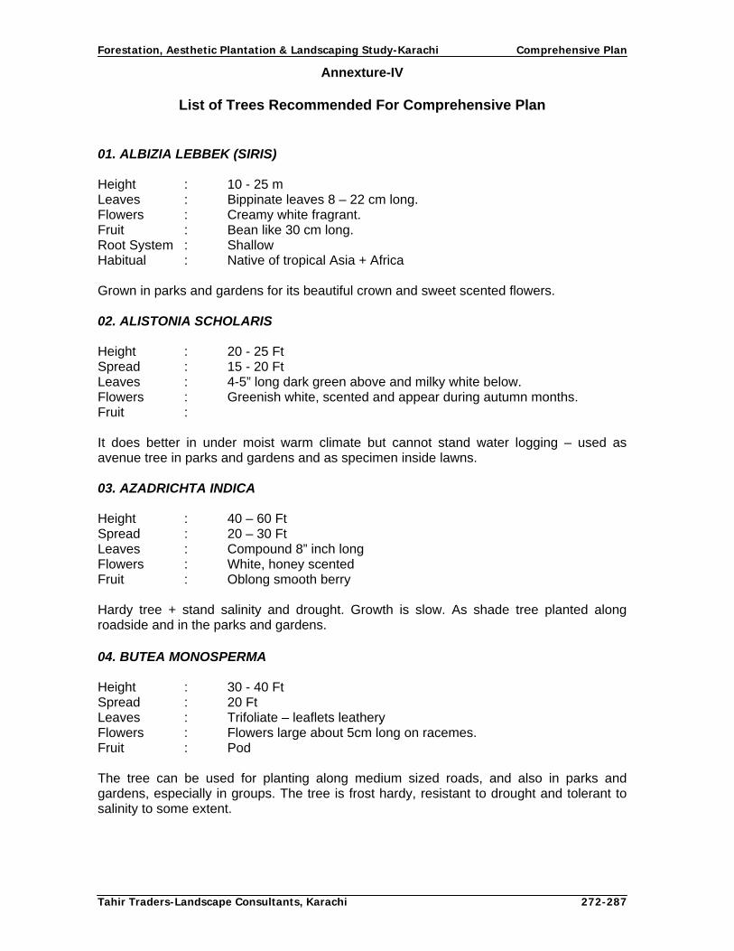
Forestation, Aesthetic Plantation & Landscaping Study-Karachi Comprehensive Plan
Tahir Traders-Landscape Consultants, Karachi 272-287
Annexture-IV
List of Trees Recommended For Comprehensive Plan
01. ALBIZIA LEBBEK (SIRIS) Height : 10 - 25 m Leaves : Bippinate leaves 8 – 22 cm long. Flowers : Creamy white fragrant. Fruit : Bean like 30 cm long. Root System : Shallow Habitual : Native of tropical Asia + Africa Grown in parks and gardens for its beautiful crown and sweet scented flowers. 02. ALISTONIA SCHOLARIS Height : 20 - 25 Ft Spread : 15 - 20 Ft Leaves : 4-5” long dark green above and milky white below. Flowers : Greenish white, scented and appear during autumn months. Fruit : It does better in under moist warm climate but cannot stand water logging – used as avenue tree in parks and gardens and as specimen inside lawns. 03. AZADRICHTA INDICA Height : 40 – 60 Ft Spread : 20 – 30 Ft Leaves : Compound 8” inch long Flowers : White, honey scented Fruit : Oblong smooth berry Hardy tree + stand salinity and drought. Growth is slow. As shade tree planted along roadside and in the parks and gardens. 04. BUTEA MONOSPERMA
Height : 30 - 40 Ft Spread : 20 Ft Leaves : Trifoliate – leaflets leathery Flowers : Flowers large about 5cm long on racemes. Fruit : Pod The tree can be used for planting along medium sized roads, and also in parks and gardens, especially in groups. The tree is frost hardy, resistant to drought and tolerant to salinity to some extent.

Forestation, Aesthetic Plantation & Landscaping Study-Karachi Comprehensive Plan
Tahir Traders-Landscape Consultants, Karachi 273-287
05. BUTEA MONOSPERMA Height : 30 - 40 Ft Spread : 20 Ft Flowers : Orange Pink Fruit : Pod, slightly curved, long stilted. Quick growing in early stages and attains a height of 8 ft in first season of planting and flowers during the second year suitable for roadside planting, large or small gardens, parks, railway platforms, office compounds etc. 06. BAUHINIA VARIEGATA Height : 30 Ft Spread : 20-50 ft Leaves : Leathery Connate, dull green Flowers : Pale Mauve or Red. Orchid like. Fruit : Pods flat, slightly curved, long slacked. Quick growing in early stages and attains a height of 8 – 10 ft in first season of planting and flowers during the second year. Suitable for roadside planting, large or small gardens, parks, railway platforms, office compounds etc. 07. CALOPHYLLUM INOPHYLLUM
Height : 20 – 30 Ft Spread : 10 – 15 Ft Leaves : 3” – 7” long, 3”- 4” broad, leathery in texture, shining green. Flowers : White fragrant. Fruit : A drupe, globosely yellow fleshy with smooth skin. Grows well under moist tropical climate. Specially areas along the sea coast. Flowering time varies with locality from late summer, rainy season to winter. Suitable for planting along canals, seaside, parks and gardens. 08. CALLISTEMON – LANCEDATUS BOTTLE
Height : 10-15 feet Spread :10-15 feet Leaves :Compound Flowers :Red-Pinkish 9. CASSIA GRANDIS Height : 30 - 40 Ft Spread : 15 - 20 Ft Leaves : Parinpinnate, reddish in color when young. Flowers : Bright pale pink when grown in sun and yellowish in shade. Fruit : One ft long pod. Grown widely in gardens of tropics.
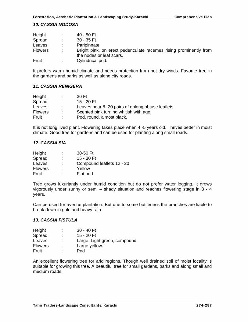
Forestation, Aesthetic Plantation & Landscaping Study-Karachi Comprehensive Plan
Tahir Traders-Landscape Consultants, Karachi 274-287
10. CASSIA NODOSA Height : 40 - 50 Ft Spread : 30 - 35 Ft Leaves : Paripinnate Flowers : Bright pink, on erect pedenculate racemes rising prominently from
the nodes or leaf scars. Fruit : Cylindrical pod. It prefers warm humid climate and needs protection from hot dry winds. Favorite tree in the gardens and parks as well as along city roads. 11. CASSIA RENIGERA Height : 30 Ft Spread : 15 - 20 Ft Leaves : Leaves bear 8- 20 pairs of oblong obtuse leaflets. Flowers : Scented pink turning whitish with age. Fruit : Pod, round, almost black. It is not long lived plant. Flowering takes place when 4 -5 years old. Thrives better in moist climate. Good tree for gardens and can be used for planting along small roads. 12. CASSIA SIA
Height : 30-50 Ft Spread : 15 - 30 Ft Leaves : Compound leaflets 12 - 20 Flowers : Yellow Fruit : Flat pod Tree grows luxuriantly under humid condition but do not prefer water logging. It grows vigorously under sunny or semi – shady situation and reaches flowering stage in 3 - 4 years. Can be used for avenue plantation. But due to some bottleness the branches are liable to break down in gale and heavy rain. 13. CASSIA FISTULA Height : 30 - 40 Ft Spread : 15 - 20 Ft Leaves : Large, Light green, compound. Flowers : Large yellow. Fruit : Pod An excellent flowering tree for arid regions. Though well drained soil of moist locality is suitable for growing this tree. A beautiful tree for small gardens, parks and along small and medium roads.

Forestation, Aesthetic Plantation & Landscaping Study-Karachi Comprehensive Plan
Tahir Traders-Landscape Consultants, Karachi 275-287
14. CAUARINA EQUISELFOLIA Height : 100 Ft Spread : 10 - 15 Ft Leaves : End of branches thickly set with long dropping branchlets
performing the function. Flowers : pinkish, inconspicuous. Fruit : It is a good tree in parks and large gardens. Due to its brittle branches it is not advisable to plant them along the roads. It is very suitable for mass planting along the sea shore and the river banks where spacing should be close to check soil erosion. 15. COSOS NUCIFERA Height : 50 - 80 Ft Spread : 10 – 15 Ft Fruit : Nut 16. COLVILLEA RACEMOSA Height : 40 - 50 Ft Spread : 30 - 35 Ft Leaves : Compound bipinnate. Flowers : Red Fruit : Pod. It prefers a moist or moderately dry climate. A good tree for large avenues and parks. It can be used for group planting in an expensive green setup. 17. CRATAEVA ADANSONII (BERNA)
Height : 30 - 40 Ft Spread : 10 – 15 Ft Leaves : Compound Flowers : White fragrant. Fruit : Egg shaped 1” – 1 ½” diameter. Salt resistant tree. 18. CONOCARPUS ERECTUS (CONO) Height : 20-30 feet Spread : 25-30 feet Leaves : Elliptical Flowers : Creamish while bunch Fruit : Small seeds 19. PHEONIX DACTYLIFERA (DATE PALM)
Height : 20- 60 feet Spread : 20-30 feet Leaves : Palm Fruit : Dates

Forestation, Aesthetic Plantation & Landscaping Study-Karachi Comprehensive Plan
Tahir Traders-Landscape Consultants, Karachi 276-287
20. DELONIX REGIA (GUL MOHAR)
Height : 60 Ft Spread : 30 - 40 Ft Leaves : Bipinnate Flowers : Red Pinkish Fruit : Broad Pod It prefers warm humid climate particularly along the sea coast but cannot stand water logging and frost. It is one of the flowering trees of tropics and subtropics.
21. DILLENIA PENTAGYNA (KERMAL) Height : 30 - 60 Ft Spread : 30 Ft Leaves : Large Simple Flowers : Creamish pink Fruit : Globular Succulent. A beautiful roadside tree. 22. EUCALYPTUS CAMALDULENSIS
Height : 100 - 250 Ft Spread : 20 - 50 Ft Leaves : Eliptical Flowers : White Pink Fruit : Small seeds 23. ERYTHRINA INDICA (GUL-E-NISHTAR) Height : 80-100 feet Spread : 30-40 feet Leaves : Compound Flowers : Red 24. FICUS BENGALENSIS (BAR)
Height : 100 Ft Spread : 100 Ft Leaves : 4” – 8” x 2” - 5” alternate Flowers : Male flower, monoandrous, in the same receptacle with female and
gall flowers. Fruit : Red, round less than 1” diameter. The tree prefers warm humid climate, it may be planted in large gardens, parks and along the wide roads to provide shade. 25. FICUS BENJAMINA (GOLDEN FIG) Height : 30 - 40 Ft Spread : 20 - 30 Ft Leaves : 2 – 3” long 1 - 1 ½” broad leathery shining green.

Forestation, Aesthetic Plantation & Landscaping Study-Karachi Comprehensive Plan
Tahir Traders-Landscape Consultants, Karachi 277-287
Flowers : Male, female and gall flower in the same receptacle. Fruit : Oborate The tree prefers humid climate and moist soil, very good shade tree suitable for planting along highways and large avenue, also in large parks and traffic islands. 26. F. INFECTORIA (PHILKIN)
Height : 50 - 60 Ft Spread : 30 - 40 Ft Leaves : 2 ½ - 3” long 2 ½” broad Flowers : White male, female and gall flowers in the same receptacle
monoandrous. Fruit : White round F. infectoria grows both in the dry and humid frost tree tracts. Mainly used as a shade tree in parks and gardens and along large roads.
27. GLEDITSCHIA SEPIUM Height : 30 - 40 Ft Spread : 10 Ft Leaves : leaves imparipinnate, long feathery. Flowers : Pinkish purple. Fruit : Pods linear It prefers warm humid climate and rich well drained soil. The tree should be pruned at a height of 6 – 8 ft, once a year after flowering to maintain attractive shape. It is specially suited for roadside planting and along the path of a park. Also used as shade tree for the plantation of crops. 28. GUAIEACUM OFFICINALE (LIGNUM)
Height : 25 - 30 Ft Spread : 20 - 25 Ft Leaves : Compound Flowers : Blue Fruit : Somewhat flattened abcordate capsule. It thrives better in arid climate, in deep and rich soil. It can be grown along small avenues and garden paths or in small and medium gardens. 29. KIGLIA PINNATA Height : 30 - 50 Ft Spread : 30 – 35 Ft Leaves : Leaves clustered near the end of branches in opposite pairs or
whorls. Flowers : Pinkish red. Fruit : Hard cylindrical, cucumber like. It prefers dry arid tracts but grows in humid trops under good soil condition. It is a good avenue tree, it can be planted in large gardens and arks for its shade and its peculiar looking fruit.

Forestation, Aesthetic Plantation & Landscaping Study-Karachi Comprehensive Plan
Tahir Traders-Landscape Consultants, Karachi 278-287
30. LAGERSTROEMIA FLOSREGINAE
Height : 40 - 50 Ft Spread : 20 - 30 Ft Leaves : Leaves from elliplic to lanceolate bright green above and light green
below. Flowers : Mauve purplish Fruit : A capsule It prefers warm and humid climate and moist deep soil. It can be stand water logging very well, survive submergence for several days. Very good for roadside, canal side, group planting, planting along a large lawn or around water gardens and ponds. 31. LIVISTONA CHINENSIS (ROYAL PALM) Height : 80-100 feet Spread : 20-30 feet Leaves : Palm type 32. MAGNOLIA GRANDIEFLORA Height : 60 - 80 Ft Spread : 30 - 40 Ft Leaves : Simple, alternate evergreen, abvate to oblong. Flowers : Creamy white, fragrant, lotus like. Fruit : Ovoid red suspended by thread like structures. The tree prefers cool, humid climate and seldom sets seeds in warm regions. This is a choice ornamental tree in all gardens big or small. 33. MELIA AZEDARACH BAKAIN Height : 25-35 feet Spread : 20-30 feet Leaves : Compound Flowers : Whitish scented Fruit : Berry like 34. MILLETTIA PEGUINSIS
Height : 40 Ft Spread : 15 – 20 Ft Leaves : Imparipinnate, leaflets 7, elliptic ovate. Flowers : Rose tinged blue. Fruit : Pods pale, flat slightly curved. The tree prefers warm, humid climate, slow growing in the early age but soon picks up and comes to flowering when 4 – 5 years old. This tree is well suited for town roads, large private gardens and parks. 35. MILLINGTONIA HORTENSIS Height : 80 Ft Spread : 30 – 40 Ft

Forestation, Aesthetic Plantation & Landscaping Study-Karachi Comprehensive Plan
Tahir Traders-Landscape Consultants, Karachi 279-287
Leaves : Opposite, imparipinnate at apex and bi or tripinnate below. Flowers : Small white with greenish tinge. Fruit : A pod It prefers a deep, fertile soil and warm humid climate. The tree is extensively planted along the roads, in the gardens and parks especially for its beautiful fragrant flowers. 36. MIMUSOPS ELENGI (MOLSARI) Height : 40 – 60 Ft Spread : 30 – 40 Ft Leaves : Alternate, upside shiny green, lower side pale green. Flowers : Creamish white, fragrant. Fruit : Berry Ovoid, orange when ripe. This tree grows in tropical climate both in moist and dry regions with equal ease but cannot stand water logging. A very handsome tree for roadside planting and provides pleasant shade in gardens and parks. 37. PLUMERIA OBTUSIFOLIA (CHAMPA) Height : 15 – 25 Ft Spread : 10 – 15 Ft Leaves : Oblanceolate or obvate with rounded apex, dark green glossy. Flowers : Red, pink, white. Fruit : Plumerias are popular and free flowering tree in tropical gardens. It grows in all type of soil but flowers better in poor and porous soil. 38. POLYATHEA LONGIFOLIA (ASHOK) Height : 40 – 50 Ft Spread : 20 – 30 Ft Leaves : Lance shaped, glossy green translucent narrowing to a point with a
wavy of undulated margin. Flowers : Greenish yellow Fruit : In a cluster of many pedunculate carpels on a common stack, egg
shaped. The tree can grow on any soil and climate except desert. It can stand drought and hot climate very well and also grows vigorously in humid region. The trees are favorite as an avenue plant. They are also planted in close row along the boundary wall of large compound. 39. POLYAlTHEA LONGIFOLIA PENDULATA Height : 80 Ft Spread : 10 Ft Leaves : Compound (Pendulated) This tree is very suitable along the path inside gardens and parks, and the boundary wall of building compounds and gardens.

Forestation, Aesthetic Plantation & Landscaping Study-Karachi Comprehensive Plan
Tahir Traders-Landscape Consultants, Karachi 280-287
40. ROYSTONEA REGIA (BOTTLE PALM) Height : 70 – 100 Ft Spread : 15 – 20 Ft Leaves : Palm type 41. SAMANEA SAMAN (RAIN TREE) Height : 50 – 70 Ft Spread : 30 – 50 Ft Leaves : Bipinnate upper side bright green lower pubescent. Flowers : Pinkish Fruit : A pod, sessile, straight. Rain tree prefers warm, humid climate. This is very good for large wide roads and highways and also for big parks. 42. SPATHODA COMPANULATA Height : 60 - 70 Ft Spread : 30 - 35 Ft Leaves : Densely arranged near tip of branches, opposite, odd pinnate. Flowers : Reddish Fruit : A long pointed pod. The tree grows in a rich, light soil in tropical and subtropical climate. It is suitable for medium and large gardens and avenues. 43. STERCULIA GUTLATA Height : 30 - 50 Ft Spread : 10 – 15 Ft Leaves : Simple 6” – 9” long, 3” – 5” broad Flowers : Pinkish red Fruit : 3” – 4” boat shaped. 44. THESPESIA POPULINEA (PARUS PEOPLE) Height : 30 - 40 Ft Spread : 15 - 20 Ft Leaves : Green cordite, acuminate, entire. Flowers : yellow, purple Fruit : A capsule, oblong. It requires a moist tropical climate and porous soil, can stand salinity well and grow luxuriantly along sea coast. It is a good shading as well as ornamental tree for planting along road and in private gardens and parks.

Forestation, Aesthetic Plantation & Landscaping Study-Karachi Comprehensive Plan
Tahir Traders-Landscape Consultants, Karachi 281-287
Annexture-V
List of Abbreviations used in Comprehensive Plan
ADB: Asian Development Bank CDGK: City District Government Karachi CL: Chloride Cm: Centimeter CO2: Carbon dioxide CO3: Carbonates D: Developed DHA: Defense Housing Authority DO: District Officer DDO: Deputy District Officer EC: Electrical Conductivity ET: Evapo-transpiration ETC Crop water requirement ETO: Crop water optimum requirement EDO: Executive District Officer ESP: Exchangeable sodium Percent F: Fahrenheit FAO: Food and Agriculture Organization FYM: Farm Yard Manure FTC: Finance and Trade Centre GPS: Global Positioning System GIS: Geographic Information Systems GI: Geo Index GOS: Government of Sindh HQ: Head Quarter IPDF: Infrastructure Project Development Facility IT Information technology KSMP: Karachi Strategic Master Plan KNBP: Karachi Northern Bye-Pass KM: Kilometer KC: Crop Coefficient KPT: Karachi Port Trust KANUPP: Karachi Nuclear Power Plant LDPP: Low Density Polythlene Pipes LSU Local Support Unit MA: Muhammad Ali M & E: Monitoring & Evaluation MDA: Malir Development Authority MNA: Member National Assembly MPA: Member Provincial Assembly mm: Millimeter NGO: Non-Governmental Organization NIPA: National Institute of Public Administration NHA: National Highway Authority NHW: National Highway PECHS: Pakistan Employees Cooperative Housing Society pH: Hydrogen ion Concentration ppm: Parts per million

Forestation, Aesthetic Plantation & Landscaping Study-Karachi Comprehensive Plan
Tahir Traders-Landscape Consultants, Karachi 282-287
PD: Partially Developed PC-I: Planning Commission Proforma-I PPP: Public Private Partnership PIDC: Pakistan Industrial Development Corporation RCD: Regional Cooperation for Development ROW: Right Of Way SAR: Sodium Adsorption Ratio SLGO Sindh Local Government Ordinance SO2: Sulphur Dioxide Spp. Species SUPARCO: Surface and Upper Atmosphere Research Commission SHW: Super Highway SITE: Sindh Industrial Trading Estate TSP Total Soluble Phosphate TV: Television TOR: Terms of Reference UAE: United Arab Emirates UC: Union Council UD: Un Developed VAMM Vegetation Assessment Monitoring Model VI Vegetation Indices VIP: Very Important Personality VVIP: Very Important Personality WHO: World Health Organization

Forestation, Aesthetic Plantation & Landscaping Study-Karachi Comprehensive Plan
Tahir Traders-Landscape Consultants, Karachi 283-287
Annexture-VI
List of background reports and deliverables
S.NO Reports/Deliverables 1. Situation Analysis report of the Existing Tree Growth 2. Identification of Gaps in existing Tree Plantation Areas requiring new plantation
and rehabilitation 3. Identification of Appropriate/Potential Areas along/within Target Areas 4. Water Quality, Availability & Suitability report 5. Soil Quality, Availability & Suitability report 6. Assessment & Concept Design of Micro-Irrigation Techniques 7. Assessment Concept Design of Landscaping Techniques for Roundabouts and
Green Belts 8. Assessment Concept Design of Landscaping Techniques for Highways, Roads,
Link roads & Bye-Passes 9. Assessment & Concept Design of various Aesthetic Plantation Techniques for
Major Roads & Arteries in Urban Areas 10. Assessment Concept Design of various Techniques for Establishment of Mini
Forests 11. Assessment and concept design of landscaping techniques of coastal belt outside
mangrove areas 12. Assessment Concept Design of various Social/Farm Forestry Concepts. 13. Assessment and Concept Design of Rivers 14. Report on Designing a Monitoring & Evaluation System by using Satellite facilities 15. Report on Contract Packages, Pre-Qualification of Contractors, Tendering, Bid
Evaluation and Contract Administration (ADB, CDGK, GoS) 16. Recommendations on Public Private Partnership Methods for Green Pockets of
Out skirts of the city & Renovation/Aesthetic Plantation of Roundabouts within City
17. Report on monsoon Plantation Campaign 18. Mid Term Report
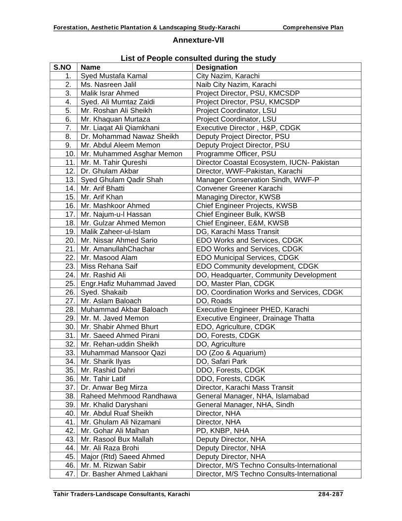
Forestation, Aesthetic Plantation & Landscaping Study-Karachi Comprehensive Plan
Tahir Traders-Landscape Consultants, Karachi 284-287
Annexture-VII
List of People consulted during the study S.NO Name Designation
1. Syed Mustafa Kamal City Nazim, Karachi 2. Ms. Nasreen Jalil Naib City Nazim, Karachi 3. Malik Israr Ahmed Project Director, PSU, KMCSDP 4. Syed. Ali Mumtaz Zaidi Project Director, PSU, KMCSDP 5. Mr. Roshan Ali Sheikh Project Coordinator, LSU 6. Mr. Khaquan Murtaza Project Coordinator, LSU 7. Mr. Liaqat Ali Qiamkhani Executive Director , H&P, CDGK 8. Dr. Mohammad Nawaz Sheikh Deputy Project Director, PSU 9. Mr. Abdul Aleem Memon Deputy Project Director, PSU 10. Mr. Muhammed Asghar Memon Programme Officer, PSU 11. Mr. M. Tahir Qureshi Director Coastal Ecosystem, IUCN- Pakistan 12. Dr. Ghulam Akbar Director, WWF-Pakistan, Karachi 13. Syed Ghulam Qadir Shah Manager Conservation Sindh, WWF-P 14. Mr. Arif Bhatti Convener Greener Karachi 15. Mr. Arif Khan Managing Director, KWSB 16. Mr. Mashkoor Ahmed Chief Engineer Projects, KWSB 17. Mr. Najum-u-l Hassan Chief Engineer Bulk, KWSB 18. Mr. Gulzar Ahmed Memon Chief Engineer, E&M, KWSB 19. Malik Zaheer-ul-Islam DG, Karachi Mass Transit 20. Mr. Nissar Ahmed Sario EDO Works and Services, CDGK 21. Mr. AmanullahChachar EDO Works and Services, CDGK 22. Mr. Masood Alam EDO Municipal Services, CDGK 23. Miss Rehana Saif EDO Community development, CDGK 24. Mr. Rashid Ali DO, Headquarter, Community Development 25. Engr.Hafiz Muhammad Javed DO, Master Plan, CDGK 26. Syed. Shakaib DO, Coordination Works and Services, CDGK 27. Mr. Aslam Baloach DO, Roads 28. Muhammad Akbar Baloach Executive Engineer PHED, Karachi 29. Mr. M. Javed Memon Executive Engineer, Drainage Thatta 30. Mr. Shabir Ahmed Bhurt EDO, Agriculture, CDGK 31. Mr. Saeed Ahmed Pirani DO, Forests, CDGK 32. Mr. Rehan-uddin Sheikh DO, Agriculture 33. Muhammad Mansoor Qazi DO (Zoo & Aquarium) 34. Mr. Sharik Ilyas DO, Safari Park 35. Mr. Rashid Dahri DDO, Forests, CDGK 36. Mr. Tahir Latif DDO, Forests, CDGK 37. Dr. Anwar Beg Mirza Director, Karachi Mass Transit 38. Raheed Mehmood Randhawa General Manager, NHA, Islamabad 39. Mr. Khalid Daryshani General Manager, NHA, Sindh 40. Mr. Abdul Ruaf Sheikh Director, NHA 41. Mr. Ghulam Ali Nizamani Director, NHA 42. Mr. Gohar Ali Malhan PD, KNBP, NHA 43. Mr. Rasool Bux Mallah Deputy Director, NHA 44. Mr. Ali Raza Brohi Deputy Director, NHA 45. Major (Rtd) Saeed Ahmed Deputy Director, NHA 46. Mr. M. Rizwan Sabir Director, M/S Techno Consults-International 47. Dr. Basher Ahmed Lakhani Director, M/S Techno Consults-International

Forestation, Aesthetic Plantation & Landscaping Study-Karachi Comprehensive Plan
Tahir Traders-Landscape Consultants, Karachi 285-287
48. Syed Munawar Zaman Senior Engr. (Design) Engineering Associates 49. Mr. Sikandar Ali Memon Assistant Engineer PHED, CDGK 50. Nazim UC Bin Qasim Nazim UC Bin Qasim 51. Nazim U Malir Nazim U Malir 52. Mr. Ghulam Mohyuddin Asim Deputy Project Coordinator, LSU 53. Mr. Naveed Channa Consultant, LSU 54. Mr. Naeem Ahmed Programme Officer, LSU 55. Miss Shazia Mallah Programme Officer, Investment, LSU 56. Mr. Ayub Ali Khan Accounts Officer, LSU 57. Mr. Junaid Ahmed Channa Deputy Programme Officer , LSU 58. Mr. Shams-ul-Haq Memon Secretary Forests (Rtd) GoS 59. Mr. Munir Ahmed Awan Additional Secretary Forests (Rtd) GoS 60. Mr. Hanif Nasir Ex Director H&P, Karachi 61. Brig. Ishaq Malir Cantonment, Karachi 62. Mr. Mehboob Ali Bhatti Conservator of Forests (Rtd), GoS 63. Mr. Abdul Jabbar Qazi Additional Secretary Forests, GoS 64. Mr. Riaz Ahmed Wagan Conservator of Forests, Thatta 65. Mr. Agha Tahir Hussain Durani Divisional Forest Officer, Coastal Division Karachi 66. Mr. A. K. Khan Founder, Chairman Horticulturist Society of
Pakistan 67. Miss Anjum Parvez Roots and Shoots Landscape Consultants 68. Mr. Parvez Khan Roots and Shoots Landscape Consultants 69. Mr. Yaseen Khan Proprietor Yaseen Nursery, Karsaz 70. Horticulturist Agha Khan Hospital 71. Progressive Farmers UCs’ Malir, Gadap and Bin Qasim 72. Horticulturist Port Qasim Authority, Karachi 73. Dr. A. A. Qureshi Senior Horticulturist, Karachi 74. Prof. Engr. M. Saleh Sheikh Professor NED University 75. Miss Amber Ai Bhai G. S. SHEHREE 76. Members Malir and Gadap Union Councils 77. Incharge Botanical Garden Karachi University

Forestation, Aesthetic Plantation & Landscaping Study-Karachi Comprehensive Plan
Tahir Traders-Landscape Consultants, Karachi 286-287
Bibliography
1. A. S. Khan, (1963): Town and Highway Plantations in West Pakistan. 2. Asian Development Bank, (2005): Guide on Bid Evaluation. 3. Asian Development Bank, (2005): Procurement of Plant-Design, Supply, Install. 4. Asian Development Bank, (2005): Procurement of Works. 5. Defries et al, (2000): Use of GIS for Land Use Planning. 6. FAO, United Nations, (2005): Crop Co-efficient Values of Some Crops. 7. G. L. Chopra: Angiosperms 8. Government of Pakistan, (2008): Infrastructure Project Development Facility (IPDF). 9. Government of Pakistan: Code of Criminal Procedure-Act V of 1888. 10. Government of Sindh, (2006): Procedures for Public Procurement Rules. 11. J. A. Khan & Noushad Khan, (2000): Hand Book on Participatory Forestry. 12. Karachi Municipal Corporation, (1999): Draft Karachi Parks and Trees Act 1998. 13. Karachi Strategic Master Plan-2020, (2007): A Master Plan of Karachi. 14. Kazmi & Ghori, (1995): A Report on Rivers of Karachi. 15. National Highway Authority, (2008): NHA Expansion Plans. 16. National Highway Authority, (2008): Tree Plantation Policy for National Highways &
Motorways. 17. Pakistan and Gulf Economist, (2007): A Magazine on Economic of Gulf States &
Pakistan. 18. Pakistan Penal Code: Act XLV of 1860 for Judicial Proceedings. 19. Sindh Local Government Ordinance, (2001): Local Government Ordinance for
Devolution of Powers. 20. Tahir Traders-Landscape Consultants, (2008): Assessment & Concept Design of
Landscaping Techniques for Roundabouts and Green Belts in Karachi. 21. Tahir Traders-Landscape Consultants, (2008): Assessment & Concept Design of
Landscaping Techniques for Highways, Roads, Link Roads & Bye-Passes of Karachi. 22. Tahir Traders-Landscape Consultants, (2008): Assessment & Concept Design of
Aesthetic Plantation Techniques for Major Roads & Arteries in Urban Areas of Karachi. 23. Tahir Traders-Landscape Consultants, (2008): Assessment & Concept Design of
Various Techniques for Establishment of Mini Forests in Karachi. 24. Tahir Traders-Landscape Consultants, (2008): Assessment & Concept Design of
Landscape Techniques for Coastal Belt outside Mangrove Areas of Karachi. 25. Tahir Traders-Landscape Consultants, (2008): GIS Report of Karachi. 26. Tahir Traders-Landscape Consultants, (2008): Micro-Irrigation Report of Karachi. 27. Tahir Traders-Landscape Consultants, 2008: Monitoring and Evaluation Report 28. Tahir Traders-Landscape Consultants, (2008): Report on Contract Packages, Pre-
Qualification, Bid Evaluation and Contract Administration for Karachi. 29. Tahir Traders-Landscape Consultants, (2008): Report on Identification Gaps in
Existing Tree Plantation requiring new plantation and rehabilitation in Karachi 30. Tahir Traders-Landscape Consultants, (2008): Report on Identification of Potential
Areas for Plantation within the Target Areas in Karachi. 31. Tahir Traders-Landscape Consultants, (2008): Report on Public Private Partnership
Methods for Karachi. 32. Tahir Traders-Landscape Consultants, (2008): Report on Social/Farm Forestry
Techniques for Karachi. 33. Tahir Traders-Landscape Consultants, (2008): Situation Analysis Report of Karachi. 34. Tahir Traders-Landscape Consultants, (2008): Soil and Water Quality Report, Karachi. 35. V.C. Magno, (1994): Forestry Extension Manual 36. V.C. Magno, (1994): Social Forestry Hand Book. 37. Wikipedia Encyclopedia, (2008): Karachi Encyclopedia. 38. Works & Services Department, (2008): Office Memorandum on Corridors of Karachi.

Forestation, Aesthetic Plantation & Landscaping Study-Karachi Comprehensive Plan
Tahir Traders-Landscape Consultants, Karachi 287-287

Tahir Traders-Landscape Consultants 16-C, 13th Commercial Street, DHA Extension-II, Karachi, Pakistan Tel: +92-21-5882552 Fax: 5882552 Cell: +92-300-3034371, +92-321-3774073 Email: [email protected], [email protected]