formate of checklist for first presentation before...
TRANSCRIPT
Environmental Clearance report Page 1
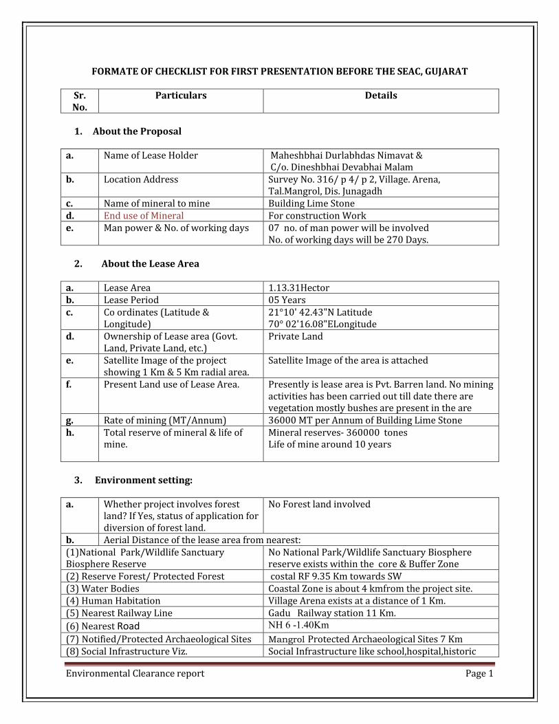
FORMATE OF CHECKLIST FOR FIRST PRESENTATION BEFORE THE SEAC, GUJARAT
Sr. No.
Particulars Details
1. About the Proposal
a. Name of Lease Holder Maheshbhai Durlabhdas Nimavat & C/o. Dineshbhai Devabhai Malam
b. Location Address Survey No. 316/ p 4/ p 2, Village. Arena, Tal.Mangrol, Dis. Junagadh
c. Name of mineral to mine Building Lime Stone d. End use of Mineral For construction Work e. Man power & No. of working days 07 no. of man power will be involved
No. of working days will be 270 Days.
2. About the Lease Area
a. Lease Area 1.13.31Hector b. Lease Period 05 Years c. Co ordinates (Latitude &
Longitude) 21°10' 42.43"N Latitude 70° 02'16.08"ELongitude
d. Ownership of Lease area (Govt. Land, Private Land, etc.)
Private Land
e. Satellite Image of the project showing 1 Km & 5 Km radial area.
Satellite Image of the area is attached
f. Present Land use of Lease Area. Presently is lease area is Pvt. Barren land. No mining activities has been carried out till date there are vegetation mostly bushes are present in the are
g. Rate of mining (MT/Annum) 36000 MT per Annum of Building Lime Stone h. Total reserve of mineral & life of
mine. Mineral reserves- 360000 tones Life of mine around 10 years
3. Environment setting:
a. Whether project involves forest
land? If Yes, status of application for diversion of forest land.
No Forest land involved
b. Aerial Distance of the lease area from nearest: (1)National Park/Wildlife Sanctuary Biosphere Reserve
No National Park/Wildlife Sanctuary Biosphere reserve exists within the core & Buffer Zone
(2) Reserve Forest/ Protected Forest costal RF 9.35 Km towards SW (3) Water Bodies Coastal Zone is about 4 kmfrom the project site. (4) Human Habitation Village Arena exists at a distance of 1 Km. (5) Nearest Railway Line Gadu Railway station 11 Km.
(6) Nearest Road NH 6 -1.40Km
(7) Notified/Protected Archaeological Sites Mangrol Protected Archaeological Sites 7 Km (8) Social Infrastructure Viz. Social Infrastructure like school,hospital,historic

Environmental Clearance report Page 2
school,hospital,historic cultural/religious places,defence establishment etc.
cultural/religious places at mangrol 7 Km
c. Hydrology indicating water bodies & ground water depth & quality.
No surface water body exists in the core zone
d. Wind rose diagram/Predominates wind direction & wind Speed
Predominant wind direction SW Wind Speed – Max 12 Km/Hr & Min 04 Km/hr
e. Existing dust & Noise level After operation start reported Existing dust level. Average Noise level around site @ 60 dB
f. Endemic and endangered species for flora and fauna, if any in the area
No Endemic & endangered species of flora & fauna found in the core Zone.
4. About the mining Activities:
a. Requirement of power supply and water supply and its source
Power supply required is 42 HP at the mine site. About 3.00 KLD water is required for the purpose of drinking, dust suppression & green belt development & water will be made available bore well.
b. Method of mining (Manual/Semi mechanized/mechanized)
Open cast Semi mechanized method of mining.
c. Details of method of working with phasing of actives (Sequence of mining operations). Height and width of benches and side slope
Semi mechanized open cast method of excavation. The soil cover be remove by use of a JCB. The Production is in form of lime stone blocks. The limestone block is generated with help of stone cutter. Wet cutting is employed. The blocks are liberated manually and loaded into trucks or Tractor to be sent the construction site. The blocks measure around 15” X 09” X 09”
d. Likely impact of mining activities. Dust & Noise will be generated e. Details of drilling, Blasting,
explosives. No Drilling & Blasting is involved in the mining Method.
f. Storage of explosive and safety measures at the time blasting.
No need to store explosive Because there is no proposal for blasting.
g. Section plan map showing overburden (Average)
Section plan that showing OB is enclosed with Form 1
h. Details of over barding (OB) removal And Stacking
About 40 % waste as mineral reject will be generated in next 10 years which will be used for backfilling by step wise.
i. Plan for managing storm water, Details of garland drains to be provided
Yes, Garland drain will be provided around working pit.
j. Plan for managing dust ,noise ,slit and other pollution during mining activities
Proper Plantation within and around working area.
Regular water sprinkling to suppress dust Avoid unnecessary & idle running of
machine &make its optimum use. Regular maintenance of machineries,
vehicals etc and use PPE
Environmental Clearance report Page 3
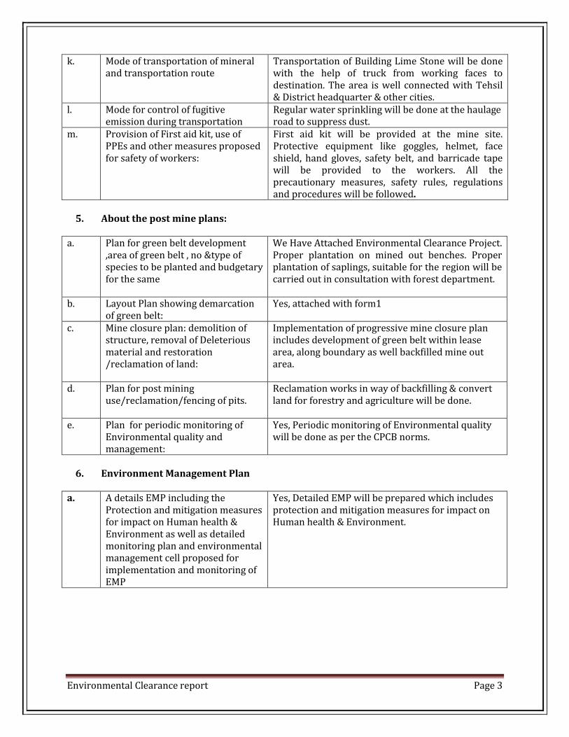
k. Mode of transportation of mineral and transportation route
Transportation of Building Lime Stone will be done with the help of truck from working faces to destination. The area is well connected with Tehsil & District headquarter & other cities.
l. Mode for control of fugitive emission during transportation
Regular water sprinkling will be done at the haulage road to suppress dust.
m. Provision of First aid kit, use of PPEs and other measures proposed for safety of workers:
First aid kit will be provided at the mine site. Protective equipment like goggles, helmet, face shield, hand gloves, safety belt, and barricade tape will be provided to the workers. All the precautionary measures, safety rules, regulations and procedures will be followed.
5. About the post mine plans:
a. Plan for green belt development
,area of green belt , no &type of species to be planted and budgetary for the same
We Have Attached Environmental Clearance Project. Proper plantation on mined out benches. Proper plantation of saplings, suitable for the region will be carried out in consultation with forest department.
b. Layout Plan showing demarcation of green belt:
Yes, attached with form1
c. Mine closure plan: demolition of structure, removal of Deleterious material and restoration /reclamation of land:
Implementation of progressive mine closure plan includes development of green belt within lease area, along boundary as well backfilled mine out area.
d. Plan for post mining use/reclamation/fencing of pits.
Reclamation works in way of backfilling & convert land for forestry and agriculture will be done.
e. Plan for periodic monitoring of Environmental quality and management:
Yes, Periodic monitoring of Environmental quality will be done as per the CPCB norms.
6. Environment Management Plan
a. A details EMP including the
Protection and mitigation measures for impact on Human health & Environment as well as detailed monitoring plan and environmental management cell proposed for implementation and monitoring of EMP
Yes, Detailed EMP will be prepared which includes protection and mitigation measures for impact on Human health & Environment.

Environmental Clearance report Page 4
7. About the social obligations:
a. Mitigation measure to reduce
hazardous conditions and hardship to local inhabitants.
No, Hazardous substance will be used.
b. Concerns of local inhabitants like: health ,water, employment, resettlement/rehabilitation, etc.
Project will provide employment opportunity to the local people .we will arrange the medical check-up camps for mine workers & proposed effected villager. No R/R plan is applicable.
c. Specific activities proposed to be carried out under the corporate social Responsibility addressing the concerns of local inhabitants along with budgetary.
Development activities like hand pump for drinking water; maintenance of road, common toilet will be taken up. Total fund for Socio Economic development is about 2 % total income.
Date: / /2015 Signature and Stamp of Place: Junagadh Mining and Geological Department
Environmental Clearance report Page 5
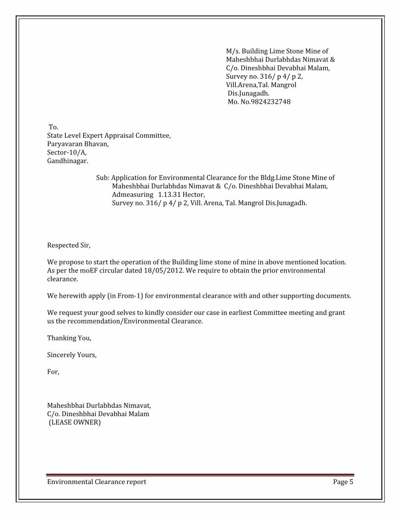
M/s. Building Lime Stone Mine of Maheshbhai Durlabhdas Nimavat & C/o. Dineshbhai Devabhai Malam, Survey no. 316/ p 4/ p 2, Vill.Arena,Tal. Mangrol Dis.Junagadh. Mo. No.9824232748 To. State Level Expert Appraisal Committee, Paryavaran Bhavan, Sector-10/A, Gandhinagar. Sub: Application for Environmental Clearance for the Bldg.Lime Stone Mine of Maheshbhai Durlabhdas Nimavat & C/o. Dineshbhai Devabhai Malam, Admeasuring 1.13.31 Hector, Survey no. 316/ p 4/ p 2, Vill. Arena, Tal. Mangrol Dis.Junagadh. Respected Sir, We propose to start the operation of the Building lime stone of mine in above mentioned location. As per the moEF circular dated 18/05/2012. We require to obtain the prior environmental clearance. We herewith apply (in From-1) for environmental clearance with and other supporting documents. We request your good selves to kindly consider our case in earliest Committee meeting and grant us the recommendation/Environmental Clearance. Thanking You, Sincerely Yours, For, Maheshbhai Durlabhdas Nimavat, C/o. Dineshbhai Devabhai Malam (LEASE OWNER)

Environmental Clearance report Page 6
APPENDIX –I
FROM 1
Basic Information: Name of the project: Building Lime Stone Mine of Maheshbhai Durlabhdas Nimavat C/o. Dineshbhai Devabhai Malam Location : Survey no. 316/ p 4/ p 2, Vill. Arena, Tal. MangrolDis.Junagadh Size of the Project: 1.13.31Hector. Expected cost of the project: 20 lakh Contact Information: Maheshbhai Durlabhdas Nimavat C/o. Dineshbhai Devabhai Malam At. Vill. Thali, Tal. Mangrol & Dis.Junagadh Mo. 9824232748
Screening Category: “B2”
Capacity corresponding to sectoral activity (such as production capacity for manufacturing,mining lease area and production capacity for mineral production, area for mineral exploration, length for linear transport infrastructure, generation capacity for power generation etc.,)
Activity Construction operation or decommissioning of the Project involving actions which will cause physical changes in the locality (topography, land use, changes in water bodies, etc.)
S.No Information/Checklist confirmation
Yes/No Details thereof (with approximate quantities/rates, wherever possible)with source of information data
1.1 Permanent or temporary change in land use, land cover or topography including increase in intensity of land use (with respect to local land use plan)
Yes Change in the land use of Mining Lease area is envisaged as the existing land use category is barren land which shall continue to be so even after mining operations cease. Present topography is having flat terrain. Please refer layout plan and short view is attached as per Annexure -6 & 7 respectively.

Environmental Clearance report Page 7
1.2 Clearance of existing land, vegetation and building?
No Clearance of some weeds/grasses may take place. No vegetation exists within the lease area.
1.3 Creation of new land uses? No Not Applicable 1.4 Pre-construction investigations e.g.
bore house, soil testing? No Not Applicable
1.5 Construction works? No Office and store house set up temporary basis so no new construction work is required.
1.6 Demolition works? No NA 1.7 Temporary sites used for
construction works or housing of construction workers?
No Most of the workers are from nearby village and they return to their homes after their work only rest shelter will be made on temporary.
1.8 Above ground buildings, structures or earthworks including linear structures, cut and fill or excavations.
NO NA
1.9 Underground works including mining or tunneling?
No NA
1.10 Reclamation works? Yes After completion of mining period, pit will be reclaimed as agriculture and cultivation purpose.
1.11 Dredging? NO NA 1.12 Offshore structures? No Not Applicable 1.13 Production and manufacturing
processes? Yes Semi mechanizes open cast method of
excavation. The soil cover will be removed by use of a JCB. The Production is in from of limestone blocks. The limestone blocks are generated with help of stone cutters. Wet cutting is employed. The blocks are liberated manually and loaded on to trucks or tractor trolleys to be sent to the client. The blocks measure around 15”X9” X9”
1.14 Facilities for storage of goods or materials?
No No Facilities for storage of goods or materials. Mineral will be kept at the working faces and directly sold to the local suppliers. The top soil will be stacked at separate site and the same will be used for the plantation purpose.
1.15 Facilities for treatment or disposal of solid waste or liquid effluents?
yes About 40 % waste will be generated. This waste will be used for the backfilling.
1.16 Facilities for long term housing of No Enough construction workers
Environmental Clearance report Page 8
operational workers? available in nearby area.
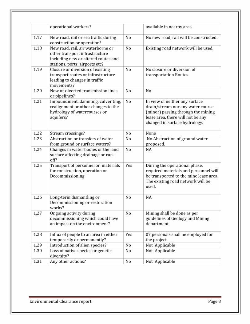
1.17 New road, rail or sea traffic during construction or operation?
No No new road, rail will be constructed.
1.18 New road, rail, air waterborne or other transport infrastructure including new or altered routes and stations, ports, airports etc?
No Existing road network will be used.
1.19 Closure or diversion of existing transport routes or infrastructure leading to changes in traffic movements?
No No closure or diversion of transportation Routes.
1.20 New or diverted transmission lines or pipelines?
No No
1.21 Impoundment, damming, culver ting, realignment or other changes to the hydrology of watercourses or aquifers?
No In view of neither any surface drain/stream nor any water course (minor) passing through the mining lease area, there will not be any changed in surface hydrology.
1.22 Stream crossings? No None 1.23 Abstraction or transfers of water
from ground or surface waters? No No Abstraction of ground water
proposed. 1.24 Changes in water bodies or the land
surface affecting drainage or run-off?
No NA
1.25 Transport of personnel or materials for construction, operation or Decommissioning
Yes During the operational phase, required materials and personnel will be transported to the mine lease area. The existing road network will be used.
1.26 Long-term dismantling or Decommissioning or restoration works?
No NA
1.27 Ongoing activity during decommissioning which could have an impact on the environment?
No Mining shall be done as per guidelines of Geology and Mining department.
1.28 Influx of people to an area in either temporarily or permanently?
Yes 07 personals shall be employed for the project.
1.29 Introduction of alien species? No Not Applicable 1.30 Loss of native species or genetic
diversity? No Not Applicable
1.31 Any other actions? No Not Applicable

Environmental Clearance report Page 9
Use of Natural resources for construction or operation of the Project (such as land, water, materials or energy, especially any resources which are non-renewable or in short supply)
S.No. Information/Checklist confirmation Yes/No Details thereof (with approximate quantities/rates, wherever possible)with source of information data
2.1 Land especially undeveloped or agricultural land (ha)
Yes A copy of 7-12 and NA is attached as per Annexure -9
2.2 Water (expected source & competing users unit: KLD
Yes Water consumption will be 3.00 KL/Day. Out of this 1.00 KL/Day will be used for Domestic purpose and 1.00 KL/Day will be use for sprinkling purpose. 1.00 KL/Day Source of water will be Bore well
2.3 Minerals (MT) Yes Building Lime stone 36000 MT per Year.
2.4 Construction material –stone, aggregates, and/soil (expected source-MT)
No Not Applicable
2.5 Forests and timber (source MT) No Not Applicable 2.6 Energy including electricity and
fuels (source, competing users) Unit: fuel (MT), energy (MW)
Yes Electricity used 42 HP connection Electricity provided by PGVCL No other energy is required
2.7 Any other natural resources (use appropriate standard units)
No Not Applicable
Use, storage, transport, handling or production of substances or materials, which could be harmful to human health or the environment or raise concerns about actual or perceived risks to human health.
S. No. Information/Checklist confirmation Yes/No Details thereof (with approximate quantities/rates, wherever possible)with source of information data
3.1 Use of substances or materials, which are hazardous (as per MSIHC rules) to human health or the environment (flora, fauna, and water supplies)
No Not applicable
3.2 Changes in occurrence of disease or affect disease vectors (e.g. insect or water borne diseases)
No Not Applicable
3.3 Affect the welfare of people e.g.by changing living conditions?
Yes Local Persons will get direct & indirect employment and enhance the skill of

Environmental Clearance report Page 10
the local people of nearby village.
3.4 Vulnerable groups of people who could be affected by the project e.g. hospital patients, children, the elderly etc.
No The proposed project shall not affect any vulnerable groups of people in the near vicinity.
3.5 Any other causes No Not Applicable Production of solid waste during construction or operation or decommissioning (MT/month).
S. No. Information/Checklist confirmation Yes/No Details thereof (with approximate quantities/rates, wherever possible)with source of information data
4.1 Spoil, overburden or mine wastes Yes Total 40 % of the ROM WILL BE GENERATED AS A WASTE, WHICH WILL BE FURTHER USED FOR BACKFILLING.
4.2 Municipal waste (domestic and or commercial waste)
No Not Applicable
4.3 Hazardous wastes (as per Hazardous Waste Management Rules)
No Not Applicable
4.4 Other industrial process wastes No Not Applicable 4.5 Surplus product No Not Applicable
4.6 Sewage sludge or other sludge from effluent treatment
No Not Applicable
4.7 Construction or demolition wastes No Not Applicable
4.8 Redundant machinery or equipment
No Not Applicable
4.9 Contaminated soils or other materials
No Not Applicable
4.10 Agricultural wastes No Not Applicable
4.11 Other solid wastes No Not Applicable Release of pollutants or any hazardous, toxic or noxious substances to air(Kg/hr)
S. No. Information/Checklist confirmation
Yes/No Details thereof (with approximate quantities/rates, wherever possible)with source of information data
5.1 Emissions from combustion of fossil fuels from stationary or mobile sources
No NO
5.2 Emissions from production Yes Dust will be generated during

Environmental Clearance report Page 11
processes activities such as cutting, sizing, handling and transportation of minerals. A think green belt shall be developed around the periphery of the mine to attenuate the noise levels. Additionally, daily sprinkling of water will carry the dust suppression.
5.3 Emissions from materials handling including storage or equipment
Yes NA
5.4 Emissions from construction activities including plant and equipment
No Not Application
5.5 Dust or odors from handling of materials including construction materials, sewage and waste.
No NA
5.6 Emission from incineration of waste
No Not Application
5.7 Emissions from burning of waste in open air (e.g. slash material s, construction debris)
No Not Application
5.8 Emissions from any other sources No Not Application Generation of Noise and Vibration, and Emissions of Light and Heat:
S. No. Information/Checklist confirmation
Yes/No Details thereof (with approximate quantities/rates, wherever possible)with source of information data
6.1 From Operation of equipment e.g. engines, ventilation plant, crushers
Yes The mining operation will be open cast manual method. Noise will be generated from operation of cutting and sizing only. However, earmuff will be provided to be the personals/Operators at the time of operation.
6.2 From industrial or similar processes
No No industrial process will be involved at mine lease area.
6.3 From construction or demolition No Not Applicable 6.4 From blasting or piling No No blasting is proposed. 6.5 From construction or operational
traffic No NA
6.6 From lighting or cooling systems No Not Applicable 6.7 From any other sources No Not Applicable
Risks of contamination of land or water from releases of pollutants into the ground or into sewers, surface waters, groundwater, coastal waters or the sea:
S .No. Information/Checklist Yes/No Details thereof (with
Environmental Clearance report Page 12
confirmation approximate quantities/rates, wherever possible)with source of information data
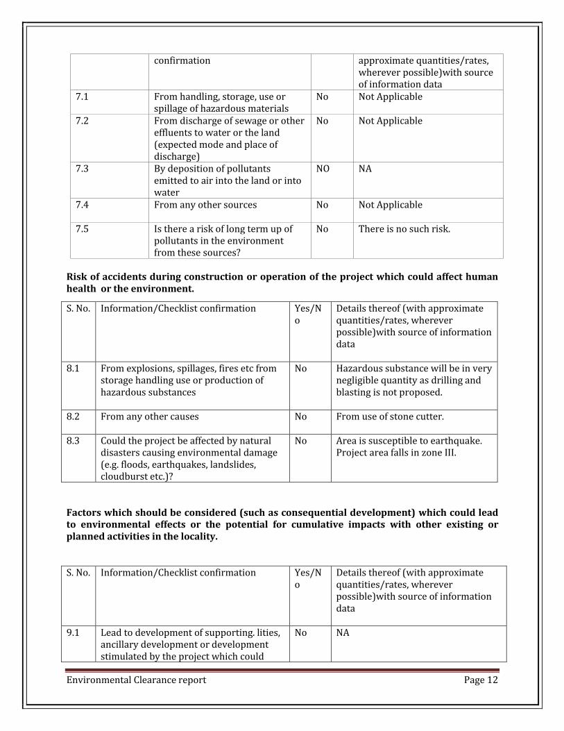
7.1 From handling, storage, use or spillage of hazardous materials
No Not Applicable
7.2 From discharge of sewage or other effluents to water or the land (expected mode and place of discharge)
No Not Applicable
7.3 By deposition of pollutants emitted to air into the land or into water
NO NA
7.4 From any other sources No Not Applicable
7.5 Is there a risk of long term up of pollutants in the environment from these sources?
No There is no such risk.
Risk of accidents during construction or operation of the project which could affect human health or the environment.
Factors which should be considered (such as consequential development) which could lead to environmental effects or the potential for cumulative impacts with other existing or planned activities in the locality. S. No. Information/Checklist confirmation Yes/N
o Details thereof (with approximate quantities/rates, wherever possible)with source of information data
9.1 Lead to development of supporting. lities, ancillary development or development stimulated by the project which could
No
NA
S. No. Information/Checklist confirmation Yes/No
Details thereof (with approximate quantities/rates, wherever possible)with source of information data
8.1 From explosions, spillages, fires etc from storage handling use or production of hazardous substances
No Hazardous substance will be in very negligible quantity as drilling and blasting is not proposed.
8.2 From any other causes No From use of stone cutter.
8.3 Could the project be affected by natural disasters causing environmental damage (e.g. floods, earthquakes, landslides, cloudburst etc.)?
No Area is susceptible to earthquake. Project area falls in zone III.

Environmental Clearance report Page 13
have impact on the environment e.g. Supporting infrastructure (roads, power supply, waste or waste water treatment, etc.) housing development extractive industries supply industries other
Yes No No No No
Only temporary rest shelter would be made. NA NA NA NA
9.2 Lead to after –use of the site, which could haven impact on the environment
No Part of the excavated Mine will be backfilled & will be developed as green belt. & Rest will be used for rain water storage and which will have a positive impact on nearby agricultural lands.
9.3 Set a precedent for later developments No NA 9.4 Have cumulative effects due to proximity
to other existing or planned projects with similar effects
No As the area being rich with building lime stone mineral, number of mines in surrounding area, may either restart or increase production which will lead to increase combined environmental impacts, particularly due to increased road traffic for materials transport/dispatch
Environmental Sensitivity S. No. Information/Checklist confirmation Yes/N
o Details thereof (with approximate quantities/rates, wherever possible)with source of information data
1. Areas protected under international conventions, national or local legislation for their ecological, landscape, cultural or other related value
No Not Applicable
2. Areas which are important or sensitive for ecological reasons – Wetlands, watercourses or other water bodies, coastal zone, biospheres, mountains forests.
Yes Arabian sea costal 4 km
3. Areas used protected, important or sensitive species of flora or fauna for breeding, nesting, foraging, resting, over wintering, migration
No Not Applicable
4. Inland, coastal, marine or underground waters
No NA
5. State, National boundaries No Not Applicable

Environmental Clearance report Page 14
6. Routes or facilities used by the public for access to recreation or other tourist, pilgrim areas.
No Not Applicable
7. Defense installations No Not Applicable 8. Densely populated or built-up area Yes Arena 1 km in direction 9. Areas occupied by sensitive man-made
uses (hospitals, schools, places of worship, community facilities)
Yes Mangrol -7 km in direction
10. Areas containing important, high quality or scarce resources (ground water resources, surface resources, forestry, agriculture, fisheries, tourism, minerals)
No Not Applicable
11. Areas already subjected to pollution or environmental damage.( those where existing legal environmental standards are exceeded)
No Not Applicable
12. Areas susceptible to natural hazard which could cause the project to present environmental problems (earthquakes, subsidence, landslides, erosion, folding or extreme or adverse climatic conditions)
No Area is susceptible to Earthquake. Projects are falls in Zone III.
Proposed Terms of Reference for EIA studies “ I hereby given undertaking that the data and information given in the application and enclosures are true to the best of my knowledge and belief and I am aware that if any part of the data and information submitted is found to be false or misleading at any stage , the project will be rejected and clearance give, if any to the project will be revoked at our risk and cost. Date: ……………………… Place: …………………….
Signature of the applicant With Name and Full Address
(Project Proponent/ Authorized Signatory)

Environmental Clearance report Page 15
From –i, pre FeasibilitY report
&
environment management plan
For
m/s. building lime stone mine oF
maHesHbHai durlabHdas nimavat &
C/o. dinesHbHai devabHai malam
area 1.13.31 (surveY no. 316/ p 4/ p 2 , vill.arena, tal.mangrol,
dis.JunagadH)
proposed produCtion:-36000 tpa
proJeCt Cost: - 20 laCs
Details of Area Applicant Total Area -1.13.31 ha, Maheshbhai Durlabhdas Nimavat
Near Village-Arena, C/o. Dineshbhai Devabhai Malam
Taluka- Mangrol, Vill.Arena, Tal.Mangrol,
District-Junagadh (Gujarat) Dis.Junagadh
Mob. 9824232748

Environmental Clearance report Page 16
CONTENT
S. NO. DETAILS PAGE NO.
1 Executive summary
2 Introduction of the project/ back ground information
3 Project Description
4 Site Analysis
5 Planning Brief
6 Existing Infrastructure
7 Rehabilitation and resettlement (R & R Plan)
8 Project schedule and cost estimates
9 Analysis of proposal (final recommendation)

Environmental Clearance report Page 17
PRE-FEASIBILITY REPORT
1. eXeCutive summarY:
Particulars Details
Project Name M/s.Building Lime stone mine of Maheshbhai Durlabhdas Nimavat & C/o. Dineshbhai Devabhai Malam
Location Survey No: 316/ p 4/ p 2, Vill.Arena, Tal.Mangrol, Dis.Junagadh.
Latitude 21°11' 42.43"N Latitude
Longitude 70° 02'16.08"E Longitude Topo Sheet No. - Total Area 1.13.31 Hect. Mineable Reserves 360000 tones Capacity 36000 TPA Life of Mine 10 years Estimated Cost Project 20 Lacs EMP Cost 1.00 lacs Ultimate Pit Limit 7 meter Power Requirement 42 HP Fuel Requirement NA DG set NA Highest and Lowest Elevation NA Land use Private land (Non Agricuture land) Nearest Habitation/Town Arena 1 km Nearest Air port Porbandar Airport 76 km Nearest Highway NH 6 -1.40 km Nearest Railway Station Gadu Railway station 11 Km Power supply 42 HP By PGVCL Nearest Dispensary And Govt. Hospital
Arena primary Health centre 1 Km
Educational Facility Arena village primary,secoundary,ITI 1Km Water Demand and supply 3.00 KLD and supply nearest farm well Nearest Tourist place Madhavpur (Ghed) 10 Km Defense installation NA Archeological Features NA Ecological Sensitive Zones NA Nearest Streams/Rivers/water bodies(From mine boundary)
Arabian sea 3 km

Environmental Clearance report Page 18
2. introduCtion oF tHe proJeCt
The proposed M/s. Building Lime Stone Mine of Maheshbhai Durlabhdas Nimavat & C/o. Dineshbhai Devabhai Malam Area at near Village-Arena, Taluka- Mangrol, Dist. Junagadh,(Gujarat) has been granted to Maheshbhai Durlabhdas Nimavat & C/o. Dineshbhai Devabhai Malam , resident of At. Thali, Tal. Mangrol, Dis. Junagadh Applied Area-1.13.31Ha. Proposed Production-36000 TPA.
2.1. Copy of Mining Lease/ Letter of Intent.
A letter of intent has been issued in Favor of Maheshbhai Durlabhdas Nimavat & C/o. Dineshbhai Devabhai Malam, for extraction of Lime Stone, Near Village- Arena, Taluka- Mangrol & Dist.- Junagadh (Guj.), For The Period of 5 years Vide Letter no……………………………………………….. Dated-……………………
2.2 Nature of the project: Mining of Building Limestone is proposed in the applied area 1.13.31 Ha. (Private. Near land), Village-Arena, Taluka- mangrol, Dist.- Junagadh, (Gujarat).Mining will be carried out by Semi-Mechanized Opencast Method. Proposed Production 36000 TPA. The Building Limestone Area near Arena is a hub for building limestone Extraction. There are various projects for production of limestone blocks in the mine. The building limestone industry is a thriving industry because of prolific use of limestone in building industry. The project is aimed at producing building limestone slabs from the applied area. TABLE 2.1 SHOWS THE ML AREA ALONG WITH ITS DIMENSIONS.
SI No. Near Village Area 1. Arena 1.13.31Ha.
2.2. Need For The Project and its importance to the country:
Building Limestone is an important mineral for the building Construction. It is naturally available in sample quantities and thus is important for construction of buildings due to its toughness. It is being used as bricks and khandas.

Environmental Clearance report Page 19
2.3. Demand - Supply gap
The demand of building stone depends on the level of development and the rate of growth of the economy. However, there is a persistent demand for this commodity.
2.4. Imports vs. Indigenous Production There is no Import of building Limestone. All production of building Stone is earmarked for the indigenous demand/ local market.
2.5. Export Possibility There is no proposal to export the production.
2.6. Domestic/Export Markets The limestone (Building) will be only for domestic market/local Suppliers.
2.7. Employment Generation (Direct and Indirect) Due to the Project The proposed Limestone (Building) making activity is envisaged to improve the socio-economic condition on a micro-economic scale by generating local employment 10 direct and 3 indirect.
TABLE NO. 2.2 EMPLOYMENT POTENTIAL S.No. Particulars Numbers
1 Permit Manager 1
2 Forman 1 3 Others 8
Total 10
For the plantation, security, or any type of general labour shall be kept on contract basis.
Environmental Clearance report Page 20
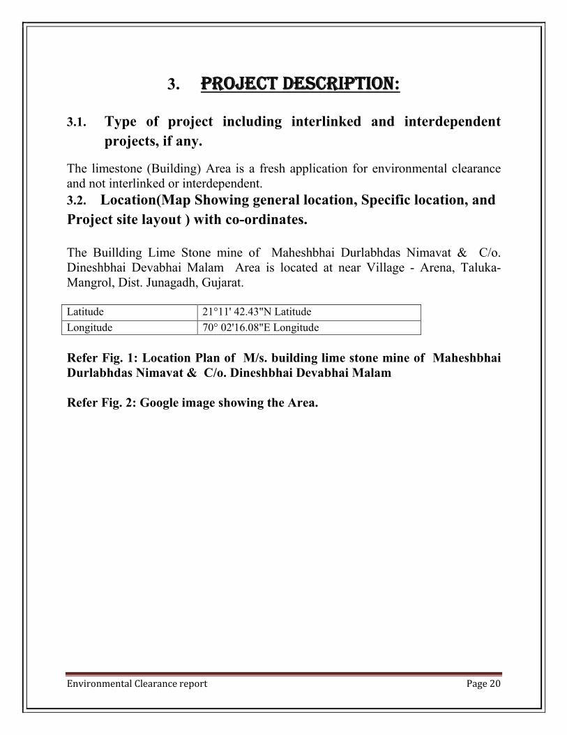
3. proJeCt desCription:
3.1. Type of project including interlinked and interdependent
projects, if any.
The limestone (Building) Area is a fresh application for environmental clearance and not interlinked or interdependent.
3.2. Location(Map Showing general location, Specific location, and
Project site layout ) with co-ordinates. The Buillding Lime Stone mine of Maheshbhai Durlabhdas Nimavat & C/o. Dineshbhai Devabhai Malam Area is located at near Village - Arena, Taluka- Mangrol, Dist. Junagadh, Gujarat. Latitude 21°11' 42.43"N Latitude
Longitude 70° 02'16.08"E Longitude
Refer Fig. 1: Location Plan of M/s. building lime stone mine of Maheshbhai Durlabhdas Nimavat & C/o. Dineshbhai Devabhai Malam Refer Fig. 2: Google image showing the Area.

Environmental Clearance report
Fig.1: LOCATION PLAN OF M/s.MAHESHBHAI DURLABHDAS NIMAVATDEVABHAI MALAM
Fig.1: LOCATION PLAN OF M/s. BUILDING LIME STONE MIMAHESHBHAI DURLABHDAS NIMAVAT & C/O. DINESHBHAI
Page 21
BUILDING LIME STONE MINE OF C/O. DINESHBHAI

Environmental Clearance report Page 22
Fig.2:GOOGLE IMAGE OF THE M/s. BUILDING LIME STONE MINE OF MAHESHBHAI DURLABHDAS NIMAVAT & C/O. DINESHBHAI DEVABHAI MALAM
3.3. Details of alternate sites considered and the basis of selecting the proposed site, particularly the environmental consideration done into should be highlighted. The site is suitable because of its location and availability of resources. The topography is flat along with scanty overburden to remove. The site is also away From major habitation centers. 3.4. Size and Magnitude of operation
The maximum rated capacity of the project will be 36000 TPA productions and the area is spread over 1.0000 Ha. The bricks formation is in form of 15”X 9” X 9”. 3.5. Project Description with process details
The soil cover is firstly stacked with use of an hired JCB/excavator and piled for backfilling and plantation later on. The surface to be mined is scrapped to a level and 3-4 stone cutters are put into use. The standard saleable limestone block measures 15”x9”x9”. Depth is kept constant at 9 to 10 inches for a cutter and cuts are made by wet cutting. The blocks are carefully liberated manually thereafter and are ready for sale.

Environmental Clearance report Page 23
3.6. Raw material Required along with estimated quantity, likely source,
marketing area o final products, mode of transport of raw material and
finished product.
No raw materials are required in preparation of final products.
3.7. Resource Optimization/ Recycling and reuse envisaged in the project, if any. NA. 3.8. Availability of water and its source, Energy/ Power requirement and
source should be Given.
Water will be brought from nearby Villages through water tankers
TABLE NO. 3.1. WATER DEMAND
Purpose Requirement (KLD) Drinking Purpose 0.3
Domestic use 0.7 Dust Suppression/Stone
cutting 1.0
Plantation 1.0 Total 3.00
3.9. Quantity of wastes to be generated (Liquid and Solid) and scheme for
their Management/disposal.
About 40% wastes will be generated & waste will be used for the backfilling.

Environmental Clearance report Page 24
4. site analYsis 4.1. Connectivity
TABLE-4.1: CONNECTIVITY DETAILS FROM SITE: Sr. No.
Particulars Details
1. Road Connectivity
The village Arena, nearest population center is 1km away from the lease area & it is connected with other important towns and cities through a good network of roads with regular public transport services. The District Headquarter Junagadh is 71 km connected by tar road.
2. Nearest
Highway NH 6 -1.2 Km in direction.
3. Nearest Railway Station
The nearest railhead is at Chorvad Railway station 11 km lease area.
4. Nearest Airport
The nearest civilian airport for regular commercial flights is at Porbandar Airport the road distance from the lease area is around 73 km.
4.2. Land form, land use and land ownership
Applied Area 1.13.31 State Gujarat
District Junagadh Taluka Mangrol Village Arena
Land ownership The land is of private land and the LoI has been granted in favor of Maheshbhai Durlabhdas Nimavat & C/o. Dineshbhai Devabhai Malam for the period of 5 years. 4.3. Topography
The topography of the lease area is almost flat. The mine has a thin veneer of soil having a thickness of about 0.5 to 1.5 meters. The applied area forms a part of survey No. 316/ p 4/ p 2 .
Environmental Clearance report Page 25
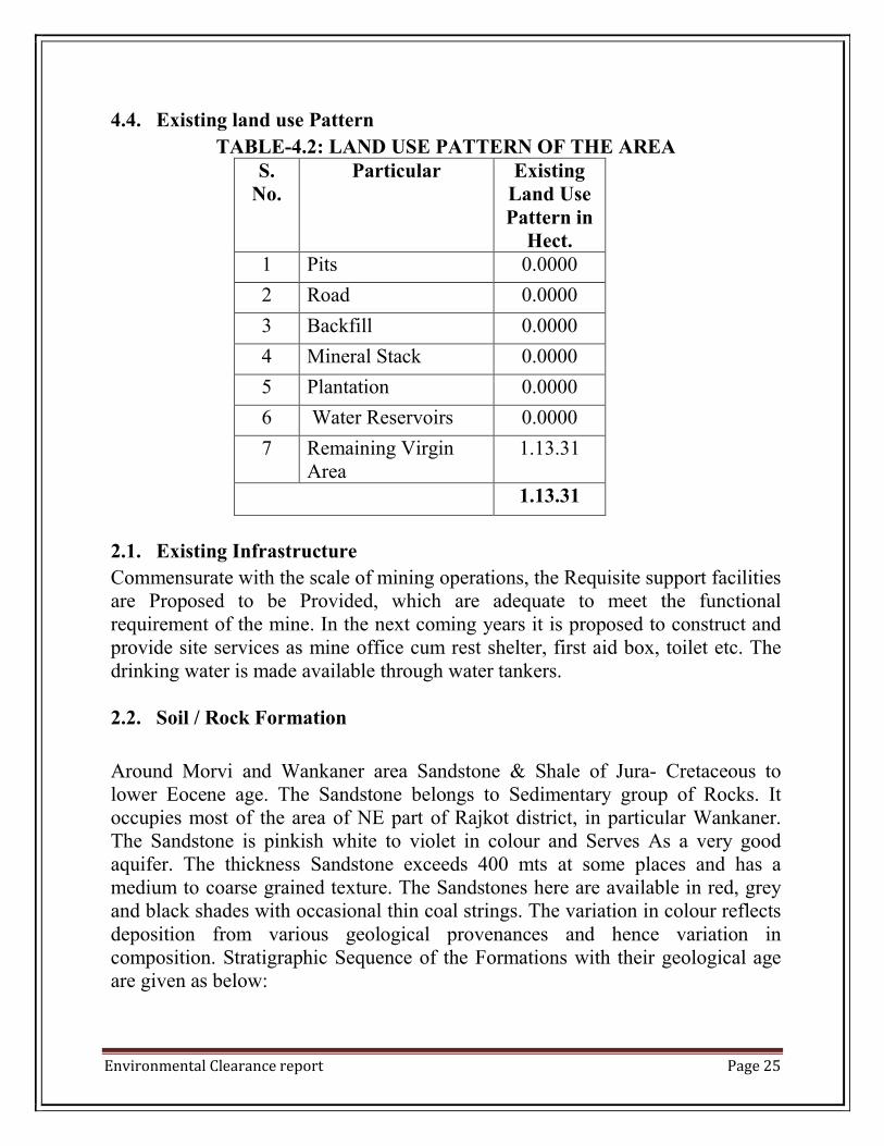
4.4. Existing land use Pattern
TABLE-4.2: LAND USE PATTERN OF THE AREA S.
No. Particular Existing
Land Use Pattern in
Hect. 1 Pits 0.0000
2 Road 0.0000
3 Backfill 0.0000
4 Mineral Stack 0.0000
5 Plantation 0.0000
6 Water Reservoirs 0.0000
7 Remaining Virgin Area
1.13.31
1.13.31
2.1. Existing Infrastructure
Commensurate with the scale of mining operations, the Requisite support facilities are Proposed to be Provided, which are adequate to meet the functional requirement of the mine. In the next coming years it is proposed to construct and provide site services as mine office cum rest shelter, first aid box, toilet etc. The drinking water is made available through water tankers. 2.2. Soil / Rock Formation
Around Morvi and Wankaner area Sandstone & Shale of Jura- Cretaceous to lower Eocene age. The Sandstone belongs to Sedimentary group of Rocks. It occupies most of the area of NE part of Rajkot district, in particular Wankaner. The Sandstone is pinkish white to violet in colour and Serves As a very good aquifer. The thickness Sandstone exceeds 400 mts at some places and has a medium to coarse grained texture. The Sandstones here are available in red, grey and black shades with occasional thin coal strings. The variation in colour reflects deposition from various geological provenances and hence variation in composition. Stratigraphic Sequence of the Formations with their geological age are given as below:

Environmental Clearance report Page 26
Group System Rock type Localities Age in Millions of years
Quaternar Y
Recent and Sub- Recent
Alluvium, blown Sand, Silts of Rann and Banni, Tidal Flats And Raised beaches
Alluvial plains of Gujarat, Ran, Banni & Coastal deposites.
0.01
Pleistocene Milliolites Saurastra Coast from Gopnath Northwards extending beyond Porbandar. Kutch area
1
Tertiary or Kainozoic
Pilliocene Dwarka beds, Manchhar beds, Gypsiferous clays and sandy Foraminiferallimesto-nes.
Dwarka,Okha, Piram island, Kutch
12
Miocene Gaj beds-highly fossiliferous clays and limestones. Agate bearing Conglomerates. Kand Formations
Saurashtra Coast, Kutch
25
Oligocene Tarkeshwar clays Tarkeshwar (District Surat) And Kutch
40
Eocene Nummulitic limestones and clays
Tarkeshwar area and Kutch
60
Paleocene Madh series- Supratrapean
Kutch
Secondary or Mesozoic.
Cretaceous Eocene
Deccan traps with inter Trappeans
Parts of Sabarkantha, Panchmahals, Baroda, Broach, Surat and Major part of Saurashtra and Small part of Kutch

Environmental Clearance report Page 27
Cretaceous Himatnagar sand-Stones, Lameta(Limestone). Bagh beds
Himatnagar, Kapadvanj, Balasinor, Parabia, Dahod, Gabat, Narmada Valley.
110
Land / Soil Characteristic The Soils are generally developed from sandstone formation and are coarse in texture with satisfactory internal drainage. The sub soil condition below the Existing ground level is almost uniform in nature. Sub soil is Composed of clay mixed with little fine grained silty sand, Moram and Kankar with Low Resistivity due to clay and soil moisture. The area is covered with recent to Sub Recent alluvial deposits comprising of brownish clay mixed with little fine grained Sand, silty Sand. The soil below ground level consist of top silty low plastic soil layer having no swelling nature. Blackish Brown to yellowish brown clayey silt or sand silt layer extends to the depth of 2 to 3 mts. Extend of Mechanization & Mining Machinery Deployed: The only Machinery deployed are the stone cutter for cutting the blocks and JCB. ORE BODY DIMENSION
BODY LENGTH WIDTH DEPTH MINERAL REMARKS LIMESTONE LAY OUT
PLAN LAY OUT
PLAN 6.0 LIMESTONE -
TONNE
MT
REMAINING RESERVE 360000 LIFE OF MINE@ RATE OF 36000 MT 10 YRS Recovery Factor: 60% of building Limestone & remaining 40% is rejected.
LOSSES ALONG LEASE BOUNDARY -
360000
TOTAL 360000

Environmental Clearance report Page 28
2.3. Climate date From Secondary Sources M/s Building Lime Stone Mine of Maheshbhai Durlabhdas Nimavat & C/o. Dineshbhai Devabhai Malam area is situated in district Junagadh. Junagadh has semi-arid climate, with hot, dry summers from mid-March to mid- June and the wet monsoon season from mid-june to oct., when the city receives 750 mm of rain on average. The months from November to February are mild, the average temperature being around 20 °C, with low humidity. During summer time, the temperature ranges between 24 °C and 42 °C. In the months of winter, Junagadh temperature varies between 10 °C and 22 °C but on a whole winters are pleasant.
2.4. Social infrastructure available. The infrastructure like, toilets, shelter etc. is proposed at mine site.
The nearest village is Mangrol, health & educational facilities (in the form
of Primary and secondary schools) are available there.
Medical facilities, Primary Health centre are therein the mine, imparting
services, for advance medical facilities. In each village one health worker
has been appointed by the Govt. to provide primary health facilities.
Village people are availing drinking water facilities generally from the hand
pump, open well and tube well. The water supply is also supplied through
tanker in few villages.
Communication services like post office and telephones are available in the
nearby village. Some of the villagers are having mobile phones.
An occupational health unit will be organized and the proposed measures
will be adopted:
Pre & Periodical Medical checkup program for all the workers.
Compulsory medical checkup program and first –aid box with
necessary equipment will be provided.
Training for workers Regarding occupational hazards.
Safety equipment i.e. dusts mask, safety shoes, gloves etc.

Environmental Clearance report Page 29
5. planning brieF 5.1. Planning concept
It is a mining project of mineral building limestone. The proposed production of is 36000 TPA. Opencast, Semi- Mechanized method of mining will be adopted and transportation of minerals shall be done through road by trucks. 5.2. Man Power Requirement
Man Power requirement for mining is estimated to be 10 Nos. Most of the employees will be recruited from neighboring village. The laborers are provided along with tractor trolley by contractor or from nearby villages. So there will no permanently migration of people, hence there will be no population projection. 5.3. Land use Planting
TABLE-5.1: LAND USE PATTERN OF THE AREA
S.No. Land use Category
Pre Operational Phase
Operational Phase
Post Operational Phase
1 Pits 0.00 0.4614 0.6918 2 Dumps 0.00 0.000 0.000 3 Plantation 0.00 0.3345 0.3345 4 Road 0.00 0.0346 0.00 5 Mineral Stack 0.00 0.0115 0.00 6 Black Filled mine
out mine 0.00 0.0000 0.1271
7 Remaining Virgin land
1.13.31 0.3114 0.000
Total 1.13.31 1.13.31 1.13.31
Total 1.13.31hect. Area will be covered under the plantation, which includes
0.3345 hect. Area will be used for plantation on statutory barrier, 0.1271
hect. Area will be used for backfilling along with plantation and 0.6918 hect.
Area will be used for plantation on mined out benches.

Environmental Clearance report Page 30
5.4. Facilities Provided 5.4.1. Infrastructure
The infrastructure like, toilets, shelter etc. are proposed at mine site. For drinking, water will be brought from water tanker outside the applied mine. A first aid box will also be constructed and maintained. Communication services like post office and telephones are available in the nearby villages. Medical facilities are also provided. 5.4.2. Landscaping and Green belt development
It is proposed to plant total 335 Saplings, covering an area of 0.3345 hect. During the post- Operational Stage.
TABLE-5.2: PLANTATION PROGRAM Year Along the lease boundary
Mine(ha.) Plants 1 0.03345 33
2 0.03345 33
3 0.03345 33
4 0.03345 33
5 0.03345 33
6 0.03345 33
7 0.03345 33
8 0.03345 33
9 0.03345 33
10 0.03345 38 Total 0.3345 335
Total 1.13.31hect. Area will be covered under the plantation, which includes
0.3345 hect. Area will be used for plantation on statutory barrier, 0.1271 hect. Area
will be used for backfilling along with plantation and 0.6918 hect. Area will be
used for plantation on mined out benches. A number of species will be planted
suitable to this area of climate conditions like coconut, papal, neem, mango,
Jamun etc.

Environmental Clearance report Page 31
5.4.3. Health And Safety System
During the opencast working, and allied activities, all the precautionary measures shall be taken into account as per GMMR 1961 and GMCDR 1988 for safety and security. Following Safety & security measures will be enforced;
Moving front of the quary shall have temporary fencing.
Permanent fencing will be provided where quarry has reached the ultimate
pit limit.
Mine entrance will have a permanent check post and record shall be
maintained of all persons/vehicles entering the mine area.
Round the clock security arrangement shall be provided to prevent
inadvertent entry of persons.
5.4.4 Disaster Management and Risk Assessment
Inspite of following all the precautionary measures and following all safety
rules, regulations and Procedures, in mining accidents cannot be ruled out
completely. The project proponent will formulate a disaster Management
plan with the approval of DGMS. Following are the accidents which can
take place in mechanised opencast mining and measures proposed to be
taken.
Fall of human beings or fall of machines from benches/ dumps/ haul roads.
Fire & Explosion in machinery
Emergency situation due to social reason such as public unrest, terrorism etc.
Preventive Measures:
Creating berm on the side of benches/ haul roads of hight greater than or
equal to ½ tyre radius. Minimum height of berm shall be 1.2 m and slop
45°. Minimum clearance of 1.5 m will be maintained between outer tyre and
berm.
Fire fighting equipment in the machinery / workshop/ office will be
maintained. Persons will be trained in the use of fire fighting equipment and
mock rehearsal will be conducted.
Training of security personnel.

Environmental Clearance report Page 32
Procedures as laid down in disaster management plan to be followed.
Training Persons will be trained in the following:
Knowledge of chemicals and use of protective equipment
Procedure for reporting emergencies
Location and use of fire fighting equipment
Knowledge of alarm system and siren
Evacuation procedures.
Training in first aid as per mines rules 1955
Emergency Equipment & Facilities:
Mobiles
Fire fighting equipment’s
Emergency medical supplies
Other protective equipment’s i.e. goggles, helmet, face shield, hand gloves, safety belts, barricade tape. First aid station as per the provisions of mines rules 1955.
Environmental Clearance report Page 33
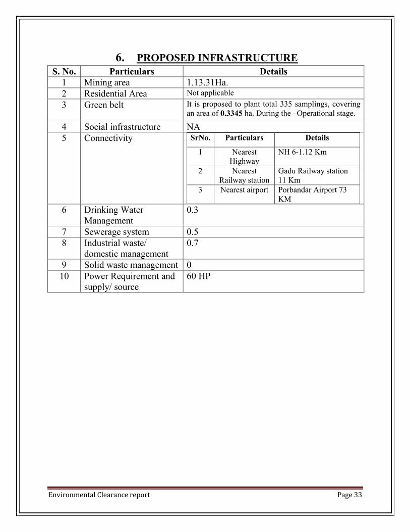
6. PROPOSED INFRASTRUCTURE S. No. Particulars Details
1 Mining area 1.13.31Ha. 2 Residential Area Not applicable
3 Green belt It is proposed to plant total 335 samplings, covering an area of 0.3345 ha. During the –Operational stage.
4 Social infrastructure NA 5 Connectivity SrNo. Particulars Details
1 Nearest Highway
NH 6-1.12 Km
2 Nearest Railway station
Gadu Railway station 11 Km
3 Nearest airport Porbandar Airport 73 KM
6 Drinking Water Management
0.3
7 Sewerage system 0.5 8 Industrial waste/
domestic management 0.7
9 Solid waste management 0 10 Power Requirement and
supply/ source 60 HP
Environmental Clearance report Page 34
7. reHabilitation and resettlement (r & r) plan Since the project is private land, there is no reserves forest or protected forest land within the applied area. There is no human settlements within the area so, no resettlement and rehabilitation is required.
8. proJeCt sCHedule & Cost estimates 8.1. Likely date of start of construction and likely date of completion (time
schedule for the project to be given)
The project activity will be taken up in parallel along with the opening of mine, after the environmental clearance & CTE/CTO is granted. The production will commence within two months of the environmental clearance & CTE/CTO. 8.2. Estimated project cost along with analysis in terms of economic viability
of the project
The project proponent will incur a total cost of Rs. 20 lakh and may vary from place to place and with magnitude of the limestone mining. This will include the rent/lease for land, cost of labor, cost of transportation, fuel charges etc.
9. analYsis oF proposal (Final reCommendations)
The project will bring economical benefits to the state by the way of royalty for mineral and people by the way of direct(10 persons) and secondary employment (3 persons) opportunities. Management will be helping nearby village by providing aid to school, conducting medical and social awareness camps, helping in formation of self help groups etc. especially keeping in the view the tribal and economically backward population in the area as part of its corporate social responsibility.

Environmental Clearance report Page 35
ENVIRONMENT MANAGEMENT
PLAN

Environmental Clearance report Page 36
environment management plan limestone (building)
1.0. INTRODUCTION:
The proposed M/s. Building Lime Stone Mine of Maheshbhai Durlabhdas Nimavat & C/o. Dineshbhai Devabhai Malam Area at near Village-Arena, Taluka- Mangrol, Dist. Junagadh,(Gujarat) has been granted to Maheshbhai Durlabhdas Nimavat & C/o. Dineshbhai Devabhai Malam , resident of At. Thali, Tal. Mangrol, Dis. Junagadh Applied Area-1.13.31Ha. Proposed Production-36000 TPA. The building lime stone mine near Arena is a hub for building lime stone extraction. The building lime stone industry is a thriving industry because of profile use of lime stone in building industry. The project is aimed at producing building lime stone slabs from the lease mine. The mining methodology consists of carving up blocks of dimensions 15’’x9’’x9’’ with help of a stone cutter, in this method there is a reject of 40% of the production and about 60% of the yield is usable. Topography of the Area
The topography of the lease area is almost flat. The mine has a thin veneer of soil having a thickness of about 0.5 to 1.5 meters. The applied area forms a part of survey of India topo-sheet no.
Latitude 21°11' 42.43"N Latitude
Longitude 70° 02'16.08"E Longitude
Climate date From Secondary Sources The M/s. Building Lime Stone Mine of Maheshbhai Durlabhdas Nimavat & C/o. Dineshbhai Devabhai Malam area is situated in district Junagadh. Junagadh has semi-arid climate, with hot, dry summers from mid-March to mid- June and the wet monsoon season from mid-june to oct., when the city receives 750 mm of rain on average. The months from November to February are mild, the average temperature being around 20 °C, with low humidity. During summer time, the temperature ranges between 24 °C and 42 °C. In the months of winter, Junagadh temperature varies between 10 °C and 22 °C but on a whole winters are pleasant.

Environmental Clearance report Page 37
Flora & Fauna No forests land the area. It is entirely a private Ag. Land. No endangered Species found in the core zone, so no adverse impact on the flora & Fauna. Since, there are no endangered spices of flora & fauna observed in core zone. The environmental Management plan has been developed with a view to bring down the levels of impacts as discussed in the last chapter within limits. In each of the areas of impact, measures have to be taken to reduce potentially significant adverse impacts are to be enhanced/ augmented so that the overall adverse impacts are reduced to as low level as possible. The mining in the area has been proposed with time bound management plan so that impacts on different environmental parameters are minimized at every stage of mining. Measures to be taken for each of the impact areas are detailed in the following para:
Land Environment
Air Environment
Water Environment
Noise Environment
Reclamation & Rehabilitation of lands
Discharge of Effluents
Afforestation & Green belt development programme
Corporate Social Responsibilities
Risk assessment & Disaster Management Plan

Environmental Clearance report Page 38
2.0. ENVIRONMENT IMPACT & MEASURES
2.1. AIR ENVIRONMENT
2.1.1 Anticipated impacts The opencast mining operations are generally prone to generation of high levels of PM and to a limited extent SO2, NOx due to fossil fual based vehicles and machines etc. Air pollution due to SO2 , NOx and PM may result in irritation and inflammation of eyes and congestion of throat and infection in lungs. 2.1.2 Mitigation Measures: In addition to the above the following measures will be adopted:-
1. Water spraying on the roads for suppression of dust.
2. Development of green belt.
3. Water sprinklers will be sprayed at all loading / transfer points.
4. Wet cutting will be adopted.
5. PPE will be provided to the workers.
6. To control the emissions regular preventative maintenance of
equipment will be carried out.
2.2. WATER ENVIRONMENT
2.2.1 Anticipated impacts No impact on the surface water resources is envisaged. The rain water accululates in the area, which will be used for dust suppression and plantation purpose. The ground water table in this region range from 30-40 m from the surface level. Due to mining , ground water will not intersect in this project. Since no chemicals or explosives are used for mining of building Limestone, there is no source of contaminants that can contaminate surface waters or the ground waters. 2.2.2 Mitigation Measures There is not the case with this lease, as mineral or soil does not contain any harmful ingredients that could leach to the water table. Thus the area working shall not affect the ground water quality. The impact of mining on ground water is not anticipated ; therefore measures are not required.

Environmental Clearance report Page 39
2.3. LAND ENVIRONMENT
2.3.1 Anticipated impacts
In open cast mining, the top crust of earth i.e. top soil/sub soil is completely removed below which are mineral deposits. The earth rock and other strata, called O/B are completely removed to provide access to the mineral deposit. In this manner land use pattern of an area always changes in the form of voids formed due to excavation of mineral. Topography of the surrounding area will remain unchanged. The drainage pattern due to proposed mining will not be disturbed within core zone as well as buffer zone. The thickness of the top soil is 1.0 m , it shall be scrapped and stack at separate place and will be used for plantation. 2.3.2 Mitigation measures The mining area will be affected to the land environment. The excavated area will be backfilled for aesthetic purpose at the life of area. The top soil will be stack at separate earmarked site and use for the plantation.
2.4. NOISE ENVIRONMENT
2.4.1 Anticipated impacts As far as noise pollution is concerned, Limestone mining does not contribute much to noise pollution, except the noise generated from stone cutter. Noise level in the working environment is compared with the standards prescribed by central pollution control board which will be adopted and enforced by the govt. of india through the noise pollution (Regulation and control) Rules, 2000 The exposures to excessive noise levels can lead to:
Prevention of sleep, insomnia & fatigue.
Decrease in speech reception, communication, disturbance and diminished
concentration thus adversely affecting job performance efficiency.
Irreparable psychological disturbance including impaired hearing.
2.4.2 Mitigation measures Mitigate the noise level following control measures will be adopted:-
1. Periodical monitoring of noise will be done.
2. Regular and proper maintenance of noise generating machinery.
3. Proper PPE in form of earplugs and safety eye wear shall be provided to
workers working with the stone cutter and those in immediate vicinity of it.
4. Plantation in applied area will – also reduce propagation of noise outside
the core zone.
5. Green belt shall provide at the lease periphery, within the applied area.

Environmental Clearance report Page 40
2.5. BIOLOGICAL ENVIRONMENT
No forests land the area. It is entirely a private Ag. Land. No endangered species found in the applied area, so no adverse impact on the flora & fauna. Since, there are no endangered spices of flora & fauna observed in core zone as well as buffer zone. Therefore, measures are not required. 2.5.1 GREENBELT DEVELOPMENT
The implementation for development of green belt will be of paramount
importance as it will not only add up as an aesthetic feature, but also act as
a pollution sink.
The species to be grown in the area should be dust tolerant and fast growing
species so that permanent green belt is created.
Apart from the green belt and aesthetic plantation for elimination fugivitive
of emission and noise control, all other plantation efforts shall be decided
and executed with the assistance and co-operation of the local community.
Trees proposed for green belt development
SI. No.
Scientific name Common Name
1. Azadirachtaindica Neem 2. Eucalyptus globulus Nilgiri 3. Mangiferaindica Aam 4. Scigiumcumuni Jamun
2.6. Socio-Economic
The impact of mining on social demographic profile is positive because displacements of habitat are not involved in this project. Mangrol project will generate rural employment. The mining activities in the area will raise economic status of the mine workers.

Environmental Clearance report Page 41
3.0. ENVIRONMENTAL MANAGEMENT PLAN IMPLEMENTATION
Environmental Management plan serves no purpose if it is not implemented with true spirit. Thus, an implementation and monitoring programme has to be prepared. Implementation of proposed control measures and monitoring programmed has an implementation on the surrounding area as well as for the region. Therefore mining management should be strengthen the existing control measures implemented within the sandstone mining area relating to the following specific areas.
Collection of air and water samples at strategic location with frequency
suggested and by analyzing thereof. If the parameters exceed the
permissible tolerance limits, corrective regulation measure should be taken.
Collection of soil samples at strategic locations once in a year and analysis
thereof with regard to deleterious constituents, if any.
Regular visual examination will be carried out to look for possibilities of
erosion. Any abnormal condition, if observed should be taken care of.
Measurement of noise levels at mine site, stationary and mobile sources,
and adjacent villages will be done.
Plantation will be done as per program i.e. along the boundary.
3.1. ENVIRONMENTAL OFFICER
Environmental professional/ officer should be appointed/ hired to implement the environment management plan. The officer shall ensure the suitability, adequacy and effectiveness of the environment management programme:-
Environmental officer will be responsible for proper maintenance and
operation of the programme and it will oversee the following aspect:
Conduct environmental awareness program to the workers, supervisory
staff and contract leborers during the mining and operation period.
Regularly monitor the environmental parameters and prepare reports as
required by the GPCB.
Recommend necessary measures to improve environmental conditions.
Conduct safety program to create safety awareness among workers/staff.
Train the staff and other workers on safety measures and conduct safety
drills to educate them.

Environmental Clearance report Page 42
Environmental officer will be in regular touch with state pollution control board and state mining department and send them annual progress report. Any new regulations considered by state/central pollution control board for the building stone mining would be taken care of. 3.2. PROPOSED SET UP
The Environmental professional/ officer will be responsible for: Liasion with environment monitoring laboratory for collecting and
analyzing water and air samples from surrounding area and work zone
monitoring for pollutants.
Implementing the control and protective measures.
Co-coordinating the environment related activities within the project as well
as with outside agencies.
Collecting statistics of health of workers and population of surrounding
villages.
Monitoring the progress of implementation of environmental management
program.
Greenbelt development along the area.

Environmental Clearance report Page 43
AREAL VEIW A SETELITE IMAGE OF 1 & 5 KM REDIUS OF STUDY
Name of Lease Holder Maheshbhai Durlabhdas Nimavat C/o. Dineshbhai Devabhai Malam
Location Address Survey No. 316/ p 4/ p 2, Village. Arena, Tal.Mangrol, Dis. Junagadh