formulas - oklahoma state...
TRANSCRIPT
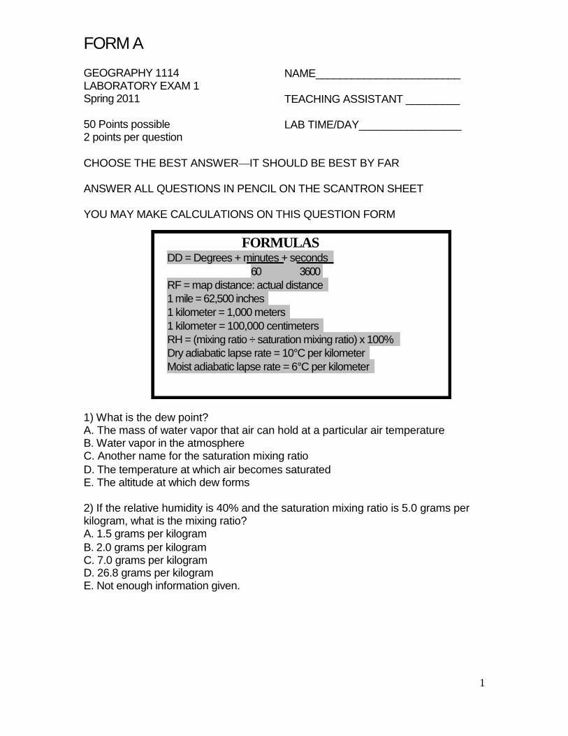
FORM A GEOGRAPHY 1114 LABORATORY EXAM 1 Spring 2011 50 Points possible 2 points per question
NAME________________________ TEACHING ASSISTANT _________ LAB TIME/DAY_________________
CHOOSE THE BEST ANSWER—IT SHOULD BE BEST BY FAR ANSWER ALL QUESTIONS IN PENCIL ON THE SCANTRON SHEET YOU MAY MAKE CALCULATIONS ON THIS QUESTION FORM
FORMULAS
DD = Degrees + minutes + seconds 60 3600
RF = map distance: actual distance 1 mile = 62,500 inches 1 kilometer = 1,000 meters 1 kilometer = 100,000 centimeters RH = (mixing ratio ÷ saturation mixing ratio) x 100% Dry adiabatic lapse rate = 10°C per kilometer Moist adiabatic lapse rate = 6°C per kilometer
1) What is the dew point? A. The mass of water vapor that air can hold at a particular air temperature B. Water vapor in the atmosphere C. Another name for the saturation mixing ratio D. The temperature at which air becomes saturated E. The altitude at which dew forms 2) If the relative humidity is 40% and the saturation mixing ratio is 5.0 grams per kilogram, what is the mixing ratio? A. 1.5 grams per kilogram B. 2.0 grams per kilogram C. 7.0 grams per kilogram D. 26.8 grams per kilogram E. Not enough information given.
1
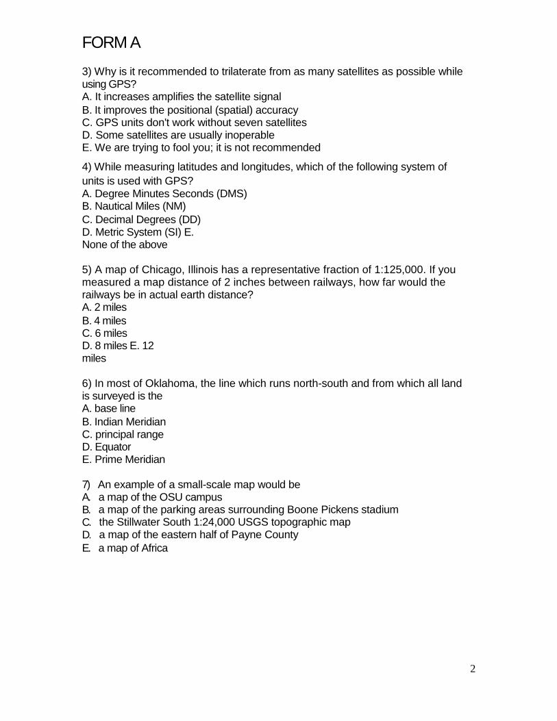
FORM A 3) Why is it recommended to trilaterate from as many satellites as possible while using GPS? A. It increases amplifies the satellite signal B. It improves the positional (spatial) accuracy C. GPS units don't work without seven satellites D. Some satellites are usually inoperable E. We are trying to fool you; it is not recommended
4) While measuring latitudes and longitudes, which of the following system of units is used with GPS? A. Degree Minutes Seconds (DMS) B. Nautical Miles (NM) C. Decimal Degrees (DD) D. Metric System (SI) E. None of the above 5) A map of Chicago, Illinois has a representative fraction of 1:125,000. If you measured a map distance of 2 inches between railways, how far would the railways be in actual earth distance? A. 2 miles B. 4 miles C. 6 miles D. 8 miles E. 12 miles 6) In most of Oklahoma, the line which runs north-south and from which all land is surveyed is the A. base line B. Indian Meridian C. principal range D. Equator E. Prime Meridian 7) A. B. C. D. E.
An example of a small-scale map would be a map of the OSU campus a map of the parking areas surrounding Boone Pickens stadium the Stillwater South 1:24,000 USGS topographic map a map of the eastern half of Payne County a map of Africa
2
FORM A
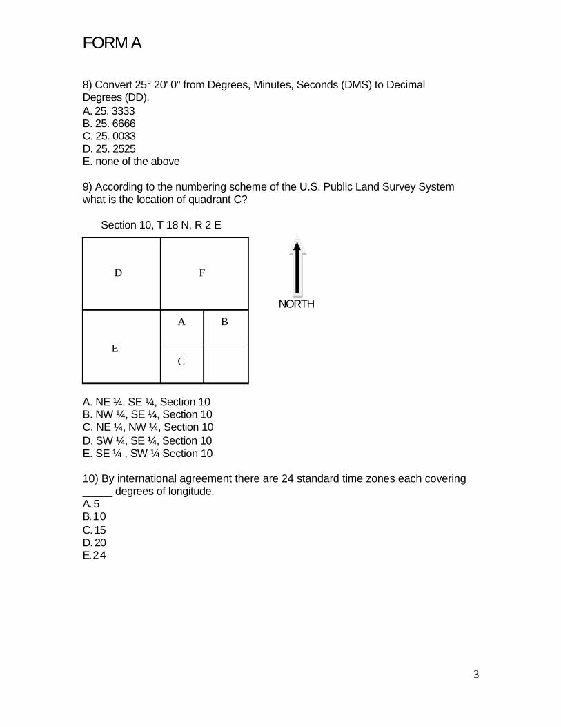
8) Convert 25° 20' 0" from Degrees, Minutes, Seconds (DMS) to Decimal Degrees (DD). A. 25. 3333 B. 25. 6666 C. 25. 0033 D. 25. 2525 E. none of the above 9) According to the numbering scheme of the U.S. Public Land Survey System what is the location of quadrant C?
Section 10, T 18 N, R 2 E
D F
NORTH A B
E C
A. NE ¼, SE ¼, Section 10 B. NW ¼, SE ¼, Section 10 C. NE ¼, NW ¼, Section 10 D. SW ¼, SE ¼, Section 10 E. SE ¼ , SW ¼ Section 10 10) By international agreement there are 24 standard time zones each covering _____ degrees of longitude. A. 5 B. 1 0 C. 15 D. 20 E. 2 4
3
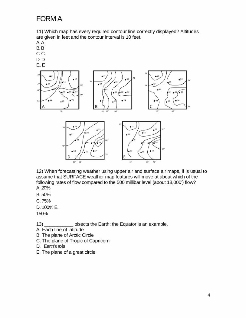
FORM A 11) Which map has every required contour line correctly displayed? Altitudes are given in feet and the contour interval is 10 feet. A. A B. B C. C D. D E.. E 12) When forecasting weather using upper air and surface air maps, if is usual to assume that SURFACE weather map features will move at about which of the following rates of flow compared to the 500 millibar level (about 18,000') flow? A. 20% B. 50% C. 75% D. 100% E. 150% 13) ___________ bisects the Earth; the Equator is an example. A. Each line of latitude B. The plane of Arctic Circle C. The plane of Tropic of Capricorn D. Earth's axis E. The plane of a great circle
4
FORM A
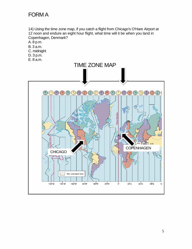
14) Using the time zone map, if you catch a flight from Chicago's O'Hare Airport at 12 noon and endure an eight hour flight, what time will it be when you land in Copenhagen, Denmark? A. 8 p.m. B. 3 a.m. C. midnight D. 3 p.m. E. 8 a.m.
TIME ZONE MAP
COPENHAGEN CHICAGO
5
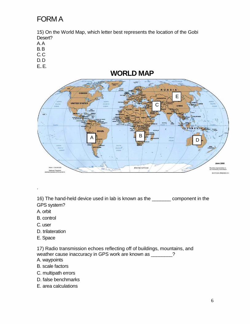
FORM A 15) On the World Map, which letter best represents the location of the Gobi Desert? A. A B. B C. C D. D E.. E.
WORLD MAP
E
C
A
B
D
. 16) The hand-held device used in lab is known as the _______ component in the GPS system? A. orbit B. control C. user D. trilateration E. Space 17) Radio transmission echoes reflecting off of buildings, mountains, and weather cause inaccuracy in GPS work are known as ________? A. waypoints B. scale factors C. multipath errors D. false benchmarks E. area calculations
6

FORM A 18) A(n) ________ is a location stored in a GPS receiver A. area calculation B. waypoint C. section D. control E. representation fraction 19) If the air outside is 30° C, the mixing ratio is 14.0 g/kg, and the saturation mixing ratio is 28.0 g/kg, what is the relative humidity in percent? A. 25% B. 50% C. 75% D. 100% E. 200% 20) What is the surface pressure in millibars shown on this weather station model? A. 5 7 B. 5 6 C. 107 D. 910.7 E. 1010.7
7
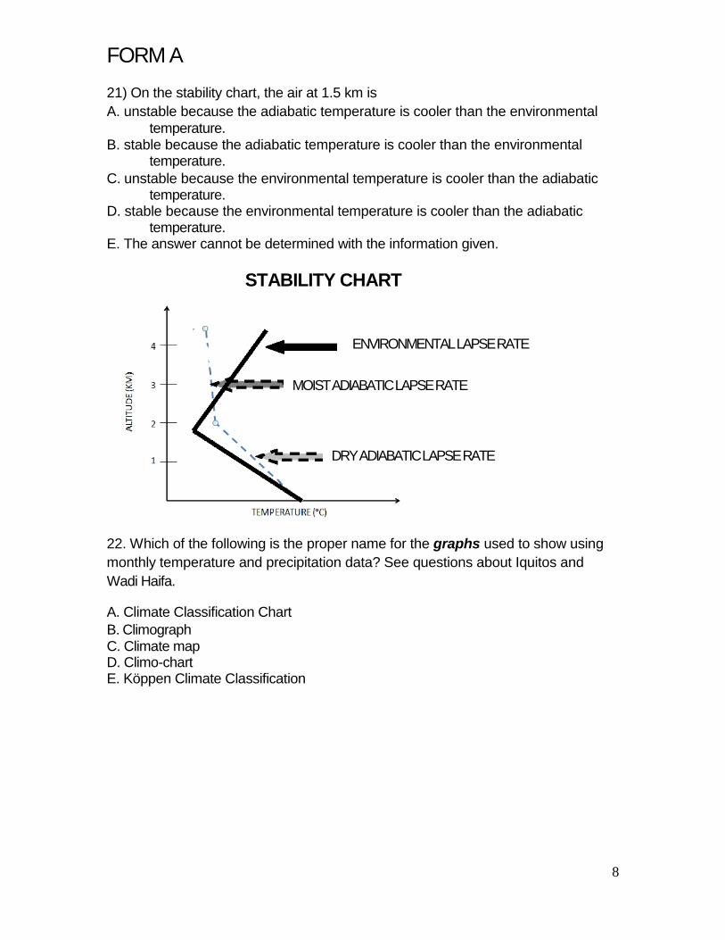
FORM A 21) On the stability chart, the air at 1.5 km is A. unstable because the adiabatic temperature is cooler than the environmental
temperature. B. stable because the adiabatic temperature is cooler than the environmental
temperature. C. unstable because the environmental temperature is cooler than the adiabatic
temperature. D. stable because the environmental temperature is cooler than the adiabatic
temperature. E. The answer cannot be determined with the information given.
STABILITY CHART
ENVIRONMENTAL LAPSE RATE
MOIST ADIABATIC LAPSE RATE
DRY ADIABATIC LAPSE RATE
22. Which of the following is the proper name for the graphs used to show using monthly temperature and precipitation data? See questions about Iquitos and Wadi Haifa. A. Climate Classification Chart B. Climograph C. Climate map D. Climo-chart E. Köppen Climate Classification
8

FORM A
23) On diagram of air flowing over the mountain, unsaturated air rises from 500m (at A) to become saturated at 2,000m (at B). The air continues to rise saturated until the mountain top at 3,500m (at C). Unsaturated, the air sinks back to 500m (at D). What is the temperature at D if the initial temperature of the air is 10°C at A? A. 10° B. -8° C. 16° D. 22° E. Need more information
AIR FLOWING OVER THE MOUNTAIN
24. Classify the Waidi Haifa, Sudan data into the proper Köppen climate type using the charts at the end of the exam. A. Am B. BWh C. BSk D. Dfd E. ET
9

FORM A
MEAN TEMPERATURE 26°C MEAN PRECIPITATION 0.3 CM EVAPORATION IS GREATER THAN PRECIPITATION
25. Classify the Iquitos, Peru data into the proper Köppen climate type using the charts at the end of the exam. A. Af B. BSh C. Csa D. Dwc E. EF
IQUITOS, PERU
3°S, 73°W, 115M °C CM
40 30
25 30
20
20 15
10 10
5
0 0 JAN MAR MAY JUL SEP NOV
FEB APR JUN AUG OCT DEC PRECIPITARTION IS GREATER THAN EVAPOTRANSPIRATION
YEAR: 24.7°C, 261.9 CM
10

FORM A
KOPPEN CLIMATE CHARTS
FIRST LETTERS DERIVATION DESCRIPTION A Alphabetical average monthly temperature above 18°C B Alphabetical evaporation exceeds precipitation
average temperature 18°C and -3°C in coldest month, above C Alphabetical 10 in wa rm e st m onth
C average monthly temperature of warmest month above 10°C;
D Alphabetical coldest month below -3°C E H
SECOND LETTERS
f
Alphabetical Highland German "feucht", moist
no m onth with a ve ra ge te m pe ra ture a bove 10 C significant climatic changes in short horizontal distances due to altitudinal variations In A climates rains all year, average monthly rainfall at least 6 cm; in other climates, nopronounced dry season
F Frost no m onth with a ve ra ge te m pe ra ture a bove 0 C m Monsoon only 1-3 months with average rainfall below 6 cm
driest summer month has below 1/3 the average precipitation s Summer dry of wettest winter month
average annual precipitation between 38 cm and 76 cm in low latitudes, 25 cm to 64 cm in midlatitudes; no pronounced
S Steppe, semiarid seasonal concentration at least 1 month with average temperature between
T w W
third letters
Tundra Winter dry German "Wuste", desert
0° a nd 10 C In A climates, 3-6 months with average rainfall below 6 cm; in C and D climates, driest winter month has less than 1/10 the average rainfall of wettest summer month average annual precipitation generally below 38 cm in low latitudes, and below 25 cm in midlatitudes
a Alphabetical a ve r a g e t e m p e r a t u r e o f w a r m e s t m o n t h a b o ve 2 2 C average temperature of wa rm e st m onth be low 22 ; C
b Alphabetical a t le a st 4 m onths with a ve ra ge te m pe ra ture a bove 10 C a ve ra ge te m pe ra ture of wa rm e st m onth be low 22 ; fe we r C tha n 4 m onths with a ve ra ge te m pe ra ture a bove 10 ; colde st C
c Alphabetical month above --38°C d Alphabetical average temperature of coldest month below -38 C
German "heiss", h hot a ve r a g e a n n u a l t e m p e r a t u r e a b o ve 1 8 C
German "kalt", k cold a ve ra ge a nnua l te m pe ra ture be low 18 C
11
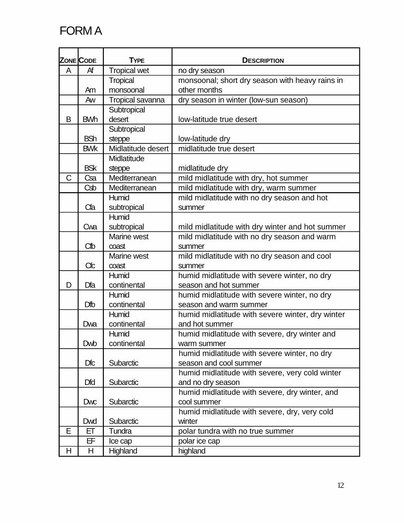
FORM A ZONE CODE TYPE DESCRIPTION
A Af Tropical wet no dry season Tropical monsoonal; short dry season with heavy rains in
Am monsoonal other months Aw Tropical savanna dry season in winter (low-sun season)
Subtropical B BWh desert low-latitude true desert
Subtropical BSh steppe low-latitude dry BWk Midlatitude desert midlatitude true desert
Midlatitude BSk steppe midlatitude dry
C Csa Mediterranean mild midlatitude with dry, hot summer Csb Mediterranean mild midlatitude with dry, warm summer
Humid mild midlatitude with no dry season and hot Cfa subtropical summer
Humid Cwa subtropical mild midlatitude with dry winter and hot summer
Marine west mild midlatitude with no dry season and warm Cfb coast summer
Marine west mild midlatitude with no dry season and cool Cfc coast summer
Humid humid midlatitude with severe winter, no dry D Dfa continental season and hot summer
Humid humid midlatitude with severe winter, no dry Dfb continental season and warm summer
Humid humid midlatitude with severe winter, dry winter Dwa continental and hot summer
Humid humid midlatitude with severe, dry winter and Dwb continental warm summer
humid midlatitude with severe winter, no dry Dfc Subarctic season and cool summer
humid midlatitude with severe, very cold winter Dfd Subarctic and no dry season
humid midlatitude with severe, dry winter, and Dwc Subarctic cool summer
humid midlatitude with severe, dry, very cold Dwd Subarctic winter
E ET Tundra polar tundra with no true summer EF Ice cap polar ice cap
H H Highland highland
12