forrestfield district centre structure … centre. hale road/hawtin road abuts the southern boundary...
TRANSCRIPT
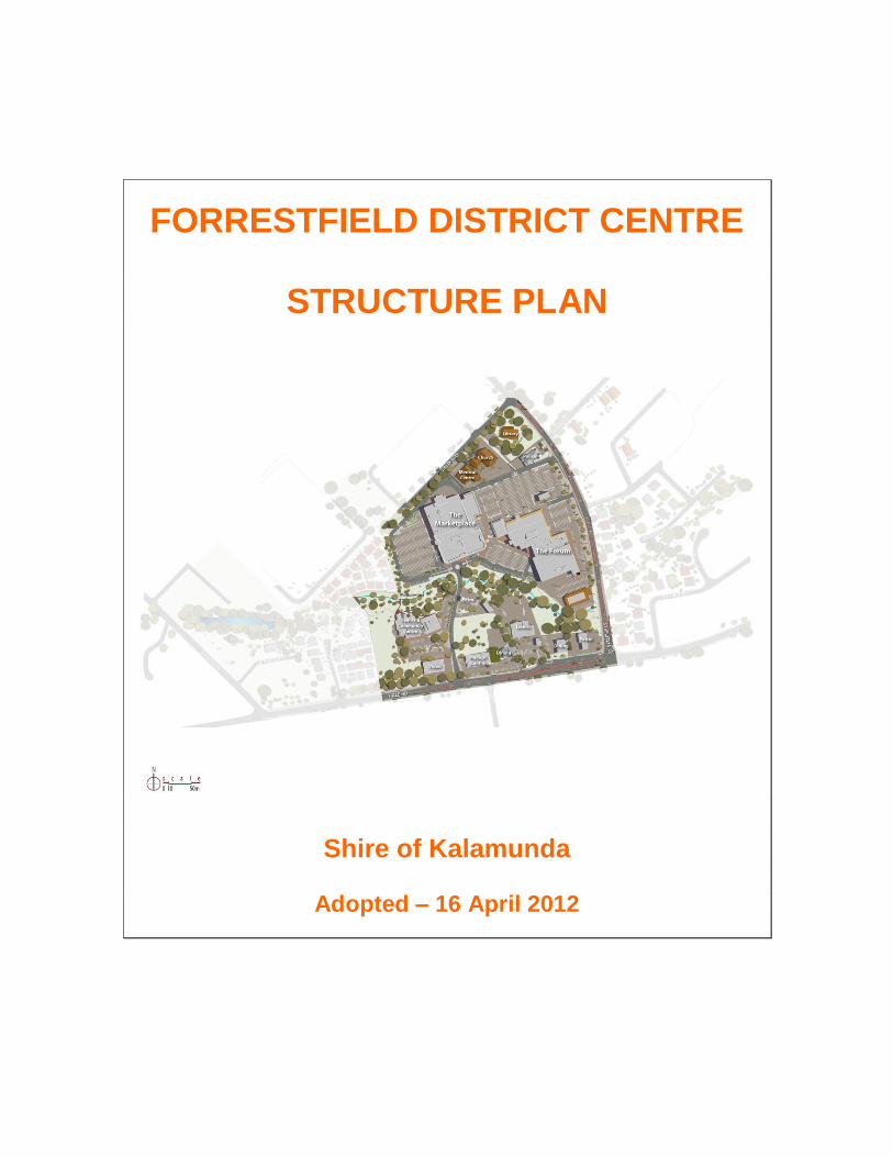
FORRESTFIELD DISTRICT CENTRE
STRUCTURE PLAN
Shire of Kalamunda
Adopted – 16 April 2012
FORRESTFIELD DISTRICT CENTRE STRUCTURE PLAN
Table of Contents
PART I – THE STRUCTURE PLAN 1.0 INTRODUCTION 1
Document Structure Background What is an Activity Centre? What is a Structure Plan? Structure Plan Objectives
2.0 CENTRE CONTEXT 4
Regional Context Local Context
3.0 KEY ISSUES and STRATEGIC OPPORTUNITIES 7
Introduction Activity Clusters Land Uses – General Comments Residential Development Office Development Restaurants and Cafés Retail Activity Recreation, Leisure and Entertainment Urban Design, Site Layout and Continuity Walkable Connections Public Transport Car Parking Environment Resource Conservation
4.0 THE VISION 15 5.0 THE PLANNING FRAMEWORK 15 6.0 LAND USES and ACTIVITIES 16
Principles Strategies
7.0 MOVEMENT NETWORK (Movement, Access and Parking) 18
Principles Strategies
8.0 BUILT FORM and URBAN DESIGN 22
Principles Strategies
9.0 PUBLIC SPACE NETWORK 27
Principles Strategies
10.0 RESOURCE CONSERVATION 30
Principles Strategies
11.0 STRUCTURE PLAN IMPLEMENTATION 31
PART II – APPENDICES APPENDIX 1 – Research 34
1.0 Forrestfield Snapshot 2.0 Existing Statutory and Planning Considerations 3.0 Existing Development within the Centre 4.0 Land Tenure 5.0 Existing Surrounding Urban Form and Character 6.0 Existing Road Hierarchy 7.0 Existing Transport Infrastructure 8.0 Physical Infrastructure and Services 9.0 Demographic Data
APPENDIX 2 – Proposed Actions & Recommendations 55 APPENDIX 3 – Forrestfield District Centre Structure Plan 57

1 | P a g e
PART I – THE STRUCTURE PLAN 1.0 INTRODUCTION 1.1 Document Structure This document has been prepared in two parts:
(i) Part I contains the Structure Plan; and (ii) Part II contains the supporting Appendix (background research).
1.2 Background
Under the State Government’s State Planning Policy 4.2 (“Activity Centres for Perth and Peel”) [August 2010], the Forrestfield Centre is identified as a “District Centre” in the Activity Centres’ Hierarchy. This classification highlights the important role the Forrestfield Centre currently performs in the day-to-day functioning of the Forrestfield area, and more importantly, reinforces the ongoing and expanding role the Centre is expected to play into the future. The Forrestfield Centre currently contains approximately 17,060 sq.m of commercial floor space (DPI data). Of this, approx. 12,044 sq.m is classified as “shop-retail”. Clause 6.4(2) of SPP 4.2 states that “Activity centre structure plans should be endorsed prior to a major development being approved to ensure a centre’s development is integrated, cohesive and accessible.” According to the interpretations included in SPP 4.2 (Appendix 1), a “major development” is defined as:
“Development of any building or extension/s to an existing building where the building or extensions are used or proposed to be used for shop-retail purposes and where the shop-retail NLA of the:
proposed building is more than 10,000 sq.m, or
extension/s is more than 5,000 sq.m.”
In September 2010 the Shire of Kalamunda was approached by representatives of the two major retail outlets operating within the Centre (the “Forrestfield Forum” and “Forrestfield Marketplace”) with an informal proposal to undertake major extensions to those two outlets, which currently make up approx. 75% of the total Forrestfield Centre commercial floor space. The proposed extensions would increase the floor space of the two major retail outlets by over 7,200 sq.m of shop-retail, and constitute a major development. A formal Development Application has yet to be received by the Shire. However the Shire considers it prudent to undertake the preparation of a Structure Plan for the Centre, in anticipation of a formal Application being received for this, or any other site within the Forrestfield Centre. Clause 6.4.1 of SPP 4.2 states that the relevant local authority is the approval authority for District centres of less than 20,000 sq.m shop-retail NLA. The WAPC must endorse a
2 | P a g e
District Centre structure plan if the floor space exceeds 20,000 sq.m shop-retail NLA. The current shop-retail floor space of the Centre is well below this figure, and therefore the Structure Plan does not have to be referred to the WAPC for approval. The Shire of Kalamunda is also a major landowner within the Forrestfield District Centre, and is currently developing plans for a major new residential development and a possible extension of existing community facilities. The Shire of Kalamunda has therefore prepared this Structure Plan to guide the future redevelopment and renewal of all the area identified as the “Forrestfield District Centre”. The Structure Plan has been prepared generally in accordance with the “Structure Plan Preparation Guidelines” contained in SPP 4.2. 1.3 What is an Activity Centre? An activity centre is a community focal point, and ideally it includes activities such as commercial, retail, higher-density housing, entertainment, tourism, civic/community, higher education and medical services. Activity centres vary in size and diversity, and should be located and designed to be well-served by public transport. 1.4 What is a Structure Plan? An activity centre structure plan is a tool to manage change and the development form of activity centres. Structure planning is a process of developing a framework for the co-ordinated development of private and public land over a period of 10 to 20 years, and includes guidance for long-term, major changes to land use, built form, movement networks and public spaces. An activity centre structure plan sets out the spatial plan and strategy to achieve a compact, pedestrian-friendly, mixed-use activity centre that will offer a range of lifestyle choices, reduce car dependency and limit environmental impact. 1.5 Structure Plan Objectives Land Uses and Activities –
To support a wide range of retail and commercial premises and to promote a competitive retail and commercial market;
To support the provision of appropriate civic and community facilities which will increase the broad appeal and multi-faceted nature of the Centre;
To increase the range of employment opportunities, which will in turn contribute to the achievement of sub-regional employment self-sufficiency;
To increase the density and diversity of housing in and around the Centre to improve land use efficiency, housing variety and choice, and to support Centre facilities; and
To ensure the Centre provides sufficient development intensity and land use mix to support higher frequency public transport.
3 | P a g e
Built Form, Urban Design and the Public Domain –
To improve the layout of the Centre in terms of its legibility and character;
To encourage respect for human scale and user amenity when new buildings are located and designed;
To preserve and enhance the Centre’s natural assets; and
To improve the quality and character of the open spaces between buildings, and the public spaces set aside exclusively for non-vehicular use.
Movement, Access and Parking –
To improve the safety and amenity of those visitors, customers and employees moving about the Centre;
To increase the access options available to development sites;
To improve the layout, design and amenity of car parking areas; and
To maximise access to the Centre by walking, cycling and public transport to encourage reduced private car trips.
Resource Conservation –
To encourage environmentally sustainable outcomes by incorporating innovative design, construction and management principles; and
To discourage wasteful use of resources and infrastructure through more efficient and intensive use of land.
4 | P a g e
2.0 CENTRE CONTEXT 2.1 Regional Context
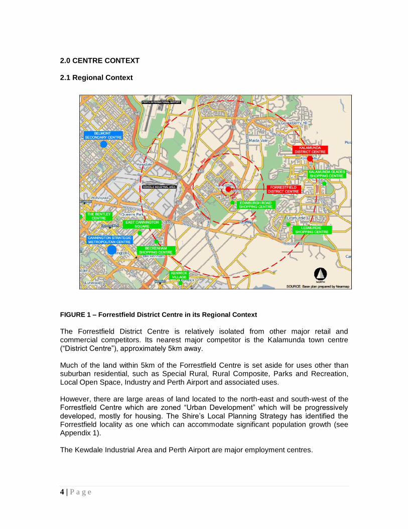
FIGURE 1 – Forrestfield District Centre in its Regional Context The Forrestfield District Centre is relatively isolated from other major retail and commercial competitors. Its nearest major competitor is the Kalamunda town centre (“District Centre”), approximately 5km away. Much of the land within 5km of the Forrestfield Centre is set aside for uses other than suburban residential, such as Special Rural, Rural Composite, Parks and Recreation, Local Open Space, Industry and Perth Airport and associated uses. However, there are large areas of land located to the north-east and south-west of the Forrestfield Centre which are zoned “Urban Development” which will be progressively developed, mostly for housing. The Shire’s Local Planning Strategy has identified the Forrestfield locality as one which can accommodate significant population growth (see Appendix 1). The Kewdale Industrial Area and Perth Airport are major employment centres.
5 | P a g e
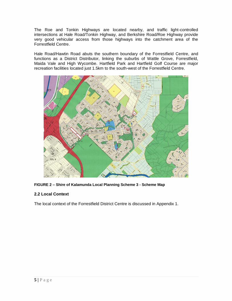
The Roe and Tonkin Highways are located nearby, and traffic light-controlled intersections at Hale Road/Tonkin Highway, and Berkshire Road/Roe Highway provide very good vehicular access from those highways into the catchment area of the Forrestfield Centre. Hale Road/Hawtin Road abuts the southern boundary of the Forrestfield Centre, and functions as a District Distributor, linking the suburbs of Wattle Grove, Forrestfield, Maida Vale and High Wycombe. Hartfield Park and Hartfield Golf Course are major recreation facilities located just 1.5km to the south-west of the Forrestfield Centre.
FIGURE 2 – Shire of Kalamunda Local Planning Scheme 3 - Scheme Map
2.2 Local Context The local context of the Forrestfield District Centre is discussed in Appendix 1.
6 | P a g e
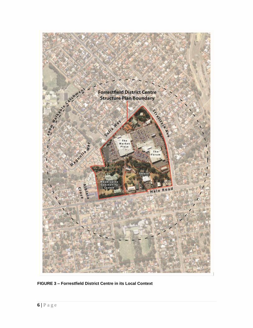
FIGURE 3 – Forrestfield District Centre in its Local Context
7 | P a g e
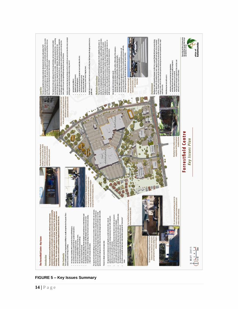
3.0 KEY ISSUES and STRATEGIC OPPORTUNITIES 3.1 Introduction The Forrestfield Forum and Marketplace are only two, albeit large and important, commercial components of a much broader variety of commercial uses and community facilities that collectively make up what is a de facto “town centre” for the suburb of
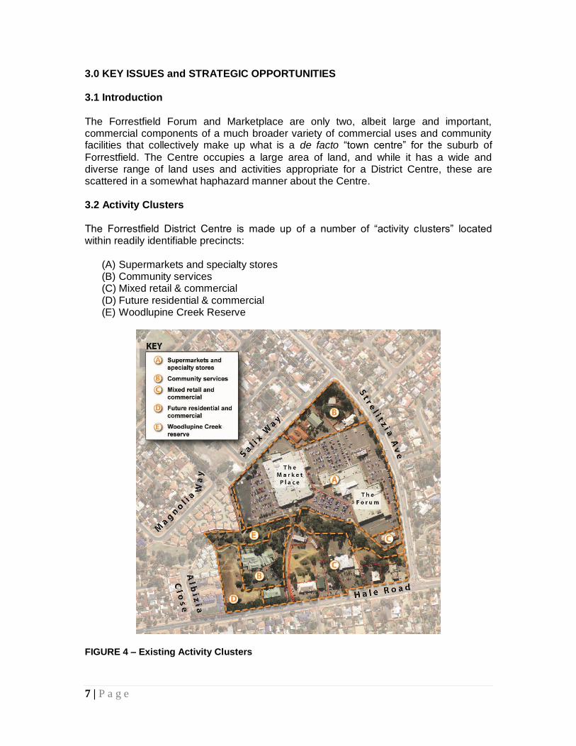
Forrestfield. The Centre occupies a large area of land, and while it has a wide and diverse range of land uses and activities appropriate for a District Centre, these are scattered in a somewhat haphazard manner about the Centre. 3.2 Activity Clusters The Forrestfield District Centre is made up of a number of “activity clusters” located within readily identifiable precincts:
(A) Supermarkets and specialty stores (B) Community services (C) Mixed retail & commercial (D) Future residential & commercial (E) Woodlupine Creek Reserve
FIGURE 4 – Existing Activity Clusters
8 | P a g e
While this broad and diverse range of uses is one of the assets of the Forrestfield Centre, the segregation of these “clusters” is a disadvantage to users and visitors, as it decreases the “walkability” of the Centre. 3.3 Land Uses – General Comments The majority of existing uses making up the Centre are inward-looking, and most stores are closed outside normal shopping hours. This means the site as a whole – including the community facilities – is uninviting after hours and may even be a magnet for anti-social behaviour. However, the pressure for new development in the area may eventually prove beneficial to the site – while land ownership across the site is fragmented, the challenge will be to take advantage of new development so that it contributes to the diversity and vitality of the Centre, while at the same time significantly improving the amenity of the area. Any new mixed use development undertaken on the Forrestfield District Centre site should be sited, orientated and designed in a manner which helps address existing issues of:
poor passive surveillance;
fragmented building fabric;
a lack of interaction between component uses located about the site;
poor internal movement system and connections between individual sites;
poor address on Hale Road, and
anti-social activity outside normal shopping hours. 3.4 Residential Development There is a need to increase the population within and surrounding the Forrestfield District Centre in order to increase potential patronage, to reduce travel demand, and to increase the vibrancy which comes with greater numbers of people shopping, working, visiting and just moving about the Centre. Population growth has been minimal over the past decade (see Appendix 1) and more residential opportunities need to be provided within the area. This includes the surrounding low density residential areas, the nearby areas zoned “Urban Development”, the area of Shire-owned land on Hale Road (Lot 106), and ideally as part of any new “major development” that may take place within the District Centre in the future. 3.5 Office Development The Forrestfield Centre has a very small quantity of what could be termed “office” space. Examples are some medical-related premises, an office for a local Member of Parliament, and an accountant. Future demand for office space in the area is difficult to forecast. However, if the Forrestfield Centre is to function and grow as a true District Centre, it will need to accommodate more office space to service the needs of the surrounding community, and to provide increased local employment opportunities.
9 | P a g e
3.6 Restaurants and Cafés While the Forrestfield Centre has a variety of eat-in and take-away restaurants, cafés and fast-food outlets, there is little al fresco dining available. This is a significant shortcoming, and is difficult to understand considering the attractiveness of the local climate and the abundance of large mature trees and potentially attractive open spaces that occur in various parts of the Centre. 3.7 Retail Activity The quantity and variety of retail outlets within the Forrestfield Centre is significant (see Appendix 1). However, the Centre lacks a discount department store. The introduction of such an outlet would be appropriate as it would complement existing uses and provide local employment opportunities, and therefore be welcomed, provided it was located and designed in a manner which exhibited good urban design principles. Bulky goods stores or warehouse-type outlets would not, however, be appropriate due to their large size, large car parking requirements, low employment requirements and their need for large freight vehicle access. These uses are better located in light industrial areas or specifically zoned localities. There are several drive-through fast-food outlets, and another (KFC) is under construction now (May 2011). A broader mix of uses is required in the future to offset the current imbalance in favour of retailing. 3.8 Recreation, Leisure and Entertainment A notable gap in the recreation, leisure and entertainment on offer within the Forrestfield District Centre is the lack of a cinema and one or more small bars. 3.9 Urban Design, Site Layout and Continuity
The Forrestfield Centre is very fragmented and difficult to visually comprehend on the ground. This is caused by a number of things, including:
the large areas of parking which surround the Forum and Marketplace;
the multitude of entrances available from the peripheral road system;
the poor internal road and pathway system;
the ad-hoc traffic circulation system in the south-east quadrant of the Centre, where drive through fast-food outlets and a drive-through bottle shop are all located on their own lots without any cross-access rights provided;
the lack of an easily identifiable “heart” for the centre;
the poor amenity of the spaces between buildings;
large areas of vacant/derelict land;
the lack of any visually unifying elements displayed in the architecture or street furniture; and
10 | P a g e
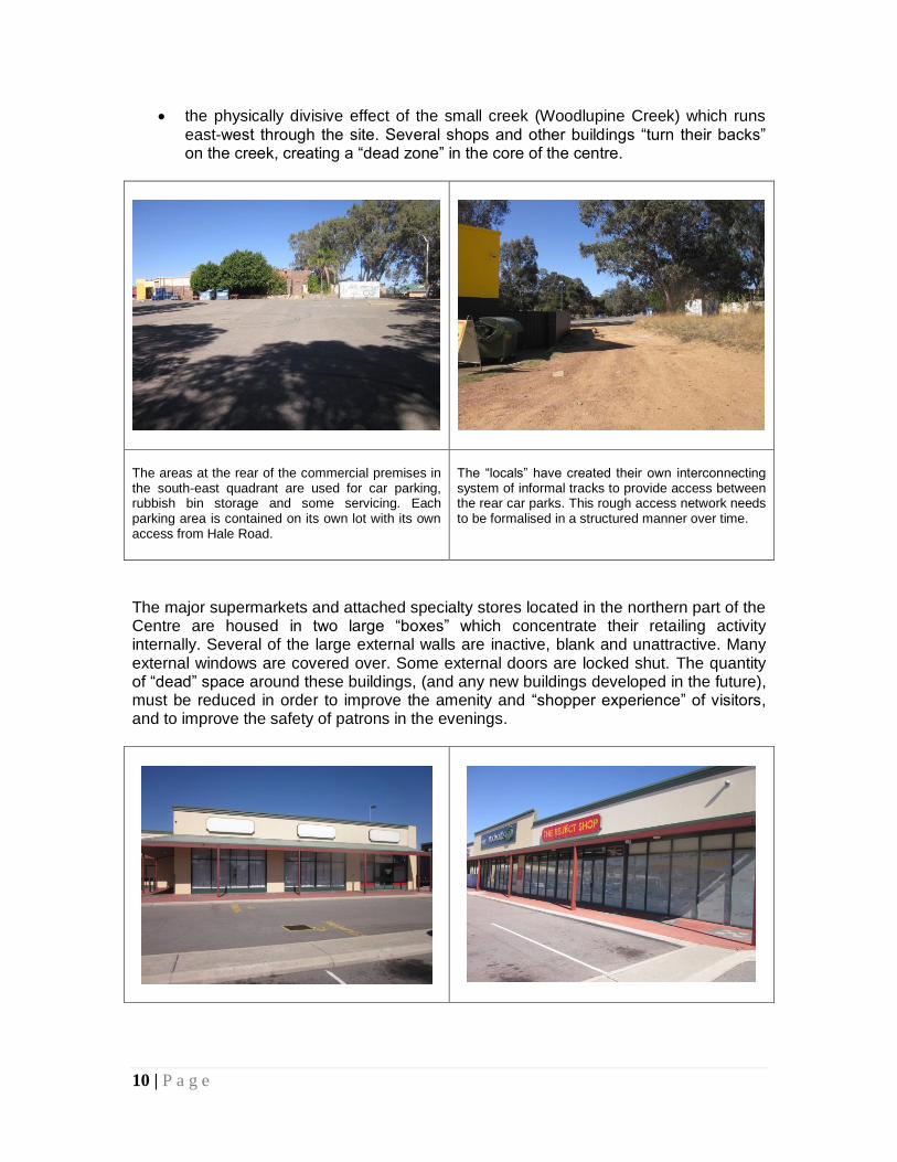
the physically divisive effect of the small creek (Woodlupine Creek) which runs east-west through the site. Several shops and other buildings “turn their backs” on the creek, creating a “dead zone” in the core of the centre.
The areas at the rear of the commercial premises in the south-east quadrant are used for car parking, rubbish bin storage and some servicing. Each parking area is contained on its own lot with its own access from Hale Road.
The “locals” have created their own interconnecting system of informal tracks to provide access between the rear car parks. This rough access network needs to be formalised in a structured manner over time.
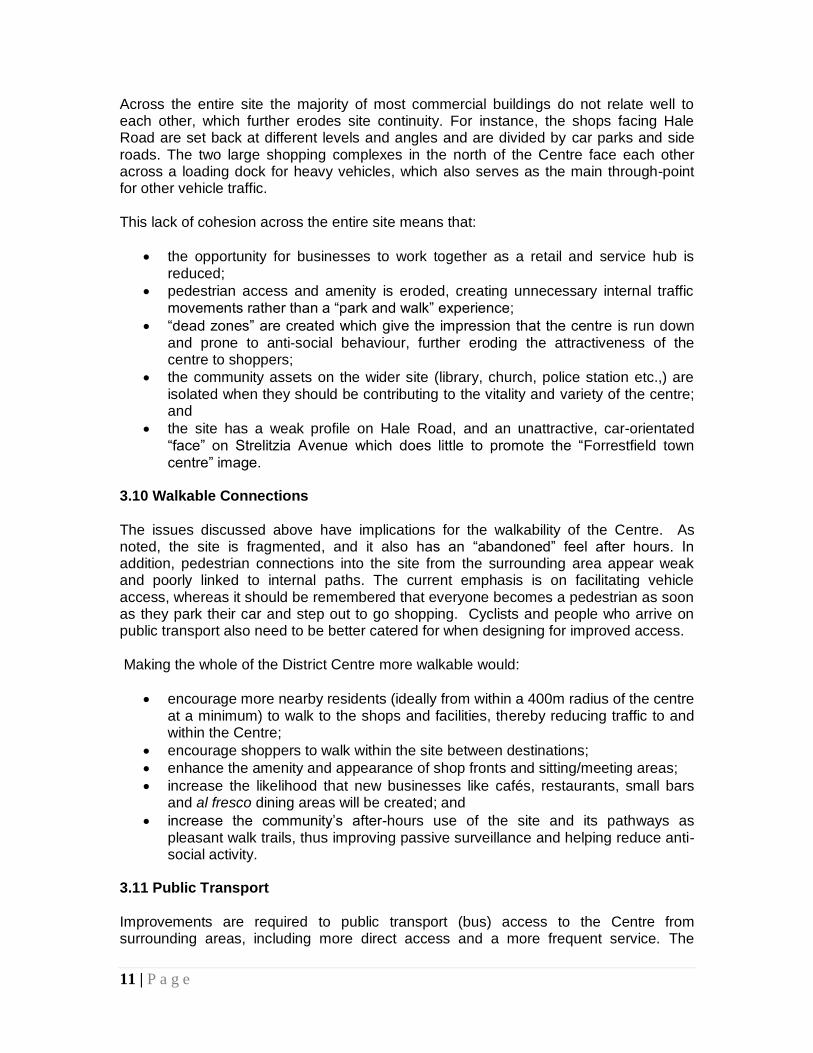
The major supermarkets and attached specialty stores located in the northern part of the Centre are housed in two large “boxes” which concentrate their retailing activity internally. Several of the large external walls are inactive, blank and unattractive. Many external windows are covered over. Some external doors are locked shut. The quantity of “dead” space around these buildings, (and any new buildings developed in the future), must be reduced in order to improve the amenity and “shopper experience” of visitors, and to improve the safety of patrons in the evenings.
11 | P a g e
Across the entire site the majority of most commercial buildings do not relate well to each other, which further erodes site continuity. For instance, the shops facing Hale Road are set back at different levels and angles and are divided by car parks and side roads. The two large shopping complexes in the north of the Centre face each other across a loading dock for heavy vehicles, which also serves as the main through-point for other vehicle traffic. This lack of cohesion across the entire site means that:
the opportunity for businesses to work together as a retail and service hub is reduced;
pedestrian access and amenity is eroded, creating unnecessary internal traffic movements rather than a “park and walk” experience;
“dead zones” are created which give the impression that the centre is run down and prone to anti-social behaviour, further eroding the attractiveness of the centre to shoppers;
the community assets on the wider site (library, church, police station etc.,) are isolated when they should be contributing to the vitality and variety of the centre; and
the site has a weak profile on Hale Road, and an unattractive, car-orientated “face” on Strelitzia Avenue which does little to promote the “Forrestfield town centre” image.
3.10 Walkable Connections
The issues discussed above have implications for the walkability of the Centre. As noted, the site is fragmented, and it also has an “abandoned” feel after hours. In addition, pedestrian connections into the site from the surrounding area appear weak and poorly linked to internal paths. The current emphasis is on facilitating vehicle access, whereas it should be remembered that everyone becomes a pedestrian as soon as they park their car and step out to go shopping. Cyclists and people who arrive on public transport also need to be better catered for when designing for improved access. Making the whole of the District Centre more walkable would:
encourage more nearby residents (ideally from within a 400m radius of the centre at a minimum) to walk to the shops and facilities, thereby reducing traffic to and within the Centre;
encourage shoppers to walk within the site between destinations;
enhance the amenity and appearance of shop fronts and sitting/meeting areas;
increase the likelihood that new businesses like cafés, restaurants, small bars and al fresco dining areas will be created; and
increase the community’s after-hours use of the site and its pathways as pleasant walk trails, thus improving passive surveillance and helping reduce anti-social activity.
3.11 Public Transport
Improvements are required to public transport (bus) access to the Centre from surrounding areas, including more direct access and a more frequent service. The
12 | P a g e
current service (see Appendix 1) is most circuitous, and does not include a continuous route along Hale Road, which is surprising. In addition to an improved service, bus shelters should be provided at all stops adjacent to the District Centre, linking in with dedicated pedestrian paths. 3.12 Car Parking
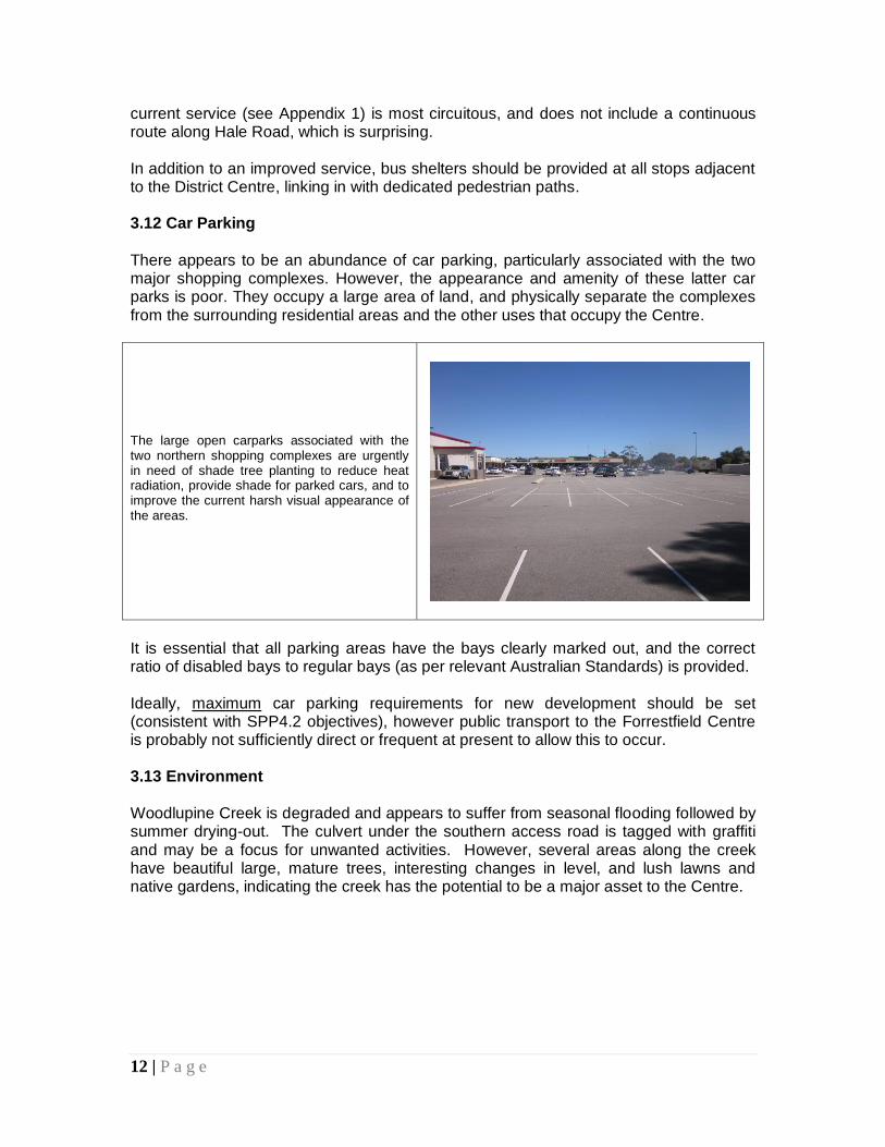
There appears to be an abundance of car parking, particularly associated with the two major shopping complexes. However, the appearance and amenity of these latter car parks is poor. They occupy a large area of land, and physically separate the complexes from the surrounding residential areas and the other uses that occupy the Centre. The large open carparks associated with the two northern shopping complexes are urgently in need of shade tree planting to reduce heat radiation, provide shade for parked cars, and to improve the current harsh visual appearance of the areas.
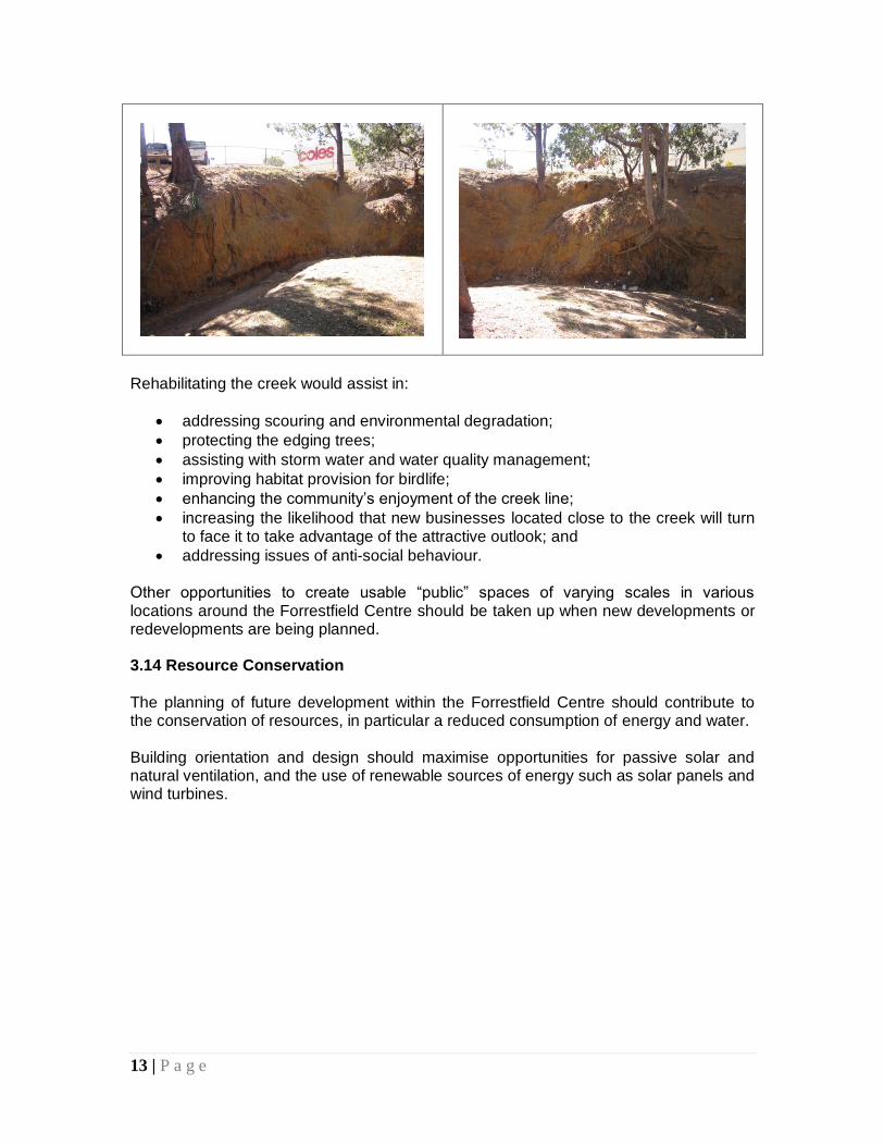
It is essential that all parking areas have the bays clearly marked out, and the correct ratio of disabled bays to regular bays (as per relevant Australian Standards) is provided. Ideally, maximum car parking requirements for new development should be set (consistent with SPP4.2 objectives), however public transport to the Forrestfield Centre is probably not sufficiently direct or frequent at present to allow this to occur. 3.13 Environment Woodlupine Creek is degraded and appears to suffer from seasonal flooding followed by summer drying-out. The culvert under the southern access road is tagged with graffiti and may be a focus for unwanted activities. However, several areas along the creek have beautiful large, mature trees, interesting changes in level, and lush lawns and native gardens, indicating the creek has the potential to be a major asset to the Centre.
13 | P a g e
Rehabilitating the creek would assist in:
addressing scouring and environmental degradation;
protecting the edging trees;
assisting with storm water and water quality management;
improving habitat provision for birdlife;
enhancing the community’s enjoyment of the creek line;
increasing the likelihood that new businesses located close to the creek will turn to face it to take advantage of the attractive outlook; and
addressing issues of anti-social behaviour. Other opportunities to create usable “public” spaces of varying scales in various locations around the Forrestfield Centre should be taken up when new developments or redevelopments are being planned. 3.14 Resource Conservation
The planning of future development within the Forrestfield Centre should contribute to the conservation of resources, in particular a reduced consumption of energy and water. Building orientation and design should maximise opportunities for passive solar and natural ventilation, and the use of renewable sources of energy such as solar panels and wind turbines.
14 | P a g e
FIGURE 5 – Key Issues Summary
15 | P a g e
4.0 THE VISION
The Forrestfield District Centre will be developed and expanded as the most significant activity focus of this region. It will be a place where people can shop, work and live, and access social networks and personal and community services. It will be a diverse, distinctive, vibrant and enjoyable place – day and night. It will be sustainable and accessible to all. The Forrestfield District Centre will focus on servicing the daily and weekly needs of the surrounding community. It will provide services, facilities and job opportunities that reflect the particular needs of the surrounding residential catchment. It will be the focal point for the bus network.
Note: This vision statement has been developed making specific reference to WAPC SPP 4.2, Activity Centres for Perth and Peel.
5.0 THE PLANNING FRAMEWORK The proposed structure of the Forrestfield District Centre is illustrated on the following pages, showing the desired organisation of the major components of the Centre’s urban development. This represents a combination of existing conditions as well as the identification of opportunities for positive change as guided by the vision, principles and strategies contained in Part One of this document. The planning framework includes the following components:
land uses and activities that are appropriate to their location and surrounds, which meet community needs, and which contribute to the quality and vitality of the publicly-accessible areas;
a linked movement network of safe and attractive streets, laneways and other accessways to encourage walking, cycling and public transport usage, and to improve road management;
built forms and good urban design that contributes positively to the quality, safety and amenity of the spaces between and around buildings, and improves the image of the District Centre;
a network of public spaces of varying forms and sizes to support local recreation and social needs, and community interaction; and
principles for resource conservation in new development. Each component of the planning framework is discussed further in the following pages. The proposed strategies which flow from each component are guided by the principles which precede them, and the overall objectives of the Structure Plan.
16 | P a g e
6.0 LAND USES and ACTIVITIES 6.1 Principles
Ensure that new uses and activities support and enhance the recognised role of the Forrestfield District Centre;
Encourage and promote a diverse mix of uses in new developments on larger sites in preference to mono-functional land uses such as solely retail or commercial;
Encourage new residential developments and greater housing choice within and surrounding the Centre;
Encourage a sense of vibrancy and excitement within the Centre which would appeal to local and regional visitors, but which is lacking at present;
Reinforce the importance of the customer and visitor by giving priority to active, street-orientated land uses over off-street “big box” activities;
Encourage developments that provide greater employment and visitation opportunities in proximity to the main bus stops, and discourage new developments that don’t;
Maintain and enhance retail uses that serve local shopping needs, offer convenience and provide local services;
Examine opportunities to upgrade, extend and increase the areas set aside for public use and community events and improve their quality, and link these spaces wherever possible through both public and private initiatives; and
Encourage attractive and safe al fresco dining facilities to foster lively
streetscapes and other public interface areas. 6.2 Strategies Employment: The latest data from DPI (2008) shows that the Forrestfield District Centre employs 558 people. Predictably, the great majority (75%) are employed in shop/retail activities. 18.6% are office workers. 3.6% are employed in entertainment/recreation/cultural activities. The Shire of Kalamunda will promote the Forrestfield Centre as an important employment hub. Increasing the number of jobs within the Centre will provide opportunities for attracting and retaining staff, will result in more efficient use of infrastructure, will increase opportunities for establishing a service cluster and the sharing of knowledge and skills, and will support the public transport service. Floor Space by Land Use: Current total floor space of the Forrestfield Centre is approx.17,061 sq.m. SPP4.2 includes a “diversity performance target” for the desirable mix of land uses in an activity centre. At present the percentage of all occupied floor space in the Forrestfield Centre taken up by non-retail/shop uses is approx. 21%.
17 | P a g e
- For a Centre in excess of 10,000 sq.m, the proportion of non-retail/shop uses should be 20%.
- For a Centre in excess of 20,000 sq.m, the proportion of non-retail/shop uses should be 30%.
This suggests that future expansion of the Forrestfield Centre should include a greater proportion of mixed uses (i.e., non-retail/shop uses) than is currently offered. This means commercial/office, health, education, entertainment, cultural, recreational and community facilities and higher density housing. Land uses that generate activity outside normal business hours (e.g., hospitality, entertainment, community facilities, gymnasiums etc.) will be encouraged to generate additional evening and weekend activities, and to take advantage of shared use of facilities such as car parking and public transport. Stand-alone or supplementary residential uses will also be strongly encouraged.
Housing Density:
- A minimum residential density of R60 should be set for the walkable catchment (400m) of the Centre #.
- New residential development within the boundaries of the Centre should be a minimum of R40 and a maximum of R80.
Note: # This could be a split R40/60 coding, or possibly up to R80. Given the state of the Forrestfield housing market it is likely that significant incentives will need to be offered to prospective developers to encourage any significant redevelopment of existing housing areas - hence the relatively high R80 coding proposed. An increase in housing choice is also required given (i) the very high percentage of single dwellings making up the housing stock, and (ii) the large number of single dwellings currently occupied by only one or two people. An important part of the Shire’s proposed Housing Strategy must include consideration of appropriate redevelopment incentives, and the development of ways to achieve appropriate new dwelling forms, rather than just allowing for “a new house behind each existing house”, which would be a vastly inferior outcome.
Retail Sustainability/Needs Assessment Study: A Retail Sustainability/Needs Assessment Study must be prepared by the proponents of any major development of a commercial nature. The Study, together with its likely
impacts measured against the objectives and principles of this Structure Plan, will be assessed by the Shire of Kalamunda prior to any determination being made by Council, and if required, also forwarded to the WAPC for final approval.
18 | P a g e
7.0 MOVEMENT NETWORK (Movement, Access & Parking) 7.1 Principles
Support the provision of a safe, efficient and integrated transport, traffic and pedestrian/cycle network that adequately serves the needs of residents, workers, visitors and businesses;
Pursue, improve and promote an appropriate balance regarding accessibility to the Forrestfield Centre and its major attractors by walking, cycling, public transport and motor vehicles;
Ensure the street environment emphasises the pedestrian wherever possible and practicable, while maintaining appropriate access;
Manage the provision of adequate car parking facilities, and encourage integration of car parking with adjoining sites which are convenient, safe and sustainable;
Locate car parking areas to minimise impacts upon the streetscape, and not be detrimental to the positive attributes of the Centre;
Control new development so that accessways and parking facilities do not visually dominate the public realm or create obstructions to the pedestrian environment, and minimise potential pedestrian/vehicle conflicts;
Require new buildings and spaces to be designed in a manner that promotes accessibility and local permeability by integration into neighbouring developments; and
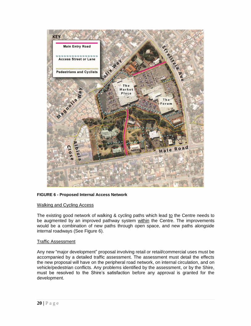
Over a period of time gradually establish a simple network of publicly-owned roads and pathways to penetrate the internal areas of the Centre, particularly the south-east quadrant, and to improve accessibility options.
7.2 Strategies
Public Transport Infrastructure Attractive, efficient and convenient public transport access can reduce private car dependency and lead to a more efficient use of land within the Centre. The quality of public transport infrastructure plays an important role in the attractiveness of this travel mode over others. The Shire of Kalamunda shall negotiate with the Public Transport Authority with a view to improving the bus service to and from the Forrestfield District Centre. This may mean:
Providing more direct routes to the main stops on Strelitzia Avenue,
Providing a continuous route along Hale Road, and
Providing a more frequent service. The Forrestfield Centre should be regarded as an important destination in its own right, rather than just one of many stops along circuitous routes. As the Centre expands and grows in importance, its role as a community hub serving the wider district will increase, and the public transport service must be upgraded accordingly.
19 | P a g e
All bus stops on both sides of Strelitzia Avenue between Salix Way and Hale Road should be provided with quality bus shelters. Any future bus stops to be located on Hale Road and directly serving the Centre should also be supplied with quality bus shelters. All bus stops and their immediate environs should be safe, well-lit, attractive, highly visible areas and easy to access in order to provide a positive perception of public transport. The stops should be directly linked in with the pedestrian walkway system of the area. Internal Road System Within the Forrestfield Centre there are a number of significant changes required to upgrade existing conditions, and to improve the circulation system. These changes would be incremental, and should include:
Bringing the private road which links Hale Road to the northern shopping complexes into public ownership. (This would then allow the Shire to upgrade the road with wide footpaths on each side, quality street lighting and avenue shade tree planting). This is a priority action;
Creating a simple network of linked laneways and service ways within the south-east quadrant of the Centre to improve the existing poor circulation system. Such a network can be achieved incrementally over time as new developments are proposed; and
Upgrading the main vehicle accessways into and through the land occupied by the two major shopping complexes which lead off Strelitzia Avenue. These accessways should be improved to provide clearer visual cues for drivers, and provide greater safety and improved amenity for pedestrians.
POSTSCRIPT: The Shire should also investigate the opportunity to construct a roundabout at the intersection of Hale Road and the private road which links it to the northern shopping complexes, to facilitate safer and more efficient traffic movements at that intersection.
20 | P a g e
FIGURE 6 - Proposed Internal Access Network
Walking and Cycling Access The existing good network of walking & cycling paths which lead to the Centre needs to be augmented by an improved pathway system within the Centre. The improvements would be a combination of new paths through open space, and new paths alongside internal roadways (See Figure 6). Traffic Assessment Any new “major development” proposal involving retail or retail/commercial uses must be accompanied by a detailed traffic assessment. The assessment must detail the effects the new proposal will have on the peripheral road network, on internal circulation, and on vehicle/pedestrian conflicts. Any problems identified by the assessment, or by the Shire, must be resolved to the Shire’s satisfaction before any approval is granted for the development.
21 | P a g e
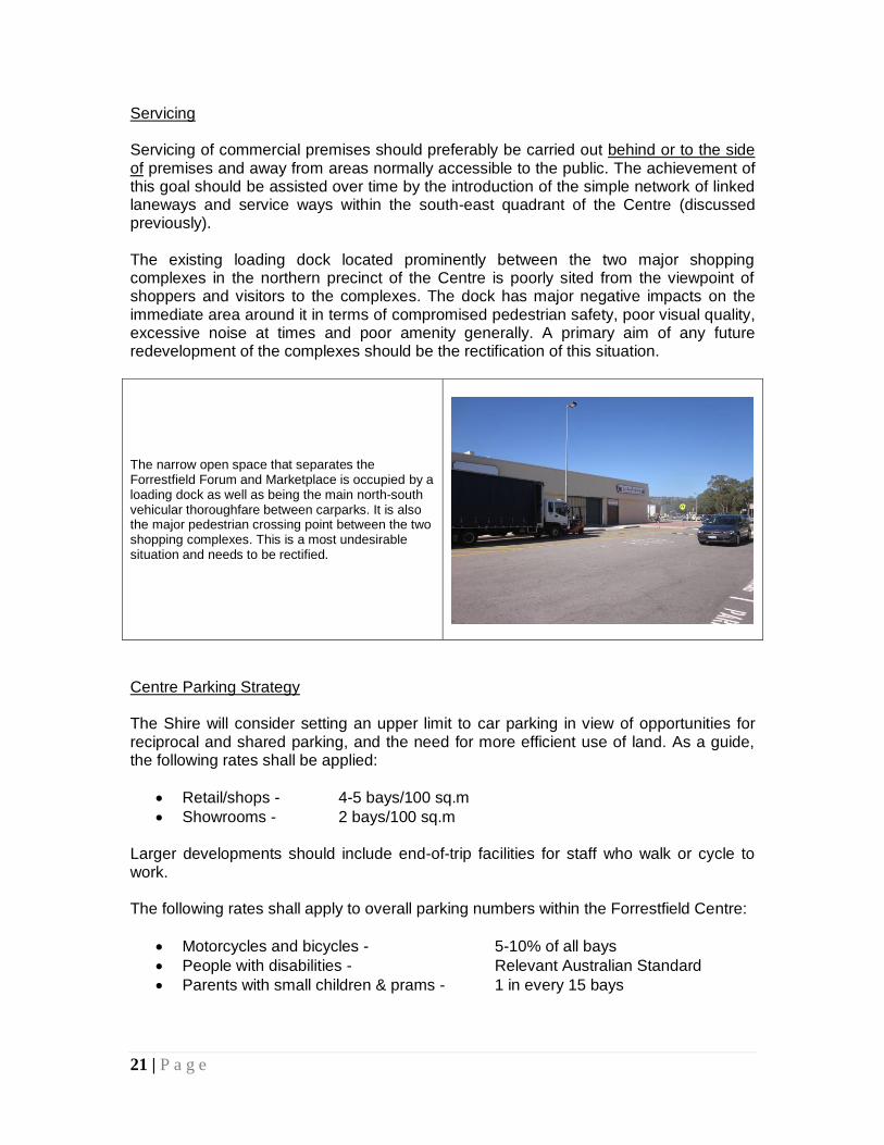
Servicing Servicing of commercial premises should preferably be carried out behind or to the side of premises and away from areas normally accessible to the public. The achievement of this goal should be assisted over time by the introduction of the simple network of linked laneways and service ways within the south-east quadrant of the Centre (discussed previously). The existing loading dock located prominently between the two major shopping complexes in the northern precinct of the Centre is poorly sited from the viewpoint of shoppers and visitors to the complexes. The dock has major negative impacts on the immediate area around it in terms of compromised pedestrian safety, poor visual quality, excessive noise at times and poor amenity generally. A primary aim of any future redevelopment of the complexes should be the rectification of this situation.
The narrow open space that separates the Forrestfield Forum and Marketplace is occupied by a loading dock as well as being the main north-south vehicular thoroughfare between carparks. It is also the major pedestrian crossing point between the two shopping complexes. This is a most undesirable situation and needs to be rectified.
Centre Parking Strategy The Shire will consider setting an upper limit to car parking in view of opportunities for reciprocal and shared parking, and the need for more efficient use of land. As a guide, the following rates shall be applied:
Retail/shops - 4-5 bays/100 sq.m
Showrooms - 2 bays/100 sq.m Larger developments should include end-of-trip facilities for staff who walk or cycle to work. The following rates shall apply to overall parking numbers within the Forrestfield Centre:
Motorcycles and bicycles - 5-10% of all bays
People with disabilities - Relevant Australian Standard
Parents with small children & prams - 1 in every 15 bays
22 | P a g e
The allocation of these bays shall be determined after an inventory of all existing parking bays has been undertaken by the Shire. 8.0 BUILT FORM and URBAN DESIGN 8.1 Principles
Encourage a new development philosophy for the Centre which has greater emphasis on street-based uses and activities, rather than internalised malls and other car-orientated architecture;
Encourage development of specific areas with opportunities for new growth in accordance with specific design and development guidelines and controls;
Encourage higher quality and innovative architecture and urban design;
Encourage new development located around the periphery of the Centre to demonstrate particularly high standards of construction and design, and to include design elements which clearly indicate to the visitor or passer-by that the building is part of a much greater “whole” which is the Forrestfield District Centre;
Ensure that each new development responds sensitively to its site and setting, and contributes to a place that is valued and visually attractive;
Ensure new buildings are designed to provide a safe environment for all users, contribute positively to the enhancement of public safety, and minimise the need for intrusive surveillance technologies;
Encourage incorporation of security measures into building design that are visually unobtrusive and in keeping with the building’s architectural style and materials;
Encourage new development to include publicly-accessible spaces designed to enable pedestrian use of the spaces and to create a sense of public ownership;
Encourage the establishment of an individual “Forrestfield character” within the Centre that can be built upon by subsequent developments, and “tied” together through the introduction of distinctive and well-designed street furniture and public art;
Increase the diversity of activities, and ensure human scale, amenity and safety are paramount design considerations for new buildings;
Ensure that new building design contributes to a comfortable pedestrian environment, providing opportunities for weather protection and minimising strong wind conditions in the street and public spaces;
Ensure new development minimises any detrimental impacts on neighbouring properties;
Ensure that the unnecessary removal of large mature trees on-site does not occur; and
Ensure that all public buildings and spaces are designed to be universally accessible.
8.2 Strategies In General The nature and design of new buildings must reflect the role of the Centre in terms of building heights, scale, orientation, materials and textures. New buildings should
23 | P a g e
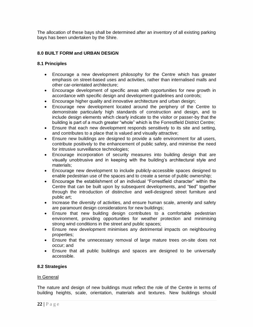
incorporate contrasts and expression to avoid visual monotony and to create interest, particularly at the public interface. A greater degree of sophistication and innovation in new building design within the Forrestfield Centre would be welcomed. New buildings must have greater consideration for the attractiveness and comfort of the street environment. They should frame the internal landscape and views, provide weather protection for pedestrian comfort, and have minimal blank walls facing areas readily accessible to the public. The opportunity to “sleeve” large scale retail and/or to introduce outwards-facing uses to avoid blank walls is strongly encouraged. Buildings at ground level should contain activities that positively contribute (either passively or actively) to the public domain. Proponents of new larger-scale developments should include in their preliminary design investigations into the possibility of including outdoor spaces which are readily accessible to the public, and could perform the function of an actively-edged square or plaza. Proponents must demonstrate they have adequately explored such options during their initial design processes.
This corner site of a major shopping complex has been redeveloped to create a public square edged with cafés and retail outlets. The square faces north and has good exposure to the winter sun.

24 | P a g e
Street Interfaces and Opportunity Sites
FIGURE 7 – Street Interfaces and Opportunity Sites
The above plan highlights (i) the areas which have weak frontages to streets, and (ii) strategically-located sites which have potential for new development. The weak frontages do little to elevate the profile of the Forrestfield Centre as an important community asset and major activity focus. Introducing buildings that create strong edges and which frame streets will give shape and expression to new activities, and help to overcome Forrestfield’s current image as a one-dimensional shopping centre. (i) It is very important that existing and new development has active frontages to
both Hale Road and Strelitzia Avenue. It is not proposed that buildings should be built up to the public footpath edge in these areas. This would not be consistent with previous development forms, nor practical in this suburban situation where pedestrian traffic on the adjacent public streets is low. Some car parking may be
25 | P a g e
located between the street and the building front, however this will be limited to two rows maximum, one row preferably. Those premises facing the street must have active frontages, and have generous footpath widths in front of them.
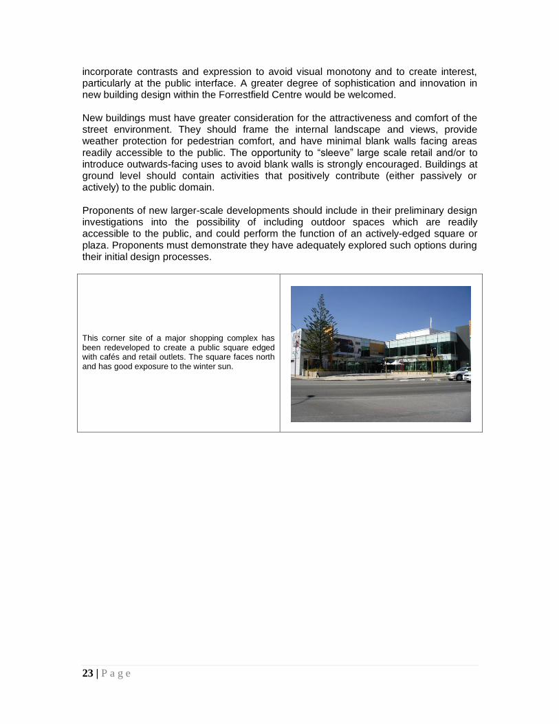
(ii) The identified opportunity sites include:
1. The existing service station site corner of Hale Road and Strelitzia Avenue; 2. The large site located on east side of private access road into the centre off
Hale Road. (Note: the lot is shown vacant in the photo above, however a drive-through
fast-food outlet is currently being constructed on the site. Given the strategic nature and relatively large size of the lot, it may be that the development is seen as a temporary one. The site remains an important “opportunity site” which may only reach its full potential in future years when it is redeveloped.);
3. The vacant Shire-owned land adjacent to the existing Community Centre; 4. The portion of land presently used for car parking overlooking Woodlupine
Creek and the Community Centre; and 5. The current library site.
The introduction of appropriately designed two or three storey buildings on any of these sites would be welcomed. Illustrated below is a possible concept design for the second-mentioned site above, (currently being developed as a small drive-through fast-food outlet). This option shows a modest one-storey building which addresses and actively engages with the private street, as well as the new access side road/laneway proposed and illustrated in previous Figure 6. This is the form of development which is more appropriate for inclusion in a District Activity Centre.
FIGURE 8 – ‘Before and After’ Concept of Key Opportunity Site No. 2
26 | P a g e
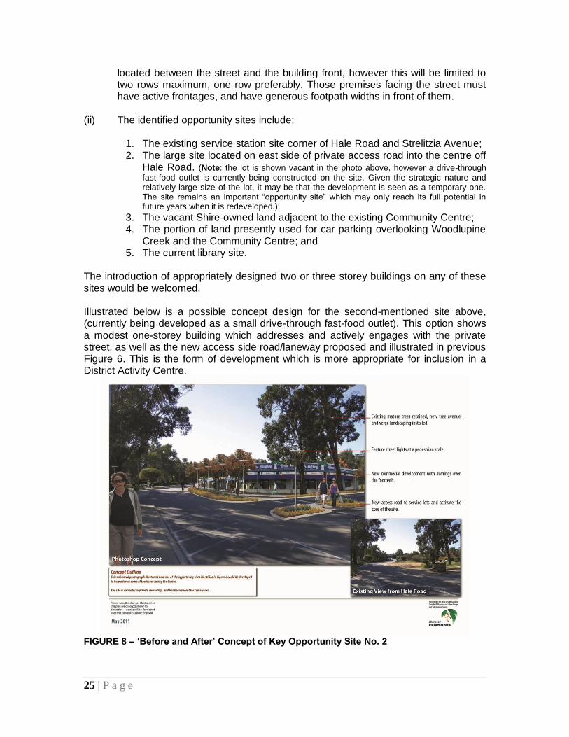
The photo at right shows Opportunity Site No. 4. Presently used for car parking, this site has potential for redevelopment into a one or two storey mixed use development, which would overlook the creek and its landscaped setting. A simple adjustment to the vehicular circulation layout in the vicinity would be sufficient to accommodate the new development.
Landmarks and View Lines The view northwards up the private road from Hale Road to the northern shopping complexes is an important one in terms of visitor orientation, and for reinforcing built character. The existing roundabout and the immediately surrounding area require significant upgrading. The introduction of a large sculptural element or other artwork to the roundabout could be appropriate.
The existing roundabout at the northern end of the private road is utilitarian and very unattractive. An opportunity exists to upgrade the roundabout by the inclusion of landscaping or a significantly-scaled public art feature.
Character At present the Forrestfield Centre is an ad-hoc collection of building styles, street furniture and remnant vegetation. This is a result of the Centre being constructed over an extended period of time, and by several different landowners. The introduction of visually unifying elements to the public domain would assist in partially overcoming this issue. These elements could include:
Uniform paving for all pedestrian areas;
27 | P a g e
Consistency in new plantings of tree species; and
The introduction of a “family” of street furniture throughout the Centre (seats, benches, bins, lights, information signs, public art). All furniture should be high quality, colour co-ordinated, robust and easy to maintain.
Safety The Shire should undertake an audit of the external lighting available within the Centre. This would include lighting on the peripheral streets, lighting along all the pedestrian/cycle paths leading to and within the Centre, and lighting within all areas south of the Woodlupine Creek. The Shire should then work with land owners to introduce an appropriate level of lighting throughout this area, concentrating on access routes and car parks. 9.0 PUBLIC SPACE NETWORK 9.1 Principles
Provide a series of good quality, publicly-accessible spaces and pathways that link with each other and to the movement network, and to the major activity destinations within and surrounding the District Centre;
Provide opportunities for passive recreation, social and community activities, visual relief, wildlife habitat and stormwater management;
Ensure streets, pathways and laneways are pedestrian-friendly, and provide opportunities for a range of activities for all age groups including sitting and socialising to occur in association with moving from one place to another and other routine activities;
Improve visual connections to publicly-accessible spaces from adjacent streets and sites, and increase passive surveillance to support personal safety in public places;
Encourage the provision of private recreation spaces which can link with, and complement, public recreation spaces;
Protect and enhance the Woodlupine Creek Reserve;
Protect areas of natural vegetation, particularly stands of large mature trees, and increase shade tree planting in areas that are currently deficient, such as large car parks; and
Ensure an integrated approach to the siting, design and development of the public buildings and spaces – existing and new - centred on the Woodlupine Community Centre.
9.2 Strategies Woodlupine Creek The Shire will introduce a management plan for the ongoing protection and upgrading of the Woodlupine Creek Reserve, and allocate funds to deal urgently with existing problems of erosion.
28 | P a g e
Pedestrian access alongside and across the creek needs to be formalised (see Figure 6). A system of raised boardwalks may be appropriate. Three to four small “picnic” nodes should be established along the creek banks where fixed benches and tables can be established to encourage their use by Centre employees, shoppers and casual passers-by. Public Spaces In general terms, the Shire will work both independently and with landowners to:
Protect and improve access to existing public open spaces;
Improve the design and management of public spaces;
Create new public spaces (these may be quite small and intimate) and public facilities;
Develop synergies between public spaces and uses at their edges;
Explore provision of alternative kinds of spaces;
Incorporate public art into public open space design to create interest and to support place-making and encourage community engagement; and
Encourage private sector provision of publicly-accessible spaces (once again, these may be small and intimate spaces, but with associated commercial facilities) and commercial recreational facilities.
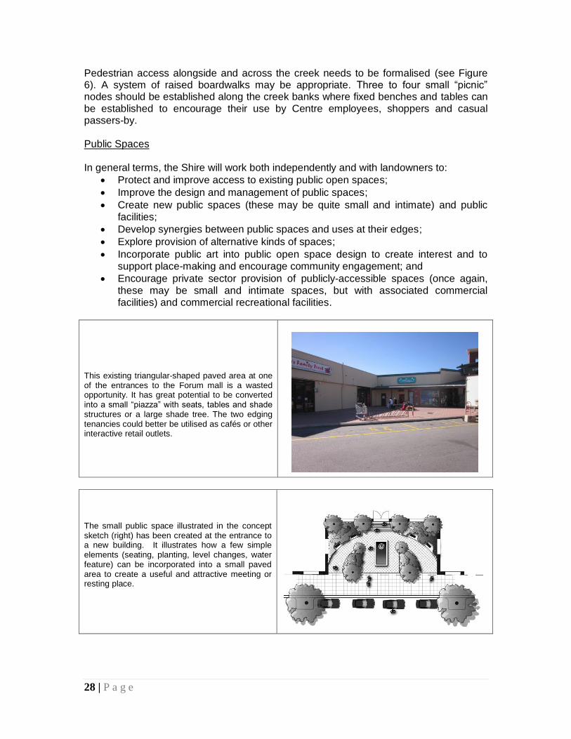
This existing triangular-shaped paved area at one of the entrances to the Forum mall is a wasted opportunity. It has great potential to be converted into a small “piazza” with seats, tables and shade structures or a large shade tree. The two edging tenancies could better be utilised as cafés or other interactive retail outlets.
The small public space illustrated in the concept sketch (right) has been created at the entrance to a new building. It illustrates how a few simple elements (seating, planting, level changes, water feature) can be incorporated into a small paved area to create a useful and attractive meeting or resting place.
29 | P a g e
The following existing public spaces require better management and constant attention:
Adjacent to and surrounding the Woodlupine Community Centre;
The Woodlupine Creek Reserve; and
The large linear Reserve located to the north-west of the Forrestfield Centre. The treed area located immediately adjacent to the Centre has the potential to be upgraded as a significant, attractive children’s playground to complement the broader activities of the Centre.
Of critical importance is the maintenance of public spaces through regular cleaning and refurbishment programmes. The community is more likely to value and use spaces that are fresh, attractive, clean and have a sense of amenity and safety. Landscape
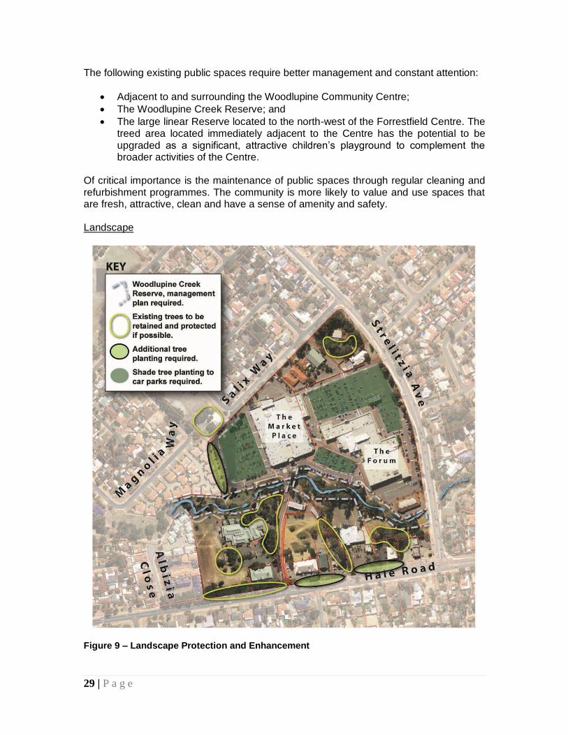
Figure 9 – Landscape Protection and Enhancement
30 | P a g e
The existing stands of mature trees highlighted in Figure 9 should be retained and protected if possible. It is unfortunate that the two large Marri trees in the foreground of the photo shown in previous Figure 8 have recently been destroyed as part of a redevelopment of the site. This would appear to have occurred unnecessarily. Casual removal of mature trees within the District Centre shall not be permitted, as this would be very detrimental to the maintenance of the established and very desirable treed character that prevails in parts of the Centre. In general terms, new trees and other plantings that are undertaken throughout the Centre should be easy to care for, be highly water-efficient (i.e., “waterwise”), and add to the local biodiversity. New planting should preferably use species native to the area and be comparable with the existing vegetation. A consistent approach to landscaping throughout the Centre should be adopted. The main entry road into the Centre off Hale Road should be planted with large trees within both (proposed) edging footpaths to create an impressive and attractive avenue. The large open carparks associated with the two northern shopping complexes are urgently in need of shade tree planting to reduce heat radiation, provide shade for parked cars, and to improve the current harsh visual appearance of the areas. The Shire shall investigate whether any conditions have been previously attached to the formal approvals for these developments in relation to landscaping of the car parks, and if so, shall enforce those conditions. Ideally, the car parks should be planted with large shade trees at the rate of one tree per eight car bays. 10.0 RESOURCE CONSERVATION 10.1 Principles
Encourage environmentally sustainable principles in building design, including energy and water efficiency, appropriate material selection, durability and ease of maintenance and a healthy indoor environment;
Increase the use of environmentally friendly forms of transport such as walking, recreational and commuter cycling and public transport to achieve greater mobility and safety for the community and positive outcomes for the environment;
Incorporate opportunities for inclusion or development of social and affordable housing on appropriate sites; and
Design buildings to be adaptable and to accommodate changes in land use or additions expected over time.
31 | P a g e
10.2 Strategies Energy The Shire shall encourage a reduction in overall consumption of energy by requiring new buildings be designed so that mechanical heating and cooling can be minimised. Heavyweight materials can generally maintain a moderate internal temperature better than lightweight, framed structures. Renewable sources of energy, such as solar panels and wind turbines, can reduce the carbon footprint of development. Correct building orientation can also result in reduced energy use. The Shire may introduce developer incentives to include green energy sources. Water Development proponents are encouraged to provide landscaped areas designed for high water efficiency. Water Sensitive Urban Design principles shall be applied to manage stormwater from roads and open spaces, and other integrated water systems shall be incorporated in new development where possible. Water conservation shall be extended to buildings through water-saving installation and management measures. Rainwater collection and re-use will be strongly encouraged. Materials and Waste Existing buildings and materials should be conserved and re-used wherever possible, as well as recyclable building materials or building materials sourced from renewable sources. Locally-sourced materials should be sought wherever possible. Cut and Fill Where possible and practical, natural land contours should be retained to minimise the need for excessive cut and fill. 11.0 STRUCTURE PLAN IMPLEMENTATION
It is proposed that this Structure Plan:
(i) Be publicly advertised to encourage community input; (ii) Be adopted by Council when finalised as a planning policy in accordance with
Part 2 of Local Planning Scheme No. 3. This will effectively empower the Structure Plan as a relevant planning document in decision-making processes, and will assist the Shire in exercising discretion in relation to development proposals.
32 | P a g e
Ideally, the Structure Plan should be given further weight by being cited within the Scheme text. Priority Actions for the Shire
(i) Advertise the Structure Plan prior to final adjustments and adoption by Council. Ensure each landowner is aware of their responsibilities in regard to new development/redevelopment when the Structure Plan is adopted;
(ii) Prepare and adopt a management plan for Woodlupine Creek and allocate funds to address pressing issues of erosion and public access;
(iii) Finalise comprehensive site planning for the redevelopment of Lot 106, making provision for the new medium-density housing development, additional commercial development, improvements to the Community Centre building and surrounds, inclusion of the proposed new library building, and possible inclusion of a Shire “shop front” office;
(iv) Undertake a lighting and vegetation inventory of the area covered by the Structure Plan;
(v) Initiate steps to bring the private road off Hale Road into Shire ownership;
(vi) Research and prepare a Local Housing Strategy for the entire Shire, and apply any relevant resultant recommendations to the walkable catchment area (400m) of the Forrestfield District Centre (this may be an R40/60 coding, and possibly up to R80); and
(vii) Initiate talks with TransPerth to discuss the potential for improving the bus service to/from the Forrestfield District Centre.
A full list of recommended actions is contained in Appendix 2 of this document. Appendix 3 contains a summary plan of recommended actions. Conclusion The Forrestfield District Centre Structure Plan promotes principles that are consistent with the WAPC’s Directions 2031, SPP4.2 Activity Centres for Perth and Peel, and other
strategic policies and objectives adopted by the WAPC and Shire of Kalamunda. Following the proposed community consultation process the Plan should be reviewed in the light of any submissions made by the community, and resubmitted to Council for adoption.
*
33 | P a g e
POSTSCRIPT – April 2012 The draft Forrestfield District Centre Structure Plan was duly advertised for public comment, and at its Ordinary Council Meeting of 16 April 2012, the Council resolved as follows: “That Council:
1. Adopts the Draft Structure Plan (Attachment 2) for Forrestfield District Centre subject to the following modification: a. The inclusion of an Action investigating the opportunity for the development
of a roundabout at the intersection of Hale Road and Woolworths Drive #.
2. Subject to the inclusion of the modification identified in Point 1 a copy of the adopted Structure Plan for the Forrestfield District Centre be forwarded to the Western Australian Planning Commission for their information.”
Note #: Woolworths Drive is the name sometimes used to describe the private road which links Hale Road
to the northern shopping complexes.
An appropriate modification to the Structure Plan (Appendix 3) has been made consistent with the Council’s resolution, and the adopted Structure Plan document can now be forwarded to the WAPC for its information.
*
34 | P a g e
PART II – APPENDICES APPENDIX 1 – Research
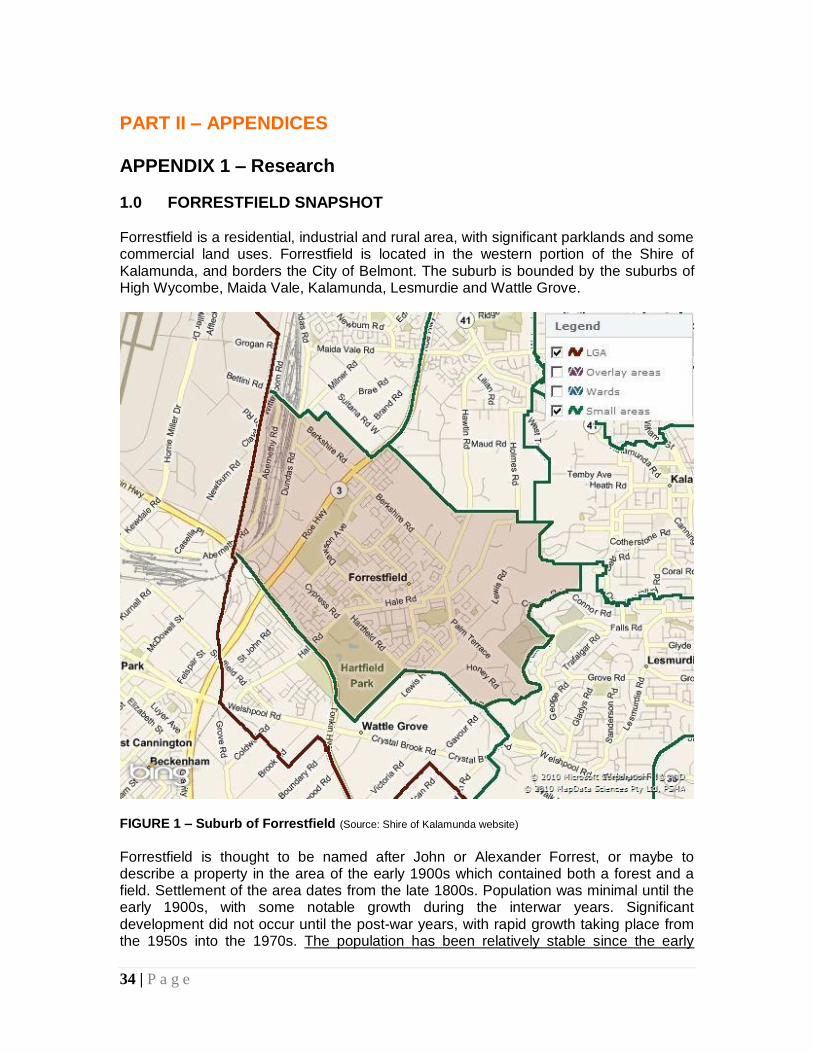
1.0 FORRESTFIELD SNAPSHOT Forrestfield is a residential, industrial and rural area, with significant parklands and some commercial land uses. Forrestfield is located in the western portion of the Shire of Kalamunda, and borders the City of Belmont. The suburb is bounded by the suburbs of High Wycombe, Maida Vale, Kalamunda, Lesmurdie and Wattle Grove.
FIGURE 1 – Suburb of Forrestfield (Source: Shire of Kalamunda website) Forrestfield is thought to be named after John or Alexander Forrest, or maybe to describe a property in the area of the early 1900s which contained both a forest and a field. Settlement of the area dates from the late 1800s. Population was minimal until the early 1900s, with some notable growth during the interwar years. Significant development did not occur until the post-war years, with rapid growth taking place from the 1950s into the 1970s. The population has been relatively stable since the early
35 | P a g e
1990s, a result of some new dwellings being constructed, but household occupancy rates declining. Major features of the suburb include:
Lesmurdie Falls National Park & Darling Range Regional Park
Hartfield Park Recreation Centre & Hartfield Country Club
Dawson Park, Juniper Way Reserve, Magnolia Way Reserve & Pioneer Park
Woodlupine Creek
a number of schools
the Woodlupine Community Centre and
the district shopping centre which has grown up around the Forrestfield Forum and The Market Place.
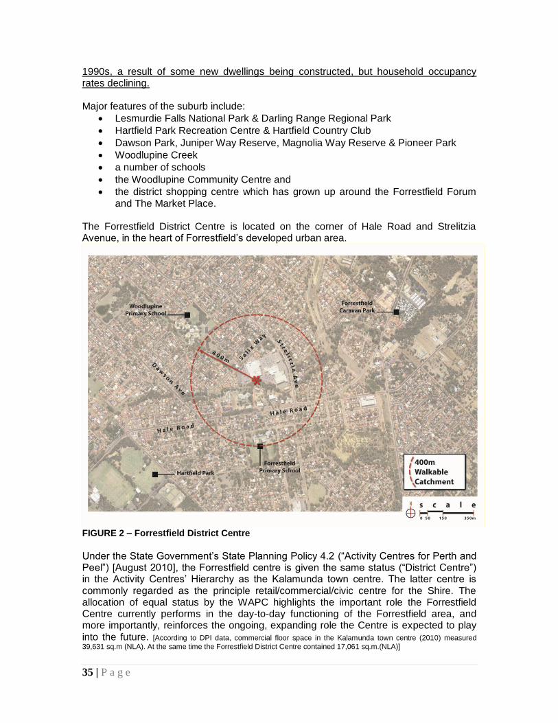
The Forrestfield District Centre is located on the corner of Hale Road and Strelitzia Avenue, in the heart of Forrestfield’s developed urban area.
FIGURE 2 – Forrestfield District Centre
Under the State Government’s State Planning Policy 4.2 (“Activity Centres for Perth and Peel”) [August 2010], the Forrestfield centre is given the same status (“District Centre”) in the Activity Centres’ Hierarchy as the Kalamunda town centre. The latter centre is commonly regarded as the principle retail/commercial/civic centre for the Shire. The allocation of equal status by the WAPC highlights the important role the Forrestfield Centre currently performs in the day-to-day functioning of the Forrestfield area, and more importantly, reinforces the ongoing, expanding role the Centre is expected to play into the future. [According to DPI data, commercial floor space in the Kalamunda town centre (2010) measured
39,631 sq.m (NLA). At the same time the Forrestfield District Centre contained 17,061 sq.m.(NLA)]
36 | P a g e
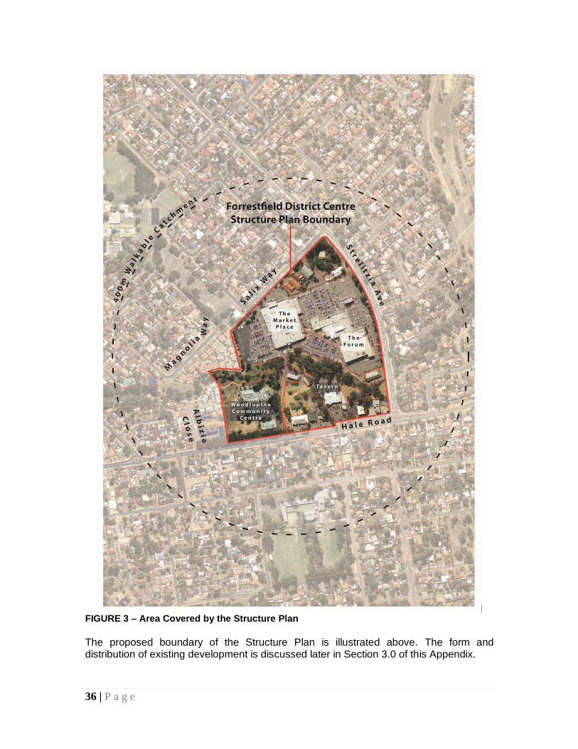
FIGURE 3 – Area Covered by the Structure Plan
The proposed boundary of the Structure Plan is illustrated above. The form and distribution of existing development is discussed later in Section 3.0 of this Appendix.
37 | P a g e
2.0 EXISTING STATUTORY and PLANNING CONSIDERATIONS
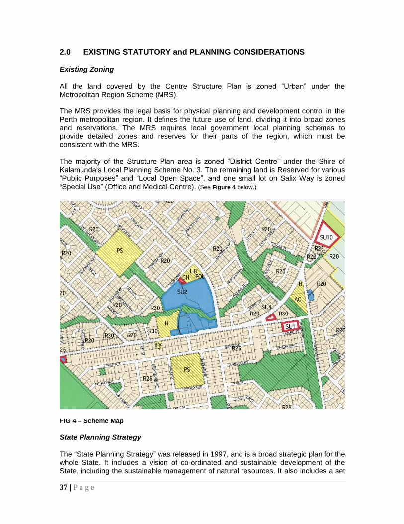
Existing Zoning All the land covered by the Centre Structure Plan is zoned “Urban” under the Metropolitan Region Scheme (MRS). The MRS provides the legal basis for physical planning and development control in the Perth metropolitan region. It defines the future use of land, dividing it into broad zones and reservations. The MRS requires local government local planning schemes to provide detailed zones and reserves for their parts of the region, which must be consistent with the MRS. The majority of the Structure Plan area is zoned “District Centre” under the Shire of Kalamunda’s Local Planning Scheme No. 3. The remaining land is Reserved for various “Public Purposes” and “Local Open Space”, and one small lot on Salix Way is zoned “Special Use” (Office and Medical Centre). (See Figure 4 below.)
FIG 4 – Scheme Map
State Planning Strategy The “State Planning Strategy” was released in 1997, and is a broad strategic plan for the whole State. It includes a vision of co-ordinated and sustainable development of the State, including the sustainable management of natural resources. It also includes a set
38 | P a g e
of fundamental principles in relation to the environment, the community, the economy and infrastructure, which are intended to guide and co-ordinate action at all levels of government and across all agencies. Part One of the Strategy provides an overview of the future challenges facing the State and outlines an appropriate planning response. It identifies those things that the community regards as being fundamentally important, and sets out the key principles which should guide the way in which future planning decisions are made. Some short-term priority actions are identified in Part One to improve the way planning is undertaken and decisions made. Part Two is comprised of a manual, which provides a comprehensive list of strategies and actions for government to improve the environment, community, economy and infrastructure. The strategies and actions are region-based. The “State Planning Strategy” is essentially a land use planning strategy for WA’s development up to its bicentenary in 2029. State Planning Framework Policy (SPP No. 1) The “State Planning Framework Policy” is a Statement of Planning Policy (SPP No.1) made under Section 26 of the “Planning and Development Act”. It provides a framework for decision-making on land use and development with underlying general principles and an amalgamation of all existing State and regional plans, policies, strategies and guidelines which apply to land use and development in Western Australia. Under the legislation, SPPs have force and effect to be implemented through planning processes, including local planning schemes. SPP No.1 has been updated several times, with the current variation No 2 Gazetted in 2006. The primary aim of planning is to provide for the sustainable use and development of land, and the “State Planning Framework Policy” identifies five key principles which further define this primary aim and describe the considerations which influence good decision-making. Four of these principles are applicable to the Shire of Kalamunda, and are taken into account in the preparation of the Forrestfield DC Structure Plan:
Environment – to protect and enhance the key natural and cultural assets of the State and deliver to all West Australians a high quality of life which is based on environmentally sustainable principles.
Community – to respond to social changes and facilitate the creation of vibrant, safe and self-reliant communities.
Economy – to actively assist in the creation of regional wealth, support the development of new industries and encourage economic activity in accordance with sustainable development principles.
Infrastructure – to facilitate strategic development by making provision for efficient and equitable transport and public utilities.
Part ‘A’ of SPP No. 1 also provides statements which elaborate on these principles.
39 | P a g e
Directions 2031 (August 2010) “Directions 2031” is a high level spatial framework and strategic plan that establishes a vision for future growth of the metropolitan Perth and Peel region. It also provides a framework to guide the detailed planning and delivery of housing, infrastructure and services necessary to accommodate a range of growth scenarios. “Directions 2031” builds on many of the aspirational themes of previous metropolitan plans which sought to guide the future structure and form of the city. “Directions 2031” responds directly to several of the tasks identified in the WAPC SPP No. 1 (discussed previously), including detailing the metropolitan structure, determining local population housing and job targets, managing growth and developing the activity centre concept. Three integrated networks that form the basis of the spatial framework have been identified:
Activity centres network – a network and hierarchy of centres that provide a more equitable distribution of jobs and amenity throughout the city.
Movement network – an integrated system of public and private transport networks that are designed to support and reinforce the activity centres network.
Green network – a network of parks, reserves and conservation areas that support biodiversity, preserve natural amenity and protect valuable natural resources.
“Directions 2031” is aimed at improving current infill residential development trends by a factor of 50%, and sets a target of 47% of new housing as infill development. It also seeks a 50% increase in the current average residential density of 10 dwellings per gross urban zoned hectare.* “Directions 2031” replaces all previous metropolitan strategic plans for the Perth and Peel region and supersedes the draft “Network City” policy. NOTE * : Typically, the average R Code (or net density) equivalent is two to three times the number of dwellings per gross hectare.
Shire of Kalamunda Draft Local Planning Strategy The Shire of Kalamunda’s draft Local Planning Strategy (2010/11) contains a “Spatial Plan”, which proposes several ways in which the projected population of the area will be accommodated. Within the immediate Forrestfield area, growth is to be accommodated through a consolidation of the existing urban area bounded by Berkshire Road, Hale Road and Tonkin Highway. Two “population scenarios” are proposed for this area. New infill development will be planned to accommodate either:
(i) growth to 800 lots (2,000 people); or (ii) growth to 1,333 lots (3,332 people).
40 | P a g e
Under the Shire’s four broader population scenarios, up to 30,000 more residents could be accommodated throughout the Shire in selected areas through a combination of infill, expansion, and residential bushland, rural composite and special rural accommodation. Other State Planning Policies Relevant documents from the “State Planning Framework Policy” that apply to the Shire of Kalamunda are outlined below: SPP No. 2 – Environment and Natural Resources Policy (2003) This policy defines the principles and considerations that represent proper and responsible planning in terms of environment and natural resource issues within the framework of the “State Planning Strategy”.
SPP No. 3 – Urban Growth and Settlement (2006) This policy aims to facilitate sustainable patterns of urban growth and settlement by setting out the requirements of sustainable settlements and communities, and broad policy for accommodating growth and change. The policy is to be taken into account in preparing LPSs and local planning schemes. The objectives of the policy are:
To promote a sustainable and well planned pattern of settlement across the State, with sufficient and suitable land to provide for a wide variety of housing, employment, recreation facilities and open space.
To build on existing communities with established local and regional economies, concentrate investment in the improvement of services and infrastructure and enhance the quality of life in those communities.
To manage the growth and development of urban areas in response to the social and economic needs of the community and in recognition of relevant climatic, environmental, heritage and community values and constraints.
To promote the development of a sustainable and liveable neighbourhood form which reduces energy, water and travel demand while ensuring safe and convenient access to employment and services by all modes, provides choice and affordability of housing and creates an identifiable sense of place for each community.
To co-ordinate new development with the efficient, economic and timely provision of infrastructure and services.
The Shire of Kalamunda is obliged to take into account the various policy measures contained within this document.
SPP No. 3.1 – Residential Design Codes (Variation 1) SPP 3.1 was amended in November 2010 to include additional multiple dwelling provisions in the R-Codes. The purpose of the R-Codes is to provide a comprehensive basis for the control, through local government, of residential development throughout Western Australia. They are
41 | P a g e
intended to cover all requirements for development control purposes and to minimise the need for local government to introduce separate planning policies concerning residential development (although local authorities retain the right to include some local variations to standards through supplementary local planning policies.) The R-Codes do not address the physical construction requirements or internal arrangements of buildings – these matters are dealt with by the Building Code of Australia. The R-Codes were amended to encourage housing diversity, affordability ands flexibility, and to help improve the quality of multiple dwelling developments, in line with contemporary planning needs. The new provisions will apply to areas with a density code of R30 or greater under a local planning scheme, and to the residential component of mixed use developments and activity centres. A new suite of activity centre codings (R-AC) for residential development within activity centres has also been created. SPP No. 4.2 – Activity Centres for Perth and Peel (2010) This Policy replaces SPP 4.2 “Metropolitan Centres Policy Statement for the Perth Metropolitan Region”. The main purpose of the Policy is to specify broad planning requirements for the planning and development of new, and the redevelopment and renewal of existing, activity centres in the urban areas of Perth and Peel. It is mainly concerned with the distribution, function, broad land use and urban design criteria for activity centres, and with co-ordinating their land use and infrastructure planning by local governments and public authorities. Other purposes of the Policy include the integration of activity centres with public transport; ensuring they contain a range of activities to promote community benefits through infrastructure efficiency and economic benefits of business clusters; and lower transport energy use and associated carbon emissions. This policy also reflects the intention of the WAPC to encourage and consolidate residential and commercial development in activity centres so they contribute to a balanced network. Broadly defined, “activity centres” are community focal points for people, services, employment and leisure that are highly accessible. Key characteristics include their levels of diversity, accumulation of activities and access to public transport. Commercial, retail, higher-density living, entertainment, tourism, civic/community, higher education, and medical services are just a few such activities. The Policy covers the following types of activity centres:
Perth Capital City
Strategic Metropolitan Centres
Secondary Centres
42 | P a g e
Specialised Centres
District Centres (such as Forrestfield), and
Neighbourhood Centres (supplemented by local centres). The Policy is aimed at guiding the preparation and review of Local Planning Strategies, Schemes and Structure Plans, and development control. Activity Centre Structure Plans should be prepared using the “Structure Plan Preparation Guidelines”, as published by the WAPC from time to time. The Policy also provides a “Model Centre Framework” table of contents, and guidelines for preparing Activity Centre Structure Plans (which have generally been adhered to in this document). Other Relevant WAPC Plans & Policies Development Control Policy 1.5 Bicycle Planning [1998] This Policy was adopted in response to the issues of:
Adverse environmental effects of motor vehicles;
The encouragement of low energy lifestyles as a result of the 1970s “energy crisis”;
Efficient use of transport infrastructure; and
Road congestion and demand for car parking. The Policy aims to make cycling safer and more convenient for users; to ensure that adequate planning for cyclists is undertaken; to encourage the use of bicycles as an alternative to private motor vehicle use; to highlight the benefits of cycling; and to ensure adequate provision of cycling facilities is considered in statutory planning processes. Development Control Policy 1.6 Planning to Support Transit Use & Transit-Orientated Development (TOD) [2006] This updated policy seeks to maximise the benefits to the community of an effective and well used public transit system by promoting planning and development outcomes that will support and sustain public transport use. The policy is intended to inform government agencies, local governments, landowners and prospective developers of the policy approach which will be applied by the WAPC. The DoP will encourage TOD principles to link land use and public transport across Perth. This policy is closely linked to the “State Planning Strategy” and “Statement of Planning Policy No. 3 Urban Growth and Settlements”.
Strategic Policies Liveable Neighbourhoods (2004 and updated since)
“Liveable Neighbourhoods” was prepared to implement the objectives of the “State Planning Strategy” and “Network City”, and operates as a development control policy, or code, to facilitate the development of sustainable communities. It has been adopted by
43 | P a g e
the WAPC as operational policy, and is to be followed in the design and approval of urban development. “Liveable Neighbourhoods” applies to structure planning and subdivision for greenfield sites and for the redevelopment of large brownfield and urban infill sites. In general, “Liveable Neighbourhoods” replaces the current WAPC development control policies. Where there is conflict with existing policies, “Liveable Neighbourhoods” will prevail unless an applicant can demonstrate why the relevant “Liveable Neighbourhoods” policies cannot or should not apply. Overlaps between development control policies and “Liveable Neighbourhoods” will be progressively removed through a mixture of incorporation into “Liveable Neighbourhoods” and rescission of redundant policies. “Liveable Neighbourhoods” is being regularly updated.
Operational Policies In addition to all the previously mentioned documents, the WAPC has adopted a wide range of operational policies to guide its decision-making on subdivision and development applications. These policies apply when the Commission considers applications for subdivision or development within the Shire of Kalamunda, when the Council comments and recommends upon such proposals to the Commission, and when the Council has regard to them in making its own decisions under its local planning scheme. The WAPC has also published a series of “Planning Bulletins” as practice notes for local governments, State Government agencies and other parties on planning matters. A list and copies of these policies and guidelines can be obtained from the Department of Planning and through the WAPC website. Other Relevant State Government Strategies, Plans & Policies State Sustainability Strategy (2003) This Strategy is a co-ordinated government approach to delivering a sustainable framework in which implementation actions (such as “Liveable Neighbourhoods”) can be delivered. The “State Sustainability Strategy” forms part of the State Government’s broader commitment to manage urban and regional growth, and advocates initiatives to enhance and revitalise district centres such as Forrestfield. Planning Makes it Happen (currently underway) The DoP and WAPC have commenced a comprehensive and strategic reform to improve the land use planning processes and the approvals system in WA. “Planning Makes It Happen – a blueprint for planning reform” sets out 11 key strategic priorities and a two year work programme that includes 22 actions for the State. The 11 key priorities include major project facilitation, establishment of development assessment panels, urban land supply and infrastructure co-ordination, a strategic plan for land use
44 | P a g e
in Metropolitan Perth and Peel – Directions 2031, a development vision for Perth, and a review of WAPC state planning policies.
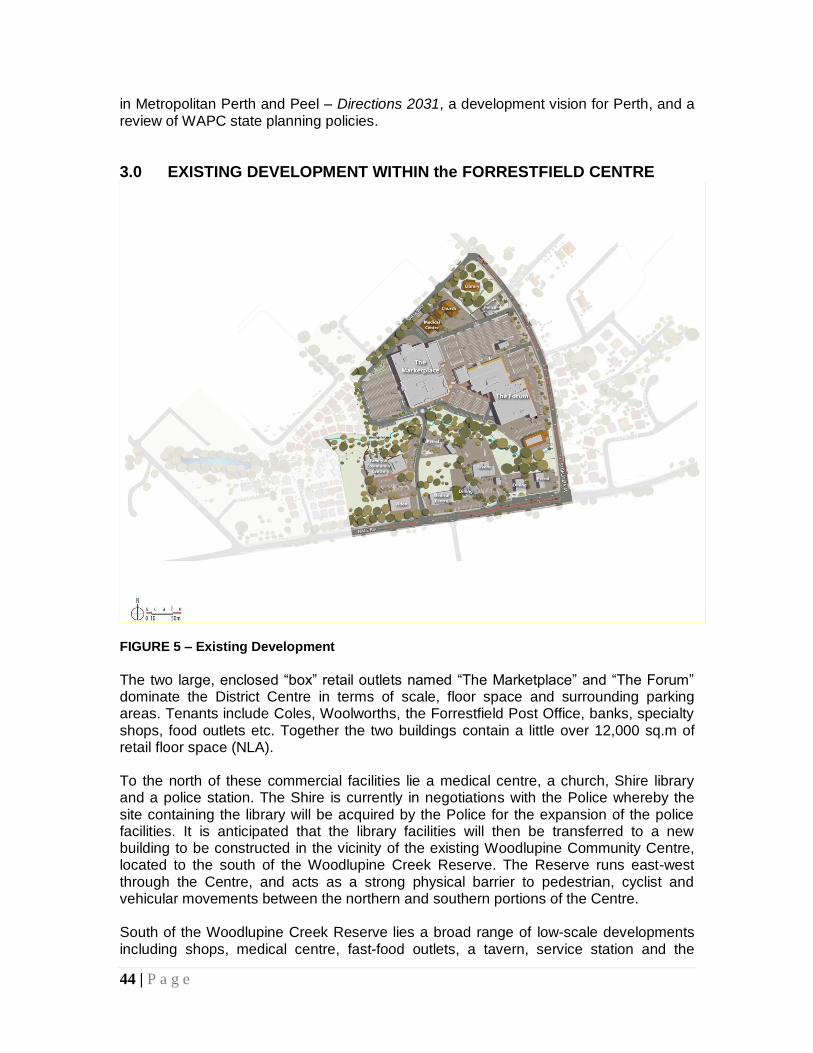
3.0 EXISTING DEVELOPMENT WITHIN the FORRESTFIELD CENTRE
FIGURE 5 – Existing Development
The two large, enclosed “box” retail outlets named “The Marketplace” and “The Forum” dominate the District Centre in terms of scale, floor space and surrounding parking areas. Tenants include Coles, Woolworths, the Forrestfield Post Office, banks, specialty shops, food outlets etc. Together the two buildings contain a little over 12,000 sq.m of retail floor space (NLA). To the north of these commercial facilities lie a medical centre, a church, Shire library and a police station. The Shire is currently in negotiations with the Police whereby the site containing the library will be acquired by the Police for the expansion of the police facilities. It is anticipated that the library facilities will then be transferred to a new building to be constructed in the vicinity of the existing Woodlupine Community Centre, located to the south of the Woodlupine Creek Reserve. The Reserve runs east-west through the Centre, and acts as a strong physical barrier to pedestrian, cyclist and vehicular movements between the northern and southern portions of the Centre. South of the Woodlupine Creek Reserve lies a broad range of low-scale developments including shops, medical centre, fast-food outlets, a tavern, service station and the
45 | P a g e
Woodlupine Community Centre. The commercial uses have a Hale Road frontage, set back behind linear-shaped parking areas. The Community Centre is located away from Hale Road and concealed behind some commercial premises. Commercial Land Use Data from the Department of Planning (DPI) [2010] shows the following breakdown of commercial floor space of the Forrestfield District Centre by type:
Shop/retail 12,044 sq.m (70.6%)
Other retail 361 sq.m ( 2.1%)
Service industry 478 sq.m ( 2.8%)
Office/business 2,096 sq.m (12.3%)
Health/welfare/community services 121 sq.m ( 0.7%)
Entertainment/recreation/culture 500 sq.m ( 2.9%)
Utilities/communications 87 sq.m ( 0.5%)
Residential 0
Vacant floor area 1,374 sq.m ( 8.1%) _______________________ 17,061 sq.m Total (100.0%) Of the District Centre’s total floor space of 17,061 sq.m, the Forum and Marketplace complexes make up 12,052 sq.m, or 70.1%. Note: All figures are net lettable area (NLA)
Employment The latest data from DPI (2008) shows that the Forrestfield District Centre employs 558 people. The great majority (75%) are employed in shop/retail. 18.6% are office workers. 3.6% are employed in entertainment/recreation/cultural activities. Directions 2031 predicts that the trend for increasing levels of local employment is likely to continue, and has identified a target of 75% employment self-sufficiency in the North-east sub region of the Perth Metropolitan Area (within which Forrestfield is located). To achieve this target, it is estimated that the sub-region will need to attract another 42,000 jobs by 2031. The Forrestfield District Centre has the potential to provide some of the increased local employment opportunities through the expansion of existing businesses, and the establishment of new developments in retailing, offices, entertainment and recreation services.
4.0 LAND TENURE
Apart from the major landholdings containing the Coles and Woolworths developments (Forum and Marketplace), remaining development within the Forrestfield Centre is located on smaller lots with numerous (about 20) different owners.
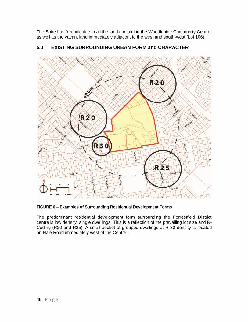
46 | P a g e
The Shire has freehold title to all the land containing the Woodlupine Community Centre, as well as the vacant land immediately adjacent to the west and south-west (Lot 106).
5.0 EXISTING SURROUNDING URBAN FORM and CHARACTER
FIGURE 6 – Examples of Surrounding Residential Development Forms
The predominant residential development form surrounding the Forrestfield District centre is low density, single dwellings. This is a reflection of the prevailing lot size and R-Coding (R20 and R25). A small pocket of grouped dwellings at R-30 density is located on Hale Road immediately west of the Centre.
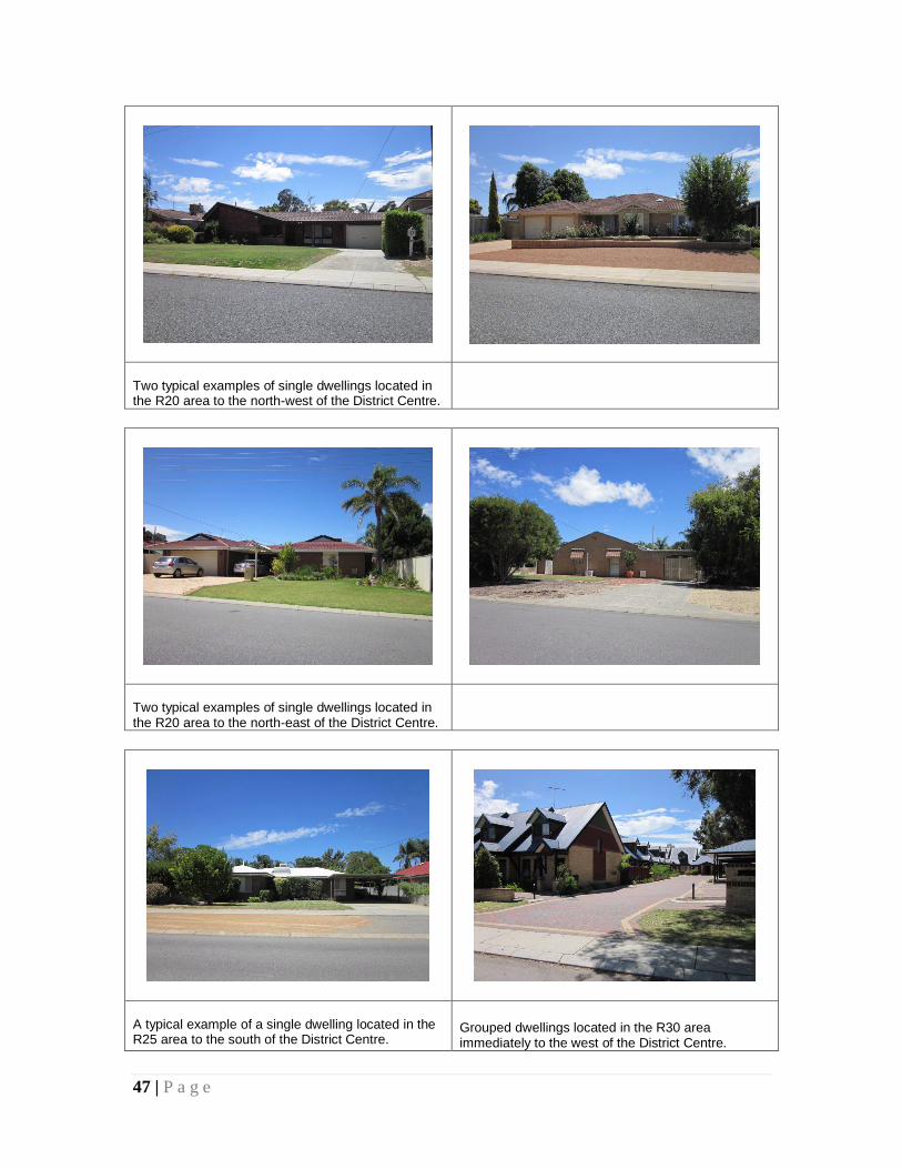
47 | P a g e
Two typical examples of single dwellings located in the R20 area to the north-west of the District Centre.
Two typical examples of single dwellings located in the R20 area to the north-east of the District Centre.
A typical example of a single dwelling located in the R25 area to the south of the District Centre.
Grouped dwellings located in the R30 area immediately to the west of the District Centre.
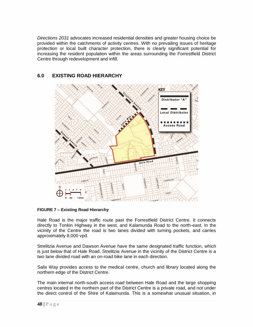
48 | P a g e
Directions 2031 advocates increased residential densities and greater housing choice be provided within the catchments of activity centres. With no prevailing issues of heritage protection or local built character protection, there is clearly significant potential for increasing the resident population within the areas surrounding the Forrestfield District Centre through redevelopment and infill.
6.0 EXISTING ROAD HIERARCHY
FIGURE 7 – Existing Road Hierarchy
Hale Road is the major traffic route past the Forrestfield District Centre. It connects directly to Tonkin Highway in the west, and Kalamunda Road to the north-east. In the vicinity of the Centre the road is two lanes divided with turning pockets, and carries approximately 8,000 vpd. Strelitzia Avenue and Dawson Avenue have the same designated traffic function, which is just below that of Hale Road. Strelitzia Avenue in the vicinity of the District Centre is a two lane divided road with an on-road bike lane in each direction. Salix Way provides access to the medical centre, church and library located along the northern edge of the District Centre. The main internal north-south access road between Hale Road and the large shopping centres located in the northern part of the District Centre is a private road, and not under the direct control of the Shire of Kalamunda. This is a somewhat unusual situation, in
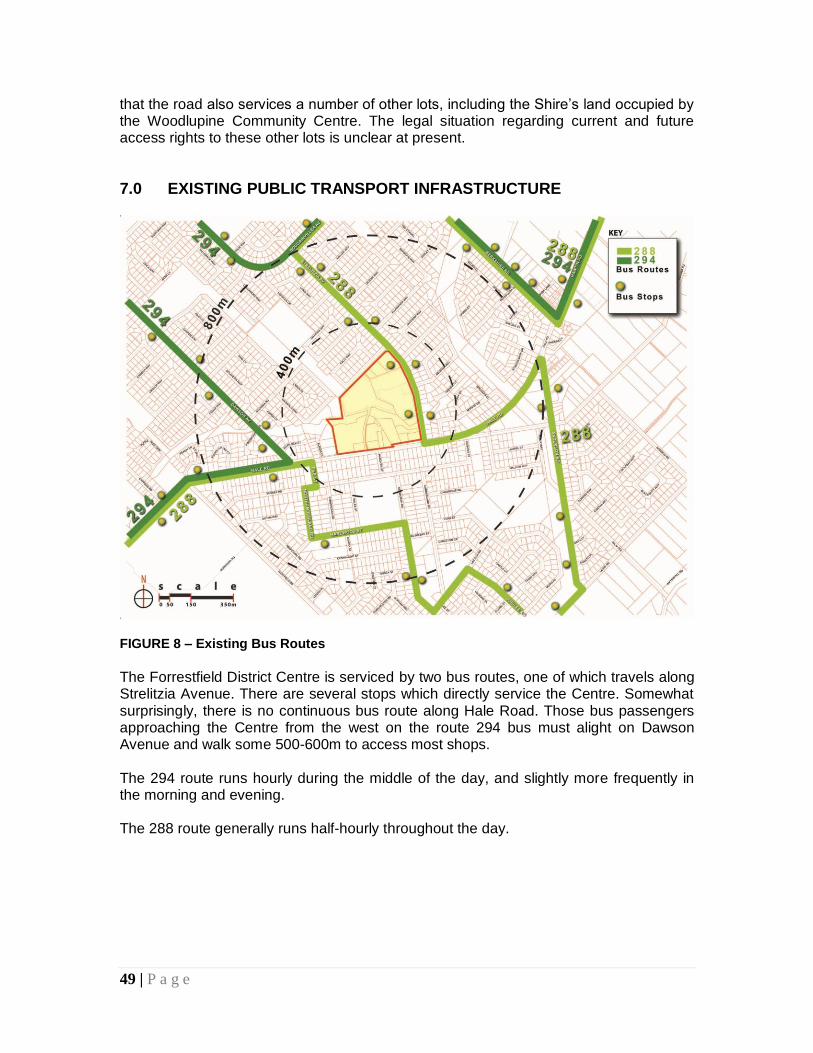
49 | P a g e
that the road also services a number of other lots, including the Shire’s land occupied by the Woodlupine Community Centre. The legal situation regarding current and future access rights to these other lots is unclear at present.
7.0 EXISTING PUBLIC TRANSPORT INFRASTRUCTURE
FIGURE 8 – Existing Bus Routes
The Forrestfield District Centre is serviced by two bus routes, one of which travels along Strelitzia Avenue. There are several stops which directly service the Centre. Somewhat surprisingly, there is no continuous bus route along Hale Road. Those bus passengers approaching the Centre from the west on the route 294 bus must alight on Dawson Avenue and walk some 500-600m to access most shops. The 294 route runs hourly during the middle of the day, and slightly more frequently in the morning and evening. The 288 route generally runs half-hourly throughout the day.
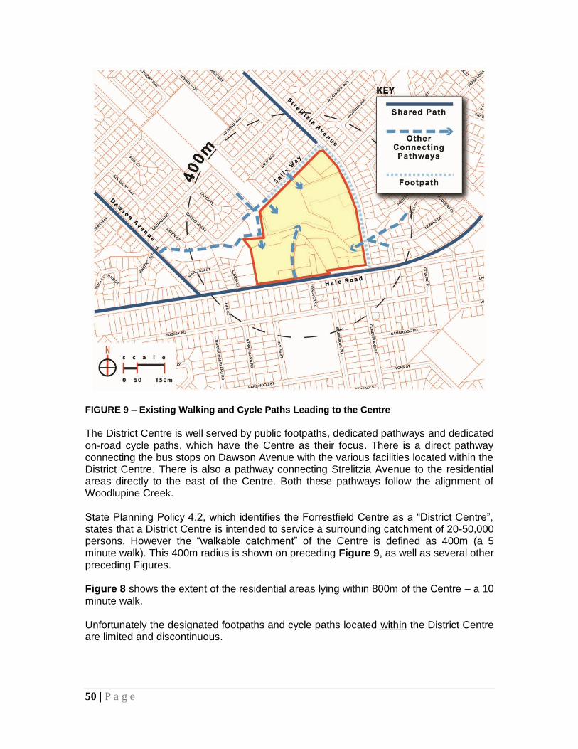
50 | P a g e
FIGURE 9 – Existing Walking and Cycle Paths Leading to the Centre
The District Centre is well served by public footpaths, dedicated pathways and dedicated on-road cycle paths, which have the Centre as their focus. There is a direct pathway connecting the bus stops on Dawson Avenue with the various facilities located within the District Centre. There is also a pathway connecting Strelitzia Avenue to the residential areas directly to the east of the Centre. Both these pathways follow the alignment of Woodlupine Creek. State Planning Policy 4.2, which identifies the Forrestfield Centre as a “District Centre”, states that a District Centre is intended to service a surrounding catchment of 20-50,000 persons. However the “walkable catchment” of the Centre is defined as 400m (a 5 minute walk). This 400m radius is shown on preceding Figure 9, as well as several other preceding Figures. Figure 8 shows the extent of the residential areas lying within 800m of the Centre – a 10
minute walk. Unfortunately the designated footpaths and cycle paths located within the District Centre are limited and discontinuous.
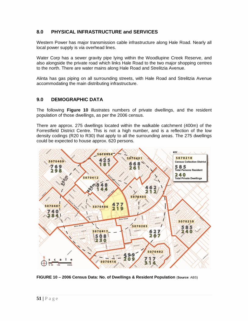
51 | P a g e
8.0 PHYSICAL INFRASTRUCTURE and SERVICES Western Power has major transmission cable infrastructure along Hale Road. Nearly all local power supply is via overhead lines. Water Corp has a sewer gravity pipe lying within the Woodlupine Creek Reserve, and also alongside the private road which links Hale Road to the two major shopping centres to the north. There are water mains along Hale Road and Strelitzia Avenue. Alinta has gas piping on all surrounding streets, with Hale Road and Strelitzia Avenue accommodating the main distributing infrastructure.
9.0 DEMOGRAPHIC DATA The following Figure 10 illustrates numbers of private dwellings, and the resident population of those dwellings, as per the 2006 census. There are approx. 275 dwellings located within the walkable catchment (400m) of the Forrestfield District Centre. This is not a high number, and is a reflection of the low density codings (R20 to R30) that apply to all the surrounding areas. The 275 dwellings could be expected to house approx. 620 persons.
FIGURE 10 – 2006 Census Data: No. of Dwellings & Resident Population (Source: ABS)
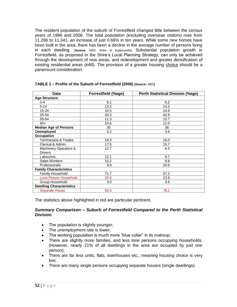
52 | P a g e
The resident population of the suburb of Forrestfield changed little between the census years of 1996 and 2006. The total population (excluding overseas visitors) rose from 11,266 to 11,341, an increase of just 0.66% in ten years. While some new homes have been built in the area, there has been a decline in the average number of persons living in each dwelling. (Source: ABS, Shire of Kalamunda). Substantial population growth in Forrestfield, as proposed in the Shire’s Local Planning Strategy, can only be achieved through the development of new areas, and redevelopment and greater densification of existing residential areas (infill). The provision of a greater housing choice should be a paramount consideration. TABLE 1 – Profile of the Suburb of Forrestfield (2006) (Source: ABS)
Data Forrestfield (%age) Perth Statistical Division (%age)
Age Structure
0-4 6.1 6.2
5-14 13.2 13.3
15-24 15.5 14.8
25-54 43.3 42.9
55-64 11.3 10.7
65+ 10.6 12.0
Median Age of Persons 35 36
Unemployed 3.2 3.6
Occupation
Technicians & Trades 19.3 16.0
Clerical & Admin. 17.5 15.7
Machinery Operators & Drivers
12.7 6.3
Labourers 12.1 9.7
Sales Workers 10.2 9.8
Professionals 9.8 20.6
Family Characteristics
Family Household 71.7 67.2
Lone Person Household 20.8 23.6
Group Household 3.0 3.6
Dwelling Characteristics
Separate House 92.3 78.1
The statistics above highlighted in red are particular pertinent. Summary Comparison – Suburb of Forrestfield Compared to the Perth Statistical Division
The population is slightly younger;
The unemployment rate is lower;
The working population is much more “blue collar” in its makeup;
There are slightly more families, and less lone persons occupying households. (However, nearly 21% of all dwellings in the area are occupied by just one person);
There are far less units, flats, townhouses etc., meaning housing choice is very low;
There are many single persons occupying separate houses (single dwellings).
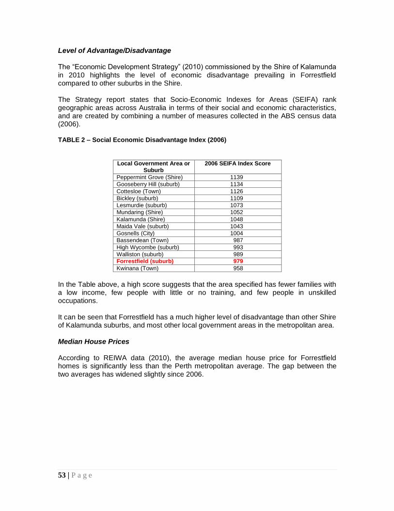
53 | P a g e
Level of Advantage/Disadvantage The “Economic Development Strategy” (2010) commissioned by the Shire of Kalamunda in 2010 highlights the level of economic disadvantage prevailing in Forrestfield compared to other suburbs in the Shire. The Strategy report states that Socio-Economic Indexes for Areas (SEIFA) rank geographic areas across Australia in terms of their social and economic characteristics, and are created by combining a number of measures collected in the ABS census data (2006). TABLE 2 – Social Economic Disadvantage Index (2006)
Local Government Area or Suburb
2006 SEIFA Index Score
Peppermint Grove (Shire) 1139
Gooseberry Hill (suburb) 1134
Cottesloe (Town) 1126
Bickley (suburb) 1109
Lesmurdie (suburb) 1073
Mundaring (Shire) 1052
Kalamunda (Shire) 1048
Maida Vale (suburb) 1043
Gosnells (City) 1004
Bassendean (Town) 987
High Wycombe (suburb) 993
Walliston (suburb) 989
Forrestfield (suburb) 979
Kwinana (Town) 958
In the Table above, a high score suggests that the area specified has fewer families with a low income, few people with little or no training, and few people in unskilled occupations. It can be seen that Forrestfield has a much higher level of disadvantage than other Shire of Kalamunda suburbs, and most other local government areas in the metropolitan area. Median House Prices According to REIWA data (2010), the average median house price for Forrestfield homes is significantly less than the Perth metropolitan average. The gap between the two averages has widened slightly since 2006.
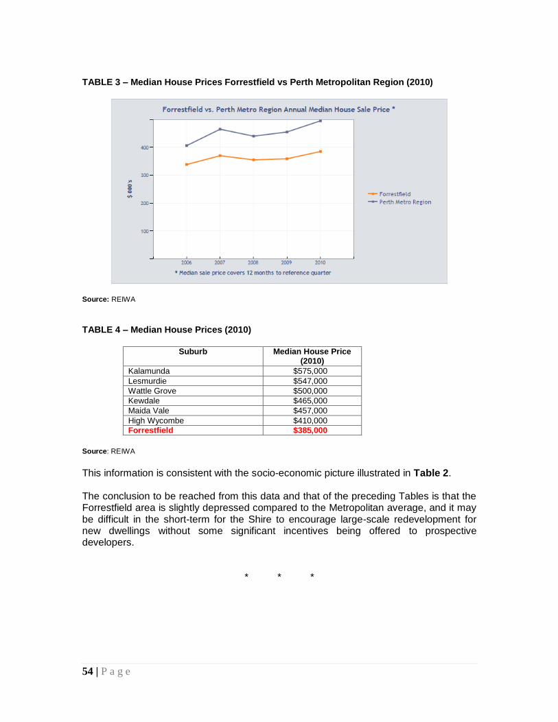
54 | P a g e
TABLE 3 – Median House Prices Forrestfield vs Perth Metropolitan Region (2010)
Source: REIWA
TABLE 4 – Median House Prices (2010)
Suburb Median House Price
(2010)
Kalamunda $575,000
Lesmurdie $547,000
Wattle Grove $500,000
Kewdale $465,000
Maida Vale $457,000
High Wycombe $410,000
Forrestfield $385,000
Source: REIWA
This information is consistent with the socio-economic picture illustrated in Table 2. The conclusion to be reached from this data and that of the preceding Tables is that the Forrestfield area is slightly depressed compared to the Metropolitan average, and it may be difficult in the short-term for the Shire to encourage large-scale redevelopment for new dwellings without some significant incentives being offered to prospective developers.
* * *
55 | P a g e
APPENDIX 2 – Proposed Actions & Recommendations Priority Actions for the Shire of Kalamunda:
Advertise the Structure Plan prior to final adjustments and adoption by Council. Ensure each landowner is aware of their responsibilities in regard to new development/redevelopment when the Structure Plan is adopted;
Prepare and adopt a management plan for Woodlupine Creek and allocate funds to address pressing issues of erosion and public access;
Finalise comprehensive site planning for the redevelopment of Lot 106, making provision for the new medium-density housing development, additional commercial development, improvements to the Community Centre building and surrounds, inclusion of the proposed new library building, and possible inclusion of a Shire “shop front” office;
Undertake a lighting and vegetation inventory of the area covered by the Structure Plan;
Initiate steps to bring the private road off Hale Road into Shire ownership; Research and prepare a Local Housing Strategy for the entire Shire, and apply
any relevant resultant recommendations to the walkable catchment area (400m) of the Forrestfield District Centre (this may be an R40/60 coding, or possibly up to R80); and
Initiate talks with TransPerth to discuss the potential for improving the bus service to/from the Forrestfield District Centre.
Summary of Additional Actions – Both General and Specific - Required to be Taken (further details contained within the body of the report): LAND USE & ACTIVITIES:
Promote a broader mix of land uses within the Centre, especially offices, health-related uses, cultural and entertainment uses, community facilities and higher density residential uses. A cinema and a small bar or two would be beneficial. Uses which operate during evenings should be particularly encouraged.
Promote the development of more al fresco dining opportunities associated with existing and new restaurants and cafés.
Ensure any new major development of a commercial nature proposed for the
Centre is supported by a Retail Sustainability/Needs Assessment Study. MOVEMENT NETWORK:
Upgrade and extend the internal road and pedestrian/bike pathway system; Upgrade the main vehicle accessways into and through the land occupied by the
two major shopping centres. Ensure any new major development of a commercial nature proposed for the
Centre is supported by a detailed traffic assessment. Ensure all new commercial servicing arrangements are carried out behind or to
the side of premises, and strictly segregated from shoppers and other visitors to the Centre.
56 | P a g e
Carry out an inventory of all existing parking bays within the Centre, with a view to setting revised car parking requirements for existing and new developments.
Improve infrastructure (bus shelters, lighting, paving and access) which supports the bus service.
BUILT FORM & URBAN DESIGN:
The Shire to encourage or mandate improved built form and urban design principles for new developments, and for alterations/extensions to existing developments.
Ensure the highest quality of development is implemented on the nominated opportunity sites.
Introduce uniform paving for all pedestrian areas, consistent plantings of tree species, and select a new “family” of co-ordinated street furniture for use throughout the Centre. [NOTE: When the private road off Hale Road is brought into Shire ownership (priority action) the opportunity should be taken to upgrade that road and its verges, landscaping and street furniture to the required high standard, in order to set an example.]
Introduce an appropriate level of lighting along all pedestrian/cycle paths leading to and within the Centre, and within car parking areas.
PUBLIC SPACES:
The Shire to work both independently and with private landowners to protect and improve public spaces and publicly-accessible open spaces, and to create new, small open spaces and public facilities wherever these opportunities arise.
Existing stands of mature trees should be retained and protected wherever possible.
A consistent approach to landscaping should be adopted throughout the Centre, and large open car parks provided with significant shade tree plantings. A palette of appropriate waterwise plants and shade trees should be developed by the Shire.
The Shire to investigate whether any conditions have been attached previously to the formal approvals for the two large supermarket developments in relation to landscaping of the car parks, and if so, to enforce those conditions.
RESOURCE CONSERVATION:
The Shire to insist upon the highest standards of energy and water conservation in new developments, and to encourage the conservation and re-use of materials, and a reduction in the need for excessive cut and fill associated with new developments.
*

57 | P a g e
APPENDIX 3 – Forrestfield District Centre Draft Structure Plan (over page)
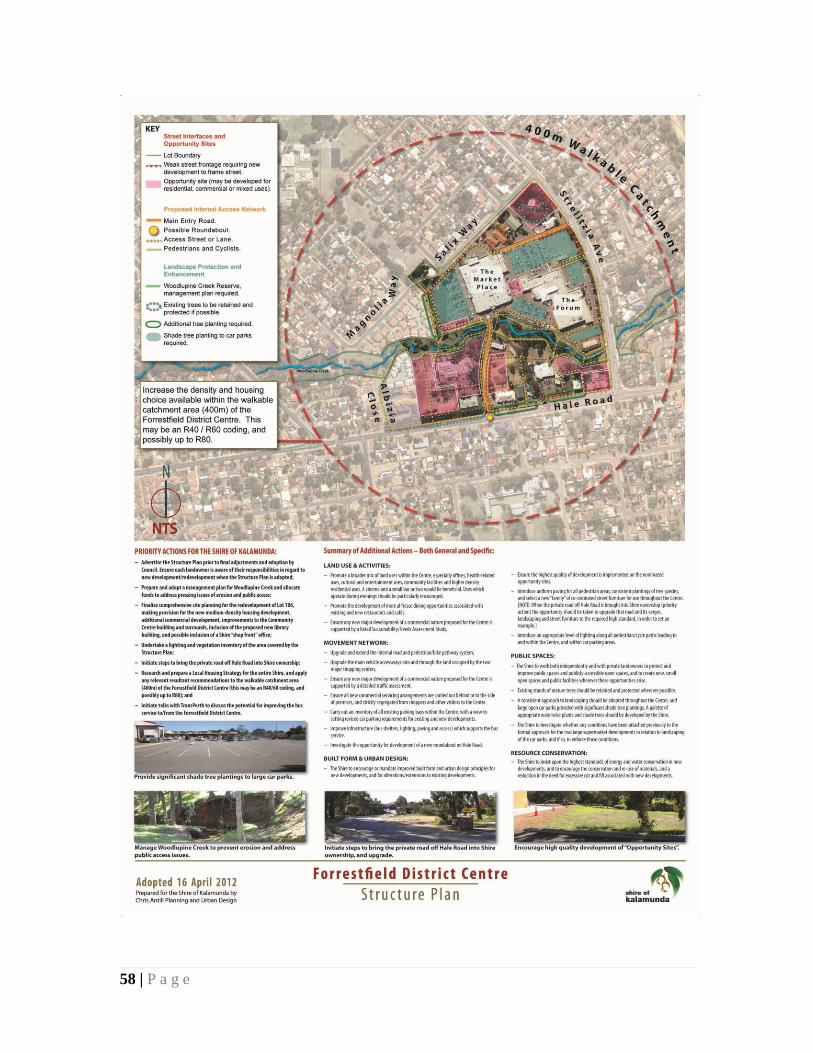
58 | P a g e