fort chadbourne officers quarters (ranch...
TRANSCRIPT
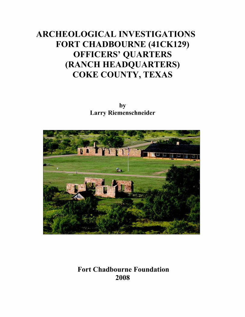
ARCHEOLOGICAL INVESTIGATIONS
FORT CHADBOURNE (41CK129)
OFFICERS’ QUARTERS
(RANCH HEADQUARTERS)
COKE COUNTY, TEXAS
by
Larry Riemenschneider
Fort Chadbourne Foundation
2008
2
ARCHEOLOGICAL INVESTIGATIONS
FORT CHADBOURNE (41CK129)
OFFICERS’ QUARTERS
(RANCH HEADQUARTERS)
COKE COUNTY, TEXAS
by
Larry Riemenschneider
Prepared for
Fort Chadbourne Foundation
Published by
Fort Chadbourne Foundation
2008
3
ABSTRACT
Over an eight year period, the Concho Valley Archeological Society has conducted archeological investigations at Fort Chadbourne (41CK129), a United States Military Army post (1852-1867) northeast of San Angelo in Coke County Texas. In 2007, the Fort Chadbourne Foundation received a grant to rebuild an officers’ quarters (ranch headquarters) building. The Concho Valley Archeological Society (San Angelo, Texas) and the Special Military Active and Retired Travel Club (Oklahoma) excavated 135 one-meter-square units within the building recovering 136,673 artifacts from three components (military occupation, ranching and subsequent abandonment). The information gathered from the investigation will aid in the reconstruction of the building. The following documentation reports the findings of this investigation.
4
INTRODUCTION
Since the formation of the Fort Chadbourne Foundation in 1999, many archeological projects have been undertaken to stabilize, preserve, protect and rebuild structures and ruins. In 2007, the Foundation received a grant to rebuild an Officers’ Quarters. The building constructed in 1858 was occupied until the middle 1860’s by the military. In 1874, the building was used as headquarters for the T.L. Odom ranch and the Odom family lived in it until it burned in the early 1920’s. When the building burned, it was abandoned and soon became a ruin in which trash collected over the years. The uninformative nature of the ruins, sketchy archival information and the lack of photos hindered plans for the re-construction of the building. A decision was made by the Fort Chadbourne Foundation to conduct an archeological investigation including excavation. This investigation was conducted by the Concho Valley Archeological Society and the Special Military Active and Retired Travel Club. When the building burned, it created a mini-time capsule. The positions of doors and windows were located by window glass, door paraphernalia, burned door jams, and burned window sills. Burned sandstone rocks placed as a foundation base for a fireplace were located in two rooms of the building. The three components identified by artifacts recovered were military (mid 1800’s), ranch era dwelling (late 1800’s to early 1900’s) and ranch era trash dump (mid 1900’s). Artifacts found in the excavations defined living areas within the building when it was occupied during the ranch dwelling.

5
ACKNOWLEDGEMENTS A project of this magnitude could not have been completed without the support of the Fort Chadbourne Foundation. A very special thanks to Garland and Lana Richards for providing everything needed to complete the project. Thanks to the Fort Chadbourne staff, Steve Clark, Annie Gill and Ann Pate for providing technical support during and after excavations. A special thanks to the excavation crew chiefs, Fred Braziel, Virginia Hudspeth, Sue Meacham, Jack Pool, Brownie Roberts and Bill Yeates, for an outstanding job of supervising. A very special thanks to Ann Pate for acting as site secretary, compiling information during excavation and lab. Thanks to Steve Clark for managing equipment and making many trips for needed items. During excavations and lab, many good meals were served and enjoyed. Thanks to the Fort Chadbourne Foundation and the SMART Club for preparing and serving these meals. Thanks to my wife Jo for helping with this publication and her support during the project. Thanks to Solveig Turpin, Lana Richards and Ann Pate for proof reading the publication. Thanks to the Fort Chadbourne Foundation for publishing this report. In a project of this size, many thanks are due to all. Sometimes thanks are inadvertently left out. Thanks to all who may not have been mentioned for helping make this project a success. Two groups, the Concho Valley Archeological Society (CVAS) of San Angelo and the Special Military Active and Retired Travel Club (SMART) of Oklahoma, are to be commended for the many hours of volunteer time devoted to this project. The two groups contributed 5934 volunteer hours to the project. Without their time and efforts, this project could not have been completed in a timely manner. Thanks to the following members of the CVAS and SMART organizations for a job well done:
6
Concho Valley Archeological Society
Crew Chiefs Fred Braziel Jack Pool Virginia Hudspeth Brownie Roberts Sue Meacham Bill Yeates
Members Tom Ashmore Gary Heumier Shirley Bell Claude Hudspeth
Charles Blake C.A. Maedgen Joy Blake Tee Maedgen Lila Boles Margie Matheny
Eileen Braziel Jerry McPherson Christine Buckstead Anika Moreno
Kathy Cheatham Tami Moreno Josh Cheatham Cody Moore Callan Clark Ann Pate Steve Clark Randall Pate Arnetta Cooper Cynthia Purcell
Diannie Davis Adolph Riemenschneider Crystal Elliot Anita Riemenschneider
Marcia Essor Jo Riemenschneider Darrel Fischer Garland Richards Richard Fiveash Lana Richards Annie Gill Marilyn Ross Ward Gregory Van Ross
Lee Keele Steven Schooler Loy Marie Haley Bob Wilson
Loy Haley Jack Woodrow Bill Haley
Special Military Active and Retired Travel Club
Worth Clayton Judene Lederer Etta Daniel Robert Lederer Donald Daniel Lorey Meier Judy Davis Fred Meier Gerald Davis Patricia Meyer Stevie-Ann Dingley Roger Meyer Roger Dingley James Mims Roy Dingley Judy Rolen Lilian Gillis Herbert Rolen Duane Gillis Sandy Russell JoAnn Hale T.J. Russell Jim Hale Frances Town Olga Jones Eugene Town Linza Jones Peggy Wilson Carolyn King Billy Winchester Danny King Tom Winchester
7
ORGANIZATIONS CONTRIBUTING
TO THE PROJECT
A project of this magnitude could not be completed without the help of volunteer organizations. Two groups, the Concho Valley Archeological Society (CVAS) and the Special Military Active and Retired Travel Club (SMART), contributed many volunteer hours to this project.
CONCHO VALLEY ARCHEOLOGICAL SOCIETY
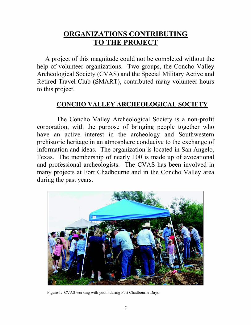
The Concho Valley Archeological Society is a non-profit corporation, with the purpose of bringing people together who have an active interest in the archeology and Southwestern prehistoric heritage in an atmosphere conducive to the exchange of information and ideas. The organization is located in San Angelo, Texas. The membership of nearly 100 is made up of avocational and professional archeologists. The CVAS has been involved in many projects at Fort Chadbourne and in the Concho Valley area during the past years.
Figure 1: CVAS working with youth during Fort Chadbourne Days.
8
SPECIAL MILITARY ACTIVE AND RETIRED
TRAVEL CLUB
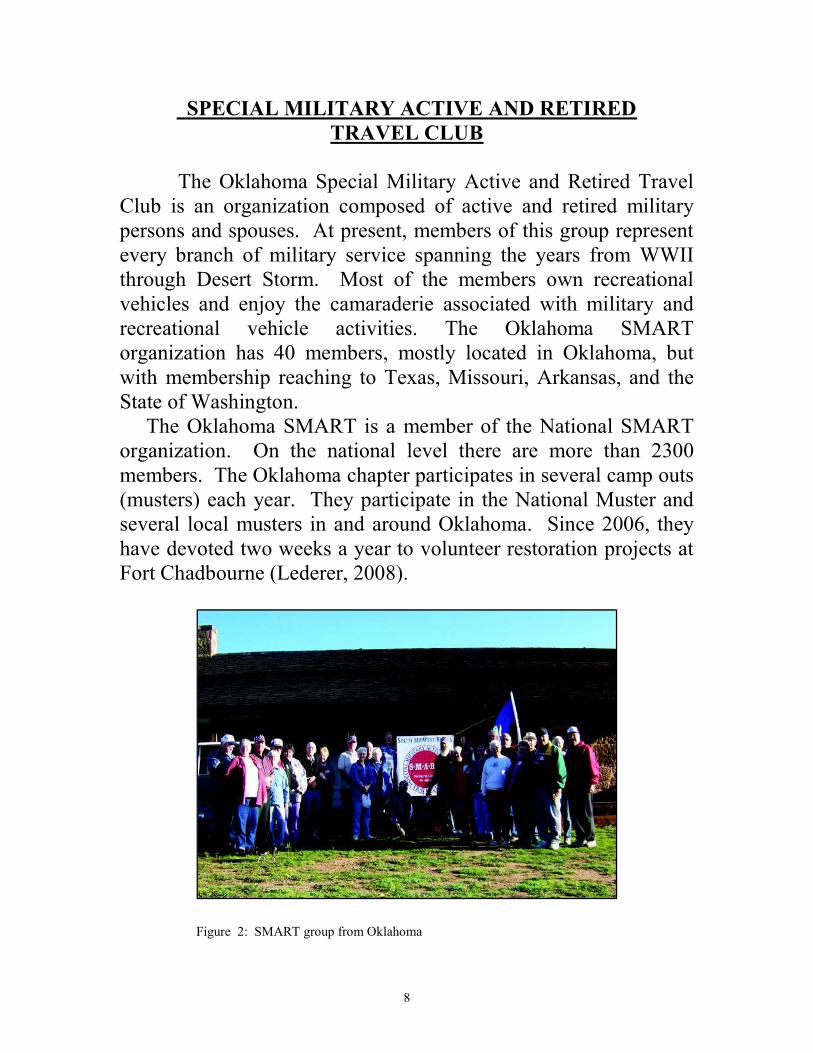
The Oklahoma Special Military Active and Retired Travel Club is an organization composed of active and retired military persons and spouses. At present, members of this group represent every branch of military service spanning the years from WWII through Desert Storm. Most of the members own recreational vehicles and enjoy the camaraderie associated with military and recreational vehicle activities. The Oklahoma SMART organization has 40 members, mostly located in Oklahoma, but with membership reaching to Texas, Missouri, Arkansas, and the State of Washington. The Oklahoma SMART is a member of the National SMART organization. On the national level there are more than 2300 members. The Oklahoma chapter participates in several camp outs (musters) each year. They participate in the National Muster and several local musters in and around Oklahoma. Since 2006, they have devoted two weeks a year to volunteer restoration projects at Fort Chadbourne (Lederer, 2008).
Figure 2: SMART group from Oklahoma

9
TABLE OF CONTENTS
Abstract…………………………………………………………3 Introduction……………………………………………………..4 Acknowledgments………………………………………………5 Organizations Contributing to the Project………………………7 Location………………………………………………………..12 History of Fort Chadbourne……………………………………13 History of Land Fort Chadbourne Occupied 1852-2008………16 Archeological Investigations…………………………………..27 Results of the Archeological Investigation…………………….40 Officers’ Quarters (Ranch Headquarters) 150 Years Later…....69 References……………………………………………………...70
List of Figures
Figure 1. CVAS working with youth during Fort Chadbourne Days… .7 Figure 2. SMART group from Oklahoma………………………………8 Figure 3. Location of Fort Chadbourne………………………………..12 Figure 4. Infantry field artillery re-enactors Fort Chadbourne Days…..14 Figure 5. Lucinda S. and Thomas L. Odom…………………………...22 Figure 6. Entrance to Chadbourne Ranch……………………………..24 Figure 7. Rough plan of proposed building at Fort Chadbourne, August 1853…………………………………………………28 Figure 8. Fort Chadbourne, 1856, drawn by Colonel J.K.F. Mansfield……………………………………29 Figure 9. Fort Chadbourne, 1856, drawn by First Lieutenant Andrew G. Miller………………………….30 Figure 10. Ruins of Officers’ Quarters (Ranch Headquarters)…………32 Figure 11. Grid system Officers’ Quarters (Ranch Headquarters)……..33 Figure 12. Excavated rooms Officers’ Quarters (Ranch Headquarters)……………………………………….34 Figure 13. Photographing from overhead Officers’ Quarters (Ranch Headquarters)……………………………………….35 Figure 14. Excavations Officers’ Quarters (Ranch Headquarters)……..36 Figure 15. Excavations Officers’ Quarters (Ranch Headquarters)……..36 Figure 16. Screening Officers’ Quarters (Ranch Headquarters)……….37
10
Figure 17. Overview of excavations Officers’ Quarters (Ranch Headquarters)………………………………………37 Figure 18. Artifacts in situ Officers’ Quarters (Ranch Headquarters)…38 Figure 19. Removing windmill tail section from Officers’ Quarters (Ranch Headquarters)……………………………………….38 Figure 20. Cataloging artifacts Officers’ Quarters (Ranch Headquarters)……………………………………….39 Figure 21. Cataloging artifacts Officers’ Quarters (Ranch Headquarters)……………………………………….39 Figure 22. Plan-view of Officers’ Quarters (Ranch Headquarters)…….40 Figure 23. Construction of wall Officers’ Quarters (Ranch Headquarters)……………………………………….41 Figure 24. Footings for floor joists Officers’ Quarters (Ranch Headquarters)……………………………………….42 Figure 25. Location of window sill and fireplace Officers’ Quarters (Ranch Headquarters)……………………………………….43 Figure 26. Burned door jam Officers’ Quarters (Ranch Headquarters)……………………………………….44 Figure 27. Profile of burn level Officers’ Quarters (Ranch Headquarters)……………………………………….45 Figure 28. Activity areas Officers’ Quarters (Ranch Headquarters)…...46 Figure 29. Sewing and writing artifacts………………………………...48 Figure 30. Selected recreational artifacts……………………………….49 Figure 31. Frozen Charlotte Porcelain Doll fragment…………………..49 Figure 32. Selected firearms artifacts…………………………………..50 Figure 33. Selected domestic artifacts………………………………….51 Figure 34. Selected domestic artifacts………………………………….51 Figure 35. Selected domestic artifacts………………………………….52 Figure 36. Selected domestic artifacts………………………………….52 Figure 37. Selected domestic artifacts………………………………….52 Figure 38. Selected domestic artifacts………………………………….53 Figure 39. Selected domestic artifacts………………………………….53 Figure 40. Selected domestic artifacts………………………………….53 Figure 41. Selected domestic artifacts………………………………….54 Figure 42. Selected domestic artifacts………………………………….54 Figure 43. Selected domestic artifacts………………………………….54 Figure 44. Selected domestic artifacts………………………………….55 Figure 45. Selected domestic artifacts………………………………….55 Figure 46. Selected domestic artifacts………………………………….56 Figure 47. Selected domestic artifacts………………………………….56
11
Figure 48. Selected domestic artifacts………………………………….56 Figure 49. Selected personal artifacts…………………………………..57 Figure 50. Selected personal artifacts…………………………………..57 Figure 51. Selected personal artifacts…………………………………..58 Figure 52. Selected personal artifacts…………………………………..58 Figure 53. Selected personal artifacts…………………………………..58 Figure 54. Selected personal artifacts…………………………………..59 Figure 55. Selected personal artifacts…………………………………..59 Figure 56. Selected personal artifacts…………………………………..59 Figure 57. Selected personal artifacts…………………………………..60 Figure 58. Selected personal artifacts…………………………………..60 Figure 59. Selected personal artifacts…………………………………..60 Figure 60. Selected personal artifacts…………………………………..60 Figure 61. Selected personal artifacts…………………………………..61 Figure 62. Selected workshop artifacts………………………………...61 Figure 63. Selected workshop artifacts………………………………...62 Figure 64. Selected construction artifacts……………………………...62 Figure 65. Re-constructed Officers’ Quarters (Ranch Headquarters)……………………………………...69
List of Tables
Table 1. Artifact totals and percentages by category Officers’ Quarters (Ranch Headquarters)…………………….48 Table 2. Artifacts listing Officers’ Quarters (Ranch Headquarters)…………………………………………63
12
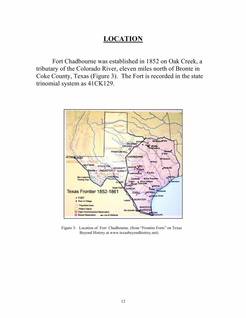
LOCATION
Fort Chadbourne was established in 1852 on Oak Creek, a tributary of the Colorado River, eleven miles north of Bronte in Coke County, Texas (Figure 3). The Fort is recorded in the state trinomial system as 41CK129.
Figure 3: Location of Fort Chadbourne. (from “Frontier Forts” on Texas
Beyond History at www.texasbeyondhistory.net).
13
HISTORY OF FORT CHADBOURNE
After Texas declared its independence from Mexico, a need for protection on the frontier was evident. During this time, the only military presence was the Texas Mounted Volunteers and Gunmen. By the 1850’s, a line of frontier forts was established to protect travelers on the road from San Antonio to El Paso (Brown et al. 1998). The annexation of Texas placed the protection of the frontier under the auspices of the U.S. Army which had little knowledge of Plains Indian warfare. Only a few thousand soldiers were stationed in the state and they did not prove to be much of a defense against the wide-ranging Comanches. A series of forts referred to as the Army’s “Indian Frontier Line” was established immediately after the war with Mexico. Eight of these were in west Texas and five were in southwest Texas. Within a few years, the “Indian Frontier Line” of forts had become obsolete and the U.S. Army created a second line of defense. Fort Chadbourne was commissioned as part of this second effort (Brown et al. 1998). Fort Chadbourne was established on October 21, 1852 and, by November, it housed the 8th infantry consisting of companies A, C, G, I, and K. The following years saw many changes of command at Fort Chadbourne. When Texas seceded from the Union, the U.S. forces peacefully abandoned the state’s forts, and the frontier was left to the defense of minutemen and the Texas Rangers who occupied the posts in small detachments. Two years after the end of the Civil War, the army reoccupied Fort Chadbourne. Finding it to be in a serious state of disrepair, no less than 103 construction workers were employed to complete the task of rebuilding. During this time, the commander was directed to scout for a more suitable location. Seventeen years after its founding, the post at Fort Chadbourne was abandoned for lack of good water, wood and adequate facilities. Headquarters of the command were transferred
14
to Camp Hatch (later known as Fort Concho) on December 4, 1867 (Brown et al.1998).
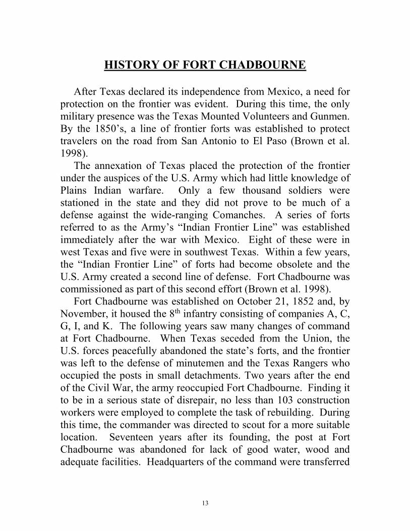
Figure 4: Infantry field artillery re-enactors Fort Chadbourne Days May 2006.
In 1867, Thomas L. Odom and his son Garland G. Odom, drove cattle into the abandoned fort area and, in 1874, established the O-D Ranch. The fort buildings were used as the headquarters for the cattle ranch operations until the 1960’s when new barns were built. The Chadbourne ranch is still a working cattle operation today. Although the owners’ names have changed from Odom, to Wylie and now to Richards, the ranch is still owned by the eighth generation of Odoms. The Fort Chadbourne Foundation is a non-profit organization created to preserving the military post and interpreting it for the public. It has undertaken many different projects since it was established in 1999. Some of these projects include: 1. Intensive archival research resulting in a comprehensive history of Fort Chadbourne by Freeman (2001).

15
2. Archeological excavations at the Fountain House officers’ quarters by the Concho Valley Archeological Society; reported by Riemenschneider (2002). 3. Reconstruction of an officers’ quarters (called the “Fountain House”). 4. Hosting the Texas Archeological Society’s 2004 Archeology Academy including excavations inside Barracks No. 2, and site survey of the alluvial terrace of Oak Creek below the Fort; reported by Boyd (2004). 5. Reconstruction of a barracks (Barracks No. 2). 6. Comprehensive mapping of military and nonmilitary features at the fort by Prewitt and Associates, Inc. (2003). 7. Magnetometer tests conducted by the Texas Historical Commission around the buildings in search of hidden features (2006). 8. Archeological excavations of foundations west of Fountain House by the Concho Valley Archeological Society; reported by Riemenschneider (2007). 9. Developing a Chronological Order of Events taking place at Fort Chadbourne from its beginning in 1852 to present day; report in print. The Fort Chadbourne Foundation continues to remain active in the role of preserving the past and developing the fort’s future.
16
HISTORY OF LAND FORT CHADBOURNE
OCCUPIED 1852-2008
Fort Chadbourne, established in 1852 on Oak Creek in Coke County had an interesting history of land acquisition. From 1852 to 2008, several men, women and their families played a very important role in the development of the land that housed the buildings of Fort Chadbourne.
SAMUEL MAVERICK, LAND BARON
Samuel Augustus Maverick was born at Pendleton, South Carolina on July 23, 1803. He spent his earliest years primarily in Charleston, but, in 1810, the family moved to Pendleton, where Maverick’s father established a plantation and devoted much of his energy to buying land in South Carolina, Alabama, and Georgia. Maverick was educated at home until age 18, when he left South Carolina and spent a summer studying under a tutor at Ripton, Connecticut, in preparation for entry to Yale University. Maverick received his Virginia law license on March 26, 1829. He returned to Pendleton in 1829 and opened a law office. He ran for the South Carolina legislature in 1830, but his antisecession and antinullification views contributed to his defeat and led him to leave the state in 1833. He settled temporarily in Georgia, then on a plantation in Lauderdale County, Alabama, before moving to Texas in March 1835 (Marks, The Handbook of Texas Online). Maverick arrived in Texas eager to start building his own land empire, but the Texas Revolution was rapidly developing. He reached San Antonio shortly before the siege of Bexar began and was soon put under house arrest on the orders of Mexican general Martin Perfecto de Cos. Forbidden to leave the city, Maverick kept a diary that provides a vivid record of the siege. After March 5, 1836, he departed for Alabama on family business (Marks, The Handbook of Texas Online).
17
In Alabama, Maverick met Mary Ann Adams and married her on August 4, 1836. The couple lived in Alabama until they returned to Texas and established a home in San Antonio. Maverick obtained his Texas law license, engaged in West Texas land speculation, and served as the city’s mayor in 1839. Maverick later served in the Eighth Congress and was a strong advocate of annexation of Texas to the United States. Maverick, noted as being a land baron who also was a land surveyor, acquired land throughout the State of Texas. Being a surveyor, he had access to land records and, if the land was of particular interest he would buy the property. His endeavors helped him acquire land which housed Fort Clark, Fort Mason and Fort Chadbourne (Marks, The Handbook of Texas Online). In 1844, the tax rolls showed that Maverick owned 35,299 acres by title in Bexar County and Bexar Territory, with an additional 20,077 by survey, as well as 21 town lots. The following year he also purchased 11,000 acres for his father, to be an inheritance for Maverick’s children and nieces and nephews (Marks, 1989).
SAMUAL MAVERICK ACQUIRES LAND
OCCUPIED BY FORT CHADBOURNE
The first recorded ownership data of the land dates back to March 1, 1852, when 640 acres were deeded to James Gross for unknown reasons. The recorded information is from the General Land Office and involves certificate number 2353/2454. “This is
to certify, that James Gross is entitled to have Surveyed by any
legally authorized Surveyor upon any of the vacant and
unappropriated public domain of the State of Texas-Six hundred
and forty acres of land, in accordance with the provisions of an act
authorizing and requiring the Commissioners of the Genl. Land
18
Office to issue to the said James Gross a Certificate for Six
hundred and forty acres of land.” Approved Feby. 13th. 1852.” (General Land Office 1854; File 1483). On March 19, 1852, James Gross transferred ownership of the property to Jno D. McLeod. The General Land Office files note this transaction occurred in Bexar County Texas. “Know all
men by these presents that I[,] James Gross of the County and
State aforesaid of the first part [,] for the consideration of One
Hundred dollars to me in hand paid have this day sold,
transfer[red] & [?] all right title 7 interest in and to the within
certificate of 640 acres of Land issued by Sl Crosby Com. Of the
Genl. Land Office 7 dated the 1st day of March 1852 to me, unto
Jno D. Mcleod his heirs executors 7 assigns, and all land, accruing
to me by virtue of said certificate…”. (General Land Office 1854, File 1483). On July 5, 1852, Samuel A. Maverick bought the land from Jno D. Mcleod. The transaction occurred in Bexar County, Texas. “Know ye that I, John D. McLeod, in consideration of one hundred
dollars to me paid by Samuel A[.] Maverick, have this day
bargained sold and assigned, the within and above mentioned
Certificate No. 2353/2454 for 640 acres of land and the lands to
accrue thereunder…”. (General Land Office 1854; File 1483). Samuel probably speculated based on rumors that this land would be a good location for Fort Chadbourne. His speculation paid off when the 10th Infantry left Camp Johnston in October 1852 to establish a post on Oak Creek, later known as Fort Chadbourne. On March 9, 1853 Samuel Maverick went with John McDonald surveying to Fort Mason and the Llano River, and to Fort Chadbourne and the Red Fork of the Colorado River. Following are excerpts from the Field notes of the Survey. Surveyed March 26, 1853 and March 27, 1853. “Field notes of a
survey of 320 acres of land made for James Gross, it being part of
the land to which he is entitled of certificate No. 2353/2354 issued
by S. Crosby, Commissioner of the General Land Office, said
survey is No. 300, in Section No. 9, situated on Oak Creek, a
19
branch of the Colorado River about ¼ south of Fort Chadbourne.”
“Field notes of a survey of 320 acres of land made for James
Gross, it being part of the land to which he is entitled by virtue of
certificate No. 2353/2354 issued by J. Crosby commissioner of the
General Land Office. Said Survey is N. 301 in Section No. 9,
situated on Oak Creek, a branch of the Colorado River” and
includes Fort Chadbourne…”. “On April 25, 1853 Samuel
returned in good health [from the surveying trip he left on March
9, 1853].” Samuel had confirmed through his surveys that the land occupied by Fort Chadbourne was property he had acquired from the original land grant to James Gross (Freeman 2001). One year later on March 10, 1854, “Survey 300 and 301
were patented to Samuel A. Maverick, assignee.” (Texas. General Land Office 1854b). Fort Chadbourne was listed on both of the surveys. Maverick now having acquired the patent for the land, confronted the government about Fort Chadbourne being built on property owned by him. He requested rent be paid for the use of buildings on his land. On September 20, 1856, “Articles of
agreement were made and entered into between Brvt. Lieut. Col.
A.C. Myers, U.S. Army, Asst. Quarter Master, Department of
Texas, on the one part, and Samuel A. Maverick of Bexar County,
Texas, of the other part. Maverick agreed that he, his heirs,
executors and administrators, “shall let, rent and lease to the
United State of America a certain tract and parcel of Land, lying
and being situated in the County of Bexar and State of Texas, and
described as follows:--All that tract of Land, which has been and is
now occupied as a Military Post, and known as Fort Chadbourne,
situated on Oak Creek a branch of the Red Fork of the Colorado
River, said Land being known as Survey No. 301. in Section No. 9.
and contains three hundred and twenty acres…The said tract of
Land being granted to the said Samuel A. Maverick as assignee of
James Gross, by the State of Texas, as is shown by Letter Patent
No. 42 in Vol. No. 10” (Freeman 2001). The contract further read, "The United States or their Officers
and Agents are to hold the said premises with rights and
20
appurtenances thereto belonging, so long as they or any portion of
them may be required by the United States for occupancy as a
Military Post, not however to exceed the period of Twenty years,
dating from the first day of November one thousand Eight hundred
and fifty two, reserving the privilege to the United States, to cut and
use any timber or other material which may be found upon the Land
herein before described and which may be required for the erection
or repairs of any and all Public buildings and fences, or for other
purposes connected with the Military Post of Fort Chadbourne.--
Also the right to cut and use from the described Survey of Land
whatever wood may be required for fuel for the use of troops which
now or may hereafter occupy the said Military Post of Fort
Chadbourne; For and in consideration of which the United States
are to pay to the said Samuel A. Maverick, his heirs, executors or
administrators the sum of Twenty five Dollars per month rent, for
the premises and privileges granted by this Lease, from and after the
First day of November One thousand Eight Hundred and fifty two,
being the date of the first occupancy of the said Post.--It is further
agreed on the part of the United States, that the buildings, fences,
erections and improvements now made and which may be hereafter
made on the aforesaid described Survey, shall be left thereon for the
benefit of the said Samuel A. Maverick, when they shall no longer be
required by the United States”. The money for the rent of the property was not paid until a year later (Freeman 2001). Samuel Maverick was an intelligent man when it came to buying land. In anticipation of Fort Chadbourne being built on Survey 301, Samuel purchased the land. Samuel also purchased Survey 300 knowing that the fort would be in need of wood for fuel. On May 28, 1857, Lt. T.A. Washington, Fort Chadbourne in a report to Major D.H. Vinton, Principal Quartermaster San Antonio, supports the importance of wood. “Your communication of the 1st
Instant is at hand and I proceed to comply with the instructions
therein contained in the order and manner you desire.” In the ten
instructions given by Washington, the fifth set of instructions
addressed the issue of fuel. “Fuel. Description, quantity, quality,
21
how procured, facilities for procuring? Answer. The fuel is of post
& live-oak, abundant & of excellent quality--& lies upon 2 tracts of
land [,] one rented of S.A. Maverick at $25. pr month, containing
320 acres, the other from Howard & Twohig at $50 pr. month,
quantity not specified in lease. The post proper is on Maverick[']s
land. Fuel is cut & hauled by the command & is readily procured” (Freeman 2001). The following statement has much truth in the dealings Sam Maverick had with the government, "While it is true that the post
provided some reassurance to frontiersmen and probably helped in
a small way to subdue the Indians, it is difficult to escape the
conclusion that the man who benefited most from Fort Chadbourne's
location was Sam Maverick” (Freeman 2001). Samuel Maverick died September 2, 1870, ending an important part of the history of the land development at Fort Chadbourne. He left fifty percent of his property to his wife Mary A. Maverick and fifty percent to his children. On January 4, 1876, the children of Samuel Maverick transfered the James Gross Survey, which included Fort Chadbourne, to Mary Maverick (Freeman 2001).
THOMAS LAWSON ODOM
ADVENTURER AND RANCHER
Thomas Lawson Odom was born March 20, 1825 in Conecuh County, Alabama, where he married Lucinda S. Milstead on October 28, 1845. After their marriage, they lived in Jefferson and Baldwin counties, Alabama. They then moved to the San Antonio area where they lived on the Medina River near present-day Bandera. During this time, they lived with the A.M. Milstead and P.D. Saner families and worked making wood shingles, then in demand in San Antonio and on the frontier military posts (Freeman 2001).
22
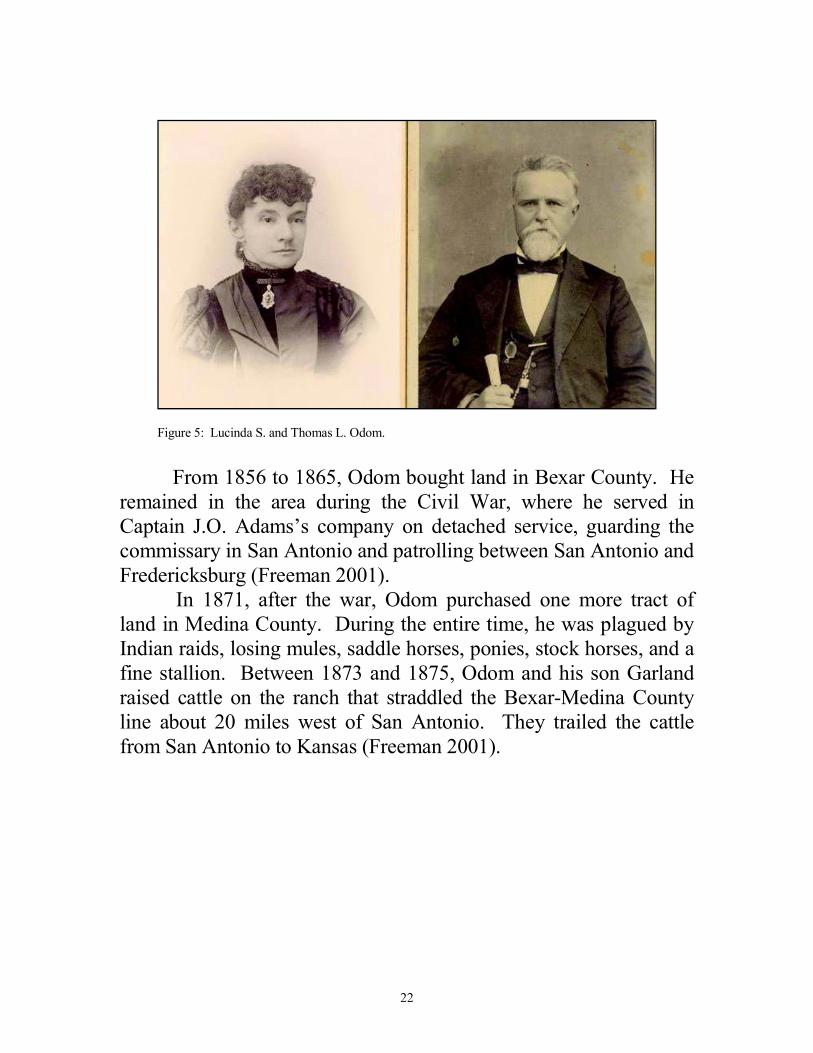
Figure 5: Lucinda S. and Thomas L. Odom.
From 1856 to 1865, Odom bought land in Bexar County. He remained in the area during the Civil War, where he served in Captain J.O. Adams’s company on detached service, guarding the commissary in San Antonio and patrolling between San Antonio and Fredericksburg (Freeman 2001). In 1871, after the war, Odom purchased one more tract of land in Medina County. During the entire time, he was plagued by Indian raids, losing mules, saddle horses, ponies, stock horses, and a fine stallion. Between 1873 and 1875, Odom and his son Garland raised cattle on the ranch that straddled the Bexar-Medina County line about 20 miles west of San Antonio. They trailed the cattle from San Antonio to Kansas (Freeman 2001).
23
ODOM FAMILY
ACQUISITION OF FORT CHADBOURNE
In 1877, in a rather unusual deal, the Odom family purchased the nucleus of what would become the Fort Chadbourne Ranch. Garland Richards, great-great grandson of Lucinda Odom, best portrays this transaction, “Lucinda knew what she wanted and had
the gold to pay for it. When she saw the large sandstone “house”
(officers’ quarters) among the fort’s buildings, with the Butterfield
Overland Mail stopping by the front door, and the wide sweeping
vistas, she knew she was home. Perhaps it was the spacious
officers’ house she wanted as a home for her family, but she also
wanted the land. Grandmother paid $500 in gold for the fort and
640 acres. Imagine this transaction in 1877, Lucinda Odom and the
widow Mary Maverick making a deal near present-day Highway
277, eleven miles north east of Bronte, Coke County, Texas” (Bruckner 2002).
LAND PURCHASED TO BECOME THE FORT
CHADBOURNE RANCH
After the original transaction, the purchase of land slowed until two years later when Garland Odom (son of Thomas and Lucinda) purchased adjoining surveys from Mary Maverick . Following this purchase, the Odom’s purchased several more adjacent tracts. At the time of Lucinda’s death in 1882, she left an interest in community property that consisted of fifty-six tracts of land totaling 31,562 acres in fee simple, an additional 1,784 acquired by tax title, and four Confederate scripts that entitled the holder to 5120 acres. At that time, the Fort Chadbourne ranch she owned with Thomas Odom included land in Runnels, Tom Green, Taylor, and present-day Coke County (Freeman 2001).
24
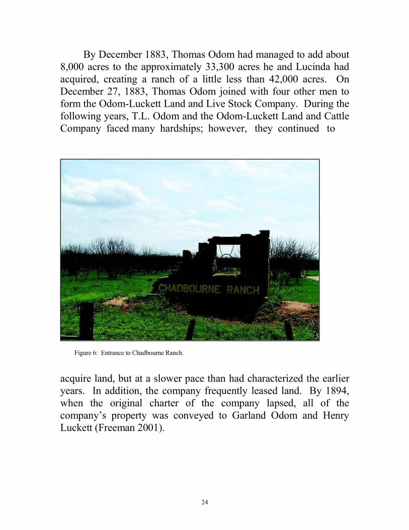
By December 1883, Thomas Odom had managed to add about 8,000 acres to the approximately 33,300 acres he and Lucinda had acquired, creating a ranch of a little less than 42,000 acres. On December 27, 1883, Thomas Odom joined with four other men to form the Odom-Luckett Land and Live Stock Company. During the following years, T.L. Odom and the Odom-Luckett Land and Cattle Company faced many hardships; however, they continued to
Figure 6: Entrance to Chadbourne Ranch.
acquire land, but at a slower pace than had characterized the earlier years. In addition, the company frequently leased land. By 1894, when the original charter of the company lapsed, all of the company’s property was conveyed to Garland Odom and Henry Luckett (Freeman 2001).
25
GARLAND ODOM ACQUIRES FORT CHADBOURNE
Following the dissolution of the company, Odom and Luckett divided the property, and Garland Odom took the tracts comprising the west half, retaining Fort Chadbourne as his ranch headquarters. This division was followed by the death of Thomas L. Odom on March 29, 1897, which ended a generation of acquiring land that centered around Fort Chadbourne (Freeman 2001).
GARLAND G. ODOM CONTINUES RANCHING
Garland G. Odom was born in Baldwin County, Alabama on the 16th day of December, 1852. During the Civil War he served at San Antonio with the Home Guard. Odom was educated in the country schools near his home and the public schools of San Antonio. He later joined his father, Thomas Odom, in the cattle business and continued the ranching tradition after the death of his father (Jenkins, Stone, Jr., Gregory, 1975). On January 28, 1875, he married Sallie M. Crigler in San Antonio. Garland and his wife Sallie, and their two daughters , Lou Nettie and Edna Mae, lived at Fort Chadbourne headquarters, using some of the building for ranch operations. During this time, they continued to purchase land in the area (Freeman, 2001).
CONDA H. WYLIE
CONTINUES RANCHING TRADITION
The continuation of the ranching tradition was bolstered by the marriage of Edna Odom (daughter of Sallie and Garland Odom) to Conda H. Wylie on December 14, 1904. Wylie was born on the old Wylie Ranch on the Colorado River in Runnels County. He grew up
26
in Ballinger and attended college in Fort Worth. He entered the ranching business soon after marrying Edna, and they moved to Fort Chadbourne. After a brief period of running a San Angelo hardware store with his brothers, he returned to Fort Chadbourne where he, along with his wife and daughter (Maurine), continued the ranching operation (Freeman, 2001).
C.O. (CONDA) RICHARDS
ASSUMES CONTROL OF RANCH
Maurine Wylie married E.L. Richards of Utica New York. Their son, C.O. (Conda) Richards, returned to Fort Chadbourne to work with his grandfather after World War II. The two men ran an Angus cowherd to which they introduced some numbers of Charolais. C.O. (Conda) Richards then assumed full control of the ranch at Fort Chadbourne following the death of his grandfather and grandmother. C.O. (Conda) Richards died in 1998 and left the ranch to his three children (Freeman 2001).
GARLAND RICHARDS
ESTABLISHES FORT CHADBOURNE FOUNDATION
After the passing of Conda O. Richards, the ranch was deeded to his three children. They divided the ranch and the portion that included the Fort Chadbourne ruins was selected by Garland Richards. Garland and his wife Lana formed the Fort Chadbounre Foundation on January 29, 1999, for the purposes of protecting and preserving the site and promoting its social and cultural significance (Freeman, 2001). Their children and grandchildren make eight generations who have lived on the ranch since it was purchased by T.L. and Lucinda Odom.
27
ARCHEOLOGICAL INVESTIGATIONS
HISTORY OF OFFICERS’ QUARTERS
(RANCH HEADQUARTERS)
The archeological investigations and findings of the Officers’ Quarters (Ranch Headquarters) could not be fully understood without a brief history of the construction of military buildings at Fort Chadbourne. The establishment of Fort Chadbourne in October 1852 set off a chain reaction of activities. The arrival of troops was followed by the arrival of the post physician Ebenezer Swift who kept very busy with the many contusions suffered as the troops busied them-selves in a vigorous building campaign in hopes of creating shelter before the cold weather of winter set in. During this time, hints of building activity were reported in letters from post commander Captain J. Beardsley to department headquarters requesting permission to employ men in the mounted portion of the command to help in building the garrison (Freeman 2001). In 1853, the increase in the number of troops meant a need for more housing which resulted in an increased amount of construction. In 1853, Colonel W.G. Freeman provided a plan of the fort on which he delineated both the completed and the proposed buildings (figure 7). The plan followed the typical layout that the military used in building other forts in the region. A rectangular parade ground was flanked by barracks on the north and officers’ quarters on the south. A hospital, commanding officers’ quarters and surgeons’ quarters were to be built on the west side of the parade ground. A quartermaster, storeroom, guardhouse and combination office, library and courtroom were also planned for the east side of the parade ground (Freeman 2001).
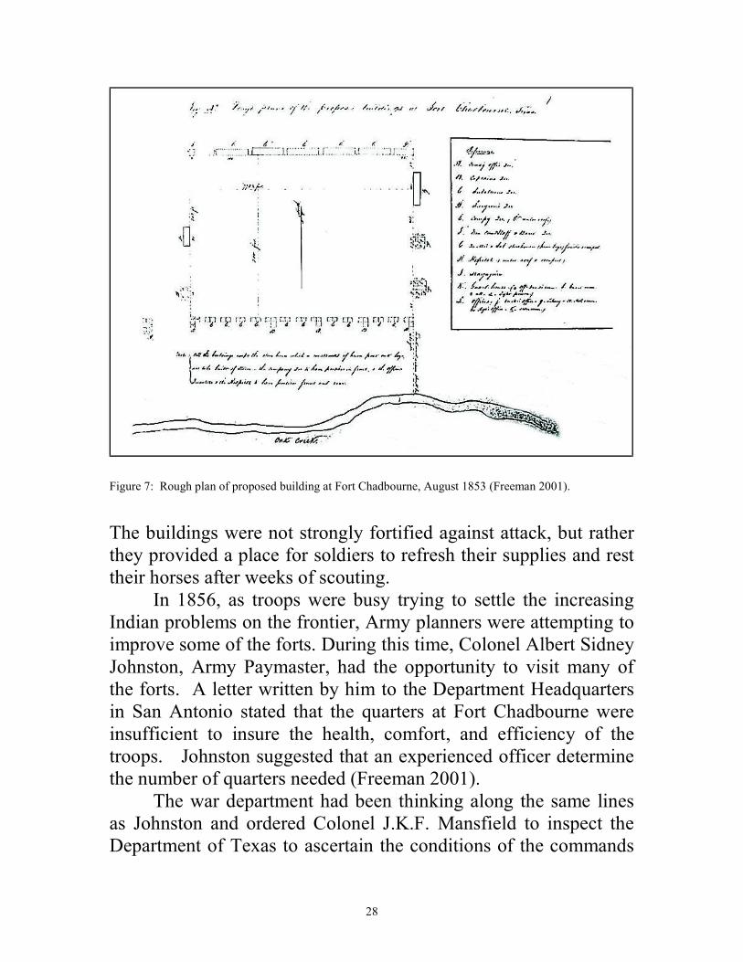
28
Figure 7: Rough plan of proposed building at Fort Chadbourne, August 1853 (Freeman 2001).
The buildings were not strongly fortified against attack, but rather they provided a place for soldiers to refresh their supplies and rest their horses after weeks of scouting. In 1856, as troops were busy trying to settle the increasing Indian problems on the frontier, Army planners were attempting to improve some of the forts. During this time, Colonel Albert Sidney Johnston, Army Paymaster, had the opportunity to visit many of the forts. A letter written by him to the Department Headquarters in San Antonio stated that the quarters at Fort Chadbourne were insufficient to insure the health, comfort, and efficiency of the troops. Johnston suggested that an experienced officer determine the number of quarters needed (Freeman 2001). The war department had been thinking along the same lines as Johnston and ordered Colonel J.K.F. Mansfield to inspect the Department of Texas to ascertain the conditions of the commands
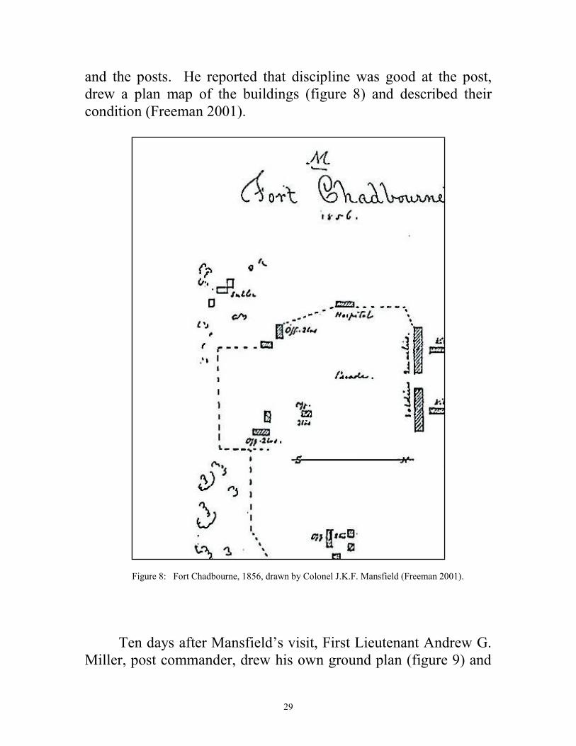
29
and the posts. He reported that discipline was good at the post, drew a plan map of the buildings (figure 8) and described their condition (Freeman 2001).
Figure 8: Fort Chadbourne, 1856, drawn by Colonel J.K.F. Mansfield (Freeman 2001).
Ten days after Mansfield’s visit, First Lieutenant Andrew G. Miller, post commander, drew his own ground plan (figure 9) and
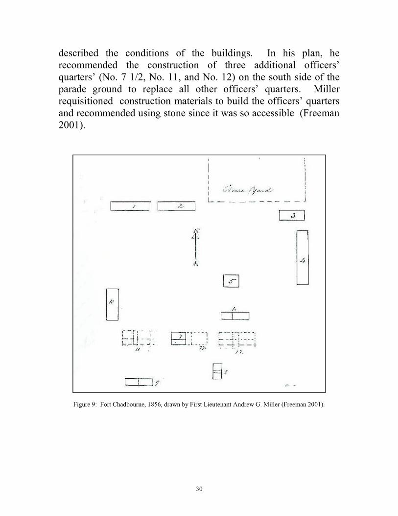
30
described the conditions of the buildings. In his plan, he recommended the construction of three additional officers’ quarters’ (No. 7 1/2, No. 11, and No. 12) on the south side of the parade ground to replace all other officers’ quarters. Miller requisitioned construction materials to build the officers’ quarters and recommended using stone since it was so accessible (Freeman 2001).
Figure 9: Fort Chadbourne, 1856, drawn by First Lieutenant Andrew G. Miller (Freeman 2001).
31
Beginning in 1857, significant construction took place at Fort Chadbourne. At the end of May, a report by Acting Associate Quartermaster and First Lieutenant T.A. Washington listed some of the finished buildings that appeared on Miller’s plan (figure 9). He listed a newly constructed, four-room, stone officers quarters and another stone building under construction. These were probably structures No. 11 and No. 12 on Miller’s plan (Freeman 2001). In Freeman’s original plan (figure 7), a row of fifteen officers’ quarters were to be constructed on the south side of the parade ground. Miller’s plan only shows eight structures occupied by officers, four built of stone and four built of logs. When the Fort Chadbourne Foundation was established in 1999, only three stone ruins of officers’ quarters remained. The archeological investigation and reconstruction of the Fountain House (Officers’ Quarters) (Riemenschneider 2002) was one of the first restoration projects of the Fort Chadbourne Foundation. This stone structure was No. 7 1/2 on Millers plan. Following this project, an archeological investigation west of the Fountain House (Riemenschneider 2007) confirmed another foundation of an officers’ quarters (No. 7 on Millers plan). Further west of this foundation are the ruins of the commanding officers’ quarters which were built of sandstone and adobe (No. 11 on Millers plan). East of the fountain house lie the ruins of the officers’ quarters (ranch headquarters), which are ruins are building No. 12 on Miller’s plan and are the subject of this investigation. The officers’ quarters constructed in 1857 were occupied until the middle 1870’s by the military. In 1877, the building was used as headquarters for the T.L. Odom ranch and the Odom family used the building as a dwelling until it burned in the early 1920’s.
32
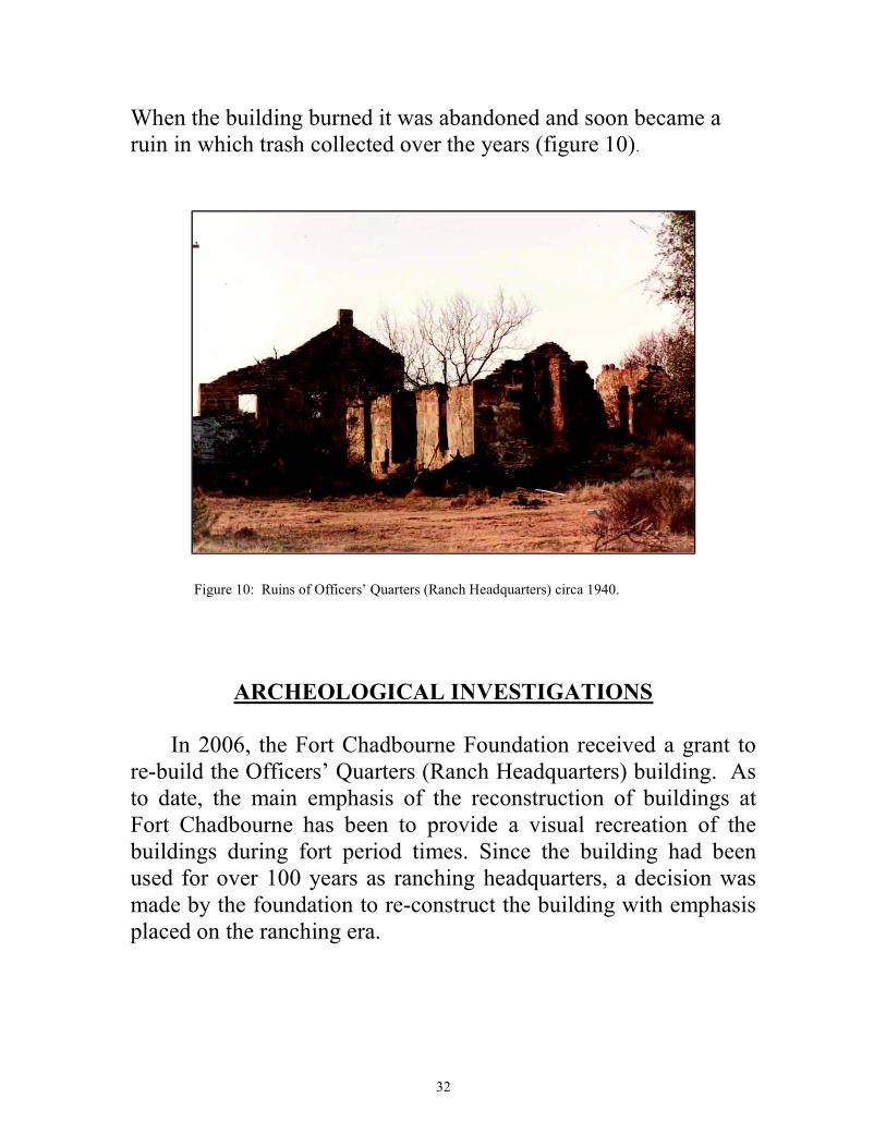
When the building burned it was abandoned and soon became a ruin in which trash collected over the years (figure 10).
Figure 10: Ruins of Officers’ Quarters (Ranch Headquarters) circa 1940.
ARCHEOLOGICAL INVESTIGATIONS
In 2006, the Fort Chadbourne Foundation received a grant to re-build the Officers’ Quarters (Ranch Headquarters) building. As to date, the main emphasis of the reconstruction of buildings at Fort Chadbourne has been to provide a visual recreation of the buildings during fort period times. Since the building had been used for over 100 years as ranching headquarters, a decision was made by the foundation to re-construct the building with emphasis placed on the ranching era.
33
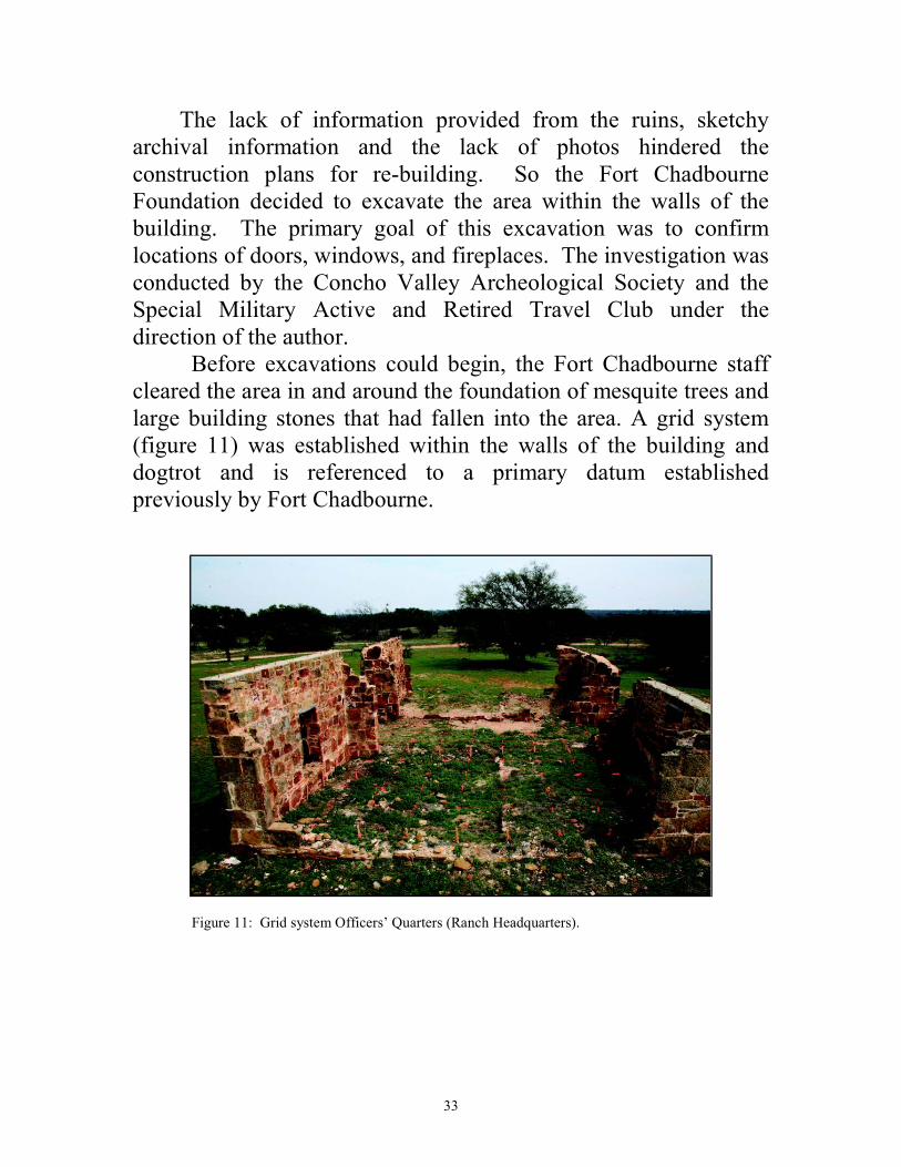
The lack of information provided from the ruins, sketchy archival information and the lack of photos hindered the construction plans for re-building. So the Fort Chadbourne Foundation decided to excavate the area within the walls of the building. The primary goal of this excavation was to confirm locations of doors, windows, and fireplaces. The investigation was conducted by the Concho Valley Archeological Society and the Special Military Active and Retired Travel Club under the direction of the author. Before excavations could begin, the Fort Chadbourne staff cleared the area in and around the foundation of mesquite trees and large building stones that had fallen into the area. A grid system (figure 11) was established within the walls of the building and dogtrot and is referenced to a primary datum established previously by Fort Chadbourne.
Figure 11: Grid system Officers’ Quarters (Ranch Headquarters).
34
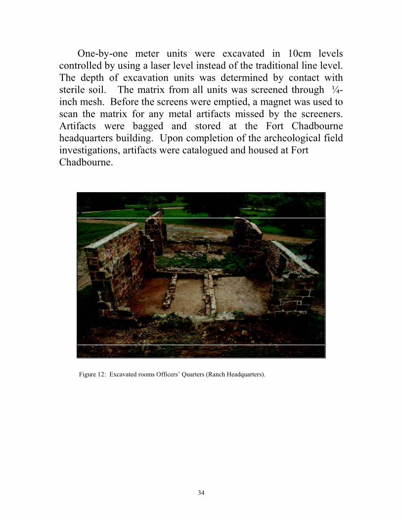
One-by-one meter units were excavated in 10cm levels controlled by using a laser level instead of the traditional line level. The depth of excavation units was determined by contact with sterile soil. The matrix from all units was screened through ¼- inch mesh. Before the screens were emptied, a magnet was used to scan the matrix for any metal artifacts missed by the screeners. Artifacts were bagged and stored at the Fort Chadbourne headquarters building. Upon completion of the archeological field investigations, artifacts were catalogued and housed at Fort Chadbourne.
Figure 12: Excavated rooms Officers’ Quarters (Ranch Headquarters).
35
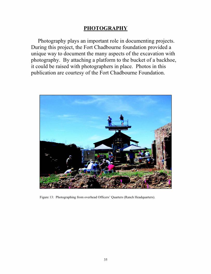
PHOTOGRAPHY
Photography plays an important role in documenting projects. During this project, the Fort Chadbourne foundation provided a unique way to document the many aspects of the excavation with photography. By attaching a platform to the bucket of a backhoe, it could be raised with photographers in place. Photos in this publication are courtesy of the Fort Chadbourne Foundation.
Figure 13: Photographing from overhead Officers’ Quarters (Ranch Headquarters).
36
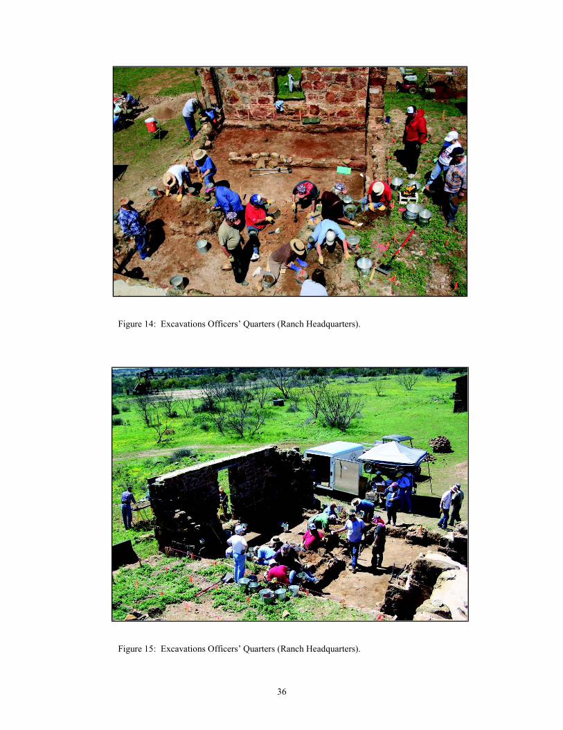
Figure 14: Excavations Officers’ Quarters (Ranch Headquarters).
Figure 15: Excavations Officers’ Quarters (Ranch Headquarters).
37
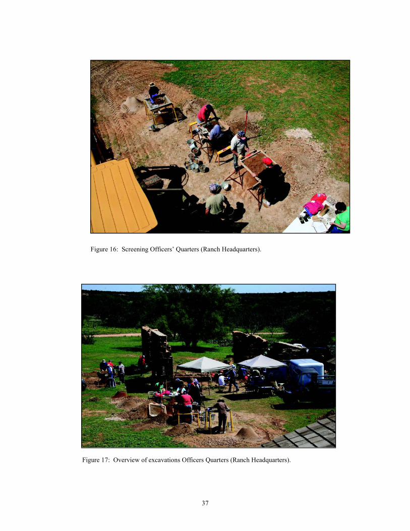
Figure 16: Screening Officers’ Quarters (Ranch Headquarters).
Figure 17: Overview of excavations Officers Quarters (Ranch Headquarters).
38
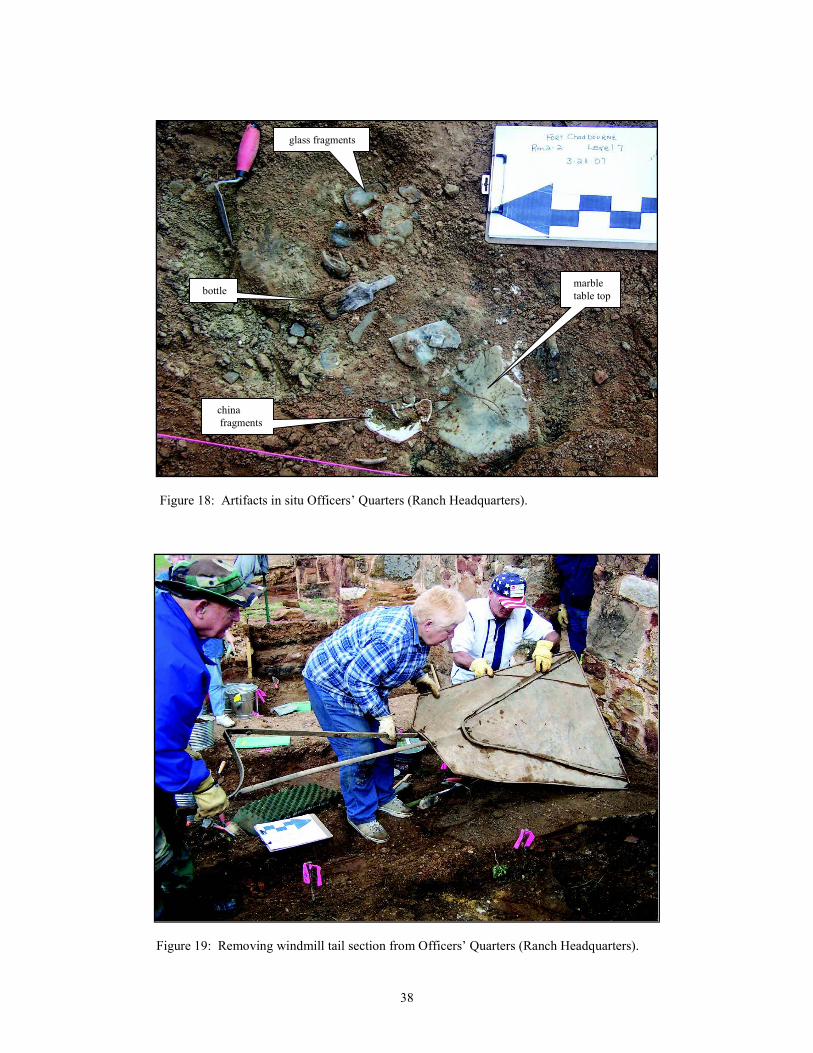
Figure 18: Artifacts in situ Officers’ Quarters (Ranch Headquarters).
Figure 19: Removing windmill tail section from Officers’ Quarters (Ranch Headquarters).
marble
table top
china
fragments
bottle
glass fragments
39
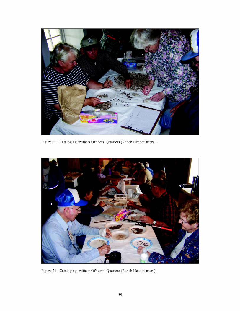
Figure 20: Cataloging artifacts Officers’ Quarters (Ranch Headquarters).
Figure 21: Cataloging artifacts Officers’ Quarters (Ranch Headquarters).
40
RESULTS OF THE ARCHEOLOGICAL
INVESTIGATIONS
BUILDING DIMENSIONS
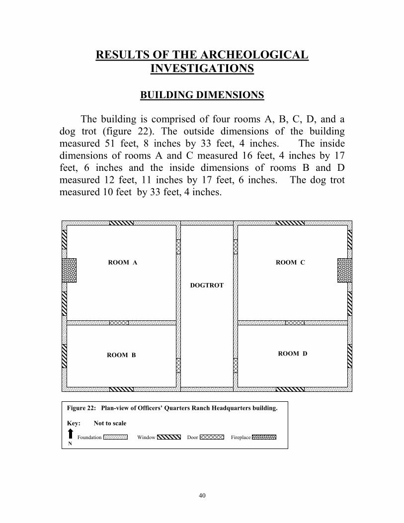
The building is comprised of four rooms A, B, C, D, and a dog trot (figure 22). The outside dimensions of the building measured 51 feet, 8 inches by 33 feet, 4 inches. The inside dimensions of rooms A and C measured 16 feet, 4 inches by 17 feet, 6 inches and the inside dimensions of rooms B and D measured 12 feet, 11 inches by 17 feet, 6 inches. The dog trot measured 10 feet by 33 feet, 4 inches.
DOGTROT
ROOM A
ROOM B
ROOM C
ROOM D
Figure 22: Plan-view of Officers’ Quarters Ranch Headquarters building.
Key: Not to scale
Foundation Window Door Fireplace
N
41
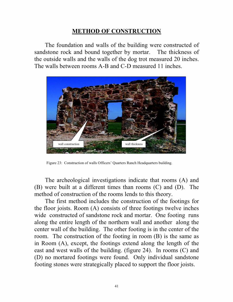
METHOD OF CONSTRUCTION The foundation and walls of the building were constructed of sandstone rock and bound together by mortar. The thickness of the outside walls and the walls of the dog trot measured 20 inches. The walls between rooms A-B and C-D measured 11 inches.
Figure 23: Construction of walls Officers’ Quarters Ranch Headquarters building.
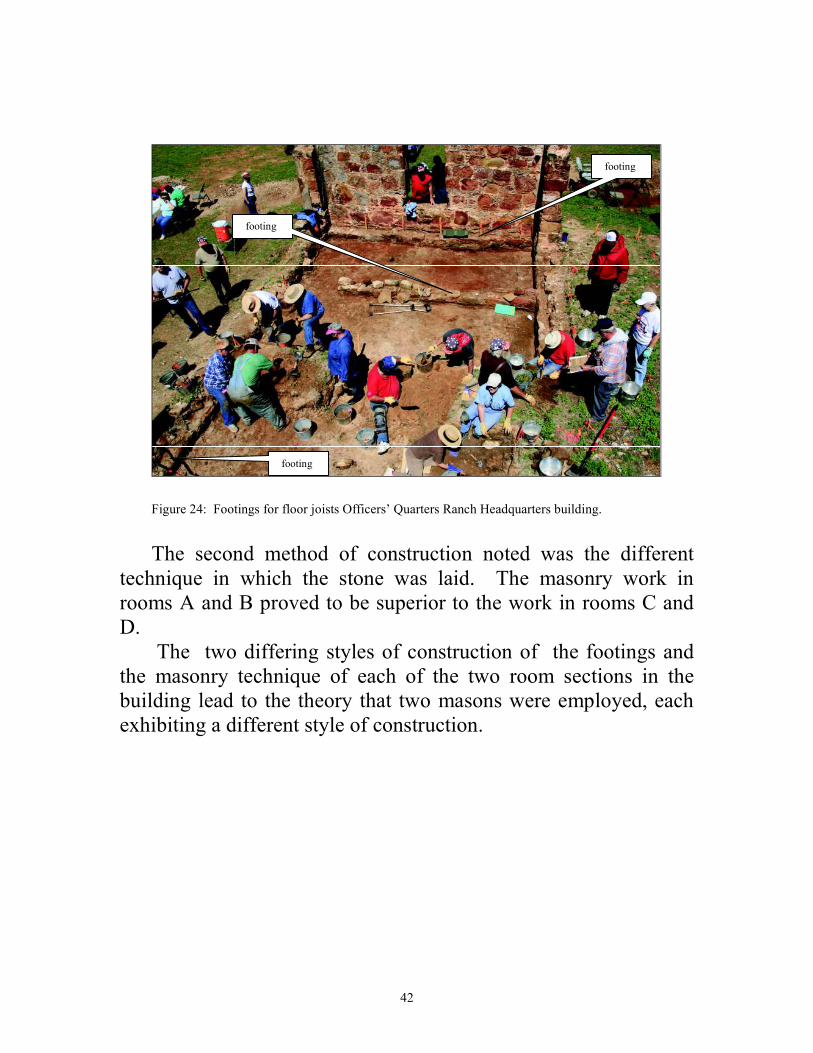
The archeological investigations indicate that rooms (A) and (B) were built at a different times than rooms (C) and (D). The method of construction of the rooms lends to this theory. The first method includes the construction of the footings for the floor joists. Room (A) consists of three footings twelve inches wide constructed of sandstone rock and mortar. One footing runs along the entire length of the northern wall and another along the center wall of the building. The other footing is in the center of the room. The construction of the footing in room (B) is the same as in Room (A), except, the footings extend along the length of the east and west walls of the building. (figure 24). In rooms (C) and (D) no mortared footings were found. Only individual sandstone footing stones were strategically placed to support the floor joists.
wall construction wall thickness
42
Figure 24: Footings for floor joists Officers’ Quarters Ranch Headquarters building.
The second method of construction noted was the different technique in which the stone was laid. The masonry work in rooms A and B proved to be superior to the work in rooms C and D. The two differing styles of construction of the footings and the masonry technique of each of the two room sections in the building lead to the theory that two masons were employed, each exhibiting a different style of construction.
footing
footing
footing
43
LOCATION OF WINDOWS, DOORS AND FIREPLACES
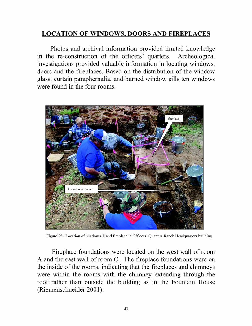
Photos and archival information provided limited knowledge in the re-construction of the officers’ quarters. Archeological investigations provided valuable information in locating windows, doors and the fireplaces. Based on the distribution of the window glass, curtain paraphernalia, and burned window sills ten windows were found in the four rooms.
Figure 25: Location of window sill and fireplace in Officers’ Quarters Ranch Headquarters building.
Fireplace foundations were located on the west wall of room A and the east wall of room C. The fireplace foundations were on the inside of the rooms, indicating that the fireplaces and chimneys were within the rooms with the chimney extending through the roof rather than outside the building as in the Fountain House (Riemenschneider 2001).
fireplace
burned window sill
44
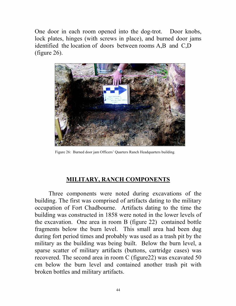
One door in each room opened into the dog-trot. Door knobs, lock plates, hinges (with screws in place), and burned door jams identified the location of doors between rooms A,B and C,D (figure 26).
Figure 26: Burned door jam Officers’ Quarters Ranch Headquarters building.
MILITARY, RANCH COMPONENTS
Three components were noted during excavations of the building. The first was comprised of artifacts dating to the military occupation of Fort Chadbourne. Artifacts dating to the time the building was constructed in 1858 were noted in the lower levels of the excavation. One area in room B (figure 22) contained bottle fragments below the burn level. This small area had been dug during fort period times and probably was used as a trash pit by the military as the building was being built. Below the burn level, a sparse scatter of military artifacts (buttons, cartridge cases) was recovered. The second area in room C (figure22) was excavated 50 cm below the burn level and contained another trash pit with broken bottles and military artifacts.
45
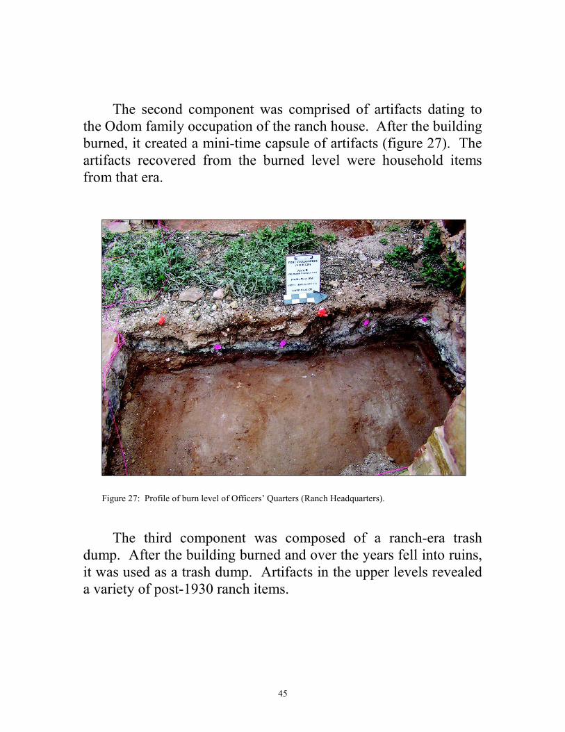
The second component was comprised of artifacts dating to the Odom family occupation of the ranch house. After the building burned, it created a mini-time capsule of artifacts (figure 27). The artifacts recovered from the burned level were household items from that era.
Figure 27: Profile of burn level of Officers’ Quarters (Ranch Headquarters).
The third component was composed of a ranch-era trash dump. After the building burned and over the years fell into ruins, it was used as a trash dump. Artifacts in the upper levels revealed a variety of post-1930 ranch items.
46
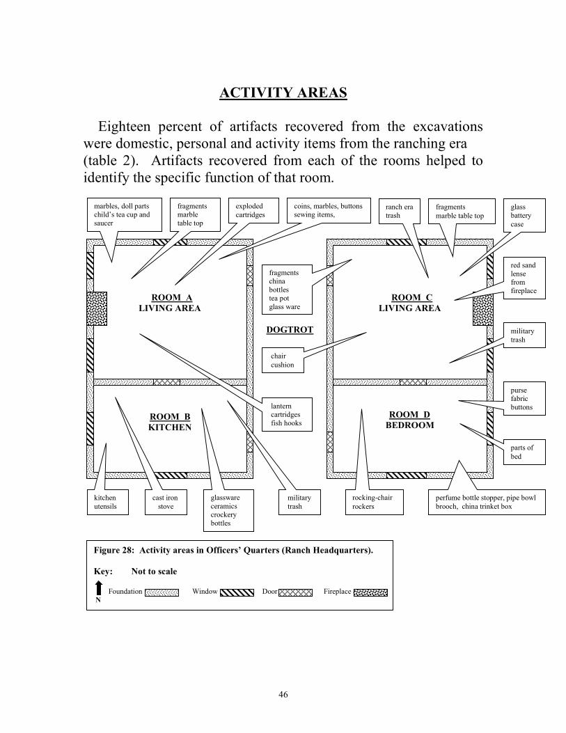
ACTIVITY AREAS
Eighteen percent of artifacts recovered from the excavations were domestic, personal and activity items from the ranching era (table 2). Artifacts recovered from each of the rooms helped to identify the specific function of that room.
DOGTROT
ROOM A
LIVING AREA
ROOM B
KITCHEN
ROOM C
LIVING AREA
ROOM D
BEDROOM
Figure 28: Activity areas in Officers’ Quarters (Ranch Headquarters).
Key: Not to scale
Foundation Window Door Fireplace N
cast iron
stove
military
trash
kitchen
utensils
marbles, doll parts child’s tea cup and saucer
fragments china bottles tea pot glass ware
fragments
marble table top
ranch era trash
military
trash
coins, marbles, buttons sewing items, cartridges
parts of
bed
rocking-chair
rockers
chair
cushion
purse fabric buttons
red sand lense from fireplace
lantern cartridges fish hooks
glassware ceramics crockery bottles
exploded
cartridges
fragments marble table top
glass battery
case
perfume bottle stopper, pipe bowl
brooch, china trinket box
47
BUILDING RESHINGLED
Nails, used in the construction of buildings, are excellent time markers for 19th and 20th century buildings. Machine-headed cut nails (square) were perfected by circa 1835. Such nails dominated the building construction until circa 1890. Wire nails (round) rapidly replaced cut nails after circa 1890 (Center for Historic Preservation, 2008). When the building was built circa 1860, cut nails would have been used in shingling the roof. Archeological findings reveal a large amount of wire (round) shingle nails present within the matrix. These findings indicate that the building had been re-shingled sometime between about 1890 and prior to the fire.
ARTIFACTS RECOVERED
The archeological investigation recovered 136,673 artifacts from the excavation of 135 units. The artifacts were categorized according to use and the system used was similar to that used by Roland in her archeological investigation of an enlisted men’s barracks at Fort Concho National Historic Landmark (Roland 2000). Six categories were used in this report to describe the artifacts recovered. These categories include: activities, domestic, personal, workshop, construction, and miscellaneous artifacts.
Some of the categories were grouped into more specific use categories and will be discussed under each of the category headings. The following chart breaks down the artifacts in each category by number and percentage.
48
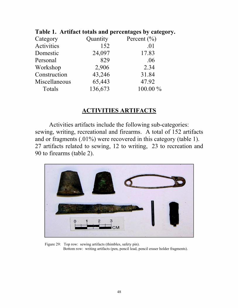
Table 1. Artifact totals and percentages by category.
Category Quantity Percent (%) Activities 152 .01 Domestic 24,097 17.83 Personal 829 .06 Workshop 2,906 2.34 Construction 43,246 31.84 Miscellaneous 65,443 47.92 Totals 136,673 100.00 %
ACTIVITIES ARTIFACTS
Activities artifacts include the following sub-categories: sewing, writing, recreational and firearms. A total of 152 artifacts and or fragments (.01%) were recovered in this category (table 1). 27 artifacts related to sewing, 12 to writing, 23 to recreation and 90 to firearms (table 2).
Figure 29: Top row: sewing artifacts (thimbles, safety pin). Bottom row: writing artifacts (pen, pencil lead, pencil eraser holder fragments).
49
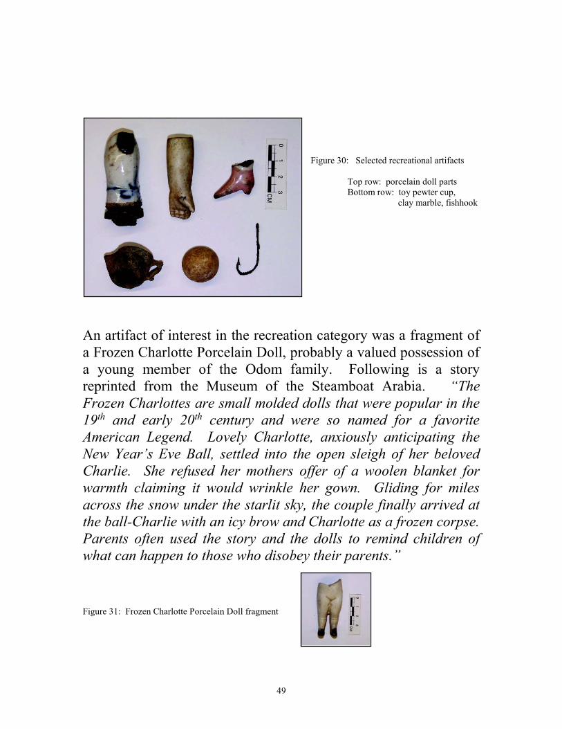
Figure 30: Selected recreational artifacts Top row: porcelain doll parts Bottom row: toy pewter cup, clay marble, fishhook
An artifact of interest in the recreation category was a fragment of a Frozen Charlotte Porcelain Doll, probably a valued possession of a young member of the Odom family. Following is a story reprinted from the Museum of the Steamboat Arabia. “The
Frozen Charlottes are small molded dolls that were popular in the
19th and early 20th century and were so named for a favorite
American Legend. Lovely Charlotte, anxiously anticipating the
New Year’s Eve Ball, settled into the open sleigh of her beloved
Charlie. She refused her mothers offer of a woolen blanket for
warmth claiming it would wrinkle her gown. Gliding for miles
across the snow under the starlit sky, the couple finally arrived at
the ball-Charlie with an icy brow and Charlotte as a frozen corpse.
Parents often used the story and the dolls to remind children of
what can happen to those who disobey their parents.” Figure 31: Frozen Charlotte Porcelain Doll fragment
50
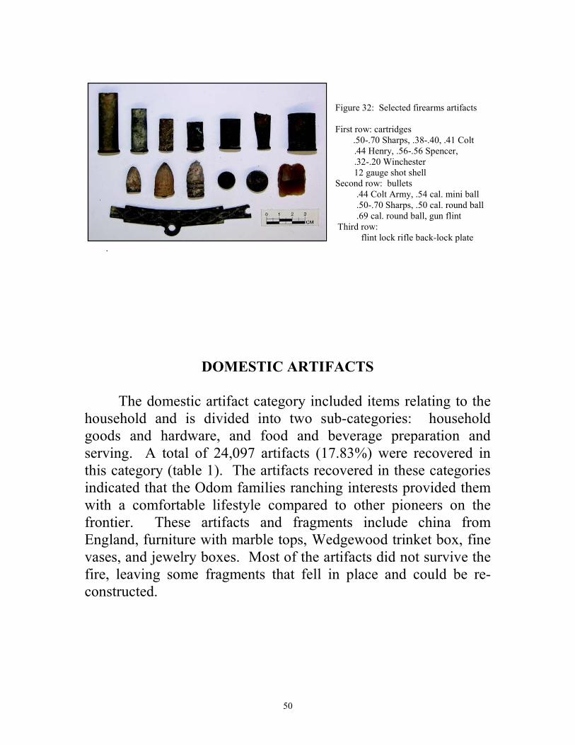
Figure 32: Selected firearms artifacts First row: cartridges .50-.70 Sharps, .38-.40, .41 Colt .44 Henry, .56-.56 Spencer, .32-.20 Winchester 12 gauge shot shell Second row: bullets .44 Colt Army, .54 cal. mini ball .50-.70 Sharps, .50 cal. round ball .69 cal. round ball, gun flint Third row: flint lock rifle back-lock plate
.
DOMESTIC ARTIFACTS
The domestic artifact category included items relating to the household and is divided into two sub-categories: household goods and hardware, and food and beverage preparation and serving. A total of 24,097 artifacts (17.83%) were recovered in this category (table 1). The artifacts recovered in these categories indicated that the Odom families ranching interests provided them with a comfortable lifestyle compared to other pioneers on the frontier. These artifacts and fragments include china from England, furniture with marble tops, Wedgewood trinket box, fine vases, and jewelry boxes. Most of the artifacts did not survive the fire, leaving some fragments that fell in place and could be re-constructed.
51
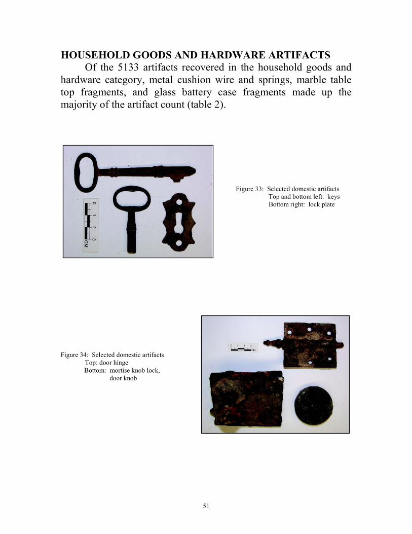
HOUSEHOLD GOODS AND HARDWARE ARTIFACTS
Of the 5133 artifacts recovered in the household goods and hardware category, metal cushion wire and springs, marble table top fragments, and glass battery case fragments made up the majority of the artifact count (table 2).
Figure 33: Selected domestic artifacts Top and bottom left: keys Bottom right: lock plate
Figure 34: Selected domestic artifacts Top: door hinge Bottom: mortise knob lock, door knob
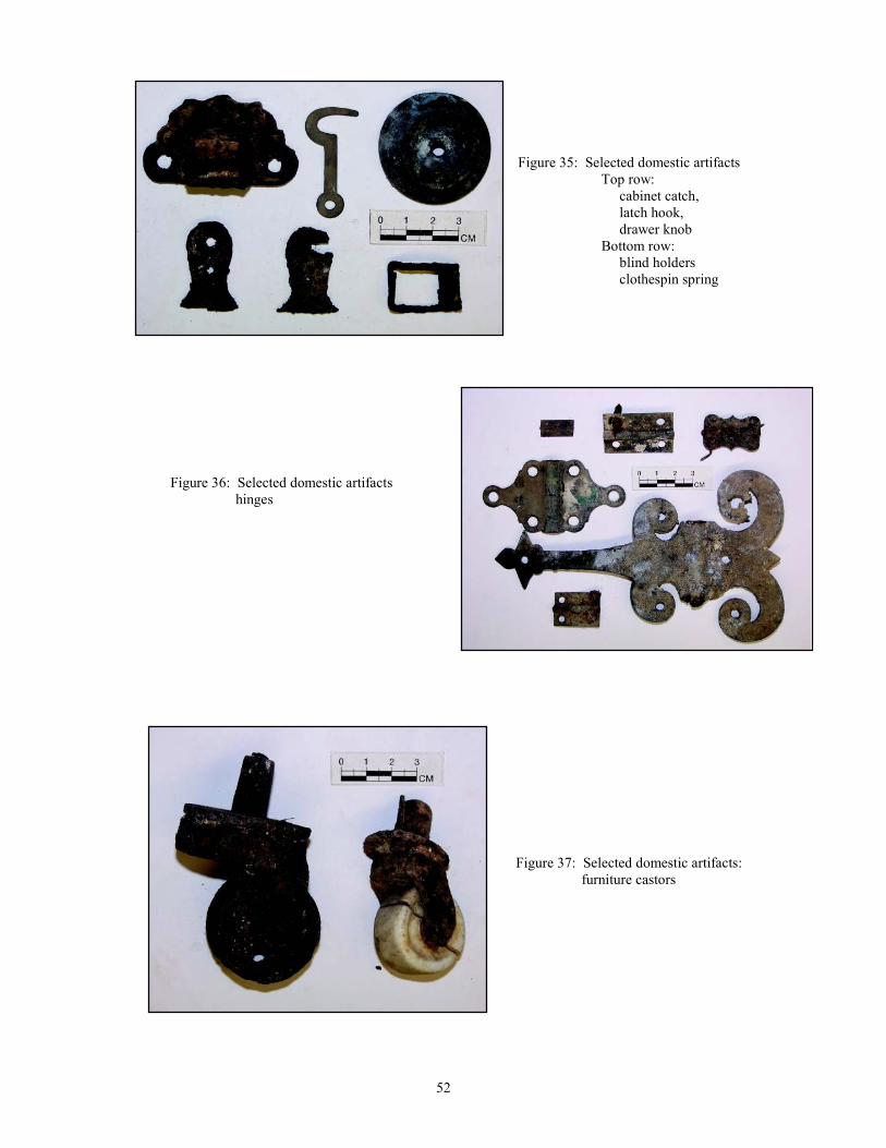
52
Figure 35: Selected domestic artifacts Top row: cabinet catch, latch hook, drawer knob Bottom row: blind holders clothespin spring
Figure 36: Selected domestic artifacts hinges
Figure 37: Selected domestic artifacts: furniture castors
53
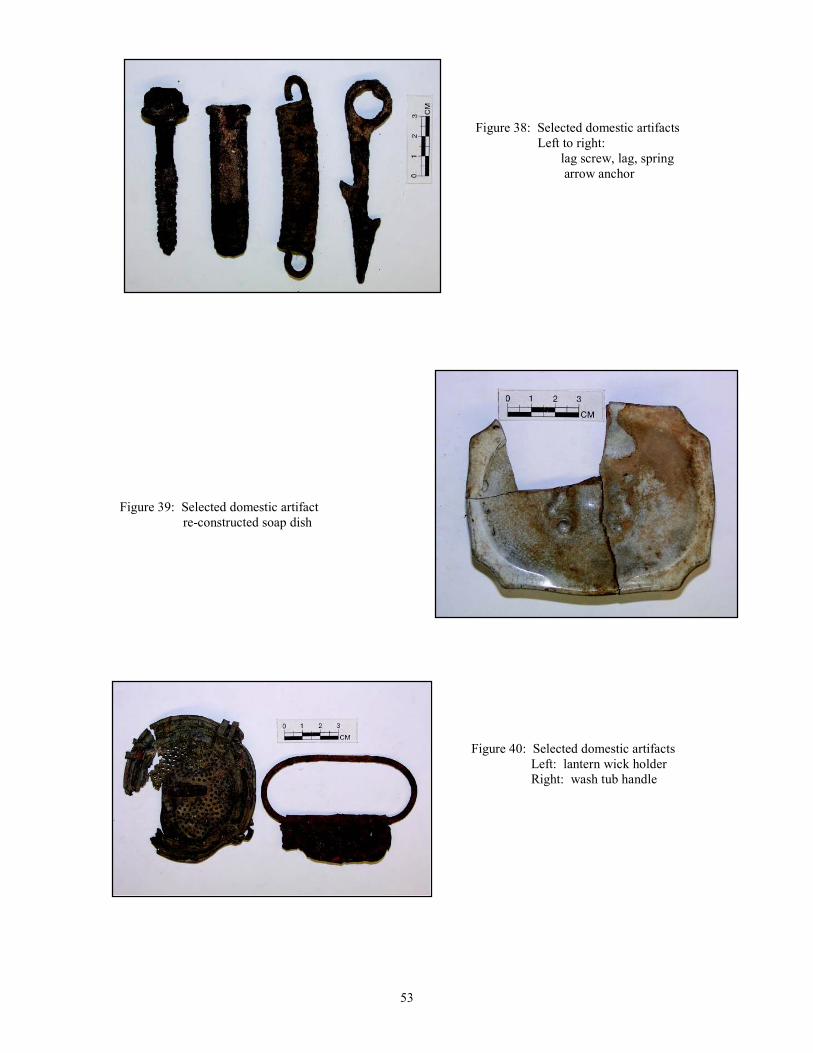
Figure 38: Selected domestic artifacts Left to right: lag screw, lag, spring arrow anchor
Figure 39: Selected domestic artifact re-constructed soap dish
Figure 40: Selected domestic artifacts Left: lantern wick holder Right: wash tub handle
54
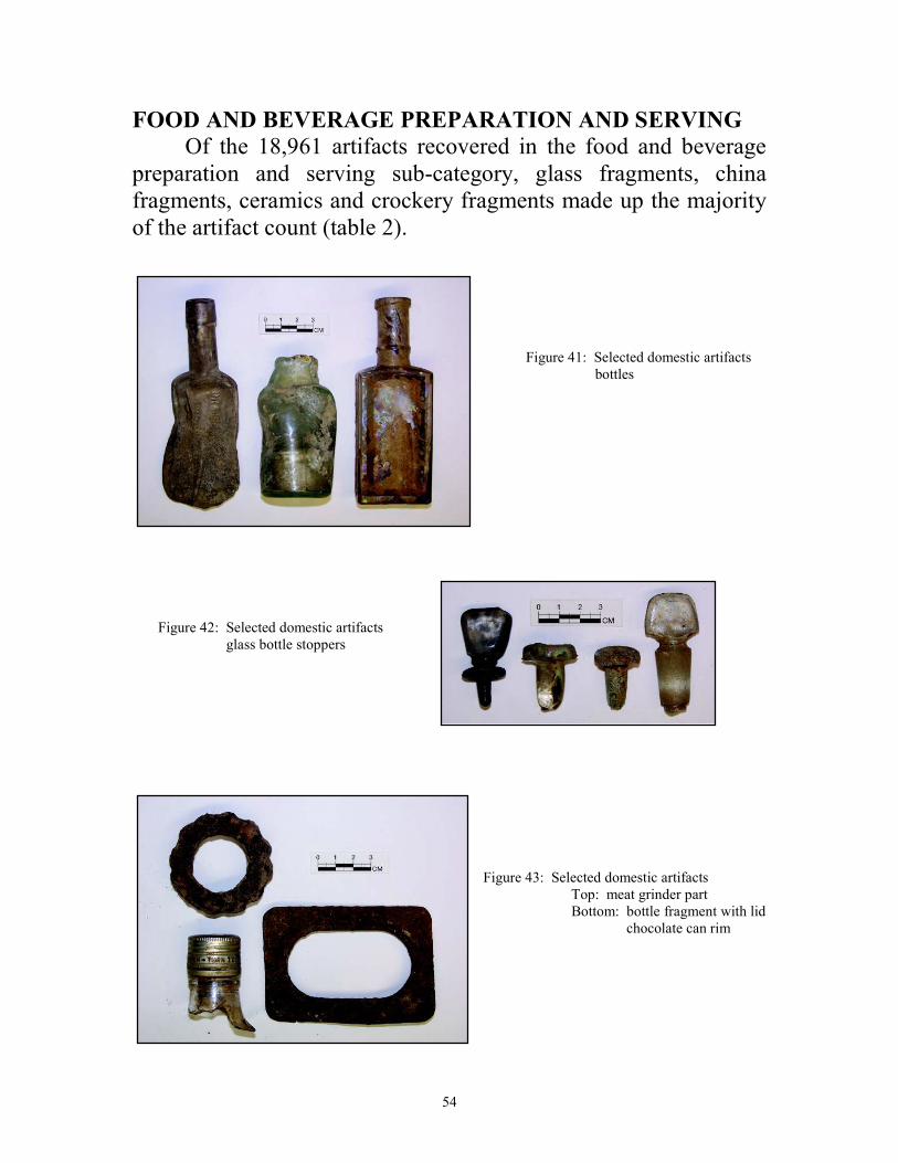
FOOD AND BEVERAGE PREPARATION AND SERVING
Of the 18,961 artifacts recovered in the food and beverage preparation and serving sub-category, glass fragments, china fragments, ceramics and crockery fragments made up the majority of the artifact count (table 2).
Figure 41: Selected domestic artifacts bottles
Figure 42: Selected domestic artifacts glass bottle stoppers
Figure 43: Selected domestic artifacts Top: meat grinder part Bottom: bottle fragment with lid chocolate can rim
55
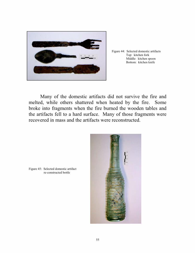
Figure 44: Selected domestic artifacts Top: kitchen fork Middle: kitchen spoon Bottom: kitchen knife
Many of the domestic artifacts did not survive the fire and melted, while others shattered when heated by the fire. Some broke into fragments when the fire burned the wooden tables and the artifacts fell to a hard surface. Many of those fragments were recovered in mass and the artifacts were reconstructed. Figure 45: Selected domestic artifact re-constructed bottle
56
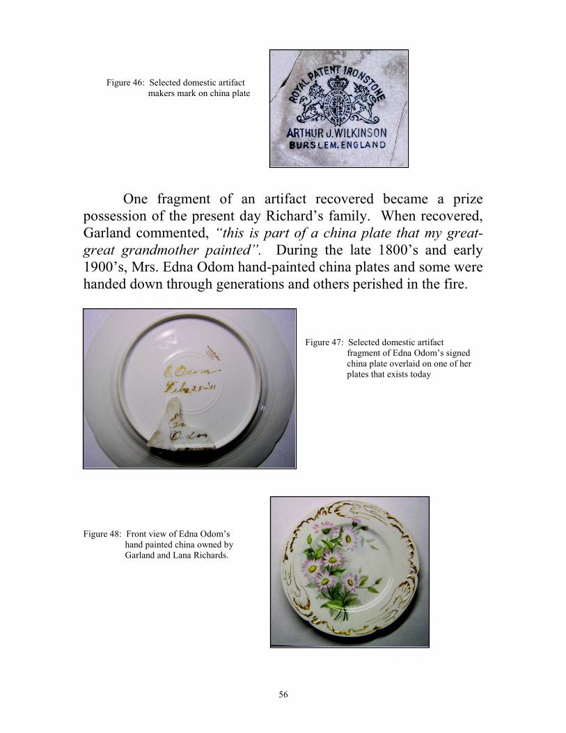
Figure 46: Selected domestic artifact makers mark on china plate
One fragment of an artifact recovered became a prize possession of the present day Richard’s family. When recovered, Garland commented, “this is part of a china plate that my great-
great grandmother painted”. During the late 1800’s and early 1900’s, Mrs. Edna Odom hand-painted china plates and some were handed down through generations and others perished in the fire.
Figure 47: Selected domestic artifact fragment of Edna Odom’s signed china plate overlaid on one of her plates that exists today
Figure 48: Front view of Edna Odom’s hand painted china owned by Garland and Lana Richards.

57
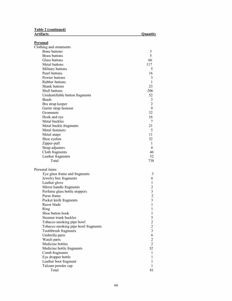
PERSONAL ARTIFACTS
Personal artifacts include three subcategories, clothing and ornaments, personal items and coins. A total of 829 artifacts and or fragments (.06%) were recovered in this category (table 1).
CLOTHING AND ORNAMENTS
Of the artifacts recovered in this sub-category 738 related to clothing and ornaments (table 2). The majority of these artifacts were buttons. Many of these buttons were located in and around the burned fragments of a purse found in the bedroom. Two of the military buttons were recovered from the military component, and the others were within the burned ranch-era level and were probably collected from the grounds by the Odom family.
Figure 49: Selected personal artifacts Top row: glass buttons Middle row: glass buttons Bottom row: metal buttons
Figure 50: Selected personal artifacts Top row: shell buttons Bottom row: metal buttons
58
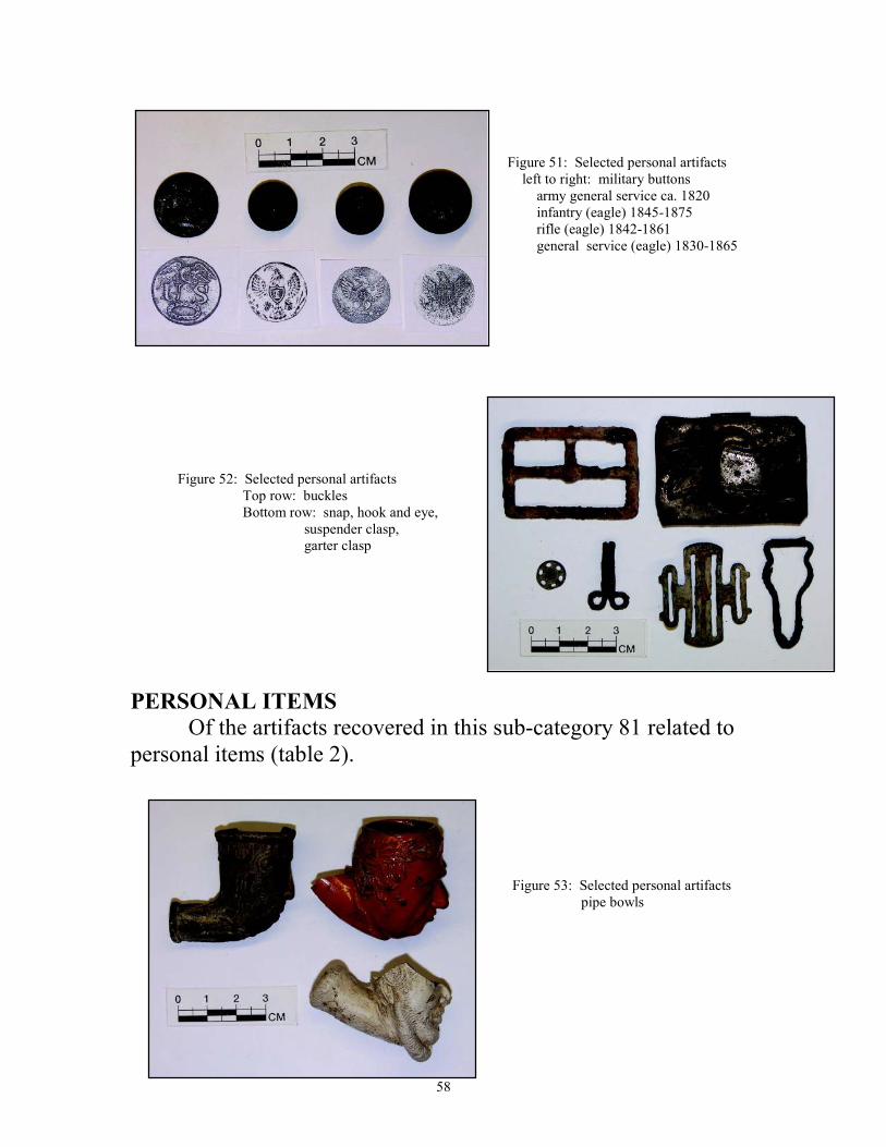
Figure 51: Selected personal artifacts left to right: military buttons army general service ca. 1820 infantry (eagle) 1845-1875 rifle (eagle) 1842-1861 general service (eagle) 1830-1865
Figure 52: Selected personal artifacts Top row: buckles Bottom row: snap, hook and eye, suspender clasp, garter clasp
PERSONAL ITEMS
Of the artifacts recovered in this sub-category 81 related to personal items (table 2).
Figure 53: Selected personal artifacts pipe bowls
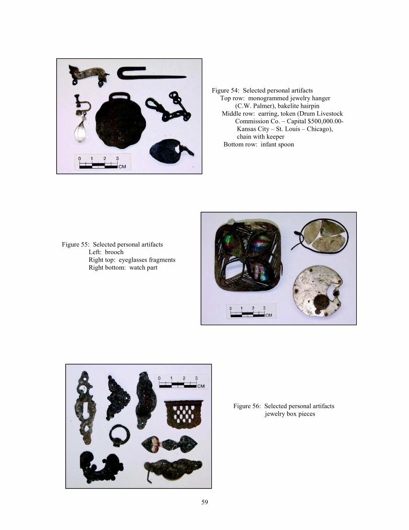
59
Figure 54: Selected personal artifacts Top row: monogrammed jewelry hanger (C.W. Palmer), bakelite hairpin Middle row: earring, token (Drum Livestock Commission Co. – Capital $500,000.00- Kansas City – St. Louis – Chicago), chain with keeper Bottom row: infant spoon
Figure 55: Selected personal artifacts Left: brooch Right top: eyeglasses fragments Right bottom: watch part
Figure 56: Selected personal artifacts jewelry box pieces
60
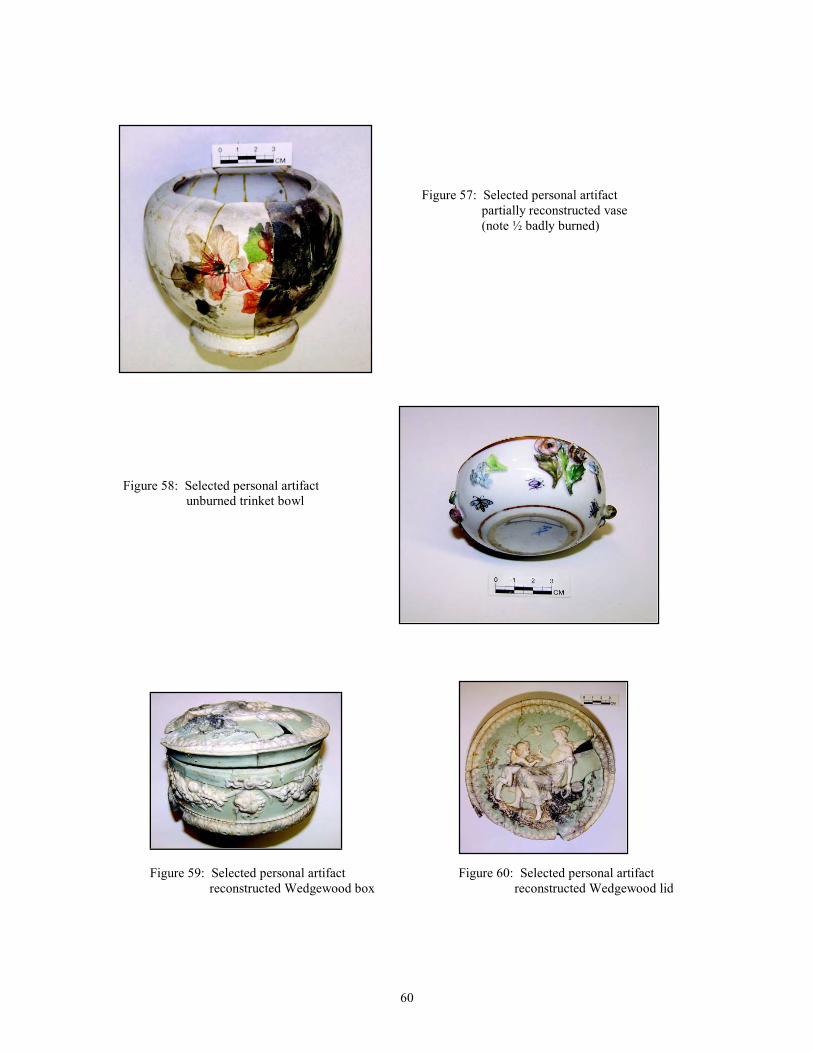
Figure 57: Selected personal artifact partially reconstructed vase (note ½ badly burned)
Figure 58: Selected personal artifact unburned trinket bowl
Figure 59: Selected personal artifact Figure 60: Selected personal artifact reconstructed Wedgewood box reconstructed Wedgewood lid
61
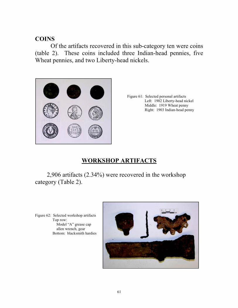
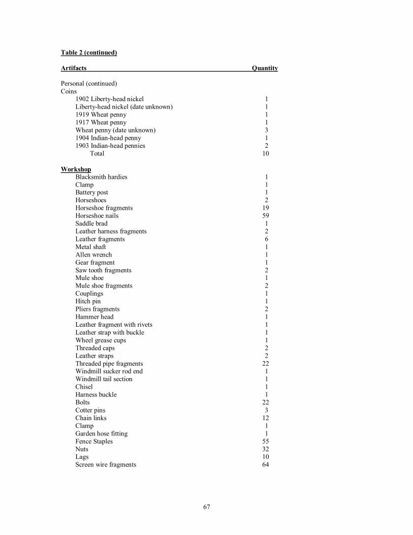
COINS
Of the artifacts recovered in this sub-category ten were coins (table 2). These coins included three Indian-head pennies, five Wheat pennies, and two Liberty-head nickels.
Figure 61: Selected personal artifacts Left: 1902 Liberty-head nickel Middle: 1919 Wheat penny Right: 1903 Indian-head penny
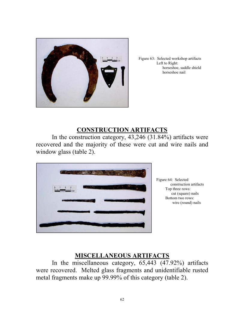
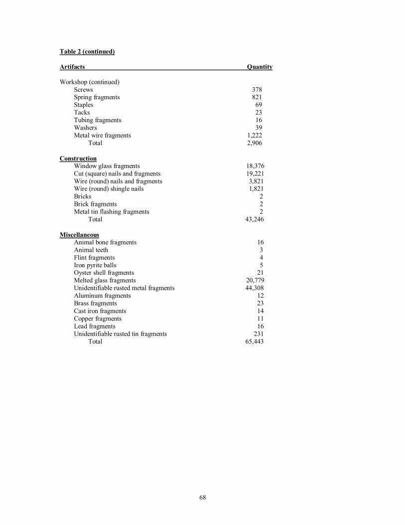
WORKSHOP ARTIFACTS
2,906 artifacts (2.34%) were recovered in the workshop category (Table 2). Figure 62: Selected workshop artifacts Top row: Model “A” grease cap allen wrench, gear Bottom: blacksmith hardies
62
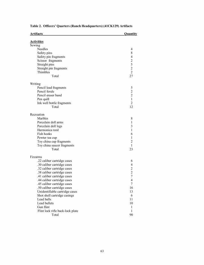
Figure 63: Selected workshop artifacts Left to Right: horseshoe, saddle shield horseshoe nail
CONSTRUCTION ARTIFACTS
In the construction category, 43,246 (31.84%) artifacts were recovered and the majority of these were cut and wire nails and window glass (table 2).
Figure 64: Selected construction artifacts Top three rows: cut (square) nails Bottom two rows: wire (round) nails
MISCELLANEOUS ARTIFACTS
In the miscellaneous category, 65,443 (47.92%) artifacts were recovered. Melted glass fragments and unidentifiable rusted metal fragments make up 99.99% of this category (table 2).
63
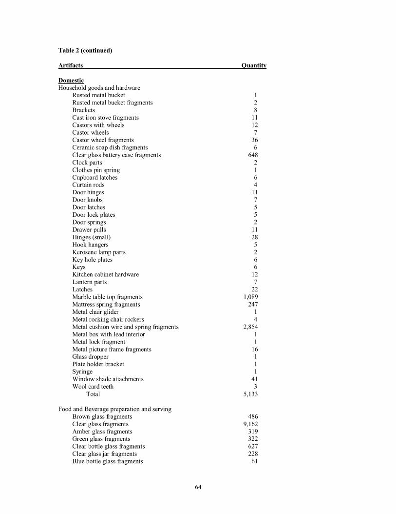
Table 2. Officers’ Quarters (Ranch Headquarters) (41CK129) Artifacts
Artifacts_________________________________________________Quantity
Activities
Sewing Needles 4 Safety pins 8 Safety pin fragments 4 Scissor fragments 2 Straight pins 5 Straight pin fragments 2 Thimbles 2 Total 27
Writing Pencil lead fragments 5 Pencil ferule 2 Pencil eraser band 2 Pen quill 1 Ink well bottle fragments 2 Total 12 Recreation Marbles 8 Porcelain doll arms 1 Porcelain doll legs 3 Harmonica reed 1 Fish hooks 6 Pewter tea cup 1 Toy china cup fragments 2 Toy china saucer fragments 1 Total 23 Firearms .22 caliber cartridge cases 6 .30 caliber cartridge cases 4 .32 caliber cartridge cases 2 .38 caliber cartridge cases 2 .41 caliber cartridge cases 7 .44 caliber cartridge cases 4 .45 caliber cartridge cases 7 .50 caliber cartridge cases 16 Unidentifiable cartridge cases 13 Shot shell cartridge casings 6 Lead balls 11 Lead bullets 10 Gun flint 1 Flint lock rifle back-lock plate 1 Total 90
64
Table 2 (continued)
Artifacts Quantity
Domestic
Household goods and hardware Rusted metal bucket 1 Rusted metal bucket fragments 2 Brackets 8 Cast iron stove fragments 11 Castors with wheels 12 Castor wheels 7 Castor wheel fragments 36 Ceramic soap dish fragments 6 Clear glass battery case fragments 648 Clock parts 2 Clothes pin spring 1 Cupboard latches 6 Curtain rods 4 Door hinges 11 Door knobs 7 Door latches 5 Door lock plates 5 Door springs 2 Drawer pulls 11 Hinges (small) 28 Hook hangers 5 Kerosene lamp parts 2 Key hole plates 6 Keys 6 Kitchen cabinet hardware 12 Lantern parts 7 Latches 22 Marble table top fragments 1,089 Mattress spring fragments 247 Metal chair glider 1 Metal rocking chair rockers 4 Metal cushion wire and spring fragments 2,854 Metal box with lead interior 1 Metal lock fragment 1 Metal picture frame fragments 16 Glass dropper 1 Plate holder bracket 1 Syringe 1 Window shade attachments 41 Wool card teeth 3 Total 5,133 Food and Beverage preparation and serving Brown glass fragments 486 Clear glass fragments 9,162 Amber glass fragments 319 Green glass fragments 322 Clear bottle glass fragments 627 Clear glass jar fragments 228 Blue bottle glass fragments 61
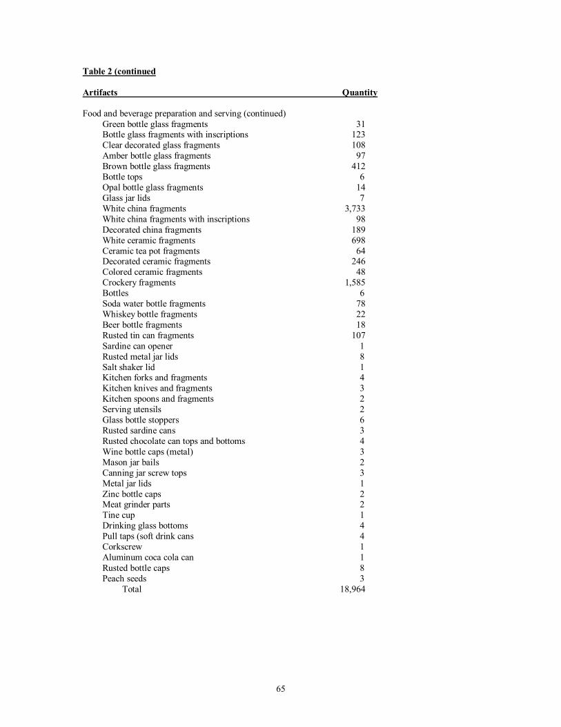
65
Table 2 (continued
Artifacts Quantity
Food and beverage preparation and serving (continued)
Green bottle glass fragments 31 Bottle glass fragments with inscriptions 123 Clear decorated glass fragments 108 Amber bottle glass fragments 97 Brown bottle glass fragments 412 Bottle tops 6 Opal bottle glass fragments 14 Glass jar lids 7 White china fragments 3,733 White china fragments with inscriptions 98 Decorated china fragments 189 White ceramic fragments 698 Ceramic tea pot fragments 64 Decorated ceramic fragments 246 Colored ceramic fragments 48 Crockery fragments 1,585 Bottles 6 Soda water bottle fragments 78 Whiskey bottle fragments 22 Beer bottle fragments 18 Rusted tin can fragments 107 Sardine can opener 1 Rusted metal jar lids 8 Salt shaker lid 1 Kitchen forks and fragments 4 Kitchen knives and fragments 3 Kitchen spoons and fragments 2 Serving utensils 2
Glass bottle stoppers 6 Rusted sardine cans 3 Rusted chocolate can tops and bottoms 4 Wine bottle caps (metal) 3 Mason jar bails 2 Canning jar screw tops 3 Metal jar lids 1 Zinc bottle caps 2 Meat grinder parts 2 Tine cup 1 Drinking glass bottoms 4 Pull taps (soft drink cans 4 Corkscrew 1 Aluminum coca cola can 1 Rusted bottle caps 8 Peach seeds 3 Total 18,964
66
Table 2 (continued)
Artifacts Quantity
Personal
Clothing and ornaments Bone buttons 3 Brass buttons 5 Glass buttons 66 Metal buttons 117 Military buttons 5 Pearl buttons 16 Pewter buttons 3 Rubber buttons 1 Shank buttons 23 Shell buttons 206 Unidentifiable button fragments 52 Beads 3 Bra strap keeper 2 Garter strap fastener 9 Grommets 32 Hook and eye 16 Metal buckles 7 Metal buckle fragments 21 Metal fasteners 5 Metal snaps 11 Shoe eyelets 32 Zipper-pull 1 Strap adjusters 4 Cloth fragments 46 Leather fragments 52 Total 738 Personal items Eye glass frame and fragments 3 Jewelry box fragments 6 Leather glove 1 Mirror handle fragments 2 Perfume glass bottle stoppers 3
Purse frame 2 Pocket knife fragments 3 Razor blade 1 Ring 1 Shoe button hook 1 Steamer trunk buckles 5 Tobacco smoking pipe bowl 2 Tobacco smoking pipe bowl fragments 2 Toothbrush fragments 3 Umbrella parts 6 Watch parts 2 Medicine bottles 2 Medicine bottle fragments 32 Comb fragments 1 Eye dropper bottle 1 Leather boot fragment 1 Talcum powder cap 1 Total 81
67
Table 2 (continued)
Artifacts Quantity
Personal (continued) Coins 1902 Liberty-head nickel 1 Liberty-head nickel (date unknown) 1 1919 Wheat penny 1 1917 Wheat penny 1 Wheat penny (date unknown) 3 1904 Indian-head penny 1 1903 Indian-head pennies 2 Total 10
Workshop
Blacksmith hardies 1 Clamp 1 Battery post 1 Horseshoes 2 Horseshoe fragments 19 Horseshoe nails 59 Saddle brad 1 Leather harness fragments 2 Leather fragments 6 Metal shaft 1 Allen wrench 1 Gear fragment 1 Saw tooth fragments 2 Mule shoe 1 Mule shoe fragments 2 Couplings 1 Hitch pin 1 Pliers fragments 2 Hammer head 1 Leather fragment with rivets 1 Leather strap with buckle 1 Wheel grease cups 1 Threaded caps 2 Leather straps 2 Threaded pipe fragments 22 Windmill sucker rod end 1 Windmill tail section 1 Chisel 1 Harness buckle 1 Bolts 22 Cotter pins 3 Chain links 12 Clamp 1 Garden hose fitting 1 Fence Staples 55 Nuts 32 Lags 10 Screen wire fragments 64
68
Table 2 (continued)
Artifacts Quantity
Workshop (continued) Screws 378 Spring fragments 821 Staples 69 Tacks 23 Tubing fragments 16 Washers 39 Metal wire fragments 1,222 Total 2,906
Construction
Window glass fragments 18,376 Cut (square) nails and fragments 19,221 Wire (round) nails and fragments 3,821 Wire (round) shingle nails 1,821 Bricks 2 Brick fragments 2 Metal tin flashing fragments 2 Total 43,246
Miscellaneous
Animal bone fragments 16 Animal teeth 3 Flint fragments 4 Iron pyrite balls 5 Oyster shell fragments 21 Melted glass fragments 20,779 Unidentifiable rusted metal fragments 44,308 Aluminum fragments 12 Brass fragments 23 Cast iron fragments 14 Copper fragments 11 Lead fragments 16 Unidentifiable rusted tin fragments 231 Total 65,443
69
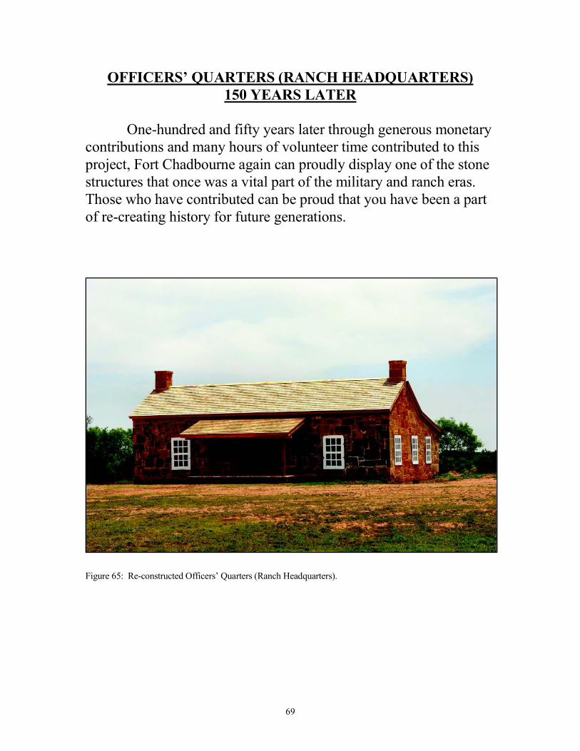
OFFICERS’ QUARTERS (RANCH HEADQUARTERS)
150 YEARS LATER
One-hundred and fifty years later through generous monetary contributions and many hours of volunteer time contributed to this project, Fort Chadbourne again can proudly display one of the stone structures that once was a vital part of the military and ranch eras. Those who have contributed can be proud that you have been a part of re-creating history for future generations.
Figure 65: Re-constructed Officers’ Quarters (Ranch Headquarters).
70
REFERENCES
Boyd, Douglas K.
2004 Archeological Investigations At Fort Chadbourne
And the Flat On Oak Creek, Coke County, Texas.
Texas Archeology Academy Report Prepared for the Texas Archeological Society.
Brown, Maureen, Zapata, Jose E., and Moses, Bruce K.
1998 Camp Elizabeth, Sterling County, Texas:
An Archeological and Archival Investigation of a
U.S. Army Subpost , and Evidence Supporting
Its Use by the Military and “Buffalo Soldiers”
Archeological Survey Report, No. 267 Center for Archaeological Research The University of Texas at San Antonio.
Bruckner, Jane Austin
2002 Grandmother Stories from the Heart of Texas
“Lucinda Milstead Odom” Eakin Press, Austin Texas.
Center for Historic Preservation
2008 Nail Chronology <http://histpres.mtsu.edu/histpres/SERVICE/naildating.htm> [ACCESSED February 2, 2008]
Freeman, Martha Doty
A History of Fort Chadbourne Coke County, Texas
The Fort Chadbourne Foundation Bronte, Texas.
71
Jenkins, Frank D, Stone, Claude Jr., Gregory Peggy H. 1975 Runnels County Pioneers, Bicentennial 1976 in
Ballinger
The Ballinger Bicentennial Commission R&R Reproduction Company 1026 North Fifth
Street Abilene, Texas 76904. Lederer, Robert 2008 Personal Communication Marks, Paula Mitchell
1989 Turn Your Eyes Toward Texas: Pioneers Sam and
Mary Maverick
Centennial Series of the Association of Former Students, Texas A&M University, Number 30, College Station, Texas: Texas A&M Press, ISBN 0890963800.
Marks, Paula Mitchell “Maverick, Samuel Augustus”. The Handbook of Texas
Online at <http://www.tshaonline.org/handbook/online> Articles/MM/fma84.htm/> [ACCESSED February 13, 200 2008.] Riemenschneider, Larry 2002 Archeological Investigations Fort Chadbourne
(41CK129) Officers’ Quarters (Fountain House)
Coke County, Texas
Fort Chadbourne Foundation, Bronte, Texas. Riemenschneider, Larry
2007 Archeological Investigation Fort Chadbourne
(41CK 129) Officers’ Quarters Coke County, Texas
Fort Chadbourne Foundation, Bronte Texas
72
Roland, Kathleen S. 1999 Enlisted Men’s Barracks 2 Restoration, Fort Concho
National Historic Landmark, San Angelo, Texas:
An Archeological Investigation
Fort Concho National Historic Landmark City of San Angelo, Texas.