fort halifax park master site plan
TRANSCRIPT

FORT HALIFAX PARK MASTER SITE PLAN
Prepared for: Halifax Township 214 North River Road Halifax, PA 17032 Prepared by: Larson Design Group 1000 Commerce Park Drive Suite 201 Williamsport, PA 17701 Telephone (570) 323-6603 Project No. 5844-004 November 2011

ACKNOWLEDGEMENTS
The Fort Halifax Park Master Site Plan was made possible by the following generous contributions.
This project was financed in part by a grant from the Community Conservation Partnerships Program, Keystone Recreation, Park and Conservation Fund, under the administration of the Pennsylvania Department of Conservation and Natural Resources, Bureau of Recreation and Conservation.
Additional funding and support for this project was provided by:
Dauphin County Commissioners
Halifax Township Supervisors
We gratefully acknowledge the following Study Committee members, whose commitment of time and dedication to the Fort Halifax Park Vision made this project possible:
Lauren Bitting-Ellis: Educator, Friends of Fort Halifax Park, Inc.
Trudy Bitting: Director, Halifax Area School Board; Halifax Historical Society Board of Directors
Robert Blosser: retired electrical engineer, former Director, Halifax Area School Board
Carl Dickson: Director, Dauphin County Parks and Recreation Department
James Eppley: Retired Engineer/Surveyor for the Pennsylvania Department of Conservation and Natural Resources, Bureau of Forestry, former Chairman of the Halifax Township Planning Commission, Friends of Fort Halifax Park, Inc.
Emory Eyster: retired Staff Director for the Pennsylvania State Educators Association
Robert Hassinger: Superintendent, Halifax Area School District
Rev. William Krenz: Pastor Emeritus of Halifax Lutheran Parish, Friends of Fort Halifax Park, Inc.
Nevin Maurer: resident and local historian
Mika Miller: family member of the Tobias Animal Farm; Proprietor of Green Acres Landscaping
Stephen Pancoe; Director of the Office of the Majority Caucus Administrator
Linda Ruff-Stopfel: Halifax Township Supervisor; retired educator, Friends of Fort Halifax Park, Inc.
Norma Shearer: retired educator; former Chairman of the Halifax Township Board of Supervisors, Friends of Fort Halifax Park, Inc.

TOC - 1
TABLE OF CONTENTS
DESCRIPTION
Acknowledgements
Table of Contents
Tab 1 Location Map
Introduction
Halifax Township Description ----------------------------------------------------------------------- 1-1
Fort Halifax Park - Site Description ----------------------------------------------------------------- 1-2
Regional Park System Context ---------------------------------------------------------------------- 1-6
Tab 2 Public Participation
Fort Halifax Park Study Committee ----------------------------------------------------------------- 2-1
Community Recreation Interest Survey ------------------------------------------------------------- 2-1
Key Person Interviews, Park Focus Groups and Public Meetings --------------------------- 2-6
Tab 3 Master Site Plan Development Process
Mission and Goals ------------------------------------------------------------------------------------ 3-1
Site Inventory -------------------------------------------------------------------------------------------- 3-2
Concept Plan ----------------------------------------------------------------------------------- Follows 3-3
Site Analysis ------------------------------------------------------------------------------------------- 3-12
Proposed Use Areas/Facilities (Potential activities, uses, support facilities) ------------ 3-20
Planned Elements and Site Features Matrix -------------------------------------------- Follows 3-21
Sketch Plan A --------------------------------------------------------------------------------- Follows 3-21
Sketch Plan B ---------------------------------------------------------------------------------- Follows 3-21
Fort Halifax Park Master Site Plan Narrative -------------------------------------------------- 3-23
Items Beyond the Scope of this Project---------------------------------------------------------- 3-30

TOC - 2
Fort Halifax Park Master Site Plan -------------------------------------------------------- Follows 3-35
Tab 4 Park Management Structure
Management Structure -------------------------------------------------------------------------------- 4-2
Tab 5 Financial Analysis
Phased Development Costs -------------------------------------------------------------------------- 5-1
Plan of Phase 1 Construction --------------------------------------------------------------- Follows 5-2
Plan of Overall Phasing ---------------------------------------------------------------------- Follows 5-2
Operating Budget and Revenue Projection ------------------------------------------------------ 5-7
Proposed Operating Budget Chart ------------------------------------------------------ Follows 5-12
Proposed Revenue Plan Chart ------------------------------------------------------------- Follows 5-12
Potential Partnerships -------------------------------------------------------------------------------- 5-13
Site Sustainability Resources ----------------------------------------------------------------------- 5-22
Appendix Community Recreation Interest Survey
Minutes of Public Meetings
Soils Map
USFWS Wetland Map
PNDI Notifications
The Remembrance Walk Concept
Example: Draft Intergovernmental Agreement of Cooperation (Generic)
Master Site Plan Rendering

TAB
1


SECTION 1 - 1
INTRODUCTION Halifax Township Description Photo credit: Halifax Township Website Halifax Township is located on the east side of the Susquehanna River in upper Dauphin County, encompassing 27.9 square miles of land, and 4.2 square miles of water. This municipality surrounds Halifax Borough, and is bordered on the north by Upper Paxton Township - which surrounds Millersburg, on the east by Jackson and Wayne Townships, on the south by Middle Paxton, and on the west by Reed Township and the Susquehanna River. This community is rural in character with a population of 3,483 people. The Valleys Comprehensive Plan dated June 2011 and authored by Rettew and Associates, noted that Halifax Township grew from a population of 1,500 in 1950 to just under 3,500 in 1990. The Township’s population decreased slightly between 1990 and 2000 and then grew by 154 people by 2010. While the 2010 United States’ Census indicates the population of Halifax Township has grown 4.6 % between 2000 and 2010, additional updated details about the demographics of Halifax Township were not available at the publication of this document. This report used the detailed data from the 2000 census, comparing it with the information gathered throughout this study. Land use within the Township is primarily agriculture and forest land mixed with low density residential lots, and a corridor of moderate density residential development and limited commercial establishments located within the State Route 147 corridor. The Township surrounds Halifax Borough, which provides a quaint downtown and community center for residents.

SECTION 1 - 2
The Halifax Area School District encompasses Halifax Borough, Halifax Township, Jackson Township and Wayne Township, which is approximately 83 square miles. The District serves about 1,200 students and has a resident population of 7,366, according to the 2000 federal census data. Halifax Township is governed by a 5 member Board of Supervisors, and has a 5 member Planning Commission. The Township employs a road master, who has assisted with general maintenance of the park property. Halifax Township does not have zoning regulations, but the proposed Master Site Plan for the park will need to conform to the Halifax Township Comprehensive Plan, The Valleys Regional Comprehensive Plan, as well as Article IV activities; Uses; Disturbance of Resources; and of the Conservation and Preservation Easement on the property. This municipality utilizes the services of the State Police stationed in Elizabethville, PA.
Fort Halifax Park – Site Description The Fort Halifax Park property was previously owned by the Sarah E. Yeager Family. They grew up farming this land and fishing these waters, and held a vision to preserve the property as public open space for conservation and passive recreation. To help meet this goal, assistance was provided by PaDCNR Bureau of Recreation and
SECTION 1 - 3
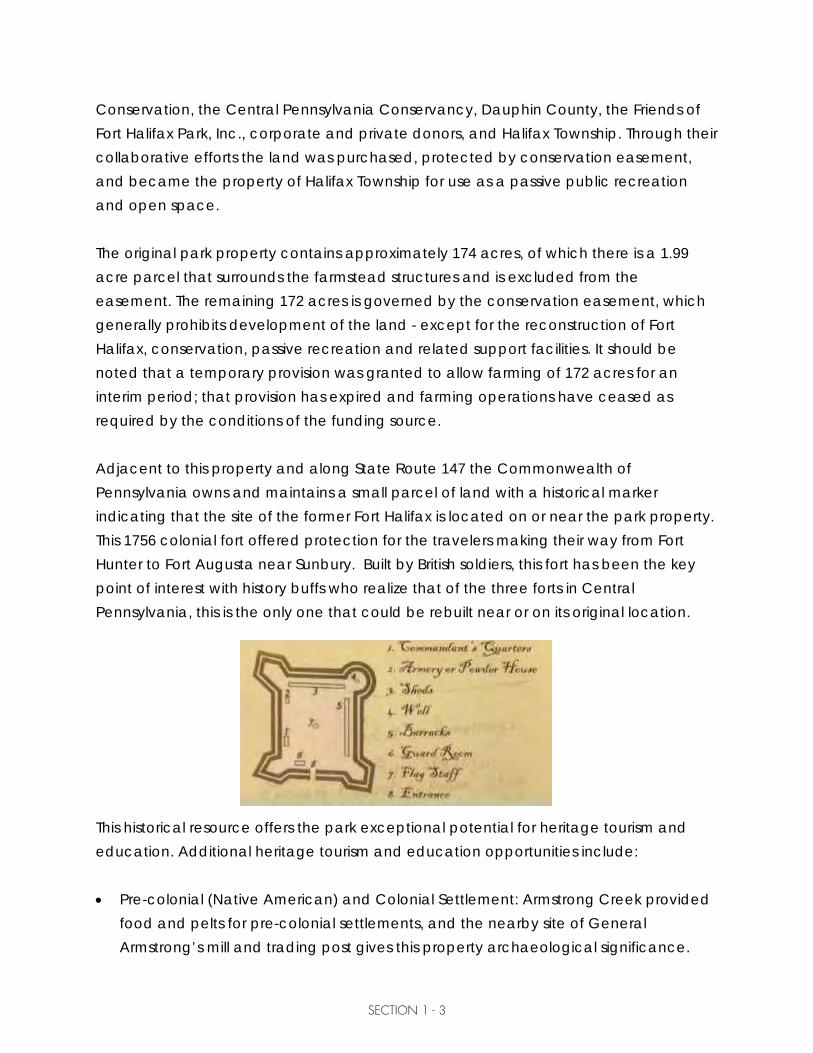
Conservation, the Central Pennsylvania Conservancy, Dauphin County, the Friends of Fort Halifax Park, Inc., corporate and private donors, and Halifax Township. Through their collaborative efforts the land was purchased, protected by conservation easement, and became the property of Halifax Township for use as a passive public recreation and open space. The original park property contains approximately 174 acres, of which there is a 1.99 acre parcel that surrounds the farmstead structures and is excluded from the easement. The remaining 172 acres is governed by the conservation easement, which generally prohibits development of the land - except for the reconstruction of Fort Halifax, conservation, passive recreation and related support facilities. It should be noted that a temporary provision was granted to allow farming of 172 acres for an interim period; that provision has expired and farming operations have ceased as required by the conditions of the funding source. Adjacent to this property and along State Route 147 the Commonwealth of Pennsylvania owns and maintains a small parcel of land with a historical marker indicating that the site of the former Fort Halifax is located on or near the park property. This 1756 colonial fort offered protection for the travelers making their way from Fort Hunter to Fort Augusta near Sunbury. Built by British soldiers, this fort has been the key point of interest with history buffs who realize that of the three forts in Central Pennsylvania, this is the only one that could be rebuilt near or on its original location.
This historical resource offers the park exceptional potential for heritage tourism and education. Additional heritage tourism and education opportunities include: • Pre-colonial (Native American) and Colonial Settlement: Armstrong Creek provided
food and pelts for pre-colonial settlements, and the nearby site of General Armstrong’s mill and trading post gives this property archaeological significance.

SECTION 1 - 4
• Agricultural Heritage: Agriculture was a driving force in colonial America, and the farmstead structures on this site provide good examples of period agrarian architecture.
• The Transportation Story: the advancement of transportation systems was a driving
force in the development of the United States of America. For educational purposes this property has direct or visual access to the following significant transportation systems:
o Susquehanna River o Buffalo Park Road o Wiconisco Canal o Norfolk Southern Railroad o The present Route 147 - also known as Legislative Route 1 - was the most
important highway leading from Harrisburg to New York. • The Historic Sycamore Alee`: This World War I Sycamore Alee’ is listed on the
National Historic Register for sites to see in America. It is only the second Alee’ to make the United States’ honorary listing. Planted in April, 1922 at the direction of President Warren G. Harding, the trees were planted to honor World War 1 veterans and to beautify the nation’s most important highways.

SECTION 1 - 5
In addition to heritage education, this property holds potential for being a model of conservation planning which can teach science/ecology and stewardship. Connector trails throughout the park will offer jogging/walking/cross-country skiing opportunities, and open spaces that can be used to teach life sports and support healthy living within a community. These trails will also provide access to diverse habitats for plant identification, bird watching, stargazing, fishing, and general spiritual renewal. Fort Halifax park holds potential to offer the following benefits to Halifax Township and its residents: (paraphrased from Better Models for Development in Pennsylvania, Ideas for Creating More Livable and Prosperous Communities, by Edward T. McMahon and Shelley S. Mastran) • Fiscal impact analyses have demonstrated that the cost of residential development
exceeds its tax benefits while open space provides a net gain. Protected open space can result in lower infrastructure and service delivery costs and lower taxes for the Township residences.
• Numerous studies have concluded that open space increases nearby property values.
• Corporate CEO’s report that the quality of life offered by a community is the third
most important factor in locating a business, while small business owners rank recreation/parks and open space as the highest priority in choosing a new business location.
• Accessible public open space has been shown to be a catalyst in economic
development and neighborhood revitalization. • Heritage parks and open space offer tourist attractions that generate expenditure
on lodging, food, and recreation oriented services. This in turn can attract new business to your community.
• Open space protects natural resources including water and air quality. • Open space promotes healthy lifestyles by providing recreation opportunities close
to home.

SECTION 1 - 6
Regional Park System Context To understand the context in which Fort Halifax Park will operate we explored the regional recreation facilities and their owner/managers. The following summary represents our findings, which provides a framework for developing this park so that it will compliment, and not compete, with existing recreational facilities. Recreation Facility Operators: Halifax Area Recreation Authority: The Halifax Area Recreation Authority (HARA) was established in 1989 when five (5) of the region’s municipalities agreed to cooperate with each other for the purpose of improving and expanding the region’s public recreation opportunities. Three municipalities, Halifax Township, Halifax Borough and Reed Township, remain active in this voluntary organization. HARA operates three recreation areas within the region. These public parks include: • Veterans Memorial Park: Located in Halifax Borough at the intersection of Rise Street
and Park Drive. Amenities include picnic pavilions, playground apparatus area, the Harry Row Public Swimming Pool, a baseball/softball field, horseshoe pits, volleyball court, two (2) bandstands and open space.
• Deppen Park: Located on Route 225 at Armstrong Creek. This park includes picnic
pavilions, charcoal grills, trout fishing, a playground area, sandbox, and public restrooms.
• The Athletic Fields: Located north of Halifax just east of Route 147. This property was
acquired in 2003, and is being developed as a cooperative effort between the Halifax Area School District, HARA, and the area’s parent and coaches for the purpose of expanding the area’s athletic facilities. Future plans include rugby, soccer, baseball, softball, full size football, and other park amenities.
Millersburg Borough’s Parks: Millersburg Borough owns and operates four (4) parks: Millersburg Youth Organization (MYO) Park, Riverfront Park, Seal Park and Market Square Park.
SECTION 1 - 7
• MYO Park: Located in Millersburg, the MYO Park hosts a ballfield, restrooms, playground apparatus area and two (2) picnic pavilions.
• Riverfront Park: Located on River Street in Millersburg, Riverfront Park offers picnic
tables, a view of Susquehanna River as well as a view of Ferry Boat operations.
• Seal Park: Seal Park is an active park on Millersburg’s North Street and includes a ball field, tennis courts, kid's play area, 3 picnic pavilions and restrooms.
• Market Square Park: Market Square Park is a passive park that feature benches, a bandstand, and the Civil War Monument inscribed with the names of the Millersburg soldiers of 1861 to 1865.
The Ned Smith Center: The Ned Smith Center for Nature and Art is located at 176 Water Company Road in Millersburg. This is a not-for-profit organization, which has a mission “to merge the arts and the natural world and foster a celebration of both.” This center is funded through memberships, user fees and public and private grants. In addition to the Center and galleries, the site offers 500 acres of hardwood forests, stream, trails and habitat for bear, deer, fox, wild turkey, grouse and many other species of smaller animals. Dauphin County Parks Department: The Dauphin County Parks and Recreation Department provides a wide variety of historic, cultural, educational and natural recreation facilities and services. This Department operates seven (7) recreation sites throughout the County, including: Fort Hunter, Fort Hunter Conservancy, Wildwood Natural Area, Henninger Farm Covered Bridge and Community Gardens, Lykens Glen Park and Wiconisco Recreation and Natural Area. • Fort Hunter Park: This historic recreation area is located at 5300 North Front Street,
overlooking the Susquehanna River. The property tells historic tales back to the pre-colonial era. Donated to the County in 1980, the site features the Fort Hunter Mansion, the Centennial Barn, eight other historic buildings and a historic church which was recently relocated to the Park. Also included at this site are two (2) playgrounds, two (2) picnic pavilions and public open space.

SECTION 1 - 8
• Fort Hunter Conservancy: The Fort Hunter Conservancy is located one mile from the fort Hunter Mansion and was part of the Fort Hunter Estate. This 150 acre tract of land is available for day hiking only.
• Wildwood Park: This 210 acre nature sanctuary includes a 90 acre lake, wetlands,
an environmental education center and opportunities for hiking, biking and experiencing nature.
• Wiconisco Recreation and Natural Area: This public open space is located
adjacent to the Ned Smith Center in Millersburg and includes a 14-target archery skills trail, a large pavilion, soccer and softball fields, tot lot play equipment, a sand volleyball court and walking trails.
• Lykens Glen Park: The County leases this 51 acre recreation area from the Borough
of Lykens. This park offers steep mountain slopes and the tumbling Rattling Creek as well as two (2) picnic pavilions, benches, a sand volleyball court, a playground, and a creek-side walk.
• The Henninger Farm Covered Bridge: The historic, 1850 style Covered Bridge is
owned and operated by the Dauphin County Parks and Recreation Department. • Community Gardens: The County Parks and Recreation Department operates this
318 plot Community Garden. The land is leased to the County by the State and the county rents each plot to private individuals to grow produce.

TAB
2

SECTION 2 - 1
PUBLIC PARTICIPATION Photo credit: Halifax Township Website This Master Site Plan Study explored all aspects of the proposed development including the impact on the local economy and the area’s quality of life. The most important part of this planning process was gathering information and opinions from local residents. This was accomplished through meetings with the Study Committee, advertised public meetings, interviews held with individuals and groups of interested citizens, and from the results of a Community Recreation Interest Survey. Fort Halifax Study Committee At the inception of this project, Halifax Township formed a Study Committee to guide the planning of this park; individual committee members are listed in the acknowledgements at the front of this report. This committee represents a diverse group of citizens who expressed a desire to see this park become a reality and served as project contacts for the local government and citizenry. This Study Committee interviewed and made recommendations for hiring the planning consultant, with whom they worked closely with to identify community needs and concerns, develop project concepts, and hold public meetings. Community Recreation Interest Survey The survey developed by the consultant and the Study Committee was mailed to every resident within the 17032 zip code on October 29, 2009, which represented 3,354 addresses. (see exhibit in the Appendix). The survey distribution included residents of Halifax Township, Jackson Township, Jefferson Township, Reed Township, Wayne Township and Halifax Borough. Follow up post cards were sent encouraging residents to complete the survey and deliver it to either a drop off box at Sheetz on Route 147, the Giant grocery store, or to the Halifax Township Building. Surveys were accepted

SECTION 2 - 2
through November 16, 2009. Study Committee volunteers regularly collected the surveys and another Study Committee volunteer tabulated the data. According to the information provided by 2000 US Census Bureau and Halifax Township officials, there are 3,354 occupied housing units within the six (6) municipalities. The Study Committee collected 149 surveys representing 314 individuals and 5% of the region’s occupied housing units. As demonstrated by the table below, the percentage of individuals represented in the survey closely mirrors the region’s actual population. The data gathered through this survey process is lower than what is preferred but qualifies as a statistically valid random sampling. This data collected through the Survey was consistent with the data collected through other studies such as the Pennsylvania Outdoor Recreation Plan and The Dauphin County Parks, Recreation Open Space and Greenways Study, as well as in the key person interviews and information shared through the first public meeting held on November 4th at the Halifax Area School District. According to survey respondents, individuals within the following age groups were perceived to have the greatest need for recreation services: • Ages 10 through 19: • Ages 25 through 34 • Ages 20 to 24 • Ages 45 to 54 • Ages 5 to 9 • Ages 35 to 44

SECTION 2 - 3
Area residents were asked to select their preferred activities. The table below demonstrates the 15 most desired activities. The Pennsylvania Outdoor Recreation Plan also reflects high interest in many of these activities. According to this study, walking and picnicking are the most preferred activities for Pennsylvanians. Halifax Area residents were asked about the factors that affect their participation at events or are considered by them when visiting recreation areas. The following five factors earned the highest consideration: • Cost • Distance • Condition of the Facility • Accessibility • Parking These factors should be considered when planning the design and operation of this public park.

SECTION 2 - 4
When Survey respondents were asked to select which park features are highly valued, they included the following: • Restrooms • Walking/Hiking Trails • Picnic Pavilions • Parking areas • Picnic Tables • Open Space and Natural Areas • Festivals and Concerts The following table demonstrates the satisfaction of area residents with current festivals and events offered at Fort Halifax Park. As demonstrated by the table below, those who attended the events were very satisfied with their experience. Some of the individuals who participated in the key person interviews expressed concern that they did not know about these events; this demonstrates the need to better promote these events among local residents. The special event organizers should identify opportunities to engage and build relationships between Fort Halifax Park and local residents.
Dauphin County is blessed with valuable open space and public recreation areas; survey respondents were asked to identify which of these are their most valued public spaces. The top 13 most valued public recreations areas demonstrate the wide variety of recreation activities that are available.

SECTION 2 - 5
While area residents value the existing public recreation areas, they are reluctant to assume the responsibility of acquiring, developing and maintaining park lands. Survey respondents indicated that they believe parks should be supported in the following order. 1. Private and corporate donations 2. Volunteer time and donated materials 3. Facility rental fees 4. Grants 5. User fees 6. Memberships 7. A combination of all of these resources. Using taxes to solely support parks and recreation was considered undesirable. Survey respondents were evenly split on their support for this park. Some people expressed a desire for this land to have been developed as residential housing and a “big-box type” store. Many other people feel that this park offers opportunity for historical and environmental education, land conservation, and recreation - to provide long-term benefits to the community.

SECTION 2 - 6
Current operators of the park are aware of and are very sensitive to the citizens’ concerns. Park advocates have formed the Friends of Fort Halifax Park, Inc. group to research and develop the assets and vision for this park. This group has creatively employed strategies and techniques working with private and public agencies and organizations to identify resources and expand opportunities while reducing the potential burden on the taxpayer. More efforts should be devoted to educating the public about how this park will benefit the region’s economy as well have a profound impact on the area’s quality of life. Key Person Interviews, Park Focus Groups and Public Meetings The Consultants interviewed 48 individuals either as single interviews or in focus groups. The purpose of these interviews was to verify the findings of the project interest survey as well as to gather additional information about the history and potential uses of the site. Individuals participating in the interviews included community leaders, park neighbors, citizens with significant information about the park property, and persons with knowledge of the local community and character. A sample interview guide is included as an exhibit in the Appendix. Individuals interviewed in this process included:
Name Affiliation / Organization
Name Affiliation / Organization
Karen Lee Newman Artist/Crafts/Music Performer & Education.& Park Enthusiast
Sharon Nace Jessica McGuire Heather Frantz Sharon Manning Shara Mattis Joe Steppy Marie Suhr Maria DeMent Amy Lowery Jenny Diehl Duane Frantz Ryan Herb
Halifax Area School District Educators

SECTION 2 - 7
Name Affiliation / Organization
Name Affiliation / Organization
Lauren Bitting-Ellis Sub-teacher recently returned to area, worked w/comm. parks, healing gardens w/city agency on aging, & various outdoor events & headed many fundraising committees
Linda Stopfel Dee Hoffman Bonnie Freeman Carol Witzman Noel Falk Carol Eppley Dane Snyder Nevin A Maurer, Sr.
Friends of Fort Halifax Park, Inc.
Jerry Stuck Gaye Boyer Bill McIntosh Paul Hogritt Dayna King Virginia Stone Kelly Enders Becki Enders Lisa Smith Dave Hatfield Jen Stewart Glen Laudenslager Bob Osenbach Jeff Kerstetter Krista Caponigro Bill Moore
Halifax Area School District Educators
Fred Ford Millie Rainey Jan Hoffner Heather Crook Florence K. McGuire Tracy Cox Mike Enders
Halifax Area Recreation Authority
Richard Motter Retired teacher & historian
Shirley Radel, Secretary Tony Trost Gary Miller John Shoop Lee Warfel Ed Fisher
Wayne Township Supervisors
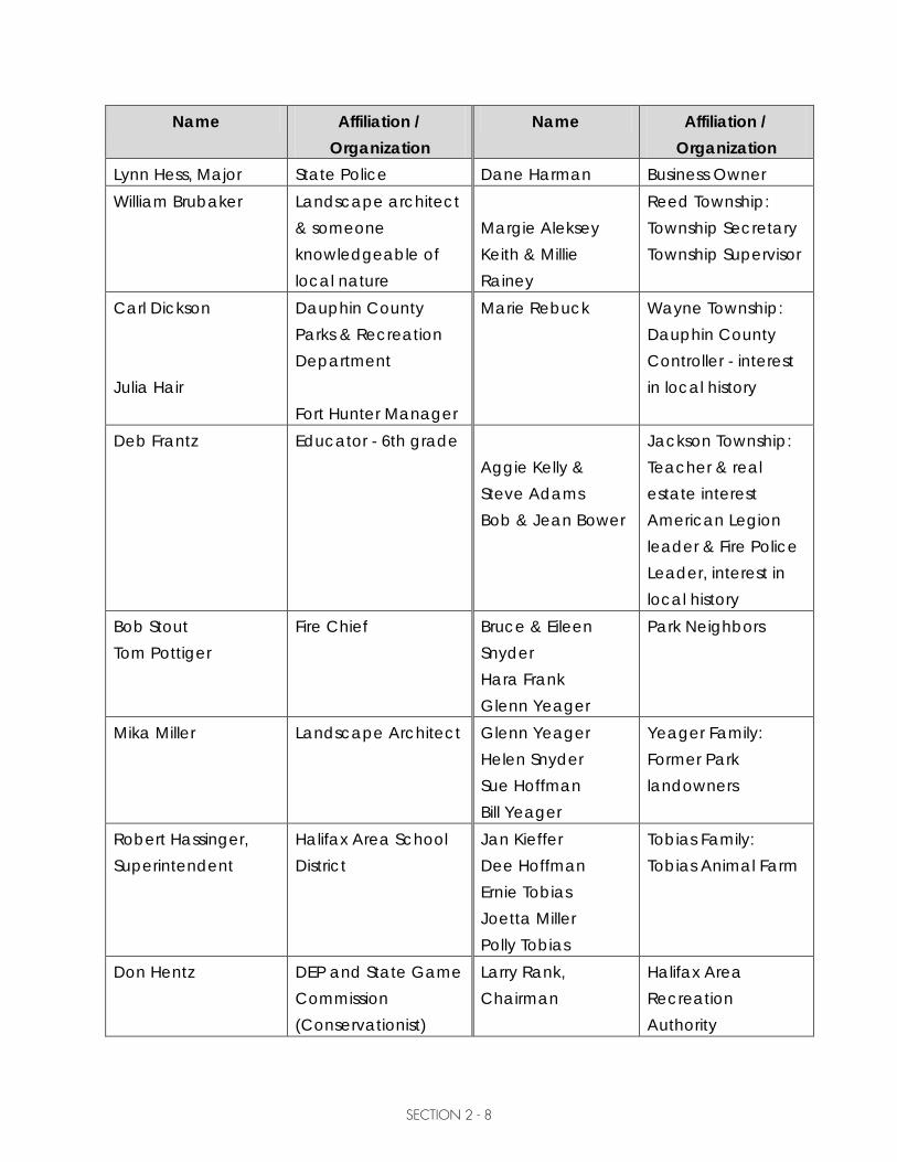
SECTION 2 - 8
Name Affiliation / Organization
Name Affiliation / Organization
Lynn Hess, Major State Police Dane Harman Business Owner William Brubaker Landscape architect
& someone knowledgeable of local nature
Margie Aleksey Keith & Millie Rainey
Reed Township: Township Secretary Township Supervisor
Carl Dickson Julia Hair
Dauphin County Parks & Recreation Department Fort Hunter Manager
Marie Rebuck Wayne Township: Dauphin County Controller - interest in local history
Deb Frantz Educator - 6th grade Aggie Kelly & Steve Adams Bob & Jean Bower
Jackson Township: Teacher & real estate interest American Legion leader & Fire Police Leader, interest in local history
Bob Stout Tom Pottiger
Fire Chief Bruce & Eileen Snyder Hara Frank Glenn Yeager
Park Neighbors
Mika Miller Landscape Architect Glenn Yeager Helen Snyder Sue Hoffman Bill Yeager
Yeager Family: Former Park landowners
Robert Hassinger, Superintendent
Halifax Area School District
Jan Kieffer Dee Hoffman Ernie Tobias Joetta Miller Polly Tobias
Tobias Family: Tobias Animal Farm
Don Hentz DEP and State Game Commission (Conservationist)
Larry Rank, Chairman
Halifax Area Recreation Authority

SECTION 2 - 9
Name Affiliation / Organization
Name Affiliation / Organization
Carol Witzman, Past President
Central Pennsylvania Conservancy (CPC)
Rich Yohn Norfolk Southern Administrative Clerk
Travis McConnell Norfolk Southern Train Master
Thomas Bracey Norfolk Southern Engineer
Chris Deitz Millersburg Council Glenn Hoffman Business Owner Michael Kieminski MPO/Tri County
Regional Planning Joe Burget Upper Dauphin
County Highway Occupancy Permit Officer
Steven Warfel Retired State Archaeologist
Bryan VanSweden Pennsylvania Historic & Museum Commission
Doug McClearan Pennsylvania Historic & Museum Commission
Mike Brown Halifax Township Sewage Enforcement Officer
The information which was gathered in this process has been included throughout this study.

SECTION 2 - 10
Public Meetings This Study included public meetings for the purpose of gathering information, presenting Study findings and clarifying specific aspects of the proposed Master Site Plan. These meetings included:
Date Location Purpose Oct. 22, 2009 Halifax Area High
School Cafeteria Meeting with the neighbors of the Fort Halifax Park. Neighbors discussed concerns and opportunities associated with the Park’s development and use.
Nov. 4, 2009 Halifax Area High School Cafeteria
Gather information from public about the Park use, history, interests, benefits and concerns. (PM #1)
Aug. 4, 2010 Halifax Township Meeting Room
Meeting with Township Supervisors, Township Solicitor, Central Pennsylvania Conservancy, PA Department of Conservation and Natural Resources Bureau of Recreation and Conservation.
Oct. 25, 2010 Halifax Area High School Cafeteria
Present alternative plans and discuss potential development and implementation. (PM #2)
May 26, 2011 Halifax Area High School Cafeteria
Present preliminary Master Site Plan and Phasing Plan. (PM #3)
June 14, 2011 Halifax Township Meeting Room
Halifax Township Supervisors held a special workshop meeting to discuss the specifics of the Fort Halifax Master Site Plan. (PM #4)
Nov. 17, 2011 Halifax Area High School Cafeteria
Present Final Fort Halifax Master Site Plan. (PM #5)

TAB
3

SECTION 3 - 1
MASTER SITE PLAN DEVELOPMENT PROCESS The following sections summarize the in-depth process that was facilitated by the consultant in working with the Study Committee to provide structure for developing the Fort Halifax Master Site Plan. Mission and Goals To provide guiding principles for evaluating decisions throughout the planning process, the Study Committee began by defining a Vision Statement and Study Goals. Vision Statement: “Fort Halifax Park, a place where we can creatively enhance our lives and celebrate our heritage.” Study Goals: Goal 1: Identify and document the recreational needs of the people living within the
service area. Goal 2: Create opportunities to communicate and explore the community’s rich
cultural and environmental heritage. Goal 3: Create physical and social connections between the park and the
communities that it serves. Goal 4: Increase public awareness and participation in park and recreation
services. Goal 5: Define an effective organizational structure to administer future efforts and
initiatives. Goal 6: Identify and prioritize a list of park improvements, associated costs and
potential sources of funding.

SECTION 3 - 2
Goal 7: Identify opportunities for intergovernmental interagency cooperation, in order to expand and enhance education and recreation services available to the community.
Goal 8: Identify marketing and public relation initiatives to promote The Fort Halifax
Park locally, regionally and nationally. Goal 9: Identify and promote opportunities for volunteerism and stewardship.
Site Inventory The site context and physical features of this property provide both constraints and opportunities relative to the development potential of Fort Halifax Park. A site inventory was performed to gain understanding of these parameters. Information was obtained by numerous sources which included a review of existing mapping, interviewing individuals and groups with hands-on knowledge of the property, and making site visits for field reconnaissance. The property boundary as shown on the plan is plotted from deeds of record. Topographic data shown was collectively assembled from the following plans or record: – PASDA.psu.edu GIS shape file of topographic contour lines. – PennDOT drawings for Construction dated June 1953 – Retracement Survey by Glenn H. Arnold dated May 29, 2005 – North Central Railway Company Right of Way and Track map dated June 30, 1918 – Portions of maps as provided by the Halifax Sewer and Water Authority

SECTION 3 - 3
This park contains approximately 174 acres of land, with State Route 147 running north/south and effectively bisecting the property into eastern and western areas. The westernmost area is further divided by an active Norfolk Southern Rail line (also running north/south), which effectively divides that parcel into two smaller areas of use. To some degree Armstrong Creek (running north/south) similarly divides the eastern parcel, creating two additional use areas. Each of these four areas has a distinct landscape character, which offers a diversity of experiences to park users. These areas are depicted on the Conceptual Areas Map.

nm
nm
nmnm
nm
nm
nm
nm
nm
nm
nm
nm
nm
nmnm
nm
nm
nm
nm
nm
nm
nm
nm
nm
nmnm
nm
nm
nm
nm
nm
nm
nm
nm
nm
nm
nm
nm
nm
nm
nmnm
nm
nm
nm
nm
nm
nm
Section 1A - Conservation -River related activities and riverine interpretation Section 1B - Historic Interpretation Section 2 - Fields -Community based activity Section 3 - Meadows -Passive recreation and special events Section 4 - Conservation -Woodland management and ecological interpretation with low impact passive recreation
SU
SQ
UE
HA
NN
A R
IVE
R1A 1B
Section 2+/- 17 Acres
Section 3+/- 83 Acres
Section 4+/- 49 Acres
Section 1+/- 23 Acres
!
! !
!
!
!
!
Building Envelope1.99 Acres
!
Fort Halifax ParkConceptual Areas
Halifax Twp., Dauphin Co., PA
LegendActive Railroad
Park Boundary
Local Roads
Field Roads
Wet Areas
Streams
Overhead Power lines
Forested
Meadow/Grass
Residential
0 250 500125 Feet
Ë
Armstrong Creek
PA N O R A MI C
PA N O R A MI C
V I EW
V I EW
U P P E R F I E L D SU P P E R F I E L D S( M O W E D A G . L A N D S )( M O W E D A G . L A N D S )
L O W E RL O W E RF I E L D SF I E L D S
M I D D L EM I D D L EF I E L D SF I E L D S
B A C KB A C KM E A D O WM E A D O W
L O W E RL O W E RM E A D O WM E A D O W
RIVERSIDERIVERSIDECLEARING CLEARING
RIPARIAN RIPARIAN BUFFERBUFFER
(W/ INVASIVE (W/ INVASIVE SPECIES)SPECIES)
FORT FORT HALIFAXHALIFAX
AREAAREA
NEIGHBORINGNEIGHBORINGEARLY EARLY
SETTLEMENTSETTLEMENTAREAAREA
(NOT WITHIN(NOT WITHIN PARK) PARK)
F I E L D R O A D ( T Y P. )
F I E L D R O A D ( T Y P. )
R I V E R I N ER I V E R I N EE C O L O G YE C O L O G Y
ST
EE
P S
LO
PE
SS
TE
EP
SL
OP
ES
ST E
EP
SL O
PE
S
ST E
EP
SL O
PE
S
ST
EE
P S
LO
PE
S
ST
EE
P S
LO
PE
S
STREAM STREAM CROSSINGCROSSING
MATUREMATUREHARDWOODHARDWOODWOODLANDWOODLAND
RIVERRIVERACCESS (?)ACCESS (?)
(GEESE PROBLEM)(GEESE PROBLEM)
LARGE CHESTNUTLARGE CHESTNUTTREE (WITNESS?)TREE (WITNESS?)
FARMSTEADFARMSTEAD
WICONISCOWICONISCOCANALCANAL
NORFOLK - NORFOLK - SOUTHERNSOUTHERN
RAILRAIL
ROUTE 147ROUTE 147
WWIWWISYCAMORESYCAMORE
ALLEEALLEE
New E
nglan
d Run
UNDERGROUNDUNDERGROUNDSPRINGSPRING
BUFFALO PARK RD.BUFFALO PARK RD.
3RD STREET3RD STREET4TH STREET4TH STREET

SECTION 3 - 4
Section 1: This land is approximately 25 acres (including the 1.99 acre building envelope), situated on the eastern shore of the Susquehanna River and bounded on the north by a farmstead, to the east by active Norfolk Southern railroad tracks, and to the south by fallow land. This area is characterized as gently sloping floodplain and adjacent uplands that were previously used for agriculture. This is a peaceful setting with the Susquehanna River as the dominant landscape feature. There is excellent access to the river, with gently sloping river banks. The riparian buffer along the river consists of mature trees including sycamore, silver maple, ash, mulberry and alder. Invasive species noted include tree of heaven, Japanese knotweed, and mile-a-minute vine. This riparian buffer would benefit from the control of noxious weeds and invasive species, and the enhancement of native plantings to expand the depth of buffer from the river’s edge.

SECTION 3 - 5
This area contains the former Buffalo Park Road (T-373), a PPL electric line, open fields, remnants of the Wiconisco Canal, and the a1.99 acre building envelope with the farmstead buildings. The buildings on this site include a barn, two farm houses and outbuildings. These houses are served by an on-lot well and on-lot sewage disposal, and the overhead electric service along Buffalo Park Road. There is a clearing of trees that provides scenic views of the river from the farmstead, with Clemson and Lingle Islands visible across the water. This clearing has lawn maintained to the water’s edge, which invites Canadian geese to take up residence; these waterfowl leave excessive droppings and are generally a nuisance. Between the farmstead and the railroad are the remnants of the Wiconisco Canal, the northern portion of which has been backfilled and planted in lawn. South of the farmstead within a grove of trees, the original cross-section of the canal is intact, and
has potential for historic interpretation and small-scale restoration. This section of the property is also believed to be the location (or near location) of the 1756 Fort Halifax, which offered protection for colonial travelers making their way from Fort Hunter to Fort Augusta near Sunbury. Initial archeological investigations were recently performed to identify underground anomalies which are used to identify areas of high probability for finding archaeological remains
such as the former Fort Halifax site. A report of findings is pending. The Norfolk Southern railroad tracks are slightly elevated above the adjacent park land, with an at-grade driveway crossing conveyed to the landowner. Norfolk Southern has been a cooperative partner for special (temporary) events; they reduce the speed of passing trains and permit public use of the crossing – provided that the driveway is manned with personnel to serve as crossing guards.

SECTION 3 - 6
It should be noted that there have been recent deliberations with a person claiming to have purchased a strip of land adjacent and parallel to the railroad. Documents of record indicate that land conveyed by the railroad reserved the access rights of adjoining landowners, thereby having minimal, if any, impact on this plan. At the time of finalizing this report Supervisors indicated that this dispute has been resolved and does not impact the Master Site Plan as proposed. Section 2: This land is approximately 17 acres, situated on the western side of State Route 147 and bounded on the west by the active Norfolk Southern rail line. The area to the north is fallow land, and to the south is single family residential housing. This area is characterized as gently sloping meadows, previously used for agriculture. The World War I Sycamore Alee` is being replanted on this side of the road. This land is fully exposed to sights and sounds of SR 147; it is highly visible and provides a foreground to the park. The land adjacent to SR147 has been used to restore the World War I Sycamore Alee; proposed wildflower plantings would visually enhance it. These fields are seasonally wet, with areas of standing water following heavy precipitation events. This water appears to result from the combination of accepting the storm water discharge from cross pipes under State Route 147, and having the drainage pipes under the railroad not properly functioning. It is recommended that there be further study of the condition of the outlet drainage pipes under the railroad tracks as well as performance of a wetland delineation prior to design or construction of proposed development in this area.
SECTION 3 - 7
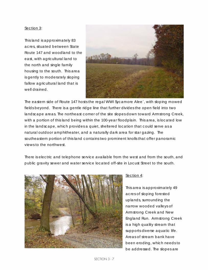
Section 3: This land is approximately 83 acres, situated between State Route 147 and woodland to the east, with agricultural land to the north and single family housing to the south. This area is gently to moderately sloping fallow agricultural land that is well drained. The eastern side of Route 147 hosts the regal WWI Sycamore Alee`, with sloping mowed fields beyond. There is a gentle ridge line that further divides the open field into two landscape areas. The northeast corner of the site slopes down toward Armstrong Creek, with a portion of this land being within the 100-year floodplain. This area, is located low in the landscape, which provides a quiet, sheltered location that could serve as a natural outdoor amphitheater, and a naturally dark area for star gazing. The southeastern portion of this land contains two prominent knolls that offer panoramic views to the northwest. There is electric and telephone service available from the west and from the south, and public gravity sewer and water service located off-site in Locust Street to the south.
Section 4: This area is approximately 49 acres of sloping forested uplands, surrounding the narrow wooded valleys of Armstrong Creek and New England Run. Armstrong Creek is a high quality stream that supports diverse aquatic life. Areas of stream bank have been eroding, which needs to be addressed. The slopes are

SECTION 3 - 8
rocky, oak forests, and the valleys contain wet bottomlands that provide excellent habitat for avian and wildlife species. Wetland investigation work should be performed as part of the design of any facilities in this area. This portion of the site is accessed by a steep dirt road, extending from the stone farm lane down to a low flow crossing of Armstrong Creek and connecting to a dirt farm lane on the eastern side of the creek. These roads have visible signs of erosion. There is a second, less steep woods road descending from the northeastern area of the upper field; with a minimal amount of vegetation clearing this would make a more desirable access to the lower field and Armstrong Creek. This section of the park is bounded on the east by large-lot residential development and Fuhrman Road, which is a private drive that cannot be used by the park users. There is a PPL high-tower electric line near the eastern boundary, with a rough and rocky access road beneath it. The southeastern portion of this land is a combination of steep, rugged oak forest and fallow agricultural fields. The fields provide open habitat area for both avian species and wildlife. Apparent wet areas were noted in these fields. Wetland investigation work should be performed as part of the design of facilities in this area. Site Soils: The portion of the property on the eastern side of SR147 is located within the Calvin-Leck Kill-Klinesville association, with deep to shallow, dominantly well drained, gently sloping and sloping soils that have shaly silt loam subsoil. The portion of the property on the western side of SR147 is located within the Duncannon-Chavies-Tioga association, with deep, well-drained nearly level and gently sloping soils that have a fine sandy

SECTION 3 - 9
loam to silt loam subsoil, found along the Susquehanna River. (See exhibit in the Appendix). A review of the USGS National Wetland Inventory Maps did not reveal any wetlands on this site (see exhibit in the Appendix). However, field observations indicated areas where further investigation is recommended (see text above). Site Access: Currently this site is accessed by two central driveways; one on the east and one on the west side of State Route 147. The eastern access is a stone field road that was used for agricultural purposes; the western single-lane, paved drive crosses the railroad to serve the farmstead. Initial discussions with Norfolk Southern indicated that the Township has legal access across the tracks to their land, but that extensive improvements would be required to provide permanent public access at this driveway crossing. Since this is the only access to the western property - and the important historic features on that side of the tracks - a permanent crossing at this location is recommended (see Tab 3-Items Beyond the Scope of this Project.)

SECTION 3 - 10
Buffalo Park Road (south of this property) currently does not extend to the park land, so the driveway that crosses the railroad is the only current means of ingress and egress. It is recommended to extend Buffalo Park Road into the park to provide a secondary access – but it needs to be noted that during periods of high water the river inundates that road. If the Township chooses to pursue a public railroad crossing, they will need to apply to the Public Utility Commission (PUC) and petition making this a public crossing. Further discussion with the PUC and Norfolk Southern is recommended to explore signalized access during future phases. Additionally, the Township should petition Norfolk Southern Railroad to permanently reduce train speeds from Armstrong Creek through Halifax Borough. In 2010 an adjacent landowner generously donated a parcel of land to the Friends of Fort Halifax Park, Inc. for the intended purpose of expanding the park; once this land is incorporated into the park property, this parcel will provide direct access for the extension of Buffalo Park Road into the park on the river side of the railroad. Discussions and a field view of State Route 147 with PennDOT resulted in the recommendation of having a central access road on the west, and both a north and a south access road on the east side of the highway. Additional public access to the site is available to the eastern portion of the site via the public right-of-way of Third Street, Fourth Street and Fifth Street. At this time it is recommended that a stabilized trail extending Fourth Street into the park be developed for pedestrians, bikes, and maintenance and emergency vehicles. Storm water: Stormwater management on this site is simplified by the nearly level terrain and the minimal impervious areas. Additional impervious areas are mainly parking lots and drives, which will be cross-sloped to drain as sheet flow onto existing vegetated ground. Gentle swales will be constructed to divert water from high traffic areas, and cross pipes

SECTION 3 - 11
will be installed as needed under driveways and trails. The overall intent is to excavate and create numerous recharge areas to dissipate storm water on-site, reducing runoff and providing filtering of storm water. If the Township performs a municipal-wide storm water plan, areas of open space within the park could also serve as rain gardens and infiltration areas for dissipating off-site runoff. Public Water and Sewer: These public utilities are available in Locust Street to serve the eastern portion of the site. Based on conversations with the Halifax Sewer and Water Authority there is adequate capacity to serve the park needs, providing it is a gravity sewer service. The distance between these existing public utilities on the western portion of the park property is too great to be cost effective. It is recommended that soil testing be completed and a new, large, on-lot sewage disposal system be developed to serve this area of the park. Likewise, it is recommended that a new well be constructed in accordance with the PA Department of Environmental Protection Water Supply Manual to provide water to the farmhouses and western pavilions.

SECTION 3 - 12
Site Analysis Site Opportunities This property provides diverse site character, landform, and passive recreation and education opportunities; there are also site features that present development challenges. The following is a brief outline of the site’s potential. Regional Context: 1. Educational destination for Living History experience. Develop site features and
programming for hosting seasonal events; provide walking trails with interpretive signs that can also be used as a self-guided educational tool.
a. Native American culture b. Early colonial settlement, including Fort Halifax c. Agricultural role in American history featuring the farmstead structures d. Transportation systems evolution e. World War I (memorial alee)
2. Open spaces that will accommodate large gatherings of people for special events,
hiking and walking trails, activities such as disc golf, and habitat for avian and wildlife species.

SECTION 3 - 13
3. Conservation stories to be told.
a. Land Conservation: Conservancy easement on this property, Pennsylvania Game Commission Islands, floodplain management, forest management, carbon sequestration, benefits of riparian buffers, storm water infiltration.
b. Varied ecosystems. Provide interpretive signs and walking trails with interpretive signs as a self-guided educational tool.
i. Riverine: stream side (riparian) buffer restoration, fish and bird migration (including shad and eels), Chesapeake Bay connection. Develop fish habitat enhancement structures that will also help stabilize stream banks.
ii. Meadows: open field habitat for wildflowers, caterpillars, songbirds, and mammals. Establish warm season grasses for health of the soil and water, carbon sequestration, and reduced mowing operations.
iii. Forest bottomlands: Armstrong Creek corridor with walnut, butternut, ash, hemlock and cherry trees. Identify wetland areas and birding habitats as points of interest.
iv. Steeply sloped woodlands: Oak forests with hickory, maple, and black cherry trees. Develop a forest management plan to maintain/conserve healthy woodlands.
4. Establish logical connectivity between this and other regional parks: Fort Hunter,
Tobias Animal Farm, and the Ned Smith Center. Develop a collective marketing plan that draws people to the region for overnight stays, which provides benefits to local economies.
5. Knoll in southeast corner provides an overview of the property with a scenic view up
north to the river/mountain cut. This location provides opportunity to talk about the geology of the region, the glaciers, the role of the river for providing rich floodplains

SECTION 3 - 14
for early settlement and farming, and the importance of properly addressing floodplains and land development as relative to local water quality and eventually the Chesapeake Bay. Provide seating, and interpretive signs as an educational tool.
Local Context: 1. The diversity of the site character and the fragmentation of the site by transportation
systems provide definition to regions of the site for diverse and varied uses. The layout of park facilities needs to be accomplished in a way that allows the fragmented sections of the park to function as stand-alone regions, minimizing park user interaction with the state highway and railroad systems.
2. Develop connectivity to adjoining neighborhoods while
respecting the need for neighbors’ privacy. Plan for potential future road connections; initially develop these as connecting trails for pedestrians and bikes.
3. Provide connectivity to local schools.
a. Educational opportunities b. Recreational opportunities
Work with school district staff to develop educational programs and special outing events. Explore connector trail viability.
4. Pennsylvania Fish and Boat Commission (PFBC) Halifax Access is approximately 2 miles upstream of this site. Explore potential for ‘pedal and paddle’ programs where students can ‘paddle’ from the PFBC Halifax access to Fort Halifax Park and then ‘peddle’ to the school.

SECTION 3 - 15
Site Challenges Regional Context: 1. Develop an identity that does not duplicate other regional efforts, but instead either
supports or diversifies existing regional offerings. Work in partnership to develop a regional marketing plan that draws people to the region for overnight stays, which provides benefits to local economies.
2. Sustainability and Land Use The current rate at which we are developing open space to support our growing population is not sustainable. Forests, meadows and wetlands are decreasing and wildlife habitat is being lost. Fragmentation of previously contiguous lands denies many species the corridors that are needed to support their life cycles. The Fort Halifax Park conservation easement provides a foundation for using this property to demonstrate sustainable land use and management practices that address many of these issues. This property’s previous land use was agriculture, which is not a permitted land use under the restrictions of the easement and the funding source used for the purchase of the land. The land is to be used for public passive recreation, including education and the rebuilding of Fort Halifax. It is recommended that the Township explore how this conversion of land use provides new opportunities to view the park open space areas as valuable in terms of the Pennsylvania Infrastructure Investment Authority (PENNVEST) Nutrient Credit Trading Program, and EPA’s green infrastructure for storm water initiatives, both connected to water quality improvements in the Chesapeake Bay watershed. Wastewater treatment plants face potentially expensive upgrades in order to meet nitrogen and phosphorous discharge limits to comply with Chesapeake Bay requirements. The Nutrient Credit Trading program provides a cost-effective means for regulated public and private waste water treatment plants and other parties to purchase credits to meet their nitrogen and phosphorus discharge limits for the compliance year. This effort is aimed at facilitating nutrient credit trades between wastewater treatment plants and farming operations to foster a less expensive solution for wastewater treatment plants to meet their discharge requirements.

SECTION 3 - 16
Proposed planting suggestions shown on the Master Site Plan provide many environmental benefits. Planting meadow areas in warm-season grasses and forbs retains soil, filters, cools, and reduces storm water runoff, reduces mowing operations, and offers wildlife food and habitat. Restoring riparian buffers provides shade to surface waters, reduces the velocity of flood water, and diversifies habitat. Planting large tree groves helps to define spaces and use areas, provides shade for human comfort, reduces mowing and maintenance operations, diversifies habitat, filters air and water, reduces storm water runoff velocities and erosion potential, and provides cooling. All of these proposed plantings provide carbon sequestration – which is beneficial to all life. Because they are well adapted to local conditions, native plants often require less maintenance such as trimming, watering and fertilizer applications; this results in a reduction of both material and management costs, and aids in the reduction of nutrients and chemicals running off the land and into waterways. (Native plants can be defined as those species that were present when the first Europeans arrived in the New World.) Planting native species therefore helps to improve water quality and reduce the money, time and labor spent on maintenance. It is recommended to develop a woodland management and harvesting plan in accordance with the conservation easement. The diversity of this site offers a wide range of habitat value. There is river bank areas, open fields, hedgerows, wet meadows, a small stream corridor, and hardwood woodlots. These landscape features offer food, water, cover and nesting sites as needed to support local insects, birds, mammals and humans. It is recommended to plant a variety of locally native plants that will provide environmental benefits, and food and cover for local and migrating species. In is recommended that interpretive signs be included throughout the park, to raise awareness and educate the public as to the value of sustainable land use practices.

SECTION 3 - 17
Local Context: 1. Fragmentation of the site by PennDOT Route 147, the Norfolk Southern active rail
line, and the Wiconisco Canal remnants present potential safety concerns for site users. Consider each section of land individually in terms of facility development, and where viable provide trails for overall connectivity. Work with respective ROW owners to determine adequate safety measures.
2. Invasive species are present on the site and need a plan for removal and
management. Invasive species observed include: mile-a-minute vine, Japanese knotweed, rugosa rose, and tree of heaven. Also observed were trees that were in major decline due to an extensive coverage of poison ivy and fox grapes. Develop a vegetation management plan and form a volunteer stewardship entity to help control invasive species and noxious weeds.
3. This is a large land holding with limited capacity by the owner for maintenance.
a. Explore options for vegetative cover that reduces mowing operations but still provides recreational and ecological benefits.
i. Warm season grasses and forbs with wildflowers and mowed trails. ii. Seasonal mazes that are mowed for recreational / educational experiences.
A maze can have signs with ‘stations’ throughout where questions are asked about topics such as wildlife, conservation or agriculture in Pennsylvania.
iii. Areas of reforestation for providing shade and carbon sequestration. b. Provide interpretive signs and walking trails as a self-guided conservation
education tool.

SECTION 3 - 18
Existing Buildings and Structures As noted above, the farmstead structures hold potential opportunity for teaching the role of Agriculture in American history; their proximity to each other and their position in the landscape portray an Americana landscape representative of our agrarian heritage. As this park develops, structures will eventually be needed on-site to serve as centers of activity and to house equipment for park programming and maintenance operations. It is possible that with adaptive reuse, some of these buildings could serve useful park functions. Under the direction of Carl Dickson, Director of Dauphin County Parks and Recreation Department, the County provided a large dumpster (complete with hauling fees) and labor to perform some repairs, clean out the cellar and attic of the farmhouse and both floors of the barn. Following this effort Mr. Dickson performed a visual assessment of the farmstead structures to determine their viability for potential future use. The following summarizes his findings and the opinions of the Consultant and the Study Committee: 1. Preserve the setting that the buildings are in: this landscape has value and serves as
an education center that tells a cultural story. The Committee views this grouping of buildings as an outdoor museum that can be educational through interpretation. This could be done by possibly using all-weather interpretive signs, panels, or a walking brochure to highlight the area’s long history of agrarian heritage.
2. Barn: Preserve the exterior as an example of the agrarian history that was at one
time a common landmark in the region’s landscape. a. Lower story: with a new, level concrete slab this area could be used for
storage of large maintenance equipment and various other items that could be easily moved when anticipating a 100-year flood event.
b. Upper story: undeveloped, this area could be used for interpretation and educational exhibits. With modest improvements this could be a space with three-season use for traditional barn events such as square dancing and outdoor festivals.
3. Corn Crib/ Wagon Shed: This structure could be used for landscape machinery
storage.

SECTION 3 - 19
4. Granary: This is a charming, modest building that lends itself to be adaptively reused as a small building such as a gift shop or Friends of Fort Halifax Park, Inc. office.
5. Milk House: A sturdy building suitable for storing items such as small power tools (chain saw, weed whacker, etc.) gasoline and paint.
6. Houses:
a. Current – rental units for income, or interpretive and/or exhibit areas (rotating exhibits such as antique trains/toys, quilts etc.)
b. Future – if so needed, these could serve as a larger park office, interpretive areas, exhibit areas, or a nature center.
c. A large room could be set up as a classroom/conference/community meeting room. This could also be used as rental for reunions, outdoor weddings, etc.
A visual assessment of the barn was also completed by a structural engineer with Larson Design Group’s (LDG) on August 6, 2009 that supplemented the report prepared by CenterPoint Engineering; a copy of each of these reports is available for review at Halifax Township Building. LDG’s focus was to document additional observations, changes in condition, and make recommendations regarding the suitability for reuse for a specific occupancy. Recommended action plan involves making a decision to either demolish or save the barn: Option 1: Demolish the barn, arranging for demolition and/or salvage of materials for future use. Or… Option 2: Save the barn, making repairs to gutters and downspouts, removing debris, replace the severely damaged cantilevered floor beams, temporarily shore cantilevered wall if replacement is deferred; arrange for feasibility study to evaluate possible adaptive reuse(s) of the building. At the time of this report the Board of Supervisors had not yet reached consensus regarding the plan of action for the barn and farmstead buildings. It is the recommendation of the consultant and Study Committee to initially make repairs to the downspouts and gutters to prevent further deterioration of the barn structure. Further study should be done to explore potential adaptive reuse of this building in the future. As buildings are improved, consideration should be given to

SECTION 3 - 20
incorporate energy efficiency such as natural lighting, insulation, efficient water heating systems, geothermal heating units, solar roof panels, and conversion to low energy compact fluorescent bulbs. Purchase low-emission, fuel-efficient equipment for the maintenance of the park; develop educational programs to teach others about alternative energies, conservation and sustainable land use principles. Proposed Use Areas/Facilities The following list of activities, uses and support facilities was compiled from the visioning process done with the Steering Committee, and the feedback received from the first public meeting and the Public Recreation Interest Survey. Considerations for these decisions included whether or not the element is: – necessary for park function – filling a community/regional need – revenue producing, which is denoted with this symbol (*) below

/
Strong Relationship
Comment noted
Some Relationship
Planned Elements and Site Features Matrix
Arc
haeo
logi
cal D
ig S
iteBi
king
Tra
ilsBi
rd W
atch
ing
Are
asBo
at L
aunc
hBu
ffer
Zon
esCa
mpi
ng
Com
mun
ity G
arde
nsCo
nser
vatio
n Ar
eaD
isc
Gol
f
Dog
Tra
ils
Eque
stri
an T
rails
Fest
ival
Are
aFi
shin
g A
cces
sFo
rt H
alifa
x Re
cons
truc
tion
Mem
oria
l Are
aH
ealin
g G
arde
nH
ikin
g W
alki
ng T
rails
His
t. In
terp
. Agr
icul
ture
/Far
min
g A
rea
His
t. In
terp
. Con
serv
atio
n Ar
ea
His
t. In
terp
. For
t Hal
ifax
Are
a
His
t. In
terp
. Nat
ive
& N
on-n
ativ
e A
mer
ican
Are
a
His
t. In
terp
. Syc
amor
e Al
ee A
rea
His
t. In
terp
. Tra
nspo
rtat
ion
Are
a
Mee
ting
Cent
erM
useu
m
On-
site
Off
ice
Ope
n Sp
ace
(kite
flyi
ng, e
tc.)
Out
door
Cla
ssro
omPa
rkin
g
Picn
ic A
reas
Picn
ic P
avili
onRe
cept
ion
Hal
lRe
-ena
ctm
ent A
rea
Refo
rest
atio
n Ar
eaRe
stro
oms
Scen
ic V
ista
sSt
arga
zing
Are
a
Armstrong Creek / / / / / / /
Buffalo Park Road / / / / / / / / / / / / / / / / / / /
Building Envelope / / /
Electric / / / / / / / / /
Floodplains / / / / / / / / / / / / / / / / / / /
Island
Forests / / / / / / / / / /
Fort Halifax Site / / / / / /
Neighboring Residents / / / / / / / / / / / / / / / / /
Norfolk Southern
Railroad/ / / / / / / / / / / / / /
Open Meadows / / / / / / / / / / /
Public Sewer / / /
Public Water / / / / / /
Rolling Hills / / / / / / / / / / / / / /
Scenic Vistas
State Route 147 / / / / / / / / / / /
Susquehanna River / / / / / / / / / / /
Sycamore Alee / / / / / / /
Wetlands / / / / / / / / / / / / / / / / / / / /
Wiconisco Canal / / / / / / / / / / / / / / / / / /


SECTION 3 - 21
E = Essential Elements D = Desired Elements____________________ Trails Trails E Hiking Walking Trails D Equestrian Trails D Biking Trails Historical Interpretation D Dog Trails (designated trails) E Transportation E Fort Halifax General E Agriculture/Farming D Memorial Area* E Conservation D Meeting Center* E Native Americans D Reception Hall* E Sycamore Alee D Canoe/Kayak rental* D Community Gardens General D Healing Garden E Restrooms D On-site office E Parking D Archaeological Dig Site E Festival/Event Area* (music, etc.) D Outdoor Classroom E Re-enactment Area* D Fort Halifax Reconstruction E Picnic Pavilion* D Boat Launch (canoe/kayak) E Buffer Zones D Disc Golf E Conservation Area D Stargazing Area E Camping D Museum E Fishing access D Reforestation Area E Open space (kite flying, etc.) D Bird Watching Areas E Picnic Areas The Study Committee evaluated the relationships between these activities, uses, and support facilities and the site features using the following matrix. This analysis was used to determine which locations would be most suitable for the desired facilities. Based on this data the consultant and Study Committee developed Sketch Plans A & B, to show two (2) conceptual alternatives for the layout of site facilities. Conceptual Sketch Plans These sketch plans were presented for review and comment at Public Meeting #2, held on October 25, 2010 with 34 people attending. Alice Trowbridge (Larson Design Group) presented the following key features of the two Concept Plans.

SECTION 3 - 22
• The Susquehanna River and Armstrong Creek corridors are proposed as Conservation Zones, with proposed trails, interpretive signs for environmental education, and primitive camping areas (by permit only).
• The area between Route 147 and the Susquehanna is proposed as an area for Heritage Interpretation. This portion of the site contains known cultural, historic & potentially pre-historic artifacts including: Fort Halifax, Native American settlements, the agricultural farmstead, Wiconisco Canal, Sycamore Alee. A walking/heritage trail is proposed to generally follow Buffalo Park Road, meandering into the riparian buffer, and traversing the historic features noted above. Sketch A shows the Festival Area located in this region of the site.
• The Western Meadows between Route 147 and the railroad are proposed as open areas for passive recreation, wet meadows, and field parking for special events. The Sycamore Alee` is proposed to be restored where trees are missing. Sketch A includes a somewhat formal Remembrance Walk in this area; to honor veterans and raise awareness of our military history. Sketch B shows a Dog Park located in this area, with no Remembrance Walk.
• The Eastern Meadows would enhance the sycamore alee by developing a pull off area with interpretive signs near Route 147, an outdoor amphitheatre (in the northeast corner) with a pavilion for outdoor education, parking, a pavilion with restrooms near the knoll, an overlook grove on the knoll, and wildflower meadows along SR 147. Sketch A is predominantly open fields of warm season grasses, with tree groves and a dog park in the southeastern region. Sketch B: the Festival area is proposed in this region, with Memorial Tree Groves and picnic pavilions.
Four smaller discussion groups were formed to review and discuss the Alternative Concept Plans in more detail. People were asked to share what they like and dislike about the plans, and what elements they would like to see done first. Each of these groups was facilitated by Study Committee members, who documented the group comments. The collective group was then reassembled and a summary of comments was presented. These public comments were reviewed by the consultant and the Study Committee and taken into consideration while developing the Preliminary Master Site Plan. Public Meeting #3 was held on May 26, 2011 to present the Preliminary Master Site Plan; and on June 14, 2011 a special workshop meeting was conducted to discuss specifics of the
SECTION 3 - 23
plan with the Halifax Township Supervisors. These comments were taken into consideration and the Final Draft Master Site Plan was developed and presented at a Public Meeting on November 17, 2011. See exhibit at the end of this Tab in conjunction with the following narrative, which elaborates on the Land Use Key and numbered areas as noted on the plan. Master Site Plan: River Conservation Area 1. Native Species Plantings – enhance the riparian buffer along the river banks by
planting species native to this area and developing a plan for the control of noxious weeds and invasive species.
2. Trail System – install a trail system that meanders along the river bank and circles
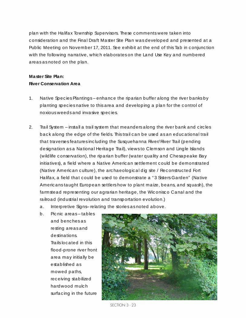
back along the edge of the fields. This trail can be used as an educational trail that traverses features including the Susquehanna River/River Trail (pending designation as a National Heritage Trail), views to Clemson and Lingle Islands (wildlife conservation), the riparian buffer (water quality and Chesapeake Bay initiatives), a field where a Native American settlement could be demonstrated (Native American culture), the archaeological dig site / Reconstructed Fort Halifax, a field that could be used to demonstrate a “3 Sisters Garden” (Native Americans taught European settlers how to plant maize, beans, and squash), the farmstead representing our agrarian heritage, the Wiconisco Canal and the railroad (industrial revolution and transportation evolution.) a. Interpretive Signs– relating the stories as noted above. b. Picnic areas – tables
and benches as resting areas and destinations. Trails located in this flood-prone river front area may initially be established as mowed paths, receiving stabilized hardwood mulch surfacing in the future

SECTION 3 - 24
as park features are developed. In the final design and engineering of park trails, to the extent reasonable, considerations must be given to make trails universally accessible in accordance with the Americans with Disabilities Act (ADA) guidelines (see http://www.access-board.gov/outdoor/nprm.pdf.) Considering the remote areas and slopes that some of these trails traverse, it should be noted that not all of the trails must or can be made accessible. However, it is the intent of this plan that all trails near the developed areas of the site should comply with the ADA guidelines. Accessibility needs to consider longitudinal slopes of 5% or less, adequate width (5’ minimum), and stabilized surfacing that meets ADA standards.
3. River Camping – two low-impact campsites for use by Susquehanna River Water
Trail travelers. These are envisioned to be developed and maintained through a partnership with the Susquehanna River Trail Association.
4. Canoe/Kayak Launch – a stabilized path and ‘soft launch’ providing access to the
river for hand-carried boats. Stabilized access trail and parking spaces will be provided.
Heritage Interpretation 5. Archaeological Dig – Potential exists for partnership with a University to excavate,
interpret and provide educational opportunities for park visitors. Exact location will be determined as part of the archaeological study.
6. Fort Halifax Reconstruction - Exact location will be determined as part of an
archaeological study. It should be noted that reconstruction will not occur in the exact historical location, as that would destroy artifacts.
7. Native American Culture – This mowed field is defined by a hedgerow, and can
be used to set up Native American encampment for education / demonstration purposes.
8. Agriculture & Early American Settlement – This field could be used for planting a
“Three Sisters” garden, demonstrating how the Native Americans taught the European Settlers to plant maize, beans and squash.

SECTION 3 - 25
9. Transportation Role in Developing America – The Susquehanna River, Wiconisco Canal, Norfolk Southern Railroad, and SR 147 (former U.S. Route 1) together can tell the “Transportation Evolution Story” and how it impacted developing America.
10. Barn – this structure could serve an adaptive reuse such as storage, display area,
or boat rental. 11. Festival Area – stabilized stone trails are proposed within groves of trees that define
the space and provide shade for outdoor activities. 12. Farmhouses – these have potential to initially serve as rental units, providing
income to offset park maintenance costs. In the future, these could be used as an education center, park office, or support building for outdoor activities such as meetings and weddings.
13. Parking – with a paved access drive and six universally accessible spaces, five
stabilized stone bus parking spaces, 44 stabilized stone parking spaces, and 119 lawn parking spaces defined by tree rows.
14. Picnic Grove with Pavilions and Restroom – within a planted tree grove, accessing
the existing electric service along Buffalo Park Road, and the proposed new on-site well for public water and a new on-site septic system. Both pavilions will have electricity, water, concrete floors, and picnic tables; one will have public restrooms. These facilities will be served by water from a new on-site well permitted for public drinking water.
14A. Canal Pavilion – this pavilion will contain architectural features that reflect period
canal boats, and can be used as an outdoor education classroom. This pavilion will have electricity, a concrete floor, and picnic tables.
Trails within this Heritage Interpretation are envisioned as compacted, stabilized stone paths (with limestone screenings) for universal accessibility in accordance with the Americans with Disabilities Act (ADA) guidelines (see http://www.access-board.gov/outdoor/nprm.pdf.) Considering the remote areas and slopes that some of these trails traverse, it should be noted that not all of the trails must or can be made accessible. However, it is the intent of this plan that all trails near the developed areas of the site should comply with the ADA guidelines. Accessibility needs to consider

SECTION 3 - 26
longitudinal slopes of 5% or less, adequate width (5’ minimum), and stabilized surfacing that meets ADA standards. Trails located within the steeper terrain of this site should, where possible, adhere to these guidelines, excepting that if to do so would detract or damage the natural features with which the trail is intended to connect.
Western Meadows 15. Remembrance Walk / Peace Garden - a formal walking path with interpretive
signs installed for each of the wars/conflicts since the William Penn Charter, to raise awareness of our veterans and military heritage. This is envisioned as a walkway stabilized with pavers around the perimeter of a lawn area, which would be surrounded by formal (military style) tree plantings. In the center of the lawn there could be a large white pine with an interpretive sign educating about the Iroquois Tree of Peace. (See Appendix for Elaboration of the Remembrance Walk Concept). It is recommended to conduct a wetland investigation prior to earth disturbance for construction.
16. Parking – the existing driveway will be widened for two-way access, having a
center island with flagpoles and park entrance sign. A paved access drive and six universally accessible spaces, five stabilized stone bus parking spaces, 20 stabilized stone parking spaces, stabilized trails and shade trees will be constructed. Conduct a wetland investigation prior to earth disturbance for construction. Engage with Mr. Robert Keefer, a local stone mason who offered to donate his services for stone construction.
17. Trails – trails will be mowed within the wet meadow habitat area with interpretive
signs teaching about the varied ecosystems and storm water recharge areas. Annual mulching of trails with wood chips will allow for eventual elevation of the walking surface; provide cross pipes with end sections in the future to prevent water from ponding where undesirable. In the final design and engineering of all park trails, to the extent reasonable considerations must be given to make trails universally accessible in accordance with the Americans with Disabilities Act (ADA) guidelines (see http://www.access-board.gov/outdoor/nprm.pdf.)

SECTION 3 - 27
18. Wet Meadow Habitat Area – this area should be checked for the presence of invasive species, and seeded with wet meadow mix (no-till). Mowing will be done on varied schedules of once or twice per year, and once every two years, to allow varied stages of succession to establish. Conduct wetland investigation prior to earth disturbance for recharge areas.
19. Overhead Walkway – connect the segments of the park on both sides of SR 147
using an overhead walkway. If possible incorporate the use of an abandoned bridge through PennDOT or the Pennsylvania Historic and Museum Commission.
19A. Heritage Bridge Project – If determined necessary by Norfolk Southern, install
above grade railroad crossing and required accessible ramps. Utilize this structure as a teaching tool to educate about transportation systems and the industrial revolution.
Eastern Meadow 20. Sycamore Alee w/ Wildflowers – the WWI Sycamore Alee` is being restored by
planting replacement sycamore trees for those that are missing. Establish a buffer of wildflowers along SR 147 to enhance the Alee`, to visually define the park boundary, and to identify the park’s presence.
21. WWI Alee Interpretation – construct a pull off area within the park consisting of 2
accessible and 3 standard parking spaces, a paved walkway and an interpretive sign to educate about the significance of the Sycamore Alee`. A gate will be installed to designate park closure at dusk.
22. Hiking/Walking Trails – mow trails within the fields for recreation purposes including
walking, hiking, cross-country skiing, bird watching, etc. The perimeter trail along the eastern woods line will be constructed of stabilized stone (with limestone screenings) 8 feet wide for universal accessibility and access for maintenance and emergency vehicles. The trail around the pavilion (#27) may initially be established as a mowed path, receiving stabilized hardwood mulch surfacing in the future as park features are developed. In the final design and engineering of park trails, to the extent reasonable, considerations must be given to make trails universally accessible in accordance with the Americans with Disabilities Act (ADA) guidelines (see http://www.access-board.gov/outdoor/nprm.pdf.)

SECTION 3 - 28
Considering the remote areas and slopes that some of these trails traverse, it should be noted that not all of the trails must or can be made accessible. However, it is the intent of this plan that all trails near the developed areas of the site should comply with the ADA guidelines. Accessibility needs to consider longitudinal slopes of 5% or less, adequate width (5’ minimum), and stabilized surfacing that meets ADA standards.
23. Meadow of Warm-season Grasses – establish warm-season grasses and forbs to
replace the existing vegetation. Use species that have deep roots for water and soil retention, fixing nitrogen, filtering runoff, and carbon sequestration. These species will also provide natural habitat, food and cover, and reduce mowing operations.
24. Native Tree Groves - Trees and forests play an important role in reducing storm
water and filtering pollutants that would otherwise wind up in our waterways. By providing tree canopies we can reduce the amount of rainfall that reaches the ground, reducing storm water runoff and erosion. Tree roots and leaf litter allow for better infiltration and absorption of rainfall, which further reduces runoff and improves water quality. Through the process of evapo-transpiration, trees take up water through their roots and transpire it back into the atmosphere as water vapor; through phyto-remediation they remove pollutants such as nitrates and phosphates, heavy metals, pesticides, solvents, oils and hydrocarbons.
25. Parking – a paved access drive and four universally accessible spaces and 85
lawn parking spaces defined by tree rows. A gate will be installed to designate access only by authorized vehicles beyond this point.
26. Outdoor Amphitheatre – this naturally sloping area is secluded in a way that
provides opportunity for using the pavilion for entertainment and/or education, with the lawn area for public viewing. Mulched paths will provide access around this area.
27. Outdoor Education Pavilion - this pavilion will can be used as an outdoor
education classroom; it will have electrical service, a concrete floor, and picnic tables.
28. Composting Toilet – this will be a self-contained vault style restroom facility.

SECTION 3 - 29
29. Gated Maintenance Road – this perimeter road will be paved to provide access to authorized vehicles for emergencies and maintenance, and circulation of buses for special events.
30. Pavilion w/ Restroom - This pavilion will have public restrooms, gravity sewer
service, public water service, electricity, concrete floors and picnic tables. An access drive, drop off and parking stalls will be provided near this facility.
31. Overlook Grove – this feature consists of a grove of six trees with picnic tables
situated on a knoll that offers panoramic vistas to the northwest. 32. Parking – a paved access drive from both Third Street and SR 147, with one paved
parking lot drive with four universally accessible spaces and 108 lawn parking spaces. The driveway is defined by tree rows. A gate will be installed to designate access only by authorized vehicles beyond this point.
33. Wildflower meadow - establish a buffer of trees along neighboring properties, with
a meadow of wildflowers on the inside of the tree buffer. 34. Wildflower meadow - establish a buffer of trees along neighboring properties, with
a meadow of wildflowers on the inside of the tree buffer. Creek Conservation 35. Hiking/Walking Trails w/ Interpretive Signs – develop mulched trails through the
woods following existing deer paths. Provide interpretive signs to educate about woodland conservation, wildlife habitat and riparian buffers. The connector trail to the lower meadow should be constructed of stabilized stone (with limestone screenings) 8 feet wide for universal accessibility and access for maintenance and emergency vehicles. The remaining trails may initially be established as mowed paths, receiving stabilized hardwood mulch surfacing in the future as park features are developed. In the final design and engineering of park trails, to the extent reasonable, considerations must be given to make trails universally accessible in accordance with the Americans with Disabilities Act (ADA) guidelines (see http://www.access-board.gov/outdoor/nprm.pdf.) Considering the remote areas and slopes that some of these trails traverse, it should be noted that not all of the trails must or can be made accessible. However, it is the intent of this plan that all

SECTION 3 - 30
trails near the developed areas of the site should comply with the ADA guidelines. Accessibility needs to consider longitudinal slopes of 5% or less, adequate width (5’ minimum), and stabilized surfacing that meets ADA standards.
36. Stream bank Restoration/Fish Habitat Enhancement – work with the Pennsylvania
Fish and Boat Commission to develop enhancement projects that enhance aquatic habitats and improve stream bank stabilization. Install signage to educate the public about the projects.
37. Primitive Camping – develop designated (by permit) campsites with picnic tables.
This will be carry-in / carry-out sites that could be used by stewardship groups to teach low-impact camping.
38. Bridge – a small bridge is proposed over Armstrong Creek to provide access to the
eastern most portion of the site. There is an existing low-flow crossing, but it is recommended to install a bridge for maintenance and authorized vehicles.
39. Sitting Area – this area is elevated above Armstrong Creek and offers an overview
of the stream valley floor. A small shelter such as a gazebo would serve as a destination and resting area for trail users.
40. Meadow of Warm-season Grasses – establish warm-season grasses and forbs to
replace the existing vegetation. Use species that have deep roots for water and soil retention, fixing nitrogen, filtering runoff, and carbon sequestration. These species will also provide natural habitat food and cover, and reduce mowing operations.
Items Beyond the Scope of this Project: Further study is warranted in the following areas, as they are beyond the scope of services of this project:

SECTION 3 - 31
Railroad Considerations: Norfolk Southern Railroad Comments – provided by Thomas Bracey, NFS Engineer 1. The Township use of the crossing for access to their property and for maintenance is
being reviewed. A private crossing agreement will be needed for continued access by the Township.
2. Any proposed public crossing at this site should be grade separated, i.e. tunnel or
elevated 23’ above tracks. a. An overhead structure would detract from the atmosphere of the site; but if
required could be used to tell the history of the industrial revolution/impact to transportation. The cost of the structure would delay some elements of the park due to limited access.
b. The extension of Buffalo Park Road is essential; planning for this should be initiated concurrent with Phase 1 construction.
c. This could impact houses as rental units, and will also impact the phasing of the park development.
d. Special events/festivals could also be impacted: i. Recommendation: Develop a set of protocols, i.e. a plan for public safety
relative to the railroad crossing. This could include coordinated operations such as reduced train speeds for specific hours, and the park providing crossing guards.
3. The fencing indicated to be required along the tracks would be both expensive and
a detraction from the historic atmosphere of a heritage park. Recommendation: Work with NFS to develop a reasonable plan for protecting the public while also preserving the character of a heritage park.
Township Options
1. The Township should petition for a lowered train speed limit – asking for an extension
of the slower speed zone in Halifax Borough to be extended to Armstrong Creek. This should be viewed as a safety issue not just for the park, but for the neighboring citizens as well.
2. Challenge NFS via the PUC to permit this to be a public access.

SECTION 3 - 32
a. Without this access being approved for use by the public, the westernmost portion of the park property is land locked (for public use). Even if Buffalo Park Road is extended, the property cannot be accessed by the land owner (or emergency vehicles) during seasonal high water events.
b. Make a case regarding the importance of this park for heritage and conservation education, not just locally but on a regional and state-wide level.
i. Present a summary of public funds invested to date for the purchase and development of this park, demonstrating public support.
ii. Obtain letters of support from DCNR, PHMC, CPC, Halifax School District, County Commissioners, PA Representative Susan Helm, State Senators John Gordner and Jeffrey Piccolo, and U.S. Representative Tim Holden, etc.
c. Demonstrate the hardship created by NFS required expenditures: i. for at-grade public crossing (signs, markings, gates) - $150,000 ii. grade-separated requirements - $3,984,000 iii. industrial fencing - $340,020 (for type recommended by NFS)
Note: Frank Wilmarth, a citizen who has worked for PUC, requested the Township provide documentation of the existing private crossing so the classification of crossing can be verified. If this is determined to be a public crossing, we could then petition the PUC to allow the existing at-grade crossing to be used by the public, constructing improvements to support pedestrian, and maintenance/emergency vehicle access. Recommendations: 1. Township should locate their current crossing agreement. 2. Demonstrate to NFS that this access is the only way in and out of the western park
property, especially during seasonal high water. 3. Petition PUC to intercede on Township’s behalf. 4. Engage political support including County Commissioners, Representative Susan
Helm and Senator Jeffrey Piccola and Congressman Tim Holden. 5. Request reduced train speeds while traveling through the Borough and north to the
Armstrong Creek Bridge.

SECTION 3 - 33
Sewer and Water Considerations: Public Water and Sewer vs. On-Site Systems: Fred Ford of the Halifax Water and Sewer Authority expressed concern about the cost of extending public water and sewer into the park along Buffalo Park Road. He cited that the use would not justify the cost of installation and operation, which would require a pump station. When asked about malfunctioning septic systems in the area, Mr. Ford indicated that no problems exist. When asked about the possibility of public sewer service from Fourth Street to serve a pavilion with restrooms upslope of the Locust Street gravity sewer line Mr. Ford indicated that service to this facility would be possible, clarifying that the Authority would not bear the cost of the construction. It was noted by the Supervisors that there are some existing septic system issues at the farmhouse that will need to be resolved. Based on conversations with Mike Brown (Township SEO), on-site sewage disposal systems would be feasible for the western portion of the park, noting that testing would need to be done to verify the type of system and area requirements. Recommendation: Pursue the use of onsite water and sewage disposal systems for the western portion of the property, and public water and sewer for the eastern portion. The SEO should be engaged to do the required testing. Archaeological Considerations: Archaeological Survey: Before any development can begin, an archeological survey should be completed. Since this is a lengthy process, initial investigations should be pursued promptly in Phase 1 and Phase 2 areas. In August of 2011 the Township was fortunate to have been chosen to receive donated services from PennDOT’s Highway Archaeological Survey Team (PHAST). The following is a brief description of the program and services performed, as provided by Joe Baker, PennDOT Archaeologist.
Note: In April of 2011, DCNR and PennDOT concluded an informal interagency agreement that allowed DOT the use of the Tom Ridge Center at Presque Isle in Erie for a multi-day meeting in exchange for the services of PennDOT’s Highway

SECTION 3 - 34
Archaeological Survey Team (PHAST) for a small project. (DCNR has no in-house archaeological or historic preservation services, and when they’re required for a project to comply with State and Federal preservation laws, the agency has to contract with a consultant, sometimes at substantial costs.) The PHAST program, operated as an agency-university partnership between PennDOT and Indiana University of Pennsylvania (IUP) gives archaeology graduate students an opportunity to work on small but important projects ahead of PennDOT highway improvements. PHAST offers real world experience under the direction of experienced staff archaeologists for the students, and a cost-effective and agile alternative to traditional consulting services for the Department and the taxpayers; a real win-win.
When PHAST asked DCNR what project they’d like them to work on, they suggested Fort Halifax, primarily because of IUP’s experience with various kinds of geo-archaeological technologies like Ground Penetrating Radar (GPR). PHAST fulfilled their end of the interagency agreement by conducting the GPR survey at Fort Halifax Park in August 2011, and followed it up with a volunteer weekend effort in October. This initial investigative field work has been completed, and a report is being completed by PennDOT with specific recommendations.
At the conclusion of the work, the following was posted on the Friends of Fort Halifax website:
In regard to future excavation of the site, Joe recommended that the Township might want to consider establishing a long-term relationship with one of the nearby state universities with an archaeology department, Millersville University likely being the best possibility. If this type of relationship were established, the school could conduct summer study programs and possibly lease existing structures on the Fort Halifax Park property to house equipment, students and faculty. In time, on-going excavations would likely generate increased interest at the school and locally, as well, and could possibly lead to an answer to the outstanding question: “Where exactly was the site of Fort Halifax, and what if any remains currently exist?” October 2011 Preliminary Excavation Team Members

SECTION 3 - 35
Joe Baker, Head Archaeologist Christine Kula, Lay Volunteer Dane Snyder, Archaeologist Emily Poeppel, IUP Student Volunteer Angie Jaillet-Wentling, Archaeologist Eric Ptak, IUP Student Volunteer Jordan Galentine, IUP Student Volunteer Norma Shearer, Lay Volunteer Laura Kaufman, IUP Student Volunteer Frank Wilmarth, Lay Volunteer
It is recommended that the Township follow the guidance provided in the report that is forthcoming from the PennDOT/PHAST team. This report should be shared with the Pennsylvania Historic and Museum Commission (PHMC), to open the conversation regarding potential funding for pursuing this work. It is also recommended that the Township seek further partnership opportunities with the Indiana University of Pennsylvania Archaeological Department.

W
Land Use Key
River Conservation1. Native Species Plantings2. Trail System
a. Interpretive Signageb. Picnic areas and Benches
3. River Camping4. Canoe/Kayak Launch
Heritage Interpretation5. Archaeological Dig6. Fort Halifax Reconstruction7. Native American Culture8. Agriculture & Early American Settlement9. Transportation Role in Developing America
(River, Canal, Railroad, Highway)10. Barn: storage, canoe/kayak rental11. Festival Area12. Farmhouses
a. Initially as rental unitsb. Future site of Education Center
13. Parking14. Picnic Grove with Pavilion and Restroom14A. Canal Pavilion
Western Meadows15. Remembrance Walk / Peace Garden16. Parking17. Trails18. Wet Meadow Habitat Area19. Overhead Walkway19A. Heritage Bridge Project
Eastern Meadow20. Sycamore Alee w/ Wildflowers21. WWI Alee Interpretation22. Hiking/Walking Trails23. Meadow of Warm-season Grasses24. Native Tree Groves25. Parking26. Outdoor Amphitheatre27. Outdoor Education Pavilion28. Composting Toilet29. Gated Maintenance Road30. Pavilion w/ Restroom31. Overlook Grove32. Parking33. Wildflower meadow34. Wildflower meadow
Creek Conservation35. Hiking/Walking Trails w/ Interpretive Signage36. Streambank Restoration/Fish Habitat
Enhancement37. Primitive Camping (by permit)38. Bridge39. Sitting Area40. Meadow of Warm-season Grasses
Soil Symbol Description
At Atkins silt loam
BhB2 Berks channery silt loam
BkD2 Berks shaly silt loam
BtA Brinkerton and Armagh silt loams
ClB2 Calvin-Leck Kill shaly silt loam
ClC2 Calvin-Leck Kill shaly silt loam
CnA_ Chavies fine sandy loam
CnB2 Chavies fine sandy loam
DvA Duncannon very fine sandy loam
DvB2 Duncannon very fine sandy loam
LeB2 Lawrenceville very fine sandy loam
Lw Lindside silt loam
Us Urban land
WeE2 Weikert shaly silt loam

TAB
4

SECTION 4 - 1
PARK MANAGEMENT STRUCTURE The Fort Halifax Park is a destination which has local, state and national potential. This park presents unique opportunities to: 1. Communicate significant stories about the region including:
a. Native American Culture b. Colonial History c. Transportation Evolution relative to American History d. Agricultural Heritage e. Environmental Education
2. Conserve diverse and environmentally sensitive habitats 3. Enhance the quality of life within Halifax Township and its neighboring communities 4. Positively impact the region’s economy (as a visitor destination) Larson Design Group looked at management models of other public facilities that focus on historic preservation, conservation and communication with visitors. While investigating the total operation of these facilities, the following areas were considered: • Name and mission of the site • Managing entity: state government, local government or non profit, • Role of citizen involvement: citizen governing board, citizen advisory board,
resource management and development. • Use and role of volunteers. • Role of paid employees, both part-time and full-time • Annual operating budget • Annual revenue and sources of income. • Visitor profiles and annual number of visits • Programs and festivals

SECTION 4 - 2
Some of the models which were reviewed include: • Non Profit 501-C-3 Organization
1. Louisa May Alcott’s Orchard House, Concord Massachusetts. • Local Government
2. Dauphin County Parks Department Fort Hunter Mansion and Park, Harrisburg, Pennsylvania Wildwood Park, Harrisburg, Pennsylvania
3. Bendix Woods, (Studebaker Estate), St Joe County Parks, New Carlisle, Indiana 4. HARA, Halifax Area Recreation Authority
• State Parks
5. My Old Kentucky Home, Kentucky State Park, Bardstown Kentucky 6. Fort Halifax, Maine State Park, Kennebec River Valley
• Private corporation
7. Montour Preserve, PP&L historic and environmental education and conservation facility, Danville, Pennsylvania
Management Structure In order to develop Fort Halifax Park into a valuable and sustainable community resource, it is very important for the Township to establish an entity for park management. This entity will: 1. Identify and develop beneficial partnerships - between governments, community
organizations, educational institutions, community service agencies, special interest groups and individuals.
2. Mobilize individuals and leverage resources for the purpose of encouraging the
planned development of the park. 3. Promote park use through the development of recreational and educational
programming.

SECTION 4 - 3
To achieve the above, The Fort Halifax Park Study Committee together with Larson Design Group recommends that the Township establish the Fort Halifax Park Commission. This Commission is suggested to contain 9 members, comprised of the following: • Three (3) members appointed by the Halifax Township Supervisors • Three (3) members appointed by the Friends of Fort Halifax Park, Inc. • One (1) member appointed by the Dauphin County Commissioners • One (1) member appointed by the Halifax Historical Society • One (1) member appointed by the Halifax Area School Board The Appendix to this plan includes an exhibit/document which could be used to create the Fort Halifax Park Commission. This generic, draft intergovernmental agreement identifies the participants and then defines the collective roles and responsibilities of the entities - which together form the Park Commission. Benefits to this Management Structure: This nine member commission would not only represent varied park interests, but would also engage key stakeholders and partners to be committed supporters of the park. By creating a diversified organization, a strong foundation is built for long-term sustainability and demonstrated intergovernmental cooperation. This strategy is viewed favorably by funding agencies.

TAB
5

SECTION 5 - 1
FINANCIAL ANALYSIS The financial analysis is divided into four sections: A. Phased Development costs B. Operating budget and revenue projection C. Potential Partnerships D. Site Sustainability Resources A. Phased Development Costs Development costs are presented by proposed phasing of improvements. Phasing as proposed considered community input, logical sequencing, and the potential for leveraging sources of funding; this is conceptual in nature and subject to change based on evolving community needs and funding opportunities. Costs for Phases 2-6 are presented as general costs, as there are many variables including: how far in the future these phases will be implemented, the potential for partnerships/collaboration with schools, universities, volunteer organizations, and donated in-kind services. A more detailed opinion of cost is presented for Phase 1, which will help to facilitate initial applications to potential funding entities. Unless otherwise indicated, the costs assume that all work would be contracted and minimum prevailing wage rates would apply. Opinion of Probable Costs: Phase 1 Proposed Improvements
1. Park Access - $240,150
a. Eastern driveway, parking and gates $171,800 i. Paved drive, stabilized stone parking plus gate - $32,000 ii. Plant shade 45 trees along roadway perimeter - $18,000 iii. Wildflower seeding – 1.4 acres $2,800 iv. 3.3 acres of Lawn (topsoil +Formula B seeding) – $19,000 v. Composting toilet (#28) self-contained, vault style restroom - $100,000
b. Western driveway widening and improvements $20,000 vi. Paved drive, stabilized stone parking plus gate - $20,000
c. Park Signs$14,000 i. SR 147 – directional at northern access - $2,500

SECTION 5 - 2
ii. SR 147 - park identification/directional – $11,500 + Mr. Keefer d. Trails: (#2, 22 and Fourth Street connector) $34,350
i. Trails #22 and #2 could be mowed paths – possibly adopted (for maintenance purposes) by local volunteers/organizations.
ii. Stabilized path along eastern woods line with gate:3145 SY x $10 = $34,350 2. Sycamore Alee and wildflower seeding along SR147 - $51,500
a. Sycamore Tree planting already funded. b. Northern entrance off of S.R. 147, parking, gate and interpretive signs- $34,500 c. Wildflower seeding – 8.5 acres $17,000 d. Reduced speed limit on SR 147 – meeting/coordination with PennDOT.
3. Conservation and Sustainability - $86,400
a. Farmhouse improvements for rentals - $18,000 plus volunteer labor b. Armstrong Creek fish habitat /bank restoration – total value $10,000
i. PFBC –Technical Assistance Program – $1,150 ii. Volunteers construction labor; 4-6 people @ 20 hours iii. Track hoe/ Backhoe w/ operator = $5,080 iv. Materials $3,770
c. Warm season grasses, buffers to neighbors by river, tree groves (#23 & 24) $57,400
i. 5.6 acres of seedlings (river) - $10,200 ii. 6 acres of seedlings (fields) - $12,000 iii. 44 acres warm season grasses - $35,200
d. Forest Management Plan - $1000 4. Archaeological Investigations - $168,000
a. 27 acres along River: $13,500 (geomorphology) + $135,000 (Phase 1&2) b. 3 acres along Creek: $1,500 (geomorphology) + $18,000 (Phase 1&2)
5. Sewage Testing - Soil testing /probes for mound system (approx. ½ acre) = $12,000 6. Engineering for Site Development - $41,950 PHASE 1 TOTAL COST: $600,000


SECTION 5 - 3
Phase 2 Proposed Improvements (#) Numbers in parenthesis correspond to features as labeled on plans. (*) Asterisk indicates a budget allowance for general planning purposes. More detailed
cost projections would require further study beyond the scope of this plan. Fort Halifax Archaeological dig (#5) ............................................................................... 60,000* Buffalo Park Road extension ........................................................................................... 128,000* Parking Area #14 1950 LF of paved driveway ............................................................ 31,200 6 paved accessible spaces ........................................................... 13,200 44 stabilized parking spaces ............................................................ 5,850 5 stabilized bus space .......................................................................... 800 Trail from parking to Festival area 1490 LF paved stabilized trail ......................................................... 22,350 Well for on-site public water service (serves farmstead/pavilion) ............................... 22,000* Picnic pavilion (#14 - one of two) 1 shelter w/ concrete floor ............................................................. 35,000 8 picnic tables .................................................................................... 8,000 1” Water service (420LF from public well- see above) ............... 10,000 Underground electrical service (410 LF) ....................................... 10,000 80 LF stabilized trail ............................................................................ 1,200 18 Trees ................................................................................................ 7,200 New on-site septic system ................................................................................................. 60,000* Fencing along eastern side of railroad 950 LF chain link fencing (areas screened by vegetation) ...... 38,000* 1480 LF historically-appropriate fencing ..................................... 96,200* Boat launch (#4) 1paved accessible space ............................................................... 2,200 12 stabilized parking spaces ............................................................ 2,000 80 LF of access path ......................................................................... 1,200 River camping (#3-two sites) 2 Fire rings ........................................................................................... 1,200 Pavilion (#27) 1 shelter w/ concrete floor ............................................................. 35,000 8 picnic tables .................................................................................... 8,000 Underground electrical service (1240 LF) ..................................... 28,000

SECTION 5 - 4
840 LF stabilized trail ........................................................................ 12,600 Rental units phased-out, converted into park operations .......................................... 32,000* Barn roof repairs and gutters (storage and maintenance use) .................................... 2,200* Site Enhancements 77 trees (river areas) ........................................................................ 30,800 0.5 acres warm season grass seeing (control geese population) ............................................................................................ 400 Interpretive signage ........................................................................ 10,000 PHASE 2 TOTAL COST: $714,600 Phase 3 Proposed Improvements Fort Halifax reconstruction (#6) ...................................................................................... 225,000* Buffers to neighbors (between railroad and SR147) Trees (55) ........................................................................................... 22,000 Tree seedlings (5.4 acres) ............................................................... 10,800 Wet Meadow Habitat area seeding (#17-18) Grading for recharge areas ............................................................. 4,000 3.3 acres of wet meadow mix seeding (no-till) ............................. 6,600 Additional Tree Grove plantings (#24) Trees (739) ....................................................................................... 295,600 PHASE 3 TOTAL COST: $564,000 Phase 4 Proposed Improvements Parking (#16) 770 LF of paved driveway ............................................................ 137,060 6 paved accessible spaces ........................................................... 13,200 20 stabilized parking spaces ............................................................ 2,660 5 stabilized bus spaces ........................................................................ 800 650 LF stabilized trail .......................................................................... 9,750 56 Trees .............................................................................................. 22,400 Remembrance Walk / Peace Garden (#15) 890 LF paved path ......................................................................... 58,740 67 Trees .............................................................................................. 26,800

SECTION 5 - 5
0.4 acres Lawn ................................................................................... 2,300 Interpretive signs .............................................................................. 30,000 Wet Meadow trails 800 LF Mulched trails with cross-pipes and end sections .......... 12,600 Fencing along eastern side of railroad 1590 LF chain link fencing (areas screened by vegetation) ... 63,600* 670 LF historically-appropriate fencing ...................................... 43,550* Railroad crossing improvements (signs, markings, gates) ........................................... 225,000 Southeastern entrances (from SR147 and Third Street) 1760 LF stabilized drive ........................................................................ 800 24 Trees ................................................................................................ 9,600 2.1 acres Wildflower seeding ........................................................... 4,200 Parking (#32) – mowed field Grading for swale and recharge areas ......................................... 6,500 380 LF of paved driveway .............................................................. 67,640 3 paved accessible spaces ............................................................. 6,600 380 LF stabilized driveway ................................................................ 6,080 310 LF stabilized trail .......................................................................... 4,650 Fitness trail 5 exercise stations ............................................................................ 25,000 480 LF stabilized trail .......................................................................... 7,200 5.6 acres lawn seeding ................................................................... 32,360 13 Trees ................................................................................................ 5,200 Pavilion (#30) 1 shelter w/ concrete floor ............................................................ 35,000 8 picnic tables .................................................................................... 8,000 Underground electrical service (810 LF) ....................................... 20,000 Sewer extension from Fourth Street Sewer Tap fee .................................................................................... 4,000 5 Manholes ....................................................................................... 22,500 810 LF SDR-35 sewer pipe ............................................................... 32,400 Water extension from Fourth Street Water Tap fee .................................................................................... 3,000 Water meter pit .................................................................................. 2,000 170 LF 6” Ductile Iron pipe .............................................................. 14,450 640 LF 1” HDPE water service line .................................................. 12,800 180 LF of paved driveway .............................................................. 32,040
SECTION 5 - 6
120 LF stabilized trail .......................................................................... 1,800 4 paved accessible spaces ............................................................. 8,800 17 stabilized parking spaces ............................................................ 2,260 5 Trees .................................................................................................. 2,000 Overlook Grove (#31) 6 Trees .................................................................................................. 2,400 530 LF stabilized trail .......................................................................... 7,950 3 picnic tables .................................................................................... 3,000 Wildflowers (#33 and #34) 2.5 acres wildflower seeding ............................................................ 5,000 Transportation Role in Developing American (#9) 810 LF stabilized trail ........................................................................ 12,150 Interpretive signs ................................................................................ 5,000 Site Enhancements 65 trees (river areas) ........................................................................ 26,000
PHASE 4 TOTAL COST: $1,086,840 Phase 5 Proposed Improvements Agriculture and early American settlement area (#8) Establish “Three Sisters” garden for a demonstration area.......... 6,000 35 Trees .............................................................................................. 14,000 Interpretive signs ................................................................................ 5,000 Canal Boat pavilion (#14A) – architecturally reminiscent of a canal boat 1 shelter w/ concrete floor ............................................................. 39,000 8 picnic tables .................................................................................... 8,000 Underground electrical service (150 LF) ......................................... 4,500 30 LF stabilized trail ............................................................................... 450 Pavilion (#14 – two of two) 1 shelter w/ concrete floor ............................................................. 35,000 8 picnic tables .................................................................................... 8,000 Underground electrical service (300 LF) ......................................... 7,000 17 Trees ................................................................................................ 6,800 Bridge over Armstrong Creek (#38) ........................................... 250,000* Warm season grasses (#40) 6.3 acres seeding .............................................................................. 5,040

SECTION 5 - 7
Woodland trails 480LF Trail relocation near #30 ...................................................... 10,000 2490LF of mulched trail .................................................................. 24,900 Footbridge (over seasonally wet area) ....................................... 60,000* Primitive camping (#37) Selective clearing ................................................................................. 300 4 Picnic Tables .................................................................................... 4,000 Sitting area (#39) Selective clearing ................................................................................. 300 Gazebo/Structure ............................................................................ 16,000 Interpretive Signs ................................................................................ 7,500 PHASE 5 TOTAL COST: $511,790
Phase 6 Proposed Improvements Native American Culture (#7) Develop Native American settlement demonstration area .... 12,000* Railroad - Heritage Bridge Structure (if deemed necessary) Overhead structure ................................................................... 4,000,000* Pedestrian bridge over SR147 .................................................. 1,200,000* Footbridge over New England Run.............................................. 60,000* Woodland Trails 4630 LF mulched trails ..................................................................... 46,300 Wiconisco Canal reconstruction (partial segment) ................ 350,000* Interpretive Signs ................................................................................ 5,000 PHASE 6 TOTAL COST: $5,673,300 B. Operating Budget and Revenue Projection
Because this model is volunteer driven and directed, the following budget proposal allows Halifax Township and their designees to rent special park facilities, offer special events and programs, and expand these services as the park’s facilities and amenities are developed.

SECTION 5 - 8
Anticipated Expenditures Salaries and wages This model relies on volunteers and does not provide for any additional full-time staff or seasonal employees during the first two phases of development. The existing Township’s workforce will continue to provide services as directed by the Halifax Township Supervisors. Halifax Township and their designees can also hire individuals for specific purposes, such as program leadership through a “revolving account.” The revolving account allows the Park’s managers to develop a contract with an individual. This contract defines the role and responsibilities, the length of time that the contract will be in effect as well as the amount of money paid for the services provided. These programs generate the income required by the contract through users’ fees and / or donations. Employee Benefits Since there is no additional staff, there is nothing budgeted for these line items during the first two phases of development. As the Park’s facilities grow and programs and services increase, this line item will grow. Administration As a cooperative effort by all entities participating in the Fort Halifax Park, the Park will offer facility rentals, programs, and special events. These activities will require that the Park’s managers in cooperation with the Friends of Fort Halifax Park, Inc. plan, promote and conduct its business. • Insurance such as liability and directors and officers insurance is currently provided
through Halifax Township. This insurance protects the Township and park volunteers and park visitors from the risks associated with property damage and or personal injury which may result from use of the park.

SECTION 5 - 9
• Advertising: Halifax Township and the Friends of Fort Halifax Park, Inc. are responsible for providing parks and recreation services and facilities within its service area. It is important that this entity promote and make the public aware of its services and efforts. Since events have potential to generate revenue, this should be viewed as having return for the investment.
• Postage: The Halifax Township and the Friends of Fort Halifax Park, Inc. will mail documents, advertisements and general Fort Halifax Park business.
• Subscriptions and Dues: It is recommended that Halifax Township in cooperation
with the Friends of Fort Halifax Park, Inc. Park should join the Pennsylvania Recreation and Parks Society (PRPS). This organization provides training programs for Commission members and employees as well as offers a wide variety of resources, including advertisement of events through their web-mailed bulletin board. The Commission is also encouraged to actively participate in local organizations such as the Chamber of Commerce, and the Fort Halifax Historic Society.
• Training: PRPS offers an outstanding training program for members of public
recreation committees, commissions and boards. It is strongly recommended that Halifax Township take advantage of these valuable opportunities. These training programs help municipalities improve their playgrounds, public open spaces, and improve the efficiency of park operations.
• Auditing Services: Since this organization is supported by a variety of public and
private funds, it is highly recommended that the Halifax Township’s financial activities be audited annually. A report of this audit should be shared with each of the participating entities.
• Legal Services: Fort Halifax Park development and services will require legal review
and advice as the Park’s function and use grows. • Office Supplies: While this line item is minimal, it will include paper, Fort Halifax
stationary, printer ink, pens, pencils, file folders, hanging file dividers etc.

SECTION 5 - 10
• Office Equipment: During the first two phases of operation, the Township’s office equipment will serve the park’s basic scheduling and administrative functions. Later development phases will require that the Township purchase an internet capable computer and printer in order to facilitate the expanding business of the park.
• Website Development and Maintenance: Website development and
maintenance is an important vehicle to assist in promoting the Fort Halifax Park and its services and events. The Park’s services and facilities should tie into the Township’s website as well as the Friends of Fort Halifax Park, Inc. Park’s website. Halifax Township and the Friends of Fort Halifax Park, Inc. may choose to work with a local University or College to develop the website as part of their curriculum. This might be done at no cost but the maintenance and updating of the website will likely require a cost.
Materials and Supplies This budget category allows for the purchase of material and supplies required to maintain the park as well as to purchase program supplies to enhance the programs held at the park. Please note that these costs will increase as the park is developed and park usage grows. Utilities As the Park is developed it will be necessary to incur the cost of electricity, phone and eventually internet access. In the future, public water and sewer will also serve the eastern pavilion and restroom. Equipment and Repairs As the park is developed and as park use increases, the Park Commission must purchase and maintain, communication equipment as well as tractors and mowing equipment.

SECTION 5 - 11
Anticipated Revenue The revenue plan for Fort Halifax Park relies on program income, rental income and eventually financial contributions by Halifax Township, park users, and other partners as negotiated. This model demonstrates the participation by Halifax Township in cooperation with the Friends of Fort Halifax Park, Inc. The contribution by Halifax Township can be adjusted as contributions by other sources are developed. This model considers the annual park operation and does not include capital development costs. Program Income Halifax Township in cooperation with their designees will organize programs and rent pavilions as these facilities are developed. The revenue earned from these efforts will be used to help maintain and develop the park. Below is a model that can be used for program development: Program Organization Hiring Program Instructors Halifax Township in cooperation with the Friends of Fort Halifax Park, Inc. should identify and hire program instructors. Instructors can be recruited through a notice on the Township’s website, and the website of the Friends of Fort Halifax Park, Inc. as well as in a Township Newsletter or through word of mouth. It is recommended that all instructors be required to comply with an application process. This application process should include: completing a written application; securing an Act 34 Clearance, and submitting a resume with references, interview as well as reference and past employment reviews. In many cases, program instructors can be paid by contract rather than being placed on payroll. The contract must define the roles and responsibilities of the instructor and the program sponsor.

SECTION 5 - 12
Program Fees When organizing leisure programs, Halifax Township in cooperation with their designees should have a clear understanding of the intended objectives and should communicate this information to potential program participants.
Name of Program: Day, Dates, Times: Location: Age Group of Intended Users: What will the participant learn or gain from the experience: Who and how the program will be supervised: Program Fee: Minimum Class Size: Maximum Class Size:
Property Rental Halifax Township in cooperation with the Friends of Fort Halifax Park, Inc., are urged to renovate and rent the existing homes on the site. This potential represents valuable income that can be used to help offset costs to maintain the park. Based on information and experience provided by Mrs. Linda Ruff Stopfel, each building could generate at least $500.00 per month in rental income.

Fort Halifax ParkProposed Operating Budget
5 - Phase Projection
Line Item 1st Phase 2nd Phase 3rd Phase 4th Phase 5th Phase
SALARIES & WAGES
Secretarial Services -$ -$ -$ -$ Maintenance Personnel -$ -$ -$ -$ Seasonal Personnel -$ 19,776.00$ 20,370.00$ 20,981.10$
Total Salaries & Wages -$ -$ 19,776.00$ 20,370.00$ 20,981.10$
EMPLOYEE BENEFITSFICA -$ -$ 1,512.86$ 1,558.31$ 1,605.05$ Workers' Compensation 503.34$ 523.20$ 535.72$ Life Insurance -$ -$ -$ -$ Pensions -$ -$ -$ -$ -$ Health & Dental Insurance $0.00 $0.00 $0.00
Total Benefits -$ -$ 2,016.20$ 2,081.51$ 2,140.77$
ADMINISTRATION
Insurances: D&Oand General est. -$ -$ -$ -$ Advertising 1,000.00$ 1,500.00$ 1,530.00$ 1,575.90$ 1,631.06$ Postage 800.00$ 850.00$ 850.00$ 900.00$ 900.00$ Subscriptions and Dues 100.00$ 100.00$ 100.00$ 100.00$ 100.00$ Travel Expenses 100.00$ 103.00$ 105.06$ 107.16$ 110.38$ Training 500.00$ 500.00$ 500.00$ 500.00$ 500.00$ Auditing Services 1,200.00$ 1,200.00$ 1,250.00$ 1,250.00$ 1,300.00$ Legal Services -$ -$ -$ -$ -$
Office Supplies 300.00$ 300.00$ 350.00$ 350.00$ 400.00$ Office Equipment 1,000.00$ 500.00$ 700.00$ 700.00$ 850.00$ Website Development& maintenance -$ -$ -$ -$ -$
Total Administration 5,000.00$ 5,053.00$ 5,385.06$ 5,483.06$ 5,791.43$
MATERIALS & SUPPLIES
Fuel & Motor Supplies 1,000.00$ 1,000.00$ 1,010.00$ 1,020.10$ 1,030.30$ Seed, Mulch & Fertilizer -$ 3,000.00$ 4,000.00$ 5,000.00$ 5,000.00$ Sanitary Supplies -$ 3,000.00$ 3,090.00$ 3,182.70$ 3,278.18$ Paint -$ -$ -$ -$ Tools and Supplies -$ -$ -$ -$ Program Supplies 4,000.00$ 4,000.00$ 4,500.00$ 4,500.00$ 4,500.00$
Total Mat. & Supplies 5,000.00$ 11,000.00$ 12,600.00$ 13,702.80$ 13,808.48$
UTILITIES
Office Rental -$ -$ -$ -$ -$ Phone/Internet -$ -$ 1,250.00$ 1,300.00$ 1,300.00$ Electricity -$ -$ -$ -$ Water & Sanitary -$ -$ -$ 1,600.00$ 1,800.00$
Total Utilities -$ -$ 1,250.00$ 2,900.00$ 3,100.00$
EQUIPMENT & REPAIRS
Communication Equip. -$ 720.00$ 800.00$ 800.00$ 880.00$
Maintenance Equipment purchase/lease or rental 7,000.00$ 7,140.00$ 7,282.80$ 7,428.46$
Total Equipment & Repai -$ 7,720.00$ 7,940.00$ 8,082.80$ 8,308.46$
TOTAL BUDGET 10,000.00$ 23,773.00$ 48,967.26$ 52,620.17$ 54,130.24$
1

Fort Halifax Park
Proposed Revenue Plan
Cost Per Capita $0.00 2.05$ 8.32$ 9.08$ 9.23$
Anticipated Operating Costs $10,000.00 23,773.00$ 48,977.00$ 52,621.00$ 54,131.00$
Line Item Pop. 1st phase 2nd Phase 3rd Phase 4th Phase Final Phase
Program Revenue 4,000.00$ 6,000.00$ 8,000.00$ 9,000.00$ 10,000.00$
Rental Income 12,000.00$ 12,000.00$ 12,000.00$ 12,000.00$ 12,000.00$
Halifax Township Population 3,483 -$ 7,140.15$ 28,978.56$ 30,271.17$ 30,330.00$
Total 16,000.00$ 25,140.15$ 48,978.56$ 51,271.17$ 52,330.00$
Profit/(Deficit) 6,000.00$ 1,367.15$ 11.30$ 250.00$ -$
This spread sheet demostrates a revenue plan which uses the income of the site's rental properties as well as income generated by recreation
programs organized by the Friends of Fort Halifax and their programming partners. The Township's contribution to the Fort Halifax Park's annual
maintenance is determined by adding the program and rental income together and then subtracting that amount from the operating costs
associated with the phase of development. During the first development phase, the annual income exceeds cost of operation by $6,000.00.
These excess funds can be used to offset the Township's cost in future development phases or used to increase services and facilities at the
Park. Please note that when the Township does contribute funds to the annual operation of the park, the contribution is translated into an actual

Fort Halifax Park
Proposed Revenue Plan
Cost Per Household -$ 5.05$ 20.80$ 22.71$ 23.07$
Anticipated Operating Costs $10,000.00 23,773.00$ 48,977.00$ 52,621.00$ 54,131.00$
-$ -$ -$ -$ -$
Program Revenue 4,000.00$ 6,000.00$ 8,000.00$ 9,000.00$ 10,000.00$
Municipal Contrib. 12,000.00$ 12,000.00$ 12,000.00$ 12,000.00$ 12,000.00$
Halifax Township (Households) 1,393 -$ 7,034.65$ 28,974.40$ 30,033.08$ 30,339.54$
-$
Total - Option 2 16,000.00$ 25,034.65$ 48,974.40$ 51,033.08$ 52,339.54$
Profit/(Deficit) 4,800.00$ 11.65$ 6.40$ 12.91$ 9.30$
This spreadsheet demonstrates the same information as shown in the previous spreadsheet. However, the Township's contribution to the annual
operating costs associated with future development phases of Fort Halifax Park is calculated as a cost per household.

SECTION 5 - 13
Potential Partnerships Fort Halifax Park can support a wide range of activities and interests, which provides an ample opportunity for collaborating with a diverse group of partners. The following is a list of potential partners for the development, maintenance and on-going support of the park grouped according to their potential area of involvement. Details of specific partners and/or programs follow this listing. Planning and Development Appalachian Regional Commission Dauphin County Commissioners Friends of Fort Halifax Park, Inc. National Park Service/Chesapeake Bay Gateways Network PA Department of Conservation and Natural Resources Pennsylvania Capital Budget Allocations PENNVEST Historic Conservation and Preservation Colleges and Universities Daughters of the American Revolution / Sons of the American Revolution National Park Service/Chesapeake Bay Gateways Network PA Humanities Council Pennsylvania Historic and Museum Commission (PHMC) - State and Local Histories Grants School and University Archaeological Studies Conservation Alliance for the Chesapeake Bay Central Pennsylvania Conservancy Chesapeake Bay Foundation Dauphin County Soil Conservation District Natural Resource Conservation Service PA Land Trust Association Pennsylvania Fish and Boat Commission Pennsylvania Game Commission PENNVEST

SECTION 5 - 14
Trail Development and Maintenance Dauphin County: Parks and Recreation (supervising Department of Corrections labor) Earth Team Volunteers (NRCS) Keystone Trail Association PennDOT (Transportation Enhancements and Smart Transportation) Regional Health Care Systems School and University Stewardship Groups Susquehanna River Trail Association Technical Assistance, Regional Promotion Colleges and Universities Dauphin County Parks and Recreation Dauphin County Visitors Bureau and Tourist Promotion Pennsylvania Recreation and Park Society Susquehanna Greenway Partnership Volunteers, Organization and Training Halifax Area School District Keystone Trail Association Pennsylvania Recreation and Park Society Susquehanna Appalachian Trail Club VolunteerMatch.org (free resource with educational webinars)
Details of specific partners and/or programs The following entities have missions and programs that align with the goals and concepts contained in the Master Site Plan for Fort Halifax Park. It is highly recommended that Halifax Township and the Friends of Fort Halifax Park, Inc. to get familiar with these entities and their programs, and establish working relationships with their local representatives. Successful funding of the park development will require balanced phased projects that seek funding from a variety of sources - leveraging varied sources that can be used to match one another – thereby reducing the financial impact to the Township and its residents. This list represents partners not only for funding, but for the continued support in terms of programming, planning and project development. Year-to-year funding streams are subject to change and program focuses will shift. For this reason it is essential to develop

SECTION 5 - 15
relationships with local representatives, and maintain contact to keep them apprised of on-going efforts. This is a key component of building consensus for the project and fostering successful, long-term partnerships for achieving the development of Fort Halifax Park. Alliance for the Chesapeake Bay: The Alliance has a focus on collaboration to address issues that affect the Bay and its streams and rivers; to engage, educate, partner and inspire by working with other organizations, communities, businesses and individuals. Focus includes on-the-ground restoration activity including their ‘BayScaping’ program, ‘Forestry for the Bay’, riparian planting restorations, and establishing Stormwater Audit programs. Donna Morelli, Director of PA Office (717) 737-8622. Chesapeake Bay Gateways Network (CBGN): Operating within the National Park Service, CBGN promotes and develops experiences that celebrate the diversity of the Chesapeake Bay through the Chesapeake Bay Gateways Network – a system of over 160 parks, refuges, museums, historic communities and water trails in the Bay watershed. Each of these sites tells a piece of the vast Chesapeake story. For a comprehensive guide to the Gateways Network, visit http://www.nps.gov/cbpo/index.htm Chesapeake Bay Gateways and Watertrails Network (CBGN) financial assistance awards are intended to assist projects at designated Gateways. Awards assist designated Gateways in implementing high-quality public access, stewardship and interpretive and educational projects that advance the following Network goals: • provide public access to special places and resources within the watershed • help people understand the Chesapeake Bay and its watershed through its special
places and stories • enhance conservation stewardship and motivate people to support Bay restoration
efforts
Recent CBGN grant cycles funded varied projects including stewardship and conservation efforts, water trail planning and development, education, and historic interpretation. Current funding is limited to projects that relate to national trails in the Chesapeake Bay watershed. In 2010, the National Park Service (NPS) ONLY accepted financial assistance applications for projects at Gateways that advance the development of the Captain John Smith Chesapeake National Historic Trail (CAJO), Potomac Heritage National Scenic Trail (PHNST), Star-Spangled Banner National Historic

SECTION 5 - 16
Trail (STSP), and/or national recreational trails within the Chesapeake Bay watershed (i.e. Susquehanna River Water Trail). The Chesapeake Bay Foundation (CBF): has a mission to Save the Bay, and keep it saved, as defined by reaching a 70 on CBF's Health Index. CBF’s vision is that the Chesapeake Bay and its tributary rivers, broadly recognized as a national treasure, will be highly productive and in good health as measured by established water quality standards. The result will be clear water, free of impacts from toxic contaminants, and with healthy oxygen levels. Riparian buffers that serve as natural filters on both the land and in the water will provide resilience to the entire Chesapeake Bay system and serve as valuable habitat for both terrestrial and aquatic life. http://www.cbf.org/page.aspx?pid=387 Pennsylvania Department of Conservation and Natural Resources (PaDCNR): PaDCNR provides advisory and funding support through variety of programs including the following:
C2P2 Community Recreation and Conservation: These grants fund municipalities & nonprofit organizations to plan for, acquire, develop &/or rehabilitate public park, recreation, open space, greenway, trail & conservation areas & facilities. Grants are due in mid-April. https://www.grants.dcnr.state.pa.us/LearnMore.aspx?GrantProgramId=19
DCNR C2P2 Pennsylvania Recreational Trails: These grants help develop & maintain recreational trails & trail related facilities for motorized & non-motorized recreational trail use, & to purchase equipment for those purposes. Eligible applicants include federal & state agencies, local governments & nonprofit & for profit organizations. Match requirements are a minimum of 20% from the applicant. Grants are due in mid-April. https://www.grants.dcnr.state.pa.us/LearnMore.aspx?GrantProgramId=20
DCNR C2P2 Technical Assistance: Grants to develop/promote/conduct training/education programs; prepare & distribute technical assistance/education manuals/brochures/videos or otherwise provide for training & education of professionals & the general public on local, county, regional or statewide issues concerning recreation, park, conservation, natural areas, open space, greenways & trails. Grants are due in mid-April. https://www.grants.dcnr.state.pa.us/LearnMore.aspx?GrantProgramId=26

SECTION 5 - 17
Federal Transportation Enhancements: Transportation Enhancements were included in the Intermodal Surface Transportation Efficiency Act (ISTEA) in 1991 to provide funding for a broad array of projects designed to “maximize the potential of transportation to invigorate communities.” These funds could be applied to design and development of park improvements that relate to surface transportation, including rehabilitation of transportation structures such as the Wiconisco Canal, Buffalo Park Road for a non-motorized trail, telling the ‘transportation history story’ using the Susquehanna River, Buffalo Park Road, Wiconisco Canal, Norfolk Southern Railroad, and Legislative Route 1 (S.R. 147), or developing a transportation museum. Environmental Protection Agency: (Federal funds) includes grants for environmental education, sustainable rural development, and green infrastructure that links land use and water. The Bay Program has several different grants available throughout the year for projects in the Chesapeake Bay watershed. Community Development Block Grant (CDBG): and technical assistance for federal designated municipalities for any type of community development (i.e. universal accessibility, safe walking/trails, etc.) U.S. Fish and Wildlife Service: (Federal funds) Conservation Planning Assistance. Pennsylvania has a Partners for Fish and Wildlife Program that can assist schools with wetland, stream, riparian or grassland habitat projects. USFWS Pennsylvania Field Office, State College, PA, (814) 234-4090. Natural Resource Conservation Service, Wildlife Habitat Incentive Program: (WHIP) (Federal funds) This is a US Department of Agriculture program administered through county Soil Conservation District Field Offices. The program funds up to 75% of costs for grassland, wetland or reforestation projects. Visit the Wildlife Habitat Incentive Program page: Pennsylvania Fish and Boat Commission: (mix of federal and state funds) The PFBC has several programs that could assist be applied to the Fort Halifax Park. The Technical Assistance Program (TAP) provides site assessment/evaluation, design, and project oversight for stream bank stabilization projects that also create habitat for aquatic species. Contact: Tyler Neimond, PA Fish & Boat Commission Habitat Manager, [email protected]. Additionally, planning and development grants are available for developing a canoe/kayak access to the Susquehanna River (Water Trail); this site is

SECTION 5 - 18
located within an area currently targeted by the PFBC for additional river access development. PennDOT: (State Funds) $24 million has been set aside to support projects that exhibit Smart Transportation principles through the Pennsylvania Community Transportation Initiative (PCTI) program and is currently soliciting applications for this funding. Each eligible project may receive up to $1.5 million for the pre-construction and construction phases. Requests for planning proposals may not exceed $300,000. Additional information regarding the program, including the PCTI application and guidebook can be accessed at: www.smart-transportation.com/pcti.html (this website also lists projects previously funded through the PCTI program). PENNVEST: The Pennsylvania Infrastructure Investment Authority (PENNVEST), supports various Green projects including the installation of porous pavement, green roofs, and other approaches to managing wet-weather runoff. Street tree and urban forestry programs, installation of riparian buffers and wetlands, downspout disconnection programs to eliminate storm water from combined sewer systems, and nutrient credit trading. (PENNVEST serves as central counterparty and clearinghouse for auction transactions. Credit buyers and sellers will be contracting with PENNVEST thereby reducing risk for buyers and sellers, which in turn should help create a stable nutrient credit trading market in Pennsylvania.) For regional assistance contact Tesra Schlupp (717) 783-8618 Pennsylvania Department of Environmental Protection (PaDEP): The Environmental Education Grants Program provides funds for curriculum development and enhancement. Phone: (717) 772-1828. Pennsylvania Historic and Museum Commission(State funds): The PHMC is the official historical agency of the Commonwealth of Pennsylvania, offering both technical guidance and development funding through many programs. The Keystone Recreation, Park and Conservation Fund provides funding for the Keystone Historic Preservation Grant Program, which funds projects that identify, preserve, promote and protect historic and archaeological resources. The application submission deadline is March 1, 2012. For program information, contact Karen Arnold, program manager at (717) 783-9927 or [email protected]. Keystone Historic Preservation Program - Application Deadline March 1, 2012.

SECTION 5 - 19
Department of Community and Economic Development (DCED): The Cultural Preservation Assistance Fund provides funding to support activities that positively stimulate the local and regional economy by promotion, sponsoring and/or operating museum programs, cultural festivals, fairs and events to promote the local tourism industry. By enhancing quality of life factors, communities are made more attractive to business relocation. Legislative Appropriations: Potential exists for allocation within the Capitol Budget, as was noted in House Bill 2291 (Regular Session 2009-2010) requesting a legislative allocation for “Halifax Township – Construction and improvements to Fort Halifax Park, including acquisition of land and other related costs – project allocation $5,000,000.” Legislative Initiative Grants: Once referred to “Walking-Around-Money” (WAM). These grants are available through local State Representatives and Senators and can be used to address special projects within the respective Legislative or Senatorial Districts. Pennsylvania Recreation and Park Society: this organization hosts a website with information about funding resources for park and recreation programs, and provides valuable training relative to park programming and maintenance. We highly recommend that the Township become a member of this organization. For more information visit: prps.org. Dauphin County Funds: County resources applicable to developing this park include Hotel Tax funds, Dauphin County Economic Development Funds, and Dauphin County Gaming Funds. (Act 71, The Pennsylvania Horse Race and Gaming Development Act, allows the Dauphin County Commissioners to use the county’s share of the Gaming revenues to education and community and economic development.) Fort Halifax Park presents unique educational opportunities with its diverse historical, cultural, transportation and environmental resources. It is essential to have good communication between Halifax Township and Dauphin County regarding the programming and development of this park. To date the County has been extremely supportive programmatically, financially, and with commitment of staff time. As the Executive Director of Parks and Recreation, Carl Dickson has served on the Study Committee, planned and delivered the annual music festival at the park, provided valuable assessments/ trash removal of the buildings, and provided the connection making it possible to have Joe Baker (PennDOT) do preliminary archaeological work using ground

SECTION 5 - 20
penetrating radar. Dauphin County presents exceptional opportunities for partnership; maintaining a healthy and respectful relationship is imperative. Dauphin County Conservation District: District offices often have tree seedling sales that can be combined with efforts of local environmental/conservation groups to provide riparian buffer planting and reforestation opportunities. Districts and also play a lead role in the development of green storm water facilities and water quality improvement projects. Indiana University of Pennsylvania (IUP): the Archaeological Services of IUP is a research center based in the Anthropology Department and the College of Humanities and Social Sciences. They provide technical assistance to agencies as diverse as the Pennsylvania Historical and Museum Commission, the Pennsylvania Department of Transportation, Indiana County, township planning commissions, the Pennsylvania Department of Environmental Protection, the National Park Service, the U.S. Army Corps of Engineers–Pittsburgh District, and the Allegheny National Forest. They are fully staffed to conduct field and laboratory projects with personnel computers; GPS units; and geophysical instruments, including Ground Penetrating Radar, magnetometers, gradiometers, magnetic susceptibility instruments, and electrical resistivity; a Nikon Total Data Station; and Arc View and Map Info software mapping packages. Millersville University: The Archaeology program at Millersville University is dedicated to learning and understanding the role that Lancaster County and Colonial Pennsylvania played in the context of the larger colonial Atlantic World by way of ethical archaeological excavation, historical analysis and documentary research. http://www.millersville.edu/academics/hmss/archaeology/index.php Susquehanna Colloquium: A partnership of the Nature and Human Communities Initiative and the Susquehanna River Heartland Coalition for Environmental Studies; they research, document and share the region’s cultural and environmental heritage. Current projects include: submitting a proposal to the National Park Service to extend the John Smith National Chesapeake Waterways Trail to Cooperstown , NY; “Stories of the Susquehanna Valley,” a multi-media educational series about the history of the Susquehanna Valley; and oral histories of Native American heritage. Katie Faull (Bucknell Professor of German and Humanities), Alf Siewers (Bucknell University English Professor), David Minderhout (Professor Emeritus of Anthropology, Bloomsburg University).

SECTION 5 - 21
Albert Schweitzer Environmental Youth Award: (Federal funds) presented annually to individuals or groups of students between the ages of 12 and 18, who have worked in the community to effect positive environmental change. Phone (203) 697-2741, e-mail [email protected], or write to: Albert Schweitzer Institute for the Humanities, P. O. Box 550, Wallingford, CT 06492-0550. Captain Planet Foundation: (Federal funds) The mission of the Captain Planet Foundation is to fund and support hands-on, environmental projects for children and youths. Our objective is to encourage innovative programs that empower children and youth around the world to work individually and collectively to solve environmental problems in their neighborhoods and communities. Through environmental education, we believe that children can achieve a better understanding and appreciation for the world in which they live. National Gardening Association: (Federal funds) Each year the National Gardening Association awards 300 Youth Garden Grants that include an assortment of quality tools, seeds, garden products and more.Corporations and Foundations: various private funding sources are available to apply to the Fort Halifax Park project, including corporations and foundations. Money is sometimes available through endowments, donations, or grants. Private Donors and NGOs: Supporters of the park including individuals, businesses, and groups such as Friends of Fort Halifax Park, Inc. will continue to be important resources for moving initiatives forward and pursuing grass roots fund raising. Bob Keefer, a local stone mason has volunteered his services to build entrance features including sign and flag bases. Natural Biodiversity: Invasive species control is an important aspect of site conservation. The organization Natural Biodiversity (Johnstown area) has been very successful in organizing citizens to monitor for and remove invasive plants along riparian corridors. They have a website at www.naturalbiodiversity.org. Another approach is to set up a Cooperative Weed Management Area (CWMA) dedicated to controlling the population of an invasive species. For more information on CWMA’s visit http://www.weedcenter.org/weed_mgmt_areas/wma_overview.html. There is a recently formed group doing this type of work in the Sinnamahoning area; Jim Zoschg is the coordinator ([email protected].)

SECTION 5 - 22
Toyota Tapestry Grants: (Federal funds) Offer grants for K-12 science projects. Stewardship Partners Appalachian Trail Conservancy: is a volunteer-based organization dedicated to the preservation and management of the natural, scenic, historic, and cultural resources associated with the Appalachian Trail, in order to provide primitive outdoor-recreation and educational opportunities for Trail visitors. http://www.appalachiantrail.org Susquehanna River Trail Association: has a mission to promote environmentally responsible recreation on the Susquehanna River and its islands, encouraging resource awareness, stewardship, and conservation. SRTA is a potential partner to ‘adopt’ river camping sites for maintenance and stewardship. http://www.susquehannarivertrail.org Trout Unlimited: (Local Chapter) has a mission to conserve, protect and restore North America's coldwater fisheries and their watersheds. Their vision is that…by the next generation, Trout Unlimited will ensure that robust populations of native and wild coldwater fish once again thrive within their North American range, so that our children can enjoy healthy fisheries in their home waters. Twin Valley Conservation Group: is a Charitable Organization focused on Water Resource, Wetlands Conservation and Management. c/o Arlie Steigman 1698 Enders Rd., Halifax, PA 17032-9620. Local and County Veterans Associations: may have an interest in providing support and assistance in planning and developing the Remembrance Walk. C. Site Sustainability Resources Alliance for the Chesapeake Bay, Donna Morelli, Director of PA Office (717) 737-8622 Better Models for Development in Pennsylvania, Ideas for Creating More Livable and Prosperous Communities, by Edward T. McMahon and Shelley S. Mastran Black Rock Sanctuary Interpretive Trail (educational), Chester Co., PA Central Park, Doylestown, PA- Stephanie Mason, manager Chesapeake Bay Foundation, Tom Parke, education and programming (717) 234-5550

SECTION 5 - 23
Creating Sustainable Community Parks - http://www.dcnr.state.pa.us/brc/publications/index.aspx Green Infrastructure, Linking Landscapes and Communities: Mark A Benedict and Edward T. McMahon Harriet Wetherill Park, Plymouth Township, Montgomery County, PA Milton S. Hershey School, Hershey, PA Natural Biodiversity PADCNR, Jessica Sprajcar | Natural Resource Program Specialist, (717) 214-7511 Duff’s Park Native Wildflowers and Trees – Westmorland Co., PA PA Fish and Boat Commission Headquarters, Harrisburg, PA PA Trees; http://www.patrees.org/trees-reduce-stormwater Pennsylvania Land Choices, An Educational Guide; Pennsylvania Department of Conservation and Natural Resources in partnership with the Pennsylvania Land Trust Association. Pennsylvania Game Commission, planting warm season grasses and habitat enhancement. Restoring Ecological Health to Your Land; Steven I. Apfelbaum and Alan Haney TreeVitalize: http://www.treevitalize.net/RiparianBuffer.aspx Warwick Township Parks – Dan Zimmerman, manager Yellow Creek State Park – Ken Bisbee, Park Manager (724) 357-7913

APPENDIX