fort ripley weather observations -...
TRANSCRIPT
HISTORY OF WEATHER OBSERVATIONSFort Ripley, Minnesota
1849 - 1990
January 2006
Prepared by:
Peter BoulayMinnesota State Climatology Office
DNR-Division of WatersSt. Paul, Minnesota
This report was prepared for the Midwestern Regional Climate Center under theauspices of the Climate Database Modernization Program, NOAA’ NationalClimatic Data Center, Asheville, North Carolina

2
TABLE OF CONTENTS
ACKNOWLEDGMENTS 3
LIST OF ILLUSTRATIONS 4
INTRODUCTIONGoal of the Study 5Historical Overview 6
HISTORY OF WEATHER OBSERVATIONSObservers 10Location of Observations 11Instrumentation notes from the Fort Ripley Meteorological Register 12
INSTRUMENTATIONInstrument Types and Exposure 15
Wind Vane 16Thermometers 18Rain and Snow Gauge 20Hygrometer 22Barometer 23
MODERN SITE VISIT TO FORT RIPLEY 24
BIBLIOGRAPHY References 28
APPENDICESAppendix 1 - Observations after Fort Ripley closed in 1877 30Appendix 2 _Interesting weather events at Fort Ripley 32Appendix 3 – Methodology 33
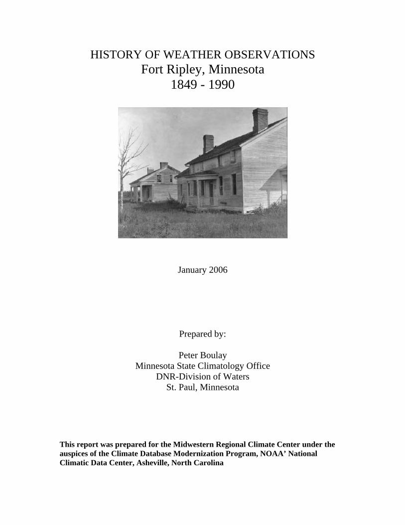
On the front cover is the abandoned hospital building and Officer’s quarters at FortRipley circa 1906. From the Minnesota Historical Society.

3
ACKNOWLEDGMENTS
The author is grateful to the Minnesota Military Museum for all their assistancewith this project and for allowing me to freely photocopy documents. I would especiallylike to thank historian Leland Smith for his help and the guided tour of the archives andthe old fort site.
The author would also like to thank Gary Grice for his guidance in developing astation history and for the references he pointed me toward to make this project a success.Thanks goes out to Karen Andsager from the Midwest Climate center for her advice andTim Owen for giving the opportunity for this interesting research.

4
LIST OF ILLUSTRATIONS
Figures
1. Minnesota Department of Transportation Map of modern Camp Ripley 52. Special Topographical Map of modern Camp Ripley 63. Map of proposed site for Fort Ripley (1848) 74. Schematic of Fort Ripley (1946) 95a. Observation Form for Fort Ripley (July 1849) 125b. Observation Form for Fort Ripley (July 1849) 126. Observation Form for Fort Ripley (July 1855) 137. Observation Form for Fort Ripley (December 1869) 148. Ink Wash Drawing of Fort Ripley (1862) 169. Ink Wash Drawing of Fort Ripley close up (1862) 1710. Sketch of the South View of Fort Ripley (ca.1862) 1711. Photograph of Fort Ripley (1870) 1912. Photograph of Fort Ripley close up (1870) 1913. Sketch of DeWitt Nine Inch Conical Rain Gauge 2114. Photograph of old Fort Ripley Site Sign (2005) 2415. Photograph of Fort Ripley Parade Grounds (2005) 2516. Photograph of Fort Ripley Hospital/Chapel site (2005) 2517. View to the west of the hospital site (2005) 2618. View to the north of the hospital site (2005) 2719. View to the east of the hospital site (2005) 2720. U.S. Weather Bureau Receipt card from Fort Ripley Station (1934-1947) 3021 Views of the Fort Ripley Cooperative Site (1959) 31

5
HISTORY OF WEATHER OBSERVATIONSFort Ripley, Minnesota
1849 – 1990
INTRODUCTION
Goal of the Study
The goal of this study is to document the site and instrumentation of old FortRipley. This period begins when the fort is under construction in 1849 and ends when thefort is abandoned in 1877. Monitoring sites near the city of Fort Ripley after 1877 will bepart of an appendix at the end of the report. Existing meteorological forms and historicaldocuments will be studied and a site visit to the current Ft. Ripley site will be preformed.
Historical Overview
The old site of Fort Ripley is entirely located within the large Camp RipleyMilitary Reservation in Morrison County. (Figures 1 & 2.) Old Fort Ripley was adjacentto the shore of the Mississippi River. In the years before the site was surveyed in 1848,the old growth pine forest in the vicinity was logged. A series of forest fires swept thoughthe area in the slash that was left behind. By 1848, There were scattered areas of secondgrowth pine, oak and birch remaining to the west of the Mississippi River and alandscape of an oak savanna to the east of the Mississippi River. The immediate terrainsurrounding the fort is generally flat with some hills to the west and a sloped bank to theMississippi. The fort was about 20 feet above the Mississippi River. Opposite the fort onthe east side of the Mississippi River was the farm of Baldwin Olmstead. The gardens forthe fort were established to the south of the post in short order after completion. Prairiefires were a common spring and autumn event.
Figure 1. Minnesota Department of Transportation road map showing the locationof Camp Ripley Military Reservation. The ruins of old Fort Ripley are at thediamond in the center of the image. North is at the top of the page and the east-westdistance across the map is 25 miles/40km.

6
Figure 2. Special topographical map of the modern Fort Ripley area with the oldfort site listed as: “Old Fort Ripley (ruins)” in the middle left part of the page.North is at the top of the map and the east-west distance across the map is 2.8mi/4.5km.
A detailed description of the fort was presented in the book: War DepartmentCircular No. 4 A Report on Barracks and Hospitals with descriptions of MilitaryPosts from 1870: ” Fort Ripley is situated in latitude 46° 10’ 30’’ north, longitude 94°18’ 45” west upon the west bank of the Mississippi, elevated 20 feet above that river, andprobably 1,100 feet above the Gulf of Mexico… (Actual location was latitude 46° 10’ 52’’north, longitude 94° 22’ 41’’ was 354m or 1161 feet.) The little river Nokay (NokasippiRiver) empties into the Mississippi from the east, at about 300 yards north of this point.The post is built upon a sandy plateau, partially drained by shallow ravines at itsnorthern and southern extremities, gradually sloping toward a narrow swamp about ahalf-mile in rear of the fort. Beyond this is a range of thickly wooded hills, rising to aheight of 100 or 150 feet, which slightly shelter the post from the northwest winds ofwinter. To the westward of these hills again is a belt of broken surface thickly coveredwith woods and swamps. Above and below the fort the river is skirted by a narrow belt ofswampy land, usually partially inundated in spring, supporting the growth of linden orbasswood elms, maple, birch, with pine and poplar on the higher grounds, and aluxuriant undergrowth of shrubs, constitute the sylva of the immediate neighborhood.
On the east side of the Mississippi (here about 180 yards wide) a gentlyundulating, sandy and barren prairie, from a few hundred yards to a three miles wide,
Fort Ripley Ruins

7
extends from the mouth of the Nokay to the southward, bordered by a growth of oaks andpines along the river, and by a range of low hills, partially covered by oaks, on the west.Opposite to the post this strip of land is less sterile than the rest, which has been forseveral years under cultivation, and part of which is liable to overflow in the spring. SeeFigure 3.
Figure 3. Map drawn of the proposed site for Fort Ripley on September 24, 1848.From: The Muster Roll, a biography of Fort Ripley Minnesota. North is at the topof the map and the east-west distance is .62mi/1km.
Fort Ripley was constructed to keep the peace in the area with the newly arrivedWinnebago Indians and the simmering conflict between the Ojibwa (Chippewa) andDakota (Sioux) Indians. The Winnebago were placed on a reservation centered near LongPrairie in August 1848. The fort was built on the west side of the Mississippi River to beon the same ground as the new Winnebago Reservation. This location was somewhatunfortunate since the main road from St. Paul to Pembina was on the east side of theriver. A ferry had to be used to cross the river sometimes with tragic consequences.
Construction began in November 1848. Work over the winter of 1848-49 was togather the timber necessary for the fort to be raised the summer of 1849. The originalname for the fort was “Fort Marcy” after the William L. Marcy, Secretary of War from1845-1849. This nomenclature didn’t last long and the fort was renamed “Ft. Gaines” in1849 after General Edmund Pendleton Gaines. Gaines lent a hand constructing a fort inAlabama, which in turn was named after him. So a new name had to be chosen for the
Plannedlocation forFort Ripley

8
Minnesota fort. The final name chosen in 1850 was Ft. Ripley after Brigadier GeneralEleazar W. Ripley, a hero from the war of 1812.
The fort was composed of one-story wood frame buildings forming three sides ofa square, the fourth side being the Mississippi River. The officer’s quarters, the barracksand hospital were filled in with brick. Between the buildings of the fort there were gapsbetween ten and twenty-five feet. There was not a picket or wall around the fort for thefirst fourteen years of its operation. There would not be a picket enclosure around the fortuntil the fall of 1862. On May 13, 1849 the posts’ first garrison arrived from Ft. Snelling.The construction of the fort was complete in April 1851. In general, Fort Ripley wasconsidered a fairly healthy fort with no major outbreaks of disease in the garrison.
The site was quite isolated and a good distance from any centers of habitation.The immediate neighborhood was the Winnebago and Ojibwa, a few scatteredfarmsteads, and the pesky whisky sellers at Crow Wing about seven miles to the north.The closest town of any size was Little Falls, fifteen miles to the south. The main supplydepot for Fort Ripley was Fort Snelling.
The winters could be long and cold in central Minnesota. The Winnebagoeslonged to leave because of the cold and the relatively poor land they were relocated to.The federal government removed the Winnebagos to a new reservation in the vicinity ofMankato in 1855. During this time settlers squatted on reservation land near the fort. In1857 the US Army, feeling that Ft. Ripley had outlived its service, withdrew the garrison.The fort was officially abandoned on July 8, 1857. A few people like the post’s RevChaplain Manney stayed behind. With the fort closed, lawlessness began to break outwith traders illegally selling liquor to the Ojibwa. Minnesota’s first lynching of threeOjibwa men in custody on a suspected murder charge brought a hasty return of a garrisonto the post. Ft. Ripley reopened on September 12, 1857.
With the Civil War in April 1861, Army regulars left the post and Minnesotavolunteer regiments replaced them. The fear of a direct Ojibwa assault on the fort was thegreatest in August 1862, coinciding with the Dakota uprising. Panicked settlers flocked tothe fort and tensions were high until the threat of attack ceased. There was never a directassault on Fort Ripley. Following the Dakota uprising, the fort became a staging groundfor the “Indian War” campaigns in the Dakotas.
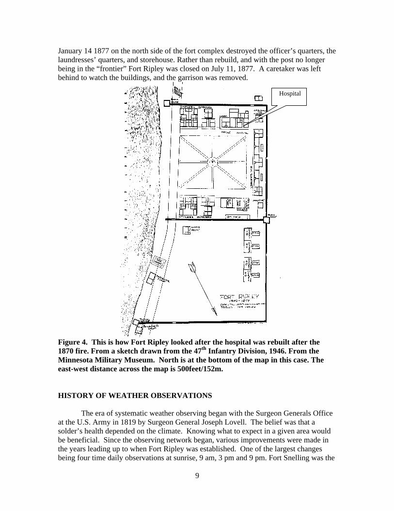
The main threat to the fort over the years wasn’t an impending Indian attack; itwas the roaring fires necessary to fend off the winter’s chill. Several fires destroyedbuildings during the course of the fort’s life. Even in the summer the threat of fire waspresent. At about midnight July 20, 1870 a fire broke out in the hospital kitchen. In shortorder the hospital, the chapel and the Adjutant’s, Quartermaster and Commissary Officeswere burned to the ground. All the post surgeon’s personal surgical instruments weredestroyed; even clothing belonging to the hospital steward was burned in the fire. Thehospital was rebuilt that winter on the same site. It was built rather hastily and the freshlysawed boards used for the hospital shrunk over the next few years with drafty results(Figure 4.)
In the 1870’s there were signs that the life of Fort Ripley was drawing to a close.By 1873 the western frontier was now 500 miles west of Fort Ripley. Even though theOjibwa didn’t take place in the 1862 outbreak, nervous settlers in the area demanded theirremoval. Eventually, the Ojibwa were moved north outside the Fort Ripley region andeliminated one of the purposes for a fort in the area. A devastating fire during the night of
9
January 14 1877 on the north side of the fort complex destroyed the officer’s quarters, thelaundresses’ quarters, and storehouse. Rather than rebuild, and with the post no longerbeing in the “frontier” Fort Ripley was closed on July 11, 1877. A caretaker was leftbehind to watch the buildings, and the garrison was removed.
Figure 4. This is how Fort Ripley looked after the hospital was rebuilt after the1870 fire. From a sketch drawn from the 47th Infantry Division, 1946. From theMinnesota Military Museum. North is at the bottom of the map in this case. Theeast-west distance across the map is 500feet/152m.
HISTORY OF WEATHER OBSERVATIONS
The era of systematic weather observing began with the Surgeon Generals Officeat the U.S. Army in 1819 by Surgeon General Joseph Lovell. The belief was that asolder’s health depended on the climate. Knowing what to expect in a given area wouldbe beneficial. Since the observing network began, various improvements were made inthe years leading up to when Fort Ripley was established. One of the largest changesbeing four time daily observations at sunrise, 9 am, 3 pm and 9 pm. Fort Snelling was the
Hospital

10
first of the fort sites established in Minnesota in 1819 with Fort Ripley the second in1849.
OBSERVERS
Similarly to Fort Snelling, Fort Ripley had many surgical personnel pass throughthe doors of its hospital during the 28 years of operation. Under orders of the SurgeonGeneral, the surgeon at each post was responsible for keeping a weather log. In the FortRipley Meteorological Register, the records are for the most part, well kept and are filledwith many interesting remarks. Clearly the people involved had more than a passinginterest in their natural environment.
It is highly likely that the routine day-to-day weather observations were relegatedto a hospital steward or orderly, with the senior staff signing the forms. In the documentMeteorological Register for Twelve Years From 1831 to 1842 Inclusive Compiledfrom Observations made by the Officers of the Medical Department at the Army atthe Military Posts of the United States the following is noted: “It is impossible for theMedical Officer to be at all times present to take the observations himself; hence the dutydevolves in some measure upon the hospital steward, who though selected for his generalintelligence, may not be so observant of the prescribed rules, nor feel the necessity ofextreme accuracy in taking Meteorological Observations, as might be desired.” In thatmouthful of a sentence, one must wonder just how often the stewards were the actualobservers, indeed with just a casual glance at the Fort Ripley record, the stewards hadmore than a minor role in observation. The Meteorological Register for Fort Ripley was analyzed for the medicalpersonnel at the post in charge of the observations. The signatures were difficult to readon the meteorological forms. An oversize monthly summary book called: VoluntaryObservers Meteorological Reports by the War Department, Office of the ChiefSignal Service Officer, was useful for crosschecking names. Two volumes of this bookare located in the Minnesota State Climatology Office.
Signatures on the Fort Ripley Meteorological Register from 1849 to 1877.
Surgical staff Months forms were signed
W.J. Frazier, Head Surgeon 7/1849-5/1854Dr. Jonathan Letterman, Assistant Surgeon 8/1853-4/1854E. J. Baily Apr. Surgeon 5/1854-6/1857Post closed from July-October 1857Aly B. Hasson Apr. Surgeon 11/1857-9/1858Rich Potts Acting Surgeon 10/1858-3/1859T.M. Smith Acting Surgeon 4/1859-8/1859A. Wall Apr Surgeon 9/1859-3/1861R Ravenburge Hospital Steward 4/1861-5/1861*JNS V Wren M.D. Acting Surgeon 6/1861-6/1861

11
Henry McMahon Acting A. Surgeon 7/1862-11/1862F. Riger Surgeon 12/1862-3/1863Henry McMahon Acting A. Surgeon 4/1863-8/1864J. V.Wren Acting A. Surgeon 9/1864-4/1865W.H. Bradley 5/1865-6/1865Wm H Rouse A.A. Surgeon 7/1865-11/1865December 1865 form is missing.Wm H Rouse A.A. Surgeon 1/1866-5/1866April, June-August 1866 forms are missing.E.E. Braun Acting Apprentice Surgeon 9/1866-11/1866October 1866 form is missing.C. T. Alexander Acting Apprentice Surgeon 12/1866-4/1867E.E. Braun Acting Apprentice Surgeon 5/1867-2/1869March 1869 to November 1869 forms are missingChas. K. Winnie Assistant Surgeon 12/1869-4/1871.J. J. De Lamater A.A. Surgeon 5/1872-9/1874Geo E. Lord A.A. Surgeon 10/1874James Shair Acting Assistant Surgeon 11/1874-4/1875John H. Kinsman Assistant Surgeon 5/1875-4/1876John C. Roser, MD Acting Post Surgeon 5/1876John H. Kinsman Assistant Surgeon 6/1875-4/1876T.H. Terry Acting Assistant Surgeon 5/1876-7/1877Last observation at the fort was at 7am July 11, 1877.
*Appears to have been the actual observer for much of the fort’s early record.
LOCATION OF OBSERVATIONS
The location of the Fort Ripley was first noted on the July 1859 form with thelatitude of 46°9’N. No longitude was mentioned but the observing site was described as“On the Mississippi River opposite mouth of Nokasippi.” Both latitude and longitudewere offered beginning with the February 1850 form: 46° 9’N and 94°16’W. A moreprecise location on the June 1850 form was 46°10’30”N 94°18’45”W. A note at thebottom of the form states: “The lat. & longitude given are taken from (name unable toread)’s map and are thought to be more accurate than those on previous registers, whichwere from maps left here by Lieut. Derby, T. Gay. U.S.A.” This was the latitude andlongitude that was offered on the rest of the meteorological forms. Actual coordinateswith a GPS at the site in October 2005 were 46°10’52”N 94°22’41”W.
Instrumentation notes from the Fort Ripley Meteorological Register.
Meteorological Observations began presumably in close proximity to the posthospital on July 1, 1849 (see Figures 5a &b). The post hospital was located in acollection of frame structures that stretched east to west and was the southwest corner ofthe fort. The front of the hospital had a porch or veranda and faced north. It is not

12
known exactly where the instruments were placed in 1849. Only one thermometer wasfurnished to W.J. Frazier, Head Surgeon. The Surgeon Generals’ office supplied FormNo. 3 Meteorological Register to transcribe the observations. Four time dailytemperature readings were noted at sunrise, 9 am, 3 pm and 9 pm. At these same timesalso recorded were “clearness of the sky,” wind and clouds. Both wind direction and“wind force” were observed. The notation: “No rain gauge at post.” was written under the“quantity” section of the form. Times beginning and ending of precipitation was noted.Beginning in August 1849 a four times daily description of clouds began.
Figure 5a. This is the first observing form for Fort Ripley when records began inJuly 1849. Only the top left part of the form is shown to improve readability. Fromthe Forts Database CD ROM, Midwestern Regional Climate Center and theNational Climatic Data Center.
Figure 5b. This is the same observing form for Fort Ripley from July 1849. Only thetop right part of the form is shown to improve readability. From the Forts DatabaseCD ROM, Midwestern Regional Climate Center and the National Climatic DataCenter.

13
A rain gauge or a snow gauge was put into use in December 1849. Again, exactlocation of this gauge is unknown.
Beginning with July 1855 (Figure 6), the meteorological forms changed. Nolonger is “sunrise” included in the time of measurement. The thermometer, winds, andremarks are now noted at 7 am, 2 pm and 9 pm. Rain beginning and ending is unchanged.On December 3, 1855 there is a notation in the remarks section: “Hygrometer receivedtoday.” Hygrometer readings begin on December 4th, 1855.
Figure 6. Fort Ripley observation form for July 1855. Only the top part of the formis shown to improve readability. From the Forts Database CD ROM, MidwesternRegional Climate Center and the National Climatic Data Center.
The closure of the fort in June 1857 brought a temporary end to observations.Thus, there is a gap in reporting from July 1857 to October 1857. When observationsresume in November 1857, three time daily temperature, hygrometer (wet bulb), windsand weather were measured at 7 am, 2 pm and 9 pm. There was also a notation at thebottom of the form that read: “Quantity of rain not entered because vessel was notreceived from Fort Snelling until near the end of the month.” It is not noted what kind ofvessel this is, but was probably a De Witt Rain Gauge. Rain quantity measurement beganagain in December 1857.
On September 7, 1859 some calibration of instruments took place as noted in thecomment section: “Compared the Thermometer and Hygrometer. (Soaked?) thermometerby lowering pair temperatures to the freezing point. Hygrometer is ½ degree lower thanthe thermometer. The latter did not reach the freezing point as the Hygrometer beingdivided into degrees not ascending 130 (degrees). Their boiling point could not beascertained. After placing a new covering of twisted cotton (made for the purpose no silkbeing on hand) left by Mr. Potts over the bulb of the Hygrometer, it fell considerablylower than before. The former observations cannot be relied upon. The covering of theHygrometer bulb being entirely out of order. M. R Ravenburge hospital steward.” The

14
remarks of Mr. Ravenburge are interesting that he was the one performing theobservations, which confirms that the hospital stewards definitely had a role. On the sameform that Mr. Ravenburge makes his comments, TM Smith Acting Surgeon, signs theform at the bottom.
With the cold weather of winter approaching in November, 1859 this note is listedunder remarks: “November 8, No water is kept in the reservoir of the Hygrometer fromthis day. The bulb is moistened 15 minutes before each observation.” It’s impossible totell what kind of shelter if any the thermometers were in. On the July 1861 form underJuly 25th: “Thermometer, Hygrometer exposed to the sun at 12:30 pm.” This was theonly comment this month so its possible that this was only temporary. There is anunexplained gap in the register from May 27 1865 to June 6th 1865 with a simple notesaying, “No register was kept.”
In December 1869 (Figure 7), a new form appears and has: Self registeringthermometer with max and min, three time daily movements of the atmosphere (7 am, 2pm, 7 pm), amount of cloudiness 7 am 2 pm and 9 pm and quantity of precipitation.
Figure 7. Observation form at Fort Ripley for December 1869. Only the top part ofthe form is shown to improve readability. From the Forts Database CD ROM,Midwestern Regional Climate Center and the National Climatic Data Center.
There is a note on the December 1869 form that says: “No observations madewith standard thermometer” under the three time daily section. However, three timedaily temperature readings at 7 am, 2 pm and 9 pm begin again in February 1870.Beginning in September 1872 an aneroid barometer was added and readings were takenthree times a day at 7am, 2pm and 9 pm. There is a scribble at the bottom of theSeptember form that mentions “aneroid barometer.” An interesting note from theobserver on the October 1872 report said this about the barometric pressure: “These obsare of no scientific value.” A later note from the Surgeon’s General office WashingtonD.C. advises the observer to continue recording the atmospheric pressure. Under the
15
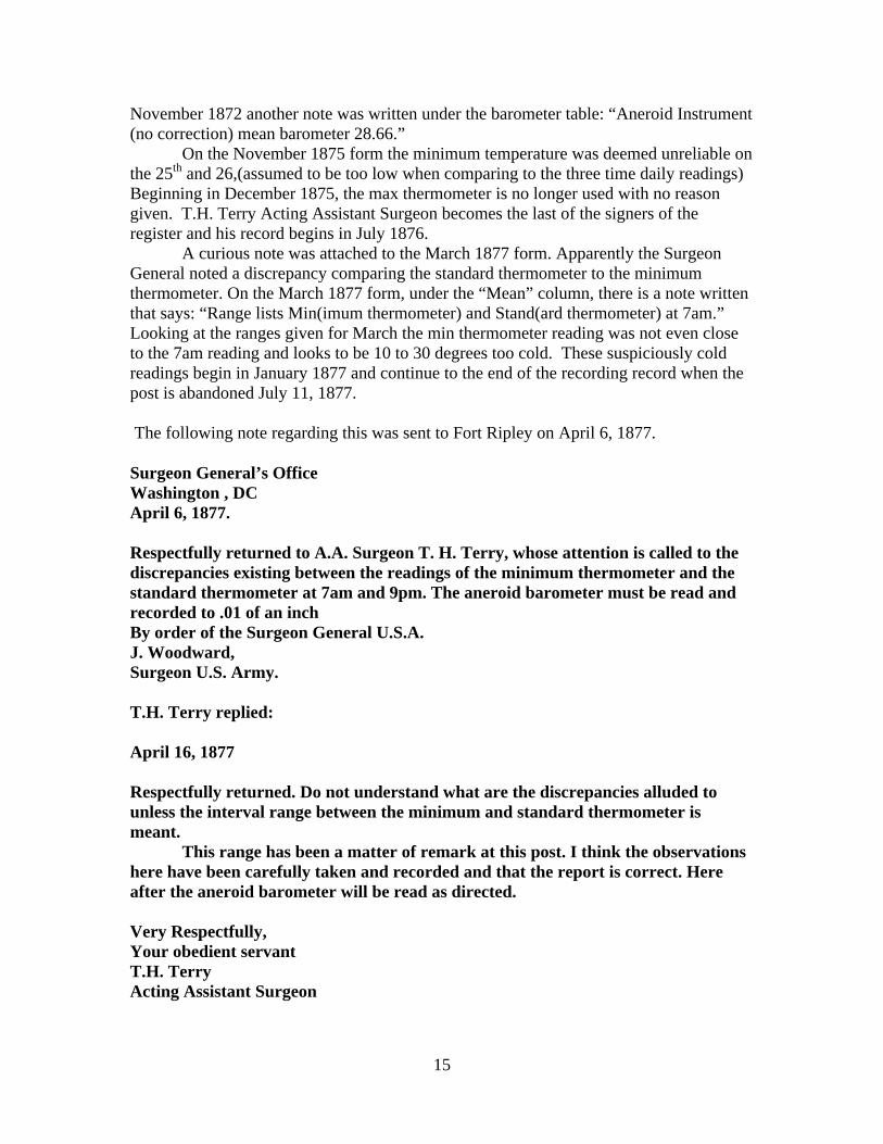
November 1872 another note was written under the barometer table: “Aneroid Instrument(no correction) mean barometer 28.66.”
On the November 1875 form the minimum temperature was deemed unreliable onthe 25th and 26,(assumed to be too low when comparing to the three time daily readings)Beginning in December 1875, the max thermometer is no longer used with no reasongiven. T.H. Terry Acting Assistant Surgeon becomes the last of the signers of theregister and his record begins in July 1876.
A curious note was attached to the March 1877 form. Apparently the SurgeonGeneral noted a discrepancy comparing the standard thermometer to the minimumthermometer. On the March 1877 form, under the “Mean” column, there is a note writtenthat says: “Range lists Min(imum thermometer) and Stand(ard thermometer) at 7am.”Looking at the ranges given for March the min thermometer reading was not even closeto the 7am reading and looks to be 10 to 30 degrees too cold. These suspiciously coldreadings begin in January 1877 and continue to the end of the recording record when thepost is abandoned July 11, 1877.
The following note regarding this was sent to Fort Ripley on April 6, 1877.
Surgeon General’s OfficeWashington , DCApril 6, 1877.
Respectfully returned to A.A. Surgeon T. H. Terry, whose attention is called to thediscrepancies existing between the readings of the minimum thermometer and thestandard thermometer at 7am and 9pm. The aneroid barometer must be read andrecorded to .01 of an inchBy order of the Surgeon General U.S.A.J. Woodward,Surgeon U.S. Army.
T.H. Terry replied:
April 16, 1877
Respectfully returned. Do not understand what are the discrepancies alluded tounless the interval range between the minimum and standard thermometer ismeant.
This range has been a matter of remark at this post. I think the observationshere have been carefully taken and recorded and that the report is correct. Hereafter the aneroid barometer will be read as directed.
Very Respectfully,Your obedient servantT.H. TerryActing Assistant Surgeon

16
Instrument Types and Exposure
Since many of the forts were active weather observers before the use ofphotography became widespread, few if any photos or sketches have been found.Instead, remarks about the instruments become very valuable. Listed are instrumentsused at Fort Ripley and any information found about each.
Wind vane
Wind vanes were furnished to the forts, but few images exist of them. In fact,there are only two instances where a sketch shows the location of wind vanes, FortSnelling and Fort Ripley. The first glimpse of a meteorological instrument at Ft. Ripleyis a weather vane that can plainly be seen in an 1862 ink wash drawing of the fort. Thiswind vane is located in the vicinity of the hospital (see Figures 8, 9, & 10).
Figure 8. 1862 Ink Wash Drawing of Ft. Ripley. Note open area surround fort andpine stands to west. Flag showing wind direction from the north. From theMinnesota Historical Society
Hospital

17
Figure 9. Close up of hospital building (middle right) in 1862 with wind vane pokingabove the roofline. The wind vane direction matches that of the flag. From theMinnesota Historical Society
Figure 10. Another view of Ft. Ripley, this time from the south showing the windvane at middle left (Courtesy Minnesota Historical Society)
Hospitalbefore1870 fire
Wind vane
Wind vane

18
Thermometers
When Fort Ripley was commissioned in 1849, Army Surgeon Generalinstructions for thermometers involved a single thermometer read four times a day. Theseinstructions did not change until 1868. On 10 August 1868, the following instructionswere issued to Army field surgeons by the Surgeon General’s Office regardingthermometer placement:
“The thermometer should be placed in the open air, but under a roof of some kind,and should be well sheltered toward the South. It should be protected not onlyfrom the direct rays of the sun, but from the influences of all surfaces whichstrongly reflect the sun’s heat, and of all bodies, such as thick walls, large rocks,etc., which become great reservoirs of heat during the day, and of cold during thenight.’
‘…The height which it is deemed best to fix upon is that of four feet from theground to the thermometer bulb, and the surface under the thermometer should beof short grass, sufficiently exposed to the sun and wind to keep it from habitualdampness.’
‘A thermometer box, in which most of the thermometers observed and recorded atthe station are suspended, is generally used for the best conducted meteorologicalobservations, and one should be made and set up at every post where there aremeans of constructing it. This box, which should be at least two feet square, ispreferably made of louver-boards or overlapping slates, but ordinary boardspierced with numerous half-inch holes may be used instead. It should be open atthe bottom, and have a roof, which will shed rain. One of the sides should behinged for convenience of access to the interior, or the box may be leftpermanently open toward the North, a piece of board or of canvas being used toprotect it against driving winds from that quarter. This box is to be well securedon posts, at the proper height from the ground. It should be sheltered from the sunbetween sunrise and 7 AM, and between 11 AM and 3 PM, special screens beingerected for the purpose if necessary. These screens, as well as the box itself,should be whitewashed or painted white.”
Evidence of such a thermometer box can possibly be seen in a striking photograph of FortRipley from 1870 (see Figures 11 & 12).

19
Figure 11. Fort Ripley in 1870, showing the Officer’s Quarters front left with thehospital with the double chimneys. From the Minnesota Historical Society
Figure 12. Close up of the hospital (on the left) in 1870 showing a possibleinstrument shelter and wind vane mast. This view is to the west. From theMinnesota Historical Society
New hospital after1870 fire
Possible shelter
Possible windvane mastHospital

20
Rain Gauge
Little information can be gleamed about the rain gage used at Ft. Ripley. One wasdelivered from Fort Snelling in 1849. No description exists about the type of gauge. Itwas probably a De Witt type of gauge that is mentioned in a book published in 1851titled: Meteorological Register: Observations Made by the Officers of the MedicalDepartment of the Army at the Military Posts of the United States. See Figure 13.
“In 1836, rain gauges were furnished to many of the posts, by which the dailyfalls of rain and snow could be measured and entered upon the tables in inchesand the fractions of an inch. The instrument employed is the conical rain gauge ofDe Witt; and observations are ordered to be made immediately after every showeror fall of rain or snow. The following are the instructions issued by theDepartment for its observers:’
‘The instrument used to measure the quantity of rain which falls, is the conicalrain gauge. It will be kept remote from all elevated structures at a distance at leastequal to their height, and still further off, where it can be conveniently done. It isto be suspended in a circular opening, made in a board, which is to be fixed to apost, eight feet from the ground; the opening to be five inches in diameter, andbeveled, so as to fit the side of the gauge, into which the cap is to be fixed, basedownwards, to prevent evaporation.’
‘In freezing weather, when the rain gauge cannot be used out of doors, it will betaken into the room, and a tin vessel will be substituted for receiving the snow,rain, or sleet that may then fall. This vessel must have its opening exactly equalto that of the rain gauge, and widen downwards to a sufficient depth, with aconsiderable slope. It should be placed where nothing can obstruct thedescending snow from entering, and where no drift snow can be blown into it.During a continued snowstorm, the snow may be occasionally pressed down. Thecontents of the vessel must be melted by placing it near the fire, with a cover toprevent evaporation, and the water produced poured into the gauge to ascertain itsquantity, which must then be entered into the Register.”

21
Figure 13. Sketch of the DeWitt Nine Inch Conical Rain Gauge from: “Stillman’sJournal of the Arts and Sciences”
The old rain gauge instructions were replaced on 10 August 1868, when the ArmySurgeon General’s Office advised the following gauge to use:
“The rain gauge now issued by the Department is a brass cylinder seven and ahalf inches high, and with a diameter at its mouth of one and ninety-sevenhundredths (1.97) of an inch; this diameter being fixed upon for the reason thatone inch of rain falling through such an aperture will measure exactly fifty cubiccentimeters (50 cc), and centimeter graduates are furnished with each gauge forthe purpose of making such measurement.’
‘The most desirable place for a rain gauge, other things being equal, is at thesurface of the ground, but since it is not easy to protect an instrument in thatsituation, the gauge will be placed on the top of a post eight feet high,…’

22
‘For measuring very heavy snow falls, a snow gauge must be used having amouth of the same size with that of the rain-gauge, but wider at the bottom, so asnot to be easily overfilled. The snow which falls in it is to be melted andmeasured in the centimeter graduate.”
There is mention of the “tin vessel” used to measure snow at Ft. Ripley. For theamusement of the people at the fort, sometimes a charcoal cup of mercury was placed inthe snow gauge during extreme cold so people could observe the frozen mercury.
Hygrometer
The first measurement of atmospheric moisture at Fort Ripley was on 4December 1855. There was a note in the remarks section on 3 December 1855 that stated,“Hygrometer arrived to day.” Fort Ripley acquired a wet-bulb thermometer even thoughArmy Surgeon General stopped measuring wet-bulb (hygrometer) temperatures on 1February 1850. Below are instructions in 1844 with regard to wet-bulb observations:
“The most easy method of finding this (wet bulb temperature) is to wet the bulbof a Thermometer covered round with fine gauze, and swing the instrument in theopen air, in the shade, until the mercury sinks as low as it will.”
“The current of air upon the wet-bulb should be kept up (by swinging) as long asthe mercury continues to descend in the tube of the instrument, and for a fewminutes after it becomes stationary, in order to ensure the full effect of theevaporation and the lowest degree to which the mercury can be forced to descendby this process, will constitute the observation required…”
When wet-bulb temperatures were again measured in the Army MedicalDepartment the Surgeon General instructions for 1856 contained the following:
“The hygrometer adopted by this Department consists essentially of athermometer, the bulb of which is covered with floss silk enclosed in a piece ofthin muslin, the ends of the silk sufficiently long to dip into water contained in abrass reservoir secured immediately below the bulb. In the top of this reservoir isa small opening to admit the silk, and to the front is attached a cylindercommunicating with the interior by a small hole. The reservoir is to be keptalways supplied with water poured into it through the cylinder, and the bulb willbe constantly moistened by capillary absorption.”
As was noted in the Meteorological forms section, the observer at Fort Ripleysubstituted cotton for the silk wick on September 7, 1859 and found the results to besatisfactory. The 1868 Surgeon General instructions elaborated on taking wet-bulbtemperatures:

23
“An apparatus for swinging a pair of thermometers – a wet and dry bulb – hasbeen constructed at this Office, and will be issued to a certain number of posts formaking specially accurate observations. In using this apparatus the covering ofthe wet bulb is to be moistened with a soft brush before each observation, and theapparatus then whirled round for a few minutes…’
‘When a stationary wet bulb is used it is to be placed in the box with the otherthermometers, but far enough from them not to communicate cold to their bulbs.All casings around the lower part of such a thermometer should be removed, anda piece of wick which dips by one end into a receptacle of rain water, should haveits other end coiled around the stem and resting on the top of the bulb, in such away as to keep the muslin covering uniformly and sufficiently wet. If the wick isconnected with the lower part of the bulb, the wetting is more apt to be unequal.”
Barometer
Differing from other military posts, Fort Ripley had an aneroid type of barometer.It is unknown where the placement of this barometer was. Many posts had mercurythermometers. The attached thermometer to the barometer would sometimes offer a clueto its location, either indoor or outdoor. In Fort Ripley, this was not the case since athermometer was not needed to correct the aneroid barometer.

24
Modern site visit to Fort Ripley
Figure 14.
After the closing of Fort Ripley in 1877 a caretaker was left in charge of thebuildings for a number of years. When the caretaker left, the local farmers in the areabegan to scavenge the siding on the buildings that remained. A prarie fire destroyedseveral buildings in 1879. Nonetheless, there were still several structures remaining atthe site in the early 1900’s. With continued scavenging, by 1931 the only building leftstanding was the old stone magazine. The remnants of this building still stand in 2005.Most of the artifacts displayed at the Minnesota Military Museum are items fished out ofthe Mississippi River.
To visit the site, an escort is required since it is within the firing range area of theCamp Ripley Military Reservation. Other than the fact that the buildings are no longerthere, the site is remarkably undisturbed. The cellars for the former buildings are plainlyvisible and the site is obviously mowed at least several times a year. The hospital waseasy to locate with the aid of markers that pointed out the position of each building. Thelook of the site is quite desolate and one can imagine being at the fort in the 19th century.The author visited the site on October 27, 2005. All site visit photos are from the author.

25
Figure 15. Overall view of the parade grounds. View is to the west. The magazineruins are on the far right. A modern flagpole marks the site of the original one onthe parade grounds. The hospital was located far left center by the lone trees.
Figure 16. This is the site of the hospital and chapel. View is to the south. Thesetrees are growing in the depression left by the cellar.
Location ofhospital site

26
Figure 17. View to the west of the hospital site.
Figure 18. View to the north of the hospital site.

27
Figure 19. View to the east of the hospital site

28
BIBLIOGRAPHY
References
Army Surgeon General. Directions for Taking Meteorological Observations Adoptedby the Medical Department of the United States Army. War Department,Government Printing Office, Washington.1844
Army Surgeon General. General Meteorological Instructions. War Department,Government Printing Office, Washington D.C. 1868
Baker, Robert Orr. The Muster Roll: a biography of Fort Ripley Minnesota. St. Paul:H.M. Smyth Co. Inc., 1972?
Billings, John S. Circular No. 4 Report on Barracks and Hospitals with Descriptionsof Military Posts Washington D.C.: War Department, Surgeon Generals OfficeCircular No. 4 December 5, 1870. (Reprinted 1974 Sol Lewis: New York)
Coolidge, Richard. Statistical report on the sickness and mortality in the Army ofthe United States: embracing a period of sixteen years, from January 1839 toJanuary 1855 Circular No. 8. Washington: A.O.P. Nicholson, printer, 1856.
Fisk, Charles John, Reconstruction of Daily 1820-1872 Minneapolis-St. Paul,Minnesota Temperature Observations (Master of Science Thesis). University ofWisconsin-Madison, Madison, WI., 1984
Harper’s New Monthly Magazine Vo. 19 Issue 109 The Red River Trail pp 37-55Harper& Bros. New York, June 1859
Johnson, MAJ Jack K. History of Old Fort Ripley 1849-1877 Military HistoricalSociety of Minnesota (website publication, no date given)
Kerr, James, Certified bill, 1879, 1892. A Bill to restore to the public domain a part ofthe military reservation known as the Fort Ripley reservation in the state of Minnesota.United States. Congress (46th, 1st Session : 1879) House of Representatives, 1892
Ludlum, David M. Early American Winters, II 1821-1870. American MeteorologicalSociety, Boston, MA., 1968.
Midwestern Regional Climate Center (Gary Grice and Peter Boulay), History ofWeather Observations at Fort Snelling, Minnesota 1820-1892. National ClimaticData Center, Ashville, NC., 2005
Nelson, Col. J.E. A History of Fort Ripley Assistant Adjunct General State ofMinnesota, 1931.

29
Prucha, Francis Paul. The Army Post on the Minnesota Frontier 1819-1882 ( Masterof Arts Thesis). University of Minnesota, 1947.
Sheridan, Lieutenant General P.H. Outline Descriptions of the Posts in the MilitaryDivision of the Missouri. Washington D.C.: U.S. Adjunct General’s Office. 1876.(Reprinted by The Old Army Press Bellevue, Nebraska 1969)
Upham, Warren. Minnesota Geographic Names Their Origin and Historicalsignificance. St. Paul: Minnesota Historical Society (reprint edition), 1969.
United States. Army. Descriptive commentaries from the medical histories of posts,[178-]-1920 [microform]. Washington, D.C. : National Archives, 1972.
Stillman’s Journal of the Arts and Sciences. Periodical found in the NOAA Library.Publication date unknown.

30
APPENDICES
Appendix 1
Observations after Fort Ripley closed in 1877
After the post closed in 1877 there was a desire to continue observations in someform at Fort Ripley. In August 1887 a river and rainfall station began with C.B. Clouse asthe observer. His location was most likely at the new town of Fort Ripley located justacross the river. The forms used were (Form No. 180-1887) Beginning in 1894 form 1009was used. His last observation was on May 31, 1895. There is a gap until the nextobservations began with J.J. Tucker in June 1906. This new site was a full cooperativestation with max/min thermometers, a rain gauge and a river gauge. During the early yearssome problems were noticed with the minimum thermometer.
Clarence A. Tucker (The son of J.J Tucker took over in May 1914 and continued toNovember 1918. Then Irving R. Tucker and his mother were the observers beginning inNovember 1918. A note on the June 14, 1926 inspection reports notes: “Minimumthermometer elevated at the bulb about 40 degrees and there were a number of separationsin the alcohol column. The index found near the top. Minimum temperature record notreliable and should not be used. The length of time the thermometer has been out of ordercould not be determined from the observer. A new shelter and support would be required ifrecords continue long, but the present it is likely the Mother of the Observer, who is thecooperative observer will resign.” Apparently Irving Tucker decided to keep the stationgoing for the next 27 years and was the observer until September 1953. However,thermometer measurements ceased on December 31, 1928.
An interesting snapshot of this site can be found in the 1930’s receipt file held at theState Climatology Office. It looks like this station had to put up with floods and thievesduring its tenure. See Figure 20.
Figure 20. U.S Weather Bureau Receipt Card from October 6, 1934 with notes aboutthe rain and river gauge at Fort Ripley from 1934 to 1947. From the Minnesota StateClimatology Office Archives.

31
In September 1953, Gladys B. Nelson became a river and rainfall observer. Herhouse was located 1.1 miles north of the old Fort Ripley Site on the east side of the river.A standard rain gauge was installed. See Figure 21. Gladys remained the observer until sheretired in November 1990. A new precipitation observer was not found, but river gaugereadings are still measured in the area using an automated gage.
Figure 21. These four images are part of a series of National Weather ServiceCooperative Station photographs in the late 1950’s. This is the Fort RipleyCooperative Site in October 1959 while Gladys B. Nelson was the observer. From theMinnesota State Climatology Office Archives.

32
Appendix 2
One cannot help in looking through the recorded observations the remarks ofunusual weather the hapless medical staff found themselves in when transferred to anoutpost such as Fort Ripley. Listed are some of the more interesting remarks found in theMeteorological Register.
On the bottom of the June, 1850 form the following was noted: “Jun 18,1850Territorial Governor Ramsey reports that about halfway between Ft. Ripley and Ft.Snelling on the Mississippi a severe hail storm occurred in the evening. One or twohailstones picked up were as large as hen’s eggs and he thought he saw one about the sizeof a musket ball.”
J. Frazier noted an interesting phenomenon of a Minnesota spring on the May1853 form. “Note, May 31-June 1. Fires still needed for comfort in quarters. Woods(chiefly oak) & prairies just appear to begin generally green. Frazier would put hisobservations to good use when he published Medical Topography and Diseases of FortRipley in 1852. Frazier and his family left Fort Ripley via canoe on August 17, 1853.
An infamous meteorological event was noted in the Meteorological Register inJuly, 1867. Fort Ripley was the closest meteorological site to the great Sauk Centerrainstorm of July 17-18th 1867. This flood was witnessed by a surveyor visiting the SaukCenter area and documented the event. Unofficial amounts claimed 36 inches in 36 hoursin the Sauk Center area. Fort Ripley was the closest site with a rain gage and 7.50 incheswas measured at Fort Ripley in 24 hours. The Mississippi river rose 5 feet in 24 hours. Abridge over the Nokasippi River was washed out. By the 22nd, the river had risen 8 feet 8inches. It could have been13 feet 8 inches total. Over the next 19 days the river fell 9.5feet.
John C. Roser, MD reports a tornado on the May 20, 1876.

33
Appendix 3
Methodology
The Meteorological register was the primary source for information regardinginstrumentation changes at Fort Ripley. These were provided on CD’s titled: ClimateDatabase Modernization Program: Forts Database from Midwestern RegionalClimate Center and the National Climatic Data Center. The Meteorological Registerhad observation sheets from 1849 to when the fort closed in 1877.
A visit to the Minnesota Military Museum and looking though their archives wasvery helpful. There was quite a bit of information in their archives regarding the FortRipley. There is also a scale model of the old fort in their museum. The staff at themuseum also assisted me with research. It was also at the Minnesota Military Museumwhere I discovered the excellent book by Robert Orr Baker titled: The Muster Roll: aBiography of Fort Ripley Minnesota. There were many references in this book anduseful maps of the fort. A site visit to the fort itself was beneficial to see what the lay ofthe land was. Leland P. Smith, the historian at the fort, went above and beyond answeringmy questions and I am very thankful for his help.
The Minnesota Historical Society Archives proved to be useful. The diary of RevSolon W. Manney, who was the chaplain of the fort from 1851 to 1859, is in theirholdings. Rev Manney recorded the daily happenings of the fort and mentionsmeteorological events.
The resources of the University of Minnesota libraries were helpful in assistancevia inter-library loan to find some of the more rare books in this study. Notably:“Circular No. 4 Report on Barracks and Hospitals with Descriptions of MilitaryPosts”