frangois blouin 1 and jean-frangois giroux
TRANSCRIPT

J. Field Ornithol., 70(2):187-199
THE USE OF SATELLITE TEI.EMETRY TO TRACK GREATER SNOW GEESE
FRANGOIS BLOUIN 1 AND JEAN-FRANGOIS GIROUX Dgpartement des sciences biologiques, Universitd du Quebec a Montreal
P.O. Box 8888, Station Centre-ville, Montreal, Quebec, Canada, H3C 3P8
JEAN FERRON Ddpartement de biologie, Universitg du Qudbec d Rimouski, 300 All& des Ursulines
Rimouskh Quebec, Canada, G5L 3A1
GILLES GAUTHIER
Ddpartment de biologie and Centre d'gtudes nordiques, Universitg Laval, Ste-Foy Quebec, Canada, G1K 7P4
G. JEAN DOUCET Transt•nergie, 75 boul. Reng-Lgvesque West, Montrgal, Quebec, Canada, H2Z 1A4
Abstract.--We compared the performance of two models of satellite transmitters and two types of attachments to track Greater Snow Geese (Chen caerulescens atlantica) from their Arctic breeding grounds to their wintering areas along the Atlantic coast of the United States. Six birds were fitted with a Toyocom T-2038 attached with a back-mounted harness (141 g, vertical upward antenna) in 1993, 5 with a back-mounted Telonics ST-10 (116 g, horizontal antenna) in 1994, and 11 with a Telonics ST-10 fixed on a neck collar (99 g, vertical down- ward antenna) in 1995. The transmitters represented 3.5-5.2% of goose body mass. All trans- mitters operated on a 84-96 s repetition period with a duty cycle of 8 h on and 16 h off and were tracked using the Argos system. Six birds (all with harness attachment) were shot by hunters; 12 could not be tracked for the entire migration because of mortality, radio loss, or radio failure; 4 (all with neck collar attachment) reached the wintering grounds. Overall, we obtained 2.4-7.2 locations/goose/day with a greater number at higher latitudes than at lower ones. In 1993, 75% of locations had a quality class (LC) --> 1, while only 18-20% of locations were similarly classified in 1994-1995. We could not evaluate the relative effect of the antenna orientation and the intrinsic characteristics of the transmitters on the PTT
performance and location quality. The difference between true and estimated locations ranged on average between 1.4 km for LC 2 to 23 km for LC B. Geese fitted with harnesses spent more time in comfort movements than unmarked birds. We recommend that harnesses be avoided for geese. Satellite telemetry is adequate to track long-distant movements of migrants or to locate unknown critical areas (breeding, wintering, etc.) but not for detailed studies on habitat use or local movements.
EL USO DE TELEMETRiA DE SATP_J. ITES PARA SEGUIR MOVIMIENTOS DE CHEN CAERULESCENS ATLANTICA
Sinopsis.--Comparamos la labor de dos modelos de transmisores de satdites y de dos tipos de fijadores para seguir individuos de Chen caerulescens atlantica desde sus lugares de anidaje en el Artico hasta las fireas invernales a lo largo de la costa del Atl/tntico de los Estados Unidos. Se colocaron sistemas Toyocom T-2038 a seis aves usando un arn6s dorsal (141 g, antena vertical ergida) en 1993, sistemas Telonics ST-10 (110 g, antena horizontal) puestos en la espalda de cinco aves en 1994, y sistemas Telonics ST-10 fijos en un collar (99 g, antena vertical hacia abajo) en 11 aves en 1995. Los transmisores sumaban de 3.5 a 5.2% de la masa
• Current address: Wildlife Branch, Manitoba Natural Resources, Box 24, 200 Saulteaux Cres- cent, Winnipeg, Manitoba, Canada, R3J 3W3.
187

188] F. Blouin et al. J. Field Ornithol. Spring 1999
corporal total de las aves. Todos los transmisores operaron en periodos de repetici6n de 84- 96 s con ciclos de trabajo de 8 h encendidos y 16 h apagados y se monitorearon usando el sistema Argos. Seis aves (todas con arn•s) fueron muertas por cazadores; 12 no pudieron seguirse por toda la migraci6n debido a muerte, pfirdida del radio, o fallas en el radio; 4 (todos con sistema de collar) 11egaron alas fireas invernales. En general, tuvimos 2.4-7.2 localidades/ave/dia con mayor nfimero en latitudes altas queen las bajas. E1 75% de las localizaciones fueron de calidad clase (LC) > 1 en 1993, mientras queen 1994-1995 solo de 18 a 20% de las localidades se clasificaron asi. No se pudo evaluar el efecto relativo de orientar la antena y las caracteristicas intrinsecas de los transmisores en el funci6namiento del PTT y de la calidad de la localidad. Las diferencias entre las localidades verdaderas y estimadas fiuctuaron de 1.4 km para el LC 2 a 23 km para el LC B. Aves con arneses usaron m/rs tiempo en movimientos para comodidad que aves sin marcar. No recomendamos usar arneses en estas aves. La telemetria usando satdites es adecuada para seguir movimientos de larga distancia en migrantes o para hallar fireas criticas ignoradas (invernales, de apaream- iento, etc.) pero no en estudios detaliados del uso de habitat o movimientos locales.
Satellite telemetry permits study of movements of long-distance mi- grants (Craighead and Craighead 1987, Harris et al. 1990, Fuller et al. 1995). Until recently, the use of this technology was restricted to mam- mals, reptiles, or large birds like eagles and swans. However, with size reduction of the platform transmitter terminals (PTTs), it is now possible to track smaller birds such as geese and ducks (Gudmundsson et al. 1995, Petersen et al. 1995).
Before undertaking tracking studies and making biological inferences using satellite telemetry data, wildlife researchers must (1) decide on the type of PTT to use and means of attachment, (2) evaluate the effect of additional load and attachment technique on the behavior of the bird, and (3) determine what performance is to be expected from the satellite system under the study conditions. A few studies have focused on perfor- mance and precision of the Argos satellite tracking system (Harris et al. 1990, Keating et al. 1991). However, these were prior to 1994 when Argos introduced a new algorithm to estimate locations. These tests also in- volved large mammals or fixed locations. Finally, the PTTs used in these studies were programmed to send a signal once every 60 s while Argos now requires a pulse rate of 90 s. According to Keating et al. (1991), this may result in a reduced proportion of higher-quality locations.
We compared the performance of two models of PTTs and two types of attachments on Greater Snow Geese (Chen caerulescens atlantica) dur- ing their fall migration. We examined the fate of birds fitted with trans- mitters and quantified the performance of the Argos satellite system to track geese from their Arctic breeding grounds in the Northwest Terri- tories to their wintering area along the east coast of the United States. We also compared the accuracy of the locations with the values predicted by Argos. Finally, we studied the effect of harness-attached PTTs on' be- havior at staging areas.
METHODS
Capture of birds.--A total of 22 birds was fitted with a PTT in the sum- mers of 1993 (six females) and 1995 (11 males), and in the fall of 1994
Vol. 70, No. 2 Satellite Telemetry [ 189
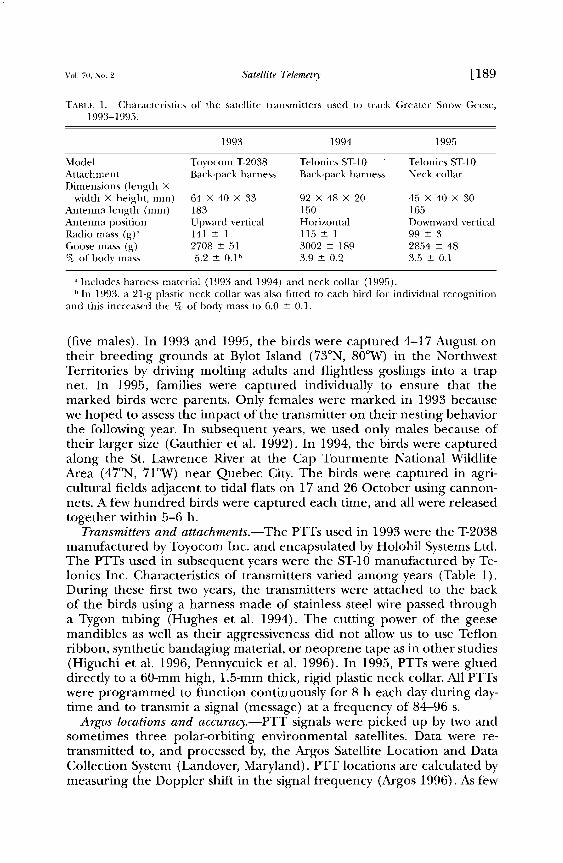
TABLE l. Characteristics of the satellite transmitters used to track Greater Snow Geese, 1993-1995.
1993 1994 1995
Model Toyocom T-2038 Telonics ST-10 Telonics ST-10 Attachment Back-pack harness Back-pack harness Neck collar Dimensions (length X
width X height, mm) 64 X 40 X 33 92 X 48 X 20 45 X 40 X 30 Antenna length (mm) 183 150 165 Antenna position Upward vertical Horizontal Downward vertical Radio mass (g)'• 141 + 1 115 + 1 99 + 3 Goose mass (g) 2708 + 51 3002 _+ 189 2854 + 48 % of body mass 5.2 + 0.1 b 3.9 + 0.2 3.5 + 0.1
a Includes harness material (1993 and 1994) and neck collar (1995). b In 1993, a 21-g plastic neck collar was also fitted to each bird for individual recognition
and this increased the % of body mass to 6.0 + 0.1.
(five males). In 1993 and 1995, the birds were captured 4-17 August on their breeding grounds at Bylot Island (73øN, 80øW) in the Northwest Territories by driving molting adults and flightless goslings into a trap net. In 1995, families were captured individually to ensure that the marked birds were parents. Only females were marked in 1993 because we hoped to assess the impact of the transmitter on their nesting behavior the following year. In subsequent years, we used only males because of their larger size (Gauthier et al. 1992). In 1994, the birds were captured along the St. Lawrence River at the Cap Tourmente National Wildlife Area (47øN, 71øW) near Quebec City. The birds were captured in agri- cultural fields adjacent to tidal flats on 17 and 26 October using cannon- nets. A few hundred birds were captured each time, and all were released together within 5-6 h.
Transmitters and attachments.--The PTTs used in 1993 were the T-2038
manufactured by Toyocom Inc. and encapsulated by Holohil Systems Ltd. The PTTs used in subsequent years were the ST-10 manufactured by Te- lonics Inc. Characteristics of transmitters varied among years (Table 1). During these first two years, the transmitters were attached to the back of the birds using a harness made of stainless steel wire passed through a Tygon tubing (Hughes et al. 1994). The cutting power of the geese mandibles as well as their aggressiveness did not allow us to use Teflon ribbon, synthetic bandaging material, or neoprene tape as in other studies (Higuchi et al. 1996, Pennycuick et al. 1996). In 1995, PTTs were glued directly to a 60-mm high, 1.5-mm thick, rigid plastic neck collar. All PTTs were programmed to function continuously for 8 h each day during day- time and to transmit a signal (message) at a frequency of 84-96 s.
Argos locations and accuracy.--PTT signals were picked up by two and sometimes three polar-orbiting environmental satellites. Data were re- transmitted to, and processed by, the Argos Satellite Location and Data Collection System (Landover, Maryland). PTT locations are calculated by measuring the Doppler shift in the signal frequency (Argos 1996). As few

190] F. Blouin et al. J. Field Ornithol. Spring 1999
as two signals during one satellite pass can be used to calculate a location but at least four are required to allow Argos to assign a location quality class (LC) with a predicted accuracy. LC are based on the satellite/trans- mitter geometry during a satellite pass, the number of messages received during a pass and the transmitter frequency stability (Argos 1996). LC 3, 2, 1, and 0 have an estimated accuracy in latitude and longitude of <150, 150-350, 350-1000, and >1000 m, respectively. LC 0 (prior to 1994) as well as A and B (since 1994) are calculated with less than four messages but with no estimated accuracy.
The accuracy of locations was tested along the St. Lawrence River dur- ing the 1994 and 1995 fall tracking periods. In all cases, tracked birds were on the ground in open areas, either on tidal flats, water, or in ad- jacent agricultural fields at an elevation <20 m above sea level. In 1994, marked birds were colored with individual patterns using picric acid to facilitate relocation and identification within flocks. In 1995, individual codes on the neck collar met this need. We used the Argos locations from the day before and a portable UHF receiver (model TSUR-B; Telonics Inc.) to help locate birds in the field. The receiver did not allow for triangulation but could pick up a signal from a PTT within about 1.5 km in open areas (E Blouin, pers. obs.; Harris et al. 1990). Upon reception of a signal we scanned each flock within 1.5 km using a 15-60X spotting scope and searched for the marked goose. We noted time and length of each observation, type of habitat, social status of the marked bird (alone, paired or in a family), and estimated the flock size in which it was found. We recorded the location of the goose from a topographic map of the area (1:50,000) in the UTM (Universal Transverse Mercator) coordinates based on the North American Datum 1927 (NAD27) system. If the marked bird was not seen in a flock when a signal was received, we re- corded the central position of the flock. We compared the observed lo- cations with Argos locations at the corresponding time for a calculation of error.
Behavior of marbed geese.--In 1994, we observed the activities of the radio-tagged birds during the days following their marking along the St. Lawrence River, Quebec. Continuous samples (Altmann 1974) were con- ducted during daylight hours for periods of 10-30 min. Behavior was classified as feeding (head below horizontal, including drinking, grazing, grubbing, or searching for food), alert (head up, standing still on land or in water), moving (walking or swimming head up), resting (head tucked in feathers), comfort (preening either feathers or antenna, peck- ing at the transmitter or the harness, and all other comfort activities), social interactions (chasing other birds or being chased away, pecking at other birds or being pecked at), and flying (as far as it was possible to see the bird).
Control birds were selected within the same group as the marked geese and observed for a similar length of time. When this condition could not be met (e.g., birds flushed), control birds were selected from a flock of similar size, in the same type of habitat, and at about the same time of

Vol. 70, No. 2 Satellite Telemetry [191
day. We tried to select birds with similar social status (unpaired, paired, with young) as the marked geese.
Statistical analyses.--Significance level was established at a = 0.05 and means are presented _1 SE. To calculate location accuracy, we first as- sumed that the World Geodetic System 1984 (WGS84) used by Argos was identical to the North American Datum 1983 (NAD83) coordinate sys- tems because the differences between them are considered trivial (Keat- ing et al. 1991). We then transformed the Argos locations from NAD83 to NAD27 using the NADCON program (Dewhurst et al. 1992). They were then converted to UTM (Universal Transverse Mercator) using a SAS program. The efficiency of the system was determined as the pro- portion of satellite passes yielding a location. A pass was detected when ->1 messages were received. For this analysis and for comparing the pro- portion of locations with different LC, we only used data from birds that were known to be alive and still in movement.
An angular transformation was applied to percentages for the behav- ioral data. Because the number of experimental birds was limited we com- pared each bird with the sample of control geese using a Student t-test for each activity (Sokal and Rohlf 1995:227). We assumed no significant differences in behavior between geese prior to marking.
RESULTS AND DISCUSSION
Fate of the birds.--In 1993, all birds either lost their radio, had radio failure, or died before completing their fall migration. In three cases, the goose movement stopped but the radio kept working, while in two cases, the radios stopped emitting abruptly. The sixth bird was shot 130 km south of the banding site by a hunter who reported that the bird was lean, weak, and had difficulty flying (J. Naquitaqvik, pers. comm.). Four of the six birds moved more than 1000 km, including one that covered more than 2400 km. Transmitter load, poor harness fit, or poor aerody- namics may have contributed to exhausting the birds and preventing them from completing their migration (Gessaman and Nagy 1988, Ob- recht et al. 1988). Harness-mounted transmitters are believed to have decreased survival of Brant (Branta bemicla nigricans) (Ward and Flint 1995). Moreover, only five out of ten Brant (B. b. hrota) fitted with satellite transmitters glued on the back were tracked successfully to their breeding grounds (Gudmundsson et al. 1995).
The five geese marked in 1994 were all shot by hunters (Table 2). Three were killed on their staging area along the St. Lawrence River, one on Long Island (New York) and one in a cropland in New Jersey. These last two birds moved more than 775 km from the banding site. Two birds were shot in flight and two on water while three were by themselves and one in a flock. Information is unavailable for the last bird. It should be
noted that all birds were exposed to hunting pressure immediately fol- lowing their release at the Cap Tourmente National Wildlife Area. Green- wood and Sargeant (1973) believe that the first few weeks after marking represent an adjustment period of the birds to the package. We suggest

192] F. Blouin et al. .J. Field Ornithol. Spring 1999

Vol. 70, No. 2 Satellite Telemet•' [ 193
that the capture and/or the radio may have affected the social behavior of some birds separating them from the rest of the group, and thus mak- ing them an easier target for hunters or more risk prone to decoys. The direct effect of the harness on the flight performance (flying slower and/ or lower) cannot be dismissed but we have no evidence of that. Finally, the increased time spent pecking the transmitter and pulling the harness by the marked birds (see below) may have affected the alertness and thus the vulnerability of the birds shot on water.
The bird that eventually migrated to New Jersey was recaptured two weeks after its marking during a banding operation near the original capture site. It displayed feather wear under the harness, skin abrasion at the base of the antenna, and had lost 185 g or 7% of its body mass. Two other birds examined after they were shot also showed some feather wear under the harness, while the other two (including the one that reached Long Island) did not exhibit any. Perry (1981) observed 22% mass loss for Canvasbacks (Aythya valisineria) 9 d after they had been fitted with conventional radios attached with back-mounted harnesses. Harnesses
have also been reported to cause feather wear and skin abrasion with other species of waterfowl and with Bald Eagles (Haliaeetus leucocephalus) (Greenwood and Sargeant 1973, Buehler et al. 1995).
In 1995, five birds out of eleven traveled from the Arctic to their staging area along the St. Lawrence River (2900 km), and four of them success- fully completed their migration to the wintering grounds (1000 km far- ther south). The fate of two other birds is unknown (no movement after 1400 and 1560 km, respectively). The radios continued to transmit, sug- gesting that the birds may have died or lost their collars. The four re- maining birds did not leave Bylot Island and their PTTs were found the following summer within 3 km from the original banding sites. One radio was still attached to a complete carcass while two others were located near portions of carcasses. No bird was found near the fourth radio fixed on an intact collar. These birds probably died from direct or indirect effects of the transmitter, either from exhaustion or predation.
Battery lifetime.mWith our configuration, most PTTs used in 1993 and 1995 functioned for the lifetime estimated by the manufacturer (88-126 d for the Toyocom and 63 d for the Telonics). PTTs used in 1994 were switched off when recovered following the death of the birds and before batteries were exhausted. In 1993 and 1995, the transmitters worked for 23-109 d (median = 96 d) and 76-173 d (median = 141 d), respectively. Although battery exhaustion was probably the main cause of termination, electronic failure and antenna breakage cannot be discounted. The four birds tracked successfully to their wintering area in 1995 took 52-80 d (mean: 67 _+ 6 d) to complete their migration from the Arctic. Both types of PTTs could therefore last for the entire fall migration under the con- figuration used in this study.
System performance.--Totals of 1813, 363, and 2689 locations of live birds were obtained in 1993, 1994, and 1995, respectively. Both the av- erage number of locations/goose/day and the efficiency rate (% of sat-

194] F. Blouin et al. J. Field Ornithol. Spring 1999
TABI•E 3. Accuracy of the Argos Location System (km) for five location classes (LC) during the tracking of Snow Geese along the St. Lawrence River, Quebec, 1994-1995.
LC a n Mean ___ SE b Min Max
B 20 22.7 -+ 5.5 a 0.4 89.7 A 24 8.0 __+ 2.7 bc 0.7 61.8 0 37 10.4 +_ 2.9 b 0.4 103.6 1 15 2.3 -+ 0.7 d 0.2 11.8 2 4 1.4 +_ 0.3 dc 0.9 2.1
Argos location quality classes (LC) are defined in Methods. Means followed by the same letters are not significantly different (P < 0.05, LSD test).
ellite passes detected yielding a location) significantly decreased with lat- itude (Table 2). These results support those of Harris et al. (1990) and were expected because PTTs near the poles are more often located within the satellite path than those closer to the equator (Argos 1996). Under near optimal conditions, Keating et al. (1991) obtained an efficiency rate of 99%, but we expected this number to be lower with a repetition period of 90 s now required by Argos. Under less optimal topographic condi- tions, efficiency rates drops to 30-40% (Craighead and Craighead 1987, Keating et al. 1991). With Snow Geese, it is unlikely that reduced effi- ciency resulted from the effect of the surrounding topography. Except for some regions of the Arctic and the mountainous areas of New Eng- land, Snow Geese travel over relatively flat and open terrain. However, because they could be flying during a satellite pass, this could have re- suited in a reduced number of uplinks. Moreover, the Argos system as- sumes a constant predefined altitude to calculate locations. Battery ex- haustion as the migration progressed southward could have also added to the effect of latitude and flight on efficiency. This was apparent at low latitudes in 1995 when the transmitters that had been operating for sev- eral weeks yielded a lower efficiency rate than in 1994 when transmitters were put on the birds at low latitude (Table 3; X'• = 4.06, df = 1, P = 0.044).
PTTs used in 1993 provided more locations/day at low latitude than those used in the other two years (F2,537 : 38.7, P < 0.001). The differ- ence may partly be a consequence of the latitude at which tracking ended (49øN in 1993; 40 ø and 38øN in 1994 and 1995).
Globally, a location was obtained on 94.6% of the 1008 goose-days of tracking. All days without a location occurred when the birds were at -<60øN and the proportion of misses was greater in 1994 (16.7%) than in 1993 (0.8%) or 1995 (4.6%) (X'• = 50.2, df = 1, P = 0.001). However, 22 of the 25 missing data in 1994 were from the same PTT, which had an electronic problem resulting in a duty cycle of 4-5 h instead of 8. If this bird is removed from the sample, a location was obtained on 96.5% of the 921 goose-days of tracking. When only locations south of 60øN are considered and the faulty PTT discarded, a location was obtained on 92.9% of the 453 goose-days.

Vol. 70, No. 2 Satellite Telemetry [195
5O
40 1994 (n 363)
30 1995 (n
lO
o
B A 0 1 2 3
LC
FIGURE 1. Location quality (LC) obtained from the Argos System during the tracking of Snow Geese, 1993-1995. Classes A and B were not existent prior to 1994.
With the configuration used in our study, the proportion of days with locations and the mean number of locations/day were sufficient to track the geese to their wintering areas. A longer daily transmission period could have improved the number of locations, but could have also ex- hausted the batteries before the end of migration (Gudmundsson et al. 1995). On the other hand, a shorter duty cycle would have increased the risk of having a greater proportion of days without location, especially at low latitude.
Location quality.--In 1993, 75% of all locations fell into LC --> 1 (Fig. 1). The proportion of locations in each LC did not differ between 1994 and 1995 (X 2 = 1.99, df = 5, P = 0.849), and <20% were found in LC --> 1. When data for 1994 and 1995 were compared with those of 1993 by pooling LC B, A, and 0, a significant difference emerged (X 2 = 1547, df = 3, P < 0.001). These differences could partly be attributed to differ- ences in PTT configuration between years (see below). In other studies, the proportion of locations with LC --> 1 varied between 10 and 50% (Prince et al. 1992, Gudmundsson et al. 1995, Nicholls et al. 1995, Bro- deur et al. 1996, Kjellen et al. 1997). A greater proportion of LC 3 was obtained for the four immobile radios that remained on Bylot Island in 1995-1996 (31.7% of 3372 locations) than for those on live geese (2.1% of 2689 locations; X 2 = 864, df = 1, P = 0.001) indicating that tests at fixed locations overestimate location accuracy (Harris et al. 1990).
A greater proportion of higher quality locations (LC 1, 2 and 3) was obtained above 60øN compared to meridional locations both in 1993 (X 2 = 27.6, df = 3, P < 0.001) and 1995 (X • = 91.3, df = 5, P < 0.001). This indicates that more messages/pass are obtained during a larger propor- tion of satellite passes at higher latitudes when PTTs are more often with- in the satellite path (Harris et al. 1990). Battery exhaustion may also reduce the number of messages/pass thus contributing to a decrease in location quality further south. This was indicated by a greater proportions
196] F. Blouin et al. J. Field Ornithol. Spring 1999
of LC 1, 2 and 3 at low latitudes in 1994 (PTT turned on at low latitude) than in 1995 (PTT turned on at high latitude) (X 2 = 25.5, df = 5, P < 0.001). Moreover, the quality of locations at high latitudes in 1995 and at low latitudes in 1994 when batteries were in similar states did not differ
significantly (X 2 = 1.92, df = 5, P = 0.860). At high latitudes, the quality of locations was better in 1993 than in
1995 (X 2 = 1094, df = 3, P < 0.001). Similarly at low latitudes, the quality of locations was better in 1993 than in 1994 and 1995 (X" = 224, df = 6, P < 0.001). We suggest that the vertical upward position of the antennas on the back of the birds in 1993 improved the radiating power of the PTTs compared to the horizontal antennas lying down on the back of the birds in 1994 or to the vertical antennas pointing toward the ground (for a bird standing) or horizontal under the bird (for a bird flying) on the 1995 neck collars. A more efficient upward vertical antenna, however, increases the drag caused by the transmitter and may reduce the distance a bird can cover during a flight (Obrecht et al. 1988). We cannot dismiss the possibility that the PTTs used in 1993 were electronically better than those used in 1994 and 1995 but this could not be evaluated because of
different designs used each year. Location accuracy.--The marked birds were observed in open fields or
tidal flats bordering the St. Lawrence River. A total of 100 goose obser- vations occurred at the same time as an Argos location but none was obtained for LC 3. The mean difference between the observed and the
estimated locations was less than 23 km for all LC (Table 3). Pennycuick et al. (1996) found the majority of their locations within 10 km from the observed location of a Whooper Swan (Cygnus cygnus) but with some outliers as far as 100 km away. During their study of Ospreys (Pandion haliaetus), Kjellen et al. (1997) reported that locations of unspecified accuracy (LC B, A, or 0) were 5-10 km off the true position with extremes up to 20-100 km. Osborne et al. (1997) calculated errors of 2.5 and 4.2 km for latitude and longitude, respectively, for locations of Houbara Bus- tard (Chlarnydotis undulata) with LC -> 0.
Except for LC 0, location accuracy increased with location class (F4,95 -- 6.26, P < 0.001). However, significant differences were found only between LC B or 0 and 1 or 2. Standard classes 1 and 2 displayed the greatest precision. According to Keating et al. (1991) and Argos (1996), 68% of the locations should be found within 1510 m for LC 1 and within
528 m for LC 2. Six locations out of 15 (40%), and none out of four were found within the predicted limit for LC 1 and 2, respectively. Under ideal conditions, Keating et al. (1991) found 77% and 51% of their locations within these respective limits. They concluded that accuracy better than 1510 m was probably not achievable under most field conditions. Harris et al. (1990) found that precision was lower than predicted using PTTs placed on fence posts, and further reduced when deployed on animals. For the immobile PTTs that remained on Bylot Island in 1995-1996, we determined their locations by averaging LC 3 locations (n -- 471, 518,
Vol. 70, No. 2 Satellite Telemet•, [197
97, and 173); three were <30 m from the predicted locations and one at 80 m.
Effect of transmitter on bird behavior.--Only two geese fitted with a Te- lonics ST-10 transmitter attached with a back-mounted harness were ob-
served. The time spent in each activity was therefore computed for each experimental bird (n = 17 and 18 bouts of-•10 min) and compared with the control birds (n = 33 bouts). It is very unlikely that the same control birds were observed more than once because they were chosen in flocks of several thousands geese. Only one experimental bird differed in its activity budget from the control birds by spending more time in comfort movements that is preening, pecking at the radio, and pulling the anten- na (24.3 vs. 2.2 + 0.6%; t = 2.940, df = 32, P < 0.01). This resulted in less time feeding but this was not significantly different (34.8 vs. 55.2 + 5.4%; t = 0.793, df = 32, P > 0.05). The other marked bird spent only 4.7% of its time in comfort movements indicating that some individuals may become adapted to harness. Other waterfowl species marked with back-mounted transmitters also spent a greater amount of time in comfort activities in nature or in captivity (Perry 1981, Petrie et al. 1996). In most cases, this change was accompanied by a reduction in time spent feeding, an increase in resting activities, and even a change in habitat use (Perry 1981). Harness-attached transmitters have caused a reduced return rate to breeding sites of female Brant and are believed to interfere with the establishment of pair bonds (Ward and Flint 1995). On the other hand, Whooper Swans did not seem affected by the use of harness (Pennycuick et al. 1996).
CONCLUSION
Bird studies using satellite telemetry should rely upon a system that does not affect bird behavior and survival, and provides a sufficient num- ber of precise locations for the entire length of the study.
In the present study, both types of transmitters worked for a long enough to cover the duration of the fall migration. Using an 8 h on/16 h off cycle, the system provided a sufficient number of daily locations to track Greater Snow Geese from high latitude nesting grounds to southern wintering areas where location efficiency and number of daily locations were reduced. The Toyocom T-2038 PTT used in 1993 provided a greater proportion of high quality classes (LC > 1), either because of the vertical upward antenna and/or of superior electronic components.
The majority of bird studies using satellite telemetry assume that ac- curacy is within 1 km (1 standard deviation) for LC -> 1 as specified by Argos (Prince et al. 1992, Gudmundsson et al. 1995, Brodeur et al. 1996, Higuchi et al. 1996, Guinet et al. 1997). In this study, however, LC -> 1 were on average within 2.3 km of the location calculated by Service Argos. Even though higher class locations were more accurate, but still less than predicted, the majority of locations were found in the lower quality classes (LC < 1) characterized by lower accuracy. As it stands now, satellite track- ing of birds is adequate to determine location of critical and unknown

198] œ. Blouin et al. j. Field Ornithol. Spring 1999
breeding or wintering sites as well as general migration routes or long- distance feeding trips. It cannot be used, however, for detailed studies on habitat use, local movements or home range estimation. Similar conclu- sions were reached by Kjellen (1997) with Ospreys.
The use of a harnesses to attach PTTs appears to have increased the vulnerability of Snow Geese to hunting and possibly predation by modi- fying their behavior. The additional weight and increased drag may also have exhausted the birds and prevented them from completing their mi- gration. We therefore suggest that harnesses be avoided for geese and recommend the use of light (3-4% of body mass), aerodynamically shaped PTTs affixed to neck collars, as we did in 1995. PTTs less than 30 g have been recently developed (Fuller et al. 1995) and hold great prom- ise.
ACKNOWLEDGMENTS
This study was supported by a Fonds pour la Formation de Chercheurs et l'Aide fi la recherche (FCAR) grant to GG and J-FG, a grant from the Fonds de d•veloppement aca- d•mique du r•seau (FODAR) of the Universit• du Quebec to J-FG and JF, Hydro-Qu•bec, Universit• Laval, Universit• du Quabec fi Montreal, the Arctic Goose Joint Venture, the Polar Continental Shelf Project and finally by a scholarship to FB from the Department of Indian Affairs and Northern Development through its Northern Scientific Training Program. We thank J. Bfity, E. Landa, J. Ootoovak, and E St-Pierre for assistance with marking, tracking the birds and recovering the radios. This is contribution No. 02298 of Polar Continental Shelf Project.
LITERATURE CITED
ALTMANN, J. 1974. Observational stud)' of behavior: sampling methods. Behaviour 49:227- 267.
A•GOS. 1996. User's manual. Service Argos Inc. Landover, Maryland. 176 pp. BRODEUR, S., R. DI•CARIE, D. M. BIRD, AND M. FULLER. 1996. Complete migration cycle of
Golden Eagles breeding in northern Quebec. Condor 98:293-299. BUEHLER, D. A., j. D. FRASER, M. R. FULLER, L. S. MCALLISTER, AND J. K. D. SEEGAR. 1995.
Captive and field-tested radio transmitter attachments for Bald Eagles. J. Field Ornithol. 66:173-180.
CP, AIGHE^D, D.j., AND j. j. CP, AIGHEAD. 1987. Tracking caribou using satellite telemetry. Natl. Geogr. Res. 3:462-479.
DEWHURST, W. T., A. R. DREW, ANDJ. M. BENGSTON. 1992. North American Datum Conversion Program. U.S. National Geodetic Survey. Rockville, Maryland.
FULLER, M. R., W. S. SEEG^R, AND P. W. HOWE¾. 1995. The use of satellite systems for the study of bird migration. Isr. J. Zool. 41:243-252.
GAUTHIER, G.,J.-E GIROUX, ANDJ. BI•-DARD. 1992. Dynamics of fat and protein reserves during winter and spring migration in Greater Snow Geese. Can. J. Zool. 70:2077-2087.
GESSAMAN, J. A., AND K. A. N^G¾. 1988. Transmitter loads affect the flight speed and metab- olism of homing pigeons. Condor 90:662-668.
GPmENWOOD, R.J., •r) A. B. S^RGE^NT. 1973. Influence of radio packs on captive mallards and blue-winged teal. J. Wildl. Manage. 37:3-9.
GUDMUNDSSON, G. A., S. BENVENUTI, T. ALERSTAM, F. PAPI, K. LILLIENDAHL, AND S. AKESSON. 1995. Examining the limits of flight and orientation performance: satellite tracking of brent geese migrating across the Greenland ice-cap. Proc. R. Soc. Lond. B. Biol. Sci. 26: 73-79.
GUINET, C., M. KOUDIL, C. A. BOST, J.P. DURBEC, J. Y. GEORGES, M. C. MOUCHOT, AND P. JOUVENTIN. 1997. Foraging behaviour of satellite-tracked king penguins in relation to

VoL 70, No. 2 Satellite TelemetL• [ 199
sea-surface temperatures obtained by satellite telemetry at Crozet Archipelago, a study during three austral summers. Mar. Ecol. Prog. Ser. 150:11-20.
HARRIS, R. B., S. G. FANCY, D. C. DOUGLAS, G. W. GAMER, S.C. AMSTRUP, T. R. MCCABE, AND L. F. P^NK. 1990. Tracking wildlife by satellite: current systems and performance. U.S. Fish Wildl. Serv. Fish Wildl. Tech. Rep. 30. 52 pp.
HIGUCHI, H., K. OZAKI, G. FUJ•T^, J. MINTON, M. UETA, M. SOMA, AND N. MITA. 1996. Satellite tracking of White-napped Crane migration and the importance of the Korean demili- tarized zone. Cons. Biol. 10:806-812.
HUGHES, R.J., A. R•En, ̂ x'n G. G^UTH•ER. 1994. Space and habitat use by greater snow goose broods on Bylot Island, Northwest Territories. J. Wildl. Manage. 58:536-545.
KE^TING, K. A., W. G. BRrWSTER, ANn C. H. KEY. 1991. Satellite telemetry: performance of animal-tracking systems. J. Wildl. Manage. 55:160-171.
KIELLEN, N., M. HAKE, AND T. ALERST^M. 1997. Strategies of two Ospreys Pandion haliaetus migrating between Sweden and tropical Africa as revealed by satellite tracking. J. Avian Biol. 28:15-23.
NICHOLLS, D., D. MURRAY, H. BATTAM, C•. ROBERTSON, P. MOORS, E. BUTCHER, AND M. HIL- DEBRANDT. 1995. Satellite tracking of the Wandering Albatross Diomedea exulans around Australia and in the Indian Ocean. Emu 95:223-230.
OBRECHT, H. H., C.j. PENNYCUICK, AND M. R. FULLER. 1988. Wind tunnel experiments to assess the effect of back-mounted radio transmitters on bird body drag. J. Exp. Biol. 135: 265-273.
OSBOtL*E, P. E., M. AL BOWARDI, AND T. A. BAILEY. 1997. Migration of the Housbara Bustard Chlamydotis undulata from Abu Dhabi to Turkmenistan; the first results from satellite tracking studies. Ibis 139:192-196.
PENNYCUICK, C.J., O. EINARSSON, T. A.M. BRADBURY, AND M. OWEN. 1996. Migrating Whoop- er Swans Cygnus cygnus. satellite tracks and flight performance calculations. J. Avian Biol. 27:118-134.
PER•Y, M. C. 1981. Abnormal behavior of canvasbacks equipped with radio transmitters. J. Wildl. Manage. 45:786-789.
PETERSEN, M. R., D.C. DOUGLAS, AND D. M. MULCAHY. 1995. Use of implanted satellite transmitters to locate Spectacled Eiders at sea. Condor 97:276-278.
PETRIE, S. A., K. H. ROGERS, AND F. R. BALOYI. 1996. Effects of harness-attached satellite transmitters on captive white-faced ducks Dendrocygna viduata. S. Afr. J. Wildl. Res. 26: 93-95.
PPdNCE, P. A., A. G. Woon, T. B^•TON, ̂ Nn J.P. C•O:VO•L. 1992. Satellite tracking of wan- dering albatrosses (Diomedea exulans) in South Atlantic. Antarct. Sci. 4:31-36.
SOKAL, R. R., AND F. j. ROHLF. 1995. Biometry. 3rd ed. W. H. Freeman and Co., New York. 887 pp.
WMm, D. H., ,•ND P. L. FLINT. 1995. Effects of harness-attached transmitters on premigration and reproduction of brant. J. Wildl. Manage. 59:39-46.
Received 8 Dec. 1997; accepted 6 Apr. 1998.