fraser island weed management plan - · pdf file1 landscape weed management plan for fraser...
TRANSCRIPT
1
Landscape Weed
Management Plan for
Fraser Island Developed for the Fraser Island Natural
Integrity Alliance (FINIA)
Jason Harvey BSc. (Environmental Sciences 2000) -FINIA Weeds Project Officer
09/03/2011
2
© University of the Sunshine Coast
Views expressed in this publication are those of the author and not necessarily those
of the supporting agencies
Published 2011
by the Fraser Island Natural Integrity Alliance (FINIA)
&
University of the Sunshine Coast,
Sippy Downs, Queensland, Australia
Suggested form of citation: Harvey, J.P. (2011) Landscape Weed Management Plan
for Fraser Island. Invasive plant species management plan developed for the Fraser
Island Natural Integrity Alliance (FINIA). University of the Sunshine Coast, Sippy
Downs.
Title: Landscape weed management plan for Fraser Island
Author: Harvey, Jason Philip
Publication Date: 03/2011
ISBN: 978-0-9804744-2-8
The Fraser Island Natural Integrity Alliance is a collaborative group made up of the various
agencies (Government and non-Government), stakeholders, community and interest groups
that are involved in the management of the Fraser Island World Heritage Area.
The management of invasive species on Fraser Island has typically been carried out by
various groups and departments with a limited level of cooperation. The purpose of this
document is to identify a landscape approach to the management of invasive species on Fraser
Island and identify the roles of the various stakeholders involved.

3
Acknowledgments ......................................................................................................... 5
Executive summary ........................................................................................................ 6 A Background to Fraser Island ...................................................................................... 8
Fraser Island as a World Heritage Area ..................................................................... 9 Geomorphology of Fraser Island ............................................................................... 9
Vegetation of Fraser Island ...................................................................................... 10 Vegetation classes ................................................................................................ 10
Hydrology of Fraser Island ...................................................................................... 11 Land Tenure ............................................................................................................. 12 Historical Land Use ................................................................................................. 15
Current Land Use ..................................................................................................... 16 Stakeholders and Interest Groups ............................................................................ 17
A Background to the Weeds of Fraser Island .............................................................. 20
Declared Pest Plant Species ..................................................................................... 23 Environmental Weeds .............................................................................................. 27 Weeds as Classified by Land Tenure ....................................................................... 29 Weeds as Classified by Land Use or Surrounding Vegetation Type ....................... 38
Stakeholders and Partners ............................................................................................ 41 State Government Bodies ........................................................................................ 41
Department of Environment and Resource Management (DERM) ..................... 41 Department of Employment, Economic Development and Innovation -
Biosecurity Queensland (Biosecurity Queensland) ............................................. 42 Local Government Bodies ....................................................................................... 43
Fraser Coast Regional Council (FCRC) .............................................................. 43 Gympie Regional Council (GRC) ........................................................................ 43
Off-Island Community Bodies ................................................................................. 44
Fraser Island Natural Integrity Alliance (FINIA) ................................................ 44
Burnett Mary Regional Group (BMRG) .............................................................. 44 University of the Sunshine Coast (USC) ............................................................. 44 Sandy Cape Lighthouse Conservation Association (SCLCA) ............................. 45
Fraser Island Defenders Organisation (FIDO) ..................................................... 45 Conservation Volunteers Australia (CVA) .......................................................... 45 National Parks Association of Queensland (NPAQ) ........................................... 46
On-Island Community Bodies ................................................................................. 46 Traditional Owners .............................................................................................. 46
Fraser Island Association (FIA) ........................................................................... 46 Orchid Beach Progress Association (OBPA) and Aircraft Landing strip
Association (ALA) ............................................................................................... 46
Residents and Property Managers of Fraser Island.............................................. 47 Residents of Happy Valley .................................................................................. 47
Residents of Eurong ............................................................................................. 48 Residents of Orchid Beach ................................................................................... 50
Different Weed Introduction Modes to Fraser Island .................................................. 50 Intentional Introductions .......................................................................................... 50
Broad-scale Introductions .................................................................................... 50
Control Procedures............................................................................................... 51 Localised Introductions ........................................................................................ 51 Control Procedures............................................................................................... 52
Unintentional Introductions ..................................................................................... 53 Control Procedures............................................................................................... 53
4
Natural Process Introductions .................................................................................. 54
Control Procedures............................................................................................... 55 Impacts and Management Options .............................................................................. 56
Specific Impacts of Weed Species ........................................................................... 57 Management within a Landscape Framework ......................................................... 59
The Landscape ..................................................................................................... 59 The Built Environment ........................................................................................ 59 The Natural Environment .................................................................................... 61
Future needs ............................................................................................................. 67 Identified Area Action Plans .................................................................................... 69
Dilli Village ......................................................................................................... 69 Eurong .................................................................................................................. 72 Happy Valley ....................................................................................................... 78
Orchid Beach ....................................................................................................... 85 Sandy Cape Lighthouse ....................................................................................... 90
BROAD ACTION PLAN ........................................................................................ 95 SPECIFIC ACTION PLANS ................................................................................... 97
References .................................................................................................................. 104 Appendix 1 ................................................................................................................. 108
FINIA Contact List ................................................................................................ 108

5
Acknowledgments
The FINIA weeds project that resulted in the publication of this document has been
made possible through the Commonwealth Governments Caring for our Country
scheme.
This document has been developed in collaboration with the various partner members
of the FINIA organisation. I would like to acknowledge all partner members who
contributed to the development of this document with their support, suggestions and
recommendations.
Within the University of the Sunshine Coast I would like to particularly acknowledge
and thank Dr. Alison Shapcott for her guidance in its development, Dr. Sanjeev
Kumar Srivastava for his direction in the development of the various maps and Laura
Simmons for support developing the Identified Area Action Plans for Eurong and
Happy Valley. Within BMRG I would like to thank Sue Sargent for her constant
support in all areas of this project and Nora Brandli for her assistance editing the final
draft.
I would also like to make a special mention of the great work carried out by Don and
Lesley Bradley of the Sandy Cape Lighthouse Conservation Association in
developing the Identified Area Action Plan for Sandy Cape in conjunction with the
QPWS.
Jason Harvey – 9th
of November 2010

6
Executive summary
This is the final version of the Landscape Weed Management Plan for Fraser Island
developed by the Fraser Island Natural Integrity Alliance (FINIA) Weeds Project
Officer. It has been developed as a linking document that acts to outline a landscape
management approach to the issue of invasive plant species occurring on Fraser Island
World Heritage Area. It is not intended to replace or make redundant any existing
management plan or strategies, but has been developed in an attempt to align existing
strategies and action plans.
The intent of this document is to provide advice on the potential threat of invasive
plant species to the natural environment of Fraser Island and to specifically identify
species that are high priority management issues, barriers to management of these
species, identify resources that exist to manage threats and suggestions to aid
management. It is in no way intended as comment or criticism of the management
practices of stakeholders on Fraser Island but rather as an expert and objective
assessment of the situation based on existing knowledge and recognition of the unique
circumstances of Fraser Island as an area of Natural Value. This document has been
developed in collaboration with the various partner members of the FINIA
organisation.
Fraser Island is a unique natural area. It is the largest sand island in the world and a
World Heritage Area that represents excellent examples of natural features. Its
structure, geographical location and exposure to man-made disturbance have impacted
on the natural integrity of the island. To preserve the natural features of Fraser Island,
protect it as a National Park and maintain its status as a World Heritage Area constant
effort needs to be made to address threats to natural integrity. Invasive plant species
is one of these threats.
The FINIA weed management project commenced in April 2008 with the intent to
develop a collaborative approach to management of invasive plant species threatening
Fraser Island. This approach was adopted as the area in question is formed of a mix
of land titles. National Park land lies adjacent to Unallocated State Land, Local
Government land and Free and lease hold land titles. Consequently there are issues
affecting consistent management of the island, particularly where the management
priorities differ across these boundaries. In order to address these issues and to
support the valuable contribution of other community groups and organisations
FINIA was formed, comprising of representatives of State Government, Local
Government, land holders, community action groups, volunteer organisations,
Traditional Owners and other non-Government organisations. The aim of the group is
to facilitate communication between the partner members, to identify particular
threats and to support projects across the group. Since the projects inception there has
been a great deal achieved to align management priorities across the island. This
includes the development of Local Government laws that recognise Fraser Island as a
significant environment, the formation of land holder volunteer groups, the support of
already existing volunteer efforts as well as the engagement of Traditional Owners
and residents of Fraser Island into FINIA.
The prioritisation of the species in this document has been made based on an
understanding of the invasive potential of these species, their effects on native
7
habitats, their suitability to the unique environments of Fraser Island and the capacity
to adequately manage these in respect to existing or potential resources. In the
context of this certain recommendations will make reference to the locations at which
these species are occurring. It is important to understand that when assessing the
density and abundance of weed species on Fraser Island that parallels are not drawn to
the situation on mainland Australia. The relative isolation and the low levels of
disturbance and development of Fraser Island have acted to a large extent to protect
the island from invasive plant species. In instances where the density of a species is
referred to this needs to be taken in the context of this situation. Please note that the
introduction or discovery of other plant species may require adjustment of this list.
While the majority of Fraser Island is National Park, many of the invasive plant
species issues are closely related to other land title areas such as Unallocated State
Land, Council reserve and private property. Consequently the differing priorities of
these different bodies results in unbalanced management strategies. This is
particularly related to the management priorities as set out by various departments.
For example Unallocated State Land (USL), while managed by the Department of
Environment and Resource Management (DERM) is under the Lands Services sector.
The focus on weed management on USL is towards Declared Plant Species, in
particular those declared as class 1 or 2. Potentially this USL will be reallocated to
National park which may act to change management.
The close proximity of an urban environment to the National Park areas of Fraser
Island is also a source of weed species spread, particularly as land holders may have a
very different view of non-endemic species.
In order to aid in the management of pest plant species on Fraser Island it is suggested
that support be given to volunteer and community groups carrying out weed control
activities on the island. This aid can take the form of financial support, advice and
assistance with planning and decision making and maintenance of a close level of
communication with Government and non-government stakeholders.
In order to reduce the potential for new invasive species arriving at the island there
should be effort to provide residents with a source of acceptable native species for
their gardens, these should be Fraser Island native species. Additionally there is
scope to enact “quarantine” style control procedures to prevent contaminated
materials being carried to the island. This would also act to limit the introduction
other non-plant species.
Education of the general public, residents and users of Fraser Island should include
raising awareness of the impact of weed species on the island and provide helpful
advice on how to avoid the introduction of pest plant species.

8
A Background to Fraser Island
This document has been written to address the issues of exotic plant species on the
World Heritage listed Fraser Island. As an area of environmental significance
considerable resources and effort have been put into weed species management on the
island by the various State and Local government agencies (FIWHA Draft Pest
Management Strategy, 2005; Fraser Coast Regional Council Pest Management Plan
2010 – 2014), by community organisations such as the Fraser Island Defenders
Organisation (FIDO) (Laura Simmons: Pers.Com., 2008-2009) and the Sandy Cape
Lighthouse Conservation Association (SCLCA) (Lesley Bradley: Pers.Com., 2008 –
2009) and by residents (Bree Jashin: Pers. Com., 2008 – 2009; David Anderson: Pers.
Com., 2010). However as there are several stakeholders (e.g. land holders, Local
Council and State Government bodies) and multiple land use issues (e.g.
conservation, residential, recreation) in this area the spread of exotic species has
continued particularly where there are gaps between the management plans of the
administering bodies. The existing State and Local government management plans
have not included the contributions of the Fraser Island communities or of various
volunteer groups that operate on the island. This management plan is intended to act
as a linking document that identifies the existing strategies, defines their limitations
and attempts to develop an overall strategy that integrates weed management across
the whole island.
At 123 km long, varying from 5 km to 27 km wide and covering an area of 165,000
hectares Fraser Island is the largest sand island in the world. It is recognised
internationally as displaying extraordinary dune structures, forests and lake systems
(Great Sandy Region Management Plan, 1994). Being an island it represents isolated
populations that have been separated from mainland species for several thousands of
years and thus subject to different evolutionary pressures and influences. Patches of
subtropical rainforest are essentially refuges for species whose previous distribution
has been reduced by changes in climate and coastline over the last two million years
(Great Sandy Region Management Plan, 1994). This has resulted in the preservation
of isolated populations of species such as the primitive fern Angiopteris evecta around
Wanggoolba Creek (Great Sandy Region Management Plan, 1994). The co-evolution
of species has led to the development of unique ecosystems in a mostly undisturbed
landscape. With international recognition of the unique beauty of Fraser Island
leading to an increase in visitor numbers and the existing land uses, the natural
integrity of these systems is under threat. One of the primary threats is through
habitat loss and ecosystem disturbance due to the introduction and continued spread
of exotic plant species. The geology and ecology plus historical and ongoing land
uses of Fraser Island determine to a large extent which areas contain the greatest
numbers and diversity of weed species, which species have the greatest potential
impacts and which natural areas are most threatened.

9
Fraser Island as a World Heritage Area
Fraser Island was inscribed as a World Heritage Area (WHA) in 1992. Under the
Criteria for Selection (revised in 2005) in order to be eligible for listing as a WHA a
site must be of outstanding universal value and meet at least one of ten selection
criteria (World Heritage Centre web site, The Criteria for Selection 2009;
http://whc.unesco.org/en/criteria/).
Fraser Island was recognised as meeting three of these (defined below); criteria vii,
viii and ix (World Heritage Centre web site, The Criteria for Selection 2009;
http://whc.unesco.org/en/criteria/).
Criteria vii - to contain superlative natural phenomena or areas of exceptional
natural beauty and aesthetic importance;
Criteria viii - to be outstanding examples representing major stages of earth's
history, including the record of life, significant on-going geological processes in
the development of landforms, or significant geomorphic or physiographic
features;
Criteria ix - to be outstanding examples representing significant on-going
ecological and biological processes in the evolution and development of
terrestrial, fresh water, coastal and marine ecosystems and communities of
plants and animals;
The features that have gained Fraser Island this recognition are its:
Status as the largest sand island in the world
Identification as part of mainland Australia‟s largest wind blown sand mass
Over 250 km of clear sandy beaches and over 40 km of coloured sand cliffs
Examples of ongoing geological process represented in its evolving dunes, soil
formation and the number, age and diversity of fresh water lakes
Representation of biological adaptation in its complex rainforest systems
occurring over tall sand dunes
Representation of biological evolution (acid frogs)
(UNESCO Advisory Body, 1992)
Geomorphology of Fraser Island
Fraser Island has been formed as a series of overlapping dune systems from episodic
deposition of predominately quartz sands through the Quaternary Period (the past two
million years) (Great Sandy Region Management Plan, 1994). The weathering and
erosion of granitic rock along the eastern coast of Australia has deposited large
amounts of material in the ocean and continued working and weathering of this
material by the sea has led to the development of the fine white sands characteristic of
Australian beaches and coastlines (Clark and Cook: 1995). The south-east movement
of waves along the eastern shore of Australia leads to longshore drift transport of

10
beach material in a northerly direction (Thompson, 2004). When geographic features
such as protruding headlands and rock formations cause changes in the direction and
velocity of flow of this material it is deposited out forming the large sand bodies of
Southern Queensland such as Fraser Island and the Cooloola coastline (Clark and
Cook: 1995; Thompson, 2004).
Above the swash zone the sand is transported inland by wind action where it is
stabilised by vegetation forming both parallel and overlapping dune structures
(Buchanan, 1999; Thompson, 2004). On Fraser Island the dunes have been vegetated
for hundreds of thousands of years (Walker and Thompson, 2004; Sinclair, 1997).
These represent extremely old dune sequences where the vegetation has acted to
influence the dune formation and preserve its structure.
The development of the overlapping dune systems represents the longest time
sequence for coastal dunes that has ever been recorded (Great Sandy Region
Management Plan, 1994; Sinclair, 1997). Successional periods of sand accumulation,
vegetation and erosion have led to the development of distinct vegetation types and
geomorphologic features (Great Sandy Region Management Plan, 1994). While the
soils of Fraser Island are extremely simple (nutrient-poor quartz sands) the variation
in sand profile ages and leaching of nutrients over time has created conditions where
the vegetation types are heavily influenced by how old the profiles are (Great Sandy
Region Management Plan, 1994). Despite low nutrient levels the vegetation types
represented are very complex (Great Sandy Region Management Plan, 1994).
Vegetation of Fraser Island
Over the island several distinct vegetation types can be identified, each with different
representative structures and species. The Department of Environment and Resource
Management (DERM) recognises six broad vegetation classes as well as areas of sand
(sand blows and beaches above the high water mark), shallow and marine water
bodies, areas cleared since European habitation and plantations of timber woods. The
vegetation classes can be further refined based on dominant canopy or abundance of
key species (e.g. Vine forests, Carrol scrub etc). Weeds grow in all plant
communities, however the percentage that grows in each plant community varies and
this percentage is increased after disturbance (Buchanan, 1999). This demonstrates
that the structure of the vegetation community and how intact it is will influence the
area‟s susceptibility to weed incursion.
Vegetation classes
Coastal forest – These are salt tolerant pioneering or primary succession species that
bind the sands together and hold dunes in place. These species are capable of
growing in a low nutrient environment
Open forest and woodlands or mixed forests – Protected from salt-laden winds and
recruiting to areas where the soil is developing more nutrients are taller specimens of

11
the canopy species occurring in the coastal forests and other pioneering rainforest
species.
Tall eucalypt forest and wet sclerophyll forest – Occupying ridges on the high
centre dunes of the island are predominately tall growing Eucalypt species.
Closed forest or rainforest – Occupying the slopes and valleys of the middle high
dunes are the rainforest species growing in areas with higher rainfall levels and access
to rich layers of nutrients buried deep in the dunes. This includes the dominant
canopy species such as the satinay, kauri pine and hoop pine historically targeted for
logging operations.
Heath and sedge land – Occurring in areas where the water table is close to the
surface this type of vegetation displays treeless, grassy wetlands, often surrounded by
paper barks and supporting shrubs, heath species and sedges.
Mangroves or forests on intertidal mud flats – the salt marsh and intertidal mud
flats of the western side of Fraser Island support a reported thirteen different species
of Mangrove. These species and the environment their roots and pneumatophores
form are important habitat for marine life.
The age association of the dunes to the vegetation demonstrate a situation in which
the younger dune systems support progressive stages of plant succession and the older
systems support the regressive stages (Thompson, 2004). The complexity and
floristics change with this loss of nutrient to the retrogressive succession stages
(Walker and Thompson, 2004). This characteristic is important to understand in
management planning as these retrogressive succession stages are less resilient to
disturbances as the low nutrient soils are slow to recruit new native plant germination
(Thompson, 2004). As exotic species often demonstrate faster colonisation of
disturbed areas than native species (Buchanan, 1999) this would potentially create a
situation which has the opportunity to favour faster growing exotic species following
disturbance.
Hydrology of Fraser Island
The structure of the island is such that virtually all rain fall is captured and infiltrates
into an unconfined subsurface water table (Thompson, 2004). This has given rise to
distinctive hydrological features. Fraser Island contains about 40 fresh water lakes
representing differing lake structures such as perched, barraged and window lakes
(UNESCO Advisory Body, 1992). The perched lakes in particular are noteworthy of
which Lake Boomanjin is recognised as the world‟s largest and Boomerang Lake the
highest known perched lake (Sinclair, 1997). While the colour of the water in the
lakes and creeks varies from clear to deeply organic stained the water itself is very
pure with the staining of water by organic colloids (colouring of the water) occurring
as rain water passes over the surface of the sand layer, taking with it organic material
in suspension (Sinclair, 1997). Water passing through the sand layers leeches oxides
from the surface of sand grains and through this process the organic staining will
precipitate out (Thompson, 2004).

12
Land Tenure
Fraser Island contains multiple land holdings and tenures. The differing use and
management of these land parcels is a component for the need to develop a
comprehensive plan of management. The management practices of the various land
holders varies dependant on their identity. Private land holders tend to follow
management principles as suits their personal or commercial situation, while the
government stakeholders (local and state level) are required to act in accordance with
the objectives and priorities of the department that they are a part of. This has led to a
misalignment and in some cases a direct conflict of management practices. In order
to understand this situation it is necessary to understand the actual goals and
objectives of the various parties.
NB: on the 26th
of March 2009 the former Environmental Protection Agency (EPA)
and the former department of Natural Resources and Water (NRW) were
amalgamated to form the Department of Environment and Resource Management
(DERM). This amalgamation may result in a shift in the management priorities
employed by one or both of these former agencies. The information presented here is
based on the situation prior to the 26th
of March 2009, as this appropriately reflects
the framework in which the current systems of management have evolved.
The current existing land tenure categories for Fraser Island (sourced from the Great
Sandy Region Management Plan, 1994) and their management bodies are:
National Park – Great Sandy National Park – EPA (now DERM)
Conservation Park – Sandy Cape – EPA (now DERM)
Freehold land parcels – Privately owned by individuals, groups and companies
Township areas – Fraser Coast Regional Council (FCRC)
Leased crown land – Privately managed
Unallocated State Land – NRW (now DERM)
Native Title – Traditional Owners representative bodies
Marine Park – Great Sandy Marine Park - EPA (now DERM)
World Heritage Area – which covers all tenures
The areas listed above fall into specific land use categories that define purposes that
the property is suitable for.
National Park, Conservation Park and Marine Park are designated conservation areas.
Their management is the responsibility of the Queensland Parks and Wildlife Service
(QPWS) division, which was until recently an arm of the EPA and now falls under
DERM. The use of these land holdings needs to comply with the preservation and
protection of identified natural and heritage values which includes establishing a
balance between the provision of suitable recreational facilities and opportunities and
maintaining resources in as close to natural state as possible so that they are preserved
for future generations (Nature Conservation Act 1992). The management of National
Parks is carried out to:

13
Provide to the greatest possible extent, for the permanent preservation of the
area‟s natural condition and the protection of the area‟s cultural resources and
values; and
Present the area‟s cultural and natural resources and their value‟s; and
Ensure that the only use of the area is nature based and sustainable.
(Master plan for Queensland‟s Parks System, 2001)
These management priorities determine the planning and actions of the QPWS in
relation to any particular National Park estate. Consequently the focus will be on
protecting the park from processes that are determined to be threatening to its natural
and cultural values. This includes the control and eradication of plant and animal pest
species (Master plan for Queensland‟s parks system, 2001). Thus the QPWS will
identify any species that is not endemic to Fraser Island as „exotic‟ and management
priorities will reflect this focus. When prioritising weed management issues the focus
will be on those species that are known to be particularly invasive and threatening of
undisturbed areas or of particular habitats as found on Fraser Island (e.g. coastal
heath), and made in consideration of the resources available (QPWS Pest
Management Plan; 2003). The Fraser Island Pest Management Plan (Thrash, 2005) is
currently due to be reviewed, and with the amalgamation of EPA and NRW may need
to be changed significantly. In addition to this the QPWS Pest Management Plan
(2003) should soon be due for review as it was originally written with the intent that it
extend from July 2003 until July 2008.
Freehold land use categories are determined by the local government zoning laws for
the townships and the properties so allocated which in turn are developed in
accordance with the Integrated Planning Act 1997. These include residential,
recreational and suitable commercial (tourism based) uses. Local planning laws also
govern the requirements for construction and renovation of new and existing facilities
Integrated Planning Act, 1997). Within the scope of these regulations and planning
laws the owner of the land will develop management priorities based on their own
personal belief systems or requirements. Garden landscaping may be a priority to
make a property aesthetically pleasing. Alternately a freehold estate that is being
managed as a rental property for investment may have a low maintenance garden
consisting primarily of grasses. Larger resorts are more likely to display landscaped
grounds as they tend to have dedicated grounds keeping staff.
Township (local government) land use is as suitable and required for the provision of
facilities and services to residential and non-residential rate payers such as the
construction and maintenance of roads, waste management facilities and other
services (Integrated Planning Act 1997). Following the amalgamation of the Hervey
Bay and Maryborough councils into the single Fraser Coast Regional Council (FCRC)
the existing management plans were reviewed and integrated to create an interim
management plan that is consistent across all townships (Fraser Coast Regional
Council, 2008). The FCRC has now developed the Fraser Coast Regional Council
Pest Management Plan 2010 – 2014 and also put forward changes to local laws
governing controlled species in the properties of rate payers on Fraser Island.. The
Fraser Coast Regional Council Pest Management Plan 2010 – 2014 is currently being
reviewed by the State Minister prior to acceptance (Colin Zemek: Pers. Com.
11/10/2010). For more information on this document please contact Fraser Coast

14
Regional Council. Local Government Authorities are responsible for the control of
pest plants on lands under their control and can enforce control orders for class 1 and
class 2 pest plant species on private property and class 3 pest on land in or adjacent to
an Environmentally Significant Area (Land Protection (Pest and Stock Route
Management) Act 2002). They can also locally classify species as pests under local
law and enforce compliance with these local laws on plants that are not class 1, 2 or 3
pest species. The Local Government Area Pest Management Plan has been developed
to recognise several species of plant as pest species specifically on Fraser Island. As
such Freehold properties on Fraser Island harbouring these species can be forced to
either develop control programs or meet FCRCs costs of control.
Leased Crown Land is leased from the state government and used for a variety of
purposes including commercial and facility provision (Orchid Beach airport). The
responsibility for the management of these properties falls to the party or body
holding the lease (Land Act 1994).
Unallocated State Land is Crown Land held by the state government for future
development or other appropriate uses (Jason Reberger: Pers. Com. 07/07/2009). On
Fraser Island these mainly relate to the areas of land surrounding the townships of
Eurong and Happy Valley. The management of these land parcels has historically
been the responsibility of the Land and Vegetation Services division of NRW,
although this division is now encompassed within DERM. Land and Vegetation
Services is primarily responsible for ensuring the sustainable use of natural resources
including land, water, vegetation and cultural heritage in the state of Queensland. The
NRW serves the purpose of managing the “…legislative framework, policies and
processes, associated programs, supporting science, information and service delivery
associated with the management of Queensland‟s land, water and native vegetation
resources” (Strategic Plan 2008 – 13. NRW, pg.3).
Native Title is recognition by Australian Law of the rights and interests of Indigenous
People to their traditional land through their heritage and customs. The use of this
land is as determined by a representative group of the Traditional Owners, with an
emphasis on traditional life style and resource allocation.
World Heritage Area tenure overlays all land tenures of Fraser Island, it does not
override existing ownership or management priorities but does set out objectives and
obligations agreed to by signatories of the World Heritage committee (Great Sandy
Region Management Plan, 1994). The responsibility of management of land parcels
within a World Heritage Area in accordance with WHA values lies with the manager
for that particular property, with the federal government also having a level of
responsibility to assist in the administration and provision of the WHA values.
Compliance with these management principles cannot be enforced, however a failure
to maintain the World Heritage Values as inscribed may result in deletion of listing as
occurred in the Dresden Elbe Valley WHA in June 2005
(http://whc.unesco.org/en/news/522 ).
To ensure the effective protection, conservation and presentation of World Heritage
Areas the World Heritage Committee has set out a list of duties and obligations of
signatories to the Convention (Great Sandy Region Management Plan, 1994).

15
These are:
To adopt a general policy which aims to give the cultural and natural heritage
a function in the life of the community and to integrate the protection of the
heritage into comprehensive planning programs;
to set up within its territories, where such services do not exist, one or more
services for the protection, conservation, and presentation of the cultural and
natural heritage with an appropriate staff and possessing the means to
discharge their functions;
to develop scientific and technical studies and research and to work out such
operating methods as will make the State capable of counteracting the dangers
that threaten its cultural and natural heritage;
to take the appropriate legal, scientific, technical, administrative and financial
measures necessary for the identification, protection, conservation,
presentation, and rehabilitation of this heritage; and
to foster the establishment or development of national or regional centres for
training in the protection, conservation and presentation of the cultural and
natural heritage and to encourage scientific research in this field.
Historical Land Use
The historical use of land on Fraser Island is relevant to this document in that in
general patterns of man-made disturbance are closely associated with weed
infestations (Buchanan, 1999). More specific to the situation on Fraser Island the
presence of particular weed types and species is a legacy of former land use with
ornamental species often occurring around settlement areas and dune stabilising
species occurring around historic sand mining sites.
Agriculture – Agricultural leases were held along eastern beaches for horses and
cattle such as the Grouyeah Run (also known as the Fraser Island Run) which would
have occupied what is now Dilli Village out as far as Lake Boomanjin and north of
this the Yarong Homestead which covered the area that is now Eurong Township
(Williams, 1982). Further north the Indian Head Run covered from above Akuna
Creek to the current site of Orchid Beach Township (Williams, 1982).
Missions – (source: Williams 1982) In 1872 Reverend Fuller established the
Ballargan Aboriginal Mission at North White Cliffs. This site was only active for 2
years and was closed down to be converted to a quarantine station for immigrants to
the Gympie gold fields. In 1897 it was briefly reopened by Archibald Meston, but
was relocated to Boghimbah that same year where it operated until 1904.
Sisal hemp (Agave sisalana) was planted around the mission sites to be used as a
source of fibre for fishing and weaving (Ivan Thrash: Pers. Com., 17/07/2009)
Quarantine and immigration station - The influx of immigrants to the Gympie
Gold fields in the 1870‟s led to the establishment of a quarantine station in what had
been the Ballargan Mission site at North White Cliffs (Williams, 1982; Sinclair,
1997)

16
Logging – Logging operations were carried out across various areas of Fraser Island
from 1868 until 1991 (Sinclair, 1997). There are remnant sites and structures in
Central Station as well as tracks and wharves where timber was hauled and dispatched
to the mainland (Williams, 1982; Sinclair, 1997). Some of these sites have minor
weed populations (data extracted from QPWS PestInfo system), however as the
majority of this work was done before weed species became prevalent on Fraser
Island exotic species may not have been given great opportunity to recruit into the
disturbed areas. Known occurrences of the plantation species „slash pine‟ indicate
that the QPWS program for control has effectively managed this species without
further infestations being recorded since 2007 (QPWS PestInfo system).
Sand mining – Confined to south-east of the island sand was mined for heavy
minerals from 1971 until 1976 (Williams, 1982; Sinclair, 1997). Only 150 hectares
was affected by sand mining (UNESCO Advisory Body 1994), however again there
are structures, sites and practices associated with sand mining that may affect exotic
species distribution. The Coolooli Creek Jetty for example is a site affected by
Singapore daisy, Chinese burr, siratro and other weed species (QPWS PestInfo
system). It has also been reported that lantana and bitou bush were both used as dune
stabilisation plants after mining operations (Ivan Thrash: Pers. Com., 18/07/2009).
Marine Safety – Sandy Cape Lighthouse was constructed in 1870 to warn ships of
the dangerous Breaksea Spit (Williams, 1982). The lighthouse keepers and families
had housing, gardens and a school there (Sinclair, 1997). These structures and
gardens are the source of weed issues that are currently being managed by DERM and
the Sandy Cape Lighthouse Conservation Association (Lesley Bradley: Pers. Com.,
2008 – 2009).
Current Land Use
Residential – There are three townships on Fraser Island - Eurong, Happy Valley and
Orchid Beach. There are also freehold sites at Poyungan Rocks, Poyungan Valley,
The Oaks, Yidney Rocks, Waddy Point and Indian Head. In 1962-63 land was
excised from the forestry leases on the eastern side of Fraser Island, and Happy
Valley and Eurong were surveyed for subdivision (FIDO, date unknown, around
2002). Land was also surveyed for the construction of the Orchid Beach resort which
failed as a business venture and was rezoned to residential in 1992 (FIDO, date
unknown, around 2002). These represent the only permanent residential zones on
Fraser Island. As well as freehold residential estates many of the structures there are
rental accommodations and resorts. Those who reside permanently and semi-
permanently on Fraser Island tend to have elected to do so as a life-style choice while
houses not held as residences are either investment or holiday homes.
Recreational – Fraser Island supports a wide range of recreational activities and some
light commerce associated with these. The current statistics suggest that in excess of
300,000 visitors come to Fraser Island each year (FIDO, 2004). Some of the facilities
this number of tourists require or can access includes roads and walking tracks, shops,
drinking water, accommodation, restaurants, ferries and barges, camping sites, toilet
facilities, cooking facilities, interpretive signs and devices, instructional material,

17
access points, boat access, garbage facilities, air strips, automotive mechanic
assistance and emergency services. Each of these facilities has the potential to
provide a point of disturbance and an access for exotic species.
The reasons that people access Fraser Island facilities for recreation can be grouped
into some broad categories:
Camping – Fraser Island provides some excellent opportunities for a variety of
levels of camping from isolated, self-sufficient camping to facility rich
camping;
Fishing – The fishing opportunities of the island are recognised across
Australia and internationally;
Island experience – Many tourists visit Fraser Island for the experience
portrayed in postcards and travel brochures, such as crystal clear lakes and
encounters with dingoes;
Natural value – The natural values of Fraser Island attract large numbers of
tourists who are very appreciative of these values;
Cultural heritage – Central Station and Sandy Cape both represent aspects of
European settlement in Australia and cultural sites of the Butchulla people
offer an opportunity for visitors and Traditional Owners to identify with their
heritage;
Four wheel driving – the very structure of the island offers those interested in
recreational four-wheel driving a broad range of experiences from novice to
highly skilled;
Conservation – As a National Park and a WHA it goes without saying that the
primary value of Fraser Island in these roles is as an area of significant environmental
and cultural value. Management of these conservation assets requires balancing
between the need to limit numbers of visitors impacting on the environment and the
rights of all to have access to areas of natural beauty and cultural heritage. Thus
while management strategies may indicate that access to certain sites is causing
damage to those areas, public pressure and perception is that they exist to be accessed.
Following the allocation of Native Title rights to the Butchulla people sites such as
K‟Gari allow the Traditional Owners an opportunity to be involved in the preservation
of their cultural heritage.
Stakeholders and Interest Groups
There are various groups that are involved in the management of Fraser Island. This
ranges from the primary stakeholders such as management authorities and landholders
to voluntary interest groups such as recreational clubs and community organisations.
The level of involvement these bodies engage in is dependent on their identities and
interests. Management authorities have a direct responsibility to administer the
resources and facilities of Fraser Island that fall under their tenure. Landholders and
commercial operations have an interest in protecting their lifestyle or investment.
Recreational groups have an interest in ensuring that they are able to access the

18
facilities or resources that they make use of and that those qualities of the island they
value are preserved. Community organisations tend to act out of a sense of obligation
to certain values and a desire to contribute. Below is a list of some of these groups,
which is by no means exhaustive. Some of these have been identified before:
Queensland Parks and Wildlife Service, DERM – Primary management body
for the National Park
Land and Vegetation Services, DERM – Primary management body for the
Unallocated State Land areas
FCRC – Local Government body
Fraser Island Association (FIA) – Association representing residents and
business interests on Fraser Island
Aircraft Landing strip Association (ALA)/Orchid Beach Progress Association
(OBPA) – Progress Association representing the interests of Orchid Beach and
management of the leased airstrip in that township
Scrub Hill Community – Traditional Owners representing a body of the
Butchulla people
Fraser Island World Heritage Area Scientific Advisory Committee (FIWHA
SAC) – Committee that gives scientific advice to the World Heritage
Convention
Fraser Island World Heritage Area Community Advisory Committee (FIWHA
CAC) – Committee that represents community engagement to the World
Heritage Convention
Fraser Island Traditional Owners Working Group (TOWG) – Group that
represents the Traditional Owners of Fraser Island
Fraser Island Defenders Organisation (FIDO) – A non-profit organisation that
raises public awareness and takes action in regards to issues affecting the
natural integrity of Fraser Island
Queensland four-wheel drive clubs – Representing multiple clubs across the
state and country, some of which are involved in regular environmental events
on Fraser Island
Burnet Mary Regional Group (BMRG) – non-government organisation that
supports the community and other stakeholders in achieving sustainable
natural resource management.
Sandy Cape Lighthouse Conservation Association (SCLCA) – Volunteer
group that carry out duties of tending to the grounds and facilities of Sandy
Cape Lighthouse
Conservation Volunteers Australia (CVA) – A non-profit organisation that
engages volunteer labour in projects across Australia and which has frequent
projects on Fraser Island
University of the Sunshine Coast (USC) – Tertiary education institute that
carries out research and engagement on Fraser Island, operates Dilli Village
research station and accommodation facility

19
Kingfisher Resort – Largest single provider of recreational facilities,
accommodation and transport on Fraser Island and managers of the Kingfisher
Eco-tourist Resort on the western side of the island.
Fraser Island Natural Integrity Alliance (FINIA) – A non-signatory body
representing a cooperative alliance of parties and groups engaged in
management of the natural and cultural values of Fraser Island. Many of the
groups listed above have representation in FINIA.
Department of Employment, Economic Development and Innovation
(Biosecurity Queensland) – the Queensland Government Department
responsible for the prevention, response and recovery from pest plants and
animals and diseases that threaten the economy and environment (formerly the
Department of Primary Industries and Fisheries).
There is the potential for the pest plant management issues on Fraser Island to be dealt
with using a collaborative management approach that identifies areas of
responsibility, threats and critical gaps and assesses the knowledge, interests and
resources available and attempts to apply these to a landscape management approach.

20
A Background to the Weeds of Fraser Island
In general plant species that do not occur naturally within a defined geographical area
are referred to as 'introduced' species (Radosevich, et al., 2003; Arcioni, 2004). This
definition encompasses plant species native to a continent but occurring outside of
their natural range (Arcioni, 2004). Buchanan (1999) indicates that often used
interchangeably with the term introduced are the terms 'exotic', 'non-endemic', 'alien'
and 'weed' species.
Introduced plant species can be very broadly defined as either naturalised or non-
naturalised. According to Radosevich, et al. (2003) a species is recognised as
naturalised when it successfully establishes new, widely dispersed populations that
are self-sustaining and incorporated into the resident flora. The Queensland
Herbarium recognises naturalisation as occurring when the species has established at
least three populations beyond cultivation (Batianoff and Butler, 2004). A naturalised
plant species that is aggressive and persistent in most ecosystems can be further
identified as 'invasive' (Cousens and Mortimer, 1995). Plant species that are both
invasive and naturalised may pose a threat to the environment, economy or
community.
Plants that invade natural ecosystems resulting in modifications to indigenous
biodiversity and ecosystem function are termed as „environmental weeds‟ (Nicholls,
1999; Williams and West, 2000; Muyt, 2001).
For the purpose of this document the terms „invasive plants‟, „pest plants‟, „weeds‟
and „exotic species‟ will interchangeably refer to flora species that are not naturally
occurring on Fraser Island.
Weed infestations on Fraser Island can be broadly classed into two different types.
Those of localised infestations that infest well identified and defined geographical
boundaries and have populations of a known size (e.g. Senna pendula and Asparagus
plumosus), and infestations that are non-localised, have broad geographical
boundaries and have an indeterminate number of individuals (e.g. Lantana camara
and Baccharis halimifolia).
The QPWS pest plant data set displays the distribution of all known pest plant
populations across Fraser Island (figure 1). By isolating and removing only seven
broadly dispersed species from this list (Lantana camara, Opuntia tomentosa,
Opuntia stricta, Paspalum mandiocanum, Baccharis halimifolia, Passiflora suberosa
and Passiflora foetida) the distribution and significance of localised pest plant species
across Fraser Island becomes more obvious (figure 2).

21
Figure 1: Distribution of all known infestations of pest plants on Fraser Island.

22
Figure 2: Distribution of localised infestations of pest plants on Fraser Island.
The difference in these distributions can assist in determining the priorities and modes
of management for different weed species on Fraser Island.
Two categories of weeds can immediately be created:
Broadly dispersed (or non-localised) weed species

23
Locally dispersed (or localised) weed species
Based on this categorisation limited resources can be assigned to the areas they will
have the most effect in protecting the natural integrity of Fraser Island.
Declared Pest Plant Species
The weed species of Fraser Island can be further divided according to the Classes of
declared plants under the Land Protection (Pest and Stock Route Management) Act
2002. These are plants that have been targeted for control because of potential or
actual economic, environmental or social impacts (Department of Employment,
Economic Development and Innovation – Biosecurity Queensland website:
http://www.dpi.qld.gov.au/4790_8331.htm).
In addition to defining the Classes of declared plants the Act also defines the legal
responsibilities of landowners, which includes landowning state agencies, to control
declared pests on property under their management (see website listed above).
There are three classes of Declared Pest Plants.
Class 1 declared plants – These species are not commonly established in
Queensland, but if they became so would have adverse economic, environmental or
social impacts. They have been identified as having a high potential to become
serious pests. Populations that are established are to be eradicated from the state, land
managers must take all reasonable steps to keep their land free of Class 1 pests. It is a
serious offence to introduce, keep or supply these species without a permit issued by
the DPI with fines up to $60,000 applying (Biosecurity Queensland website for Class
1 declared plants: http://www.dpi.qld.gov.au/4790_7006.htm).
The only known Class 1 declared plant on Fraser Island is bitou bush
(Chrysanthemoides monilifera sub sp. rotundata). The recorded distribution of this
species is displayed in figure 3.

24
Figure 3: Distribution of Class 1 declared pest plants on Fraser Island.
Class 2 declared plants – These species are already established in Queensland and
do or could have adverse economic, environmental or social impacts if they are not
controlled. Management programs must be established for known populations and
land managers are to take reasonable steps to keep land free of Class 2 pests and it is a
serious offence to introduce, keep or supply these species without a permit issued by

25
the DPI with fines up to $30,000 applying (Dept. Primary Industries and Fisheries –
Biosecurity Queensland website for Class 2 declared plants:
http://www.dpi.qld.gov.au/4790_7023.htm).
The Class 2 declared plants known to occur on Fraser Island are: annual ragweed
(Ambrosia artemisiifolia), groundsel bush (Baccharis halimifolia), mother-of-millions
species and hybrids (Bryophyllum spp.), prickly pear (Opuntia stricta and Opuntia
tomentose) and two species of rat‟s tail grasses (Sporobolus jacquemontii and
Sporobolus africanus). The distributions of these are displayed in figure 4.
Figure 4: Distribution of Class 2 declared pest plants on Fraser Island.

26
Class 3 declared plants – These species are already established in Queensland and
do or could have adverse economic, environmental or social impacts if not controlled.
The Class 3 listing exists to prevent or limit the spread of these species by preventing
the sale of them. Land managers are only required to control Class 3 plants if they are
adjacent to an environmentally significant area. The supply of Class 3 plants without
a suitable permit is a serious offence that attracts a fine of up to $15,000 (Biosecurity
Queensland website on Class 3 declared plants:
http://www.dpi.qld.gov.au/4790_7024.htm).
Currently the known Class 3 declared plants occurring on Fraser Island are:
Asparagus ferns (Asparagus aethiopicus and A. plumosus), broadleaved pepper tree
(Schinus terebinthifolius), Lantana (Lantana camara), Madeira vine (Anredera
cordifolia) and Singapore daisy (Sphagneticola trilobata). The distribution of the
Class 3 plants is displayed in figure 5.

27
Figure 5: Distribution of Class 3 declared pest plants on Fraser Island.
Environmental Weeds
Invasive naturalised plant species can be defined as either or Environmental or
Ruderal.

28
Environmental weeds are invasive plant species that have the capacity to spread into
native ecosystems and adversely affect the survival of indigenous flora and fauna
through the modification of ecosystem function (Environmental Weeds Working
Group, 2000; South East Queensland Environmental Weed Strategy; Williams and
West 2000; Batianoff and Butler, 2002).
Ruderal weeds are those species that have a distribution limited to disturbed areas and
are not able to invade natural bushland environments (Batianoff and Butler, 2002).
Batianoff and Butler (2002) have compiled a list of 200 environmental invasive plant
species in south-east Queensland. From this list 57 of these species occur on Fraser
Island either as localised or as broadly dispersed weed species (Table 1).
Table 1: Environmental weeds known to occur on Fraser Island
Species Name Common Name
Agave sisalana Sisal hemp
Ageratum houstonianum Blue billygoat
Andropogon virginicus Whiskey grass
Anredera cordifolia Madiera vine
Asparagus aethiopicus Basket asparagus
Asparagus plumosus Climbing asparagus fern
Axonopus compressus Broadleaf carpet grass
Baccharis halimifolia Groundsel bush
Bidens pilosa Cobbler peg
Bryophyllum daigremontianum Mother-of-millions/resurrection plant
Bryophyllum daigremontianum x Bryophyllum
delagoense Mother-of-millions/resurrection plant
Bryophyllum pinnatum Mother-of-millions/resurrection plant
Bryophyllum tubiflorum Mother-of-millions/resurrection plant
Catharanthus roseus Pink periwinkle
Cenchrus echinatus Mossman River grass
Chloris gayana Rhodes grass
Chrysanthemoides monilifera Bitou bush
Cinnamomum camphora Camphor laurel
Conyza canadensis Canadian fleabane
Eleusine indica Crowsfoot grass
Eragrostis curvula African lovegrass
Eugenia uniflora Brazilian cherry
Euphorbia cyathophora Painted spurge
Gloriosa superba Gloriosa lily
Ipomoea cairica Mile-a-minute/coastal morning glory
Ipomoea indica Blue morning glory
Lantana camara Lantana
Lepidium virginicum Wild peppercress
Leucaena leucocephala Leucaena
Macroptilium atropurpureum Siratro
Melinis minutiflora Molasses grass
Melinis repens Red Natal grass
Nephrolepis cordifolia Fishbone fern
Nymphaea caerulea subsp. zanzibarensis Blue-cape lily
Ochna serrulata Ochna/Mickey mouse plant
Opuntia stricta Common pest pear

29
Opuntia tomentosa Velvety pest pear
Panicum maximum Green Panic
Panicum maximum var. coloratum Guinea grass
Panicum maximum var. maximum Guinea grass
Paspalum notatum Bahia grass
Paspalum dilatatum Paspalum
Paspalum mandiocanum Paspalum
Passiflora edulis Edible passionfruit
Passiflora foetida Stinking passion vine
Passiflora suberosa Corky passion flower
Pinus elliottii Slash pine
Psidium guajava Guava
Pyrostegia venusta Orange trumpet creeper
Rivina humilis Coral berry
Sansevieria trifasciata Mother-in-laws tongue
Schefflera actinophylla Queensland umbrella tree
Schinus terebinthifolius Broad-leaf pepper tree
Senna pendula var. glabrata Easter cassia
Setaria sphacelata South African pigeon grass
Sida rhombifolia Paddy's lucerne
Solanum seaforthianum Brazilian nightshade
Sphagneticola trilobata Singapore daisy
Sporobolus africanus Parramatta grass
Tagetes minuta Stinking Roger
Triumfetta rhomboidea Chinese burr
Weeds as Classified by Land Tenure
The tenure of the land on which a weed species occurs will help to define the control
procedures (if any) that are being carried out to manage the occurrence.
Table 2: Weeds occurring on Freehold land
Species Name Common Name
Agave sisalana Sisal hemp
Asparagus aethiopicus Basket asparagus
Baleria repens Creeping balaria
Bidens pilosa Cobblers peg
Bryophyllum tubiflorum Mother-of-millions/resurrection plant
Cenchrus echinatus Mossman River grass
Chloris gayana Rhodes grass
Digitaria ciliaris Summer grass
Eleusine indica Crowsfoot grass
Eugenia uniflora Brazilian cherry
Euphorbia cyathophora Painted spurge
Leucaena leucocephala Leucaena
Macroptilium atropurpureum Siratro
Melinis repens Red Natal grass
Panicum maximum Green panic
Paspalum dilatatum Paspalum
Passiflora edulis Edible passionfruit

30
Pityrogramma calomelanos var. austroamericana Golden fern
Plectranthus verticillatus Creeping Charlie
Sansevieria trifasciata Mother-in-law tongue
Schefflera actinophylla Queensland umbrella tree
Schinus terebinthifolius Broad-leaf pepper tree
Senna pendula var. glabrata Easter cassia
Setaria sphacelata South African pigeon grass
Solanum nigrum Blackberry nightshade
Solanum seaforthianum Brazilian nightshade
Sphagneticola trilobata Singapore daisy
Sporobolus indicus Parramatta grass
Table 3: Weeds occurring on National Park land
Species Name Common Name
Agave sisalana Sisal hemp
Ageratum houstonianum Blue billiygoat
Allamanda cathartica Yellow allamanda
Alternanthera pungens Khaki weed
Andropogon virginicus Whiskey grass
Anredera cordifolia Madeira vine
Asparagus aethiopicus Basket asparagus
Asparagus plumosus Climbing asparagus fern
Axonopus compressus Broadleaf carpet grass
Baccharis halimifolia Groundsel bush
Bauhinia galpinii Pride of the Cape
Bidens pilosa Cobblers peg
Bougainvillea glabra Bougainvillea
Bromus catharticus Prairie grass/wild oats
Bryophyllum daigremontianum x Bryophyllum
delagoense Mother-of-millions/resurrection plant
Bryophyllum pinnatum Mother-of-millions/resurrection plant
Bryophyllum tubiflorum Mother-of-millions/resurrection plant
Calyptocarpus vialis Creeping Cinderella weed
Catharanthus roseus Pink periwinkle
Cenchrus echinatus Mossman River grass
Chloris gayana Rhodes grass
Chrysanthemoides monilifera Bitou bush
Clerodendrum thomsoniae Bleeding heart vine
Cocos nucifera Coconut palm
Conyza canadensis Canadian fleabane
Crassocephalum crepidioides Thickhead
Crotalaria lanceolata Rattlepod
Crotalaria pallida Streaked rattlepod
Dactyloctenium aegyptium Coast button grass
Digitaria ciliaris Summer grass
Eleusine indica Crowsfoot grass
Eragrostis curvula African lovegrass
Eragrostis tenuifolia Elastic grass
Euphorbia cyathophora Painted spurge
Euphorbia lathyrus Caper spurge
Gloriosa superba Gloriosa lily
Gomphrena celosioides Gomphrena weed
31
Guilleminea densa Small matweed
Hibiscus rosasinensis Hibiscus
Ipomoea cairica Mile-a-minute/Coastal morning glory
Ipomoea indica Blue morning glory
Lantana camara Lantana
Leucaena leucocephala Leucaena
Macroptilium atropurpureum Siratro
Melinis minutiflora Molasses grass
Melinis repens Red Natal grass
Musa acuminata Native banana
Nerium oleander Oleander
Ochna serrulata Ochna/Micky-mouse plant
Opuntia stricta Common pest pear
Opuntis tomentosa Velvety pest pear
Panicum maximum Green panic
Panicum maximum var. coloratum Guinea grass
Panicum maximum var. maximum Guinea grass
Paspalum notatum Bahia grass
Paspalum dilatatum Paspalum
Paspalum mandiocanum Paspalum
Paspalum quadrifarium Tussock paspalum
Paspalum scrobiculatum Kodo millet
Paspalum urvillei Vasey grass
Passiflora edulis Edible passionfruit
Passiflora foetida Stinking passion vine
Passiflora suberosa Corky passion flower
Pinus elliottii Slash pine
Pityrogramma calomelanos var. austroamericana Golden fern
Plectranthus amboinicus Allspice/five-spice
Plectranthus verticillatus Creeping Charlie
Pyrostegia venusta Orange trumpet creeper
Richardia brasiliensis Mexican clover/white-eye
Rivina humilis Coral berry
Sansevieria trifasciata Mother-in-laws tongue
Schefflera actinophylla Queensland umbrella tree
Senna pendula var. glabrata Easter cassia
Sida cordifolia Flannelweed
Sida rhombifolia Paddy's lucerne/common sida
Solanum nigrum Blackberry nightshade
Solanum seaforthianum Brazilian nightshade
Soliva anthemifolia Dwarf jojo weed
Sphagneticola trilobata Singapore daisy
Sporobolus africanus Parramatta grass
Sporobolus indicus Parramatta grass
Sporobolus indicus var. major Parramatta grass
Sporobolus jacquemontii Giant rat's tail grass
Triumfetta rhomboidea Chinese burr
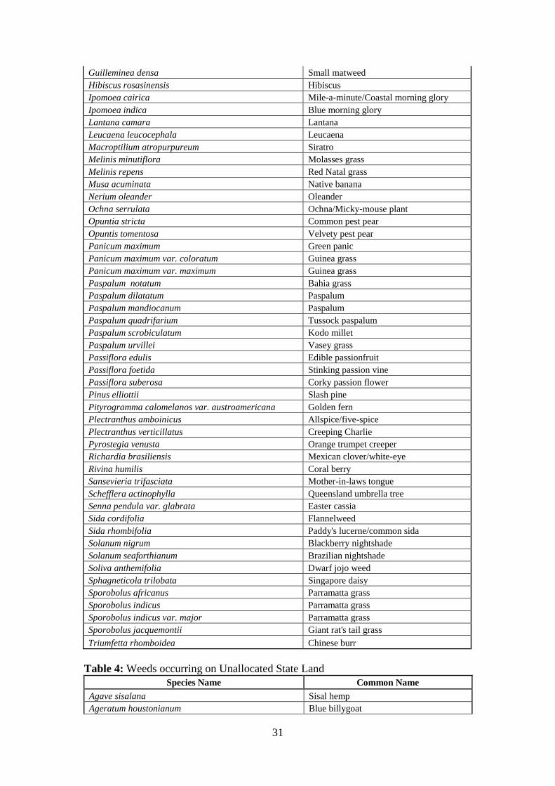
Table 4: Weeds occurring on Unallocated State Land
Species Name Common Name
Agave sisalana Sisal hemp
Ageratum houstonianum Blue billygoat

32
Asparagus aethiopicus Basket asparagus
Baccharis halimifolia Groundsel bush
Baleria repens Creeping baleria
Bidens pilosa Cobblers peg
Calyptocarpus vialis Creeping Cinderella weed
Cenchrus echinatus Mossman River grass
Chloris gayana Rhodes grass
Chrysanthemoides monilifera Bitou bush
Conyza canadensis Canadian fleabane
Eleusine indica Crowsfoot grass
Eragrostis curvula African lovegrass
Eragrostis tenuifolia Elastic grass
Eugenia uniflora Brazilian cherry
Euphorbia cyathophora Painted spurge
Gomphrena celosioides Soft khaki weed
Lantana camara Lantana
Leucaena leucocephala Leucaena
Macroptilium atropurpureum Siratro
Melinis repens Red Natal grass
Opuntia stricta Common pest pear
Opuntia tomentosa Velvety pest pear
Panicum maximum Green panic
Panicum maximum var. coloratum Guinea grass
Paspalum dilatatum Paspalum
Paspalum mandiocanum Paspalum
Paspalum scrobiculatum Kodo millet
Paspalum urvillei Vasey grass
Passiflora edulis Edible passionfruit
Passiflora foetida Stinking passion vine
Passiflora suberosa Corky passion flower
Richardia brasiliensis Mexican clover
Schefflera actinophylla Queensland umbrella tree
Schinus terebinthifolius Broad-leaf pepper tree
Senna pendula var. glabrata Easter cassia
Setaria viridis Green pigeon grass
Solanum nigrum Blackberry nightshade
Solanum seaforthianum Brazilian nightshade
Sphagneticola trilobata Singapore daisy
Sporobolus indicus var. major Parramatta grass
Tagetes minuta Stinking Roger
Triumfetta rhomboidea Chinese burr

33
Figure 6: Eurong Weed Map showing extent of the weeds recorded at Eurong
Township and relationship to land tenure.
The map above (Figure 6) illustrates the extent of the weed infestation around Eurong
and demonstrates the fact that infestations occur across management boundaries.
34
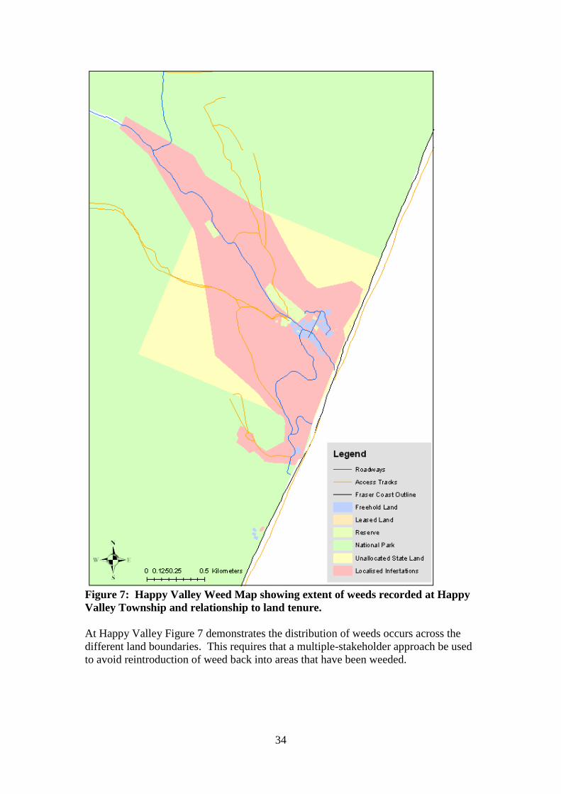
Figure 7: Happy Valley Weed Map showing extent of weeds recorded at Happy
Valley Township and relationship to land tenure.
At Happy Valley Figure 7 demonstrates the distribution of weeds occurs across the
different land boundaries. This requires that a multiple-stakeholder approach be used
to avoid reintroduction of weed back into areas that have been weeded.

35
Figure 8: Orchid Beach Weed Map showing extent of weeds recorded at Orchid
Beach Township and relationship to land tenure.
In Orchid Beach (Figure 8) there is no Unallocated State Land. The infestations of
weeds are primarily localised around the old resort site. The infestation along the
freehold property boundary could be due either to the roadway that runs along there or
due to garden escape.

36
Figure 9: Sandy Cape Weed Map showing extent of weeds around Lighthouse
site and single land tenure.
Weeds at Sandy Cape (Figure 9) occur around and below the sand dune on which the
lighthouse and associated buildings are situated and represents successive generations
of garden escape. Management is simplified here as it is under a single land tenure.
37
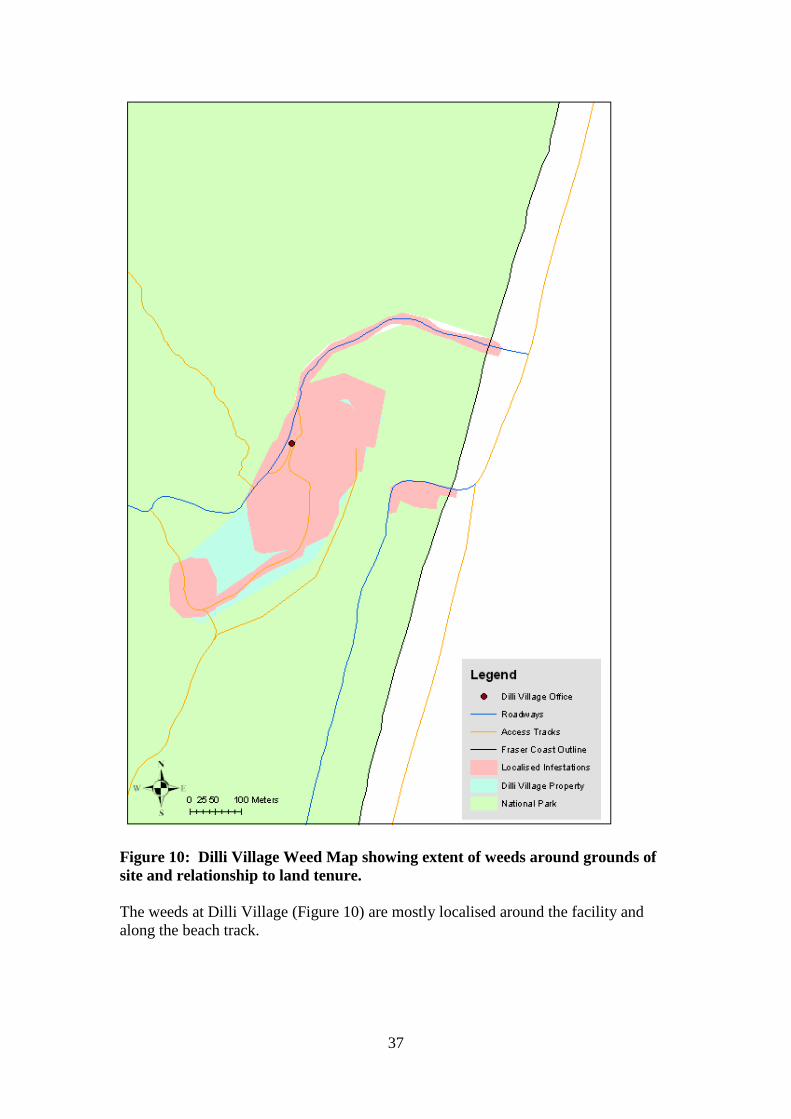
Figure 10: Dilli Village Weed Map showing extent of weeds around grounds of
site and relationship to land tenure.
The weeds at Dilli Village (Figure 10) are mostly localised around the facility and
along the beach track.
38
Weeds as Classified by Land Use or Surrounding Vegetation Type
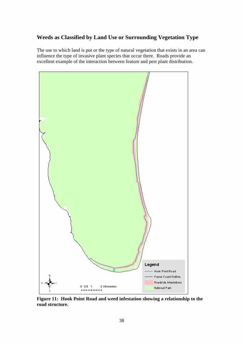
The use to which land is put or the type of natural vegetation that exists in an area can
influence the type of invasive plant species that occur there. Roads provide an
excellent example of the interaction between feature and pest plant distribution.
Figure 11: Hook Point Road and weed infestation showing a relationship to the
road structure.

39
This map (Figure 11) demonstrates the distribution of weeds, mainly grasses, along
the inland track from Hook Point. This is the access point for vehicles entering at the
southern end of the island and may represent plant seed transported from the mainland
attached to vehicles.
Figure 12: The distribution of Mossman River grass closely matches the form of
Dilli Village road.

40
Again the association between weed spread and roads can be seen in Figure 12.
Mossman River grass has a spiky seed head that sticks readily to clothes and vehicle
tyres. The smaller infestation that can be seen between the beach and the Dilli Village
grounds is a now closed camping site.
The different vegetation classes are also susceptible to different weed species. Figure
13 shows the distribution of localised weed species in four different vegetation classes
.
Figure 13: Invasive plant species occurring in four different vegetation classes on
Fraser Island.

41
Stakeholders and Partners
As previously identified several different organisations at various levels are involved
in the management of invasive plant species on Fraser Island. These can be separated
into state government bodies, local government bodies, on-island community bodies
and off-island community bodies.
State Government Bodies
Department of Environment and Resource Management (DERM)
In March 2009 the Environmental Protection Agency (EPA) and the Department of
Natural Resources and Water (NRW) were amalgamated to form the Department of
Environment and Resource Management or DERM. This department is responsible
for the conservation and management of the natural environment with a key focus on
water, climate change, land and environmental services (DERM website: Homepage).
These duties are broadly defined into the categories of Environment and of Resource
Management reflecting their historical division as two separate departments (DERM
website: Homepage).
DERM is responsible to two ministers in order to adequately meet this range of
responsibilities; The Queensland Minster for Climate Change and Sustainability and
the Queensland Minister for Natural Resources, Mines and Energy (DERM website:
http://www.derm.qld.gov.au/about/organisation/ministers.html).
While the structure for management of environmental and natural resources now rests
under a single department the responsibilities of land management are still defined by
the classification of that land. Land identified under the Nature Conservation Act
1992 as National Park remains subject to the management principles as set out by that
act while land identified as Unallocated State Land remains subject to the
management principles set out by the Land Act 1994.
National Park – The underlying principle of park management is the preservation of
the area‟s natural condition and protection of the areas cultural resources and values
(Nature Conservation Act 1992). This responsibility is administered by the
Queensland Parks and Wildlife Service (QPWS).
The primary obligations of managers of National Parks land are the permanent
preservation of the natural condition and protection of cultural resources, the
presentation of these values so that they may be appreciated by the general public and
to ensure that any use of the area is nature based and ecologically sustainable
(Nature Conservation Act 1992).
From a pest plant management perspective meeting the first of these obligations
requires that control measures be put into action for all non-endemic plant species in
order that the natural values of the site are as before European settlement (Master plan

42
for Queensland‟s parks system). Thus management needs to address both declared
and non-declared plants.
Unallocated State Land – The State acts as the Custodian of Unallocated State Land
and as such has the responsibility of control of declared plants on Unallocated State
Land (Land Act 1994). This responsibility is undertaken by the Land and Vegetation
Services division of DERM (Strategic Plan 2008 – 13. NRW). The primary focus of
management of Unallocated State Land is the preservation of the natural and cultural
resources of the area so as to be available as required for potential future use (Jason
Reberger: Pers. Com. 07/07/2009).
From a pest plant management perspective meeting these obligations requires that
only declared Class 1 or 2 plant species be controlled, however managers of
properties adjacent to an environmentally significant area also have an obligation to
control Class 3 declared pest plant species (Land Act 1994).
Department of Employment, Economic Development and Innovation -
Biosecurity Queensland (Biosecurity Queensland)
Biosecurity Queensland brings together resources and functions of the Department of
Primary Industries and Fisheries with those of the former departments Natural
Resources and Water and EPA and among other duties is responsible for protecting
Queensland‟s primary industries and environment from threats of a biological nature
(plants, animals and diseases) (Biosecurity Queensland website:
http://www.dpi.qld.gov.au/4790_6998.htm).
The department works in partnership with local governments, communities and other
stakeholders to minimize the economic, environmental and social impacts of these
threats. Biosecurity Queensland is responsible for the administration of the following
Acts in relation to pest plant management on Fraser Island:
Biological Control Act 1987
Land Protection (Pest & Stock Route Management) Act 2002 (except Chapter
3)
Plant Protection Act 1989
Biological Control Act 1987 – This Act provides for the protection of the
environment through the use of biological agents to control agricultural pest species.
It does so through the declaration of target organisms and the declaration and release
of agent organisms to combat these. It also establishes the Queensland Biological
Control Authority and defines its powers and functions. A full version of this act is
available at:
http://www.legislation.qld.gov.au/LEGISLTN/CURRENT/B/BiologConA87.pdf
Land Protection (Pest & Stock Route Management) Act 2002 – The Act provides
a framework and sets out legislation for the improved management of declared pest
plants and animals. It identifies the actions of bodies and individuals in regards to the
control of these as well as providing a legal instrument to local government by which
to enforce the management of high priority pest species. Importantly the Act allows

43
for the declaration of pests considered to be potential serious threats to Queensland
and imposes a range of restriction on the introduction, sale and possession of these. A
full version of this act is available at:
http://www.legislation.qld.gov.au/LEGISLTN/CURRENT/L/LandPrPSRMA02.pdf
Plant Protection Act 1989 – The objectives of this Act are to:
Prevent, control or remove pest infestations of plants in Queensland
Help other jurisdictions prevent, control or remove plant pests, diseases, pest
infestations, infections or conditions
Facilitate the movement of plants into and out of Queensland.
A full version of this act is available at:
http://www.legislation.qld.gov.au/LEGISLTN/CURRENT/P/PlantProA89.pdf
Unlike the various obligations of DERM which are defined by specific geographical
boundaries the obligations of Biosecurity Queensland cover all land tenures on Fraser
Island and are specific to declared pest species (Land Protection (Pest and Stock
Route Management) Act 2002). The Department of Primary Industries and Fisheries
– Biosecurity Queensland has an important linking role in pest plant management on
Fraser Island and has the capacity to provide valuable advice and resources and to
bring other techniques such as biological control into play.
Local Government Bodies
Fraser Coast Regional Council (FCRC)
The township areas of Fraser Island are all within the Local Government boundaries
of the Fraser Coast Regional Council. This is an amalgamated council that has been
created by the incorporation of previous local council boundaries of Maryborough,
Hervey Bay, Woocoo and Tiaro Shire Councils. The first two being the two council
areas under which the townships of Fraser Island formerly fell. As a result of this
amalgamation a new Local Government Area Pest Management Plan has had to be
created and passed through the various levels of Local and State Government for
approval. At the time of writing the new Pest Management Plan has been accepted by
council and has been submitted to the Minister for comment. The new Local
Government Area Pest Management Plan has had included into it the declaration of
seven environmental weeds on Fraser Island only. Once approved and adopted this
will allow the FCRC to enforce compliance requiring that landholders on Fraser
Island have control measures in place for these species. It is expected that the new
local laws will be adopted in February 2011 (Colin Zemek: Pers. Com. 29/09/2010).
The interim document that council staff has been using was compiled from existing
pest management plans adopted by previous Councils on the Fraser Coast (Fraser
Coast Regional Council Pest Management Annual Action Plan 2008/2009).
Gympie Regional Council (GRC)
44
The township of Rainbow Beach and the land of Inskip Point are in the Local Council
Area boundaries of the Gympie Regional Council. While GRC is not involved in the
management of Fraser Island; consideration should be given to the fact that Inskip
Point is a ferry access point to the southern end of Fraser Island. Consequently that
area may serve as an access point for invasive plant species to enter Fraser Island.
Any control measures that involve activities in this area may require the cooperation
of Gympie Regional Council. In addition to this Gympie Regional Council is involved
in the cooperative bitou bush control programme held annually in Rainbow Beach and
Inskip Point and coordinated by Biosecurity Queensland (Barry Sullivan: Pers. Com.
2008). To this point in time GRC is not an active member of the FINIA cooperative,
however the proximity of its Local Government Area and involvement in pest plant
suppression activities on land adjacent to Fraser Island make it worth mentioning in
this document.
Off-Island Community Bodies
Fraser Island Natural Integrity Alliance (FINIA)
The Fraser Island Natural Integrity Alliance is a cooperative body of stakeholders and
interested parties formed to implement a collaborative management approach to
environmental management on Fraser Island (Harvey, 2008). FINIA has a Weeds
Project Officer in a paid position whose duties include: Coordination of volunteer
weeding events, community and public education, mapping of weed infestations from
existing and newly collected data, community engagement, establishment of a source
of Fraser Island native plant stock, recruitment of volunteers, development of a
landscape plan of management towards weed issues, supporting weed research and
facilitating the communication and operations of the various bodies involved in weed
management on Fraser Island.
Burnett Mary Regional Group (BMRG)
(Information taken from the BMRG website: homepage)
The Burnett Mary Regional Group for Natural Resource Management Inc. (BMRG) is
the peak coordinating body for Natural Resource Management in the Burnett Mary
Region. BMRG represents the combined interests of community, industry and
government in regards to environmental issues. Its coordinating area includes Fraser
Island and the group was instrumental in the creation of FINIA
University of the Sunshine Coast (USC)
The USC is a tertiary education facility located in the Sunshine Coast that also carries
out research and community engagement on Fraser Island in part through its
connection with the FINIA project. USC operates Dilli Village Accommodation

45
facility and Research Station on the south eastern coast of the island and hosts and
supports the FINIA Weeds Project Officer position as a part of its commitment to the
FINIA project.
USC student research into the population dynamics of Asparagus aethiopicus has
been used in planning the management of this species on the island.
As the current lease holder for Dilli Village the University has an obligation under the
Land Protection (Pest & Stock Route Management) Act 2002 to control Class 1, Class
2 and possibly Class 3 Declared plant species on these grounds.
Sandy Cape Lighthouse Conservation Association (SCLCA)
(Information sourced from Lesley Bradley: Pers. Com. 2008-2009 and from Bradley,
2008)
SCLCA is an arm of the Lower Mary River Land and Catchment Care Group. The
members of SCLCA take on the duties of volunteer lighthouse keepers maintaining
the premises and grounds of the historic Sandy Cape Lighthouse at the north west of
Fraser Island. Included in these duties is an obligation to carry out weeding activities,
including, at times, coordinating the activities of volunteer groups such as
Conservation Volunteers Australia (CVA). The prioritisation and recording of
weeding activities is as determined by Queensland Parks and Wildlife. The
volunteers may also at times be required to assist with weed management of
surrounding campsites. As a volunteer body SCLCA confines its area of focus to the
lighthouse and its immediate environs. As individuals, members of SCLCA may also
be involved in other weeding activities on Fraser Island.
Fraser Island Defenders Organisation (FIDO)
FIDO is a volunteer community organisation consisting of members with a common
interest in Fraser Island. This organisation was formed in response to the perceived
threats of sand mining and logging to the natural heritage values of the island. FIDO
has continued beyond the cessation of these activities, with its members continuing to
take an active interest in protecting and preserving the natural and cultural values the
area. In addition to continuing to raise community awareness of issues affecting
Fraser Island, the group fund and organise construction of facilities and volunteer
weeding events. The weeding activities are carried out in consultation with FINIA,
FCRC and DERM representatives as the areas volunteers operate over cover land
tenures under the management of each of these bodies. FIDO has the capacity to
continue to operate volunteer projects.
Conservation Volunteers Australia (CVA)
Conservation Volunteers Australia is a non-profit community organisation that
organises and operates volunteer projects throughout Australia and internationally
(CVA website: http://www.conservationvolunteers.com.au/). CVA has been involved
in a variety of projects on Fraser Island as funded by corporate sponsorship, through
46
competitive grant bids and as partner organisations to DERM most recently working
in close partnership with FINA. These projects have involved working in a variety of
areas across the island. CVA has the capacity to continue to provide appropriate
volunteer projects.
National Parks Association of Queensland (NPAQ)
(Information sourced from the NPAQ website)
The National Parks Association of Queensland is a non-political, non-profit
organisation formed to promote the continued creation, preservation and good
management of National Parks and reserve areas in Queensland. The organisation
lobbies ministers, politicians and key stakeholders in order to achieve their goals.
On-Island Community Bodies
Traditional Owners
The K‟Gari camp ground is operated by a body of Traditional Owners. The facilities
and grounds are maintained by the group. The body that operates this facility works
out of Hervey Bay, but there is a presence on the island as well. The Traditional
Owners carry out weed management around K‟Gari, and there is the potential to
develop a working relationship with this body.
Fraser Island Association (FIA)
This organisation is a body that represents the residents and business interests of
Fraser Island in order that the community can have a voice on matters relating to
management and other issues. The FIA have the potential to be involved in the
FINIA management process and as an umbrella to community weeding groups that
could be established on the island.
Orchid Beach Progress Association (OBPA) and Aircraft Landing strip
Association (ALA)
The Orchid Beach Progress Association and Aircraft Landing strip Association are
two bodies comprising of residents and owners from Orchid Beach but essentially
formed of the same members (Matt Organ: Pers. Com., 25/06/2009). These groups
are an excellent representation of this community and have been involved in
education and community weeding projects in the past (Paul Fishburn, Pers. Com.,
25/06/2009). The OBPA/ALA committee have donated wall space in an information
shelter. The shelter was constructed with FINIA funding and is to be used for
community notices and to display weed information.

47
Residents and Property Managers of Fraser Island
Those areas of land on Fraser Island that are either privately owned (Freehold) or are
leased from the State (Leasehold) are managed by the entities or individuals who hold
those titles. The OBPA and ALA is an example of a lease holding body for the
aircraft landing strip at Orchid Beach.
Residents – In terms of weed management on their properties the focus of Fraser
Island residents will depend on their own values and belief systems. They will
exercise personal preferences in their decisions to have a garden that is either
aesthetically pleasing to them, provides a functional space, minimises fire risk,
reflects the natural surroundings or achieves some or all of the above functions.
As freehold landowners the residents of the various townships of Fraser Island have
obligations under the Land Protection (Pest & Stock Route Management) Act 2002 to
control Class 1 and 2 declared pest species on their properties. The close proximity of
those land titles to an area of environmental significance may require that this
includes the control of Class 3 declared plant species.
There are individuals in Eurong, Happy Valley and Orchid Beach who have indicated
a history of, and an interest in, being involved with pest plant management activities
in areas around the townships. Initial discussions with these groups have been very
positive and have already resulted in volunteer works being carried out and the
development of a cooperative relationship. The next step will be to develop a formal
relationship between these groups, FINIA and FCRC to provide assistance,
equipment, training and insurance cover for the groups.
Property managers – Many of the properties on Fraser Island are managed as
commercial businesses ventures or community services at various scales of operation.
The list of these properties includes large scale resort developments, small scale
holiday rental houses, shops and cafes and facilities such as the ambulance station or
Orchid Beach airstrip. The grounds of these properties are designed to meet
constraints of aesthetics, functionality and practicality similar to those of the
residential properties. As owners, trustees or lessees these bodies have obligations
under the Land Protection (Pest & Stock Route Management) Act 2002 to ensure their
lands are free of Class 1 and 2 declared pests and possibly Class 3 declared pests as
well.
Residents of Happy Valley
There are residents of Happy Valley who have been involved in weeding activities in
areas around this settlement and have also provided accommodation and assistance to
FIDO and FINIA weeding projects in Happy Valley. Three areas have been identified
where residents have carried out weeding work and shared areas that can be worked
by volunteer to assist the community groups have also been identified (Figure 14).
The FINIA weeds project officer has assisted in the equipping of Happy Valley
volunteers and in the planning of their weed control works.
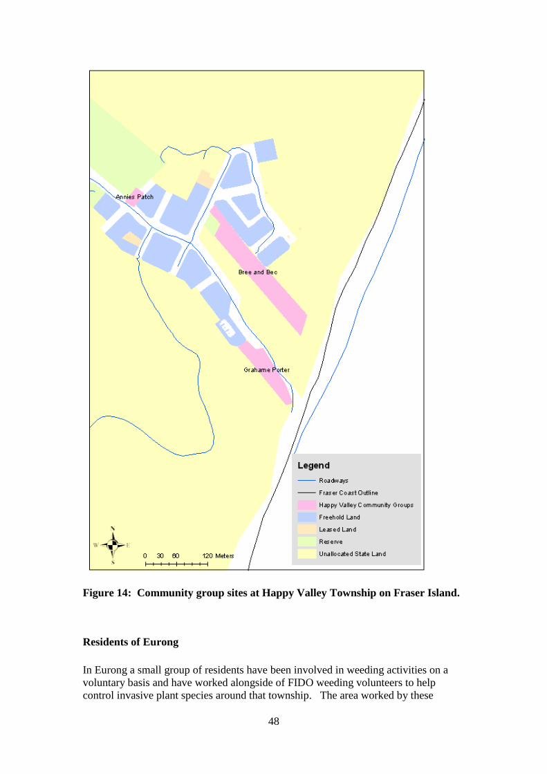
48
Figure 14: Community group sites at Happy Valley Township on Fraser Island.
Residents of Eurong
In Eurong a small group of residents have been involved in weeding activities on a
voluntary basis and have worked alongside of FIDO weeding volunteers to help
control invasive plant species around that township. The area worked by these
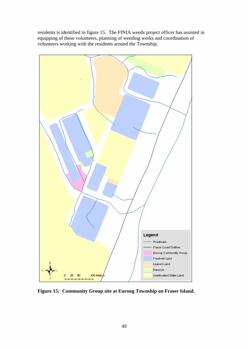
49
residents is identified in figure 15. The FINIA weeds project officer has assisted in
equipping of these volunteers, planning of weeding works and coordination of
volunteers working with the residents around the Township.
Figure 15: Community Group site at Eurong Township on Fraser Island.

50
Residents of Orchid Beach
Residents of Orchid Beach have indicated an interest in becoming involved in local
weed management issues through attending community engagement days and hosting
a small scale native plant nursery to propagate native plants for residential garden
plantings for on Fraser Island.
Different Weed Introduction Modes to Fraser Island
While the geographical isolation of Fraser Island affords some level of protection
from new weed infestations, there is a continued risk of future introductions of pest
species. The first step in managing this risk is to recognise the potential modes of
introduction and identify measures of prevention. Three categories of introduction
can be identified. These are: intentional introductions, unintentional introductions and
natural process introductions. An understanding of these will allow appropriate
control processes to be put into place. The modes of introduction may also be the
mechanisms by which pest species are being transported around Fraser Island. Many
of the control methods identified here can also be applied to decrease movement of
weeds around the island.
Intentional Introductions
Plants that have been purposely brought to the island and have established naturalised
populations can be identified as intentional introductions. There have been several
plant species introduced to Fraser Island in this way. Most of the species in this
category were introduced prior to the gazetting of Fraser Island as either a National
Park or a World Heritage Area. The reasons for these introductions can be further
divided into broad-scale introductions and localised introductions. Broad-scale
introductions are those identified as having been made for rehabilitation or
commercial purposes while localised introductions have been introduced on a smaller
scale for landscaping or cottage industry purposes. Note that 'broad-scale' and
'localised' do not refer to the current distribution of these species, only to the effort
invested in their original cultivation.
Broad-scale Introductions
Chrysanthemoides monilifera (bitou bush) and Lantana camara (lantana) are both
believed to have been introduced to Fraser Island as dune rehabilitation species while
Pinus elliottii (slash pine) was cultivated as a harvestable timber plantation species.
Intensive, regular efforts on the part of QPWS and DEEDI (previously DPI&F) have
successfully reduced the range of bitou bush, however seedlings and mature plants are
still located occasionally (Ivan Thrash: Pers. Com. 2008 - 2009) and regular
surveillance will continue to be a necessary part of any long term management plan.
Management records would also indicate that slash pine has been controlled as no
further occurrences of it have been recorded since 2007 (QPWS Parkinfo system).
51
Lantana camara (lantana) is much more widely dispersed, having spread the entire
length of the island‟s eastern coast.
Control Procedures
Under current policy there should be minimal risk of new intentional broad-scale
introductions of exotic species as the majority of the island is now under management
as a National Park. As such new plantation species would not be introduced to the
island and any species planted for rehabilitation would have to be appropriate as per
the preservation of the natural values of the National Park.
To ensure a supply of appropriate species for rehabilitation and revegetation the
QPWS should continue to maintain its native plant nursery on Fraser Island. This
provides local and appropriate Fraser Island native plant species from seed collected
and germinated on the island. The local production of plants also acst to decrease the
risk of disease or other pests entering Fraser Island in potting mix or soil.
Localised Introductions
Currently there is an extremely strong relationship between the occurrence of several
exotic plant species on Fraser Island and their historical status as garden plants.
Species such as Asparagus spp (basket and ferny asparagus), Bryophyllum spp
(mother of millions) and Senna pendula var. glabrata (Easter cassia) almost certainly
entered Fraser Island as ornamental plants while Agave sisalana (sisal hemp) was
most likely introduced for 'cottage industry' purposes as a fibre producing plant. Over
time these species became garden escapes and have managed to establish naturalised
populations in undisturbed environments. While the residents and land holders of
Fraser Island have a certain level of responsibility under the Land Protection (Pest &
Stock Route Management) Act 2002 to prevent the spread of declared pest plant
species they also have the right to be able to landscape their properties to provide
privacy and a pleasing environment as well as to stabilise soils. Consequently there is
a continued risk of introduction and reintroduction of pest plant species that are not
declared under this act.
This risk stems from two factors:
Inappropriate species selection
Gardening practices
Discussions with Fraser Island landholders would indicate that there are several
factors which influence decisions on which species to plant. These include:
Personal preferences and attitudes
Purpose of planting (e.g. screening plants, decoration etc)
Availability of species
Suitability to local conditions
Knowledge of plant behaviour
Knowledge of legislation and regulations
Fire proneness of area to be planted

52
Likewise discussion with residents has also indicated there are several factors which
influence the gardening practices they employ:
Understanding of issues and problems associated with their gardens
Knowledge of appropriate and inappropriate practices
Time
Equipment
Garden waste disposal options
Interest
One of the most well recognised threatening processes is the dumping of garden waste
in bushland areas which is often carried out with the mistaken belief that the organic
material is good for the environment (Buchanan, 1999; Muyt, 2001; Blood, 2001)
Control Procedures
The selection of appropriate species and use of responsible gardening practices can
help prevent the further introduction and spread of pest plants. To minimise the risk
from household gardens intervention should focus on:
Making suitable on-island species available to residents and landholders at
minimal cost – This role can be taken on through cooperative efforts by QPWS,
FCRC and the residents of Fraser Island.
Promoting the aesthetic values of island native plant species – This can be
achieved by the identification of attractive plant species through discussion with
island residents and the production of colour pamphlets and alternative planting
guides similar to those produced by FCRC.
Providing education and information regarding weed issues associated with
garden plants and best practices for garden management - Highlighting
specific issues of importance on Fraser Island would make informational
publications more effective communication and engagement tools.
Encouraging resident and landholders to organise or participate in weeding
activities – Involvement of landholders and residents may act to promote a sense
of involvement and stewardship and give incentive to discuss appropriate
gardening techniques with neighbours.
Providing suitable and accessible disposal options for garden waste and
encourage their use – Despite the availability of green waste facilities in the
council operated waste disposal sites there are still instances of garden dumping
occurring (personal observations). The reasons why these sites are underutilised
needs to be better understood and addressed.
At a household level residents and landholders can take the following actions to
minimise the impacts of their garden species on the natural environment:
Remove seed heads and seeding parts before they mature.
Dispose of garden waste and lawn clippings appropriately in the designated
areas of the township waste transfer depots.
Seek advice on the potential for plant species to become problematic on Fraser
Island prior to bringing new plants onto the island.

53
Select island provenance species when they become available
Unintentional Introductions
Plant species that have been introduced to Fraser Island accidentally can be defined as
unintentional introductions. That is, there was no intent to transport or grow the
resulting plant. These species may have been transported in a variety of ways as
seeds, live plants or regenerating plant parts. Grasses are an excellent example of a
species most likely transported to Fraser Island in this way and of a species that
continues to be spread around the island by this method of transport. Some methods
by which weed seed or material can be transported are:
Stuck on vehicle or trailer bodies, tyres and under wheel arches
Caught in clothing, tents, camping equipment
In gravel, soil and other building and landscaping materials brought in from
the mainland
On heavy earth moving equipment
In timber brought onto the island as fire wood
As dormant seeds or seedlings in pots with other plants
As food plants
A very recent example of this mode of transport is a live propagule of a cactus species
that was found attached to bush timber brought to Waddy Point camping ground as
fire wood. The live plant material was noticed growing on a piece of wood left at a
camp fire ring and may not have been the only specimen of its kind (personal
observation).
Control Procedures
In order to control and minimise the risk of further introductions there needs to be a
focus on education and behaviour modification as well as facilitation of appropriate
behaviour. Target audiences need to be identified and informed about the risks of
weed transportation and then provided with options to minimise these risks. There is
also the potential to place quarantine style procedures in place in order to effectively
manage risks.
Individuals travelling to Fraser Island can be divided into identifiable groups or target
audiences. Information media and delivery methods can then be specific to each
group and the associated risks.
Target audiences and behavioural changes include:
Four wheel drive vehicle operators – encourage washing down vehicles
before visiting the island.
Campers, anglers, hikers and bush walkers – encourage checking clothing
and equipment for weed seeds and plant parts, if planning to have a fire
encourage us of milled timber NOT bush wood.
54
Contractors – encourage washing down of equipment before coming to
Fraser Island and encourage them to provide Weed Hygiene Declerations for
sands and gravels when providing or transporting materials.
Resort operators – encourage washing down of vehicles and recruit to
disseminate information.
Residents and landholders of Fraser Island – encourage washing down of
vehicles and equipment before returning to island and use of certified hygienic
construction/landscaping materials and recruit to disseminate information
Public sector staff operating on Fraser Island – encourage washing down of
vehicles and equipment before entering the island and recruit to disseminate
information.
Private sector staff and businesses operating on Fraser Island – encourage
washing down of vehicles and equipment before entering the island and recruit
to disseminate information. Encourage to provide facilities for wash down of
vehicles
Private sector staff and businesses operating off of Fraser Island – encourage washing down of vehicles and equipment before entering the island
and recruit to disseminate information. Encourage to provide facilities such as
hygienic milled timber as a commercial venture.
Similar procedures could also be effective in preventing the transport of pest plant
species around the island. Washing down vehicles while on the island and checking
clothing and equipment before moving or travelling to different areas, especially from
areas of known weed infestation, could help prevent weed spread. Encouraging those
contractors and service providers operating on Fraser Island to clean equipment
before moving around may act to limit spread by this method.
The geographical separation of Fraser Island offers the potential to initiate quarantine
style procedures in order to limit introduction of contaminated materials. Quarantine
procedures could include:
Providing a Weed Hygiene Declerationfor any materials transported to the
island.
Declaring any materials that may contain weeds or pathogens so that potential
problems can be detected early.
Searching for and confiscating or quarantining plants or suspect materials
being transported to the island.
Providing wash down facilities at vehicle access points to the island or
providing opportunity and incentive to use existing wash down facilities.
Natural Process Introductions
This category includes plant species that have arrived on Fraser Island through
otherwise natural processes such as wind borne seed, tidal transport or in animal
droppings. An example of such a species is Baccharis halimifolia (groundsel bush),

55
the seed of which is believed to have been carried by wind from the mainland to the
western coast of the island where a substantial population now occurs (Paul Fishburn,
Pers. Com. 25/06/2009). Birds and flying mammals such as bats could represent
possible biological vectors for weed transportation when they eat fruit on the
mainland then travel to Fraser Island. The movement of plant seed and material in
this way will be the most difficult to manage as it involves processes and organisms
that cannot be controlled.
Control Procedures
For this process to occur it requires both a source of potential infestation (e.g. seeding
plants) and a vector of transport (Blood, 2001). As the actual processes or vectors of
transport themselves cannot be controlled the best method for minimising this risk
involves decreasing the sources of seed infestation in areas adjacent to Fraser Island.
The rationale behind this is that the transportation mechanisms involved have only a
limited distance they can move material (Grice & Setter, 2002). For example a
fruiting pest plant occurs at a specific distance from Fraser Island (distance „a‟) while
a bird that eats that fruit will only be able to travel a certain distance before the seed
passes through its digestive tract (distance „b‟). If distance „a‟ is greater than distance
„b‟ the pest plant seed will not be transported to Fraser Island. This rationale is
supported by the framework put forward by Westcott and Dennis (cited, Grice &
Setter (Eds), 2002) which focussed on the distances travelled by bird species between
ingestion and excretion of fruit. The bitou control program carried out at Rainbow
Beach each year acts to remove potential weed seed sources from Inskip Point
adjacent to Fraser Island. This acts to decrease the potential source of seed for this
species in the area, effectively decreasing the risk of transport.
To decrease the spread of weeds already on the island management strategies need to
focus on controlling core infestations and scheduling management activities to
prevent the development of fully matured seed.
The research of Goosem (cited Grice and Setter (Eds), 2002) indicates that weeds of
rainforests are mainly found along road and other disturbance edges, but also
opportunistically move into previously undisturbed areas when natural gaps in canopy
occur and that this is particularly true of species that are wind dispersed. Easter cassia
is a wind dispersed species (Blood, 2001; Muyt, 2001) which could be expected to
follow this pattern of invasion. The management of Easter cassia should therefore
focus primarily on core infestations that occur in open areas, along roadways and
other corridors of disturbance as these are the infestations that will spread the
quickest.
With species dispersed by frugivores however dispersal will continue in both
disturbed and undisturbed areas, even though the specific species responsible will
differ (Grice & Setter, 2002). The research of Shimizu (2009) into the modelling of
the invasive potential of Asparagus aethiopicus on Fraser Island indicates the
potential range of this species around its main known occurrences can be predicted as
can a framework for effective control of the species, which would require removal of
more than 90% of individuals in all growth stages every two years.

56
Impacts and Management Options
As previously defined, environmental weeds are those species with the capacity to
invade native ecosystems and modify ecosystem function such that they affect the
health and survival capacity of native flora and fauna. Environmental weeds hinder
the survival and regeneration of native flora, altering the structure and composition of
vegetation which, in turn, can also affect the survival capacity of native fauna through
habitat changes (South-East Queensland Environmental Weeds Strategy, 2002).
Weeds have been primarily responsible for the extinction of four Australian plant
species (Groves and Willis, 1999).
Environmental weeds may have significant environmental, social and economic
impacts such as:
Reduction in biodiversity
Loss of habitat area
Impacts on landscape
Degradation of water quality
Altered fire risk
Costs of control
Loss of ecotourism activities
Impacts on recreational activities
As management issues these are very real threats to Fraser Island as both a World
Heritage Area and as a unique natural environment. Risks of loss of habitat and
biodiversity are exacerbated by the island‟s geographical isolation and level of
endemism which prevents easy migration of species to replace those lost (Thresher,
1999, cited in Williams and West, 2000). In fact the replacement of island species by
those from the mainland could actually put further pressure on the endemic species of
Fraser Island.
Weed impact studies and research into the biology and control of weed species are
identified as a critical knowledge gaps in the effective planning and management of
environmental weed species (Adair and Groves, 1998). In order to utilise the limited
resources available on Fraser Island management decisions need to be based on an
understanding of the potential or actual impacts particular weeds or groups of weeds
have on natural diversity. Differentiation needs to be made between weeds present
and weeds present that are having a negative impact.
Analysis of the current information collected about weed occurrences on Fraser Island
indicates that while there are some species (e.g. lantana, prickly pear etc) that are very
widely dispersed across the island they generally do not form extremely dense
populations. The majority of the island has a low weed density, with the most critical
infestations occurring in association with man-made structures. As previously
indicated there are localised pockets of weed species often occurring around the
settled areas of the island. It is these localised occurrences that represent the highest
management priorities as they are currently controllable and represent a significant
threat to the natural ecosystems.
57
In further determining management priorities the specific impacts of environmental
weeds as a whole and the species present on the island that cause these impacts needs
to be considered.
Specific Impacts of Weed Species
Outcompetes and replaces native species – The lack of predators or diseases to limit
the population size and rapid rates of growth tend to provide introduced species with a
competitive advantage over native species, allowing them to quickly invade disturbed
environments (Buchanan, 1999). Once established these species replace the native
vegetation in this niche and compete for resources such as space and nutrients (Adair
and Groves, 1998).
Invades undisturbed ecosystems – Some species can utilise the cycles of natural
disturbance in rainforest to quickly invade otherwise intact ecosystems (Grice &
Setter, 2002).
Inhibits or excludes other plant species – Weed species can impede and suppress
regeneration of indigenous plants through a variety of mechanisms (Muyt, 2001). The
rhizomes and root mass of Asparagus aethiopicus for example form a dense mat that
prevents other seedlings from establishing (Blood, 2001).
Smothers plants – Vines climb over the top of canopy species and can smother
smaller plants preventing photosynthesis, or break branches and trunks of larger
plants by sheer weight of biomass (Buchanan, 1999).
Toxic to animals and humans – Broadleaved pepper tree produces a resin toxic to
humans and animals (Biosecurity Queensland Fact Sheet – broadleaved pepper).
Alters habitat structures and local flora and fauna ecosystems – Changes in soil
chemistry and nutrient cycling alter the structure of habitat for native animal and plant
species, which can favour the spread of weed species, while vine invasion can change
the structure of habitat completely by destroying canopy species (Muyt, 2001).
Changes fire frequency and intensity– Some plants can alter fire regime, with some
grasses increasing fire intensity and frequency (Adair and Groves, 1998) as does
lantana (Oosterhout, 2004).
Can harbour diseases and pests – Broad leaf pepper harbours a disease that can kill
mangroves (Biosecurity Queensland – Broadleaved pepper).
These impacts can be placed into a table along with the species occurring on Fraser
Island that are recognised as being associated with them.
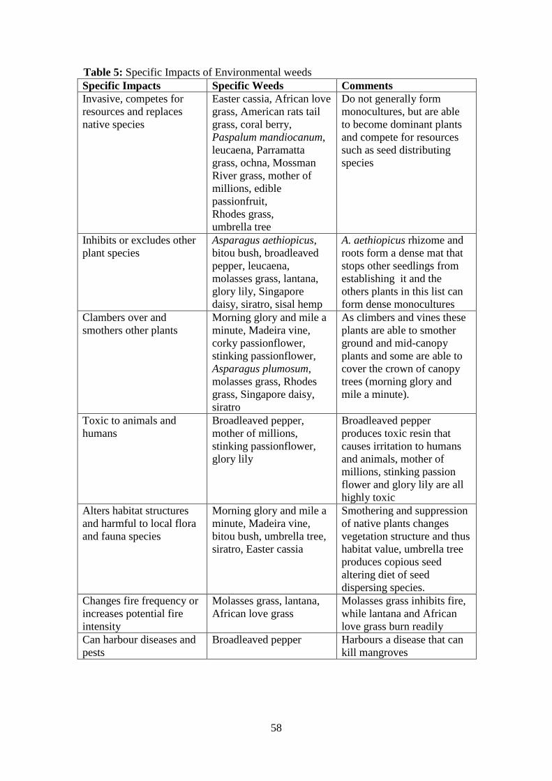
58
Table 5: Specific Impacts of Environmental weeds
Specific Impacts Specific Weeds Comments
Invasive, competes for
resources and replaces
native species
Easter cassia, African love
grass, American rats tail
grass, coral berry,
Paspalum mandiocanum,
leucaena, Parramatta
grass, ochna, Mossman
River grass, mother of
millions, edible
passionfruit,
Rhodes grass,
umbrella tree
Do not generally form
monocultures, but are able
to become dominant plants
and compete for resources
such as seed distributing
species
Inhibits or excludes other
plant species
Asparagus aethiopicus,
bitou bush, broadleaved
pepper, leucaena,
molasses grass, lantana,
glory lily, Singapore
daisy, siratro, sisal hemp
A. aethiopicus rhizome and
roots form a dense mat that
stops other seedlings from
establishing it and the
others plants in this list can
form dense monocultures
Clambers over and
smothers other plants
Morning glory and mile a
minute, Madeira vine,
corky passionflower,
stinking passionflower,
Asparagus plumosum,
molasses grass, Rhodes
grass, Singapore daisy,
siratro
As climbers and vines these
plants are able to smother
ground and mid-canopy
plants and some are able to
cover the crown of canopy
trees (morning glory and
mile a minute).
Toxic to animals and
humans
Broadleaved pepper,
mother of millions,
stinking passionflower,
glory lily
Broadleaved pepper
produces toxic resin that
causes irritation to humans
and animals, mother of
millions, stinking passion
flower and glory lily are all
highly toxic
Alters habitat structures
and harmful to local flora
and fauna species
Morning glory and mile a
minute, Madeira vine,
bitou bush, umbrella tree,
siratro, Easter cassia
Smothering and suppression
of native plants changes
vegetation structure and thus
habitat value, umbrella tree
produces copious seed
altering diet of seed
dispersing species.
Changes fire frequency or
increases potential fire
intensity
Molasses grass, lantana,
African love grass
Molasses grass inhibits fire,
while lantana and African
love grass burn readily
Can harbour diseases and
pests
Broadleaved pepper Harbours a disease that can
kill mangroves
59
Management within a Landscape Framework
The type of threats posed by weed species differs dependant on the types of
landscapes they occur in and the potential economic, social and environmental
impacts they can have needs to be assessed based on recognition of the limitations and
opportunities that landscape presents (Groves, Panetta and Virtue (Eds), 2001).
As an island environment with multiple stakeholders and a large area dedicated to
conservation of natural heritage values, Fraser Island poses a mix of landscape
management planning challenges.
The way in which the landscape interacts with weeds needs to be examined.
Examining what aspects of the landscape act to facilitate or to discourage weed
incursion and how can these landscape aspects be used to better understand and
control pest plant infestations will allow development of a more successful
management approach.
Management planning is about prioritising allocation of limited resources to best
effect (Groves, Panetta and Virtue (Eds), 2001). This requires identifying the threats
present and the resources available and making decisions as to which threats can be
addressed adequately with those resources. This critical trade-off between
environmental and economic factors can require allowing one problem to go
unchecked while another, more manageable one is addressed.
The Landscape
The landscape consists of both man-made and natural features and it is the interaction
between these that give weed species the opportunities to invade and establish. Roads
and urban structures, changes in hydrology and nutrient cycles are all examples of
well recognised anthropogenic disturbance processes that advantage weed species
(Buchanan, 1999; Groves, Panetta and Virtue, 2001; Grice and Setter, 2003). It is
mans; interaction with the environment that has created the original source of
infestation (by either intentional or accidental introduction) as well as the
opportunities to establish (by habitat disturbance and land practices) that benefit weed
species.
In terms of the natural environment it is the availability of suitable habitat, vectors of
seed or plant part spread, access to resources and protection from predators or
diseases that determine the success (or failure) of a newly established plant colony
(Groves, Panetta and Virtue, 2001, Grice and Setter, 2003; Radosevich, Stubbs and
Ghersa, 2003).
The Built Environment
The Townships, roads and various facilities on Fraser Island are components of the
built environment. Of these the most significant weed impact comes from the

60
townships as can be demonstrated by a map showing the locations of the main
localised weed species (Figure 16).
Figure 16: The relationship between towns, structures and weed infestations on
Fraser Island.
The towns as epicentres of localised weed occurrences can be explained as a product
of the large numbers of garden species that have been introduced there over time.
Over time the plant species that were best suited to the local conditions were able to
extend their range beyond the gardens and into the surrounding bushland areas

61
Roads – Roadways have a significant influence on bushland health. They fragment
habitats, are a disturbance that allows weeds to gain a foot hold in an environment, are
a pathway for weed seed to be distributed by the movement of humans, vehicles and
animals that use the tracks and are sites of erosion and altered hydrology (Buchanan
1999).
The relationship of the roads to the movement of weeds and their occurrence can be
well highlighted by the map in section 2 (figures 12 & 13) demonstrating the
distribution of grass species along the hook point road and around Dilli village.
Disturbance – Disturbance is a well recognised factor in the establishment and spread
of weeds (Adair and Groves, 1998; Buchanan, 1999; Groves, Panetta and Virtue,
2001; Grice and Setter, 2003). Clearing for house blocks, fence lines and other
structures exposes soil providing opportunity for weeds to germinate.
Weed introductions and weed reservoir – Cultivated plant species that have the
ability to form self sustaining populations in the wild have a capacity to become
environmental weeds (Batianoff and Butler, 2002). Gardens and cultivated areas
associated with residences act as sources of plants and weed seed that are able to
escape cultivation and form colonies in bushland and environmental areas (Buchanan,
1999).
Changes in nutrient and hydrology cycling – Disturbances to hydrology and
nutrient cycles can quickly degrade natural systems and make them more susceptible
to weed incursion (Buchanan, 1999). Waste treatment systems, roadways, runoff
from houses and paved or concreted areas can alter the hydrology and nutrient flow in
natural areas (Groves, Panetta and Virtue, 2001). These processes are all associated
with the success of weed species establishing in natural areas.
The Natural Environment
Availability of resources – Plants growing in natural environments are dependent on
the availability of resources in those environments to survive and the types of weeds
that will establish will be determined by those plants‟ ability to harvest the available
resources (Buchanan, 1999). The availability of nutrients is generally limited on
Fraser Island due to the simple soil structure and the nutrient layer reaches increasing
depths heading from East to West on the island (Walker and Thompson 2004). This
requires plants growing on the island to be adapted to this situation. Likewise the
weeds that establish tend to be limited to those that can survive lower nutrient levels
in the soil.
Climate – The climate of Fraser Island, being sub-tropical favours plants that are
adapted to sub-tropical and tropical environments. Species that originate from similar
latitudes such as those of South Africa and South America are quite well adapted to
conditions in warmer parts of Australia such as northern New South Wales and South-
east Queensland (Buchanan, 1999). Brazilian cherry, asparagus fern and Opuntia spp
are good examples of this, all being species well suited to hot environments.

62
Growth environment – The types of growth environment available will determine
the types of weed species that are able to establish in an area. Bitou bush grows in
sand and sandy soils, both in full sun and in shade, while basket asparagus grows well
in coastal environments (Blood, 2001). The growth environment, essentially akin to
habitat for fauna, is a complex interaction of a variety of factors that meet the life
needs of that organism. It includes aspect, amounts of solar radiation available,
moisture and nutrient levels in soil, presence of seed dispersal mechanisms and of
course available space.
Seed or plant spread vectors – Mechanisms for seed or propagule dispersal need to
be available for weed species to be able to establish and spread effectively (Grice and
Setter, 2003). These can be mechanical such as water or wind movement or by
gravity or can be biological such as in GI tract of animals or attached to fur or feathers
(Groves, Panetta at al, 2001). In rainforest and near rainforest environments birds are
often the main dispersal mechanisms of both rainforest and weed species (Grice and
Setter, 2003). Bird species occurring on Fraser Island that are known to be vectors of
weed seed spread in rainforests and disturbed sites are: emerald dove, brown cuckoo
dove, top-knot pigeon, rose-crowned fruit dove, wompoo fruit dove, sulphur crested
cockatoo, yellow eyed cuckoo-shrike, Lewin‟s honey eater, silvereye and currawong.
Life-cycles and patterns of growth – Different plant communities host different
flora and fauna species, demonstrate a variety of growth patterns and therefore are
susceptible to different threatening processes (Buchanan, 1999).
In order to develop an effective management plan that addresses high priority weeds
and areas under threat the FINIA weed database (a composite database complied from
Pestinfo data, volunteer groups weeding records and mapping undertaken by the
Weeds Project Officer) has been interrogated and the results interpreted to indicate
which vegetation classes or plant communities are already under threat by existing
weed infestations.
Table 6: Vegetation class, area and weed diversity showing the number of weed
species recorded for each vegetation class
Vegetation class Area Ha % of total land
area
No. weed species
recorded
Coastal forest 14346 8.8 85
Open forest 82921 51 63
Heath and sedge 13425 8.3 34
Sand 5524 3.4 28
Cleared areas 490 0.3 26
Mangrove 3971 2.4 25
Tall eucalypt forest 29083 18 24
Closed forest 12544 7.7 18
Plantation 189 0.1 11
Total area 162493
Table 6 illustrates the occurrence of weed species in each of the nine basic vegetation
classes and each of these communities area in hectares.
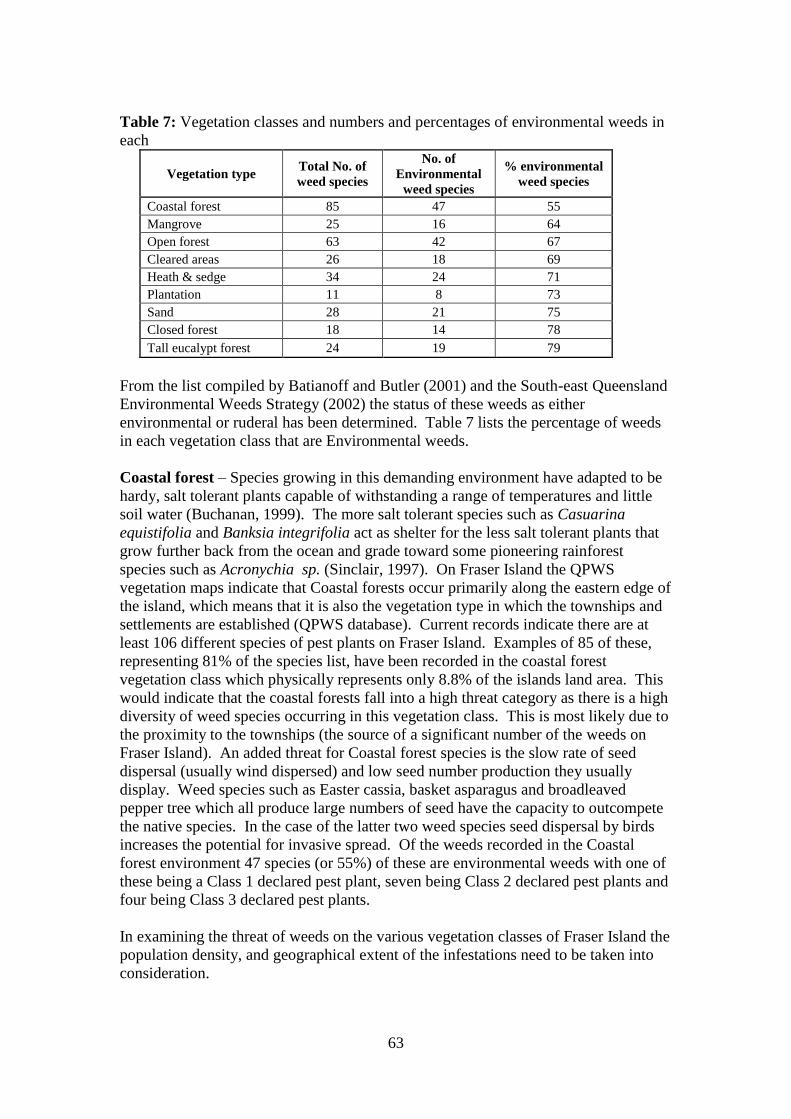
63
Table 7: Vegetation classes and numbers and percentages of environmental weeds in
each
Vegetation type Total No. of
weed species
No. of
Environmental
weed species
% environmental
weed species
Coastal forest 85 47 55
Mangrove 25 16 64
Open forest 63 42 67
Cleared areas 26 18 69
Heath & sedge 34 24 71
Plantation 11 8 73
Sand 28 21 75
Closed forest 18 14 78
Tall eucalypt forest 24 19 79
From the list compiled by Batianoff and Butler (2001) and the South-east Queensland
Environmental Weeds Strategy (2002) the status of these weeds as either
environmental or ruderal has been determined. Table 7 lists the percentage of weeds
in each vegetation class that are Environmental weeds.
Coastal forest – Species growing in this demanding environment have adapted to be
hardy, salt tolerant plants capable of withstanding a range of temperatures and little
soil water (Buchanan, 1999). The more salt tolerant species such as Casuarina
equistifolia and Banksia integrifolia act as shelter for the less salt tolerant plants that
grow further back from the ocean and grade toward some pioneering rainforest
species such as Acronychia sp. (Sinclair, 1997). On Fraser Island the QPWS
vegetation maps indicate that Coastal forests occur primarily along the eastern edge of
the island, which means that it is also the vegetation type in which the townships and
settlements are established (QPWS database). Current records indicate there are at
least 106 different species of pest plants on Fraser Island. Examples of 85 of these,
representing 81% of the species list, have been recorded in the coastal forest
vegetation class which physically represents only 8.8% of the islands land area. This
would indicate that the coastal forests fall into a high threat category as there is a high
diversity of weed species occurring in this vegetation class. This is most likely due to
the proximity to the townships (the source of a significant number of the weeds on
Fraser Island). An added threat for Coastal forest species is the slow rate of seed
dispersal (usually wind dispersed) and low seed number production they usually
display. Weed species such as Easter cassia, basket asparagus and broadleaved
pepper tree which all produce large numbers of seed have the capacity to outcompete
the native species. In the case of the latter two weed species seed dispersal by birds
increases the potential for invasive spread. Of the weeds recorded in the Coastal
forest environment 47 species (or 55%) of these are environmental weeds with one of
these being a Class 1 declared pest plant, seven being Class 2 declared pest plants and
four being Class 3 declared pest plants.
In examining the threat of weeds on the various vegetation classes of Fraser Island the
population density, and geographical extent of the infestations need to be taken into
consideration.
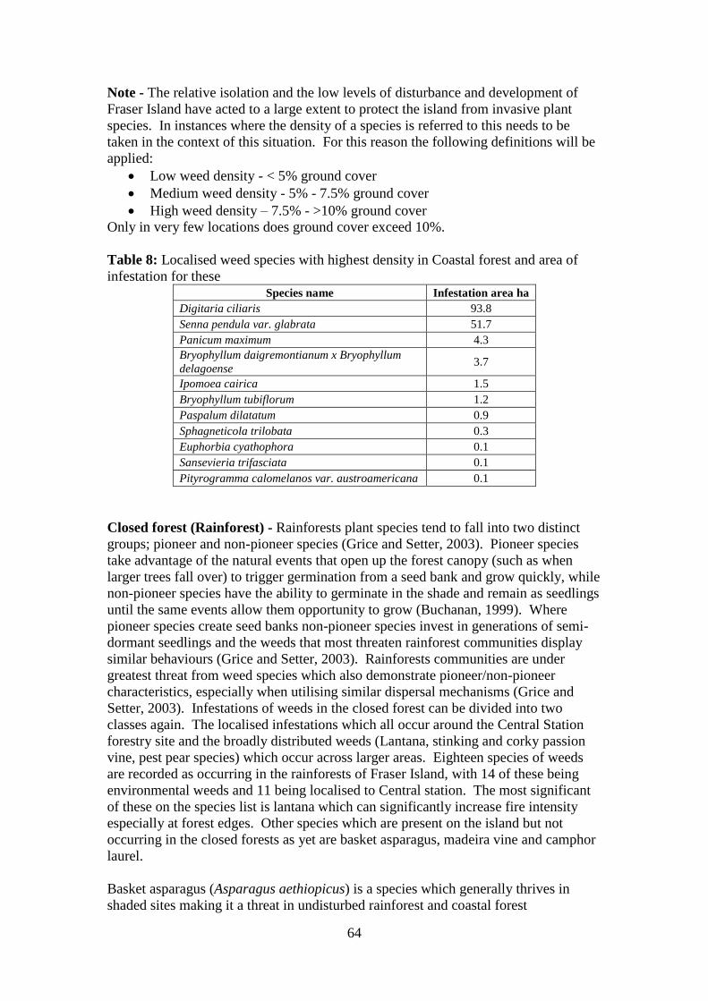
64
Note - The relative isolation and the low levels of disturbance and development of
Fraser Island have acted to a large extent to protect the island from invasive plant
species. In instances where the density of a species is referred to this needs to be
taken in the context of this situation. For this reason the following definitions will be
applied:
Low weed density - < 5% ground cover
Medium weed density - 5% - 7.5% ground cover
High weed density – 7.5% - >10% ground cover
Only in very few locations does ground cover exceed 10%.
Table 8: Localised weed species with highest density in Coastal forest and area of
infestation for these Species name Infestation area ha
Digitaria ciliaris 93.8
Senna pendula var. glabrata 51.7
Panicum maximum 4.3
Bryophyllum daigremontianum x Bryophyllum
delagoense 3.7
Ipomoea cairica 1.5
Bryophyllum tubiflorum 1.2
Paspalum dilatatum 0.9
Sphagneticola trilobata 0.3
Euphorbia cyathophora 0.1
Sansevieria trifasciata 0.1
Pityrogramma calomelanos var. austroamericana 0.1
Closed forest (Rainforest) - Rainforests plant species tend to fall into two distinct
groups; pioneer and non-pioneer species (Grice and Setter, 2003). Pioneer species
take advantage of the natural events that open up the forest canopy (such as when
larger trees fall over) to trigger germination from a seed bank and grow quickly, while
non-pioneer species have the ability to germinate in the shade and remain as seedlings
until the same events allow them opportunity to grow (Buchanan, 1999). Where
pioneer species create seed banks non-pioneer species invest in generations of semi-
dormant seedlings and the weeds that most threaten rainforest communities display
similar behaviours (Grice and Setter, 2003). Rainforests communities are under
greatest threat from weed species which also demonstrate pioneer/non-pioneer
characteristics, especially when utilising similar dispersal mechanisms (Grice and
Setter, 2003). Infestations of weeds in the closed forest can be divided into two
classes again. The localised infestations which all occur around the Central Station
forestry site and the broadly distributed weeds (Lantana, stinking and corky passion
vine, pest pear species) which occur across larger areas. Eighteen species of weeds
are recorded as occurring in the rainforests of Fraser Island, with 14 of these being
environmental weeds and 11 being localised to Central station. The most significant
of these on the species list is lantana which can significantly increase fire intensity
especially at forest edges. Other species which are present on the island but not
occurring in the closed forests as yet are basket asparagus, madeira vine and camphor
laurel.
Basket asparagus (Asparagus aethiopicus) is a species which generally thrives in
shaded sites making it a threat in undisturbed rainforest and coastal forest

65
environments where dense canopy would usually act to suppress light-loving weed
species. The production of red, bird attracting berries also means this plant will utilise
similar seed dispersal mechanisms as the rainforest species. These factors combined
with rapid growth rate, short time to seed production and abundant seed production
(essentially pioneering characteristics) make basket asparagus a high priority weed
species on Fraser Island.
Madeira vine can climb into and weigh down the canopy causing limbs to snap or
pulling down weakened trees. While this process is a natural one in rainforests the
rapid growth rate of madeira vine and ability to produce large numbers of offspring
both by seed and vegetatively make this a problem plant.
Table 9: Localised weed species with highest density in Closed forest and area of
infestation for these Species name Infestation area ha
Bryophyllum tubiflorum 0.0076
Nephrolepis cordifolia 6.4
Open forest – This forest type makes up 51% of the vegetation types on Fraser
Island. They occur in areas of high rainfall and also tend to have high soil nutrient
levels (Buchanan, 1999). In the case of Fraser Island this is a comparative level as the
entire island generally has a low soil nutrient level. Open forests tend to be quite
susceptible to weed invasion as a consequence of the same climate and nutrient
features that they derive their characteristics from (Buchanan, 1999). The higher level
of light at the ground level also allows weed species that cannot germinate in shade to
establish.
The Open forests contain the second highest diversity of weed species with 63
different species being present, 67% of these are environmental weeds.
There are less species with a high density occurring in the Open forests (table 10) than
in the Coastal forests. The large infestation area of Easter cassia (Senna pendula var.
glabrata) is of concern as this environmental weed is able to germinate in partially
shaded conditions. As a wind/water/gravity dispersed species the movement of Easter
cassia can be expected to be slower than that of animal dispersed plants however it is
still a high priority weed species as it seeds prolifically and has seed viability of
several years (Muyt, 2001).
Table 10: Localised weed species with highest density in Open forest and area of
infestation for these Species name Infestation area ha
Agave sisalana 23.1
Bryophyllum tubiflorum 3.4
Ipomoea indica 0.3
Panicum maximum 0.7
Senna pendula var. glabrata 60.3
Heath and sedge land – This community is extremely vulnerable to changes in water
balance, nutrient cycles, fire frequency and fire intensity (Buchanan, 1999). Thirty-
four species of weeds occur in the heath and sedge land environments of Fraser

66
Island, 71% of these are environmental weeds. Fortunately only two of these have
high species densities. Sisal hemp (Agave sisalana) has been effectively controlled
by QPWS programs in the past and as it reproduces from live plants that germinate
while still attached to the parent does not generate a seed bank. .
Table 11: Localised weed species with highest density in Heath and sedge land and
area of infestation for these Species name Infestation area ha.
Agave sisalana 22.5
Digitaria ciliaris 196.2
Mangrove swamps – Mangrove swamps have saline soils, low oxygen levels and
water logging of soils which plants have to be adapted to in order to be able to invade
these environments (Buchanan, 1999). There are 25 species of weeds recorded in the
Mangrove swamps. Sixty-four% of these are environmental weeds, but only one of
these, sisal hemp, occurs in a high density, covering an area of 30.3 ha.
Aside from the risks posed by the much more widely distributed groundsel bush
management of sisal hemp has been quite successful (Pers. Com. Ivan Thrash,
17/07/2009).
Tall eucalypt forest – The Tall eucalypt communities are a wet sclerophyll forest
similar to the open forest with high rainfall and nutrient levels (Buchanan, 1999). On
Fraser Island they occur around the centre of the island along a zone running north-
south. These forests have only 24 weeds species, with 79% of these are
environmental weeds. However only two occur in high densities, and these have been
subject to control programs.
Table 12: Localised weed species with highest density in Tall eucalypt forest and
area of infestation for these
Species Infestation area ha
Agave sisalana 30.3
Nephrolepis cordifolia 6.5
Sand – The sand blows and mobile, non-stabilised dunes of Fraser Island are among
its most spectacular features. They occur both as coastal dunes that extend back from
the beach line as detached dunes that are surrounded by vegetation and continue to
migrate until they either cross the island or are stabilised by the vegetation
surrounding and growing over them. As large bare areas these dunes provide sites for
potential invasion. Especially on Fraser Island where rainfall and hydrology ensure
that moisture availability is not particularly limited. Only 28 species of weed occur
on the sand areas of Fraser Island, 75% of which are environmental weed species. Of
this number however 10 occur in high densities and again Easter cassia is well
represented in this list, especially in terms of the area covered by the infestations.

67
Table 13: Localised weed species with highest density in Sand and area of infestation
for these Species name Infestation area ha
Bryophyllum daigremontianum x
Bryophyllum delagoense 3.7
Bryophyllum tubiflorum 0.2
Cenchrus echinatus 1
Digitaria ciliaris 110.8
Panicum maximum 7.9
Paspalum dilatatum 0.001
Rivina humilis 6.8
Senna pendula var. glabrata 67.9
Sphagneticola trilobata 0.2
Sporobolus africanus 2.7
Future needs
Further research – For a World Heritage Area and the largest sand island in the
world there is a surprising lack of research on Fraser Island in general. Addressing
the knowledge shortfalls in environmental weed issues is a crucial step in developing
effective management procedures. While there is a growing body of research into the
biology, ecology and impacts of invasive species, Fraser Island offers the opportunity
to put this research into the perspective if island biogeography. Climate change is
another area that will need to be investigated in the future not only on the potential
impacts it may have regarding invasive species on Fraser Island, but also in regards to
the natural integrity of the island as a whole.
FINIA is in a unique position by virtue of its extensive partnerships to provide
support to researchers interested in working on Fraser Island. Within the partnerships
there already exists the potential to generate research of significance such as that
produced by Shimizu (2009) modelling the potential spread of basket asparagus.
Climate change modelling – The effects of climate change on natural systems is still
poorly understood, however it is well recognised that significant shifts in rainfall and
temperature would most likely effect the ability of native flora, and thus the fauna
dependent on them, to survive and reproduce (Groves et al, 2001). The gaps left by
retreating native species is either going to be filled by other native species or by
introduced species and climate change research to date suggests that invasive species
will be advantaged by these changes (Grice and Setter, 2003).
Another issue that may be of extreme relevance to Fraser Island is the threat posed to
the sand blows. Wind power is recognised as the major feature affecting sand dune
formation and mobilisation and there currently seems to be a decrease in the intensity
of winds and the intensity and frequency of cyclones off the east coast of Queensland
(Levin, 2009). The stabilisation of dunes occurs when rates of vegetation growth are
higher than rates of sand movement (Sinclair, 1997). The research of Levin (2009)
indicates that decreased wind intensity could lead to stabilisation of dunes as
pioneering species form foreshore vegetation isolating the dunes from the coast.

68
Those introduced species which show a capacity to invade dunes and sand blows and
which have pioneering characteristics (fast growth rates, rapid production of seed etc.)
could increase these rates of dune stabilisation.
Modelling of anticipated effects of climate change on rainfall, temperature and storm
frequency/intensity may allow anticipation of where invasive species are likely to be
advantaged by these changes.
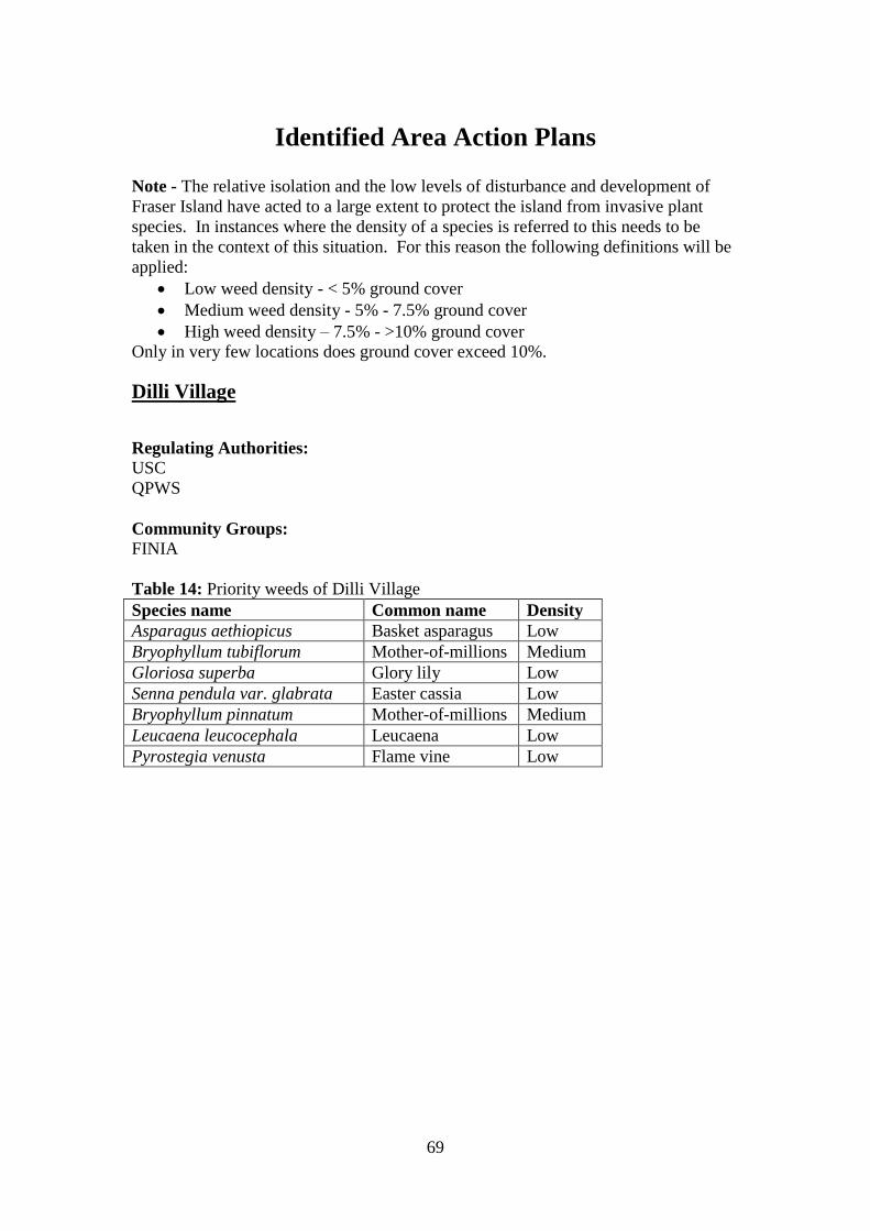
69
Identified Area Action Plans
Note - The relative isolation and the low levels of disturbance and development of
Fraser Island have acted to a large extent to protect the island from invasive plant
species. In instances where the density of a species is referred to this needs to be
taken in the context of this situation. For this reason the following definitions will be
applied:
Low weed density - < 5% ground cover
Medium weed density - 5% - 7.5% ground cover
High weed density – 7.5% - >10% ground cover
Only in very few locations does ground cover exceed 10%.
Dilli Village
Regulating Authorities:
USC
QPWS
Community Groups:
FINIA
Table 14: Priority weeds of Dilli Village
Species name Common name Density
Asparagus aethiopicus Basket asparagus Low
Bryophyllum tubiflorum Mother-of-millions Medium
Gloriosa superba Glory lily Low
Senna pendula var. glabrata Easter cassia Low
Bryophyllum pinnatum Mother-of-millions Medium
Leucaena leucocephala Leucaena Low
Pyrostegia venusta Flame vine Low

70
Figure 17: Weed occurrences at Dilli Village for high priority species
Management Issues: Managed as a basic cabin and camping style of resort Dilli Village has mown lawns
and needs to have a fire buffer maintained around the outside perimeter of the
grounds. Mowing can spread weeds such as mother-of-millions.

71
Control Programs:
Caretakers who manage Dilli Village to continue carrying out control of many
of the grasses and weeds on the grounds.
Table 15: Control procedures recommended for weeds of Dilli Village
Species Control procedure Notes
Asparagus aethiopicus Crown out plant by cutting
around rhizome with a
boning knife, remove
water bulbs and shoots and
dispose of rhizome. Bag
and dispose of berries
Research by Y. Shimuzu
suggests that second yearly
follow-up should be used
to control this species
Bryophyllum tubiflorum Carefully remove and bag
all plants and plant parts
for disposal
All plant fragments have
the capacity to grow into a
new plant.
Gloriosa superba Carefully dig out root bulb
of plant and dispose of
entire plant
Caution: This plant is
toxic to humans, wear
gloves.
Senna pendula var.
glabrata
For small plants remove
manually by hand pulling.
For larger plants cut stems
near ground and
immediately paint base
with 100% glyphosate.
Bag and remove all seed
pods.
This species is best
targeted between the end
of March and the end of
May when bright yellow
flowers make it easy to
locate.
Bryophyllum pinnatum Carefully remove and bag
all plants and plant parts
for disposal
All plant fragments have
the capacity to grow into a
new plant.
Leucaena leucocephala For small plants remove
manually by hand pulling.
For larger plants cut stems
near ground and
immediately paint base
with 100% glyphosate.
Bag and remove all seed
pods.
Sites around seeding
individuals need to be
monitored as seeds scatter
when ripe.
Pyrostegia venusta Cut stems near ground and
immediately paint with
100% glyphosate
Flowers through autumn
and winter make this plant
obvious at this time of
year.

72
Eurong
Regulating Authorities:
QPWS - DERM
Land and Vegetation Services - DERM
FCRC
Community Groups:
Andersons
Volunteer Groups:
FIDO
FINIA
Table 16: Priority weeds of Eurong
Species Name Common Name Density
Agave sisalana Sisal hemp; sisal Low
Anredera cordifolia Madeira vine; potato vine Low
Asparagus aethiopicus Basket Asparagus Medium
Asparagus plumosus Climbing asparagus fern Medium
Baleria repens Creeping baleria High
Bryophyllum tubiflorum Mother-of-millions Medium
Eugenia uniflora Brazilian cherry High
Leucaena leucocephala Leucaena Low
Macroptilium
atropurpureum Siratro Low
Schefflera actinophylla Umbrella tree Low
Senna pendula var.
glabrata Easter cassia Low
Solanum seaforthianum
Brazilian nightshade; climbing
solanum Medium
Sphagneticola trilobata Singapore daisy High

73
Figure 18: Large scale weed occurrences at Eurong for high priority species.

74
Figure 19: Small scale weed occurrences at Eurong for high priority species.
Management Issues:
Main infestations of basket asparagus and Easter cassia are occurring in USL and
need to be controlled.
Creeping baleria is escaping from Eurong Beach Resort gardens and establishing in
behind council toilet block and in Second Valley.
Brazilian nightshade infestation is increasing in size and number due to bird spread
and has potential to spread into coastal forest and rainforest edges.

75
Brazilian cherry is a threat to move out of location in Second Valley and would be
well adapted to conditions on Fraser Island
Control Procedures:
Support and facilitate works of local volunteer groups and encourage these to
gradually expand focus of efforts.
Source Fraser Island native seedlings and plants and encourage plant
exchange.
Have volunteer program of basket asparagus control every second year as per
method suggested by Shimizu (2009) from GPS data collected during that
research.
Map spread of creeping balaria and support control project by QPWS and
encourage FCRC to carry out control.
Continue to support works of FIDO and encourage to increase community
engagement in their projects.
Volunteers to work through areas as designated on work sites map (figure 20).
Table 17: Control procedures recommended for weeds of Eurong
Species Control procedure Notes
Agave sisalana If small dig out entire
plant, if large cut and paint
with 100% glypohosate.
Plants usually occur in
clusters so check around
any plants found
Anredera cordifolia Dig out root bulb
carefully, roots can break
easily. Bag and dispose
of.
Root bulbs will reshoot so
must all be removed and
beware of nodules growing
on stem as these too
reshoot.
Asparagus aethiopicus Crown out plant by cutting
around rhizome with a
boning knife, remove
water bulbs and shoots and
dispose of rhizome. Bag
and dispose of berries
Research by Y. Shimuzu
suggests that second yearly
follow-up should be used
to control this species
Asparagus plumosus Crown out plant by cutting
around rhizome with a
boning knife and dispose
of rhizome. Bag and
dispose of berries
Research by Y. Shimuzu
suggests that second yearly
follow-up should be used
to control this species
Baleria repens Hand remove smaller
plants. Foliar spraying
with 10% glyphosate
solution
Notify QPWS of location
so that spread can be
monitored
Bryophyllum tubiflorum Carefully remove and bag
all plants and plant parts
for disposal
All plant fragments have
the capacity to grow into a
new plant.
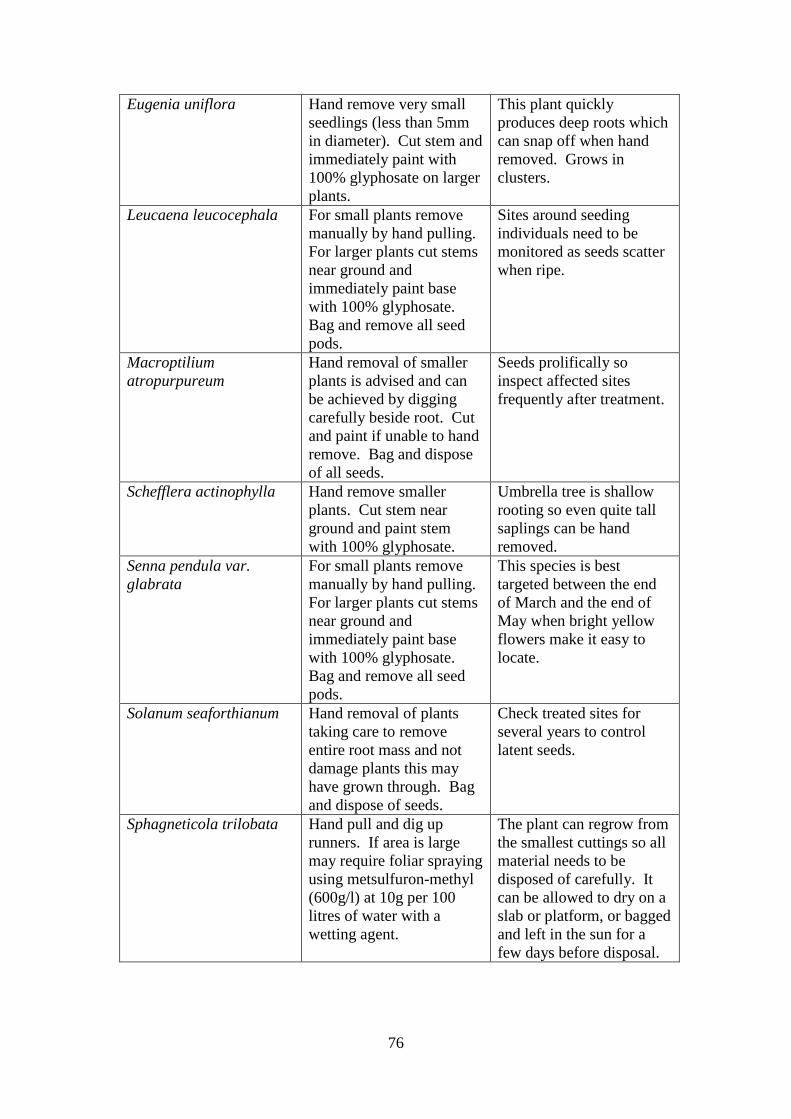
76
Eugenia uniflora Hand remove very small
seedlings (less than 5mm
in diameter). Cut stem and
immediately paint with
100% glyphosate on larger
plants.
This plant quickly
produces deep roots which
can snap off when hand
removed. Grows in
clusters.
Leucaena leucocephala For small plants remove
manually by hand pulling.
For larger plants cut stems
near ground and
immediately paint base
with 100% glyphosate.
Bag and remove all seed
pods.
Sites around seeding
individuals need to be
monitored as seeds scatter
when ripe.
Macroptilium
atropurpureum
Hand removal of smaller
plants is advised and can
be achieved by digging
carefully beside root. Cut
and paint if unable to hand
remove. Bag and dispose
of all seeds.
Seeds prolifically so
inspect affected sites
frequently after treatment.
Schefflera actinophylla Hand remove smaller
plants. Cut stem near
ground and paint stem
with 100% glyphosate.
Umbrella tree is shallow
rooting so even quite tall
saplings can be hand
removed.
Senna pendula var.
glabrata
For small plants remove
manually by hand pulling.
For larger plants cut stems
near ground and
immediately paint base
with 100% glyphosate.
Bag and remove all seed
pods.
This species is best
targeted between the end
of March and the end of
May when bright yellow
flowers make it easy to
locate.
Solanum seaforthianum Hand removal of plants
taking care to remove
entire root mass and not
damage plants this may
have grown through. Bag
and dispose of seeds.
Check treated sites for
several years to control
latent seeds.
Sphagneticola trilobata Hand pull and dig up
runners. If area is large
may require foliar spraying
using metsulfuron-methyl
(600g/l) at 10g per 100
litres of water with a
wetting agent.
The plant can regrow from
the smallest cuttings so all
material needs to be
disposed of carefully. It
can be allowed to dry on a
slab or platform, or bagged
and left in the sun for a
few days before disposal.
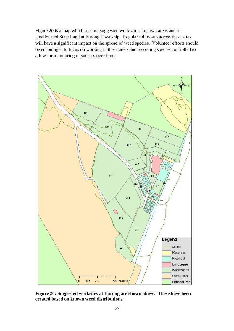
77
Figure 20 is a map which sets out suggested work zones in town areas and on
Unallocated State Land at Eurong Township. Regular follow-up across these sites
will have a significant impact on the spread of weed species. Volunteer efforts should
be encouraged to focus on working in these areas and recording species controlled to
allow for monitoring of success over time.
Figure 20: Suggested worksites at Eurong are shown above. These have been
created based on known weed distributions.
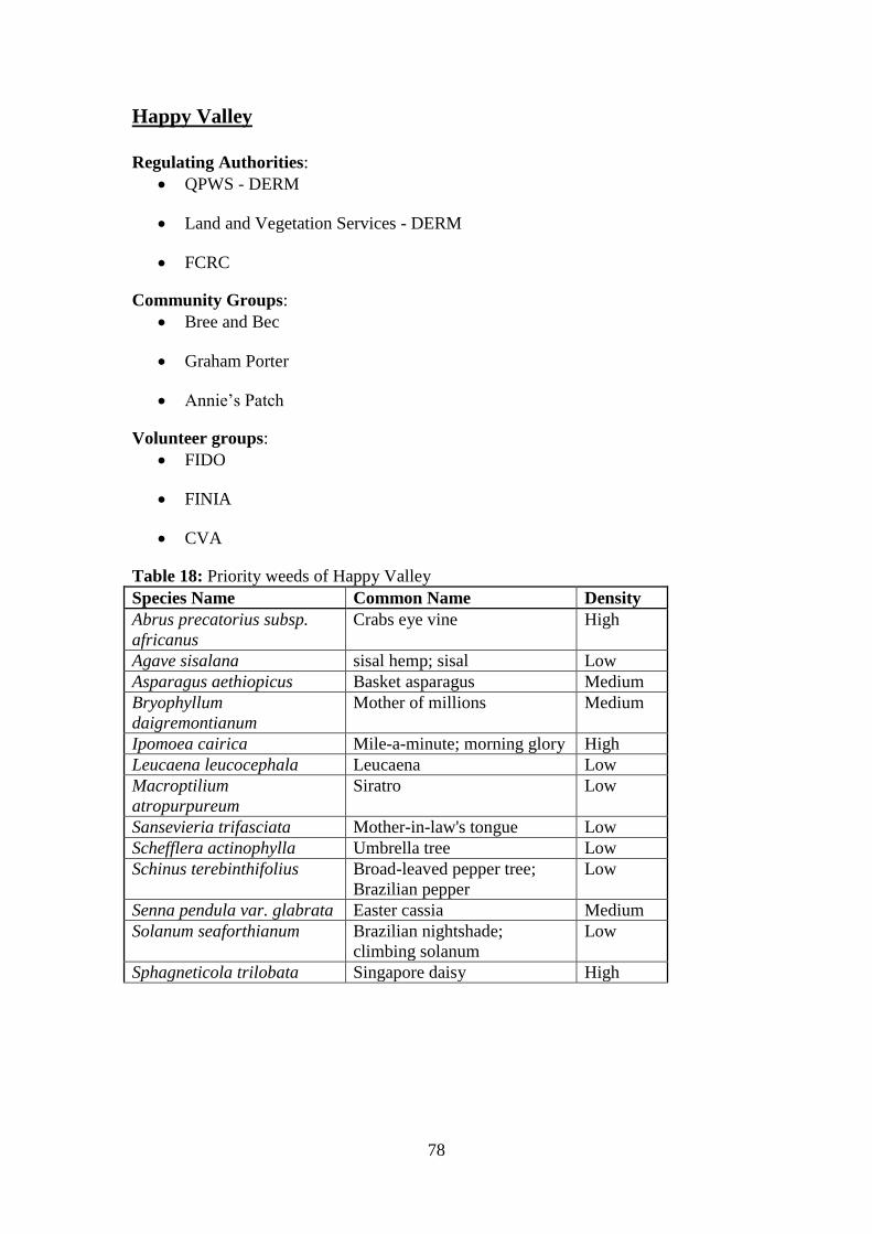
78
Happy Valley
Regulating Authorities:
QPWS - DERM
Land and Vegetation Services - DERM
FCRC
Community Groups:
Bree and Bec
Graham Porter
Annie‟s Patch
Volunteer groups:
FIDO
FINIA
CVA
Table 18: Priority weeds of Happy Valley
Species Name Common Name Density
Abrus precatorius subsp.
africanus
Crabs eye vine High
Agave sisalana sisal hemp; sisal Low
Asparagus aethiopicus Basket asparagus Medium
Bryophyllum
daigremontianum
Mother of millions Medium
Ipomoea cairica Mile-a-minute; morning glory High
Leucaena leucocephala Leucaena Low
Macroptilium
atropurpureum
Siratro Low
Sansevieria trifasciata Mother-in-law's tongue Low
Schefflera actinophylla Umbrella tree Low
Schinus terebinthifolius Broad-leaved pepper tree;
Brazilian pepper
Low
Senna pendula var. glabrata Easter cassia Medium
Solanum seaforthianum Brazilian nightshade;
climbing solanum
Low
Sphagneticola trilobata Singapore daisy High

79
Figure 21: Large scale weed occurrences at Happy Valley for high priority weed
species

80
Figure 22: Small scale weed occurrences at Happy Valley for high priority weed
species
Management Issues:
Easter cassia is an extreme threat in this area and should be considered the highest
local priority. The slope between the Yidney bypass track and the Sailfish resort has
extremely dense stands of this species and the populations in the USL are continuing
to increase in size and density.
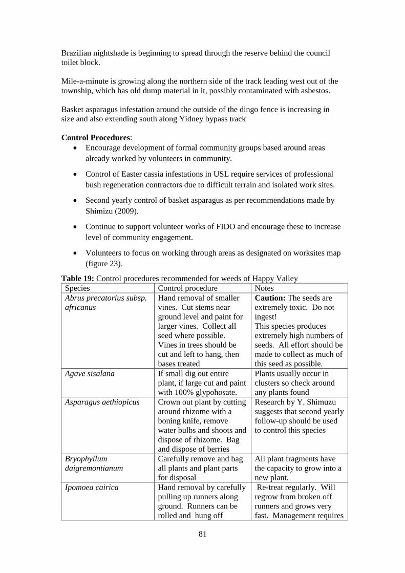
81
Brazilian nightshade is beginning to spread through the reserve behind the council
toilet block.
Mile-a-minute is growing along the northern side of the track leading west out of the
township, which has old dump material in it, possibly contaminated with asbestos.
Basket asparagus infestation around the outside of the dingo fence is increasing in
size and also extending south along Yidney bypass track
Control Procedures:
Encourage development of formal community groups based around areas
already worked by volunteers in community.
Control of Easter cassia infestations in USL require services of professional
bush regeneration contractors due to difficult terrain and isolated work sites.
Second yearly control of basket asparagus as per recommendations made by
Shimizu (2009).
Continue to support volunteer works of FIDO and encourage these to increase
level of community engagement.
Volunteers to focus on working through areas as designated on worksites map
(figure 23).
Table 19: Control procedures recommended for weeds of Happy Valley
Species Control procedure Notes
Abrus precatorius subsp.
africanus
Hand removal of smaller
vines. Cut stems near
ground level and paint for
larger vines. Collect all
seed where possible.
Vines in trees should be
cut and left to hang, then
bases treated
Caution: The seeds are
extremely toxic. Do not
ingest!
This species produces
extremely high numbers of
seeds. All effort should be
made to collect as much of
this seed as possible.
Agave sisalana If small dig out entire
plant, if large cut and paint
with 100% glypohosate.
Plants usually occur in
clusters so check around
any plants found
Asparagus aethiopicus Crown out plant by cutting
around rhizome with a
boning knife, remove
water bulbs and shoots and
dispose of rhizome. Bag
and dispose of berries
Research by Y. Shimuzu
suggests that second yearly
follow-up should be used
to control this species
Bryophyllum
daigremontianum
Carefully remove and bag
all plants and plant parts
for disposal
All plant fragments have
the capacity to grow into a
new plant.
Ipomoea cairica Hand removal by carefully
pulling up runners along
ground. Runners can be
rolled and hung off
Re-treat regularly. Will
regrow from broken off
runners and grows very
fast. Management requires

82
ground. Where growing
into canopy cut runners at
chest height and pull away
from base of tree. Leave
cut vines hanging to die
off, do not pull out of
canopy
committed follow-up over
several years.
Leucaena leucocephala For small plants remove
manually by hand pulling.
For larger plants cut stems
near ground and
immediately paint base
with 100% glyphosate.
Bag and remove all seed
pods.
Sites around seeding
individuals need to be
monitored as seeds scatter
when ripe.
Macroptilium
atropurpureum
Hand removal of smaller
plants is advised and can
be achieved by digging
carefully beside root. Cut
and paint if unable to hand
remove. Bag and dispose
of all seeds.
Seeds prolifically so
inspect affected sites
frequently after treatment.
Sansevieria trifasciata Dig up and remove roots
and rhizomes and bag
these for disposal. Broken
rhizomes will reshoot so
care must be taken to
collect all fragments.
Persistent monitoring and
follow-up is required.
Schefflera actinophylla Hand remove smaller
plants. Cut stem near
ground and paint stem
with 100% glyphosate.
Umbrella tree is shallow
rooting so even quite tall
saplings can be hand
removed.
Schinus terebinthifolius Hand remove smaller
seedlings and saplings.
For larger plants cut stem
near ground and paint with
100% glyphosate.
Caution: Contact with the
sap can cause skin
irritation, rashes, welts etc.
Gloves must be worn
when dealing with this
plant.
Senna pendula var.
glabrata
For small plants remove
manually by hand pulling.
For larger plants cut stems
near ground and
immediately paint base
with 100% glyphosate.
Bag and remove all seed
pods.
This species is best
targeted between the end
of March and the end of
May when bright yellow
flowers make it easy to
locate.
Solanum seaforthianum Hand removal of plants
taking care to remove
entire root mass and not
damage plants this may
Check treated sites for
several years to control
latent seeds.

83
have grown through. Bag
and dispose of seeds.
Sphagneticola trilobata Hand pull and dig up
runners. If area is large
may require foliar spraying
using metsulfuron-methyl
(600g/l) at 10g per 100
litres of water with a
wetting agent.
The plant can regrow from
the smallest cuttings so all
material needs to be
disposed of carefully. It
can be allowed to dry on a
slab or platform, or bagged
and left in the sun for a
few days before disposal.
Figure 23 is a map which sets out suggested work zones in town areas and on
Unallocated State Land at Happy Valley Township. Regular follow-up across these
sites will have a significant impact on the spread of weed species. Volunteer efforts
should be encouraged to focus on working in these areas and recording species
controlled to allow for monitoring of success over time.
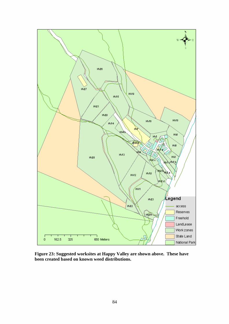
84
Figure 23: Suggested worksites at Happy Valley are shown above. These have
been created based on known weed distributions.

85
Orchid Beach
Regulating Authorities:
QPWS
FCRC
Community Groups:
Orchid Beach Progress Association (OBPA)
Aircraft Landing strip Association (ALA)
Matt and Christine‟s nursery
Volunteers:
CVA
Table 20: Priority weeds of Orchid Beach
Species Name Common Name Density
Asparagus aethiopicus Basket asparagus Low
Bryophyllum daigremontianum x
Bryophyllum delagoense
Hybrid mother-of-millions High
Bryophyllum pinnatum Live plant; resurrection plant High
Bryophyllum tubiflorum Mother-of-millions High
Catharanthus roseus Madagascar periwinkle; pink
periwinkle
Medium
Euphorbia cyathophora Painted spurge High
Gloriosa superba Glory lily Low
Ipomoea indica Blue morning-glory Low
Leucaena leucocephala Leucaena Low
Macroptilium atropurpureum Siratro High
Pyrostegia venusta Flame vine Low
Sansevieria trifasciata Mother-in-law's tongue Low
Schefflera actinophylla Umbrella tree Low
Senna pendula var. glabrata Easter cassia Low
Sida cordifolia Flannelweed High
Sphagneticola trilobata Singapore daisy Low

86
Figure 24: Weed occurrences at Orchid Beach for high priority species
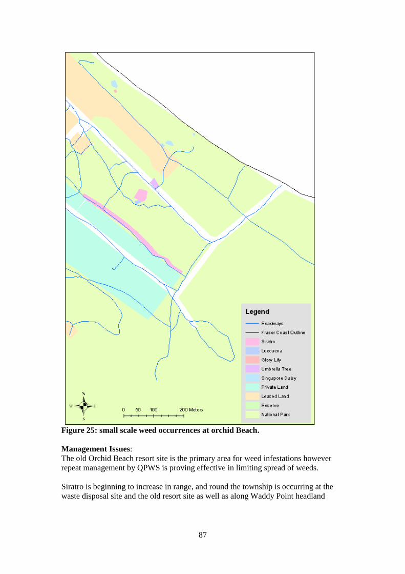
87
Figure 25: small scale weed occurrences at orchid Beach.
Management Issues:
The old Orchid Beach resort site is the primary area for weed infestations however
repeat management by QPWS is proving effective in limiting spread of weeds.
Siratro is beginning to increase in range, and round the township is occurring at the
waste disposal site and the old resort site as well as along Waddy Point headland

88
Community engagement has revealed a good level if interest in obtaining native
species for gardens. Matt and Christine Organ are currently hosting an experimental
nursery where QPWS collected seeds and rescued plants will be germinated doe
distribution to the community.
Control Procedures:
Encourage and support continuation of community native plant nursery
Provide seed collection kits for QPWS rangers to source seed for nursery
Support control programs by QPWS and FCRC
Second yearly sweeps for basket asparagus as per GPS data collected by
Shimizu (2009)
Table 21: Control procedures recommended for weeds of Orchid Beach
Species Control procedure Notes
Asparagus aethiopicus Crown out plant by cutting
around rhizome with a
boning knife, remove water
bulbs and shoots and
dispose of rhizome. Bag
and dispose of berries
Research by Y. Shimuzu
suggests that second
yearly follow-up should
be used to control this
species
Bryophyllum
daigremontianum x
Bryophyllum delagoense
Carefully remove and bag
all plants and plant parts for
disposal
All plant fragments have
the capacity to grow into
a new plant.
Bryophyllum pinnatum Carefully remove and bag
all plants and plant parts for
disposal
All plant fragments have
the capacity to grow into
a new plant.
Bryophyllum tubiflorum Carefully remove and bag
all plants and plant parts for
disposal
All plant fragments have
the capacity to grow into
a new plant.
Catharanthus roseus Plants can be controlled by
hand removal. Pulled
plants should be stacked up
off the ground to dry out.
Stems laying on the
ground are likely to
reshoot.
Euphorbia cyathophora Plants can be removed by
hand and should be stacked
off the ground until they
have dries out.
Caution: The milky fluid
that the plant exudes from
the stems when broken is
caustic and can cause skin
irritation. Wear gloves
when handling.
Gloriosa superba Carefully dig out root bulb
of plant and dispose of
entire plant
Caution: This plant is
toxic to humans, wear
gloves.
Ipomoea indica Hand removal by carefully
pulling up runners along
ground. Runners can be
rolled and hung off ground.
Where growing into canopy
Re-treat regularly. Will
regrow from broken off
runners and grows very
fast. Management
requires committed

89
cut runners at chest height
and pull away from base of
tree. Leave cut vines
hanging to die off, do not
pull out of canopy
follow-up over several
years.
Leucaena leucocephala For small plants remove
manually by hand pulling.
For larger plants cut stems
near ground and
immediately paint base with
100% glyphosate. Bag and
remove all seed pods.
Sites around seeding
individuals need to be
monitored as seeds scatter
when ripe.
Macroptilium
atropurpureum
Hand removal of smaller
plants is advised and can be
achieved by digging
carefully beside root. Cut
and paint if unable to hand
remove. Bag and dispose
of all seeds.
Seeds prolifically so
inspect affected sites
frequently after treatment.
Pyrostegia venusta Cut stems near ground and
immediately paint with
100% glyphosate
Flowers through autumn
and winter make this
plant obvious in these
seasons.
Sansevieria trifasciata Dig up and remove roots
and rhizomes and bag these
for disposal. Broken
rhizomes will reshoot so
care must be taken to
collect all fragments.
Persistent monitoring and
follow-up is required.
Senna pendula var.
glabrata
For small plants remove
manually by hand pulling.
For larger plants cut stems
near ground and
immediately paint base with
100% glyphosate. Bag and
remove all seed pods.
This species is best
targeted between the end
of March and the end of
May when bright yellow
flowers make it easy to
locate.
Sida cordifolia Hand removal of plants is
sufficient to control this
weed. Remove and bag
seed heads.
After treating check
clothing for clinging seed
heads before moving out
of area.
Sphagneticola trilobata Hand pull and dig up
runners. If area is large
may require foliar spraying
using metsulfuron-methyl
(600g/l) at 10g per 100
litres of water with a
wetting agent.
The plant can regrow
from the smallest cuttings
so all material needs to be
disposed of carefully. It
can be allowed to dry on
a slab or platform, or
bagged and left in the sun
for a few days before
disposal.

90
Sandy Cape Lighthouse
Regulating Authorities:
QPWS
Community Groups:
Sandy Cape Lighthouse Conservation Association (SCLCA)
Volunteer groups:
CVA
Management Issues: The extreme isolation at Sandy Cape makes management by volunteers outside of the
programs already run by the SCLCA and the QPWS quite problematic. Closure of
the eastern beach track prevents volunteer from reaching Sandy Cape except by boat.
The expense of transport by sea requires that periods in excess of the usual week long
volunteer projects offered by CVA are required. It becomes logistically difficult to
support the requirements of a larger volunteer force in regards to their needs for food,
equipment and personal effects. Consequently it seems likely that the responsibility
for the project in the future will mainly be dependent on the contributions of SCLCA
volunteers without the help of CVA.
Control Procedures:
The close working relationship between the SCLCA and the QPWS has resulted in
the development of a successful and highly appropriate management program for
invasive plant species. This program should continue to be promoted with support
being provided to the SCLCA as appropriate. The form of this support should be
determined by the needs of the SCLCA such as information, equipment, printed
materials and advice on implementation of projects. The program as presented here
has been adapted from notes by Don and Lesley Bradley of SCLCA.
Continue to support SCLCA programs with equipment, information and
advice where appropriate.
Support CVA programs when available with information and advice.
Weeding program:
The weed management program as developed by QPWS and the SCLCA categorises
weeds into four prioritised lists:
A. High priority weeds with a strong invasive potential that must be prevented
from flowering or seeding.
B. Medium priority weeds that have low numbers of individuals remaining and
which are well controlled.

91
C. Low priority weeds that have low invasive potential and/or are managed by a
bio-control agent and/or are of such large numbers management is a poor
allocation of volunteer resources.
D. Historic weeds which have not been seen in the area for several years, but may
have the potential to reappear and require ongoing monitoring.
The areas of worst infestation have been mapped into blocks approximately 40 meters
wide (see figure 24).
The volunteers of the SCLCA are required to live at the lighthouse accommodation
for periods of two weeks or more and to carry out duties as part of their commitment
to the management of the facility. These duties include maintenance of tracks and
buildings, preservation of the nesting turtle populations and the weeding activities.
Consequently the amount of time devoted to weeding will depend on the seasonal
requirements of other management duties, current cycles of weeds and the particular
interests and skill sets of the volunteers. In order to maintain some level of continuity
and monitor progress volunteers are required to keep a record of their activities which
is used by QPWS to update ParkInfo records.

92
Figure 26: Worksites at Sandy Cape are shown above. These have been created
based on known weed distributions.
Section A. High Priority.
Climbing asparagus fern (Asparagus plumosus) – twining plant that climbs trees
and shrubs and is able to fruit at one year old producing bird attracting berries in
winter. This is the primary plant being targeted by the current operations.
Method – dig plant roots out with shovel, making sure to get the entire underground
crown and rhizome. Roots and leaves can be trimmed off this leaving just rhizome
which needs to be disposed of carefully (bagged).

93
Sisal hemp (Agave sisalana) – This takes seven years to produce seeds.
Method – dig out small plants, trim off leaves and dispose of rhizome carefully as it is
able to reshoot. Larger plants need to be treated by cutting off leaves at base and
treating base with glyphosate.
Easter cassia (Senna pendula var. glabrata) – obvious yellow flowers occurring
between April and May.
Method – pull entire plant out of ground if small enough and leave to lie. For larger
plants cut the stem at ground level and treat with herbicide.
Green Panic (Panicum maximum) – Seeds can reach maturity in 6 weeks during
summer leading to need to treat infestations early.
Method – harvest seed heads into a bucket (not a bag) and dispose of carefully. Dig
plants out, shake soil from roots and leave to lie with roots off ground. Large areas
may require chemical spraying.
Section B. Medium Priority.
1. Grasses:
Crows-foot grass (Eleusine indica)
Mossman river burr (Cenchrus echinatus)
Red natal grass (Melinis repens)
2. Non-grasses:
Mother-in-law-tongue (Sansevieria trifasciata)
Dig out using a high level of care to ensure the rhizome does not break up and
is removed entirely. Bag and dispose of the entire plant.
Purple succulent (Callisia fragrans?)
Dig out and dispose of carefully.
Madeira vine (Anredera cordifolia) and Glory lily (Gloriosa superba)
Both of these species have underground tubers and are localised to areas near
the residences. These are currently being controlled chemically and no effort
is required by volunteers.
Section C. Low Priority. These species can be controlled as they are encountered but for a variety of
reasons should not become the primary focus of a weeding session.
Flannel weed (Sida cordifolia), Periwinkle (Catharanthus roseus), Corky
Passion (Passioflora suberosa), Stinky Passion (Passioflora foetida),
Blackberry Nightshade (Solanum nigrum), Blue Top or Billy goat weed
(Ageratum houstonianum) and Coral Berry (Rivinia humilis)

94
Table 22: Priority weeds of Sandy Cape
Species Name Common Name Priority Density
Agave sisalana Sisal hemp High Medium
Ageratum
houstonianum Billy goat weed or Blue top
Low Low
Anredera cordifolia
Madeira vine; jalap; lambs-
tail vine
Mid Low
Asparagus Aethiopicus Basket asparagus High Low
Asparagus plumosus Climbing asparagus fern High High
Bryophyllum tubiflorum Mother-of-millions Low High
Catharanthus roseus Flannel weed Low Low
Gloriosa superba Glory lily Mid Medium
Panicum maximum Green Panic High High
Passioflora foetida Stinky passion flower Low Low
Passioflora suberosa Corky passion flower Low Low
Rivina humilis Coralberry; turkeyberry Low Medium
Sansevieria trifasciata Mother-in-law's tongue Mid Low
Senna pendula var.
glabrata Easter cassia
High Low
Solanum nigrum Blackberry nightshade Low Low
Sphagneticola trilobata Singapore daisy Historic? Low

95
BROAD ACTION PLAN Action Rationale Participants Other potential
partners
1. Establish a source of
attractive native plants as
substitutes for non-endemic
garden species. This can be
done through the rescue of
plants and the germination of
island origin seed stock.
Garden escapees are a high risk factor for
continued and future incursion of weeds
into National Park area. Providing
residents with suitable and attractive
plant species sourced from Fraser Island
will encourage more responsible plant
selection and may help develop better
relationship with community and increase
community interest in project
FINIA Weeds Project
Officer (WPO)
Fraser Coast Regional
Council (FCRC)
Queensland Parks and
Wildlife Service (QPWS)
Fraser Island Community
Traditional Owners
Private nurseries
2. Support Fraser Island (FI)
Community in weed
management activities
Engagement of community will help
foster positive relationship and culture of
stewardship
Community groups
WPO – Facilitation
FCRC – Community
support
3. Establish closer
relationship between various
Off Island (OI) Volunteer
groups and FI community
groups when working around
settlement areas
Communication will prevent „territorial
disputes‟, increase value of work carried
out by volunteers and utilise community
members knowledge of areas that require
work
WPO – coordination and
communication
FI Community –
communication
Volunteer groups -
communication
FIDO, CVA, Global
Works,
4. Develop management or
work plans for sites being
cared for by OI volunteers
Having an ongoing management plan
with time line and recording process will
allow different groups to work the same
areas effectively
WPO
FIDO
FI Community groups
FCRC
CVA
Global Works
5. Formalise system of
permission for volunteers
There is legal requirement to have
permission from land manager prior to
WPO
Land and Vegetation
QPWS division
FIDO
96
Action Rationale Participants Other potential
partners
working on Council land and
USL.
carrying out works on land parcels Services division , DERM
FCRC
6. Engage with Fraser Island
Association (FIA) by inviting
to be involved in FINIA
FIA represents the interests of residents
and businesses on Fraser Island. FIA is a
potential pathway for delivering
information to the community as a whole
WPO
FIA
7. Alter Land and Vegetation
division work plans on USL
to include management of all
declared plant species (i.e.
including Class 3 species in
workplan)
As a National Park the areas of land
adjacent to USL are environmentally
significant areas (areas of high
conservation value) requiring control of
all declared pest plant species on adjacent
land
Land and Vegetation
Services division, DERM
QPWS, DERM
FINIA WPO
FIDO
CVA
FCRC
8. Engage broader community
in locating new weed
infestations and passing this
information on
Bush walkers, tour operators, campers,
residents and regular visitors to Fraser
Island may visit areas not frequented by
Rangers
WPO – point of contact
and information
dissemination
QPWS – point of contact
and information
dissemination
Campers, 4 WD
groups, anglers,
residents of Fraser
Island, tour operators,
Queensland National
Parks Association
9. Create and continue to
develop „web presence‟ for
FINIA with information and
contacts as well as dates for
projects and opportunities to
become involved
Web presence provides potential access
to large target audience and can act as
recruitment point for various projects e.g.
volunteers
WPO – web site
development and
maintenance
USC – Web hosting and
technical assistance
BMRG – Web hosting
and technical assistance
(by having site links:)
QPWS
FCRC
CVA
FIDO
Kingfisher resort
10. Engage Traditional Owner
groups
TO groups have presence on island and
carry out programs already
Traditional Owners -
WPO - Facilitation
BMRG
97
SPECIFIC ACTION PLANS
1.0 Establish Source of Native Plants
Action Rationale Participants and role Other potential
partners
1.1 Identify individuals or
groups to collect and
germinate native plants and
plant seed on Fraser Island
and obtain appropriate
licensing
Collection of seed stock from Fraser
Island will provide suitable acclimatised
species, collectors need to hold
appropriate permissions
To be determined Traditional Owners
Private nurseries
FCRC
QPWS
1.2 Develop Memorandum of
Understanding (MOU)
between participants
MOU will ensure concerns regarding
integrity of stock, weed and disease
contamination and capacity are agreed
upon
To be determined
1.3 Consult with residents
and nursery to identify and
generate list of desirable and
practical Fraser Island species
Residents will have preferences of plants
and be more likely to support program if
they are engaged at an early stage
FI Community
To be determined
2.0 Engage Fraser Island Community
Action Rationale Participants and role Other potential
partners
2.1 Identify, train, resource
and equip those individuals
and groups on Fraser Island
that have a history of, or
interest in, carrying out local
Residents have a greater presence on the
island and thus are able to achieve more
over long period that volunteers returning
intermittently.
Fraser Island residents –
ground works,
identifying areas of
interest
WPO – training,
BMRG
Landcare
Coastcare
FIDO

98
Action Rationale Participants and role Other potential
partners
restoration works (FI
Community groups).
planning assistance,
provision of equipment
FCRC – community
group support, insurance
and liability
2.2 Identify areas where
residents have been, or would
like to, carry out restoration
work
Residents have already been carrying out
works or have interest in maintaining
certain areas, identifying and formalising
these will increase community
satisfaction and sense of ownership
Fraser Island residents –
identifying areas of
interest or of past work
WPO – support and
mapping
FCRC
2.3 Develop management or
work plans and recording
procedures in conjunction
with FI Community groups
Formalised work plans will produce
better outcomes and allow for the setting
and assessment of goals
Fraser Island residents –
planning and assessment
WPO – assistance with
planning and
development of
assessment system
FCRC
2.4 Identified „shared areas‟
that have a common boundary
or relationship with those
identified by FI Community
groups and carry out
restoration work on these
Removing weed source for areas adjacent
to those worked by community groups
will prevent reinfestation from that site
and also increase feeling of support for
community groups
WPO – identification of
sites, mapping, planning
and sourcing of
volunteers
FI Community groups –
site identification
FIDO, CVA, Global
Works, FCRC

99
3.0 Establish relationship between volunteer groups and on-island community groups
Action Rationale Participants and role Other potential
partners
3.1 Identify central figure or
figures in each settlement
willing to take on role of
„volunteer liaison‟
Having one central figure allows
continuity of information
FI community
WPO
FIDO
CVA
Traditional Owners
3.2 Identify central figure
within volunteer groups
willing to take on role of
„community liaison‟
Having one central figure allows
continuity of information
Volunteer groups
WPO
3.3 Assist in communication
and act as proxy when
required for volunteer groups
and community
Some volunteer groups may not have
„presence‟ to be able to communicate
with community groups
WPO
Volunteer groups
FI Community
4.0 Develop work plans for Off Island volunteer groups to follow
Action Rationale Participants and role Other potential
partners
4.1 Identify sites on which
volunteer labour is
appropriate
Some sites on Fraser Island have steep
slopes, dense scrub and difficult terrain.
These may be too challenging for all
levels of volunteers or require skill sets
and experience volunteers do not possess.
WPO
Volunteer groups
FIDO
CVA
Global Works
FCRC
FI community
4.2 Map appropriate sites into
manageable unit sizes
Defining geographical work zones and
formalising these allows for continuity of
effort and accurate results measurement.
WPO FIDO
FI community
FCRC

100
Action Rationale Participants and role Other potential
partners
Other volunteer groups
4.3 Develop work plan for
sites and recording format
that allows for intermittent
projects, without a formal
time line but with suggested
seasonal priorities
Periodical nature of volunteer trips makes
timeline of management plan difficult,
however accurate recording and seasonal
priorities will allow for coordination of
work by different volunteers and groups
WPO FIDO
FI community
Other volunteer groups
5.0 Formalise system for obtaining Temporary Permit to Occupy
Action Rationale Participants and role Other potential
partners
5.1 Identify correct procedure
for obtaining permission to
work on council land and on
USL.
Each body will have different procedures,
e.g. USL requires „permit to occupy‟
WPO
Vegetation and Lands
division DERM
FCRC
BMRG
5.2 Develop procedure sheet
that includes required Lot on
Plan numbers for each area,
other information required to
fill forms out correctly and
contact people
Lot on Plan numbers are specific to land
parcels
WPO
Land and Vegetation
division DERM
FCRC
BMRG

101
6.0 Engage Fraser Island Association with FINIAproject
Action Rationale Participants and role Other potential
partners
6.1 Present overview of
weeds project to FIA meeting
Offers opportunity to openly discuss
goals and benefits of weed project with
FIA members
WPO
FIA
FI Community
6.2 Submit articles to FIA
newsletter as appropriate
updating on progress of
FINIA weeds project
Allows for continued engagement of FIA WPO FI Community
6.3 Invite representative of
FIA to attend FINIA meetings
Increased community representation is
essential to long term success of FINIA
projects. FIA represents a cross section
of Fraser Island residents and community
WPO FI Community
7.0 Alter Land and Vegetation division work plans on USL to include management of all declared plant species
Action Rationale Participants and role Other potential
partners
7.1 Identify specific weeds
occurring in USL of threat
and adjacent to areas of
Environmental Significance
Information can be used to plan
management strategies
FIDO
FI Community
BMRG
7.2 Develop management
plan with Land and
Vegetation Services division,
QPWS and FCRC to address
identified species
Management needs to be on both sides of
boundaries to be effective
DERM
FCRC
BMRG

102
8.0 Engage broader community in locating new weed infestations and passing this information on
Action Rationale Participants and role Other potential
partners
8.1 Identify groups with an
interest in conservation
values of Fraser Island and
capacity to develop skill sets
to identify weed species
Identification of target groups will allow
for development of resources
As identified Queensland National
Parks Association
FIDO
4 Wheel Driving clubs
8.2 Identify opportunities to
engage target groups
Different target groups can be engaged
via different media
As identified As identified
8.3 Develop reporting
procedure – possibly online
Online reporting of GPS coordinates
would allow easy collection of data
WPO As identified
8.4 Verify accuracy of data
sets
Ground truthing of information by
reliable personnel would ensure integrity
of data
WPO
QPWS
FCRC
FIDO
9.0 Create and continue to develop ‘web presence’ for FINIA with information and contacts as well as dates for projects
and opportunities to become involved
Action Rationale Participants and role Other potential
partners
9.1Identify appropriate
partner possessing capacity to
host and maintain site
Maintenance of web site involves
specialised skills and capacities
WPO – Facilitation and
engagement
Partner as appropriate
BMRG
USC
9.2 Develop appropriate web
presence
Well developed web presence will
increase access to target audience
WPO – Web design
Partner – technical advise
FIDO

103
10.0 engage Traditional Owners in FINIA projects
Action Rationale Participants and role Other potential
partners
10.1 Identify appropriate
Traditional Owners groups
with presence on Fraser
Island
There are multiple „tribal‟ groups
representing the various historic familial
divisions on Fraser Island
WPO – Facilitator
Traditional Owners
Working Groups
BMRG
USC
10.2 Develop rapport and
relationship with
representatives of group
Various groups may feel disengaged from
process due to historic conflicts and
attitudes
WPO
Groups as identified
BMRG
QPWS
10.3 Develop work plans and
practices in cooperation with
Traditional Owner groups
Traditional Owner groups may have an
existing level of knowledge and insight
into weed issues and will feel more
engaged if involved in planning process
WPO
Groups as identified
QPWS

104
References
Adair, R.J. and Groves, R.H. 1998. Impact of Environmental Weeds on Biodiversity:
A Review and Development of a Methodology. Canberra: National Weeds Program,
Environment Australia.
Arcioni, E. 2004. What‟s in a Name? The Changing Definition of Weeds in
Australia. Environmental Planning and Law Journal, 2004: 450 – 465.
Batianoff, G.N. and Butler, D.W. 2002. Assessment of Invasive Naturalised Plants
in South-east Queensland. Plant Protection Quarterly. Volume 17 No. 1
Biological Control Act 1987:
http://www.legislation.qld.gov.au/LEGISLTN/CURRENT/B/BiologConA87.pdf
Blood, K. 2001. Environmental Weeds: A Field Guide for SE Australia. Mt.
Waverly: CH Jerram & Asociates.
Burnett Mary Regional Group website: Homepage; http://www.bmrg.org.au/
Bradley, L. 2008. Sandy Cape Lighthouse Conservation Association. Powerpoint
presentation; http://www.bmrg.org.au/information.php/information.php/2/55/256
Bradley, L. Sandy Capy Lighthouse Conservation Association Secretary. 2008.
Personal Communications
Buchanan, R.A. 1999. Bush Regeneration. Recovering Australian Landscapes.
Strathfield: Open Training and Education Network – Distance education.
Conservation Volunteers Website: About us;
http://www.conservationvolunteers.com.au/aboutus.html
Cousens, R. and Mortimer, M. 1995. Dynamics of Weed Populations. New York:
Cambridge University Press.
Communication Services. 2008. Strategic Plan 2008-13. Department of Natural
Resources and Water
Dept. of. Environment and Resource Management website: Homepage;
http://www.derm.qld.gov.au/index.html
Dept. of Environment and Resource Management website: About us;
http://www.derm.qld.gov.au/about/ministers.html
Dept. of Primary Industries and Fisheries – Biosecurity website: Fact sheet, Bitou
bush; http://www.dpi.qld.gov.au/documents/Biosecurity_EnvironmentalPests/IPA-
Bitou-Bush-PP10.pdf

105
Dept. of Primary Industries and Fisheries – Biosecurity website: Fact sheet,
Broadleaved pepper;
http://www.dpi.qld.gov.au/documents/Biosecurity_EnvironmentalPests/IPA-Broad-
Leaved-Pepper-Tree-FactSheet.pdf
Dept. of Primary Industries and Fisheries – Biosecurity website: Declared Plants of
Queensland;
http://www.dpi.qld.gov.au/cps/rde/dpi/hs.xsl/4790_7005_ENA_HTML.htm
Dept. Primary Industries and Fisheries – Biosecurity website: Class 1 declared plants;
http://www.dpi.qld.gov.au/cps/rde/dpi/hs.xsl/4790_7006_ENA_HTML.htm
Dept. Primary Industries and Fisheries – Biosecurity website: Class 2 declared plants;
http://www.dpi.qld.gov.au/cps/rde/dpi/hs.xsl/4790_7023_ENA_HTML.htm
Dept. Primary Industries and Fisheries – Biosecurity website: Class 3 declared plants;
http://www.dpi.qld.gov.au/cps/rde/dpi/hs.xsl/4790_7024_ENA_HTML.htm
Dept. Primary Industries and Fisheries – Biosecurity website: About Biosecurity;
http://www.dpi.qld.gov.au/cps/rde/dpi/hs.xsl/4790_2897_ENA_HTML.htm
Environmental Protection Agency. 1994. Great Sandy region Management Plan.
Fraser Implementation Unit. Brisbane
Environmental Protection Agency. 2001. Masterplan for Queensland's parks system.
Queensland Parks and Wildlife Service
Environmental protection Agency. 2003. Pest Management Plan: Areas Managed by
Queensland Parks and Wildlife Service July 2003 – July 2008. Queensland parks and
Wildlife Service
Environmental Weeds Working Group. 2002. South-east Queensland Environmental
Weeds Strategy July 2002 – July 2005.
FIDO. A History of Land Alienation on Fraser Island;
http://www.fido.org.au/moonbi/backgrounders/28%20History%20FI%20Land%20Ali
enation.pdf
FIDO. 2004. A History of Fraser Island Road Degradation;
http://www.fido.org.au/education/Roads.pdf
Fishburn, P. Queensland Parks and Wildlife Services division (QPWS) Department of
Environment and Resource Management (DERM) 25/06/2009. Personal
Communications
Fraser Coast Regional Council Environmental Management Department. 2008. Pest
Management Annual Action Plan Part C 2008/2009. Hervey Bay
Goosem, S. 2003. Landscape processes relevant to weed invasion in

106
Australian rainforests and associated ecosystems. In Grice, A.C. and Setter, M.J.
(Eds) (2003) Weeds of Rainforests and Associated Ecosystems. Cooperative Research
Centre for Tropical Rainforest Ecology and Management. Rainforest CRC, Cairns.
(116 pp)
Grice, A.C. and Setter, M.J. (Eds) (2003) Weeds of Rainforests and Associated
Ecosystems. Cooperative Research Centre for Tropical Rainforest Ecology and
Management. Rainforest CRC, Cairns. (116 pp)
Groves, R.H., Panetta, F.D. And Virtue, J.G. 2001. Weed Risk Assessment.
Collingwood: CSIRO Publishing
Harvey, J. 2008. Weed Management on Fraser Island – A Multi-partner approach.
Powerpoint presentation;
http://www.bmrg.org.au/downloads/PowerPoint_-
_Weed_Management_Fraser_Island_A_Multi_Partner_Appr.pdf
Integrated Planning Act 1997:
http://www.legislation.qld.gov.au/LEGISLTN/CURRENT/I/IntegPlanA97.pdf
Jashin, B. 2008 -2009. Personal Communication
Land Protection (Pest & Stock Route Management) Act 2002:
http://www.legislation.qld.gov.au/LEGISLTN/CURRENT/L/LandPrPSRMA02.pdf
Levin, N. 2009. The Effect of Tropical Cyclones on Dune Activity on Fraser Island.
in a presentation of findings of research presented at the University of the Sunshine
Coast
Muyt, A. 2001. Bush Invaders of South-East Australia: A guide to the identification
and control of environmental weeds found in South-East Australia. R.G. & F.J.
Richardson; Meridith
Nicholls, F. 1999. Creating an Environmental Weed Strategy. Land for Wildlife
Notes No. 3 November 1999
National Parks Association of Queensland (NPAQ) website: About;
http://www.npaq.org.au/about.html
van Oosterhout, E. (2004). Lantana: Current management and control options for
lantana (Lantana camara) in Australia. Brisbane: Department of Natural Resources,
Mines and Energy.
Radosevich, S.R., Stubbs, M.M. and Ghersa, C.M. 2003. Plant Invasion – process
and patterns. Weed Science, 51: 254 – 259.
Reberger, J. Lands and Vegetation Services division, DERM. 07/07/2009. Personal
Communications
107
Shimizu, Y. (2009) Modeling the Potential Invasion of Basket Asparagus Fern
(Asparagus aethiopicus L.) on Fraser Island, Australia. USC Honours thesis.
Simmons, L. FIDO weeds Manager 2008 - 2009. Personal Communications
Thompson, C.H. 2004. Fraser Island and other Coastal Sandmasses of Southern
Queensland: Some geomorphic, pedological. Hydrological and ecological
perspectives. Fraser Island World Heritage Area Review of Outstanding Universal
Values. Environmental Protection Agency
Thrash, I. (2004). Pest Management Strategy. Fraser Island, Great Sandy District
draft plan. Environmental Protection Agency Queensland.
Thrash, I. QPWS division, DERM 17/07/2009. Personal Communications
Thrash, I. QPWS division, DERM 18/07/2009. Personal Communications
UNESCO Advisory Body Evaluation 630; 1992 from World Heritage Area web site
2009; http://whc.unesco.org/archive/advisory_body_evaluation/630.pdf
Walker, J. and Thompson, C.H. 2004. Progressive and Retrogressive Plant
Succession at Cooloolah and Fraser Island. Fraser Island World Heritage Area
Review of Outstanding Universal Values. Environmental Protection Agency
Williams, F. 1982. Written in Sand: A History of Fraser Island. The Jacaranda Press;
Milton
Williams, J.A. and West, C.J. 2000. Environmental Weeds in Australia and New
Zealand: issues and approaches to management. Austral Ecology, 25 425 – 444
Zemek, C. Fraser Coast Regional Council. 23/07/2009. Personal Communications
108
Appendix 1
FINIA Contact List
Contact name Organisation Contact details
Sue Sargent Burnett Mary Regional Group P: 07 41812999 ext 204
Juliet Musgrave Fraser Coast Regional Council P: 07 41974333
Colin Zemek Fraser Coast Regional Council P: 07 41905874
Jason Reberger DERM South East region –
Land Services
P: 07 3884 5334
Bree Jashin Fraser Island landholder –
Happy Valley
P: 0407679445
David Anderson Fraser Island landholder –
Eurong
P: 07 41279495
Don & Lesley
Bradley
Sandy Cape Lighthouse
Conservation Association
P: 0417633281
Luke Barrowcliffe Traditional Owners -
Goorievision
P: 0427 319 612
E: luke@goorievision
Nora Brandli Burnet Mary Regional Group P: 07 4169 0720
Sandra Page Traditional Owners – World
Heritage Advisory Committee
P: 0407596929
Mark Dwyer Conservation Volunteers
Australia
P: 0404 828 921
John Bristow Queensland National parks
Association
P: 0427199572
John Sinclair Fraser Island Defenders
Organisation (FIDO)
P: 0418650535
Alison Shapcott University of the Sunshine
Coast
P: 07 54301211
Malcolm Burns Traditional Owners P: 07 41914721
Norman Barney Traditional Owners – K‟Gari
campground
P: 07 41246908
E:
Bernie Shore DPI&F Biosecurity Queensland P: 07 41315800
Bill Carter University of the Sunshine
Coast
P: 07 5430 1140
Laura Simmons Fraser Island Defenders
Organisation – weeds officer
P: 0439064996
Michael Lowe Michael Lowe Environmental
services
P: 0412 119 719
John Stewart DERM QPWS – Senior Ranger
Fraser Island
P: 0457528331
Ross Belcher DERM P: 07 4121 1629