frequently used navaids/waypoints gxu for central new ... · fairchild a-10 thunderbolt ii the a-10...
TRANSCRIPT

Sectional Aeronautical Chart of the McGuire AFB area, Alert Area 220 (not to be used for navigation)
FREQUENCIES VHF UHF McGuire Radar Control 124.15 363.8 Clearance Delivery 135.2 335.8 ATIS 110.6 270.1 TOWER 118.65 255.6
FREQUENTLY USED NAVAIDS/WAYPOINTS
MCGUIRE GXU 110.6 COYLE CYN 113.4 ROBBINSVILLE RBV 113.8 CEDAR LAKE VCN 115.2 DIXIE RBV/122/16.5 113.8 NAGGS RBV/269/17 113.8 INNEZ VCN/040/17 115.2
For Central New Jersey
Prepared in the interest of aviation safety by the 305th and 514th Air Mobility Wings
McGuire Air Force Base, New Jersey Updated September 2007
Wreckage of a Piper Seminole after a midair collision with a Piper Navajo
over Burlington Township, NJ
A damaged C-172 after midair with a C-150. The C-150 crashed killing its pilot, the sole occupant. The two on-
board the C-171 were unhurt.
A Piper Cadet collided with a C-152 on short final to the airport in Plant City,
FL. Luckily no one was injured.
Aftermath of a midair collision involving a C-172 and an F-16. The F-16 pilot ejected successfully, but the
Cessna pilot died as a result.
S E E
&
A V O I D !
Contents
1. Introduction (It CAN Happen to You!) 2. Contact Information 3. McGuire AFB Mission and Flight Operations 4. ATC Facilities & Services a. Local Military Air Traffic Control Facilities b. Tower En-route Clearances (TEC) c. Use of McGuire AFB Navaids d. McGuire AFB Satellite Airports e. Separation and Advisory Services f. How to talk to ATC 5. Airspace
a. Local Special Use Airspace 1. Alert Area 220 2. Coyle Drop Zone 3. Fort Dix Range (R-5001) 4. Warren Grove Range (R-5002) and VR-1709 b. Local Class D Airspace c. Nearby Class B & C Airspace d. Airspace Classification – Chart & Definitions
6. McGuire AFB Departures/Arrivals a. IFR Departure/Arrival Routes b. McGuire AFB Radar and Tower Patterns c. Tactical Arrival and Departures (TADs) 7. Midair Collision Causes & Statistics 8. Eye Limitations 9. Your Role in Collision Avoidance (Minimizing the Risk!!!!)
a. Scanning Techniques b. Collision Avoidance Checklist c. Right of Way Rules
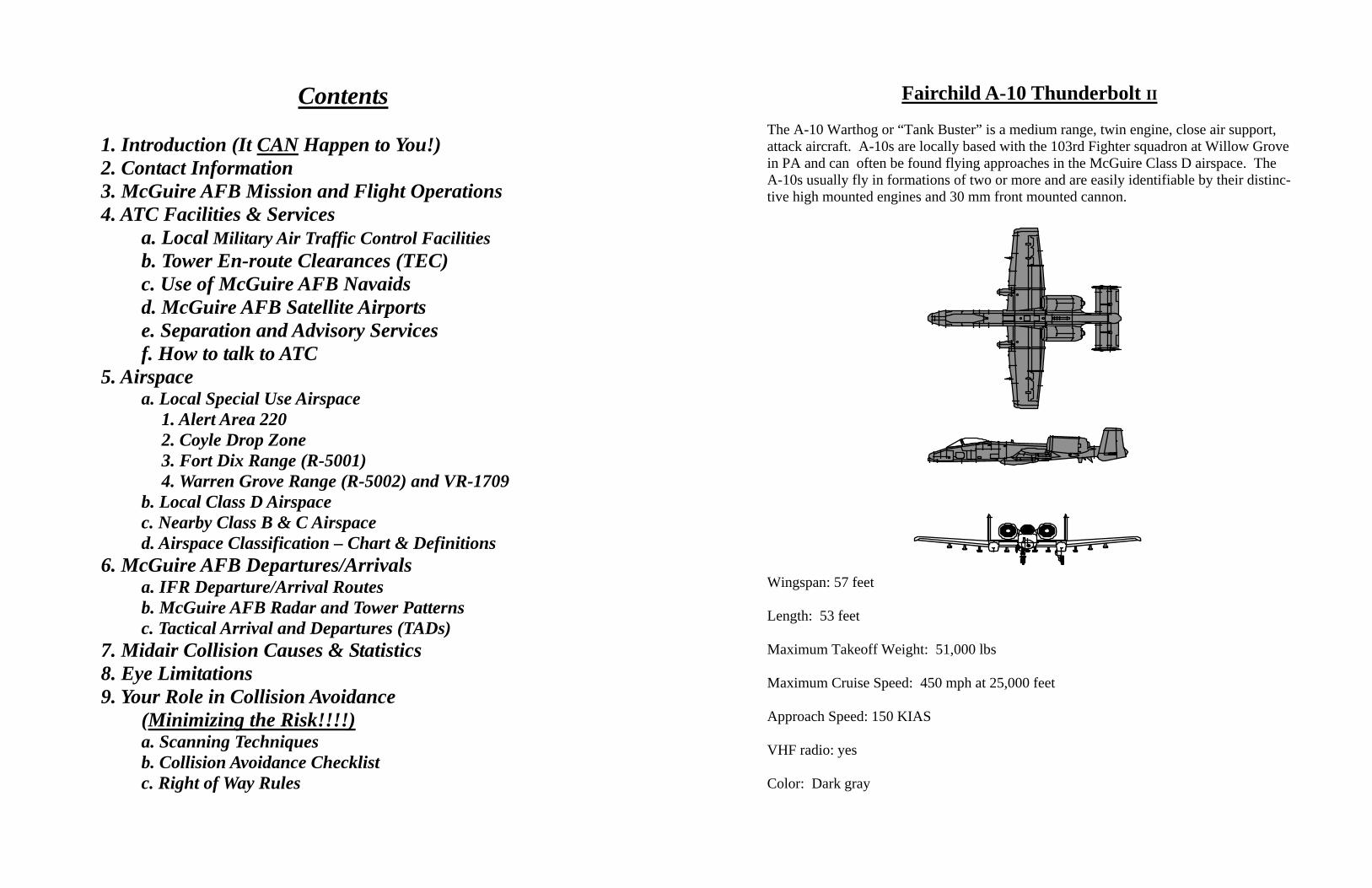
Fairchild A-10 Thunderbolt II
The A-10 Warthog or “Tank Buster” is a medium range, twin engine, close air support, attack aircraft. A-10s are locally based with the 103rd Fighter squadron at Willow Grove in PA and can often be found flying approaches in the McGuire Class D airspace. The A-10s usually fly in formations of two or more and are easily identifiable by their distinc-tive high mounted engines and 30 mm front mounted cannon.
Wingspan: 57 feet Length: 53 feet Maximum Takeoff Weight: 51,000 lbs Maximum Cruise Speed: 450 mph at 25,000 feet Approach Speed: 150 KIAS VHF radio: yes Color: Dark gray
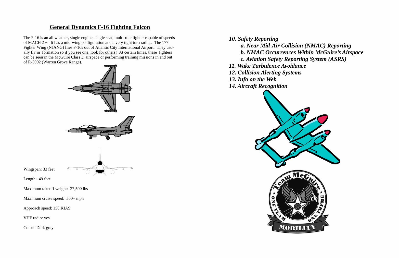
General Dynamics F-16 Fighting Falcon The F-16 is an all weather, single engine, single seat, multi-role fighter capable of speeds of MACH 2 +. It has a mid-wing configuration and a very tight turn radius. The 177 Fighter Wing (NJANG) flies F-16s out of Atlantic City International Airport. They usu-ally fly in formation so if you see one, look for others! At certain times, these fighters can be seen in the McGuire Class D airspace or performing training missions in and out of R-5002 (Warren Grove Range).
Wingspan: 33 feet Length: 49 feet Maximum takeoff weight: 37,500 lbs Maximum cruise speed: 500+ mph Approach speed: 150 KIAS VHF radio: yes Color: Dark gray
10. Safety Reporting a. Near Mid-Air Collision (NMAC) Reporting b. NMAC Occurrences Within McGuire’s Airspace c. Aviation Safety Reporting System (ASRS) 11. Wake Turbulence Avoidance 12. Collision Alerting Systems 13. Info on the Web 14. Aircraft Recognition
1. Introduction (It CAN Happen to You!)
Thank you for your interest in McGuire Air Force Base’s Mid-Air Collision Avoid-ance (MACA) program. The 305th and 514th safety offices along with McGuire’s air traffic controllers prepared this pamphlet jointly with the common interest of making our skies safer. Its purpose is to stress the high potential for midair collisions in our local area and offer ways of reducing this risk. We endeavored to compile information useful to the general aviation pilot with whom we share the same airspace. Within these pages, you will find the necessary facts on our airspace, restricted areas, flight patterns, and military aircraft. You’ll also find tips and techniques to assist you in becoming a more observant and aware pilot. Please heed its advice and pass our recommendations on to your fellow aviators. We wel-come your comments and suggestions on this publication, so that we may improve future editions.
Central New Jersey is centered within the busiest air traffic route structures in the U.S., the Boston/Washington Corridor. New Jersey contains more than 50 civil airports, which are home to nearly 5000 private aircraft. Combine this aspect with numerous military training activities and the extremely busy neighboring international airports and it’s easy to see why there’s a high collision potential. Additionally, the airspace composition in this area contributes to an increased concentration of VFR aircraft as they avoid the more restrictive airspace. These “hot spots” have already proven to be disastrous. Early in the morning of August 9, 2000, two VFR aircraft, a Piper Seminole on a training flight and a Piper Navajo on a military charter collided at 3000 feet over Burlington Township, NJ. Both aircraft were circumnavigating Philadelphia’s Class B airspace. In the post 9-11 era of TFRs and ADIZs the problem with airspace composition becomes compounded. The threat of a midair collision is very real. Operations in our crowded airspace require extra vigilance by both military and civilian pilots. Communication with available air traffic control agencies, aggressive scanning by aviators, and the knowledge of the airspace struc-ture and potential “hot spots” will help us safely operate together. Thank you again for your time and concern for aviation safety.
DISCLAIMER
This publication contains information relating to collision avoidance that’s been specifically tailored to the GA pilot in the central NJ area. References to supporting regulations are made throughout this pamphlet. Additionally, this document cites certain frequencies and describes local airspace and flight procedures. All information is current as of the date of the most recent update. Since regulatory guidance, ATC frequencies, and procedures are subject to change, periodically verify the contents of this publication. If you discover any errors or inaccuracies, please contact 514 AMW Flight Safety as noted on the following page.
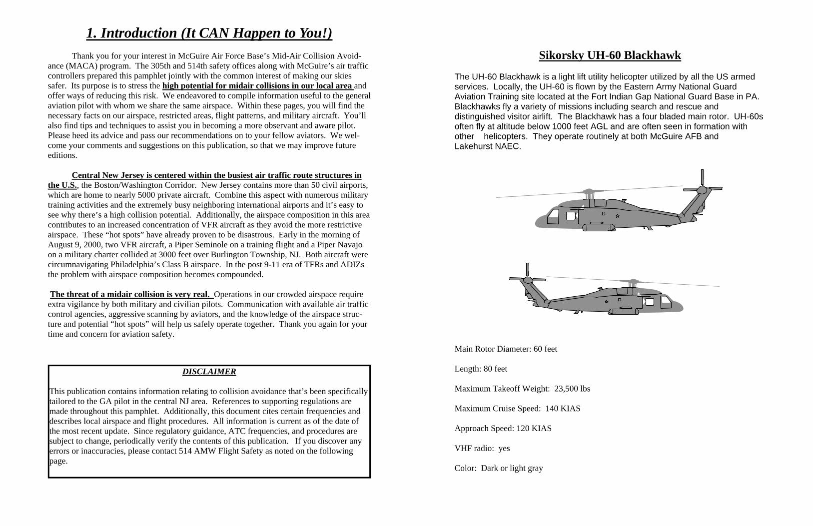
Sikorsky UH-60 Blackhawk
The UH-60 Blackhawk is a light lift utility helicopter utilized by all the US armed services. Locally, the UH-60 is flown by the Eastern Army National Guard Aviation Training site located at the Fort Indian Gap National Guard Base in PA. Blackhawks fly a variety of missions including search and rescue and distinguished visitor airlift. The Blackhawk has a four bladed main rotor. UH-60s often fly at altitude below 1000 feet AGL and are often seen in formation with other helicopters. They operate routinely at both McGuire AFB and Lakehurst NAEC.
Main Rotor Diameter: 60 feet Length: 80 feet Maximum Takeoff Weight: 23,500 lbs Maximum Cruise Speed: 140 KIAS Approach Speed: 120 KIAS VHF radio: yes Color: Dark or light gray
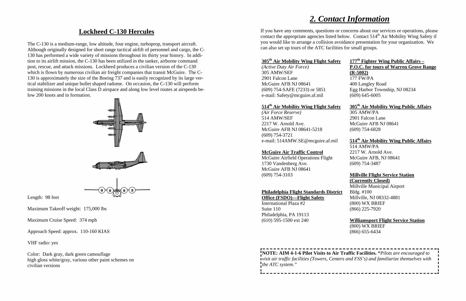
Lockheed C-130 Hercules
The C-130 is a medium-range, low altitude, four engine, turboprop, transport aircraft. Although originally designed for short range tactical airlift of personnel and cargo, the C-130 has performed a wide variety of missions throughout its thirty year history. In addi-tion to its airlift mission, the C-130 has been utilized in the tanker, airborne command post, rescue, and attack missions. Lockheed produces a civilian version of the C-130 which is flown by numerous civilian air freight companies that transit McGuire. The C-130 is approximately the size of the Boeing 737 and is easily recognized by its large ver-tical stabilizer and unique bullet shaped radome. On occasion, the C-130 will perform training missions in the local Class D airspace and along low level routes at airspeeds be-low 200 knots and in formation.
Length: 98 feet Maximum Takeoff weight: 175,000 lbs Maximum Cruise Speed: 374 mph Approach Speed: approx. 110-160 KIAS VHF radio: yes Color: Dark gray, dark green camouflage high gloss white/gray, various other paint schemes on civilian versions
2. Contact Information
If you have any comments, questions or concerns about our services or operations, please contact the appropriate agencies listed below. Contact 514th Air Mobility Wing Safety if you would like to arrange a collision avoidance presentation for your organization. We can also set up tours of the ATC facilities for small groups.
305th Air Mobility Wing Flight Safety (Active Duty Air Force) 305 AMW/SEF 2901 Falcon Lane McGuire AFB NJ 08641 (609) 754-SAFE (7233) or 5851 e-mail: [email protected] 514th Air Mobility Wing Flight Safety (Air Force Reserve) 514 AMW/SEF 2217 W. Arnold Ave. McGuire AFB NJ 08641-5218 (609) 754-3721 e-mail: [email protected] McGuire Air Traffic Control McGuire Airfield Operations Flight 1730 Vandenberg Ave. McGuire AFB NJ 08641 (609) 754-3103 Philadelphia Flight Standards District Office (FSDO)—Flight Safety International Plaza #2 Suite 110 Philadelphia, PA 19113 (610) 595-1500 ext 240
177th Fighter Wing Public Affairs – P.O.C. for tours of Warren Grove Range (R-5002) 177 FW/PA 400 Langley Road Egg Harbor Township, NJ 08234 (609) 645-6005 305th Air Mobility Wing Public Affairs 305 AMW/PA 2901 Falcon Lane McGuire AFB NJ 08641 (609) 754-6828 514th Air Mobility Wing Public Affairs 514 AMW/PA 2217 W. Arnold Ave. McGuire AFB, NJ 08641 (609) 754-3487 Millville Flight Service Station (Currently Closed) Millville Municipal Airport Bldg. #100 Millville, NJ 08332-4881 (800) WX BRIEF (866) 225-7920 Williamsport Flight Service Station (800) WX BRIEF (866) 655-6434
NOTE: AIM 4-1-6 Pilot Visits to Air Traffic Facilities. “Pilots are encouraged to visit air traffic facilities (Towers, Centers and FSS’s) and familiarize themselves with the ATC system.”
3. McGuire AFB Mission and Flight Operations
McGuire Air Force Base, Air Mobility Command’s “Eastern Gateway” is responsible for the safe, worldwide movement of cargo and troops as well as aerial refueling to both US and NATO aircraft. One of the Air Mobility Command’s busiest bases, McGuire AFB is located in Central New Jersey approximately 30 miles northeast of Philadelphia and 50 miles southwest of New York City. McGuire has contributed to all major operations worldwide to include Operations Enduring Freedom and Iraqi Freedom. The base also provides Presidential and Vice Presidential support for the White House. The men and women stationed at McGuire are particularly proud of their humanitarian airlift missions. McGuire based crews have provided relief for disaster victims world-wide. McGuire crews also play a significant role in the ongoing War on Terror. On September 16, 2004, the last flyable C-141B Starlifter departed McGuire on its final flight. C-141s were assigned to McGuire for over 37 years. On September 24, 2004, the first C-17 Globemaster III arrived to take its place. Air refueling tankers, the KC-10 and the KC-135 also fly out of McGuire as does the C-32B (an all white Boeing 757). McGuire aircrews are airborne 24 hours a day, 7 days a week. Frequently, formations of up to four C-17s or KC-10s are launched with one minute separation. The elements will then rejoin and fly in one mile trail formation with 500 feet vertical separation. It is very important to realize that if you see one military aircraft, look out for others! With speeds of up to 330 knots below 10,000 feet, there isn’t much time to react when conflicts arise. Military aircraft routinely fly multiple approaches both in the larger radar pattern and the tower’s visual pattern. Altitudes in the radar pattern are 2000, 2500 or 3000 feet MSL. Tower’s visual pattern altitude is 1600 feet MSL while its overhead pattern altitude is 2100 feet. When flying VFR near McGuire, civilian pilots are encouraged to check in with radar control on 124.15. They’ll provide you with advisories on the active mili-tary traffic to the utmost of their ability based on their current workload.
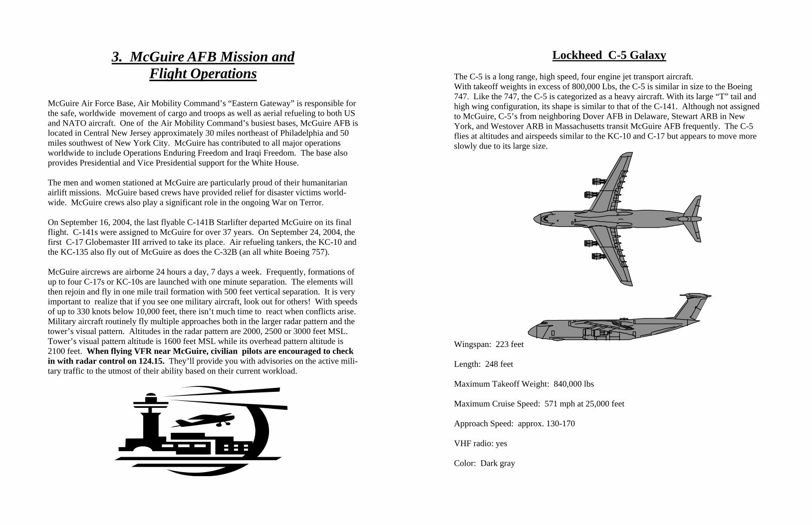
Lockheed C-5 Galaxy
The C-5 is a long range, high speed, four engine jet transport aircraft. With takeoff weights in excess of 800,000 Lbs, the C-5 is similar in size to the Boeing 747. Like the 747, the C-5 is categorized as a heavy aircraft. With its large “T” tail and high wing configuration, its shape is similar to that of the C-141. Although not assigned to McGuire, C-5’s from neighboring Dover AFB in Delaware, Stewart ARB in New York, and Westover ARB in Massachusetts transit McGuire AFB frequently. The C-5 flies at altitudes and airspeeds similar to the KC-10 and C-17 but appears to move more slowly due to its large size.
Wingspan: 223 feet Length: 248 feet Maximum Takeoff Weight: 840,000 lbs Maximum Cruise Speed: 571 mph at 25,000 feet Approach Speed: approx. 130-170 VHF radio: yes Color: Dark gray
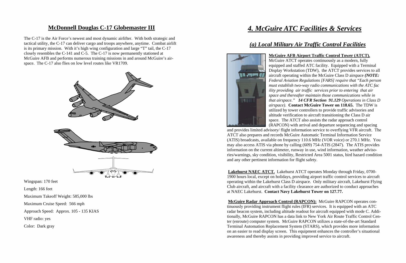
McDonnell Douglas C-17 Globemaster III
The C-17 is the Air Force’s newest and most dynamic airlifter. With both strategic and tactical utility, the C-17 can deliver cargo and troops anywhere, anytime. Combat airlift is its primary mission. With it’s high wing configuration and large “T” tail, the C-17 closely resembles the C-141 and C-5. The C-17 is now permanently stationed at McGuire AFB and performs numerous training missions in and around McGuire’s air-space. The C-17 also flies on low level routes like VR1709.
Wingspan: 170 feet Length: 166 feet Maximum Takeoff Weight: 585,000 lbs Maximum Cruise Speed: 566 mph Approach Speed: Approx. 105 - 135 KIAS VHF radio: yes Color: Dark gray
4. McGuire ATC Facilities & Services
(a) Local Military Air Traffic Control Facilities
McGuire AFB Airport Traffic Control Tower (ATCT). McGuire ATCT operates continuously as a modern, fully equipped and staffed ATC facility. Equipped with a Terminal Display Workstation (TDW), the ATCT provides services to all aircraft operating within the McGuire Class D airspace (NOTE: Federal Aviation Regulations [FARS] require that “Each person must establish two-way radio communications with the ATC fac ility providing air traffic services prior to entering that air space and thereafter maintain those communications while in that airspace.” 14 CFR Section 91.129 Operations in Class D airspace). Contact McGuire Tower on 118.65. The TDW is utilized by tower controllers to provide traffic advisories and altitude verification to aircraft transitioning the Class D air space. The ATCT also assists the radar approach control (RAPCON) with arrival and departure sequencing and spacing
and provides limited advisory/ flight information service to overflying VFR aircraft. The ATCT also prepares and records McGuire Automatic Terminal Information Service (ATIS) broadcasts, available on frequency 110.6 MHz (VOR voice) or 270.1 MHz. You may also access ATIS via phone by calling (609) 754-ATIS (2847). The ATIS provides information on the current altimeter, runway in use, wind information, weather adviso-ries/warnings, sky condition, visibility, Restricted Area 5001 status, bird hazard condition and any other pertinent information for flight safety.
Lakehurst NAEC ATCT. Lakehurst ATCT operates Monday through Friday, 0700-1900 hours local, except on holidays, providing airport traffic control services to aircraft operating within the Lakehurst Class D airspace. Only military aircraft, Lakehurst Flying Club aircraft, and aircraft with a facility clearance are authorized to conduct approaches at NAEC Lakehurst. Contact Navy Lakehurst Tower on 127.77. McGuire Radar Approach Control (RAPCON): McGuire RAPCON operates con-tinuously providing instrument flight rules (IFR) services. It is equipped with an ATC radar beacon system, including altitude readout for aircraft equipped with mode C. Addi-tionally, McGuire RAPCON has a data link to New York Air Route Traffic Control Cen-ter (enroute) computer system. McGuire RAPCON utilizes a state-of-the-art Standard Terminal Automation Replacement System (STARS), which provides more information on an easier to read display screen. This equipment enhances the controller’s situational awareness and thereby assists in providing improved service to aircraft.
Civilian fields will soon be equipped with STARS. “In early June, Philadelphia International Airport became the first (civilian) airport in the United States to fully de-ploy STARS. STARS, at an estimated cost of $1.69 bil-lion, will be capable of managing thousands of flights si-multaneously; the old system managed 300 flights at a time. STARS will be deployed in 167 airports over the next eight years if Congress approves increased funding for it.” (Flying Magazine Sep. 2003) The McGuire primary RAPCON controller functions are divided as follows: Approach/Departure, Arrival, and Clearance Delivery. This facility provides approach, departure, and radar traffic advisory service throughout its delegated airspace. Preferential routes are established throughout McGuire's airspace to provide aircraft a smooth transition from the en-route system into the terminal system. Preferential departure routes are es-tablished for transitioning aircraft into the en-route traffic flow. Preferred departure routes are standard instrument departure routes designed to systematically intermix satel-lite airport departures with an already established en-route flow in the airway struc-ture. These "PDRs", although sometimes complicated, are necessary in order to permit an orderly flow of traffic in an otherwise extremely complex and congested air-space. The PDRs are issued as a part of a flight plan departure clearance. Once airborne, McGuire Approach Control may delete any restrictions and expedite the routing if traffic conditions permit. These PDRs, though, aren’t published anywhere because they can and do change. Expect something similar to past clearances given, or if you haven’t flown that particular route, file to a nearby fix in your direction of flight. You’ll likely receive a PDR. NOTE: PDRs will expedite your departure. The reason for this is the FAA com-puter. The computer has been programmed for the PDRs, so processing such a clearance is much faster. If you insist on a different route, it will have to be checked for conflicts with other PDRs that are already in the system. This takes time; and to resolve any con-flicts with your intended route, your clearance will probably be still different from your filed flight plan and will result in a further delay. A good guide to follow for filing pur-poses is the Tower En-route Clearance routes. This should effectively transition you from the local area to the en-route system.
4. (b) Tower En-route Clearance (TEC) McGuire RAPCON/Clearance Delivery has the flexibility to amend Tower En-Route (TEC) clearances, which are routes with a requested altitude of 080 (eight thousand) or less. Clearances with requested altitudes higher than 080 (center-structure routes) can only be changed by the center. Coordination with the center can sometimes cause delays. The routes included in this list apply only to TEC clearances.
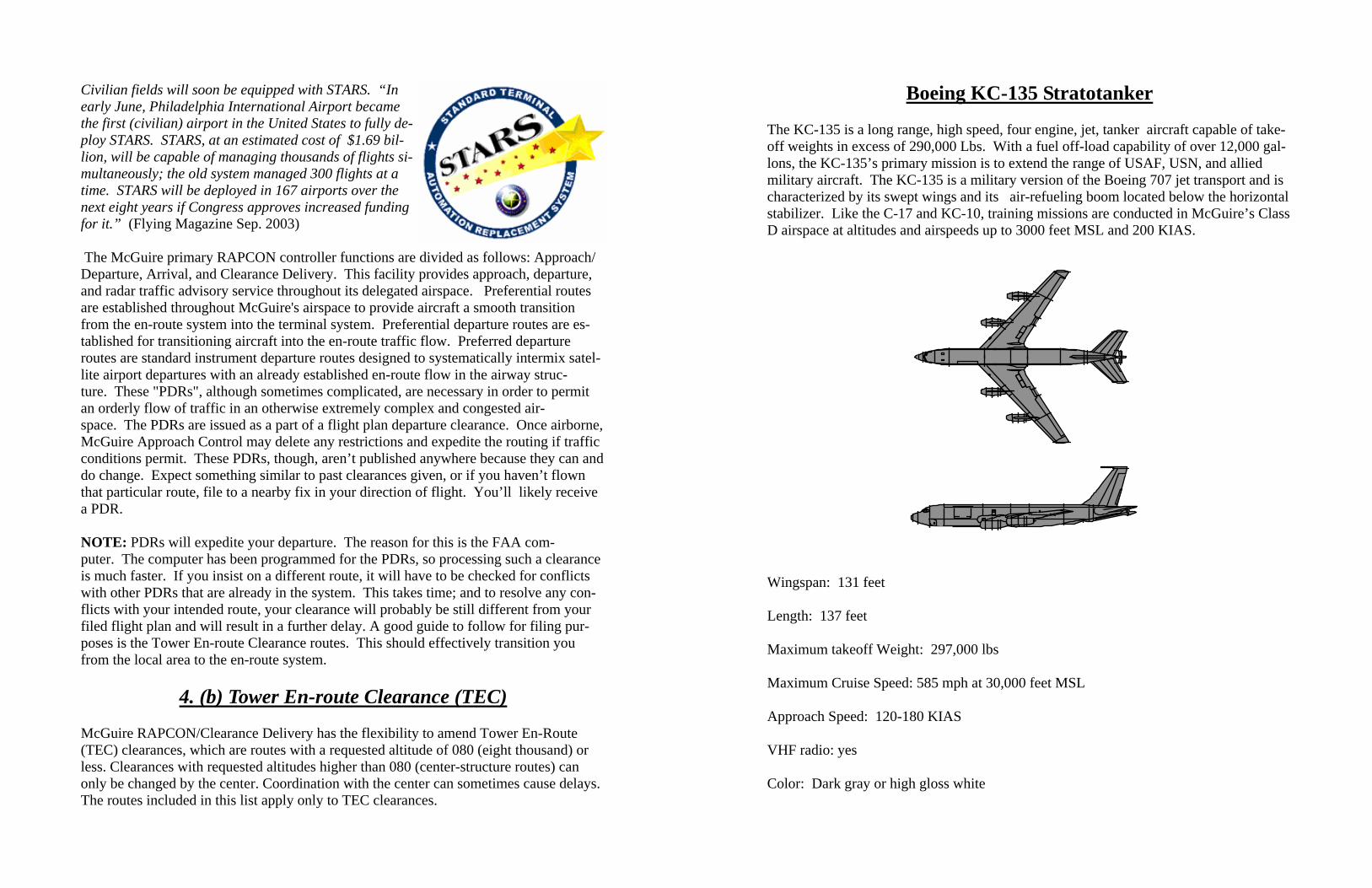
Boeing KC-135 Stratotanker The KC-135 is a long range, high speed, four engine, jet, tanker aircraft capable of take-off weights in excess of 290,000 Lbs. With a fuel off-load capability of over 12,000 gal-lons, the KC-135’s primary mission is to extend the range of USAF, USN, and allied military aircraft. The KC-135 is a military version of the Boeing 707 jet transport and is characterized by its swept wings and its air-refueling boom located below the horizontal stabilizer. Like the C-17 and KC-10, training missions are conducted in McGuire’s Class D airspace at altitudes and airspeeds up to 3000 feet MSL and 200 KIAS.
Wingspan: 131 feet Length: 137 feet Maximum takeoff Weight: 297,000 lbs Maximum Cruise Speed: 585 mph at 30,000 feet MSL Approach Speed: 120-180 KIAS VHF radio: yes Color: Dark gray or high gloss white

Boeing C-32B The C-32B is a medium range, high speed, two engine, jet transport aircraft with a maxi-mum gross takeoff weight of 255,000 lbs. The C-32B is the military version of the Boe-ing 757-200 jet transport and is characterized by its swept wings and pod mounted en-gines. Like other McGuire AFB aircraft, training missions are conducted in McGuire’s Class D airspace at altitudes and airspeeds up to 3000 feet MSL and 200 KIAS. C-32Bs in McGuire AFB’s radar pattern can be expected to cruise at 220 KIAS; C-32Bs depart-ing and arriving the area below 10,000 feet MSL can be expected to cruise at 250 KIAS.
Wingspan: 125 feet Length: 155 feet Maximum Takeoff Weight: 255,000 lbs Maximum Cruise: Approximately 570 mph Approach Speed: 110-160 KIAS Departure Speed: 200-300 KIAS VHF Radio: Yes
Departure clearances are designed to ensure appropriate non-radar routes in the event McGuire Approach loses radar. Once airborne, most pilots can either expect or request vectors to lessen the flying time. For example, a VAY departure going to Charleston (CHS) will be issued as: RBV.V276.DIXIE.V1.CHS, but when the aircraft is airborne, and based on traffic volume, vectors may be issued directly to CYN or to join V1. Be aware that flights to the west may be metered by Philadelphia Approach. This will de-pend on traffic flow, and if activated will institute a four-minute window to be airborne. Departure procedures are as follows:
VAY / N14 / N73 – intercept the Robbinsville two three six radial to Robbinsville (then V276 to DIXIE or V276 to ARD)
N87 – direct RBV (then V276 to DIXIE or V276 to ARD)
3N6 - direct RBV (then V276 to DIXIE or V276 to ARD)
BLM – direct RBV / direct DIXIE
N12 / MJX – direct DIXIE / direct CYN
19N – direct CYN
The routes provided below should only be used as a guideline when filing flight plans out of McGuire’s airspace. The routes are not guaranteed and can change at any time without notice based on traffic volume, adjacent facility restrictions, weather, and even aircraft type.
Points South: altitudes 040/060 on V16; 040/060/080 on V1: CYN.V1.CRESI or V16.VCN (Coyle Victor 1 Cresi or Coyle Victor 16 Cedar Lake)..
Points East: altitudes 060 or 070 (twin aircraft only): DIXIE.V276.MANTA.V139..
Points North: altitudes 050 or 070 (single engine only): DIXIE.V1/V16/V229.JFK..
Points Northwest: altitudes 040 or 060 depending on destination: RBV.V249.METRO..
Points West: 040: RBV.V276.ARD..
4. (c) Use of McGuire AFB Navaids
Use of McGuire AFB's Navigational Aid Facilities. Air Force policy allows any civil pilot to request practice IFR and VFR low approaches to Air Force runways. Civil air-craft may not touchdown, except during flight emergency, unless prior written
permission is granted through McGuire Base Operations ((609) 754 - 2712/4606). How-ever, since the ILS, Precision Approach Path Indicators (PAPIs), and VORTAC are es-tablished at McGuire AFB primarily to support USAF/ government flying operations, civil use of these facilities must be on a noninterference basis. Normal low density, mili-tary traffic periods are: 0600-0900 hours local, Tuesday through Saturday; all day Mon-day; and after 1600 hours local on Sundays.
4. (d) McGuire AFB Satellite Airports
McGuire ATC facilities provide services to McGuire AFB (WRI), Lakehurst NAEC (NEL) (reminder: approaches to NEL are restricted to military aircraft, Lakehurst Flying Club aircraft, and aircraft with a facility clearance), and many civil general aviation lo-cations. The following is a list of satellite airports whose location lies within the con-fines of McGuire’s designated airspace:
• BLM – Monmouth Executive Airport (formerly Allaire) (Public use near Farmingdale, NJ @ GXU 075/24.1) • MJX - Robert J. Miller Air Park Airport (Public use near Toms River, NJ @ GXU 120/4.8) • VAY - South Jersey Regional Airport (Public use near Mount Holly, NJ @ GXU 262/12.1) • N14 - Flying W Airport (Public use near Lumberton, NJ @ GXU 256/10.7) • N73 - Red Lion Airport (Public use near Vincentown, NJ @ GXU 239/9.5) • 19N - Camden County Airport (Public use near Berlin, NJ @ GXU 240/21.3) • N81 - Hammonton Municipal Airport (Public use, near Hammonton, NJ @ GXU 211/21.8) • N87 - Trenton - Robbinsville Airport (Public use near Robbinsville, NJ @ GXU 010/12.3) • N12 - Lakewood Airport (Public use near Lakewood, NJ @ GXU 091/19.5) • 3N6 - Old Bridge Airport (Public use near Old Bridge, NJ @ GXU 042/22.4) • 2N6 - Redwing Airport (Public use (turf) near Jobstown, NJ @ GXU 294/4.5 • 3N7 - Pemberton Airport (Public use (turf) near Pemberton, NJ @ GXU 261/4.7) • 31E - Eagles Nest Airport (Public use located near West Creek, NJ @ GXU 158/24.6)
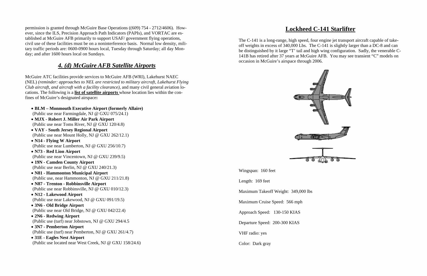
Lockheed C-141 Starlifter The C-141 is a long-range, high speed, four engine jet transport aircraft capable of take-off weights in excess of 340,000 Lbs. The C-141 is slightly larger than a DC-8 and can be distinguished by it large “T’ tail and high wing configuration. Sadly, the venerable C-141B has retired after 37 years at McGuire AFB. You may see transient “C” models on occasion in McGuire’s airspace through 2006.
Wingspan: 160 feet Length: 169 feet Maximum Takeoff Weight: 349,000 lbs Maximum Cruise Speed: 566 mph Approach Speed: 130-150 KIAS Departure Speed: 200-300 KIAS VHF radio: yes Color: Dark gray
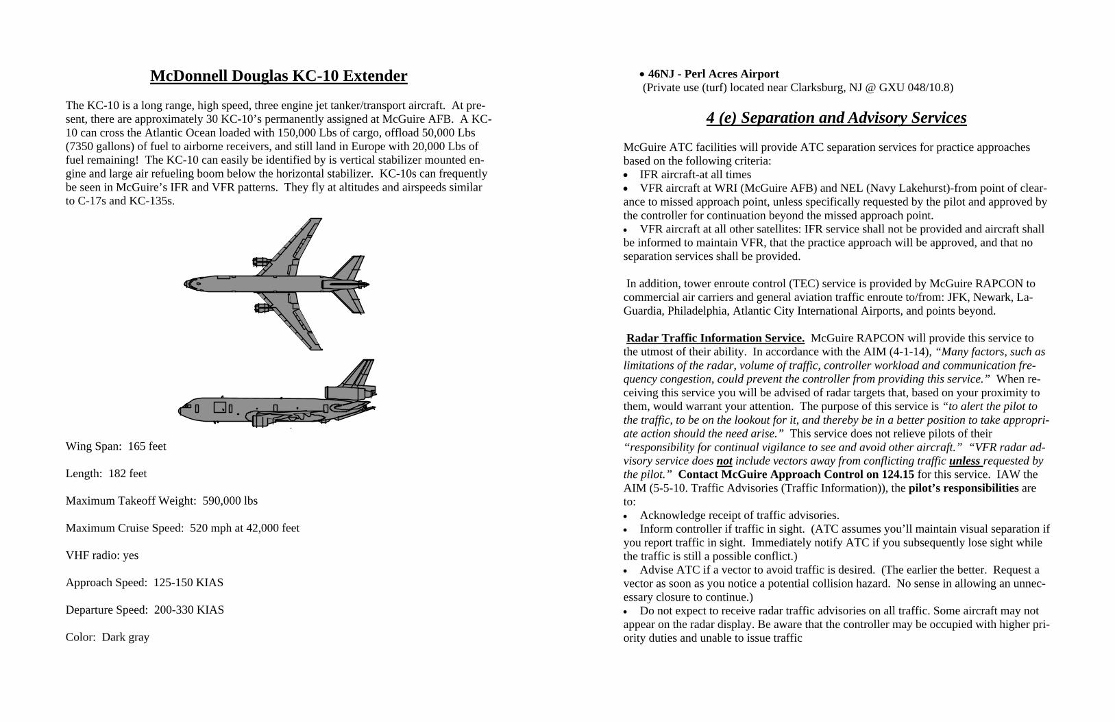
McDonnell Douglas KC-10 Extender
The KC-10 is a long range, high speed, three engine jet tanker/transport aircraft. At pre-sent, there are approximately 30 KC-10’s permanently assigned at McGuire AFB. A KC-10 can cross the Atlantic Ocean loaded with 150,000 Lbs of cargo, offload 50,000 Lbs (7350 gallons) of fuel to airborne receivers, and still land in Europe with 20,000 Lbs of fuel remaining! The KC-10 can easily be identified by is vertical stabilizer mounted en-gine and large air refueling boom below the horizontal stabilizer. KC-10s can frequently be seen in McGuire’s IFR and VFR patterns. They fly at altitudes and airspeeds similar to C-17s and KC-135s.
Wing Span: 165 feet Length: 182 feet Maximum Takeoff Weight: 590,000 lbs Maximum Cruise Speed: 520 mph at 42,000 feet VHF radio: yes Approach Speed: 125-150 KIAS Departure Speed: 200-330 KIAS Color: Dark gray
• 46NJ - Perl Acres Airport (Private use (turf) located near Clarksburg, NJ @ GXU 048/10.8)
4 (e) Separation and Advisory Services
McGuire ATC facilities will provide ATC separation services for practice approaches based on the following criteria: • IFR aircraft-at all times • VFR aircraft at WRI (McGuire AFB) and NEL (Navy Lakehurst)-from point of clear-ance to missed approach point, unless specifically requested by the pilot and approved by the controller for continuation beyond the missed approach point. • VFR aircraft at all other satellites: IFR service shall not be provided and aircraft shall be informed to maintain VFR, that the practice approach will be approved, and that no separation services shall be provided. In addition, tower enroute control (TEC) service is provided by McGuire RAPCON to commercial air carriers and general aviation traffic enroute to/from: JFK, Newark, La-Guardia, Philadelphia, Atlantic City International Airports, and points beyond. Radar Traffic Information Service. McGuire RAPCON will provide this service to the utmost of their ability. In accordance with the AIM (4-1-14), “Many factors, such as limitations of the radar, volume of traffic, controller workload and communication fre-quency congestion, could prevent the controller from providing this service.” When re-ceiving this service you will be advised of radar targets that, based on your proximity to them, would warrant your attention. The purpose of this service is “to alert the pilot to the traffic, to be on the lookout for it, and thereby be in a better position to take appropri-ate action should the need arise.” This service does not relieve pilots of their “responsibility for continual vigilance to see and avoid other aircraft.” “VFR radar ad-visory service does not include vectors away from conflicting traffic unless requested by the pilot.” Contact McGuire Approach Control on 124.15 for this service. IAW the AIM (5-5-10. Traffic Advisories (Traffic Information)), the pilot’s responsibilities are to: • Acknowledge receipt of traffic advisories. • Inform controller if traffic in sight. (ATC assumes you’ll maintain visual separation if you report traffic in sight. Immediately notify ATC if you subsequently lose sight while the traffic is still a possible conflict.) • Advise ATC if a vector to avoid traffic is desired. (The earlier the better. Request a vector as soon as you notice a potential collision hazard. No sense in allowing an unnec-essary closure to continue.) • Do not expect to receive radar traffic advisories on all traffic. Some aircraft may not appear on the radar display. Be aware that the controller may be occupied with higher pri-ority duties and unable to issue traffic
information for a variety of reasons. (Distractions, frequency congestion, etc.) • Advise controller if service is not desired. (Why would you not want this service? (rhetorical question) The AIM (8-1-8. Judgment Aspects of Collision Avoidance) states “Use this support whenever possible or when required.” The controller’s responsibilities are to: • Issue radar traffic to the maximum extent consistent with higher priority duties ex-cept in Class A airspace. • Provide vectors to assist aircraft to avoid observed traffic when requested by the pilot. • Issue traffic information to aircraft in the Class B, Class C, and Class D surface areas for sequencing purposes The controller will, IAW with the AIM (5-5-8. See and Avoid), provide “radar traffic information to radar identified aircraft operating outside positive control airspace on a workload permitting basis.” Realize that during demanding periods, controllers may deny this service. This does not mean that a pilot should assume that this service will be denied. You should always request traffic advisories, which provides another layer of protection. Additionally, the controller will issue “safety alerts to aircraft under their control if aware the aircraft is at an altitude believed to place the aircraft in unsafe prox-imity to terrain, obstructions, or other aircraft.” Controllers will do their utmost to pro-vide quality service. They, like pilots however, are human. Distractions during periods of high activity may reduce the controller’s ability to detect potential conflicts. Always practice “See and Avoid.”
The aircraft information displayed on the controller’s screen is provided by the air-craft’s transponder and is referred to as a “tag” in the controller’s vernacular.
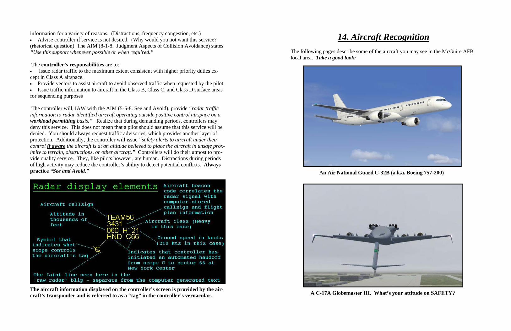
14. Aircraft Recognition
The following pages describe some of the aircraft you may see in the McGuire AFB local area. Take a good look:
An Air National Guard C-32B (a.k.a. Boeing 757-200)
A C-17A Globemaster III. What’s your attitude on SAFETY?

Allentown Flight Standards District Office (FSDO) Safety Program: http://aea.faa.gov/aea200/ea05/ Aviation Safety Network Safety Issues- Midair Collisions: http://aviation-safety.net/events/midair/ Air Nav.com - airfield and navigation information: http://airnav.com Avian Hazard Advisory System (AHAS) and Bird Avoidance Model (BAM) information: http://www.usahas.com
After 37 years of faithful service the C-141B Starlifter departs McGuire AFB
4. (f) How to talk to ATC
Many pilots, particularly those that are new and less experienced, may feel intimidated when it comes to talking with air traffic controllers. This shouldn’t be. McGuire AFB controllers are happy to provide VFR advisory services to general aviation aircraft and will do so upon request as long as their workload permits. By participating in this ser-vice, you’re also communicating your intentions to the controllers which assist them in their control of IFR traffic. They can avoid potential conflicts if they know your ex-pected route of flight. When talking to controllers, make your transmissions concise and avoid stepping on other radio calls. A controller will be more likely and able to provide you service if you’re not tying up a lot of airtime during congested periods. Plan and re-hearse your transmission prior to delivery, and with your best airline captain’s voice, state your request. A useful gouge for proper radio format is who, who, what, where, how high, why. Who – The name/call sign of the agency you’re calling, i.e. “McGuire Approach” Who – You, your call sign, i.e. “Cessna 12345” What – Your aircraft, “a Cessna 310” Where – Your current location and destination, i.e. “overhead RJ Miller (MJX) bound for Doylestown (DYL)” How high – Your current altitude and your target altitude if climbing or descending, i.e. “climbing thru 3000 feet for 3500” Why – Reason for calling, i.e. “request VFR advisories” Your participation in Radar Traffic Information Service or VFR advisories enhances safety within our complex and congested airspace. Remember though; don’t rely exclu-sively on ATC to keep you from colliding with other aircraft. They may be temporarily distracted due to a heavy workload. Use them as a tool and continue to see and avoid.
Cessna 345, traffic 12 0’clock 3 miles, NE bound, altitude
indicates 3000
McGuire Approach, Roger. That conflicts with my planned route. Request
an avoidance vector to the south
5. Airspace (a) Local Special Use Airspace
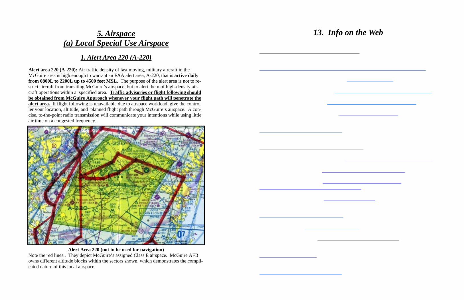
1. Alert Area 220 (A-220)
Alert area 220 (A-220): Air traffic density of fast moving, military aircraft in the McGuire area is high enough to warrant an FAA alert area, A-220, that is active daily from 0800L to 2200L up to 4500 feet MSL. The purpose of the alert area is not to re-strict aircraft from transiting McGuire’s airspace, but to alert them of high-density air-craft operations within a specified area. Traffic advisories or flight following should be obtained from McGuire Approach whenever your flight path will penetrate the alert area. If flight following is unavailable due to airspace workload, give the control-ler your location, altitude, and planned flight path through McGuire’s airspace. A con-cise, to-the-point radio transmission will communicate your intentions while using little air time on a congested frequency.
Alert Area 220 (not to be used for navigation) Note the red lines.. They depict McGuire’s assigned Class E airspace. McGuire AFB owns different altitude blocks within the sectors shown, which demonstrates the compli-cated nature of this local airspace.
13. Info on the Web

There is also a new and free service provided by the FAA that enables GA pilots to see other traffic in their vicinity. This is known as Traffic Information Service (TIS). Unlike TCAS, which is independent and self contained, TIS uses ground based radar informa-tion. This data is transmitted to your aircraft via a Mode S transponder. The hardware requirements necessary to benefit from TIS are a Mode S transponder and a display unit. Mode S transponders may be mandatory at some point in the future. The limitations to TIS include a radar environment requirement and it’s not available in all areas of the U.S. The congested northeast does have extensive coverage. TIS is a passive system provid-ing only traffic alerts, not any vertical escape maneuver guidance. However, TIS will display trend information on the other traffic, which TCAS doesn’t do. Basically, you see what the ATC controller sees. If you have the means to take advantage of these newly available collision avoidance devices, they will aid in your detection of conflicting traffic. At the very least, make sure your transponder is on, so that other aircraft collision avoidance devices can “see” you.
Example of a TCAS display on a vertical speed indicator as installed on a KC-10
Examples of other types of displays. The one on the left uses a trape-zoid cue on the PFD while the one on the right uses vertical speed tape
5. (a) 2. Coyle (CYN) Drop Zone (DZ) Coyle Drop Zone (DZ): Coyle DZ is located in the vicinity of Coyle VORTAC (CYN). This drop zone is not depicted on any aeronautical charts or in any aeronautical pub-lications. It is no longer used by C-141s. C-17s have no current plans to begin opera-tions at this DZ. However, C-130s from Wilmington, DE still use it. They approach the area from the coastline, sometimes in formation. Their ground track is just south of and parallels Route 72. Airdrop operations may occur during VMC conditions (day or night). Effective altitudes are 2000 feet MSL and below.
COYLE (CYN) VORTAC
COYLE DROP ZONE
AIRCRAFT GROUND TRACK
Terrain chart depiction of the Coyle DZ and the route of flight for participating aircraft
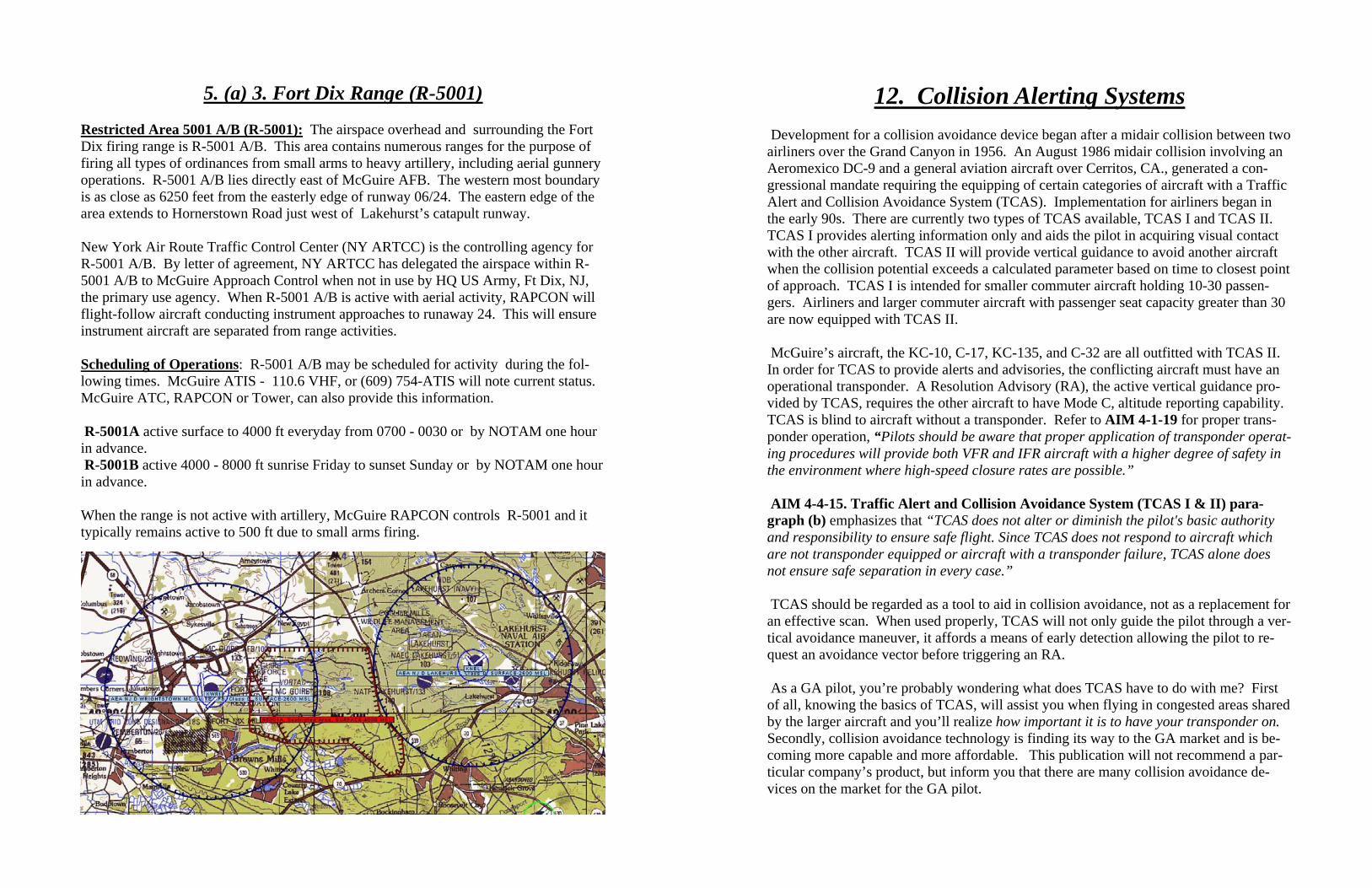
5. (a) 3. Fort Dix Range (R-5001) Restricted Area 5001 A/B (R-5001): The airspace overhead and surrounding the Fort Dix firing range is R-5001 A/B. This area contains numerous ranges for the purpose of firing all types of ordinances from small arms to heavy artillery, including aerial gunnery operations. R-5001 A/B lies directly east of McGuire AFB. The western most boundary is as close as 6250 feet from the easterly edge of runway 06/24. The eastern edge of the area extends to Hornerstown Road just west of Lakehurst’s catapult runway. New York Air Route Traffic Control Center (NY ARTCC) is the controlling agency for R-5001 A/B. By letter of agreement, NY ARTCC has delegated the airspace within R-5001 A/B to McGuire Approach Control when not in use by HQ US Army, Ft Dix, NJ, the primary use agency. When R-5001 A/B is active with aerial activity, RAPCON will flight-follow aircraft conducting instrument approaches to runaway 24. This will ensure instrument aircraft are separated from range activities. Scheduling of Operations: R-5001 A/B may be scheduled for activity during the fol-lowing times. McGuire ATIS - 110.6 VHF, or (609) 754-ATIS will note current status. McGuire ATC, RAPCON or Tower, can also provide this information. R-5001A active surface to 4000 ft everyday from 0700 - 0030 or by NOTAM one hour in advance. R-5001B active 4000 - 8000 ft sunrise Friday to sunset Sunday or by NOTAM one hour in advance. When the range is not active with artillery, McGuire RAPCON controls R-5001 and it typically remains active to 500 ft due to small arms firing.
12. Collision Alerting Systems Development for a collision avoidance device began after a midair collision between two airliners over the Grand Canyon in 1956. An August 1986 midair collision involving an Aeromexico DC-9 and a general aviation aircraft over Cerritos, CA., generated a con-gressional mandate requiring the equipping of certain categories of aircraft with a Traffic Alert and Collision Avoidance System (TCAS). Implementation for airliners began in the early 90s. There are currently two types of TCAS available, TCAS I and TCAS II. TCAS I provides alerting information only and aids the pilot in acquiring visual contact with the other aircraft. TCAS II will provide vertical guidance to avoid another aircraft when the collision potential exceeds a calculated parameter based on time to closest point of approach. TCAS I is intended for smaller commuter aircraft holding 10-30 passen-gers. Airliners and larger commuter aircraft with passenger seat capacity greater than 30 are now equipped with TCAS II. McGuire’s aircraft, the KC-10, C-17, KC-135, and C-32 are all outfitted with TCAS II. In order for TCAS to provide alerts and advisories, the conflicting aircraft must have an operational transponder. A Resolution Advisory (RA), the active vertical guidance pro-vided by TCAS, requires the other aircraft to have Mode C, altitude reporting capability. TCAS is blind to aircraft without a transponder. Refer to AIM 4-1-19 for proper trans-ponder operation, “Pilots should be aware that proper application of transponder operat-ing procedures will provide both VFR and IFR aircraft with a higher degree of safety in the environment where high-speed closure rates are possible.” AIM 4-4-15. Traffic Alert and Collision Avoidance System (TCAS I & II) para-graph (b) emphasizes that “TCAS does not alter or diminish the pilot's basic authority and responsibility to ensure safe flight. Since TCAS does not respond to aircraft which are not transponder equipped or aircraft with a transponder failure, TCAS alone does not ensure safe separation in every case.” TCAS should be regarded as a tool to aid in collision avoidance, not as a replacement for an effective scan. When used properly, TCAS will not only guide the pilot through a ver-tical avoidance maneuver, it affords a means of early detection allowing the pilot to re-quest an avoidance vector before triggering an RA. As a GA pilot, you’re probably wondering what does TCAS have to do with me? First of all, knowing the basics of TCAS, will assist you when flying in congested areas shared by the larger aircraft and you’ll realize how important it is to have your transponder on. Secondly, collision avoidance technology is finding its way to the GA market and is be-coming more capable and more affordable. This publication will not recommend a par-ticular company’s product, but inform you that there are many collision avoidance de-vices on the market for the GA pilot.

11. Wake Turbulence Avoidance You don’t necessarily have to collide with another aircraft to become a statistic. The NTSB has cited a phenomenon known as wake turbulence as contributing factors in many aircraft accidents. Examples are the December 1983 crash of a Westwind follow-ing a Boeing 757 on approach at John Wayne Airport in Orange County, CA and the 1994 accident at Pittsburgh International Airport involving a Boeing 737. More recently, wake turbulence may have played a role in the November 2001 American Airlines Flight 587 accident. To begin to understand wake turbulence, you must look at the air we fly through as a fluid similar to any body of water. As aircraft pass through the air, they gen-erate a wake as does a boat on the water. Aircraft wake turbulence originates at the wing-tips as counter rotating vortices (tornado-like composition) that begin as soon as the wings are providing lift. The vortices rotate inward and in a no-wind environment, will descend at a rate of 400 fpm to approximately 1000 feet below the aircraft and remain there until they gradually dissipate. However, there is always wind to some extent, and the wind will shift these vortices making them less predictable. Since wake turbulence is a function of lift, the heavier the aircraft, the stronger the vortices. When the aircraft is, heavy, slow and clean (flaps and gear up), it generates the most wake turbulence. Tests have shown wake turbulence can reach vortex velocities of over 130 knots. Therefore, exercise extreme caution when flying below and behind heavy jet aircraft and definitely favor the upwind side. Military operations routinely require formation flying. Despite a conscious effort to avoid the preceding aircraft’s vortices, an aircraft will invariably fly through vortices on occasion. The vortices produced by a KC-10 will shake another KC-10 at about a mile in trail with a force similar to moderate turbulence. Imagine what these same vortices would do to a light aircraft. Be alert to situations where wake turbu-lence may be expected and avoid them. It is easier and safer to avoid wake turbulence than it is to recover from an upset. Remember that a pilot’s acceptance of instructions to follow another aircraft “is also an acknowledgement that the pilot accepts the responsi-bility for wake turbulence separation (AIM 4-4-13 (b)) .”
5. (a) 4. Warren Grove Range (R-5002) and Low Level Route VR1709
R-5002 - Warren Grove Range, 108 ARW/DET 1, is responsible for managing Re-stricted Area 5002. Portions of the airspace extend from the surface to 14,000 ft MSL. The range airspace is normally active Tuesday through Saturday from 0830L to 1600L hrs. Also, from late September to mid March, the airspace is active from 1700L to ap-proximately 2130L hrs. On rare occasions the airspace is active during other periods -- day or night. Whenever there are breaks in flight training, the Range staff returns the air-space to the public through New York ARTCC, McGuire Approach Control, and Atlan-tic City Approach Control. All three agencies can advise pilots of the airspace status on their standard frequencies listed on a current sectional chart. The range also has a noise complaint and flight coordination phone number (800) 283-6550. Pilots can also call this number during preflight planning to determine expected status. However, pilots must confirm the current status through ATC before transiting the area. Range activities include military helicopter activity and fighter aircraft maneuvering at speeds approaching 600 knots and weapons deliveries of inert training bombs and bullets. Upon mission completion, the fighters exit the range in all directions to return to home bases throughout the northeast-ern US. These aircraft exit at speeds from approximately 220 to 300 knots In accordance with FAA approved waivers. Fighters and military heli-copters generally fly in groups of 2 to 4 aircraft. If you observe one, then be alert for more. VR1709 - Warren Grove Range also manages Military Training Route VR1709. This low altitude, high speed route extends from near the surface to 1500 ft AGL. Fighter air-craft fly in groups of 1 to 4 aircraft at speeds up to 450 knots along the route. The route transits parts of MD, DE, and NJ and is depicted on sectional charts. The route is used only during daylight hours. Any Flight Service Station within 100 miles of the route or Warren Grove, (800) 283-6550, can provide the status of the low level route. Warren Grove welcomes pilots to observe flying at the range to understand the impor-tance of avoiding the airspace when it is active. Contact the range at (609) 294-1264 for further information.

5. (b) Local Class D Airspace McGuire Class D Airspace: The airspace within a 4.5 NM radius around McGuire AFB from the surface extending up to and including 2600 feet MSL. There are extensions off the Class D airspace to accommodate instrument approaches to McGuire’s four runways. Guidance in the AIM advises, “if any one extension is greater than 2 miles, then all ex-tensions become Class E. In effect, McGuire’s Class D airspace has Class E extensions into Class E airspace. The resultant change is the elimination of the Class G beneath the extensions. All extensions are 3.6 NM wide and oriented from different GXU VORTAC radials or the localizer course depending on the runway (1.8 NM either side of the desig-nated radial or course). The length of the Class E extension from the Class D varies with the runway. The Class E extension description is as follows: -Runway 18. 1.8 NM each side of the 350 GXU degree radial extending from the 4.5 mile radius to 6.1 NM north of GXU (1.6 NM extension) -Runway 24. 1.8 NM each side of the 051 GXU degree radial extending from the 4.5 mile radius to 6.1 NM northeast of GXU (1.6 NM extension) -Runway 36. 1.8 NM each side of the 180 GXU degree radial extending from the 4.5 NM radius to 5.2 NM south of GXU (0.7 NM extension) -Runway 06. 1.8 NM each side of the ILS localizer course extending from the 4.5 NM radius to 7NM southwest of the localizer (2.5NM extension) Lakehurst NAS Class D Airspace: Adjacent to McGuire’s Class D airspace, Lakehurst controls airspace within a 4.2 NM radius of its field from the surface up to and including 2600 feet MSL.
Sectional depiction of Class D airspace of McGuire and Lakehurst, note Class E extensions off McGuire’s Class D (not to be used for navigation)
10. (c) Aviation Safety Reporting System (ASRS) The FAA initiated ASRS in 1975 and provides the necessary funding. In order to main-tain objectivity and anonymity, NASA sets policies and administers the program through a private contractor obtained through competitive bidding. The current contractor is Bat-telle Memorial Institute. Reports sent to the ASRS are held in strict confidence. More than 300,000 reports have been submitted to date and no reporter's identity has ever been breached by the ASRS. ASRS de-identifies reports before entering them into the incident database. All personal and organizational names are removed. Dates, times, and related information, which could be used to infer an identity, are either generalized or eliminated. The FAA will not use information obtained through ASRS for enforcement actions. If the FAA has information from other sources concerning violations they will take appro-priate action. However, because they consider the filing of a “NASA” report as “indicative of a constructive attitude” and that such an attitude tends to “prevent future violations” (Advisory Circular 00-46D), the FAA won’t impose any civil penalties or certificate suspensions. You must meet the following criteria to be eligible for immu-nity:
• Violation was not deliberate • Not a criminal offense • No mishap occurred • No violation within five years prior to the date of occurrence • Incident was properly reported. Within 10 days after the violation, complete and de-liver or mail a written report of the incident or occurrence to NASA under ASRS Obtain ASRS report forms and additional information from http://asrs.arc.nasa.gov. Bot-tom line – ASRS promotes aviation safety and offers immunity from disciplinary action, a win – win situation. Please consider using this reporting system.
NOTE: Tragic events are usually preceded by warnings, such as close calls, almost acci-dents or accidents/incidents in which tragedy was narrowly averted. These close calls need to be reported, recorded, communicated, and in many instances investigated to pre-vent future tragedies from occurring. It is every aviator’s responsibility, for the good of humanity and the promotion of aviation to detect, report, and eliminate potential hazards to aviation.

Fortunately, the pilots involved in this event had a constructive attitude and came away with a lesson learned. Both Cessna pilots attended a tour of McGuire's ATC facilities approximately six weeks after the incident. During this tour, RAPCON played back the event so they could relive the occurrence and see what the controllers saw. This was very educational, and one of the pilots, a CFI, will pass along this valuable information to her students and other pilots in the aero club
Watch out for other aircraft; be prepared to take appropriate action!
An ANG C-32 (a.k.a. Boeing 757-200) takes flight
5. (c) Class B & C Airspace Near McGuire AFB
New York City and Philadelphia are both surrounded by Class B airspace. The New York Class B airspace closely borders McGuire’s airspace at the northeast corner, while the Philadelphia Class B airspace lies less than three miles west of McGuire’s airspace in some areas. Class C surrounds Atlantic City. IF VFR, SPECIFIC CLEARANCE MUST BE OBTAINED FROM THE APPROPRI-ATE APPROACH CONTROL FACILITY PRIOR TO ENTERING CLASS B AIRSPACE. Pilots flying VFR and planning to enter either New York or Philadelphia’s Class B air-space from McGuire’s airspace should inform McGuire controllers as soon as possible. If time permits, McGuire controllers will coordinate and obtain the required clearance. If an ADIZ exists, the squawk code issued by McGuire, won’t be the same as the discreet code assigned by the ADIZ controlling facility. Contact the controlling facility and ob-tain the necessary transponder code and clearance prior to entering an ADIZ. Be aware of the locations of any TFRs affecting your flight and avoid them. If a clearance is not obtained through McGuire approach: a. If proceeding to the Kennedy/Long Island area between 1000 and 7000 feet MSL, contact New York approach BEFORE entering the NY Class B airspace on 125.7, 127.4, or 124.75 MHz. b. If proceeding to northern New Jersey between 1500 and 7000 MSL, contact New York Approach on 128.55 or 132.8 MHz BEFORE entering New York’s Class B air-space.
New York Class B airspace
Philadelphia Class B airspace
KACY
McGuire AFB
Coastline
Coastline
Delaw
are River
Delaw
are River KLGA
KPHL
-- NOT TO SCALE --
Atlantic Ocean
Atlantic City Class C airspace

c. If entering the Philadelphia Class B airspace from the northeast, contact Philadelphia approach on 128.4 or 123.8 MHz. d. If entering the Philadelphia Class B airspace from the southeast, contact Philadelphia Approach on 126.6 or 127.35 MHz. The Philadelphia Class B airspace is well depicted on the Washington VFR sectional chart and the New York Class B airspace is on the New York sectional. These sec-tional charts should be carried by all VFR pilots traveling through the Class B air-space.
Atlantic City Class C Airspace Southeast of McGuire lies Atlantic City’s Class C airspace. The composition is typical of most Class C compositions: a 5 NM core of airspace from the surface to 4000 feet and a 10 NM cylindrical portion surrounding the airport from 1200 feet AGL to 4000 feet AGL. The airspace is just south of R-5002 and just north of Ocean City. Requirements to operate within this sector include two-way radio communication and an operable alti-tude reporting transponder.
KC-10 with a “chick in tow”.
NOTE: Careful preflight planning is required in these more complex times since Sep. 11, 2001. Check NOTAMS and obtain a detailed briefing from FSS for the status of any TFR and ADIZ that may impact your route of flight.
Recent incident #4. A KC-10, call sign Team 71, was performing multiple practice ap-proaches following an air refueling training mission. While level at 3000 feet MSL on an assigned heading of 270 degrees (a pseudo downwind just northwest of CYN), the arrival controller issued a traffic advisory for a Cessna 182 traveling in a southwesterly direction at 3500 feet MSL. The Cessna was in Team 71’s one to two o’clock position on a converging flight path. Team 71 reported the traffic in sight. The Cessna, how-ever, descended unexpectedly as it approached the heavy tanker. As the two aircraft converged, The Cessna’s altitude indication abruptly changed from 3500 to 3300 feet on the controller’s display. Team 71’s Traffic Alert and Collision Avoidance System (TCAS) commanded a descend Resolution Advisory (RA). The tanker’s crew had the Cessna in sight and chose not to comply. The Cessna passed just behind the KC-10 with only 300 feet of vertical separation. An interview with the pilot of the Cessna revealed that she was under the false impres-sion that the KC-10 was climbing on a collision course with her. She merely executed what she thought was a necessary “see and avoid” maneuver. However, the tanker was configured with leading edge slats extended while at an airspeed of 200 KIAS. To maintain level flight at this configuration and airspeed, Team 71 had an eight-degree nose up deck angle. This positive angle of attack gave the pilots in the Cessna the illu-sion that the KC-10 was climbing. The Cessna pilot avoided this perceived collision hazard by maneuvering in a left descending turn to pass behind the tanker. In this case, the VFR Cessna was talking to RAPCON on the designated approach fre-quency to receive traffic advisories. In spite of this, neither of the two Cessna pilots re-ceived a traffic call on Team 71, nor did they hear Team 71 on the frequency. When McGuire RAPCON is working a high traffic volume of aircraft conducting multiple practice approaches, the watch supervisor makes a determination to operate an arrival control position. What this does is essentially sector the airspace. The arrival controller works all traffic 3000 feet and below and the approach controller works the traffic above 3000 feet. The approach controller also handles the radar traffic information service for VFR aircraft. The arrival position was in operation at the time of this incident, which placed the two aircraft on different frequencies. The arrival controller advised the KC-10 crew of the Cessna, but the approach controller never advised the Cessna pilots of the KC-10. A call to Cessna that the tanker was level at 3000 feet may have prevented the pilot’s reaction to a perceived collision hazard. The approach controller at the time of the occurrence was consumed with higher priority duties.
In all three of these incidents, the VFR aircraft was not communicating with ATC. To further complicate matters, each of these aircraft performed unpredictable altitude changes which created a collision hazard. Had these aircraft been participating in the Ra-dar Traffic Information Service, ATC would have provided instructions to maintain safe separation. McGuire’s airspace environment is very congested with VFR traffic, so the more the VFR pilots know about McGuire’s aircraft and how to contact McGuire RAP-CON, the safer all the users will be. Additionally, all pilots (civilian and military alike) need to remember their responsibilities (outlined in 14 CFR Section 91.113(a)) with re-gard to see and avoid, “When weather conditions permit, regardless of whether an opera-tion is conducted under instrument flight rules or visual flight rules, vigilance shall be maintained by each person operating an aircraft so as to see and avoid other aircraft. When a rule of this section gives another aircraft the right-of-way, the pilot shall give way to that aircraft and may not pass over, under, or ahead of it unless well clear.” All pilots need to remember their responsibilities outlined in the AIM (5-5-8), See and Avoid. “When meteorological conditions permit, regardless of type of flight plan or whether or not under control of a radar facility, the pilot is responsible to see and avoid other traffic, terrain, and obstacles.” Note: Within the NAS, ATC only provides separa-tion between IFR and VFR aircraft operating within Class B and C airspace. In Class D and E airspace, ATC provides traffic advisories on VFR aircraft on a workload-permitting basis. Standard IFR separation is provided to all aircraft operating under IFR in controlled airspace.”
Radar display illustrates a congested airspace condition in the vicinity of McGuire AFB.
CLASS A AIRSPACE a. Definition: Generally, that airspace from 18,000 feet MSL up to and including FL 600, including the airspace overlying the waters within 12 nautical miles of the coast of the 48 contiguous States and Alaska; and designated international airspace beyond 12 nautical miles of the coast of the 48 contiguous States and Alaska within areas of domestic radio navigational signal or ATC radar coverage, and within which domestic procedures are applied.
b. Operating Rules and Pilot/Equipment Requirements: Unless otherwise authorized, all persons must operate their aircraft under IFR. (See FAR Part 71.33 and FAR Part 91.167 through FAR Part 91.193.)
c. Charts: Class A airspace is not specifically charted.
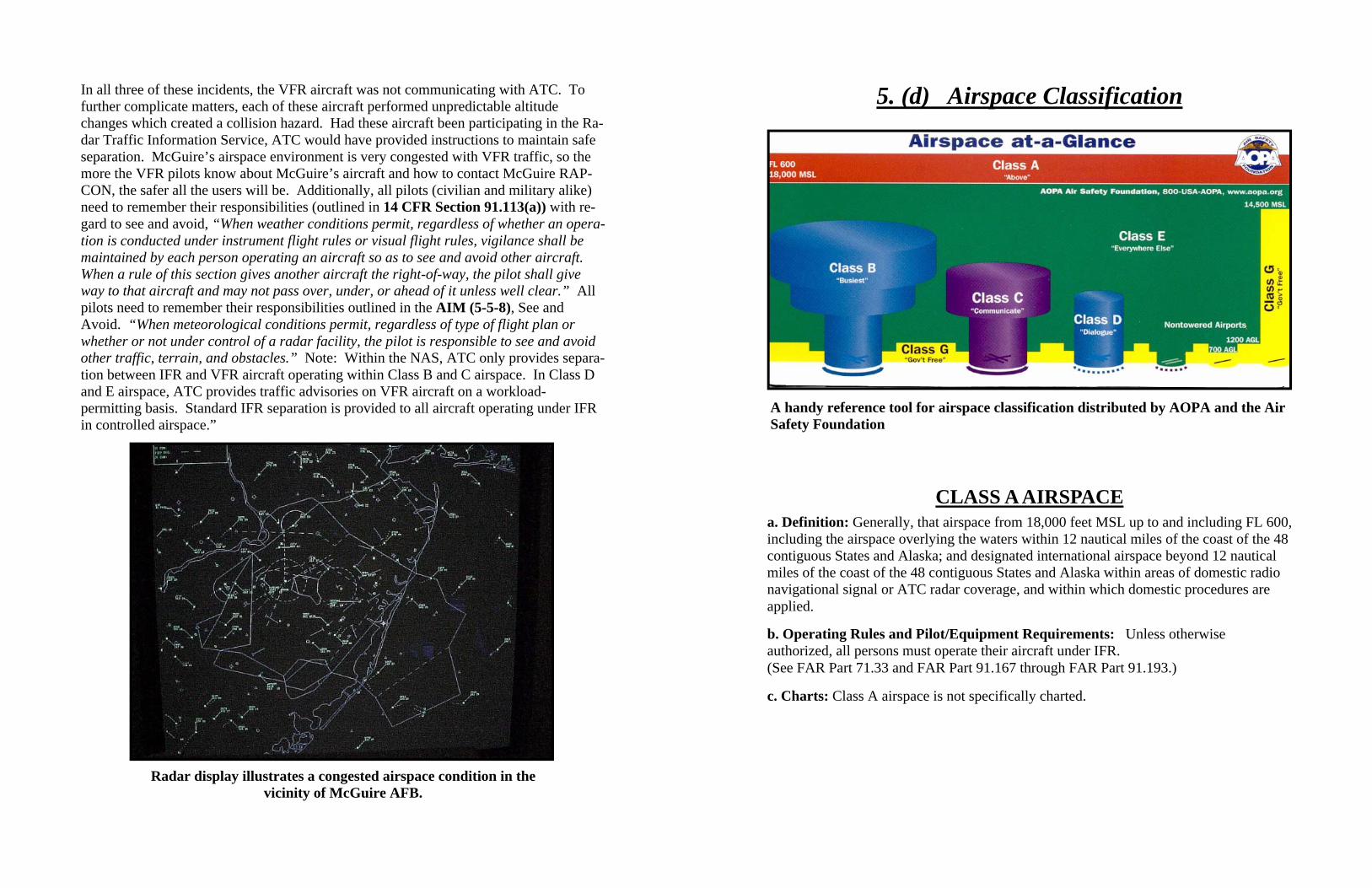
5. (d) Airspace Classification
A handy reference tool for airspace classification distributed by AOPA and the Air Safety Foundation

CLASS B AIRSPACE
a. Definition: Generally, that airspace from the surface to 10,000 feet MSL surrounding the nation's busiest airports in terms of IFR operations or passenger enplanements. The configuration of each Class B airspace area is individually tailored and consists of a surface area and two or more layers (some Class B airspace areas resemble upside-down wedding cakes), and is designed to contain all published instrument procedures once an aircraft enters the airspace. An ATC clearance is required for all aircraft to operate in the area, and all aircraft that are so cleared receive separation services within the airspace. The cloud clearance requirement for VFR operations is "clear of clouds."
b. Operating Rules and Pilot/Equipment Requirements for VFR Operations: Regardless of weather conditions, an ATC clearance is required prior to operating within Class B airspace. Pilots should not request a clearance to operate within Class B airspace unless the requirements of FAR Part 91.215 and FAR Part 91.131 are met.
c. Charts: Class B airspace is charted on Sectional Charts, IFR En Route Low Altitude, and Terminal Area Charts.
d. Flight Procedures:
1. Flights: Aircraft within Class B airspace are required to operate in accordance with current IFR procedures. A clearance for a visual approach to a primary airport is not authorization for turbine powered airplanes to operate below the designated floors of the Class B airspace.
2. VFR Flights: (a) Arriving aircraft must obtain an ATC clearance prior to entering Class B airspace and must contact ATC on the appropriate frequency, and in relation to geographical fixes shown on local charts. Although a pilot may be operating beneath the floor of the Class B airspace on initial contact, communications with ATC should be established in relation to the points indicated for spacing and sequencing purposes.
(b) Departing aircraft require a clearance to depart Class B airspace and should advise the clearance delivery position of their intended altitude and route of flight. ATC will normally advise VFR aircraft when leaving the geographical limits of the Class B airspace. Radar service is not automatically terminated with this advisory unless specifically stated by the controller.
(c) Aircraft not landing or departing the primary airport may obtain an ATC clearance to transit the Class B airspace when traffic conditions permit and provided the requirements of FAR Part 91.131 are met. Such VFR aircraft are encouraged, to the extent possible, to operate at altitudes above or below the Class B airspace or transit through established VFR corridors. Pilots operating in VFR corridors are urged to use frequency 122.750 MHz for the exchange of aircraft position information.
Recent incident #2. A KC-10 three-ship was flying the CRESI-3 departure with one-mile in-trail separation at 3000B4000 feet. Lead was at 4000, #2 at 3500, and #3 at 3000. ATC advised of traffic in their 11 to 12 o’clock position. After some searching, lead re-ported traffic in sight. During the traffic search period, the formation was instructed to climb to the block of 6000 to 7000 feet. While in the climb, lead received a “Monitor vertical speed” RA generated by the opposite direction VFR traffic. This aircraft then became a conflict to #2. The tanker crew responded by increasing their rate of climb and banking right. The VFR aircraft banked right and dove, which put it in the flight path of #3, who was offset slightly for wake turbulence avoidance. #3’s pilot had just begun his climb when the VFR aircraft flew directly underneath by 200 feet. He believes that had he not started to climb when he did, the VFR aircraft would have collided with his #3 air-craft head-on. There was no time for an avoidance maneuver. After the close encounter, the VFR aircraft continued a descent to below 2500 feet and then stopped squawking. The VFR aircraft’s primary returns indicated its flight path dissected McGuire’s Class D airspace from south to north and continued on a northerly heading until exiting McGuire’s Class E airspace. Unless this aircraft climbed above 2600 feet before reach-ing the 4.5 NM radius around McGuire, the pilot violated the two-way radio communica-tion requirement for flight within Class D airspace. The VFR aircraft never talked to ATC before or after the incident and was never traced. Recent incident #3. The crew of Jedi 07, a C-141, was two hours into an air/land train-ing mission consisting of numerous practice approaches. While being vectored on a left base at 2000 feet MSL for The TACAN Runway 18 approach, RAPCON provided a traf-fic advisory for a VFR aircraft in their 12 o’clock position at three miles, altitude indicat-ing 2500. The controller immediately followed with an updated advisory of traffic now 12 o’clock two miles altitude indicates 2200.” Immediately after Jedi 07 reported that they had the traffic in sight, the crew received a “DESCEND, DESCEND NOW!” RA from their TCAS. They complied by following TCAS guidance down to 1500 feet until clear of the conflicting aircraft, a single-engine, high-wing, light aircraft, most likely a Cessna 172. Jedi 07 returned to 2000 feet and reported the deviation to ATC as a reac-tion to a TCAS RA. The light VFR aircraft was not communicating with ATC and con-tinued its descent to land at Trenton-Robbinsville (N87).

10 (b) NMAC occurrences within McGuire’s airspace:
Recent incident #1. The crew of Jedi 87, a C-141B, was conducting practice ap-proaches as part of a typical air/land local training sortie. After completing a visual ap-proach to a touch and go with the Tower Controller, Jedi 87 contacted Approach Control with a request for radar vectors for the final approach portion of the VOR Runway 18. Jedi 87 climbed to an assigned altitude of 2000 feet MSL. The Approach Controller even-tually vectored the aging Starlifter to a 360 degree downwind heading. Just prior to the base turn (in the vicinity of Trenton-Robbinsville), the controller issued Jedi a traffic ad-visory, “traffic, 12 o’clock, three miles, northwest bound, type and altitude unknown.” Jedi’s crew began searching for the traffic. Approach control then issued a base turn heading of 270 degrees and informed Jedi that the traffic was passing harmlessly off their right at three miles heading west. Jedi’s crew reported traffic in sight as their Traffic Alert and Collision Avoidance System (TCAS) was issuing an aural “TRAFFIC, TRAF-FIC” Traffic Alert (TA). This alert was not for the previously “called out” traffic but for a new “pop-up” target, another light civil aircraft. The TA quickly progressed to a Reso-lution Advisory (RA), which commanded an immediate climb for the Jedi crew. They complied as the smaller aircraft passed 200 feet below them. This was a case where a crew’s attention was directed to visually acquire a potentially conflicting aircraft when they almost collided with another aircraft. Fortunately TCAS performed as designed. The air traffic controller did provide advisories on known/seen traffic on a time-permitting basis (IAW FAAO 7110.65 chapter 2). The controller had a strong return from the aircraft which prompted his initial advisory, but only a weak pri-mary return for the second aircraft. At the point of the NMAC, this aircraft simultane-ously produced an RA for the C-141 and provided secondary Mode C (altitude reporting) data for the radar controller. The indication on the controller’s Standard Terminal Auto-mation Replacement System (STARS) scope displayed a 200-foot difference in altitude between the two aircraft in agreement with Jedi’s TCAS. The reason for this “pop-up” effect could have been due to a malfunctioning or late turn-on of the VFR plane’s trans-ponder or it may have been too low for the radar to receive the transponder’s transmitted information. In the latter scenario, as A2 climbed through 1800 feet MSL, the controller began receiving A2’s secondary data. Aircrew must not allow themselves to become fix-ated on any one object. Keep scanning for other potential threats.
CLASS C AIRSPACE a. Definition: Generally, that airspace from the surface to 4,000 feet above the airport elevation (charted in MSL) surrounding those airports that have an operational control tower, are serviced by a radar approach control, and that have a certain number of IFR operations or passenger enplanements. Although the configuration of each Class C airspace area is individually tailored, the airspace usually consists of a 5 NM radius core surface area that extends from the surface up to 4,000 feet above the airport elevation, and a 10 NM radius shelf area that extends from 1,200 feet to 4,000 feet above the airport elevation.
b. Outer Area: The normal radius will be 20NM, with some variations based on site specific requirements. The outer area extends outward from the primary airport and extends from the lower limits of radar/radio coverage up to the ceiling of the approach control's delegated airspace, excluding the Class C airspace and other airspace as appropriate.
c. Charts: Class C airspace is charted on Sectional Charts, IFR En Route Low Altitude, and Terminal Area Charts where appropriate.
d. Operating Rules and Pilot/Equipment Requirements: 1. Pilot Certification: No specific certification required. 2. Equipment: (a) Two-way radio, and (b) Unless otherwise authorized by ATC, an operable radar beacon transponder with automatic altitude reporting equipment. 3. Arrival or Through Flight Entry Requirements: Two-way radio communication must be established with the ATC facility providing ATC services prior to entry and thereafter maintain those communications while in Class C airspace. Pilots of arriving aircraft should contact the Class C airspace ATC facility on the publicized frequency and give their position, altitude, radar beacon code, destination, and request Class C service. Radio contact should be initiated far enough from the Class C airspace boundary to preclude entering Class C airspace before two-way radio communications are established. e. Air Traffic Services: When two-way radio communications and radar contact are established, all participating VFR aircraft are: 1. Sequenced to the primary airport. 2. Provided Class C services within the Class C airspace and the outer area. 3. Provided basic radar services beyond the outer area on a workload permitting basis. This can be terminated by the controller if workload dictates.
f. Aircraft Separation: Separation is provided within the Class C airspace and the outer area after two-way radio communications and radar contact are established. VFR aircraft are separated from IFR aircraft within the Class C airspace by any of the following: 1. Visual separation. 2. 500 feet vertical; except when operating beneath a heavy jet. 3. Target resolution
CLASS D AIRSPACE a. Definition: Generally, that airspace from the surface to 2,500 feet above the airport elevation (charted in MSL) surrounding those airports that have an operational control tower. The configuration of each Class D airspace area is individually tailored and when instrument procedures are published, the airspace will normally be designed to contain the procedures.
b. Operating Rules and Pilot/Equipment Requirements: 1. Pilot Certification: No specific certification required. 2. Equipment: Unless otherwise authorized by ATC, an operable two-way radio is required. 3. Arrival or Through Flight Entry Requirements: Two-way radio communication must be established with the ATC facility providing ATC services prior to entry and thereafter maintain those communications while in the Class D airspace. Pilots of arriving aircraft should contact the control tower on the publicized frequency and give their position, altitude, destination, and any request (s). Radio contact should be initiated far enough from the Class D airspace boundary to preclude entering the Class D airspace before two-way radio communications are established. c. Charts: Class D airspace areas are depicted on Sectional and Terminal charts with blue segmented lines, and on IFR En Route Lows with a boxed [D]. d. Operating Rules and Pilot/Equipment Requirements: Arrival extensions for instrument approach procedures may be Class D or Class E airspace. As a general rule, if all extensions are 2 miles or less, they remain part of the Class D surface area. However, if any one extension is greater than 2 miles, then all extensions become Class E. e. Separation for VFR Aircraft: No separation services are provided to VFR aircraft.
Reporting a NMAC. First of all, you must inform ATC by using the following verbiage. “I wish to report a near midair collision.” This is in accordance with the AIM 7-6-3. A “Man that was close!” will not necessarily convey your intent. Properly notifying ATC will ensure the necessary data is saved. NMACs are reported on FAA Form 8020-21, “Preliminary Near Midair Collision Report,” and should contain the following informa-tion: • Date, time, and location of the NMAC • Fix or facility nearest the NMAC • The NMAC location in respect to the fix or facility • Aircraft information, such as make, model, and registration number • Type of flight rules during the NMAC • The aircraft altitude during the NMAC • A brief description of the NMAC, along with comments • Aircraft altitude when the deviation was detected • A brief description of the deviation, with appropriate comments Recent years have shown a reduction in NMAC reporting. This does not necessarily mean a reduction of incidents, just a reduction in reporting. Therefore, a reduction in re-porting should not lull anyone into a false sense of security that the threat of a midair col-lision is any less real. Why then are fewer NMACs reported? The following excerpt provides an explanation: “The reporting of a Near Midair Collision is voluntary and depends in part on the indi-vidual’s perception of a situation. A report does not necessarily involve the violation of regulations or an error by air traffic controllers, nor does it necessarily represent an un-safe condition. Significant factors influencing the submission of a report may include the proximity of the aircraft involved, the element of surprise in the encounter, or the height-ened alertness of the flight crew to the possibility of a Near Midair Collision because of the publicity surrounding a near, or actual, midair collision. Some Near Midair Colli-sions, including those which may involve unsafe conditions, may not be reported. Some reasons are the failure to see the other aircraft or to perceive accurately the distance from another aircraft due to restricted visibility or the relative angle of approach. Others are the fear of penalty, or lack of awareness of the NMAC reporting system.” (Aviation Safety Statistical Handbook - October 2002) Your participation in the reporting process is highly encouraged and essential for im-provements in the air traffic system and mishap prevention.
10. Safety Reporting
(a) Near Midair Collision Reporting Definition. A near midair collision (NMAC) as defined by the AIM (7-6-3) is “an inci-dent associated with the operation of an aircraft in which a possibility of collision occurs as a result of proximity of less than 500 feet to another aircraft, or a report is received from a pilot or a flight crew member stating that a collision hazard existed between two or more aircraft.” Although the AIM mentions a definitive 500-foot proximity in this definition, it goes on to allow the pilot or flight crew member to make a determination as to whether a collision hazard existed regardless of how close the aircraft came to one an-other. Therefore, use your judgment and make an honest assessment. If you believe a collision hazard existed, report it. It’s your responsibility! Objective of NMAC reporting. The NMAC reporting program is designed to enhance “the safety and efficiency of the National Airspace System.” The FAA uses the data col-lected from NMAC reports to “improve the quality of FAA services to users and to de-velop programs, policies, and procedures aimed at the reduction of NMAC occurrences.” Investigating NMAC reports. According to the AIM (7-6-3), all NMAC reports are “thoroughly investigated by Flight Standards Facilities in coordination with Air Traffic Facilities.” The location of the NMAC determines which FSDO conducts the investiga-tion. The FSDO who has governing jurisdiction over the area of occurrence will conduct the investigation. All aspects of the incident will be examined to include radar, commu-nications, and weather data. Flight crews will be interviewed if at all possible as will controllers if the FSDO determines they played a role in the NMAC. Be advised that if the FAA concludes that any of the involved parties committed a violation, they will pur-sue an enforcement action. This aspect of the investigation process may unfortunately dissuade many from reporting a NMAC if they believe they were partly at fault. It is gravely important, though, that these incidents are reported. If someone made a mistake that led to a NMAC, it is very likely that someone else will eventually make a similar mistake. The next occurrence may have tragic results. Proper NMAC reporting and in-vestigating provides the FAA the opportunity to employ effective preventative measures. You can protect your license from enforcement action by also filing an Aviation Safety Reporting System (ASRS) report. This is commonly referred to as a NASA report be-cause NASA acts as an independent third party to collect and analyze the ASRS reports (see the section describing the ASRS). The FAA considers safety reporting as being “indicative of a constructive attitude” (Advisory Circular 00-46D).
CLASS E AIRSPACE a. Definition: Generally, if the airspace is not Class A, Class B, Class C, or Class D, and it is controlled airspace, it is Class E airspace. b. Operating Rules and Pilot/Equipment Requirements: 1. Pilot Certification: No specific certification required. 2. Equipment: No specific equipment required by the airspace. 3. Arrival or Through Flight Entry Requirements: No specific requirements. c. Charts: Class E airspace below 14,500 feet MSL is charted on Sectional, Terminal, World, and IFR En Route Low Altitude charts. d. Vertical limits: Except for 18,000 feet MSL, Class E airspace has no defined vertical limit but rather it extends upward from either the surface or a designated altitude to the overlying or adjacent controlled airspace. e. Separation for VFR Aircraft: No separation services are provided to VFR aircraft.
BASIC VFR WEATHER MINIMUMS a. No person may operate an aircraft under basic VFR when the flight visibility is less, or at a distance from clouds that is less, than that prescribed for the corresponding altitude and class of airspace. (See TBL 3-1-1.)
NOTE- Student pilots must comply with FAR Part 61.89(A) (6) and (7).
b. Except as provided in FAR Part 91.157, Special VFR Weather Minimums, no person may operate an aircraft beneath the ceiling under VFR within the lateral boundaries of controlled airspace designated to the surface for an airport when the ceiling is less than 1,000 feet. (See FAR Part 91.155(c).)
ALWAYS SEE & AVOID!
Basic VFR Weather Minimums
Airspace Flight Visibility Distance from Clouds
Class A Not Applicable Not Applicable
Class B 3 statute miles Clear of Clouds
Class C 3 statute miles 500 feet below 1,000 feet above 2,000 feet horizontal
Class D 3 statute miles 500 feet below 1,000 feet above 2,000 feet horizontal
Class E Less than 10,000 feet MSL
3 statute miles
500 feet below 1,000 feet above 2,000 feet horizontal
At or above 10,000 feet MSL 5 statute miles 1,000 feet below 1,000 feet above 1 statute mile horizontal
Class G 1,200 feet or less above the surface (regardless of MSL altitude).
Day, except as provided in section 91.155(b) 1 statute mile Clear of clouds
Night, except as provided in section 91.155(b) 3 statute miles 500 feet below 1,000 feet above 2,000 feet horizontal
More than 1,200 feet above the surface but less than 10,000 feet MSL.
Day 1 statute mile 500 feet below 1,000 feet above 2,000 feet horizontal
Night 3 statute miles 500 feet below 1,000 feet above 2,000 feet horizontal
More than 1,200 feet above the surface and at or above 10,000 feet MSL. 5 statute miles
1,000 feet below 1,000 feet above 1 statute mile horizontal
TBL 3-1-1.
Section 91.115: Right-of-way rules: Water operations. (a) General. Each person operating an aircraft on the water shall, insofar as possible, keep clear of all vessels and avoid impeding their navigation, and shall give way to any vessel or other aircraft that is given the right-of-way by any rule of this section. (b) Crossing. When aircraft, or an aircraft and a vessel, are on crossing courses, the air-craft or vessel to the other's right has the right-of-way. (c) Approaching head-on. When aircraft, or an aircraft and a vessel, are approaching head-on, or nearly so, each shall alter its course to the right to keep well clear. (d) Overtaking. Each aircraft or vessel that is being overtaken has the right-of-way, and the one overtaking shall alter course to keep well clear. (e) Special circumstances. When aircraft, or an aircraft and a vessel, approach so as to involve risk of collision, each aircraft or vessel shall proceed with careful regard to exist-ing circumstances, including the limitations of the respective craft.
Aftermath of a midair during approach at Plant City, FL on 12/11/99 In this accident, the Piper Cadet collided with the Cessna at 300 feet AGL during final approach. The private pilot aboard the Piper never saw the Cessna. The Cessna was pi-loted by a student pilot on an instructional flight for an upcoming private pilot checkride. The instructor took over and safely landed the two aircraft dangerously linked together. Fortunately, no one was hurt and the resultant damage was relatively minor. The Piper flew out the following day.
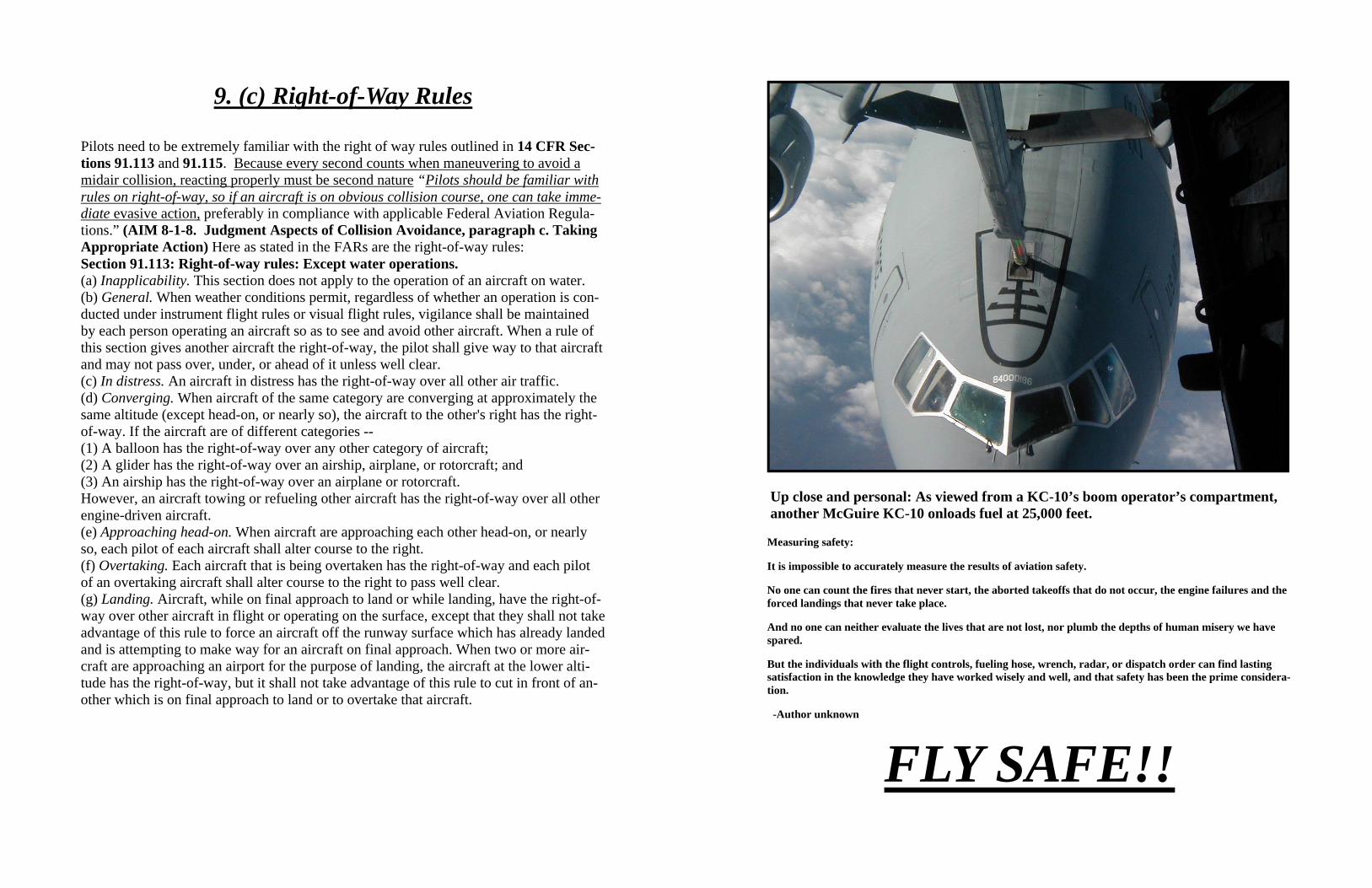
9. (c) Right-of-Way Rules
Pilots need to be extremely familiar with the right of way rules outlined in 14 CFR Sec-tions 91.113 and 91.115. Because every second counts when maneuvering to avoid a midair collision, reacting properly must be second nature “Pilots should be familiar with rules on right-of-way, so if an aircraft is on obvious collision course, one can take imme-diate evasive action, preferably in compliance with applicable Federal Aviation Regula-tions.” (AIM 8-1-8. Judgment Aspects of Collision Avoidance, paragraph c. Taking Appropriate Action) Here as stated in the FARs are the right-of-way rules: Section 91.113: Right-of-way rules: Except water operations. (a) Inapplicability. This section does not apply to the operation of an aircraft on water. (b) General. When weather conditions permit, regardless of whether an operation is con-ducted under instrument flight rules or visual flight rules, vigilance shall be maintained by each person operating an aircraft so as to see and avoid other aircraft. When a rule of this section gives another aircraft the right-of-way, the pilot shall give way to that aircraft and may not pass over, under, or ahead of it unless well clear. (c) In distress. An aircraft in distress has the right-of-way over all other air traffic. (d) Converging. When aircraft of the same category are converging at approximately the same altitude (except head-on, or nearly so), the aircraft to the other's right has the right-of-way. If the aircraft are of different categories -- (1) A balloon has the right-of-way over any other category of aircraft; (2) A glider has the right-of-way over an airship, airplane, or rotorcraft; and (3) An airship has the right-of-way over an airplane or rotorcraft. However, an aircraft towing or refueling other aircraft has the right-of-way over all other engine-driven aircraft. (e) Approaching head-on. When aircraft are approaching each other head-on, or nearly so, each pilot of each aircraft shall alter course to the right. (f) Overtaking. Each aircraft that is being overtaken has the right-of-way and each pilot of an overtaking aircraft shall alter course to the right to pass well clear. (g) Landing. Aircraft, while on final approach to land or while landing, have the right-of-way over other aircraft in flight or operating on the surface, except that they shall not take advantage of this rule to force an aircraft off the runway surface which has already landed and is attempting to make way for an aircraft on final approach. When two or more air-craft are approaching an airport for the purpose of landing, the aircraft at the lower alti-tude has the right-of-way, but it shall not take advantage of this rule to cut in front of an-other which is on final approach to land or to overtake that aircraft.
Measuring safety:
It is impossible to accurately measure the results of aviation safety.
No one can count the fires that never start, the aborted takeoffs that do not occur, the engine failures and the forced landings that never take place.
And no one can neither evaluate the lives that are not lost, nor plumb the depths of human misery we have spared.
But the individuals with the flight controls, fueling hose, wrench, radar, or dispatch order can find lasting satisfaction in the knowledge they have worked wisely and well, and that safety has been the prime considera-tion.
-Author unknown
FLY SAFE!!
Up close and personal: As viewed from a KC-10’s boom operator’s compartment, another McGuire KC-10 onloads fuel at 25,000 feet.

Depiction of departure routing from McGuire AFB Under IMC and VMC weather conditions, the pilots fly three standard instrument depar-tures out of McGuire, the CRESI, MODENA and POINT PLEASANT. Pilots may be “heads down” at times looking at flight instruments to ensure compliance with the depar-ture procedure. Airspeeds range from 200 to 330 knots depending on aircraft gross weight or if a formation rejoin is in progress. Numerous near mid-air collisions (NMAC) have taken place within this airspace, so pay close attention while flying through it, espe-cially when within 15 DME of MAFB at altitudes of 2000 to 8000 feet.
6. (a) McGuire AFB IFR Departure Routes
Do not use for navigation
COMPENSATE FOR DESIGN: Compensate for your aircraft’s design limitations. All planes have blind spots -- know yours! A mid-air potential is a fast low-wing plane over-taking a slow high-wing plane on final approach. EQUIP FOR SAFETY: Your airplane can, in fact, help avoid collisions. Certain equipment once priced out of the market for light aircraft owners, now is available at a reasonable cost. High intensity strobe lights and transponders are just two examples of equipment that can increase your safety margin. Even collision avoidance devices are becoming more affordable. Make sure you have the transponder on and “squawking” your altitude. TALK AND LISTEN: Use your radios as well as your eyes. When approaching an air-port, whether or not your going to land, call on the appropriate frequency at least 15 miles out and relay your position, altitude, and intentions. Since detecting a small aircraft at a distance is not easy, make use of any hints you get over the radio. A pilot reporting his or her position to a tower is also reporting to you! Once you have that particular traffic in sight, don’t forget the rest of the sky. If your traffic is moving in your windscreen, you’re probably not on a collision course so continue your scan and watch that traffic from time to time. However, if that traffic appears to be stationary in your windscreen, you’re probably on a collision course with it. Be prepared to take evasive action. SCAN! SCAN! SCAN!: The most important part of your checklist, of course, is to keep looking where you’re going and to watch for traffic. Scan continuously!! Review the scanning techniques portion of this publication. Basically, if you use sound airmanship, keep yourself and your plane in good shape, and develop an effective scanning technique, you’ll have no trouble avoiding in-flight colli-sions. Remember, aviation in itself is not inherently dangerous but to an even greater de-gree than the sea, it is terribly unforgiving of any carelessness, incapacity, or neglect so KEEP YOUR EYES LOOKING OUT SIDE!!! FOCUS DISTANTLY SO AS TO DETECT POTENTIAL CONFLICTS AS EARLY AS POSSIBLE!!!
With this checklist I must comply before I take off in the inviting sky

Collision avoidance involves much more than proper eyeball techniques. You can be the most conscientious scanner in the world and still have an in-flight collision if you neglect other important factors in the over all see-and-avoid picture. It might be helpful to use a collision avoidance checklist as religiously as you do the takeoff and landing checklists. Such a checklist might include the following items: CHECK YOURSELF: Start with a check of your own condition. Your safety de-pends on your mental and physical condition. Many impairments such as fatigue are in-sidious. Make an honest assessment of your condition. PLAN AHEAD: Plan your flight ahead of time. Have charts folded in proper se-quence and within handy reach. Keep your cockpit free of clutter. Be familiar with headings, frequencies, distances, etc. ahead of time so you spend minimum time with your head down in the charts. Some pilots even jot these things down on a flight log be-fore takeoff. Check your maps and the special, general, and area notices in the AIM in advance for restricted areas, jet training areas, military training routes, and other high density areas. CLEAN WINDOWS: During the walk around, make sure your windshield is clean. If possible, keep all windows clear of obstructions. Even little bug spots can block your view of an approaching aircraft in your flight path. ADHERE TO S.O.P.’s: Stick to standard operating procedures and observe the regula-tions of flight, such as correct altitudes and proper pattern practices. In most in-flight collisions, at least one of the pilots involved was not where he or she was supposed to be. AVOID CROWDS: Avoid congested airspace. You can navigate on VFR days just as accurately by passing slightly to the right of VOR stations rather than directly overhead. Pass over airports at a safe altitude, being particularly careful within a 25 mile radius of busy military or civilian fields. Plan to transit McGuire’s airspace at VFR altitudes above 3000 ft MSL to avoid the traffic pattern. If unable, plan to fly at 1500 ft or 2500 ft MSL to avoid co-altitude conflicts.
1. CHECK YOURSELF 2. PLAN AHEAD 3. CLEAN WINDOWS 4. ADHERE TO S.O.P.’S 5. AVOID CROWDS
6. COMPENSATE FOR DESIGN 7. EQUIP FOR SAFETY 8. TALK AND LISTEN 9. SCAN! SCAN! SCAN!
9. (b) Collision Avoidance Checklist
6. (a) McGuire AFB IFR Arrival Routes
Depiction of arrival routing to McGuire AFB Pilots return to McGuire from all directions. From the West, The Harrisburg VOR brings aircraft over northern Philadelphia. From the South, pilots fly in from the Sea Isle VOR. From the north and east, the traffic comes primarily from the Hampton VOR. Within 30 miles of the field, most of the arriving traffic will be found between 3000 and 8000 feet flying 250 knots.
Do not use for navigation
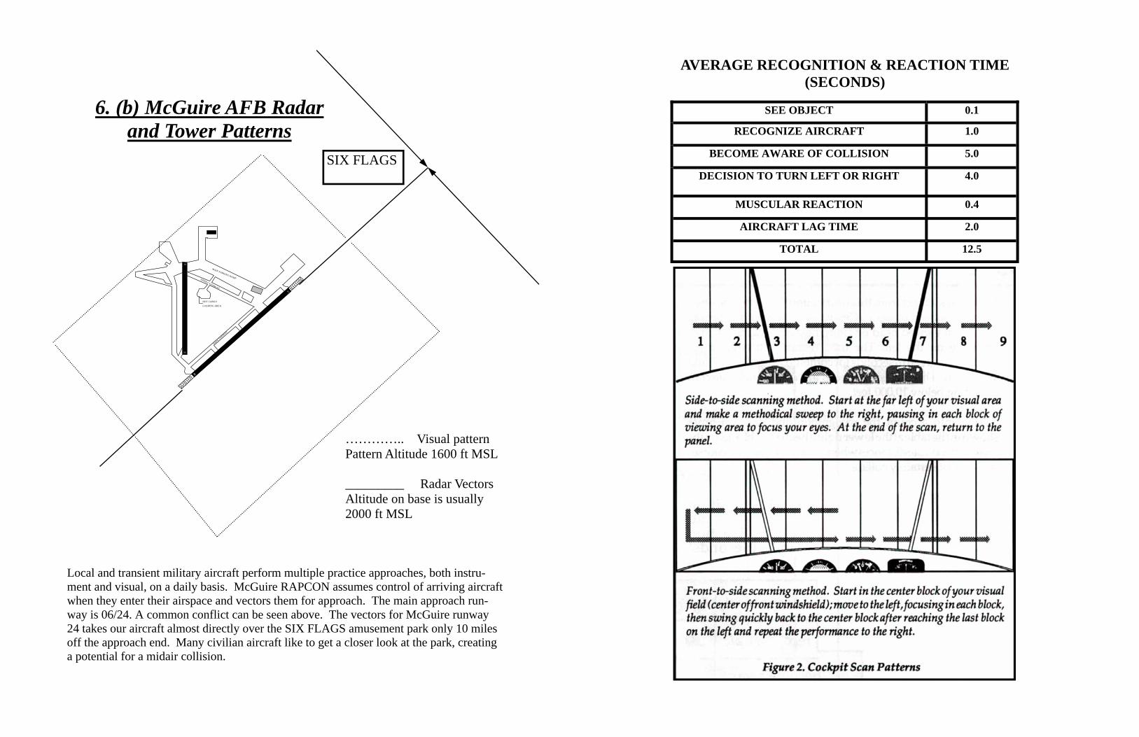
Local and transient military aircraft perform multiple practice approaches, both instru-ment and visual, on a daily basis. McGuire RAPCON assumes control of arriving aircraft when they enter their airspace and vectors them for approach. The main approach run-way is 06/24. A common conflict can be seen above. The vectors for McGuire runway 24 takes our aircraft almost directly over the SIX FLAGS amusement park only 10 miles off the approach end. Many civilian aircraft like to get a closer look at the park, creating a potential for a midair collision.
06
24
18
36
SIERRA TAXIWAY
HOT CARGO
LOADING AREA
MAIN PARKING RAMP
\PAPA TAXIWAY
SIX FLAGS
………….. Visual pattern Pattern Altitude 1600 ft MSL _________ Radar Vectors Altitude on base is usually 2000 ft MSL
6. (b) McGuire AFB Radar and Tower Patterns
AVERAGE RECOGNITION & REACTION TIME (SECONDS)
SEE OBJECT 0.1
RECOGNIZE AIRCRAFT 1.0
BECOME AWARE OF COLLISION 5.0
DECISION TO TURN LEFT OR RIGHT 4.0
MUSCULAR REACTION 0.4
AIRCRAFT LAG TIME 2.0
TOTAL 12.5

6. (c) Tactical Arrival & Departure (TAD) Procedures
All aircraft stationed at McGuire AFB (C-17s, KC-10s, and KC-135s) have begun prac-ticing non-standard arrivals and departures, known as Tactical Arrival & Departure or TAD procedures, on a regular basis. McGuire aircrews practice these maneuvers to pre-pare for operations into high threat environments overseas. The maneuvers are designed to minimize exposure from various threats on the ground. Aircrews operate under Visual Flight Rules (VFR) while performing TAD procedures. Other aircraft in the vicinity of McGuire need to be aware that these procedures include spiral up and down maneuvers with high rates of ascent and descent. These maneuvers begin or terminate at altitudes as high as 5500 feet MSL. Flying above the Class D airspace of McGuire AFB did not nor-mally create a conflict previous to the implementation of TAD procedures. However, this is no longer the case. Other than an effective scanning technique, the best method for ensuring no conflicts occur is to establish radio communication with McGuire’s RAP-CON, frequency 124.15.
Depicted flight paths of a spiral up departure and a spiral down arrival
TAD Lights Out Operations
Two times a week, from 2200 to approximately 2330 on Monday and Friday evenings, McGuire AFB turns off all airfield lighting to enable night vision goggle (NVG) training for C-17 aircrew. This training is designed to increase the proficiency level of aircrew for operations into blacked out high-threat airfields overseas. Be aware that during these time periods McGuire AFB will not be visible for use as a visual reference. Additionally, C-17s will be conducting TAD procedures as part of these operations.
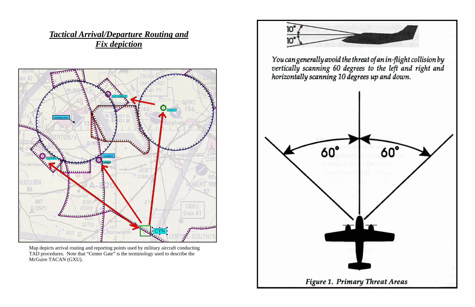
Map depicts arrival routing and reporting points used by military aircraft conducting TAD procedures. Note that “Center Gate” is the terminology used to describe the McGuire TACAN (GXU).
Tactical Arrival/Departure Routing and Fix depiction
LEMMON
—–
CENTER GATE
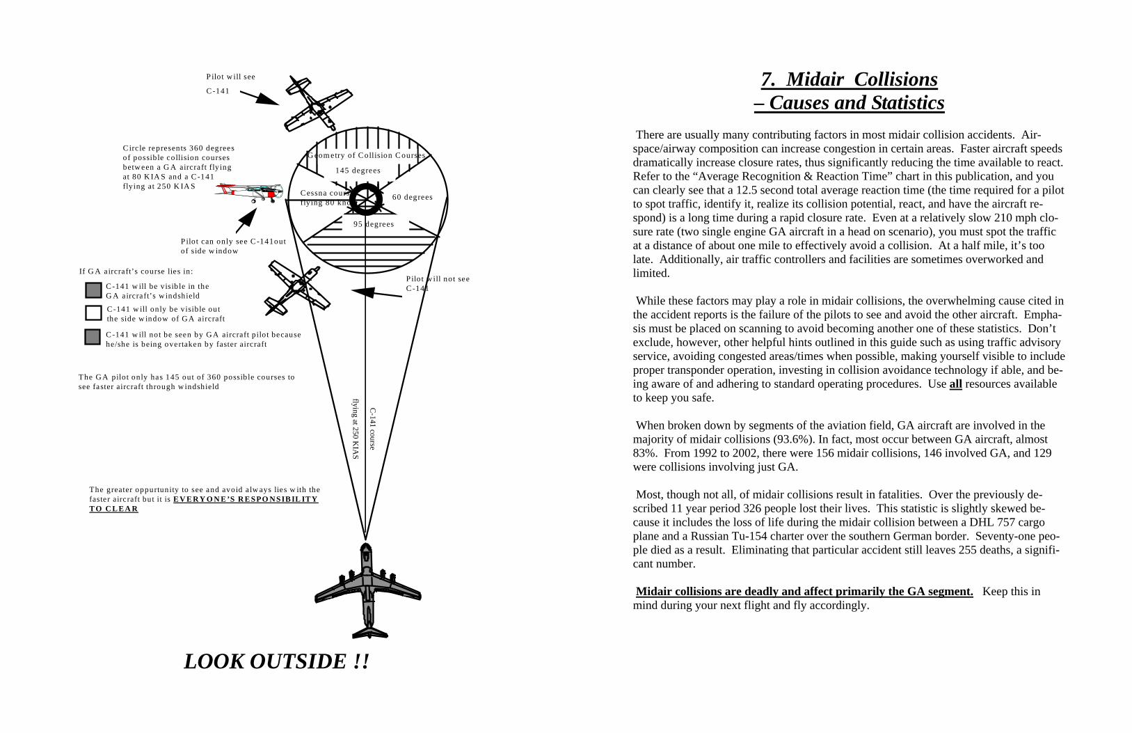
G eom etry of C ollision C ourses
95 degrees
60 degrees
145 degrees
C essna courseflying 80 knots
P ilo t w ill not seeC -141
Pilot can only see C -141outof side w indow
P ilot w ill see
C -141
C irc le represents 360 degreesof possible collision coursesbetw een a G A aircraft flyingat 80 K IA S and a C -141flying at 250 K IA S
If G A aircraft’s course lies in:
C -141 w ill be visib le in theG A aircraft’s w indshield
C -141 w ill only be visible outthe side w indow of G A aircraft
C -141 w ill not be seen by G A aircraft pilot becausehe/she is being overtaken by faster aircraft
C-141 course
flying at 250 KIA
S
The G A pilot only has 145 out of 360 possible courses tosee faster aircraft through w indshield
The greater oppurtunity to see and avoid a lw ays lies w ith thefaster aircraft but it is E V E R Y O N E ’S R E SPO N SIB IL IT YT O C L E A R
LOOK OUTSIDE !!
7. Midair Collisions – Causes and Statistics
There are usually many contributing factors in most midair collision accidents. Air-space/airway composition can increase congestion in certain areas. Faster aircraft speeds dramatically increase closure rates, thus significantly reducing the time available to react. Refer to the “Average Recognition & Reaction Time” chart in this publication, and you can clearly see that a 12.5 second total average reaction time (the time required for a pilot to spot traffic, identify it, realize its collision potential, react, and have the aircraft re-spond) is a long time during a rapid closure rate. Even at a relatively slow 210 mph clo-sure rate (two single engine GA aircraft in a head on scenario), you must spot the traffic at a distance of about one mile to effectively avoid a collision. At a half mile, it’s too late. Additionally, air traffic controllers and facilities are sometimes overworked and limited. While these factors may play a role in midair collisions, the overwhelming cause cited in the accident reports is the failure of the pilots to see and avoid the other aircraft. Empha-sis must be placed on scanning to avoid becoming another one of these statistics. Don’t exclude, however, other helpful hints outlined in this guide such as using traffic advisory service, avoiding congested areas/times when possible, making yourself visible to include proper transponder operation, investing in collision avoidance technology if able, and be-ing aware of and adhering to standard operating procedures. Use all resources available to keep you safe. When broken down by segments of the aviation field, GA aircraft are involved in the majority of midair collisions (93.6%). In fact, most occur between GA aircraft, almost 83%. From 1992 to 2002, there were 156 midair collisions, 146 involved GA, and 129 were collisions involving just GA. Most, though not all, of midair collisions result in fatalities. Over the previously de-scribed 11 year period 326 people lost their lives. This statistic is slightly skewed be-cause it includes the loss of life during the midair collision between a DHL 757 cargo plane and a Russian Tu-154 charter over the southern German border. Seventy-one peo-ple died as a result. Eliminating that particular accident still leaves 255 deaths, a signifi-cant number. Midair collisions are deadly and affect primarily the GA segment. Keep this in mind during your next flight and fly accordingly.
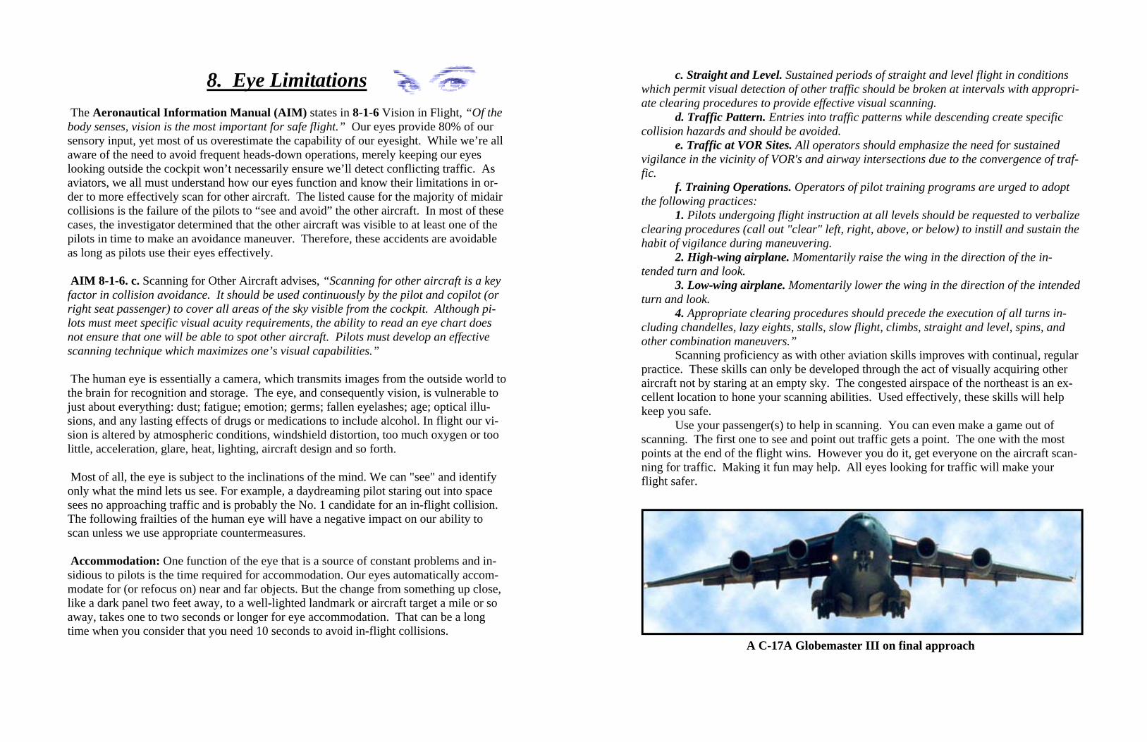
8. Eye Limitations The Aeronautical Information Manual (AIM) states in 8-1-6 Vision in Flight, “Of the body senses, vision is the most important for safe flight.” Our eyes provide 80% of our sensory input, yet most of us overestimate the capability of our eyesight. While we’re all aware of the need to avoid frequent heads-down operations, merely keeping our eyes looking outside the cockpit won’t necessarily ensure we’ll detect conflicting traffic. As aviators, we all must understand how our eyes function and know their limitations in or-der to more effectively scan for other aircraft. The listed cause for the majority of midair collisions is the failure of the pilots to “see and avoid” the other aircraft. In most of these cases, the investigator determined that the other aircraft was visible to at least one of the pilots in time to make an avoidance maneuver. Therefore, these accidents are avoidable as long as pilots use their eyes effectively. AIM 8-1-6. c. Scanning for Other Aircraft advises, “Scanning for other aircraft is a key factor in collision avoidance. It should be used continuously by the pilot and copilot (or right seat passenger) to cover all areas of the sky visible from the cockpit. Although pi-lots must meet specific visual acuity requirements, the ability to read an eye chart does not ensure that one will be able to spot other aircraft. Pilots must develop an effective scanning technique which maximizes one’s visual capabilities.” The human eye is essentially a camera, which transmits images from the outside world to the brain for recognition and storage. The eye, and consequently vision, is vulnerable to just about everything: dust; fatigue; emotion; germs; fallen eyelashes; age; optical illu-sions, and any lasting effects of drugs or medications to include alcohol. In flight our vi-sion is altered by atmospheric conditions, windshield distortion, too much oxygen or too little, acceleration, glare, heat, lighting, aircraft design and so forth. Most of all, the eye is subject to the inclinations of the mind. We can "see" and identify only what the mind lets us see. For example, a daydreaming pilot staring out into space sees no approaching traffic and is probably the No. 1 candidate for an in-flight collision. The following frailties of the human eye will have a negative impact on our ability to scan unless we use appropriate countermeasures. Accommodation: One function of the eye that is a source of constant problems and in-sidious to pilots is the time required for accommodation. Our eyes automatically accom-modate for (or refocus on) near and far objects. But the change from something up close, like a dark panel two feet away, to a well-lighted landmark or aircraft target a mile or so away, takes one to two seconds or longer for eye accommodation. That can be a long time when you consider that you need 10 seconds to avoid in-flight collisions.
c. Straight and Level. Sustained periods of straight and level flight in conditions which permit visual detection of other traffic should be broken at intervals with appropri-ate clearing procedures to provide effective visual scanning.
d. Traffic Pattern. Entries into traffic patterns while descending create specific collision hazards and should be avoided.
e. Traffic at VOR Sites. All operators should emphasize the need for sustained vigilance in the vicinity of VOR's and airway intersections due to the convergence of traf-fic.
f. Training Operations. Operators of pilot training programs are urged to adopt the following practices:
1. Pilots undergoing flight instruction at all levels should be requested to verbalize clearing procedures (call out "clear" left, right, above, or below) to instill and sustain the habit of vigilance during maneuvering.
2. High-wing airplane. Momentarily raise the wing in the direction of the in-tended turn and look.
3. Low-wing airplane. Momentarily lower the wing in the direction of the intended turn and look.
4. Appropriate clearing procedures should precede the execution of all turns in-cluding chandelles, lazy eights, stalls, slow flight, climbs, straight and level, spins, and other combination maneuvers.”
Scanning proficiency as with other aviation skills improves with continual, regular practice. These skills can only be developed through the act of visually acquiring other aircraft not by staring at an empty sky. The congested airspace of the northeast is an ex-cellent location to hone your scanning abilities. Used effectively, these skills will help keep you safe.
Use your passenger(s) to help in scanning. You can even make a game out of scanning. The first one to see and point out traffic gets a point. The one with the most points at the end of the flight wins. However you do it, get everyone on the aircraft scan-ning for traffic. Making it fun may help. All eyes looking for traffic will make your flight safer.
A C-17A Globemaster III on final approach
But don't forget that your eyes are subject to optical illusions and can play some nasty tricks on you. At one mile, for example, an aircraft flying below your altitude will appear to be above you. As it nears, it will seem to descend and go through your level, yet, all the while it will be straight and level below you. One in-flight collision occurred when the pilot of the higher flying airplane experienced this illusion and dove his plane right into the path of the aircraft flying below.
Though you may not have much time to avoid another aircraft in your vicinity,
use your head when making defensive moves. Even if you must maneuver to avoid a real in-flight collision, consider all the facts. If you miss the other aircraft but stall at a low altitude, the results may be the same for you.
Your best defense against in-flight collisions is an efficient scan pattern. Two
basic methods that have proved best for most pilots employ the "block" system of scan-ning. This type of scan is based on the theory that traffic detection can be made only through a series of eye fixations at different points in space. Each of these fixes becomes the focal point of your field of vision (a block 10-15° wide). By fixating object in each block, you get 9-12 "blocks" in your scan area, each requiring a minimum of one to two seconds for accommodation and detection.
One method of block scanning is the "side-to-side" motion. Start at the far left of
your visual area and make a methodical sweep to the right, pausing in each block to fo-cus. At the end of the scan, return to the panel.
The second form is the "front-to-side" version. Start with a fixation in the center
block of your visual field (approximately the center of the front windshield in front of the pilot). Move your eyes to the left, focusing in each block, swing quickly back to the cen-ter block, and repeat the performance to the right.
There are other methods of scanning, of course, some of which may be as effec-
tive for you as the two preceding types. Unless some series of fixations is made; how-ever, there is little likelihood that you will be able to detect all targets in your scan area. When the head is in motion, vision is blurred and the mind will not register targets.
The AIM gives guidance on proper clearing in various segments of flight opera-
tions in 4-4-14. Use of Visual Clearing Procedures. “a. Before Takeoff. Prior to taxiing onto a runway or landing area in preparation
for takeoff, pilots should scan the approach areas for possible landing traffic and execute the appropriate clearing maneuvers to provide them a clear view of the approach areas.
b. Climbs and Descents. During climbs and descents in flight conditions which permit visual detection of other traffic, pilots should execute gentle banks, left and right at a frequency which permits continuous visual scanning of the airspace about them.
Empty Field Myopia: A focusing problem usually occurring at very high altitudes, but it can also happen at lower levels on vague, colorless days above a haze or cloud layer when no distinct horizon is visible. If there is little or nothing to focus on at infinity, we do not focus at all. We experience something known as "empty-field myopia"; we stare but see nothing, even opposing traffic, if it should enter our visual field. Binocular Vision: The National Transportation Safety Board (NTSB) has seriously studied the effects of what is called “binocular vision” during investigations of in-flight collisions, with the conclusions that this is also a casual factor. To actually accept what we see, we need to receive cues from both eyes. If an object is visible to one eye, but hid-den from the other by a windshield post or other obstruction, the total image is blurred and not always acceptable to the mind. See “The Framing Game” on the next page to test your eyes in a demonstration on binocular vision. Tunnel Vision: Another inherent eye problem is that of narrow field of vision. Although our eyes accept light rays from an arc of nearly 200°, they are limited to a relatively nar-row area (approximately 10-15°) in which they can actually focus and classify an object. Though we can perceive movement in the periphery, we cannot identify what is happen-ing out there. An aircraft on a collision course will generally not have any perceived mo-tion and is therefore only detectable through the focal area of vision. We also tend not to believe what we see out of the corner of our eyes. This, aided by the brain, often leads to "tunnel vision." Blossom Effect: This limitation is compounded by the fact that at a distance an aircraft on a collision course with you will appear to be motionless. It will remain in a seemingly stationary position, without appearing either to move or to grow in size for a relatively long time, and then suddenly bloom into a huge mass filling one of your windows. This is known as "blossom effect." Since we need motion or contrast to attract our eyes' atten-tion, this becomes a frightening factor when you realize that a large bug smear or dirty spot on the windshield can hide a converging plane until he's too close to be avoided. In addition to the built-in problems, the eye is also severely limited by environment. Opti-cal properties of the atmosphere alter the appearance of traffic, particularly on hazy days. "Limited visibility" actually means, "limited vision." Three miles visibility may be legal VFR, but at that distance on a hazy day opposing traffic is not easy to detect. At a range closer than three miles—even though detectable—it may not be avoidable. Lighting also affects our vision stimuli. Glare, usually worse on a sunny day over a cloud deck or during flight directly into the sun, makes objects hard to see and scanning uncom-fortable. Also, a well-lit object against a darker background will have a high degree of contrast and thus easily detectable. Conversely, an object with low contrast at the same distance will be impossible to see. For instance, when the sun is behind you, an opposing
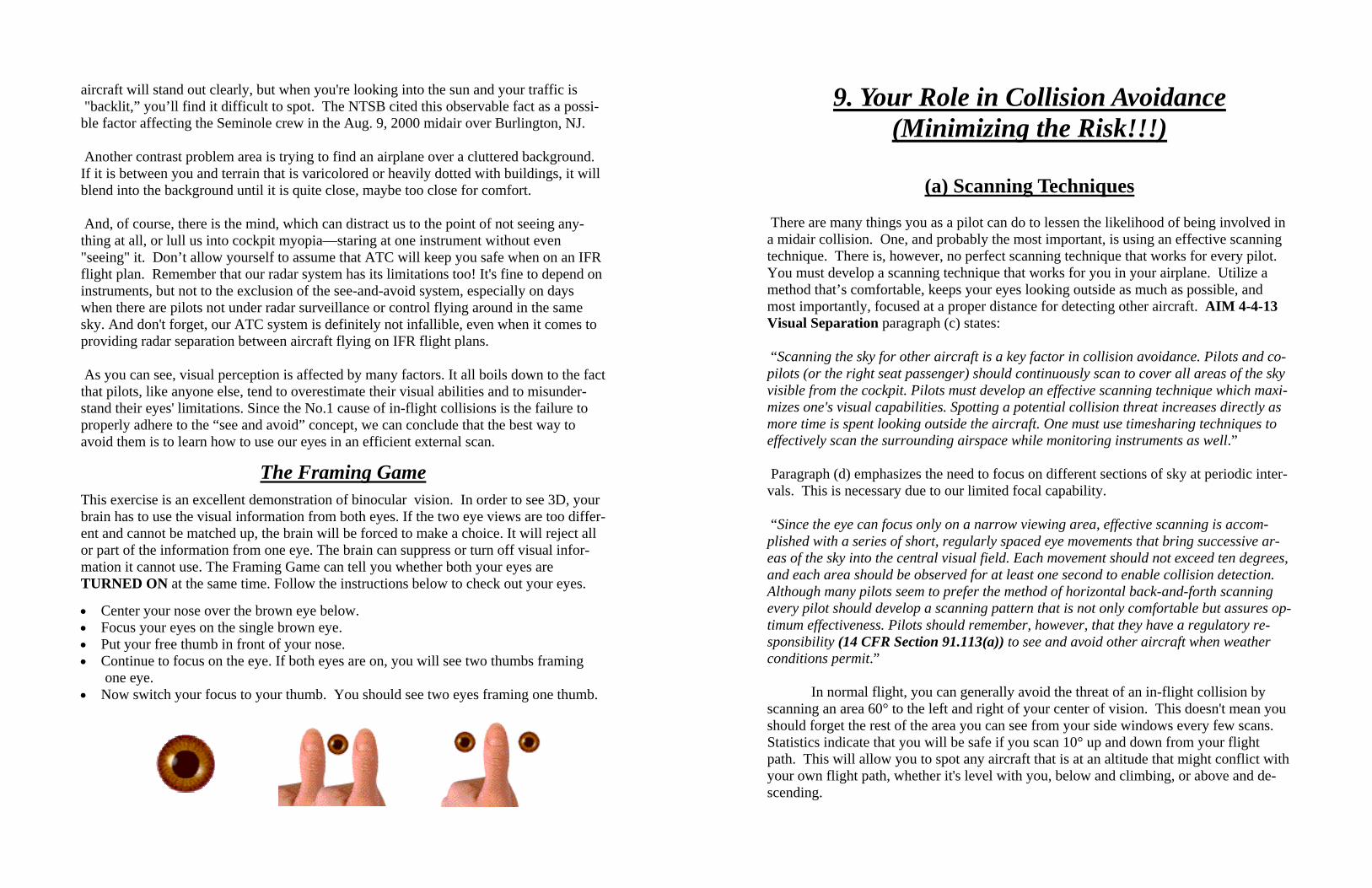
aircraft will stand out clearly, but when you're looking into the sun and your traffic is "backlit,” you’ll find it difficult to spot. The NTSB cited this observable fact as a possi-ble factor affecting the Seminole crew in the Aug. 9, 2000 midair over Burlington, NJ. Another contrast problem area is trying to find an airplane over a cluttered background. If it is between you and terrain that is varicolored or heavily dotted with buildings, it will blend into the background until it is quite close, maybe too close for comfort. And, of course, there is the mind, which can distract us to the point of not seeing any-thing at all, or lull us into cockpit myopia—staring at one instrument without even "seeing" it. Don’t allow yourself to assume that ATC will keep you safe when on an IFR flight plan. Remember that our radar system has its limitations too! It's fine to depend on instruments, but not to the exclusion of the see-and-avoid system, especially on days when there are pilots not under radar surveillance or control flying around in the same sky. And don't forget, our ATC system is definitely not infallible, even when it comes to providing radar separation between aircraft flying on IFR flight plans. As you can see, visual perception is affected by many factors. It all boils down to the fact that pilots, like anyone else, tend to overestimate their visual abilities and to misunder-stand their eyes' limitations. Since the No.1 cause of in-flight collisions is the failure to properly adhere to the “see and avoid” concept, we can conclude that the best way to avoid them is to learn how to use our eyes in an efficient external scan.
The Framing Game
This exercise is an excellent demonstration of binocular vision. In order to see 3D, your brain has to use the visual information from both eyes. If the two eye views are too differ-ent and cannot be matched up, the brain will be forced to make a choice. It will reject all or part of the information from one eye. The brain can suppress or turn off visual infor-mation it cannot use. The Framing Game can tell you whether both your eyes are TURNED ON at the same time. Follow the instructions below to check out your eyes.
• Center your nose over the brown eye below. • Focus your eyes on the single brown eye. • Put your free thumb in front of your nose. • Continue to focus on the eye. If both eyes are on, you will see two thumbs framing one eye. • Now switch your focus to your thumb. You should see two eyes framing one thumb.
9. Your Role in Collision Avoidance (Minimizing the Risk!!!)
(a) Scanning Techniques
There are many things you as a pilot can do to lessen the likelihood of being involved in a midair collision. One, and probably the most important, is using an effective scanning technique. There is, however, no perfect scanning technique that works for every pilot. You must develop a scanning technique that works for you in your airplane. Utilize a method that’s comfortable, keeps your eyes looking outside as much as possible, and most importantly, focused at a proper distance for detecting other aircraft. AIM 4-4-13 Visual Separation paragraph (c) states: “Scanning the sky for other aircraft is a key factor in collision avoidance. Pilots and co-pilots (or the right seat passenger) should continuously scan to cover all areas of the sky visible from the cockpit. Pilots must develop an effective scanning technique which maxi-mizes one's visual capabilities. Spotting a potential collision threat increases directly as more time is spent looking outside the aircraft. One must use timesharing techniques to effectively scan the surrounding airspace while monitoring instruments as well.” Paragraph (d) emphasizes the need to focus on different sections of sky at periodic inter-vals. This is necessary due to our limited focal capability. “Since the eye can focus only on a narrow viewing area, effective scanning is accom-plished with a series of short, regularly spaced eye movements that bring successive ar-eas of the sky into the central visual field. Each movement should not exceed ten degrees, and each area should be observed for at least one second to enable collision detection. Although many pilots seem to prefer the method of horizontal back-and-forth scanning every pilot should develop a scanning pattern that is not only comfortable but assures op-timum effectiveness. Pilots should remember, however, that they have a regulatory re-sponsibility (14 CFR Section 91.113(a)) to see and avoid other aircraft when weather conditions permit.”
In normal flight, you can generally avoid the threat of an in-flight collision by scanning an area 60° to the left and right of your center of vision. This doesn't mean you should forget the rest of the area you can see from your side windows every few scans. Statistics indicate that you will be safe if you scan 10° up and down from your flight path. This will allow you to spot any aircraft that is at an altitude that might conflict with your own flight path, whether it's level with you, below and climbing, or above and de-scending.