from geography to medicine: exploring innerspace via spatial and temporal databases dev oliver 1...
Post on 19-Dec-2015
214 views
TRANSCRIPT
From Geography to Medicine: Exploring Innerspace via Spatial and Temporal Databases
Dev Oliver1
Daniel J. Steinberger2
1Department of Computer Science and Engineering, University of Minnesota, USA2Department of Radiology, Medical School, University of Minnesota, USA

Outline
Motivation
Vision
Challenges
http://travel.spotcoolstuff.com/unusual-museum/amsterdam/corpus-human-body

Motivation (1/2)
Improve healthcare quality Deliver the correct diagnosis Simplify tracking of disease and determine response to therapy Reduce healthcare expenses
Medical imaging growing disproportionately Large amounts of Spatial and Temporal data
Source: CDC, Health, United States, 2009 In Brief

Motivation (2/2)
10 year Medical Imaging Debacle: The $1 Trillion freight train (no growth)
© 2010 Daniel Steinberger
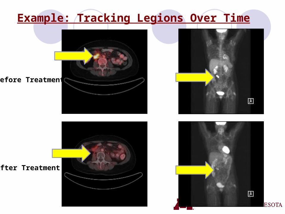
Example: Tracking Legions Over Time
Before Treatment
After Treatment
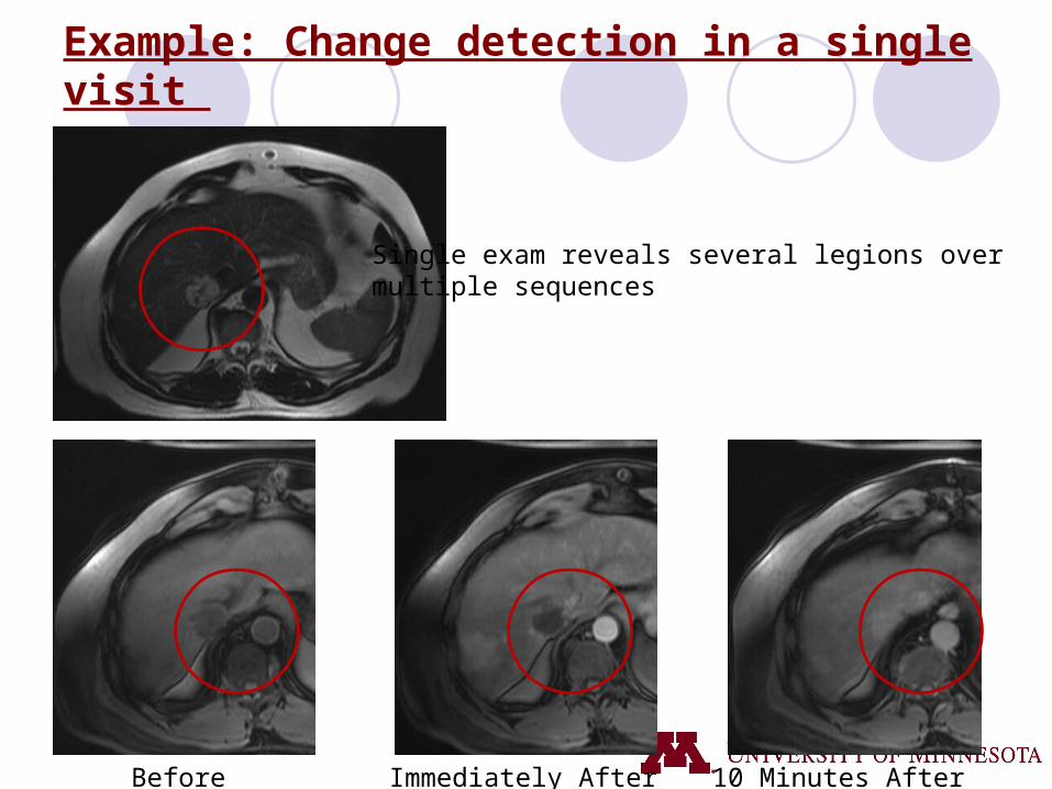
Example: Change detection in a single visit
Before Immediately After 10 Minutes After
Single exam reveals several legions over multiple sequences

Spatial and Temporal Databases
Useful for longitudinal study Monitoring
How is a crime hotspot spreading/shrinking over time?What are the recurring changes in the environment?
PredictiveWhich counties have emerging cancer clusters?
RoutingWhat is the best route from DTC to MSP during rush hour/non rush hour?
http://maps.google.com/

How may Spatial and Temporal Databases help Medicine?
Vision: A spatial-temporal framework for longitudinal study in which crucial monitoring, predictive, and routing questions may be answered algorithmically Monitoring
How is a cancerous growth spreading/shrinking over time?Have blood vessels narrowed past a certain threshold?What are the emerging symptoms in a patient?
PredictiveHow can the therapy effect on tumors across a population be used as a guide for
future therapies?What are the long term and short term trends in a patient’s liver panel test results?
What are the exceptions to the long term trend?When will a patient develop coronary artery disease?
RoutingWhat is the best route for minimally invasive surgery to remove a tumor?Which route for precision surgery tools minimizes damage to blood vessels?What is the best route to deliver life-saving medicine?
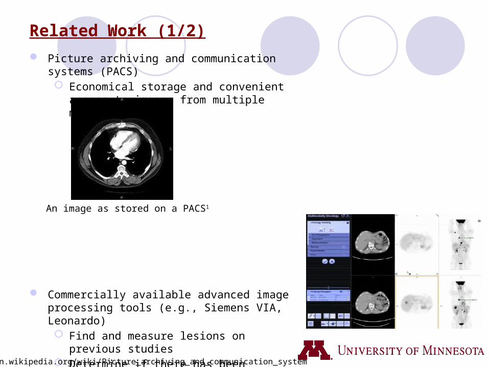
Related Work (1/2)
Picture archiving and communication systems (PACS) Economical storage and convenient access to images
from multiple machine types
Commercially available advanced image processing tools (e.g., Siemens VIA, Leonardo) Find and measure lesions on previous studies Determine if there has been relative mass loss in
certain parts of the brain
1http://en.wikipedia.org/wiki/Picture_archiving_and_communication_system
An image as stored on a PACS1

Related Work (2/2)
Limited exploratory, associative and predictive analysis capabilities Exploratory
Enable user to construct completely new queries on the data set (beyond a fixed list of canned queries)
PredictiveUse time series of snapshots to determine future behavior using data driven
techniques Associative
Correlate patient’s history and context (e.g., age, race, co-morbidities)
Largely based on raster data model (e.g., pixel, voxel) Inadequate support for vector data models (e.g., points, line strings, polygons, networks)
and queries (e.g., topological operations, shortest path, etc.)
No general frame of reference similar to geographic-based latitude/longitude or postal addresses

Challenges
1. A reference frame analogous to latitude/longitude must be developed for the human body Stereotactic surgery
2. Location determination methods are needed to know where we are in the body Remote telesurgical operation using surgical robots
3. Routing in a continuous space while reducing the invasiveness of certain procedures Deliver life-saving cancer-killing chemicals to brain tumors
4. Defining and capturing change across two images is crucial for understanding trends When will an infection metastasize?
5. Scalability to potential Petabyte and Exabyte-sized data sets Medical images captured more frequently for more people
6. Real-time mapping, change detection, and routing Change route to tumor on detection of unmapped blood vessel

Challenge 1: Reference frame for the human body (1/2)
Define coordinate systems to facilitate looking across snapshots
Rigid structures may provide clues on current spatial location Used in Stereotactic surgery to locate small targets in the body for biopsy, injection, etc.
http://en.wikipedia.org/wiki/Stereotactic_surgery
http://en.wikipedia.org/wiki/Stereotactic_surgery

Challenge 1: Reference frame for the human body (2/2)
Identify nodes (e.g., start and end of branches), edges (e.g., vessels linking nodes), and locations on branches (e.g., using distance from end-nodes) Equivalent to use of street addresses by the US Post Office
Resolution important in automatically aligning certain structures in the body across snapshots Difficult if coordinate system’s resolution is too coarse
Generality across gender, age and other demographic variables
Reference frames for human body harder than those for Earth
http://www.medtrng.com/anatomy%20lesson/bph5.htm

Challenge 2: Location Determination
Pinpoint specific locations/places in the body Remote telesurgical operation using surgical robots
Analogous to Using GPS to determine one’s location on the earth
Challenge lies in aligning each structure in the body across multiple 3-D images so that it can be guaranteed that the same structure is being observed.
Fantastic Voyage, IMDB, 1966, http://www.imdb.com/title/tt0060397/
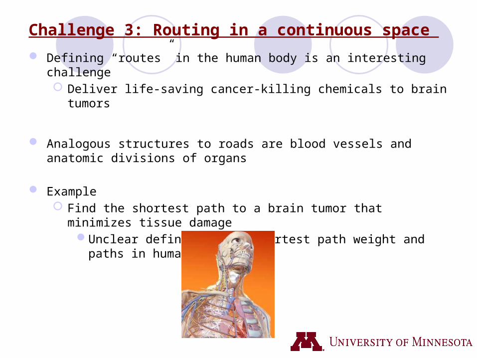
Challenge 3: Routing in a continuous space
Defining “routes” in the human body is an interesting challenge Deliver life-saving cancer-killing chemicals to brain tumors
Analogous structures to roads are blood vessels and anatomic divisions of organs
Example Find the shortest path to a brain tumor that minimizes tissue damage
Unclear definitions of shortest path weight and paths in human body

Challenge 4: Defining change across snapshots
Change detection in tumors where images at different times need to be observed When will a tumor metastasize (spread)?
Images may be taken with different instruments across several visits
Calibration becomes a problem Changes in body chemistry can impact imaging and should be accounted for
E.g., Fasting status pre-PET scan which alters physiologic distribution of radiotracer

Challenge 5: Scalability
Need to scale up to Petabyte and Exabyte-sized data sets Large amounts of data produced from medical imaging techniques Replicating data across snapshots makes long term analysis prohibitive
Compression techniques not adequate for dynamic 3-D data with features like interactive zoom in and out across the time dimension Each snapshot of a large image might be approximately 8 - 16 gigabytes
When this is multiplied by number of visits, number of images/visit and number of patients, scale increases to Exabytes

Challenge 6: Real-time mapping, change detection, routing
Real-time tracking of medical devices in peoples bloodstream, digestive tract, etc. E.g., tracking a device containing a tiny camera
Useful in emergency room settings
Dynamically detecting and reacting to changes Automatically increase/decrease medication based on patient’s reaction
Routing on the fly Change route based on new discovery such as rupture in blood vessels
Capsule endoscopyhttp://en.wikipedia.org/wiki/Capsule_endoscopy

Summary
How can spatial and temporal databases help medicine?
Vision A spatial-temporal framework capable of answering long term questions
Improve health care quality Provide doctors with a means of more quickly characterizing disease progression
Challenges Defining a reference frame for the human body Location determination Routing in a continuous space, Observing change across snapshots Scalability Real time mapping, change detection, routing
We encourage the Spatial Computing community to explore the vision and challenges we have proposed and we welcome future collaboration

Thank You!
Questions?
This material is based upon work supported by the National Science Foundation under Grant No. 1029711, III-CXT IIS-0713214, IGERT DGE-0504195, CRI:IAD CNS-0708604, and USDOD under Grant No. HM1582-08-1-0017, HM1582-07-1-2035, and W9132V-09-C-0009
University of Minnesota Spatial Databases and Spatial Data Mining Research Group, www.spatial.cs.umn.edu
Professor Shashi Shekhar and Kim Koffolt
Acknowledgement
SSTD Reviewers
Dev Oliver, [email protected] J. Steinberger, [email protected]