fuel management considerations in caribbean pine …
TRANSCRIPT

FUEL MANAGEMENT CONSIDERATIONS IN CARIBBEAN PINE
FORESTS OF THE MOUNTAIN PINE RIDGE OF BELIZE, CENTRAL
AMERICA
______________________________________________________
A Thesis presented to the Faculty of the Graduate School
University of Missouri-Columbia
________________________________________________________________________
In Partial Fulfillment of the Requirements for the Degree
Master of Science
________________________________________________________________________
By
RON COLATSKIE
Dr. Rose-Marie Muzika, Thesis Supervisor
May 2011

The undersigned, appointed by the Dean of the Graduate School, have examined the
thesis entitled
FUEL MANAGEMENT CONSIDERATIONS IN CARIBBEAN PINE FORESTS OF
THE MOUNTAIN PINE RIDGE OF BELIZE, CENTRAL AMERICA
Presented by Ron Colatskie
a candidate for the degree of Master of Science
and hereby certify that in their opinion that is worthy of acceptance
_____________________________________________
Rose-Marie Muzika, Ph.D.
_____________________________________________
John Dwyer, Ph.D.
_____________________________________________
Grant Elliott, Ph.D.

ii
ACKNOWLEDGEMENTS
The journey of the last three years has been unique, exciting, exhausting, and by no means a typical graduate experience. The chain of people it took for me to complete this project is astounding. Thanks to Daniel Beckman and Missouri State University for introducing me to Belize and thanks Matthew Miller of Monkey Bay for introducing me to the Headley family. To Gerald Summers, Robin Hurst, and Bethany Stone for getting me on board with several biology teaching assistantships, without which this journey would have been stopped in its tracks. Thanks to my former employers Carrie Steen with the Missouri Department of Conservation and Glenda Hefty with the Forest Service for giving me experience and fostering my interest in the realm of forestry.
This project would have been impossible if it were not for the man of endless vision and passion for the Mountain Pine Ridge, George Headley. It will always amaze me that a random, inquiring e-mail led to such an amazing experience and untold friendships. I will never forget the generosity of the Headley family as you opened your home to Shelly and I during those winter months of 2010. I am also incredibly grateful for the help of the staff of Bull-Run Overseas, especially Solomon Tzib for your help and pleasant company in the field. To Tom and Marge Gallagher, your hospitality will never be forgotten. Ronnie Martinez, we enjoyed our field excursions with you and I am looking forward to doing so again. I am also grateful for the Dorris D. and Christine M. Brown Fellowship, your contribution made this project come to life. Also to Geoeye Inc. for their GIS imagery grant.
I am incredibly grateful to Rose-Marie Muzika for giving me a chance and accepting me to the graduate program and for her efforts to turn my garbled ramblings into a thesis worthy of submission, your efforts and advice will aid me throughout my career. Thanks to the other committee members John Dwyer and Grant Elliott for their assistance throughout the project. I also appreciate the comments from others including David Larsen, Keith Grabner (thanks for the snake chaps), John Kabrick, Randy Miles and Elma Kay. I appreciate my past and present lab mates Chad King, Sharon Reed, Josh Stevens, and Lizzie Wright for your uplifting and random conversations and entertainment as well as to other fellow graduate students.
And most of all I am ever thankful for my friends and family for your support. To my dad allowing me to make my own path in life, letting me learn from my own mistakes, and instilling in me the idea that a career should be a passion not a job. Without my best friend and wife Shelly, this venture would not have occurred, thanks for giving me the inspiration to go forward with this effort and for your endless love and support.
Dedicated to Janet Lynn Colatskie (Mom) 1954-2000
You left us early, but your imprint will persist throughout my life

iii
Abstract
Situated within the Maya Mountains of Central America, the Mountain Pine Ridge (MPR) ecosystem encompasses approximately 76,000ha (107,000 acres) within the country of Belize. Dominated by Caribbean pine (Pinus caribaea), the MPR is a fire-dependent ecosystem that is currently in transition following a devastating 2001 outbreak of the Southern pine beetle (Dendroctonus frontalis). The beetle outbreak was preceded by an era of fire suppression which recruited dense stands of pine with a hardwood understory. Currently the ecosystem is a patchwork of varying forest conditions from open savanna to stands of pine exceeding 7,000 trees per acre (2832 trees per hectare). Threatening the pine regeneration is the buildup of fuels such as dense thickets of tiger fern (Dicranopteris pectinata), which can carry intense fires. In early 2010, thirty nine plots were established within the eastern portion of the MPR to determine the variation in abundance and height of a variety of fuels including major physiognomic plant groups, coarse woody debris, bare mineral soil, and percent cover of litter within designated units of varying times since fire. The fire return interval units were grouped into three separate fire intervals including recent (1-3 years since fire), midrange (4-10 years) and extended (11+ years). Plant physiognomic groups were also evaluated in plots of varying stand densities and canopy coverage. As expected, hardwoods, shrubs, and litter significantly increase in abundance in extended fire intervals. As expected grasses showed a negative correlation with canopy coverage while tiger fern showed a positive correlation. With respect to tiger fern abundance, GIS analysis was conducted to determine if aspect had an effect, however no significant differences were found.

iv
TABLE OF CONTENTS
Acknowledgements ............................................................................................................ ii
Abstract .............................................................................................................................. iii
List of Figures .................................................................................................................... vi
List of Tables ..................................................................................................................... viii
Introduction ......................................................................................................................... 1
Background ......................................................................................................................... 2
Cultural and Historical Perspective ................................................................................. 2
The Mountain Pine „Ridge‟ ............................................................................................. 3
Climate ............................................................................................................................ 5
Geology ........................................................................................................................... 6
Soils ................................................................................................................................. 7
Current Forest Ecosystem Conditions within the Mountain Pine Ridge ...................... 11
Pine-Oak Savannah and Pine-Oak Forest .................................................................. 12
Broadleaf/Riparian Forest.......................................................................................... 14
Pine/Broadleaf Transition Forest ............................................................................... 15
Vegetation of the Pine-Oak Savannah/Pine-Oak Forest ............................................... 17
Grasses and Sedges .................................................................................................... 17
Tiger Fern .................................................................................................................. 20
Shrubs ........................................................................................................................ 21
Hardwoods ................................................................................................................. 23
Pine ............................................................................................................................ 24
Past Forest Management in the Mountain Pine Ridge .................................................. 26
Southern Pine Beetle Outbreak and Response .............................................................. 28
Fire Ecology and Management in the Mountain Pine Ridge ........................................ 31
Goals of Research ............................................................................................................. 35
Study Area ........................................................................................................................ 37
Methodology ..................................................................................................................... 39
Sampling Site Selection ................................................................................................ 39
Plot Design and Use ...................................................................................................... 40

v
Physiognomic Vegetative Groups ................................................................................. 43
Down Woody Debris, Litter, and Bare Mineral Soil .................................................... 43
Pine Regeneration ......................................................................................................... 43
Canopy Coverage .......................................................................................................... 44
Analysis of Slope Aspect and Tiger Fern Abundance .................................................. 44
Results ............................................................................................................................... 48
Time Since Fire and Vegetative Response .................................................................... 48
Time Since Fire and Pine Regeneration Response........................................................ 52
Percent Canopy Coverage and Vegetative Response .................................................... 53
Time Since Fire Compared to Down Woody Debris, Soil and Litter ........................... 55
Fire Frequency Following the SPB Outbreak ............................................................... 57
GIS Analysis of Tiger Fern ........................................................................................... 59
Discussion ......................................................................................................................... 60
Physiognomic Vegetative Groups ................................................................................. 60
Pine Regeneration Response ......................................................................................... 62
Bare Mineral Soil and Litter.......................................................................................... 63
Down Woody Debris ..................................................................................................... 64
Tiger Fern ...................................................................................................................... 65
Remaining Questions ........................................................................................................ 67
Fire Behavior and Intensity ........................................................................................... 68
Seasonality of Fire ......................................................................................................... 69
Considerations and limitations of Fire Ecology Research ............................................ 70
Considerations and Constraints of the Study ................................................................ 72
Fire Mediated Succession at the Mountain Pine Ridge .................................................... 73
Major Conclusions ............................................................................................................ 75
Literature Review.............................................................................................................. 77

vi
LIST OF FIGURES
Figure 1. Map of Belize ..................................................................................................... 3
Figure 2. Average monthly temperatures ............................................................................ 6
Figure 3. Soils of the Mountain Pine Ridge. ..................................................................... 10
Figure 4. Four typical pine stand conditions of the MPR. ................................................ 13
Figure 5. Broad ecosystems of the MPR. ......................................................................... 16
Figure 6. Limited grass recruitment following an intense fire......................................... 19
Figure 7. Tiger fern. ........................................................................................................ 21
Figure 8. The southern pine beetle. ................................................................................... 31
Figure 9. Wildfire in the MPR. ........................................................................................ 34
Figure 10. Fire regime model developed by The Nature Conservancy (2002) ................ 36
Figure 11. Location of the Mountain Pine Ridge. ............................................................ 38
Figure 12. Example of systematic location of plots. ......................................................... 40
Figure 13. Plot design. ...................................................................................................... 42
Figure 14. Tiger fern as observed from satellite images. .................................................. 45
Figure 15. Sampling design for GIS analysis of tiger fern relative to aspect ................... 47
Figure 16.The mean abundance measured as percent cover of vegetative physiognomic
groups in each of three temporal stages of fire activity on the MPR. ............................. 49
Figure 17. The percent abundance of hardwoods in each of three fire time periods fire at
the MPR. ........................................................................................................................... 49
Figure 18. Hardwood average height in each of three fire time periods.......................... 50
Figure 19. The percent abundance of shrubs in each of three fire time periods. .............. 50
Figure 20. Shrub average height in each of three fire time periods. ................................. 51

vii
Figure 21. The percent of fern abundance in each of three fire time periods. .................. 51
Figure 22. Pine seedlings per acre in each of three fire time periods. .............................. 52
Figure 23. The basal area of pole size pines in each of three fire time periods. ............... 53
Figure 24. Regression indicating the relationship between fern height and percent canopy
coverage ............................................................................................................................ 54
Figure 25. Regression indicating the relationship between abundance of grass and canopy
coverage ............................................................................................................................ 54
Figure 26. The mean abundance for rotten woody debris, coarse woody debris, fine
woody debris, bare mineral soil, and litter relative to recent, midrange and extended fire
intervals. ............................................................................................................................ 56
Figure 27. The percent of plot area in bare mineral soil in each of three fire time periods.
........................................................................................................................................... 56
Figure 28. The percent of plot area in litter in each of three fire time periods. ................ 57
Figure 29. Percent Abundance of coarse woody debris relative to the number of fire
events following the SPB outbreak of 2001. .................................................................... 58
Figure 30. Percent coverage of hardwoods relative to the number of fire events following
SPB outbreak of 2001. ...................................................................................................... 58
Figure 31. Abundance of tiger fern relative to aspect. ..................................................... 59
Figure 32. Typical tiger fern location on the landscape.. .................................................. 67
Figure 33. Conceptual fire regime model and plant community development based on
data and observations from the MPR ................................................................................ 74
viii
LIST OF TABLES
Table 1 Common grass and sedges of the Mountain Pine Ridge. .................................... 18
Table 2 Common Shrubs of the Mountain Pine Ridge ..................................................... 22
Table 3 Common Hardwoods of the Mountain Pine Ridge .............................................. 24

1
Introduction
Situated within the Maya Mountains, the Mountain Pine Ridge (MPR) Ecosystem
encompasses approximately 76,000 hectares (192,000 acres) in the west-central portion
of the Central American country of Belize. The MPR Forest Reserve, owned by the
Belize government, encompasses 44,000 hectares (107,000 acres), comprising the largest
landholding in the MPR. The remaining lands in the MPR ecosystem are owned by
private landowners.
The MPR ecosystem is a fire-dependent community dominated by Caribbean pine (Pinus
caribaea) with a variable component of Honduran pine (Pinus oocarpa). The MPR is
currently in transition following the devastating 2001 outbreak of the southern pine beetle
(SPB) (Dendroctonus frontalis). The outbreak caused an estimated 70-90 percent
mortality of mature pine, thereby, setting back the forest to an early stage of succession
(Headley 2008, FAO 2008). The beetle outbreak was preceded by an era of intense
management which included logging and fire suppression beginning in the 1940s in an
effort to protect pine regeneration from fires that commonly burn during the dry season
which extends January through June. Currently, the MPR is a patchwork of pine
regeneration from dense regeneration > 2,820 trees per ha (>7,000 trees per acre) to open
savannahs invaded by tiger fern (Dicranopteris pectinata) in some areas.

2
Background
Cultural and Historical Perspective
Belize, with an area of 22,966km2 (8,966mi2), is located on the Yucatan peninsula and is
bordered by Mexico to the North and by Guatemala to the West and South (Figure 1).
Formerly a British colony known as British Honduras, Belize gained its independence in
1981. The British had officially held Belize following a treaty signed with Mexico in
1897; however, Europeans had maintained a presence in the region since the 17th century.
As was the fate of many European colonial assets, Belize‟s natural resources suffered
heavily from extraction. However prior to the time Europeans settled in the region,
human presence had been firmly established with the Mayan culture as early as1500 BC,
with initial hunter-gatherer cultures existing centuries prior.
In terms of timber, valuable hardwood species of the hardwood rainforest, such as
Mahogany (Swietenia macrophylla), were the initial target of loggers. During the early
20th century, logging activities included other regions, such as the MPR, where cypress
(Podocarpus guatemalensis) and pine (Pinus caribaea) were harvested.
Culturally, Belize is unique in that it is the only Central American country to carry a
British colonial heritage. The low population density of Belize at 14.6/km2 (38/mi2)is also
unique relative to surrounding countries such as Guatemala, which has a population
density of 128/km2 (334/mi2).This low population density offers potential in terms of
conservation of biodiversity in this small country .The growth rate of the region is
relatively high compared to neighboring countries, with a growth rate of 2.056% and a
present population of 310,000 with 36% of the population under 14 years of age (CIA,

3
2011). Racially, Belize is a melting pot of cultures with the principal groups including
Mestizo, Creole, Mayan, Asian, Mennonite, European, and American cultures.
Figure 1. Map of Belize (Outlined in red). Belize is bordered to the West by Guatemala and to the North by
Mexico. Image courtesy of NASA (http://visibleearth.nasa.gov/view_rec.php?id=9199).
The Mountain Pine ‘Ridge’
The MPR is situated on a grantic dome that encompasses a hilly plateau ranging from
400 to 1,000 meters above sea level within the west-central portion of Belize (Johnson
and Chaffey 1973).

4
The MPR supports a variety of habitat types including upland pine-oak savannah,
broadleaf forests, palm bogs, a variety of streams, as well as varying degrees of
agricultural uses. The most abundant habitat type of the entire MPR region is the pine-
oak savannah/pine-oak woodlands or „pine ridge‟ by which it is referred to locally (the
term „ridge‟ refers to vegetation types and is not to be confused with topography), this
vegetation type once comprised 75-80% of the MPR (Means 1996). The distribution of
savannahs were confined to the non-calcareous parts of the reserve and consisted of a
generally low stocking of young and naturally-regenerated pine with an open understory
of small trees, shrubs and a varying mixture of ground vegetation (Johnson and Chaffey
1973).
The MPR is a fire-dependent ecosystem that historically persisted in a savanna condition
with a sparse canopy dominated by interspersed Caribbean pine (Pinus caribaea),
Honduran pine (Pinus oocarpa) and oaks (Quercus spp). Pither and Kellman (2001)
point out that charcoal and pollen evidence indicate that the savanna condition of the
ecosystem had been in existence for at least 11,000 years and was possibly a remnant of a
much larger system of savannas that were present throughout Central America during the
last glacial maximum approximately 20,000 years ago. As is the case with most savannah
ecosystems, the richest species diversity of the MPR resides within the ground layer
vegetation. A diverse array of grasses, ferns, sedges, and shrubs populate the ground
layer and during the dry season the vegetation will desiccate and carry fires through the
forest.
The persistence of the savannah was due to frequent fires and poor soil fertility which
precluded the establishment of a closed canopy forest. Without frequent fire, an essential

5
component of the ecosystem, the open savanna condition will give way to losses in
understory vegetative diversity and highly stocked stands of pine mixed with an
understory of hardwoods (Myers, O'Brien, & Morrison, 2006).
Climate
At 17° N latitude Belize experiences a humid, subtropical climate, yet this varies
depending on location and altitude. For example, annual rainfall ranges from 127cm
(50”) in northwestern Belize to 450cm (177”) recorded in the southern portion of Belize.
A general north to south gradient exists with considerably more rainfall occurring in the
southern portion of the country (Penn, Sutton, & Monro 2003). Even within the MPR,
annual rainfall totals can be quite variable. The majority of the MPR resides in the rain
shadow of the Maya Mountain massif (Johnson & Chaffey, 1973). Typically, moisture is
brought in on trade winds from the Caribbean Sea, rising over the eastern portion of the
escarpment. Orographic lift causes a gradient of moisture within the MPR with more
precipitation falling on the eastern portions of the pine ridge with less precipitation
towards the west.
The climate pattern is variable from year-to-year but generally the MPR experiences a
dry season of limited precipitation and warm weather lasting from February until May
(Figure 2). Temperatures vary from 9° C (48° F) in January to over 38°C (100°F) during
the peak of the dry season in May. Unlike temperate climates with peak temperatures in
the mid-summer, the MPR experiences peak temperatures during April and May (Figure
2). The „dry‟ season is followed by sporadic storms during the summer months with
heavier long-lasting rainfall events occurring in November and December. The

6
combination of high temperatures, low humidity, low rainfall, and high incidence of
electrical storms is highly conducive to the ignition of natural fires by lightning as well as
ignition by anthropogenic sources, both accidental and induced, during the dry season
(Means 1997).
Figure 2. Average monthly temperatures (F°) (red line) and average monthly precipitation (inches)(blue bars)
recorded from 1983-1996. Data recorded at the Hidden Valley Inn in the Eastern portion of the MPR. Recorded
by John McLaughlin and presented in Means (1997). The yellow bar indicates the average extent of the dry
season.
Geology
The MPR ecosystem owes its existence to the underlying geological features. Means
(1997) describes Belize and adjacent parts of Mexico and Guatemala as a vast limestone
platform with a large “island” of much older rocks protruding from it in the form of the
Maya Mountains. The MPR is part of an uplifted fault block composed of metamorphic,

7
igneous, and sedimentary rocks dating from the Pennsylvanian to the early Cretaceous
periods (Dubbin, Penn, & Hodsona, 2006). During the Permian period (280-300 million
years ago) the area consisted of folded metasediments, a group of rocks which fall into
the Santa Rosa group (Ennion, 1995). Over time, granite intruded the Santa Rosa stones
during the Triassic period (220-230 million years ago). During the Cretaceous period,
(140-180 mya) the area was submerged under a shallow sea and layers of limestone were
deposited over the Santa Rosa metasediments as well as the protruding granites. It is
suggested the Bald Hills, which persist at higher elevations of greater than 2,700 feet
(700m), were not submerged and subjected to continued weathering. Following the
recession of the shallow seas the limestone veneer weathered except for scattered areas
within the western portion of the MPR where limestone capped hills still persist.
Presently the MPR is a highly dissected region with exposed granite, Santa Rosa
metasediments, and surrounded by limestone hardwood dominated forests.
Soils
As within all forest ecosystems, species abundance and diversity are constrained by a
number of factors including nutrient deficiencies and water-holding capacity limitations.
In the MPR, these limitations are imposed by the coarse-textured and highly-weathered
ultisols derived from metasediments and granitic parent materials (Figure 3) (Dubbin,
Penn, & Hodsona, 2006). The soils of the MPR fall within one of two suites. The Stopper
suite is derived from granitic parent materials and the Ossory suite is derived from
metasediments. The Stopper suite includes the pinol subsuite while the Ossory subsuites
include Cooma, Baldy and Chiquibul (Ennion, 1995).

8
The pinol subsuite soils are formed from granitic materials and generally weather into
coarse loamy sand to clay loam topsoil with a sandy loam-clay subsoil. This soil is
characterized the presence of angular quartz materials. Being born of granitic parent
materials these soils are the most resistant to weathering than those of the
metasedimentary Ossory subsuites. Wright et al., (1959) describe this soil as „senile‟ in
terms of soil development and found them to be highly acidic and lacking in base
saturation. Johnson and Chaffey (1973) describes this subsuite as mature soils in the
development sequence from yellow latosolic to red-yellow podzolic, formed on lime-
poor parent material. Caribbean pine dominates on this soil, however, the abundance of
pine is largely determined by fire and logging histories (Ennion, 1995).
On the eastern portion of the MPR the „bald hills‟ persist. At 3,000 feet (700m) the bald
hills occupy the highest topography in the MPR. The soils of the bald hills are classified
under the baldy subsuite and are formed by weathering of underlying argillites, which are
lithified clays. These soils are very shallow with stony loam topsoil. In addition, they are
limiting to plant growth in that they are highly leached, acidic and base deficient and
contain little phosphate (Ennion, 1995). The vegetation occurring on this soil type
includes principally grasses and sedges with a few stunted Caribbean pine.
Also derived from metasediments are the deeper and more developed cooma subsuite
soils. The topsoils of this subsuite are silty or fine sandy loam-clay loam with an
underlying stony horizon which is above a silt clay layer (Ennion, 1995). Cooma soils are
developed from Santa Rosa slates and have redder, siltier subsoils and contain less coarse
sand relative to soils developed from granitic parent materials such as the pinol subsuite
soils (Johnson & Chaffey, 1973). These soils are also nutrient poor with low available

9
phosphate. P. caribaea dominates on this soil with P. oocarpa occurring and dominating
on the steeper slopes. When these soils are disturbed by anthropogenic practices such as
logging they are often prone to invasion by tiger fern (Dicranopteris pectinata) or dumb
cane (Tripsacum latifolium) (Kemp, 1972).
Occurring intermixed with and typically downslope from the soils of the Cooma subsuite
are the Chiquibul subsuite soils. These soils occur on steeper slopes than the Cooma
subsuite soils and are more prone to erosion. As they occur on steeper slopes they are
shallower and less developed than the Cooma soils which make them droughtier than the
Cooma soils upslope. The texture of chiquibul soils are typically sandy loam to clay loam
(Ennion, 1995). Tiger fern may also invade these slopes when they are disturbed due to
their predisposition to erosion. Caribbean pine may occur in these soils however on
steeper slopes P. oocarpa dominate.

10
Figure 3. Soils of the Mountain Pine Ridge. The soils key out to Ultisols as they are highly weathered, acidic,
nutrient poor soils with minimal water holding capacity. Soils developed from Santa Rosa slates, such as the
cooma and chiquibul subsuites (Photo A) have red silty clay subsoils. Soils in the pinol subsuite are developed
from granite and often contain coarse sands (Photos B and C). Soils of the baldy subsuite are very thin and stony
due to intense weathering above argillites (Photo D).

11
Current Forest Ecosystem Conditions within the Mountain Pine Ridge
Penn et al. (2003) state that the MPR ecosystem is a dynamic assemblage of successional
vegetation maintained in a subclimax state mainly by fire, hurricane, and more recently
insect predation. Ecologists, including Means (1997), Penn et al. (2003) Meerman &
Sabido (2001), and Pither and Kellman (2002), have attempted to delineate the variety of
ecosystems that occur within the MPR. However, the effect of fire regimes one these
ecosystems over time was not assessed prior to this study.
Means (1997) delineated fifteen distinct ecosystems including pine savanna, slope
transition forest, exposed rocky cliff, broadleaf forest, hillside seepage bog, palm bog,
floodplains, cascade rock face, plateau stream ravine stream, canyon stream, and a variety
of ruderal habitats. Penn et al. (2002) characterized 32 specific vegetation classes within
the greater Maya Mountains. Furthermore, Wright et al., (1959) classified MPR
vegetation into three vegetation types including oak-pine-florazul forest, oak-pine-Clusia
spp. forest with abundant silver palmetto, and savanna grass with scattered pine, oak,
Leucothos spp. Clusia spp. and crabboo.
For the purpose of discussion within this publication, ecosystems within a forested setting
can be broadly delineated within one of three categories including: pine-oak
savanna/pine-oak forest, pine/broadleaf transition forest, and broadleaf riparian forest
(Figure 5).

12
Pine-Oak Savannah and Pine-Oak Forest
Historically, the pine-oak savannah/pine-oak forest was the most abundant forest type
within the Mountain Pine Ridge, once covering 75-80% of the MPR (Means, 1997). The
persistence and the reason for the origin of the pine savannah through time is debatable.
Hutchinson (1976) discusses two theories for its origin; one in which the acidic soils were
the main driver for the existence of the MPR, the second theory holds that anthropogenic
disturbance through agricultural use and fires produced acidic soil which was populated
by the pine-oak savannah ecosystem. Hutchinson (1976) contends that the soils were
poor to begin with and that native cultures may have expanded the range of the savannah
ecosystem and increased the frequency of fires. The most refutable reason for the
anthropogenic creation hypothesis is that palynological (pollen) data suggest the
savannah ecosystems were at their most extensive 1000-4000 BP and prior to the peak of
the Maya civilization (Wyatt, 2008).
The pine-oak savannah ecosystem is a globally unique tropical resource. In the
publication regarding tropical American savannas, Beard (1953) defined a savannah as
“a plant formation of tropical American comprising a virtually continuous,
ecologically dominant stratum of more or less xeromorphic herbs, of which
grasses and sedges are the principal components, which scattered shrubs, trees or
palms sometimes present, the essential point is that the herb stratum is
ecologically dominant”.
With its historic ground vegetation layer rich in grasses and sedges, shrubs, with scattered
oaks and pines, the MPR as a whole once fit Beard‟s description. Means (1997)

13
describes the historic MPR savannah as a region of sparse pine (P. caribaea) with
scattered oaks (Quercus spp) and a rich diversity of hardwoods, shrubs, grasses/sedges,
and forbs (Figure 5.C). Following the fire suppression efforts of the 1940‟s however, the
biomass of the ground vegetation was lost as they were shaded out by dense stands of
pine and hardwoods which were once thinned by periodic fires. Following the
reintroduction of fire through prescribed fire, this ecosystem shows potential for
restoration to its historic state. Depending on a variety of factors including fire,
silvicultural use, and insect predation, current stands of pine can be found in a variety of
densities. These densities can be categorized into four broad groups relative to
silvicultural needs (Figure 4).
Figure 4. Four typical pine stand conditions of the MPR. Upper left is an appropriately thinned stand, upper
right is overstocked, lower left is lacking in regeneration and lower right shows mortality from an intense
wildfire.

14
Broadleaf/Riparian Forest
Paralleling the streams which traverse the MPR is what is commonly referred to as
„hardwood stringers‟ or broadleaf/riparian forests (Figure 5.B) The richer soils and higher
humidity, due to greater canopy structure and closure, support a variety of hardwoods at
the foot of these slopes which can also be found in the broadleaf lowlands surrounding
the MPR. These islands or fragments of ancient broadleaf forests are unique in that they
persist within a pine savannah forest allowing for observation of long-term fragmentation
from larger tracts of broadleaf forests (Pither & Kellman, 2002). Pither and Kellman
(2002) further demonstrate the uniqueness of these communities as they found 49.2% of
the species were exclusively humid forest species, 27.8% occur in both rainforest and
other communities, and 13.9 % are not typically found in broadleaf rainforests. Species
occurring in this ecosystem include mahogany (Swietenia macrophylla), santa maria
(Calophyllum brasilience), and nargusta (Terminalia amazonia), among others (Means,
1997). Pither and Kellman (1997) identified 144 species of hardwoods which comprises
1/5th of the 700 native tree species of Belize. The presence of this ecosystem augments
the biodiversity of the MPR. As evidence indicates the MPR savannah has been in
existence for at least 11,000 years, it is likely that the riparian broadleaf forests have been
in existence for the same period of time (Meave & Kellman, 1994).
With their dense canopy, moist litter layer, and proximity to perennial streams, these sites
serve as naturally occurring firebreaks. However, during extreme fire weather conditions
fuels in these regions may be dry enough for ignition allowing for fires to move through,
particularly where these bands of broadleaf forests are narrow. Kellman and Meave
(1997) indicate the uncommon fires in the broadleaf/riparian forests have had an

15
enrichment in terms of biodiversity instead of a negative effect on the forest, which
provide refugia for broadleaf forest species in the fire-prone region of the MPR. The
disturbance of fire creates a heterogeneous environment allowing for a gradation of both
hardwood and savannah species.
Pine/Broadleaf Transition Forest
Straddling sites between the pine savannah/forest and the broadleaf forest is the
pine/broadleaf transitional forest or as Means (1997) refers to it, the „slope transition
forest‟. This ecosystem is a mix of both species from the two forests which border it
(Figure 5.D). Over time the size and location of this community varies depending on the
frequency and intensity of fires which reach it. In dry years with frequent fires, species of
the pine savannah may dominate this region. With lack of fire, or anthropogenic fire
suppression which occurred through the mid 20th century, species of the broadleaf forest
encroached on these slopes and became established; however their rate of growth may be
slowed on the poorer soils. In some instances following extreme fire suppression species
of the hardwood forest were found on summit positions where pine savannah naturally
occurs, indicating these species were invading that community.
Species within this transition zone include P. caribaea, gumbolimbo (Bursera simaruba),
polewood (Xylopia frutescens), and several other species of hardwoods. The abundance
of dumb cane (Tripsacum latifolium), silver palmetto (Schippia concolor) in particular is
indicative of the savannah/broadleaf transition forest.

16
Figure 5. Broad ecosystems of the MPR. A: Pine forest, B: Broadleaf/Riparian Forest, C: Pine/Oak Savannah,
D: Pine/Broadleaf transitional forest.

17
Vegetation of the Pine-Oak Savannah/Pine-Oak Forest
For the purposes of this study the vegetation of pine-oak savannah/pine-oak forest will be
highlighted. Hutchison (1976) points out visitors from temperate regions find themselves
in a familiar setting when traveling through the MPR. In the ecosystem‟s historic setting,
the scattered pine trees with interspersed with oaks (Quercus spp.), a variety of shrubs,
and a carpet of pyrogenic grasses and forbs can be compared to the pine ecosystems of
the southeast United States or the pine-oak woodlands once common in the Ozarks of
Missouri.
Grasses and Sedges
Grasses and sedges comprise the highest proportion of biomass of the ground layer
vegetation in the historic savannah setting (Means, 1997). This physiognomic plant group
is highly adapted to the presence of fire and in effect, the group facilitates fire in the MPR
by providing a carpet of dry fuels with high potential of ignition during the dry season.
Sites with an abundant grass and sedge component carry low intensity fires with a low to
moderate rate of spread (Hutchinson, 1976). Following these fires the re-establishment of
grasses has been observed to take place quickly. Hutchinson (1976) spoke of a fire which
left three percent grass coverage within weeks of the fire and by one year following the
fire grass had covered 24 percent of the site. Wolffsohn (1967) suggested that one year‟s
worth of grass growth following a fire would generate enough fuel available for ignition
during times of what he termed „high‟ fire conditions.
The reason for the flush of grass and sedge growth following a fire is two-fold. First, the
roots of grasses are protected from the low intensity fires which commonly occur in pine

18
savannahs. These roots utilize stored nutrients to provide for renewed growth just below
charred portions of the plant. Secondly, grasses and sedges which are adapted to fire-
dependent ecosystems typically produce seed at times when a good seedbed is available,
such as following a fire (Means, 1997). Presumably, a good seedbed will be available
following these late dry season fires which would lead into the wet season following June
encouraging grass recruitment from seed.
The low-growing bunch grasses of the MPR resemble the wiregrass (Aristida spp.)
species of the Southeastern U.S. with their rolled leaves (Means, 1997). A complete
inventory of grass species of the MPR is not available; however Means (1997) identified
Axonopus purpusii, Mesosetum filifolium, Paspalum plicatum, and Trachypogon
plumosus as the most common grasses encountered at the MPR (Table 1).
Table 1 Common grass and sedges of the Mountain Pine Ridge.
Common Name Scientific Name Family
Sedge Bulbostylis paradoxa Cyperaceae Cutgrass Scleria bracteata N/A Anoxopus pupussii Gramineae N/A Mesosetum filifolium
N/A Paspalum plicatum
N/A Trachypogon plumosus
Dumb Cane Tripsacum latifolium
The carpet of bunch grasses serve a vital role in terms of soil conservation by intercepting
and reducing impact from rain droplets during the intense downpours of the rainy season.
One problem that can be observed on several sites across the MPR is the lowered
abundance of the grass/sedge component caused by canopy closure due to fire
suppression and the following initiation of dense stands of pine with a hardwood

19
understory. The SPB outbreak eliminated the dense pine component exposing the
understory vegetation such as tiger fern (Dicranopteris pectinata), shrubs, and hardwoods
which developed below pine stands during the era of fire suppression. The combination
of inflammable dead pine trees and the understory vegetation which developed out of fire
suppression carried fires that were more intense than that of the natural grass fires. The
grasses, which had been suppressed for decades in these sites, were no longer locally
abundant enough to support much biomass. In some sites, the lack of grass recruitment
left the soil vulnerable to erosion. Several centimeters of soil loss was observed in some
sites due to the loss of vegetative grass coverage (Figure 6). With the loss of surface soil
horizons these sites may become vulnerable to establishment of tiger fern (Dicranopteris
pectinata) which can carry fires more intense than that of a site dominated by grasses.
Figure 6. Limited grass recruitment following an intense fire. Grasses once occupied the majority of the ground
layer vegetation in the MPR. In some locations grass recruitment following intense fires is spotty due to shading
from dense stands of pine and hardwood which developed from fire suppression.

20
Tiger Fern
Dicranopteris pectinata (Gleicheniaceae) is a trailing or scrambling fern found in the
New Word tropics (Figure 7). Tiger fern, as it is more commonly known, is a pioneer
species that colonizes nutrient poor or disturbed sites and can form into nearly
impenetrable thickets exceeding 2m in height. In the MPR, prior to the SPB outbreak,
tiger fern was restricted as ground cover beneath Pinus oocarpa stands in the eastern
portions of the MPR and on the foot slopes within the slope transition as vegetation
graded towards hardwood dominance (Means 1997, Ennion 1995). Penn et al. (2003)
classify tiger fern within a „scrubland‟ vegetation type due to its scattered nature and
considers it a successional species with a degree of persistence being governed by
topography and geology. Ennion (1995) states that this fern is prominent on disturbed
sites such as logging decks, skid trails, and along roads. However, following the SPB
outbreak of 2001, the occurrence of the fern became more widespread as pine mortality
led to a more open condition, possibly with the initiation of tiger fern. The soil
disturbance created by increased logging activity to salvage beetle killed pines may have
also favored the expansion of tiger fern across the MPR. Regeneration the fern persisted
beneath stands of dense pine, creating dense thickets limiting silvicultural practices such
as thinning.
Tiger fern can become quite flammable during the latter half of the dry season between
March and June. The fern is a very porous fuel with a high surface area to volume ratio
allowing for the inflow of oxygen and ease of ignition. The fern has been observed
reaching heights of 2m, which during conditions conducive to intense fires, can lead to
crown scorch and pine mortality in pole size of 4-10cm (3-5 inches) stands.

21
Figure 7. Tiger fern. Tiger fern (Dicranopteris pectinata) (bright green foliage above) can form dense thickets in
pine stands and can carry intense fires during the dry season.
Shrubs
The shrub layer is an important component of the MPR savannah (Table 2) (Hutchinson,
1976). This physiognomic group‟s diversity is dominated by individuals within the
Melastomataceae family (Means, 1997). There are at least ten species in the MPR
(Miller, 1997). The Melastomes, a large family of tropical plants are readily identified
with leaves bearing five prominent veins or ribs. Clidemia sericea and Miconia albicans
are two common Melastomes which occur throughout the MPR. The fruits of the
melastomes are an important food source for wildlife including bats within the family

22
Phyllostomidae which contribute to the pollination and distribution of these plants (Miller
& Miller, 2002). Larger specimens of the melastomes are found in the fire protected
riparian hardwood forests but they will readily establish upslope, which indicates these
species are encroaching upslope in regions where fire is periodic (>3 year return interval)
(Means, 1997). Following the end of the dry season these plants can become flammable,
especially on sites which are limiting in terms of water availability.
One of the most common species of shrub seen in the pine forest is St. John‟s Wort
(Hypericum terrae-firmae). The shrub can grow up to 1.5 meters and is readily identified
by its bright yellow flowers (Means, 1997). Fires will readily kill the above ground stems
but the plant is often observed re-sprouting rapidly following fires. In addition to the two
afore mentioned groups of shrubs, a variety of other species exist, however, the
melastomes represent the most common group.
Table 2 Common Shrubs of the Mountain Pine Ridge
Common Name Scientific Name Family
N/A Miconia albicans Melastomataceae N/A Miconia spp
Hairy Leaved Melastome Clidemia sericea
N/A Clidemia neglecta
N/A Tococa guianensis St. John's Wort Hypericum terrae-firmae Guttiferae N/A Hypericum spp
N/A Clusia salvinii

23
Hardwoods
For the purposes of this study, hardwoods include broadleaf trees which can achieve a
dbh greater than 12.7cm (>5‟‟). Means (1997) identifies a variety of hardwoods in his
report (Table 3). The degree of historical hardwood abundance in an upland setting of the
pine-oak savannah/woodland forests, where fire frequented, was most likely scattered but
still maintained a significant presence overall (Means 1997). However, following the
suppression of wildfire in the 1940‟s, species within the hardwood group readily
established beneath dense stands of pine (Means, 1997). Some of these species appear to
be moderately tolerant to periodic fires. Oaks in particular (Quercus spp.) are prominent
components of the MPR and can tolerate low intensity fires and may re-sprout following
intense fires. In an annual fire regime however, these species can be replaced by a
community dominated by grasses and Pinus spp. Species of oak mentioned in Means
(1997) as well as in Hutchinson (1976) include Quercus oleoides, Q. peduncularis, Q.
hondurensis, and Q. perseifolia. Means (1997) is quick to point out that knowledge of
how many species of oak which occur in the MPR, their ecology, and their taxonomy is
meager and additional research is needed.
Another common hardwood is craboo (Byrsonima crassifolia). These trees can be spotted
within the pine forest as well as within the hardwood stringers at the foot slopes. A
variety of other hardwoods occur within the pine forests, however like the Oaks and
craboo, their presence may have increased following an era of fire suppression. As with
the shrub group larger specimens of these species are often found in fire protected
locations such as in riparian zones. One practice which makes an assessment of the

24
ecological response of these species difficult is the silvicultural practice of selecting
against these species through thinnings to promote pine.
Table 3 Common hardwoods of the Mountain Pine Ridge
Common Name Scientific Name Family
Black Oak Quercus oleoides Fagaceae White Oak Quercus peduncularis
Red Oak Quercus perseifolia Craboo Byrsonima crassifolia Malphigaceae Polewood Xylopia frutescens Annonaceae Clethra Clethra hondurensis Clethraceae Wild anatto Bixa orellana Bixaceae
Pine
The pine forests of Central America cover 45,000km2, primarily in Honduras, Nicaragua,
and Guatemala, but in smaller areas within Belize (Kemp, 1972). Pinus caribaea var.
hondurensis, the Central American variety of Caribbean pine, ranges from the coastal
plains of Belize and portions of the MPR, through the eastern lowland of Honduras, and
northeastern Nicaragua (Myers, O'Brien, & Morrison, 2006). Two species of pine occur
in Belize: Caribbean pine (Pinus caribaea) and Honduran pine (Pinus
oocarpa).Caribbean pine is considered a lowland pine rarely occurring above 700 meters
in elevation while Honduran pine occurs at higher elevations (600-1,000 meters)
(Hutchinson, 1976). This study focuses on Caribbean pine.
The taxonomy of these two pines, especially Honduran pine is often not clearly described
in the literature. Complicating this issue is the hybridization of Caribbean pine and

25
Honduran pine, which has been observed in the interior of Honduras and in the interior
mountains of Belize (Mirov, 1967). Caribbean pine is physiognomically similar to slash
pine (P. elliottii), and in older literature such as Standley and Record (1936), they were
both referred to as P. elliottii.
Caribbean pine is adapted to the droughty and nutrient poor soils of the MPR. Caribbean
pine‟s thin needles, which minimize the excess loss of water through evapotranspiration,
a trait common among most conifers allowing them to persist in xeric sites. Both
Caribbean pine and Honduran pine have rooting systems with a high degree of horizontal
growth which is concentrated within 30 cm of the soil surface allowing for the efficient
capture of water through mist or dew (Dubbin, Penn, & Hodsona, 2006). These pines also
exhibit a higher root to shoot ratio than many hardwoods, which persist in the nutrient
rich soils derived of limestone in the surrounding broadleaf forests, relative to the acidic
soils of the upland pine forest.
Pines generally are adapted to the presence of fire and in Belize they depend upon the
presence of fire for regeneration (Miller A. G., 2007). Thick fire-resistant bark protects
the vascular cambium from the heat of fire events. Growth form is another important trait
in mitigating damage by heat as mature pines have tall wide branching canopies allowing
for the dissipation of heat. The abundance of Caribbean pine on the landscape is a
balance between varying fire regimes.
When fire was removed from the ecosystem, the pine stands grew dense with pine and
developed a hardwood and shrubby understory which limited the recruitment of
additional pine regeneration. Caribbean pine are shade intolerant requiring a disturbance
event to open the canopy allowing for adequate light exposure. In the absence of fire
26
following the initiation of abundant pine regeneration, the pine may develop in an
overstocked condition leaving the stand susceptible to drought and insect infestation.
Such was the case in 2001 when highly stocked and therefore stressed pine stands
succumbed to the SPB outbreak. Fires act as a thinning mechanism allowing for greater
growing space which in turn allows for pine to develop under less stress within the
nutrient poor, and at times droughty environment of the MPR.
Conversely with a situation in which fire is too frequent, such as bi-annual fires, pine
regeneration could be nearly eliminated over time. Pine seedling and sapling mortality
depends on several factors including seasonality, intensity, and the position relative to the
flaming front. Caribbean pine seedlings over 1.5 meters in height can survive moderate
burning conditions such as backing and flanking fires (Myers, O'Brien, & Morrison,
2006). However, high intensity fires, such as a late dry-season fire in May, can cause
high mortality to most saplings less than 1.5m and may torch the crowns of taller pines.
Past Forest Management in the Mountain Pine Ridge
The greater MPR ecosystem totals 78,000 hectares (192,000 acres). The MPR Forest
Reserve, an area of 43,000 hectares (107,000 acres), was established in 1944 in order to
protect and to actively manage the pine forest. Private landholdings comprised the
remaining lands of the MPR ecosystem. The forest had been logged prior to and
following the establishment of the reserve for pine (Pinus caribaea). Following the
stewardship of the Belize Forestry Department, a long term plan was initiated to suppress
fire through construction of a network of firebreaks and access roads. The objective of
fire suppression was to increase the stocking of merchantable pine. Practically the entire

27
reserve burned in1949, demonstrating the lack of resources available to the forestry
department at that time (Johnson and Chaffey, 1973).With the acquisition of mechanical
equipment in the 1950s fire suppression became more effective. The equipment aided in
the construction of roads which could be used as a barrier in the event of a wildfire.
Over the following decades, the majority of MPR communities transitioned from a
savannah condition sparsely populated with pines and carpeted with rich groundcover
flora of grasses and forbs to a condition in which the forest became densely stocked with
pine regeneration. With time and fire suppression, hardwoods and shrubs began to
populate the understory below the pine. By seeding in upslope from lower slope position
where they naturally protected from fire, hardwoods became more abundant in upland
settings (Means 1996). Over the next two decades, dense pine stands developed with a
hardwood understory and devoid of the once diverse ground flora. Fire, which
occasionally occurred in the region, no longer occurred at a frequency to produce a
savanna condition. In the absence of periodic (3-5 year) fires, broadleaved species,
notably oak (Quercus spp.) replaced the pine component in the understory. (Johnson and
Chaffey 1973).
The hurricane of 1961 (Hattie) leveled large sections of the forest, in particular the more
mature age classes (Friesner, 1993). Following the destruction salvage logging that
ensued, and by 1973 little harvestable pine remained in the MPR according to Johnson
and Chaffey‟s 1973 forest inventory. The next few decades leading up to the 21st century
was a time of natural regeneration with minimal management, although efforts were
made towards implementing prescribed fire as well as wildfire suppression during the late
dry season (Headley 2005). Furthermore, the current cohort of regeneration which

28
initiated following the SPB outbreak vary from dense stands of pine (>10,300 trees /ha)
to sparse regeneration. Current stocking conditions are an artifact of the amount of seed
produced from mature seed trees prior to their mortality (Headley 2003). This leaves a
portion of surviving pine in the region in the younger regeneration cohorts susceptible to
fire due to the fuel build up below some stands.
Until recently, periodic fires within the pine ridge were not considered a threat to the
broader MPR ecosystem. The recent SPB outbreak, the first in 50 years, changed this
scenario; by virtually eliminating 90% +/- of the mature pine and placing the remaining
pine regeneration at risk to fire related mortality. Following the beetle outbreak, down
woody debris fuel accumulated from pine mortality. Thickets of tiger fern (Dicranopteris
pectinata) and dumb cane (Tripsacum latifolium) also increased in abundance following
the beetle outbreak, both of which facilitate intense fires during the dry season.
Managing Caribbean pine forests in the MPR for lumber production as well as ecological
benefits may be challenging given the frequent occurrence of disturbance within the
system. The 3.8 million hectares of native pine (Pinus species.) forest in Central America
have long been threatened by a variety of destructive agents including hurricanes,
droughts, wildfires, human activities and forest pest outbreaks (Billings, et al., 2004).
Southern Pine Beetle Outbreak and Response
From 1999 to 2002 the MPR was devastated by an outbreak of pine bark beetles
(Coleoptera: Scolytidae) (Figure 8). This was the first major outbreak of bark beetles
reported in the history of the Forestry Reserve and perhaps in all of Belize (Haack,
Eckelmann, & Green, 2000). Haack et al. (2000) mention that none of staff of the Belize

29
Forestry Department has ever witnessed such an outbreak of SPB at such a large scale.
The scale of the outbreak may be attributed to the loss of diversity and creation of a
monoculture following fire suppression and the recruitment of dense stands of pine. The
bark beetle infestation led to mortality to approximately seventy percent of the MPR and
an estimated, but unconfirmed ten to fifteen percent of pine forests of the South Coastal
Plains of Belize (FAO, 2008).
Billings et al. (2004) attribute the SPB outbreak to an abundance of dense, susceptible
pine stands, a failure to recognize and respond to the beetle outbreak in the early stages,
and a severe reduction in forestry personnel in 1995. Haack et al. (2000) attributes a
severe drought in 2000 just prior to the beetle outbreak as an inciting factor, as drought
has triggered outbreaks of bark beetles across a variety of ecosystems (Mattson & Haack,
1987).
Twelve species of pine bark beetles native to Mexico and portions of Central America
have been identified (Billings et al 2004). Haack (2000) identified three common pine
bark beetle that are native to Belize: Dendroctonus frontalis Zimmermann, Ips
calligraphus (Germar), and Ips grandicollis (Eichhoff). FAO (2008) identifies the same
beetles mentioned by Haack (2000) in addition to Ips apache. During the outbreak
Haack (2000) set six multiple-funnel traps baited with frontalin and trapped 1,934 D.
frontalis adults, indicating they were the primary agent of the outbreak. In addition to D.
frontalis, 153 I. grandicollis adults and six I. calligraphus adults were found in the traps.
Billings et al (2004) mentions D. frontalis and D. adjunctus (the latter primarily in
Guatemala) are the most destructive bark beetles in the region. Midtgaard and Thunes

30
(2002) indentified a new species of Dendroctonus in Central America, but the role of this
new species in the recent outbreak remains unclear. The taxonomy of these beetles may
need additional observation as ecologists in the region have suggested these may be
subspecies of bark beetles encountered in the Southeastern United States.
While it appeared that 90%+ of the pine timber that existed before the beetle epidemic
has died, there were pockets of living pine throughout the MPR in 2005 (Mark Meagher
personal communication). During visual observations on the eastern boundaries of the
MPR, some trees were observed as infested, however it should be noted these were
individual trees and not pockets of trees infested. It is assumed that small populations of
the SPB exist throughout the ecosystem and will again reach epidemic densities given
recurrence of drought conditions and the absence of forest management. Following the
outbreak, many managers and landowners in the region realized the potential for loss of
the pine component due to the unprecedented bark beetle outbreak. They also feared that
intense wildfires would occur following the outbreak which would eliminate any
developing pine regeneration. However, observations of pine regeneration abundance
have exceeded expectations. In some sites where fires occurred prior to the SPB
outbreak, dense stands of pine regeneration have initiated, which require immediate
thinning to promote tree vigor and prevent an additional beetle outbreak.

31
Figure 8. The southern pine beetle. The southern pine beetle (Dendroctonus frontalis) highlighted by the red
circle above, was found on a mature pine on the Eastern portion of the Mountain Pine Ridge. Southern pine
beetles exist in low density across Central America but reached epidemic proportions in 2001 and attacked
overstocked stressed pines causing over 90 percent mortality across the MPR.
Fire Ecology and Management in the Mountain Pine Ridge
It is likely that in the Mountain Pine Ridge and the other upland pine savannas, the
balance between savanna and broadleaved forest is determined primarily by fire, caused
naturally by lightning and also by human sources. Fires can occur any time during the
year as long as fuels have experienced desiccation to the point where ignition may occur.
The greatest incidence of fires is within the dry season, from January to May, a period of
limited precipitation and low humidity. Fire risk becomes particularly extreme in May
following several months of limited precipitation and the incidence of storms which are
accompanied with lightning and no rainfall.

32
Forestry Department data shows that from 1963-1970 63% of reported fires in the MPR
were caused by lightning with the remaining 37% of fires being caused by humans
(Meerman & Sabido, 2001). With the increase in population within the region in the past
40 years it can be expected that anthropogenic fires have increased, however lightning
caused fires are still common.
The degree to which anthropogenic fires occurred in the MPR during Mayan occupation
(7,000 B.P.-1500 CE) has been subject to debate. Johnson and Chaffey (1973) assert that
the proximity of several Maya centers off the MPR escarpment on richer soils dominated
by limestone may have had some effect on the ecosystem. With its resinous wood,
Caribbean Pine makes an excellent fuel wood and was used in a variety of ceremonial
practices (Wyatt, 2008). Wyatt (2008) found evidence pine refuse from household
hearths was used as a soil amendment suggesting extensive use of pine by the Maya
village, one of which existed in Chan, an area where pine is a non-local species amongst
calciphile hardwood species. The evidence of pine remains within sites where pine did
not occur, coupled with the proximity of Maya centers surrounding the MPR suggest
anthropogenic fires may have frequently occurred in the region. With the highest
population and most intensive land use occurring around 670 CE, and with evidence of
human habitation occurring at least 10,000 years B.P., it can be possible that humans
could have influenced fire frequency on the MPR landscape for millennia.
Regardless of the degree of anthropogenic or natural influence in the ignition of fires,
observers in the early 20th century found an ecosystem shaped by and dependent on the
disturbance by fire. There is little information regarding the condition of the MPR prior
to the late 19th and early 20th century. One of the earliest written accounts was by Hooper

33
(1887) in which he visited a portion of what he termed, „the Great Southern Pine Ridge‟.
Standley and Record (1936) describe the MPR with a rich herbaceous layer and sparse
pine which can be attributed to periodic fire. Anecdotal accounts by local hunters report
pursuing game on an open landscape with sparse pines, a condition far different than the
present landscape dominated by scattered dense patches of tiger fern dense stands of
Pinus spp. regeneration, with some savannah-like grasslands.
Initial efforts of fire suppression were focused within the granite basin of the MPR. The
periphery of the granite basin, such as the highly dissected region east towards the bald
hills was relatively inaccessible, leading to containment rather than suppression in these
areas (Hutchinson, 1976). The primary goal of fire suppression by the Forestry
Department in the MPR was to increase the stocking of pine timber across the pine
savanna (Means, 1997). The practice worked as planned; the savannah condition was
replaced by dense stands of pine and the groundcover flora of grasses, sedges and forbs
were shaded out as canopy closer increased. In effect, fire suppression in the MPR was
too „successful‟ in producing vigorous dense stands of pine (Chun, 2005). Hardwoods
established beneath dense stands of pine. These hardwoods and remained down slope in
natural fire protected sites and scattered in low numbers in the pine savannah.
Historically, the primary fuels of the MPR were grasses and sedges and to a lesser extent
shrubs as well as pine and hardwood leaf litter (Means 1997). Ignition potential of
grasses and sedges increases following periods of limited precipitation. Grass fires are
generally „cool‟ fires in that they have a moderate rate of spread limiting the time the fire
is present on the surface. Hunt (1962) describes the rate of spread from a lightning fire at
9 meters per minute. Wolffsohn (1967) calculated a rate of spread with a fuel bed of
34
grasses at 1.6 km/hour (1mi/hour) and estimated from observations that fires within dry
scrub and fern moved at twice the speed of grass fires. Following the fires the grasses
reestablish quickly.
Presently, the fuel bed composition has been altered from its historic composition of
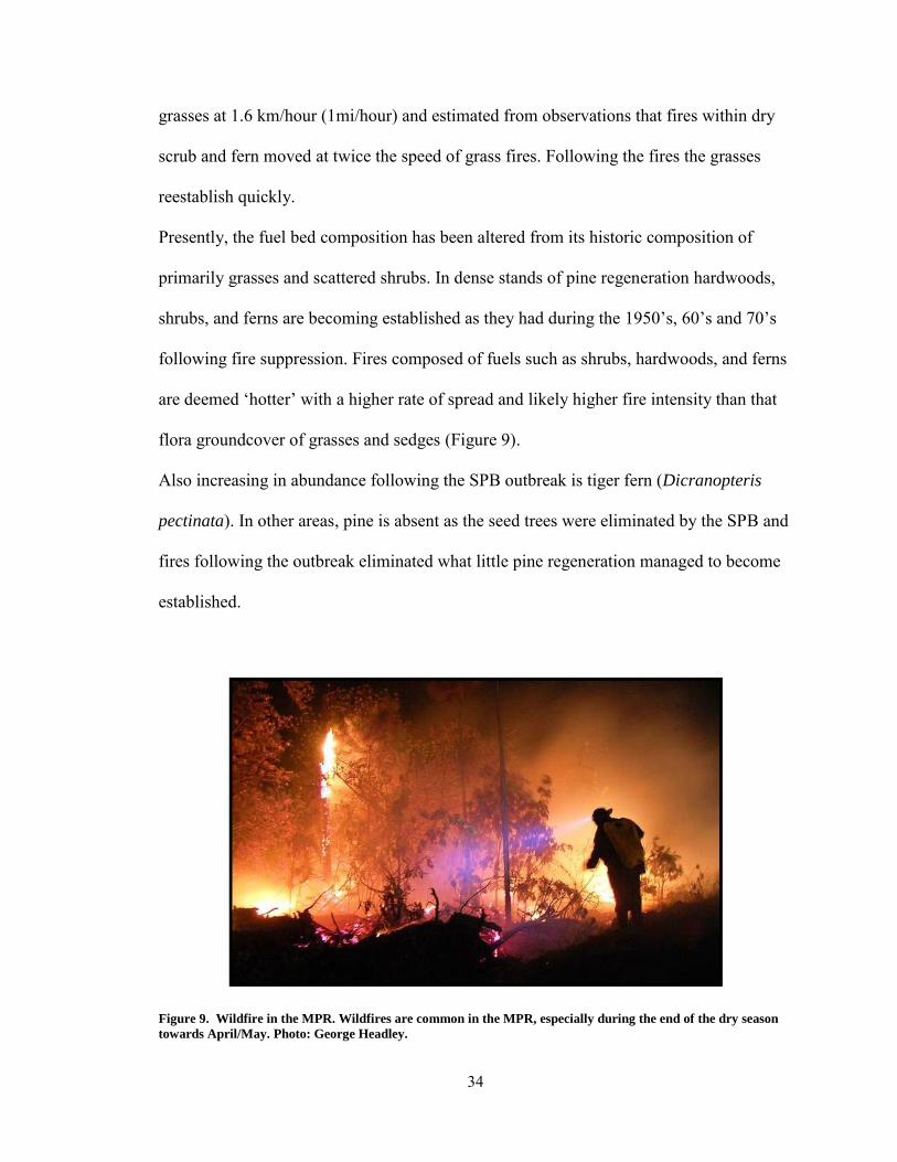
primarily grasses and scattered shrubs. In dense stands of pine regeneration hardwoods,
shrubs, and ferns are becoming established as they had during the 1950‟s, 60‟s and 70‟s
following fire suppression. Fires composed of fuels such as shrubs, hardwoods, and ferns
are deemed „hotter‟ with a higher rate of spread and likely higher fire intensity than that
flora groundcover of grasses and sedges (Figure 9).
Also increasing in abundance following the SPB outbreak is tiger fern (Dicranopteris
pectinata). In other areas, pine is absent as the seed trees were eliminated by the SPB and
fires following the outbreak eliminated what little pine regeneration managed to become
established.
Figure 9. Wildfire in the MPR. Wildfires are common in the MPR, especially during the end of the dry season
towards April/May. Photo: George Headley.

35
Goals of Research
Few ecological studies have taken place in the pine-oak forests of the MPR. The most
pressing management issue in the MPR is implementation of an appropriate fire
management regime to facilitate quality timber production, while at the same time,
emulating natural fire regimes that support the biodiversity of the ecosystem. In order to
advance the productivity of the ecosystem, managers must implement a long-term fire
management plan that takes into account the response of the ecosystem following
disturbance events. Research in the MPR was initiated in order to augment the ecological
understanding of the ecosystem, which in turn could be used in management.
Following a 2002 workshop held at Rio Bravo Conservation and Management area,
ecologists from The Nature Conservancy developed a basic conceptual model (Figure 10)
illustrating the response of Belize pine savannah ecosystems to varying fire regimes. The
Rio Bravo pine-savannah ecosystem is ecologically similar to the MPR, however the
terrain is less dissected then that of the MPR.
The diagram indicates the effect of modifications in the assumed historic fire regime (2-7
year fires) on successional dynamics in pine savannahs of Belize. Following fire
suppression they assert that the forests will develop from a savannah condition to a
woodland pine-oak forest to eventually a forest where hardwoods dominate. With annual
fires the pine savannah would eventually develop into a shrub/grassland.
Data from this study will aid in validating the model developed by The Nature
Conservancy and will be used in the development of a new fire regime model specific to
the present pine-oak ecosystems of the MPR. In the absence of fire following the SPB

36
outbreak, hardwoods and shrubs would be expected to increase in abundance while sites
that experienced intense fire would exhibit soil loss and establishment of tiger fern.
Figure 10. Fire regime model developed by The Nature Conservancy (2002) for describing successional
dynamics in Belize pine savannahs
The objectives of the study were to:
1. Determine the effect of time since last fire and the short term fire frequency, on
potential vegetative fuels, pine regeneration, down woody debris, litter, and bare
mineral soil.
2. Determine the association of foliar canopy coverage to soil, litter, down woody
debris and vegetative fuels.
3. Use GIS to determine if slope aspect plays a role in the distribution of tiger fern
(Dicranopteris pectinata) colonies, an important fuel in the MPR.
Based on the objectives, the following null hypotheses (H0) were developed:
H0 1: Time since fire and short term fire frequency will have no effect on
vegetative fuels, pine regeneration, down woody debris, liter and bare mineral soil

37
H0 2: Foliar canopy coverage has no effect on soil, litter, down woody debris and
vegetative fuels
H0 3: Aspect does not play a role in the distribution of tiger fern
Study Area
The research took place on the property owned by Bull Run Overseas Ltd and as well as
lands owned by Hidden Valley Inn. The properties are located in the Cayo Political
District in west-central Belize. The Bull Run Overseas Ltd. (Bull Run) property lies on
the northern end of the MPR. The property is bounded on the south by the MPR Forest
Reserve, on the west jointly by the Pine Ridge Enclave and the Elijio Panti National Park
and on the north by the hardwood dominated escarpment leading down to Barton Creek,
and the Thousand Foot Falls National Park (Headley 2005). The total acreage owned by
Bull Run Overseas Ltd as well as Hidden Valley Inn totals 5,862 ha (14,486 acres)
(Figure 11).

38
Figure 11. Location of the Mountain Pine Ridge. The location and the MPR (red) and the study site within it
(green).

39
Methodology
Sampling Site Selection
Since the late 1990‟s, fire events including prescribed and wildfire events were recorded
and mapped by Bull Run Overseas, Ltd. These represent all fires occurring on and
adjacent to the property managed by the company from 1998 until January 2010. For the
purposes of research, fire units were categorized into three classifications relative to time
since fire following the SPB outbreak, including recent (1-3 years since fire), midrange
(4-10 years since fire) and extended (11+ years since fire) (Figure 12).
Plot selection was based on several criteria. To eliminate the effect of slope and aspect as
well as variation within soil types, plots were established on summit positions on the
landscape with a slope percentage of less than fifteen percent. Plots were also located in
areas free of any mechanical disturbance following the SPB outbreak such as logging,
thinning, skidder trails, or within 20 meters of roads. These criteria limited sampling
areas to specific sites where sampling could occur.
A 100x100 meter grid was overlain on a map of the study area. The grids were used to
install plots systematically within varying burn units. Within each site, plot arrays of
three plots were established in a row North to South or West to East within 100 meters of
each other when possible. In some locations where a plot within a row fell into a zone
which did not meet criteria (e.g. conflict with a road or exceeding slope percentages of 15
percent), it was shifted 100 meters in any direction until sampling criteria were met. The
plots were located with the use of a GPS device. Accuracy utilizing GPS equipment

40
ranged from 2 to 10 meters. Plots were sampled from January until the onset of the dry
season in March when plants began to desiccate in which data would be affected.
Figure 12. Example of systematic location of plots. Dark red layers represent recent fire intervals, orange
represent periodic, and plots with no colored polygon represent extended fire intervals. The dark orange
polygon (center) shows overlap between a recent and periodic fire event.
Plot Design and Use
Circular 1/5th of an acre fixed radius (16m/52.7‟) plots were used for sampling (Figure
13). Four, 16m transects were established in each cardinal direction from plot center.
Along each transect four 1m2 quadrats were established at 4, 8, 12, and 15 meters from
plot center. Quadrats represented sampling units for estimating abundance and mean

41
height of physiognomic plant groups, abundance of woody debris, bare mineral soil, and
litter. Percent foliar canopy coverage estimates were made at 8m and 15m along each
transect for a mean plot estimate of canopy coverage based on 8 measurements.
At the terminus of each transects a 1/100th of an acre subplot and a 1/1000th of an acre
microplot was established for measurement of pine saplings and seedlings respectively.
SAS was used for all statistical analyses. ANOVA, using PROC GLM was used for
assessing the effect of time since last fire (treatment variables) on physiognomic
vegetative group abundance, height of vegetation, abundance of litter, bare mineral soil
and woody debris. SAS PROC REG was used for detecting the relationship between
canopy coverage, as the predictor variable and abundance of particular vegetation
physiognomic groups.

42
Figure 13. Plot design. Plot utilized for data collection. At the terminus if each transect a 1/100th acre plot (light
blue circle) and a 1/1000th acre microplot (dark blue circle) were installed for pine regeneration surveys. Along
each transect a 1m2 quadrat was placed at the 4m, 8m, 12m, and 15m from plot center for assessment of
physiognomic vegetative group abundance and heights.

43
Physiognomic Vegetative Groups
Within each of the four transects, four 1m2 quadrats were established. These quadrats
were established for measurements of physiognomic plant groups including grasses,
forbs, ferns, vines, shrubs, hardwoods and pine. Within each of the 16 quadrats in each
plot, the percent abundance of each physiognomic group was visually estimated and
recorded. The mean abundance for each physiognomic group in all 16 quadrats was
calculated. Height of the tallest individual within each quadrate for each physiognomic
plant group was measured using a height pole. The mean height for each physiognomic
plant group was calculated for the whole plot using data from all quadrates.
Down Woody Debris, Litter, and Bare Mineral Soil
Within each quadrat the abundance of down woody debris was visually estimated. Down
woody debris was classified into three classes including fine woody debris (< 3‟‟ in
diameter), coarse woody debris (>3‟‟ in diameter), and rotten woody debris which was
classified as material no longer supporting its cylindrical form with the application of
pressure to the material. In addition to down woody debris the percent abundance of litter
and bare mineral soil (BMS) was visually estimated within each plot.
Pine Regeneration
Subplots (1/100th acre) were utilized for measurements of saplings (trees 1-5‟‟ in
diameter) while microplots (1/1000th acre) were utilized for counts of pine seedling
regeneration (all pines less than 1‟‟ in diameter) at breast height 1.37m (4.5‟). Within

44
each plot four subplots and microplots were established. The mean basal area for each
plot and the mean number of seedlings per acre for each microplot were calculated.
Canopy Coverage
Percent foliar canopy coverage of pine and hardwood trees above 2.5 meters were
estimated using a convex densiometer within each plot. Canopy coverage was measured
at the second and fourth quadrate site for each transect. The mean percent foliar canopy
coverage estimates were later calculated. These measurements were utilized to determine
the effect of canopy coverage on the abundance and height of grass, fern, forb, and vine
physiognomic vegetation classes.
Analysis of Slope Aspect and Tiger Fern Abundance
Tiger fern (Dicranopteris pectinata) is a vegetative fuel which can initiate intense fires
during the dry season. It is important to understand where and why the fern colonizes in
order to manage this fuel. Tiger fern colonies are easily identified on satellite imagery as
they appear as bright green patches relative to surrounding vegetation (Figure 14a). On
infrared imagery tiger fern colonies appear as a bright white color relative to surrounding
vegetation allowing for quick identification (Figure 14b). Using Arcmaptm version 9.3.1,
GIS software and imagery provided by Geoeye Inc., the abundance of tiger fern were
measured relative to slope aspect.

45
Figure 14. Tiger fern as observed from satellite images. Tiger fern is easily observed forming circular colonies in
color images (left) and appears bright white in infrared satellite images (right).
Aspects were grouped in North (slopes with an aspect of 330-30°), East (60-120°), South
(150-210°) and West (240-300°). GIS layers indicating slope aspect were not available so
aspects had to be manually outlined. Nineteen slopes of each cardinal direction were
identified and outlined for a total of 76 identified slopes. In each slope a 2.5 hectare
square plot was situated mid-slope in the geographic center of each slope polygon as this
size plot fit within all selected aspects. To avoid bias in selection, each outlined slope
GIS layer had a solid fill during the placement of the 2.5ha plot layer. Once all 2.5 ha
plots were placed in the geographic center of each outlined slope, the solid fill was

46
removed and all visible tiger fern was mapped in the plot (Figure 15). The area of tiger
fern was ascertained within each plot through the use of Arcmap and divided by the 2.5
hectare plot for a calculation of the relative percentage. Tiger fern abundance data was
recorded into excel and inputted into SAS where the PROC GLM procedure was used to
calculate differences between slope aspects and percent abundance of tiger fern.
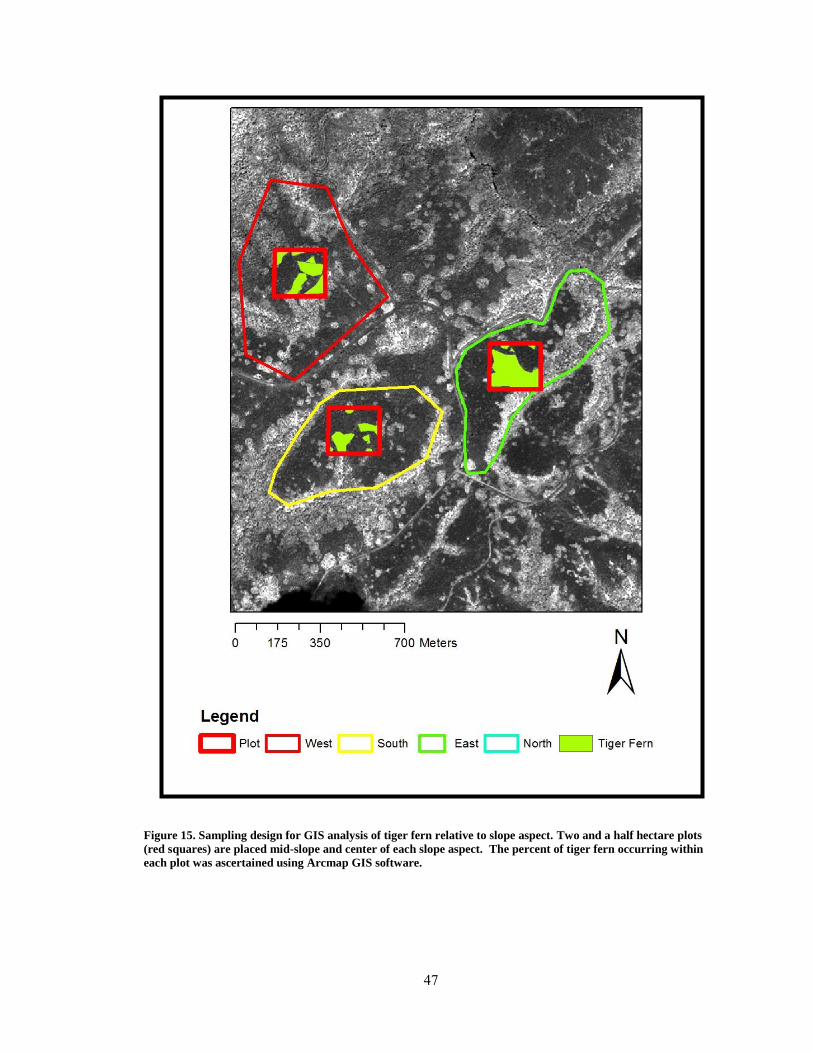
47
Figure 15. Sampling design for GIS analysis of tiger fern relative to slope aspect. Two and a half hectare plots
(red squares) are placed mid-slope and center of each slope aspect. The percent of tiger fern occurring within
each plot was ascertained using Arcmap GIS software.

48
Results
Time Since Fire and Vegetative Response
From late January until early March 2010 thirty nine plots were measured to assess the
effect of fire temporal intervals on the abundance of grasses, fern, forbs, vines, shrubs,
hardwoods and pine. Of all the physiognomic plant groups, shrubs, hardwoods, and ferns
were the only three to show a significant response relative to fire temporal intervals
(Figure 16). For hardwood abundance only the 1-3 and 11+ fire temporal intervals varied
significantly (P= 0.0265) (Figure 17). In terms of hardwood heights, the „recent‟ fire
interval varied significantly from the midrange (4-10 year) and extended (11+ year) fire
intervals (P = .0147) (Figure 17).
Shrub abundance was significantly greater in the extended fire events than the recent fire
events (P=0.0351) (Figure 19). The shrub physiognomic group mirrored the results of the
hardwoods with shrub height showing significant difference between the recent (1-3
year) and the midrange (4-10 year) as well as between the recent (1-3 year) and extended
(11+ year) fire intervals (P=.0002)(Figure 20).
Fern abundance was significantly greater in the midrange (4-10 year) fire events than the
1-3 and 11+ year fire intervals (P=.013) (Figure 21).

49
Figure 16.The mean abundance measured as percent cover of vegetative physiognomic groups in each of three
temporal stages of fire activity on the MPR. The categories represent time since last fire in and recent refers to
an area that has burned 1-3 years before sampling, periodic (4-10), and extended fire represents 11 or more
years since the last fire.
Figure 17. The percent abundance of hardwoods in each of three fire time periods fire at the MPR. The line in
the middle of the box represents the median for the data, with middle quartiles filling the remaining portion of
the box. The lines extending beyond the box represent the upper and lower quartiles while dots extending
beyond the lines represent outliers.

50
Figure 18. Hardwood average height in each of three fire time periods. The line in the middle of the box
represents the median for the data, with middle quartiles filling the remaining portion of the box. The lines
extending beyond the box represent the upper and lower quartiles while dots extending beyond the lines
represent outliers.
Figure 19. The percent abundance of shrubs in each of three fire time periods. The line in the middle of the box
represents the median for the data, with middle quartiles filling the remaining portion of the box. The lines
extending beyond the box represent the upper and lower quartiles while dots extending beyond the lines
represent outliers.

51
Figure 20. Shrub average height in each of three fire time periods. The line in the middle of the box represents
the median for the data, with middle quartiles filling the remaining portion of the box. The lines extending
beyond the box represent the upper and lower quartiles while dots extending beyond the lines represent outliers.
Figure 21. The percent of fern abundance in each of three fire time periods. The line in the middle of the box
represents the median for the data, with middle quartiles filling the remaining portion of the box. The lines
extending beyond the box represent the upper and lower quartiles while dots extending beyond the lines
represent outliers.

52
Time Since Fire and Pine Regeneration Response
Pine seedling density was significantly greater at the sites that burned 4-10 years ago than
the sites with recent (1-3 year) events. (P=.029) (Figure 22). Similarly, the basal area of
pole size pines was significantly greater at sites that burned 4-10 years ago than the sites
with recent fire events. (P=.0063)(Figure 23).
Figure 22. Pine seedlings per acre in each of three fire time periods. The line in the middle of the box represents
the median for the data, with middle quartiles filling the remaining portion of the box. The lines extending
beyond the box represent the upper and lower quartiles while dots extending beyond the lines represent outliers.

53
Figure 23. The basal area of pole size pines in each of three fire time periods. The line in the middle of the box
represents the median for the data, with middle quartiles filling the remaining portion of the box. The lines
extending beyond the box represent the upper and lower quartiles while dots extending beyond the lines
represent outliers.
Percent Canopy Coverage and Vegetative Response
Canopy coverage estimates were determined within 39 plots. The canopy coverage was
compared to the abundance of all vegetative physiognomic groups. Only two vegetative
groups, grasses and ferns, showed a trend relative to percent foliar canopy cover. Canopy
coverage correlated with fern abundance (R2 =.73) (Figure 24), but negatively and more
weakly related with grass abundance. Grass abundance shows a weak negative
correlation to canopy coverage and shows a noticeable decline in abundance with > 60
percent canopy coverage, (R2 =. 20) (Figure 25).

54
Figure 24. Regression indicating the relationship between fern height and percent canopy coverage with a 95%
confidence interval. R2=.73
Figure 25. Regression indicating the relationship between abundance of grass and canopy coverage with a 95%
confidence interval. R2=.20

55
Time Since Fire Compared to Down Woody Debris, Soil and Litter
No significant difference was found between any of the fire event times in relation to any
of the down woody debris conditions including fine woody debris, coarse woody debris,
or rotten woody debris. The abundance of bare mineral soil (BMS) as well as litter
showed significant variation between the fire events (Figure 26). Specifically, there was a
significantly greater amount of BMS in the recent (1-3 year) fire events than the
midrange (4-10 year) fire events (P=<.0001) as well as between the recent and extended
(11+ year) fire events (P=<.0001) (Figure 27).
The abundance of litter between plots and certain fire events also showed significant
variation. A significant difference existed between the recent (1-3 year) fire interval and
the midrange (4-10 year) fire event (P=0.005) as well as between the recent and extended
(11+ year) fire events (P=0.0013) (Figure 28).

56
Figure 26. The mean abundance for rotten woody debris, coarse woody debris, fine woody debris, bare mineral
soil, and litter relative to recent, midrange and extended fire intervals.
Figure 27. The percent of plot area in bare mineral soil in each of three fire time periods. The line in the middle
of the box represents the median for the data, with middle quartiles filling the remaining portion of the box. The
lines extending beyond the box represent the upper and lower quartiles while dots extending beyond the lines
represent outliers.
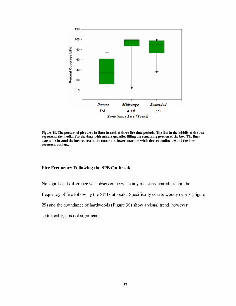
57
Figure 28. The percent of plot area in litter in each of three fire time periods. The line in the middle of the box
represents the median for the data, with middle quartiles filling the remaining portion of the box. The lines
extending beyond the box represent the upper and lower quartiles while dots extending beyond the lines
represent outliers.
Fire Frequency Following the SPB Outbreak
No significant difference was observed between any measured variables and the
frequency of fire following the SPB outbreak,. Specifically coarse woody debris (Figure
29) and the abundance of hardwoods (Figure 30) show a visual trend, however
statistically, it is not significant.

58
.
Figure 29. Percent Abundance of coarse woody debris relative to the number of fire events following the SPB
outbreak of 2001. The line in the middle of the box represents the median for the data, with middle quartiles
filling the remaining portion of the box. The lines extending beyond the box represent the upper and lower
quartiles while dots extending beyond the lines represent outliers.
Figure 30. Percent coverage of hardwoods relative to the number of fire events following SPB outbreak of 2001.
The line in the middle of the box represents the median for the data, with middle quartiles filling the remaining
portion of the box. The lines extending beyond the box represent the upper and lower quartiles while dots
extending beyond the lines represent outliers.

59
GIS Analysis of Tiger Fern
Data were collected from 19 plots from each aspect for a total of 76 2.5 hectare plots. The
abundance of tiger fern in each plot was mapped using Arcmap. No statistically
significant relationship exists between aspects and the abundance of tiger fern
(Dicranopteris pectinata). The southern aspect showed the greatest mean abundance
compared to the other aspects, however the difference is not statistically significant
(Figure 31).
Figure 31. Abundance of tiger fern relative to aspect. The line in the middle of the box represents the median
for the data, with middle quartiles filling the remaining portion of the box. The lines extending beyond the box
represent the upper and lower quartiles while dots extending beyond the lines represent outliers.

60
Discussion
Physiognomic Vegetative Groups
Among the physiognomic vegetative groups, the hardwoods and shrubs showed the
greatest response to varying times since fire. The data show that both hardwoods and
shrub abundance declines in the more recent fire intervals relative to extended fire
intervals. The observations of both hardwood and shrub height show the mean height of
these groups was less within the 1-3 year fire temporal interval and greater within the
midrange (4-10 year) and extended (11+) fire events. While the loss of abundance and
taller cohorts of shrubs and hardwoods within burned plots is demonstrated in a variety of
studies, the data indicates how quickly these can become re-established.
Hardwoods and shrubs are an important component of the biodiversity of the MPR. Some
hardwoods and many species of shrubs can carry intense fires and have shown in the data
they will become readily established following long term exclusion of fire. Maintaining a
strong presence of hardwoods in the uplands of the MPR will conflict with the pine
timber production, while silviculturally selecting against hardwoods may eventually
lower the biodiversity of the ecosystem. For instance, the degree of oak (Quercus spp.)
presence may be a function of local site conditions, as several „oak groves‟ were
observed in lower elevations.
Within thinned stands, it was observed that hardwoods were selected against in favor of
the pine component. In the southern pine forests of the United States, silviculturalists
often advise that a hardwood component should be maintained where appropriate within

61
stands of pine to mitigate the spread of the southern pine beetle (Dendroctonus frontalis)
(Billings, et al., 2004). Hardwoods often support predators of the SPB, however, the
specific predators of SPB and the plants which host them within the MPR ecosystem are
not well known.
The ground layer vegetation, which included grasses, ferns, and small shrubs, once
comprised the greatest proportion of biomass within the MPR savannah (Means, 1997).
Grasses in particular represent an important part of the ground layer vegetation as they
are the most abundant component. Therefore, grasses were the primary fuel in the historic
MPR ecosystem as they carried the low intensity fires across the pine savannah
maintaining an open condition. Wolffsohn (1967) pointed out that one years‟ grass
growth following a fire would be enough to carry a fire in „high‟ fire conditions. This was
supported by the data in that no significant variation was detected in the abundance of
grasses between fire temporal intervals.
Available light seems to be the most obvious limiting factor in terms abundance of
grasses. However, the tolerance of this important fuel to percent foliar canopy coverage
has not been quantified within the MPR prior to this study. Measurements of canopy
coverage show that the majority of grass abundance was arrested when canopy coverage
exceeded sixty percent. Sites such as these included areas where dense pine regeneration
had been recruited following the SPB outbreak, primarily in the midrange (4-10 year) fire
event sites. The dense canopies of these sites may have been further augmented by
hardwoods as well as thickets of tiger fern.

62
Within these sites of dense canopy coverage, a high abundance of litter such as pine
needles has replaced the grass component. The loss of the grass component can lead to
soil erosion following intense fires in which the canopy is reopened in a stand
replacement scenario.
One common vegetative fuel, dumb cane (Tripsacum latifolium), was not observed
within any plots. Dumb cane often occurs in lower slope positions where it is assumed
soil moisture levels are higher. However, in extended dry seasons, dumb cane become
desiccated and has been observed carrying intense fires. Plots in this study were placed
on summit positions in order to alleviate the effect of confounding variables and to
observe general trends of fire temporal intervals and canopy coverage on vegetative fuels.
Future studies, which include the effect of aspect and slope position on the occurrence of
this fuel, may provide useable information in terms of fire management.
Pine Regeneration Response
The greatest abundance of both seedling and pole size pine regeneration fell within the
midrange (4-10 year) fire event sites. This can be attributed to the SPB outbreak which
created ideal conditions for seedling establishment. Pine stands under stress from the SPB
outbreak may have produced excess seed which may have fallen on bare mineral soil
which was recently exposed by the fire. In effect the reason midrange (4-10 year) fire
events may have supported abundant pine may have been a combination of stressed pines
and optimum site conditions created by fire.
63
With the SPB outbreak in mind, future studies will need to evaluate pine stands which
have reached a dynamic climax state to accurately identify the effect of fire temporal
intervals on pine regeneration.
Bare Mineral Soil and Litter
Data from fire interval measurements indicate soil exposure is limited to 4 years given
re-colonization by ground layer vegetation occurs. The degree of bare mineral soil
exposure following fires may be a function of fire intensity; however additional research
is needed to confirm this assumption.
Exposure of bare mineral soil historically occurred following low intensity fires through
the ground vegetation; however the time it remained exposed was limited as the historic
grass and sedge component would have been rapidly recruited. For regeneration of pine,
seed needs to be in contact with bare mineral soil for germination. Whereas if bare
mineral soil is exposed for longer periods of time, such as following an intense fire, tiger
fern (Dicranopteris pectinata) may become established on the site and may preclude pine
seedling establishment.
The abundance of litter was generally above 80 percent average coverage of a plot in
both the periodic and extended fire intervals. However in the recent fire events the
abundance of litter was more variable between plots. In the annual fire temporal interval
litter abundances ranged from 2 to 80 percent. Also as expected the degree of litter
abundance was correlated with the percent foliar canopy coverage. Given the greater
canopy coverage more litter will be contributed to the forest floor. In some plots, where

64
pine stands were dense, depth of pine litter exceeded 10cm. In sites where fire has been
eliminated, litter depth will most likely preclude any establishment of pine.
Sites where bare mineral soil was exposed following intense fires should be monitored
for recolonization by vegetation. Soil properties, slope position, and past management
may affect the degree of vegetative recruitment, however additional research is needed.
Down Woody Debris
Measurements of down woody debris abundance relative to time since fire did not yield
any significant variation between fine, coarse, and rotten woody debris. In terms of fire
frequency, coarse woody debris appears to be lower in abundance following more
frequent fires; however the relationship was not statistically significant. Given the humid
climate of Belize, the decay rate of P. caribaea can be assumed to be more rapid than the
decay rate of Pinus woods in more temperate climates of North America. The probability
of the high decomposition rate may limit the degree to which down woody debris
accumulates and contributes to fuel loads and fire intensity. It should be noted that fire
frequency history was only measured using a 12 year fire history. Fire frequency may
have a significant effect on variables if the frequency is increased and the greater
temporal scale is observed.
The most pressing woody debris management issue is managing slash from thinning
operations, especially in the dense pine stands, which developed following the SPB
outbreak. The current priority is to thin these overstocked stands to augment forest health
and facilitate timber production. The degree of thinning slash contribution to fire
intensity in the MPR is unknown. These sites should be observed following treatment to

65
assess possible variables such as fuel loading, fuel persistence, vegetative colonization,
and fire effects in thinned stands where prescribed fire has been applied.
Tiger Fern
Of all the physiognomic vegetative groups, tiger fern (Dicranopteris pectinata) presents
one of the most challenging aspects of fuel management in the MPR. Thickets of tiger
fern have been observed to carrying intense fires, especially towards the end of the dry
season when the fern is most desiccated
Quantifying the abundance of tiger fern across the landscape through systematic plot
sampling in the field can be problematic due to the sporadic nature of fern colonies. Ferns
can be observed from aerial imagery growing in circular colonies which coalesce into
larger colonies as time progresses.
A denser forest canopy may support denser thickets of tiger fern as suggested by the data.
Midrange (4-10 year) fire event sites supported significantly higher abundances of tiger
fern. However it should be noted these sites supported a significantly greater density of
pine regeneration due to the conditions created by the SPB outbreak and following fires.
The high density of these pine stands supported greater canopy coverage which may have
been the governing factor for fern abundance.
Tiger fern will become readily established on sites where anthropogenic disturbance is
most severe (Slocum, Aide, Zimmerman, & Navarro, 2006). In dense stands of pine,
tiger fern was observed reaching heights of 2 meters indicating a high potential for it to
act as a ladder fuel in which it would threaten crowns of younger cohorts of pine. Walker
and Boneta (1995) found in Costa Rica that tiger fern rhizomes did not survive burning

66
but recovered rapidly by lateral growth from adjacent unburned thickets. The fact that
sites are colonized rapidly by lateral growth would indicate small scale prescribed fires
may not keep tiger fern abundances low within burn units. Tiger fern may have a greater
chance of establishing on sites burned by intense fires, even into the riparian forests
which experience longer term fire intervals than the upper slope positions. These fern
communities will burn more readily than the hardwoods leading to increased incidence of
fire within sites (Hutchinson, 1976).
The degree of tiger fern colonization may be governed mostly by the condition of the
soil. Means (1997) mentions that the fern is typically found in moist settings such as in
the riparian and slope transition forest, disturbed areas, or on rocky substrates. When
observing satellite images of the region, it becomes apparent that tiger fern is prodigious
in riparian corridors (Figure 32). There is no relationship between aspect and the relative
abundance of tiger fern. However, based on extensive field observations, position on the
slope may affect fern abundance, as dense tiger fern thickets are usually observed in GIS
imagery inhabiting riparian zones, which supports Mean‟s (1997) assertion that riparian
zones originally harbored tiger fern. There is no distinct explanation for the colonization
of fern in upland settings.
No study has addressed the effect of anthropogenic disturbance, chiefly through logging
activities, on the degree of colonization of sites by tiger fern. Heavy equipment may
increase the bulk density of soils which may predispose sites to colonization by pioneer
species such as tiger fern. No study as observed the effect of soil properties such as bulk
density, pH, or soil moisture on the presence of tiger fern.

67
Figure 32. Typical tiger fern location on the landscape. While tiger fern may occur in scattered locations in an
upland setting, it will thrive in lower slope positions such as riparian zones.
Remaining Questions
This study represented a snapshot of the effect of time since fire and percent foliar
canopy coverage on vegetation, down woody debris, soil and litter. The study of fire
ecology is a highly complex field in which several variables can contribute to an outcome
(Whelan, 1995). The following sections will highlight some of these variables which
were not observed and would be beneficial to investigate in future fire ecology studies in
the region.

68
Fire Behavior and Intensity
Fire behavior, observed during fire events, is important in the study of fire ecology as
well as in fire prescription and suppression activities (Kolaks 2004). Romme et al. (1998)
point out that the response of ecosystems is a function of the severity of the disturbance.
The intensity of fires is influenced by a range of factors including climate, topography
(slope and aspect), fuel load, fuel type and chemistry, and the vertical and horizontal
distributions of fuel (Whelan, 1995).
In this study, the effect of fire intensity on the vegetative response was not investigated.
Given these fires were observed ex post facto precluded the majority of these variables
being measured, including fuel load, fuel type and chemistry, fuel distribution, and
weather factors. However fires examined ex post facto could have taken into account
slope and aspect when vegetation parameters were measured. Future studies could
incorporate the effect of slope and aspect given the installation of additional plots which
can be justified to accurately sample the vegetative response relative to slope position.
A variety of studies have examined fire intensity during and recently following fire
events. These studies often utilize variables such as flame height to estimate the intensity
of fires and correlate the intensity to the ecosystem response. In a study assessing the
effect of fuel loads on fire intensity in the Missouri Ozarks, Kolaks (2004) utilized
passive flame height sensors, in which fire retardant string was placed within burn units
prior to ignition to measure fire intensity. A variety of studies also utilize proxies such as
char height on the bole of trees to infer fire intensity. Stevenson (2007) utilized char

69
height on upland species such as oaks to determine the effect of prescribed fires on
Missouri Ozark forests.
Similar studies could be conducted within the MPR, however such studies may be more
difficult given the ecosystem is fire dependent, making such controlled experiments
difficult. Such a study would most likely be conducted during controllable circumstances,
avoiding the height of the dry season when fires typically occur. For example, available
fuels such as down woody debris and the vegetation could be examined prior to ignition
and the char heights on the boles of pines within the fire unit can be examined post facto.
Seasonality of Fire
Seasonality of fire affects the intensity at which fires will burn in a variety of ecosystems
(Kolaks, 2004). In the MPR high intensity fires generally occur during the latter half of
the dry season (April through May) (Means, 1997). To avoid the potential of high
intensity wildfires that occur in fuel types which historically did not occupy the MPR
(such as dense colonies of D. pectinata), managers typically conduct prescribed burns
during the early dry season or whenever fuel moisture conditions allow for a low
intensity fire. The effect of these early season as well as higher intensity dry season burns
on the ecosystem should be evaluated. The data from such a study could determine if a
significant difference exists between burn seasonality and variables such as pine
mortality and soil loss between burn units.
70
Considerations and limitations of Fire Ecology Research
Forest fires are the most common disturbance on earth and vital for a variety of terrestrial
ecosystems (Rodriguez & Fule', 2003). However, ecological studies of fire are often
lacking in planning and implementation, failing to correctly ascertain the answers for
many ecological questions related to fire. The difficulty many ecologists face when
studying fire is due in part to the ambition of ecological studies to measure the effects of
a highly complex phenomenon that is governed by a variety of variables. Variables that
may have affected fire intensity and the subsequent vegetation response in the MPR for
example included humidity, ambient temperature, wind speed and direction, fuel
moisture content, fuel compactness, and fuel loading. None of these variables were
recorded; therefore it is not possible to completely understand the effect of the ecosystem
response following fires at the present time; however with further monitoring these data
may be available.
One of the most pressing issues in fire ecology is the problem of pseudoreplication.
Hulbert (1984) brought this problem to light by critiquing ecological studies which he
believed showed psuedoreplication. Hulbert defines pseudoreplication as the use of
inferential statistics to test for treatment effects with data from experiments where either
treatments are not replicated (though samples may be) or replicates are not statistically
significant. In terms of fire ecology, the classic case of pseudoreplication is inferring
results from just one burned and unburned treatment with several samples within each of
these treatments treated as independent units.

71
One way ecologists overcome the problem of pseudoreplication is by conducting highly
controlled experiments. Mantgem et al. (2001) delineates fire studies into three broad
categories based on the amount of planned intervention in the application of fire:
experimental fires, managed (or prescribed fire) and wildfires. Mantgem (2001)
explained that both experimental and prescribed fires make for easier design and
application of an experimental study. Conducting highly controlled experiments prove
difficult in fire dependent ecosystems, especially where fire management is currently in
an embryonic stage such as in the MPR.
Whelan (1995) pointed out that an ideal experimental approach, with appropriate
replication can be difficult to implement within a fire prone environment. Installing and
maintaining experimental blocks of treatment can be difficult. Weather conditions dictate
when a prescribed burn for experimental blocks can be conducted, so some years may be
too dangerous to conduct fires in fire prone ecosystems while other years may be too wet
for ignition. Keeping unwanted wildfires out of experimental plots becomes more
difficult with every year in a fire dependent ecosystem. Finally, Whelan (1995) indicates
the problem of scale in such studies. Fires conducted on a smaller scale such as
experimental blocks less than a hectare may not burn with the same intensity as naturally
occurring fires.
A time-series design can reveal effects of the fire, and can be measured over time instead
of during one field season such as this study. Time series designs are common in fire
studies due to the ease of data collection and analysis (Whelan, 1995). The influence of
fire can be long-lasting, making ecological studies time consuming and costly (Whelan,
1995). A solution to this problem is to conduct a synchronic study which is also referred

72
to as a „space-for-time-substitution‟ (Pickett, 1989). This was the approach that was
implemented in this study. However it should be noted that there are serious limitations
to the synchronic approach (Whelan, 1995). The main problem is potential covariation of
fire history differences and observed population differences with a third unknown site-
specific variable. For example, a difference in soil type may support a different suite of
vegetation affecting the relative abundance of available fuels. To overcome this, attempts
were made to limit covariation such as slope aspect and logging history.
Considerations and Constraints of the Study
It is important to note that this study attempted to evaluate broad causes for this
ecosystems response to fire and canopy coverage and to understand that fire ecology is a
highly complex field of study.
Conducting highly controlled experiments in fire dependent ecosystems such as the MPR
presents a difficult task. Restricting wildfire from any experimental block over time
would be difficult or if not impossible given the lack of resources in the region. Since
several fire events had been mapped since the late 1990‟s simultaneous measurements
occurring in sites of varying times since fire, a chronosequence of fire events could be
constructed. Due to the time and budget constraints, all sites were measured within one
field season to construct a natural snapshot experiment or NSE. Diamond and Case
(1986) describe a NSE as a condition where several sites are measured while the variable
(in this case fire) is present at different levels.
One problem with using multiple fire events of varying locations is covariation, in which
an unknown factor is affecting the variable of interest. In this study the soil type was a

73
factor which was not well understood and may have contributed some error. However fire
may have greater effect on the system than the soil which supports the vegetation.
It is important to note that plots were sampled within larger fire units, assuming the plots
were independent in terms of the degree of disturbance which they experienced from fire.
This may be a source of psuedoreplication; however no plots were installed within 100
meters of another plot. This was done to increase the sample size which was limited due
to the fact that the scale of the fire units was quite large. Mantgem (2001) mentions the
fact that samples are not properly replicated does not invalidate interesting findings.
However, Mantgem (2001) mentions that pseudoreplication should be mentioned where
it may occur.
Fire Mediated Succession at the Mountain Pine Ridge
The Nature Conservancy (2002) developed a fire regime model based on general
observations of pine savannah response to varying fire regimes (Figure 10). Following
this study a new fire regime model for the MPR (Figure 33) was developed based on data
and observations. The arrow on the image represents a time since fire continuum with the
left portion indicating annual fires and the right portion indicating a condition in which
fire is eliminated from the ecosystem. Below the continuum ecosystems are strategically
located based on the typical ecosystem response to position on the time since fire
continuum. The effect of intense fires as well as logging on these ecosystems is also
represented; both events which may predispose sites to changes in the condition of the
soil leading to invasion by tiger fern.

74
Figure 33. Conceptual fire regime model and plant community development based on data and observations from the MPR

75
Major Conclusions
1. Sites with more recent fire events had lower abundance of hardwood and shrub
physiognomic groups and a greater abundance of bare mineral soil.
2. Fire frequency, following the SPB outbreak, did not significantly affect vegetative
fuel, down woody debris, or bare mineral soil.
3. Pine regeneration response following the SPB outbreak indicates the midrange (4-
10 year) fire event sites support the greatest abundance of pine, possibly owing to
seed production and seed bed conditions created by the outbreak.
4. Increasing foliar canopy coverage positively affected fern and negatively affected
grass vegetative physiognomic groups.
5. No significant relationship existed between tiger fern (Dicranopteris pectinata)
abundance and aspect.
The restoration of the MPR ecosystem as well as the future of the timber management in
the MPR will depend on research similar to studies such as this and implementation of
practices based upon it. Understanding how to balance biodiversity and sustain the
utilization of timber resources in the MPR will be an ever-evolving process. This study
indicated how time since fire and percent foliar canopy coverage could affect
management of fuels in the MPR ecosystem.
Dense stands of pine regeneration are forming in some sites following the SPB outbreak,
especially in sites that experienced fire in the months preceding the SPB outbreak.
Silvicultural practices such as thinning and prescribed fire are currently being
implemented and need to be continued to promote the sustainability and restoration of

76
this ecosystem. The recovery of this ecosystem depends on the continued involvement of
dedicated stewards of the land as well as the support of outside sources. With continued
research and its application the expedited restoration of this unique ecosystem and the
recovery of sustainable resource utilization are promising.

77
Literature Review
Beard, J. S. (1953). The savanna vegetation of northern tropical America. Ecol. Monogr , 23, 149-215.
Billings, R. F., Clarke, S. R., Mendoza, E. V., Cabrera, C. P., Figueroa, M. B., Campos, R. J., et al. (2004). Bark Beetle Outbreak and Fire: A Devestating Combination in Central America's Pine Forests. Unasylva , 217, Vol. 55, 15-21.
Chun, A. V. (2005). Belize: Criteria and Indicators of Sustainable Forest Management. Belize Forestry Department.
Diamond, J., & Case, T. J. (1986). Community Ecology. New York, New York: Harper and Rowe.
Dubbin, W. E., Penn, M. G., & Hodsona, M. E. (2006). Edaphic influences on plant community adaptation in the Chiquibul Forest of Belize. Geoderma , 131, 76-88.
Ennion, R. C. (1995). A Study of Pinus Caribaea and Pinus Patula Regeneration in
Natural Stands Subject to a Monocyclic Silvicultural System Within the Mountain Pine
Ridge forest Reserve. Experimental Design and Background Information.
FAO. (2008). Overview of forest Pests Belize. Forest Health & Biosecurity Working
Papers. Rome, Italy: Belize Forestry Department and FAO.
(2008). Forest Health & Biosecurity Working Papers Overview of Forest Pests in Belize. Rome, Italy: Forestry Department Food and Agriculture Organization of the United Nations.
Friesner, J. (1993). Hurricanes and the Forests of Belize. Belmopan, Belize: Forestry Department.
Furley, P. A. (1974). Soil-Slope-Plant Relationships in the Northern Maya Mountains, Belize, Central America. Journal of Biogeography , Vol. 1, No. 4, 263-279.
Haack, R. A., Eckelmann, C. M., & Green, E. (2000). Southern Pine Beetle Outbreak in Belize. Michigan Entomological Society , 45 (3&4).
Haack, R. A., Eekelmann, C. M., & Green, E. (2000). Southern Pine Beetle Outbreak in
Belize. Lansing, Michigan: U.S. Forest Service Northern Research Station.
Haywood, J. D., Bauman, T. A., Goyer, R. A., & Harris, F. L. (2004). Restoring Upland Forests to Longleaf Pine:Initial Effects on Fuel Load, Fire Danger,Forest vegetation and

78
Beetle Populations. General Technical Report. U.S. Department of Agriculture, Forest
Service, Southern Research Station. , pp. 299-303.
Headley, G. (2008). Forest Stewardship and Management Plan for Bull Run Overseas
Ltd.
Hooper, E. D. (1887). Report upon the forests of Honduras. . India: Kurnool Collectorate Press.
Hulbert, S. (1984). Psuedoreplication and Design of Ecological Experiments. Ecological
Monographs , 54 (2), 187-212.
Hunt, D. R. (1962). Some notes on the pines of British Honduras. Emp. For. Rev. , 41, 134-145.
Hutchinson, I. (1976). Ecological Modelling and Stand Dynamics of Pinus Caribaea in
Mountain Pine Ridge Belize.
Johnson, M. S., & Chaffey, D. R. (1973). A Forest Inventory of Part of the Mountain
Pine Ridge,. Tolworth Tower, Surrey, England: Land Resources Division.
Kellman, M., & Meave, J. (1997). Fire in the Tropical Gallery Forests of Belize. Journal
of Biogeography , Vol. 24, No. 1., pp. 23-34.
Kellman, M., & Pither, R. (2001). Tree species diversity in small, tropical riparian forest fragments in Belize, Central America. Biodiversity and Conservation , 11: 1623–1636,.
Kemp, R. H. (1972). Seed sources and seed procurement of low altitudinal tropical pines in Central America. In Selection and breeding to improve some tropical hardwoods (pp. 9-18).
Kolaks, J.,(2004). Fuel Loading and Fire Behavior in the Missouri Ozarks of the Central
Hardwood Region.M.S. Thesis. University of Missouri.
Mantgem, P. v., Schwartz, m., & Keifer, M. (2001). Monitoring Fire Effects for Manged Burns and Wildfires: Coming to Terms with Pseudoreplication. Natural Areas Journal , 21: 266-273.
Mattson, W. J., & Haack, R. A. (1987). the role of drought in outbreaks of plant-eating insects. BioScience , 37: 110-118.
Meagher, M. (2005). Summary of Timber Assessment on Bull Run Overseas Property.
Means, B. D. (1997). Natural History of Mountain Pine Ridge Belize. Tallahassee, FL.

79
Meave, J., & Kellman, M. (1994). Maintenance of rain forest diversity in riparian forests of tropical savannas: implications for species conservation during Pleistocene drought. Journal of Biogeography , 21: 121-135.
Meerman, J. C., & Sabido, W. (2001). Central American Ecosystems Map, Belize. Belize City, Belize: Programme for Belize.
Midtgaard, F., & Thunes, K. H. (2002). Pine bark beetles in the Mountain Pine Ridge
forest Reserve, Belize: description of the species and how to monitor and combat the
beetle infestations. Isadalto, Norway: Norwegian forestry Group, Inter-American Development Bank.
Miller, A. G. (2007). Fire History of Caribbean Pine (Pinus caribaea var. bahamensis
(Griseb. W.H. Barrett & Golfari) Forests on Abaco Island, The Bahamas. Department of Geography. University of Tennessee.
Miller, B., & Miller, C. (2002). Results of a Preliminary Survey of Bats of the Mayflower-
Bocawina National Park. Gallon Jug, Belize.
Mirov, N. T. (1967). The genus of pinus. New York: Ronald Press.
Miyanishi, K., & Kellman, M. (1986). The Role of Fire in Recruitment of Two Neotropical Savanna Shrubs, Miconia albicans and Clidemia sericea. Biotropica , Vol. 18, No. 3, pp. 224-230.
(2002). Mountain Pine Ridge Carbon Sequestration Project, Belize C.A. Silviculture Belize.
Myers, R., O'Brien, J., & Morrison, S. (2006). Fire Management Overview of the
Caribbean Pine (Pinus caribaea) Savannas of the Mosquitia, honduras. GFI technical
report 2006-1b. Arlington, VA: The Nature conservancy.
Paulsell, L. K. (1957). Effects of Burning on Ozark Hardwood Timberland. Research Bulletin 640. University of Missouri College of Agriculture. Agriculture Experiment Station.
Penn, M. G., Sutton, A. D., & Monro, A. (2003). Vegetation of the Greater Maya Mountains, Belize. Systematics and Biodiversity , 2 (1): 21-44.
Penn, M. G., Sutton, D. A., & Monro, A. (2003). Vegetation of the Greater Maya Mountains, Belize. Systematics and Biodiversity , 2 (1): 21–44.
Pickett, S. T. (1989). Space for time substitution as an alternative to long-term studies. In
Long-term Studies in Ecology: Approaches and Alternatives, ed. . Berlin: Springer-Verlag.

80
Pither, R., & Kellman, M. (2002). Tree species diversity in small, tropical riparian forest fragments in Belize, Central America. Bodiversity and Conservation , 11: 1623-1636.
Rodriguez, D. A., & Fule', P. Z. (2003). Fire Ecology of Mexican Pines and a Fire Management Proposal. International Journal of Wildland Fire , 12, 33-37.
Romme, W. H., Everham, E. H., Frelich, L. E., Moritz, M. A., & Sparks, R. E. (1998). Are large, Infrequent disturbances qualitatively different from small frequent disturbances. Ecosystems , 1: 524:534.
Seaton, R. (2004). Mountain Pine Ridge Project A/R CDM Baseline Study. New Westminster B.C., Canada: Brinkman & Associates Reforestation Ltd.
Shibayama, T., Ashton, M. S., Singhakumara, B., Griscom, H. P., Ediriweera, S., & Griscom, B. W. (2006). Effects of fire on the recruitment of rain forest vegetation beneath Pinus caribaea plantations, Sri Lanka. Forest Ecology and Management , 226, 37-363.
Slocum, M. G., Aide, M. T., Zimmerman, J. K., & Navarro, L. (2006). A Strategy for Restoration of Montane Forest in Anthropogenic Fern Thickets in the Dominican Republic. Restoration Ecology , Vol. 14, No. 4, pp. 526–536.
Standley, P. C., & Record, S. J. (1936). The Forests and Flora of British Honduras. Chicago: Field Museum of Natural History.
Stevenson, A. P., (2007). Effects of Prescribed Burning in Upland Ozark Missouri
Forests. M.S. Thesis. University of Missouri
The Nature Conservancy. (2002). The Ecological Role and Management of Fire in
Caribbean & Central American Pineland Ecosystems. Highlights of a workshop held at
Rio Bravo Conservation & Management Area, Belize. Rio Bravo Conservation & Management area, Belize.: TNC Global Fire Initiative.
Walker, L. R., & Boneta, W. (1995). Plant and soil responses to fire on a fern-covered landslide in Puerto Rico. Journal of Tropical Ecology , 11: 473-479.
Weaver, P. L., & Sabido, O. A. (1997). Mahogany in Belize: A Historical Perspective. United States Department of Agriculture Forest Service Southern Research Station.
Whelan, R. J. (1995). The Ecology of Fire. Cambridge, U.K.: Cambridge University Press.
Wikum, D. A., & Shanholtzer, F. G. (1978). Application of the Braun-Blanquet Cover-Abundance Scale for Vegetation Analysis in Land Development Studies. Environmental
Management , Vol. 2, No. 4, pp. 323-329.

81
Wolffsohn, A. L. (1967). Post hurricane fires in British Honduras. . Commonw. For. Rev. , 46, 233-238.
Wright, A. C., Romney, D. H., Arbuckle, R. H., & Vial, V. E. (1959). Land in Briish
Honduras. Report of the British Honduras Land Use Survey Team. . London: HMSO.
Wyatt, A. (2008). Pine as an Element of Household Refuse in the Fertilizatin of Ancient Maya Agricultural Fields. Ethnobiology , (28)2: 244-258.