full text
DESCRIPTION
archTRANSCRIPT

Acta Geod. Geoph. Hung., Vol. 44(1), pp. 49–66 (2009)
DOI: 10.1556/AGeod.44.2009.1.6
GEOREFERENCING AND QUALITYASSESSMENT OF JOSEPHINE SURVEY
MAPS FOR THE MOUNTAINOUS REGIONIN THE TRIGLAV NATIONAL PARK
T Podobnikar1,2
1Scientific Research Centre of the Slovenian Academy of Sciences and Arts,Novi trg 2, SI-1000 Ljubljana, Slovenia, e-mail: [email protected]
2Institute of Photogrammetry and Remote Sensing, Vienna University of Technology,Gußhausstraße 27–29, A-1040, Vienna, Austria
Open Access of this paper is sponsored by the HungarianScientific Research Fund under the grant No. T47104 OTKA
(for online version of this paper see www.akkrt.hu/journals/ageod)
Various spatial data sets of high quality and homogeneity allow a higher level ofmultidisciplinary research. The study is aimed at providing a clearer understandingof the technical and semantic aspects of the quality of historical maps, especiallywith respect to positional errors, through the georeferencing process. Georeferencingthe system of historical map sheets with high precision over a large area is not easilyincorporated into the less complicated standardised process. Significant problemsmay occur in rough mountainous regions, especially as many of the areas were notaccessed at that time and therefore not surveyed. The standard process of georefer-encing comprises mosaicking of singular map sheets to a seamless map, referencingwith identical points, and applying an appropriate transformation method. Thequality of georeferenced maps is assessed with statistical and visual parameters. Theenhanced process additionally integrates descriptive (textual) information about themapping processes, derivative georeferenced data sets as land use analysis, and MonteCarlo simulations. This approach allows a more detailed understanding of the qualityand consequently improves a georeferencing process for any historical data sets. TheFirst Military Survey maps of the Habsburg Monarchy (Josephine survey), producedbetween 1763 and 1787, were used as study data and the rugged Julian Alps of theTriglav National Park in Slovenia were employed as the study area.
Keywords: error simulation; georeferencing; historical maps; land use; qualitycontrol
1217-8977/$ 20.00 c©2009 Akademiai Kiado, Budapest

50 T PODOBNIKAR
1. Introduction
Maps are a presentation of the real world reduced to points, lines, and areas,using a variety of visual resources: size, shape, value, texture or pattern, colour,orientation, and shape. Compared to a photograph, which shows all visible objectsin its view, a map is an abstraction of reality (Lanius 1999). The cartographer selectsonly that information essential to fulfil the purpose of the map and suitable for itsscale; maps are a combination of science and art. The map’s interpretation dependson a cognitive and semantic perception of the Earth by both the cartographers andthe users.
The first presentations of the Earth’s surface originated at least 30 000 yearsago when people developed the ability to express themselves with symbols. Earlymaps were more figurative than literal and they were probably used mostly for cer-emonial and ritual purposes (Robinson et al. 1995). The practical applications ofancient maps included aiding navigation, providing descriptions of places for hunt-ing particular animals, marking directions of their movement, etc. Cartographywas significantly advanced by Greek scholars who developed geometric concepts ofthe Earth. This tradition was continued and developed by Arab scholars duringthe medieval European era. The European renaissance in the sixteenth centuryfurther enhanced the development of cartography. Techniques applying the prin-ciples of mechanics, optics, chemistry, metallurgy, electromagnetism, electronics,etc. led to development of mapping and cartographic processes. For more effectivepresentation, geometrically and metrically correct presentations were demanded. Itappears that the demand for land surveying arose from the need to measure theland for agricultural purposes beginning around five thousand years ago (Ceh 2002),and also on military requirements. These are the foundations of cartography as ascience and technology.
1.1 Habsburg’s military survey
After the end of the Seven Years’ War against Prussia (1756–1763), which waslost due to the orientation problems in the unsurveyed area, a cartographical regis-tration of the Habsburg Monarchy’s crown lands was commissioned by the empressMaria Theresa (Grabnar 1994). The surveying lasted for twenty-three years (1763–1787) and resulted in 3 589 hand-drawn coloured map sheets (later expanded to4 096) measuring approximately 61 by 42 cm, in a scale of 1:28 800. They coveredthe whole territory of the former Habsburg monarchy. The survey is known as theFirst Military Survey (MS1) of the Habsburg hereditary lands or the Josephine sur-vey (Josephinische Landesaufnahme), because it was finished in the time of emperorJoseph II, Maria Theresa’s son (Wawrik and Zeilinger 1989, Zimova et al. 2006).The maps were originally drawn in two versions — an original and a copy of fairquality. The copies are a bit bigger due to a frame that surrounds the map. Thismapping and surveying was the first measurement of the whole territory of Slovenia(Triglav 2003).
A few framework points were astronomically determined (using the overviewmap), but the survey was not based on any use of triangulation (Kretschmer and
Acta Geod. Geoph. Hung. 44, 2009

JOSEPHINE SURVEY MAPS 51
Riedl 2008). Furthermore, the survey was carried out without precise (geodetic)surveying measurements utilising a plane table and busole. Additionally, the exis-tence of a cartographic projection is not clear. Some investigations suggest that thestructure of the sheets is similar to a Cassini-Soldner (or Cassini, on the sphere)projection, but the others suggest that it is a projectionless map system (Timar2004). Certainly the sheets do not hold any co-ordinates, whether of geographicor projection type. The generalisation methods are mostly unknown and variedbut very likely depended on the importance of the particular feature or object tomilitary needs. Most of the details were mapped with the unaided eye and theirquality depends on the experience of the cartographer, his semantic comprehension,the variety of landscape characteristics, etc. This survey is, however, considered tobe the most detailed and highest quality cartographical work until the end of theeighteenth century (Rajsp and Serse 1998).
The maps include the names of hills, valleys, and rivers written in local lan-guages. Political borders are marked as well. Altitudes are presented with hatchingto indicate relief. Distribution of forests and grasslands, directions of river cur-rents, cultivated land, and other features are also mapped. The cultural landscapeis presented by showing settlement type, buildings, roads, stone bridges, and evenroadside shrines. The clarity of the maps is achieved through various colour casts.The sites of natural resource activities such as mines, saltworks, and iron foundriesare not marked with symbols but rather with descriptive text. The size and formatof the city names indicate their status (Rajsp and Serse 1998, Zimova et al. 2006,Gasperic 2007, Zorn 2007).
Although the First Military Survey is the focus of this study, a few subsequentefforts should be mentioned. The inadequate quality of maps from the First MilitarySurvey led to new surveys in the nineteenth century by the emperor Francis II. Afterthe foundation of the Austrian Empire (Kaiserstaat Osterreich) in 1804, the 2ndsurvey of 1806–1869 was based on the first network of horizontal control points (tri-angulation). The Second Military Survey (Francis’), in scale 1:28 800, is consideredmuch more accurate, as it is based on a geodetic and surveying foundation of goodquality (Jenko 2008). Measurements of the triangulation networks were commonfor both land (Franciscan) cadastre and topographical maps (Korosec 1978). Thecentres of the geodetic networks (geodetic datums) for the separated co-ordinatesystems on the territory of Slovenia were Krim (near Ljubljana, Slovenia), Schockl(near Graz, Austria), and Gellert (near Budapest, Hungary). The triangulation ofthe Krim co-ordinate system that covered the larger part of modern Slovenia wascarried out between 1817 and 1825 (Klaric 1975), but the military mapping was re-alised between 1830 and 1834 (Korosec 1978). The projection of the 2nd survey wasCassini, but was not precisely applied (Timar 2004). This is a transverse cylindri-cal projection, tangent and therefore equidistant along the central meridian. Reliefwas represented by Lehmann’s hatching completed with heights of trigonometricalpoints.
After the 1860s, the rapid progress in geodesy, topography, and cartographyinitiated new approaches of topographical survey. The entire area of the Austro-Hungarian Monarchy (as to be named due to dualism since 1867) was mapped
Acta Geod. Geoph. Hung. 44, 2009

52 T PODOBNIKAR
Fig. 1. Location of Triglav National Park (marked as TNP)
by the 3rd survey, based on the metric scale of 1:25 000 (and general maps inscale of 1:75 000) in only eighteen years (1869–1887), based on a new frameworkof horizontal and vertical control points in accordance with the standards of theEuropaische Gradmessung. The 4th survey started in 1896, but was suspended in1915 due to World War I (Kretschmer and Riedl 2008).
The military survey maps were not important to the general public as theywere kept strictly as a military secret in the Military Archive in Vienna. Withthe opening of the archives, they have become an invaluable source for studiesof historical landscapes. Increasing numbers of reprinted or scanned historicalmaps from different sources are available today (Rajsp and Serse 1998, NLS 2002,NUK 2008, ARS 2004, Podobnikar and Kokalj 2007). The usability of these mapscould be significantly improved with georeferencing to allow more sophisticatedspatial analyses in geographical information systems in combination with the otherdata sets.
1.2 Triglav National Park study area
The study area comprises the whole territory of Triglav National Park, thelargest protected area in Slovenia, located in the northwest of the country(Fig. 1). The parks territory is characterised by the Julian Alps’ heterogeneousrough relief with deep and steep, glacially transformed river valleys and gorges.Relief diversity and high elevation are the main factors for allocation of cultivableareas as well as settlement and communication systems. Most of the park is rich invarious karst phenomena; limestone is the predominant rock type. Mountain ridgesare an effective orographic barrier; the territory receives approximately double theaverage rainfall of the rest of Slovenia. High precipitation and steep slopes cause anumber of landslides and avalanches. The park is characterised by richness of lifewith some rare protected flora and fauna (Podobnikar and Kokalj 2007).
The park bears important cultural heritage resources, including settlements with
Acta Geod. Geoph. Hung. 44, 2009

JOSEPHINE SURVEY MAPS 53
Fig. 2. Mosaicking and georeferencing of the MS1 maps
unique rural and sacred architecture; the historical remains of former ironworks;monuments to the memory of both world wars and to a battle of the Napoleonicperiod (at Predel); some notable archaeological sites; remarkable traditional moun-tain pastures; and a populace with rich traditional knowledge and proficiency gainedfrom centuries of observation and living in nature (Podobnikar and Kokalj 2007).
2. Mosaicking and georeferencing of the military survey maps
Georeferencing of a number of MS1 historical maps of a rough mountain regionof Slovenia was carried out with the following procedure (Fig. 2):
— mosaicking – relative georeferencing of the individual map sheets to thedependable position of the previously generated grid and stitching them seam-lessly into a cohesive map,
— georeferencing to a contemporary Slovenian co-ordinate system.
2.1 Mosaicking
Mosaicking is a process of stitching the images, in our case maps, together intoone large, coherent map of the studied area. The principle of mosaicking the MS1maps is based on the requirements that particular map sheets should be rectangular,resembling their original shape with dimensions of 61 by 42 cm, and that they shouldmeet seamlessly along the edges. This was achieved by constructing a grid system(sheet network) representing the ideal original positions of the maps, cropping theedges without cartographic content, setting reference points to the edges of the mapsheet network, and fitting the maps using rubber sheeting. The advantage of thistechnique was to prevent greater distortions (gaps and overlaps) at the borders ofthe map sheets within the mosaic (Fig. 3). As not all borders of the scanned mapsare straight, some small geometrical corrections were applied around them usinggeoreferencing methods on additional identical points.
The next step is colour balancing, a process of inconsistent colour cast homogeni-sation. The colour cast can be a result of imprecise scanning process or, more com-monly, an outcome of the original print. Because different cartographers producedthe maps, their overall colour cast differed originally and has increased over thecenturies due to aging. Colour balancing computes a global statistics across each
Acta Geod. Geoph. Hung. 44, 2009

54 T PODOBNIKAR
Fig. 3. Left: Distortions at the map sheet borders of the single map sheets and a mosaickingafterwards. Right: prevention of distortions using rubber sheeting technique (Walz and
Neubert 2005)
Fig. 4. Principles of mosaic colour matching
map in the mosaic in order to smooth out light imbalances. Certain very bright ordark areas can be avoided in order not to degrade the statistics. The method usedto compute the statistics in each map depends on the distribution of the colourdifference. This can be either parabolic — the colour difference is elliptical anddoes not darken at an equal rate on all sides, conic — the colour difference willpeak in brightness in the centre and darken at an equal rate on all sides, linear —the colour difference is graduated across the map, or exponential — the colour isvery bright in the centre and slowly, but not always evenly, darkens on all sides.Using histogram matching, to either a single map (the map that contains the colourcharacteristics we would like to see in the mosaic) or an ideal combined histogram,colour and brightness of the input maps are matched on the mosaic (Fig. 4).
The last step was manual — visually removing the remaining local anomaliesalong the edges of the mosaicked map sheets using digital brush tools. The finalproduct resembles a single seamless cohesive map. It should be noted that thecolour balancing and manual removing of the anomalies are not essential for thevectorisation of land use information from the maps, but it increases the precisionof interpretation and is important for a powerful visualisation of the studied area.
2.2 Georeferencing
Transformation to the target co-ordinate system is the main goal of georefer-encing the historical maps. Two methods of georeferencing may be distinguished:transformation between two co-ordinate systems where transformation parametersare known, and transformation using identical ground points where transformation
Acta Geod. Geoph. Hung. 44, 2009

JOSEPHINE SURVEY MAPS 55
parameters are unknown. The techniques for georeferencing depend on the char-acteristics of the historical MS1 maps: the quality of the geodetic grids, the mapprojections, generalisation methods, etc.
The possible map projection of the MS1 was Cassini-Soldner, that is, an ellip-soidal version of the Cassini projection for the sphere. It is not conformal but isrelatively simple to construct. It was later largely replaced by the conformal Gauss-Kruger or Transverse Mercator which it resembles. Like this, it has a straightcentral meridian along which the scale is true, all other meridians and parallels arecurved, and the scale distortion increases rapidly with increasing distance from thecentral meridian.
If the original projection is known and precise, the map sheets can be projectedusing unique transformation parameters, with projection parameters including acentral meridian and the shape of the map sheet (four points at the edges). Projec-tion error rises if a meridian convergence is not taken into account (Korosec 1993).This method can be applied on a small scale for low accuracy (or coarse) transforma-tion (Podobnikar and Sinkovec 2004). The Second and Third Military Surveys wereso precisely mapped that the unique transformation parameters could be obtainedfor a larger area with relatively high precision. The maps of the Second MilitarySurvey have been successfully transformed to a contemporary map grid for the entireancient Habsburg territory (Timar et al. 2006). This method was also successfullyaccomplished for the land cadastre sheets mapped in the Krim co-ordinate system,transformed with higher precision to the Slovene Gauss Kruger co-ordinates. Forthe territory of Slovenia, many studies have been available on these transformationparameters since the 1960s (Klaric 1975, Francula and Lapaine 2007, Lapaine 2008,Jenko 2008).
In the case of the MS1, there were many uncertainties in mapping, especiallywith uncertain distortions in the rough mountain area, as described earlier. Thegeoreferencing was carried out without known parameters by 1. using reference datasets, 2. finding identical points, and 3. applying an appropriate transformationmethod. Orthophotos or topographic maps of scale 1:25 000 were used for thereference data sets then mapped onto a contemporary Slovenian co-ordinate system.
Identical points should be located on geographically identical positions of theMS1. They should be chosen very carefully. Potentially the best points are themeasured ones: churches or towers. To locate appropriate points, it is important tonote the “style” of a particular cartographer and cartographic elements, includingthe level of generalisation of the maps. Additionally we should be very attentive topossible landscape changes and aware that at the time of the mapping the highestpeaks in the Julian Alps had not yet been scaled, and most of areas had not beenreached yet (Podobnikar and Kokalj 2007).
The chosen identical points in the MS1 used for georeferencing were: churches(especially those on the peaks), characteristic bridges, road crossings, towers, andoccasionally, distinguishable summits or rivers’ confluences (Podobnikar and Sinkovec2004, Podobnikar and Kokalj 2007). Very rough mountain terrain prevented se-lection of a greater number of reliable identical points (Fig. 5). Only around 190identical (ground) points were found for the whole Triglav National Park study area.
Acta Geod. Geoph. Hung. 44, 2009

56 T PODOBNIKAR
Fig. 5. High mountain areas often lack confident reference points of any kind
The third step of georeferencing with unknown transformation parameters is ap-plying the appropriate transformation method for transformation to a contemporarySlovenian co-ordinate system, based on the Gauss Kruger (UTM) map projection.Classically we can choose between the common transformation methods using ap-proximation with polynomials or with rubber sheeting (based on triangulation wherethe position of the identical points remains after the transformation). The polyno-mial order 1 is appropriate for transformation between two projections where greatdistortion is not present (useful for transformation between newer maps). The poly-nomial order 2 is appropriate for transformation between geographical co-ordinates(or sphere) and projected data, or for locally systematically distorted data sets inlarger areas (e.g. for mountain areas or for aerial photographs). The rubber sheetingmethod could be more useful on more highly distorted areas, but it requires a highnumber of identical points. Unpredictable distortions could appear around areasof deficiency. In our case a rubber sheeting method was chosen as optimal for theMS1 maps. A classical assessment for the measurement of transformation accuracyis a root mean square error (RMSE).
Acta Geod. Geoph. Hung. 44, 2009

JOSEPHINE SURVEY MAPS 57
Considering the transformation methods, a simple test would be applied to themaps to determine the projection nature. We mentioned in the previous paragraphthat the polynomial transformation order 1 is appropriate for the transformationbetween two projections lacking significant distortion. As the Cassini and GaussKruger (UTM) projections are similar, a low RMSE would be expected after thetransformation. Unfortunately, this method is not suitable for the MS1 maps asthe local distortions (errors) are too large.
3. Land use data acquisition and interpretation
Topographic maps and their predecessors, produced in land surveys since theeighteenth century, provide a suitable cartographic base for historical landscapeanalysis. They have sufficient resolution in terms of geometry and content formedium-scale studies, enabling landscape development over the past two hundredyears to be investigated (Haase et al. 2007). A rather rapid descriptive comparisoncan be made when considering elements of the maps such as the transportationnetwork (a comparison of historical and contemporary courses of roads and paths,density of network, types of connections, the number and locations of bridges),water courses and their regulations, settlements (routes of roads and streets insettlements, expansion of settlements and changes in structure), and the distributionof vegetation.
Employing land use information from the MS1 maps and comparing it with thecontemporary data sources is a common application of the series studies. Someof the significant ones are listed here. The interpretation over the territory ofSlovenia is based on the scanned reproductions. The studies of interest to historianswere published together with the maps by Rajsp and Serse (1998). GeographersRavbar and Prelovsek (2005) analysed historical land use of the Udin borst area,and Zorn (2007) studied the usability of the MS1 as a geographical source. Severalattempts were made to georeference the MS1 data and analyse them in geographicalinformation systems. A number of analyses were generated by Podobnikar andSinkovec (2004); changes of the Ljubljanica river course together with the Gruberchannel, and railways in Ljubljana were detected and mapped as a time-series usingnumerous georeferenced maps and orthophotos. Kusar and Hocevar (2005) analysedthe MS1 map sheet near Kranj as a source for determination of changes for forestrystudies. Using various historical maps together with satellite images, Timar etal. (2008) analysed watershed and geomorphological changes in the Banat region(Hungary, Romania, Serbia).
The results of these studies show that the interpretation of MS1 maps is farfrom simple. The areas that were most easily interpreted in the studies are rivers,roads, built up areas and forests. This element of study is additionally importantfor enhancing information about the maps quality in order to control and improvethe georeferencing. This is accomplished by distinguishing the positional accuraciesof the particular mapped features (e.g. positions of churches vs. borders of forests).It also aids understanding of which features or which areas might have significantlychanged since the production of the MS1 (e.g. position of churches vs. river beds).
Acta Geod. Geoph. Hung. 44, 2009
58 T PODOBNIKAR
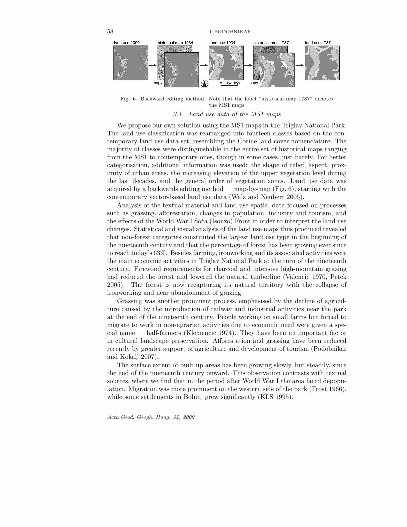
Fig. 6. Backward editing method. Note that the label “historical map 1787” denotesthe MS1 maps
3.1 Land use data of the MS1 maps
We propose our own solution using the MS1 maps in the Triglav National Park.The land use classification was rearranged into fourteen classes based on the con-temporary land use data set, resembling the Corine land cover nomenclature. Themajority of classes were distinguishable in the entire set of historical maps rangingfrom the MS1 to contemporary ones, though in some cases, just barely. For bettercategorisation, additional information was used: the shape of relief, aspect, prox-imity of urban areas, the increasing elevation of the upper vegetation level duringthe last decades, and the general order of vegetation zones. Land use data wasacquired by a backwards editing method — map-by-map (Fig. 6), starting with thecontemporary vector-based land use data (Walz and Neubert 2005).
Analysis of the textual material and land use spatial data focused on processessuch as grassing, afforestation, changes in population, industry and tourism, andthe effects of the World War I Soca (Isonzo) Front in order to interpret the land usechanges. Statistical and visual analysis of the land use maps thus produced revealedthat non-forest categories constituted the largest land use type in the beginning ofthe nineteenth century and that the percentage of forest has been growing ever sinceto reach today’s 63%. Besides farming, ironworking and its associated activities werethe main economic activities in Triglav National Park at the turn of the nineteenthcentury. Firewood requirements for charcoal and intensive high-mountain grazinghad reduced the forest and lowered the natural timberline (Valencic 1970, Petek2005). The forest is now recapturing its natural territory with the collapse ofironworking and near abandonment of grazing.
Grassing was another prominent process, emphasised by the decline of agricul-ture caused by the introduction of railway and industrial activities near the parkat the end of the nineteenth century. People working on small farms but forced tomigrate to work in non-agrarian activities due to economic need were given a spe-cial name — half-farmers (Klemencic 1974). They have been an important factorin cultural landscape preservation. Afforestation and grassing have been reducedrecently by greater support of agriculture and development of tourism (Podobnikarand Kokalj 2007).
The surface extent of built up areas has been growing slowly, but steadily, sincethe end of the nineteenth century onward. This observation contrasts with textualsources, where we find that in the period after World War I the area faced depopu-lation. Migration was more prominent on the western side of the park (Trost 1966),while some settlements in Bohinj grew significantly (KLS 1995).
Acta Geod. Geoph. Hung. 44, 2009

JOSEPHINE SURVEY MAPS 59
Fig. 7. Lack of knowledge and surveying of the mountain environment lead to an imaginativeinterpretation of the relief surface. Mountain peaks that do not actually exist can be seen by
comparing the MS1 map and overlaid contemporary contour lines
4. Quality assessment and error simulation
The quality assessment was monitored through the following methods: obtain-ing an a priori knowledge of the MS1 maps; learning about cartography methodsthrough the visual appearance of singular map sheets; trying to find rules of map-ping by means of mosaicking the map sheets; studying similarities of the mappedfeatures to contemporary conditions for defining the position of reference points;georeferencing the MS1 maps in comparison with contemporary data sets; prepar-ing an object catalogue for land use studies, and interpretation of the land uses,etc. We proved the findings of Korosec (1993) that the relief representation of thehigher and rocky areas of the Julian Alps in the MS1 maps is not only a coarse ap-proximation, but also unconvincing and unreal. Elevation data were not consideredat the time of the survey, resulting in false relationships of geomorphology (Fig. 7).
The aim of the quality assessment is to analyse the quality and errors that canoccur in the MS1 maps by:
— statistical tests (and visualisation) of the possible errors, and
— simulation of the errors.
Both approaches apply a quality assessment that includes identical points fromhistorical maps and from reference data sets as well as the vectorised land usedata sets. Simulation also involves other information gathered as part of a prioriknowledge (e.g. common problems of Habsburg’s military survey).
Acta Geod. Geoph. Hung. 44, 2009

60 T PODOBNIKAR
Table I. Positional and thematic accuracy evaluation for the MS1 maps. RMSE wastested with 190 control points (in mm as appeared in the maps and in m on the terrain)and AME with 16 control points. PCC was tested for the following categories: urban
fabric, forest, grassland, and “all the others”, as listed
Accuracy (type) Error (type) Error (value)
Positional RMSE (190 pts.) 16.7–19.1 mm 480–550 mAME1 (16 pts.) 19.8 mm 570 mMax. 36.5 mm 1050 mAME2 (10 pts. – peaks 5.5 mm 160 m
10 pts. – streams) 13.5 mm 390 m
Thematic PCC 45%, 79%, 67%, 79%Kappa 0.67
4.1 Quality assessment in MS1 maps
The quality of the land use data interpretation is affected by the positionaland thematic accuracy of the georeferenced MS1 maps. The following positionalaccuracy parameters were evaluated (Table I):
— Root mean square error (RMSE) was evaluated for polynomial transforma-tions order 1 and 2 through georeferencing (a rubber sheeting method doesnot produce the RMSE as the position of the identical points is kept after thetransformation; Podobnikar 2008).
— Averaged maximum error (AME1) was calculated as differences between man-ually selected control points on georeferenced maps (the georeferencing methodis less important in this case) in comparison with reference data sets (locallymaximum deviations were chosen); it is a control for RMSE.
— Averaged maximum error (AME2) was calculated according to rubber sheet-ing transformation. As the identical points for the rubber sheeting alreadyemployed churches, bridges, some peaks, and road crossings, ten randomly(but significant) points on peaks and ten points on streams from the MS1maps were compared with the reference data sets. For the most part, theerror signifies local systematic errors on primarily flat areas. The results aretherefore an underestimation of error.
The thematic accuracy was evaluated using (Table I):
— Proportion correctly classified (PCC) as a proportion of agreement betweenthe reference and the MS1 data sets.
— Kappa coefficient as a measure of agreement between two binary variables. AKappa value higher than 0.60 is usually interpreted as a suitable agreement(Giordano and Veregin 1994).
The final result of georeferencing is less accurate than results from comparablestudies (Kusar and Hocevar 2005, Zimova et al. 2006, Haase et al. 2007) due to theprevailing rugged alpine relief in Triglav National Park.
Acta Geod. Geoph. Hung. 44, 2009

JOSEPHINE SURVEY MAPS 61
4.2 Simulation of positional error of the MS1 maps
The quality assessment based on evaluation of positional errors, calculated withdifferent methods and on the basis of various transformations, better indicates thenature of the errors than previous steps of analysing the data. The main sourceof the errors lies in mapping the MS1 maps, and secondarily on the derived (vec-torised) land use data set (land use borders are positionally less precise than thecontrol points used for transformations). The simulation of the errors can assist inunderstanding the nature of the errors, and improving techniques for georeferencing,and, in a next iteration, improving the simulation.
Monte Carlo simulation is a known statistical method for computation withrandom numbers. Multiple realisations are often needed because every simulationis just one of a large number of representations of a specified probability model(Haining 2003). The idea of stochastic simulation is to develop a spatial Monte Carlomodel — a generator that enables creation of many equally probable realisations ofa random function/field.
Local probability density functions are used to developing a probabilistic modelfor a random variable at any point in space. A transformation of the uniformdistribution of discrete random variable to normal distribution can be applied by theBox-Muller method. A general procedure for the Monte Carlo simulation algorithmis (Podobnikar 2008):
— generate a set of random numbers i = 1, . . . , m dependant on a specific model,
— for the current set compute appropriate (conditional) distribution and storeindividual output,
— repeat the upper procedure N times, and
— compute and store sample statistics from the N outputs.
The number of simulations depends on objectives of the study and the phe-nomena surveyed. Monte Carlo methods of error analysis are usually followed bya statistical theory of error distribution and propagation (Burrough and McDonell1998). Land use data sets based on the MS1 maps were simulated with the followingassumptions (Podobnikar 2008):
— random (mostly relative) effects: instruments, human factors, and others thatare undefinable with respect to precision;
— locally systematic (mostly relative) effects over larger areas that could alsobe classified as spatially smooth or random on a smaller scale: triangulationerrors, errors in measurements of long distances, avoiding obstacles, absenceof measurements, other undefinable errors, distributed as described; and
— systematic/gross (mostly absolute) effects over the whole case study area:projections, measurements.
Acta Geod. Geoph. Hung. 44, 2009

62 T PODOBNIKAR
Fig. 8. Land use data acquired from the MS1 simulated N = 100 times with the Monte Carlomethod using the land use boundaries for that part of the Triglav National Park. Distributionsof the borders show possible error expanses. Some are less diffuse than others depending on the
accuracy of the land use with σ applied
Simulation of the first error type is the most simple. The second and thirderrors are not so easy to simulate, especially with respect to systematic or evengross errors that are most probably not distributed randomly, but their nature issometimes similar to stochastic. Nevertheless, because of inexact and uncertainclassification of error types, we tried to simulate all three groups.
The first step was to create random values with standardised unconditionalGaussian distribution, mean value 0, and standard deviation 1. Those distributionswere transformed conditionally regarding measured and evaluated RMSE valuesthat present standard deviations of simulations.
4.3 Vector boundary simulation — first principle
The Monte Carlo error simulation was applied using two different approaches.The first followed the rules of boundary simulations (Burrough and McDonell 1998).Land use boundaries acquired from the MS1 were assigned values of measuredRMSE. The average σ value is 17.9 mm · 28 800 = 515 m (Table I). This assump-tion exaggerates the reality in the flat areas (e.g. along the most populated areasin Bohinj significant error is not expected), for more precisely measured churchesand road crossings, and along the areas enhanced with more precise data sources(less diffuse borders of the highest possible vegetation occurrence in Fig. 8), but itmatches well the error in the rough mountainous relief (very diffuse borders in Fig.8). However, although this is a large error, we could not reduce the RMSE in thisregion as additional control points could not be located on the map. Additionaluncertainty of the σ determination was simulated with σ1 around σ, where σ1 � σ.Furthermore we ensured that the shape of the particular simulated object remainedsimilar to the acquired original. After applying that condition the neighbourhoodnodes of the boundary lines are correlated (Podobnikar 2008).
The second approach of the first principle was identical to the first, with theexception that simulation was applied to boundaries of polygons (not lines). Inorder to preserve original topology as much as possible, the proper solution of thissimulation is much more complex (Podobnikar 2008).
Acta Geod. Geoph. Hung. 44, 2009

JOSEPHINE SURVEY MAPS 63
Fig. 9. One of the Monte Carlo simulations of selected land uses from the MS1. A random distri-bution surface represents absolute values between co-ordinates shifted in the x and y directions.Brighter areas mean larger shifts. Contour lines support shaded surface — higher density linesrepresent conversion between different locally systematic errors. The autocorrelated arrangementof square polygons with 200 m sides presents possible distortions of the land use data due to shifts.The local systematic error is constant where squares are connected; elsewhere it is changing. Theindividual land use areas are therefore continuously deformed and shifted. Little or no random
error is expected within the square boundaries
4.4 Continuous surface simulation — second principle
With continuous surface simulation the error is simulated for the areas of theland use data and not just for the borders. This procedure can provide better un-derstanding both of what was simulated and of other possibilities applied to thesimulated error model. The main idea is that the greatest part of error distributionin the mountainous area is locally systematic and can be suitably represented bya random autocorrelated (continuous) surface. For locally systematic error distri-bution we assumed a spatially smooth distribution. Locally shifted homogenousareas were simulated (e.g. one valley, one settlement) in relation to imprecise mea-surement between selected areas, but with higher precision inside them (Podobnikar2008). The problem and appearance of this error is similar to residuals of the (seven-parameter similarity) transformation parameters between the national co-ordinatesystems and the European (more global) ETRS89 (e.g. Stopar and Kuhar 2003).
The same principles were used to apply a more spatially rough error that approx-imates the more random (or locally very thin) distribution related to measurementson short distances. This error distribution is somewhat similar to the first princi-ple, but instead of lines, small areas are simulated (Fig. 9, Podobnikar 2008). Bothartificial randomly autocorrelated surfaces were generated as standardised uncon-ditional Gaussian distributions with mean value 0 and standard deviation of 1.A Moran I measure was used to achieve the required degree of autocorrelation. Thesame procedure was performed for the smooth and rough random surfaces, but withdifferent spatial resolution. Similar to the first principle, the evaluated RMSE value(σ = 17.9 mm ·28 800 = 515 m) was annotated to the standardised complex surface.
Acta Geod. Geoph. Hung. 44, 2009

64 T PODOBNIKAR
The next stage involved attributing the shifts in the x and y direction con-sidering complex error surfaces. The shifts were applied to the land use data setacquired from the MS1 map. To apply the shifts, two approaches were followed. Thefirst was tessellation of land use into uniform square areas (vector polygons) with200 m sides. This approach was combined with the first principle, so boundariesof the polygons were simulated for all squares (Fig. 9, Podobnikar 2008). Thus wecan effectively simulate error distribution considering all three listed presumptions:random, locally systematic, and systematic/gross errors. The second approach issimilar to the first, but squares were replaced with denser grid points to simulategrid-based land use surface.
5. Conclusions
Georeferenced historical maps allow an effective multidisciplinary spatial anal-ysis in geographical information systems in combination with other georeferencedand descriptive data sets. High precision georeferencing of the system of historicalmap sheets covering a large area is a difficult task. Even greater problems mayoccur in rugged mountainous regions, especially in cases where most of the areawas not accessed and therefore not surveyed.
The main problems that occurred during the georeferencing process of theHabsburg Monarchy 1763–1787 MS1 maps were: poor geometry (big and nonho-mogeneous distortions) of the mapping, unknown (undefined) co-ordinate system,low quality surveying equipment that generated various errors, oversimplified map-ping and generalisation techniques, changes of the landscape since the time of themapping, the very narrow military purpose, inexperience of the surveyors, low stan-dardisation that allowed a great deal of subjectivity, etc.
Advantages of our georeferencing approach include: deep and precise study ofthe maps of MS1; study of different techniques of the transformation in combinationwith finding as many identical points as possible; improving the georeferencing withthe study of the accuracy parameters of the vectorised land use data; comparisonbetween the identical points and land use data set that was enhanced with a time-series analysis; and quality control of the transformed data with evaluation of thepositional and thematic accuracy by applying Monte Carlo simulation techniques— by trying to approximate the real errors that occurred on the MS1 maps. Thedescribed approach helped the understanding and avoidance of the problems ofgeoreferencing (detailed in the previous paragraph). This integrated methodologicalapproach enables improving the positional accuracy of the MS1 maps in a step-by-step empirical way.
According to Rajsp and Serse (1998) the value of the MS1 maps lies especiallyin their content: topographical names, road connections, and other information im-portant to increasing our knowledge of the cultural landscape, whereas the accuracyof these maps is unfortunately not their greatest value. Our research demonstratesthat precise georeferencing significantly enhances the value of these maps, espe-cially in combination with any other spatial data sources within the geographicalinformation system.
Usability of any (spatial) data set could be increased with a careful quality as-
Acta Geod. Geoph. Hung. 44, 2009

JOSEPHINE SURVEY MAPS 65
sessment that includes standardised and well-known procedures (e.g. according ISOstandards), and additionally, procedures adjusted to a specific problem as shownin this paper. Another important step after studying the particular data sets ispreparing the metadata information and enabling their effective accessibility forwider use, which can comprise various interdisciplinary studies on the historicaldata sets.
Acknowledgements
The maps used in this research were provided with the permission and kindness of many
institutions and people. The originals of the historical maps were digitally photographed.
The main map sources were Dr. Vincenc Rajsp and the Surveying and Mapping Authority
of the Republic of Slovenia. Applied outputs of this research were utilised within the
Interreg IIIB — SISTEMaPARC European project. I’m very grateful to Ziga Kokalj and
Jani Kozina, who contributed to successful completion of the project. The finalisation has
been carried out within the series of TMIS projects (plus, plus.II, morph) funded by the
Austrian Research Promotion Agency in the framework of the ASAP program.
References
ARS 2004: Archive of the Republic of Slovenia: Cadastre of Francis I from 19 century.http://www.arhiv.gov.si/
Burrough P, McDonnell R 1998: Principles of Geographical Information Systems – SpatialInformation Systems and Geostatistics. Oxford University Press
Ceh M 2002: Analyses of geodetic databases for the agriculture needs. Doctoral thesis,University of Ljubljana
Francula N, Lapaine M 2007: Geodetski list, 61, No. 3, 175–181.
Gasperic P 2007: Acta Geogr. Slov., 47, No. 2, 245–273.
Giordano A, Veregin H 1994: Quality control in the geographical information systems (inItalian). il Cardo, Venezia
Grabnar M 1994: Territory of Slovenia on the military map from the second part of 18century (in Slovenian). Sections 201–205, 212–215 (specimen). Zalozba ZRC SAZUand Archives of the Republic Slovenia, Ljubljana, 159–160.
Haase D, Walz U, Neubert M, Rosenberg M 2007: Land Use Policy, 24, 248–263.
Haining R 2003: Spatial Data Analysis: Theory and Practice. Cambridge University Press
Jenko M 2008: Geodetski vestnik, 51, No. 1, 83–95.
Klaric M 1975: Geodetski vestnik, 19, No. 4, 19–31.
Klemencic M 1974: Geografski vestnik, 46, 61–74.
KLS 1995: Lexicon of settlements in Slovenia (in Slovenian). Drzavna zalozba Slovenije,Ljubljana
Korosec B 1978: Our space in time and projection (in Slovenian). Geodetski zavod SRS,Ljubljana
Korosec B 1993: Forests of Slovenia through time – Spatial databases and mapping of theforests until 1828 (in Slovenian). Kmecki glas, Ljubljana
Kretschmer I, Riedl A 2008: Austrian (Habsburg) official cartographic activities from theFirst Military Survey to World War I. EGU General Assembly 2008, Vienna. Geophys.Res. Abstr., 10, EGU2008-A-00592
Kusar G, Hocevar M 2005: Gozdarski vestnik, 63, No. 9, 419–429.
Acta Geod. Geoph. Hung. 44, 2009

66 T PODOBNIKAR
Lanius C 1999: Mathematics of Cartography. Rice University, Department of Mathemat-ics, http://math.rice.edu/∼lanius/pres/map/
Lapaine M 2008: Cartographic projections (in Croatian). http://www.kartografija.hr/projekcije−dugo.pdf
NLS 2002: National Library of Scotland, 2002–2008: Digital Library. http://www.nls.uk/maps/
NUK 2008: National and University Library: Maps of the Slovenian Territory 1548–1924.National and University Library. http://www.nuk.uni-lj.si/
Petek F 2005: Land use changes in Slovenian Alpine regions (in Slovenian). GeografijaSlovenije 11, Zalozba ZRC, Ljubljana
Podobnikar T 2008: Simulation and representation of the positional errors of boundaryand interior regions in maps. In: Geospatial vision: new dimensions in cartography:selected papers from the 4th National Cartographic Conference (GeoCart’2008), NewZealand (Lecture notes in geoinformation and cartography), A Moore, I Drecki eds,Springer, Berlin, Heidelberg, 141–169.
Podobnikar T, Kokalj Z 2007: Triglav National Park historical maps analysis. In: Pro-ceedings of 5th Mountain Cartography Workshop, Bohinj, Slovenia, 2006. D Petroviced., International Cartographic Association, Commission on Mountain Cartography,Zurich; Association of Surveyors of Slovenia, Section of Cartography, Faculty of Civiland Geodetic Engineering, Ljubljana, 180–188.
Podobnikar T, Sinkovec I 2004: Ljubljana – mutual analyses of the georeferenced old maps.In: Javno dobro: indentifikacija, upotreba, upravljanje, dizajn. Beograd: Centar zaplaniranje urbanog razvoja, Z Gligorijevic ed., 67–73.
Rajsp V, Serse A 1998: Josephinian survey in the Slovienia territory 1763–1787 (inSlovienian/German). ZRC SAZU, Ljubljana, Vol. 4.
Ravbar N, Prelovsek M 2005: Land use in the Udin borst karstic terrace and its margin (inSlovenian). In: Architecture of a unique relationship people – territory, Udin borst,A Kranjc ed., Montebelluna: Museo di Storia Naturale e Archeologia, 65–71.
Robinson A H, Morrison J L, Muehrcke P C, Kimerling A J, Guptill S C 1995: Elementsof Cartography. 6th ed., John Wiley and Sons, New York
Stopar B, Kuhar M 2003: Acta Geod. Geoph. Hung., 38 43–52.Timar G 2004: Kartograficke listy, 12, 119–126.Timar G, Molnar G, Szekely B, Biszak S, Kovacs B, Markovinovic D, Kuhar M 2006:
Geodezia es Kartografia, 58. No. 12, 30–35.Timar G, Szekely B, Molnar G, Ferencz C, Kern A, Galambos C, Gercsak G, Zentai L
2008: Global and Planetary Change, 62, 29–39.Triglav J 2003: Geografski obzornik, 13, No. 3–4, 114–118.Valencic V 1970: Forestry. Economical and social history of Slovenians (in Slovenian).
History of agrarian braches, 1, Drzavna zalozba Slovenije, LjubljanaWalz U, Neubert M 2005: Historical landscape monitoring, Geo-referencing and backward
editing method. Manual, SISTEMaPARC projectWawrik F, Zeilinger E 1989: Austria on historical maps and insights (in German). Austria
picta GrazZimova R, Pestal J, Veverka B 2006: Historical military mapping of the Czech lands –
cartographic analysis. International Conference on Cartography and GIS. Borovets.http://www.datamap-bg.com/conference−cd/pdf/22−241−RZimova−Cz.pdf
Zorn M 2007: Geografski vestnik, 79, No. 2, 129–140.
Acta Geod. Geoph. Hung. 44, 2009