future sydney - a city of cities · future sydney - a city of cities bob meyer director of planning...
TRANSCRIPT
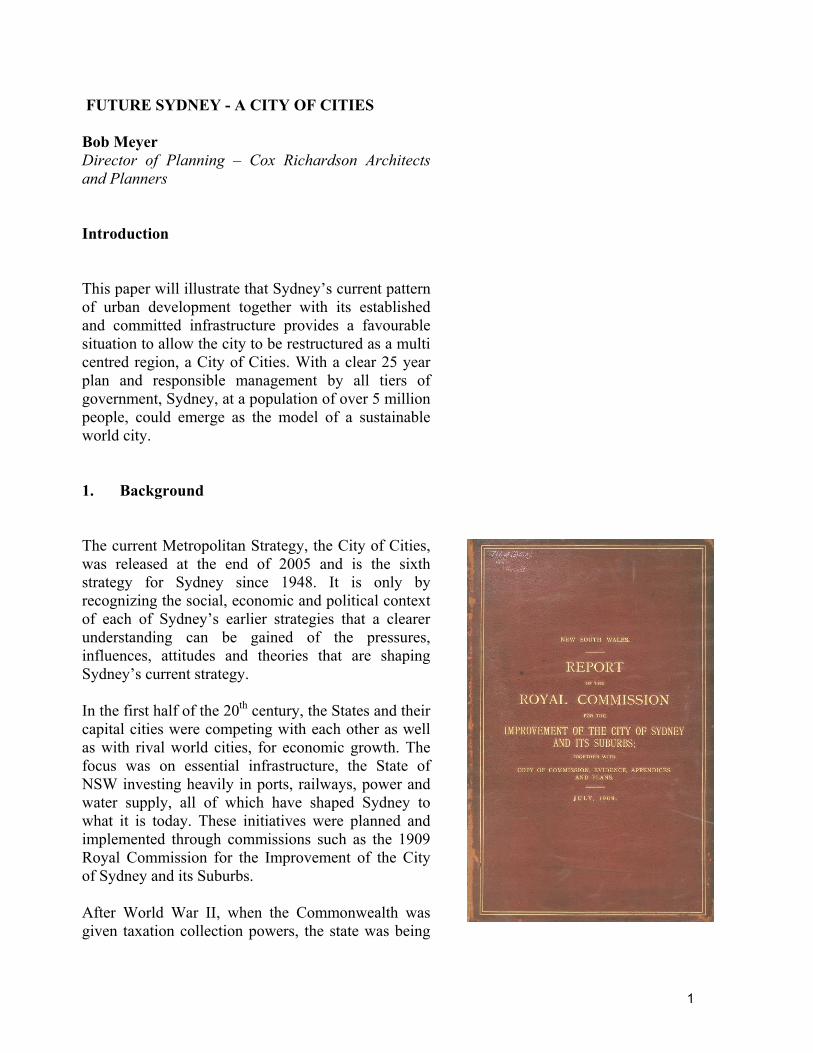
FUTURE SYDNEY - A CITY OF CITIES Bob Meyer Director of Planning – Cox Richardson Architects and Planners Introduction This paper will illustrate that Sydney’s current pattern of urban development together with its established and committed infrastructure provides a favourable situation to allow the city to be restructured as a multi centred region, a City of Cities. With a clear 25 year plan and responsible management by all tiers of government, Sydney, at a population of over 5 million people, could emerge as the model of a sustainable world city. 1. Background The current Metropolitan Strategy, the City of Cities, was released at the end of 2005 and is the sixth strategy for Sydney since 1948. It is only by recognizing the social, economic and political context of each of Sydney’s earlier strategies that a clearer understanding can be gained of the pressures, influences, attitudes and theories that are shaping Sydney’s current strategy. In the first half of the 20th century, the States and their capital cities were competing with each other as well as with rival world cities, for economic growth. The focus was on essential infrastructure, the State of NSW investing heavily in ports, railways, power and water supply, all of which have shaped Sydney to what it is today. These initiatives were planned and implemented through commissions such as the 1909 Royal Commission for the Improvement of the City of Sydney and its Suburbs. After World War II, when the Commonwealth was given taxation collection powers, the state was being
1
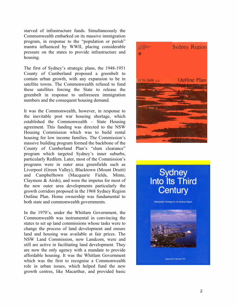
starved of infrastructure funds. Simultaneously the Commonwealth embarked on its massive immigration program, in response to the “population or perish” mantra influenced by WWII, placing considerable pressure on the states to provide infrastructure and housing. The first of Sydney’s strategic plans, the 1948-1951 County of Cumberland proposed a greenbelt to contain urban growth, with any expansion to be in satellite towns. The Commonwealth refused to fund these satellites forcing the State to release the greenbelt in response to unforeseen immigration numbers and the consequent housing demand. It was the Commonwealth, however, in response to the inevitable post war housing shortage, which established the Commonwealth – State Housing agreement. This funding was directed to the NSW Housing Commission which was to build rental housing for low income families. The Commission’s massive building program formed the backbone of the County of Cumberland Plan’s “slum clearance” program which targeted Sydney’s inner suburbs, particularly Redfern. Later, most of the Commission’s programs were in outer area greenfields such as Liverpool (Green Valley), Blacktown (Mount Druitt) and Campbelltown (Macquarie Fields, Minto, Claymore & Airds), and were the impetus for most of the new outer area developments particularly the growth corridors proposed in the 1968 Sydney Region Outline Plan. Home ownership was fundamental to both state and commonwealth governments. In the 1970’s, under the Whitlam Government, the Commonwealth was instrumental in convincing the states to set up land commissions whose tasks were to change the process of land development and ensure land and housing was available at fair prices. The NSW Land Commission, now Landcom, were and still are active in facilitating land development. They are now the only agency with a mandate to provide affordable housing. It was the Whitlam Government which was the first to recognise a Commonwealth role in urban issues, which helped fund the new growth centres, like Macarthur, and provided basic
2
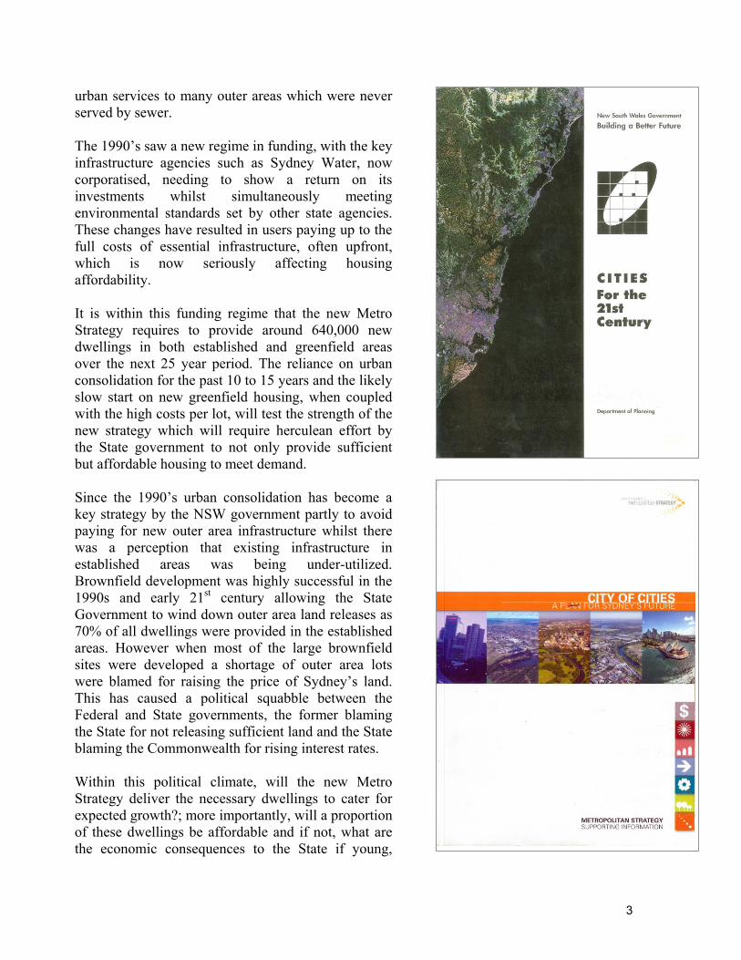
urban services to many outer areas which were never served by sewer. The 1990’s saw a new regime in funding, with the key infrastructure agencies such as Sydney Water, now corporatised, needing to show a return on its investments whilst simultaneously meeting environmental standards set by other state agencies. These changes have resulted in users paying up to the full costs of essential infrastructure, often upfront, which is now seriously affecting housing affordability. It is within this funding regime that the new Metro Strategy requires to provide around 640,000 new dwellings in both established and greenfield areas over the next 25 year period. The reliance on urban consolidation for the past 10 to 15 years and the likely slow start on new greenfield housing, when coupled with the high costs per lot, will test the strength of the new strategy which will require herculean effort by the State government to not only provide sufficient but affordable housing to meet demand. Since the 1990’s urban consolidation has become a key strategy by the NSW government partly to avoid paying for new outer area infrastructure whilst there was a perception that existing infrastructure in established areas was being under-utilized. Brownfield development was highly successful in the 1990s and early 21st century allowing the State Government to wind down outer area land releases as 70% of all dwellings were provided in the established areas. However when most of the large brownfield sites were developed a shortage of outer area lots were blamed for raising the price of Sydney’s land. This has caused a political squabble between the Federal and State governments, the former blaming the State for not releasing sufficient land and the State blaming the Commonwealth for rising interest rates. Within this political climate, will the new Metro Strategy deliver the necessary dwellings to cater for expected growth?; more importantly, will a proportion of these dwellings be affordable and if not, what are the economic consequences to the State if young,
3
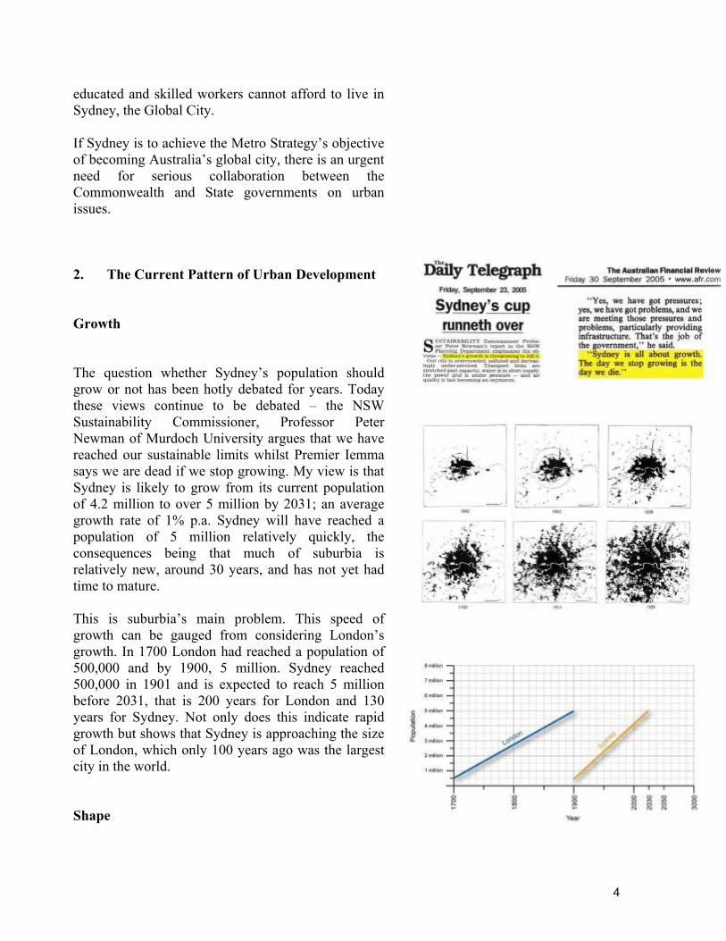
educated and skilled workers cannot afford to live in Sydney, the Global City. If Sydney is to achieve the Metro Strategy’s objective of becoming Australia’s global city, there is an urgent need for serious collaboration between the Commonwealth and State governments on urban issues. 2. The Current Pattern of Urban Development Growth The question whether Sydney’s population should grow or not has been hotly debated for years. Today these views continue to be debated – the NSW Sustainability Commissioner, Professor Peter Newman of Murdoch University argues that we have reached our sustainable limits whilst Premier Iemma says we are dead if we stop growing. My view is that Sydney is likely to grow from its current population of 4.2 million to over 5 million by 2031; an average growth rate of 1% p.a. Sydney will have reached a population of 5 million relatively quickly, the consequences being that much of suburbia is relatively new, around 30 years, and has not yet had time to mature. This is suburbia’s main problem. This speed of growth can be gauged from considering London’s growth. In 1700 London had reached a population of 500,000 and by 1900, 5 million. Sydney reached 500,000 in 1901 and is expected to reach 5 million before 2031, that is 200 years for London and 130 years for Sydney. Not only does this indicate rapid growth but shows that Sydney is approaching the size of London, which only 100 years ago was the largest city in the world. Shape
4
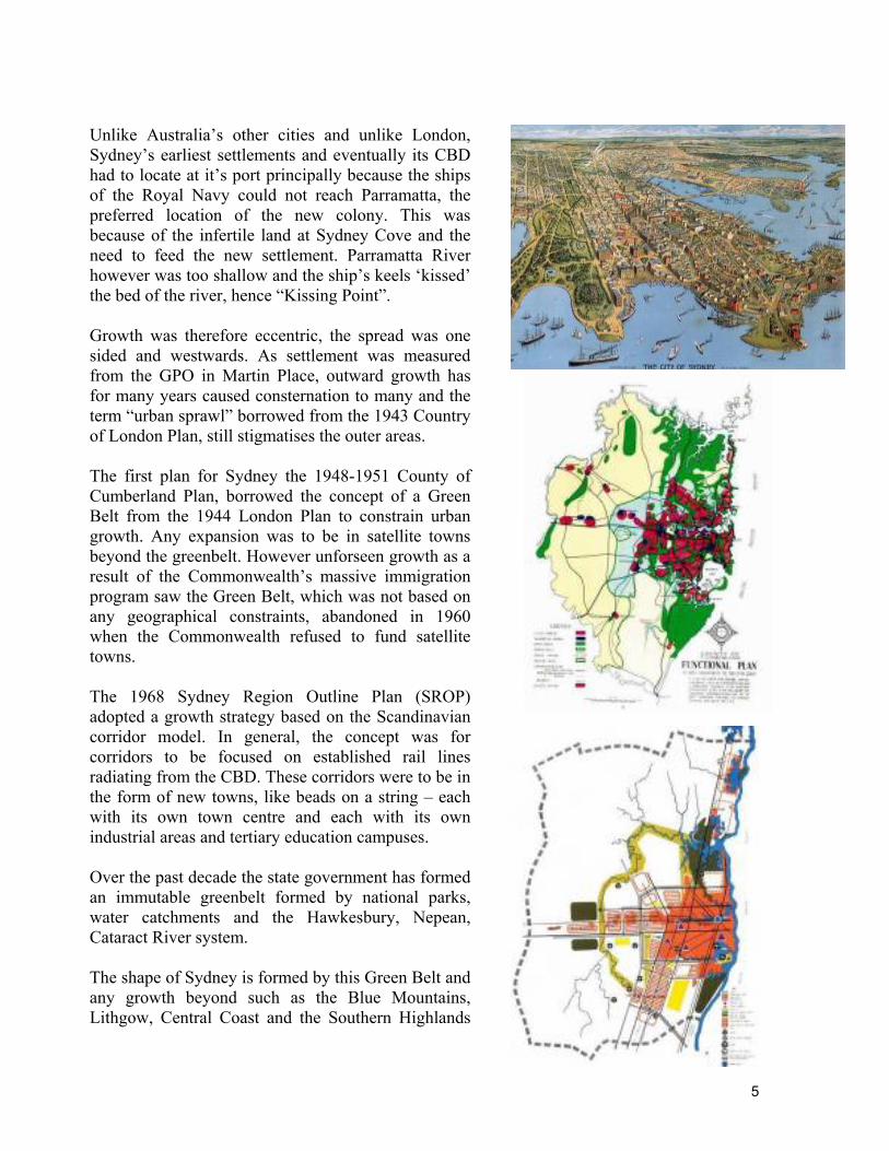
Unlike Australia’s other cities and unlike London, Sydney’s earliest settlements and eventually its CBD had to locate at it’s port principally because the ships of the Royal Navy could not reach Parramatta, the preferred location of the new colony. This was because of the infertile land at Sydney Cove and the need to feed the new settlement. Parramatta River however was too shallow and the ship’s keels ‘kissed’ the bed of the river, hence “Kissing Point”. Growth was therefore eccentric, the spread was one sided and westwards. As settlement was measured from the GPO in Martin Place, outward growth has for many years caused consternation to many and the term “urban sprawl” borrowed from the 1943 Country of London Plan, still stigmatises the outer areas. The first plan for Sydney the 1948-1951 County of Cumberland Plan, borrowed the concept of a Green Belt from the 1944 London Plan to constrain urban growth. Any expansion was to be in satellite towns beyond the greenbelt. However unforseen growth as a result of the Commonwealth’s massive immigration program saw the Green Belt, which was not based on any geographical constraints, abandoned in 1960 when the Commonwealth refused to fund satellite towns. The 1968 Sydney Region Outline Plan (SROP) adopted a growth strategy based on the Scandinavian corridor model. In general, the concept was for corridors to be focused on established rail lines radiating from the CBD. These corridors were to be in the form of new towns, like beads on a string – each with its own town centre and each with its own industrial areas and tertiary education campuses. Over the past decade the state government has formed an immutable greenbelt formed by national parks, water catchments and the Hawkesbury, Nepean, Cataract River system. The shape of Sydney is formed by this Green Belt and any growth beyond such as the Blue Mountains, Lithgow, Central Coast and the Southern Highlands
5
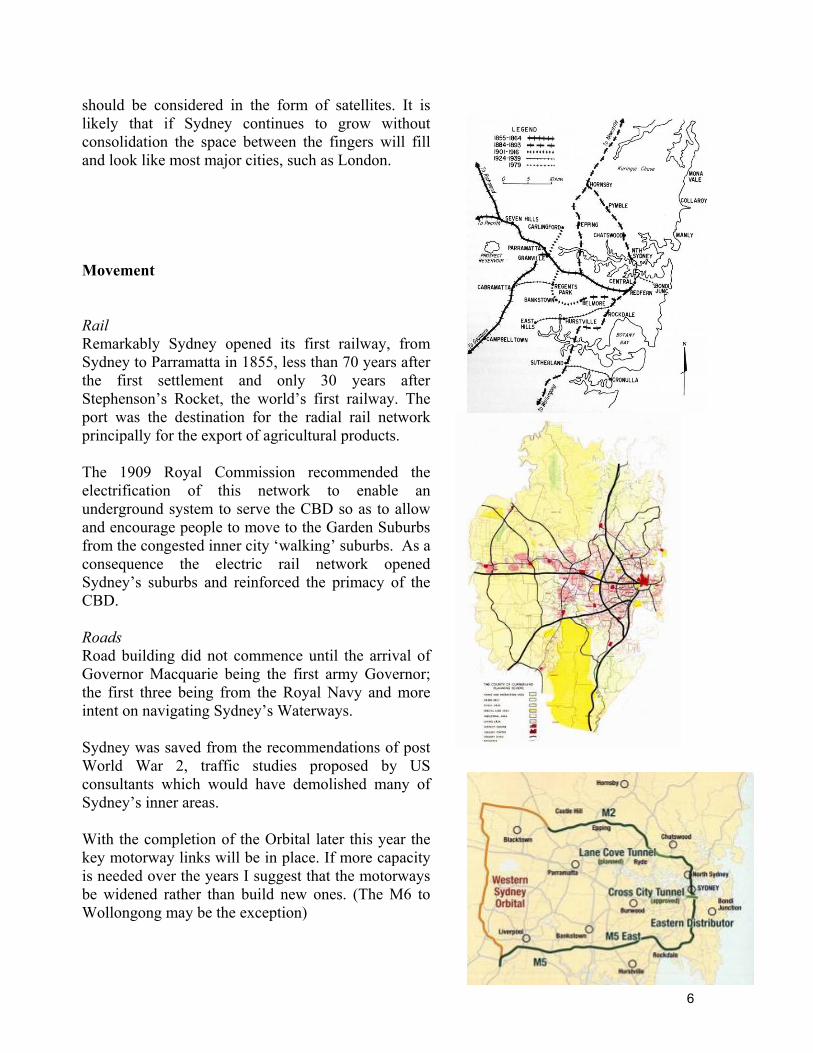
should be considered in the form of satellites. It is likely that if Sydney continues to grow without consolidation the space between the fingers will fill and look like most major cities, such as London. Movement Rail Remarkably Sydney opened its first railway, from Sydney to Parramatta in 1855, less than 70 years after the first settlement and only 30 years after Stephenson’s Rocket, the world’s first railway. The port was the destination for the radial rail network principally for the export of agricultural products. The 1909 Royal Commission recommended the electrification of this network to enable an underground system to serve the CBD so as to allow and encourage people to move to the Garden Suburbs from the congested inner city ‘walking’ suburbs. As a consequence the electric rail network opened Sydney’s suburbs and reinforced the primacy of the CBD. Roads Road building did not commence until the arrival of Governor Macquarie being the first army Governor; the first three being from the Royal Navy and more intent on navigating Sydney’s Waterways. Sydney was saved from the recommendations of post World War 2, traffic studies proposed by US consultants which would have demolished many of Sydney’s inner areas. With the completion of the Orbital later this year the key motorway links will be in place. If more capacity is needed over the years I suggest that the motorways be widened rather than build new ones. (The M6 to Wollongong may be the exception)
6
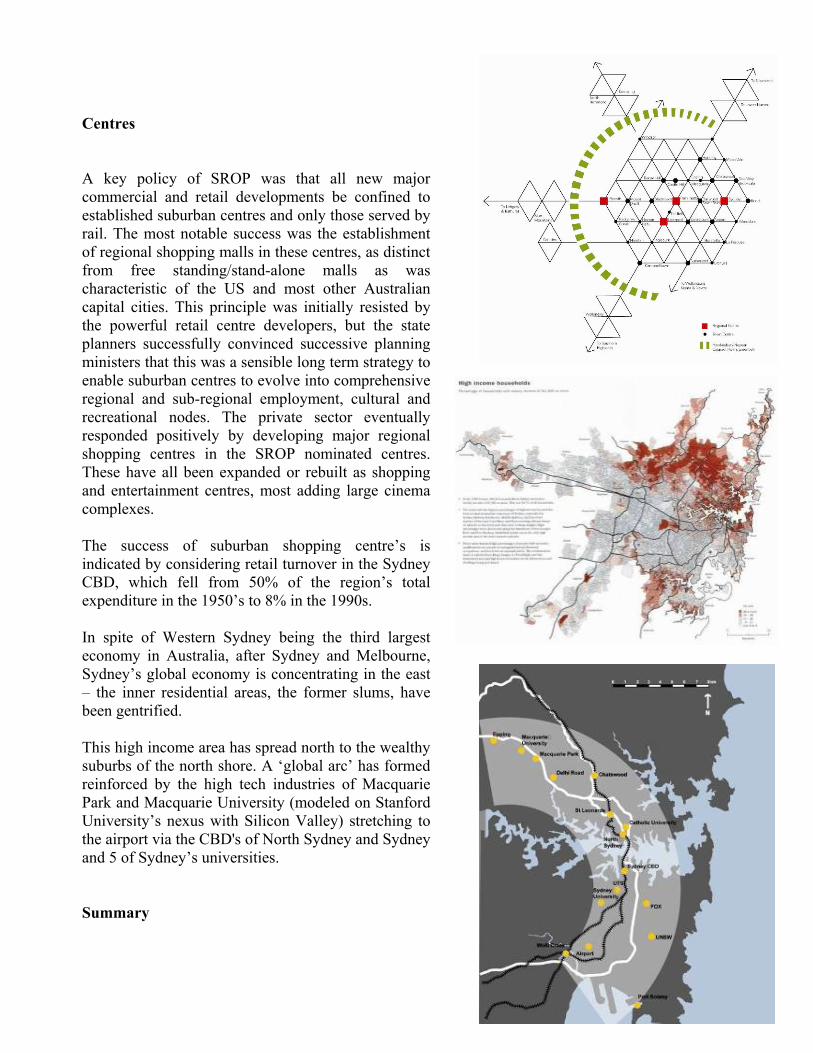
Centres A key policy of SROP was that all new major commercial and retail developments be confined to established suburban centres and only those served by rail. The most notable success was the establishment of regional shopping malls in these centres, as distinct from free standing/stand-alone malls as was characteristic of the US and most other Australian capital cities. This principle was initially resisted by the powerful retail centre developers, but the state planners successfully convinced successive planning ministers that this was a sensible long term strategy to enable suburban centres to evolve into comprehensive regional and sub-regional employment, cultural and recreational nodes. The private sector eventually responded positively by developing major regional shopping centres in the SROP nominated centres. These have all been expanded or rebuilt as shopping and entertainment centres, most adding large cinema complexes. The success of suburban shopping centre’s is indicated by considering retail turnover in the Sydney CBD, which fell from 50% of the region’s total expenditure in the 1950’s to 8% in the 1990s. In spite of Western Sydney being the third largest economy in Australia, after Sydney and Melbourne, Sydney’s global economy is concentrating in the east – the inner residential areas, the former slums, have been gentrified. This high income area has spread north to the wealthy suburbs of the north shore. A ‘global arc’ has formed reinforced by the high tech industries of Macquarie Park and Macquarie University (modeled on Stanford University’s nexus with Silicon Valley) stretching to the airport via the CBD's of North Sydney and Sydney and 5 of Sydney’s universities. Summary
7
• The region is confined by a natural Green Belt
preventing sprawl Los Angeles and even London style.
• An electric rail network with over 300 stations
and capable of expansion.
• A motorway network breaks the radial format and which more equally distributes traffic throughout the region. The network allows traffic to bypass key centres.
• Regional and sub-regional centres, served by the
rail network, are in place, ready to expand and serve a restructured region
• Many catchments around the non centre stations
are capable of intensification, allowing greater access to public transport.
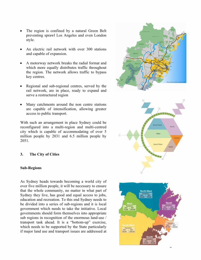
With such an arrangement in place Sydney could be reconfigured into a multi-region and multi-centred city which is capable of accommodating of over 5 million people by 2031 and 6.5 million people by 2051. 3. The City of Cities Sub-Regions As Sydney heads towards becoming a world city of over five million people, it will be necessary to ensure that the whole community, no matter in what part of Sydney they live, has good and equal access to jobs, education and recreation. To this end Sydney needs to be divided into a series of sub-regions and it is local government which needs to take the initiative. Local governments should form themselves into appropriate sub regions in recognition of the enormous land-use / transport task ahead. It is a “bottom-up” exercise, which needs to be supported by the State particularly if major land use and transport issues are addressed at
8
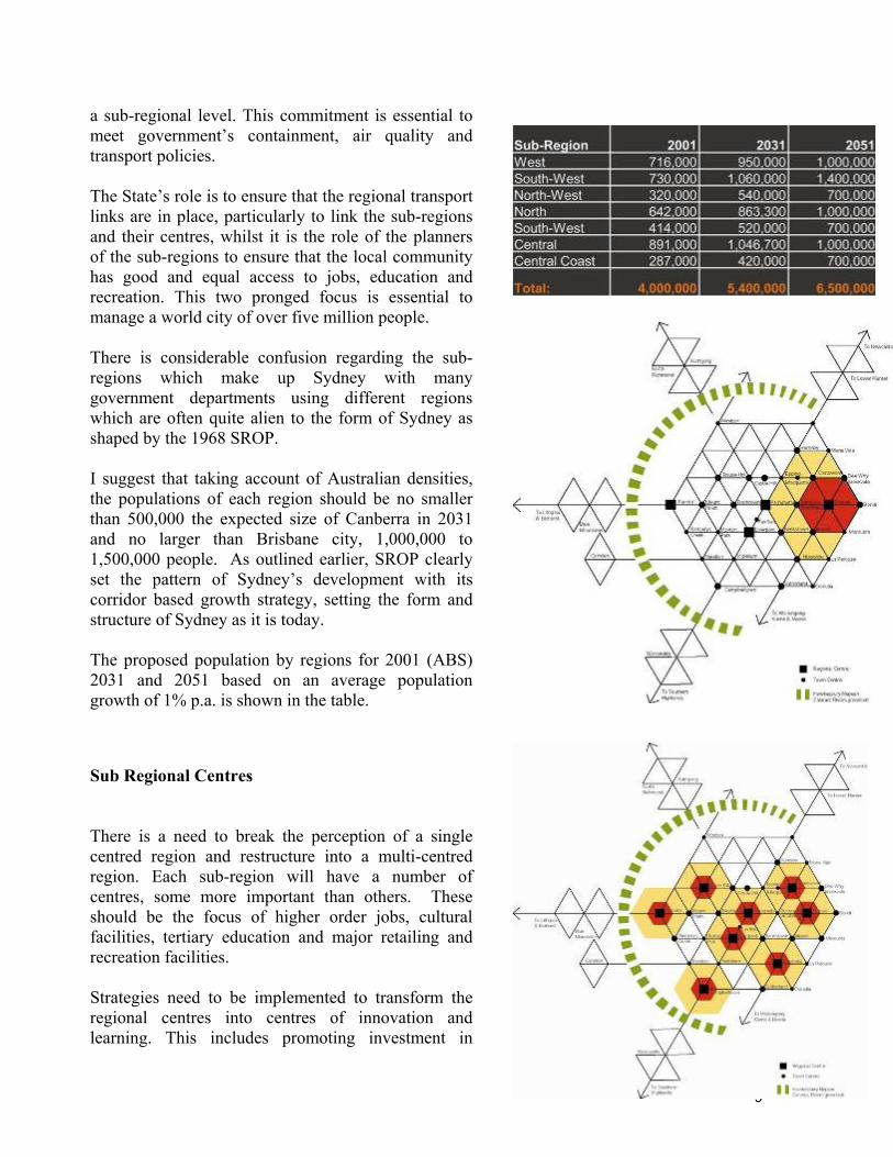
a sub-regional level. This commitment is essential to meet government’s containment, air quality and transport policies. The State’s role is to ensure that the regional transport links are in place, particularly to link the sub-regions and their centres, whilst it is the role of the planners of the sub-regions to ensure that the local community has good and equal access to jobs, education and recreation. This two pronged focus is essential to manage a world city of over five million people. There is considerable confusion regarding the sub-regions which make up Sydney with many government departments using different regions which are often quite alien to the form of Sydney as shaped by the 1968 SROP. I suggest that taking account of Australian densities, the populations of each region should be no smaller than 500,000 the expected size of Canberra in 2031 and no larger than Brisbane city, 1,000,000 to 1,500,000 people. As outlined earlier, SROP clearly set the pattern of Sydney’s development with its corridor based growth strategy, setting the form and structure of Sydney as it is today. The proposed population by regions for 2001 (ABS) 2031 and 2051 based on an average population growth of 1% p.a. is shown in the table.
Sub Regional Centres There is a need to break the perception of a single centred region and restructure into a multi-centred region. Each sub-region will have a number of centres, some more important than others. These should be the focus of higher order jobs, cultural facilities, tertiary education and major retailing and recreation facilities. Strategies need to be implemented to transform the regional centres into centres of innovation and learning. This includes promoting investment in
9
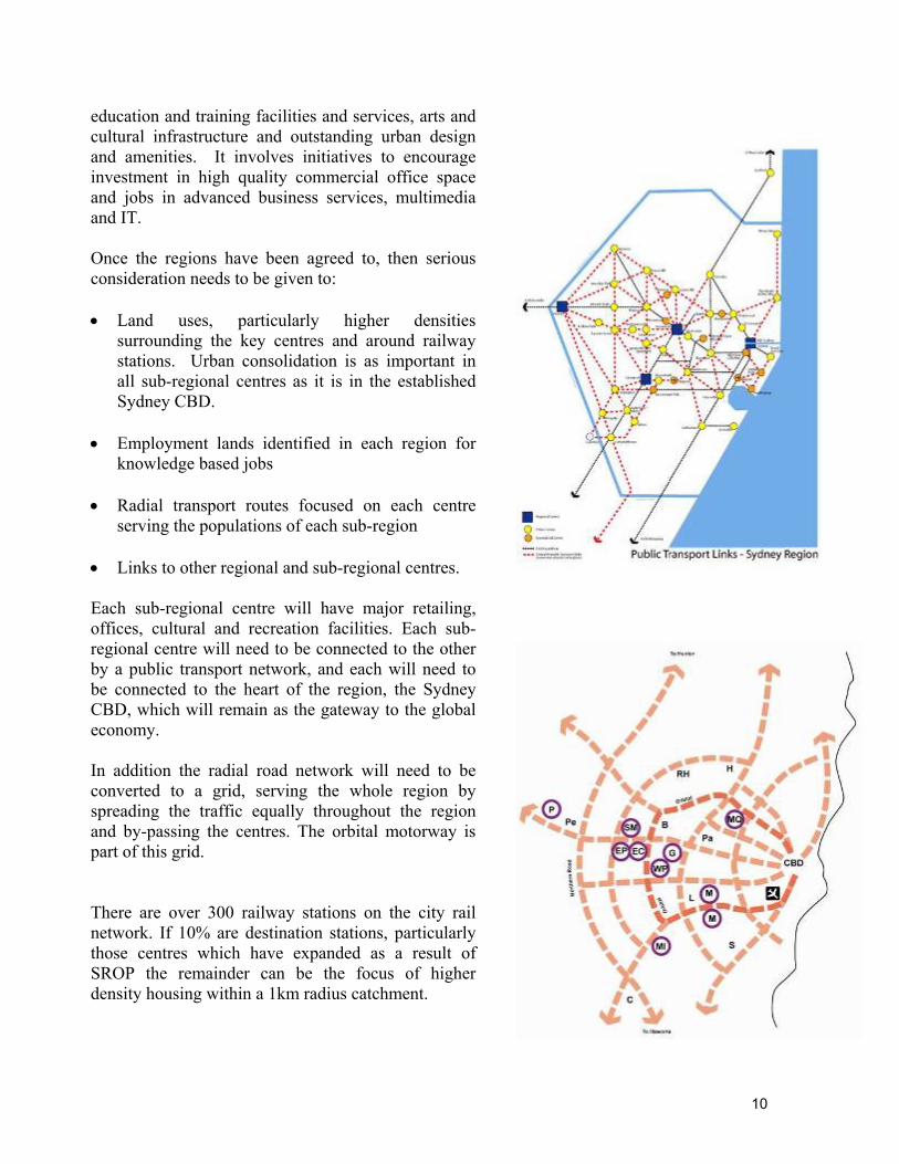
education and training facilities and services, arts and cultural infrastructure and outstanding urban design and amenities. It involves initiatives to encourage investment in high quality commercial office space and jobs in advanced business services, multimedia and IT. Once the regions have been agreed to, then serious consideration needs to be given to: • Land uses, particularly higher densities
surrounding the key centres and around railway stations. Urban consolidation is as important in all sub-regional centres as it is in the established Sydney CBD.
• Employment lands identified in each region for
knowledge based jobs • Radial transport routes focused on each centre
serving the populations of each sub-region • Links to other regional and sub-regional centres. Each sub-regional centre will have major retailing, offices, cultural and recreation facilities. Each sub-regional centre will need to be connected to the other by a public transport network, and each will need to be connected to the heart of the region, the Sydney CBD, which will remain as the gateway to the global economy. In addition the radial road network will need to be converted to a grid, serving the whole region by spreading the traffic equally throughout the region and by-passing the centres. The orbital motorway is part of this grid. There are over 300 railway stations on the city rail network. If 10% are destination stations, particularly those centres which have expanded as a result of SROP the remainder can be the focus of higher density housing within a 1km radius catchment.
10
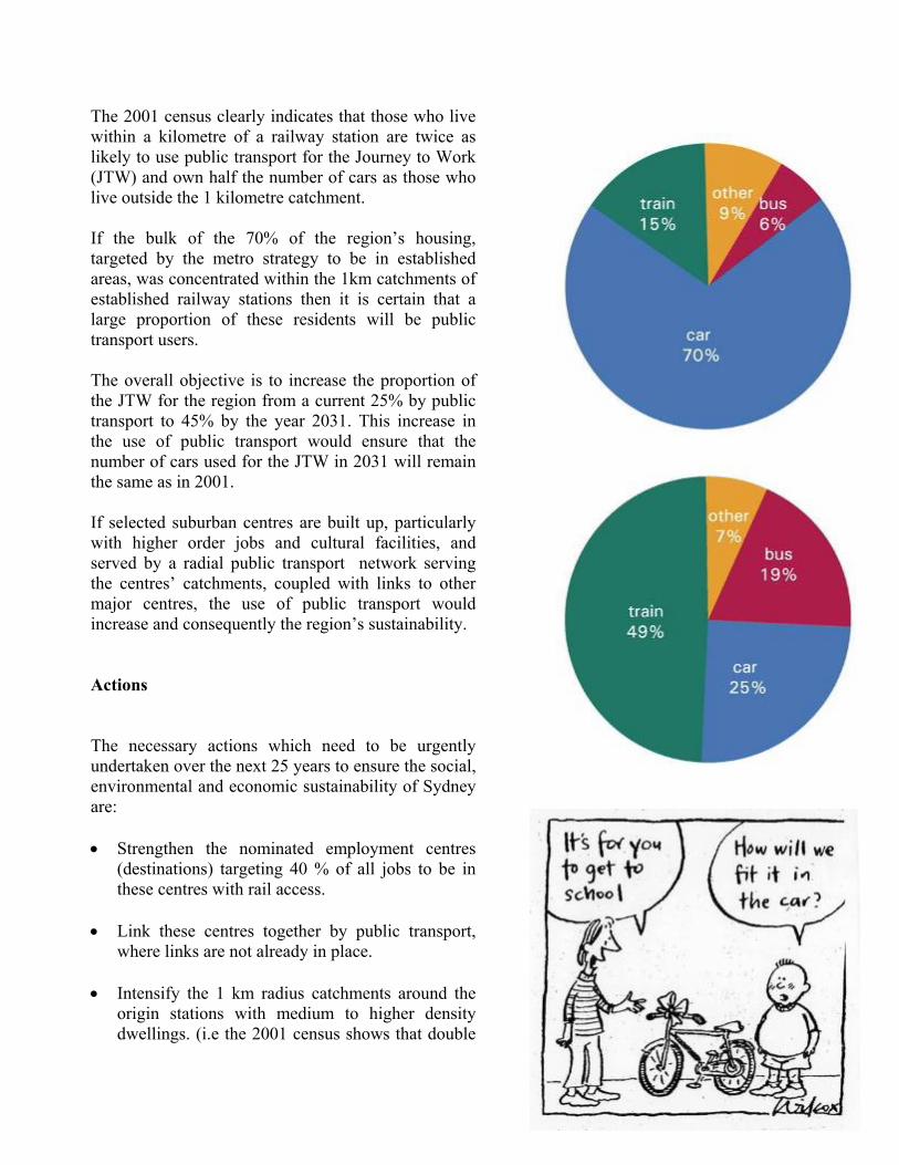
The 2001 census clearly indicates that those who live within a kilometre of a railway station are twice as likely to use public transport for the Journey to Work (JTW) and own half the number of cars as those who live outside the 1 kilometre catchment. If the bulk of the 70% of the region’s housing, targeted by the metro strategy to be in established areas, was concentrated within the 1km catchments of established railway stations then it is certain that a large proportion of these residents will be public transport users. The overall objective is to increase the proportion of the JTW for the region from a current 25% by public transport to 45% by the year 2031. This increase in the use of public transport would ensure that the number of cars used for the JTW in 2031 will remain the same as in 2001. If selected suburban centres are built up, particularly with higher order jobs and cultural facilities, and served by a radial public transport network serving the centres’ catchments, coupled with links to other major centres, the use of public transport would increase and consequently the region’s sustainability. Actions The necessary actions which need to be urgently undertaken over the next 25 years to ensure the social, environmental and economic sustainability of Sydney are: • Strengthen the nominated employment centres
(destinations) targeting 40 % of all jobs to be in these centres with rail access.
• Link these centres together by public transport,
where links are not already in place. • Intensify the 1 km radius catchments around the
origin stations with medium to higher density dwellings. (i.e the 2001 census shows that double
11
the number of people living with 1km radius of a railway station use public transport for the Journey to Work and have half the car ownership of those outside this catchment).
• Focus direct bus links to origin stations to widen
the public transport catchments of predominantly residential areas.
• Cycle ways should focus onto centres and schools
to discourage children being driven by their parents.
• Phase in a metro rail system supplementing the
long distance rail system now in place. The heavy slow loading / unloading double deckers serving the lower Hunter the Central Coast, Blue Mountains, Richmond and the Illawarra.
• Extend the ‘Global Arc’ westwards to expand
Sydney’s knowledge-based jobs to Parramatta-Westmead-Olympic Park-Rhodes and link Macquarie Park
• Forming 7 regions which have a community of
interest, are geographically related and conform to the SROP corridors which have shaped the region to this date.
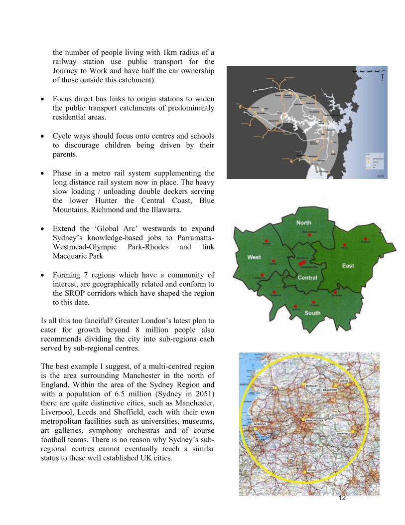
Is all this too fanciful? Greater London’s latest plan to cater for growth beyond 8 million people also recommends dividing the city into sub-regions each served by sub-regional centres. The best example I suggest, of a multi-centred region is the area surrounding Manchester in the north of England. Within the area of the Sydney Region and with a population of 6.5 million (Sydney in 2051) there are quite distinctive cities, such as Manchester, Liverpool, Leeds and Sheffield, each with their own metropolitan facilities such as universities, museums, art galleries, symphony orchestras and of course football teams. There is no reason why Sydney’s sub-regional centres cannot eventually reach a similar status to these well established UK cities.
12
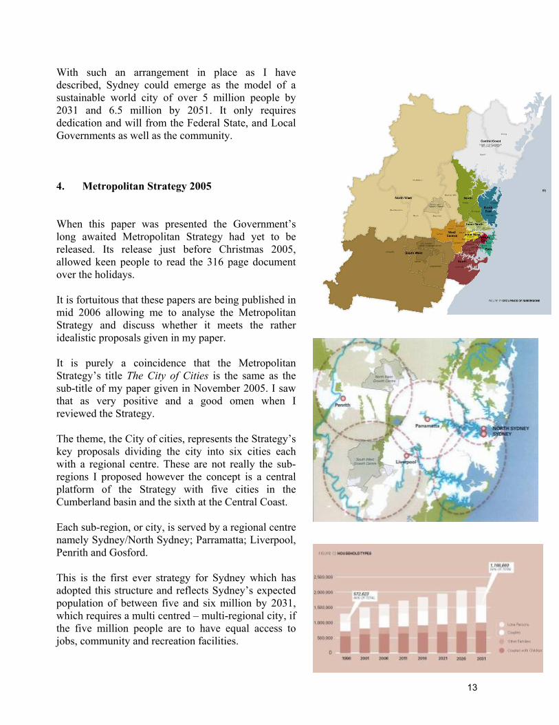
With such an arrangement in place as I have described, Sydney could emerge as the model of a sustainable world city of over 5 million people by 2031 and 6.5 million by 2051. It only requires dedication and will from the Federal State, and Local Governments as well as the community. 4. Metropolitan Strategy 2005 When this paper was presented the Government’s long awaited Metropolitan Strategy had yet to be released. Its release just before Christmas 2005, allowed keen people to read the 316 page document over the holidays. It is fortuitous that these papers are being published in mid 2006 allowing me to analyse the Metropolitan Strategy and discuss whether it meets the rather idealistic proposals given in my paper. It is purely a coincidence that the Metropolitan Strategy’s title The City of Cities is the same as the sub-title of my paper given in November 2005. I saw that as very positive and a good omen when I reviewed the Strategy. The theme, the City of cities, represents the Strategy’s key proposals dividing the city into six cities each with a regional centre. These are not really the sub-regions I proposed however the concept is a central platform of the Strategy with five cities in the Cumberland basin and the sixth at the Central Coast. Each sub-region, or city, is served by a regional centre namely Sydney/North Sydney; Parramatta; Liverpool, Penrith and Gosford. This is the first ever strategy for Sydney which has adopted this structure and reflects Sydney’s expected population of between five and six million by 2031, which requires a multi centred – multi-regional city, if the five million people are to have equal access to jobs, community and recreation facilities.
13
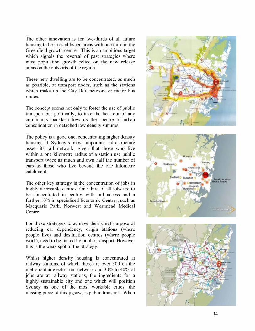
The other innovation is for two-thirds of all future housing to be in established areas with one third in the Greenfield growth centres. This is an ambitious target which signals the reversal of past strategies where most population growth relied on the new release areas on the outskirts of the region. These new dwelling are to be concentrated, as much as possible, at transport nodes, such as the stations which make up the City Rail network or major bus routes. The concept seems not only to foster the use of public transport but politically, to take the heat out of any community backlash towards the spectre of urban consolidation in detached low density suburbs. The policy is a good one, concentrating higher density housing at Sydney’s most important infrastructure asset, its rail network, given that those who live within a one kilometre radius of a station use public transport twice as much and own half the number of cars as those who live beyond the one kilometre catchment. The other key strategy is the concentration of jobs in highly accessible centres. One third of all jobs are to be concentrated in centres with rail access and a further 10% in specialised Economic Centres, such as Macquarie Park, Norwest and Westmead Medical Centre. For these strategies to achieve their chief purpose of reducing car dependency, origin stations (where people live) and destination centres (where people work), need to be linked by public transport. However this is the weak spot of the Strategy. Whilst higher density housing is concentrated at railway stations, of which there are over 300 on the metropolitan electric rail network and 30% to 40% of jobs are at railway stations, the ingredients for a highly sustainable city and one which will position Sydney as one of the most workable cities, the missing piece of this jigsaw, is public transport. When
14
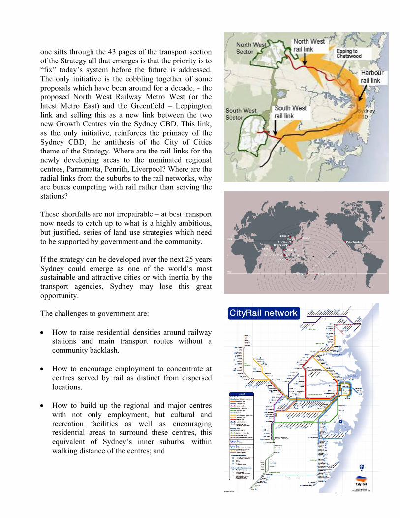
one sifts through the 43 pages of the transport section of the Strategy all that emerges is that the priority is to “fix” today’s system before the future is addressed. The only initiative is the cobbling together of some proposals which have been around for a decade, - the proposed North West Railway Metro West (or the latest Metro East) and the Greenfield – Leppington link and selling this as a new link between the two new Growth Centres via the Sydney CBD. This link, as the only initiative, reinforces the primacy of the Sydney CBD, the antithesis of the City of Cities theme of the Strategy. Where are the rail links for the newly developing areas to the nominated regional centres, Parramatta, Penrith, Liverpool? Where are the radial links from the suburbs to the rail networks, why are buses competing with rail rather than serving the stations? These shortfalls are not irrepairable – at best transport now needs to catch up to what is a highly ambitious, but justified, series of land use strategies which need to be supported by government and the community. If the strategy can be developed over the next 25 years Sydney could emerge as one of the world’s most sustainable and attractive cities or with inertia by the transport agencies, Sydney may lose this great opportunity. The challenges to government are: • How to raise residential densities around railway
stations and main transport routes without a community backlash.
• How to encourage employment to concentrate at
centres served by rail as distinct from dispersed locations.
• How to build up the regional and major centres
with not only employment, but cultural and recreation facilities as well as encouraging residential areas to surround these centres, this equivalent of Sydney’s inner suburbs, within walking distance of the centres; and
15
• How to link these land uses by public transport. This is the biggest challenge of all, yet not an insurmountable task. Sydney has a great rail network with over 300 railway stations and a series of centres, all served by rail.
• How to match the land use strategies with a
metropolitan transport plan. What is needed is a champion for public transport such as Dr Bradfield, who in 1915 designed Sydney’s electric rail system including the Harbour Bridge, which have served us well for 90 years.
The 2005 Metro Strategy, by necessity, is one of the most ambitious ever produced to guide Sydney’s growth. The city has reached the cross roads where it either becomes increasingly dysfunctional or one of this century’s most attractive and sustainable cities. The Strategy needs support however one of the key challenges is to sell it to the community and hence the politicians. The weak link, the transport system, is capable of being resolved as shown by many overseas examples, however it requires a skilful and powerful champion. Bibliography Abercrombie, P. (1945) Greater London Plan. London: HMSO. Department of Environment and Planning NSW. (1988) Sydney into its Third Century. Sydney: Department of Environment and Planning. Department of Planning. (2005) Metropolitan Strategy: City of Cities. Sydney: Department of Planning. Department of Transport NSW. (1998) Action for Transport 2010. Sydney: Department of Transport. Foreshaw, J. & Abercrombie, P. (1943) County of London Plan. London: Macmillan.
16
Greater London Authority. (2004) The London Plan. London: Greater London Authority. New South Wales Royal Commission. (1909) Report of the Royal Commission for the Improvement of the City of Sydney and Its Suburbs. Sydney: Government Printer. State Planning Authority NSW. (1968) Sydney Region Outline Plan: A Strategy for Development. Sydney: The Authority.
17