g4 u1 l1 lesson 1 where in the world do i live? where in the... · lesson 1 where in the world do i...
TRANSCRIPT
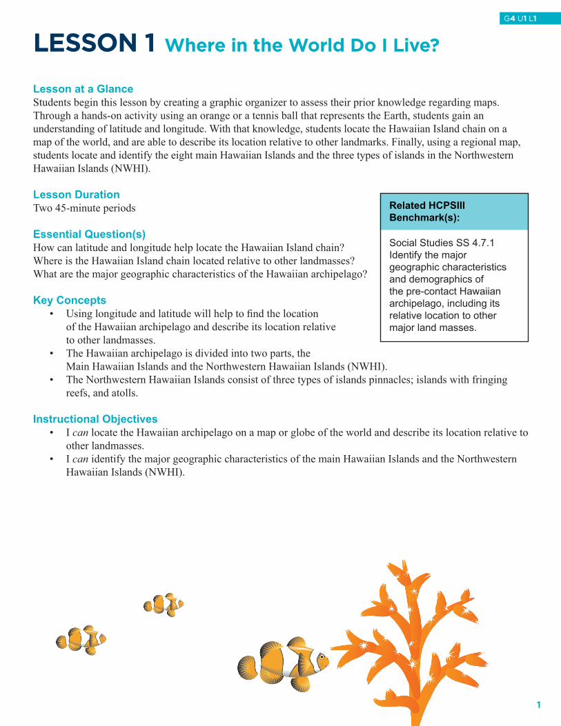
LeSSON 1 Where in the World Do I Live?
Lesson at a Glance Students begin this lesson by creating a graphic organizer to assess their prior knowledge regarding maps. Through a hands-on activity using an orange or a tennis ball that represents the Earth, students gain an understanding of latitude and longitude. With that knowledge, students locate the Hawaiian Island chain on a map of the world, and are able to describe its location relative to other landmarks. Finally, using a regional map, students locate and identify the eight main Hawaiian Islands and the three types of islands in the Northwestern Hawaiian Islands (NWHI).
Lesson DurationTwo 45-minute periods
Essential Question(s)How can latitude and longitude help locate the Hawaiian Island chain?Where is the Hawaiian Island chain located relative to other landmasses?What are the major geographic characteristics of the Hawaiian archipelago?
Key Concepts• Using longitude and latitude will help to fi nd the location of the Hawaiian archipelago and describe its location relative to other landmasses.• The Hawaiian archipelago is divided into two parts, the Main Hawaiian Islands and the Northwestern Hawaiian Islands (NWHI).• The Northwestern Hawaiian Islands consist of three types of islands pinnacles; islands with fringing
reefs, and atolls.
Instructional Objectives• I can locate the Hawaiian archipelago on a map or globe of the world and describe its location relative to
other landmasses. • I can identify the major geographic characteristics of the main Hawaiian Islands and the Northwestern
Hawaiian Islands (NWHI).
Related HCPSIIIBenchmark(s):
Social Studies SS 4.7.1Identify the majorgeographic characteristicsand demographics ofthe pre-contact Hawaiianarchipelago, including itsrelative location to othermajor land masses.
1
G4 U1 L1
Assessment Tools Benchmark Rubric:Topic Places and Regions
Benchmark SS.4.7.1Identify the major geographic characteristics and demographics of the pre-contact Hawaiian archipelago, including its relative location to other major land masses
RubricAdvanced Proficient Partially Proficient NoviceIdentify, with accuracy, the major geographic characteristics and demographics of the pre-contact Hawaiian archipelago, including its relative location to other major land masses
Identify, with no significant errors, the major geographic characteristics and demographics of the pre-contact Hawaiian archipelago, including its relative location to other major land masses
Identify, with a few significant errors, the major geographic characteristics and demographics of the pre-contact Hawaiian archipelago, including its relative location to other major land masses
Identify, with many significant errors, the major geographic characteristics and demographics of the pre-contact Hawaiian archipelago, including its relative location to other major land masses
Assessment/Evidence PiecesLesson
• FindingLatitudeandLongitudestudentworksheet• MapofArchipelagostudentworksheet
Unit• The Island Formations portfolio may be used to monitor student progress throughout the unit.
Materials Needed Teacher Class Group (optional) Student
• World map• String
• None • Two colors of permanent markers (preferably thin) or dry erase markers
• Masking tape• Orange for every two
students, or tennis ball or single color beach ball
• Construction Paper
Instructional Resources Student Reading: Map of Main Hawaiian IslandsStudent Reading: Individual Northwestern Hawaiian Island maps http://www.Hawaiireef.noaa.gov/imagery/graphicmaps.htmlStudent Worksheet: Finding Latitude and LongitudeStudent Worksheet: Map of Archipelago Teacher Answer Key: Map of ArchipelagoPowerPoint Presentation: Where in the World Do I Live?
2
G4 U1 L1
Student Vocabulary Wordsabsolute location: the exact location on the planet where something resides, or the latitude and longitude of a place.archipelago: a group of islands in an expanse of water, with many scattered islands.atoll: a ring-shaped coral reef or string of closely spaced small coral islands that enclose or nearly enclose a shallow lagoon.hemisphere: half the Earth, divided at the equator (northern and southern hemispheres) or at the Prime Meridian and International Date Line (western and eastern hemispheres).island with fringing reef: is a coral reef that occurs close to the shore of an island.lines of latitude: numerical system of imaginary circles on Earth’s surface that lie parallel to the Equator and are used to describe position north and south of the Equator; measured in increasing degrees north and south away from the Equator.lines of longitude: numerical system of imaginary half circles on Earth’s surface that lie perpendicular to the Equator and end at the poles, used to describe position east and west, measured in degrees with 0° at the Prime Meridian.pinnacle: a towering rock sticking out of the ocean. Prime Meridian: Longitude line of 0° from which all other longitudes are measured by; passes through Western Europe and Africa.relative location: the location of a place in relation to another place (Kauai is WNW of Oahu).
Lesson Plan
Lesson Preparation• Suggestion: Activity II in this lesson requires the use of an orange, tennis ball, or beach ball for
every two students. Prior to this lesson solicit class for oranges, tennis balls and/or beach balls. If using a beach ball, a dry erase marker may be used for the exercise.
• Review the Science Background provided in the Unit Overview.• Review and make copies of the Student Readings Finding Latitude and Longitude, Map of Main
Hawaiian Islands, Individual Northwestern Hawaiian Island maps and Student Worksheet Map of Archipelago, one for each student.
• Preview the PowerPoint Where in the World do I Live? and make arrangements to project it.• Cover a bulletin board with blue paper or a large space of the classroom wall with blue butcher paper
5 feet X 4 ½ feet. Students will place lines of longitude and latitude on the board as part of the lesson activities. This will be used throughout the unit as students create a wall-sized map of the Hawaiian archipelago. Ultimately, the following information about the Hawaiian archipelago will be added to the bulletin board:
180º 175º 170º 165º 160º 155º28º Midway Kure27º Pearl/Hermes Laysan/Lisianski26º Maro Reef Gardner Pinnacle25º French Frigate Shoals24º Nihoa Necker23º Ni’ihau Kaua‘i 22º Oahu Lāna‘i/Moloka‘i21º Maui/Kahoolawe19º Hawai‘i
3
G4 U1 L1
I. Pre-assessment with a Graphic OrganizerA. Assess prior knowledge by creating a word web graphic organizer on the board using the word Map.
Write the word Map in the middle of a circle and Types of Maps, Uses for Maps, Features of Maps in headings connected to the circle. (NOTE: See illustration below Step B.) If students lack prior knowledge on maps, have them go to FactMonster.com and search for types of maps, uses of maps and features of maps. As students use this website they should take notes in their portfolio or science notebook. http://www.factmonster.com/ipka/A0920936.html
B. Elicit responses from students in each category, and record responses under the appropriate heading. A model of what the graphic organizer should look like is presented below with a few examples of possible student answers:
USES OF MAPS • dividing countries,
states, land use, etc. • navigation • measuring distance • making comparisons • understanding
relationships (i.e., where people live in relation to physical features)
FEATURES OF MAPS • scale • date published • title • key • labels
MAPS
TYPES OF MAPS • physical • political • population • road • weather
C. Tell students that they will be using maps to locate and learn about the main Hawaiian Islands and the Northwestern Hawaiian Islands (NWHI). Point to the blank blue bulletin board, and tell students that they will be creating a wall-sized map of the islands to refer to and use during this unit of study on island formations.
II. World View of the Hawaiian IslandsA. Pass out an orange, an old tennis ball or solid color beach ball to student pairs and keep one for yourself.
Have each pair of students get out two different colored sharpie markers for drawing on the spheres. B. Explain to the class that today the orange/ tennis ball/ beach ball is going to represent the Earth. Draw a
line around the midsection of the orange/tennis ball/ beach ball using one of the sharpie markers, and ask the students to do the same on their orange/tennis/beach ball. What do we call this imaginary line that separates our northern and southern hemisphere? (Equator). Mark this line with a 0º mark. What do we call these lines running horizontally around the Earth? (Lines of latitude). Note: a teacher may need to refer to another globe or another map when pointing out the lines of latitude.
C. Now draw a line vertically around the orange/tennis ball/ beach ball using a different colored sharpie
4
G4 U1 L1
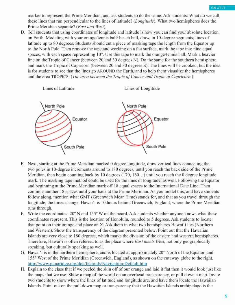
marker to represent the Prime Meridian, and ask students to do the same. Ask students: What do we call these lines that run perpendicular to the lines of latitude? (Longitude). What two hemispheres does the Prime Meridian separate? (East and West).
D. Tell students that using coordinates of longitude and latitude is how you can find your absolute location on Earth. Modeling with your orange/tennis ball/ beach ball, draw, in 10-degree segments, lines of latitude up to 80 degrees. Students should cut a piece of masking tape the length from the Equator up to the North Pole. Then remove the tape and working on a flat surface, mark the tape into nine equal spaces, with each space representing 10°. Use this tape to mark the orange/tennis ball. Mark a heavier line on the Tropic of Cancer (between 20 and 30 degrees N). Do the same for the southern hemisphere, and mark the Tropic of Capricorn (between 20 and 30 degrees S). The lines will be crooked, but the idea is for students to see that the lines go AROUND the Earth, and to help them visualize the hemispheres and the area TROPICS. (The area between the Tropic of Cancer and Tropic of Capricorn.)
Lines of Latitude Lines of Longitude
E. Next, starting at the Prime Meridian marked 0 degree longitude, draw vertical lines connecting the two poles in 10-degree increments around to 180 degrees, until you reach the back side of the Prime Meridian, then begin counting back by 10 degrees (170, 160…) until you reach the 0 degree longitude mark. The masking tape method could be used for the lines of longitude, as well. Following the Equator and beginning at the Prime Meridian mark off 18 equal spaces to the International Date Line. Then continue another 18 spaces until your back at the Prime Meridian. As you model this, and have students follow along, mention what GMT (Greenwich Mean Time) stands for, and that as you travel through the longitude, the times change. Hawai‘i is 10 hours behind Greenwich, England, where the Prime Meridian runs through.
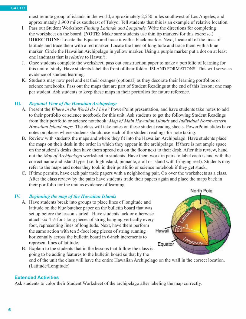
F. Write the coordinates: 20º N and 155º W on the board. Ask students whether anyone knows what these coordinates represent. This is the location of Honolulu, rounded to 5 degrees. Ask students to locate that point on their orange and place an X. Ask them in what two hemispheres Hawai‘i lies (Northern and Western). Show the transparency of the diagram presented below. Point out that the Hawaiian Islands are very close to 180 degrees, which marks the division of the eastern and western hemispheres. Therefore, Hawai‘i is often referred to as the place where East meets West, not only geographically speaking, but culturally speaking as well.
G. Hawai‘i is in the northern hemisphere, and is located at approximately 20° North of the Equator, and 155° West of the Prime Meridian (Greenwich, England), as shown on the cutaway globe to the right.
http://www.punaridge.org/doc/factoids/Navigation/Default.htmH. Explain to the class that if we peeled the skin off of our orange and laid it flat then it would look just like
the maps that we use. Show a map of the world on an overhead transparency, or pull down a map. Invite two students to show where the lines of latitude and longitude are, and have them locate the Hawaiian Islands. Point out on the pull down map or transparency that the Hawaiian Islands archipelago is the
5
G4 U1 L1
most remote group of islands in the world, approximately 2,550 miles southwest of Los Angeles, and approximately 3,900 miles southeast of Tokyo. Tell students that this is an example of relative location.
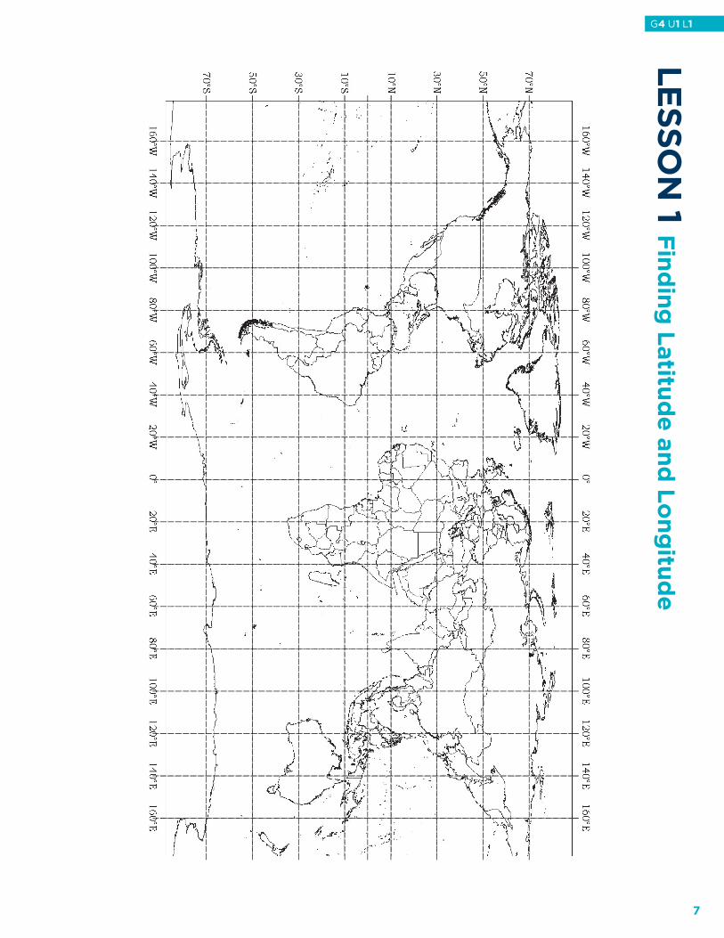
I. Pass out Student Worksheet Finding Latitude and Longitude. Write the directions for completing the worksheet on the board. (NOTE: Make sure students use thin tip markers for this exercise.)DIRECTIONS: Locate the Equator and trace it with a black marker. Next, locate all of the lines of latitude and trace them with a red marker. Locate the lines of longitude and trace them with a blue marker. Circle the Hawaiian Archipelago in yellow marker. Using a purple marker put a dot on at least one landmass that is relative to Hawai‘i.
J. Once students complete the worksheet, pass out construction paper to make a portfolio of learning for this unit of study. Have students label the front of their folder: ISLAND FORMATIONS. This will serve as evidence of student learning.
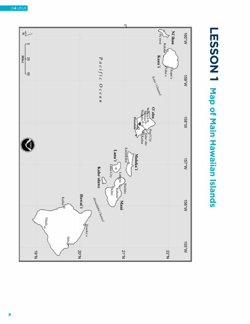
K. Students may now peel and eat their oranges (optional) as they decorate their learning portfolios or science notebooks. Pass out the maps that are part of Student Readings at the end of this lesson; one map per student. Ask students to keep these maps in their portfolios for future reference.
III. Regional View of the Hawaiian ArchipelagoA. Present the Where in the World do I Live? PowerPoint presentation, and have students take notes to add
to their portfolio or science notebook for this unit. Ask students to get the following Student Readings from their portfolio or science notebook: Map of Main Hawaiian Islands and Individual Northwestern Hawaiian Island maps. The class will take notes on these student reading sheets. PowerPoint slides have notes on places where students should use each of the student readings for note taking.
B. Review with students the maps and where they fit into the Hawaiian Archipelago. Have students place the maps on their desk in the order in which they appear in the archipelago. If there is not ample space on the student’s desks then have them spread out on the floor next to their desk. After this review, hand out the Map of Archipelago worksheet to students. Have them work in pairs to label each island with the correct name and island type. (i.e: high island, pinnacle, atoll or island with fringing reef). Students may refer to the maps and notes they took in their portfolio or science notebook if they get stuck.
C. If time permits, have each pair trade papers with a neighboring pair. Go over the worksheets as a class. After the class review by the pairs have students trade their papers again and place the maps back in their portfolio for the unit as evidence of learning.
IV. Beginning the map of the Hawaiian IslandsA. Have students break into groups to place lines of longitude and
latitude on the blue butcher paper on the bulletin board that was set up before the lesson started. Have students tack or otherwise attach six 4 ½ foot-long pieces of string hanging vertically every foot, representing lines of longitude. Next, have them perform the same action with ten 5-foot long pieces of string running horizontally across the bulletin board in 6-inch increments to represent lines of latitude.
B. Explain to the students that in the lessons that follow the class is going to be adding features to the bulletin board so that by the end of the unit the class will have the entire Hawaiian Archipelago on the wall in the correct location. (Latitude/Longitude)
Extended ActivitiesAsk students to color their Student Worksheet of the archipelago after labeling the map correctly.
6
G4 U1 L1
Le
SS
ON
1 Fin
din
g L
atitu
de
an
d L
on
gitu
de
7
G4 U1 L1
Le
SS
ON
1 Map
of M
ain
Haw
aiia
n Isla
nd
s
0oo
8
G4 U1 L1

Le
SS
ON
1 M
ap
of N
orth
weste
rn H
aw
aiia
n Isla
nd
s Ne
cke
r Islan
d
9
G4 U1 L1
Le
SS
ON
1 Map
of N
orth
weste
rn H
aw
aiia
n Isla
nd
s
10
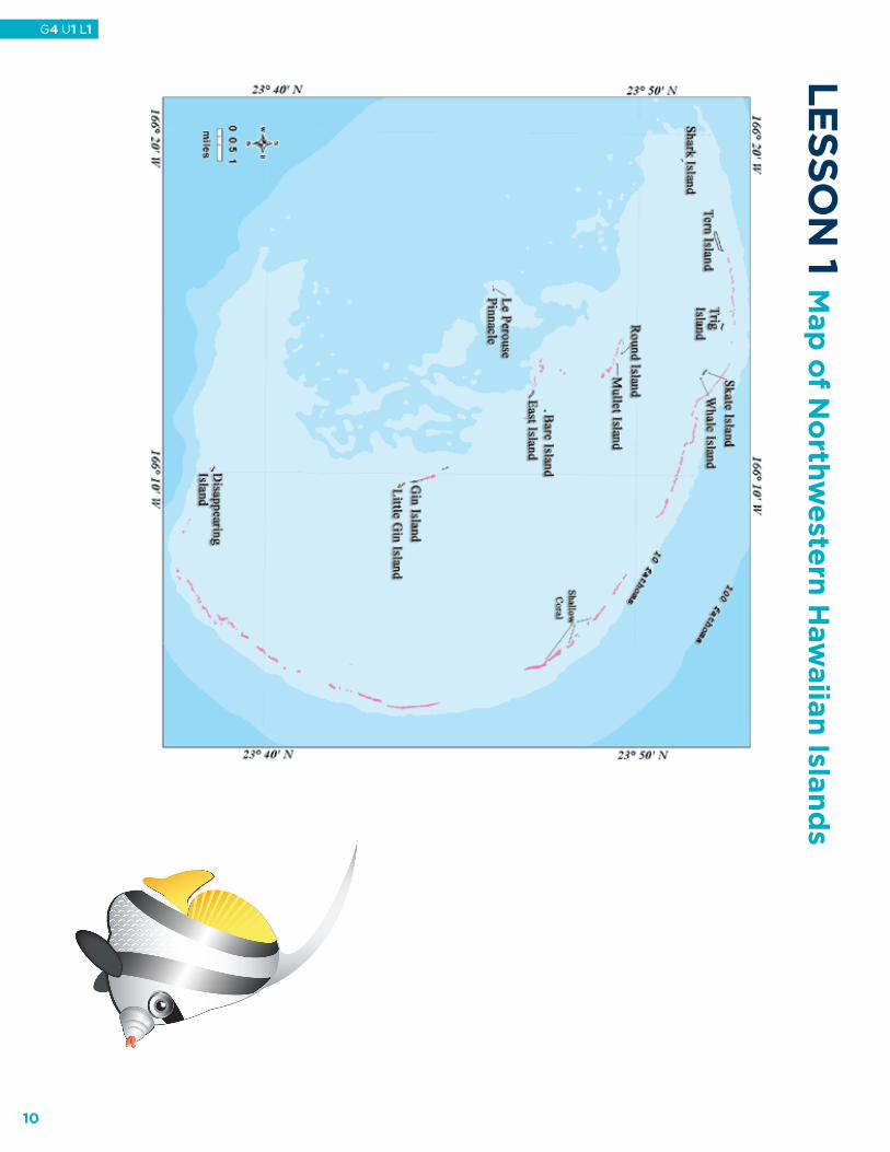
G4 U1 L1
Le
SS
ON
1 Map
of N
orth
weste
rn H
aw
aiia
n Isla
nd
s
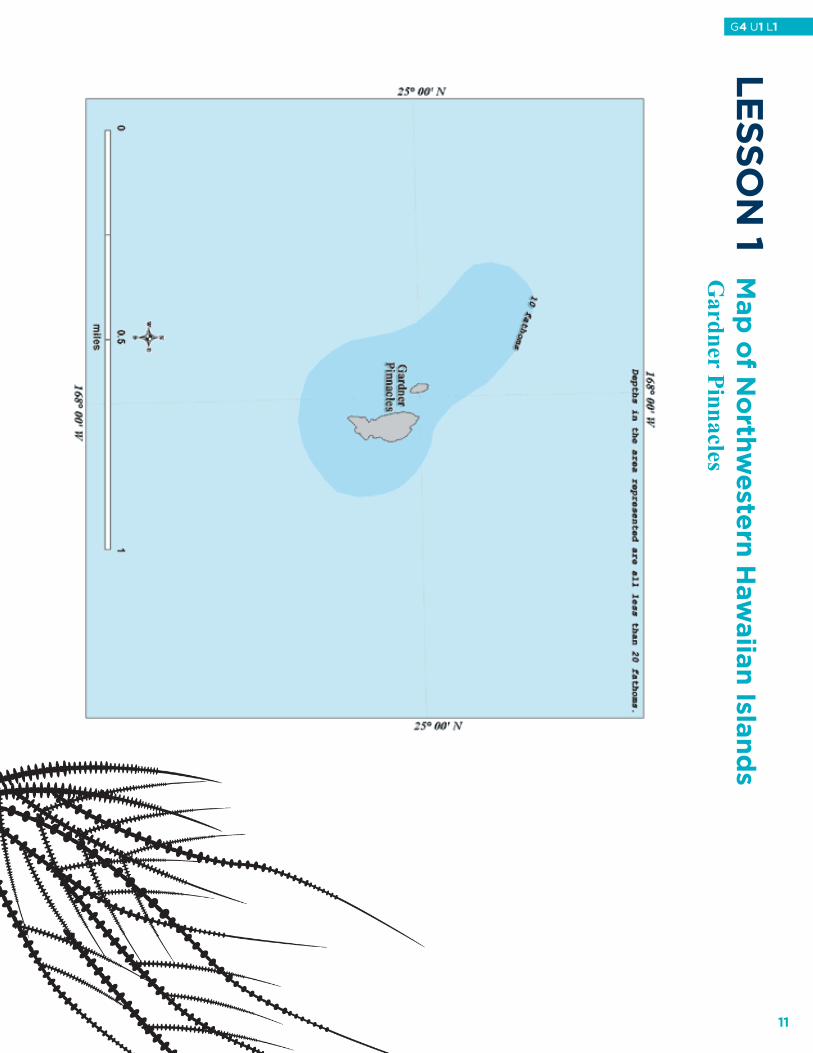
Gardner Pinnacles
11
G4 U1 L1

Le
SS
ON
1 Map
of N
orth
weste
rn H
aw
aiia
n Isla
nd
s
Laysan Island
12
G4 U1 L1
Le
SS
ON
1 Map
of N
orth
weste
rn H
aw
aiia
n Isla
nd
s
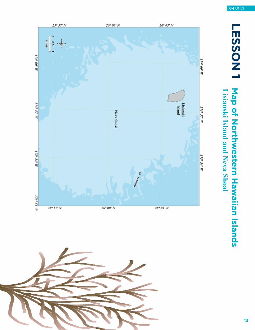
Lisianski Island and N
eva Shoal
13
G4 U1 L1

Le
SS
ON
1 Map
of N
orth
weste
rn H
aw
aiia
n Isla
nd
sM
aro Reef
14
G4 U1 L1
Le
SS
ON
1 Map
of N
orth
weste
rn H
aw
aiia
n Isla
nd
s
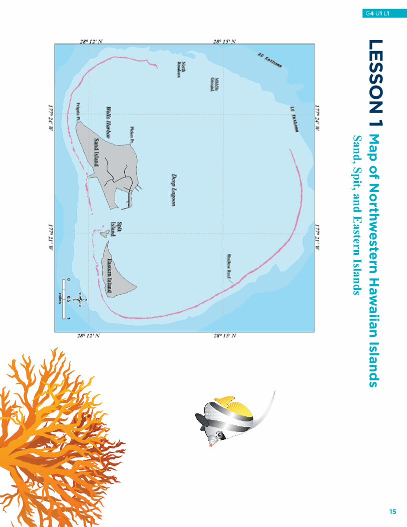
Sand, Spit, and E
astern Islands
15
G4 U1 L1

Le
SS
ON
1 Map
of N
orth
weste
rn H
aw
aiia
n Isla
nd
G
reen Island
16
G4 U1 L1
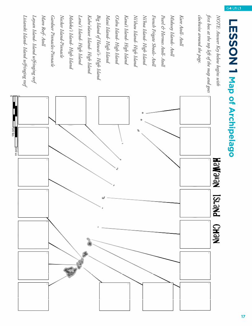
NO
TE: Answ
er Key below begins w
ith
�rst box at the top left of the map and goes
clockwise around the page.
Kure Atoll- Atoll
Midw
ay Islands- Atoll
Pearl & H
ermes Atoll- Atoll
French Frigate Shoals- Atoll
Ni’hoa Island- H
igh Island
Ni’ihau Island- H
igh Island
Kaua’i Island- High Island
O’ahu Island- H
igh Island
Maui Island- H
igh Island
Big Island of Haw
ai‘i- High Island
Kaho‘olawe Island- H
igh Island
Lana‘i Island- High Island
Moloka‘i Island- H
igh Island
Necker Island-Pinnacle
Gardner Pinnacles-Pinnacle
Maro Reef- Atoll
Laysan Island- Island w/fringing reef
Lisianski Island- Island w/fringing reef
Lesson 1- M
ap of Archipelago
Le
SS
ON
1 Map
of A
rch
ipe
lag
o
17
G4 U1 L1
Kure Atoll- Atoll
Midw
ay Islands- Atoll
Pearl & H
ermes Atoll- Atoll
French Frigate Shoals- Atoll
Ni’hoa Island- H
igh Island
Ni’ihau Island- H
igh Island
Kaua’i Island- High Island
O’ahu Island- H
igh Island
Maui Island- H
igh Island
Big Island of Haw
ai‘i- High Island
Kaho‘olawe Island- H
igh Island
Lana‘i Island- High Island
Moloka‘i Island- H
igh Island
Necker Island-Pinnacle
Gardner Pinnacles-Pinnacle
Maro Reef- Atoll
Laysan Island- Island w/fringing reef
Lisianski Island- Island w/fringing reef
1.2.3.4.5.6.7.8.9.10.
11.
12.
13.
14.
15.
16.
17.
18. Lesson 1Teacher A
nswer K
ey- Map of A
rchipelagoLe
SS
ON
1 Teach
er A
nsw
er K
ey – M
ap
of A
rch
ipe
lag
o
18
G4 U1 L1