gambia - climate change adaptation planning, …...adaptation planning (v&a) has gained great...
TRANSCRIPT
CLIMATE CHANGE VULNERABILITY
ASSESSMENT AND ADAPTATION IN
GREATER BANJUL - GAMBIA
Authors: Gifty Ampomah: ENDA Energy, Environment and Development - Senegal Lamin B.J Samatey: National Environment Agency - Gambia Faburama Fofana: Agency for the Development of Women and Children – Gambia
October, 2012.

2
CONTENTS
List of Figures .......................................................................................................................................................... 3
Executive Summary ................................................................................................................................................ 4
1. Introduction ........................................................................................................................................................ 5
1.2: Objectives of The Case study ....................................................................................................................... 5
1.3 Methodology ................................................................................................................................................ 5
1.3.1 Research Activities ................................................................................................................................. 6
1.4 Report Structure ........................................................................................................................................... 6
2. Context of study Area ......................................................................................................................................... 6
2.1 Geography and Demographic context .......................................................................................................... 6
2.2 Description of the Study area - Greater Banjul ............................................................................................. 7
2.2.1 Local politics & social organisations: ..................................................................................................... 9
2.2.2: overview of the two pilot communities................................................................................................ 9
3. Climatic conditions: variations and changes .................................................................................................... 12
3.1: Observed Seasonality ................................................................................................................................ 13
3.2: Precipitation Trends and Scenarios ........................................................................................................... 13
3.3: Temperature Trends and Scenarios ........................................................................................................... 14
4. Vulnerability of Greater Banjul to Variable and Changing Climate.................................................................. 15
4.1 Exposure to extreme events ....................................................................................................................... 15
4.1.1 Climate Trend Analysis and historical disturbance profile .................................................................. 15
4.1.2: Current Exposure to climatic Hazards ................................................................................................ 16
4.2 Sensitivity to impacts of extreme events .................................................................................................... 17
4.2.1: Impacts of Climate change on local livelihood activities .................................................................... 18
4.3 Adaptive capacity of communities ............................................................................................................. 19
4.3.1: Coping strategies adopted in past events .......................................................................................... 19
4.3.2: Current capacities in responding to climate change impacts ............................................................. 20
5: Developing of local adaptation Plans ............................................................................................................... 25
6: Conclusion ........................................................................................................................................................ 27
7: References ........................................................................................................................................................ 28

3
LIST OF FIGURES
Figure 1: Map showing the location of Gambia ...................................................................................................... 7
Figure 2: A map showing the Greater Banjul Area. Source: National Environment Agency .................................. 8
Figure 3: Population of the greater Banjul Area between 1993 and 2003 ............................................................. 8
Figure 4: A map of Greater Banjul area showing the two pilot communities in the Greater Banjul Area. Source:
National Environment Agency ................................................................................................................................ 9
Figure 5 : A resource map of Ebo Town sketched by community members ........................................................ 10
Figure 6: Observed seasonality of Temperature and Precipitation Patterns. Source: Climate Systems and
Analysis Group ...................................................................................................................................................... 13
Figure 7: Annual rainfall totals at Banjul 1886-1987. Source: Anyadike 1993 ...................................................... 14
Figure 8: A historical disturbance profile produced by local adaptation practitioners, Banjul-Gambia .............. 16
Figure 9: A Vulnerability-Exposure matrix: Impacts of hazards on major livelihood resources (Lamin
community- Greater Banjul, Gambia)................................................................................................................... 18
Figure 10: Some historical hazards outlined with coping strategies adopted. Lamin Community, Greater Banjul -
Gambia. ................................................................................................................................................................ 20
Figure 11: Institutional mapping of Lamin community-Gambia ........................................................................... 21
Figure 12: A portion of wetland being claimed with solid waste. ........................................................................ 23
Figure 13: Example of output on participatory scenario building and back casting (Lamin Community- Gambia)
.............................................................................................................................................................................. 25
Figure 14: Output of ADX tool showing the best option chosen by both voting and AHP methods .................... 26
4
EXECUTIVE SUMMARY
The Gambia, situated in West Africa, 13° 28.02' N and 16° 34.02' W, is located squarely in the river Gambia
Delta, which effectively separates the country into two halves from north to south. It is surrounded on all three
sides by Senegal and boarded to the west by the North Atlantic Ocean. It constitutes a total land area of
11,300 square kilometres: 1,300 sq/km covered with water and 10,000 sq.km being the total land mass.
The Greater Banjul area is about 93 sq km and a population size of 357,000 (26% of the total country’s
population). Like most African cities, the city has been an economic hatch for most Gambians. It hosts people
from all over the country for commercial purposes. Some economic activities in addition to commerce are
crafts making, tourism and hotel services, fishing, oyster collection, and production of rice, groundnut as well
as other agricultural crops. However, over the last decade and with urbanization, most arable lands have been
turned into settlements for the increasing population which has partly resulted from people immigrating to
this area from their rural communities for greener pastures.
Using the Adaptation Toolkit (a guide book for researchers and adaptation practitioners working with local
communities), which was produced by ENDA and SEI, this study on vulnerability and adaptation to climate
change conducted reveals that, the area is exposed to erratic rainfall patterns;, increasing temperatures and
rising sea-levels. Some consequential effects of these extreme events have been flooding, dry spells, storms
(wind, thunder and dust), droughts, cool spells, heat waves, beach erosion, outbreak of parasitic diseases,
outbreak of crop pest and saline intrusion into productive soil, river and underground fresh water.
In trying to find responses to these problems, residents receive support from existing social networks,
community-based organizations, non-governmental organizations and some governmental institutions.
Community-based organizations are said to be at the forefront of efforts to reduce risk, some of these include
creation of water ways to enhance drainage, extension of pipe borne water to areas affected by saline
intrusion and floods to ensure access to clean and potable water. Apart from these, communities have had
their coping strategies for various hazards but these have not been effective or sufficient.
In planning for adaptation actions, community members proposed to have a range of interventions such as
good road network, potable water and electricity supply, well equipped health facility, basic schools, and many
other strategies. With the help of the Adaptation Decision Explorer tool (output of this exercise can be
downloaded from: http://weadapt.org/placemarks/maps/view/837), these options were screened helping
community members to decide as an immediate measure, to halt encroachment on wetlands which also
aggravates flood problems during rainy seasons.
5
1. INTRODUCTION
Increasing climate variability and change since the beginning of the 20th
Century has presented a number of
challenges in developing countries against the backdrop of low infrastructure development, rapid
urbanization, in addition to limited financial and technical capacities. Due to this, vulnerability assessment and
adaptation planning (V&A) has gained great attention which necessitates the need for knowledge, skills and
tools for research. Through the support of the Climate Change Capacity Development project (C3D+) which is
being managed by UNITAR, ‘ENDA Energy, Environment and Development’ has undertaken a number of
capacity building activities on issues relating to climate change vulnerability assessment by conducting a
number of case studies in African countries. One of such beneficiary country is Gambia.
In 2009, ENDA conducted a first vulnerability assessment in Banjul old town in collaboration with a local
organization. Among some of the observations made from the case study was the need to enhance local
capacities in the understanding of climate variability and change in order to better respond to its adverse
effects. One key component in responding to this need is creating access to user-friendly tools which could be
employed by researchers and adaptation practitioners working with local communities.
From the latter part of 2011 to 2012, ENDA- Energy, Environment & Development in joint collaboration with
the Stockholm Environment Institute developed a toolkit for V&A. These were tested and refined for use by
local researchers and adaptation practitioners. This initiative was undertaken in three major steps, i) creation
of the tool kit; ii) testing the kit in a case study in Gambia iii) and validating the toolkit in a stakeholder
workshop. Throughout the entire process, the tools were refined where necessary. This report presents
findings of the case study conducted in Banjul-The Gambia during the testing of these tools.
1.2: OBJECTIVES OF THE CASE STUDY
1. To assess and map vulnerability according to information and data supplied primarily by local people
and also from available scientific research bodies.
2. Inform and raise community awareness about effects of climate change and lead them to plan some
adaption measures.
3. To identify and assess existing and past local knowledge systems and coping strategies that relate to
productive activity and disaster management in the Banjul municipality.
4. To increase the amount of knowledge available among local people, local decision makers and
national policy-making bodies on the nature and extent of climate impacts affecting the area, set in
the context of other socio-economic and politico-cultural dynamics and to make this knowledge
useful and deployable.
5. To develop systems by which successful work undertaken today can be reproduced in a flexible but
sustainable manner in the future by local civil society and/or community-based organizations using
methodologies that they themselves have been instrumental in developing; thus creating a real sense
of local ownership.
1.3 METHODOLOGY
Conduct an in-depth field research using the ‘adaptation tool kit’ jointly developed by the
Stockholm Environment Institute and ENDA Energy, Environment & Development.
Use Climate Information Portal (CIP) developed by Climate Systems and Analysis Group (CSAG) to
access climate trends and projections.

6
Comparison of the results of this experiential evidence and awareness to scientific evidence
obtained from Gambian and international sources consisting of climate data and scenarios, socio-
economic data.
Share project outputs on different knowledge sharing platforms such as weADAPT and
AfricaAdapt.
1.3.1 RESEARCH ACTIVITIES
The research activities were conducted in 2 major phases; there was the literary review and collection of
primary data. The literature review provided information on the general city context, climate context,
institutional, developmental and environmental context which is relevant to climate change vulnerability and
resilience. It also provided literary information on demographic, economic and physical characteristics of the
pilot location.
The field research in the study area provided insights on the exposure to climate-related hazards and their
consequences, sensitivity of community to these hazards as well as their adaptive capacity.
Tools used:
The Adaptation tool kit (http://www.africa-adapt.net/themes/5/resources/893/theme/). This is co-
developed by ENDA and SEI. It contains a range of participatory action research tools designed for
vulnerability assessment and adaptation planning.
The Climate Information Portal (http://cip.csag.uct.ac.za/webclient2/datasets/africa-
merged/#nodes/seasonality-cmip3?folder_id=24&extent=46608): This contains climate information
on various countries.
1.4 REPORT STRUCTURE
Following this introductory section is chapter 2, which provides information on context of the study location. It
highlights the geographic and bio-physical descriptions of the two pilot communities themselves. It also
contains information on demographic, socio-economic and climatic context of the area. Chapter 3 provides
detailed description and analysis of the climate situation in the Gambia, highlighting on climate trends as well
as projecting into future probabilities. Chapter 4 provides information on current vulnerability of the Greater
Banjul area with specific examples of the case study communities. It presents a reflection on their exposure,
sensitivity and adaptive capacity to these climate related events. Chapter 5 presents some road maps
developed based on available resources by the inhabitants of the Greater Banjul area during the study. These
were later screened to ascertain the most urgent action to be implemented. After Chapter 5, is a concluding
section of the report, summarizing the main findings and perspectives of the researchers.
2. CONTEXT OF STUDY AREA
This describes the geographical locations of Gambia, socio-economic conditions of the country as well as some
environment and climatic characteristics. A biophysical description of the pilot action zone is also made.
2.1 GEOGRAPHY AND DEMOGRAPHIC CONTEXT
The Gambia, situated in West Africa, 13° 28.02' N 16° 34.02' W, is based squarely in the river Gambia Delta,
which effectively separates the country into two halves from north to south. It is bounded on all three sides by
Senegal and boarded to the west by the North Atlantic Ocean. It constitutes a total land area of 11,300 square
7
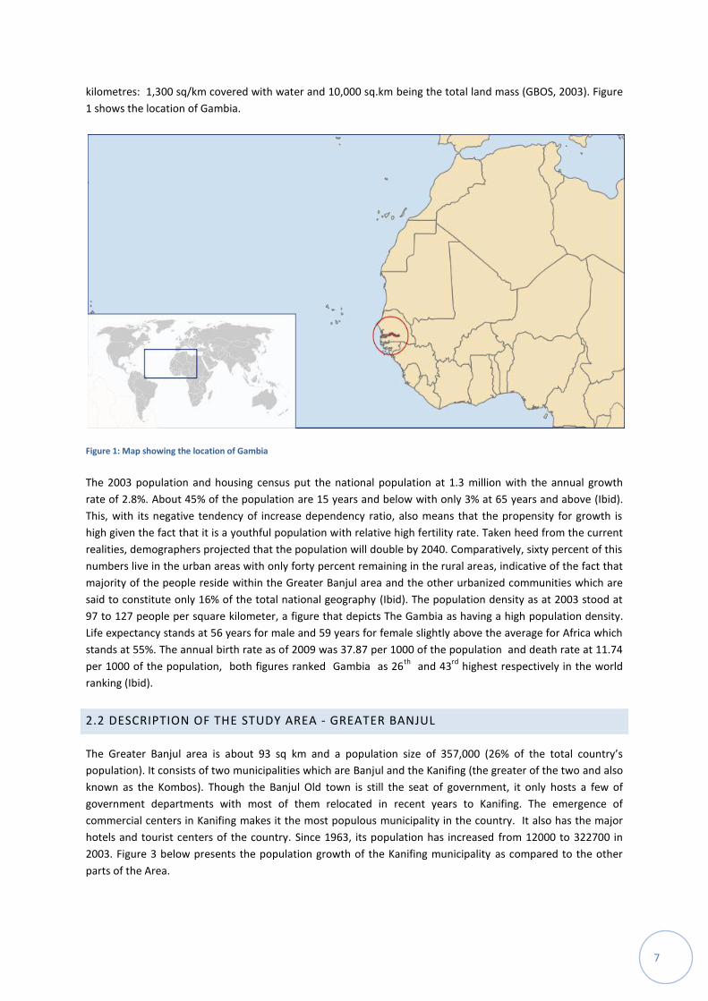
kilometres: 1,300 sq/km covered with water and 10,000 sq.km being the total land mass (GBOS, 2003). Figure
1 shows the location of Gambia.
Figure 1: Map showing the location of Gambia
The 2003 population and housing census put the national population at 1.3 million with the annual growth
rate of 2.8%. About 45% of the population are 15 years and below with only 3% at 65 years and above (Ibid).
This, with its negative tendency of increase dependency ratio, also means that the propensity for growth is
high given the fact that it is a youthful population with relative high fertility rate. Taken heed from the current
realities, demographers projected that the population will double by 2040. Comparatively, sixty percent of this
numbers live in the urban areas with only forty percent remaining in the rural areas, indicative of the fact that
majority of the people reside within the Greater Banjul area and the other urbanized communities which are
said to constitute only 16% of the total national geography (Ibid). The population density as at 2003 stood at
97 to 127 people per square kilometer, a figure that depicts The Gambia as having a high population density.
Life expectancy stands at 56 years for male and 59 years for female slightly above the average for Africa which
stands at 55%. The annual birth rate as of 2009 was 37.87 per 1000 of the population and death rate at 11.74
per 1000 of the population, both figures ranked Gambia as 26th
and 43rd
highest respectively in the world
ranking (Ibid).
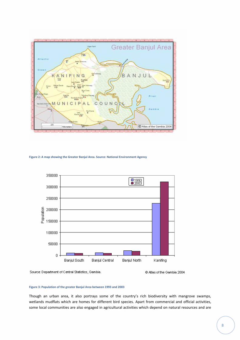
2.2 DESCRIPTION OF THE STUDY AREA - GREATER BANJUL
The Greater Banjul area is about 93 sq km and a population size of 357,000 (26% of the total country’s
population). It consists of two municipalities which are Banjul and the Kanifing (the greater of the two and also
known as the Kombos). Though the Banjul Old town is still the seat of government, it only hosts a few of
government departments with most of them relocated in recent years to Kanifing. The emergence of
commercial centers in Kanifing makes it the most populous municipality in the country. It also has the major
hotels and tourist centers of the country. Since 1963, its population has increased from 12000 to 322700 in
2003. Figure 3 below presents the population growth of the Kanifing municipality as compared to the other
parts of the Area.
8
Figure 2: A map showing the Greater Banjul Area. Source: National Environment Agency
Figure 3: Population of the greater Banjul Area between 1993 and 2003
Though an urban area, it also portrays some of the country’s rich biodiversity with mangrove swamps,
wetlands mudflats which are homes for different bird species. Apart from commercial and official activities,
some local communities are also engaged in agricultural activities which depend on natural resources and are

9
sensitive to climate variations. Two of such communities are the Lamin and Ebo town communities. This study
was based in these two communities to fully understand how vulnerable the Kombos are to climate variability
and change.
2.2.1 LOCAL POLITICS & SOCIAL ORGANISATIONS:
Following the Local Government Act of 2008, Kanifing Municipality has been divided into seventeen (17) wards
with political representation at Council. Ebo Town and New Jeshwang combined constituted one such
dichotomized wards with an elected representative known as the ward councilor. Generally the councilors are
responsible for representing their communities’ interest which includes and not limited to lobbying for
development projects and redressing social issues with potential political dimensions. In addition to the
seventeen elected councilors, there are also selected/nominated councilors representing the interest of
various groups such as women, youth, etc.
These elected representatives are part of the numerous committees in council that are responsible for the
effective functioning of the administration of Kanifing Municipal Council (KMC) as in education, health and
environment, finance, disaster management, etc (KM-VCA, 2011). These standing committees have their
sittings once in a month but emergency sessions can be called as and when necessary. Issues are brought
before these committees and discussed at such meeting for solutions to be found. However, for any issue to
become binding, two thirds (2/3) majority is required from the committee members, who themselves must
have a quorum to be able to conduct such meetings.
2.2.2: OVERVIEW OF THE TWO PILOT COMMUNITIES
The Map below shows the pilot communities (Ebo Town and Lamin) within the study area.
Figure 4: A map of Greater Banjul area showing the two pilot communities in the Greater Banjul Area. Source: National Environment
Agency
10
2.2.2.1: THE EBO TOWN COMMUNITY
The community of Ebo Town is situated in the northern part of the Kanifing Municipality. It is one of the many
sub-urban communities of the main town of Serrekunda. It is separated from Serrekunda by a Westfield
Brikama highway, bordered on the south with Tallinding, on the north with New Jeshwang, and on the east, a
few stretches of mangrove vegetation lining the bank of river Gambia. The community is situated on a
generally flat land with clay and loamy type of soil. The soils are characteristically dry and dusty during the dry
season, whilst muddy with high water retention ability in the wet season. The land rises up as one moves from
the river bank towards the central part of the municipality, a topographical dimension that allows in the
siltation of sand particles in the low land. In Ebo Town, vegetation cover barely exists with trees cleared to
make way for housing. There are few palm trees and mangroves along the river bank. The soil comprises of
clay and silt and therefore water logging, during the rains.
According to the analyzed reports of the 2003 population and housing census, Ebo Town has a population of
18,363 persons. 8,968 were female and 9,395 were males. Of these, the under five population constituted
3,422, the under fifteen at 4709, the aged population stood at 730 and remaining numbers representing the
active population (GBoS, 2003). On a global scale, the Municipality’s population is expected to increase across
all the age categories in future.
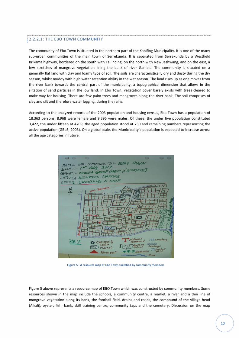
Figure 5 above represents a resource map of EBO Town which was constructed by community members. Some
resources shown in the map include the schools, a community centre, a market, a river and a thin line of
mangrove vegetation along its bank, the football field, drains and roads, the compound of the village head
(Alkali), oyster, fish, bank, skill training centre, community taps and the cemetery. Discussion on the map
Figure 5 : A resource map of Ebo Town sketched by community members

11
revealed that, a few of the indicated resources (such as schools) have restrictions in terms of access due
principally to financial resource constraints; those who cannot afford the cost will not have the opportunity to
enrol. Although, other areas do not have such restrictions but there exist some gender imbalances in some
sectors, women and men dominating according to their different areas of interest. Interestingly, none of the
indicated resources are said to be under any form of legal contract. However, some form of legality exist for
the operation of the community taps provided for by the KMC and the intervention of the ECHO project in a
form of memorandum are accessible by all. The skill centre is one of those institutions highlighted as having
some form of understanding with the community to ensure sustainability. Council regulate the market whilst
the forestry regulations and National Environmental Management Act (NEMA 1994) being the main legal
instruments protecting the mangrove ecosystems. The market helps to promote petty trading and improve
income especially for women. The river and its mangrove vegetation help to boost the breeding of both fish
and oysters; each being major sources of income for both men and women. Findings also revealed that there
were conflicts on particular land portions due to increase in the area’s population. The bone of contention has
been the annexation of rice fields and turning them into residential properties leaving poor farmers whose
livelihood depends on it. However, such is no longer an issue as the settlement is almost completely residential
now.
2.2.2.2: THE LAMIN COMMUNITY
Geographical description: Lamin is located into the Kombo North District. Lying on the north of the community
is a long stretch of wetland which is used for rice growing in the rainy season whereas sweet potato and
vegetable production (mainly by women) is done in the dry season. On the eastern part, fishing predominates
as the principal livelihood activity. Lamin is endowed with a lot of natural resources which are being exploited
by the population. There is a conservation park that remains largely untouched by the expanding settlement. It
has a narrow strip of land populated by species of grasses and trees in the eastern part as well as a long stretch
of mangrove forest along the river bank and few privately owned woodlots, which collectively constitutes the
vegetation cover. The soil is characteristically loamy and silts. The topography is sloppy at some points and this
enhances erosion during rains. Part of the community is located on upland whilst other parts are inundated
with gullies which are caused by water erosion. This part experiences a lot of run-off water effects by the
inhabitants of the area.
Bio-physical Resources: Naturally, the community is endowed with one form of natural resources or another.
Settling along a plain close to the river Gambia accords the community the opportunity to access and enjoy the
bounty of a river in terms of fish and other sea foods which could serve as sources of income for the
community people. Besides providing fish, oyster and other valuable sea food, Lamin attracts tourists who
enjoy the comfort of a lodge built along the creek. This lodge also brings income to the community which is
used on community development project activities. There exist educational institutions in the community
ranging from nursery schools, lower and upper basic schools, senior secondary school, technical and
professional institutions. In a similar vein pipe borne water is available for every home in the village.
Land Tenure: Customary land ownership systems exist in Lamin village with the first settlers controlling most
lands both for cash crop farming and cereal farming. Land belongs to clans/families and permission to use the
land for cropping in the past, is obtained through consultation with the right owners. In a similar vein, the
particular borrowed land is expected to be returned at the end of a particular cropping season. Accordingly, in
the early days of urbanization, land was permanently obtained to provide shelter with very little or no cost
attached, however, as the value appreciates proportionally with the intensified urban-rush, land becomes
scarce and expensive for poor families to afford. There still remain fewer crop fields in the communities but
the ownership/management remained in the hands of the various clans/families.
12
Lamin has good site for vegetable gardening which is exclusively managed by the women farmers without
management principles such as established by-laws. Access to a plot of land for vegetable production and crop
cultivation is based on customary practices where the farmer would approach the land owner for cultivation
and it is based on mutual consent on both parties that land is being offered to the person who requests it for
cultivation. No fee is requested for this arrangement but the land is always returned to the owner at the end of
the cropping season. This is to ensure that ownership of the land is still in the hand of the land owner.
Demography: According to the 2003 National Population and Housing Census records, Lamin village hosted a
population of 17, 033 in which male accounted for 8,517 persons while female registered a population of
8,516 persons. Of this population 4,448 people aged from 7 to 18 years were attending school which
correspondently gives a literate figure of 8,545 of the same age brackets. In terms of gender comparison 2,305
males attend school with a literate population of 4,784 males. For female education statistics, 2,143 attend
school and with 3,666 persons considered literate.
Religion: Lamin community is diverse with various religious groupings all practicing their faith while living in
harmony with each other. This is an asset as there is a high level of religious tolerance in this community –
recipe for co-existence and habitation. There are Mosques where Muslims practice their religion while
Churches are found in every ward of Lamin with their followers practicing their religion. In addition, other
faith-based groups exist.
Economic Activities: The Lamin community is engaged in rice production, groundnut, and other agricultural
crops, but over the last decades and with urbanisation costs, most of the arable land masses are turned into
settlements for the increasing population which has partly resulted from people immigrating to this area from
their rural communities for greener pastures. In addition to the mentioned activities, women are engaged in
oyster harvesting and firewood selling for additional income. There exist in the area also other informal trades
such as mechanics, carpentry, welding, bicycle and motorcycle repair workshops, hair dressing saloons, watch
repair workshops, radio repair workshops, television and mobile phone workshops that proliferated the
community.
According to the 2003 census report, 4,639 persons are employed in different economic activities while 741
persons are into crop production. A total of 2,772 males are employed with 181 people engaged in crop
production. In terms of female employment 1,867 are employed in formal and informal sector with 560
persons producing crops as source of income.
Although the community has a lot of income generating sources, it is only blessed with one commercial
financial institution that serves Lamin and its surrounding environments. This financial institution has greatly
enhanced community’s ability and potential to save and access short-term loans especially by the business
community. There are a lot of business activities as evidenced by the existence of shops of various kinds and
dimensions, make-shift markets and stalls aside the commercial institution. There is also the availability of
electricity facilities, access to certain basic services such as email, computer classes, welding, tailoring, etc
which improve living conditions of the population. As a growing centre attracting different categories of
people and business ventures, Lamin has a market that provides opportunities for the population to buy and
sell in this institution. It has an ideal location as it attracts business people from different villages which give it
an advantage over other markets in the area.
3. CLIMATIC CONDITIONS: VARIATIONS AND CHANGES
This section discusses s climatic conditions present in the Gambia which is influenced by the general climate in West Africa. Highlights are given on observed seasonality of both precipitation and temperature trends as well as projections into future climatic scenarios.
13
3.1: OBSERVED SEASONALITY
The Gambia lies within a Sahelian belt with Sudano-Sahelian type of climate characterized by a long dry season starting from October to early June and a short wet season starting from mid June to early October. Rainfall ranged from 800 mm in the East to 1700 mm at the Western end whilst the national average stands at 1020 mm for most part of the country (NEA, 2010).
Seasonal variations and duration are to a large extent determined by the changes in the surface position of the
Inter-tropical Discontinuity line (ITD), which serves as the dividing line between the North-easterly and
Southwest monsoon winds. The North-easterly winds are generally dry and dust laden, and brings the dry
condition. Southwest monsoon winds on the other hand, are moist laden and brings wet conditions. The
position of the ITD is as well determined by the intensities and proximity of North Atlantic and south Atlantic
subtropical anticyclones.
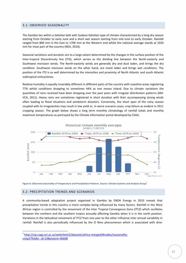
Relative humidity is equally invariably different in different parts of the country with coastline areas registering
77% whilst conditions dropping to sometimes 44% as one moves inland. Due to climate variations the
quantities of rains received have been dropping over the past years with irregular distribution patterns (KM-
VCA, 2011). Heavy rains are sometimes registered in short duration with their accompanying strong winds
often leading to flood situations and windstorm disasters. Conversely, the short span of the rainy season
coupled with its irregularities may result in low yield or, in worst scenario cases, crop failure as evident in 2011
cropping season. The graph below shows a long term monthly climatology of rainfall totals and monthly
maximum temperatures as portrayed by the Climate Information portal developed by CSAG.
Figure 6: Observed seasonality of Temperature and Precipitation Patterns. Source: Climate Systems and Analysis Group1
3.2: PRECIPITATION TRENDS AND SCENARIOS
A community-based adaptation project organized in Gambia by ENDA Energy in 2010 reveals that
precipitation trends in this country is more complex being influenced by many factors. Rainfall in the West
African region is controlled by the movement of the Inter Tropical Convergence Zone (ITCZ) which oscillates
between the northern and the southern tropics annually affecting Gambia when it is in the north position.
Variations in the latitudinal movement of ITCZ from one year to the other influence inter annual variability in
rainfall. Rainfall is also periodically influenced by the El Nino phenomenon which is associated with drier
1 http://cip.csag.uct.ac.za/webclient2/datasets/africa-merged/#nodes/seasonality-
cmip3?folder_id=24&extent=46608
14
conditions in Sahelian Africa (UNDP, 2008). The early 1960s were characterised by comparatively high rainfall
while the early 1980s were relatively dry.
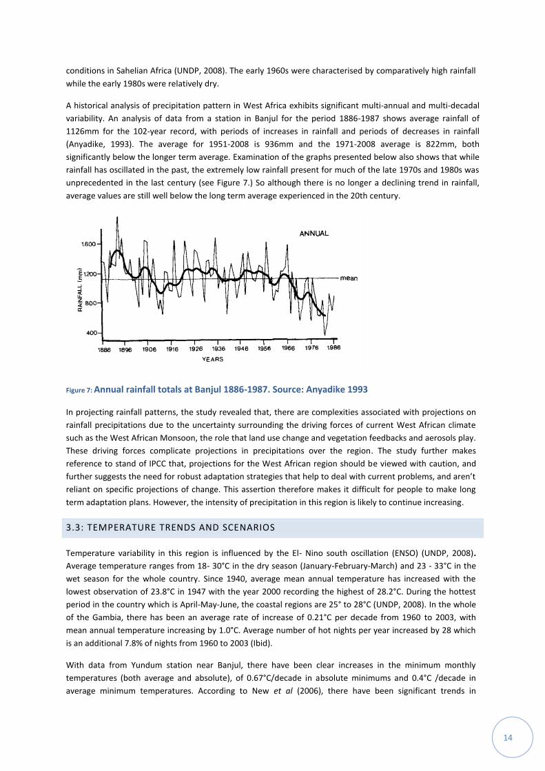
A historical analysis of precipitation pattern in West Africa exhibits significant multi-annual and multi-decadal
variability. An analysis of data from a station in Banjul for the period 1886-1987 shows average rainfall of
1126mm for the 102-year record, with periods of increases in rainfall and periods of decreases in rainfall
(Anyadike, 1993). The average for 1951-2008 is 936mm and the 1971-2008 average is 822mm, both
significantly below the longer term average. Examination of the graphs presented below also shows that while
rainfall has oscillated in the past, the extremely low rainfall present for much of the late 1970s and 1980s was
unprecedented in the last century (see Figure 7.) So although there is no longer a declining trend in rainfall,
average values are still well below the long term average experienced in the 20th century.
Figure 7: Annual rainfall totals at Banjul 1886-1987. Source: Anyadike 1993
In projecting rainfall patterns, the study revealed that, there are complexities associated with projections on
rainfall precipitations due to the uncertainty surrounding the driving forces of current West African climate
such as the West African Monsoon, the role that land use change and vegetation feedbacks and aerosols play.
These driving forces complicate projections in precipitations over the region. The study further makes
reference to stand of IPCC that, projections for the West African region should be viewed with caution, and
further suggests the need for robust adaptation strategies that help to deal with current problems, and aren’t
reliant on specific projections of change. This assertion therefore makes it difficult for people to make long
term adaptation plans. However, the intensity of precipitation in this region is likely to continue increasing.
3.3: TEMPERATURE TRENDS AND SCENARIOS
Temperature variability in this region is influenced by the El- Nino south oscillation (ENSO) (UNDP, 2008).
Average temperature ranges from 18- 30°C in the dry season (January-February-March) and 23 - 33°C in the
wet season for the whole country. Since 1940, average mean annual temperature has increased with the
lowest observation of 23.8°C in 1947 with the year 2000 recording the highest of 28.2°C. During the hottest
period in the country which is April-May-June, the coastal regions are 25° to 28°C (UNDP, 2008). In the whole
of the Gambia, there has been an average rate of increase of 0.21°C per decade from 1960 to 2003, with
mean annual temperature increasing by 1.0°C. Average number of hot nights per year increased by 28 which
is an additional 7.8% of nights from 1960 to 2003 (Ibid).
With data from Yundum station near Banjul, there have been clear increases in the minimum monthly
temperatures (both average and absolute), of 0.67°C/decade in absolute minimums and 0.4°C /decade in
average minimum temperatures. According to New et al (2006), there have been significant trends in
15
temperature extremes at Yundum station near Banjul. These include an increase in the number of warm
nights and warm days, an increase in the frequency of consecutive days of extreme temperatures, increased
temperatures of the hottest days and hottest nights, and a decrease in the number of cool nights and cool
days.
For temperature projections, the study reveals increases in temperatures (both maximium and minimum).
This is also consisted with the trends in average temperature and also extreme temperature that have been
observed over the last 50 years. It further states that average maximum temperatures are likely to increase
in the range 1-4 degrees Celcuis. The highest maximum temperatures are likely to increase in a similar
manner by the year 2065 with data from Yundum station near Banjul.
4. VULNERABILITY OF GREATER BANJUL TO VARIABLE AND CHANGING CLIMATE
This section describes vulnerability of people in the Greater Banjul area to the impacts of climate related
extreme events. Highlights are made on their exposure, sensitivity and adaptive capacity to impacts by climatic
events.
4.1 EXPOSURE TO EXTREME EVENTS
In this context, we looked at how the study area is exposed to extreme events as well as examined the nature
and the degree of existing climate stimulus. The national hazard profile shows the following common climate
related hazards: torrential rains, storms (wind, thunder and dust), drought, cool spells, heat waves, intra-
seasonal drought and erratic rainfall patterns. These have been impacting the country for decades and
collectively, they make climate change a burden to national development. The IPCC projected that some of
these climate hazards are likely to get worst in the years ahead and this scenario would significantly affect
local livelihoods. For instance, agricultural productivity would decline with reduction in grain weight for most
cereals whilst inter-annual variability is expected to increase if compensatory strategies are not put in place
(NEA, 2010). Accordingly, drought, mainly due to deforestation and encroaching deserts, have been an issue in
the 70s and 80s and made worse due to increasing human and animal populations. As such, the demand on
forest resources has gone beyond sustaining them.
4.1.1 CLIMATE TREND ANALYSIS AND HISTORICAL DISTURBANCE PROFILE
Community members in both Lamin and Ebo town identified droughts, locust invasion and salt intrusion as the
main disturbances in the 1970s; droughts, dust storms and food shortages occurred in the 1980s worsened by
an abortive coup; In the 1990s they experienced events such as drought, locust invasion, dust storm and salt
intrusion. Events like flood, locust invasion on food crops and cholera outbreaks were recounted to have
happened in the 2000s; and floods and dry spells as main disturbances in the 2010s. Figure 8 below shows a
profile of climatic events developed by local adaptation practitioners during the study.

16
Considering the frequency of these events, droughts, locust invasions, dust storms and floods appeared more
than once in the periods under review. Drought periods were more frequent in the 70s, 80s, and 90s and the
issue is attributed to insufficient rains received at the time, whilst flood situations become regular in the 2000s
and 2010s as a result of heavy rains. Drought resulted in massive crop failures for rice cultivators most of
whom were women and caused food shortages. Floods on the other hand destroyed houses, food items, and
brought about an increase in water borne infections such as cholera, typhoid and diarrhea. There was a
cholera outbreak in 2005 that affected many families due to compromised sanitary conditions. Locust invasion
also caused losses to farmers (both rice and vegetable producers).Dust storms which were not very common
created visibility problems and may have contributed to a number of respiratory abnormalities in the area. The
1981 abortive coup resulted in a major social upheaval countrywide and the area had its own share of the
trouble; a number of people were killed, private properties destroyed or stolen in the ensuing chaos.
Prior to an increase in rural urban drift in the 70s, the Greater Banjul Area had a lot of crop fields which served
them as potential source of income and food. The rice fields were producing enough to maintain families for a
considerable time without having to buy imported rice in a year as the dependency ratio and rural urban
migration was kept at minimum. However changes in rainfall patterns in the late 70s has led to a shifting of
emphasis countrywide; while there were calls for diversification in farming, many people substituted it for
other ventures and this has resulted in a rapid influx of rural migrants to urban areas. Consequently farmlands
started attracting good prices for settlement purpose by migrant families leaving the rural areas for settlement
with the hope of greener pastures.
4.1.2: CURRENT EXPOSURE TO CLIMATIC HAZARDS
The hazard profile resulted from the vulnerability mapping activities reveals that, events currently affecting
people include droughts, windstorms, outbreak of crop pest, high intensity rains and flash floods which causes
erosion, dry spell, saline intrusion into productive soil, river and underground water. Characteristics of these
events are as follows:
Figure 8: A historical disturbance profile produced by local adaptation practitioners, Banjul-
Gambia
17
High intensity of rains which is normally associated with flooding occur mostly in August and
September and contribute to outbreak of diseases such as diarrhea, malaria, cholera and some skin
infections.
Windstorms are mainly in May, June and September but the violent ones are usually at the onset of
the rainy season. Windstorms affects infrastructure- both private and public.
The problem of salinity is observed by community members to be high during periods with high
temperatures and dry conditions. These negatively affect rice fields situated along the river banks. It
is severe in March, April and May.
Dust storms is a characteristic of the dry season, however, it is most pronounced in February and
March, periods when the ground cover is mostly gone due to bush burning, grazing and removal of
crop residue.
Pest infestation is sporadic but crops are mainly vulnerable while in their vegetative state. The
commonest types of pest include locusts, beetles, grasshoppers, grass cutters, etc.
Flooding and windstorm were found to be the most frequent and severest of all climate related hazards in
Lamin and Ebo Town. Floods and windstorms have caused a number of casualties in both communities in the
2000s; two youngsters died in Ebo Town when an overblown roof fell on them on 11th
September, 2001; in
2011, two other youngsters were said to have been washed away into a covered drain resulting in their
untimely deaths in Lamin. Drought and locust invasion were found to be not frequent but also caused severe
impacts when they occur, whilst dry spells also with significant impacts, is said to be an annual phenomenon.
4.2 SENSITIVITY TO IMPACTS OF EXTREME EVENTS
Sensitivity refers to the degree to which the study area is affected by climate events whether positively or
negatively. Using the livelihood sustainable approach, impacts of both rapid and slow-onsets of climate events
on different livelihood resources were assessed. These are described in the following paragraphs.
Impacts of Saline intrusion on soil and water resources: Saline intrusion into productive soil has rendered most
rice fields which serve as a main source of staple food for the whole country unproductive. This has impacted
on rice fields and open wells located close to the river bank.
Droughts, floods, erosion, salt intrusion, siltation and pest infestation (locust) have resulted in lowering of
yields (rice), caused food shortages and the subsequent reliance on imported food in late 70s, 80s and early
90s. Water sources were not until recently very much exposed to hazards particularly during droughts and
floods. In the late 70s and 80s, drought resulted in drying up of open wells which were the major sources of
fresh water in the communities at the time. This resulted in water shortages.
With the changes in rainfall patterns, floods become a major threat to water sources. Open wells located
particularly in the low lying areas are often submerged during heavy downpours. This, coupled with poor
sanitation, largely as a result of poor waste collection systems, has made it unsafe to obtain drinking water
from those sources. Saline intrusion is also a course for concern especially for those areas around the river
bank in Ebo town. Accordingly, the open wells are now completely saline and the problem is acute during the
dry season. Since there is no pipe borne water extended to these areas, the residents resort to fetching water
from other parts of the community. In Lamin also, wells sunk in rice fields for the purpose of dry season
vegetable gardening are also affected by salinity.
Flood normally affects most parts of the Greater Banjul area negatively and more severe in those areas where
homes are situated in low lying areas/flood plains. Water erosion resulting in siltation is also said to cause
damage to roads and water ways. There were a number of structural collapses attributed to floods and
windstorms. Most of these structures were private buildings and other infrastructure. The floods
are influenced by a lack of proper drainage system, poor town planning and non-existence of infrastructure to

18
manage waste. This results into huge gullies thus making the area unpleasant and not easy to walk. The Lamin
community for instance, located on a sloppy terrain; the community is on an annual basis a victim to run-off
water which causes severe destruction in homes and roads. Even with the construction of culverts along the
high way, gush of rain water is seen moving at high speed carrying debris and other heavy objects into homes
and along the street. This renders some parts of the roads inaccessible with potholes left behind by the floods.
As a result of a lot of heavy downpour of rains, the community of Lamin has ever witnessed the worse of all
impacts which is loss of lives.
4.2.1: IMPACTS OF CLIMATE CHANGE ON LOCAL LIVELIHOOD ACTIVITIES
Within the research activities, community members described how some of their livelihood activities and
resources are currently affected by the climate hazards mentioned above. The figure below shows impacts of
some climate hazards on livelihood resources which were developed by community members in Lamin.
In the figure above, community members tried to present how vulnerable each livelihood resource is to each
climatic hazard (i.e. how significant is the impact of the climate hazard on the livelihood activity/resource). By
ranking hazards to their level of impact it becomes possible to priorities the key climate hazard(s) to be
addressed. Also by assessing how different groups and resources are affected by climate-related disturbances
differently it becomes possible to explore differentiated vulnerability and identify the most vulnerable. To
assess the level of impacts, community members rated impacts of hazards on each exposure unit using a scale
of 1-3 (3=high impact; 2=medium impact; 1=low impact, O= no impact, N/A= non-applicable) to rate the
magnitude of impacts.
A look at the figure presented above shows rice fields as the most vulnerable livelihood resources taking into
consideration the aggregated effects of all hazards. It also portrays droughts (better observed in the context of
Lamin as dry spells) to be the disaster that needs urgent attention when it comes to the above mentioned
livelihood activities. Brief descriptions of impacts of these hazards on the various livelihood activities are
outlined below:
Fishing: When there are severe windstorms, it becomes risky for fishermen to go and conduct fishing on both the sea and the river. Consequently, there is a shortage of fish supply on local markets which also results in high prices.
Figure 9: A Vulnerability-Exposure matrix: Impacts of hazards on major
livelihood resources (Lamin community- Greater Banjul, Gambia).
19
Oyster collection: when there are floods during the raining season, the harvesting of oysters ceases, as it is considered poisonous to consume the product. Thus run-offs from rain into the river pollute the oysters which make them dangerous to consume. Therefore, women who are engaged in this activity normally strive to find alternative livelihood activities during the rainy season.
Vegetable production: Salinity, erratic rainfall and pest infestations affect vegetable farming in this area. Intrusion of salt water from the sea makes some of the land uncultivable; fresh water shortage restricts many people from embarking on cultivation and pest affects the quality of crops.
Petty trading: Is by and large affected by the performance of cropping season (both rain fed and irrigation). A good season harvest does not only enhance a vibrant market but, help to stabilize prices. When the reverse occurs, in addition to food insecurity, the purchasing power of families is significantly reduced.
Micro savings: To a large extent, help to boost the financial status of women through soft loan schemes that does not necessarily carry interest. However, the sustainability of this scheme hinges on individuals’ earning, which is also determined by the performance of the cropping season. A massive crop failure either as a result of pest attack or inadequate rains could render this micro-financial activity hard to implement.
4.3 ADAPTIVE CAPACITY OF COMMUNITIES
In this section, we have discussed the ability of the community to adjust to actual or expected consequences of
hazards due to climate variability and change. Adaptive capacity looks at the ability of a system to adapt to,
cope or recover from climate impacts (Fussel, 2007). With this we examined past coping strategies adopted by
the community members as well as current ones used in responding to recent hazards. Current capacities of
existing institutions were also examined on how they could help to further adapt to negative impacts of
climate change.
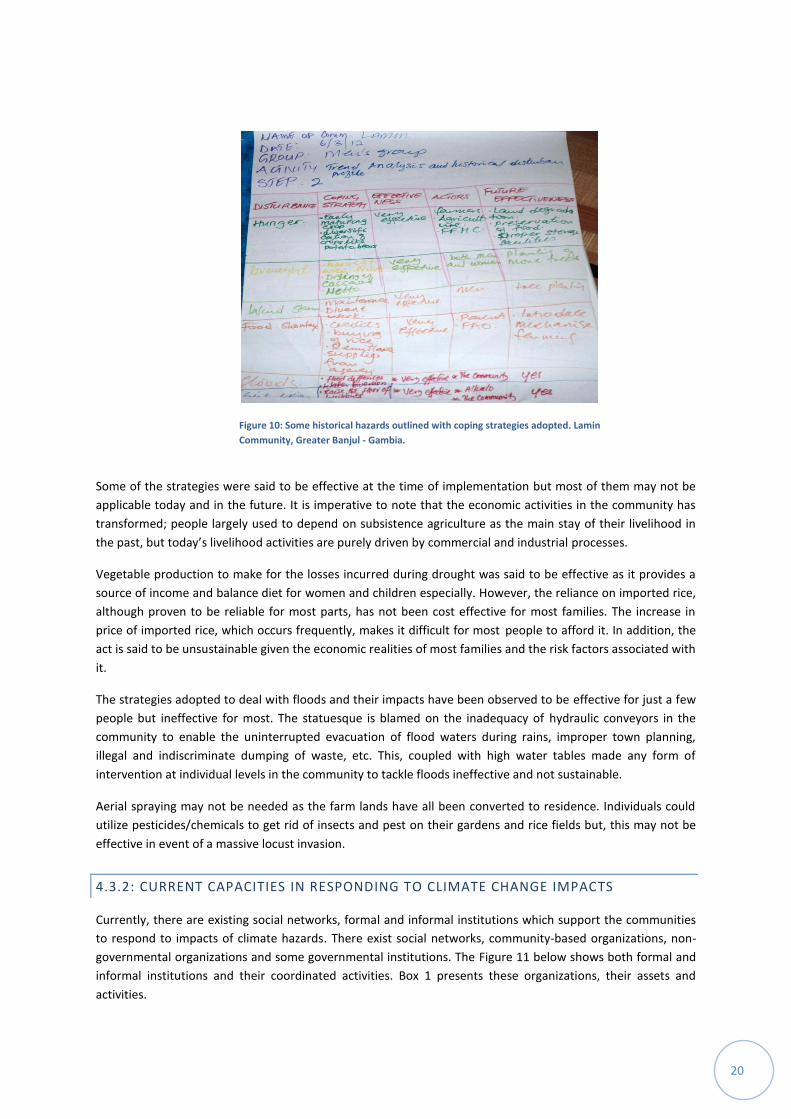
4.3.1: COPING STRATEGIES ADOPTED IN PAST EVENTS
In light of the historical disturbances that engulfed the area in the past, participants cited the following
strategies that were adopted as a way of coping with the impacts of the respective hazards:
To deal with drought and the resultant food shortages, vegetable gardening was done to ensure an
alternative source of food and income. This was made possible by digging wells to provide an alternative
source of water other than rains. Women groups as well as the Ward Development Committee (WDC)
were at the forefront of this activity. The Government through the Ministry of Agriculture was reported to
have equally intervened mainly by providing technical advice and farming inputs. The community also
benefitted from food aid from the government in the 80s and early 90s and a vast majority shifted their
attention to buying imported food as a viable alternative to locally produced food.
To deal with floods and their impacts, people adopted many methods including changing building
materials to those that can withstand the flood waters, raising the foundations of their houses to avoid
storm water entering in them, and drain cleaning and creation of water ways to ensure the free flow of
flood waters. Individual households were responsible for building their own houses; however, it took a
community initiative, often led by the Alkali (head of the community) and youth groups, to cleanup drains
and open new water channels.
Individuals use pesticides to get rid of insect pest on their farms/gardens. In the event of a massive
invasion by locust, this method is highly effective. The Government had intervened in the 1990s with
aerial spraying to tackle the problem countrywide.
In the event of a dust storm, people restricted their movements if not very essentials. Kids and old people
mainly stay indoors to avoid collusion with moving objects and minimize the risk of developing respiratory
illnesses that are associated with the phenomenon. The figure below represents some responses for the
Lamin community on coping strategies adopted.
20
Some of the strategies were said to be effective at the time of implementation but most of them may not be
applicable today and in the future. It is imperative to note that the economic activities in the community has
transformed; people largely used to depend on subsistence agriculture as the main stay of their livelihood in
the past, but today’s livelihood activities are purely driven by commercial and industrial processes.
Vegetable production to make for the losses incurred during drought was said to be effective as it provides a
source of income and balance diet for women and children especially. However, the reliance on imported rice,
although proven to be reliable for most parts, has not been cost effective for most families. The increase in
price of imported rice, which occurs frequently, makes it difficult for most people to afford it. In addition, the
act is said to be unsustainable given the economic realities of most families and the risk factors associated with
it.
The strategies adopted to deal with floods and their impacts have been observed to be effective for just a few
people but ineffective for most. The statuesque is blamed on the inadequacy of hydraulic conveyors in the
community to enable the uninterrupted evacuation of flood waters during rains, improper town planning,
illegal and indiscriminate dumping of waste, etc. This, coupled with high water tables made any form of
intervention at individual levels in the community to tackle floods ineffective and not sustainable.
Aerial spraying may not be needed as the farm lands have all been converted to residence. Individuals could
utilize pesticides/chemicals to get rid of insects and pest on their gardens and rice fields but, this may not be
effective in event of a massive locust invasion.
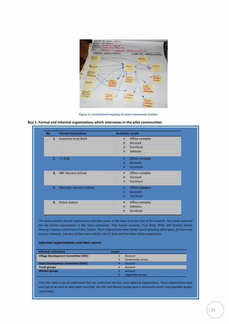
4.3.2: CURRENT CAPACITIES IN RESPONDING TO CLIMATE CHANGE IMPACTS
Currently, there are existing social networks, formal and informal institutions which support the communities
to respond to impacts of climate hazards. There exist social networks, community-based organizations, non-
governmental organizations and some governmental institutions. The Figure 11 below shows both formal and
informal institutions and their coordinated activities. Box 1 presents these organizations, their assets and
activities.
Figure 10: Some historical hazards outlined with coping strategies adopted. Lamin
Community, Greater Banjul - Gambia.
21
Box 1: Formal and Informal organizations which intervenes in the pilot communities
Figure 11: Institutional mapping of Lamin community-Gambia
No Formal Institutions Available assets
1. Guaranty trust Bank Office complex Account Furniture Vehicles
2. I.P.A.M Office complex Account Furniture
3. ABC Nursery School Office complex Account Furniture
4. Marong`s Nursery School Office complex Account Furniture
5. Police station Office complex Vehicles furniture
The above presents formal organizations and their assets in Ebo town as at the time of the research. The results indicated
five key formal organisations in Ebo Town community. They include Guaranty Trust Bank, IPAM, ABC Nursery School,
Marong`s Nursery school and a Police Station. These organizations have similar assets including office space, furniture and
account. However, only two of these have vehicles; the GT Bank and the Police station respectively.
Informal organizations and their assets
Informal Institutions Assets
Village Development Committee (VDC) Account Community center
Ward Development Committee (WDC) Account Youth groups Account Women groups Account
Vegetable garden
From this table it can be understood that the community has four main informal organizations. These organizations have
each got an account as their major asset but, the VDC and Women groups have a community center and vegetable garden
respectively.
22
Social networks are found to be very strong and effective in terms of psychological and material support
during emergencies. These are in most cases not properly and timely coordinated by any institution or
organisation. There are social organisations that comprise of youths and adults of both sexes and who
subscribe to development activities. Members of these social groups are bonded by shared values that are
highly cherished by each member.
Community-based organizations are said to be at the forefront of efforts to reduce/mitigate risk associated
with disasters of both natural and anthropogenic dimensions. The disaster mitigation initiatives include
creation of water ways, extension of pipe borne water to those areas affected by saline intrusion and floods to
ensure access to clean and potable water. There have been responsive programmes undertaken such as
evacuation of families, provision of temporal shelter as well as restoration of damage infrastructure in the
aftermath of a hazard. Box 2 presents a success story shared by the Ebo town community.
4.3.2.1: CHALLENGES TO ADAPTIVE CAPACITIES
Despite the immense efforts by community members, NGOs, Civil society groups and government’s agencies
/organizations in combating the adverse effects of climate change in the Greater Banjul Area, there are still
some challenges which slow down or retard adaptation efforts. A few of these were mentioned as; late and
inadequate responses to hazards, limited understanding of community members on the climate change
phenomenon, insufficient/less effective coping mechanisms, difficulties in waste management and
inadequate disaster preparedness. These are briefly elaborated below:
LATE AND INADEQUATE RESPONSESTO HAZARDS
Erosion has been a major problem in many parts of Greater Banjul area especially in the Lamin community.
This is partly due to the absence of an integrated drainage system and the nature of the topography of its
landscape. In addition to other intervention initiatives, the social groups also engage in refilling the gullies
created by erosion with sand obtained from dumping sites, which is believed to compact easily and withstand
erosion. The state through National Disaster Management Agency, Local Government Authority and Gambia
Red Cross Society are found to be active in giving support although some of the initiatives are said to be
geared towards preparedness, and also a significant proportion of these responses are usually untimely and
inadequate.
INSUFFICIENT / LESS EFFECTIVE COPING MECHANISMS
The communities have reported that local knowledge was used in handling hazards whenever they occur.
However, as to what extent were these skills effective in achieving the desired objectives was not made clear.
Feedbacks confirmed that, following the establishment of an Act paving way for the establishment of National
Disaster Management Agency in 2009, Ward Disaster Management Committees have been set up to primarily
Box 2: A recounted success stories in Ebo Town:
Introduction of electricity through the support of the Council and National Water and
Electricity Company (NAWEC); and the provision of stand pipes by the ECHO project
enabling the residents to have access to clean drinking water. The entire community
of Ebo Town benefitted from these interventions and they helped a lot in serving a lot
of community`s needs.
23
be the first point of action in the event of an emergency. These committees are said to have received trainings
on disaster assessment techniques and reporting.
Again, communities have had their coping strategies for various hazards and were utilizing them for ages. The
question is whether or not these have been proven effective all along. For instance, people resort to changing
building materials to protect buildings from flood collapsing. Residents living within disaster prone areas use
reinforced concrete or a belt of block around their houses to prevent water from destroying buildings. The
dwellers also construct water diversion works to prevent runoffs from getting into their houses.
In vegetable gardening, the introductions of resistant varieties as well as construction of dykes are practices
adopted to cope with the effects of droughts/dry spell and salt intrusion respectively. Women use hoes,
spades and buckets to remove layers of sand deposits brought into their fields by runoffs. However, this
particular effort is less effective and tedious as it has to be repeated several times within a year.
DIFFICULTIES IN WASTE MANAGEMENT
The absence of proper drainage system and a planning process results in intensification of erosion making
some of the road networks not unusable or sometime with extreme difficulty for children and aged. Waste
management is found to be a major environmental hazards and that is beyond the capacity of the
communities to tackle with respect to the prevailing methods. The Region’s Area Council is not adequately
equipped to deal with increasing influx of refuse and waste dumps as the institution lacks the necessary
equipment and capacity to deal with this problem. Land refill dumps are not many and sometimes not properly
treated. Activities such as open burning of solid waste causing the emission of carbon, burying of waste since
collection is not forthcoming as the only way to get rid of the solid waste. These methods may have multiple
side effects and likely to trigger the escalation of other hazards. Also, due to high water table especially in Ebo
Town, construction of septic tanks to accommodate human excreta is said to be an expensive undertaking.
Many of the people are said to have dug pit latrines which usually submerge during heavy downpours and the
accompanying floods.
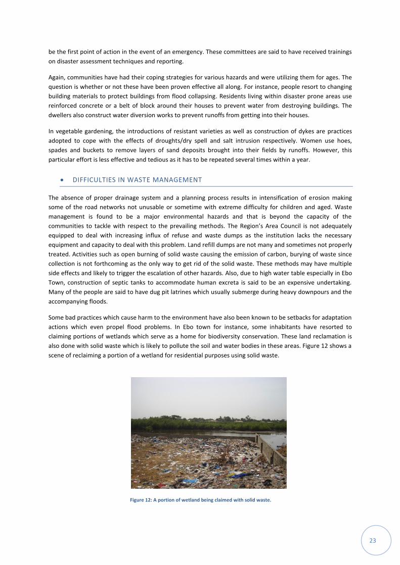
Some bad practices which cause harm to the environment have also been known to be setbacks for adaptation
actions which even propel flood problems. In Ebo town for instance, some inhabitants have resorted to
claiming portions of wetlands which serve as a home for biodiversity conservation. These land reclamation is
also done with solid waste which is likely to pollute the soil and water bodies in these areas. Figure 12 shows a
scene of reclaiming a portion of a wetland for residential purposes using solid waste.
Figure 12: A portion of wetland being claimed with solid waste.
24
INADEQUATE DISASTER PREPAREDNESS
Early warning systems are in existence but communities rely on local knowledge to predict impending hazards.
Although, this local knowledge often fails, they are said to be helpful in minimizing collateral losses in the
event of a hazard. The early warning given by the meteorological department at the national level annually
seemed not very effective as the information flow is inadequate. However, whereas information exists in
advance, economic circumstances prevent actions aimed at mitigating the impacts of hazards.
Enough time is found to be available for preparedness initiatives in a year, however, such activities are said to
be frustrated by individual`s economic circumstances. Disaster preparedness activities are usually done on
individual household basis but there are also fewer community led initiatives such as drainage cleaning done in
Ebo Town every year during the dry season in anticipation for floods. Trees and mangrove transplanting is
done in Lamin during the rainy season to replenish the lost vegetation cover. Apart from these, not much is
done due to a lack of the accurate techniques, apparatus and finance.
LIMITED UNDERSTANDING OF COMMUNITY MEMBERS ON THE CLIMATE CHANGE
PHENOMENON
Observations made during the trend analysis and historical disturbance sessions were that, although the
communities are aware of the changes that occur in terms of climate change, majority could not establish the
link between various harmful human activities and the resulting change (Box 3 presents local perceptions on
climate change). However, feedbacks clearly indicate the potential threats caused by hazards will be on the
rise as high intensity of rains and the associated floods are the results of such changes thus affecting
infrastructure and security; the erratic rainfall patterns and its accompanying dry spells affecting crop
production and compromising food security; the decline in sea foods (fish and oyster) due principally to
increase in demand of the growing local population and illegal fishing by foreign vessels; and poor
environmental sanitation as a result of the absence of the right infrastructure for proper management of
waste and an integrated drainage/sewage system as part of community planning particularly for the flood
prone areas.
Box 3: Local perceptions on climate change as presented by community members
The sun was used as the main symbol to represent the concept of climate change. By this, the participants implied
that there is rather an unusual heat being generated by the sun in recent times which was not so some years back.
This situation is influenced by various human activities including deforestation, settlement expansion and carbon
dioxide emission. Deforestation is said to be created by cutting down of trees for domestic needs as the community
expands. The changes in economic activities from mainly agrarian to industrial lead to an increase in the emission of
carbon dioxide, even though the participants believe that the rate of emission is not as compared to those of the
developed countries around the world.
According to community members, the changes in climate has resulted in erratic rainfall patterns, floods, sea-level
rise, high temperatures, windstorms, salt intrusion, crop failures, famine and structural collapse. High intensity rains
is perceived locally to be responsible for increases in floods events. Floods, rising temperatures as well as low rainfall
is perceived to be causing crop failures. Sea level rise is also associated with flooding of particularly low lying coastal
zones. High temperatures have been observed to be associated with salt intrusion as this is very common in the hot
season. Windstorms and flooding are also believed to be responsible for structural collapse. Community members
anticipate continuous occurrence of these events in higher severity in the phase of continuous global changing
climate. They predict high intensity of rainfalls, increase in windstorms, temperatures, flood events as well as
possible increase in water borne diseases and threats to infrastructure.
25
5: DEVELOPING OF LOCAL ADAPTATION PLANS
In anticipation of the likely effects of climate change mentioned by community members in Box 3 above, they
tried to develop some adaptation actions which could be implemented within their communities in
preparation for future events. This was done in two major activities.
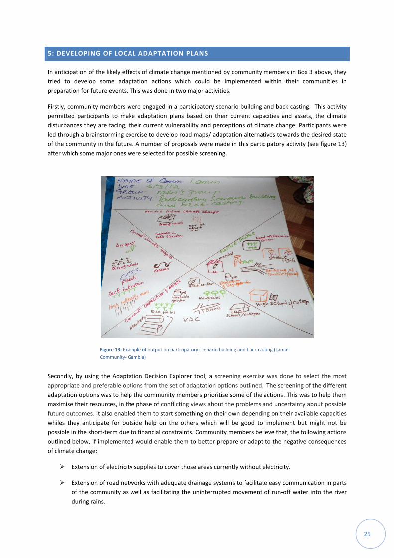
Firstly, community members were engaged in a participatory scenario building and back casting. This activity
permitted participants to make adaptation plans based on their current capacities and assets, the climate
disturbances they are facing, their current vulnerability and perceptions of climate change. Participants were
led through a brainstorming exercise to develop road maps/ adaptation alternatives towards the desired state
of the community in the future. A number of proposals were made in this participatory activity (see figure 13)
after which some major ones were selected for possible screening.
Secondly, by using the Adaptation Decision Explorer tool, a screening exercise was done to select the most
appropriate and preferable options from the set of adaptation options outlined. The screening of the different
adaptation options was to help the community members prioritise some of the actions. This was to help them
maximise their resources, in the phase of conflicting views about the problems and uncertainty about possible
future outcomes. It also enabled them to start something on their own depending on their available capacities
whiles they anticipate for outside help on the others which will be good to implement but might not be
possible in the short-term due to financial constraints. Community members believe that, the following actions
outlined below, if implemented would enable them to better prepare or adapt to the negative consequences
of climate change:
Extension of electricity supplies to cover those areas currently without electricity.
Extension of road networks with adequate drainage systems to facilitate easy communication in parts
of the community as well as facilitating the uninterrupted movement of run-off water into the river
during rains.
Figure 13: Example of output on participatory scenario building and back casting (Lamin
Community- Gambia)
:
26
Extension of pipe borne water to ensure each and every part of the community has access to clean
and safe drinking water.
Availability of well equipped health centre in the community capable of handing most of the
healthcare needs of the people.
Availability of well equipped Lower Basic schools as well as skills training centres to ensure that young
people have access to primary level education and skill training facilities at their disposal. This will
enable them to diversify their economic activities.
Availability of a well equipped police station within the community.
Halt encroachment on wetlands and setting systems to monitor this action.
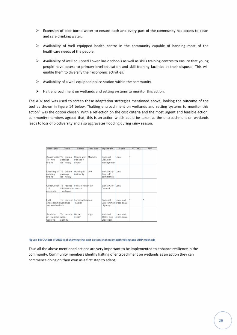
The ADx tool was used to screen these adaptation strategies mentioned above, looking the outcome of the
tool as shown in figure 14 below, “halting encroachment on wetlands and setting systems to monitor this
action” was the option chosen. With a reflection on the cost criteria and the most urgent and feasible action,
community members agreed that, this is an action which could be taken as the encroachment on wetlands
leads to loss of biodiversity and also aggravates flooding during rainy season.
Figure 14: Output of ADX tool showing the best option chosen by both voting and AHP methods
Thus all the above mentioned actions are very important to be implemented to enhance resilience in the
community. Community members identify halting of encroachment on wetlands as an action they can
commence doing on their own as a first step to adapt.
27
6: CONCLUSION
This study establishes that, the Greater Banjul is vulnerable to climate variability and change due to their exposure, high sensitivity and inadequate/low adaptive capacity of people to respond effectively to these challenges. The area is rich in various types of resources, especially biophysical ones. However, their exposure to various types of climate related hazards threatens their existence. The area is exposed to erratic rainfall patterns, rising temperatures and sea-levels. Some consequential effects of these extreme events have been torrential rains, dry spells, storms surges, droughts, cool spells, heat waves, beach erosion, outbreak of parasitic diseases, outbreak of crop pest and saline intrusion into productive soil, river and underground fresh water.
These problems are also aggravated by some existing non-climatic challenges in the Greater Banjul Area, which retards adaptation efforts; these were mentioned as late and inadequate responses to hazards, limited understanding of community members on the climate change phenomenon, insufficient/less effective coping mechanisms, difficulties in waste management and inadequate disaster preparedness.
A forecast into likely future climate scenarios, shows that average maximum temperatures are likely to continue increasing where as rainfall patterns in this region remain highly uncertain with likely increase in its intensity. There is therefore the need for robust adaptation strategies that would help to deal with current problems, and aren’t reliant on specific projections of change.
In response to these hazards, communities normally receive aid from available institutions such as social groups, NGOs and government development committees. These are also complemented by various coping mechanisms developed by community members themselves. However, these supports are not all sufficient in dealing with all the challenges. In the coming years, with the likelihood of more uncertain climatic hazards, it could be very difficult for people living in this area if business should continue as usual as realized in this study without any aggressive interventions with regards to adaptation.
It has been realized that with the strengthening of available institutional support and effective coordination between community members and various institutions, there could be better ways for people to adapt to these climate impacts. Also, as community members have been able develop their own adaptation plans and decisions, this makes them ready for any institutional support and also alerts the need for their engagement in implementing some these actions.
28
7: REFERENCES
Fussel, H.M. (2007). Vulnerability: A generally applicable conceptual framework for climate change research,
Global Environmental Change 17(2), 155-167
Government of The Gambia. Gambia National Adaptation Programme of Action on Climate Change (2007).
Gambia Bureau of Statistics (2007). The Gambia Population and Housing Census – 2003, Kanifing Institutional
Layout, Bethel Harding Highway, Kanifing, The Gambia.
Ibe, A. C., and Awosika, L. F.(1991): Sea Level Rise Impacts on African Coastal Zones. In A Change in the
Weather: African Perspectives on Climate Change, eds. S.H. Omide and C. Jump, 105-12. Nairobi, Kenya:
African Center for Technology Studies.
IPCC (Intergovernmental Panel on Climate Change) Special Reports 1996: Regional Impacts of Climate Change.
An Assessment of Vulnerability Chapter 2: Africa, African Coastal Zones.
IPCC (2007a): Observations: Surface and Atmospheric Climate Change. In: Climate Change 2007: The Physical
Science Basis. Contribution of Working Group I to the Fourth Assessment Report of the Intergovernmental
Panel on Climate Change [Solomon, S., D. Qin, M. Manning, Z. Chen, M. Marquis, K.B. Averyt, M. Tignor and
H.L. Miller (eds.)]. Cambridge University Press, Cambridge, United Kingdom and New York, NY, USA.
IPCC (2007b): Regional Climate Projections. In: Climate Change 2007: The Physical Science Basis. Contribution
of Working Group I to the Fourth Assessment Report of the Intergovernmental Panel on Climate Change
[Solomon, S., D. Qin, M. Manning, Z. Chen, M. Marquis, K.B. Averyt, M. Tignor and H.L. Miller (eds.)].
Cambridge
Kanifing Municipal Council (KMC) Report (2011). Vulnerability and Capacity Assessment in 11 Wards in the
KMC.
National Environment Agency (Gambia). State of the Environment Report (SER-TG) 2010. 2nd
ed. Jimpex Road,
Kanifing, The Gambia-West Africa. http://www.nea.gm/assets/Publications/Preliminary-Section-of-State-of-
the-Environment-Report-The-Gambia-Second-Edition.pdf
New, M. Hewitson, B. Stephenson, B.D.Tsiga, A,Kruger, A. Manhique
A. Gomez, B. Coelho,C.A.S. Ntiki Masisi
D.
Kululanga, E. Mbambalala, E. Adesina, F. Saleh, H. Kanyanga, J. Juliana, J. Lebohang Bulane
13, Fortunata, L.
Mdoka, M.L. Robert Lajoie, R. (2006) Evidence of trends in daily climate extremes over southern and western
Africa: Journal of Geophysical Research. Vol.111, Issue D14.
United Nations Development Program (2008): Climate Change Country Profiles, The Gambia, Authors: C.
McSweeney, M. New and G. Lizcano, School of Geography and the Environment, South Parks Road, Oxford,
OX1 3QY, United Kingdom.