garmin gtn 650 training - flying20club.org · presentation outline basic 650 operations gtn 650...
TRANSCRIPT

Garmin GTN 650 Workshop
VFR & IFR Operations
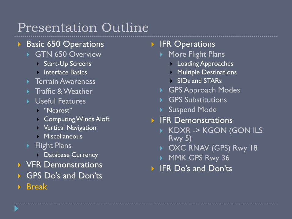
Presentation Outline Basic 650 Operations
GTN 650 Overview Start-Up Screens
Interface Basics
Terrain Awareness
Traffic & Weather
Useful Features “Nearest”
Computing Winds Aloft
Vertical Navigation
Miscellaneous
Flight Plans Database Currency
VFR Demonstrations
GPS Do’s and Don’ts
Break
IFR Operations More Flight Plans
Loading Approaches
Multiple Destinations
SIDs and STARs
GPS Approach Modes
GPS Substitutions
Suspend Mode
IFR Demonstrations KDXR -> KGON (GON ILS
Rwy 5)
OXC RNAV (GPS) Rwy 18
MMK GPS Rwy 36
IFR Do’s and Don’ts

GTN 650 Overview

Database Verification
Displays GTN software versions
Displays installed databases and their expiration dates
Expired databases will be shown in yellow
“Navigation” database required to be current for IFR flight*
All other databases are optional for VFR and IFR flight
* Some exceptions apply – addressed in a later slide

Instrument Panel Self-Test
Verify CDI / GS displacement is correct
CDI (LCDI) half left
G/S (VCDI) half up
To/From is TO
No flags
Verify OBS course
Garmin “OBS” value and selected OBS course should match
Should be within 2 degrees
Technically, IFR flight is prohibited if any of the self-tests fail

Default Nav Page Press and hold HOME to load from any page
Can also access it from the Home page
Provides a shortcut button to enter the moving map page
It’s where the CDI and OBS functions are controlled from
Active leg of flight plan
TO/FROM flag*
Course
deviation
indicator (CDI)
* Always TO when in GPS mode
User-selectable
data fields
Moving Map
Shortcut ButtonCDI Source
SelectorOBS
Selector
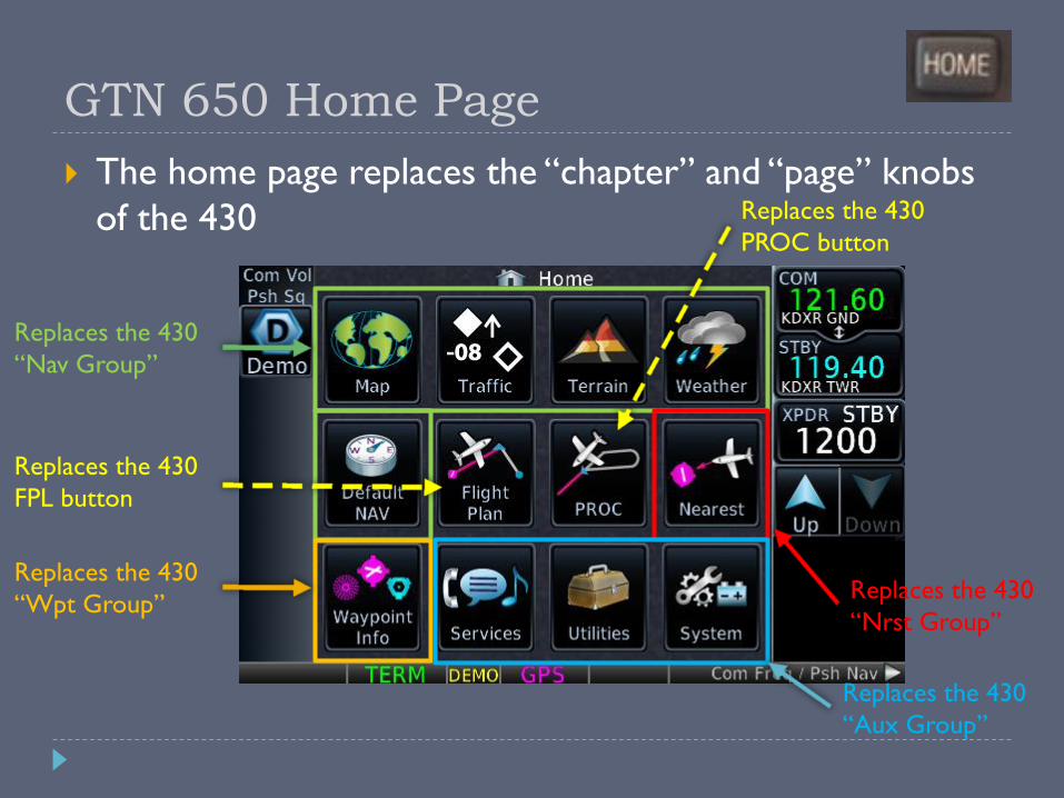
GTN 650 Home Page
The home page replaces the “chapter” and “page” knobs
of the 430
Replaces the 430
“Nav Group”
Replaces the 430
“Wpt Group”Replaces the 430
“Nrst Group”
Replaces the 430
“Aux Group”
Replaces the 430
FPL button
Replaces the 430
PROC button
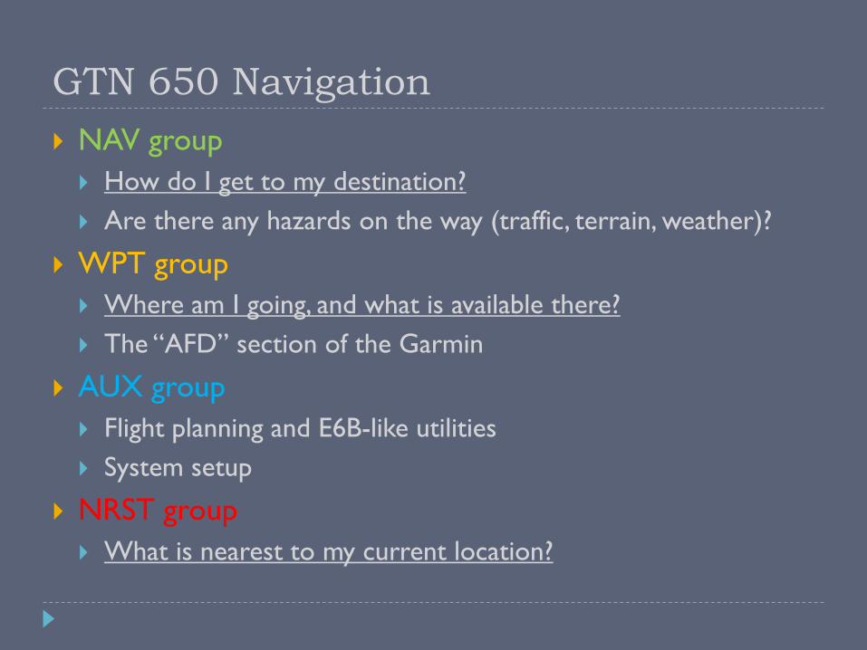
GTN 650 Navigation
NAV group
How do I get to my destination?
Are there any hazards on the way (traffic, terrain, weather)?
WPT group
Where am I going, and what is available there?
The “AFD” section of the Garmin
AUX group
Flight planning and E6B-like utilities
System setup
NRST group
What is nearest to my current location?
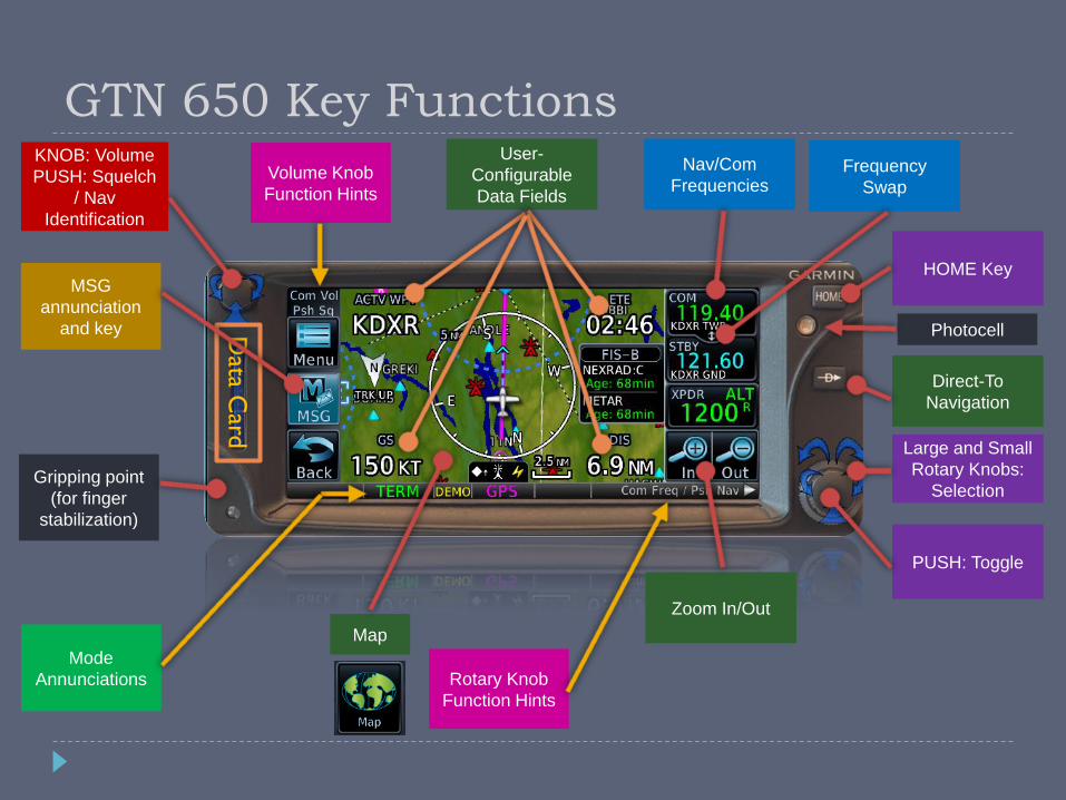
GTN 650 Key FunctionsKNOB: Volume
PUSH: Squelch
/ Nav
Identification
PUSH: Toggle
Large and Small
Rotary Knobs:
Selection
HOME Key
Direct-To
Navigation
Zoom In/Out
Nav/Com
Frequencies
User-
Configurable
Data Fields
Map
Data C
ard
Rotary Knob
Function Hints
MSG
annunciation
and key
Frequency
Swap
Mode
Annunciations
Gripping point
(for finger
stabilization)
Volume Knob
Function Hints
Photocell

GTN 650 Data Fields (Subset)
ACTV WPT – Active
Waypoint
BRG – Bearing To Waypoint
DIS – Distance To Waypoint
DFLT NAV – Default nav
page (lower-right only)
DTK – Desired Track
ESA – En-route Safe Altitude
ETA – Estimated Time of
Arrival
ETA at Dest
ETE – Estimated Time En-
route
GS – Groundspeed
OBS/Susp/Unsusp button
(lower-right only)
TRK – Track
Wind – Wind Speed and
Direction
Time to TOD – Time to Top
of Descent
XTK – Cross-Track Error
BOLD = Default; Underlined = Recommended
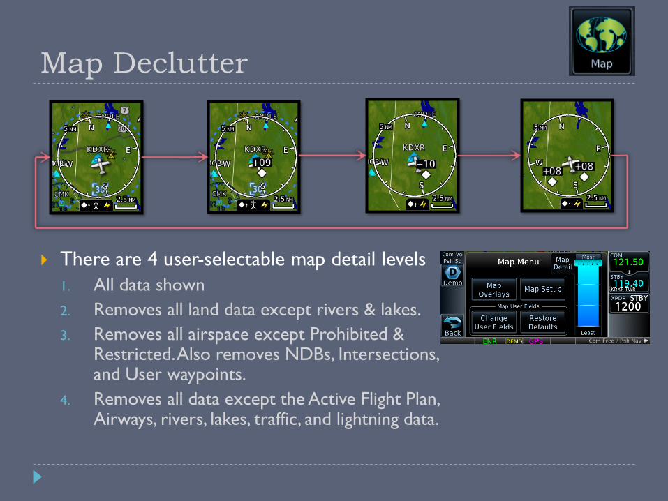
Map Declutter
There are 4 user-selectable map detail levels
1. All data shown
2. Removes all land data except rivers & lakes.
3. Removes all airspace except Prohibited & Restricted. Also removes NDBs, Intersections, and User waypoints.
4. Removes all data except the Active Flight Plan, Airways, rivers, lakes, traffic, and lightning data.
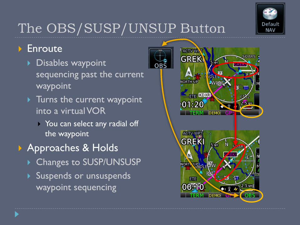
The OBS/SUSP/UNSUP Button
Enroute
Disables waypoint
sequencing past the current
waypoint
Turns the current waypoint
into a virtual VOR
You can select any radial off
the waypoint
Approaches & Holds
Changes to SUSP/UNSUSP
Suspends or unsuspends
waypoint sequencing
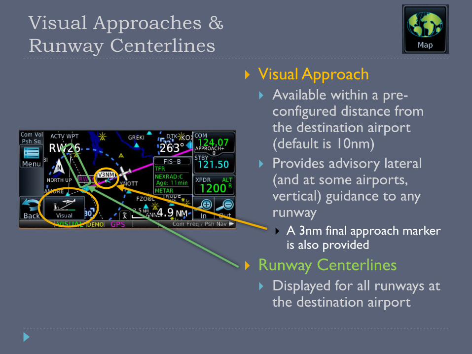
Visual Approaches &
Runway Centerlines
Visual Approach
Available within a pre-configured distance from the destination airport (default is 10nm)
Provides advisory lateral (and at some airports, vertical) guidance to any runway
A 3nm final approach marker is also provided
Runway Centerlines
Displayed for all runways at the destination airport

Terrain Awareness
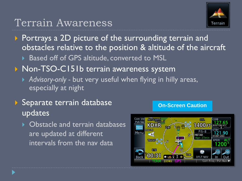
Terrain Awareness
Portrays a 2D picture of the surrounding terrain and obstacles relative to the position & altitude of the aircraft
Based off of GPS altitude, converted to MSL
Non-TSO-C151b terrain awareness system
Advisory-only - but very useful when flying in hilly areas, especially at night
On-Screen Caution Separate terrain database
updates
Obstacle and terrain databases
are updated at different
intervals from the nav data

Terrain Awareness Criteria
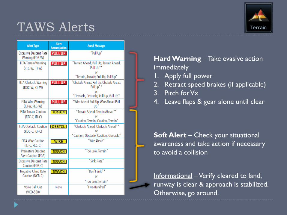
TAWS Alerts
Hard Warning – Take evasive action
immediately
1. Apply full power
2. Retract speed brakes (if applicable)
3. Pitch for Vx
4. Leave flaps & gear alone until clear
Soft Alert – Check your situational
awareness and take action if necessary
to avoid a collision
Informational –Verify cleared to land,
runway is clear & approach is stabilized.
Otherwise, go around.
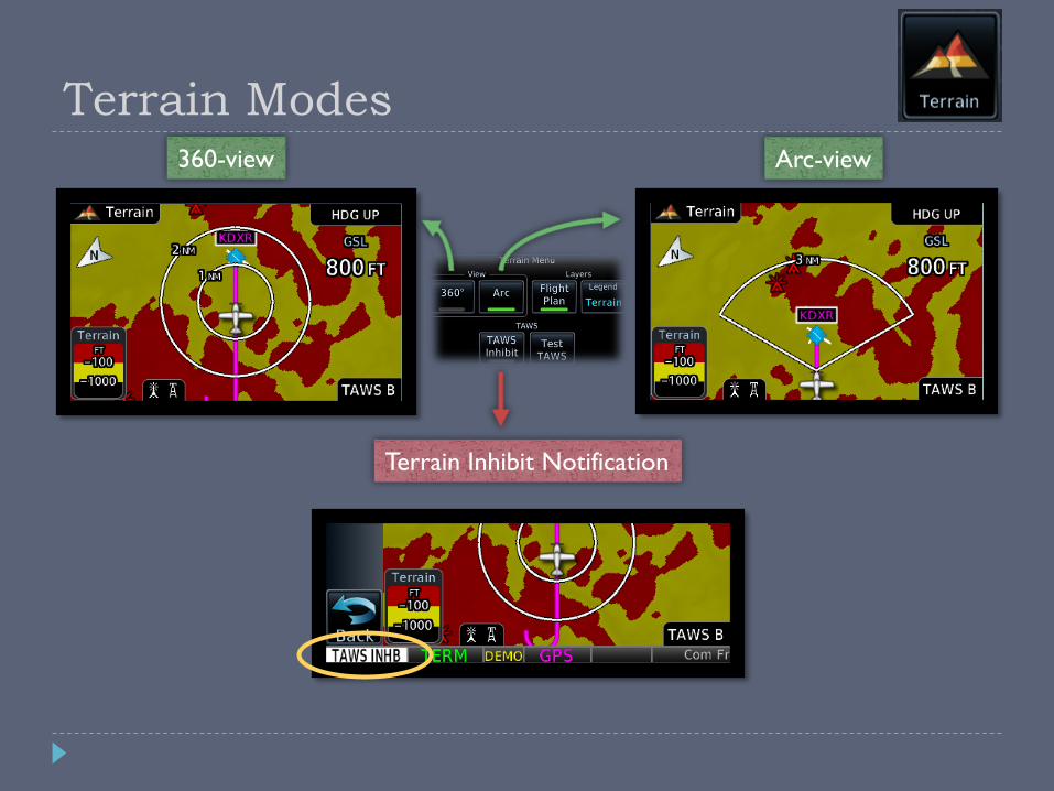
Terrain Modes360-view Arc-view
Terrain Inhibit Notification

Traffic & Weather Pages
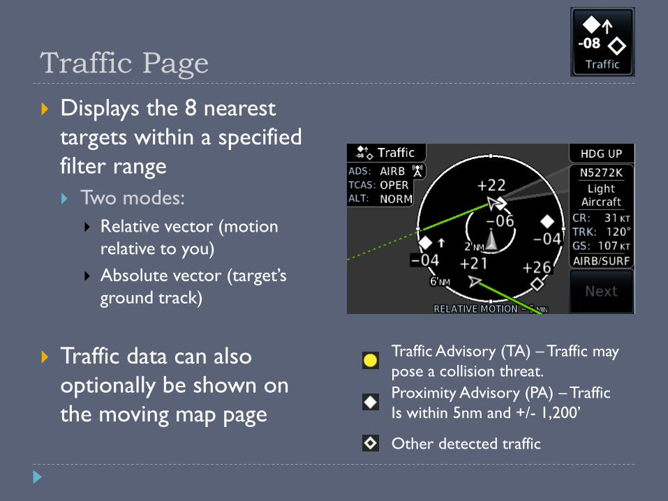
Traffic Page
Displays the 8 nearest
targets within a specified
filter range
Two modes:
Relative vector (motion
relative to you)
Absolute vector (target’s
ground track)
Traffic data can also
optionally be shown on
the moving map page
Traffic Advisory (TA) – Traffic may
pose a collision threat.
Proximity Advisory (PA) – Traffic
Is within 5nm and +/- 1,200’
Other detected traffic

Weather Page
From the “Home” screen,
select “Weather” and then
“FIS-B Weather”
Displays NEXRAD radar,
graphical METARs, TFRs,
AIRMETs/SIGMETs, and
PIREPs
Weather data (radar,
stormscope, and METARs)
can also optionally be shown
on the moving map page

Textual Weather Pages
From the “Map” or
“Weather” page, touch
the location you want
more information on.
You can also select “WX
Data” from the airport
information screen.

Useful Features & Tips
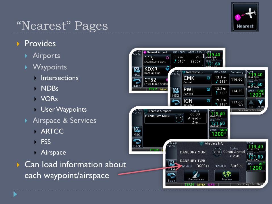
“Nearest” Pages
Provides
Airports
Waypoints
Intersections
NDBs
VORs
User Waypoints
Airspace & Services
ARTCC
FSS
Airspace
Can load information about
each waypoint/airspace
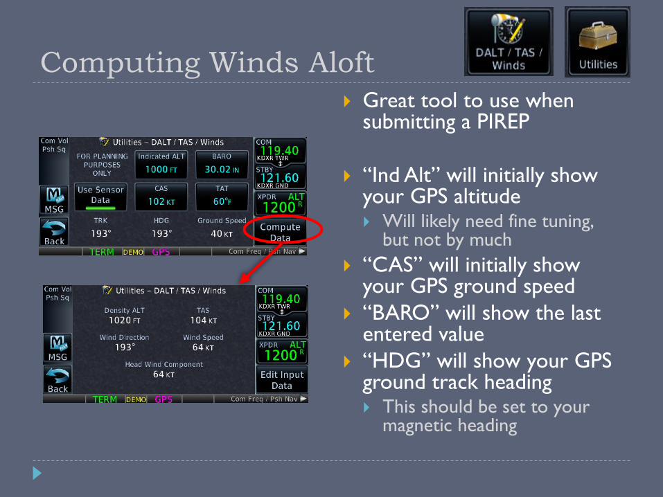
Computing Winds Aloft
Great tool to use when submitting a PIREP
“Ind Alt” will initially show your GPS altitude Will likely need fine tuning,
but not by much
“CAS” will initially show your GPS ground speed
“BARO” will show the last entered value
“HDG” will show your GPS ground track heading This should be set to your
magnetic heading
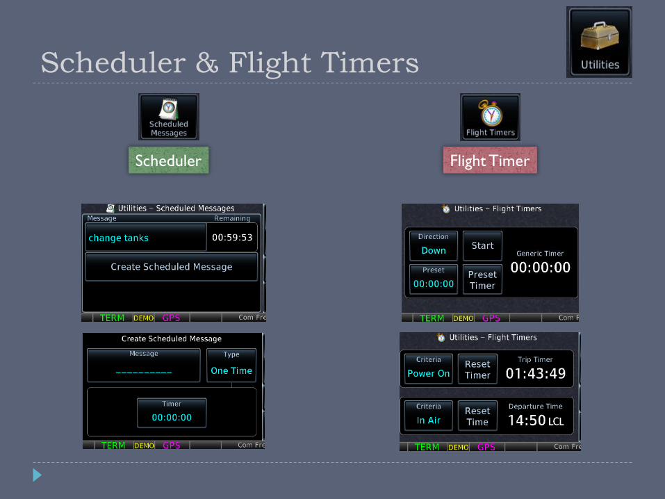
Scheduler & Flight Timers
Scheduler Flight Timer
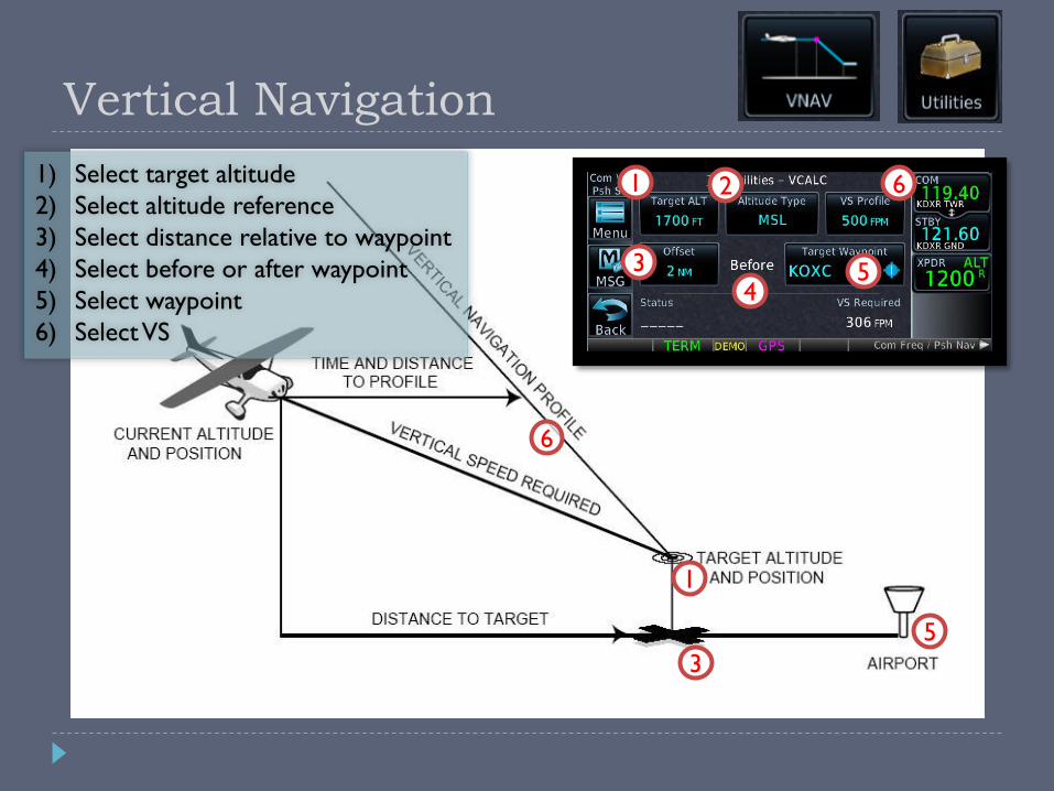
Vertical Navigation
1) Select target altitude
2) Select altitude reference
3) Select distance relative to waypoint
4) Select before or after waypoint
5) Select waypoint
6) Select VS
1
34
5
62
1
5
6
3
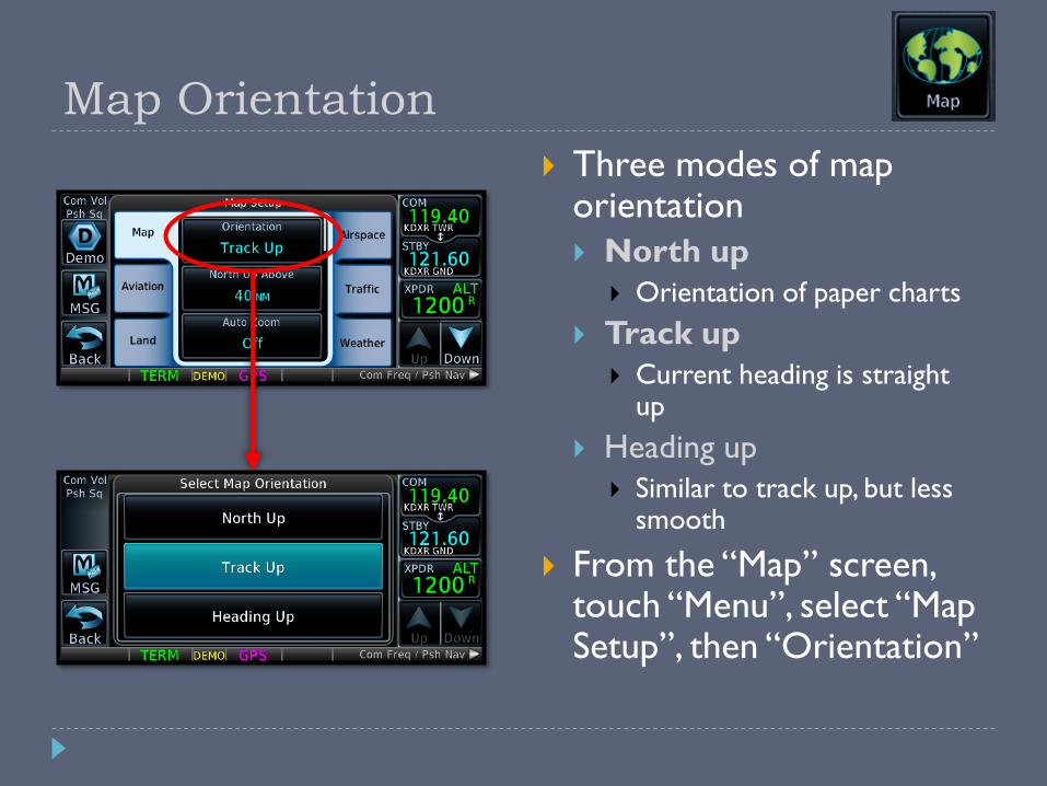
Map Orientation
Three modes of map orientation
North up
Orientation of paper charts
Track up
Current heading is straight up
Heading up
Similar to track up, but less smooth
From the “Map” screen, touch “Menu”, select “Map Setup”, then “Orientation”
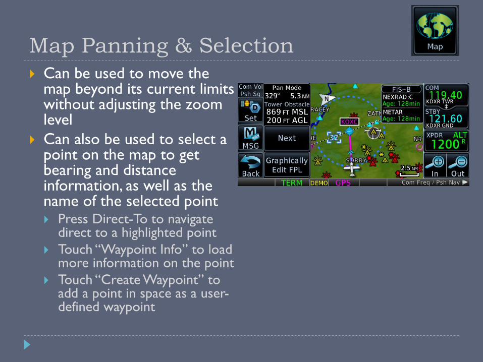
Map Panning & Selection
Can be used to move the map beyond its current limits without adjusting the zoom level
Can also be used to select a point on the map to get bearing and distance information, as well as the name of the selected point Press Direct-To to navigate
direct to a highlighted point
Touch “Waypoint Info” to load more information on the point
Touch “Create Waypoint” to add a point in space as a user-defined waypoint
User-Defined Waypoints
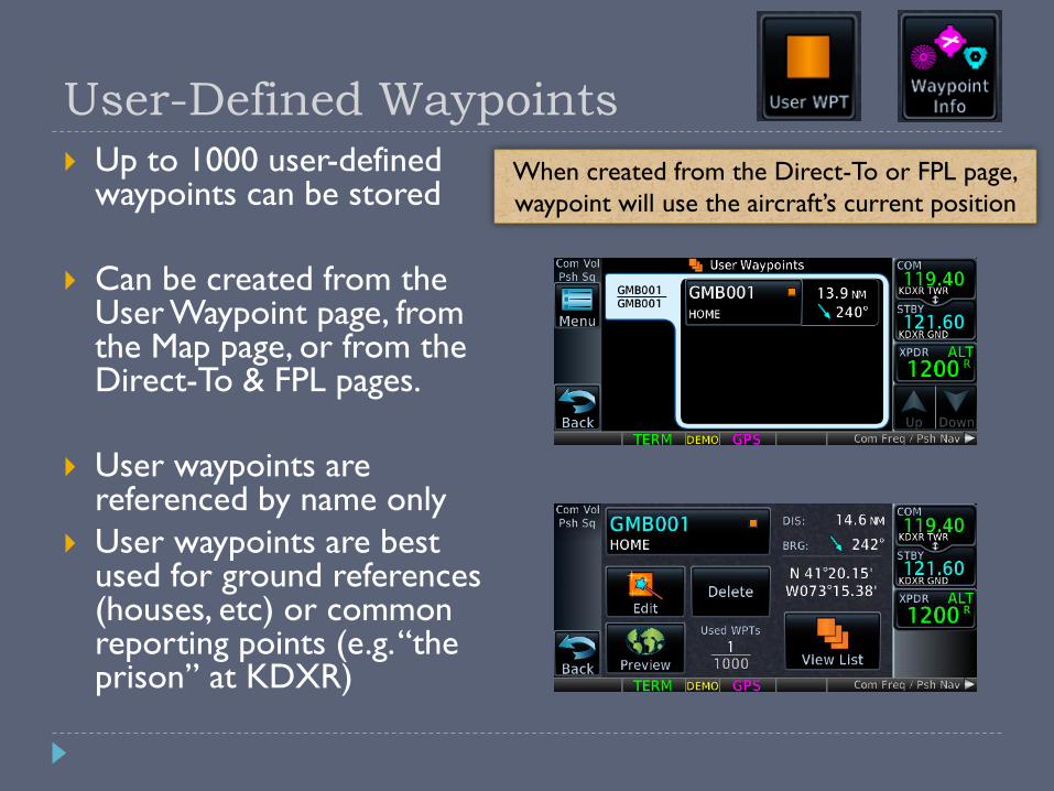
Up to 1000 user-defined waypoints can be stored
Can be created from the User Waypoint page, from the Map page, or from the Direct-To & FPL pages.
User waypoints are referenced by name only
User waypoints are best used for ground references (houses, etc) or common reporting points (e.g. “the prison” at KDXR)
When created from the Direct-To or FPL page,
waypoint will use the aircraft’s current position
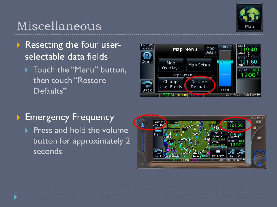
Miscellaneous
Resetting the four user-
selectable data fields
Touch the “Menu” button,
then touch “Restore
Defaults”
Emergency Frequency
Press and hold the volume
button for approximately 2
seconds

Flight Plans
VFR & IFR

When Your Database is Not Current
VFR
No legal requirements to have a current database
IFR
Legal for en-route and terminal navigation
Each waypoint must be verified with an alternate source of currentdata (e.g. paper chart, electronic chart)
Per the Garmin 650 STC, “GPS”, “or GPS”, and “RNAV (GPS)” approaches are not allowed
Example: Danbury’s “GPS RWY 08” approach is not allowed, but something like a “VOR or GPS-A” approach is allowed if flown using VOR guidance.
Danbury’s “LOC RWY 08” is also allowed
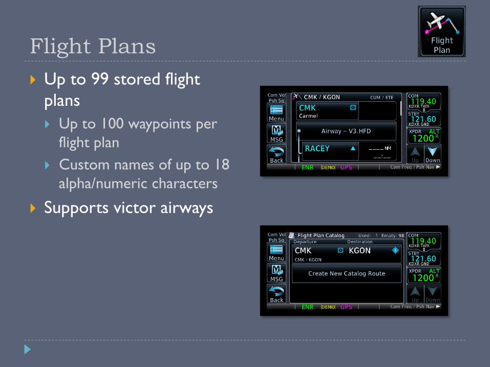
Flight Plans
Up to 99 stored flight
plans
Up to 100 waypoints per
flight plan
Custom names of up to 18
alpha/numeric characters
Supports victor airways
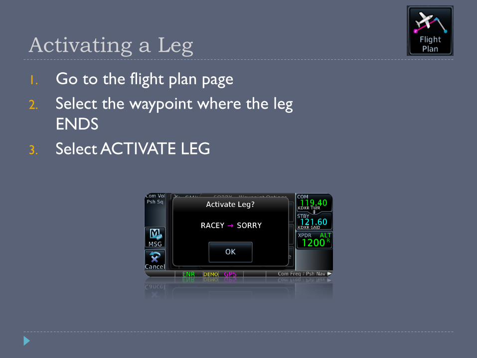
Activating a Leg
1. Go to the flight plan page
2. Select the waypoint where the leg
ENDS
3. Select ACTIVATE LEG
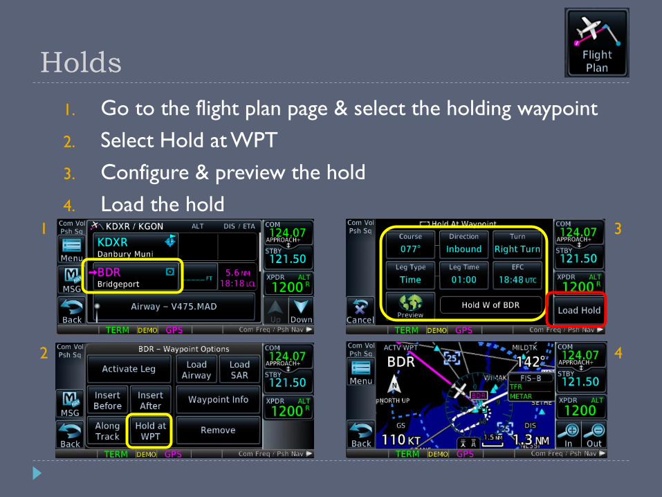
Holds
1. Go to the flight plan page & select the holding waypoint
2. Select Hold at WPT
3. Configure & preview the hold
4. Load the hold1
2
3
4

Garmin Aviation Trainer
PC Trainer
Windows 7 or later
macOS not supported
iPad Trainer
iPad 2 or newer
1. Start-up screen: Database currency
2. Home page
3. Interface navigation basics
4. Changing data fields on the map page
5. Map setup
6. Terrain awareness
7. Looking up waypoint/airport information
Entering data
8. “Nearest” demonstration
9. Scheduler and flight timers
10.Computing winds aloft
11.Vertical navigation
VFR GPS Demonstrations
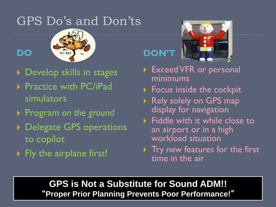
GPS Do’s and Don’ts
DO DON’T
Develop skills in stages
Practice with PC/iPad
simulators
Program on the ground
Delegate GPS operations
to copilot
Fly the airplane first!
Exceed VFR or personal minimums
Focus inside the cockpit
Rely solely on GPS map display for navigation
Fiddle with it while close to an airport or in a high workload situation
Try new features for the first time in the air
GPS is Not a Substitute for Sound ADM!!“Proper Prior Planning Prevents Poor Performance!”
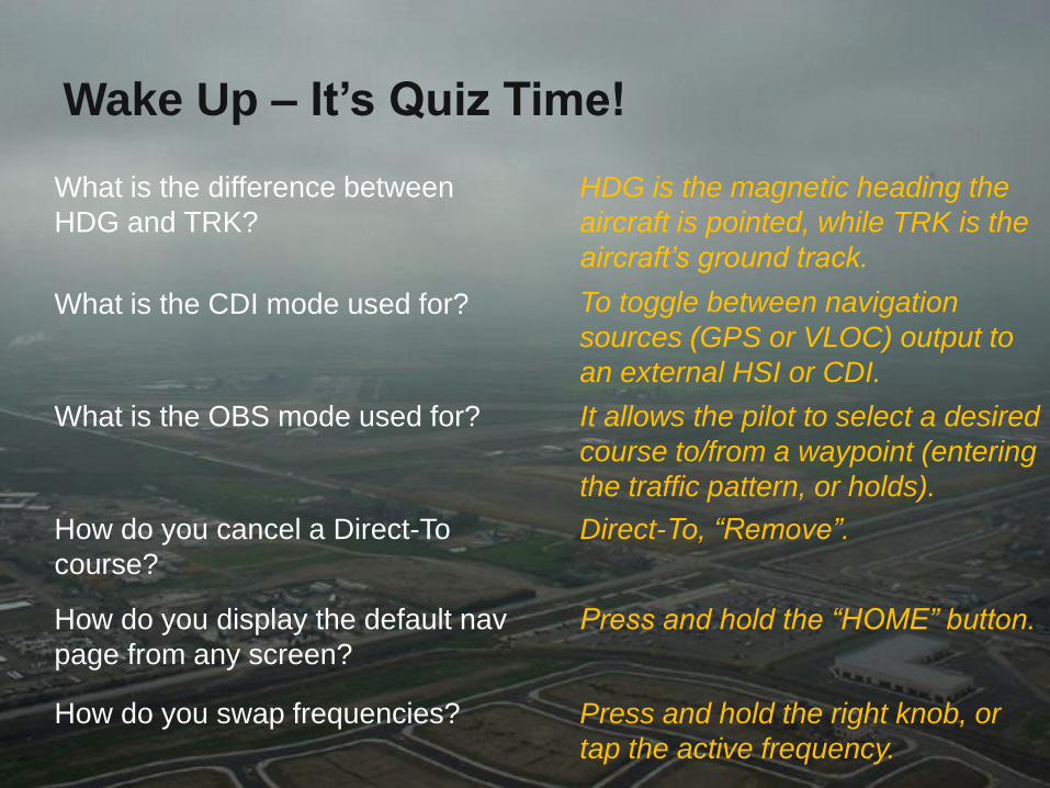
Wake Up – It’s Quiz Time!
How do you swap frequencies?
What is the CDI mode used for?
How do you cancel a Direct-To
course?
What is the difference between
HDG and TRK?
What is the OBS mode used for?
How do you display the default nav
page from any screen?
HDG is the magnetic heading the
aircraft is pointed, while TRK is the
aircraft’s ground track.
To toggle between navigation
sources (GPS or VLOC) output to
an external HSI or CDI.
It allows the pilot to select a desired
course to/from a waypoint (entering
the traffic pattern, or holds).
Direct-To, “Remove”.
Press and hold the “HOME” button.
Press and hold the right knob, or
tap the active frequency.

IFR Operations
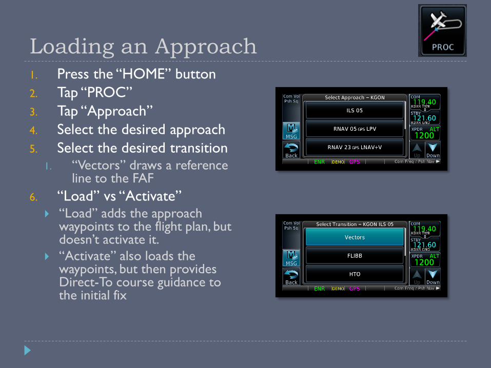
Loading an Approach1. Press the “HOME” button
2. Tap “PROC”
3. Tap “Approach”
4. Select the desired approach
5. Select the desired transition1. “Vectors” draws a reference
line to the FAF
6. “Load” vs “Activate” “Load” adds the approach
waypoints to the flight plan, but doesn’t activate it.
“Activate” also loads the waypoints, but then provides Direct-To course guidance to the initial fix
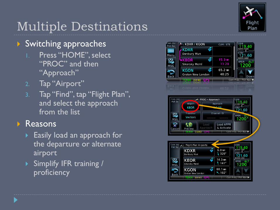
Multiple Destinations
Switching approaches
1. Press “HOME”, select “PROC” and then “Approach”
2. Tap “Airport”
3. Tap “Find”, tap “Flight Plan”, and select the approach from the list
Reasons
Easily load an approach for the departure or alternate airport
Simplify IFR training / proficiency
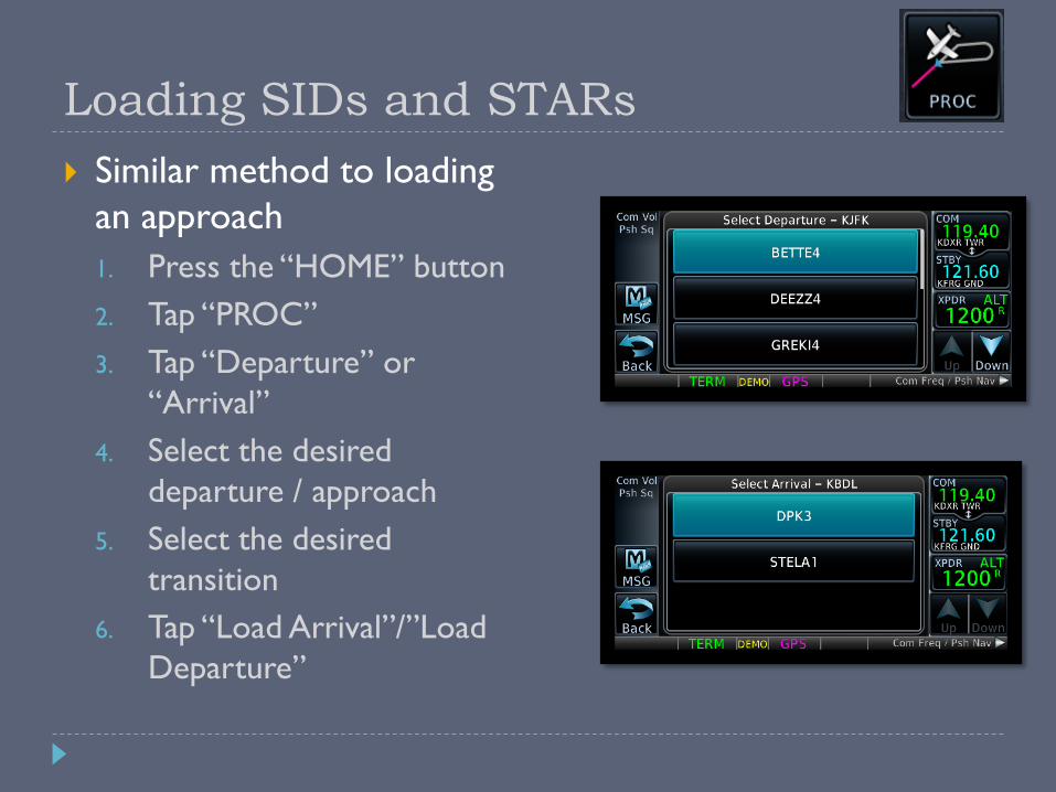
Loading SIDs and STARs
Similar method to loading
an approach
1. Press the “HOME” button
2. Tap “PROC”
3. Tap “Departure” or
“Arrival”
4. Select the desired
departure / approach
5. Select the desired
transition
6. Tap “Load Arrival”/”Load
Departure”
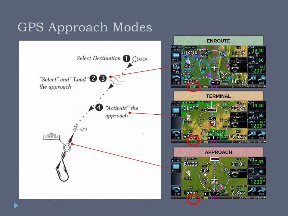
ENROUTE
TERMINAL
APPROACH
GPS Approach Modes
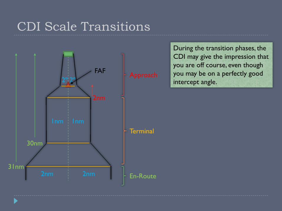
CDI Scale Transitions
During the transition phases, the
CDI may give the impression that
you are off course, even though
you may be on a perfectly good
intercept angle.
31nm
30nm
2nm
2nm 2nm
1nm1nm
2º2º
En-Route
Terminal
ApproachFAF
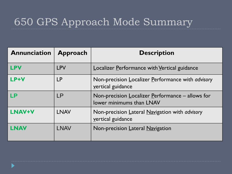
Annunciation Approach Description
LPV LPV Localizer Performance with Vertical guidance
LP+V LP Non-precision Localizer Performance with advisory
vertical guidance
LP LP Non-precision Localizer Performance – allows for
lower minimums than LNAV
LNAV+V LNAV Non-precision Lateral Navigation with advisory
vertical guidance
LNAV LNAV Non-precision Lateral Navigation
650 GPS Approach Mode Summary
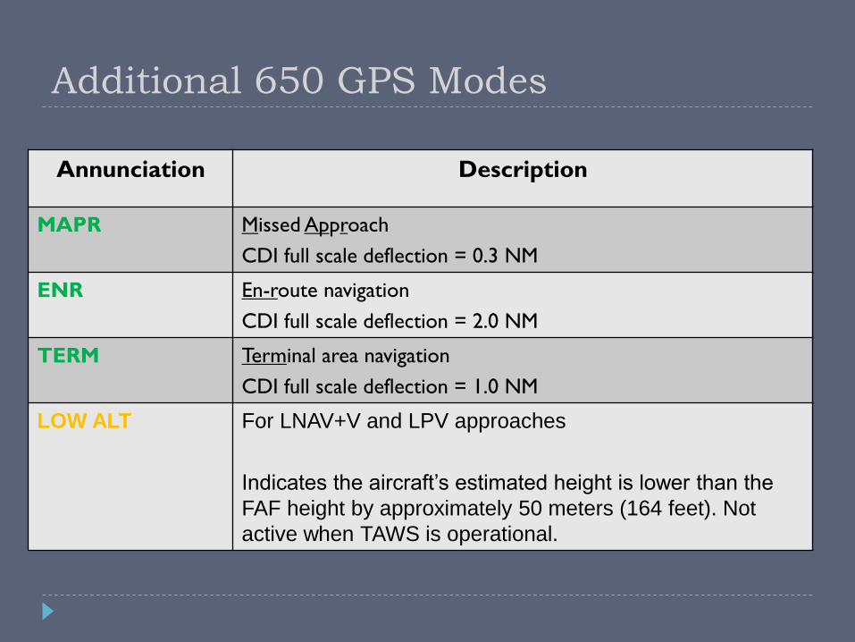
Annunciation Description
MAPR Missed Approach
CDI full scale deflection = 0.3 NM
ENR En-route navigation
CDI full scale deflection = 2.0 NM
TERM Terminal area navigation
CDI full scale deflection = 1.0 NM
LOW ALT For LNAV+V and LPV approaches
Indicates the aircraft’s estimated height is lower than the
FAF height by approximately 50 meters (164 feet). Not
active when TAWS is operational.
Additional 650 GPS Modes

GPS Substitutions AC90-108 – Operational & Airworthiness Guidance
Suitable RNAV system as an alternate means of navigation
Allowed substitutions Determine aircraft position relative to/distance from a VOR, TACAN, NDB,
compass locator, DME fix, fix defined by a VOR radial/TACAN course/NDB bearing/compass locator bearing intersecting a VOR or LOC course
Navigate to/from a VOR, TACAN, NDB, or compass locator
Hold over a VOR, TACAN, NDB, compass locator, or DME fix
Fly an arc based upon DME
All of the above is allowed even when a facility is identified as required on a procedure (e.g. “ADF required”)
Non-allowed substitutions When a procedure is NOTAMed as “not authorized” (“NA”)
Example: A procedure is based upon a recently decommissioned NAVAID
Substitution on a Final Approach Segment
Lateral Navigation on LOC-Based Courses
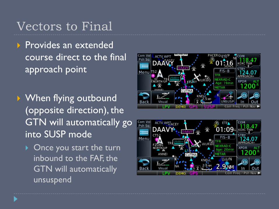
Vectors to Final
Provides an extended
course direct to the final
approach point
When flying outbound
(opposite direction), the
GTN will automatically go
into SUSP mode
Once you start the turn
inbound to the FAF, the
GTN will automatically
unsuspend
Missed Approach
Upon reaching the MAP, the “Missed Approach Waypoint Reached” screen will pop up
“Remain Suspended” to complete the approach
“Activate Missed Approach” to begin guidance for the missed approach
You can also manually activate the missed approach for any GPS approach once inside the FAF
HOME, PROC, “Activate Missed Approach”
Suspend Mode
GTN suspends automatic leg sequencing when the start
of the next leg cannot be determined
SUSP = Pilot intervention required
Two main types of waypoint sequencing suspension
Pilot-induced
Pilot intentionally suspends waypoint sequencing
Navigator-induced
Navigator cannot determine when to begin the next leg
Suspend Mode
Reasons for automatic waypoint suspension
The MAP has been reached
Does the pilot intend to land, or follow the missed approach?
Holding pattern requires pilot action to exit
Ex) A hold at the end of a missed approach procedure
Leg requires a course/heading to be flown indefinitely
Ex) “fly heading 360, expect radar vectors”
Leg ends at a specific altitude and baro-corrected input not
provided
Ex) “climb to 2500, then…”
Aircraft flying opposite direction to a vectors-to-final course
Temporary – navigator will resume sequencing when flying inbound
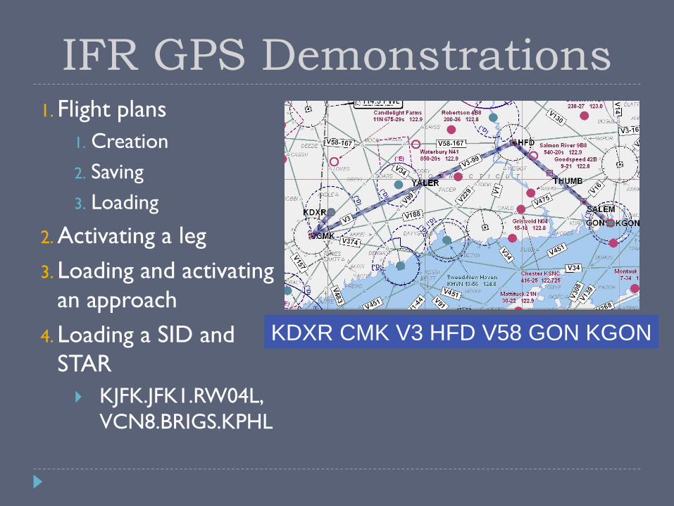
KDXR CMK V3 HFD V58 GON KGON
IFR GPS Demonstrations1. Flight plans
1. Creation
2. Saving
3. Loading
2. Activating a leg
3. Loading and activating
an approach
4. Loading a SID and
STAR
KJFK.JFK1.RW04L,
VCN8.BRIGS.KPHL
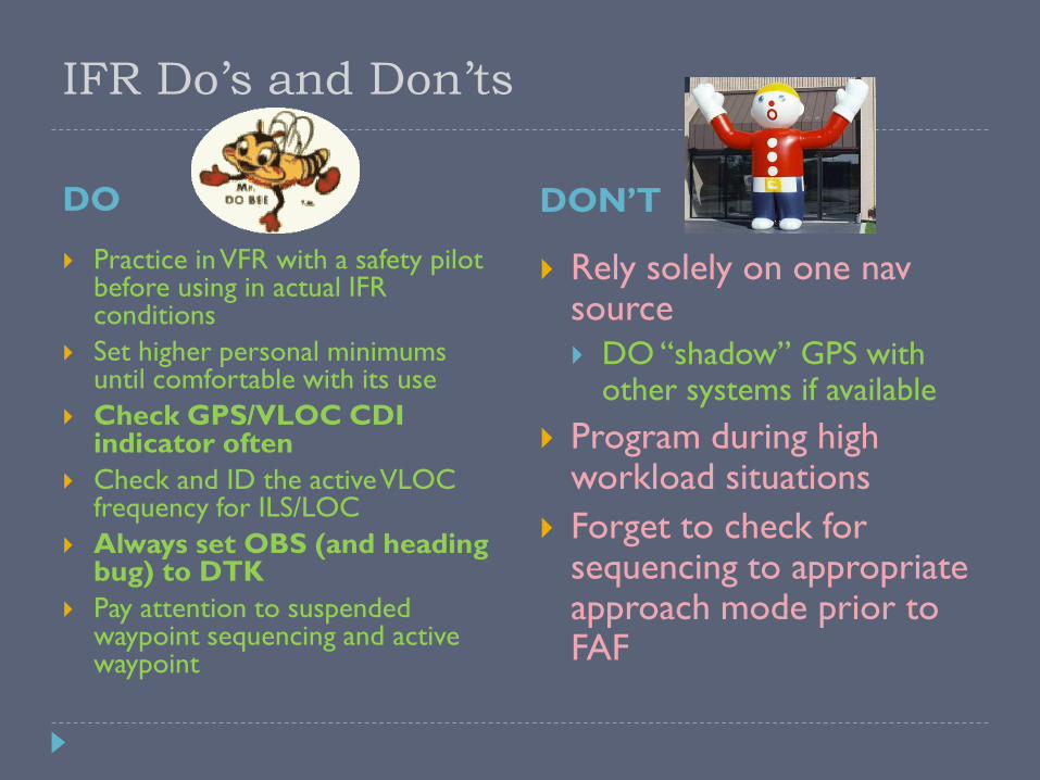
IFR Do’s and Don’ts
DO DON’T
Practice in VFR with a safety pilot before using in actual IFR conditions
Set higher personal minimums until comfortable with its use
Check GPS/VLOC CDI indicator often
Check and ID the active VLOC frequency for ILS/LOC
Always set OBS (and heading bug) to DTK
Pay attention to suspended waypoint sequencing and active waypoint
Rely solely on one navsource
DO “shadow” GPS with other systems if available
Program during high workload situations
Forget to check for sequencing to appropriate approach mode prior to FAF
Wake Up – It’s Quiz Time!
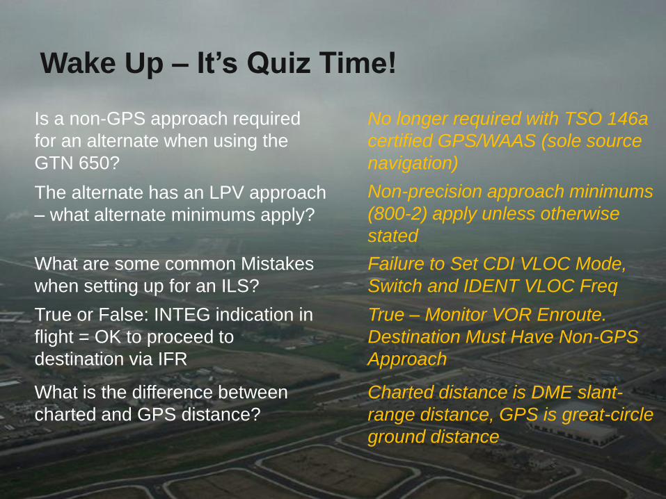
The alternate has an LPV approach
– what alternate minimums apply?
True or False: INTEG indication in
flight = OK to proceed to
destination via IFR
Is a non-GPS approach required
for an alternate when using the
GTN 650?
What are some common Mistakes
when setting up for an ILS?
What is the difference between
charted and GPS distance?
No longer required with TSO 146a
certified GPS/WAAS (sole source
navigation)
Non-precision approach minimums
(800-2) apply unless otherwise
stated
Failure to Set CDI VLOC Mode,
Switch and IDENT VLOC Freq
True – Monitor VOR Enroute.
Destination Must Have Non-GPS
Approach
Charted distance is DME slant-
range distance, GPS is great-circle
ground distance

More Information
Garmin Website –http://www.garmin.com
GTN 650 manual
Garmin Aviation Trainer
Training Syllabus
Tutorial Videos
Avweb –http://www.avweb.com
AOPA Air Safety Foundation –http://www.aopa.org/asf
ASF Safety Advisor – GPS Technology
Open Sky Aviation, LLC.
http://openskyaviation.biz

Additional Information
More information for the curious
GPS/WAAS Overview
A Brief Review

GPS and WAAS Overview Global Positioning System (GPS)
Satellite-based navigation 24 satellites orbiting 12,000 miles above the earth’s surface
Satellites orbit twice a day in a precisely-known orbit
Full constellation became operational in 1994
Receivers use time-based triangulation to calculate the user’s location Accurate within 15 meters (~50 feet)
Wide Area Augmentation System (WAAS) Corrects for GPS signal errors
Consists of a network of ground reference stations at precisely-surveyed locations
A master station generates a correction signal and transmits it to one of two geostationary satellites
Available in the entire Continental US and parts of Canada and Mexico
Improved position accuracies 1 meter (~3 feet) horizontal
2 meters (~6 feet) vertical

GPS Timeline
1995: GPS Selective Availability (SA)
330 – 990 feet
2000: SA Turned Off
100 – 330 feet
2003: Wide Area Augmentation System (WAAS) Enabled
< 23 feet
Provides Vertical Guidance
WAAS Approaches Slightly Higher Minimums than Cat I ILS
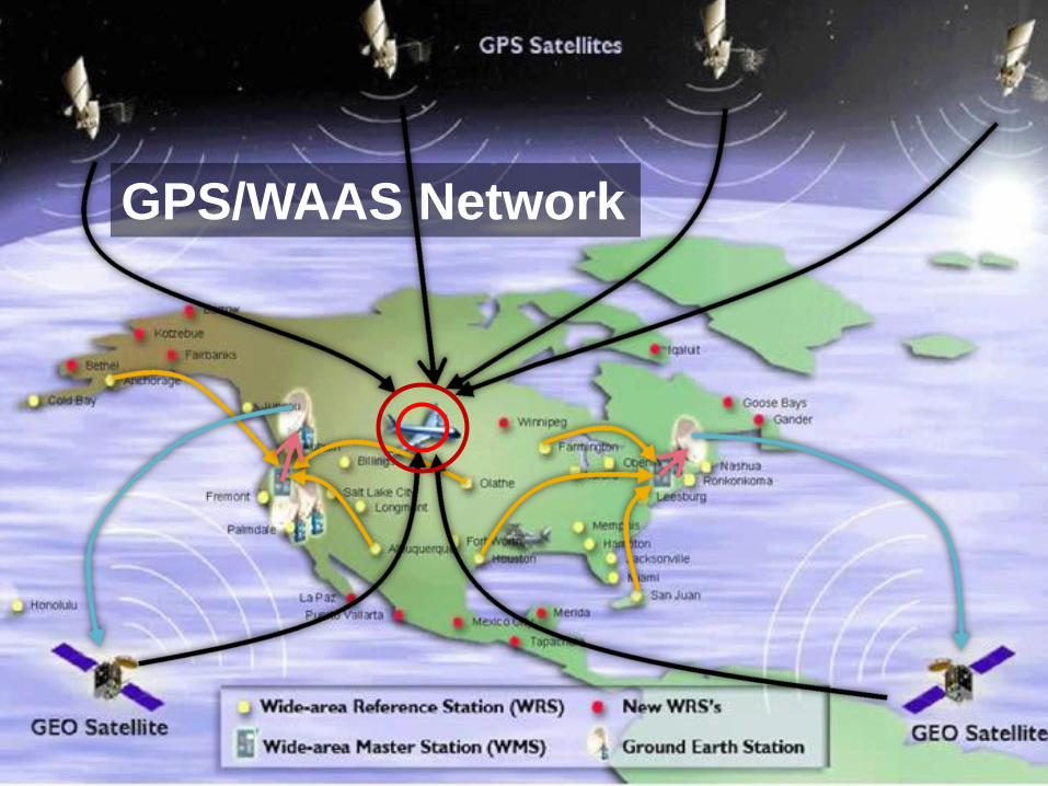
GPS/WAAS Network

GPS Navigation Concepts
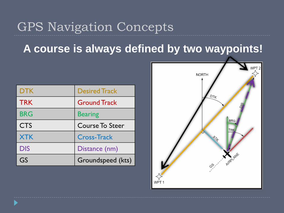
GPS Navigation Concepts
DTK Desired Track
TRK Ground Track
BRG Bearing
CTS Course To Steer
XTK Cross-Track
DIS Distance (nm)
GS Groundspeed (kts)
A course is always defined by two waypoints!
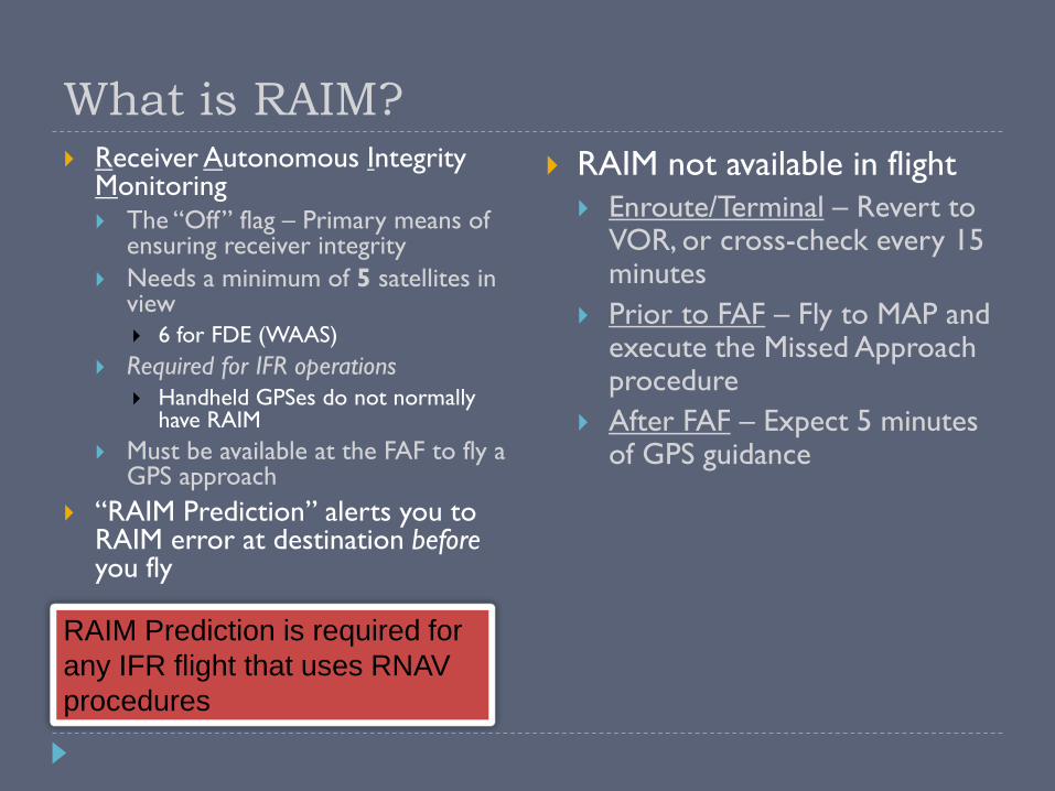
RAIM Prediction is required for
any IFR flight that uses RNAV
procedures
What is RAIM? Receiver Autonomous Integrity
Monitoring The “Off” flag – Primary means of
ensuring receiver integrity
Needs a minimum of 5 satellites in view
6 for FDE (WAAS)
Required for IFR operations
Handheld GPSes do not normally have RAIM
Must be available at the FAF to fly a GPS approach
“RAIM Prediction” alerts you to RAIM error at destination beforeyou fly
RAIM not available in flight
Enroute/Terminal – Revert to VOR, or cross-check every 15 minutes
Prior to FAF – Fly to MAP and execute the Missed Approach procedure
After FAF – Expect 5 minutes of GPS guidance
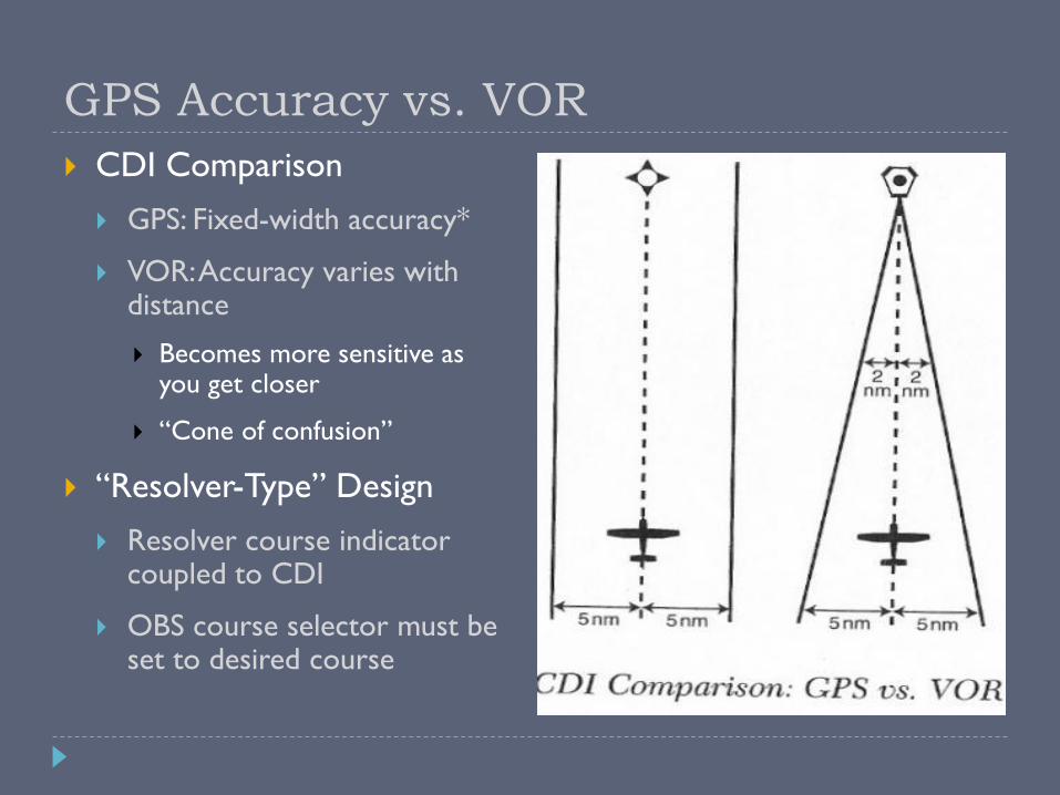
GPS Accuracy vs. VOR
CDI Comparison
GPS: Fixed-width accuracy*
VOR: Accuracy varies with distance
Becomes more sensitive as you get closer
“Cone of confusion”
“Resolver-Type” Design
Resolver course indicator coupled to CDI
OBS course selector must be set to desired course
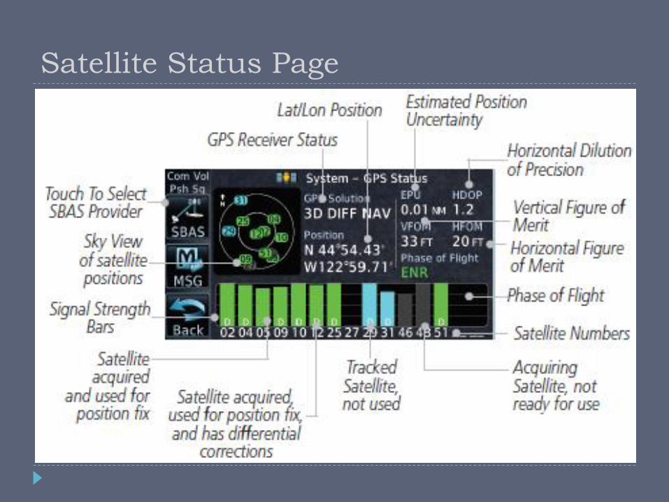
Satellite Status Page

IFR Concepts
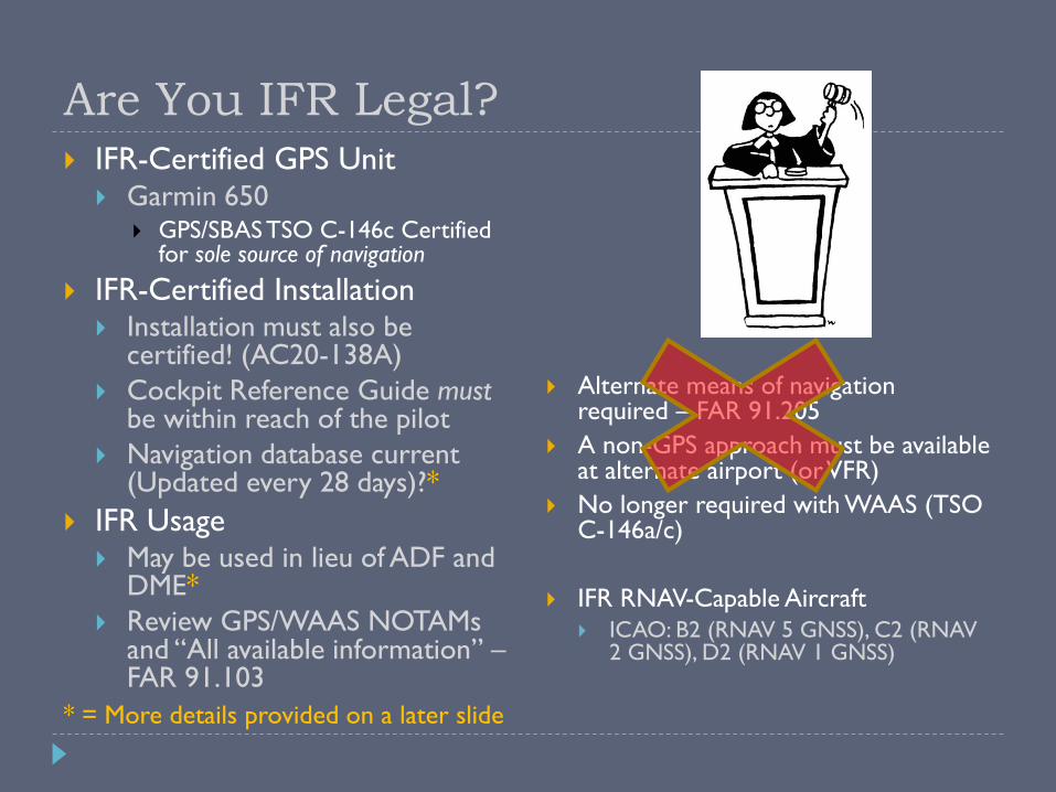
Alternate means of navigation required – FAR 91.205
A non-GPS approach must be available at alternate airport (or VFR)
No longer required with WAAS (TSO C-146a/c)
IFR RNAV-Capable Aircraft
ICAO: B2 (RNAV 5 GNSS), C2 (RNAV 2 GNSS), D2 (RNAV 1 GNSS)
Are You IFR Legal? IFR-Certified GPS Unit
Garmin 650 GPS/SBAS TSO C-146c Certified
for sole source of navigation
IFR-Certified Installation Installation must also be
certified! (AC20-138A)
Cockpit Reference Guide mustbe within reach of the pilot
Navigation database current (Updated every 28 days)?*
IFR Usage May be used in lieu of ADF and
DME*
Review GPS/WAAS NOTAMs and “All available information” –FAR 91.103
* = More details provided on a later slide

Types of GPS Approaches
1st Generation – Non-precision VOR/NDB overlay approaches (RNAV)
Many are being replaced by 2nd Gen approaches
2nd Generation – Stand-alone non-precision GPS approaches (RNAV)
3rd Generation – WAAS approach with vertical guidance