gateway transit centre: realizing the eco-distrcit
DESCRIPTION
University of Oregon Masters of Architecture Thesis. A proposal to the Gateway Neighborhood as fodder for an eco-district to come.TRANSCRIPT
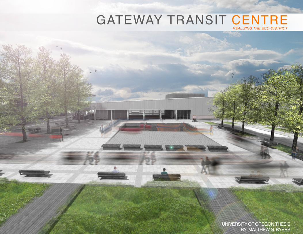
GATEWAY TRANSIT CENTREREALIZING THE ECO-DISTRICT
UNIVERSITY OF OREGON THESISBY: MATTHEW N. BYERS

SPECIAL THANKS TO:
UNIVERSITY OF OREGON FACULTYNANCY CHENG
SUENN HOGERRY GAST
HAJO NEIS Ph.D.JOSH CERRA
JAMES McGRATH CH2M-HILL
JUSTIN DOUGLAS P.D.C.DAVID C. SALAMON UNIVERSITY of PENNSYLVANIA
MY FELLOW CLASSMATES + FAMILY
WITHOUT YOU NONE OF THIS WOULD HAVE BEEN POSSIBLE
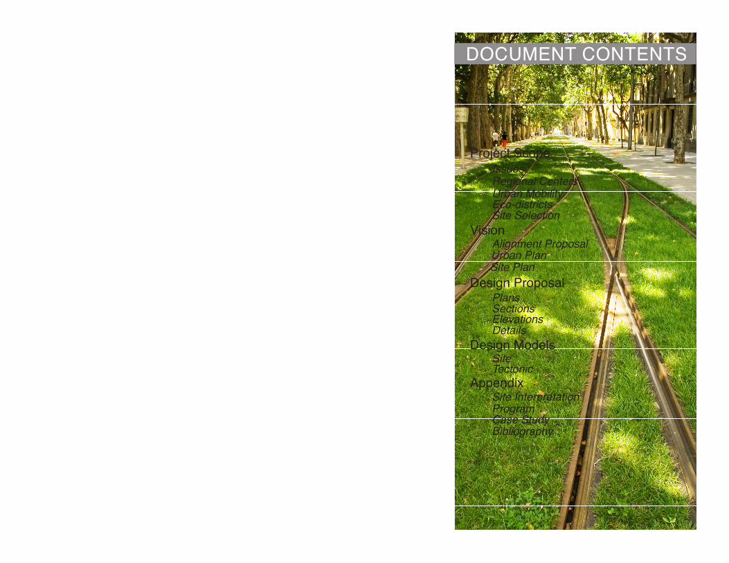
DOCUMENT CONTENTS
Project Scope
Vision
Design Proposal
Design Models
Appendix
IssuesRegional CentersUrban MobilityEco-districtsSite Selection
Alignment ProposalUrban PlanSite Plan
PlansSectionsElevationsDetails
SiteTectonic
Site InterpretationProgramCase StudyBibliography

URBAN SPRAWL AUTOMOBILE DEPENDENCY HABITAT DESTRUCTION

The Issue
The typical late nineteenth-century family living outside the city sought space, sanitation, and security. With the rise of automobile sales in the 1950’s, the car justified and made living outside of the city almost effortless. The suburbs promised a higher quality of living that could not be found in most urban centers. Although living in the suburbs today may seem economical, they are seldom safer or more convenient than living in an urban center.
In recent years the urbanization of rural areas has increased significantly due to large amounts of undeveloped and relatively inexpensive land. Urban sprawl has become detrimental to both our urban fabric and natural habitat. Single use zoning, low land use densities, extensive automobile usage, and the destruction of precious habitat + potential farmlands are all perpetuated by this movement away from the city.
The world’s population is growing at an unprecedented rate; current projections show a continued increase of population expected to reach between 7.5 and 10.5 billion by the year 20501. Aspirations of fleeing the city in hopes of possessing the ever-ubiquitous “humble abode” are no longer realistic. At the exponential rate we grow each year, we are unable to sustain the lifestyles previous generations worked so hard to obtain. The current planning practices evident in suburban neighborhoods have greatly under utilized density and have created town centers that exist in the form of shopping malls surrounded by seas of asphalt parking. The strong priority and reliance we’ve placed on the automobile as a primary mode of travel has created context that is un-walkable, un-active, and honestly un-livable.
ROUTE OF OUR PROBLEMS: Is it too late to turn around?
AMERICAN DREAM?

PDX
VANCOUVER
PORTLAND
GRESHAM
GATEWAYHOLLYWOOD
MILWAUKIE
BEAVERTON
TIGARD
HILLSBORO
LENTS
CLAKAMAS
OREGON CITY
REGIONAL CENTERS + TRANSPORTATION PLAN (METRO)

REGIONAL CENTERS:Focusing Future Growth.
HIGHEST DENSITY
CITY CENTERSUBURBS REGIONAL CENTERS
LOWESTDENSITY
GREATEST POTENTIAL{PORTLAND TRANSECT
2040 Growth Plan
Despite these ghastly conditions there is hope. These poorly planned areas are going to become key in dealing with the influx of this foreseeable population growth. Our existing city centers will be the primary focus for further urbanization, but what about those who are uninterested in living in an urban center? Denser development of suburban centers in terms of infill/new construction will provide the necessary dwellings and activity that are currently lacking and in some cases non-existent. Accessibility to alternative transportation in conjunction with new urbanization will ease this necessary transformation of the suburbs into the “urbs”.
Metro, an elected regional government for the Portland Metropolitan area, has devised the 2040 Growth Plan, identifying ‘Regional Centers’ and future alignments among other things. These centers are in anticipation of the development Portland can expect over the next 30 years. A considerable amount of these Regional Centers are situated on or adjacent to Light Rail Transportation, a testament to the worth Metro sees in Portland’s public transportation.
These Centers have an incredible amount of potential, due to their proximity to existing transit alignments and their ability to provide urban living in a place never imagined. Attentive planning will play a pivotal role in the re-urbanization of these currently disarrayed areas. Living in close proximity to Public Transit and everyday amenities needs to be something we value as much as owning our own home or car. The under utilization of these Regional Centers would be the biggest missed opportunity of all.
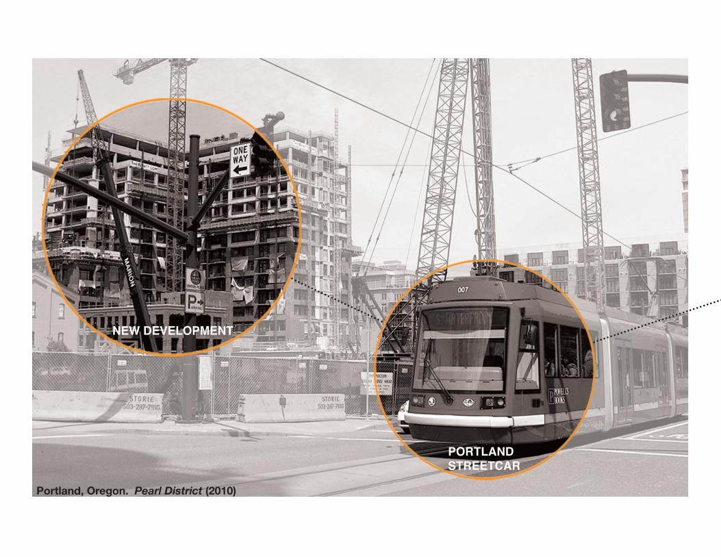
NEW DEVELOPMENT
PORTLANDSTREETCAR
Portland, Oregon. Pearl District (2010)

INCREASING MOBILITY:Fostering Urban Growth.
Return of the Streetcar
Portland’s Light Rail Transit (L.R.T.) works well at moving people long distances, from one Regional Center to the next (e.g. Gresham to Downtown), but what about mobility throughout the Regional Center itself? The implementation of a Streetcar would begin to increase mobility at the district (neighborhood) scale acting as a branch to the regional trunk of transportation (see diagram). Users of L.R.T. would be able to utilize and experience more of a regional center if they were no longer limited to the amenities within walking distance of their stop.
The idea of reintroducing modern streetcar service initially got its start in Portland, where it emerged as part of the 1988 Central City Plan. From its initiation, the modern Streetcar strategy drew on the same land-use transportation nexus that led to the historic system a hundred years prior. Among the numerous goals for the streetcar its been successful in “encouraging infill and serving as a catalyst for housing development.”
Streetcars are a proven catalyst noted for rejuvenating urban neighborhoods, providing convenient and reliable transport to resources and amenities.
DOWNTOWN PORTLAND
GATEWAY
AIRPORT
LENTS
MILWAUKEE
LAKE OSWEGO
HOLLYWOOD
CLACKAMAS
GRESHAM
SWE
REGIONAL TRANSIT (MAX)
TRANSIT STRUCTURE CONCEPT PLAN
DISTRICT TRANSIT (STREETCAR)
REGIONAL CENTERS (ECO-DISTRICTS)
“Investing in public transportation is one of the more effective ways to combat global climate change and conserve energy. Public transit encourages more compact development and greater personal choice in how people travel. People have closer access to jobs and shopping [while] more trips can be made on foot, by bike, or just a short car ride.”
-William W. Millar, President of the A.P.T.A.
Mobility Tree

Portland, Oregon. Downtown Transit Mall (2009)
4-DOOR SEDANCapacity (Max): 5Daily ridership: 1-4MPG: 25-30
D40FLR 40’ BUSCapacity (Max): 53Daily ridership: 171,500MPG: 6-8
Siemens SD660Capacity (Max): 166Daily ridership: 121,500MPG. : N/A

Performance Areas (POSI)
TRANSIT INFRASTRUCTURE:Sowing Eco-District Seeds.
A Path to Living More Sustainable
The most energy efficient households in America that produce the least amount of carbon are located within close proximity of a bus or rail line. The people in these households drive an average of 4,400 fewer miles annually as compared to persons in similar households with no access to public transit, according to a new study released by the American Public Transportation Association (APTA). Cities that choose to invest in public transportation reduce the nation’s carbon emissions by 37 million metric tons annually, which is equivalent to the electricity used by 4.9 million households.
Implementation of a Streetcar for further urbanization of regional centers would provide a resilient foundation for successfully executing an Eco-District. In 2009, the Portland Sustainable Institute (PoSI) partnered with the City of Portland to develop the Eco-Districts Initiative to broaden Portland’s commitment to sustainable design.
The Eco-District Initiative realizes the strong need for our cities and habitat to coexist and outlines seven performance areas (Community Vitality, Air Quality and Carbon, Energy, Access and Mobility, Water, Habitat and Ecosystem Function, and Materials Management) as a way to accomplish this. Under the performance area “Access and Mobility” its purpose is to foster healthy, clean, and affordable transportation options.
Access + Mobility
Energy
Air Quality + Carbon
Habitat + Ecosystem
Community Vitality
Materials Management Water
“An Eco-District is a neighborhood or district with a broad commitment to accelerate neighborhood-scale sustainability. Eco-districts commit to achieving ambitious sustainability performance goals, guiding district investments and community action, and tracking the results over time”
-PoSI

Portland, Oregon. Gateway Neighborhood (2011)
Transit Center
MAX (BLUE, RED, GREEN)
Surface Parking (OVER 280,000 sq.ft.)
BUS (15,19, 22, 23, 24, 25,)
Shopping Center

GATEWAY U.R.A.: An Ideal Candidate
Lack of Connectivity*
Access to Gateway by alternative transportation modes, whether via transit, bicycling or walking, is generally good. However, automobile use remains high with an average of 26.7 daily miles traveled per person, the highest in the city of Portland. Mobility is impeded in the district by breaks in sidewalk coverage, long block lengths on corridors like 102nd Avenue, and unimproved streets throughout the Central Gateway area.
Absence of Parks and Habitat areas*
The Gateway URA has an absence of parks and public spaces, which has multiple effects on Gateway’s environmental performance: decreased carbon sequestration potential, reduced air quality, reduced pedestrian street-scape quality and reduced habitat for urban ecological function.
Abundant Impervious Surface*
Average impervious surface coverage in the Gateway URA is more than 70%. Compared to a citywide average of just over 50%, this suggests a significant impact on the total volume of storm water across the district.
*Gateway Eco-District Pilot Study
Area Selection
Gateway was chosen because unlike the other Regional Centers, it lacks a central organizing body to coordinate various interests and is slated to absorb significant future growth from its diverse neighboring areas. As the only Regional Center within Portland, the district is envisioned as a second downtown. Since much of that growth has yet to materialize, Eco-districts planning here is particularly relevant, especially considering policy goals like the Portland Climate Action Plan. Previous plans for Gateway reveal an area with many of the fundamental characteristics necessary for an Eco-district. However, stimulating economic investment in the district has proven difficult despite extensive planning and analysis.


“It is time to redefine the American Dream. We must make it more accessible to our diverse pop-ulation: singles, the working poor, the elderly, and the pressed middle-class families who can no longer affords the ‘Ozzie and Harriet’ ver-sion of the good life.”
–Peter Cathorpe, The Next American Metropolis
THE VISION

INCREASED STREET TREES SLAB MODIFICATION (AT R.O.W) BIO-SWALED PLATFORMS SHARED INFRASTRUCTURE (BAT BOX)
20’ 20’12’12’14’12’12’10’
ECOLOGICAL DETAILING
MIXED TRAFFIC (AT PLATFORM) MEDIAN RIGHT OF WAY
A. B. C. D.
A.
B.
D.
C.

“The doors are closing...on AUTOMOBILE DEPENDENCY.” INCREASING MOBILITY FOR PEOPLE AND HABITAT
BLUE LINE
GRE
EN L
INE
URA BOUNDARY
CLACKAMAS
GRESHAM
PDX
H
H
P
$
$
$
$
$
H
MODAL OVERLAP
(Green Line)
MODAL OVERLAP(Blue Line)
TC0.25 mi.
KELLY BUTTE
“PATCH “ RICH IN PLANT+ WILDLIFE DIVERSITY
GATEWAY GREEN +ROCKY BUTTE
The construction of Light Rail Transit (LRT) and Streetcars can begin adding the greatest benefit to habitat if we understand the parts and pieces that make up their infrastructure. Both provide significant amounts of development opportunity for areas as a result of their implementations; increasing mobility while stimulating economic investment a`nd growth. They lend their best efforts to serving habitat and the environment through the predictability of their implementation.
Planning the Alignment
Critical evaluation of the Gateway, has shown significant opportunities to implement a Streetcar; increasing the movement of people from the existing transit center throughout the neighborhood while creating better habitat connections between Kelly Butte and Rocky Butte (over 2.5 miles apart). Implementation of a streetcar in this district would successfully fulfill the criteria found in the Access and Mobility performance area. It could easily be argued that a streetcar alignment with the modifications mentioned earlier would also be adding to: community vitality, improves air quality (less cars), more energy efficient (shared infrastructure), could treat storm-water, and is conscious of Habitat and Ecosystem functions.
ALIGNMENT PROPOSAL
Commercial Couplet(Halsey/Weidler)
North/South Arterial (102nd)
Big Box Shopping Center(MALL 205)
Medical Center(Adventist)

A. B.C.
D.
A. BOARDWALK PAVING (CONTINUITY) B. MIXED BIOSWALE (WATER MGMT.) C. SPACE FOR OUTSIDE SEATING D. 3-4 STORIES MIXED USE INFILL
URBAN PLAN

“Transfer to Bus and Streetcar Via PACIFIC PROMENADE.” FOSTERING GROWTH FROM TRANIST ACTIVITY
Transit ‘Centre’ Concept
Benefiting from the catalytic power of pedestrian activity, the existing transit center is reconfigured. Bus and Light Rail are reorganized to activate the plaza between, and placed on axis with a prime future Streetcar stop. To reinforce this connection and provide a sense of way finding, a bio-swale-promenade is proposed to create continuity between the modes, function as storm water treatment, and become a piece of infrastructure that facilitates future “main street” growth.
If you build it...
The first phase of this vision is the implementation of the Streetcar along with the redevelopment of the Transit Center. These improvements will act as bookends, containing the activity of visitors and locals utilizing transit. This increased presence of pedestrian activity will encourage a second wave of development to occur at the immediate under utilized sites adjacent to the Transit Centre proposal. This second phase will start to create a sense of place and significantly add to the lacking critical mass of the Gateway area. A Third phase will occur over the next fifty years infilling the vacant land between the transit plaza and the streetcar stop. This infill will work to put pressure on the existing shopping center, slowly changing it from a sea of asphalt into a thriving urban center.

NE FUTURE ST.
NE PACIFIC ST.
NE
99th
AVE
.
i
(RED, BLUE, GREEN)
(15 ,22, 23, 25 )
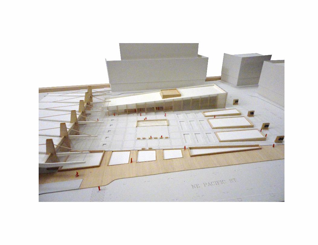
SITE PLAN
A. MARKET SPACE B. WATER FEATURE C. FOOD CART SPACE D. COMMUNITY GARDENS
A.B.
C.
D.

“GATEWAY TRANSIT CENTRE....doors to my left.” PROVIDING SOCIAL INFRASTRUCUTRE
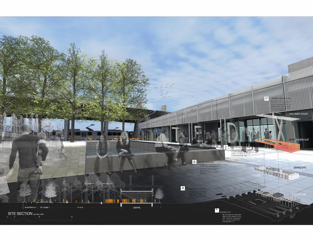
Making a Gateway
In an attempt to turn transit activity into an experience the two existing modes (Bus and Light Rail) are separated from one another and placed on an axis with a future streetcar stop. In an attempt to retain critical mass and activate the plaza, a café, exhibition, event space, a water feature, along with amble seating are strategize to keep the plaza constantly dynamic.
Every edge engages the visitor’s experience as they proceed through the site. Series of varying thresholds, both man made and natural, provides a clear sense of arrival and inversely departure. Acting like a filter, both functionally and metaphorically, the Transit Centre offers opportunity for coarse-grain and fine-grain interactions.
Site Organization
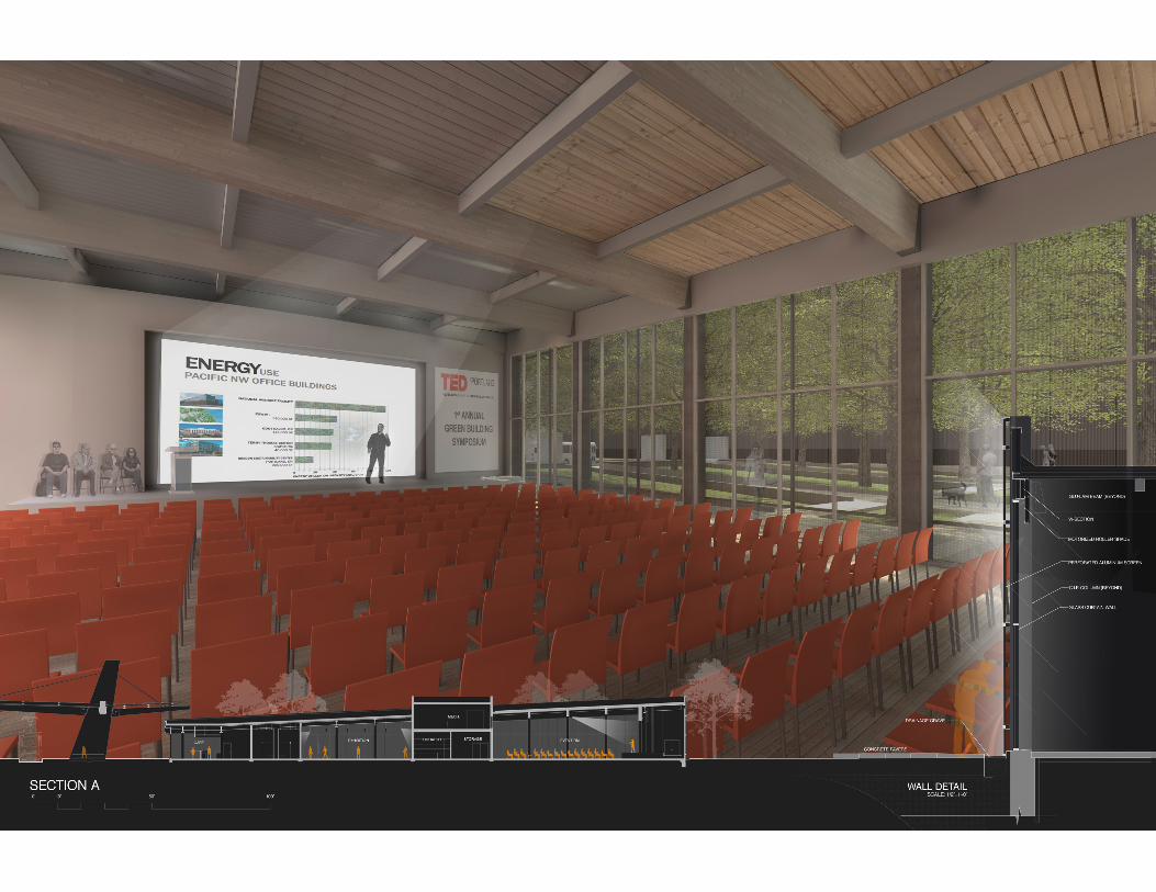
The site is organized into four main parts around a centrally located clearing with water feature. To the west an iconic transit shelter will span all three platforms, its large concrete masts framing activity. To the south a boardwalk becomes home to future food carts and provides continuity throughout the neighborhood to the streetcar stop. To the East raised planting beds provide opportunity for a demonstrative community garden, while doubling as a seat wall for bus queuing. Lastly, the Ted X inspired centre situated to the north provides flexible event space, and becomes the backdrop to plaza activity.


DESIGN PROPOSAL

EARLY CONCEPT SKETCH: TRANSIT CENTER as public place

EARLY CONCEPT SKETCH: TRANSIT PLATFORM creating contrast


EARLY CONCEPT SKETCH: EXHIBITION interior-exterior permeability


EARLY CONCEPT SKETCH: AUDITORIUM visually connected with outdoors


SITE MODEL: 1/16”=1’-0” Basswood + Museum board


TECTONIC MODEL: 1/4”=1’-0” Basswood, Museum board + Rockite


APPENDIX

SITE
3D Interpretation of Site
AA site interpretation model begins to examine Gateway and the surrounding area diagrammatically and in section. The I-84/I-205 interchange and topography are exaggerated to highlight their inherent natures. This contrast illustrates that in working to move people quickly, the freeways work better at leaving areas disjointed and separate from one another.
In elevation the model examines habitable zones and identi-fies them as the urban fabric begins to emanate away from the concrete arteries that feed the city. A grey scale organizes these zones by density, both people and land usage, (black being very dense, light grey being sparse).
Lastly identified are areas that are rendered undeveloped and left as open space. This study depicts them as remnant land that is left over acting as a buffer between the freeways and the developed areas. Other residual can be found trapped be-tween the off ramps and interchanges.
This study evokes thoughts of how our freeways are people movers and at certain times of the day they are more dense than the city itself. How can a site that is feed by transit users begin to harness this energy and density and use it as a means to support its own buildings functions? A freeways intent is to connect us to different parts of the city, yet in doing so it can divide other portions intentionally or unintentionally. HoHow can this building learn from these mistakes/opportunities?


TEDx Portland: A Centre for the Fostering, Developing, and Spreading of Ideas.
WWhat is TED? It started out as an annual conference that brought together leaders from the technology, entertainment, and design in-dustries. Over the years its content has become more broader and now great thinkers, creators and visionaries from all areas of thought, work, and life are being asked to participate. This is with the realization that all knowledge is connected in some way, you can get unexpected insight or inspiration when you listen to people wwho are outside your normal line of work.
This building program is designed to give communities, organiza-tions and individuals the opportunity to stimulate dialogue through TED-like experiences, but at a local level. Additional support spaces will allow for people to actively engage on any current or future topics that hold value to them.
This is a place for Children, Student, Parents, Adults, of not only the adjacent neighborhoods but neighborhoods along the transit corridors (making arrival easy there is no excuse for people to not show up) can be exposed to new cutting edge ideas and issues, but also have the appropriate facilities to support the necessary re-sponses.
YOUR DISCUSSION ON CLIMATE CHANGE
YOU BRINGING AWARENESSTO LOCAL ECOLOGIES
YOUR CHANCE TO BE HEARD
PROGRAMPORTLAND
Will replace the 1,800 square feet of public space reserved for public space by each school making for a total of (7,200 sqft).
This inserted portion of the program will receive and be responsible for the largest volumes of visitors directly related to guest lectures/events hosted by the commu-nity. This portion of the program is expected to receive the most “walk-in” use from people directly in the community as well as people taking their time while they wait to transfer.
Large Auditorium/Main Event Room (4,000) This will support the guest lectures primarily from Portland, but with the intenT that guest speakers nationally and internationally will find this as a useful venue. The lecture hall should be able to support numbers anywhere from 500-1000 seats, stage, and projection. Lecture Hall (1,000) This event space will be used for smaller presentation and for community meetings reliant on a lecture type setting. Should be able to support 100-150 seats and a stage.Exhibition space/ Galleries (1,000) Exhibition space will be used to display works produced within the Centre and from the community. The main purpose of the exhibition space is to become a visual aid used to support, stimulate and evoke conversation and questions in regards to up-coming, current, and future presentation. Works from the local community are strongly encouraged for displayed if not in these main areas then smaller galleries. This may double as receptionReception (1,000) This space’s main intent is to support the function of the event space by provid ing a place for people to continue to have discussions and add input based on the lectures topics. This space should be able to contain flexible seating and catered services. A prep room with a functioning kitchen adjacent to this space will be necessary for food service to work from.Lobby/Entry (200) Used as the transitional space for people coming in from either a public transit or vehicular approach. Main circulation to all other parts of the building should be accessed through this space.

PORTLANDWill replace the 1,800 square feet of public space reserved for public space by each school making for a total of (7,200 sqft).
This inserted portion of the program will receive and be responsible for the largest volumes of visitors directly related to guest lectures/events hosted by the commu-nity. This portion of the program is expected to receive the most “walk-in” use from people directly in the community as well as people taking their time while they wait to transfer.
Large Auditorium/Main Event Room (4,000) This will support the guest lectures primarily from Portland, but with the intenT that guest speakers nationally and internationally will find this as a useful venue. The lecture hall should be able to support numbers anywhere from 500-1000 seats, stage, and projection. Lecture Hall (1,000) This event space will be used for smaller presentation and for community meetings reliant on a lecture type setting. Should be able to support 100-150 seats and a stage.Exhibition space/ Galleries (1,000) Exhibition space will be used to display works produced within the Centre and from the community. The main purpose of the exhibition space is to become a visual aid used to support, stimulate and evoke conversation and questions in regards to up-coming, current, and future presentation. Works from the local community are strongly encouraged for displayed if not in these main areas then smaller galleries. This may double as receptionReception (1,000) This space’s main intent is to support the function of the event space by provid ing a place for people to continue to have discussions and add input based on the lectures topics. This space should be able to contain flexible seating and catered services. A prep room with a functioning kitchen adjacent to this space will be necessary for food service to work from.Lobby/Entry (200) Used as the transitional space for people coming in from either a public transit or vehicular approach. Main circulation to all other parts of the building should be accessed through this space.
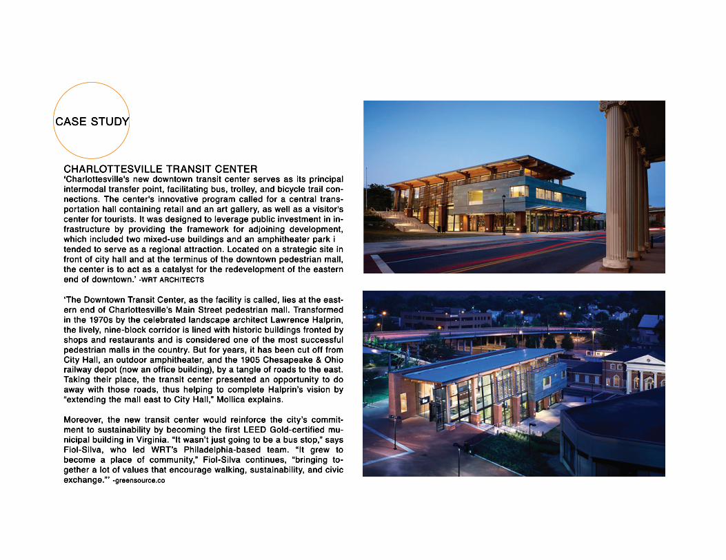
CASE STUDY
CHARLOTTESVILLE TRANSIT CENTER‘‘Charlottesville's new downtown transit center serves as its principal intermodal transfer point, facilitating bus, trolley, and bicycle trail con-nections. The center's innovative program called for a central trans-portation hall containing retail and an art gallery, as well as a visitor's center for tourists. It was designed to leverage public investment in in-frastructure by providing the framework for adjoining development, which included two mixed-use buildings and an amphitheater park itended to serve as a regional attraction. Located on a strategic site in front of city hall and at the terminus of the downtown pedestrian mall, the center is to act as a catalyst for the redevelopment of the eastern end of downtown.’ -WRT ARCHITECTS
‘The Downtown Transit Center, as the facility is called, lies at the east-ern end of Charlottesville’s Main Street pedestrian mall. Transformed in the 1970s by the celebrated landscape architect Lawrence Halprin, the lively, nine-block corridor is lined with historic buildings fronted by shops and restaurants and is considered one of the most successful pedestrian malls in the country. But for years, it has been cut off from City Hall, an outdoor amphitheater, and the 1905 Chesapeake & Ohio rrailway depot (now an office building), by a tangle of roads to the east. Taking their place, the transit center presented an opportunity to do away with those roads, thus helping to complete Halprin’s vision by “extending the mall east to City Hall,” Mollica explains.
Moreover, the new transit center would reinforce the city’s commit-ment to sustainability by becoming the first LEED Gold-certified mu-nicipal building in Virginia. “It wasn’t just going to be a bus stop,” says Fiol-Silva, who led WRT’s Philadelphia-based team. “It grew to become a place of community,” Fiol-Silva continues, “bringing to-gether a lot of values that encourage walking, sustainability, and civic exchange.”’ -greensource.co

AMTRAK
TROLLEY
5.
6.
1. TRANSIT CENTER 2. CONERT PAVILLION 3. PEDESTRIAN MALL
4. OMNI HOTEL5. GREYHOUND STATION6. AMTRAK
1.
4.
3.
2.

ECO-DISTRICTS/GATEWAY
Portland Sustainability Institute. EcoDistricts Performance Areas Toolkit, Understanding Districts Impact. PoSI, June 2010. PDF. www.pdxinstitute.org
In-depth Explanation of seven performance areas. Each area broken down into; Vision, Intent, Goals, Target, Metrics, and Potential Strategies. Includes projects that demonstrate proper ex-ecution of performance area with link to specific project’s webpage.
District Lab- Michael Budds, Erin Reome, Dan Schauer, and Aaron Wilson. Gateway Ecodistrict Pilot Study. Portland State University, June 2010. PDF. http://www.pdc.us/ura/gateway.asp
Includes an Executive summary, Background, Approaches/processes, Community priorities, Site Conditions, Pilot project recommendations, and Future steps.
Architects, GBD, Lango Hansen Landscape, KPFF Structural, and Gerding/Edlen Development. GTC MASTERPLAN. PORTLAND DEVEL-OPMENT COMISSION, 2010. PDF.
Phase I-IV MASTER Plan for gateway, Prepared by GBD. Includes plans for future mixed use, residential, and Hotel.
AXIS DESIGN GROUP. Final AXIS GEC Work Product. Gateway PAC Educa-tion Sub-Committee, 2010. PDF.
Goals/Intent of the Gateway education center. vague program description and square footage's. Massing and adjacencies.
SOURCES

URBAN DESIGNOwen, David. Green Metropolis: Why Living Smaller, Living Closer, and Driving Less Are Keys to Sustainability. New York: Riverhead, 2009. Print.
Most Americans think of crowded cities as ecological nightmares, as wastelands of concrete and gar-bage. Yet residents of urban centers actually consume less oil electricity, and water than other Ameri-cans. chapter 5 is particularly good criticizing USGBC’s LEED.
Gatje, Robert F. Great Public Squares: An Architect's Selection. New York: W.W. Norton &, 2010. Print.
Forty public squares from The US and Western Europe. Major successful characteristics are enu-merated including area, plan dimensions, width to length ratios. Each project is at the same scale making it easy to compare them to each-other. Nolli style figure grounds makes for easy quick visual understanding.
Duany, Andres, Jeff Speck, and Mike Lydon. The Smart Growth Manual. New York: McGraw-Hill, 2010. Print.
Looks at growth starting from all scales, Starting at the Regional, Neighborhood, the street, and finally ending with the building.
Calthorpe, Peter. The next American Metropolis: Ecology, Community, and the American Dream. New York: Princeton Architectural, 1993. Print.
Farr, Douglas. Sustainable Urbanism: Urban Design With Nature. Hoboken, NJ: John Wiley & Sons, 2008. Print.
The end of the book includes a bunch of great Urban Case studies ranging from Built and unbuilt infill and Greenfield projects. Chapter 8 entitled biophilia begins to examine strategies dealing with waste/storm water.

TRANSPORTATION/SUSTAINABILITY
Light Rail Transit: Planning, Design, and Implementation: Papers Presented at the Conference on Light Rail Transit, San Diego, Calif. 1982. Washington, D.C., 1982.
Materials used for prior research on LRT design in North America. Concepts of Right of Ways and Feasable implementation covered. Examples of several cities current and future Lightrail projects.
Loechl, Paul M., et al (2003). Design Schematics for a Sustainable Parking Lot. Champaign, IL: US Army Corps of Engineers, Research and Development Center. Construction Engineering Research Laboratory. Document no. ERDC/CERL TR-03-12.
Kwok, Alison G., AIA and Grondzik, Walter T., PE. The Green Studio Handbook. Amsterdam: Elsevier, 2007. Print.
pp. 227,256,261-262,264,338 used for Bio Remediation pp. 233-37,243-60 Used for Water recycling/reuse and conservation pp. 255-56, 261-64 used for Retention pond Design pp. 49-52, 341-43 intensive/extensive Green Roofs
Smith, Daniel S., and Paul Cawood. Hellmund. Ecology of Greenways: Design and Function of Linear Conservation Areas. Minneapolis: University of Minnesota, 1993. Print.
Light Rail Transit Systems. Paris: European Conference on Ministers of Transport, 1994. Print.
Edner, Sheldon M., and G. B. Arrington. Urban Decision Making for Transportation Investments: Portland's Light Rail Transit Line. Washington, D.C.: U.S. Dept.of Transportation, 1985. Print.
Demoro, Harre W., and John N. Harder. Light Rail Transit on the West Coast. New York: Quadrant, 1989. Print.
SOURCES
"International Data Base (IDB) — World Population". Census.gov. 2010-06-28. Retrieved 2011-14-03
Forman, Richard T. T. Land Mosaics: the Ecology of Landscapes and Regions. Cambridge England: Cambridge UP, 1995. Print.
