gatwick airport ltd - · pdf filegatwick airport ltd nw zone hangar project ... operational...
TRANSCRIPT

Gatwick Airport Ltd
NW Zone Hangar Project
Landscape & Ecological
Mitigation and Enhancement Strategy
May 2017


May 2017 1 Gatwick Airport NWZ Hangar
Landscape & Ecology Mitigation & Enhancement Strategy
11125001_LEMES_05-17 Chris Blandford Associates
CONTENTS
1.0 INTRODUCTION 2
1.1 Background 2
1.2 Legislative Context 3
1.3 Previous and baseline surveys 6
2.0 MITIGATION & ENHANCEMENT CONSTRAINTS 7
3.0 STRATEGIC OBJECTIVES OF THE LEMES 8
3.1 Strategic Objectives 8
4.0 METHOD STATEMENTS FOR THE MITIGATION OF FEATURES OF
ECOLOGICAL INTEREST 9
4.1 Hedgerows & Woodland 9
4.2 Waterbodies & Mans Brook 13
4.3 Bats 15
4.4 Breeding birds 22
4.5 Fish 27
4.6 Grass snakes 29
4.7 Harvest Mouse 35
4.8 Invertebrates 36
4.9 Landscape 37
TABLES
1: Summary of safeguarding legislation (in text)
2: Summary of hazardous bird species (in text)
3: Criteria for the selection of receptor sites (in text)
FIGURES
Landscaping and Ecological Mitigation Plan
Planting Plans – Areas 1 and 2
APPENDICES
Appendix 1: Design specification for temporary reptile fencing (taken from DMRB Volume 10 s.4 Pt. 7)

May 2017 2 Gatwick Airport NWZ Hangar
Landscape & Ecology Mitigation & Enhancement Strategy
11125001_LEMES_05-17 Chris Blandford Associates
1.0 INTRODUCTION
1.1 Background
1.1.1 Chris Blandford Associates (CBA) was commissioned by Gatwick Airport Limited (GAL) to
undertake landscape and ecology appraisals to support a planning application for the
construction of a proposed maintenance hangar, located in Gatwick Airport’s North West Zone
(NWZ). The Planning Statement describes the proposed development as:
“the construction of a new hangar and other associated works including aircraft apron,
connection to taxiway ‘Uniform’, vehicle parking and external parts storage area, fire
suppression plant, diversion of Larkins Road and realigned security fencing, drainage and
lighting, together with associated landscaping and ecological mitigation and enhancement
works”
1.1.2 This Landscape and Ecological Mitigation & Enhancement Strategy (LEMES) supports statements
set out in the documentation prepared in support of the planning application submitted for the
Gatwick NWZ Hangar Project. It provides a strategy to address the potential adverse landscape
and ecological effects associated with the proposed development, by setting out a plan for the
delivery of landscape and ecological mitigation and enhancement measures designed to
ameliorate the identified adverse effects.
1.1.3 The preparation of the LEMES draws on the findings of the landscape and ecology appraisals
undertaken during 2016 and 2017, as well as desk study data drawn from previous studies
undertaken in 2008 and 2014. These reports are submitted separately in support of the
planning application1,2,3.
1.1.4 The LEMES sets out the legislative context for the protection of each species (or group of
species), and the habitats that support them; the previous surveys that have informed the
development of the LEMES; the strategic objectives of the LEMES, and the specific method
statements for mitigating impacts associated with habitats and species likely to be affected by
the proposed development.
1 CBA (2016). NW Zone Hangar Project: Ecological Appraisal. For and on behalf of Gatwick Airport Ltd. 2 CBA (2017). NW Zone Hangar Project: Reptile Survey Report. For and on behalf of Gatwick Airport Ltd. 3 CBA (2017). NW Zone Hangar Project. Bat Survey Report. For and on behalf of Gatwick Airport Ltd.

May 2017 3 Gatwick Airport NWZ Hangar
Landscape & Ecology Mitigation & Enhancement Strategy
11125001_LEMES_05-17 Chris Blandford Associates
1.2 Legislative Context
Aerodrome Safeguarding
1.2.1 The mitigation set out in this LEMES has been prepared in the context of Civil Aviation
Authority guidelines set out in “CAP 772: Wildlife Hazard Management at Aerodromes”, Civil
Aviation Authority (2014) to ensure that GAL GAL fulfils its regulatory obligations relating to
wildlife management including compliance with ICAO Annex 14, EASA regulations and
CAP772. It is therefore critical that all the mitigation and enhancement proposals set out in the
LEMES fully comply with the requirements of CAP772 to ensure aerodrome safety. Any
reference to ‘enhancing’ excludes any enhancement that may attract hazardous bird species or
non-compliance with the above requirements. A summary of the relevant legislation and
protocols is described below:
Table 1: Summary of Safeguarding Legislation
Requirements ICAO Annex 14 to the Convention on International Civil Aviation, Aerodromes, Volume 1, Aerodrome Design and Operations: Sixth Edition July 2003, Section 9.4 Wildlife Strike Hazard Reduction The UK, as a signatory to the Convention on International Civil Aviation, Chicago 1944, has adopted many of the provisions specified in Annex 14 to the Convention. Annex 14 published by the International Civil Aviation Organization (ICAO), includes standards and recommended practices (SARPs) that address the risk of a birdstrike and a potential increase of the birdstrike risk due to the presence or development of bird-attractant features on, or in the vicinity of, an aerodrome. Under the heading "birdstrike hazard reduction", Annex 14 Volume 1 (6th Edition section 9.4.1) states that: the birdstrike hazard on, or in the vicinity of, an aerodrome shall be assessed through: a) the establishment of a national procedure for recording and reporting bird strikes to aircraft; b) the collection of information from aircraft operators, airport personnel, etc. on the presence of birds on or around the aerodrome constituting a potential hazard to aircraft operations; and c) an ongoing evaluation of the wildlife hazard by competent personnel Annex 14 section 9.4.3 also states that: Action shall be taken to decrease the risk to aircraft operations by adopting measures to minimise the likelihood of collisions between wildlife and aircraft. Annex 14 section 9.4.4 goes further by stating that: The appropriate authority shall take action to eliminate or to prevent the establishment of garbage disposal dumps or any such other source attracting bird activity on, or in the vicinity of, an aerodrome unless an appropriate aeronautical study indicates that they are unlikely to create conditions

May 2017 4 Gatwick Airport NWZ Hangar
Landscape & Ecology Mitigation & Enhancement Strategy
11125001_LEMES_05-17 Chris Blandford Associates
conducive to a bird hazard problem. Where the elimination of existing sites is not possible, the appropriate authority shall ensure that any risk to aircraft posed by these sites is assessed and reduced to as low as reasonably practicable" The term "in the vicinity" is taken to be land or water within 13 km of the aerodrome reference point, and "garbage disposal dumps" refers to landfill sites (i.e. the disposal of waste by landfill) as defined under relevant UK legislation. An "appropriate aeronautical study" is taken to be a study that focuses on the potential flight safety implications at the relevant aerodrome(s) that an existing or proposed bird attractant development may cause. Such a study should consist of the overall assessment of the ambient birdstrike risk at the aerodrome and a site-specific risk assessment relating to any development or site in the vicinity. In the UK, the aerodrome licence holder shall take all reasonable steps to secure that the aerodrome and the airspace within which its visual traffic pattern is normally contained are safe at all times for use by aircraft (Article 128(5) of the Air Navigation Order (ANO) 2005). The licence holder is therefore responsible for the development and implementation of birdstrike risk control measures.
Actions for
compliance
ICAO Airport Services Manual Part 3 Fourth Edition 2012 Section 4.7.1 [Off Airfield monitoring of bird species and behaviour should occur and should include species, flightlines, seasonal patterns, time of day etc.] Section 4.7.2 [Any significant bird/wildlife attractants within a defined radius (the exact distance will be dependent upon local or State regulations) centred on the aerodrome reference point (ARP) should be assessed and a management plan developed to reduce their attractiveness to birds/wildlife.]
Requirements COMMISSION REGULATION (EU) No 139/2014, ARTICAL 10, Wildlife Hazard Management, ANNEX III Part Organisation Requirements – Aerodrome Operators (Part – ADR.OR) SUBPART B – AERODROME OPERATIONAL SERVICES, EQUIPMENT AND INSTALLATIONS (ADR.OPS.B) ADR.OPS.B.020 Wildlife Strike Hazard Reduction The aerodrome operator shall: (a) Assess the wildlife hazard on, and in the surrounding, of the aerodrome; (b) Establish means and procedures to minimise the risk of collisions between wildlife and aircraft, at the aerodrome; and (c) Notify the appropriate authority if a wildlife hazard assessment indicates conditions in the surroundings of the aerodrome are conducive to a wildlife hazard problem.
Actions for
compliance
CAA CAP772 Wildlife Hazard Management: This UK CAA Guidance document is seen as providing UK Aerodromes with an alternative means of compliance to the above EASA legislation. Chapter 3, Roles and Responsibilities details the objectives that should be met by the [GAL] Bird Control Manager / Co-ordinator, these include, but are not

May 2017 5 Gatwick Airport NWZ Hangar
Landscape & Ecology Mitigation & Enhancement Strategy
11125001_LEMES_05-17 Chris Blandford Associates
limited to: 5. Monitor habitat changes on and in the vicinity of the aerodrome and develop and implement appropriate management and control activities. 7. Understand the implications of not managing wildlife strike hazards effectively and not flowing the plan and initiating any necessary changes. 8. Analyse and interpret records (shift logs) of control activities, strike reports and on and off-airfield observations and intelligence 9. Understand the need for periodic surveys of bird and wildlife concentrations and movements in the local area (up to or beyond 13km as determined by aerodrome management policies. 10. Work with [third parties] in order to influence and raise awareness of bird hazard matters. 12. Monitor the effectiveness of any bird and habitat measures via quality audit or similar process. 13. Identify potential strike risks through collation of local ornithological reports and survey data.
Nature Conservation Legislation
1.2.2 The primary legislative drivers for the protection of wildlife within the UK, and that are
pertinent to this site are:
• Wildlife and Countryside Act 1981 (as amended) • Countryside and Rights of Way Act 2000 (otherwise known as the CRoW Act) • Natural Environment and Rural Communities Act 2006 (otherwise known as the NERC Act) • The Conservation of Habitats and Species Regulations 2010 (otherwise known as the
Habitats Regulations) • The Hedgerows Regulations 1997.
1.2.3 The requirements for complying with legislation designed to protect wildlife within the national
planning context is currently set out under Section 11 of the National Planning Policy
Framework4 (NPPF). Within the local planning context, Crawley Borough Council’s
Supplementary Planning Document for Gatwick Airport5 provides specific reference to
landscape and visual impact (para 41) and biodiversity (para 44). Additionally, Crawley
Borough Council’s Local Plan6 Policy ENV2 (Biodiversity), sets out the Council’s priorities with
respect to the protection of the natural environment with respect to development. The
requirements set out in these documents have been reviewed and taken into account as part of
the formulation of the LEMES.
1.2.4 The Site is not one of the opportunity areas identified in the Crawley Local Plan, but the River
Mole corridor is identified by GAL as a biodiversity opportunity area.
4 DCLG (2012). National Planning Policy Framework. 5 Crawley Borough Council (November 2008). Development at Gatwick Airport: Supplementary Planning Document. 6 Crawley Borough Council (December 2015). Crawley 2030: Crawley Borough Local Plan 2015-2030

May 2017 6 Gatwick Airport NWZ Hangar
Landscape & Ecology Mitigation & Enhancement Strategy
11125001_LEMES_05-17 Chris Blandford Associates
1.2.5 A brief outline of current legislative protection for each species is set out under the relevant
headings below.
1.3 Previous and baseline surveys
1.3.1 Surveys for protected species and habitat quality have been conducted across the Site during
2008, 2014 and 2016. In addition, desk top information from the Sussex and Surrey Biological
Records Centre has also been reviewed as part of the appraisal process. Summaries of the key
findings of the surveys are set out under the relevant sections below and the full reports have
been submitted as separate documents as part of the planning application.

May 2017 7 Gatwick Airport NWZ Hangar
Landscape & Ecology Mitigation & Enhancement Strategy
11125001_LEMES_05-17 Chris Blandford Associates
2.0 MITIGATION & ENHANCEMENT CONSTRAINTS
2.1 As described under Section 1.2.1 above, the mitigation set out in this LEMES has been
prepared in the context of the management of wildlife hazards at aerodromes, which has
placed limits on the scope of the proposals described in the following sections of the report.
Nevertheless, it is considered that the LEMES meets the overall objective of achieving a ‘no
net loss’ in biodiversity.

May 2017 8 Gatwick Airport NWZ Hangar
Landscape & Ecology Mitigation & Enhancement Strategy
11125001_LEMES_05-17 Chris Blandford Associates
3.0 STRATEGIC OBJECTIVES OF THE LEMES
3.1 Strategic Objectives
3.1.1 The strategic objectives of the LEMES are to ensure that the most appropriate mitigation
strategy, and opportunities for enhancement, is adopted for each of the habitats and species
affected by the proposed scheme. The strategic objectives are as follows:
• Avoidance: the opportunity to ensure that any development activity does not affect the species of interest in the first place. This may be through design, revised working methods or timing of certain activities within particular areas of the development site;
• Reduction: the opportunity to identify means for reducing overall impacts. This may be facilitated through design, incorporation of ecological protection methods within Construction Method Statements, working methods,
• Habitat recreation: the opportunity to recreate habitats that may otherwise be permanently lost as the result of development activities;
• Prevention: the incorporation of methods for preventing intentional harm being caused to species, or the reckless destruction of habitat, during the construction phase of the project, such as the use of protective fencing or the management of site drainage. These measures can also be enmeshed within existing plans and structures as part of the overall delivery of the project;
• Relocation / Translocation: the opportunity to move and re-establish populations of species or habitats that are situated within areas defined as comprising part of the proposed development area; and,
• Compensatory Habitat Creation: where it is not feasible to fully compensate for the loss of habitats of nature conservation value within the Site, consideration is given to the creation of new habitat at suitable off-site locations in partnership with local landowners and stakeholders.
3.1.2 To achieve the objectives of the strategy, a series of Method Statements have been prepared to
address mitigation relating to both habitats and species that will be affected by the
development of the NWZ Hangar Project. There are eight components of the mitigation
strategy for which Method Statements have been prepared. These are as follows:
• Hedgerows & Woodland (Section 4.1); • Waterbodies & Mans Brook (Section 4.2); • Bats (Section 4.3); • Breeding birds (Section 4.4); • Fish (Section 4.5); • Grass snakes (Section 4.6); • Harvest mice (Section 4.7); • Invertebrates (Section 4.8); and, • Landscape & Visual (Section 4.9).

May 2017 9 Gatwick Airport NWZ Hangar
Landscape & Ecology Mitigation & Enhancement Strategy
11125001_LEMES_05-17 Chris Blandford Associates
4.0 METHOD STATEMENTS FOR THE MITIGATION OF FEATURES OF ECOLOGICAL INTEREST
4.1 Hedgerows & Woodland
On-Site Distribution - Hedgerows
4.1.1 A total of three hedgerows have been identified that would be affected by the proposed
development, all of which are relatively similar in species composition and structure. Most
appear to be unmanaged and now comprise more or less continuous belts of large shrubs (with
some access gaps), most commonly blackthorn Prunus spinosa, hawthorn Crataegus monogyna
and willows Salix spp., especially grey willow Salix cinerea, and frequent mature standard trees,
mostly oak Quercus robur and ash Fraxinus excelsior. The field layer is quite species-rich and
includes species present within the adjoining grasslands, but also a number of woodland
species, including ancient woodland indicator species such as bluebell Hyacinthoides non-
scripta and wood meadow-grass Poa nemoralis.
On-Site Distribution – Woodland
4.1.2 A small area of woodland lies immediately north of the concrete batcher and is variable in
structure and species composition. The north western side has a canopy of ash and
pedunculate oak (including a pollard oak that exhibits veteran features) with occasional field
maple Acer campestre and a shrub layer dominated by hazel Corylus avellana and hawthorn,
though blackthorn and spindle Euonymus europaeus are present. The field layer is quite
species rich with a range of AWIS, including bluebell, wood anemone, wood meadow-grass,
wood melick Melica uniflora and wood spurge Euphorbia amygdaloides.
4.1.3 Many of the trees in the south eastern part of the wood are dead, although there are some
scattered oaks as well as widespread and locally abundant regeneration, especially of ash, but
also some pedunculate oak and field maple. In contrast to the north western part of the wood,
the field layer is quite species poor, comprising largely of stands of bramble and ruderal
(‘weedy’) species, such as nettle Urtica dioica, broad-leaved dock Rumex obtusifolia, thistles
Cirsium spp. and the invasive non-native Himalayan Balsam Impatiens glandulifera, but also
with frequent red campion. However, there are some wet depressions which support stands of
water pepper Persicaria hydropiper as well as gypsywort Lycopus europaeus, woody
nightshade Solanum dulcamara and remote and pendulous sedge Carex remota and C.
pendula. There is abundant standing and fallen dead wood.

May 2017 10 Gatwick Airport NWZ Hangar
Landscape & Ecology Mitigation & Enhancement Strategy
11125001_LEMES_05-17 Chris Blandford Associates
Legislative Context
4.1.4 Hedgerows receive legal protection under the Hedgerows Regulations 1997. A definition of
what constitutes a hedgerow is provided in the Regulations, and they also include a set of
criteria for identifying ‘Important’ hedgerows (generally hedgerows that are old, well
connected, and support a diverse range of species). Under the terms of the Regulations,
notification of the intention to remove a hedgerow must be provided to the Local Planning
Authority (LPA). The LPA has certain powers to issue hedgerow retention notices to protect or
prevent the loss of ‘Important’ hedgerows.
4.1.5 For the purposes of this development, the granting of planning permission would supersede the
Regulations (only in relation to those hedgerows specifically identified within the planning
application and/or supporting documents).
4.1.6 All three of the hedgerows identified on the Site have been classified as ‘Important’ under the
terms of the criteria set out in the Hedgerows Regulations.
Biodiversity Action Plan
4.1.7 Hedgerows are included in the UK BAP and Sussex lBAP. The woodland is classified as semi-
natural broadleaved woodland and is also therefore included in the UK BAP and Sussex lBAP.
Mitigation Strategy
Site Organisation
4.1.8 The hedgerows to be lost occur towards the northern end of the Site. This totals approximately
230m of hedgerow.
4.1.9 The woodland north of the concrete batcher plant is approximately 1ha. in size.
Tree loss and Replacement Requirements
4.1.10 According to the arboricultural survey a total of 83 semi-mature and mature trees located
within the hedgerow will be lost as a result of the scheme. Applying Crawley Borough
Council’s Policy CH6 (tree planting and replacement standards), there will be a requirement for
235 trees to be planted as replacements.

May 2017 11 Gatwick Airport NWZ Hangar
Landscape & Ecology Mitigation & Enhancement Strategy
11125001_LEMES_05-17 Chris Blandford Associates
4.1.11 Similarly, the arboricultural survey identified a total of 58 surviving semi-mature and mature
trees within the woodland which will be lost as a result of the scheme. Applying Crawley
Borough Council’s Policy CH6 (tree planting and replacement standards), there will be a
requirement for 265 trees to be planted as replacements.
4.1.12 In summary, a total of 141 trees will be lost as a result of the scheme which, applying the
methodology of policy CH6, would require a total of 550 trees to be planted as replacements.
New tree and shrub planting
4.1.13 Species Selection: Due to the close proximity of the airport’s runway and flight path, the choice
of tree species available for including within this buffer planting is restricted and largely
excludes any nut and fruit bearing species that could attract birds and consequently increase
bird strike hazards. Therefore, it is proposed that the buffer planting will be dominated by a
variety of willow species and some oak, alder, field maple, holly (male, non-berry bearing),
aspen, downy birch and ash mixed in. Although the mix will be relatively species poor, it is
acknowledged that willows are typically fast growing species, which will help to provide the
required screening effects necessary to reduce light spill into Brockley Wood for the purposes
of mitigating the effects of lighting on bats and breeding birds.
4.1.14 A similar species mix to the one outlined above will be used for additional infill planting
proposed for the screening bund.
4.1.15 Habitat Functionality: Whilst it is never possible to directly replace an area of woodland or a
hedgerow, the provision of new planting helps to minimise the loss of these habitats and help
to establish a new mosaic of habitat types and linkages within the area.
4.1.16 Planting Locations: See the Landscaping and Ecological Mitigation Plan for proposed planting
locations. New planting is proposed along the eastern boundary of Brockley Wood (Planting
Plan – Area 2) in the protected 20m wide buffer. The planting is intended to reinforce and
extend the area of woodland in general, but protect the existing extent of ancient woodland in
particular. More specifically, it will over time also help to reduce light spill into Brockley Wood
as part of the overall mitigation to protect the bat assemblage using the woodland.
Additionally, infill planting on the screening bund is also proposed (Planting Plan – Area 1).
This will be subject to detailed survey for where it would be effective to close gaps and
integrate with existing planting.

May 2017 12 Gatwick Airport NWZ Hangar
Landscape & Ecology Mitigation & Enhancement Strategy
11125001_LEMES_05-17 Chris Blandford Associates
4.1.17 It is estimated that a total of around 294 trees will be accommodated within the buffer planting
for Brockley Wood together with further infill planting of around 491 trees on the screening
bund. The proposed planting includes a range of tree species which, over time, will provide a
barrier to prevent light shed into the main boy of Brockley Wood, and to create a transition
habitat between Brockley Wood and the adjacent grassland. It is anticipated that this new
planting will be subject to selective thinning after an initial 3-5 year establishment period (with
the intention of ensuring that 550 trees are retained in the longer term). The purpose will be to
ensure a varied structure is created for the longer-term, however, the screening effect of taller
trees adjacent to Brockley Wood, will be maintained. The tree species selected, as well as the
density at which they will be planted, conform with the requirements set out for safeguarding
purposes.
4.1.18 Whilst it is acknowledged that the loss of the pollard oak that exhibits veteran features will be
unavoidably lost, the felled timber will be retained and, insofar as it may be possible, used to
create standing dead timber habitat and other log and brash habitat piles.

May 2017 13 Gatwick Airport NWZ Hangar
Landscape & Ecology Mitigation & Enhancement Strategy
11125001_LEMES_05-17 Chris Blandford Associates
4.2 Waterbodies & Mans Brook
On-Site Distribution
4.2.1 A total of 4 No. small ponds will be lost as a result of the development. Each of these
waterbodies are being heavily encroached with vegetation and are either seasonally wet, or are
now permanently dry. Additionally, an approximately 200m length of a remnant channel Mans
Brook will also be lost to the development. This section of the Brook was severed by the River
Mole diversion corridor in 1999. It has a steep sided ‘ditch-like’ profile and channel with
largely stagnant water. The brook lies mainly within large dense hedges and Brockley Wood
and is therefore moderately to heavily shaded and as a consequence supports little aquatic,
emergent or marginal vegetation, although a small open area at the eastern end has soft rush,
hemlock water dropwort Oenanthe crocata, greater willowherb Epilobium hirsutum, pendulous
and remote sedge and water figwort.
Biodiversity Action Plans
4.2.2 Rivers & streams and open standing water are listed in the UKBAP and the Sussex and Surrey
lBAPs.
Mitigation Strategy
Site Organisation
4.2.3 4 No. wetlands and a 200m section of the Mans Brook will be lost as a result of the
development. This may either be by infilling, or culverting in the case of brook.
Wetland Creation
4.2.4 It is intended that agreements will be reached with the Environment Agency in conjunction
with GAL Aerodrome Safeguarding to deliver a series of suitable wetland mitigation
interventions to compensate for the loss of a section of the Mans Brook and wetlands within the
proposed development area. These interventions will be undertaken at appropriate locations
that do not pose a risk in relation to airport safeguarding and the potential for an increase in
bird strike hazards.

May 2017 14 Gatwick Airport NWZ Hangar
Landscape & Ecology Mitigation & Enhancement Strategy
11125001_LEMES_05-17 Chris Blandford Associates
General Principles for Wetland Mitigation and Enhancement
4.2.5 In general, the principles for wetland mitigation will be to enhance the hydromorphological
characteristics of appropriately identified watercourses through the design and installation of
in-channel features intended to create irregular flow characteristics and aquatic habitat
heterogeneity, which will help to support marginal and in-channel vegetation, associated
aquatic invertebrate assemblages and fish recruitment.
4.2.6 Mitigation may also include either the restoration of existing, or creation of new, ponds or
similar small wetlands.
4.2.7 There is extensive information available on the creation of wildlife ponds such as that provided
by Pond Conservation7, however, the general principles are as follows:
• The ponds should be constructed in habitats that are not otherwise valuable in their own
right or for other species (e.g. species rich grasslands); • Ponds should be constructed in October to allow for natural charging during winter rainfall
and to avoid potential disturbance to species of conservation concern (e.g. access to a new pond site should not be over land that could be used as hibernacula, or where there is a risk of harming grass snakes during the pond construction;
• Ponds do not have to be big. Ideally, however, each pond should be a different size (between 5m and 15m in diameter);
• Ponds should be created using a 360o excavator or JCB with a toothed bucket. Pond excavation is simple and relatively quick. There is no requirement to remove the spoil from site, it can be profiled next to the pond and allowed to revegetate naturally;
• Ponds should be no deeper than 750mm at their deepest point; • Ponds should have uneven sides, but importantly at least half should be gently sloping; • The base of ponds should be uneven; • Ponds should be allowed to colonise naturally; • It does not matter if the pond is ephemeral as these are important habitats too.
Monitoring
4.2.8 The agreed mitigation and enhancement measures delivered in accordance with the principles
set out above will require a period of monitoring in order to determine their relative success
and to identify any remedial action that may be required to correct any deficiencies that may
be identified following completion of the initial work. The exact mechanism for determining
how this monitoring could be delivered will be agreed with the EA.
7 http://www.pondconservation.org.uk/advice/makeapond/

May 2017 15 Gatwick Airport NWZ Hangar
Landscape & Ecology Mitigation & Enhancement Strategy
11125001_LEMES_05-17 Chris Blandford Associates
4.3 Bats
On-Site Distribution
4.3.1 At least 11 species of bat have been recorded during the surveys undertaken in the NWZ area:
45kHz pipistrelle; 55kHz pipistrelle; Nathusius’ pipistrelle, long-eared, noctule, Leisler’s,
serotine and Natterer’s and Bechsteins, Additionally, whiskered and Daubenton’s were caught
during trapping surveys. The confirmation of the whiskered, Daubenton’s and Bechstein’s was
made during the trapping process in 2014. Within the analysis of the bat detector surveys it is
not possible to identify bats from this genus to species level from the echolocation call analysis
alone except in the case of Natterer’s bat if, as in the recordings made at Gatwick, the end
frequency is recorded below 25kHz.
4.3.2 In total 5,226 bat passes were recorded during the 2014 static monitoring surveys, of which
3,320 were by pipistrelle bats (63.5%) and 866 (16.6%) were by bats from the Myotis genus. In
addition 861 passes by the Nyctalus genus were recorded, 172 passes by long-eared bats and 7
by Leisler’s bat.
4.3.3 The activity and emergence surveys have identified at least two tree roosts in 2016. In 2014 a
single tree roost was found during the emergence surveys and a second was found during the
radio tracking (tree P). Furthermore, given the early emergence times recorded during the
surveys of several bats, it is considered that more bat roosts occur within the Site, specifically
within the small area of woodland to the north of the concrete batcher (adjacent to Larkins
Road) and within Brockley Wood, which supports a large number of trees with potential for
bats. In addition, the hedgerow along Mans Brook have a number of mature standard trees, of
which most are oak.
4.3.4 A more detailed description of the bat survey methodologies is discussed in the Bat Survey
report (CBA, 2016).
Legislative Protection
4.3.5 All British bat species receive legal protection in the United Kingdom. The Wildlife and
Countryside Act 1981 (WCA) (as amended) transposes into UK law the Convention on the
Conservation of European Wildlife and Natural Habitats (Bern Convention). The 1981 Act was
recently amended by the Countryside and Rights of Way (CRoW) Act 2000 and the Habitats
Regulations 2010. All British bat species are listed under Schedule 5 of the 1981 Act, and are

May 2017 16 Gatwick Airport NWZ Hangar
Landscape & Ecology Mitigation & Enhancement Strategy
11125001_LEMES_05-17 Chris Blandford Associates
therefore subject to the provisions of Section 9, which makes it an offence to: Intentionally kill,
injure or take a bat [Section 9(1)];
• Possess or control any live or dead specimen or anything derived from a bat [Section 9(2)]
• Intentionally or recklessly disturb a bat while it is occupying a structure or place which it
uses for shelter or protection [Section 9(4)(b)];
• Intentionally or recklessly obstructs access to any structure or place which a bat uses for
shelter or protection [Section 9(4)(c)]
• Sell, offer for sale, possess or transport for the purpose of sale or publish advertisements to
buy or sell a bat [section 9(5)]
4.3.6 Bats are also included on Annex IV of Council Directive 92/43/EEC of 21 May 1992 on the
Conservation of Natural Habitats and of Wild Fauna and Flora (known as the Habitats
Directive). As a result of the UK ratifying this directive, all British bats are protected under The
Habitat Regulations 2010. Annex IV of the Habitats Directive requires member states to
construct a system of protection as outlined in Article 12, this is done through Schedule 2 of
the Regulations whereby Regulation 39 makes it an offence to:
• Deliberately capture or kill a bat [Regulation 39(1)(a)];
• Deliberately disturb a bat in such a way as to be likely to significantly affect i) the ability of
any significant group of animals of that species to survive, breed or rear or nurture their
young, OR
• ii) the local distribution of that species. [Regulation 39(1)(b)];
• Damage or destroy a breeding site or resting place of a bat [Regulation 39(1)(d)].
4.3.7 Under the law, a roost is any structure or place used for shelter or protection. This could be
any structure, for example any building or mature tree. Bats use many roost sites and feeding
areas throughout the year. These vary according to bat age, condition, gender and species, as
well as season and weather. Since bats tend to re-use the same roosts for generations, the
roost is protected whether the bats are present or not.
4.3.8 The UK is a signatory to the Agreement on the Conservation of Bats in Europe, set up under the
Bonn Convention. The Fundamental Obligations of Article III of this Agreement require the
protection of all bats and their habitats, including the identification and protection from
damage or disturbance of important feeding areas for bats.

May 2017 17 Gatwick Airport NWZ Hangar
Landscape & Ecology Mitigation & Enhancement Strategy
11125001_LEMES_05-17 Chris Blandford Associates
Biodiversity Action Plans
4.3.9 All the bats identified on the site are included in lists developed by the “UK Biodiversity Action
Plan Steering Group Report” (HMSO 1995). Pipistrelles are a Priority Species, being of
‘unfavourable conservation status’ in Europe having suffered a 25-49% decline in
numbers/range in Great Britain in the last 25 years (HMSO, 1995). All other species found on
the site are listed in the Long List of Globally Threatened/Declining Species and are of
‘unfavourable conservation status in Europe’.
4.3.10 A Species Action Plan for pipistrelles is included in the Sussex Biodiversity Action Plan.
Mitigation Strategy
Site Organisation
4.3.11 There are two critical elements to the NWZ Hangar Project that would directly affect bats.
These are the direct loss of woodland/trees that provide potential roosting sites and any
increase in lighting associated with the new structures, infrastructure and the diverted Larkins
Road running between the proposed hangar and Brockley Wood.
4.3.12 Woodlands/Trees: A total of 34 trees with roosting potential for the bat population would be
lost from the NWZ Stands Site. Of these 18 are considered to be Category 1 (Category 1 means
that the trees have obvious features such as broken limbs, holes, splits etc. that mean the
presence of roosting bats is most likely), 7 are considered to be Category 2 (Category 2 means
that the trees do not have obvious features when surveyed from the ground, but would require
checking prior to felling) and 3 are Category 1/ 2 trees. These trees are situated:
• Within the small area of woodland to the north of the concrete batcher plant and
immediately adjacent to Larkins Road. These trees will be removed to accommodate the
hangar and apron; and,
• The hedgerow bordering the Mans Brook that will be removed for the purposes of
constructing the proposed hangar and diverted Larkins Road.
4.3.13 Lighting: It is anticipated that once constructed, the hangar will significantly reduce current
levels of light spill currently experienced by parts of the North West Zone. Nevertheless,
lighting will be associated with the exterior of the hangar, once operational, as well as the
secure perimeter of the airfield. Final details of the lighting design will be submitted for the

May 2017 18 Gatwick Airport NWZ Hangar
Landscape & Ecology Mitigation & Enhancement Strategy
11125001_LEMES_05-17 Chris Blandford Associates
approval of the Local Authority. The approach as to how the effects of light spill will be
reduced as far as possible, is summarised later below.
4.3.14 The retained woodlands, including Brockley Wood, and mature trees in the retained
hedgerows provide sufficient, good quality habitat, to retain the resident bat population within
the NWZ area. There would, therefore, be a no net loss in the bat population of the NWZ as a
result of the proposed scheme.
Natural England Licensing
4.3.15 Given the scope and nature of the proposed development, it is most likely that mitigation work
in relation to bats will need to be undertaken under a Natural England licence to an agreed
Method Statement. The following statements provide a general overview of the likely
requirements for a licence and the agreed Method Statement will develop out of more detailed
discussions with Natural England.
Tree Felling
4.3.16 The numbers and location of trees with bat potential likely to be felled is described in Section
4.3.18 and the Landscaping and Ecological Mitigation Plan illustrates the general location of
the trees to be felled.
4.3.17 To date the tree surveys have been restricted to ground inspections, with trees being
categorised on features (e.g. broken limbs, canker, rot etc.) visible from the ground. Further,
more detailed surveys would be required for a number of the trees, particularly those classified
as Category 2 where there remains uncertainty of the potential. These surveys would require
the trees to be climbed or inspected from an elevated platform such as a MEWP (mobile
elevating working platform) or cherry picker. Where tree climbing is necessary, this will be
undertaken by suitably qualified and trained bat ecologists. As well as a visual inspection of the
outside of the tree, where necessary holes and cavities will be inspected using an endoscope.
Depending on the results of these surveys, trees currently listed may be re-categorised
depending on the features identified during the inspections.
4.3.18 For those trees that are to be felled and that have the potential to support roosting bats, a series
of evening emergence surveys were undertaken in 2016, of which four were found to support
bats. Immediately prior to the felling works emergence surveys will be undertaken by suitably
qualified ecologists, positioned to enable them to observe those features of a tree from which
bats are most likely to emerge. The surveys will commence approximately 20-30 minutes

May 2017 19 Gatwick Airport NWZ Hangar
Landscape & Ecology Mitigation & Enhancement Strategy
11125001_LEMES_05-17 Chris Blandford Associates
before sunset and continue until at least one hour after sunset or until such time as it is not
possible to observe bat activity. Each surveyor will be equipped with head phones to frequency
division and time expansion (e.g. make / model of detector to be confirmed) bat detectors. Each
tree will be observed and any positive evidence for bats emerging from trees will be noted on a
record sheet. This will allow recordings to be crossed referenced with observations to enable
bat species to be identified.
4.3.19 It may also be necessary for some of the surveys to be undertaken as pre-dawn surveys.
4.3.20 If a roost is discovered within a tree that needs to be removed, the felling would be undertaken
under licence from Natural England. These trees would be section felled under the supervision
of a licensed bat ecologist avoiding the periods when bats are most vulnerable; these being the
hibernation period (November/December – February/March) and the breeding period (May –
August).
4.3.21 The initial surveys suggest that Brockley Wood and the woodland around dog kennel pond and
hedgerows would retain a sufficient number of trees with good bat potential to not require the
provision of additional bat boxes, although this is subject to discussion with Natural England.
4.3.22 The loss of hedgerows and woodland trees (Section 4.1) will also affect the way in which bats
navigate the area, as they will use these landscape features for dispersal and foraging. The
establishment of proposed new tree planting within a 20m buffer strip along the eastern
boundary of Brockley Wood (see the Landscaping and Ecological Mitigation Plan) will help to
reduce these effects, although it is acknowledged that there will be a time delay between the
new planting being established and it becoming a sufficient age to be useful for navigation
and/or foraging. Nevertheless, the NWZ area and surrounding landscape retains a sufficient
area of suitable habitat that bats will be able to relatively easily adapt to the changes in the
landscape.
4.3.23 Due to the close proximity of the airport’s runway and flight path, the choice of tree species
available for including within this buffer planting is restricted and largely excludes any nut and
fruit bearing species that could attract birds and consequently increase bird strike hazards.
Therefore, it is proposed that the buffer planting will be dominated by a variety of willow
species and some oak, alder, field maple, holly (male, non-berry bearing), aspen, downy birch
and ash mixed in. Although the mix will be relatively species poor, it is acknowledged that
willows are typically fast growing species, which will help to provide the required screening
effects more quickly than may otherwise be the case. Moreover, it is intended that the tree

May 2017 20 Gatwick Airport NWZ Hangar
Landscape & Ecology Mitigation & Enhancement Strategy
11125001_LEMES_05-17 Chris Blandford Associates
planting will provide an irregular woodland edge that has potential to provide additional
foraging habitat, as well as reduce light spill.
Lighting
4.3.24 The lighting of the realigned Larkins Road running alongside the new hangar will result in some
light spillage into the areas of retained habitat which may affect roosts in trees that would
otherwise be retained. Details of the lighting design will be submitted for the approval of the
Local Authority in due course. The lighting strategy will be the subject to an iterative design
process for the purpose of reducing the effects of light spill as far as possible. Importantly, the
process will be informed by the Bat Conservation Trust’s best practice guidance on lighting
design, which includes the following points:
• Do not provide excessive lighting. Use only the minimum amount of light needed for safety. • Minimise light spill. Eliminate any bare bulbs and any upward pointing light. The spread of
light should be kept near to or below the horizontal; flat cut-off lanterns are best. • Use narrow spectrum bulbs to lower the range of species affected by lighting. Use light
sources that emit minimal ultra-violet light and avoid the white and blue wavelengths of the light spectrum to avoid attracting lots of insects. Lighting regimes that attract lots of insects result in a reduction of insects … that bats may be using for foraging.
• Lights should peak higher than 550nm or use glass lantern covers to filter UV light. White LED lights do not emit UV but have still been shown to disturb slow-flying bat species.
• Increase the spacing of lanterns. • Limit the times that lights are on to provide some dark periods.
4.3.25 New planting is also proposed along the eastern boundary of Brockley Wood to further buffer
the retained woodlands from the increased lighting.
New Roosts
4.3.26 Brockley Wood has already received a fairly significant number of bat boxes during earlier
works in the area which resulted in trees with bat potential being removed within the airport.
Bat boxes will be erected on suitable mature trees within the woodlands and hedgerows to the
west of the River Mole to compensate for the loss of roosts: a total of 20 No. bat boxes will be
provided, consisting of: 10 No. Schwegler 3FNs, 5 No. Schwegler 2Fs and 5 No. Schwegler
1FFs. The provision of bat boxes will be undertake in collaboration with members of the Surrey
Bat Group, who are active in monitoring bat populations in the area, including on Gatwick
Airport landholdings. The provision of these additional roost boxes would be an extension to
this ongoing work.
4.3.27 In order to address the sensitivity of Brockley Wood with respect to the bats it supports,
additional tree planting is proposed within the 20m wide buffer along the woodland’s eastern

May 2017 21 Gatwick Airport NWZ Hangar
Landscape & Ecology Mitigation & Enhancement Strategy
11125001_LEMES_05-17 Chris Blandford Associates
boundary. The primary reason for undertaking this additional planting will be to reduce as far
as possible light spill from neighbouring operational areas of the airport, including ‘back of
house’ activities associated with the hangar.
Post Construction Monitoring
4.3.28 In order to understand and evaluate the effects of the proposed development on the use of the
NWZ area by bats, it will be necessary to undertake post-construction monitoring. This will
involve a series of transect and emergence surveys undertaken annually for three years
following completion of the construction of the scheme with hibernation checks of the new
hibernacula continuing for five years post construction. The monitoring will be undertaken to
compare usage of the area pre and post construction.

May 2017 22 Gatwick Airport NWZ Hangar
Landscape & Ecology Mitigation & Enhancement Strategy
11125001_LEMES_05-17 Chris Blandford Associates
4.4 Breeding birds
On-Site Distribution
4.4.1 A breeding bird survey of the North West Zone in 2008 recorded a diverse assemblage
associated with the varied habitats present. It included species on the red (e.g. grey wagtail,
starling, song and mistle thrush, linnet, yellowhammer and spotted flycatcher) and amber (e.g.
reed bunting, house martin and kingfisher) lists of Birds of Conservation Concern 48. Most of
these species were recorded in habitats to the west of the Site.
4.4.2 Notable records in the North West Zone in recent years include probable passage migrants
(e.g. wheatear, black redstart and willow warbler), species probably using the area for foraging
only (herring gull, barn owl, kestrel, swift, swallow and house martin) and possible residents
(kingfisher, water rail, mallard, meadow pipit, skylark, reed bunting, linnet, house sparrow,
bullfinch, dunnock, starling and song and mistle thrushes). The red listed nightingale was
recorded among hedges and wintering woodcock (red list) and snipe (amber list) have also
been recorded.
Legislative Context
4.4.3 Birds are protected by four major pieces of legislation:
• EC Directive 79/409/EEC on the Conservation of Wild Birds 1979 (‘the Birds Directive’) • The Habitats Regulations 2010 • The Wildlife and Countryside Act 1981 (WCA) (as amended) • The Countryside and Rights of Way (CRoW) Act 2000
4.4.4 In the UK the provisions of the Birds Directive are implemented through the WCA and the
Habitats Regulations. The WCA gives protection to all birds during the breeding season. Birds
listed under Schedule 1 of the WCA are afforded protection at all times.
4.4.5 The CRoW Act strengthens aspects of the WCA, adding ‘reckless’ disturbance of birds,
including those listed under Schedule 1, during the breeding season is an offence.
4.4.6 Separately, bird species identified as hazardous under aerodrome safety, in line with
aerodrome requirements to comply with Commission Regulation (EU) No 139/2014 as well as
those for biodiversity value are monitored and recorded on an annual basis and the
8 Eaton, M. et al. (2015). Birds of Conservation Concern 4: the population status of birds in the UK, Channel Isles and Isle of Man. British Birds 108 pp 708-746.
May 2017 23 Gatwick Airport NWZ Hangar
Landscape & Ecology Mitigation & Enhancement Strategy
11125001_LEMES_05-17 Chris Blandford Associates
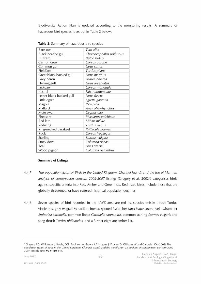
Biodiversity Action Plan is updated according to the monitoring results. A summary of
hazardous bird species is set out in Table 2 below.
Table 2: Summary of hazardous bird species
Barn owl Tyto alba Black headed gull Choicocephalus ridibunus Buzzard Buteo buteo Carrion crow Corvus corone Common gull Larus canus Fieldfare Turdus pilaris Great black-backed gull Larus marinus Grey heron Ardrea cinerea Herring gull Larus argentatus Jackdaw Corvus monedula Kestrel Falco tinnunculus Lesser black-backed gull Larus fuscus Little egret Egretta garzetta Magpie Pica pica Mallard Anas platyrhynchos Mute swan Cygnus olor Pheasant Phasianus colchicus Red kite Milvus milvus Redwing Turdus iliacus Ring-necked parakeet Psittacula krameri Rook Corvus frugilegus Starling Sturnus vulgaris Stock dove Columba oenas Teal Anas cressa Wood pigeon Columba palumbus
Summary of Listings
4.4.7 The population status of Birds in the United Kingdom, Channel Islands and the Isle of Man: an
analysis of conservation concern 2002-2007 listings (Gregory et al, 20029) categorises birds
against specific criteria into Red, Amber and Green lists. Red listed birds include those that are
globally threatened, or have suffered historical population declines.
4.4.8 Seven species of bird recorded in the NWZ area are red list species (mistle thrush Turdus
viscivorus, grey wagtail Motacilla cinerea, spotted flycatcher Muscicapa striata, yellowhammer
Emberiza citronella, common linnet Carduelis cannabina, common starling Sturnus vulgaris and
song thrush Turdus philomelos, and a further eight are amber list.
9 Gregory RD, Wilkinson I, Noble, DG, Robinson A, Brown AF, Hughes J, Proctor D, Gibbons W and Galbraith CA (2002) The population status of Birds in the United Kingdom, Channel Islands and the Isle of Man: an analysis of conservation concern 2002-2007. British Birds 95-9 410-448.

May 2017 24 Gatwick Airport NWZ Hangar
Landscape & Ecology Mitigation & Enhancement Strategy
11125001_LEMES_05-17 Chris Blandford Associates
Biodiversity Action Plans
4.4.9 Seven of the recorded species are listed in the UKBAP. One species, song thrush Turdus
philomelos is listed in the Sussex BAP.
Mitigation Strategy
Site Organisation
4.4.10 The main concentrations of birds are found along the woodland edges and hedgerows.
Vegetation (Site) Clearance Works – breeding bird monitoring
4.4.11 All ground clearance, tree felling, removal of hedgerows and scrub and the filling in of (or re-
engineering of) ponds should be conducted outside the bird breeding season. Natural England
and RSPB guidelines suggest March to August inclusive as the period during which the majority
of breeding bird activity takes place in the UK. However, breeding birds are protected
irrespective of the time of year and certain species, such as collared dove and song thrush, will
breed throughout the year if the conditions are suitable.
4.4.12 Irrespective of the timing, but particularly if site clearance works need to occur within the bird
breeding season, a suitably qualified ecologist will attend site immediately prior to the work
being undertaken. The ecologist will assess the site to determine whether there is evidence of
bird breeding in the affected areas.
4.4.13 In the event that breeding birds are recorded within any affected area, a 20m (radius) exclusion
will be established around individual nests in order to avoid disturbance. Nests will be
periodically monitored by the ecologist to determine when breeding is complete. Breeding is
deemed to be complete when the young have fledged and left the nest. Particular care must be
taken to determine whether adults have commenced a second brood.
Vegetation (Site) Clearance Works – Contractors
4.4.14 Due to the potential constraints that breeding bird activity may have with respect to the
development, it is recommended that more than one team of arboricultural contractors are
employed to undertake clearance works during times outside the breeding season, to increase
effort and thus ensure there are no delays as a consequence of over runs into the bird breeding
season.

May 2017 25 Gatwick Airport NWZ Hangar
Landscape & Ecology Mitigation & Enhancement Strategy
11125001_LEMES_05-17 Chris Blandford Associates
4.4.15 All vegetation will be cut with either hand held power tools, or specialist felling equipment
used by arboricultural contractors (which may include tractor mounted hydraulic shears).
4.4.16 Sections of branches or trunks will be stacked neatly as habitat piles and the brashings laid
along the boundary of Brockley Wood as “dead hedges”.
4.4.17 On no account must cut vegetation be left as stock piles within the Site. Such piles of brash
tend to attract breeding birds. If piles are left, they will also be monitored by the ecologist, in
addition to any stands of vegetation that are due to be felled. Any brash piles identified as
supporting breeding birds will be subject to the 20m radius exclusion zone until such time as
breeding has been completed.
Lighting
4.4.18 New lighting associated with the scheme includes: external lights to the hangar; delivery bays
and associated back-of-house infrastructure, including offices and car parking. This lighting will
result in light spillage into the areas of retained habitat which may affect tree nesting
opportunities. In order to reduce this effect as far as possible, lights closest to the boundary of
the woodland will be fitted with deflectors to direct as much of the light into the development
area and will accord with the design principles set out in Section 4.3.24 above.
Nest boxes
4.4.19 It is most likely that breeding territories may be reorganised in the first season after vegetation
has been cleared. In addition, due to safety concerns regarding the potential of bird strikes,
additional nesting boxes will not be provided for the NWZ area. Alternative locations for the
provision of additional nest boxes will be identified in the land east of the railway land.
New Planting
4.4.20 The provision of new planting on the eastern boundary of Brockley Wood (see Section 4.6)
will, in time (est. 7 – 20 years, depending on species), provide new and alternative nesting
opportunities for breeding birds.

May 2017 26 Gatwick Airport NWZ Hangar
Landscape & Ecology Mitigation & Enhancement Strategy
11125001_LEMES_05-17 Chris Blandford Associates
Post-Construction Monitoring
4.4.21 A series of post-construction monitoring surveys for the 3 years immediately following
completion of the development will be undertaken. The purpose of the monitoring will be to
assess site usage, determine what changes may have occurred in the overall bird assemblage
and identify the extent to which breeding territories have been reorganised within the
remaining habitats of the NWZ area.

May 2017 27 Gatwick Airport NWZ Hangar
Landscape & Ecology Mitigation & Enhancement Strategy
11125001_LEMES_05-17 Chris Blandford Associates
4.5 Fish
On-Site Distribution
4.5.1 Fish surveys undertaken in 2004 and 2008 revealed the presence of up to eight species of fish
in the retained western arm of the Man’s Brook (at the confluence with the River Mole. Dace
Leucisus leucisus were the most numerically abundant species, with chub Leuciscus cephalus
making up the greatest biomass. Gudgeon Gobio gobio and minnow Phoxinus phoxinus were
also recorded, as were roach Rutilus rutilus, stickleback spp and bleak Alburnus alburnus in
small numbers. The population density was estimated at 35 fish 100m2.
Legislative Context
4.5.2 None of the species of fish identified in the survey receive legal protection for their nature
conservation value. However, the movement of fish is controlled under the Salmon and
Freshwater Fisheries Act 1975 (see Section 4.5.5 below).
Biodiversity Action Plans
4.5.3 None of the species of fish identified in the survey are listed in the UK or local Biodiversity
Action Plans.
Mitigation Strategy
Site Organisation
4.5.4 Fish are known to occur in the Mans Brook and feeder ditches, connected with the River Mole
to the West of the River Mole. Fish are not thought to be present in the remnant channel of
Man’s Brook east of Brockley Wood based on local site knowledge, however, their presence
cannot be ruled out, accordingly an ecologist will survey for the presence of fish prior to works
being undertaken.
Environment Agency Consent
4.5.5 The movement of fish (both removal and reintroduction) requires Environment Agency consent.
These consents are issued under Section 30 of the Salmon and Freshwater Fisheries Act 1975.
The written consent is usually a one-off 'permission' issued for a specified date, site and
consignment of fish. This is known as a “Section 30” consent.

May 2017 28 Gatwick Airport NWZ Hangar
Landscape & Ecology Mitigation & Enhancement Strategy
11125001_LEMES_05-17 Chris Blandford Associates
4.5.6 Under Section 30 of the Salmon and Freshwater Fisheries Act 1975*
A person shall be guilty of an offence if he introduces any fish or spawn of fish into an inland
water, or has in his possession any fish or spawn of fish intending to introduce it into an inland
water, unless he first obtains the written consent of the water authority** or the inland water is
one which consists exclusively of, or of part of, a fish farm and which, if it discharges into
another inland water, does so only through a conduit constructed or adapted for the purpose.
*Including an amendment under Section34, Salmon Act 1986
**The authority is the consenting authority, i.e. The Environment Agency
4.5.7 The Environment Agency regulates the removal of fish from, and introduction of fish into,
inland waters in England and Wales to protect fisheries and the environment from aspects such
as the impacts of inappropriate fish transfers and disease transmission. The national application
form enables an application to be made for this at the same time as for using fishing
instruments (other than rod and line). Before introducing (stocking) any fish (or fish spawn) into
inland waters (including all private fisheries and stillwaters), the written consent of The
Environment Agency must be obtained.
Fish Removal and Reintroduction
4.5.8 The removal of fish will solely relate to the 200m length of Mans Brook that will require
permanent removal or culverting as part of the development.
4.5.9 The fish removal will be undertaken by specialist fisheries contractors. The contractors, in
consultation with the Environment Agency, will select the most efficient method for catching
fish but in all probability this will be a combination of either electrofishing and/or netting.
4.5.10 Any fish caught will be transferred downstream to the confluence of the Mans Brook with the
River Mole.

May 2017 29 Gatwick Airport NWZ Hangar
Landscape & Ecology Mitigation & Enhancement Strategy
11125001_LEMES_05-17 Chris Blandford Associates
4.6 Grass snakes
On Site Status
4.6.1 A small population of grass snakes Natrix natrix is present within the Site. The extent and
distribution of the grass snake population is discussed in detail in the Reptile Survey Report
(CBA, 2016). In general, grass snakes have been recorded within and along the boundaries of
the small relic woodland adjacent to Larkins Road.
4.6.2 Surveys were undertaken between September and October 2016. The standard Froglife10 and
Herpetofauna Workers Manual11 survey techniques were used with the deployment of roofing
felt tiles and corrugated tin sheets at a density in excess of the minimum 10 tins per hectare
recommendation. The highest, single survey, peak count was 3 grass snakes. Using the Froglife6
methodology for evaluating population sizes using peak counts, it was calculated that the total
estimated maximum population within the Site is approximately 20 – 30 individuals.
4.6.3 Suitable habitat within the Site is generally restricted to the woodland, hedgerows and the wet,
rush dominated, grassland along the southern boundary. The majority of the site consists of an
open grass field with few features offering shelter, hibernation opportunities or protection from
predation and as such grass snakes are considered to be largely absent from this area (although
it is possible, but largely unlikely, that individual grass snakes may occasionally traverse the
field when moving between different areas of suitable habitat. As a consequence, it is
considered that grass snakes are most likely present within discrete areas of the Site, which is
important to understand in order to identify the appropriate level of mitigation required for
each specific area of suitable habitat within the Site. The sub-division of the development site
into a series of discrete compartments also enables separate teams of ecologists to undertake
mitigation activities simultaneously to aid the timely and efficient delivery of the mitigation.
Legislative Protection
4.6.4 All British reptiles are afforded legal protection under Schedule 5 of the Wildlife and
Countryside Act 1981 (WCA) (as amended) largely as a consequence of a national decline in
numbers associated with habitat loss. Under the terms of the Act, it is illegal to intentionally
kill or injure a reptile.
10 Froglife (1999). Reptile Survey: an introduction to planning, conducting and interpreting surveys for snake and lizard conservation. Froglife Advice Sheet 10, Froglife, Halesworth. 11 Gent, T and Gibson, S. (1998). Herpetofauna Workers Manual. JNCC.

May 2017 30 Gatwick Airport NWZ Hangar
Landscape & Ecology Mitigation & Enhancement Strategy
11125001_LEMES_05-17 Chris Blandford Associates
4.6.5 The protection of grass snakes in anticipation of proposed development activities usually relies
on one of two mitigation strategies: relocation or translocation. For the purposes of the NWZ
Hangar Project, the most appropriate method to employ is relocation within the NWZ area.
Biodiversity Action Plans
4.6.6 Grass snakes are included in lists developed by the “UK Biodiversity Action Plan [BAP]
Steering Group Report” (HMSO 1995). They are included in the Long List of Globally
Threatened/Declining Species and are of ‘unfavourable conservation status in Europe’.
Mitigation Strategy
Site Organisation
4.6.7 The mosaic of semi natural habitats within the NWZ area adjacent to the Site supports good
grass snake habitat. The surveys have also shown the numbers and distribution of resident grass
snakes, confirming that the western and northern boundaries of the NWZ area have capacity to
support the resident grass snake population. Furthermore, the NWZ area is not isolated as the
River Mole corridor provides linkages to the wider landscape.
Receptor Area
4.6.8 Prior to commencement of any relocation exercise, it is important to ensure that the long-term
viability of the receptor site is established. In order to do this, the receptor site needs to fulfil a
number of criteria (see Table 3 below):
Table 3: Criteria for the selection of receptor sites
Criteria Performance of receptor site against criteria Locality: as a matter of good practice, it is preferable that grass snakes are safely relocated as close as possible to the area from which they have been moved.
The proposed areas to which grass snakes will be relocated are to the west of Brockley Wood, adjacent to the River Mole corridor.
Owners consent: it is important that the landowner of any potential receptor site is prepared to receive relocated grass snakes. Furthermore, it is necessary to establish a guarantee that the receptor site remains protected against changes in land use or future development.
The land to which the grass snakes will be located is under Gatwick ownership. The land identified for the reptile relocation will not be used by Gatwick for any future planned development.
Aspect and geology: grass snakes in any particular location will be suited to certain
The receptor area is in direct continuity with the land which will be used for the NWZ Hangar

May 2017 31 Gatwick Airport NWZ Hangar
Landscape & Ecology Mitigation & Enhancement Strategy
11125001_LEMES_05-17 Chris Blandford Associates
Criteria Performance of receptor site against criteria conditions dictated by the aspect and underlying geology of their habitat. It is important that these features are replicated as closely as possible at the receptor site.
Project and consists of the same aspect, underlying geology and vegetation types.
Vegetation structure: grass snakes require a mosaic of habitat including open grassland with varying sward height, scrub fringes and areas of broken ground and/or tree roots. The structure of the habitat provides food (specifically insects, molluscs etc.), opportunities for thermo-regulation, shelter from predation and suitable shelter for hibernation.
The receptor area consists of a mosaic of rough grasslands, shrubs, trees and woodland, the River Mole corridor and associated riparian vegetation.
Existing land management: it is important that existing land management practices are either sympathetic, or can easily be adapted, to ensure suitable vegetation structure is maintained. Inappropriate management (such as heavy grazing or close mowing) can lead to either direct harm being inflicted on grass snakes, or more subtly, the erosion of suitable habitat can lead to pressure on food resources and consequently lead to starvation for a proportion of the population.
The receptor area is not subject to an intensive land management regime. Some light cutting of vegetation occurs in specific areas, however, much of it has been left to develop a rank sward. The grasslands, woodland and wetter areas provide foraging opportunities, whilst access to the edges of Brockley Wood offer shelter and places for hibernation.
Future land management: through consent of the landowner it is necessary to establish agreement to ensure that appropriate current land management is not altered in such a manner as to cause deterioration in the quality of the habitat. Alternatively, it may be necessary to agree changes in current land management to improve or enhance the quality of the habitat.
Gatwick is committed to retaining this land as a receptor area for grass snakes and has confirmed that the land will not be the subject of future development.
4.6.9 As grass snakes are already present in the NWZ area, it is expected that maintenance of the
current management regime would ensure that the receptor area (shown on the Landscaping
and Ecological Mitigation Plan) remains suitable for grass snakes.
Reptile Capture Methodology
4.6.10 Reptile capture is restricted by seasonal constraints. Depending on the prevailing weather, it is
expected that the relocation would commence during early April. The work may commence
earlier if there is an early warm Spring, conversely the work may be delayed until early May if
the weather is cold and wet. Either way, the early establishment of refugia (see Section 4.6.12
below) will enable the emergence of grass snakes to be monitored.

May 2017 32 Gatwick Airport NWZ Hangar
Landscape & Ecology Mitigation & Enhancement Strategy
11125001_LEMES_05-17 Chris Blandford Associates
4.6.11 A suite of methods are employed in order to guarantee that a reasonable effort is made to
remove as many grass snakes as possible from the Site, within an appropriate time period.
These methods are described below.
Tinning
4.6.12 The use of corrugated tins or roofing felt (refugia) is a tried and tested method for capturing
grass snakes. Sheets of tin and/or roofing felt are spread over a given area at a minimum density
of 50 tins per hectare. It is anticipated that the density used for the NWZ Hangar Project will far
exceed this threshold. The tins are checked approximately twice daily and any grass snakes
encountered are caught.
4.6.13 Population densities vary across the Site and trapping effort varies accordingly, in line with
current Natural England guidelines. The number of checks of the tins needs to be balanced
such that maximum capture effort is made without causing undue disturbance that prevents the
animals from using the tins.
4.6.14 Each of the tins is numbered and a record made of which tin each reptile is captured under.
Furthermore, a record is kept of tin numbers where a reptile was encountered but not caught.
Over time a map can be created of the distribution of animals, allowing capture effort to be
targeted and refined to increase efficiency.
4.6.15 Biometric data (sex, life stage, weight, length) of each grass snake is recorded. This data is kept
and will be used for subsequent post-relocation monitoring (see below).
Drift Fencing and Vegetation Clearance
4.6.16 Alongside the tinning effort, a series of reptile proof drift fences will be constructed to increase
capture rate (the Landscaping and Ecological Mitigation Plan shows the general layout of the
proposed drift and exclusion fencing). In particular, drift fencing will be constructed on either
side of the hedgerows affected by the proposed development, further fencing will be
established around the small woodland adjacent to Larkins Road and the western most extent
of the proposed development. The purpose of the drift fencing is to prevent grass snakes
entering the development site and to help direct any grass snakes within the development site,
to areas of suitable habitat away from the construction footprint. It is recommended that the

May 2017 33 Gatwick Airport NWZ Hangar
Landscape & Ecology Mitigation & Enhancement Strategy
11125001_LEMES_05-17 Chris Blandford Associates
reptile proof fence follows the design set out in the Design Manual for Roads and Bridges
(DMRB12) and included as Appendix 1.
4.6.17 Once the fences are established the vegetation within the development site is cleared using a
combination of hand cutting using saws (to remove scrub), brush cutters and strimmers. The
principle is that as the vegetation is removed the grass snakes will begin to preferentially use
the tin traps. The next stage is to cut and remove vegetation using brush cutters. This requires
teams of operators to work in sequence with one another such that they are always cutting
towards a drift fence line or from areas of unsuitable habitat (e.g. areas of existing hard
standing), towards suitable habitat outside the construction area. This has the effect of making
the tins more attractive for shelter, but also, encourages grass snakes to move away from the
vibration of the cutters. This operation is then repeated using strimmers until the ground is
virtually bare.
4.6.18 It is important to undertake this work slowly and in stages in order that no grass snakes are
harmed during the process. Overall, however, the effect is to improve capture efficiency within
a given area.
Destructive Searches
4.6.19 The final technique to be employed is destructive searching. Following an appropriate tin
trapping period and the removal of vegetation using brush cutters, there may still be
opportunities for grass snakes to remain within a given area. This is particularly true of areas of
made ground, broken ground or piles of rubble etc. Under these circumstances it is necessary
to undertake a programme of destructive searching using a mechanical digger, or removal of
rubble by hand.
4.6.20 A machine driver and ecologist will work as a team, with the search commencing from a
position at the edge of the area and working inwards. In doing so there is no chance of the
machine driving over potential areas and harming grass snakes. In general the purpose will be
to remove the top few inches of ground a little at a time, in order to flush out or see grass
snakes that may be hiding. In some circumstances buried rubble may be encountered, in which
case the operation continues until the machine driver encounters natural ground level. Any
animals seen are caught and removed from the area during the operation.
12 Highways Agency (2005) Nature Conservation Advice in Relation to Reptiles and Roads Vol. 10 Section 4 Part 7 HA 116/05 Annex B page B/1. Highways Agency.

May 2017 34 Gatwick Airport NWZ Hangar
Landscape & Ecology Mitigation & Enhancement Strategy
11125001_LEMES_05-17 Chris Blandford Associates
4.6.21 The use of destructive searches is not a substitute for trapping effort. Rather, destructive
searches are employed as part of a “belt and braces” approach to delivering effective and
successful mitigation.
4.6.22 The timely and sequential use of these techniques ensures the removal of all animals from a
given area within an appropriate timeframe.
Post Relocation Monitoring
4.6.23 It is proposed that an annual programme of monitoring for each of the first three years,
following completion of the NWZ Hangar Project, will be established. This will involve the
capturing of a proportion of the reptile population over a two week period, with biometric data
being recorded to compare with the data collected at the time of the relocation. Whilst it will
not be possible to identify individual grass snakes, an overall comparison of age and sex
structure, as well as size, will enable an assessment of population status.

May 2017 35 Gatwick Airport NWZ Hangar
Landscape & Ecology Mitigation & Enhancement Strategy
11125001_LEMES_05-17 Chris Blandford Associates
4.7 Harvest Mouse
On Site Distribution
4.7.1 Harvest mice have been recorded in low numbers in the NWZ area, including within the Site.
Legislative Context
4.7.2 The harvest mouse is listed under s41 of the NERC Act 2006 (Species of Principal Importance).
Biodiversity Action Plan
4.7.3 The harvest mouse is a UK and Sussex BAP species.
Mitigation Strategy
Site Organisation
4.7.4 Harvest mice are known to occur in low densities in in areas of tall grassland and scrub
bordering the Mans Brook and the woodland adjacent to Larkins Road.
Relocation
4.7.5 In order to conserve the existing population of harvest mice, it is proposed that a period of
trapping be undertaken within areas of suitable habitat, during April and May. Trapping will be
undertaken by suitably qualified ecologists experienced in small mammal ecology, using a
combination of longworth and tube traps. These will be placed in appropriate locations,
mounted on canes so that they are located within the stalk zone in areas of tall vegetation, and
visited daily. Any mice found in the traps will be collected and moved areas of suitable habitat
within the River Mole corridor (the Landscaping and Ecological Mitigation Plan). Harvest mice
occur in low density within the Development site, and therefore it is considered that that there
is sufficient carrying capacity to support harvest mice introduced to the R Mole corridor
habitat.

May 2017 36 Gatwick Airport NWZ Hangar
Landscape & Ecology Mitigation & Enhancement Strategy
11125001_LEMES_05-17 Chris Blandford Associates
4.8 Invertebrates
On-Site Distribution
4.8.1 Invertebrate surveys undertaken in 2008 and 2014 have identified over 130 terrestrial
invertebrate species within the NWZ area including 1 Nationally Scarce a (NSa) species, the
bee Hylaeus cornutus, 5 NSb species including the ruddy darter dragonfly Sympetrum
sanguineum, Roesel’s bush cricket Metrioptera roeselli, the ladybird Hippodamia variegate and
two solitary wasps Ectemnius dives and Pemphredon morio.
Legislative Context
4.8.2 Two species listed under s41 of the NERC Act 2006 (Species of Principal Importance) are
present within the Site; the potter wasp Odynerus melanocephalus and the long-horned bee
Eucera longicornis.
Mitigation Strategy
Site Organisation
4.8.3 Both s41 species occur in the grassland between the Larkins road woodland and Brockley
Wood.
Habitat Creation
4.8.4 Much of the grass field will be lost as a result of the development. In order, however, to support
the retained population of invertebrates, small scale landscape interventions would be
undertaken to create shallow south facing banks across the retained area of the field and the
edges of the diverted Larkins Road. The banks (illustrated on the Landscaping and Ecological
Mitigation Plan) would be approximately 2m wide and no greater than 1m in height. The bund
will be sown with a seed mix comprising a variety of grass and forb species. It is anticipated
that this new grassland will be managed in accordance with airport safeguarding requirements,
but periodic management would create small areas of bare ground to ensure that nesting sites
are available. Further sites in the land east of the railway line will also be identified for
enhancing invertebrate diversity.

May 2017 37 Gatwick Airport NWZ Hangar
Landscape & Ecology Mitigation & Enhancement Strategy
11125001_LEMES_05-17 Chris Blandford Associates
4.9 Landscape
On Site Distribution
4.9.1 The landscape of the proposed Site and its surroundings to the north and west consists of a
mosaic of woodlands connected with hedgerows that include mature trees, with fields
comprising grassland / scrub mosaic habitats. The realigned River Mole forms the western
boundary of Gatwick Airport’s landholdings, beyond which lies a predominantly pastoral
landscape of hedged fields interspersed with woodlands and small settlements. To the south
and east, lies the main body of the airport, runway and associated infrastructure.
Legislative Context
4.9.2 The legislative context for the protection of the airfield from wildlife hazards is summarised in
Section 1.0.
Mitigation Strategy
Site Organisation
4.9.3 Within the Site, the proposed development comprises the direct extension of operational
facilities immediately adjacent with the existing airfield. Moreover, the Site is also broadly
geometric in shape which will therefore result in the direct loss of existing landscape features
(fields, hedgerows and trees), but will not lead to the fragmentation of those features that will
be retained.
Scheme design
4.9.4 In recognition of the landscapes sensitivity to a development on the scale proposed, the design
of the hangar has gone through a number of iterations, informed in part by the ongoing
landscape and visual appraisal. This iterative process has achieved a development which is
considered to have the least possible landscape and visual impacts. Measures have included
ensuring the hangars footprint and that of its apron are as small as possible, whilst the adoption
of a stepped roof line would minimise the extent of the highest part of the roof. The maximum
height of the hangar is the minimum required to meet the operational needs of the type of
aircraft to be maintained.

May 2017 38 Gatwick Airport NWZ Hangar
Landscape & Ecology Mitigation & Enhancement Strategy
11125001_LEMES_05-17 Chris Blandford Associates
4.9.5 The choice of ‘goosewing grey’ as the selected colour for the metal exterior cladding has
sought to further minimise landscape and visual impacts. This would involve the use of a
darker shade of grey on the lower parts of each elevation and a lighter shade on the upper
parts. This is considered to be the best arrangement and use of colour to assist with the
buildings integration into its environment and in particular, to blend the building into the sky
from low lying views.
4.9.6 Other measures include avoiding the use of windows on the upper elevations and instead
setting skylights within the flat roof behind the parapets. Whilst there would be flood lighting to
the front of the hangar, low level security lighting is proposed around the other three sides of
the building complex and alongside the diverted Larkins Road. This would ensure there is no to
light spillage beyond the airport.
On-site planting
4.9.7 The proposed development will result in the loss of 141 trees, for which around 550 new trees
will be planted as their replacements. For reasons set out in Sections 4.1 and 4.3 above
(particularly in relation to bat mitigation), this additional planting will be undertaken along the
eastern boundary of Brockley Wood. It will consist of a range of tree species to provide a
woodland edge buffer to protect Brockley Wood from disturbance, but particularly lightshed
arising from the new buildings and associated infrastructure.
4.9.8 Additional planting will also be provided on the existing airport noise bund over the area
shown in the Landscaping and Ecological Mitigation Plan. This will be subject to detailed
survey regarding where the landscape planting will interface with existing planting to be of
most benefit.
Off-site views
4.9.9 A separate Landscape and Visual Appraisal has been undertaken for the scheme. It is
acknowledged that the new hangar will be visible from viewpoints outside the airport
perimeter. However, the scheme has been subject to an iterative design process to try and
ameliorate the visual effects of the development on the wider landscape. In particular,
westward facing windows on the upper elevations of the hangar have been replaced with the
use of skylights, as a means of reducing increased light intrusion into the night time views of
this part of the airport.

FIGURES
LANDSCAPING AND ECOLOGICAL MITIGATION PLAN

PLANTING PLANS
AREAS 1 AND 2

APPENDIX 1
Design specification for temporary reptile fencing
(taken from DMRB Volume 10 Section 4 Part 7)

FIGURES

LANDSCAPING AND ECOLOGICAL MITIGATION PLAN

LA
RK
IN
S R
OA
D
AIR
SID
E R
OA
D
M
a
n
s
B
r
o
o
k
B
r
o
c
k
l
e
y
W
o
o
d
R
e
e
d
s
R
i
v
e
r
M
o
l
e
D
r
a
i
n
D
r
a
in
F
B
D
r
a
i
n
D
r
a
in
D
r
a
in
River Mole
D
r
a
in
F
B
R
i
v
e
r
M
o
l
e
F
o
r
d
R
iv
e
r
M
o
l
e
P
o
n
d
Drain
R
i
v
e
r
M
o
l
e
P
o
n
d
M
a
r
l
e
s
D
r
a
i
n
D
r
a
in
D
r
a
in
5
8
.
2
m
5
8
.
5
m
H
O
R
L
E
Y
R
O
A
D
S
t
o
c
k
w
e
l
l
N
i
t
o
n
5
8
.
8
m
D
r
a
i
n
D
r
a
i
n
R
i
v
e
r
M
o
l
e
M
a
n
s
B
r
o
o
k
T
a
n
k
C
a
r
P
a
r
k
S
t
e
p
p
i
n
g
S
t
o
n
e
s
L
T
w
r
L
T
w
r
L
T
w
r
L
T
w
r
L
A
R
K
I
N
S
R
O
A
D
E
l
S
u
b
S
t
a
E
l
S
u
b
S
t
a
B
l
a
s
t
S
c
r
e
e
n
L
T
w
r
L
T
w
r
C
o
C
o
n
s
t
B
d
y
R
H
U
n
d
B
o
r
o
C
o
n
s
t
B
d
y
R
H
U
n
d
E
l
S
u
b
S
t
a
P
o
n
d
s
T
a
n
k
C
o
n
v
e
y
o
r
T
r
a
c
k
P
a
t
h
(u
m
)
T
a
n
k
s
T
r
a
c
k
F
B
s
F
B
F
B
B
a
l
a
n
c
i
n
g
P
o
n
d
EX
IS
TIN
G T
AX
ILA
NE
U
NIF
OR
M
LANDSCAPING AND ECOLOGICAL
MITIGATION PLAN
958: LANDSCAPE AND ECOLOGY
900 : ENVIRONMENTAL MONITORING
LJ 02.02.2017 GH/LJ
02.02.2017
NM 02.02.2017 1:1250
IFS
20760-00-U-958-GA-000001 C
Conceptual Design
20760-00-U-958-GA-000001
C
KEY
REDLINE BOUNDARY
LARKINS ROAD DIVERSION
RETAINED DITCH
BROCKLEY WOOD
GRASS
ANCIENT WOODLAND: BROCKLEY WOOD BUFFER
MIX 1:
PROPOSED TREE PLANTING
PROPOSED SHRUB PLANTING
LARKINS ROAD BUND: SCREEN BUND MIX 1:
PROPOSED SEEDING
HABITAT RELOCATION AND EXCLUSION AREAS:
HARVEST MOUSE RELOCATION SITE
GRASS SNAKE RELOCATION SITE
TEMPORARY REPTILE EXCLUSION FENCE
A 02.02.17 For Planning Permission GH LJ NMB 06.02.17 Tree planting details adjusted KM LJ NM
N
DIRTY SIDE
BALANCING POND M
CLEAN SIDE
CONNECT TO EXISTING AIRSIDE ROAD
FOR GENERAL ARRANGEMENT
PLAN OF ROADS AND AIRSIDE
BOUNDARY, REFER TO DRAWING
NO. 20760-00-C-600-GA-000001
EX
IS
TIN
G L
AR
KIN
S R
OA
D
N
BROCKLEY WOOD -
ANCIENT WOODLAND
M
AN
S B
R
O
O
K
REFERENCE DRAWINGS:
20760-00-M2-000-000001-D5A-DR-A-915-0001-C.DWG
20760-00-M2-000-000001-EGKK_2500 BACKGROUND_GAL AIRPORT
SURVEY.DWG
20760-00-M2-000-000001-OS MASTERMAP.DWG
20760-00-M2-000-000001-PRIORITY ROAD OPT2.DWG
20760-00-M2-000-000003-LANDSCAPE AND ECOLOGY.DWG
11 NO. ACER CAMPESTRE 5%
16 NO. ALNUS GLUTINOSA 7.5%
11 NO. BETULA PUBESCENS 5%
16 NO. CARPINUS BETULUS 7.5%
11 NO. CORYLUS AVELLANA 5%
11 NO. FRAXINUS EXCELSIOR 5%
11 NO. ILEX AQUIFOLIUM 5%
11 NO. POPULUS TREMULA 5%
63 NO. QUERCUS ROBUR 30%
27 NO. SALIX ALBA 12.5%
27 NO. SALIX FRAGILIS 12.5%
MIX OF SEDGES/GRASSES (60%) AND HERBACEOUS (40%)
AREA : 3000m² (10% OF THE AREA 300m² TO BE AUGMENTED)
DENSITY : 8/m²
SEDGES : CAREX OTRUBAE, ELEOCHARIS PALUSTRIS, JUNCUS ARTICULATS,
JUNCUS CONGLOMERATUS.
HERBACEOUS : AGRIMONIA EUPATORIA, GERANIUM DISSECTUM,
LATHYRUS NISSIOLA, LATHYRUS PRATENSIS, LOTUS CORNICULATUS,
MEDICAGO LUPULINA, POTENTILLA REPTANS, PULICARIA DYSENTERICA,
TRIFOLIUM DUBIUM, VICIA SATIVA
4 NO. ACER CAMPESTRE 5%
6 NO. ALNUS GLUTINOSA 7.5%
4 NO. BETULA PUBESCENS 5%
6 NO. CARPINUS BETULUS 7.5%
4 NO. CORYLUS AVELLANA 5%
4 NO. FRAXINUS EXCELSIOR 5%
4 NO. ILEX AQUIFOLIUM 5%
4 NO. POPULUS TREMULA 5%
23 NO. QUERCUS ROBUR 30%
10 NO. SALIX ALBA 12.5%
10 NO. SALIX FRAGILIS 12.5%
NOTES:
1. ALL AREAS THAT ARE NOT OCCUPIED BY HARD STANDING
WITHIN MOTT MACDONALD'S SITE BOUNDARY TO BE SEEDED
WITH GRASS MIX 1 AND MANAGED IN ACCORDANCE WITH
GAL SAFEGUARDING TO ACHIEVE CLOSE TRIMMED SWORD.
2. FLOWERING LAWN MIX TO BE ESTABLISHED AND MANAGED
ON THE LARKINS ROAD BUND IN ACCORDANCE WITH GAL
SAFEGUARDING'S REQUIREMENTS FOR ALL GRASS
MANAGEMENT.
3. NO LANDSCAPE SOFT WORKS TO BE PROVIDED WITHIN THE
HARVEST MOUSE AND GRASS SNAKE RELOCATION SITES AS
CONFIRMED BY THE CLIENT TEAM.
MIX OF SEDGES / GRASSES AND HERBACEOUS
SPECIFICATION DENSITY AREA
SEDGES : CAREX OTRUBAE, ELEOCHARIS
PALUSTRIS, JUNCUS ARTICULATS,
JUNCUS CONGLOMERATUS.
8/m² 300m²
HERBACEOUS : AGRIMONIA EUPATORIA,
GERANIUM DISSECTUM,
LATHYRUS NISSIOLA, LATHYRUS
PRATENSIS, LOTUS CORNICULATUS,
MEDICAGO LUPULINA, POTENTILLA
REPTANS, PULICARIA DYSENTERICA,
TRIFOLIUM DUBIUM, VICIA SATIVA
EMORSGATE FLOWERING LAWN MIX EL1
SPECIES % OF MIX
LADY'S BEDSTRAW 3%
ROUGH HAWKBIT 0.5%
OXEYE DAISY 1%
BIRDSFOOT TREFOIL 3%
COWSLIP 1.5%
SELFHEAL 5%
MEADOW BUTTERCUP 3%
COMMOM SORREL 2%
WILD RED CLOVER 1%
COMMON BENT 8%
CRESTED DOGSTAIL 40%
SLENDER-CREEPING RED FESCUE 28%
SMALLER CAT'S-TAIL 2%
GRASS MIX 1 - APPROVED GATWICK AIRSIDE
MIX (R406A)
SPECIES % OF MIX
GRANDE - TALL FESCUE 25%
SCORPIONES - TALL FESCUE 25%
GREENFAIR - PERENNIAL RYEGRASS 25%
GREENWAY - PERENNIAL RYEGRASS 25%
DIRTY SIDE
BALANCING POND M
CLEAN SIDE
CONNECT TO EXISTING AIRSIDE ROAD
EX
IS
TIN
G L
AR
KIN
S R
OA
D
EMORSGATE EL1 SEED MIX
AREA : 1075 SQ m
DENSITY : 4g/m²
37 NO. ACER CAMPESTRE 7.5%
25 NO. CORYLUS AVELLANA 5%
37 NO. POPULUS TREMULA 7.5%
147 NO. SALIX CAPREA 30%
147 NO. SALIX CINEREA 30%
98 NO. SALIX VIMINALIS 20%
NOTE
TREES AND LIGHT STANDARDS OF SAME SPECIES TO BE PLANTED IN GROUPS OF MIN 3-4 NUMBERS WITHIN THE PLANTING MIX
* CORYLUS AVELLANA TO BE SPREAD EVENLY ALONG FRONT EDGE OF THE PLANTING
**PUPOLUS TREMULA PLANTED IN FRONT TO AVOID BEING IN SHADE
EMORSGATE SEED MIX
SPECIFICATION DENSITY AREA
EL1 - EMORSGATE FLOWERING LAWN MIX 4/m² 1075m²
PLANTING IN THIS AREA TO BE
AGREED ON SITE TO MEET THE
SIGHT LINE SAFETY REQUIREMENTS
LAND BETWEEN LARKINS
ROAD AND BOEING
PERIMETER ROAD NOT
DESCRIBED ELSEWHERE
SHALL BE SEEDED WITH
EMORSGATE EL1 SEED MIX
GRASS MIX 1 (R406A)
BY BOEING
GRASS MIX 1 (R406A)
BY BOEING
GRASS MIX 1 (R406A)
BY BOEING
75
Metres - 1:1250
1500
TREE PLANTING SCHEDULE
TREES
NUMBER SPECIES SPECIFICATION HEIGHT GIRTH DENSITY
52 NO. ACER CAMPESTRE LIGHT STANDARD: BR: STAGGERED 2.5 - 3.0m 6.0 - 8.0m 4 CTR
22 NO. ALNUS GLUTINOSA LIGHT STANDARD: BR: STAGGERED 2.5 - 3.0m 6.0 - 8.0m 4 CTR
15 NO. BETULA PUBESCENS LIGHT STANDARD: BR: STAGGERED 2.5 - 3.0m 6.0 - 8.0m 4 CTR
22 NO. CARPINUS BETULUS LIGHT STANDARD: BR: STAGGERED 2.5 - 3.0m 6.0 - 8.0m 4 CTR
* 40 NO. CORYLUS AVELLANA LIGHT STANDARD: BR: STAGGERED 2.5 - 3.0m 6.0 - 8.0m 4 CTR
15 NO. FRAXINUS EXCELSIOR LIGHT STANDARD: BR: STAGGERED 2.5 - 3.0m 6.0 - 8.0m 4 CTR
15 NO. ILEX AQUIFOLIUM LIGHT STANDARD: BR: STAGGERED 2.5 - 3.0m 6.0 - 8.0m 4 CTR
** 52 NO. POPULUS TREMULA LIGHT STANDARD: BR: STAGGERED 2.5 - 3.0m 6.0 - 8.0m 4 CTR
86 NO. QUERCUS ROBUR LIGHT STANDARD: BR: STAGGERED 2.5 - 3.0m 6.0 - 8.0m 4 CTR
37 NO. SALIX ALBA LIGHT STANDARD: BR: STAGGERED 2.5 - 3.0m 6.0 - 8.0m 4 CTR
37 NO. SALIX FRAGILIS LIGHT STANDARD: BR: STAGGERED 2.5 - 3.0m 6.0 - 8.0m 4 CTR
147 NO. SALIX CAPREA LIGHT STANDARD: BR: STAGGERED 2.5 - 3.0m 6.0 - 8.0m 4 CTR
147 NO. SALIX CINEREA LIGHT STANDARD: BR: STAGGERED 2.5 - 3.0m 6.0 - 8.0m 4 CTR
98 NO. SALIX VIMINALIS LIGHT STANDARD: BR: STAGGERED 2.5 - 3.0m 6.0 - 8.0m 4 CTR
ISO A1 Landscapezz12_V8_0_lgw-a1l-s
AppChkRev DrnRevision DescriptionDate
Key Plan
Project Name
Title
YO UR LON D ON AIRPORT
Document Uncontrolled when printed
Status
Common Language System
Revision
Originator's Job No.
GAL Project No.Common Language Series
Approved By
Checked By
Drawing Originator
Approval Date
Checked Date
Scale
Drawn By
Drawn Date
Location-Level-Discipline-Systems/Series-DOC Type-Unique Number
Reason for Issue
08
L
08
R
26
L
26
R
U
V
W
X
Y
Z
A
B
C
D
E
F
F
GG
BOEING HANGAR DESIGN
40925
70029306
WSP/PARSONS BRINCKERHOFF
OS Copyright Acknowledgement.
Reproduced by permission of Ordnance Survey on behalf of HMSO. © Crown
Copyright and database right.
This drawing may contain some Ordnance Survey Landline and Raster data
Do not scale from this drawing. Use figured dimensions only.
This drawing has been compiled from a variety of data sources based on
information initially provided by GAL AMC (including as-built and survey
information). Reasonable care has been taken during the compilation of this
drawing to omit errors. If any discrepancy is identified it shall be clarified in writing
with the Project Manager and or Contract Administrator in accordance with the
agreed project procedure and such clarification circulated to all relevant parties in
a timely manner
Intent and dimensions are to be verified on site by the contractor and any
discrepancies shall be clarified in writing with the Project Manager and or
Contract Administrator in accordance with the agreed project procedure and such
clarification circulated to all relevant parties in a timely manner.
This drawing must be read in-conjunction with all other relevant project
documentation. Any discrepancies between this document and any other relevant
project document shall be clarified in writing with the Contract Administrator in
accordance with the agreed project procedure and such clarification circulated to
all relevant parties in a timely manner.
The information shown on this drawing is given without obligation or warranty, the
accuracy thereof cannot be guaranteed.
Do not scale from the drawing. Use figured dimensions only.
It is assumed that all works will be carried out by a competent contractor working,
where appropriate, to an approved method statement
In addition to the hazards/risks normally associated with the
types of work detailed on this drawing, note the following :
SAFETY, HEALTH AND ENVIRONMENTAL INFORMATION
DECOMMISSIONING/DEMOLITION
MAINTENANCE/CLEANING
CONSTRUCTION
Project Name / Contract Description Document Number:
Revision Number:
Code Assignment:
Code 1
Code 2
Code 3
Code 4
Work may proceed
Revise and resubmit. Work may proceed subject to incorporation of comments indicated
Revise and resubmit. Work may NOT proceed
Revise and resubmit. Work may proceed
Permission to proceed does not constitute acceptance or approval of design details, calculations
analyses, test methods, or materials developed or selected by the contractor/supplier, and does not
relieve contractors/supplier from full compliance with contractual obligations or release any "holds"
placed on the contract.
GAL Development Team Action Person:
Signature:
Alternative Reference:
Date Signed:
Project Name
www.wspgroup.com
Tel: +44 (0)1483 582 400 Fax: +44 (0)1483 582 989
Westbrook Mills, Borough Road, Godalming, Surrey, GU7 2AZ
This drawing is not to be used in whole or part other than for the intended purpose
and project, refer to the contract for full terms and conditions.
C 17.05.17 Tree planting details adjusted KM LJ NM

PLANTING PLANS
AREAS 1 AND 2

P
o
n
d
Drain
R
i
v
e
r
M
o
l
e
P
o
n
d
D
r
a
i
n
D
r
a
in
5
8
.
2
m
H
O
R
L
E
Y
R
O
A
D
S
t
e
p
p
i
n
g
S
t
o
n
e
s
C
o
C
o
n
s
t
B
d
y
B
o
r
o
C
o
n
s
t
B
d
y
B
a
l
a
n
c
i
n
g
P
o
n
d
Note:
Trees/ whips/ seedlings of same species to be planted in groups of min 3-4
numbers within the planting mix.
* Corylus avellana to be spread evenly along the front edge of the planting
** Populus tremula planted in front to avoid being planted in shade
37 No. Acer campestre 7.5%
25 No. Corylus avellana 5%
37 No. Populus tremula 7.5%
147 No. Salix caprea 30%
147 No. Salix cinerea 30%
98 No. Salix viminalis 20%
4Ctr6-8cm2.5 - 3.0mLight Standard :BR :StaggeredSalix viminalis98 No.
4Ctr6-8cm2.5 - 3.0mLight Standard :BR :StaggeredSalix cinerea147 No.
4Ctr4-6cm2.5 - 3.0mLight Standard :BR :StaggeredSalix caprea147 No.
4Ctr6-8cm2.5 - 3.0mLight Standard :BR :StaggeredPopulus tremula37 No.
4Ctr6-8cm2.5 - 3.0mLight Standard :BR :StaggeredCorylus avellana25 No.
4Ctr6-8cm2.5 - 3.0mLight Standard :BR :StaggeredAcer campestre37 No.
DensityGirthHeightSpecificationSpeciesNumber
Trees
PLANTING SCHEDULE
**
*
EX
IS
TIN
G T
AX
ILA
NE
U
NIF
OR
M
M
a
n
s
B
r
o
o
k
B
r
o
c
k
le
y
W
o
o
d
R
e
e
d
s
R
i
v
e
r
M
o
l
e
D
r
a
in
Drain
FB
D
r
a
in
D
r
a
in
D
r
a
in
River Mole
Drain
FB
R
i
v
e
r
M
o
l
e
B
r
o
o
k
F
a
r
m
F
o
r
d
P
o
n
d
Drain
R
i
v
e
r
M
o
l
e
P
o
n
d
M
a
r
le
s
D
r
a
in
Dr
ain
D
r
a
in
D
r
a
i
n
5
8
.2
m
5
8
.5
m
H
O
R
L
E
Y
R
O
A
D
Stockwell
Niton
Dar-as-Salaam
58.8m
D
r
a
in
D
r
a
i
n
D
r
a
in
R
iv
e
r
M
o
l
e
Taxiway
M
a
n
s
B
r
o
o
k
Drain
T
a
n
k
Car Park
S
t
e
p
p
in
g
S
t
o
n
e
s
L Twr
L Twr
L Twr
L Twr
L
A
R
K
I
N
S
R
O
A
D
E
l
S
u
b
S
t
a
El Sub Sta
Blast Screen
L Twr
L
T
w
r
R
H
C
o
C
o
n
s
t
B
d
y
RH
U
n
d
B
o
r
o
C
o
n
s
t
B
d
y
R
H
U
n
d
El Sub Sta
P
o
n
d
s
Drain
Drain
T
a
n
k
Conveyor
T
r
a
c
k
Pa
th
(u
m)
Tanks
T
r
a
c
k
P
a
t
h
(
u
m
)
P
a
t
h
(
u
m
)
FBs
F
B
FB
B
a
la
n
c
in
g
P
o
n
d
LA
RK
IN
S R
OA
D
AIR
SID
E R
OA
D
This document should not be relied on or used in circumstances
other than those for which it was prepared and for which Chris
Blandford Associates was commissioned. Chris Blandford Associates
accepts no responsibility for this document to any other party other
than the person by whom it was commissioned.
DateRev Drw Revision or reason for Issue
Drawing number
Project Title
Revision
Scale @ A1
Drawing Series and Title
Drawing Status
Scale
0 10m 20m
1:500
N
S:\projects\11125001 Gal NWZ Hanger 2016 Project\4 CAD\11125001-PL-001.dwg
Drawn
Approved
Date
/ North Point
Client
CHRIS BLANDFORD ASSOCIATES
landscape | environment | heritagecba
W o o l y a r d , 5 2 B e r m o n d s e y S t r e e t , L o n d o n S E 1 3 U D
T 020 7089 6480 E [email protected] W www.cbastudios.com
GATWICK AIRPORT LIMITED
BOEING HANGER DESIGN
4000 SERIES
PLANTING PLAN - AREA 1
PLANNING
-
BW
APRIL 2017PK
- 04-05-17 PK ISSUED FOR PLANNING
BH-CBA-1-GF-M2-L-4001
PART 1

M
a
n
s
B
r
o
o
k
B
r
o
c
k
l
e
y
W
o
o
d
D
r
a
in
D
r
a
in
F
B
D
r
a
i
n
T
r
a
c
k
T
a
n
k
s
T
r
a
c
k
F
B
Mix of Sedges/Grasses (60%) and Herbaceous (40%)
Area : 3000 m² (10% of the area 300 m² to be augmented)
Density : 8/m²
Sedges : Carex otrubae, Eleocharis palustris, Juncus articulats,
Juncus conglomeratus.
Herbaceous : Agrimonia eupatoria, Geranium dissectum,
Lathyrus nissiola, Lathyrus pratensis, Lotus corniculatus,
Medicago lupulina, Potentilla reptans, Pulicaria dysenterica,
Trifolium dubium, Vicia sativa.
Emorsgate EL1 seed mix
Area : 1075 sq m
Density : 4g/m²
Mix of Sedges/Grasses and Herbaceous
Specification Density Area
Sedges : Carex otrubae, Eleocharis palustris, Juncus
articulats, Juncus conglomeratus.
300 m²8/m²Herbaceous : Agrimonia eupatoria, Geranium
dissectum, Lathyrus nissiola, Lathyrus pratensis, Lotus
corniculatus, Medicago lupulina, Potentilla reptans,
Pulicaria dysenterica, Trifolium dubium, Vicia sativa.
Emorsgate seed mix
Specification Density Area
EL1 – Emorsgate Flowering lawn mixture1075 m²
4g/m²
Note:
Trees/ whips/ seedlings of same species to be planted in groups of min 3-4
numbers within the planting mix.
* Corylus avellana to be spread evenly along the front edge of the planting
** Populus tremula planted in front to avoid being planted in shade
4 No. Acer campestre 5%
6 No. Alnus glutinosa 7.5%
4 No. Betula pubescens 5%
6 No. Carpinus betulus 7.5%
4 No. Corylus avellana 5%
4 No. Fraxinus excelsior 5%
4 No. Ilex aquifolium 5%
4 No. Populus tremula 5%
23 No. Quercus robur 30%
10 No. Salix alba 12.5%
10 No. Salix fragilis 12.5%
11 No. Acer campestre 5%
16 No. Alnus glutinosa 7.5%
11 No. Betula pubescens 5%
16 No. Carpinus betulus 7.5%
11 No. Corylus avellana 5%
11 No. Fraxinus excelsior 5%
11 No. Ilex aquifolium 5%
11 No. Populus tremula 5%
63 No. Quercus robur 30%
27 No. Salix alba 12.5%
27 No. Salix fragilis 12.5%
4Ctr6-8cm2.5 - 3.0mLight Standard :BR :StaggeredSalix fragilis37 No.
4Ctr6-8cm2.5 - 3.0mLight Standard :BR :StaggeredSalix alba37 No.
4Ctr6-8cm2.5 - 3.0mLight Standard :BR :StaggeredQuercus robur86 No.
4Ctr6-8cm2.5 - 3.0mLight Standard :BR :StaggeredPopulus tremula15 No.
4Ctr6-8cm2.5 - 3.0mLight Standard :BR :StaggeredIlex aquifolium15 No.
4Ctr6-8cm2.5 - 3.0mLight Standard :BR :StaggeredFraxinus excelsior15 No.
4Ctr6-8cm2.5 - 3.0mLight Standard :BR :StaggeredCorylus avellana15 No.
4Ctr6-8cm2.5 - 3.0mLight Standard :BR :StaggeredCarpinus betulus22 No.
4Ctr6-8cm2.5 - 3.0mLight Standard :BR :StaggeredBetula pubescens15 No.
4Ctr6-8cm2.5 - 3.0mLight Standard :BR :StaggeredAlnus glutinosa22 No.
4Ctr6-8cm2.5 - 3.0mLight Standard :BR :StaggeredAcer campestre15 No.
DensityGirthHeightSpecificationSpeciesNumber
Trees
PLANTING SCHEDULE
**
*
EX
IS
TIN
G T
AX
ILA
NE
U
NIF
OR
M
Mans Brook
B
r
o
c
k
le
y
W
o
o
d
R
e
e
d
s
R
i
v
e
r
M
o
l
e
D
r
a
in
Drain
FB
D
r
a
in
D
r
a
in
D
r
a
in
River Mole
Drain
FB
R
i
v
e
r
M
o
l
e
B
r
o
o
k
F
a
r
m
F
o
r
d
Pond
Drain
R
i
v
e
r
M
o
l
e
Pond
M
a
r
le
s
D
r
a
in
Dr
ain
Dr
ain
D
r
a
i
n
5
8
.2
m
5
8
.5
m
H
O
R
L
E
Y
R
O
A
D
Stockwell
Niton
Dar-as-Salaam
58.8m
D
r
a
in
D
r
a
i
n
D
r
a
in
R
iv
e
r
M
o
l
e
Taxiway
M
a
n
s
B
r
o
o
k
Drain
T
a
n
k
Car Park
Stepping Stones
L Twr
L Twr
L Twr
L Twr
L
A
R
K
I
N
S
R
O
A
D
El Sub Sta
E
l
S
u
b
S
t
a
Blast Screen
L Twr
L Twr
R
H
C
o
C
o
n
s
t
B
d
y
RH
U
n
d
B
o
r
o
C
o
n
s
t
B
d
y
R
H
U
n
d
E
l
S
u
b
S
t
a
P
o
n
d
s
Drain
Drain
T
a
n
k
Conveyor
T
r
a
c
k
Pat
h (um)
Tanks
T
r
a
c
k
P
a
t
h
(
u
m
)
P
a
t
h
(
u
m
)
FBs
FB
FB
B
a
la
n
c
in
g
P
o
n
d
LA
RK
IN
S R
OA
D
AIR
SID
E R
OA
D
This document should not be relied on or used in circumstances
other than those for which it was prepared and for which Chris
Blandford Associates was commissioned. Chris Blandford Associates
accepts no responsibility for this document to any other party other
than the person by whom it was commissioned.
DateRev Drw Revision or reason for Issue
Drawing number
Project Title
Revision
Scale @ A1
Drawing Series and Title
Drawing Status
Scale
0 10m 20m
1:500
N
S:\projects\11125001 Gal NWZ Hanger 2016 Project\4 CAD\11125001-PL-001.dwg
Drawn
Approved
Date
/ North Point
Client
CHRIS BLANDFORD ASSOCIATES
landscape | environment | heritagecba
W o o l y a r d , 5 2 B e r m o n d s e y S t r e e t , L o n d o n S E 1 3 U D
T 020 7089 6480 E [email protected] W www.cbastudios.com
GATWICK AIRPORT LIMITED
BOEING HANGER DESIGN
4000 SERIES
PLANTING PLAN -
AREA 2,3,4 and 5
PLANNING
-
BW
APRIL 2017PK
- 04-05-17 PK ISSUED FOR PLANNING
BH-CBA-1-GF-M2-L-4002
PART 2,3,4 &5

APPENDIX 1
Design specification for temporary reptile fencing
(taken from DMRB Volume 10 Section 4 Part 7)


South East Studio The Old Crown High Street Blackboys Uckfield East Sussex TN22 5JR T 01825 891071 F 01825 891075 E [email protected] W www.cbastudios.com
London Studio Woolyard 52 Bermondsey Street London SE1 3UD T 020 7089 6480
Directors C J Blandford BA DipLD MLA FLI • M E Antonia BSc EnvSci RSA DipPA • D Watkins BSc MSc MRTPI Chris Blandford Associates is the trading name of Chris Blandford Associates Ltd Registered in England No 3741865. Registered Office: The Old Crown High Street Blackboys East Sussex TN22 5JR