gce marking scheme - geology rocks … · introduction the marking schemes which follow were those...
TRANSCRIPT
GCE MARKING SCHEME
GEOLOGY AS/Advanced
SUMMER 2011
INTRODUCTION The marking schemes which follow were those used by WJEC for the Summer 2011 examination in GCE GEOLOGY. They were finalised after detailed discussion at examiners' conferences by all the examiners involved in the assessment. The conferences were held shortly after the papers were taken so that reference could be made to the full range of candidates' responses, with photocopied scripts forming the basis of discussion. The aim of the conferences was to ensure that the marking schemes were interpreted and applied in the same way by all examiners. It is hoped that this information will be of assistance to centres but it is recognised at the same time that, without the benefit of participation in the examiners' conferences, teachers may have different views on certain matters of detail or interpretation. WJEC regrets that it cannot enter into any discussion or correspondence about these marking schemes. PAGE Geology - GL1 1 Geology - GL3 5 Geology - GL4 10 Geology - GL5 17
1
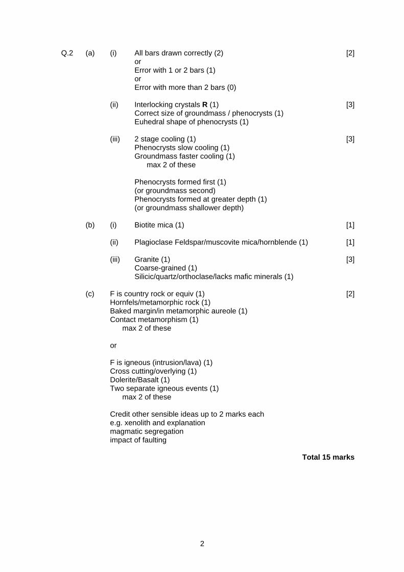
GL1
Q.1 (a) (i) to show dextral movement (1) [1] i.e. to SE on NE side, and to NW on SW side
(ii) A Divergent 3 correct = 2 marks [2] 1 or 2 correct = 1 mark
B Convergent
C Conservative (b) (i) plate movement in opposite directions/past each other (1) [3] stress build up (1) friction (1) stress release (1) (ii) deeper from X to Y (1) [3] plate subducts to Y (East) (1) point where 2 plates meet therefore deeper toY (or equivalent) (1) (c) (i) A (1) [1] (ii) Partial Melting (1) [2] of upper mantle/peridotite/ultramafic rock (1) (d) increase in width (1) [3] reference to spreading ridge/divergent plate boundary/ sea floor spreading (1) addition of lithosphere at spreading centre (1) Credit other sensible ideas (e) Decrease in size of Juan de Fuca plate (1) [2] Rate of subduction greater than rate of spreading of plate (1) Total 17 marks
2
Q.2 (a) (i) All bars drawn correctly (2) [2] or Error with 1 or 2 bars (1) or Error with more than 2 bars (0) (ii) Interlocking crystals R (1) [3] Correct size of groundmass / phenocrysts (1) Euhedral shape of phenocrysts (1) (iii) 2 stage cooling (1) [3]
Phenocrysts slow cooling (1) Groundmass faster cooling (1) max 2 of these
Phenocrysts formed first (1) (or groundmass second) Phenocrysts formed at greater depth (1) (or groundmass shallower depth) (b) (i) Biotite mica (1) [1] (ii) Plagioclase Feldspar/muscovite mica/hornblende (1) [1] (iii) Granite (1) [3] Coarse-grained (1) Silicic/quartz/orthoclase/lacks mafic minerals (1) (c) F is country rock or equiv (1) [2] Hornfels/metamorphic rock (1)
Baked margin/in metamorphic aureole (1) Contact metamorphism (1) max 2 of these or F is igneous (intrusion/lava) (1) Cross cutting/overlying (1) Dolerite/Basalt (1) Two separate igneous events (1) max 2 of these
Credit other sensible ideas up to 2 marks each e.g. xenolith and explanation magmatic segregation impact of faulting Total 15 marks
3
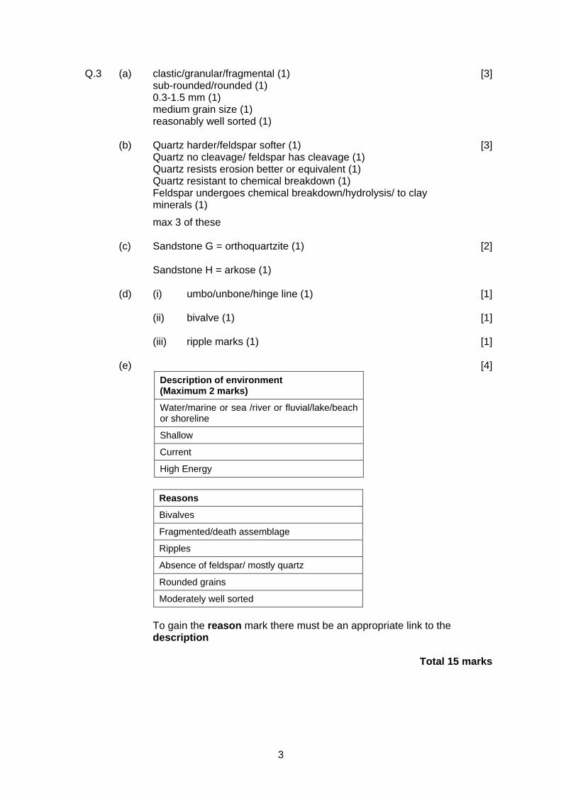
Q.3 (a) clastic/granular/fragmental (1) [3] sub-rounded/rounded (1)
0.3-1.5 mm (1) medium grain size (1) reasonably well sorted (1)
(b) Quartz harder/feldspar softer (1) [3]
Quartz no cleavage/ feldspar has cleavage (1) Quartz resists erosion better or equivalent (1) Quartz resistant to chemical breakdown (1) Feldspar undergoes chemical breakdown/hydrolysis/ to clay minerals (1)
max 3 of these (c) Sandstone G = orthoquartzite (1) [2] Sandstone H = arkose (1) (d) (i) umbo/unbone/hinge line (1) [1] (ii) bivalve (1) [1] (iii) ripple marks (1) [1] (e) [4]
Description of environment (Maximum 2 marks)
Water/marine or sea /river or fluvial/lake/beach or shoreline
Shallow
Current
High Energy
Reasons
Bivalves
Fragmented/death assemblage
Ripples
Absence of feldspar/ mostly quartz
Rounded grains
Moderately well sorted
To gain the reason mark there must be an appropriate link to the description
Total 15 marks
4
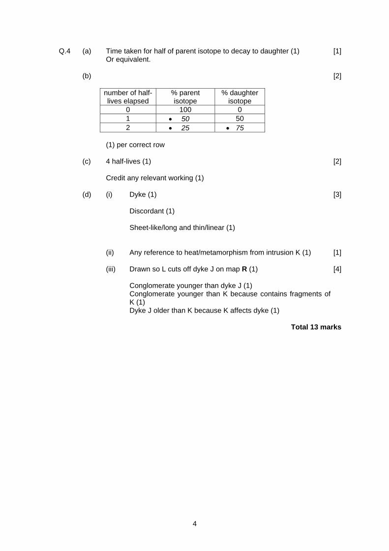
Q.4 (a) Time taken for half of parent isotope to decay to daughter (1) [1] Or equivalent.
(b) [2]
number of half- lives elapsed
% parent isotope
% daughter isotope
0 100 0 1 • 50 50 2 • 25 • 75
(1) per correct row (c) 4 half-lives (1) [2] Credit any relevant working (1) (d) (i) Dyke (1) [3] Discordant (1) Sheet-like/long and thin/linear (1) (ii) Any reference to heat/metamorphism from intrusion K (1) [1] (iii) Drawn so L cuts off dyke J on map R (1) [4]
Conglomerate younger than dyke J (1) Conglomerate younger than K because contains fragments of
K (1) Dyke J older than K because K affects dyke (1)
Total 13 marks
5
GL3
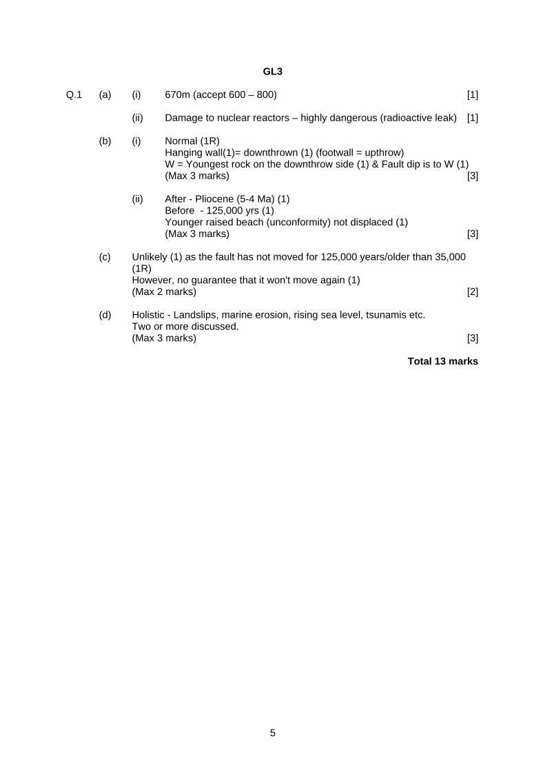
Q.1 (a) (i) 670m (accept 600 – 800) [1] (ii) Damage to nuclear reactors – highly dangerous (radioactive leak) [1] (b) (i) Normal (1R) Hanging wall(1)= downthrown (1) (footwall = upthrow) W = Youngest rock on the downthrow side (1) & Fault dip is to W (1) (Max 3 marks) [3] (ii) After - Pliocene (5-4 Ma) (1) Before - 125,000 yrs (1) Younger raised beach (unconformity) not displaced (1) (Max 3 marks) [3] (c) Unlikely (1) as the fault has not moved for 125,000 years/older than 35,000
(1R) However, no guarantee that it won't move again (1) (Max 2 marks) [2] (d) Holistic - Landslips, marine erosion, rising sea level, tsunamis etc. Two or more discussed. (Max 3 marks) [3] Total 13 marks
6
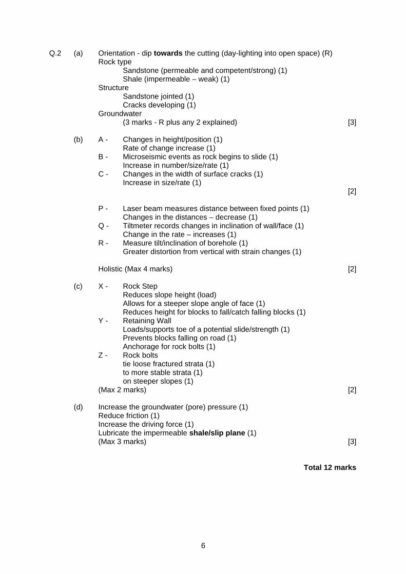
Q.2 (a) Orientation - dip towards the cutting (day-lighting into open space) (R) Rock type Sandstone (permeable and competent/strong) (1) Shale (impermeable – weak) (1) Structure Sandstone jointed (1) Cracks developing (1) Groundwater (3 marks - R plus any 2 explained) [3] (b) A - Changes in height/position (1) Rate of change increase (1) B - Microseismic events as rock begins to slide (1) Increase in number/size/rate (1) C - Changes in the width of surface cracks (1) Increase in size/rate (1) [2] P - Laser beam measures distance between fixed points (1) Changes in the distances – decrease (1) Q - Tiltmeter records changes in inclination of wall/face (1) Change in the rate – increases (1) R - Measure tilt/inclination of borehole (1) Greater distortion from vertical with strain changes (1) Holistic (Max 4 marks) [2] (c) X - Rock Step Reduces slope height (load) Allows for a steeper slope angle of face (1) Reduces height for blocks to fall/catch falling blocks (1) Y - Retaining Wall Loads/supports toe of a potential slide/strength (1) Prevents blocks falling on road (1) Anchorage for rock bolts (1) Z - Rock bolts tie loose fractured strata (1) to more stable strata (1) on steeper slopes (1) (Max 2 marks) [2] (d) Increase the groundwater (pore) pressure (1) Reduce friction (1) Increase the driving force (1) Lubricate the impermeable shale/slip plane (1) (Max 3 marks) [3] Total 12 marks
7
Q.3 (a) Describe the geological factors which control the pathways that landfill pollutants (leachate and gas) will take in the event of their leakage from a landfill site.
Rate of movement and direction of a pollution plume from a landfill site
depends upon Permeability &/or Porosity, structure (dip of bedding and joints/faults)
POROSITY depends upon gaps between grains large/interconnected
Primary and secondary porosity depends upon Packing of grains - cubic v rhombic Fracture/joint spacing Shape/orientation of grains - angular v rounded Sorting of grains - small fit in between larger Cementation
PERMEABILITY depends upon
Connectivity of pores Size of pores Joints and fractures
STRUCTURE
Interconnected joints, faults, fractures, solution cavities. Dip direction. Examples – limestone, sandstone, fractured/jointed igneous and met rock Case studies given credit [15]
(b) Explain the measures needed to change an abandoned sandstone quarry into
a landfill site and to reduce the dangers from decomposing domestic waste. Site must be capable of retaining waste - sandstone permeable
(fractures/joints/porous)
Permanent containment – clay lining by compaction of clay, plastic/geomembrane Careful monitoring of hydrological system – wells outside landfill Venting of methane gas – boreholes within the landfill Leachate management system – porous pipes for removal/recycling of leachate Holistic approach (max 10 marks) [10]
Total 25 marks
8
Q.4 (a) Describe
(i) two potential benefits (ii) two potential hazards
of living in an active volcanic region, dominated by frequent basaltic
eruptions. (i) Good soils Geothermal power Tourism Any two stated (2 marks) Other (e.g. mineral water -Volvic) Described and developed and/or using examples (3 marks) (Max 5 marks) (ii) Holistic Hazards associated with type of magma – mafic. Expect lava flows,
ash, gases, lahars Basaltic magma (less silica – less viscous) – divergent plate Non-viscous - Fluid - fast moving (initially few km/hr, cooler at front of flow thus more viscous) - less warning but rarely kill (except - Nyirongongo,
Zaire in 1971) - flows further - more hazard to property on lower
slopes - hotter initially Hazards associated with ash and gases relating to agricultural land,
roads, bridges and buildings. Also accept earthquake, tsunamis. (Not pyroclastic flows, blast/explosion or max 7) Examples (Etna, Nyiragongo, Iceland, Hawaii etc.) (Max10 marks) [15] (b) Using case studies, discuss the effectiveness of some of the measures used
to minimise loss of life and damage to property in volcanically active areas. Holistic approach relating to: Evacuation, hazard mapping, diversion/blocks, dropping – spraying with
water, explosion of flow margin, prediction methods. Ultimately little management/control if people choose to live near volcanoes. Case studies – Iceland, Etna, etc. credited. (Max. 10. No evaluation of effectiveness/case study – Max. 7) [10]
Total 25 marks
9
Q.5 (a) Describe how ground subsidence may be related to the extraction of (i) rock and minerals (ii) water (i) Rock and minerals Ground instability associated with Dip strata, rock cleavage, joint patterns Orientation of rock discontinuities Stable friction angles (35 degrees) Reduction of rock strength by undermining Associated with underground mining Surface expression of collapse Examples credited, e.g. coal and salt extraction (Max. 7 plus 1) (ii) Water Reduction of pore pressure Grains readjust position/packing – less volume Porosity reduced Examples associated with human extraction from wells and natural
extraction by vegetation (trees) (Max. 7 plus 1) [15] (b) Explain how the extraction of rock, minerals and water may result in the
pollution of surface water and groundwater. 1. Mine drainage pollution explained Pyrite/iron oxidised in acidic mine water Waste tipping – pollution effect of percolating water Potential leakage if hole used for landfill 2. Overpumping – contamination with saltwater explained Cones of exhaustion result in pressure difference which draws in
saline water in coastal areas [10] (Max 10 - 7 if only mention one) Total 25 marks
10
GL4
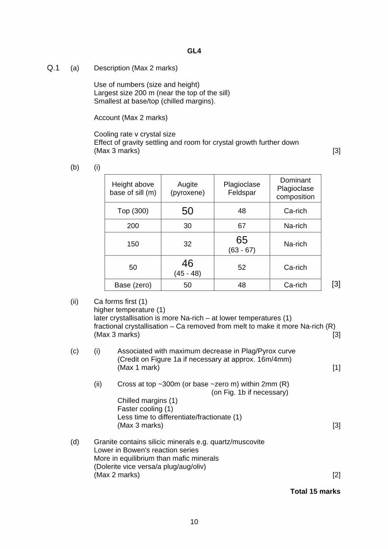
Q.1 (a) Description (Max 2 marks) Use of numbers (size and height) Largest size 200 m (near the top of the sill) Smallest at base/top (chilled margins). Account (Max 2 marks) Cooling rate v crystal size Effect of gravity settling and room for crystal growth further down (Max 3 marks) [3] (b) (i) [3] (ii) Ca forms first (1) higher temperature (1) later crystallisation is more Na-rich – at lower temperatures (1) fractional crystallisation – Ca removed from melt to make it more Na-rich (R) (Max 3 marks) [3]
(c) (i) Associated with maximum decrease in Plag/Pyrox curve (Credit on Figure 1a if necessary at approx. 16m/4mm) (Max 1 mark) [1] (ii) Cross at top ~300m (or base ~zero m) within 2mm (R)
(on Fig. 1b if necessary) Chilled margins (1) Faster cooling (1) Less time to differentiate/fractionate (1) (Max 3 marks) [3]
(d) Granite contains silicic minerals e.g. quartz/muscovite Lower in Bowen's reaction series More in equilibrium than mafic minerals (Dolerite vice versa/a plug/aug/oliv) (Max 2 marks) [2] Total 15 marks
Height above base of sill (m)
Augite (pyroxene)
Plagioclase Feldspar
Dominant Plagioclase composition
Top (300) 50 48 Ca-rich
200 30 67 Na-rich
150 32 65 (63 - 67)
Na-rich
50 46 (45 - 48)
52 Ca-rich
Base (zero) 50 48 Ca-rich
11
Q.2 (a) X = Sedimentary (1) Y = Igneous (1) (Max 2 marks) [2] (b) (i) Temp/Depth (1) 10°C km-1 (1) (Max 2 marks) [2] (ii) Line at 25°C km-1 [1] (iii) B (1) (mark C correct if erroneously drawn higher than B) Hornfels – Contact met (1) High temperature/Low pressure (1) (Max 3 marks) [3] (c) (i) Garnet porphyroblast correctly labelled [1] (ii) Large crystals (1) e.g. garnet (1) Finer groundmass (1) Mica (foliations) wrapped around garnet (1) (Max 3 marks) [3] (d) (i) Horizontal line (left-right) (1) [1] (ii) Holistic Schistosity different orientation to inclusions in garnet Indicates σ max has changed over time S-shaped nature of inclusions (suggesting continuing change) Accept porphyroblasts may have rotated (Max 2 marks) [2] Total 15 marks
12
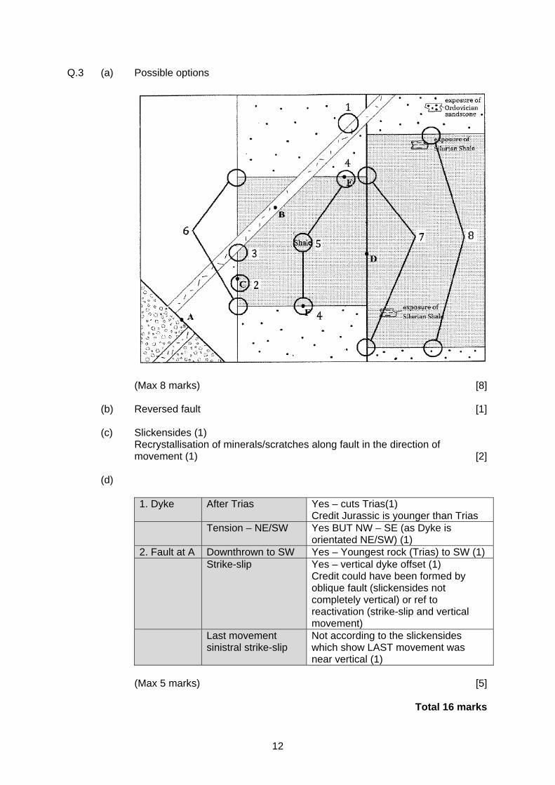
Q.3 (a) Possible options
(Max 8 marks) [8] (b) Reversed fault [1] (c) Slickensides (1) Recrystallisation of minerals/scratches along fault in the direction of
movement (1) [2]
(d)
1. Dyke After Trias Yes – cuts Trias(1) Credit Jurassic is younger than Trias
Tension – NE/SW Yes BUT NW – SE (as Dyke is orientated NE/SW) (1)
2. Fault at A Downthrown to SW Yes – Youngest rock (Trias) to SW (1) Strike-slip Yes – vertical dyke offset (1)
Credit could have been formed by oblique fault (slickensides not completely vertical) or ref to reactivation (strike-slip and vertical movement)
Last movement sinistral strike-slip
Not according to the slickensides which show LAST movement was near vertical (1)
(Max 5 marks) [5] Total 16 marks

13
Q.4 (a) [3] (b) (i) G = appropriate trough (15,000/135,000) (1) I = appropriate crest (Present/120,000) (1) (max 2 marks) [2] (ii) 18O is heavier than 16O More 16O is evaporated from the sea Returns via water cycle in interglacial – current 18O/16O ratio 16O locked in ice during glacial – ocean richer in 18O 18O/16O ratio is incorporated into the carbonate shells of forams (Holistic - max 3 marks) [3] (c) 1. Volcanism, respiration of biosphere, weathering of limestone (1) 2. Chemical weathering of silicate rock (photosynthesis) (1) (max 2 marks) (accept photosynthesism) [2] (d) (i) Direct correlation between CO2 and temperature variation Positive correlation – Increase in CO2 reflects temp increase/decrease
in ice. Numbers credited [2] (ii) Cause and effect not established Is CO2 the cause of ice age or vice versa Other contributory factors – ocean rifting, mountain building, Other greenhouse gases [2] N.B. - geological time, not industrial revolution Total 14 marks
Cycle Cycle length (years) Possible cause of Milankovitch cycle
A • ~100,000 (1) Eccentricity (variations in the shape of Earth's orbit)
B ~41,000 • Obliquity (variation
in tilt of Earth's axis) (1)
C • ~23,000 (1) Precession (variation in the wobble of Earth's axis)
14
Q.5 (a) (i) Hill Peat (1) [1] (ii) Erosion, cut by rivers/streams (1) [1] do not accept 'weathering' (b) (i) 1cm = 90 m thus 13 mm (1) × 90 m = 117 m (accept 112 m -122 m) (1) [2] (ii) 8 cm (1) × 25,000 = 200,000 cm or 2000 m or 2 km (1) [2] (accept 1975 m - 2025 m) (iii) Effect of topography (shallow to east)(1) Beds get thinner to west (1) Effect of dip (1) (max 2 marks) [2] (iv) Dip of beds to south (1) in a valley (1) [2] Total 10 marks
15
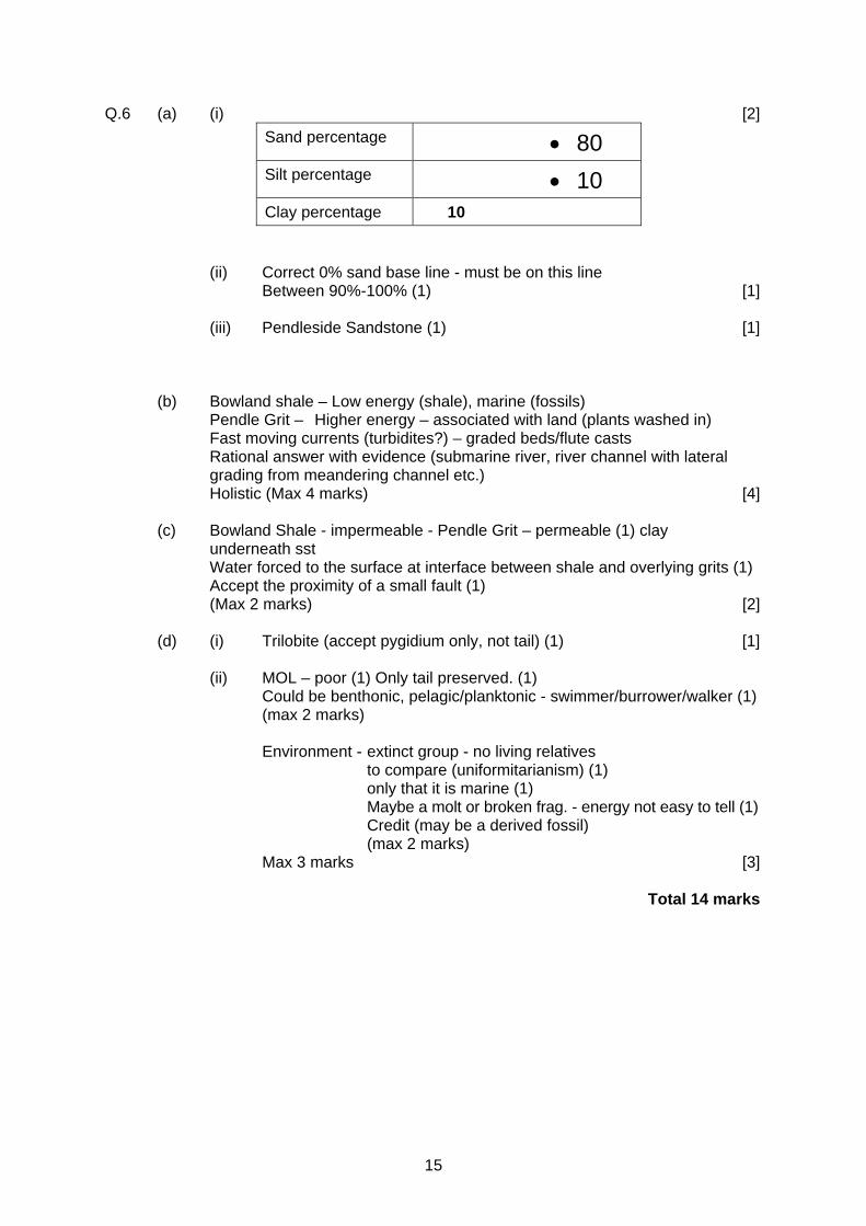
Q.6 (a) (i) [2] Sand percentage • 80 Silt percentage • 10 Clay percentage 10
(ii) Correct 0% sand base line - must be on this line Between 90%-100% (1) [1] (iii) Pendleside Sandstone (1) [1] (b) Bowland shale – Low energy (shale), marine (fossils) Pendle Grit – Higher energy – associated with land (plants washed in) Fast moving currents (turbidites?) – graded beds/flute casts Rational answer with evidence (submarine river, river channel with lateral
grading from meandering channel etc.) Holistic (Max 4 marks) [4] (c) Bowland Shale - impermeable - Pendle Grit – permeable (1) clay
underneath sst Water forced to the surface at interface between shale and overlying grits (1) Accept the proximity of a small fault (1) (Max 2 marks) [2] (d) (i) Trilobite (accept pygidium only, not tail) (1) [1] (ii) MOL – poor (1) Only tail preserved. (1) Could be benthonic, pelagic/planktonic - swimmer/burrower/walker (1) (max 2 marks) Environment - extinct group - no living relatives to compare (uniformitarianism) (1) only that it is marine (1) Maybe a molt or broken frag. - energy not easy to tell (1) Credit (may be a derived fossil) (max 2 marks) Max 3 marks [3]
Total 14 marks
16
Q.7 (a) Anticline/Antiform/Monochine (1) Plunging SW (1) [2] (b) Syncline to west (1) Plunging SW (1) [2] (c) Incorrect (1) (1 km = half wavelength measured between APT shown) Wavelength approx 2km (1) Need 2 peaks or 2 troughs to measure distance (1) (Max 2 marks) [2] Total 6 marks
Q.8 (a) Holistic Bowland Shale Group – shale Overlain by Boulder Clay Impermeable Less leakage Valley bottom – catchment Stable, very little faulting in area (max 3) [3] (b) Holistic
• Rock type : High. Permeable Pendle grit overlies impermeable Upper Bowland Shale. (max 2) • Dip (angle and direction) of beds Low. Beds dip INTO the hill and too shallow (re stable angle). (max 2) • Steepness of the slope High. Contours close together. Allows material to flow more easily down over steepened slope. (max 1) • Local groundwater conditions High. Evidence of spring and stream associated with each landslip. Shale unstable when wet. (max 2)
• Faulting Low. Not in the case of more northern landslip (though credit southern slip as showing a small fault near spring). Faults may not be mapped. (max 2) (Max 7 marks) [7]
Max 10 marks
17
GL5
Unit 1 - Quaternary Geology
Q.1 (a) (i) Scarp and vale, valleys & ridges, cuesta (1) [1] (ii) Limstones/conglomerates harder than shale (1) more resistant to
erosion (1) Dipping strata (1) [2] (iii) Boundary between permeable & impermeable beds (1) water table (1) [2] (b) (i) lens shaped / other reasonable description of its shape (1) dimension(s) e.g. width 20 m (1) [2] (ii) Reef (1) contains colonial coral (1) massive (1) fossil diversity (1) [3] (iii) Fossils e.g. corals accumulate on the sea floor / death (or life)
assemblage / calcite precipitated / by algae / or saturated warm seas / between fossils / burial.
Holistic mark (3) [3] (c) Figure 1a - untrue - sea level fluctuates / alternation between limestone and
shale. Figure 1b - true - reef is covered by lagoonal sediments / shale is deeper
water sediment. Holistic mark. (4) [3]
18
Q.2 Evaluate the statement: "The Glacial and Interglacial deposits and landforms in Britain provide an incomplete
record of climatic fluctations and varying sedimentary environments for the Quaternary" [25]
Descriptions - up to 19 marks :
Glacial
Landforms related to glacial erosion. Cwm (corrie/cirque), arête, hanging valley, glacial trough, roche moutonee etc.
related to glacial deposition. Moraines (terminal, recessional) drumlins, crag and tail. Deposits – Till. Erratics
Interglacial Limestone Pavements. Formation of Peat. Fossil content.
Evaluation - 20+ marks : Landforms and deposits indicate that climate change must have occurred but they are limited in the data they provide. May be fragmentary. Erosion / no deposition leaves incomplete record. Very difficult to date. Landforms and deposits do indicate changes to the sedimentary environments during the Quaternary. Need other information such as fossils for reconstruction of the climate Sediments from a marine deposit give a more continuous record.
19
Q.3 (a) Describe the evidence for sea level change during the Quaternary. (b) "Sea level change in the Quaternary is linked to continental ice sheets."
Evaluate this statement. [25]
Descriptions - up to 19 marks : (a) Raised beaches, inland sea clifs, river terraces etc.
Submerged features (rias/fjords, submerged forests.) Oxygen isotopes.
Evaluation - 20+ marks : (b) Isostatic sea level change in response to mass of ice locally on the
continents, displacing the mantle. Isostatic change is localised phenomenon that can be more directly related to local quantity of continental ice.
Eustatic sea level changes in response to changing volumes of continental ice. Evidence can be derived from oxygen isotopes for a global quantity of continental ice. Superimposition of the two changes (and their differing rates) create the landforms and evidence seen today. Melting sea ice causes no change in volume. Melting continental ice adds to volume of water in oceans. Tectonic activity (such as in Alaska) can cause sea level change unrelated to continental ice sheets. Also climate warming causes thermal expansion.
20
Q.4. (a) Describe turbidity currents how they are caused. (b) Evaluate the use of the sediments and sedimentary structures in interpreting
the physical processes that lead to the formation of turbidites. [25]
Descriptions - up to 19 marks : (a) High density fluid (mixture of sediment and water) flows beneath less-dense
fluid (clear seawater). Flows down continental slope under gravity at high speed (~100 kmh-1).
Accumulation of sediment on continental shelf. Often offshore from major
river mouths. Sediment becomes unstable (earthquakes, volcanic eruptions, mass movement, storms).
Evaluation - 20+ marks : (b) Graded bedding, repeated cycles of sedimentation, Bouma sequences, flat laminations and cross bedding all give good data on the cyclic changes of energy. Flute casts, cross bedding and sole structures (prod/bounce/groove marks
and flute casts) can give good indication of flow direction. Convolute bedding and load casts only give an indication of the post-depositional processes as the sediments de-water.
21
GL5
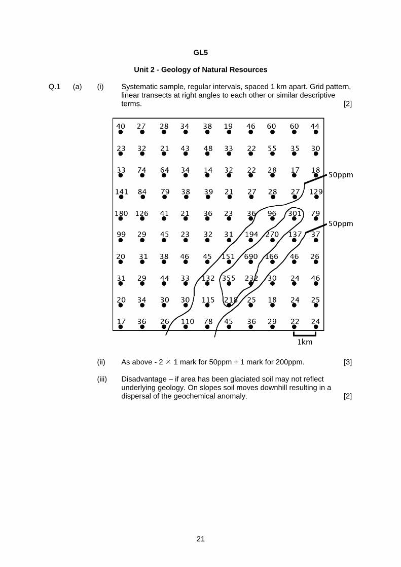
Unit 2 - Geology of Natural Resources Q.1 (a) (i) Systematic sample, regular intervals, spaced 1 km apart. Grid pattern,
linear transects at right angles to each other or similar descriptive terms. [2]
(ii) As above - 2 1 mark for 50ppm + 1 mark for 200ppm. [3] (iii) Disadvantage – if area has been glaciated soil may not reflect
underlying geology. On slopes soil moves downhill resulting in a dispersal of the geochemical anomaly. [2]
22
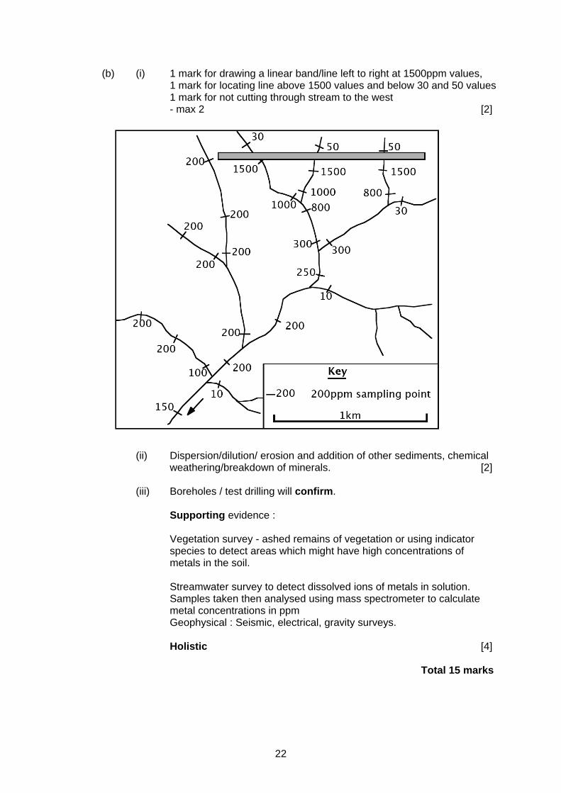
(b) (i) 1 mark for drawing a linear band/line left to right at 1500ppm values, 1 mark for locating line above 1500 values and below 30 and 50 values 1 mark for not cutting through stream to the west - max 2 [2]
(ii) Dispersion/dilution/ erosion and addition of other sediments, chemical
weathering/breakdown of minerals. [2]
(iii) Boreholes / test drilling will confirm.
Supporting evidence : Vegetation survey - ashed remains of vegetation or using indicator species to detect areas which might have high concentrations of metals in the soil. Streamwater survey to detect dissolved ions of metals in solution. Samples taken then analysed using mass spectrometer to calculate metal concentrations in ppm Geophysical : Seismic, electrical, gravity surveys. Holistic [4]
Total 15 marks
23
Q.2. Descriptions - up to 19 marks :
Importance of water – sources: magmatic, meteoric, groundwater, seawater. Igneous – pegmatites, porphyry copper, hydrothermal, black smokers. Sedimentary – Residual deposits. Placer deposits. Banded Ironstone Formations. Evaporites. Evaluation - 20+ marks : Other factors important not just water: source of elements, tectonic setting, geothermal gradient, rock type, rock structure, climate, relief, sea level etc.
Q.3 Descriptions - up to 19 marks :
Planktonic life in surface waters of oceans. Source rock - clay/shale, organic content. Reservoir Rock - porosity/permability. Cap rock-impermeable clay/shale. Depth / temperature and length of time buried-formation of kerogen. Oil window. Traps - anticline, fault, unconformity, salt domes. Evaluation - 20+ marks : Source rock, reservoir rock, cap rock and trap ALL essential for commercial accumulation.
Q.4 Descriptions - up to 19 marks :
(a) Explanation depends upon case study of raw material. Coal extraction by deep mining/open cast. Salt extraction by brine pumping / underground mining. Offshore / onshore oilfield development. Quarrying for roadstone / aggregate /sand and gravel extraction.
Evaluation - 20+ marks : (b) Potential environmental problems e.g. Noise, dust, pollution of water courses
by chemical/waste, waste disposal etc and the ways by which these may be minimised. e.g. restricted blasting, baffle banks, settling tanks, backfill etc.
How significant are the problems and the way(s) that they are minimised ?
Case studies to show planning to satisfy local or national legislation for maximum levels of pollution.
24
GL5
Unit 3 - Geological Evolution of Britain Q.1 (a) inclination gets steeper towards the poles [1] positive values in the northern hemisphere (needles point into the ground) negative values in the southern hemisphere (needles point up in the air [1]
(b) (i) 60ºS [1]
(ii) -50º [1] (c) (i) ONE choice = fossil / limestone / erosional surface [1] Explanation to match choice [2]
(ii) ONE choice = black shales / graptolites / turbidites / volcanics [1] Explanation to match choice [2]
(d) (i) correct position of line approx NE-SW [1]
(ii) palaeomagntism – Wales and Scotland/plates separated fossils - separate provinces / benthos cannot cross ocean
sediments – deep oceanic between continental shelves Holistic [4]
Total 15 marks
Q.2 (a) Describe the location and large-scale geology of the Variscan orogenic belt in
the British area. Evaluate the extent to which the geology of the Variscan orogenic belt enables are construction of the plate tectonic setting in which it developed.
(b) Evaluate the extent to which the geology of the Variscan orogenic belt enables a reconstruction of the plate tectonic setting in which it developed.
Descriptions - up to 19 marks :
Location - main effects in SW Britain. Ages - Devonian Carboniferous rocks. Trend of structures mainly E-W but variable further north e.g. N-S Pennine anticline. Tight vertical and overturned folding to SW. Lizard thrust. Obduction of ophiolites. Deformation less intense further north. Preservation of coalfields in synclinal basins. Low grade regional metamorphism slate grade in SW. Granitic batholiths and associated mineralisation in Cornwall. Related vulcanicity elsewhere in Britain - Whin sill. Evaluation - 20+ marks :
Thrusting / ophiolites consistent with desctructive plate margin. N-S compression producing E W trending structures. SW Britain nearer centre of collision zone with more intense deformation/ metamorphism. Melting of continental crust or mantle wedge followed by crystal fractionation and crustal assimilation to explain the batholith. Lizard ophiolites and not typical (age and chemistry.) Lack of andesitic volcanics. Where have all the mountains gone ?
Total 25 marks
25
Q.3 (a) With reference to examples from the British stratigraphic column, explain how sedimentary rocks and their contained fossils may be used to interpret fluvial and deltaic environments of deposition.
(b) Evaluate the reliability of the evidence.
Descriptions - up to 19 marks : Fluvial (Devonian//Carboniferous/Triassic.) Meandering river systems - fining upwards cycles, river channel, floodplain, small scale cross bedded sandstones. Flash flood conglomerates/breccias (alluvial fans/wadi. Fossil fresh water fish, bivalves, plants. Haematite - oxidising conditions. Deltaic (Coal measures/Millstone Grit.) Coal, seatearth, fossil soil, swamp. Deltaic sediments – coarsening upwards cycles. Abundant plant material. Fossil insects/amphibians. Evaluation - 20+ marks : Interpretation depends on uniformitarianism the reliability of which diminishes with the age of sediments and fossils. Some sedimentary facies can be interpreted in different ways. Cross-bedding, red beds, shales, and fossils all open to interpretation. Could argue a delta is a number of rivers so not easy to distinguish unless have large amount of spacial data.
Total 25 marks Q.4 (a) Describe the igneous rocks and structures of the Tertiary Igneous Province of
northwest Scotland and northern Ireland. (b) The igneous rocks and structures of the Tertiary Igneous Province have been
interpreted as being associated with the opening of the North Atlantic. Evaluate this statement.
Descriptions - up to 19 marks : Late Cretaceous /Tertiary abundant igneous activity in NW Britain. Basaltic volcanic activity and associated gabbroic and granitic centres of igneous activity Flood basalts. Plutons. Dyke swarms. Sills. Columnar jointing. Locations. Evaluation - 20+ marks Mantle plume develops beneath north west UK and Greenland. Rifting and development of spreading centre, opening of North Atlantic. Large volume of basalt associated with mantle plumes. Hot spot trail to Iceland. Mid ocean ridge still active. Evidence of tension (dykes etc) Trend of dyke swarms a problem. Later granitic intrusions due to melting of continental crust. Backed up by polar wandering curves.
Total 25 marks
26
GL5
Unit 4 - Geology of the Lithosphere Q.1 (a) (i) σx = max (1) σy = min (1) [2] (ii) A : folded / shortened B : pulled apart (boudinage) / extended compression v tension [3] (b) Best of the 3 given as L shows elastic / plastic behaviour and then
failure consistent with A and B in Fig 1a. Use of test not a good choice. Restricted application. Are temperatures, pressures and time accurate ? [3] (c) (i) 10 (1) (Only one which) intersects the temperature range within the pressure
range. (All 3 coincide.) ( 2 valid points relating to T and P) [3] (ii) actual intersection of GTG with T / where all 3 coincide (1) therefore good (1) or: not good because of estimates (1) [2] (iii) subduction zone low GTG / lower than stable crust / cold water / ocean floor [2] Total 15 marks Q.2 Descriptions - up to 19 marks : (a) Island arc subduction. Oceanic / oceanic collision. Trench. Subduction zone.
Relative density / age of oceanic plate. (b) Cordilleran. Oceanic / continental. Trench. Orogentic belt. For either / both : increase in temperature with depth; water content lowers
M.Pt. etc Evaluation - 20+ marks : Theoretically: island arcs = basalts = just oceanic lithosphere. cordillera = andesites = oceanic + continental lithosphere. In practice : contamination / differentiation etc potentially "ALL" types at both
locations.
27
Q.3 Descriptions - up to 19 marks : (a) Layers 1, 2 and 3. Layer 1 sediments. (b) Sedimentary stratification / metamorphic foliation / igneous limited
(pyroclastics / lavas). Examples. Larger scale layering / sedimentary cover of metamorphics, migmatites and
igneous base to continental crust. (Conrad discontinuity ?) Sedimentary upper layer of variable thickness. Sedimentary basins. Evaluation - 20+ marks : (a) confined to Layer 1. Thicken away from MOR. Quantitatively insignificant. (b) primary stratification / secondary foliation (latter may obliterate former). Q.4 Descriptions - up to 19 marks : (a) Example(s).Older rock surrounded by or adjacent to younger rocks. Africa and North America provide examples. Britain older to NW and younger
to the SE. Evaluation - 20+ marks :
(b) Continents "grow" due to obduction at DPM. Younger material is obducted onto older material. Destructive plate margins. Essentially older material in the centre / progressively younger outwards (e.g. North America). Obduction may not be from all sides and continents may be split due to plate tectonics (e.g. Britain.) Wilson Cycle.
28
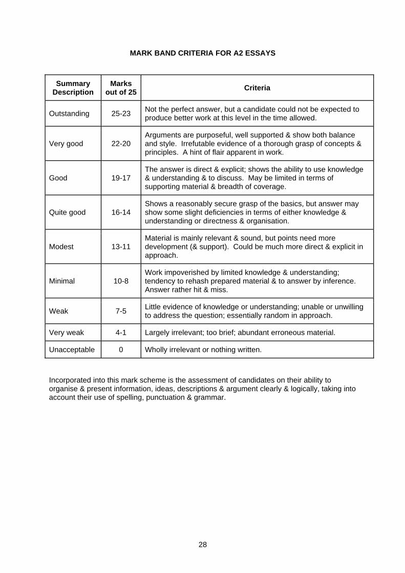
MARK BAND CRITERIA FOR A2 ESSAYS
Summary Description
Marks out of 25 Criteria
Outstanding 25-23 Not the perfect answer, but a candidate could not be expected to produce better work at this level in the time allowed.
Very good 22-20 Arguments are purposeful, well supported & show both balance and style. Irrefutable evidence of a thorough grasp of concepts & principles. A hint of flair apparent in work.
Good 19-17 The answer is direct & explicit; shows the ability to use knowledge & understanding & to discuss. May be limited in terms of supporting material & breadth of coverage.
Quite good 16-14 Shows a reasonably secure grasp of the basics, but answer may show some slight deficiencies in terms of either knowledge & understanding or directness & organisation.
Modest 13-11 Material is mainly relevant & sound, but points need more development (& support). Could be much more direct & explicit in approach.
Minimal 10-8 Work impoverished by limited knowledge & understanding; tendency to rehash prepared material & to answer by inference. Answer rather hit & miss.
Weak 7-5 Little evidence of knowledge or understanding; unable or unwilling to address the question; essentially random in approach.
Very weak 4-1 Largely irrelevant; too brief; abundant erroneous material.
Unacceptable 0 Wholly irrelevant or nothing written. Incorporated into this mark scheme is the assessment of candidates on their ability to organise & present information, ideas, descriptions & argument clearly & logically, taking into account their use of spelling, punctuation & grammar.

29
QUICK GUIDE
Description K / U Discussion Terminology
Outstanding 23-25 Not perfect BUT Thorough
Very good 20-22 Thorough grasp Well supported. Hint of flair + EVALUATION Sound
Good 17-19 Direct/explicit Limited support - breadth. Lacks detail - depth Significant
Quite Good 14-16 Basics Slight deficiencies. Limited scope relevance Basic
Modest 11-13 Mainly relevant Needs much more development
Minimal 8-10 Limited/rehash Hit and miss Little
Weak 5-7 Little evidence Question not addressed
Very Weak 1-4 Irrelevant/erroneous Too brief
Unacceptable 0 Thus key dividing lines are:
Outstanding - Across the board – no significant weaknesses
Very good - EVALUATION
Good - Good read - some omissions in content/detail/discussion
Quite Good - Essay title has been addressed but not a convincing argument
Modest - Bit difficult to follow. Do they really know? Addressed the question but need much more discussion = mark scheme
Minimal/Weak/Very Weak - Rehash at best - irrelevant material/no essay to mark/mark per point ?

WJEC 245 Western Avenue Cardiff CF5 2YX Tel No 029 2026 5000 Fax 029 2057 5994 E-mail: [email protected] website: www.wjec.co.uk