gef minor loan scientific report 1001gef.nerc.ac.uk/documents/report/1001.pdf · gef minor loan...
TRANSCRIPT
GEF Minor Loan Scientific Report 10012015
Quantifying the action of debris flows in the Westfjords of Iceland: Hazard and Geomorphic Change
Susan J Conway1, Hazel Rymer2
1 Dept. Physical Sciences, Open University, Walton Hall, Milton Keynes, MK7 6AA. UK 2 Dept. Earth Environment and Ecosystems, Open University, Walton Hall, Milton Keynes, MK7 6AA. UK
Summary The slopes above Ísafjörður town in NW Iceland are well-known for active debris flows: mobile slurries of rock and mud that propagate downslope and can be destructive. This loan formed part of an ongoing project to understand the behaviour of these flows, hence allowing us to better quantify the risk, and also to better understand landscape change since the last glacial maximum. This loan was requested to support NERC ARSF (IG13/11) and NERF FSF deployments to Ísafjörður in Iceland in July-August 2013.
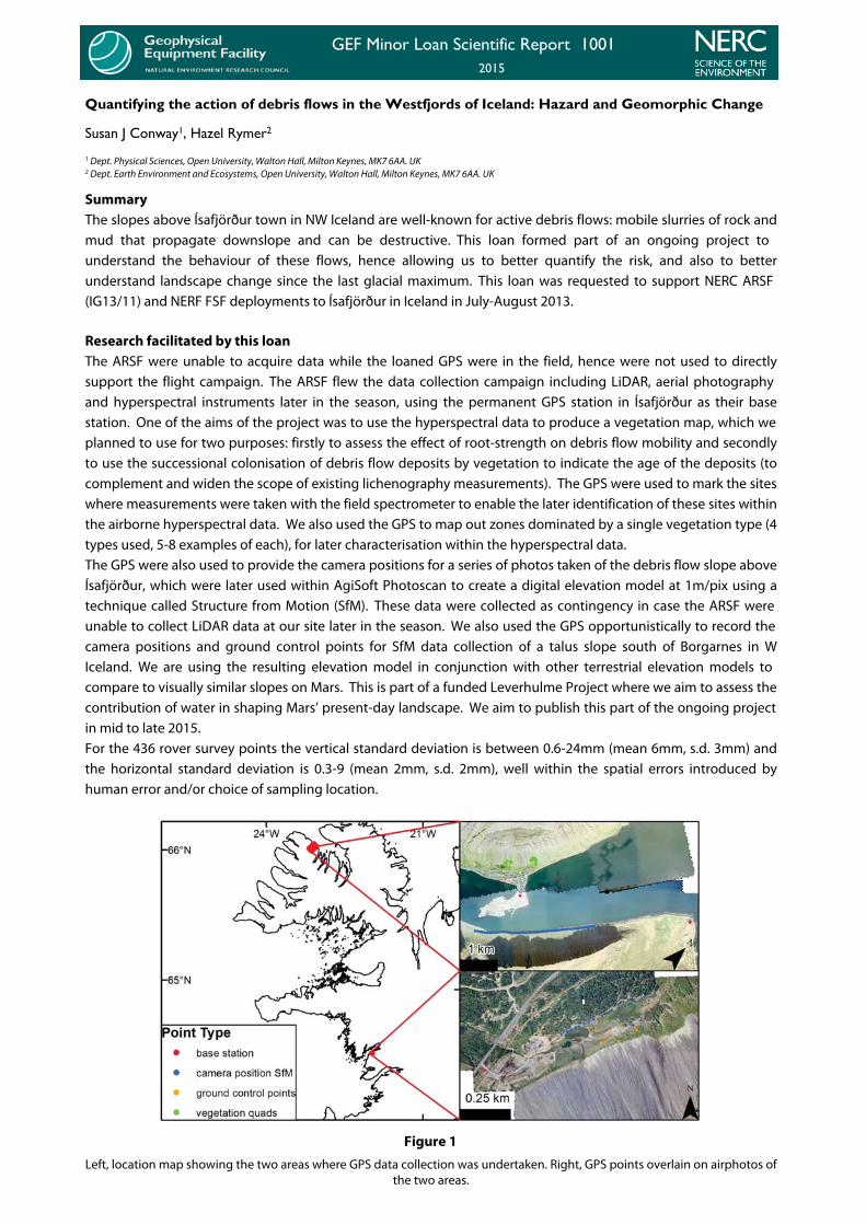
Research facilitated by this loan The ARSF were unable to acquire data while the loaned GPS were in the field, hence were not used to directly support the flight campaign. The ARSF flew the data collection campaign including LiDAR, aerial photography and hyperspectral instruments later in the season, using the permanent GPS station in Ísafjörður as their base station. One of the aims of the project was to use the hyperspectral data to produce a vegetation map, which we planned to use for two purposes: firstly to assess the effect of root-strength on debris flow mobility and secondly to use the successional colonisation of debris flow deposits by vegetation to indicate the age of the deposits (to complement and widen the scope of existing lichenography measurements). The GPS were used to mark the sites where measurements were taken with the field spectrometer to enable the later identification of these sites within the airborne hyperspectral data. We also used the GPS to map out zones dominated by a single vegetation type (4 types used, 5-8 examples of each), for later characterisation within the hyperspectral data. The GPS were also used to provide the camera positions for a series of photos taken of the debris flow slope above Ísafjörður, which were later used within AgiSoft Photoscan to create a digital elevation model at 1m/pix using a technique called Structure from Motion (SfM). These data were collected as contingency in case the ARSF were unable to collect LiDAR data at our site later in the season. We also used the GPS opportunistically to record the camera positions and ground control points for SfM data collection of a talus slope south of Borgarnes in W Iceland. We are using the resulting elevation model in conjunction with other terrestrial elevation models to compare to visually similar slopes on Mars. This is part of a funded Leverhulme Project where we aim to assess the contribution of water in shaping Mars’ present-day landscape. We aim to publish this part of the ongoing project in mid to late 2015. For the 436 rover survey points the vertical standard deviation is between 0.6-24mm (mean 6mm, s.d. 3mm) and the horizontal standard deviation is 0.3-9 (mean 2mm, s.d. 2mm), well within the spatial errors introduced by human error and/or choice of sampling location.
Figure 1
Left, location map showing the two areas where GPS data collection was undertaken. Right, GPS points overlain on airphotos of the two areas.

Outcomes The airborne hyperspectral data analysis is yet to be completed, but is likely to contribute to a publication for a special issue in 'Géomorphologie: reliefs, processus, environnements' to be published in early 2016. We are using the SfM elevation model in conjunction with other terrestrial elevation models to compare to visuallysimilar slopes on Mars. This is part of a funded Leverhulme Project where we aim to assess the contribution of water in shaping Mars’ present-day landscape. We aim to publish this part of the ongoing project in mid to late 2016.
Data archiving The data from this project are being archived on the Open University's dedicated research servers.
References N/A
NERC Geophysical Equipment Facility - View more reports on our website at http://gef.nerc.ac.uk/reports.php