gen 2. tables and codes - dinacia.gub.uy
TRANSCRIPT
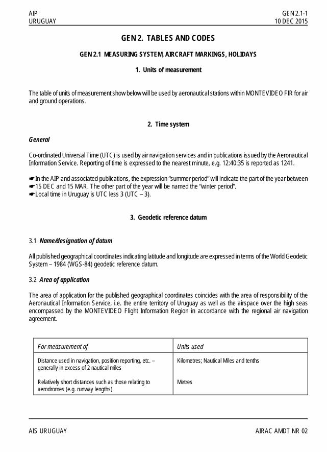
AIP GEN 2.1-1 URUGUAY 10 DEC 2015 GEN 2. TABLES AND CODES GEN 2.1 MEASURING SYSTEM, AIRCRAFT MARKINGS, HOLIDAYS 1. Units of measurement The table of units of measurement show below will be used by aeronautical stations within MONTEVIDEO FIR for air and ground operations. 2. Time system General Co-ordinated Universal Time (UTC) is used by air navigation services and in publications issued by the Aeronautical Information Service. Reporting of time is expressed to the nearest minute, e.g. 12:40:35 is reported as 1241. !In the AIP and associated publications, the expression “summer period” will indicate the part of the year between !15 DEC and 15 MAR. The other part of the year will be named the “winter period”. !Local time in Uruguay is UTC less 3 (UTC – 3). 3. Geodetic reference datum 3.1 Name/designation of datum All published geographical coordinates indicating latitude and longitude are expressed in terms of the World Geodetic System – 1984 (WGS-84) geodetic reference datum. 3.2 Area of application The area of application for the published geographical coordinates coincides with the area of responsibility of the Aeronautical Information Service, i.e. the entire territory of Uruguay as well as the airspace over the high seas encompassed by the MONTEVIDEO Flight Information Region in accordance with the regional air navigation agreement.
For measurement of
Units used
Distance used in navigation, position reporting, etc. – generally in excess of 2 nautical miles Relatively short distances such as those relating to aerodromes (e.g. runway lengths)
Kilometres; Nautical Miles and tenths Metres
AIS URUGUAY AIRAC AMDT NR 02

GEN 2.1-2 AIP 05 NOV 1998 URUGUAY
For measurement of
Units used
Altitudes, elevations and heights Horizontal speed including wind speed Vertical speed Wind direction for landing and taking off Wind direction except for landing and taking off Visibility including runway visual range Altimeter setting Temperature Weight Time
Metres; Feet Kilometres/Hour; Knots Metres/Second; Feet per minute Degrees Magnetic Degrees True Kilometres or metres Hectopascals Degrees Celsius Metric tones or Kilogrammes Hours and minutes, beginning at midnight UTC
3.3 Use of an asterisk to identify published geographical coordinates An asterisk (*) will be used to identify those published geographical coordinates which have been transformed into WGS-84 coordinates but whose accuracy of original field work does not meet the requirements in Annex 11, Chapter 2 and Annex 14, Volumes I and II, Chapter 2. Specifications for determination and reporting of WGS-84 coordinates are given in Annex 11, Chapter 2 and in Annex 14, Volumes I and II, Chapter 2. 4. Aircraft nationality and registration marks The nationality mark for aircraft registered in Uruguay is the letter CX. The nationality mark is followed by a hyphen and a registration mark consisting of 3 letters, e.g. CX-AAA. 5. Public holidays
Name Date/Day New Year’s Day 01 JAN Children Day 06 JAN * Carnival 40 days before Easter (Monday and Tuesday) Easter (From Monday to Friday)
Disembarkation of the 33 Orientals 19 APR AIRAC AIP/AMDT NR 02 AIS URUGUAY

AIP GEN 2.1-3 URUGUAY 05 NOV 1998 Labour Day 01 MAY Las Piedras Battle 18 MAY
Artigas birthday 19 JUN Constitution day 18 JUL * Independence day 25 AUG America’s day 12 OCT All Soul’s day 02 NOV
Christmas Eve 25 DEC Note: The public holidays are not labor days, but for private companies the ones marked by asterisk (*) are optional. AIS URUGUAY AIRAC AIP/AMDT NR 02

IIINNNTTTEEENNNTTTIIIOOONNNAAALLLLLLYYY LLLEEEFFFTTT BBBLLLAAANNNKKK

AIP GEN 2.2-1 URUGUAY 02 JAN 2017 GEN 2.2 ABBREVIATIONS USED IN AIS PUBLICATIONS
A A Amber AAA (or AAB, AAC, ... etc., in sequence) Amended meteorological message (message type designator) A/A Air-to-air AAD Assigned altitude deviation AAIM Aircraft autonomous integrity monitoring AAL Above aerodrome level !AAR Air to air refuelling ABI Advance boundary information ABC Abbreviations and codes ABM Abeam ABN Aerodrome beacon ABT About ABV… Above ... AC Altocumulus ACARS† (to be pronounced “AY-CARS”) Aircraft communication addressing and reporting system ACAS† Airborne collision avoidance system ACC+ Area control centre or area control ACCID Notification of an aircraft accident ACFT Aircraft ACK Acknowledge ACL Altimeter check location ACN Aircraft classification number ACP Acceptance (message type designator) ACPT Accept or accepted ACT Active or activated or activity AD Aerodrome ADA Advisory area ADC Aerodrome chart ADDN Addition or additional ADF+ Automatic direction-finding equipment ADIZ† (to be pronounced “AY-DIZ”) Air defence identification zone ADJ Adjacent ADO Aerodrome office (specify service) ADR Advisory route ADS* The address (when this abbreviation is used to request a repetition, the question mark (IMI) precedes the abbreviation, e.g. IMI ADS) (to be used in AFS as a procedure signal) ADS-B+ Automatic dependent surveillance - broadcast
ADS-C+ Automatic dependent surveillance - contract ADSU Automatic dependent surveillance unit ADVS Advisory service ADZ Advise AES Aircraft earth station AFIL Flight plan filed in the air AFIS Aerodrome flight information service AFM Yes or affirm or affirmative or that is correct AFS Aeronautical fixed service AFT … After . . . (time or place) AFTN+ Aeronáuticas Aeronautical fixed telecommunication network A/G Air-to-ground AGA Aerodromes, air routes and ground aids AGL Above ground level AGMC Aerodrome Ground Movement Chart AGN Again AIC Aeronautical information circular AIDC Air traffic services interfacility data Communications !AIM Aeronautical information management AIP Aeronautical information publication AIRAC Aeronáutica Aeronautical information regulation and control AIREP† Air-report AIRMET† Information concerning en-route weather phenomena which may affect the safety of low-level aircraft operations AIS Aeronautical information services ALA Alighting area ALERFA† Alert phase ALR Alerting (message type designator) ALRS Alerting service ALS Approach lighting system ALT Altitude ALTN Alternate o alternanting (light alternates in colour ) ALTN Alternate (aerodrome) AMA Area minimum altitude AMD Amend or amended (used to indicate amended meteorological message; message type designator) AMDT Amendment (AIP Amendment) AMS Aeronautical mobile service AMSL Above mean sea level AMSS Aeronautical mobile satellite service
AIS URUGUAY AMDT NR 51

GEN 2.2-2 AIP 02 JAN 2017 URUGUAY
ANC… Aeronautical chart - 1:500.000 (followed by name/title) ANCS… Aeronautical navigation chart — small scale (followed by name/title and scale) ANS Answer AOC … Aerodrome obstacle chart (followed by type and name/title) !AO Aircraft operator AP Airoport APAPI † (to be pronounced “AY-PAPI”) Abbreviated precision approach path indicator APC Aircraft parking/docking chart APCH Approach APDC… Aircraft parking/docking chart (followed by name/title) APN Apron APP Approach control office or approach control or approach control service APR April APRX Approximate o approximately APSG After passing !APU Auxiliary power unit !APV Approach procedure with vertical guidance ARC Area chart (followed by the area represented) ARFOR Area forecast (aeronautic meteorologic key) ARNG Arrange ARO Air traffic services reporting office ARP Aerodrome reference point ARP Air-report (message type designator) ARQ Automatic error correction ARR Arrival (message type designator) ARR Arrive or arrival ARS Special air-report (message type designator) ARST Arresting (specify (part of) aircraft arresting equipment) AS Altostratus !ASAP As soon as possible ASC Ascend to or ascending to ASDA Accelerate-stop distance available ASE Altimetry system error ASHTAM Special series NOTAM notifying, by means of
a specific format, change in activity of a volcano, a volcanic eruption and/or volcanic ash cloud that is of significance to Aircraft operations
ASPH Asphalt AT... At (followed by time at which weather
change is forecast to occur) ATA+ Actual time of arrival ATC+ Air traffic control (in general) ATCSMAC… Air traffic control surveillance minimum
altitude chart (followed by name/title) ATD+ Actual time of departure ATFM Air traffic flow management ATIS† Automatic terminal information service ATM Air traffic management ATN Aeronautical telecommunication network ATP … At... (time or place) ATS Air traffic services ATTN Attention AT-VASIS† (to be pronounced “AY-TEE-VASIS”)
Abbreviated T visual approach slope indicator system
ATZ Aerodrome traffic zone AUG August AUTH Authorized or authorization !AUTO Automatic AUW All up weight AUX Auxiliary AVBL Available or availability AVG Average AVGAS† Aviation gasoline !AWOS Automated Weather Observation System AWTA Advise at what time able AWY Airway AZM Azimuth B B Blue BA Braking action BARO-VNAV† (to be pronounced “BAA-RO-VEENAV”) Barometric vertical navigation BASE† Cloud base BCFG Fog patches BCN Beacon (aeronautical ground light) BCST Broadcast BDRY Boundary BECMG Becoming BFR Before BKN Broken BL... Blowing (followed by DU = dust, SA = sand
or SN = snow) BLDG Building BLO Por debajo de nubes BLW … Below . . .
AMDT NR 51 AIS URUGUAY

AIP GEN 2.2-3 URUGUAY 02 JAN 2017
BOMB Bombing BR Mist BRF Short (used to indicate the type of approach
desired or required) BRG Bearing BRKG Braking BS Commercial broadcasting station BTL Between layers BTN Between BUFR Binary universal form for the representation of
meteorological data C ... C Centre (preceded by runway designation
number to identify a parallel runway) C Degrees Celsius (Centigrade) CA Course to an altitude CAA Civil Aviation Authority or Civil Aviation
Administration CAT Category CAT Clear air turbulence CAVOK† (to be pronounced “KAV-OH-KAY”) Visibility,
cloud and present weather better than prescribed values or conditions
CB+ (to be pronounced “CEE BEE”) Cumulonimbus
CC Cirrocumulus CCA (or CCB, CCC . . . etc., in sequence)
Corrected meteorological message (message type designator)
CCO Continuous climb operations CD Candela CDN Coordination (message type designator) CDO Continuous descent operations CDR Conditional route CF Change frequency to . . . CF Course to a fix CFM* Confirm or I confirm (to be used in AFS as a
procedure signal) CGL Circling guidance light(s) CH Channel CH# This is a channel-continuity-check of
transmission to permit comparison of your record of channelsequence numbers of messages received on the channel (to be used in AFS as a procedure signal)
CHEM Chemical CHG Modification (message type designator) CI Cirrus CIDIN† Common ICAO data interchange network
CIV Civil CK Check CL Centre line CLA Clear type of ice formation CLBR Calibration CLD Cloud CLG Calling CLIMB-OUT Climb-out area CLR Clear(s) or cleared to . . . or clearance CLRD Runway(s) cleared (used in
METAR/SPECI) CLSD Close or closed or closing CM Centimetre CMB Climb to or climbing to CMPL Completion or completed or complete CNL Cancel or cancelled CNL Flight plan cancellation (message type
designator) CNS Communications, navigation and
surveillance COLD Long Distance Operational Control COM Communications CONC Concrete COND Condition CONS Continuous CONST Construction or constructed CONT Continue(s) or continued COOR Coordinate or coordination COORD Coordinates COP Change-over point COR Correct or correction or corrected (used to
indicate corrected meteorological message; message type designator)
COT At the coast COV Cover or covered or covering CPDLC+ Controller-pilot data link communications CPL Current flight plan (message type
designator) CRC Cyclic redundancy check CRM Collision risk model CRP Compulsory reporting point CRZ Cruise CS Call sign CS Cirrostratus CTA Control area CTAM Climb to and maintain CTC Contact CTL Control CTN Caution CTR Control zone CU Cumulus CUF Cumuliform CUST Customs
AIS URUGUAY AM DT NR 51

GEN 2.2-4 AIP 12 AUG 2021 URUGUAY
CVR Cockpit voice recorder CW Continuous wave CWY Clearway D D Downward (tendency in RVR during previous 10 minutes) D... Danger area (followed by identification) DA Decision altitude D-ATIS† (to be pronounced “DEE-ATIS”) Data link
automatic terminal information service DCD Double channel duplex DCKG Docking DCP Datum crossing point DCPC Direct controller-pilot communications DCS Double channel simplex DCT Direct (in relation to flight plan clearances
and type of approach) DE* From (used to precede the call sign of the
calling station) (to be used in AFS as a procedure signal)
DEC December DEG Degrees DEP Depart or departure DEP Departure (message type designator) DEPO Deposition DER Departure end of the runway DES Descend to or descending to DEST Destination DETRESFA† Distress phase DEV Deviation or deviating DF Direct to a fix DF Direction finding DFDR Digital flight data recorder DFTI Distance from touchdown indicator DH Decision height DIF Diffuse DINACIA Dirección Nacional de Aviación Civil e
Infraestructura Aeronáutica (Civil Aviation Authority)
DIST Distance DIV Divert or diverting DLA Delay or delayed DLA Delay (message type designator) DLIC Data link initiation capability DLY Daily DME+ Distance measuring equipment DNG Danger or dangerous DOF Date of flight DOM Domestic DP Dew point temperature DPT Depth DPTAL Departamental (political-administrative
division)
DR Dead reckoning DR ... Low drifting (followed by DU = dust,
SA = sand or SN = snow) DRG During DS Duststorm DSB Double sideband DTAM Descend to and maintain DTG Date-time group DTHR Displaced runway threshold DTRT Deteriorate or deteriorating DTW Dual tandem wheels DU Dust DUC Dense upper cloud DUPE# This is a duplicate message (to be used in
AFS as a procedure signal) DUR Duration D-VOLMET Data link VOLMET DVOR Doppler VOR DW Dual wheels DZ Drizzle E E East or eastern longitude EAT Expected approach time EB Eastbound EDA Elevation differential area EDTO Extended diversion time operations EC En-Route chart EEE# Error (to be used in AFS as a procedure
signal) EET Estimated elapsed time EFC Expect further clearance EFIS† (to be pronounced “EE-FIS”) Electronic
flight instrument system EGNOS† (to be pronounced “EGG-NOS”) European
geostationary navigation overlay service EHF Extremely high frequency [30 000 to 300
000 MHz] ELBA† Emergency location beacon — aircraft ELEV Elevation ELR Extra long range ELT Emergency locator transmitter EM Emission EMBD Embedded in a layer (to indicate
cumulonimbus embedded in layers of other clouds)
EMERG Emergency END Stop-end (related to RVR) ENE East-north-east ENG EngineENR En route
AIRAC AIP AMDT NR 02 AIS URUGUAY
AIP GEN 2.2-5 URUGUAY 02 JAN 2017
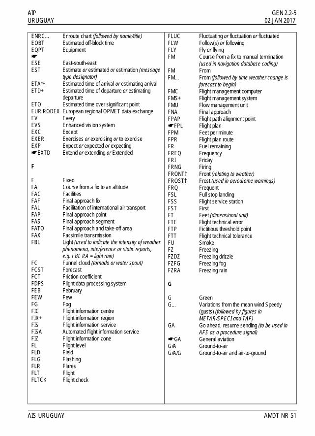
ENRC… Enroute chart (followed by name/title) EOBT Estimated off-block time EQPT Equipment ! ESE East-south-east EST Estimate or estimated or estimation (message
type designator) ETA*+ Estimated time of arrival or estimating arrival ETD+ Estimated time of departure or estimating
departure ETO Estimated time over significant point EUR RODEX European regional OPMET data exchange EV Every EVS Enhanced vision system EXC Except EXER Exercises or exercising or to exercise EXP Expect or expected or expecting !EXTD Extend or extending or Extended F F Fixed FA Course from a fix to an altitude FAC Facilities FAF Final approach fix FAL Facilitation of international air transport FAP Final approach point FAS Final approach segment FATO Final approach and take-off area FAX Facsimile transmission FBL Light (used to indicate the intensity of weather
phenomena, interference or static reports, e.g. FBL RA = light rain)
FC Funnel cloud (tornado or water spout) FCST Forecast FCT Friction coefficient FDPS Flight data processing system FEB February FEW Few FG Fog FIC Flight information centre FIR+ Flight information region FIS Flight information service FISA Automated flight information service FIZ Flight information zone FL Flight level FLD Field FLG Flashing FLR Flares FLT Flight FLTCK Flight check
FLUC Fluctuating or fluctuation or fluctuated FLW Follow(s) or following FLY Fly or flying FM Course from a fix to manual termination
(used in navigation database coding) FM From FM… From (followed by time weather change is
forecast to begin) FMC Flight management computer FMS+ Flight management system FMU Flow management unit FNA Final approach FPAP Flight path alignment point !FPL Flight plan FPM Feet per minute FPR Flight plan route FR Fuel remaining FREQ Frequency FRI Friday FRNG Firing FRONT† Front (relating to weather) FROST† Frost (used in aerodrome warnings) FRQ Frequent FSL Full stop landing FSS Flight service station FST First FT Feet (dimensional unit) FTE Flight technical error FTP Fictitious threshold point FTT Flight technical tolerance FU Smoke FZ Freezing FZDZ Freezing drizzle FZFG Freezing fog FZRA Freezing rain G G Green G… Variations from the mean wind Speedy
(gusts) (followed by figures in METAR/SPECI and TAF)
GA Go ahead, resume sending (to be used in AFS as a procedure signal)
!GA General aviation G/A Ground-to-air G/A/G Ground-to-air and air-to-ground
AIS URUGUAY AMDT NR 51
GEN 2.2-6 AIP 02 JAN 2017 URUGUAY
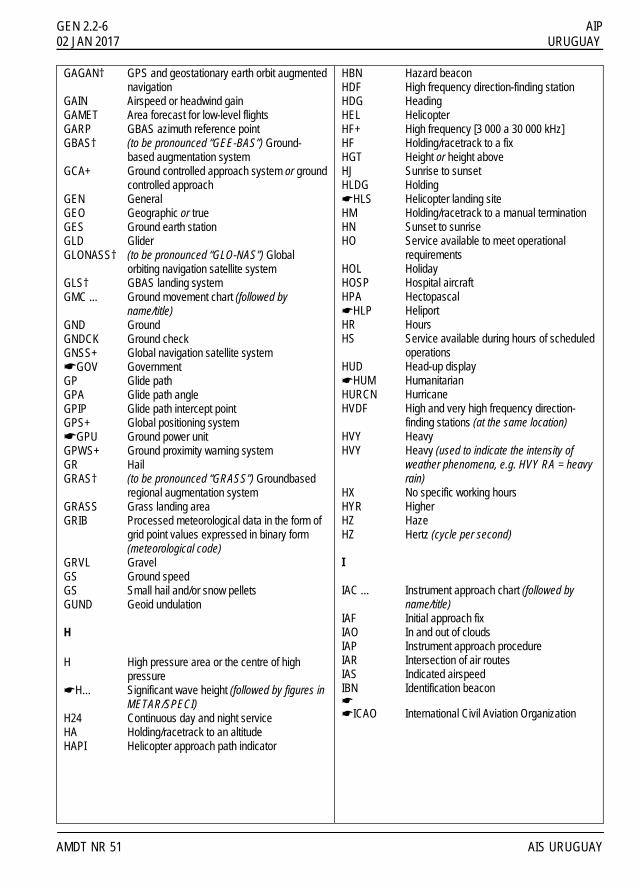
GAGAN† GPS and geostationary earth orbit augmented navigation
GAIN Airspeed or headwind gain GAMET Area forecast for low-level flights GARP GBAS azimuth reference point GBAS† (to be pronounced “GEE-BAS”) Ground-
based augmentation system GCA+ Ground controlled approach system or ground
controlled approach GEN General GEO Geographic or true GES Ground earth station GLD Glider GLONASS† (to be pronounced “GLO-NAS”) Global
orbiting navigation satellite system GLS† GBAS landing system GMC ... Ground movement chart (followed by
name/title) GND Ground GNDCK Ground check GNSS+ Global navigation satellite system !GOV Government GP Glide path GPA Glide path angle GPIP Glide path intercept point GPS+ Global positioning system !GPU Ground power unit GPWS+ Ground proximity warning system GR Hail GRAS† (to be pronounced “GRASS”) Groundbased
regional augmentation system GRASS Grass landing area GRIB Processed meteorological data in the form of
grid point values expressed in binary form (meteorological code)
GRVL Gravel GS Ground speed GS Small hail and/or snow pellets GUND Geoid undulation H H High pressure area or the centre of high
pressure !H… Significant wave height (followed by figures in METAR/SPECI) H24 Continuous day and night service HA Holding/racetrack to an altitude HAPI Helicopter approach path indicator
HBN Hazard beacon HDF High frequency direction-finding station HDG Heading HEL Helicopter HF+ High frequency [3 000 a 30 000 kHz] HF Holding/racetrack to a fix HGT Height or height above HJ Sunrise to sunset HLDG Holding !HLS Helicopter landing site HM Holding/racetrack to a manual termination HN Sunset to sunrise HO Service available to meet operational
requirements HOL Holiday HOSP Hospital aircraft HPA Hectopascal !HLP Heliport HR Hours HS Service available during hours of scheduled
operations HUD Head-up display !HUM Humanitarian HURCN Hurricane HVDF High and very high frequency direction-
finding stations (at the same location) HVY Heavy HVY Heavy (used to indicate the intensity of
weather phenomena, e.g. HVY RA = heavy rain)
HX No specific working hours HYR Higher HZ Haze HZ Hertz (cycle per second) I IAC … Instrument approach chart (followed by
name/title) IAF Initial approach fix IAO In and out of clouds IAP Instrument approach procedure IAR Intersection of air routes IAS Indicated airspeed IBN Identification beacon ! !ICAO International Civil Aviation Organization
AMDT NR 51 AIS URUGUAY

AIP GEN 2.2-7 URUGUAY 28 MAR 2019
ICE Icing ID Identifier or identify IDENT† Identification IF Intermediate approach fix IFF Identification friend/foe IFR+ Instrument flight rules IGA International general aviation ILS+ Instrument landing system IM Inner marker IMC+ Instrument meteorological conditions IMG Immigration IMI* Interrogation sign (question mark) (to be used
in AFS as a procedure signal) IMPR Improve or improving IMT Immediate or immediately INA Initial approach INBD Inbound INC In cloud INCORP Incorporated INCERFA† Uncertainty phase INFO† Information INOP Inoperative INP If not possible INPR In progress INS Inertial navigation system INSTL Install or installed or installation INSTR Instrument INT Intersection INTL International INTRG Interrogator INTRP Interrupt or interruption or interrupted INTSF Intensify or intensifying INTST Intensity IR Ice on runway IRS Inertial reference system IRU Inertial reference unit ISA International standard atmosphere ISB Independent sideband ISOL Isolated J JAN January JTST Jet stream JUL July JUN June K KG Kilograms KHZ Kilohertz KIAS Knots indicated airspeed KM Kilometres
KMH Kilometres per hour KPA Kilopascal KT Knots KW Kilowatts L …L Left (preceded by runway designation
number to identify a parallel runway) L Locator (see LM, LO) L Low pressure area or the centre of low
pressure L Litre LAM Logical acknowledgement (message type
designator) LAN Inland !LAR Latin american regulations LAT Lattitude LCA Local or locally or location or located LDA Landing distance available LDAH Landing distance available, helicopter LDG Landing LDI Landing direction indicator LEN Length LF Low frequency [30 to 300 kHz] LGT Light or lighting LGTD Lighted LIH Light intensity high LIL Light intensity low LIM Light intensity medium LINE Line (used in SIGMET) LLZ Locator, middle LM Radiofaro de localización, intermedio LMT Local mean time LNAV† (to be pronounced “EL-NAV”) Lateral
navigation LNG Long (used to indicate the type of approach
desired or required) LO Locator, outer LOC Localizer LONG Longitude LORAN† LORAN (long range air navigation system) LOSS Airspeed or headwind loss LPV Localizer performance with vertical
guidance LR The last message received by me was . . .
(to be used in AFS as a procedure signal) LRG Long range
AIS URUGUAY AIRAC AIP AMDT NR 01

GEN 2.2-8 AIP 02 JAN 2017 URUGUAY
LS The last message sent by me was . . . or Last message was . . . (to be used in AFS as a procedure signal)
!LTA Lower control area LTD Limited LTP Landing threshold point ! LV Light and variable (relating to wind) LVE Leave or leaving LVL Level LVP Low visibility procedures LYR Layer or layered M … M Metres (preceded by figures) M … Mach number (followed by figures) M … Minimum value of runway visual range
(followed by figures in METAR/SPECI) MAA Maximum authorized altitude MAG Magnetic MAHF Missed approach holding fix MAINT Maintenance MALSR Medium-intensity Approach Lighting System
with Runway Alignment Indicator Lights MAP Aeronautical maps and charts MAPT Missed approach point MAR At sea MAR March ! MATF Missed approach turning fix !MATZ Military aerodrome traffic zone MAX Maximum MAY May MBST Microburst MCA Minimum crossing altitude !MCTR Military control zone MCW Modulated continuous wave MDA Minimum descent altitude MDF Medium frequency direction-finding station MDH Minimum descent height MEA Minimum en-route altitude !MEDEVAC Medical evacuation flight MEHT Minimum eye height over threshold (for visual
approach slope indicator systems) MET† Meteorological or meteorology METAR† Aerodrome routine meteorological report (in
meteorological code) MET REPORT Local routine meteorological report (in abbreviated plain language)
MF Medium frequency [300 to 3 000 kHz] !MHA Minimum holding altitude MHDF Medium and high frequency direction-
finding stations (at the same location) MHVDF Medium, high and very high frequency
direction-finding stations (at the same location)
MHZ Megahertz MID Mid-point (related to RVR) MIFG Shallow fog MIL Military MIN* Minutes MIS Missing . . . (transmission identification) (to
be used in AFS as a procedure signal) MKR Marker radio beacon MLS+ Microwave landing system MM Middle marker MNM Minimum MNPS Minimum navigation performance
specifications MNT Monitor or monitoring or monitored MNTN Maintain MOA Military operating area MOC Minimum obstacle clearance (required) MOCA Minimum obstacle clearance altitude MOD Moderate (used to indicate the intensity of
weather phenomena, interference or static reports, e.g. MODRA = moderate rain)
MON Above mountains MON Monday MOPS† Minimum operational performance
standards MOV Move or moving or movement MPS Metres per second MRA Minimum reception altitude MRG Medium range MRP ATS/MET reporting point MS Minus MSA Minimum sector altitude MSAS† (to be pronounced “EM-SAS”)
Multifunctional transport satellite (MTSAT) satellite-based augmentation system
MSAW Minimum safe altitude warning MSG Message MSL Mean sea level
AMDT NR 51 AIS URUGUAY

AIP GEN 2.2-9 URUGUAY 02 JAN 2017
MSR# Message . . . (transmission identification) has been misrouted (to be used in AFS as a procedure signal)
MSSR Monopulse secondary surveillance radar MT Mountain !MTOM Maximum take-off mass MTU Metric units MTW Mountain waves MVDF Medium and very high frequency direction-
finding stations (at the same location) MWO Meteorological watch office MX Mixed type of ice formation (white and clear) N N No distinct tendency (in RVR during previous
10 minutes) N North or northern latitude NADP Noise abatement departure procedure NASC† National AIS system centre NAT North Atlantic NAV Navigation !NAVAID Navigation aid NB Northbound NBFR Not before NC No change NCD No cloud detected (used in automated
METAR/SPECI) NDB+ Non-directional radio beacon NDV No directional variations available (used in
automated METAR/SPECI) NE North-east NEB North-eastbound NEG No or negative or permission not granted or
that is not correct NGT Night NIL*† None or I have nothing to send to you NM Nautical miles NML Normal NN No name, unnamed NNE North-north-east NNW North-north-west NO No (negative) (to be used in AFS as a
procedure signal) NOF International NOTAM office !NONSTD Non-standard NOSIG† No significant change (used in trend-type
landing forecasts)
NOTAM† A notice distributed by means of telecommunication containing information concerning the establishment, condition or change in any aeronautical facility, service, procedure or hazard, the timelyknowledge of which is essential to personnel concerned with flight operations
!NOTAMC Cancelling NOTAM !NOTAMN New NOTAM !NOTAMR Replacing NOTAM NOV November NOZ Normal operating zone NPA Non-precision approach NR Number NRH No reply heard NS Nimbostratus NSC Nil significant cloud NSE Navigation system error NSW Nil significant weather NTL National NTZ+ No transgression zone NW North-west NWB North-westbound NXT Next O OAC Oceanic area control centre OAS Obstacle assessment surface OAS Organization of American States OBS Observe or observed or observation OBSC Obscure or obscured or obscuring OBST Obstacle OCA Obstacle clearance altitude OCA Oceanic control area OCC Occulting (light) OCH Obstacle clearance height OCNL Occasional or occasionally OCS Obstacle clearance surface OCT October OFZ Obstacle free zone OGN Originate (to be used in AFS as a
procedure signal) OHD Overhead OIS Obstacle identification surface OK* We agree or It is correct (to be used in AFS
as a procedure signal) OLDI† On-line data interchange OM Outer marker
AIS URUGUAY AMDT NR 51

GEN 2.2-10 AIP 02 JAN 2017 URUGUAY
OPA Opaque, white type of ice formation OPC Control indicated is operational control OPMET† Operational meteorological (information) OPN Open or opening or opened OPR Operator or operate or operative or operating
or operational OPS† Operations O/R On request ORD Order OSV Ocean station vessel OTP On top OTS Organized track system OUBD Outbound OVC Overcast P P… Maximum value of wind speed or runway
visual range (followed by figures in METAR/SPECI and TAF)
P... Prohibited area (followed by identification) PA Precision approach PALS Precision approach lighting system (specify
category) PANS Procedures for air navigation services PAPI† Precision approach path indicator PAR+ Precision approach radar PARL Parallel PATC … Precision approach terrain chart (followed by
name/title) PAX Passenger(s) !PBC Performance-based communication PBN Performance-based navigation !PBS Performance-based surveillance PCD Proceed or proceeding PCL Pilot-controlled lighting PCN Pavement classification Lumber !PCT Per cent PDC+ Pre-departure clearance PDG Procedure design gradient PER Performance PERM Permanent PIB Pre-flight information bulletin PJE Parachute jumping exercise PL Ice pellets PLA Practice low approach ! PLVL Present level PN Prior notice required PNR Point of no return
PO Dust/sand whirls (dust devils) POB Persons on board POSS Possible PPI Plan position indicator PPR Prior permission required PPSN Present position PRFG Aerodrome partially covered by fog PRI Primary PRKG Parking PROB† Probability PROC Procedure !PROP Propeller PROV Provisional PRP Point-in-space reference point PS Plus PSG Passing PSN Position PSP Pierced steel plank PSR+ Primary surveillance radar PSYS Pressure system(s) PTN Procedure turn PTS Polar track structure PWR Power Q QDL Do you intend to ask me for a series of
bearings? or I intend to ask you for a series of bearings (to be used in radiotelegraphy as a Q Code)
QDM+ Magnetic heading (zero wind) QDR Magnetic bearing QFE+ Atmospheric pressure at aerodrome
elevation (or at runway threshold) QFU Magnetic orientation of runway QGE What is my distance to your station? or
Your distance to my station is (distance figures and units) (to be used in radiotelegraphy as a Q Code)
QJH Shall I run my test tape/a test sentence? or Run your test tape/a test sentence (to be used in AFS as a Q Code)
QNH+ Altimeter sub-scale setting to obtain
elevation when on the ground QSP Will you relay to . . . free of charge? or I will
relay to . . . free of charge (to be used in AFS as a Q Code)
QTA Shall I cancel telegram number . . .? or Cancel telegram number . . . (to be used in AFS as a Q Code)
QTE True bearing
AMDT NR 51 AIS URUGUAY

AIP GEN 2.2-11 URUGUAY 02 JAN 2017
QTF Will you give me the position of my station according to the bearings taken by the D/F stations which you control? or The position of your station according to the bearings taken by the D/F stations that I control was . . . latitude . . . longitude (or other indication of position), class . . . at . . . hours (to be used in radiotelegraphy as a Q Code)
QUAD Quadrant QUJ Will you indicate the TRUE track to reach
you? or The TRUE track to reach me is . . . degrees at . . . hours (to be used in radiotelegraphy as a Q Code)
R …R Right (preceded by runway designation
number to identify a parallel runway) R Rate of turn R Red R... Restricted area (followed by identification) R… Runway (followed by figures in
METAR/SPECI) R* Received (acknowledgement of receipt) (to be
used in AFS as a procedure signal) !R… Radial from VOR (followed by three figures) RA Rain RA Resolution advisory RAC Rules of the air and air traffic services RAFC Regional area forecast centre RAG Runway arresting gear RAG Ragged RAI Runway alignment indicator RAIM† Receiver autonomous integrity monitoring RASC† Regional AIS system centre RASS Remote altimeter setting source RAU Reglamento Aeronáutico Uruguayo
(Uruguayan Air Regulation) RB Rescue boat RCA Reach cruising altitude RCC Rescue coordination centre RCF Radiocommunication failure (message type
designator) RCH Reach or reaching RCL Runway centre line RCLL Runway centre line light(s) RCLR Recleared RCP+ Required communication performance
!RDOACT Radioactive RDH Reference datum height RDL Radial RDO Radio RE Recent (used to qualify weather
phenomena, e.g. RERA = recent rain) REC Receive or receiver REDDIG Red de Comunicaciones Digitales (Digital
Network) REDL Runway edge light(s) REF Reference to . . . or refer to . . . REG Registration RENL Runway end light(s) REP Report or reporting or reporting point REQ Request or requested RERTE Re-route RESA Runway end safety area RF Constant radius arc to a fix !RFFS Rescue and fire fighting services RG Range (lights) RHC Right-hand circuit RIF Reclearance in flight RIME† Rime (used in aerodrome warnings) ! RL Report leaving RLA Relay to RLCE Request level change en route RLLS Runway lead-in lighting system RLNA Request level not available RMK Remark RNAV† (to be pronounced “AR-NAV”) Area
navigation RNG Radio range RNP+ Required navigation performance ROBEX† Regional OPMET bulletin Exchange
(scheme) ROC Rate of climb ROD Rate of descent RON Receiving only RPDS Reference path data selector RPI+ Radar position indicator RPL Repetitive flight plan RPLC Replace or replaced RPS Radar position symbol RPT* Repeat or I repeat (to be used in AFS as a
procedure signal) RQ* Request (to be used in AFS as a procedure
signal) RQMNTS Requirements RQP Request flight plan (message type
designator)
AIS URUGUAY AMDT NR 51

GEN 2.2-12 AIP 02 JAN 2017 URUGUAY
RQS Request supplementary flight plan (message type designator)
RR Report reaching RRA (or RRB, RRC . . . etc., in sequence) Delayed
meteorological message (message type designator)
RSC Rescue sub-centre RSCD Runway surface condition !RSP+ Required surveillance performance RSP Responder beacon RSR En-route surveillance radar RSS Root sum square RTD Delayed (used to indicate delayed
meteorological message; message type designator)
RTE Route RTF Radiotelephone RTG Radiotelegraph RTIL Runway threshold identification lights RTHL Runway threshold light(s) RTN Return or returned or returning RTODAH Rejected take-off distance available,
helicopter RTS Return to service RTT Radioteletypewriter RTZL Runway touchdown zone light(s) RUT Standard regional route transmitting
frequencies RV Rescue Wessel !RVA Radar vectoring area RVR+ Runway visual range RVSM+ Reduced vertical separation minimum (300 m
(1 000 ft)) between FL 290 and FL 410 RWY Runway S S South or southern latitude S… State of the sea (followed by figures in
METAR/SPECI) SA Sand SALS Simple approach lighting system SAN Sanitary ! SAR Search and rescue SARPS Standards and Recommended Practices
[ICAO] SAT Saturday !SATCOM† Satellite communication (used only when
referring generally to both voice and data satellite communication or only data satellite communication)
!SATVOICE† Satellite voice communication SB Southbound
SBAS† (to be pronounced “ESS-BAS”) Satellite-based augmentation system
SC Stratocumulus SCT Scattered SD Standard deviation SDBY Stand by SDF Step down fix SE South-east SEA Sea (used in connection with sea-surface
temperature and state of the sea) SEB South-eastbound SEC Seconds SECN Section SECT Sector SELCAL† Selective calling system SEP September SER Service or servicing or served SEV Severe (used e.g. to qualify icing and
turbulence reports) SFC Surface SG Snow grains SGL Signal SH... Shower (followed by RA = rain, SN = snow,
PL = ice pellets, GR = hail, GS= small hail and/or snow pellets or combinations thereof, e.g. SHRASN = showers of rain and snow)
SHF Super high frequency [3 000 to 30 000 MHz]
SI International system of units SID† Standard instrument departure SIF Selective identification feature SIG Significant !SIGMET† Information concerning en-route weather
and other phenomena in the atmosphere that may affect the safety of aircraft operations
SIMUL Simultaneous or simultaneously SIWL Single isolated wheel load SKC Sky clear SKED Schedule or scheduled SLP Speed limiting point SLW Slow SMC Surface movement control SMR Surface movement radar SN Snow SNOCLO Aerodrome closed due to snow (used in
METAR/SPECI)
AMDT NR 51 AIS URUGUAY

AIP GEN 2.2-13 URUGUAY 02 JAN 2017
SNOWTAM† Special series NOTAM notifying the presence or removal of hazardous conditions due to snow, ice, slush or standing water associated with snow, slush and ice on the movement area, by means of a specific format
SOC Start of climb SPECI† Aerodrome special meteorological report (in
meteorological code) SPECIAL† Local special meteorological report (in
abbreviated plain language) SPI Special position indicator SPL Supplementary flight plan (message type
designator) SPOC SAR point of contact SPOT† Spot wind SQ Squall SQL Squall line SR Sunrise SRA Surveillance radar approach SRE Surveillance radar element of precision
approach radar system SRG Short range SRR Search and rescue region SRY Secondary SS Sandstorm SS Sunset SSB Single sideband SSE South-south-east SSR+ Secondary surveillance radar SST Supersonic transport SSW South-south-west ST Stratus STA Straight-in approach STAR† Standard instrument arrival STD Standard STF Stratiform STN Station STNR Stationary STOL Short take-off and landing STS Status STWL Stopway light(s) SUBJ Subject to SUN Sunday SUP Supplement (AIP Supplement) SUPPS Regional supplementary procedures !SVC Service (message type only) SVCBL Serviceable SW South-west SWB South-westbound SWY Stopway
T T Temperature …T True (preceded by a bearing to indicate
reference to True North) TA Traffic advisory TA Transition altitude TAA Terminal arrival altitude TACAN† UHF tactical air navigation aid TAF† Aerodrome forecast (in meteorological code) TA/H Turn at an altitude/height TAIL† Tail wind TAR Terminal area surveillance radar TAS True airspeed TAX Taxiing or taxi TC Tropical cyclone TCAC Tropical cyclone advisory centre TCAS RA† (to be pronounced “TEE-CAS-AR-AY”) Traffic alert and collision avoidance system resolution advisory TCH Threshold crossing height TCU Towering cumulus TDO Tornado TDZ Touchdown zone TECR Technical reason TEL Telephone TEMPO† Temporary or temporarily TF Track to fix TFC Traffic TGL Touch-and-go landing TGS Taxiing guidance system THR Threshold THRU Through THU Thursday TIBA Traffic information broadcast by aircraft TIL† Until TIP Until past . . . (place) TKOF Take-off TL... Till (followed by time by which weather change is forecast to end) TLOF Touchdown and lift-off area TMA+ Terminal control area TN… Minimum temperature (followed by figures
in TAF) TNA Turn altitude TNH Turn height TO … To . . . (place) TOC Top of climb TODA Take-off distance available
AIS URUGUAY AMDT NR 51

GEN 2.2-14 AIP 02 JAN 2017 URUGUAY
TODAH Take-off distance available, helicopter TOP† Cloud top TORA Take-off run available TOX Toxic TP Turning point TR Track TRA Temporary reserved airspace TRANS Transmits or transmitter TREND Trend forecast TRL Transition level !TRG Training TROP Tropopause TS Thunderstorm (in aerodrome reports and
forecasts, TS used alone means thunder heard but no precipitation at the aerodrome)
TS... Thunderstorm (followed by RA = rain, SN = snow, PL = ice pellets, GR = hail, GS = small hail and/or snow pellets or combinations thereof, e.g. TSRASN = thunderstorm with rain and snow)
TSUNAMI† Tsunami (used in aerodrome warnings) TT Teletypewriter TUE Tuesday TURB Turbulence T-VASIS† (to be pronounced “TEE-VASIS”) T visual
approach slope indicator system TVOR Terminal VOR TWIL FROM Beginning of civil morning twilight TWIL TO End of civil evening twilight TWR Aerodrome control tower or aerodrome
control TWY Taxiway ! TX … Maximum temperature (followed by figures in
TAF) !TXL Taxilane TXT* Text (when the abbreviation is used to
request a repetition, the question mark (IMI) precedes the abbreviation, e.g. IMI TXT) (to be used in AFS as a procedure signal)
TYP Type of aircraft TYPH Typhoon U U Upward (tendency in RVR during previous 10
minutes) UA Unmanned aircraft UAB … Until advised by . . .
UAC Upper area control centre UAR Upper air route UAS Unmanned aircraft system UDF Ultra high frequency direction-finding station UFN Until further notice UHDT Unable higher due traffic UHF+ Ultra high frequency [300 to 3 000 MHz] UIC Upper information centre UIR+ Upper flight information region !ULM Ultra light motorized aircraft ULR Ultra long range UN United Nations UNA Unable UNAP Unable to approve UNL Unlimited UNREL Unreliable UP Unidentified precipitation (used in
automated METAR/SPECI) U/S Unserviceable UTA Upper control area UTC+ Coordinated Universal Time V …V… Variations from the mean wind direction
(preceded and followed by figures in METAR/SPECI, e.g. 350V070)
VA Heading to an altitude VA Volcanic ash VAAC Volcanic ash advisory centre VAC … Visual approach chart (followed by
name/title) VAL In valleys VAN Runway control van VAR Magnetic variation VAR Visual-aural radio range VASIS Visual approach slope indicator systems VC … Vicinity of the aerodrome (followed by FG =
fog, FC = funnel cloud, SH = shower, PO = dust/sand whirls, BLDU = blowing dust, BLSA = blowing sand, BLSN = blowing snow, DS = duststorm, SS = sandstorm, TS = thunderstorm or VA = volcanic ash, e.g. VCFG = vicinity fog)
VCY Vicinity VDF Very high frequency direction-finding station VER Vertical VFR+ Visual flight rules VHF+ Very high frequency [30 to 300 MHz] VI Heading to an intercept
AMDT NR 51 AIS URUGUAY

AIP GEN 2.2-15 URUGUAY 02 JAN 2017
VIP+ Very important person VIS Visibility VLF Very low frequency [3 to 30 kHz] VLR Very long range VM Heading to a manual termination VMC+ Visual meteorological conditions VNAV† (to be pronounced “VEE-NAV”) Vertical
navigation !VOL Volume (followed by I, II...) VOLMET† Meteorological information for aircraft in flight VOR+ VHF omnidirectional radio range VORTAC† VOR and TACAN combination VOT VOR airborne equipment test facility VPA Vertical path angle VPT Visual manoeuvre with prescribed track VRB Variable VSA By visual reference to the ground VSP Vertical speed VTF Vector to final VTOL Vertical take-off and landing VV … Vertical visibility (followed by figures in
METAR/SPECI and TAF) W W West or western longitude W White W… Sea-surface temperature (followed by figures
in METAR/SPECI) WAAS† Wide area augmentation system WAC … World Aeronautical Chart — ICAO 1:1 000
000 (followed by name/title) WAFC World area forecast centre WB Westbound WBAR Wing bar lights WDI Wind direction indicator WDSPR Widespread WED Wednesday WEF With effect from or effective from WGS-84 World Geodetic System — 1984 WI Within WID Width or wide WIE With immediate effect or effective immediately
WILCO† Will comply WIND Wind WIP Work in progress WKN Weaken or weakening WNW West-north-west WO Without WPT Way-point WRNG Warning WS Wind shear WSPD Wind speed WSW West-south-west WT Weight WTSPT Waterspout WWW Worldwide web WX Weather !WXR Weather radar X X Cross XBAR Crossbar (of approach lighting system) XNG Crossing XS Atmospherics Y Y Yellow YCZ Yellow caution zone (runway lighting) YES* Yes (affirmative) (to be used in AFS as a
procedure signal) YR Your Z Z Coordinated Universal Time (in
meteorological messages)
† When radiotelephony is used, the abbreviations and terms are transmitted as spoken words. + When radiotelephony is used, the abbreviations and terms are transmitted using the individual letters in non-phonetic form. * Signal is also available for use in communicating with stations of the maritime mobile service. # Signal for use in the teletypewriter service only. AIS URUGUAY AMDT NR 51

IIINNNTTTEEENNNTTTIIIOOONNNAAALLLLLLYYY LLLEEEFFFTTT BBBLLLAAANNNKKK

AIP GEN 2.3-1 URUGUAY 01 DEC 2005 GEN 2.3 CHART SYMBOLS 1. Topography
Contours 5000
Sand area
17456
Elevation, Hightest elevation on chart
17456
2. Hidrography
Shore line
Large river (perennial)
Small river (perennial)
Rivers and stream (non-perennial)
Lakes (perennial)
Rice field
3. Vegetation
Trees
Vegetation in general AIS URUGUAY AMDT NR 23

GEN 2.3-2 AIP 01 DEC 2005 URUGUAY 4. Constructions 4.1 Built-up areas
Large urbanization
City
Town
Buildings 4.2 Highways and roads
Main highway 1
Secondary road 21
Road
Bridge on road
4.3 Railroads
Railroad
Bridge on railroad
AMDT NR 23 AIS URUGUAY

AIP GEN 2.3-3 URUGUAY 01 DEC 2005 5. Aerodromes 5.1 Charts other than approach charts
Civil (land)
Civil (water)
Joint civil and military (land)
Joint civil and military (water)
Military (land)
Military (water)
Emergency aerodrome or aerodrome with no facilities
Abandoned or closed aerodrome
Sheltered anchorage
Aerodrome. Used on charts on which aerodrome classification is not required.
Heliport H
5.2 Approach charts
Aerodrome on which the procedure is based Aerodromes affecting the traffic pattern on the aerodrome on which the procedure is based
AIS URUGUAY AMDT NR 23

GEN 2.3-4 AIP 01 DEC 2005 URUGUAY 6. Radio navigation aids
Basic radio navigation aid symbol
Non-directional radio beacon (NDB)
VHF omnidirectional radio range (VOR)
Distance measuring equipment
Collocated VOR and DME radio navigation aids (VOR/DME)
Plan view Instrument landing system (ILS)
Profile
Radio marker beacon
Compass rose
0
9
27
18
AMDT NR 23 AIS URUGUAY
AIP GEN 2.3-5 URUGUAY 01 APR 2017 7. Air traffic services
Flight information región (FIR)
Aerodrome traffic zone
Control area
Airway
RNAV
Control zone
Scale-break (on ATS routes) !Conventional Navigation !Area Navigation
On request fly-by
Compulsory fly-by
On request fly-by
Compulsory fly-by
On request flyover
Compulsory flyover
VFR reporting point ! !
Intersection INT ! !
VOR ! !
VOR/DME ! !
NDB ! !
Waypoint WPT
!Not used !Not used
Compulsory ATS/MET reporting point (MRP)
On request
Final approach fix (FAF)
Altitude/flight level “window” FL 245
900
“At or above” altitude/flight level FL 245
“At or below” altitude/flight level 900
Altitudes/flight levels
“Mandatory” altitude/flight level FL 245
Airspace clasification Between “GND” and 600 M: class “G”; between 600 M and FL 195: class “C”; between FL 195 and FL 245: class “A”
FL 245
FL 195
600 M
GND
A
CG
AIS URUGUAY AMDT NR 52

GEN 2.3-6 AIP 05 NOV 2020 URUGUAY 8. Airspace restrictions
Restricted airspace (prohibited, restricted or danger areas)
Common boundary of two areas
Air defence identification zone (ADIZ)
9. Obstacles
Obstacle
Lighted obstacle
Group obstacles
Lighted group obstacles
Exceptionally high obstacle (higher than 300 M above terrain)
Exceptionally high obstacle - lighted
52(15)
Elevation of top
Height above specified
datum
Wind turbine – unlighted and lighted
Wind turbines – minor Group and Group in major area, lighted.
10. Visual aids
Marine light
Aeronautical ground light
AIRAC AIP AMDT NR 02 AIS URUGUAY

AIP GEN 2.3-7 URUGUAY 01 AUG 2011 !11. Aerodrome charts
Hard surface runway
Unpaved runway
Stopway
Taxiways and parking areas
Aerodrome reference point (ARP)
Helicopter alighting area on an aerodrome H
VOR check-point
Runway visual range (RVR) observation site
Point light
Obstacle light
Wind direction indicator (lighted)
Wind direction indicator (unlighted)
Landing direction indicator (lighted)
Landing direction indicator (unlighted)
Runway-holding
AIS URUGUAY AMDT NR 39

GEN 2.3-8 AIP 01 AUG 2011 URUGUAY !12. Symbols for aerodrome obstacle charts – Type A, B and C
Tree or shrub
Pole, tower, spire, antenna, etc.
Building or large structure
Railroad
Transmission line or overhead cable
1
Identificationnumber
Terrain penetrating obstacle plane
Stopway (SWY)
Clearway (CWY) !13. Various
Transmission line or overhead cable
Isogonal 3º W
Minimun sector altitude (MSA)
6600'
8600'10500'
8100'270º
090º
180º
360º
MSA CRR VOR
Holding pattern
Direct approach
Missed approach track
Runway
Radio navigation aid (type of aid and its use in the procedure to be annotated on topo of the symbol)
Radio marker beacon (type of beacon to be annotated on top of the symbol)
DME fix
AIS URUGUAY AMDT NR 39

AIP GEN 2.4-1 URUGUAY 01 JUN 2008 GEN 2.4 LOCATION INDICATORS The location indicators marked with an asterisk (*) cannot be used in the address component of AFS messages 1. ENCODE 2. DECODE
Location Indicator Indicator Location ANCHORENA / Ad ARTIGAS / Intl BELLA UNION / Ad BOISO LANZA / Ad CANELONES / Ad CARDONA / Ad CARMELO / Intl CHALKLING / Ad CHUY / Ad COLONIA / Intl "Laguna de los Patos" DOLORES / Ad DURAZNO / Santa Bernardina Intl de Alternativa EDIFICIO LIBERTAD / Heli EL MIRADOR - ESTANCIA / Ad E.T.A. / Heli FLORIDA / Ad FRAY BENTOS / Ad !FRIGORÍFICO TACUAREMBÓ / Ad GENERAL ARTIGAS - E.M.A. / Ad GUICHÓN / Ad
SUAN * SUAG SUBU * SUBL SUCN * SUCD * SUCM * SUPC * SUCH * SUCA SUDL * SUDU SUEL * SUEM * SUET * SUFL * SUFB * SUFT * SUGA SUGN *
SUAA SUAG SUAN * SUAY * SUBL SUBU * SUCA SUCD * SUCH * SUCL * SUCM * SUCN * SUDL * SUDU SUDR * SUEL * SUEM * SUEO SUEO SUET *
MONTEVIDEO / Ad Ángel S. Adami ARTIGAS / Intl ANCHORENA / Ad TERMAS DEL ARAPEY / Ad BOISO LANZA / Ad BELLA UNIÓN / Ad COLONIA / Intl "Laguna de los Patos" CARDONA / Ad CHUY / Ad LA CALERA - MINAS / Ad CARMELO / Intl CANELONES / Ad DOLORES / Ad DURAZNO / Santa Bernardina Intl de Alternativa SARANDI GRANDE / Ad Dos Robles EDIFICIO LIBERTAD / Heli EL MIRADOR - ESTANCIA / Ad MONTEVIDEO / ACC MONTEVIDEO / FIR E.T.A / Heli
AIS URUGUAY AMDT NR 30

GEN 2.4-2 AIP 01 AUG 2010 URUGUAY 1. ENCODE 2. DECODE
Location Indicator Indicator Location JOSE PEDRO VARELA / Ad JUAN LACAZE / Ad LA CALERA - ESTANCIA / Ad LA CALERA - MINAS / Ad ! LA PALOMA - ROCHA / Ad LASCANO / Ad MALDONADO / Intl C/C Carlos A. Curbelo "Laguna del Sauce" MELO / Intl de Cerro Largo MERCEDES / Dptal Ricardo Detomasi MINAS / Ad MONTEVIDEO / Intl Carrasco - "Gral. Cesáreo L. Berisso" MONTEVIDEO / ACC MONTEVIDEO / Ángel S. Adami MONTEVIDEO / FIR NUEVA MEHLEM - ESTANCIA / Ad OMBÚES DE LAVALLE / Ad PASO DE LOS TOROS / Ad PAYSANDÚ / Intl Tydeo Larre Borges PROGRESO / Ad PUNTA DEL ESTE / Dptal "El Jagüel" RESIDENCIA SUÁREZ / Heli
SUJP * SUJL * SULC * SUCL * ! SULP * SULA * SULS SUMO SUME * SUMI * SUMU SUEO SUAA SUEO SUNM * SUOL * SUPT * SUPU SUPR * SUPE SURS *
SUFB * SUFL * SUFT * SUGA SUGN * SUJL * SUJP * SULA * SULC * ! SULP * SULS SUME * SUMI * SUMO SUMU SUNM * SUOL * SUPC * SUPE SUPR * SUPT * SUPU
FRAY BENTOS / Ad FLORIDA / Ad FRIGORÍFICO TACUAREMBÓ / Ad GENERAL ARTIGAS - E.M.A. / Ad GUICHÓN / Ad JUAN LACAZE / Ad JOSÉ PEDRO VARELA / Ad LASCANO / Ad LA CALERA - ESTANCIA / Ad ! LA PALOMA - ROCHA / Ad MALDONADO / Intl C/C Carlos A Curbelo "Laguna del Sauce" MERCEDES / Dptal Ricardo Detomasi MINAS / Ad MELO / Intl de Cerro Largo MONTEVIDEO / Intl Carrasco - "Gral. Cesáreo L. Berisso" NUEVA MEHLEM - ESTANCIA / Ad OMBÚES DE LAVALLE / Ad CHALKLING / Ad PUNTA DEL ESTE / Dptal "El Jagüel" PROGRESO / Ad PASO DE LOS TOROS / Ad PAYSANDÚ / Intl Tydeo Larre Borges
AMDT NR 36 AIS URUGUAY
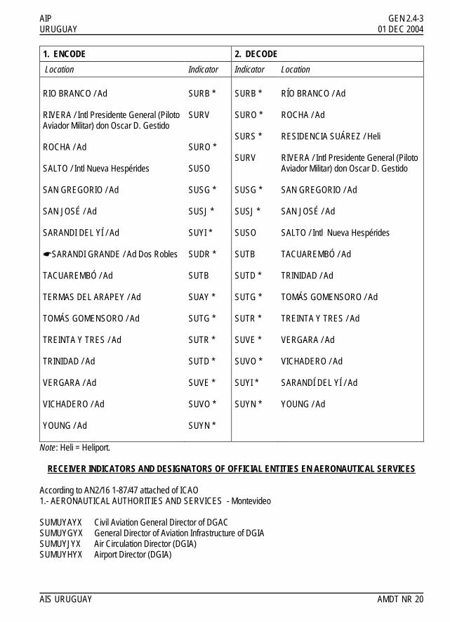
AIP GEN 2.4-3 URUGUAY 01 DEC 2004 1. ENCODE 2. DECODE
Location Indicator Indicator Location RIO BRANCO / Ad RIVERA / Intl Presidente General (Piloto Aviador Militar) don Oscar D. Gestido ROCHA / Ad SALTO / Intl Nueva Hespérides SAN GREGORIO / Ad SAN JOSÉ / Ad SARANDI DEL YÍ / Ad !SARANDI GRANDE / Ad Dos Robles TACUAREMBÓ / Ad TERMAS DEL ARAPEY / Ad TOMÁS GOMENSORO / Ad TREINTA Y TRES / Ad TRINIDAD / Ad VERGARA / Ad VICHADERO / Ad YOUNG / Ad
SURB * SURV SURO * SUSO SUSG * SUSJ * SUYI * SUDR * SUTB SUAY * SUTG * SUTR * SUTD * SUVE * SUVO * SUYN *
SURB * SURO * SURS * SURV SUSG * SUSJ * SUSO SUTB SUTD * SUTG * SUTR * SUVE * SUVO * SUYI * SUYN *
RÍO BRANCO / Ad ROCHA / Ad RESIDENCIA SUÁREZ / Heli RIVERA / Intl Presidente General (Piloto Aviador Militar) don Oscar D. Gestido SAN GREGORIO / Ad SAN JOSÉ / Ad SALTO / Intl Nueva Hespérides TACUAREMBÓ / Ad TRINIDAD / Ad TOMÁS GOMENSORO / Ad TREINTA Y TRES / Ad VERGARA / Ad VICHADERO / Ad SARANDÍ DEL YÍ / Ad YOUNG / Ad
Note: Heli = Heliport.
RECEIVER INDICATORS AND DESIGNATORS OF OFFICIAL ENTITIES EN AERONAUTICAL SERVICES According to AN2/16 1-87/47 attached of ICAO 1.- AERONAUTICAL AUTHORITIES AND SERVICES - Montevideo SUMUYAYX Civil Aviation General Director of DGAC SUMUYGYX General Director of Aviation Infrastructure of DGIA SUMUYJYX Air Circulation Director (DGIA) SUMUYHYX Airport Director (DGIA) AIS URUGUAY AMDT NR 20

GEN 2.4-4 AIP 01 DEC 2002 URUGUAY !SUMUYIYX Carrasco Intl Airport Director (DGIA) !SUMUYKYX Administration and Finance Director (DGIA) !SUMUYQYX Electronic Director (DGIA) !SUMUYTYX Air Telecomunications Director VSUMUYNYX NOTAM Office - Uruguay !SUMUYEYX Air Traffic Division !SUMUYCYX Search and Rescue Coordinating Centre - SAR !SUMUYUYX South Region (DGIA) !SUMUYRYX North Region (DGIA) !SUMUYMYX Meteorological Office, Carrasco Intl Airport (DGMU) !SUMUZRZX Montevideo Area Control Centre - General !SUMUZQZX Montevideo Area Control Centre - referred to IFR flights !SUMUZFZX Montevideo Area Control Centre - referred to VFR flights !SUMUZBZX Repetitive Flight plans Centre - Montevideo 2.- AERONAUTICAL AUTHORITIES AND SERVICES - Generic ! (1) YAY Civil aviation authority ! (1) YBY Meteorological Telecommunication Network of Operations in Europe ! (1) YCY Search and Rescue Coordinating Centre (RCC) ! (1) YDY Administrative Authority of Aerodrome ! (1) YFY Aeronautical Fix Station ! (1) YGD Corporación Centroamericana de Servicios de Navegación Aérea (COCESNA) ! (1) YLY Authority responsible for investigating aviation accidents ! (1) YMY Meteorological Office ! (1) YNY International NOTAM Office ! (1) YOY Aeronautical Information dependencies ! (1) YSY Aeronatical Moving Station (AMS) ! (1) YTY Telecomunications Service ! (1) YWY Military Operations in Flight Control Center ! (1) YXY Military Services or Organizations * ! (1) YYY Agency which is not exclusively assigned an ICAO designator * ! (1) YZY Data Bank ! (1) ZAZ Approach Control Office ! (1) ZBZ Repetitive Flight Plans Office ! (1) ZDZ Air Traffic Flow regulator dependency ! (1) ZEZ Flight information data base ! (1) ZFZ Centre in charge of a Flight Information Region or a Superior Flight Information Region (either an ACC or FIC) when the message is relevant to a VFR flight (see ZQZ) ! (1) ZGZ Air Traffic Control (in general) ! (1) ZIZ Flight Information Centre (FIC) ! (1) ZOZ Oceanic Air Traffic Control ! (1) ZPZ Air Traffic Flow notification dependency ! (1) ZQZ Centre in charge of a Flight Information Region or a Superior Flight Information Region (either an ACC or FIC) when the message is relevant to a IFR flight (see ZFZ) ! (1) ZRZ Area Control Centre AMDT NR 15 AIS URUGUAY

AIP GEN 2.4-5 URUGUAY 01 DEC 2002 ! (1) ZSZ SARSAT Centre ! (1) ZTZ Aerodrome Control Tower ! (1) ZUZ Superior Area Control Centre ! (1) ZYZ Aerodrome Security Services ! (1) ZZZ Aircraft in flight ** !* Must be placed at the beginning of the message text the name of the Agency, Service, or government agency !** Must be placed at the beginning of the message text, the identification of the flight (1) Place in the four-letter location indicator for the recipient / originator of the message here (see GEN 2.4-1 GEN 2.4-3) GENERAL NOTE The destination indicator contains the location indicator of the destination locations, followed immediately by the ICAO three-letter designator identifying the department or agency of destination AIS URUGUAY AMDT NR 15

IIINNNTTTEEENNNTTTIIIOOONNNAAALLLLLLYYY LLLEEEFFFTTT BBBLLLAAANNNKKK

AIP GEN 2.5-1 URUGUAY 01 DEC 2013
GEN 2.5 LIST OF RADIO NAVIGATION AIDS
ID
Station name
Aid
Purpose
Station name
Aid
ID
Purpose
AR ASI ! BD CA ! CRR DO DUR ICAR IMVD LS LDS MLO MO ! RA ! ST STO TBO TMB
Carrasco Adami ! Durazno Carrasco ! Carrasco Durazno Durazno Carrasco Carrasco Curbelo Curbelo Melo Melo ! Durazno ! Salto Salto Tacuarembó Tacuarembó
L NDB ! L L ! VOR/DME NDB VOR/DME ILS ILS NDB VOR/DME VOR NDB ! L ! NDB VOR NDB VOR
A AE ! A A ! AE A AE A A A AE AE A ! A ! A AE A AE
Adami ! Carrasco Carrasco Carrasco Carrasco Carrasco ! Curbelo Curbelo Durazno Durazno Durazno Durazno Melo Melo ! ! Salto Salto Tacuarembó Tacuarembó
NDB ! ILS ILS L L VOR/DME ! NDB VOR/DME L L NDB VOR/DME NDB VOR ! ! NDB VOR NDB VOR
ASI ! ICAR IMVD AR CA CRR ! LS LDS BD RA DO DUR MO MLO ! ! ST STO TBO TMB
AE ! A A A A AE ! A AE A A A AE A AE ! ! A AE A AE
Purpose........: A = Aerodrome E = En-route AIS URUGUAY AMDT NR 44

GEN 2.5-2 AIP 01 AUG 2010 URUGUAY
GEN 2.5-1 LIST OF LOCATION INDICATORS ASSOCIATED WITH EACH AERODROME/HELIPORT
1. ENCODE 2. DECODE
ID Location Indicator Location Indicator ID
AN SUAN SUAA ASI ASI SUAA SUAG AT AT SUAG SUAN AN AY SUAY SUAY AY BL SUBL SUBL BL BU SUBU SUBU BU CD SUCD SUCA COL CH SUCH SUCD CD CL SUCL SUCH CH CM SUCM SUCL CL CN SUCN SUCM CM
COL SUCA SUCN CN !CR !SUCR !SUCR !CR CRR SUMU SUDL DL DL SUDL SUDR DR
DUR SUDU SUDU DUR DR SUDR SUEL EL EL SUEL SUEM EM EM SUEM SUET ET ET SUET SUFB FB FB SUFB SUFL FL FL SUFL SUFT FT FT SUFT SUGA GA GA SUGA SUGN GN GN SUGN SUJL JL JL SUJL SUJP JP JP SUJP SULA LA LA SULA SULC LC LC SULC ! !
LDS SULS SULP LP ! ! SULS LDS LP SULP SUME ME ME SUME SUMI MI MI SUMI SUMO MLO
MLO SUMO SUMU CRR !NH !SUNH !SUNH !NH NM SUNM SUNM NM OL SUOL SUOL OL PC SUPC SUPC PC PE SUPE SUPE PE PN SUPU SUPR PR PR SUPR SUPT PT PT SUPT SUPU PN RB SURB SURB RB
AMDT NR 36 AIS URUGUAY

AIP GEN 2.5-3 URUGUAY 01 AUG 2010
1. ENCODE 2. DECODE
ID Location Indicator Location Indicator ID
RO SURO SURO RO RS SURS SURS RS
RVA SURV SURV RVA SG SUSG SUSG SG SJ SUSJ SUSJ SJ
STO SUSO SUSO STO TD SUTD SUTB TMB TG SUTG SUTD TD
TMB SUTB SUTG TG TR SUTR SUTR TR VE SUVE SUVE VE VO SUVO SUVO VO YI SUYI SUYI YI YN SUYN SUYN YN
AIS URUGUAY AMDT NR 36

IIINNNTTTEEENNNTTTIIIOOONNNAAALLLLLLYYY LLLEEEFFFTTT BBBLLLAAANNNKKK

AIP GEN 2.6-1 URUGUAY 01 JUN 1997
GEN 2.6 CONVERSION TABLES
NM to KM
1 NM = 1.852 KM
KM to NM
1 KM = 0.54 NM
FT to M
1 FT = 0.3048 M
M to FT
1 M = 3.281 FT
NM
KM
KM
NM
FT
M
M
FT
0,1 0,2 0,3 0,4 0,5 0,6 0,7 0,8 0,9 1 2 3 4 5 6 7 8 9
10 20 30 40 50 60 70 80 90
100 200 300 400 500
0,185 0,370 0,556 0,741 0,926 1,111 1,296 1,482 1,667 1,852 3,704 5,556 7,408 9,260
11,112 12,964 14,816 16,668 18,520 37,040 55,560 74,080 92,600
111,120 129,640 148,160 166,680 185,200 370,400 555,600 740,800 926,000
0,1 0,2 0,3 0,4 0,= 0,6 0,7 0,8 0,9 1 2 3 4 5 6 7 8 9
10 20 30 40 50 60 70 80 90
100 200 300 400 500
0,05 0,11 0,16 0,22 0,27 0,32 0,38 0,43 0,49 0,54 1,08 1,62 2,16 2,70 3,24 3,78 4,32 4,86 5,40
10,80 16,20 21,60 27,00 32,40 37,80 43,20 48,60 54,00
107,99 161,99 215,98 269,98
1 2 3 4 5 6 7 8 9
10 20 30 40 50 60 70 80 90
100 200 300 400 500 600 700 800 900
1 000 2 000 3 000 4 000 5 000 6 000 7 000 8 000 9 000
10 000
0,305 0,610 0,914 1,219 1,524 1,829 2,134 2,438 2,743 3,048 6,096 9,144
12,192 15,240 18,288 21,336 24,384 27,432 30,480 60,960 91,440
121,920 152,400 182,880 213,360 243,840 274,320 304,800 609,600 914,400
1 219,200 1 524,000 1 828,800 2 133,600 2 438,400 2 743,200 3 048,000
1 2 3 4 5 6 7 8 9
10 20 30 40 50 60 70 80 90
100 200 300 400 500 600 700 800 900
1 000 2 000 3 000 4 000 5 000
3,28 6,56 9,84
13,12 16,40 19,69 22,97 26,25 29,53 32,81 65,62 98,43
131,23 164,04 196,85 229,66 262,47 295,28 328,08 656,17 984,25
1 312,34 1 640,42 1 968,50 2 296,59 2 624,67 2 952,76 3 280,84 6 561,68 9 842,52
13 123,36 16 404,20
AIS URUGUAY 3RD EDITION
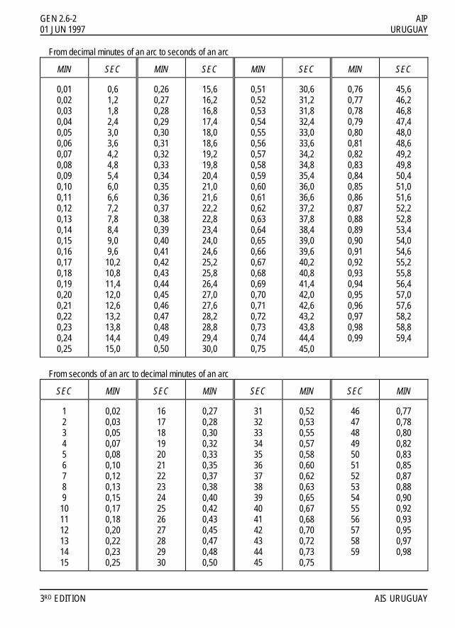
GEN 2.6-2 AIP 01 JUN 1997 URUGUAY From decimal minutes of an arc to seconds of an arc
MIN
SEC
MIN
SEC
MIN
SEC
MIN
SEC
0,01 0,02 0,03 0,04 0,05 0,06 0,07 0,08 0,09 0,10 0,11 0,12 0,13 0,14 0,15 0,16 0,17 0,18 0,19 0,20 0,21 0,22 0,23 0,24 0,25
0,6 1,2 1,8 2,4 3,0 3,6 4,2 4,8 5,4 6,0 6,6 7,2 7,8 8,4 9,0 9,6
10,2 10,8 11,4 12,0 12,6 13,2 13,8 14,4 15,0
0,26 0,27 0,28 0,29 0,30 0,31 0,32 0,33 0,34 0,35 0,36 0,37 0,38 0,39 0,40 0,41 0,42 0,43 0,44 0,45 0,46 0,47 0,48 0,49 0,50
15,6 16,2 16,8 17,4 18,0 18,6 19,2 19,8 20,4 21,0 21,6 22,2 22,8 23,4 24,0 24,6 25,2 25,8 26,4 27,0 27,6 28,2 28,8 29,4 30,0
0,51 0,52 0,53 0,54 0,55 0,56 0,57 0,58 0,59 0,60 0,61 0,62 0,63 0,64 0,65 0,66 0,67 0,68 0,69 0,70 0,71 0,72 0,73 0,74 0,75
30,6 31,2 31,8 32,4 33,0 33,6 34,2 34,8 35,4 36,0 36,6 37,2 37,8 38,4 39,0 39,6 40,2 40,8 41,4 42,0 42,6 43,2 43,8 44,4 45,0
0,76 0,77 0,78 0,79 0,80 0,81 0,82 0,83 0,84 0,85 0,86 0,87 0,88 0,89 0,90 0,91 0,92 0,93 0,94 0,95 0,96 0,97 0,98 0,99
45,6 46,2 46,8 47,4 48,0 48,6 49,2 49,8 50,4 51,0 51,6 52,2 52,8 53,4 54,0 54,6 55,2 55,8 56,4 57,0 57,6 58,2 58,8 59,4
From seconds of an arc to decimal minutes of an arc
SEC
MIN
SEC
MIN
SEC
MIN
SEC
MIN
1 2 3 4 5 6 7 8 9
10 11 12 13 14 15
0,02 0,03 0,05 0,07 0,08 0,10 0,12 0,13 0,15 0,17 0,18 0,20 0,22 0,23 0,25
16 17 18 19 20 21 22 23 24 25 26 27 28 29 30
0,27 0,28 0,30 0,32 0,33 0,35 0,37 0,38 0,40 0,42 0,43 0,45 0,47 0,48 0,50
31 32 33 34 35 36 37 38 39 40 41 42 43 44 45
0,52 0,53 0,55 0,57 0,58 0,60 0,62 0,63 0,65 0,67 0,68 0,70 0,72 0,73 0,75
46 47 48 49 50 51 52 53 54 55 56 57 58 59
0,77 0,78 0,80 0,82 0,83 0,85 0,87 0,88 0,90 0,92 0,93 0,95 0,97 0,98
3RD EDITION AIS URUGUAY

AIP GEN 2.7-1 URUGUAY 23 MAY 2019 GEN 2.7 SUNRISE/SUSET TABLES 1. The tables on the following pages have been prepared by the Dirección de Meteorología Aeronáutica of Uruguay and are reproduced here with their permission. The talbes include the values of Sunrise and sunset for all the country. 1.1 The tables indicate the time for beginning of civil morning twilight (TWIL FROM), sunrise (SR) sunset (SS), and !end of civil evening twilight (TWIL TO) for the years from 2019 to 2023. 1.2 The times indicated for the beginning of civil morning twilight and end of civil evening twilight are calculated for an altitude of the Sun 6° below the horizon, as commonly used. The hours are expressed in UTC. !1.3 The tables are calculated for the year 2019, which is used as an “average year” for the years from 2019 to !2023. In this period, the times on an arbitrary date and place will deviate less than 2 minutes from the times on the same date and place in the “average year” 2. Alphabetical index
Location
Page
Location
Page
Montevideo/Uruguay 350000S/0561500W
GEN 2.7-2
AIS URUGUAY AIRAC AIP AMDT NR 02

GEN 2.7-2 AIP 23 MAY 2019 URUGUAY 3. Sunrise-Sunset tables 3.1
MONTH DAY
TWIL FROM SR SS TWIL
TO MONTH DAY
TWIL FROM SR SS TWIL
TO
JAN 1 0805 !0835 2302 2332 FEB 15 0852 !0919 2239 2306 - 2 0806 0835 2302 2332 - 16 0853 !0920 2238 !2304 - 3 0807 0836 2303 2332 - 17 0854 0920 2237 2303 - 4 0807 0837 2303 2332 - 18 0855 0921 2236 2302 - 5 0808 0838 2303 2332 - 19 0856 0922 2235 2301 - 6 0809 0839 2303 2332 - 20 0857 0923 !2233 2300 - 7 0810 0839 2303 2332 - 21 0858 0924 2232 2258 - 8 0811 0840 2303 2332 - 22 0859 0925 2231 2257 - 9 0812 0841 2303 2332 - 23 0900 0926 2230 2256 - 10 0813 0842 2303 2332 - 24 0901 0927 2229 2255 - 11 0814 0843 2302 2331 - 25 0902 0928 !2227 2253 - 12 0815 0844 2302 2331 - 26 0903 0929 2226 2252 - 13 0816 0845 2302 2331 - 27 0904 0930 2225 2251 - 14 0817 0846 2302 2331 - 28 0905 0931 2224 !2249 - 15 0818 0847 2302 2330 - 16 0819 0848 2301 2330 - 17 0820 0849 2301 2330 MAR 1 0906 0932 2222 2248 - 18 0821 0850 2301 2329 - 2 0907 0933 2221 2247 - 19 0822 0851 2300 2329 - 3 0908 0934 2220 2245 - 20 0823 0852 2300 2328 - 4 0909 !0934 !2218 2244 - 21 0824 0853 2259 2328 - 5 0910 !0935 2217 2243 - 22 !0825 0854 2259 2327 - 6 0911 0936 2216 2241 - 23 0827 0855 2258 2326 - 7 !0912 0937 !2214 2240 - 24 0828 0856 2258 2326 - 8 !0912 0938 2213 !2239 - 25 0829 0857 2257 2325 - 9 0913 0939 2212 2237 - 26 0830 0858 !2257 !2324 - 10 0914 0940 2210 2236 - 27 0831 !0859 2256 2324 - 11 0915 !0941 2209 2234 - 28 0832 !0900 2255 2323 - 12 0916 !0941 !2208 2233 - 29 !0833 !0901 !2255 2322 - 13 0917 !0942 2206 !2232 - 30 !0834 !0902 2254 !2321 - 14 0918 0943 2205 2230 - 31 0836 !0903 2253 2321 - 15 !0919 0944 !2203 2229 - 16 0919 0945 2202 2227 FEB 1 0837 0904 2252 2320 - 17 0920 !0946 2201 2226 - 2 0838 0905 2252 2319 - 18 0921 0946 2259 2225 - 3 0839 0906 2251 2318 - 19 0922 0947 2158 2223 - 4 0840 0907 2250 2317 - 20 0923 0948 !2157 2222 - 5 0841 0908 2249 2316 - 21 !0924 0949 2155 2220 - 6 0842 0909 2248 2315 - 22 0924 0950 2154 2219 - 7 0843 0910 2247 2314 - 23 0925 !0950 2152 2218 - 8 0844 !0912 2246 2313 - 24 0926 0951 2151 2216 - 9 0846 !0913 2245 2312 - 25 0927 0952 2150 2215 - 10 0847 !0914 2244 2311 - 26 !0928 0953 2148 2213 - 11 0848 !0915 2243 2310 - 27 0928 0954 2147 2212 - 12 0849 !0916 2242 2309 - 28 0929 0954 2145 2211 - 13 0850 !0917 2241 2308 - 29 0930 0955 2144 2209 - 14 0851 !0918 2240 2307 - 30 0931 0956 2143 2208
AIRAC AIP AMDT NR 02 AIS URUGUAY

AIP GEN 2.7-3 URUGUAY 23 MAY 2019
MONTH DAY
TWIL FROM SR SS TWIL
TO MONTH DAY
TWIL FROM SR SS TWIL
TO
MAR 31 !0932 0957 2141 2206 MAY 17 1007 1034 2049 2116 - 18 1007 1035 2048 2115 APR 1 0932 0958 2140 2205 - 19 1008 1035 2047 2115 - 2 0933 0958 2138 !2204 - 20 1009 1036 2047 2114 - 3 0934 0959 2137 2202 - 21 1009 1037 2046 2113 - 4 0935 1000 2136 2201 - 22 1010 1037 2046 2113 - 5 0935 1001 2134 2200 - 23 1011 1038 2045 2112 - 6 0936 !1002 2133 2158 - 24 !1011 1039 2045 2112 - 7 0937 1002 2132 2157 - 25 1012 1040 2044 2112 - 8 0938 1003 2130 2156 - 26 1013 1040 !2044 2111 - 9 0938 1004 2129 2154 - 27 1013 1041 2043 2111 - 10 0939 1005 2128 2153 - 28 1014 1042 2043 2110 - 11 0940 1005 2126 2152 - 29 1015 1042 2042 2110 - 12 0941 1006 2125 !2150 - 30 1015 1043 2042 2110 - 13 !0942 1007 2124 2149 - 31 1016 1044 2042 2109 - 14 0942 1008 2122 2148 - 15 0943 1009 2121 2147 JUN 1 1016 1044 2041 2109 - 16 0944 1009 2120 !2145 - 2 1017 1045 2041 2109 - 17 !0945 1010 2119 2144 - 3 1017 1045 2041 2109 - 18 0945 1011 2117 2143 - 4 1018 1046 2041 2108 - 19 0946 1012 2116 2142 - 5 !1019 1046 2040 2108 - 20 0947 !1013 2115 2141 - 6 1019 1047 2040 2108 - 21 !0948 1013 2114 2140 - 7 1020 1048 2040 2108 - 22 0948 1014 !2112 2138 - 8 1020 1048 2040 2108 - 23 0949 1015 2111 2137 - 9 1020 1049 2040 2108 - 24 0950 1016 2110 2136 - 10 1021 1049 2040 2108 - 25 !0951 !1017 2109 2135 - 11 1021 1049 2040 2108 - 26 0951 1017 2108 2134 - 12 1022 1050 2040 2108 - 27 0952 1018 2107 2133 - 13 1022 1050 2040 2108 - 28 0953 1019 2106 2132 - 14 1023 1051 2040 2108 - 29 0954 1020 2105 2131 - 15 1023 1051 2040 2108 - 30 0954 !1021 !2104 2130 - 16 1023 1051 2040 2108 - 17 1024 1052 2040 2108 MAY 1 0955 1021 2103 2129 - 18 1024 1052 2040 2108 - 2 0956 1022 2102 2128 - 19 1024 1052 2040 2109 - 3 !0957 1023 2101 2127 - 20 1024 1053 2041 2109 - 4 0957 1024 !2100 2126 - 21 1025 1053 2041 2109 - 5 0958 1024 !2059 2125 - 22 1025 1053 2041 2109 - 6 0959 1025 2058 2124 - 23 1025 1053 2041 2109 - 7 !1000 1026 2057 2123 - 24 1025 1053 2042 2110 - 8 1000 1027 2056 2122 - 25 1025 1054 2042 2110 - 9 1001 1028 2055 2122 - 26 1025 1054 2042 2110 - 10 1002 1028 2054 2121 - 27 1026 1054 !2043 2111 - 11 1002 1029 2053 2120 - 28 1026 1054 2043 2111 - 12 1003 1030 2052 2119 - 29 1026 1054 2043 2111 - 13 1004 1031 2052 2119 - 30 1026 1054 2044 2112 - 14 1005 !1032 2051 2118 - 15 1005 1032 2050 2117 JUL 1 1026 1054 2044 2112 - 16 1006 1033 2049 2116 - 2 1026 1054 !2045 2113
AIS URUGUAY AIRAC AIP AMDT NR 02

GEN 2.7-4 AIP 23 MAY 2019 URUGUAY
MONTH DAY
TWIL FROM SR SS TWIL
TO MONTH DAY
TWIL FROM SR SS TWIL
TO
JUL 3 1026 1054 2045 2113 AUG 20 0954 1020 2117 2143 - 4 1026 1054 2045 2113 - 21 0953 1019 2118 2144 - 5 1025 1053 2046 2114 - 22 0952 !1017 2119 2145 - 6 1025 1053 2046 2114 - 23 !0950 1016 2120 2145 - 7 1025 1053 2047 2115 - 24 0949 1015 2120 2146 - 8 1025 1053 !2048 2115 - 25 0948 1014 2121 2147 - 9 1025 1053 2048 2116 - 26 0947 1012 2122 2147 - 10 1025 1052 2049 2116 - 27 0946 1011 !2122 2148 - 11 1024 1052 2049 2117 - 28 0944 1010 2123 2149 - 12 1024 1052 2050 !2118 - 29 0943 !1008 2124 2149 - 13 1024 1051 2050 2118 - 30 0942 1007 2125 2150 - 14 1023 1051 2051 2119 - 31 0940 1006 2125 2151 - 15 1023 1051 2052 2119 - 16 1023 1050 2052 2120 SEP 1 0939 !1004 2126 2152 - 17 1022 1050 2053 2120 - 2 0938 1003 2127 2152 - 18 1022 1049 !2054 2121 - 3 0936 1002 !2128 2153 - 19 1021 1049 2054 2122 - 4 0935 1000 2128 2154 - 20 1021 1048 2055 2122 - 5 0934 0959 2129 2154 - 21 1020 1048 !2056 2123 - 6 0932 0958 2130 2155 - 22 1020 1047 2056 !2124 - 7 0931 0956 !2130 2156 - 23 1019 1046 2057 2124 - 8 0930 0955 2131 2156 - 24 1019 1046 2058 2125 - 9 0928 !0953 2132 2157 - 25 1018 1045 2058 2125 - 10 0927 0952 2133 2158 - 26 1017 1044 2059 2126 - 11 0925 0951 2133 2159 - 27 1017 1044 2100 2127 - 12 0924 0949 2134 2159 - 28 1016 1043 2100 2127 - 13 !0922 0948 2135 2200 - 29 1015 1042 2101 2128 - 14 0921 0946 2135 2201 - 30 1014 1041 2102 2129 - 15 0920 0945 2136 !2201 - 31 1014 1041 2103 2129 - 16 0918 !0943 2137 2202 - 17 0917 0942 2138 2203 AUG 1 1013 1040 2103 2130 - 18 0915 0941 2138 2204 - 2 1012 1039 2104 2131 - 19 0914 0939 2139 2204 - 3 1011 1038 2105 !2132 - 20 !0912 0938 2140 2205 - 4 1010 1037 2106 2132 - 21 0911 0936 !2141 2206 - 5 1010 1036 2106 2133 - 22 0910 0935 2141 !2207 - 6 1009 1035 2107 2134 - 23 0908 0933 2142 2207 - 7 1008 1034 2108 2134 - 24 0907 0932 2143 2208 - 8 1007 1033 !2109 2135 - 25 0905 !0930 2143 2209 - 9 1006 1032 2109 2136 - 26 0904 0929 2144 2210 - 10 1005 1031 2110 2136 - 27 0902 0928 2145 2210 - 11 1004 1030 2111 2137 - 28 0901 0926 2146 2211 - 12 1003 1029 2111 2138 - 29 !0859 0925 !2147 2212 - 13 1002 1028 2112 2138 - 30 0858 0923 2147 2213 - 14 1001 1027 2113 2139 - 15 1000 1026 2114 2140 OCT 1 0857 0922 2148 2213 - 16 0959 1025 2114 !2141 - 2 0855 !0920 2149 2214 - 17 !0957 !1023 2115 2141 - 3 0854 0919 2150 2215 - 18 0956 1022 2116 2142 - 4 0852 0918 !2150 2216 - 19 0955 1021 2117 2143 - 5 0851 0916 2151 2217
AIRAC AIP AMDT NR 02 AIS URUGUAY

AIP GEN 2.7-5 URUGUAY 23 MAY 2019
MONTH DAY
TWIL FROM SR SS TWIL
TO MONTH DAY
TWIL FROM SR SS TWIL
TO
OCT 6 !0849 0915 2152 !2218 NOV 23 0758 0827 2236 2305 - 7 0848 0914 2153 2218 - 24 0758 0826 2237 2306 - 8 0847 0912 2154 2219 - 25 0757 0826 2238 2307 - 9 0845 0911 !2154 2220 - 26 0757 0826 2239 2308 - 10 0844 !0909 2155 2221 - 27 !0756 0825 2240 2309 - 11 !0842 0908 2156 2222 - 28 0756 0825 2241 2310 - 12 0841 0907 2157 2223 - 29 0756 0825 2242 2311 - 13 0840 0905 2158 2223 - 30 0756 !0824 2243 2312 - 14 0838 0904 !2159 2224 - 15 0837 0903 2259 2225 DEC 1 0755 0824 2244 2313 - 16 0836 0902 2200 2226 - 2 0755 0824 2245 2314 - 17 0834 0900 2201 2227 - 3 0755 0824 2246 2315 - 18 0833 0859 2202 2228 - 4 0755 0824 2247 2316 - 19 0832 0858 2203 2229 - 5 0755 0824 2247 2317 - 20 0830 !0856 2204 2230 - 6 0755 0824 2248 2318 - 21 0829 0855 2205 2231 - 7 0755 0824 2249 2318 - 22 0828 0854 2205 2232 - 8 0755 0824 2250 2319 - 23 0827 0853 2206 2233 - 9 0755 0824 2251 2320 - 24 0825 0852 2207 2234 - 10 0755 0824 2251 2321 - 25 0824 0851 2208 2235 - 11 0755 0824 2252 2322 - 26 0823 0849 2209 2236 - 12 0755 0824 2253 2323 - 27 0822 0848 2210 2237 - 13 0755 0825 2254 2323 - 28 0821 0847 2211 2238 - 14 0755 0825 2254 2324 - 29 0819 0846 2212 2239 - 15 0756 0825 2255 2325 - 30 0818 0845 2213 2240 - 16 0756 0825 2256 2325 - 31 0817 0844 2214 2241 - 17 0756 0826 2256 2326 - 18 0757 0826 2257 2327 NOV 1 0816 0843 2215 2242 - 19 0757 0827 2257 2327 - 2 0815 0842 2216 2243 - 20 0757 0827 2258 2328 - 3 0814 0841 2217 2244 - 21 0758 0827 2259 2328 - 4 0813 0840 2218 2245 - 22 0758 0828 2259 2329 - 5 0812 0839 2219 2246 - 23 0759 0828 2259 2329 - 6 0811 0838 2220 2247 - 24 0759 0829 2300 2330 - 7 0810 0837 2221 2248 - 25 0800 0830 2300 2330 - 8 0809 0836 2222 2249 - 26 0801 0830 2301 2330 - 9 0808 0836 2223 2250 - 27 0801 0831 2301 2331 - 10 0807 0835 !2224 2251 - 28 0802 0831 2301 2331 - 11 0806 0834 !2225 2252 - 29 0803 0832 2302 2331 - 12 0806 0833 !2226 2253 - 30 0803 0833 2302 2331 - 13 0805 !0832 !2227 2254 - 31 0804 0834 2302 2332 - 14 0804 0832 2227 2255 - 15 0803 0831 2228 2256 - 16 0802 0830 2229 2258 - 17 0802 0830 2230 2259 - 18 0801 0829 2231 2300 - 19 0800 0829 2232 2301 - 20 0800 0828 2233 2302 - 21 0759 0828 2234 2303 - 22 0759 0827 2235 2304
AIS URUGUAY AIRAC AIP AMDT NR 02

IIINNNTTTEEENNNTTTIIIOOONNNAAALLLLLLYYY LLLEEEFFFTTT BBBLLLAAANNNKKK