gen 2.2 abbreviations used in ais publicationsiaip.iaa.ie/iaip/published files/aip...
TRANSCRIPT

AIP IRELAND GEN 2.2 - 124 MAY 2018
24 MAY 2018
GEN 2.2 ABBREVIATIONS USED IN AIS PUBLICATIONS
Abbreviations marked by an asterisk (*) are either different from or not contained in ICAO Doc. 8400.
Irish Aviation Authority
A
A Amber*A Approach
(Used to specify the purpose of a Radio Navigation Aid)
AAA Amended meteorological mes-sage
A/A Air-to-airAAD Assigned altitude deviation AAIM Aircraft autonomous integrity
monitoringAAL Above aerodrome levelAAR Air to air refuellingABI Advance boundary informationABM AbeamABN Aerodrome beaconABT AboutABV AboveAC AltocumulusACARS Aircraft communication address-
ing and reporting system ACAS Airborne collision avoidance sys-
temACC Area control centre or area controlACCID Notification of an aircraft accident*A-CDM Airport Collaborative Decision
MakingACFT AircraftACK AcknowledgeACL Altimeter check locationACN Aircraft Classification NumberACP AcceptanceACPT Accept or acceptedACT Active or activated or activityAD AerodromeADA Advisory areaADC Aerodrome chartADDN Addition or additionalADF Automatic Direction FindingADIZ Air defence identification zoneADJ Adjacent*ADMIN AdministrationADO Aerodrome officeADR Advisory routeADS Automatic dependent surveillanceADS The address when this abbrevia-
tion is used to request a repetition, the question mark (IMI) precedes the abbreviation, e.g. IMI ADS (to be used in AFS as a procedure signal)
ADS-B Automatic dependant surveillance - broadcast
ADS-C Automatic dependant surveillance - contract
ADSU Automatic dependent surveillance unit
ADVS Advisory serviceADZ AdviseAES Aircraft earth stationAFIL Flight plan filed in the airAFIS Aerodrome Flight Information
ServiceAFM Yes or affirm or affirmative or that
is correctAFS Aeronautical fixed serviceAFT After…AFTN Aeronautical Fixed Telecommuni-
cation NetworkA/G Air-to groundAGA Aerodromes, air routes and
ground aidsAGL Above ground levelAGN Again*AGNIS Azimuth Guidance for Nose-In
StandAIC Aeronautical Information CircularAIDC Air traffic services inter-facility
data communicationAIM Aeronautical information manage-
mentAIP Aeronautical Information Publica-
tionAIRAC Aeronautical Information Regula-
tion and ControlAIREP Air-reportAIRMET Information concerning en-route
weather phenomena which may effect the safety of low-level air-craft operations
AIS Aeronautical Information ServicesALA Alighting areaALERFA Alert phaseALR AlertingALRS Alerting serviceALS Approach lighting systemALT AltitudeALTN Alternate or alternatingALTN AlternateAMA Area minimum altitudeAMD Amend or amendedAMDT AmendmentAMS Aeronautical mobile serviceAMSL Above mean sea levelAMSS Aeronautical mobile satellite ser-
viceANC Aeronautical Chart 1:500 000ANCS Aeronautical Navigation Chart
Small ScaleANS Answer
AIRAC Amdt 005/18

GEN 2.2 - 2 AIP IRELAND 24 MAY 2018
24 MAY 2018
*ANSP Aeronautical Navigation Service Provider
AO Oceanic control areaAO Aircraft OperatorAOC Aerodrome obstacle chart*AOC Air Operator Certificate*AOS A-CDM portalAP AirportAPAPI Abbreviated precision approach
path indicatorAPCH ApproachAPDC Aircraft parking/docking chartAPN ApronAPP Approach control office or ap-
proach control or approach con-trol service
APR AprilAPRX Approximate or approximatelyAPSG After passing…APU Auxiliary power unitAPV Approach Procedures with Verti-
cal guidanceARC Area chartARNG ArrangeARO Air traffic services reporting officeARP Aerodrome reference pointARP Air-reportARQ Automatic error correctionARR Arrive ARR ArrivalARS Special air-reportARST ArrestingAS Altrostratus*AS Aerodrome SurfaceASAP As soon as possibleASC Ascent to or ascending toASDA Accelerate stop distance availa-
bleASE Altimetry system errorASPEEDG Airspeed gainASPEEDL Airspeed lossASPH AsphaltAT… At (followed by time at which
weather change is forecast to oc-cur)
ATA Actual time of arrivalATC Air Traffic ControlATD Actual time of departureATFM Air traffic flow managementATIS Automatic terminal information
serviceATM Air traffic management*ATM Automated Teller Machine or Au-
tomatic Teller MachineATN Aeronautical telecommunication
networkATP At…ATS Air traffic services*ATSU Air traffic service unit
ATTN AttentionAT-VASIS Abbreviated T visual approach
slope indicator systemATZ Aerodrome traffic zoneAUG AugustAUTH Authorized or authorizationAUTO AutomaticAUW All up weightAUX AuxiliaryAVBL Available or availabilityAVG Average*AVDGS Advanced Visual Docking Guid-
ance SystemAVGAS Aviation gasolineAWOS Automated Weather Observation
SystemAWTA Advise at what time ableAWY AirwayAZM Azimuth
B
B BlueBA Braking actionBASE Cloud baseBCFG Fog patchesBCN BeaconBCST BroadcastBDRY BoundaryBECMG BecomingBFR BeforeBKN BrokenBL BlowingBLDG BuildingBLO Below cloudsBLW Below…BOMB BombingBR MistBRF ShortBRG BearingBRKG BrakingBS Commercial broadcasting stationBTL Between layersBTN Between
C
C CentreC Degrees CelsiusCAA Civil Aviation Authority or Civil
Aviation AdministrationCAT CategoryCAT Clear air turbulenceCAVOK Visibility, cloud and present
weather better than prescribed values or conditions
CB CumulonimbusCC CirrocumulusCCA Corrected meteorological mes-
sageCCO Continuous climb operationCD Candela
Irish Aviation AuthorityAIRAC Amdt 005/18

AIP IRELAND GEN 2.2 - 324 MAY 2018
24 MAY 2018
CDN Co-ordination messageCDO Continuous descent operationCDR Conditional route*CET Civil Evening TwilightCF Change frequency to…CFM Confirm or I confirmCGL Circling guidance light(s)CH Channel CH This is a channel – continuity -
check of transmission to permit comparison of your record of channel sequence numbers of messages received on the chan-nel
CHG Modification messageCI CirrusCIDIN Common ICAO data interchange
networkCIV CivilCK CheckCL Centre lineCLA Clear type of ice formationCLBR CalibrationCLD CloudCLG CallingCLIMB-OUT Climb-out areaCLR Clear or cleared to… or clearanceCLRD Runway(s) clearedCLSD Close or closed or closingcm CentimetreCMB Climb to or climbing toCMPL Completion or completed or com-
plete*CMT Civil Morning TwilightCNL Cancel or cancelledCNL Flight plan cancellationCNS Communications, navigation and
surveillanceCOM CommunicationsCONC ConcreteCOND ConditionCONS ContinuousCONST Construction or constructedCONT Continue(s) or continuedCOOR Coordinate, or co-ordinationCOORD CoordinatesCOP Change-over pointCOR Correct or corrected or correctionCOT At the coastCOV Cover or covered or coveringCPDLC Controller – pilot data link commu-
nicationsCPL Current flight plan messageCRC Cyclic redundancy checkCRM Collision risk modelCRP Compulsory reporting pointCRZ CruiseCS CirrostratusCS Call sign
CTA Control areaCTA *Common Travel AreaCTAM Climb to and maintainCTC ContactCTL ControlCTN Caution*CTOT Calculated take off timeCTR Control zoneCU CumulusCUF CumuliformCUST CustomsCVR Cockpit voice recorderCW Continuous waveCWY Clearway
D
D DownwardD Danger areaDA Decision altitudeD - ATIS Data link automatic terminal infor-
mation serviceDCD Double channel duplexDCKG Docking*DCL Digital ClearanceDCP Datum crossing pointDCPC Direct controller-pilot communica-
tionsDCS Double channel simplexDCT DirectDE FromDEC DecemberDEG DegreesDEP Depart or departure or departure
messageDES Descend to or descending toDEST DestinationDETRESFA Distress phaseDEV Deviation or deviatingDFDR Digital flight data recorderDFTI Distance from touch down indica-
torDH Decision heightDIF DiffuseDIST DistanceDIV Divert or divertingDLA Delay or delayedDLA DelayDLIC Data link initiation capabilityDLY DailyDME Distance measuring equipmentDNG Danger or dangerousDOF Date of flight *DOC ICAO Document*DOC Designated Operational Cover-
ageDOM DomesticDP Dew point temperatureDPT DepthDR Dead reckoning
Irish Aviation Authority AIRAC Amdt 005/18
GEN 2.2 - 4 AIP IRELAND 24 MAY 2018
24 MAY 2018
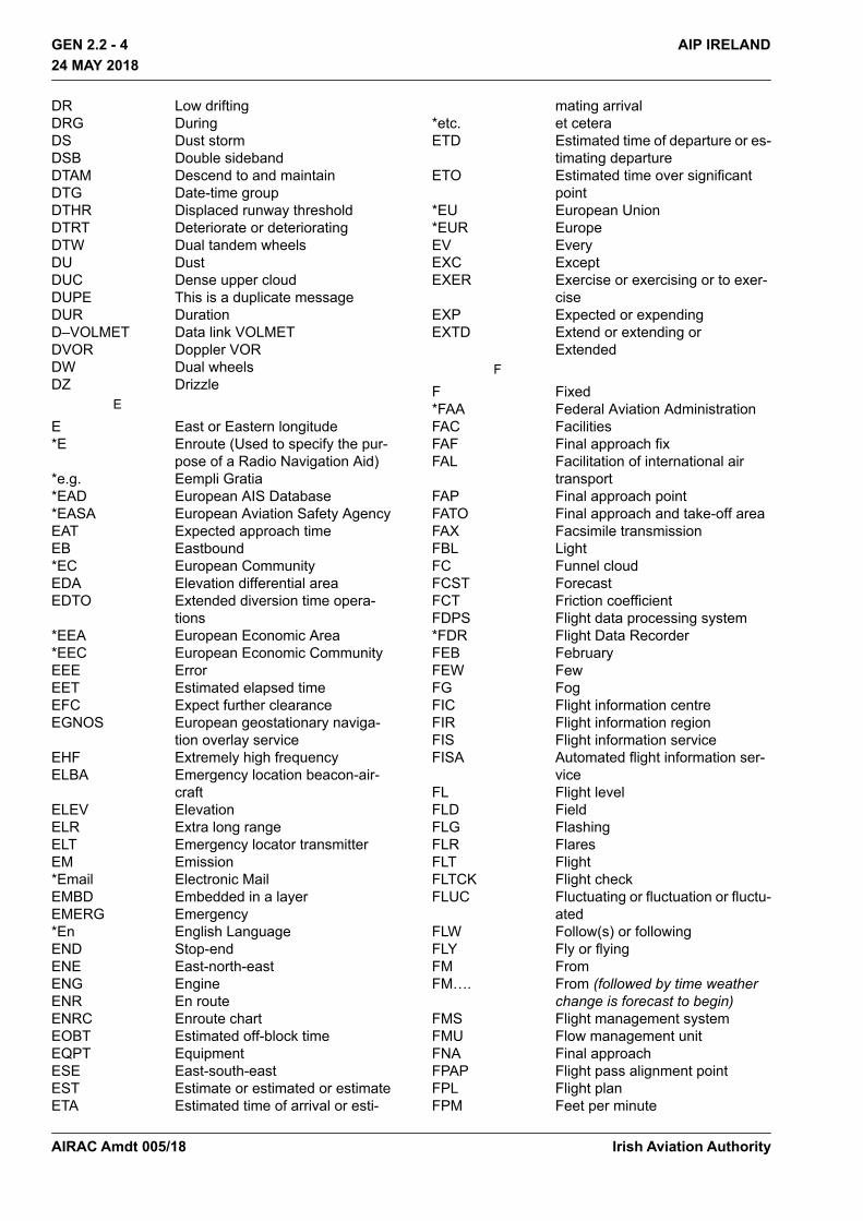
DR Low driftingDRG DuringDS Dust stormDSB Double sidebandDTAM Descend to and maintainDTG Date-time groupDTHR Displaced runway thresholdDTRT Deteriorate or deterioratingDTW Dual tandem wheelsDU DustDUC Dense upper cloudDUPE This is a duplicate messageDUR DurationD–VOLMET Data link VOLMETDVOR Doppler VORDW Dual wheelsDZ Drizzle
E
E East or Eastern longitude*E Enroute (Used to specify the pur-
pose of a Radio Navigation Aid)*e.g. Eempli Gratia*EAD European AIS Database*EASA European Aviation Safety AgencyEAT Expected approach timeEB Eastbound*EC European CommunityEDA Elevation differential areaEDTO Extended diversion time opera-
tions*EEA European Economic Area*EEC European Economic CommunityEEE ErrorEET Estimated elapsed timeEFC Expect further clearanceEGNOS European geostationary naviga-
tion overlay serviceEHF Extremely high frequencyELBA Emergency location beacon-air-
craftELEV ElevationELR Extra long rangeELT Emergency locator transmitterEM Emission*Email Electronic MailEMBD Embedded in a layerEMERG Emergency*En English LanguageEND Stop-endENE East-north-eastENG EngineENR En routeENRC Enroute chartEOBT Estimated off-block timeEQPT EquipmentESE East-south-eastEST Estimate or estimated or estimateETA Estimated time of arrival or esti-
mating arrival*etc. et ceteraETD Estimated time of departure or es-
timating departureETO Estimated time over significant
point*EU European Union*EUR EuropeEV EveryEXC ExceptEXER Exercise or exercising or to exer-
ciseEXP Expected or expendingEXTD Extend or extending or
ExtendedF
F Fixed*FAA Federal Aviation AdministrationFAC FacilitiesFAF Final approach fixFAL Facilitation of international air
transportFAP Final approach pointFATO Final approach and take-off areaFAX Facsimile transmissionFBL LightFC Funnel cloudFCST ForecastFCT Friction coefficientFDPS Flight data processing system*FDR Flight Data RecorderFEB FebruaryFEW FewFG FogFIC Flight information centreFIR Flight information regionFIS Flight information serviceFISA Automated flight information ser-
viceFL Flight levelFLD FieldFLG FlashingFLR FlaresFLT FlightFLTCK Flight checkFLUC Fluctuating or fluctuation or fluctu-
atedFLW Follow(s) or followingFLY Fly or flyingFM FromFM…. From (followed by time weather
change is forecast to begin)FMS Flight management systemFMU Flow management unitFNA Final approachFPAP Flight pass alignment pointFPL Flight planFPM Feet per minute
Irish Aviation AuthorityAIRAC Amdt 005/18
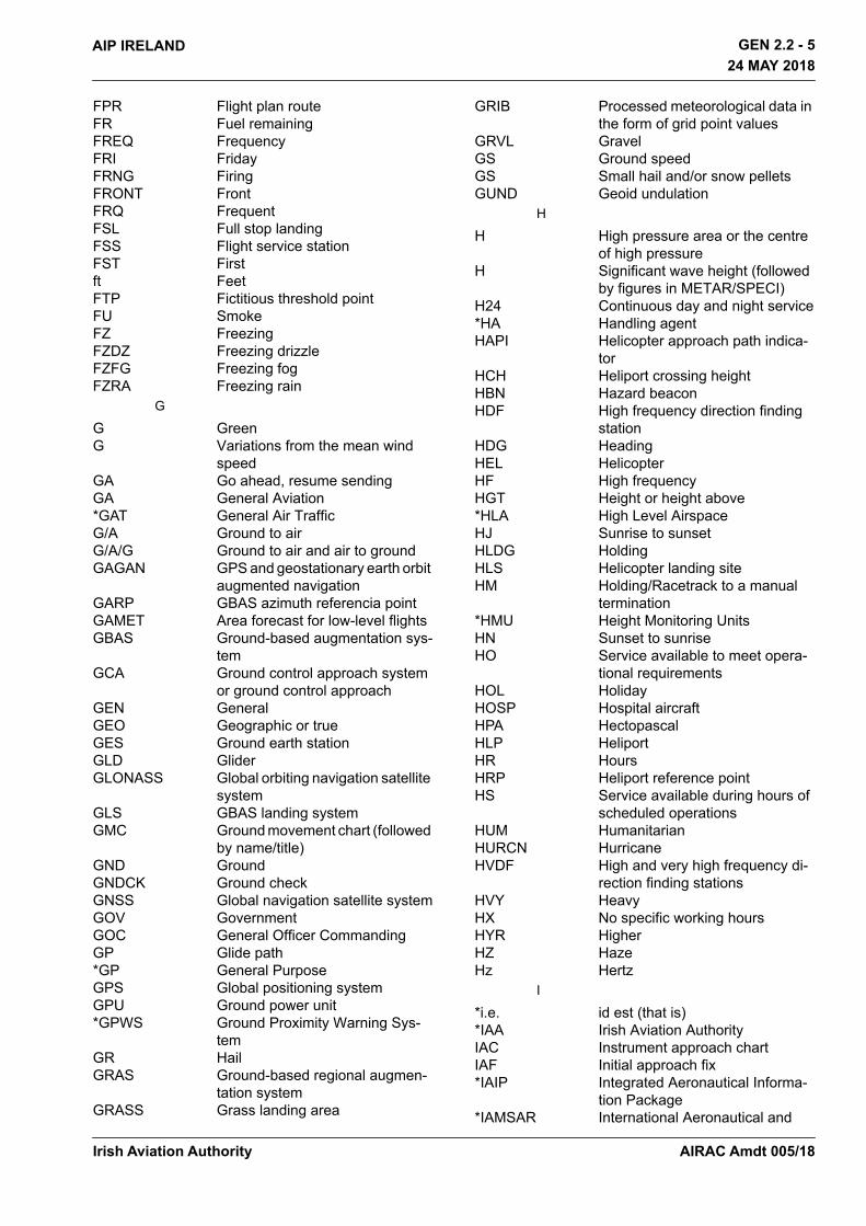
AIP IRELAND GEN 2.2 - 524 MAY 2018
24 MAY 2018
FPR Flight plan routeFR Fuel remainingFREQ FrequencyFRI FridayFRNG FiringFRONT FrontFRQ FrequentFSL Full stop landingFSS Flight service stationFST Firstft FeetFTP Fictitious threshold pointFU SmokeFZ FreezingFZDZ Freezing drizzleFZFG Freezing fogFZRA Freezing rain
G
G GreenG Variations from the mean wind
speedGA Go ahead, resume sendingGA General Aviation *GAT General Air TrafficG/A Ground to airG/A/G Ground to air and air to groundGAGAN GPS and geostationary earth orbit
augmented navigationGARP GBAS azimuth referencia pointGAMET Area forecast for low-level flightsGBAS Ground-based augmentation sys-
temGCA Ground control approach system
or ground control approachGEN GeneralGEO Geographic or trueGES Ground earth stationGLD GliderGLONASS Global orbiting navigation satellite
systemGLS GBAS landing systemGMC Ground movement chart (followed
by name/title)GND GroundGNDCK Ground checkGNSS Global navigation satellite systemGOV GovernmentGOC General Officer CommandingGP Glide path*GP General PurposeGPS Global positioning systemGPU Ground power unit*GPWS Ground Proximity Warning Sys-
temGR HailGRAS Ground-based regional augmen-
tation systemGRASS Grass landing area
GRIB Processed meteorological data in the form of grid point values
GRVL GravelGS Ground speedGS Small hail and/or snow pelletsGUND Geoid undulation
H
H High pressure area or the centre of high pressure
H Significant wave height (followed by figures in METAR/SPECI)
H24 Continuous day and night service*HA Handling agentHAPI Helicopter approach path indica-
torHCH Heliport crossing heightHBN Hazard beaconHDF High frequency direction finding
stationHDG HeadingHEL HelicopterHF High frequencyHGT Height or height above*HLA High Level AirspaceHJ Sunrise to sunsetHLDG HoldingHLS Helicopter landing siteHM Holding/Racetrack to a manual
termination*HMU Height Monitoring UnitsHN Sunset to sunriseHO Service available to meet opera-
tional requirementsHOL HolidayHOSP Hospital aircraftHPA HectopascalHLP HeliportHR HoursHRP Heliport reference pointHS Service available during hours of
scheduled operationsHUM HumanitarianHURCN HurricaneHVDF High and very high frequency di-
rection finding stationsHVY HeavyHX No specific working hoursHYR HigherHZ HazeHz Hertz
I
*i.e. id est (that is) *IAA Irish Aviation AuthorityIAC Instrument approach chartIAF Initial approach fix*IAIP Integrated Aeronautical Informa-
tion Package*IAMSAR International Aeronautical and
Irish Aviation Authority AIRAC Amdt 005/18
GEN 2.2 - 6 AIP IRELAND 24 MAY 2018
24 MAY 2018
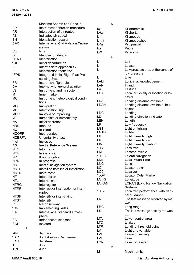
Maritime Search and RescueIAP Instrument approach procedureIAR Intersection of air routesIAS Indicated air speedIBN Identification beaconICAO International Civil Aviation Organ-
izationICE IcingID Identifier or identifyIDENT Identification*IDF Initial departure fixIF Intermediate approach fixIFF Identification friend/foe*IFPS Integrated Initial Flight Plan Pro-
cessing SystemIFR Instrument flight rulesIGA International general aviationILS Instrument landing systemIM Inner markerIMC Instrument meteorological condi-
tionsIMG ImmigrationIMI Interrogation signIMPR Improve or improvingIMT Immediate or immediatelyINA Initial approachINBD InboundINC In cloudINCORP IncorporatedINCERFA Uncertainty phase*incl InclusiveIRS Inertial Reference SystemINFO InformationINOP InoperativeINP If not possibleINPR In progressINS Inertial navigation systemINSTL Install or installed or installationINSTR InstrumentINT IntersectionINTL InternationalINTRG InterrogatorINTRP Interrupt or interruption or inter-
ruptedINTSF Intensify or intensifyingINTST IntensityIR Ice on runway*IRs Implementing RulesISA International standard atmos-
phereISB Independent sidebandISOL Isolated
J
JAN January*JAR Joint Aviation RequirementJTST Jet streamJUL JulyJUN June
K
kg KilogrammeskHz Kilohertzkm Kilometreskm/h Kilometres/hourkPa Kilo pascalkts KnotskW Kilowatts
L
L LeftL LocatorL Low pressure area or the centre of
low pressure L LitreLAM Logical acknowledgementLAN InlandLAT LatitudeLCA Local or Locally or location or lo-
catedLDA Landing distance availableLDAH Landing distance available, heli-
copterLDG LandingLDI Landing direction indicatorLEN LengthLF Low frequencyLGT Light or lightingLGTD LightedLIH Light intensity highLIL Light intensity lowLIM Light intensity medium*LLZ LocalizerLM Locator, middle*LNAV Lateral NavigationLMT Local Mean TimeLNG LongLO Locator outerLOC Localizer*LOM Locator Outer MarkerLONG LongitudeLORAN LORAN (Long Range Navigation
Systems)*LPV Localizer performance with verti-
cal guidance.LR The last message received by me
was ….LRG Long rangeLS The last message sent by me was
….LTA Lower control areaLTD LimitedLTP Landing threshold pointLV Light and variableLVE Leave or leavingLVL LevelLYR Layer or layered
M
M Mach number
Irish Aviation AuthorityAIRAC Amdt 005/18
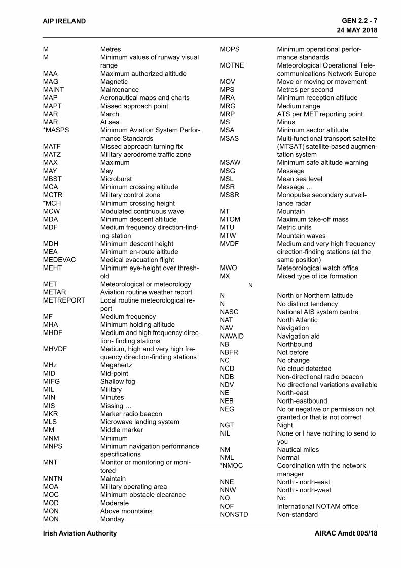
AIP IRELAND GEN 2.2 - 724 MAY 2018
24 MAY 2018
M MetresM Minimum values of runway visual
rangeMAA Maximum authorized altitudeMAG MagneticMAINT MaintenanceMAP Aeronautical maps and chartsMAPT Missed approach pointMAR MarchMAR At sea*MASPS Minimum Aviation System Perfor-
mance StandardsMATF Missed approach turning fixMATZ Military aerodrome traffic zoneMAX MaximumMAY MayMBST MicroburstMCA Minimum crossing altitudeMCTR Military control zone*MCH Minimum crossing heightMCW Modulated continuous waveMDA Minimum descent altitudeMDF Medium frequency direction-find-
ing stationMDH Minimum descent heightMEA Minimum en-route altitudeMEDEVAC Medical evacuation flightMEHT Minimum eye-height over thresh-
oldMET Meteorological or meteorologyMETAR Aviation routine weather reportMETREPORT Local routine meteorological re-
portMF Medium frequencyMHA Minimum holding altitudeMHDF Medium and high frequency direc-
tion- finding stationsMHVDF Medium, high and very high fre-
quency direction-finding stationsMHz MegahertzMID Mid-pointMIFG Shallow fogMIL MilitaryMIN MinutesMIS Missing …MKR Marker radio beaconMLS Microwave landing systemMM Middle markerMNM MinimumMNPS Minimum navigation performance
specificationsMNT Monitor or monitoring or moni-
toredMNTN MaintainMOA Military operating areaMOC Minimum obstacle clearanceMOD ModerateMON Above mountainsMON Monday
MOPS Minimum operational perfor-mance standards
MOTNE Meteorological Operational Tele-communications Network Europe
MOV Move or moving or movementMPS Metres per secondMRA Minimum reception altitudeMRG Medium rangeMRP ATS per MET reporting pointMS MinusMSA Minimum sector altitudeMSAS Multi-functional transport satellite
(MTSAT) satellite-based augmen-tation system
MSAW Minimum safe altitude warningMSG MessageMSL Mean sea levelMSR Message … MSSR Monopulse secondary surveil-
lance radarMT MountainMTOM Maximum take-off massMTU Metric unitsMTW Mountain wavesMVDF Medium and very high frequency
direction-finding stations (at the same position)
MWO Meteorological watch officeMX Mixed type of ice formation
N
N North or Northern latitudeN No distinct tendencyNASC National AIS system centreNAT North AtlanticNAV NavigationNAVAID Navigation aidNB NorthboundNBFR Not beforeNC No changeNCD No cloud detectedNDB Non-directional radio beaconNDV No directional variations availableNE North-eastNEB North-eastboundNEG No or negative or permission not
granted or that is not correctNGT NightNIL None or I have nothing to send to
youNM Nautical milesNML Normal*NMOC Coordination with the network
managerNNE North - north-eastNNW North - north-westNO NoNOF International NOTAM officeNONSTD Non-standard
Irish Aviation Authority AIRAC Amdt 005/18

GEN 2.2 - 8 AIP IRELAND 24 MAY 2018
24 MAY 2018
*Nom NominalNOSIG No significant change*NOTA Northern Oceanic Transition AreaNOTAM A notice distributed by means of
telecommunication containing in-formation concerning the estab-lishment, condition or change in any aeronautical facility, service, procedure or hazard, the timely knowledge of which is essential to personnel concerned with flight operations.
NOTAMC Cancelling NOTAMNOTAMN New NOTAMNOTAMR Replacing NOTAMNOV NovemberNOZ Normal operating zoneNR NumberNRH No reply heardNS NimbostratusNSC Nil significant cloudNSW Nil significant weatherNTL NationalNTZ No transgression zoneNW North-westNWB North-westboundNXT Next
O
OAC Oceanic area control centreOAS Obstacle assessment surfaceOAT Operational Air TrafficOBS Observe or observed or observa-
tionOBSC Obscure or obscured or obscuringOBST ObstacleOCA Obstacle clearance altitudeOCA Oceanic control areaOCC OccultingOCH Obstacle clearance height*OCL Oceanic Clearance LinkOCNL Occasional or occasionallyOCS Obstacle clearance surfaceOCT OctoberOFZ Obstacle free zoneOGN OriginateOHD OverheadOK We agree or it is correctOLDI On line data interchangeOM Outer markerOPA Opaque, white type of ice forma-
tionOPC Control indicated is operational
controlOPMET Operational meteorological (infor-
mation)OPN Open or opening or openedOPR Operator or operate or operative
or operating or operational
OPS OperationsO/R On requestORD Indication of an order*ORM Operational reply message*OSI Ordnance Survey IrelandOSV Ocean station vesselOTLK OutlookOTP On topOTS Organized track systemOUBD OutboundOVC Overcast
P
P Maximum values of runway visual range
P Prohibited areaPA Precision approachPALS Precision approach lighting sys-
tem PANS Procedures for air navigation ser-
vicesPAPI Precision approach path indicatorPAR Precision approach radarPARL ParallelPATC Precision approach terrain chartPAX Passenger(s)PBC Performance-based communica-
tionsPBN Performance-based navigationPBS Performance-based surveillancePCD Proceed or proceedingPCL Pilot controlled lightingPCN Pavement classification numberPCT Per centPDC Predeparture clearance PDG Procedure design gradient*PDS Pre-departure sequencerPER PerformancePERM PermanentPIB Preflight information bulletinPJE Parachute jumping exercisePL Ice pelletsPLA Practice low approachPLVL Present levelPN Prior notice requiredPNR Point of no returnPO Dust/sand whirls (dust devils)POB Persons on boardPOSS PossiblePPI Plan position indicatorPPR Prior permission requiredPPSN Present positionPRFG Aerodrome partially covered by
fogPRI PrimaryPRKG ParkingPROB ProbabilityPROC ProcedurePROP Propeller
Irish Aviation AuthorityAIRAC Amdt 005/18

AIP IRELAND GEN 2.2 - 924 MAY 2018
24 MAY 2018
PROV ProvisionalPS PlusPSG PassingPSN PositionPSP Pierced steel plankPSR Primary surveillance radarPSYS Pressure system(s)PTN Procedure turnPTS Polar track structurePWR Power
Q
QDL Do you intend to ask me for a se-ries of bearings? or I intend to ask for a series of bearings (to be used in radiotelegraphy as a Q Code)
QDM Magnetic heading (zero wind)QDR Magnetic bearingQFE Atmospheric pressure at aero-
drome elevationQFU Magnetic orientation of runwayQGE What is my distance to your sta-
tion or Your distance to my station is
QJH Shall I run my test tape/a test sen-tence or run your test tape/a test sentence
QNH Altimeter sub-scale setting to ob-tain elevation when on the ground
QSP Will you relay to … free of charge or I will relay to … free of charge
QTA Shall I cancel telegram num-ber…? or cancel telegram num-ber …
QTE True bearingQTF Will you give me the position of
my station according to the bear-ings taken by the D/F stations which you control or the position of your station according to the bearings taken by the D/F stations that I control was … latitude …lon-gitude
QUAD QuadrantQUJ Will you indicate the TRUE track
to reach you or The TRUE track to reach me is … degrees at … hours
R
R RightR RedR Runway (followed by figures in
METAR/SPECI)R ReceivedR Restricted areaR Radial from VOR (followed by
three figures)RA Rain
RAC Rules of the air and air traffic ser-vices
RAG RaggedRAI Runway alignment indicatorRAIM Receiver autonomous integrity
monitoringRASC Regional AIS system centreRASS Remote altimeter setting sourceRB Rescue boatRCA Reach cruising altitudeRCC Rescue co-ordination centreRCF Radio communication failure
messageRCH Reach or reachingRCL Runway centre lineRCLL Runway centre line light(s)RCLR Re clearedRCP Required Communication Perfor-
manceRDOACT Radioactive*RDARA Regional and Domestic Air Route
AreaRDH Reference datum height RDL RadialRDO RadioRE RecentREC Receive or receiverREDL Runway edge light(s)REF Reference to… or refer to…REG RegistrationRENL Runway end light(s)REP Report or reporting or reporting
pointREQ Request or requestedRERTE RerouteRESA RWY end safety area*RET Rapid Exit TaxiwayRF Constant radius arc to fixRFFS Rescue and Fire Fighting Servic-
es*RFL Requested Flight LevelRG RangeRHC Right-hand circuitRIF Re clearance on flightRIME Rime (used in aerodrome warn-
ings)RL Report leavingRLA Relay toRLCE Request level change enrouteRLLS Runway lead-in lighting systemRLNA Request level not available*RMA Regional Monitoring AgencyRMAC Radar minimum altitude chartRMK RemarkRNAV Area navigationRNG Radio rangeRNP Required navigation performanceROBEX Regional OPMET bulletin ex-
change
Irish Aviation Authority AIRAC Amdt 005/18
GEN 2.2 - 10 AIP IRELAND 24 MAY 2018
24 MAY 2018
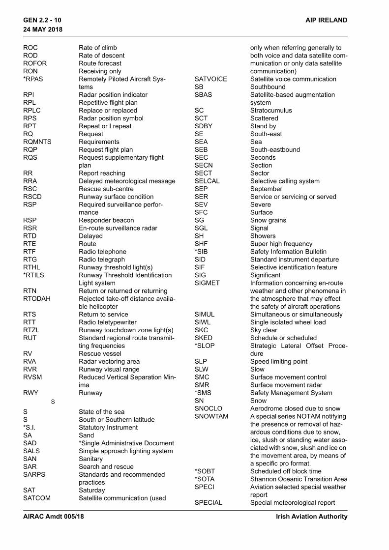
ROC Rate of climbROD Rate of descentROFOR Route forecastRON Receiving only*RPAS Remotely Piloted Aircraft Sys-
temsRPI Radar position indicatorRPL Repetitive flight planRPLC Replace or replacedRPS Radar position symbolRPT Repeat or I repeat RQ RequestRQMNTS RequirementsRQP Request flight planRQS Request supplementary flight
planRR Report reachingRRA Delayed meteorological messageRSC Rescue sub-centreRSCD Runway surface conditionRSP Required surveillance perfor-
manceRSP Responder beaconRSR En-route surveillance radarRTD DelayedRTE RouteRTF Radio telephoneRTG Radio telegraphRTHL Runway threshold light(s)*RTILS Runway Threshold Identification
Light systemRTN Return or returned or returningRTODAH Rejected take-off distance availa-
ble helicopterRTS Return to serviceRTT Radio teletypewriterRTZL Runway touchdown zone light(s)RUT Standard regional route transmit-
ting frequenciesRV Rescue vesselRVA Radar vectoring area RVR Runway visual rangeRVSM Reduced Vertical Separation Min-
imaRWY Runway
S
S State of the seaS South or Southern latitude*S.I. Statutory InstrumentSA SandSAD *Single Administrative DocumentSALS Simple approach lighting systemSAN SanitarySAR Search and rescueSARPS Standards and recommended
practicesSAT SaturdaySATCOM Satellite communication (used
only when referring generally to both voice and data satellite com-munication or only data satellite communication)
SATVOICE Satellite voice communicationSB SouthboundSBAS Satellite-based augmentation
systemSC StratocumulusSCT ScatteredSDBY Stand bySE South-eastSEA SeaSEB South-eastboundSEC SecondsSECN SectionSECT SectorSELCAL Selective calling systemSEP SeptemberSER Service or servicing or servedSEV SevereSFC SurfaceSG Snow grainsSGL SignalSH ShowersSHF Super high frequency*SIB Safety Information BulletinSID Standard instrument departureSIF Selective identification featureSIG SignificantSIGMET Information concerning en-route
weather and other phenomena in the atmosphere that may effect the safety of aircraft operations
SIMUL Simultaneous or simultaneouslySIWL Single isolated wheel loadSKC Sky clearSKED Schedule or scheduled*SLOP Strategic Lateral Offset Proce-
dureSLP Speed limiting pointSLW SlowSMC Surface movement controlSMR Surface movement radar*SMS Safety Management SystemSN SnowSNOCLO Aerodrome closed due to snowSNOWTAM A special series NOTAM notifying
the presence or removal of haz-ardous conditions due to snow, ice, slush or standing water asso-ciated with snow, slush and ice on the movement area, by means of a specific pro format.
*SOBT Scheduled off block time*SOTA Shannon Oceanic Transition AreaSPECI Aviation selected special weather
reportSPECIAL Special meteorological report
Irish Aviation AuthorityAIRAC Amdt 005/18

AIP IRELAND GEN 2.2 - 1124 MAY 2018
24 MAY 2018
SPL Supplementary flight plan mes-sage
SPOC SAR point of contactSPOT Spot windSQ SquallSQL Squall lineSR SunriseSRA Surveillance radar approach*SRA State Regulatory AuthoritySRE Surveillance radar element of pre-
cision approach radar systemSRG Short range*SRH Surveillance Radar SRR Search and rescue regionSRY SecondarySS SandstormSS SunsetSSB Single sidebandSSE South-south-eastSSR Secondary surveillance radarSST Supersonic transportSSW South-south-westST StratusSTA Straight in approachSTAR Standard (instrument) arrivalSTD StandardSTF StratiformSTN StationSTNR StationarySTOL Short take-off and landingSTS StatusSTWL Stopway light(s)*SUA Small unmanned aircraftSUBJ Subject toSUN SundaySUP SupplementSUPPS Regional supplementary proce-
duresSVC Service (message type only)SVCBL ServiceableSW South-westSWB South-westboundSWY Stopway
T
T TemperatureT True*T Terminal (Used to specify the pur-
pose of a Designated Point)TA Transition altitudeTAA Terminal arrival altitudeTACAN UHF tactical air navigation aidTAF Aerodrome forecastTAIL Tail windTAR Terminal area surveillance radarTAS True airspeedTAX Taxiing or taxiTC Tropical cycloneTCAS Traffic Collision Avoidance Sys-
temTCU Towering cumulusTDO TornadoTDZ Touchdown zoneTECR Technical reasonTEL TelephoneTEMPO Temporary or temporarilyTEND Trend forecastTFC TrafficTGL Touch-and-go landingTGS Taxiing guidance systemTHR ThresholdTHRU ThroughTHU ThursdayTIBA Traffic information broadcast by
aircraftTIL UntilTIP Until past… TKOF Take-offTL TillTLOF Touchdown and lift-off areaTMA Terminal control areaTN Minimum temperatureTNA Turn altitudeTNH Turn HeightTO To… *TOBT Target off-block timeTOC Top of climbTODA Take-off distance availableTODAH Take-off distance available, heli-
copterTOP Cloud topTORA Take-off run availableTP Turning pointTR TrackTRA Temporary reserved airspaceTRANS Transmits or transmitterTREND Trend forecastTRL Transition levelTRG TrainingTROP TropopauzaTS Thunderstorm*TSAT Target start up approval timeTT TeletypewriterTUE TuesdayTURB TurbulenceT-VASIS T visual approach slope indicator
system TVOR Terminal VORTWR Aerodrome control tower or aero-
drome controlTWY TaxiwayTX Maximum temperature (followed
by figures in TAF)TXL TaxilaneTXT Text /when the abbreviation is
used to request a repetition, the question mark (IMI) precedes the abbreviation, e.g. IMI TXT/
Irish Aviation Authority AIRAC Amdt 005/18
GEN 2.2 - 12 AIP IRELAND 24 MAY 2018
24 MAY 2018
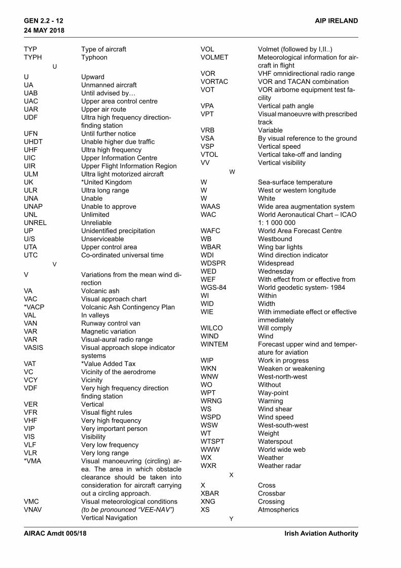
TYP Type of aircraftTYPH Typhoon
U
U UpwardUA Unmanned aircraftUAB Until advised by…UAC Upper area control centreUAR Upper air routeUDF Ultra high frequency direction-
finding stationUFN Until further noticeUHDT Unable higher due trafficUHF Ultra high frequencyUIC Upper Information CentreUIR Upper Flight Information RegionULM Ultra light motorized aircraftUK *United KingdomULR Ultra long rangeUNA UnableUNAP Unable to approveUNL UnlimitedUNREL UnreliableUP Unidentified precipitationU/S UnserviceableUTA Upper control areaUTC Co-ordinated universal time
V
V Variations from the mean wind di-rection
VA Volcanic ashVAC Visual approach chart*VACP Volcanic Ash Contingency PlanVAL In valleysVAN Runway control vanVAR Magnetic variationVAR Visual-aural radio rangeVASIS Visual approach slope indicator
systemsVAT *Value Added TaxVC Vicinity of the aerodrome VCY VicinityVDF Very high frequency direction
finding stationVER VerticalVFR Visual flight rulesVHF Very high frequencyVIP Very important personVIS VisibilityVLF Very low frequencyVLR Very long range*VMA Visual manoeuvring (circling) ar-
ea. The area in which obstacle clearance should be taken into consideration for aircraft carrying out a circling approach.
VMC Visual meteorological conditionsVNAV (to be pronounced “VEE-NAV”)
Vertical Navigation
VOL Volmet (followed by I,II..)VOLMET Meteorological information for air-
craft in flightVOR VHF omnidirectional radio rangeVORTAC VOR and TACAN combinationVOT VOR airborne equipment test fa-
cilityVPA Vertical path angleVPT Visual manoeuvre with prescribed
trackVRB VariableVSA By visual reference to the groundVSP Vertical speedVTOL Vertical take-off and landingVV Vertical visibility
W
W Sea-surface temperatureW West or western longitudeW WhiteWAAS Wide area augmentation systemWAC World Aeronautical Chart – ICAO
1: 1 000 000WAFC World Area Forecast CentreWB WestboundWBAR Wing bar lightsWDI Wind direction indicatorWDSPR WidespreadWED WednesdayWEF With effect from or effective fromWGS-84 World geodetic system- 1984WI WithinWID WidthWIE With immediate effect or effective
immediatelyWILCO Will complyWIND WindWINTEM Forecast upper wind and temper-
ature for aviationWIP Work in progressWKN Weaken or weakeningWNW West-north-westWO WithoutWPT Way-pointWRNG WarningWS Wind shearWSPD Wind speedWSW West-south-westWT WeightWTSPT WaterspoutWWW World wide webWX WeatherWXR Weather radar
X
X CrossXBAR CrossbarXNG CrossingXS Atmospherics
Y
Irish Aviation AuthorityAIRAC Amdt 005/18

GEN 2.2 - 13AIP IRELAND24 MAY 2018
24 MAY 2018
Y YellowYCZ Yellow caution zoneYES YesYR Your
Z
Z Co-ordinated Universal Time
Irish Aviation Authority AIRAC Amdt 005/18

THIS PAGE INTENTIONALLY LEFT BLANK
Irish Aviation Authority
GEN 2.2 - 14 AIP IRELAND24 MAY 2018
24 MAY 2018
AIRAC Amdt 005/18